Embed Size (px)
Citation preview
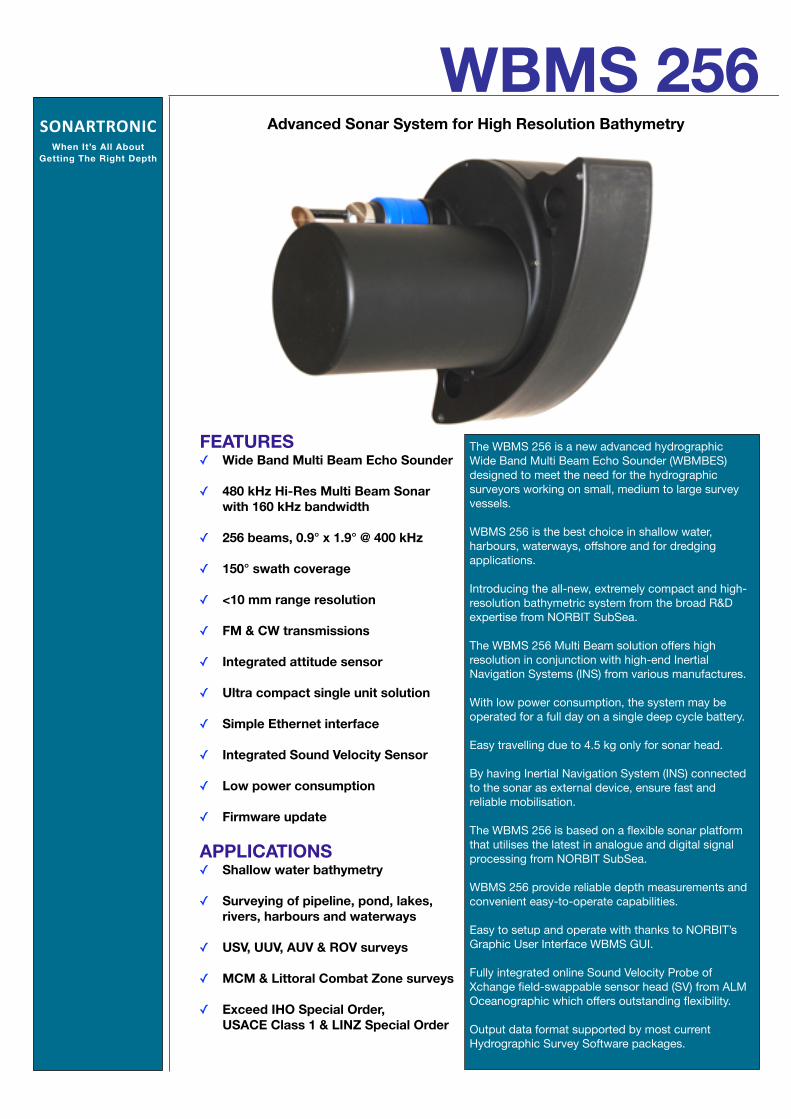
WBMS 256 Advanced Sonar System for High Resolution Bathymetry
!! !!!!!!!!!!! ! FEATURES
✓ Wide Band Multi Beam Echo Sounder !✓ 480 kHz Hi-Res Multi Beam Sonar
with 160 kHz bandwidth
✓ 256 beams, 0.9° x 1.9° @ 400 kHz !✓ 150° swath coverage !✓ <10 mm range resolution !✓ FM & CW transmissions
✓ Integrated attitude sensor !✓ Ultra compact single unit solution !✓ Simple Ethernet interface !✓ Integrated Sound Velocity Sensor !✓ Low power consumption !✓ Firmware update !
APPLICATIONS ✓ Shallow water bathymetry !✓ Surveying of pipeline, pond, lakes,
rivers, harbours and waterways !✓ USV, UUV, AUV & ROV surveys !✓ MCM & Littoral Combat Zone surveys !✓ Exceed IHO Special Order,
USACE Class 1 & LINZ Special Order
The WBMS 256 is a new advanced hydrographic Wide Band Multi Beam Echo Sounder (WBMBES) designed to meet the need for the hydrographic surveyors working on small, medium to large survey vessels.
WBMS 256 is the best choice in shallow water, harbours, waterways, offshore and for dredging applications.
Introducing the all-new, extremely compact and high-resolution bathymetric system from the broad R&D expertise from NORBIT SubSea.
The WBMS 256 Multi Beam solution offers high resolution in conjunction with high-end Inertial Navigation Systems (INS) from various manufactures.
With low power consumption, the system may be operated for a full day on a single deep cycle battery.
Easy travelling due to 4.5 kg only for sonar head.
By having Inertial Navigation System (INS) connected to the sonar as external device, ensure fast and reliable mobilisation.
The WBMS 256 is based on a flexible sonar platform that utilises the latest in analogue and digital signal processing from NORBIT SubSea.
WBMS 256 provide reliable depth measurements and convenient easy-to-operate capabilities.
Easy to setup and operate with thanks to NORBIT’s Graphic User Interface WBMS GUI.
Fully integrated online Sound Velocity Probe of Xchange field-swappable sensor head (SV) from ALM Oceanographic which offers outstanding flexibility.
Output data format supported by most current Hydrographic Survey Software packages.
!SONARTRONIC)
When It’s All About Getting The Right Depth !!!!!!!!!!!!!!!!!!!!!!!!!!!!!!!!!!!!!!!!!!!!!!!!! !!!!!!!!!!!!!!!
WBMS 256
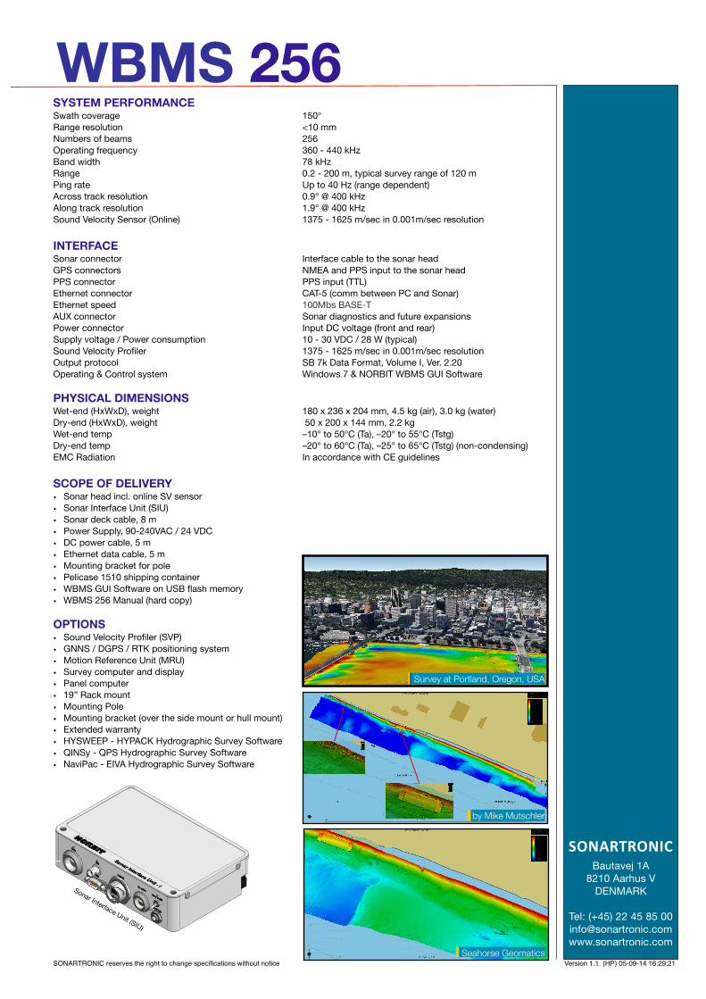
SYSTEM PERFORMANCE Swath coverage 150°Range resolution <10 mmNumbers of beams 256Operating frequency 360 - 440 kHz Band width 78 kHzRange 0.2 - 200 m, typical survey range of 120 mPing rate Up to 40 Hz (range dependent)Across track resolution 0.9° @ 400 kHzAlong track resolution 1.9° @ 400 kHzSound Velocity Sensor (Online) 1375 - 1625 m/sec in 0.001m/sec resolution!INTERFACE Sonar connector Interface cable to the sonar head GPS connectors NMEA and PPS input to the sonar head PPS connector PPS input (TTL)Ethernet connector CAT-5 (comm between PC and Sonar)Ethernet speed 100Mbs BASE-TAUX connector Sonar diagnostics and future expansions Power connector Input DC voltage (front and rear) Supply voltage / Power consumption 10 - 30 VDC / 28 W (typical)Sound Velocity Profiler 1375 - 1625 m/sec in 0.001m/sec resolutionOutput protocol SB 7k Data Format, Volume I, Ver. 2.20Operating & Control system Windows 7 & NORBIT WBMS GUI Software!PHYSICAL DIMENSIONS Wet-end (HxWxD), weight 180 x 236 x 204 mm, 4.5 kg (air), 3.0 kg (water)Dry-end (HxWxD), weight 50 x 200 x 144 mm, 2.2 kgWet-end temp –10° to 50°C (Ta), –20° to 55°C (Tstg)Dry-end temp –20° to 60°C (Ta), –25° to 65°C (Tstg) (non-condensing)EMC Radiation In accordance with CE guidelines!SCOPE OF DELIVERY • Sonar head incl. online SV sensor • Sonar Interface Unit (SIU)• Sonar deck cable, 8 m• Power Supply, 90-240VAC / 24 VDC• DC power cable, 5 m• Ethernet data cable, 5 m• Mounting bracket for pole• Pelicase 1510 shipping container• WBMS GUI Software on USB flash memory• WBMS 256 Manual (hard copy)!OPTIONS• Sound Velocity Profiler (SVP)• GNNS / DGPS / RTK positioning system • Motion Reference Unit (MRU) • Survey computer and display • Panel computer• 19” Rack mount• Mounting Pole• Mounting bracket (over the side mount or hull mount)• Extended warranty• HYSWEEP - HYPACK Hydrographic Survey Software• QINSy - QPS Hydrographic Survey Software• NaviPac - EIVA Hydrographic Survey Software
!!
!! !
SONARTRONIC reserves the right to change specifications without notice Version 1.1. (HP) 05-09-14 16:29:21
!!!!!!!!!!!!!!!!!!!!!!!!!!!!!!!!!!!!!!!!!!!!!!!!!!!!! !!!!!!SONARTRONIC)
Bautavej 1A8210 Aarhus V
DENMARK!Tel: (+45) 22 45 85 [email protected] www.sonartronic.com
29#April,#2013#
www.seahorsegeomatics.com www.norbit.com
####
Agenda#–#Portland#April#2013##Results#:##Survey#Columbia#River##
29#April,#2013#
www.seahorsegeomatics.com www.norbit.com
####
Agenda#–#Portland#April#2013##Results#:##Survey#Columbia#River#Downtown###
7.4
SIU
drawings
Part no:Material: All dimensions in millimeter
Tolerances:Sheet size:
Sheet of
Drawn:
Projection
NorbitStiklestadveien 17041 TrondheimNorwaywww.norbit.no
This document is confidential and the property of Norbit and may not be reproduced in any form without the written consent of the owner. All copies shall be returned to Norbit on request.
ScaleSonar_Interface_Unit-I
1 A21
2012-10-23hr
29024-1
Surfaces:
1:1
ON BR IT
Rear side
200
130
144,
3
50
SIU-I Weight: 1.2 kg
0 35 74 113
148
173
200
0
14
25
0
5,9
15,4
3
24,9
5
34,4
8
40,5
11,9
4
Figure
33:SIU
.
34
Sonar Interface Unit (SIU)
29#April,#2013#
www.seahorsegeomatics.com www.norbit.com
####
Agenda#–#Portland#April#2013##Results#:##Survey#Columbia#River#
Survey at Portland, Oregon, USA
Seahorse Geomatics
by Mike Mutschler