Embed Size (px)
Citation preview
1
Waukesha County Shoreland and Floodland
Protection Ordinance Mitigation Handbook
04/29/2019
2
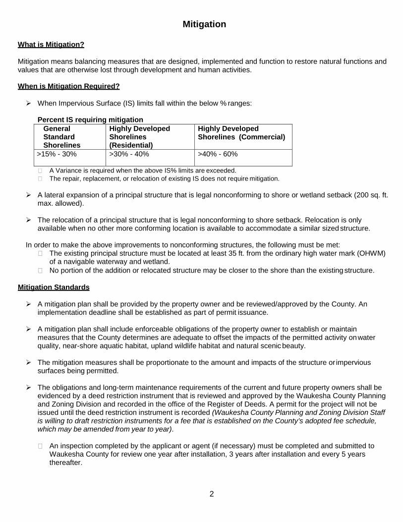
Mitigation What is Mitigation?
Mitigation means balancing measures that are designed, implemented and function to restore natural functions and values that are otherwise lost through development and human activities.
When is Mitigation Required?
When Impervious Surface (IS) limits fall within the below % ranges:
Percent IS requiring mitigation General Standard Shorelines
Highly Developed Shorelines (Residential)
Highly Developed Shorelines (Commercial)
>15% - 30% >30% - 40% >40% - 60%
A Variance is required when the above IS% limits are exceeded. The repair, replacement, or relocation of existing IS does not require mitigation.
A lateral expansion of a principal structure that is legal nonconforming to shore or wetland setback (200 sq. ft.
max. allowed). The relocation of a principal structure that is legal nonconforming to shore setback. Relocation is only
available when no other more conforming location is available to accommodate a similar sized structure.
In order to make the above improvements to nonconforming structures, the following must be met: The existing principal structure must be located at least 35 ft. from the ordinary high water mark (OHWM)
of a navigable waterway and wetland. No portion of the addition or relocated structure may be closer to the shore than the existing structure.
Mitigation Standards
A mitigation plan shall be provided by the property owner and be reviewed/approved by the County. An implementation deadline shall be established as part of permit issuance.
A mitigation plan shall include enforceable obligations of the property owner to establish or maintain
measures that the County determines are adequate to offset the impacts of the permitted activity on water quality, near-shore aquatic habitat, upland wildlife habitat and natural scenic beauty.
The mitigation measures shall be proportionate to the amount and impacts of the structure or impervious
surfaces being permitted. The obligations and long-term maintenance requirements of the current and future property owners shall be
evidenced by a deed restriction instrument that is reviewed and approved by the Waukesha County Planning and Zoning Division and recorded in the office of the Register of Deeds. A permit for the project will not be issued until the deed restriction instrument is recorded (Waukesha County Planning and Zoning Division Staff is willing to draft restriction instruments for a fee that is established on the County’s adopted fee schedule, which may be amended from year to year).
An inspection completed by the applicant or agent (if necessary) must be completed and submitted to
Waukesha County for review one year after installation, 3 years after installation and every 5 years thereafter.
3
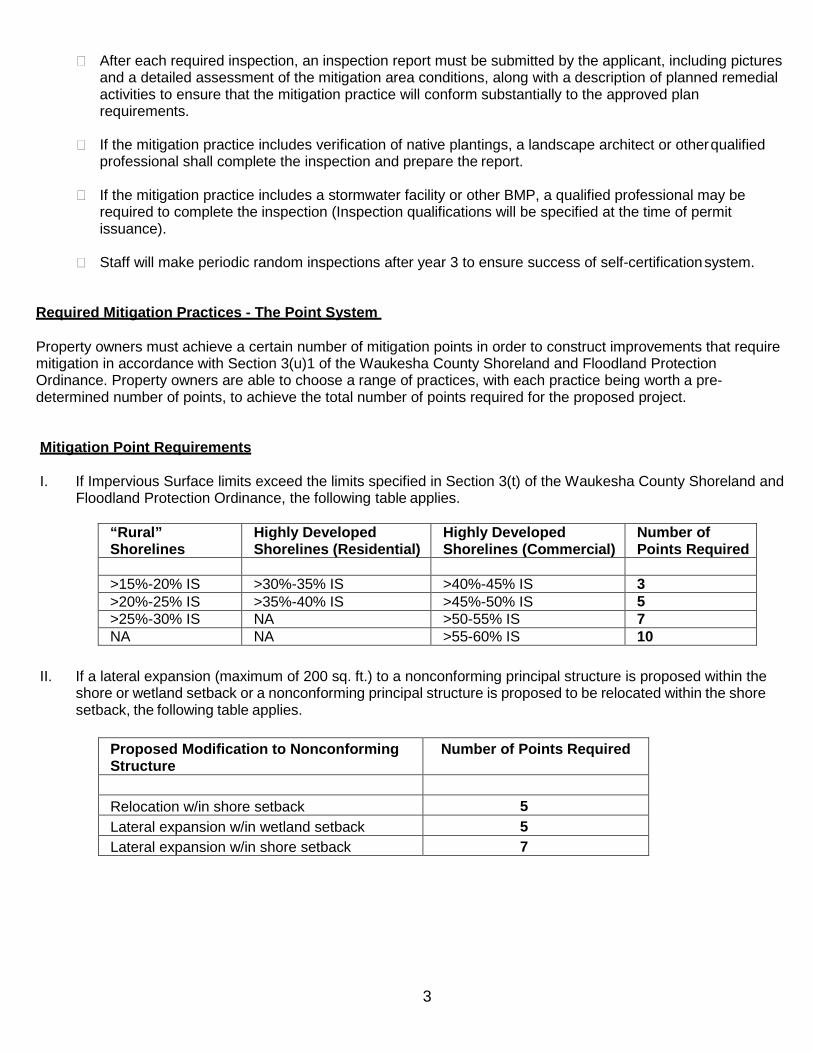
After each required inspection, an inspection report must be submitted by the applicant, including pictures and a detailed assessment of the mitigation area conditions, along with a description of planned remedial activities to ensure that the mitigation practice will conform substantially to the approved plan requirements.
If the mitigation practice includes verification of native plantings, a landscape architect or other qualified
professional shall complete the inspection and prepare the report.
If the mitigation practice includes a stormwater facility or other BMP, a qualified professional may be required to complete the inspection (Inspection qualifications will be specified at the time of permit issuance).
Staff will make periodic random inspections after year 3 to ensure success of self-certification system.
Required Mitigation Practices - The Point System
Property owners must achieve a certain number of mitigation points in order to construct improvements that require mitigation in accordance with Section 3(u)1 of the Waukesha County Shoreland and Floodland Protection Ordinance. Property owners are able to choose a range of practices, with each practice being worth a pre- determined number of points, to achieve the total number of points required for the proposed project.
Mitigation Point Requirements
I. If Impervious Surface limits exceed the limits specified in Section 3(t) of the Waukesha County Shoreland and Floodland Protection Ordinance, the following table applies.
“Rural” Shorelines
Highly Developed Shorelines (Residential)
Highly Developed Shorelines (Commercial)
Number of Points Required
>15%-20% IS >30%-35% IS >40%-45% IS 3 >20%-25% IS >35%-40% IS >45%-50% IS 5 >25%-30% IS NA >50-55% IS 7 NA NA >55-60% IS 10
II. If a lateral expansion (maximum of 200 sq. ft.) to a nonconforming principal structure is proposed within the
shore or wetland setback or a nonconforming principal structure is proposed to be relocated within the shore setback, the following table applies.
Proposed Modification to Nonconforming Structure
Number of Points Required
Relocation w/in shore setback 5 Lateral expansion w/in wetland setback 5 Lateral expansion w/in shore setback 7
4
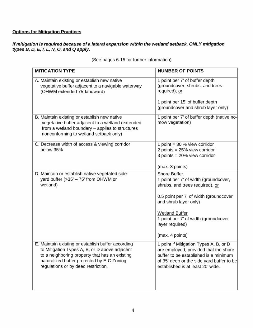
Options for Mitigation Practices If mitigation is required because of a lateral expansion within the wetland setback, ONLY mitigation types B, D, E, I, L, N, O, and Q apply.
(See pages 6-15 for further information)
MITIGATION TYPE NUMBER OF POINTS
A. Maintain existing or establish new native vegetative buffer adjacent to a navigable waterway (OHWM extended 75’ landward)
1 point per 7’ of buffer depth (groundcover, shrubs, and trees required), or
1 point per 15’ of buffer depth (groundcover and shrub layer only)
B. Maintain existing or establish new native vegetative buffer adjacent to a wetland (extended from a wetland boundary – applies to structures nonconforming to wetland setback only)
1 point per 7’ of buffer depth (native no- mow vegetation)
C. Decrease width of access & viewing corridor below 35%
1 point = 30 % view corridor 2 points = 25% view corridor 3 points = 20% view corridor
(max. 3 points)
D. Maintain or establish native vegetated side- yard buffer (>35’ – 75’ from OHWM or wetland)
Shore Buffer 1 point per 7’ of width (groundcover, shrubs, and trees required), or
0.5 point per 7’ of width (groundcover and shrub layer only)
Wetland Buffer 1 point per 7’ of width (groundcover layer required)
(max. 4 points)
E. Maintain existing or establish buffer according to Mitigation Types A, B, or D above adjacent to a neighboring property that has an existing naturalized buffer protected by E-C Zoning regulations or by deed restriction.
1 point if Mitigation Types A, B, or D are employed, provided that the shore buffer to be established is a minimum of 35’ deep or the side yard buffer to be established is at least 20’ wide.
5
F. Screen existing retaining walls located within 75 ft. of OHWM with vegetation
0.5 point per 50 lineal ft. of wall screened
(max. 2 points)
G. Remove existing retaining walls located within 75 ft. of OHWM and replace with vegetation
1 point per 25 lineal ft. of wall
H. Increasing setback of structures from OHWM 1 point per 5’ of increased setback beyond required
(max. 5 points)
I. Removal of improvements within 75 ft. of the shore or wetland
Examples: beaches, boathouse approaches, fire pits, fountains, impervious surfaces
1 point per 100 sq. ft. (credit is not provided if removal is required as part of another accredited mitigation type)
J. Removal of seawall/riprap and replacement with natural, nonstructural stabilization materials
5 points for entire shoreline, or 5 points per 100 ft. of lineal shoreline.
K. Use of earth-tone materials or colors 1 point
L. Removal of a nonconforming structure; 2nd story of a boathouse; or reduction in the area of a boathouse to 450 square feet (min. of 100 sq. ft. size reduction required)
3 points for accessory structures < 200 sq. ft. in size
5 points for accessory structures > 200 sq. ft. in size, removal of 2nd story of boathouse, or reduction in the area of a boathouse to 450 square feet (minimum 100 sq. ft. reduction).
7 points for principal structures not otherwise required to be removed.
M. Removal of a conforming boathouse or restriction prohibiting future development of a boathouse
7 points
N. Stormwater BMP 3 points (credit is not provided if the Stormwater BMP is proposed as an exclusion to the IS calculations of the ordinance
O. Maintenance or restoration of property to natural state (credit is not provided for existing wetlands)
20%-40% = 1 pt., 40-60% = 2 pts., > 60% = 3 pts.
P. Maintain existing or establish new shoreline habitat (fallen trees or fish sticks)
2 points per tree cluster as specified in the DNR Best Practices Manual
Q. Alternative method approved by Planning & Zoning Division staff
Based on proposal
6
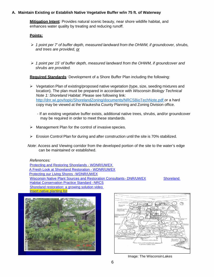
A. Maintain Existing or Establish Native Vegetative Buffer w/in 75 ft. of Waterway
Mitigation Intent: Provides natural scenic beauty, near shore wildlife habitat, and enhances water quality by treating and reducing runoff.
Points:
1 point per 7’ of buffer depth, measured landward from the OHWM, if groundcover, shrubs, and trees are provided, or
1 point per 15’ of buffer depth, measured landward from the OHWM, if groundcover and shrubs are provided.
Required Standards: Development of a Shore Buffer Plan including the following:
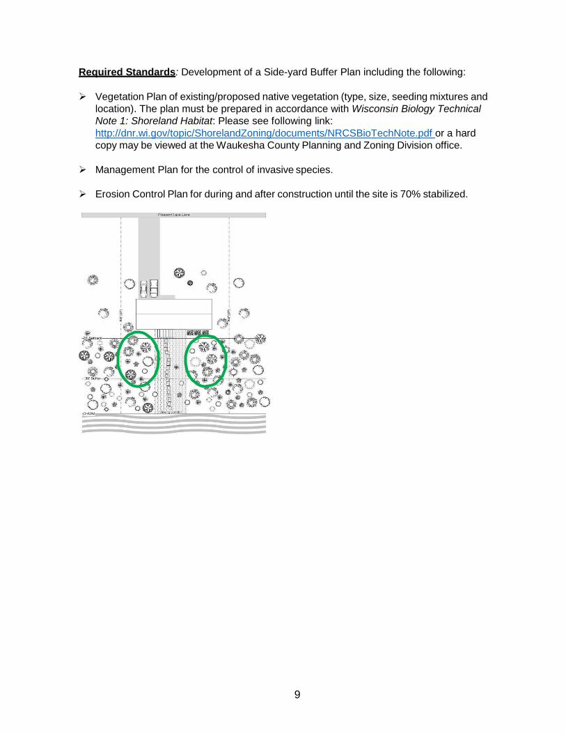
Vegetation Plan of existing/proposed native vegetation (type, size, seeding mixtures and location). The plan must be prepared in accordance with Wisconsin Biology Technical Note 1: Shoreland Habitat: Please see following link: http://dnr.wi.gov/topic/ShorelandZoning/documents/NRCSBioTechNote.pdf or a hard copy may be viewed at the Waukesha County Planning and Zoning Division office.
- If an existing vegetative buffer exists, additional native trees, shrubs, and/or groundcover
may be required in order to meet these standards.
Management Plan for the control of invasive species.
Erosion Control Plan for during and after construction until the site is 70% stabilized.
Note: Access and Viewing corridor from the developed portion of the site to the water’s edge can be maintained or established.
References: Protecting and Restoring Shorelands - WDNR/UWEX A Fresh Look at Shoreland Restoration - WDNR/UWEX Protecting our Living Shores - WDNR/UWEX Wisconsin Native Plant Sources and Restoration Consultants - DNR/UWEX Shoreland Habitat Conservation Practice Standard - NRCS Shoreland restoration: a growing solution video Insert native planting list
Image: The Wisconsin Lakes
7
B. Maintain Existing or Establish Native Vegetative Buffer w/in 75 ft. of Wetland
Mitigation Intent: Maintains hydrology; provides natural scenic beauty, aquatic and wildlife habitat; and enhances water quality by treating and reducing runoff.
Points:
1 point per 7’ of buffer depth, measured from the wetland boundary.
Required Standards: Development of a Wetland Buffer Plan including the following:
Vegetation Plan of existing/proposed native vegetation (type, size, seeding mixtures and location). The plan must be prepared in accordance with Wisconsin Biology Technical Note 1: Shoreland Habitat: Please see following link: http://dnr.wi.gov/topic/ShorelandZoning/documents/NRCSBioTechNote.pdf or a hard copy may be viewed at the Waukesha County Planning and Zoning Division office.
- If an existing vegetative buffer exists, additional vegetation may be required in order to
meet these standards.
Management Plan for the control of invasive species.
Erosion Control Plan for during and after construction until the site is 70% stabilized.
References: Wisconsin Native Plant Sources and Restoration Consultants - DNR/UWEX
C. Decrease Width of Access and Viewing Corridor below 35% w/in 35 ft. of Waterway
Mitigation Intent: Provides natural scenic beauty, near-shore wildlife habitat, and enhanced water quality by treating and reducing runoff.
Points:
1 point = 30% Viewing Corridor 2 points = 25% Viewing Corridor 3 points = 20% Viewing Corridor
*A maximum of 3 points may be provided.
Required Standards: Development of a Shore Buffer Plan including the following:
Vegetation Plan of existing/proposed native vegetation (type, size, seeding mixtures and location). The plan must be prepared in accordance with Wisconsin Biology Technical Note 1: Shoreland Habitat: Please see following link: http://dnr.wi.gov/topic/ShorelandZoning/documents/NRCSBioTechNote.pdf or a hard copy may be viewed at the Waukesha County Planning and Zoning Division office.
- If an existing vegetative buffer exists, additional native trees, shrubs, and/or groundcover
may be required in order to meet these standards.
8
Management Plan for the control of invasive species.
Erosion Control Plan for during and after construction until the site is 70% stabilized.
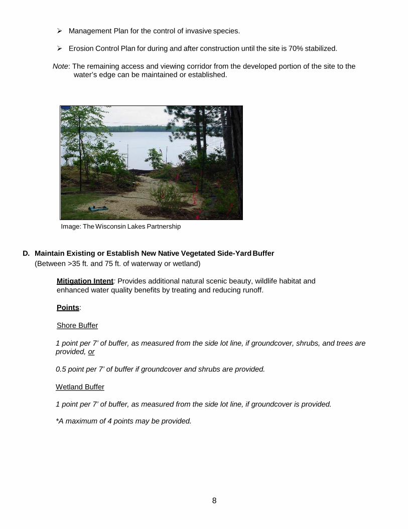
Note: The remaining access and viewing corridor from the developed portion of the site to the water’s edge can be maintained or established.
D. Maintain Existing or Establish New Native Vegetated Side-Yard Buffer (Between >35 ft. and 75 ft. of waterway or wetland)
Mitigation Intent: Provides additional natural scenic beauty, wildlife habitat and enhanced water quality benefits by treating and reducing runoff.
Points:
Shore Buffer
1 point per 7’ of buffer, as measured from the side lot line, if groundcover, shrubs, and trees are provided, or
0.5 point per 7’ of buffer if groundcover and shrubs are provided.
Wetland Buffer
1 point per 7’ of buffer, as measured from the side lot line, if groundcover is provided.
*A maximum of 4 points may be provided.
Image: The Wisconsin Lakes Partnership
9
Required Standards: Development of a Side-yard Buffer Plan including the following:
Vegetation Plan of existing/proposed native vegetation (type, size, seeding mixtures and location). The plan must be prepared in accordance with Wisconsin Biology Technical Note 1: Shoreland Habitat: Please see following link: http://dnr.wi.gov/topic/ShorelandZoning/documents/NRCSBioTechNote.pdf or a hard copy may be viewed at the Waukesha County Planning and Zoning Division office.
Management Plan for the control of invasive species.
Erosion Control Plan for during and after construction until the site is 70% stabilized.
E. Maintain Existing or Establish New Native Vegetated Buffer Adjacent to a Neighboring Property With Naturalized Buffer Protected by E-C Zoning Regulations or by Deed Restriction.
Mitigation Intent: Provides additional natural scenic beauty, wildlife habitat and enhanced water quality benefits by treating and reducing runoff.
Points:
1 point if Mitigation Types A, B, or D are employed, provided that the shore buffer to be established is a minimum of 35 ft. deep or the side yard buffer to be established is at least 20 ft. wide.
Required Standards: Compliance with standards of Mitigation Types A, B, or D and evidence that the adjacent property has a naturalized vegetative buffer protected by E-C Zoning Regulations or by Deed Restriction.
F. Screen Existing Retaining Walls within 75 ft. of Waterway with Vegetation
Mitigation Intent: Provides natural scenic beauty and potential wildlife habitat.
Points:
0.5 point per 50 lineal feet of retaining wall screened.
*A maximum of 2 points may be provided.
**Credit is not provided if removal is required as part of another accredited mitigation type or by ordinance.
Required Standards: Development of a Screening Plan that includes vegetation that will cover at least 70% of the wall as viewed from the lake with vegetation within 3 years of implementation. If 70% wall coverage is not established within 3 years, additional plantings will be required.
G. Remove Existing Retaining Walls within 75 ft. of Waterway & Replace with Native Vegetation
Mitigation Intent: Provides natural scenic beauty, wildlife habitat and restores natural topography.
Points:
1 point per 25 lineal feet of retaining wall removed.
*Credit is not provided if removal is required as part of another accredited mitigation type or by ordinance.
Required Standards: Development of a Restoration Plan including the following:
Existing and Proposed Grading Plan prepared by a licensed professional. Vegetation Plan (including type, size, seeding mixtures, and location). Erosion Control Plan for during and after con1st0ruction until the site is 70% stabilized.
11
H. Increased Setback of Structures beyond Required Shore Setback
Mitigation Intent: Provides natural scenic beauty and reduces runoff.
Points:
1 point per 5 ft. of increased shore setback beyond minimum required.
*A maximum of 5 points may be provided.
Required Standards: Survey verification that the setback has been adequately increased. I. Removal of Improvements within 75 ft. of the Waterway or Wetland (beaches, boathouse
approaches, fire pits, fountains, impervious surfaces).
Mitigation Intent: Provides natural scenic beauty, habitat, and water quality benefits.
Points:
1 point per 100 sq. ft. of improvement that is removed and replaced with vegetation.
*Credit is not provided if removal is required as part of another accredited mitigation type or by ordinance.
Required Standards: Removal of the area of improvement within 75 ft. of the water resource and the development of a Restoration Plan, including the following:
Existing and Proposed Grading Plan prepared by a licensed professional (if necessary). Vegetation Plan (including type, size, seeding mixtures, and location). Erosion Control Plan for during and after construction until the site is 70% stabilized.
J. Removal of Seawall/Riprap and Replacement with Natural, Non-structural Stabilization
Materials.
Mitigation Intent: Provides natural scenic beauty, aquatic and wildlife habitat and water quality benefits.
Points:
5 points for entire shoreline, or
5 points per 100 lineal ft. of shoreline.
Required Standards: Provide a Plan and a copy of the WDNR Permit for the removal of the seawall/riprap structure and replacement with natural, non-structural stabilization materials.
12
K. Use of Earth-Tone Materials or Colors
Mitigation Intent: Provides natural scenic beauty.
Points:
1 point is provided.
Required Standards: Use of earth-tone materials or colors for all existing and proposed structures on the property as viewed from the shore. Practices must include the use of exterior building materials or treatments that are inconspicuous and blend with the natural setting of the site.
L. Removal of a Nonconforming Structure; 2nd Story of a Boathouse; or a Reduction in the Area
of a Boathouse to 450 sq. ft. (min. of 100 sq. ft. size reduction required.)
Mitigation Intent: Provides natural scenic beauty, habitat, and water quality benefits.
Points:
3 points for accessory structures <200 sq. ft. in size.
5 points for accessory structures >200 sq. ft. in size, removal of the 2nd story of a boathouse, or a reduction in the area of a boathouse to 450 sq. ft. (min. of 100 sq. ft. size reduction required.)
7 points for principal structures that are not otherwise required to be removed by ordinance.
Required Standards: The legal nonconforming structure must be removed prior to the issuance of a Zoning Permit for the proposed development.
M. Removal of a Conforming Boathouse or Restriction Prohibiting Future Development of a
Boathouse
Mitigation Intent: Provides natural scenic beauty, aquatic and wildlife habitat, and water quality benefits.
Points:
7 points are provided
Required Standards: A deed restriction instrument must be recorded against the property that restricts the construction of a future boathouse on the property. If a boathouse already exists on the property, the boathouse must be removed prior to the issuance of a Zoning Permit for the proposed development.
13
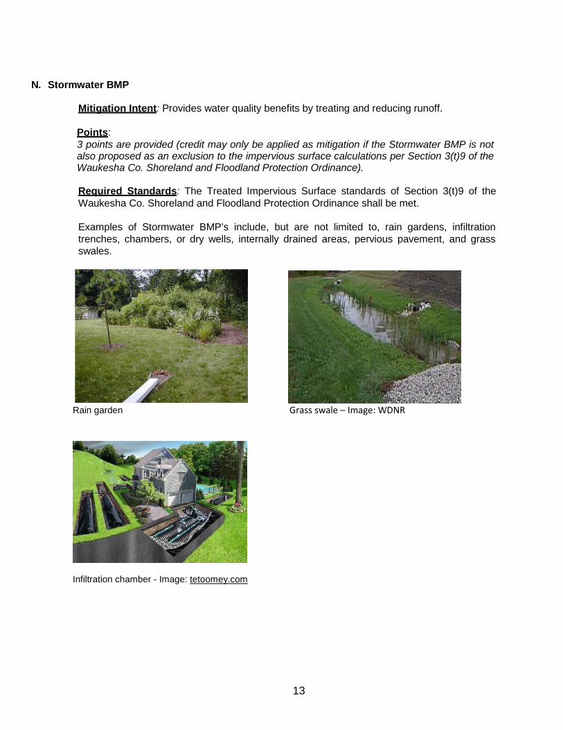
N. Stormwater BMP
Mitigation Intent: Provides water quality benefits by treating and reducing runoff.
Points: 3 points are provided (credit may only be applied as mitigation if the Stormwater BMP is not also proposed as an exclusion to the impervious surface calculations per Section 3(t)9 of the Waukesha Co. Shoreland and Floodland Protection Ordinance).
Required Standards: The Treated Impervious Surface standards of Section 3(t)9 of the Waukesha Co. Shoreland and Floodland Protection Ordinance shall be met.
Examples of Stormwater BMP’s include, but are not limited to, rain gardens, infiltration trenches, chambers, or dry wells, internally drained areas, pervious pavement, and grass swales.
Rain garden Grass swale – Image: WDNR
Infiltration chamber - Image: tetoomey.com
14
O. Maintenance or Restoration of Property to Natural State (such as native woodlands and
prairies)
Mitigation Intent: Provides natural scenic beauty, wildlife habitat and reduces runoff.
Points:
>20%-40% natural area = 1 pt.
>40%-60% natural area = 2 pts.
>60% natural area = 3 pts.
*Credit is not provided for existing wetlands.
Required Standards: Development of a Natural Area Plan including the following:
Vegetation Plan of existing/proposed native vegetation (type, size, seeding mixtures and location). The plan must be prepared in accordance with Wisconsin Biology Technical Note 1: Shoreland Habitat: Please see following link: http://dnr.wi.gov/topic/ShorelandZoning/documents/NRCSBioTechNote.pdf or a hard copy may be viewed at the Waukesha County Planning and Zoning Division office.
Management Plan for the control of invasive species.
Erosion Control Plan for during and after construction until the site is 70% stabilized.
P. Maintain Existing or Establish New Shoreline Habitat (fallen trees or fish sticks)
Mitigation Intent: Provides near shore wildlife and aquatic habitat and enhances water quality by preventing bank erosion.
Points: 2 points per tree cluster as specified in the DNR/WI Lakes Partnership Fact Sheet for Fish Sticks.
Required Standards:
Obtain a Chapter 30 DNR Permit.
Development of a Shoreline Habitat Plan in compliance with the standards set forth per the DNR Best Practices Manual for Fish Sticks. See below link:
DNR Best Practices Manual Fish Sticks Fact Sheet Series: Fish Sticks
15
Q. Alternative Method Approved by Waukesha County Planning & Zoning Division
Mitigation Intent: Accommodates alternative mitigation measures not specified in this document.
Points:
Points based on proposal.
Required Standards: Applicant must demonstrate a connection between the proposed mitigation and the intent/purpose of the mitigation requirements of the Waukesha County Shoreland and Floodland Protection Ordinance and this Handbook. For example, an applicant could provide engineering information showing that the proposal could accomplish the same outcome as one of the mitigation strategies outlined. Points would be awarded in line with the comparable mitigation points.
N:\PRKANDLU\Planning and Zoning\Zoning Permits\Forms\Mitigation Handbook.docx Revised 04/29/19