Embed Size (px)
Citation preview
Watershed management through transportation funding
M. A. Sloan & B. T. Bidolli Greater Bridgeport Regional Council, USA
Abstract
The Pequonnock River is located in southwestern Connecticut and drains into Long Island Sound. 80% of the river does not meet minimum water quality standards for habitat or recreation. The Pequonnock River Trail is generally aligned with the course of the river. Trail sections have been constructed in three communities, but the goal of an uninterrupted regional trail has not yet been realized. Several trail sections have recently been completed through a combination of public and private funding. Concurrent with the development of a watershed management plan to address water quality impairments in the Pequonnock River, the final designs for several sections of the Pequonnock River Trail were in preparation. Through inter-agency collaboration and the leveraging of transportation funds, watershed management plan recommendations were integrated into the design and construction of the trail, such as the use permeable material for the trail surface, the removal of non-native, invasive vegetation and the restoration and repair of riparian buffers. While transportation projects often places stresses on the natural environment, the continued collaboration with multiple stakeholders that represent a diverse set of interests illustrate that a transportation project can achieve economic and environmental sustainability. Keywords: transportation, recreational trails, watershed management, innovative financing plan.
1 Study area
The Greater Bridgeport Region is comprised of six municipalities located in southwestern Connecticut: the City of Bridgeport and the towns of Easton, Fairfield, Monroe, Stratford and Trumbull. Combined, the region has a
Environmental Impact II 603
www.witpress.com, ISSN 1743-3541 (on-line) WIT Transactions on Ecology and The Environment, Vol 181, © 2014 WIT Press
doi:10.2495/EID140511

population of roughly 316,200 people and a land area of 145 square miles. The Region’s historic and current core is the City of Bridgeport. Higher density development is located along the southern portions of Fairfield and Stratford. Remaining open areas, recreation uses and farmlands are located in Easton, northern Fairfield, Monroe and Trumbull [1]. Long Island Sound forms the region’s southern border. Farther north, coastal lands give way to rolling hills, as well as the headwaters of the numerous rivers and streams that flow into the Sound. Most of the region is located in the Southwest Coastal Major Watershed, with 15 designated sub-regional drainage basins centered around various rivers and streams. All flow in a north-to-south direction and eventually empty into Long Island Sound. The Pequonnock River watershed is one of the region’s largest sub-regional drainage basins, with an area of 29 square miles.
1.1 Pequonnock River and watershed
The headwaters of the Pequonnock River begin in northern Monroe. Flowing in a southerly direction through Trumbull and the City of Bridgeport, the River is influenced by tidal forces and changes from fresh water to salt water (Bridgeport Estuary), ultimately emptying into Long Island Sound. The Pequonnock River is comprised of a main channel which stretches over 12 miles from the headwaters to the end of the estuary. The West Branch of the Pequonnock River is the main tributary and adds about 4 miles to the river’s total length. A portion of the west branch is diverted to public supply water reservoirs located in Easton. Several smaller streams and tributaries flow into the Pequonnock River and create local watersheds. The Connecticut Department of Energy and Environmental Protection (CT-DEEP) has divided the river into six sections [2], illustrated in Figure 1:
Section 1: From the end of the estuary downstream of Glenwood Avenue at its crossing of US Route 1 to the upper end of Bunnell’s Pond in Beardsley Park – about 1.35 miles.
Section 2: From the upper end of Bunnell’s Pond in Beardsley Park to the crossing of Daniels Farm Road in Trumbull – about 2.92 miles. This section passes through the Beardsley State Park and Preserve, Unity Park and Twin Brooks Park.
Section 3: From the crossing of Daniels Farm Road in Trumbull to the crossing of Route 111 – about 4.19 miles. This section passes through the Pequonnock Valley State Wildlife Preserve and Old Mine Park.
Section 4: From the crossing of Route 111 in Trumbull to the outlet of Great Hollow Lake in Wolfe Park in Monroe – about 1.83 miles.
Section 5: From the inlet to Great Hollow Lake in Wolfe Park to the headwaters at the outlet from Stepney Pond in Monroe – about 2.35 miles.
Section 6: West Branch Pequonnock River from the outlet from the West Pequonnock Reservoir in Monroe to its confluence with the Pequonnock River near the crossing of Maple Drive in Monroe – about
604 Environmental Impact II
www.witpress.com, ISSN 1743-3541 (on-line) WIT Transactions on Ecology and The Environment, Vol 181, © 2014 WIT Press

1.51 miles. The headwaters of the West Branch Pequonnock River are about 2.84 miles upstream of the inlet to the West Pequonnock Reservoir. This section has not been designated by the CT-DEEP.
Figure 1: Pequonnock River watershed [2].
Environmental Impact II 605
www.witpress.com, ISSN 1743-3541 (on-line) WIT Transactions on Ecology and The Environment, Vol 181, © 2014 WIT Press

1.2 Land use, transportation and impairments
Most of the Pequonnock River watershed is developed, as over 60% of the watershed’s land is designated as urban [3] and is characterized by significant impervious surface cover [2]. Land uses within the watershed are varied and diverse, ranging from undeveloped woodlands at the headwaters in Monroe to intensely developed, heavily urbanized uses. Former heavy industrial lands are located at the mouth of the River. Travel within the watershed is dominated by State Route 25. Severe congestion occurs within this corridor and alternatives to vehicular transportation are scarce, especially in the less densely populated northern suburbs of the watershed. Historically, the Housatonic Railroad served commercial and industrial activities located along the river, but was abandoned in the 1930s. Later, some portions of the rail bed were lost when Route 25 was constructed. The Housatonic Railroad paralleled the Pequonnock River. Due to elevated bacteria levels, 80% of the river does not meet minimum water quality standards for recreation and habitat for aquatic life. Both point and non-point sources are potential causes of the river’s impairment, including failing septic systems, agricultural activity, and storm water runoff and nuisance wildlife [2]. As the extent of impervious surfaces is greater in Trumbull and Bridgeport, storm water runoff is likely the cause of impairments to the lower Pequonnock River. In Downtown Bridgeport, the combined sanitary and storm sewer systems are not capable of adequately handling the volume of flow during heavy rain events and overflows of raw sewage are discharged before treatment. Monroe is less developed and more wooded. Leaking septic systems, runoff from agricultural activity and wildlife waste are likely the primary sources of elevated bacteria levels in the upper Pequonnock [2].
2 Pequonnock River watershed management plan
To address water quality impairments in the Pequonnock River, the City of Bridgeport applied for and received a Section 319 grant under the Clean Water Act from the CT-DEEP to fund the development of a watershed management plan. The City partnered with the Towns of Monroe and Trumbull, Save the Sound (a program of the Connecticut Fund for the Environment), and the Southwest Conservation District and also hired a consulting firm to prepare the plan. Save the Sound led the formation of a watershed coalition (steering committee), organized workshops and meetings and performed public education and outreach efforts. The goals of the Pequonnock River Watershed Management Plan include the promotion of riparian restoration, sustainable land uses, stewardship and habitat and wildlife protection, improvements to water quality and public education. The Plan identifies specific, measurable actions to address the water quality impairments in the Pequonnock River and Bridgeport Harbor. Recommendations
606 Environmental Impact II
www.witpress.com, ISSN 1743-3541 (on-line) WIT Transactions on Ecology and The Environment, Vol 181, © 2014 WIT Press

include those that can be implemented throughout the watershed, some tailored to issues within specific sub-watersheds or areas and site-specific projects [2]. Low Impact Development (LID), green infrastructure and buffer restoration are common themes throughout the plan. LID and green infrastructure mimic the natural landscape or natural processes to manage, capture, filter, infiltrate and/or reuse storm water. Often, these approaches are more cost effective and environmentally beneficial than traditional methods of storm water management. Maintaining and restoring riparian buffers is critical to improving the Pequonnock River’s water quality, as the buffers encourage infiltration of rainfall and runoff and absorb high stream flows. These naturally vegetated buffers filter out pollutants, capture sediment, regulate stream water temperature and process many contaminants through vegetative uptake.
3 Pequonnock River trail project
The alignment of the Pequonnock River trail follows the abandoned Housatonic Railroad and runs parallel to the Pequonnock River. Although some sections of the rail bed were lost to the construction of Route 25 and the urbanization of the watershed, a substantial portion of the rail bed remained. This regional multi-use trail extends from northern Monroe to Downtown Bridgeport. Once completed, the trail will be slightly over 16 miles in length and will provide a continuous connection from the region’s urban core to suburban and rural areas.
3.1 Early trail projects
Planning for the trail began in the early 1990s in response to the federal Intermodal Surface Transportation Efficiency Act (ISTEA). In addition to the GBRC, the City of Bridgeport and towns of Monroe and Trumbull have been involved in the planning, funding, designing and construction of the trail. Since the early 1990s, several trail sections have been completed. Throughout the project’s history, the intent has been the creation of a regional trail. However, early projects were local and stand-alone. The construction of a 4.2 mile trail section in Monroe, originally known as the Housatonic Railway Rail-Trail in Monroe, was the first project phase. Completed in 1999, this section was built on the existing abandoned rail bed. The trail section begins in the municipally owned Wolfe Park, proceeds north and ends at the Monroe-Newtown line. In 2001, another section was completed in the City of Bridgeport. Beginning in Downtown Bridgeport, the Berkshire rail spur line was converted into a 1.6 mile shared-use path as part of a road rehabilitation project. This project phase included the demolition of elevated structures, the removal of rail and ties and environmental remediation. With the construction of a 4.5 mile section through the Town of Trumbull, a major extension of the Pequonnock River Trail was completed in 2008. This trail section follows the old Housatonic rail bed through the Pequonnock River Valley, a scenic, steep walled valley with large outcrops of granite rocks and cliffs. The natural beauty of the corridor is complemented by the historic value
Environmental Impact II 607
www.witpress.com, ISSN 1743-3541 (on-line) WIT Transactions on Ecology and The Environment, Vol 181, © 2014 WIT Press
of the surrounding area. Once the industrial centre of Trumbull, several mills are located along the river. Remnants of Trumbull’s past are evident throughout the park, including the abandoned Parlor Rock Amusement Park. Opening in 1878 and closing in the early 20th century, Parlor Rock Amusement Park was built and operated by the Housatonic Railroad Company as a means to attract riders and generate business. The Park was only accessible via the Housatonic Railroad. Attractions included a carousel, croquet grounds, a skating rink and a toboggan slide [4]. Throughout these project phases, 10.2 miles of the Pequonnock River Trail were created. Most sections are located on a discrete right-of-way and are separated from the road, providing a comfortable and safe experience for pedestrians and bicyclers, despite the urban environment. Public roads are crossed by the trail at ten locations [5].
3.2 Connecting communities
Since the three trail sections were built at different times and by different communities, none of the sections were connected and each section was known by a different name. Thus, any common, unifying theme was absent. To realize the original vision of an interconnected regional trail, the Greater Bridgeport Regional Council partnered with the City of Bridgeport and Towns of Monroe and Trumbull to connect the trail sections and establish a unified identity [5]. In deference to the primary feature within the corridor, all trail segments were renamed to “Pequonnock River Trail”. New signage that will identify the trail by the PRT name and a corresponding logo are in design and will be installed along the entire stretch of the trail. A website has also been created that describes the history of the PRT and provides information on points of interest, attractions, natural features and cultural features. Launch of the completed website is anticipated to occur during the spring of 2014.
2.3.1 Monroe: public–private partnership A private developer was responsible for constructing the trail section between Monroe’s Wolfe Park and the Monroe-Trumbull border. The developer also donated a permanent easement for the portion of the trail that runs through a large office park. At one time, this large parcel was the site of a private day camp and seemed a logical site for the trail, as the old Housatonic rail bed and the Pequonnock River run through the parcel. Alternate alignments around the parcel were not feasible. An on-road route along Main Street (Route 25) was not desirable because of high traffic volumes (in excess of 20,000 vehicles per day), high traffic speeds and limited shoulder widths. Due to the key location of this property, the Town of Monroe initiated discussions with the developer on allowing the trail to pass through the development. Ultimately, the developer played a critical role in connecting the Monroe and Trumbull trail sections. The details of the Innovative Financing Plan which credited the value of both the land and services provided by the developer to the cost of the project are discussed later in Section 3.
608 Environmental Impact II
www.witpress.com, ISSN 1743-3541 (on-line) WIT Transactions on Ecology and The Environment, Vol 181, © 2014 WIT Press

2.3.2 Current design and construction To further close trail gaps, the GBRC initiated the design and construction of a 4.1-mile extension in 2009. Due to financial constraints, the project has been divided into six sections and multiple phases. Different funding mechanisms and approaches have also been adopted. The Town of Trumbull was responsible for a section that runs through Twin Brooks Park (in Trumbull) and was the first section to be recently completed. Construction was undertaken by the Town because the trail section was aligned through a town-owned park and the design and construction plan was very straightforward. Ultimately, the extension will run through the Trumbull Center commercial area, across a major expressway interchange area, through two municipal parks and through one state park. Construction and implementation of the other sections are expected to begin during the summer of 2014. Contracts for the construction of three sections have been advertised. The total estimated cost of constructing these sections is about $3.4 million. Unique features of the Pequonnock River Trail extension include:
In Trumbull, development of a “river-walk” style section through the rear parking lot of a shopping center directly adjacent to the Pequonnock River.
Crossing of an interchange between two expressways. The Merritt Parkway is designated as a National Scenic Byway and is listed on the National Register of Historic Places. The trail will also reuse an abandoned railroad bridge that crosses the Parkway.
Creating and enhancing public access to the Pequonnock River through the Beardsley State Park and Preserve.
Re-configuration of an existing internal park road to accommodate pedestrian and bicycle travel through Beardsley Park. Beardsley Park was designed by Frederick Law Olmsted. This large country parks provides a variety of recreational activities. Beardsley Park also contains Connecticut’s only zoological garden. The garden was developed in the 1920s as an outgrowth of the park area utilized to exercise circus animals from the Barnum and Bailey circus.
The interchange/crossing of the Merritt Parkway is a key section of the extension project. This section will reuse a historic railroad bridge and is anticipated to become a signature feature of the trail. However, the cost of constructing the interchange is beyond the financial capabilities of the three communities. The Mayor of Bridgeport and the First Selectmen of Monroe and Trumbull requested that the State of Connecticut assume responsibility for designing and constructing the interchange section. This request is consistent with the Connecticut Department of Transportation’s policy for constructing and completing multi-use trails of state-wide significance. The Department agreed to this request and will design and fund construction of the interchange. Without the State’s support and assistance this section would have been delayed for many years and a critical gap would have continued to exist. Users of the trail would have been put at risk as they would have had to travel on a busy state road to get around the interchange area.
Environmental Impact II 609
www.witpress.com, ISSN 1743-3541 (on-line) WIT Transactions on Ecology and The Environment, Vol 181, © 2014 WIT Press
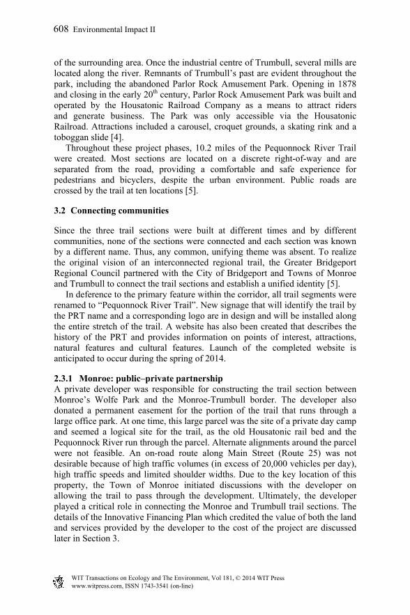
The “riverwalk” through Trumbull Center is the remaining section of the extension project. The design phase is expected to begin this summer and construction anticipated for 2016. Design has involved frequent coordination with the owner of the Trumbull Center shopping plaza. Plans include the renovation of a house into a visitor and information centre.
Figure 2: Pequonnock River trail.
610 Environmental Impact II
www.witpress.com, ISSN 1743-3541 (on-line) WIT Transactions on Ecology and The Environment, Vol 181, © 2014 WIT Press

3.3 Innovative financing plan for the Pequonnock River trail
Implementation and construction of the PRT was funded primarily through the FHWA’s Transportation Enhancement (TE) program. These federal aid funds were supplemented by state grants, Recreational Trails Program (FHWA) funds, local contributions and private donations. Due to the variety and use of these non-traditional funding sources, an Innovative Financing Plan (IFP) was developed and approved by the FHWA for the trail project. Through the IFP, any work completed by non-traditional means leverages federal dollars, rather than reducing the cost of the project. Innovative financing techniques are provided for under Section 323 of the National Highway System Designation Act of 1995. Typically, the local sponsor of a project is responsible for funding 20% of a project’s total cost. Innovative financing allows for donated funds, material and services to be utilized as the non-federal matching share. Both the value of land donated by private individuals and companies for right-of-way purposes and the value of construction services are eligible innovative financing techniques [5]. The IFP for the Pequonnock River Trail allowed for the following:
A single federal aid project was established for the entire Pequonnock River Trail. The project includes the design, right-of-way and construction phases for trail sections located in Monroe, Trumbull and Bridgeport. By establishing a single project, expenditures on various sections are accounted as part of an overall project, instead of as separate projects for individual sections.
The value of a donated permanent easement through an office park in Monroe was credited as the non-federal match requirement. As discussed in Section 3.2.1, a private developer donated a defined, permanent 25-foot easement to the Town of Monroe with the right to build and maintain a multi-use trail through the office park. The value of the easement was appraised at $62,000. Additional acquisition of private property was not necessary.
The private developer also constructed the trail section through the office park. Work included excavating, grading, labor, material and equipment. The value of the work credited to the non-federal match requirement was $160,600.
The Town of Trumbull constructed a section of the trail through Twin Brooks Park. The value of the work credited was $492,000.
As funds become available, any credits designated in the IFP can be allocated to match future federal allocations for the design and construction of remaining sections of the trail.
Credits from the non-traditional funding sources were allocated to the preliminary and final design activities for the trail extension from the end of the Pequonnock Valley in Trumbull and for the construction of three trail sections.
Given the financial constraints of the Transportation Enhancements program and the difficulty local communities have with appropriating the entirety of the
Environmental Impact II 611
www.witpress.com, ISSN 1743-3541 (on-line) WIT Transactions on Ecology and The Environment, Vol 181, © 2014 WIT Press

required 20% match, it is evident that the design and construction of the Pequonnock River Trail extensions would not have occurred without an IFP. The most vital component of the IFP was the credit provided by the activities of the private developer in Monroe. Without this plan, it is unlikely that the trail would be close to complete.
3.4 Future plans for the Pequonnock River trail
In the future, the PRT will extend south from Beardsley Park to Seaside Park, which borders Long Island Sound. Funding through the FHWA’s Congestion Mitigation and Air Quality (CMAQ) program was awarded to the City of Bridgeport for the project. Because this section will traverse an intensely developed and urban area in the City of Bridgeport, most of this trail section will consist of an on-road bicycle route. The project will also include enhancements to neighbourhoods traditionally underserved by the transportation planning process and will support existing neighbourhood revitalization efforts for sustainability, walkability and liveability. Like Beardsley Park, Seaside Park was designed by Frederick Law Olmsted and has a high historic and cultural value. This trail section will close the remaining gap in the trail and will represent the final piece in the 16-mile regional trail.
4 Final results: implementing watershed best management practices through transportation projects
As the Pequonnock River Trail generally follows the course of the Pequonnock River, the trail extension project is within the Pequonnock River watershed. The design of the extension project discussed above was concurrent with the process of developing the Pequonnock River watershed management plan. Coordination of these two projects became a critical task, as certain recommendations in the watershed plan could be implemented through the PRT extension project [5]. The design engineer for the trail project worked closely with the consultant to the watershed management plan committee. The result of this collaboration was the integration of objectives and the identification of actions that could be implemented through both planning efforts. While transportation projects often places stresses on the natural environment, the collaboration among a diverse range of stakeholders throughout the project illustrates that a transportation project can achieve economic and environmental sustainability. Specific actions identified in the watershed management that were incorporated into the design of the trail project are as follows: Removal of non-native, invasive vegetation along the banks of the
Pequonnock River. Invasive plants displace native species and threaten local biodiversity. Two areas were targeted: the area through the Trumbull Center shopping plaza and along the southern section of the trail within Beardsley Park. As part of the design, the presence and abundance of invasive species were noted and a management plan was prepared. The management plan discussed control strategies for the
612 Environmental Impact II
www.witpress.com, ISSN 1743-3541 (on-line) WIT Transactions on Ecology and The Environment, Vol 181, © 2014 WIT Press

eradication and treatment of invasive species. Design plans included the removal of the invasive vegetation and the re-planting of the areas with native plants.
Restore and repair riparian buffers. The existing stream channel has eroded over time and buffers have become overgrown with invasive vegetation and encroached upon by roadways and development. As part of the design plans, the clearing and grubbing along the trail within the riparian buffer will be limited. Along sections where existing structures, such as sidewalks, have encroached on the river, repairs will be made and structures will be relocated outside of the buffer area. In some cases, this will require the installation of new riprap material to stabilize the stream banks. Restoring and enhancing the riparian buffer will encourage infiltration of rainfall and provide absorption for high stream flows, which will help reduce flooding.
Protect and restore tree canopy and forest. Forest cover provides numerous benefits by providing habitat, reducing storm water runoff, and reducing stream and channel erosion. Tree removal will be limited during the construction of the trail and existing, mature trees will be protected. An extensive tree re-planting plan has been prepared for the section along Quarry Road to replace the trees lost because of clearing for the trail.
Cleaning of existing drainage structures. The PRT will be aligned along two abandoned local roads. The existing catch basins and drainage pipes have become clogged with debris. These will be cleaned and upgrade as part of the project. This action will help alleviate sediment and pollutants from entering the river.
Removal of concrete curbing along the existing road through Beardsley Park. The curbing channels storm water to catch basins for discharge into the Pequonnock River. As an alternative, the trail project will remove the curbing and allow storm water to sheet across the road and trail and infiltrate the land between the trail and the river. This will prevent pollutants from being discharged directly into the river.
Use permeable material for the trail surface. The trail will be aligned along sections of two abandoned local roads that have been closed to vehicle traffic for more than thirty years. Although the pavement structure is in poor condition, it still exists and creates a non-previous surface adjacent to the river. These sections will be removed and the trail will be constructed using a porous surface material to allow storm water to filter through and enter the ground. This will help remove sediment and pollutants and reduce the amount entering the river.
Install rain gardens for storm water control. These structures are used to capture, treat and infiltrate storm water before it is discharged to a water body. Opportunities exist to install rain gardens, bio-swales or storm water planters along the planned “riverwalk” section through the Trumbull Center shopping plaza. Currently, the area adjacent to the Pequonnock River is a large expanse of paved surface used for parking.
Environmental Impact II 613
www.witpress.com, ISSN 1743-3541 (on-line) WIT Transactions on Ecology and The Environment, Vol 181, © 2014 WIT Press

The design of this section will investigate rehabilitation and reconfiguration of the parking lot to better accommodate parking and help capture runoff.
Install informational signs to educate users about the river and its ecosystem. A key recommendation of the watershed management plan is public outreach and education about the value of the river eco-system and benefits to protecting it. The signage plan for the trail project will include references to watershed management and educational materials on the plants, species and habitat of the river environment.
References
[1] Greater Bridgeport Regional Council. Long Range Transportation Plan. 2011. Online http://www.gbrct.org/data-services/reports/transportation-2/#.UsXIsqAo6Uk
[2] Pequonnock River Initiative. Pequonnock River Watershed Based Plan. 2011.
[3] United States Census. 2010 Census Urban and Rural Classification and Urban Area Criteria. Online. https://www.census.gov/geo/reference/ua/ urban-rural-2010.html
[4] Sakal, Wayne. The Parlor Rock Story. Trumbull History.org. Online http://www.trumbullhistory.org/written/prock.shtml
[5] Bidolli, Brian T. and Mark Nielsen. Ecology in Motion: Using Transportation Funds for Watershed Management. International Conference on Ecology and Transportation. 2013.
614 Environmental Impact II
www.witpress.com, ISSN 1743-3541 (on-line) WIT Transactions on Ecology and The Environment, Vol 181, © 2014 WIT Press