Embed Size (px)
Citation preview
I
Watershed Development Department Government of Karnataka
India
Project Implementation Plan
OF
KARNATAKA WATERSHED PROJECT II (SUJALA III)
03 JULY 2015
II
ACRONYMS
AET : Actual Evapo Transportation
AHO : Assistant Horticultural Officer
AIR : All India Radio
ANTRIX : Antariksha
AO : Agricultural Officer
APD : Additional Project Director
ATMA : Agricultural Technology Management Agency
AWS : Automatic Weather Station
BMP : Best Management Practices
BPL : Below Poverty Line
CAS : Country Assistance Strategy
CB : Capacity Building
CBO : Community Based Organization
CEO : Chief Executive Officer
CGWB : Central Groundwater Board
CN : Concept Note
DAHVS : Department of Animal Husbandry and Veterinary Services
DEM : Digital Elevation Model
DL : Digital Library
DLC : District Level committee
DLRC : District Level Review Committee
DMG : Department of Mines and Geology
DOA : Department of Agriculture
DOAH : Department of Animal Husbandry
DOH : Department of Horticulture
DPC : Detail Project Committee
DPR : Detail Project Report
DSS : Decision Support System
DWDO : District Watershed Development officer
DWDT : District Watershed Development Team
EC : Executive committee
ED : Executive Director
III
EOI : Expression of Interest
ESMF : Environmental Social Management Framework
FM : Finance Management
FMPC : Finance Management and procurement cell
FYP : Five Year Plan
GIS : Geographic Information System
GOI : Government of India
GOK : Government of Karnataka
GP : Grama Panchayat
HD : Horticulture Department
HOPCOMS : Horticulture Producers Cooperative Marketing Society
ICAR : Indian council of Agricultural Research
ICRISAT : International Crops Research Institute for Semi Arid Tropics
ICT : Information Communication Tools
IDA : International Development Association
IIHR : Indian Institute of Horticultural Research
IISc : Indian Institute of Science
INM : Integrated Nutrient Management
IPM : Integrated Pest Management
ISO : International Standard Organization
ISRO : Indian Space Research Organization
IT : Information Technology
IUFR : Interim Unaudited Financial Reports
IWMP : Integrated Watershed Management Project
KSNDMC : Karnataka State Natural Disaster Monitoring center
KSRSAC : Karnataka State Remote Sensing Application Centre
KVA&FSW : Karnataka Veterinary, Animal and Fisheries Sciences University
KVKs : Krishi Vigyan Kendra
KWDP : Karnataka Watershed Development Project
LCC : Land Capability Class
LR : Land Resource
LRI : Land Resource Inventory
LU : Land Use
IV
M&E : Monitoring and Evaluation
MEL&D : Monitoring Evaluation, Learning and Documentation
MIS : Management of Information System
MNREGS : Mahatma Gandhi National Rural Employment Guarantee Scheme
MOA : Ministry of Agriculture
MOU : Memorandum of Understanding
MWs : Micro Watersheds
NABARD : National Bank for Agriculture and Rural Development
NBSS&LUP : National Bureau of Soil Survey and Land Use Planning
NGO : Non-Governmental Organization
NRAA : National Rainfed Area Authority
NREGS : National Rural Employment Guarantee Scheme
NRHM : National Rainfed Horticultural Mission
NRM : Natural Resource Management
OGC : Open Geo Consortium
PDO : Project Development objective
PEC : Project Empowered committee
PET : Potential Evapo Transpiration
PIA : Project Implementation Agency
PMSC : Project Management Support Cell
PPA : Pre Project Activity
PPMU : Project planning and Management Unit
PRA : Participatory Rural Appraisal
PTC : Project Technical Cell
R&D : Research and Development
RDPR : Rural Development and Panchayat Raj.
REC : Research and Extension Cell
RFO : Range Forest Officer
RIDF : Rural Infrastructure Development Fund
RRSSC : Regional Remote Sensing Service Centre
RSK : Raitha Samparka Kendras
SATCOM : Satellite Communication
SAUs : State Agricultural Universities
V
SC : Scheduled Caste
SDLC : Software Development Life Cycle
SHG : Self Help Group
SLNA : State Level Nodal Agency
SLUSI : Soil and Land Use Survey of India
SRS : System Requirement Specifications
ST : Schedules Tribe
SWS : Sub-Watershed
TGA : Total Geographical Area
TSP : Total Solution Provider
TWDO : Taluk watershed Development officer
TWDT : Taluk Watershed Development Team
UG : User Group
UHS : University of Horticultural Science
UK : United Kingdom
WA : Watershed Assistant
WAP : Watershed Action Plan
WB : World Bank
WC : Watershed Committee
WCDC : Watershed Cell cum Data Centre
WDD : Watershed Development Department
WMDSS : Watershed Management Decision Support System
ZP : Zilla Panchayat
ZREAC : Zonal Research and Extension Advisory Council
VI
CONTENTS
Particulars Page
No
Chapter-1
1 Introduction 1
1.1 Lessons learned in KWDP -I Sujala-I 2
1.2 Project Districts 2
1.3 Project Location and Beneficiaries 4
1.4 Project Approach 4
1.5 Implementation support 5
1.6 Key Focus Areas of the Project 5
1.7 Project Development Objective (PDO) 6
1.8 The project phasing and links with IWMP and NREGS 6
Chapter-2
2 Project Components
2.1 Component 1: Support for Improved Programme Integration in Rainfed
Areas
8
2.2 Component 2. Research, Development and Innovation 12
2.3 Component 3: Institutional Strengthening 15
2.4 Component 4. Strengthening Horticulture in Rainfed Areas 18
Chapter-3
3 Implementation Arrangements 24
3.1 Project Implementing Agency 24
3.2 Project Partners 24
3.3 Project Partners at different levels with Roles 25
3.4 Collaboration with other Agencies 29
3.5 Project Management 30
3.6 Project Planning and Management Unit 31
3.7 Project Technical Cell (PTC) 33
VII
3.8 Research and Extension Cell (REC) 33
3.9 Finance Management and Procurement Cell (FMPC) 33
3.10 Project management from District level to community level 34
3.11 Project Management Support Cell (PMSC) 34
3.12 Training Advisory Group 34
Chapter-4
4 Description of project components
4.1 Component 1: Support for Improved Programme Integration in Rainfed
Areas
35
Sub Component: 1.1 Development of a Digital Spatial-Data Library 35
Land Resource Inventory and GIS Database 36
Present Status of the Database 36
Role of the Nodal centres in acquiring primary and secondary data, mapping
and digitisation.
38
Community Inter-phasing 40
Responsibilities of the partners in the LRI 42
Training needs (Capacity building) for project personnel and user agencies 45
Training Framework to familiarize the use of DL, DSS and LR Portal 46
Action plan for covering 933 micro watersheds under Sujala III 49
A. Establishment and Maintenance of Digital Library 50
B. Establishment of Land Resources Portal (LR Portal) 54
Sub-component 1.2: Sub-Watershed Assessment (SWA) 57
Land Resource Survey 58
Thematic outputs needed 59
Land Resource maps 59
Preparation of conservation and Land Use Plan 61
Sub-component 1.3: Developing and piloting new decision-support models
(DSS)
63
Decision Support System 64
Functions of DSS (at different levels) 66
Utility of the System 67
Roles / Responsibilities of Partners / Agencies 68
Capacity Building and Training 68
VIII
Sub-component 1.4: Micro-watershed master planning 69
Participatory Planning 71
New Planning 71
Preparing plans 72
Role of Various partners / Agencies / Institutions during planning 72
Synchronizing the Sujala concept into IWMP 76
Action Points for NREGS Convergence 78
1.5. Intensive monitoring and documentation at local level 79
4.2 Component 2: Research, Development and Innovation 79
4.2.1 Research for integrated land management and agricultural intensification 80
4.2.2 Integrated Hydrological Assessment and Monitoring 84
4.2.3 Technology transfer 94
4.2.4 Strengthening research management 95
4.3 Component – 3 Institutional Strengthening-Capacity Building 101
4.3.1 Infrastructure improvements 103
Identified Workshops 104
Identified Modules 105
Identified Trainings 107
4.5 Component 5. Project Management and Coordination 110
4.5.1 Sub-component 5.1 Human resources 110
4.5.2 Sub-component 5.2 Financial management and procurement 111
4.5.3 Sub-component 5.3 Project monitoring and evaluation 112
Chapter-5
5 Pre Project Studies under taken under the KWDP-II (SUJALA-III) 119
5.1 Comprehensive Base line Survey of the project districts 119
5.2 Social Assessment Study 123
5.3 Environmental Assessment –EMF Report 126
Chapter 6
6 Right to Information Act 137
6.1 Schematic Diagram of RTI Structure 137
6.2 RTI Process Diagram 139
IX
6.3 Grievances Redressal 140
Annexure – I : Agro Climatic characteristics of Project districts 142
Annexure – II : Particulars of Watersheds proposed for KWDP – II (Phase I) 143
Annexure - III : Abstract of Watersheds proposed for KWDP – II (Phase I) 145
Annexure – IV : Need for Land Resource Inventory 146
Annexure – V : Sequence of activities involved in the execution of Land Resource
Inventory in watershed areas
148
Annexure - VI : Tools, Equipment and facilities required for LRI 156
Annexure – VII : Decision Support System 162
Acquisition of Pre-requisites for development of WMDSS 162
Development of WMDSS tool 162
Implementation of WMDSS 163
Annexure – VIII : Preparation of Net Plan and Detailed Project Report in IWMP 164
Annexure – IX : Schemes of Horticulture Department Suited to Watershed Areas 166
Annexure – X : Project monitoring indicators 168
Annexure – XI : Project Gantt Chart 177
Annexure – XII : Karnataka Watershed Development Project II and Integrated Watershed Management Programme – Process Diagram
200
Annexure - XIII : Project Cost Table 201
X
LIST OF FIGURES
Particulars Page
No 1 Project districts. 3
2 Organogram - Overall Project Management 29
3 Districts to be surveyed by the Nodal centres 41
4 Training Frame work in Component 1 45
5 Schematic figure indicating the flow of datasets from different sources
to the DL
51
6 Configuration of Digital Library 53
7 LP Deliverables 55
8 Schematic configuration of the Land Resources Portal 56
9 From Land Resource Inventory to Land Use Planning 62
9.1 Schematic representation of Component 1 63
10 Typical Workflow of WMDSS 66
11 New Planning Process 75
12 Integrated participatory approach in establishing the hydrological
monitoring network
92
13 Schematic Representation of component 2 97
14 Information Flow for Monitoring & Evaluation 118
1
Chapter-1
Introduction
Discussions between the World Bank, Government of India (GOI) and Government of
Karnataka (GOK) resulted in the formulation of a new Watershed Development
Project. Watershed Development Projects in Karnataka are popularly known as
“Sujala” (Su: is Good, Jala: is water). The proposed project will be known as Karnataka
Watershed Development Project II (KWDP II). This will be third in Sujala series
(SUJALA III). The Sujala I was World Bank assisted project implemented in 6
Districts during 2002 to 2009 whereas Sujala II is NABARD (RIDF) assisted project
implemented in 6 Districts during 2008 to 2014 other than Sujala I districts and also
proposed Sujala III districts.
The proposed new project will address the following three important areas:
• Integrating watershed development with all other land-based research and
developmental programmes. This would help rainfed farmers access a range of
information tools, adopt innovations and diversify crop, horticulture and livestock
production and improve the value chain through Best Management Practices
within their particular farming systems.
• Better understanding of hydrological dynamics for scientific management of
water and quantification of upstream and downstream effects of watershed
interventions to enable better targeted interventions to address surface and
groundwater management issues and minimise negative externalities.
• To develop science-based land and water management practices for effective
convergence of the IWMP approach with the employment-based MNREGS-
financed soil and water conservation programmes. This will enable Gram
Panchayats (GP), communities and policy makers to adopt scientific strategies to
tackle local problems and livelihood issues through a robust Decision Support
System.
Such interventions have so far not been a part of planned watershed development,
although some provisions for convergence into Watershed Net Plans exist. The
Watershed Development Department in Karnataka is well-positioned to pilot such an
approach by building on the success of the earlier Bank-supported Karnataka
Watershed Development Project I (KWDP -I) (Sujala-I).
2
1.1 Lessons learned in KWDP -I Sujala-I:
• Combining watershed and livelihoods interventions to establish quality economic
benefits.
• Knowledge of the hydrological behaviour of micro and macro-watersheds is
essential for effective management of the scarce water-resource.
• The participatory approaches adopted in Sujala-I for conservation and management
of natural resources helped to improved productivity and livelihoods.
• Concurrent monitoring and evaluation enable improvements in the implementation
of the project for success.
• Empowerment of lead farmers as local champions for future leadership encourages
farmers to adopt improved technologies.
In the backdrop of the range of lessons learnt, the proposed project design has been
evolved into a model that complements the ongoing IWMP through technical support
and facilitates convergence between IWMP and MNREGS (Mahatma Gandhi National
Rural Employment Guarantee Scheme) including the activities and programmes of line
departments.
The current KWDP-II (SUJALA-III) - project’s success depends on development of an
effective model for convergent-implementation-plan which would contribute to
sustainable improvements in conserving the productivity of natural resources and
livelihoods of small farmers in rainfed areas, while improving the effectiveness of
public expenditure.
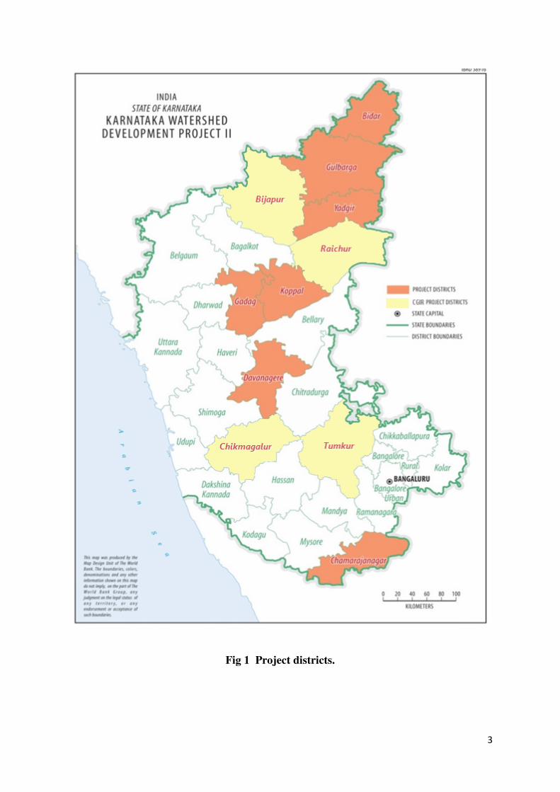
1.2 Project Districts
Karnataka Watershed Development Project II (Sujala-III) was to be implemented over
a period of six years and as a part of the centrally financed IWMP planned for the
selected 7 project districts, namely Bidar, Gulbarga, Yadgir, Gadag, Koppal,
Davangere, and Chamarajanagar subsequently 4 CGIAR districts such as Tumkur,
Bijapur, Raichur and Chikkamagalur were also added (Fig 1). The Agro Climatic
characteristics of Project districts is furnished in Annexure. – I
* IWMP is an ongoing GOI programme that supports participatory watershed management, preparation of soil and water conservation “net plans”, production systems and micro-enterprises, livelihood development through Self-Help Groups, and monitoring and evaluation of implementation and impacts.
3
Fig 1 Project districts.
4
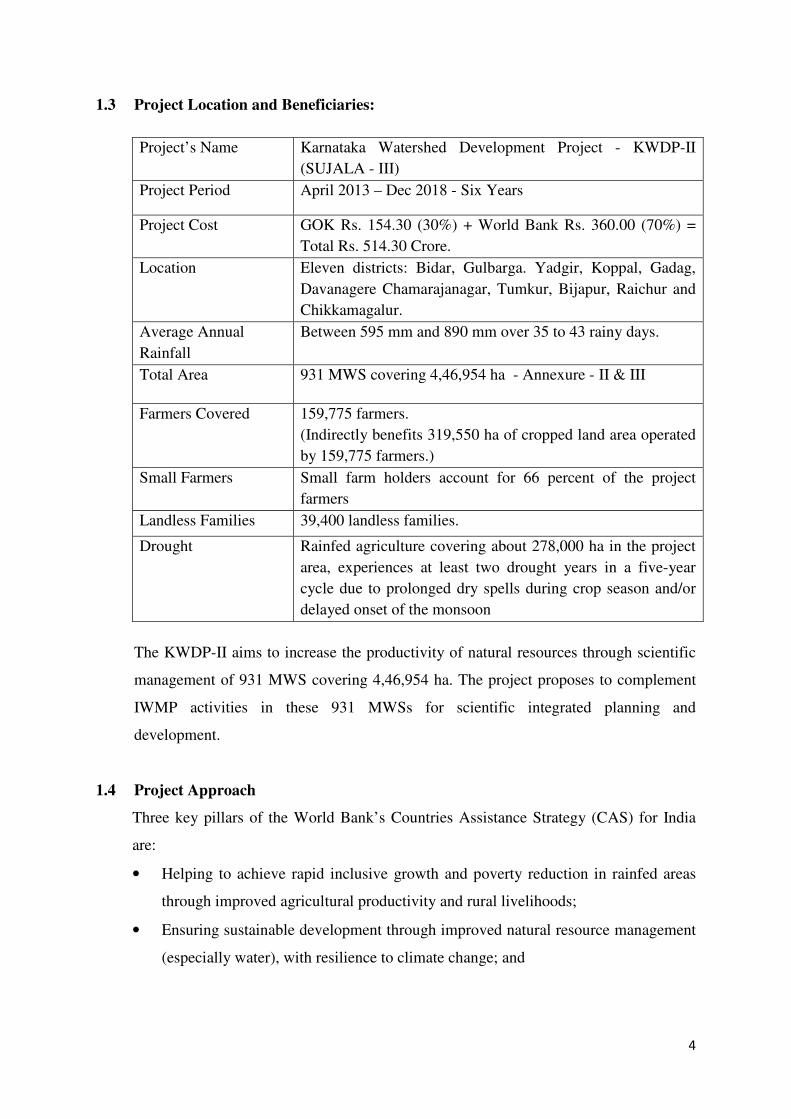
1.3 Project Location and Beneficiaries:
Project’s Name Karnataka Watershed Development Project - KWDP-II
(SUJALA - III)
Project Period April 2013 – Dec 2018 - Six Years
Project Cost GOK Rs. 154.30 (30%) + World Bank Rs. 360.00 (70%) =
Total Rs. 514.30 Crore.
Location Eleven districts: Bidar, Gulbarga. Yadgir, Koppal, Gadag,
Davanagere Chamarajanagar, Tumkur, Bijapur, Raichur and
Chikkamagalur.
Average Annual
Rainfall
Between 595 mm and 890 mm over 35 to 43 rainy days.
Total Area 931 MWS covering 4,46,954 ha - Annexure - II & III
Farmers Covered 159,775 farmers.
(Indirectly benefits 319,550 ha of cropped land area operated
by 159,775 farmers.)
Small Farmers Small farm holders account for 66 percent of the project
farmers
Landless Families 39,400 landless families.
Drought Rainfed agriculture covering about 278,000 ha in the project
area, experiences at least two drought years in a five-year
cycle due to prolonged dry spells during crop season and/or
delayed onset of the monsoon
The KWDP-II aims to increase the productivity of natural resources through scientific
management of 931 MWS covering 4,46,954 ha. The project proposes to complement
IWMP activities in these 931 MWSs for scientific integrated planning and
development.
1.4 Project Approach
Three key pillars of the World Bank’s Countries Assistance Strategy (CAS) for India
are:
• Helping to achieve rapid inclusive growth and poverty reduction in rainfed areas
through improved agricultural productivity and rural livelihoods;
• Ensuring sustainable development through improved natural resource management
(especially water), with resilience to climate change; and
5
• Increasing the effectiveness of service delivery, by covering integrated watershed
management with other development programmes adopting science-based
approaches.
The project specifically targets convergence of scientific knowledge and R&D
innovations in crop production and watershed management and strengthening of
institutional capacities to enhance overall productivity of natural resources.
The project involves the landscape-analysis approach for development of knowledge
base and design of decision tools to promote watershed participatory planning by
integrating programmes related to Agriculture, Horticulture, Forestry, Animal
Husbandry and Fisheries and Groundwater activities along with IWMP & MNREGS
for land development and NRM under Environment Social Management Framework
(ESMF).
1.5 Implementation support
Implementation support will focus on the quality of research and development (studies,
tools, etc), adoptive trials for demonstration and incorporation of these ideas in
watershed operations. Capacity building activities will also be reviewed, especially
those designed to strengthen agricultural extension service delivery. Other key areas of
focus for implementation support will be integration of sectoral development
programmes and broader programme convergence between IWMP and MNREGS with
soil and water conservation operations. Resulting in integrated participatory planning
process leading to improved IWMP planning process.
1.6 Key Focus Areas of the Project
KWDP-II (SUJALA-III) project will address following key areas:
• Improving the integration of watershed development, agricultural programmes, and
related research. This will help small farmers take up innovations and key schemes,
have better access to a range of information tools and support mechanisms,
improve value addition, and diversify crop, horticulture and livestock productivity
within their particular farming systems.
• Better understanding of hydrological dynamics based on good science and
integrated into watershed plans. This will help in better targeted interventions.
6
• Augmenting the capacity of the community as well as local institutions to
effectively integrate MNREGS watershed interventions, to address correct
positioning of structures, and to ensure technical quality.
• Thus, Dovetailing MNREGA with IWMP to ensure substantial improvements in
watershed quality.
• Shifting the approach of Gram Panchayat (GP) members and communities towards
science-based land management, and linking them into planning tools, which
would provide a more strategic approach for using MNREGS resources.
1.7 Project Development Objective (PDO):
The proposed Project Development Objective (PDO) is to demonstrate more effective
watershed management through greater integration of programmes related to rainfed
agriculture, innovative and science-based approaches, and strengthened institutions and
capacities.
1.8 The project phasing and links with IWMP and NREGS:
Year 1 : Institution strengthening, initiating key Research and Development
(R&D) studies, developing the data base. The IWMP shall engage with
participating communities through group formation, social mobilization
and training in Year 1. The Bank will simultaneously support the
activities around sub-watershed and micro-watershed planning to
broaden the focus of IWMP micro-watershed net plan preparation
processes by strengthening the land resource inventory and GIS database
input including hydrology. The GIS database work shall continue in the
second and third year to cover all the identified micro watersheds.
Year 2 : Link with IWMP Batch V & VI and MNREGS field activities through
planning and training. In Year 2, the effectiveness of IWMP will be
enhanced by better integration with agriculture, horticulture, agro-
forestry and MNREGS operations.
Year 3 : Post-harvest support, R&D, follow-on capacity building in IWMP Batch
V & VI areas. In Year 3, Bank supported initiatives will focus on
7
incremental activities to promote agricultural intensification across a
range of products, market development, value addition, etc, through
strengthened extension services
Year 4 and Year 5 :
A similar approach will be used in IWMP Batch VII & VIII operations
Year 6 : Consolidation and withdrawal from project sites
8
Chapter-II
Project Components
The project will be implemented through the following five components:
2.1 Component 1: Support for Improved Programme Integration in Rainfed Areas
This will test and demonstrate new planning by incorporating science-based approaches
especially hydrological modelling and decision tools and M&E approaches through
IWMP by convergence with other development programmes.
Implementation will be through the following five activities;
i) Developing and piloting new decision-support systems for integrated watershed
management through science-based land use planning.
ii) Development of a digital spatial-data library for integrated land use planning to
combine other development schemes for watershed management by the National
Bureau of Soil Survey and Land Use Planning (NBSS&LUP) in association with
consortium partners.
iii) Development and piloting of integrated sub-watershed assessment and planning,
with particular focus on broader hydrological dynamics of the 14 pilot sub-
watersheds (SWS).
iv) Strengthening integrated micro-watershed master planning under IWMP by
providing incremental support to the WDD and communities for more effective
linkages with agricultural, horticultural and livestock development programmes,
and convergence between IWMP and MNREGS; and
v) Strengthening community-based monitoring and documentation by providing
technical support for local M&E systems including simple groundwater monitoring
equipment and IT tools as well as training in participatory M&E.

9
Important Activities
Identified
Integration with programmes and agencies
SUJALA-III IWMP Partner Agencies,
Community & NGOs
Component-1. Support for Improved Program Integration in Rainfed Areas
activities.
Main Objective: Intervention of this component results in developing a scientific base
for participatory micro watershed master planning with suitable tools, technical and
knowledge support and Capacity Building Activities.
Establishment of
Digital Lib.(DL)
Main Activities
i. Developing and piloting new decision-support models for
integrated watershed management and site selection;
ii. Development of a spatial digital library for an integrated
landscape approach for watershed management planning by
the National Bureau of Social Survey and Land Use Planning
(NBSS&LUP), pulling together a range of data and map
layers, initially focusing on pilot watersheds, and establishing
a land resources portal for wider data access by stakeholders;
iii. Development and piloting of integrated sub-watershed
assessment and planning, with particular focus on broader
hydrological dynamics of the 931 watersheds. The activities
would include mapping, ground water planning and
modelling, and dissemination of recommendations for micro-
watershed planning;
iv. Strengthening integrated micro-watershed master planning
under IWMP by providing incremental support to the WDD
and communities for more effective linkages with agricultural
development programs, including horticulture and agro-
forestry.
Development and
Establishment of
Decision Support
System.(DSS)
Sub Watershed
Assessment on
scientific lines.
Participatory
micro-watershed
master planning.
Intensive
monitoring and
documentation at
local level
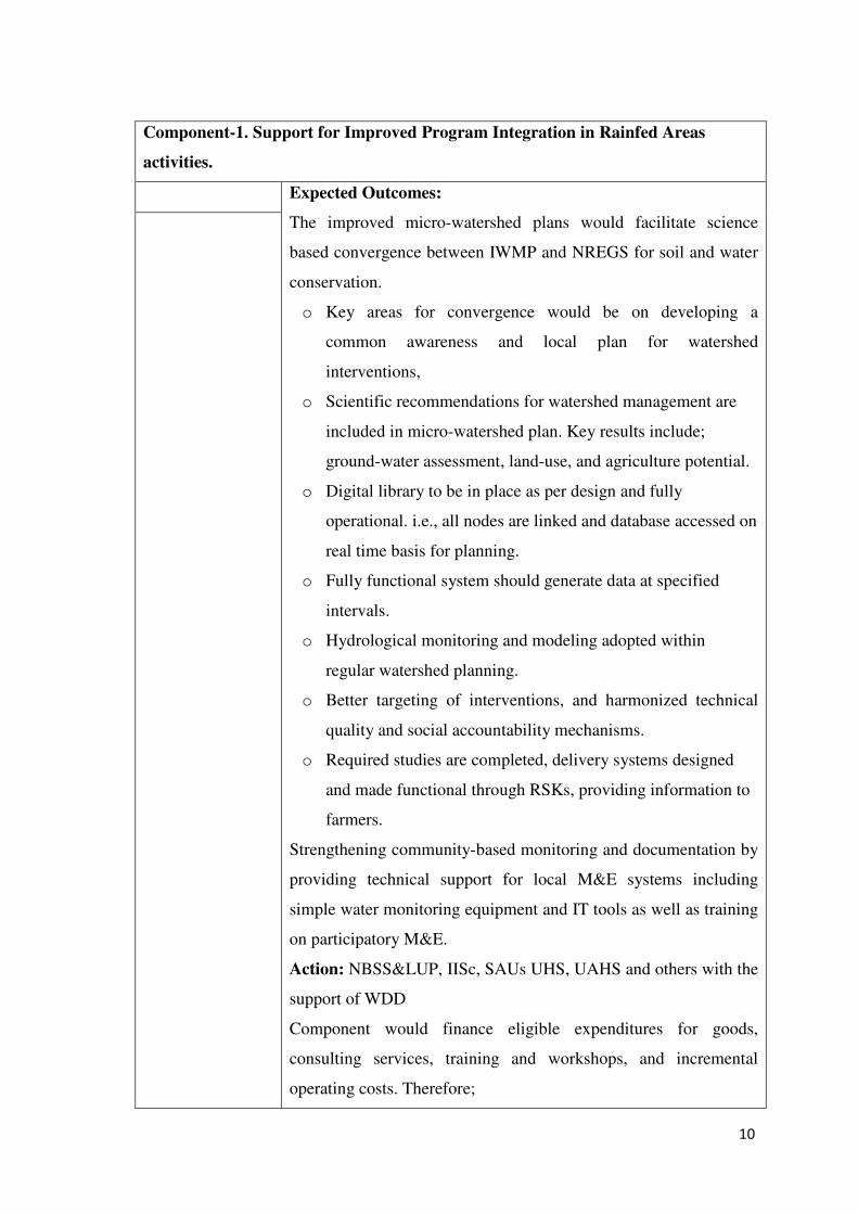
10
Component-1. Support for Improved Program Integration in Rainfed Areas
activities.
Expected Outcomes:
The improved micro-watershed plans would facilitate science
based convergence between IWMP and NREGS for soil and water
conservation.
o Key areas for convergence would be on developing a
common awareness and local plan for watershed
interventions,
o Scientific recommendations for watershed management are
included in micro-watershed plan. Key results include;
ground-water assessment, land-use, and agriculture potential.
o Digital library to be in place as per design and fully
operational. i.e., all nodes are linked and database accessed on
real time basis for planning.
o Fully functional system should generate data at specified
intervals.
o Hydrological monitoring and modeling adopted within
regular watershed planning.
o Better targeting of interventions, and harmonized technical
quality and social accountability mechanisms.
o Required studies are completed, delivery systems designed
and made functional through RSKs, providing information to
farmers.
Strengthening community-based monitoring and documentation by
providing technical support for local M&E systems including
simple water monitoring equipment and IT tools as well as training
on participatory M&E.
Action: NBSS&LUP, IISc, SAUs UHS, UAHS and others with the
support of WDD
Component would finance eligible expenditures for goods,
consulting services, training and workshops, and incremental
operating costs. Therefore;
11
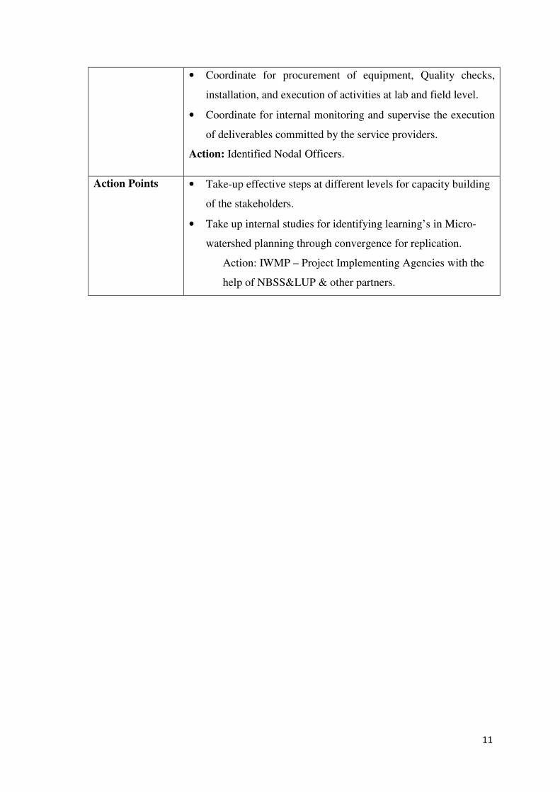
• Coordinate for procurement of equipment, Quality checks,
installation, and execution of activities at lab and field level.
• Coordinate for internal monitoring and supervise the execution
of deliverables committed by the service providers.
Action: Identified Nodal Officers.
Action Points • Take-up effective steps at different levels for capacity building
of the stakeholders.
• Take up internal studies for identifying learning’s in Micro-
watershed planning through convergence for replication.
Action: IWMP – Project Implementing Agencies with the
help of NBSS&LUP & other partners.
12
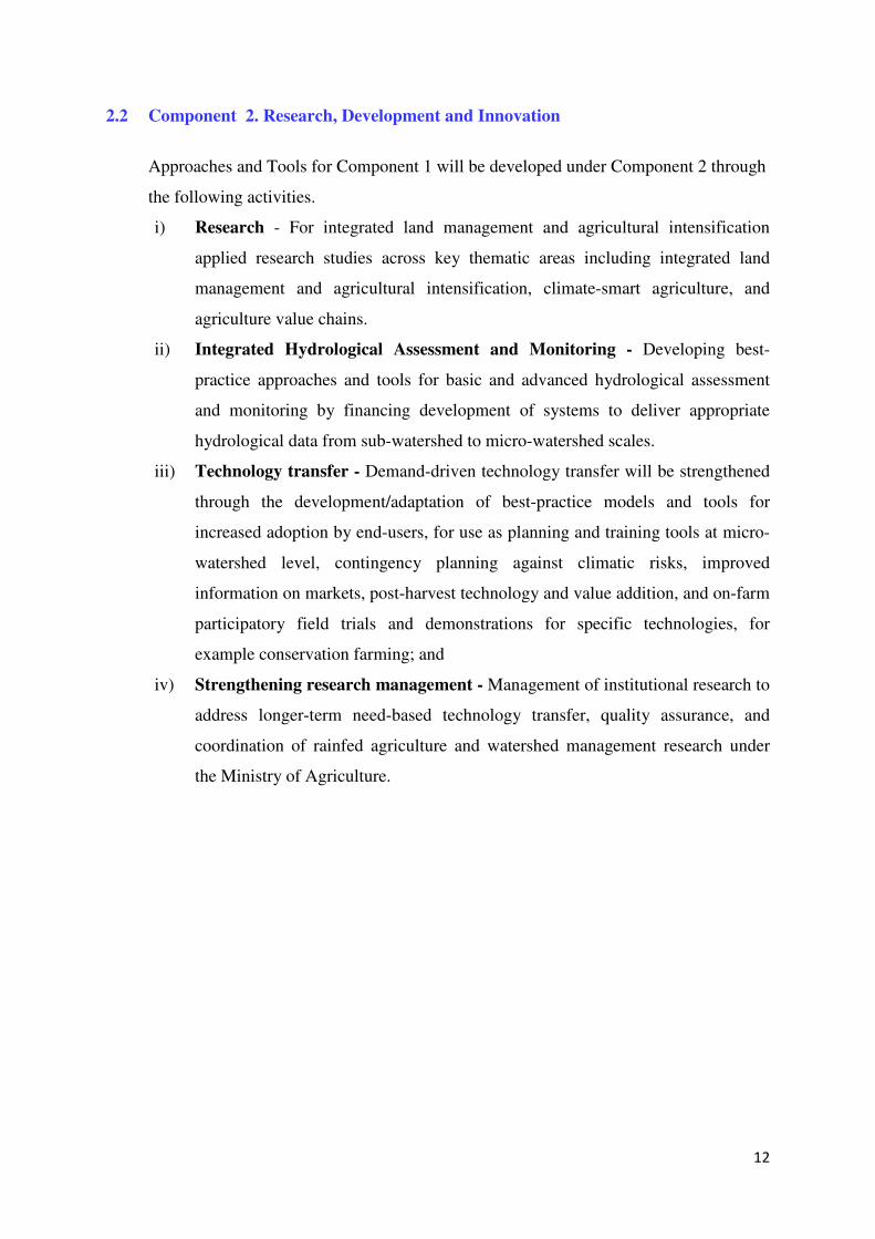
2.2 Component 2. Research, Development and Innovation
Approaches and Tools for Component 1 will be developed under Component 2 through
the following activities.
i) Research - For integrated land management and agricultural intensification
applied research studies across key thematic areas including integrated land
management and agricultural intensification, climate-smart agriculture, and
agriculture value chains.
ii) Integrated Hydrological Assessment and Monitoring - Developing best-
practice approaches and tools for basic and advanced hydrological assessment
and monitoring by financing development of systems to deliver appropriate
hydrological data from sub-watershed to micro-watershed scales.
iii) Technology transfer - Demand-driven technology transfer will be strengthened
through the development/adaptation of best-practice models and tools for
increased adoption by end-users, for use as planning and training tools at micro-
watershed level, contingency planning against climatic risks, improved
information on markets, post-harvest technology and value addition, and on-farm
participatory field trials and demonstrations for specific technologies, for
example conservation farming; and
iv) Strengthening research management - Management of institutional research to
address longer-term need-based technology transfer, quality assurance, and
coordination of rainfed agriculture and watershed management research under
the Ministry of Agriculture.
13
Important Activities
Identified
Integration with programmes and agencies
SUJALA-III IWMP Partner Agencies,
Community & NGOs
Component; 2 Research, Development and Innovation.
Main Objective: Intervention of this component would develop important
knowledge and tools for use in components 1 and 3, as well as for eventual
scaling-up in the State and beyond, through the following:
Research for
integrated landscape
management and
agricultural
intensification
Applied research studies across key thematic areas
including integrated landscape management and
agricultural intensification, climate smart agriculture,
and agriculture value chains.
Outcome:
• Studies would generate comprehensive knowledge
and lessons to support improved integrated
watershed management, evaluation and provide
guidelines for strengthening agriculture value
chains, and syntheses and adaptive research for
strengthening climate smart agriculture;
• Developing best practice approaches and tools for
basic and advanced hydrological assessment and
monitoring by financing development of systems to
deliver downscaled hydrological data to micro-
watershed scales based on appropriate models. The
component would also pilot community based
management of groundwater based on experiences
from other regions;
• Computer modeling allows us to better organize,
test, and refine our thinking about watershed
management problems and potential solutions.
Modeling to be organized the following areas:
o Precipitation and climate models;
o Precipitation-runoff models;
Integrated
Hydrological
Assessment and
Monitoring
Technology transfer
Strengthening
research management
14
o Stream and aquifer models;
o Infrastructure operations models;
o Economic, agronomic, social, environmental
demand and performance models;
o Decision-making models.
• Selecting the right model to apply to specific
problems requires that several factors to be
considered along with the objectives for modeling
in the context of the field decision problem.
• Demand-driven technology transfer strengthened
through the development/adaptation of best practice
models and tools for increased adoption by end-
users, which would include; Planning and training
tools at micro-watershed levels, Maps and climate
information for use by farmers in decision making,
Agro-climatic advisory risk systems, Improved
web-based information on markets, post-harvesting
and value addition, and on-farm participatory field
trials and demonstrations for specific technologies
like conservation farming;
• Research management to strengthen the institutional
arrangements for long-term need-based research
identification, technology transfer, research quality
assurance, and coordination of rainfed agriculture
and watershed management research under the
Ministry of Agriculture.
Action: PPMU - REC, IISc, and Service providers.
Action Points 1. The component would finance eligible expenditures
for goods, consulting services, training and
workshops, and incremental operating costs.
2. Processing for Inviting Expression of Interest (EOI)
as per the plan.
Action: PPMU/REC and Service providers.
15
2.3 Component 3: Institutional Strengthening
The capacity to use the tools and information systems, including key extension systems
of the Karnataka WDD to manage and monitor the programmes, will be strengthened
under components 3 and 4 (the latter with focus on horticulture).
The activities in Component 3 are:
i) Training and capacity-building, Training and capacity building to address the
needs of end users in terms of extension, integrated watershed management and
value addition. Towards this end, training modules shall be developed along with
awareness-raising activities and a structured set of exposure visits. Training will
be provided to village level extension agents (Watershed Assistants, Gopala
Mitras and Jala Mitras), community institutions, Gram Panchayat members, and
farmers. Special emphasis shall be given to lead farmers who could form a core
group as champions to provide peer-to-peer support to other farmers.
ii) WDD will engage a competent agency to undertake detailed training need
assessment and to develop training modules and tools to train stakeholders at
different levels and to delivers the training programmes. NGOs at district level
will assist the agency inn arranging for logistics for capacity building activities.
iii) Capacity building at State level. At state level, institutional strengthening will
include training to implementing agencies, particularly to handle DSS and use the
Digital Library, strengthening the development of in-house M&E systems,
supporting relevant national and international exposure visits, and improving
capacities in farmer contact centres in project areas.
iv) Upgrading two District Watershed Training centres servicing key project areas,
and strengthening their internal information technology (IT) systems to handle
activities related to capacity building of the stakeholders.
16
Important Activities
Identified
Integration with programmes and agencies
SUJALA-III IWMP Partner Agencies,
Community & NGOs
Component 3: Institutional Strengthening.
Objective of component 3 intervention is to address a need to make a range of tools,
some identified under component 2, and to make rainfed agriculture schemes more
accessible to enhance farmer adoption, strengthening information and extension
systems, to help farmers to improve integrated watershed management practices and
sustain rainfed productivity and incomes in long run.
Training and
capacity building
To address these above said issues the sub-components would
provide:
• Training and capacity building that would assess the needs of
end users in terms of extension, integrated watershed
management and value addition, and then development and
delivery of training modules, awareness raising activities, and
structured exposure visits.
• For this purpose specialized and experienced training NGOs
will be engaged to deliver most of the trainings. Take action to
procure qualified NGOs by following Banks procurement
methods.
• Action PPMU/REC and Service providers.
• Training would be provided to village level extension agents,
community institutions, Gram Panchayat members, and
farmers.
• Special emphasis would be given to lead farmers who would
form a core group as champions and peer-to-peer support to
other farmers;
• Institutional strengthening training at state level, would include
training to implementing agencies, particularly to strengthen
the development of in-house M&E systems,
• Supporting relevant national and international exposure visits,
Infrastructure
improvements
17
• Improving capacities of farmer contact centres in project areas;
• Upgrading two District Watershed Training centres servicing
key project areas, and strengthen their internal information
technology (IT) systems and for trainings.
Action: PPMU/REC and Service providers.
The component would finance eligible expenditures for goods,
consulting services, training, minor works, and incremental
operating costs.
Get the requirement list from the concerned and process for the
requirements as per the procurement procedures.
Action: PPMU/REC and Service providers.
18
2.4 Component 4. Strengthening Horticulture in Rainfed Areas
The aim is to strengthen the knowledge base regarding horticultural potential in rainfed
areas, and to demonstrate and build the capacity of institutions and communities to
improve production and value addition of horticultural products in project areas.
Project support will be provided through four sub-components:
i) Training and demonstrations for farmer groups (Sanghas) regarding annual and
perennial crops, nutrition gardens, water management, production methods and
diversification, etc;
ii) Soil and crop monitoring in horticultural crops: The returns from horticultural
crops are considered to be lower than in field crops due to inappropriate
management. Monitoring soils for fertility through soil and leaf analysis of the
plants on regular basis would help the farmers to use inputs as appropriate for
improving yield and through economic returns.
iii) Strengthening horticultural post-harvest management and value-addition through
technical support for identifying practices for various crops on harvest and post-
harvest management, feasibility studies and participatory value chain
investigations involving Horticultural Producers Cooperative Marketing and
Processing Society (HOPCOMS) in Karnataka. The Horticulture Department
(HD) skill-development programmes for Sanghas will be expanded through field
demonstrations.
iv) Supporting Horticulture Department to deliver the component through
incremental costs for specialist staff, travel, equipment and materials.
19
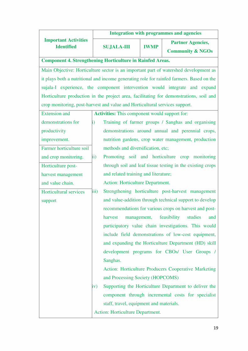
Important Activities
Identified
Integration with programmes and agencies
SUJALA-III IWMP Partner Agencies,
Community & NGOs
Component 4. Strengthening Horticulture in Rainfed Areas.
Main Objective: Horticulture sector is an important part of watershed development as
it plays both a nutritional and income generating role for rainfed farmers. Based on the
sujala-I experience, the component intervention would integrate and expand
Horticulture production in the project area, facilitating for demonstrations, soil and
crop monitoring, post-harvest and value and Horticultural services support.
Extension and
demonstrations for
productivity
improvement.
Activities: This component would support for:
i) Training of farmer groups / Sanghas and organising
demonstrations around annual and perennial crops,
nutrition gardens, crop water management, production
methods and diversification, etc;
ii) Promoting soil and horticulture crop monitoring
through soil and leaf tissue testing in the existing crops
and related training and literature;
Action: Horticulture Department.
iii) Strengthening horticulture post-harvest management
and value-addition through technical support to develop
recommendations for various crops on harvest and post-
harvest management, feasibility studies and
participatory value chain investigations. This would
include field demonstrations of low-cost equipment,
and expanding the Horticulture Department (HD) skill
development programs for CBOs/ User Groups /
Sanghas.
Action: Horticulture Producers Cooperative Marketing
and Processing Society (HOPCOMS)
iv) Supporting the Horticulture Department to deliver the
component through incremental costs for specialist
staff, travel, equipment and materials.
Action: Horticulture Department.
Farmer horticulture soil
and crop monitoring.
Horticulture post-
harvest management
and value chain.
Horticultural services
support
20
• The component would finance eligible expenditures for
goods, consulting services, training, and incremental
operating costs.
• Collect a detailed plan of Implementation from the
Horticulture Department.
• Process for the procurements based on the proposals
received by the HD as per the Procurement Policy of
WB project.
Action: PPMU/REC and Service providers
21
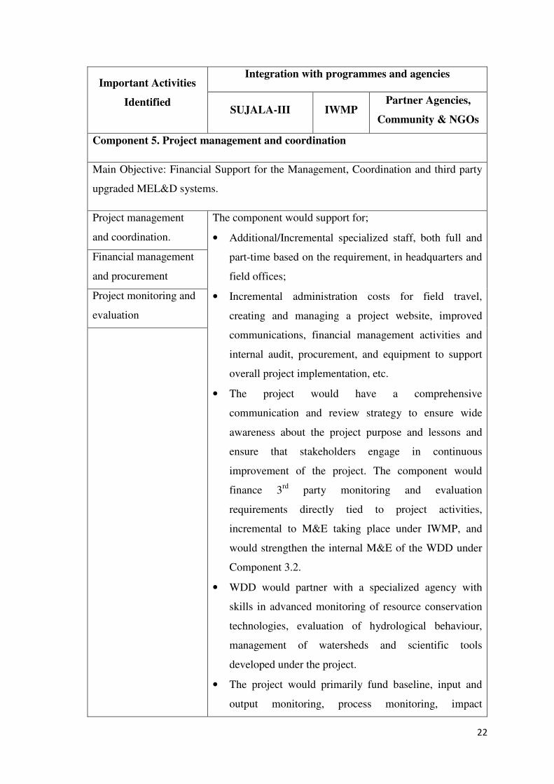
2.5 Component 5. Project Management and Coordination
This will provide incremental support to WDD to strengthen the IWMP coordination
and management systems already in place, and to ensure that the additional activities of
the project are effective.
Project support will be provided through three sub-components.
i) Project management and coordination - Overall project implementation support
through additional specialized technical staff (both full and part-time) in
headquarters and field offices, covering various fields including agriculture,
hydrology/meteorology, GIS/MIS, environment, training, documentation,
procurement, financial management, and legal services.
ii) Financial management and procurement - Through consultancies for financial
management, procurement, and audit to augment WDD capabilities and systems
costs for staff training in procurement and financial management procedures
prescribed by the Bank.
iii) Project monitoring and evaluation - Through third party monitoring and
evaluation relevant to project activities specifically, complementing the overall
M&E system operating under IWMP, which in turn would be further strengthened
under component 3.2
22
Important Activities
Identified
Integration with programmes and agencies
SUJALA-III IWMP Partner Agencies,
Community & NGOs
Component 5. Project management and coordination
Main Objective: Financial Support for the Management, Coordination and third party
upgraded MEL&D systems.
Project management
and coordination.
The component would support for;
• Additional/Incremental specialized staff, both full and
part-time based on the requirement, in headquarters and
field offices;
• Incremental administration costs for field travel,
creating and managing a project website, improved
communications, financial management activities and
internal audit, procurement, and equipment to support
overall project implementation, etc.
• The project would have a comprehensive
communication and review strategy to ensure wide
awareness about the project purpose and lessons and
ensure that stakeholders engage in continuous
improvement of the project. The component would
finance 3rd party monitoring and evaluation
requirements directly tied to project activities,
incremental to M&E taking place under IWMP, and
would strengthen the internal M&E of the WDD under
Component 3.2.
• WDD would partner with a specialized agency with
skills in advanced monitoring of resource conservation
technologies, evaluation of hydrological behaviour,
management of watersheds and scientific tools
developed under the project.
• The project would primarily fund baseline, input and
output monitoring, process monitoring, impact
Financial management
and procurement
Project monitoring and
evaluation
23
assessments, and case studies to guide project
implementation. The component would finance eligible
expenditures for goods, consulting services, training,
and incremental operating costs.
Action: PPMU, FMPC.
• The component would finance eligible expenditures for
goods, consulting services, training, and incremental
operating costs.
• Therefore, based on the procurement plan process for
formalities for Goods, Services and Training
consultancies by following procurement procedures.
Action: PPMU, FMPC.
24
CHAPTER - 3
Implementation Arrangements
3.1 Project Implementing Agency:
The WDD / DoH will be the implementing agency for the project and shall be
responsible for ensuring that the project development objectives are met.
3.2 Project Partners
The project will be partnering with many state and central organizations and agencies,
involved in research, development and management of natural resources in the state. In
this connection, Institutions involved in research and management of the natural
resources have been identified as service provider of a consortium members for
developing science-based watershed management plans under KWDP II (Sujala III).
Their proposed roles and responsibilities are listed below.
25
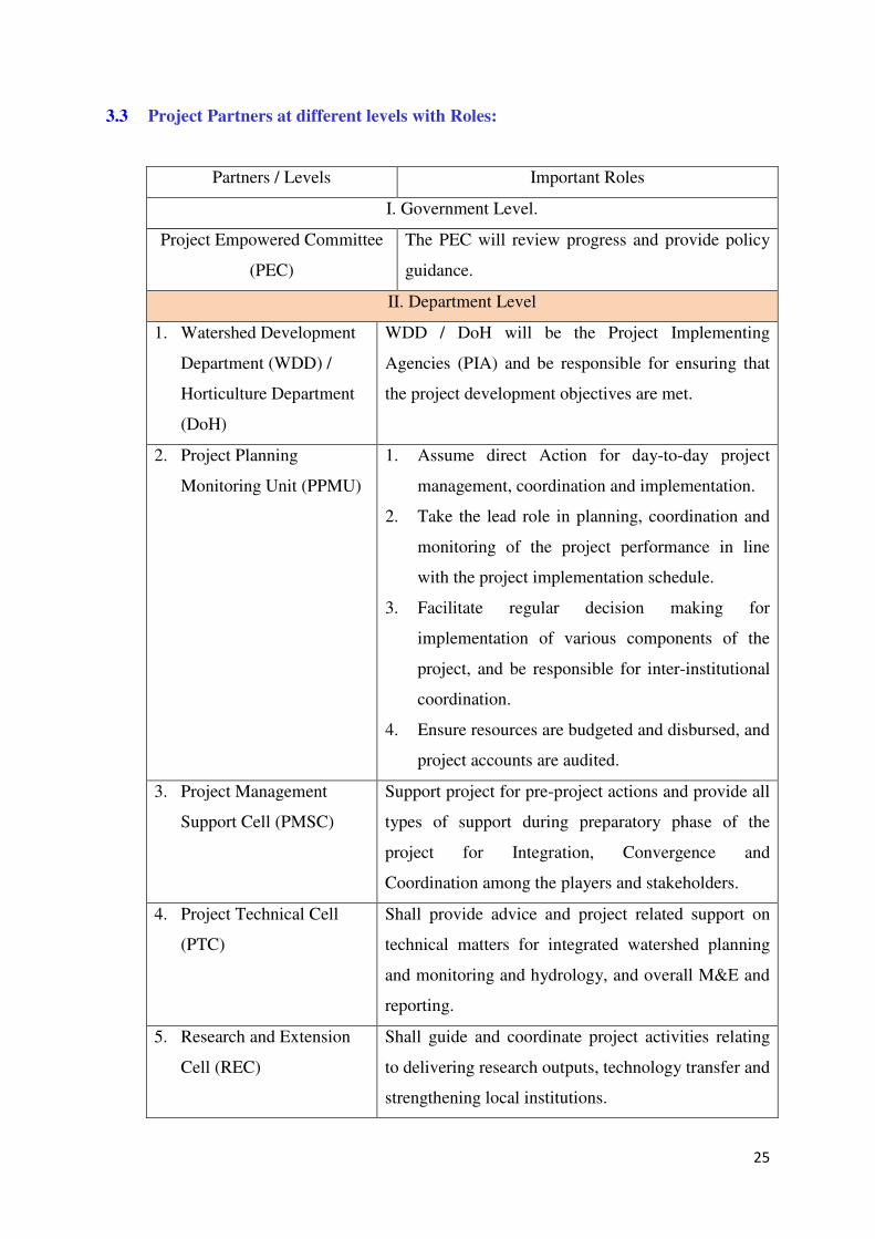
3.3 Project Partners at different levels with Roles:
Partners / Levels Important Roles
I. Government Level.
Project Empowered Committee
(PEC)
The PEC will review progress and provide policy
guidance.
II. Department Level
1. Watershed Development
Department (WDD) /
Horticulture Department
(DoH)
WDD / DoH will be the Project Implementing
Agencies (PIA) and be responsible for ensuring that
the project development objectives are met.
2. Project Planning
Monitoring Unit (PPMU)
1. Assume direct Action for day-to-day project
management, coordination and implementation.
2. Take the lead role in planning, coordination and
monitoring of the project performance in line
with the project implementation schedule.
3. Facilitate regular decision making for
implementation of various components of the
project, and be responsible for inter-institutional
coordination.
4. Ensure resources are budgeted and disbursed, and
project accounts are audited.
3. Project Management
Support Cell (PMSC)
Support project for pre-project actions and provide all
types of support during preparatory phase of the
project for Integration, Convergence and
Coordination among the players and stakeholders.
4. Project Technical Cell
(PTC)
Shall provide advice and project related support on
technical matters for integrated watershed planning
and monitoring and hydrology, and overall M&E and
reporting.
5. Research and Extension
Cell (REC)
Shall guide and coordinate project activities relating
to delivering research outputs, technology transfer and
strengthening local institutions.
26
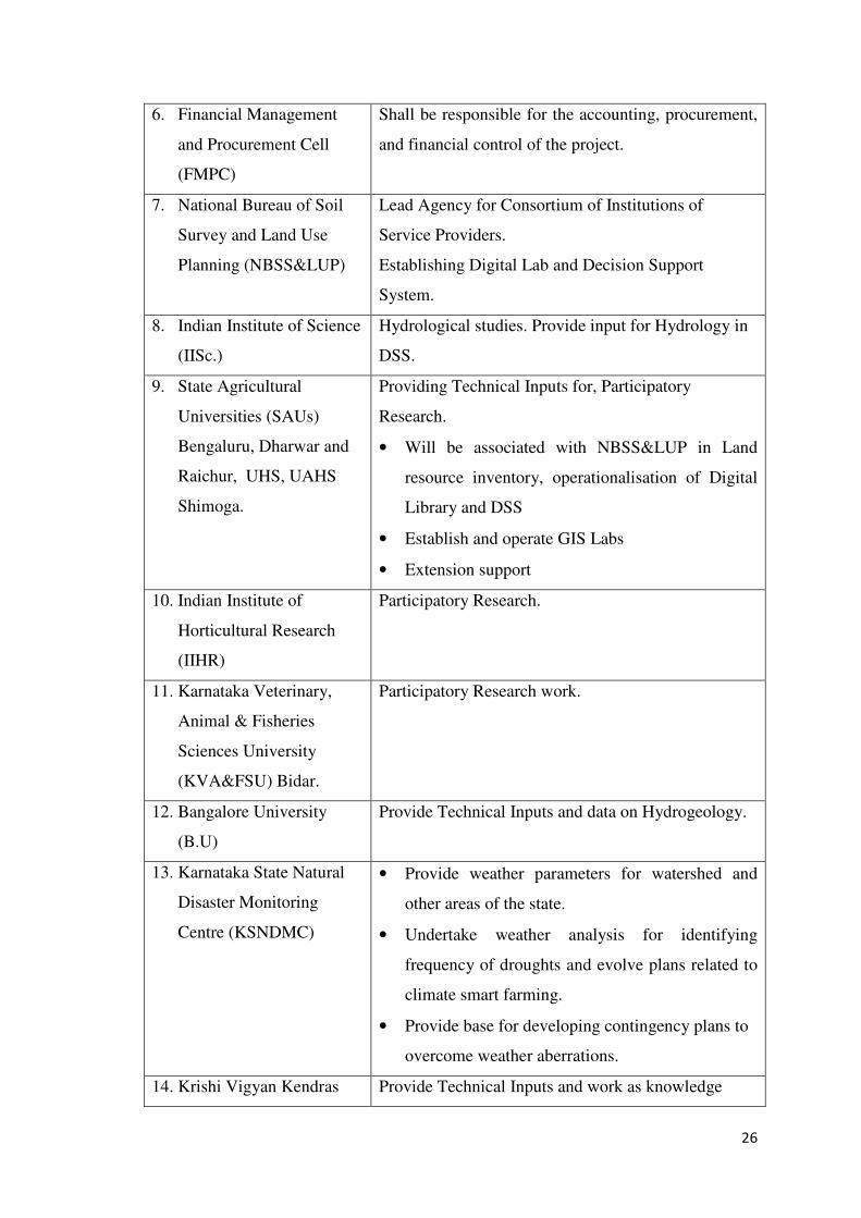
6. Financial Management
and Procurement Cell
(FMPC)
Shall be responsible for the accounting, procurement,
and financial control of the project.
7. National Bureau of Soil
Survey and Land Use
Planning (NBSS&LUP)
Lead Agency for Consortium of Institutions of
Service Providers.
Establishing Digital Lab and Decision Support
System.
8. Indian Institute of Science
(IISc.)
Hydrological studies. Provide input for Hydrology in
DSS.
9. State Agricultural
Universities (SAUs)
Bengaluru, Dharwar and
Raichur, UHS, UAHS
Shimoga.
Providing Technical Inputs for, Participatory
Research.
• Will be associated with NBSS&LUP in Land
resource inventory, operationalisation of Digital
Library and DSS
• Establish and operate GIS Labs
• Extension support
10. Indian Institute of
Horticultural Research
(IIHR)
Participatory Research.
11. Karnataka Veterinary,
Animal & Fisheries
Sciences University
(KVA&FSU) Bidar.
Participatory Research work.
12. Bangalore University
(B.U)
Provide Technical Inputs and data on Hydrogeology.
13. Karnataka State Natural
Disaster Monitoring
Centre (KSNDMC)
• Provide weather parameters for watershed and
other areas of the state.
• Undertake weather analysis for identifying
frequency of droughts and evolve plans related to
climate smart farming.
• Provide base for developing contingency plans to
overcome weather aberrations.
14. Krishi Vigyan Kendras Provide Technical Inputs and work as knowledge
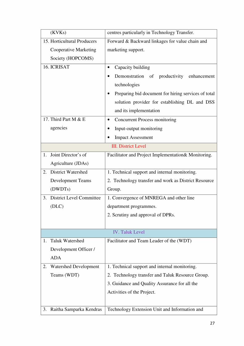
27
(KVKs) centres particularly in Technology Transfer.
15. Horticultural Producers
Cooperative Marketing
Society (HOPCOMS)
Forward & Backward linkages for value chain and
marketing support.
16. ICRISAT • Capacity building
• Demonstration of productivity enhancement
technologies
• Preparing bid document for hiring services of total
solution provider for establishing DL and DSS
and its implementation
17. Third Part M & E
agencies
• Concurrent Process monitoring
• Input-output monitoring
• Impact Assessment
III. District Level
1. Joint Director’s of
Agriculture (JDAs)
Facilitator and Project Implementation& Monitoring.
2. District Watershed
Development Teams
(DWDTs)
1. Technical support and internal monitoring.
2. Technology transfer and work as District Resource
Group.
3. District Level Committee
(DLC)
1. Convergence of MNREGA and other line
department programmes.
2. Scrutiny and approval of DPRs.
IV. Taluk Level
1. Taluk Watershed
Development Officer /
ADA
Facilitator and Team Leader of the (WDT)
2. Watershed Development
Teams (WDT)
1. Technical support and internal monitoring.
2. Technology transfer and Taluk Resource Group.
3. Guidance and Quality Assurance for all the
Activities of the Project.
3. Raitha Samparka Kendras Technology Extension Unit and Information and
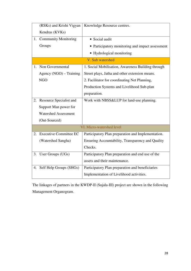
28
(RSKs) and Krishi Vigyan
Kendras (KVKs)
Knowledge Resource centres.
1. Community Monitoring
Groups
• Social audit
• Participatory monitoring and impact assessment
• Hydrological monitoring
V. Sub watershed
1. Non Governmental
Agency (NGO) – Training
NGO
1. Social Mobilisation, Awareness Building through
Street plays, Jatha and other extension means.
2. Facilitator for coordinating Net Planning,
Production Systems and Livelihood Sub-plan
preparation.
2. Resource Specialist and
Support Man power for
Watershed Assessment
(Out-Sourced)
Work with NBSS&LUP for land-use planning.
VI. Micro-watershed level
2. Executive Committee EC
(Watershed Sangha)
Participatory Plan preparation and Implementation.
Ensuring Accountability, Transparency and Quality
Checks.
3. User Groups (UGs) Participatory Plan preparation and end use of the
assets and their maintenance.
4. Self Help Groups (SHGs) Participatory Plan preparation and beneficiaries
Implementation of Livelihood activities.
The linkages of partners in the KWDP-II (Sujala-III) project are shown in the following
Management Organogram.
29
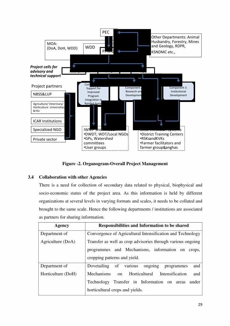
Figure -2. Organogram-Overall Project Management
3.4 Collaboration with other Agencies
There is a need for collection of secondary data related to physical, biophysical and
socio-economic status of the project area. As this information is held by different
organizations at several levels in varying formats and scales, it needs to be collated and
brought to the same scale. Hence the following departments / institutions are associated
as partners for sharing information.
Agency Responsibilities and Information to be shared
Department of
Agriculture (DoA)
Convergence of Agricultural Intensification and Technology
Transfer as well as crop advisories through various ongoing
programmes and Mechanisms, information on crops,
cropping patterns and yield.
Department of
Horticulture (DoH)
Dovetailing of various ongoing programmes and
Mechanisms on Horticultural Intensification and
Technology Transfer in Information on areas under
horticultural crops and yields.
ICAR Institutions
IWMP and NREGS:•DWDT; WDT/Local NGOs •GPs, Watershed committees•User groups
PTC
NBSS&LUP
Specialized NGO
PPMU
Agriculture/ Veterinary/ Horticulture Universities
& IISc
RECFMPC
WDDMOA: (DoA, DoH, WDD)
Other Departments: Animal Husbandry, Forestry, Mines and Geology, RDPR,
KSNDMC etc.,
Private sector
Component 1.
Support for
Improved
Program
Integration in
Rainfed Areas
Local extension systems•District Training Centers•RSKs and KVKs •Farmer facilitators and farmer groups, Sanghas
Component 2.
Research and
Development
Component 3.
Institutional
Development
Component 4.
Horticultural
PEC
Project partners
Project cells for advisory and technical support
30
Department of Animal
Husbandry and
Veterinary Services
(DAH&VS)
Incorporation of Animal husbandry programmes in the
Participatory Micro-plans for watersheds. Details of
livestock, breed improvement and diseases.
MNREGS Directorate Incorporation of MNREGS activities for Land Treatment in
the Participatory Micro-plans. Financial allocations for such
works.
Bangalore University
(B.U)
Integration of hydro-geological programmes in the
Participatory Micro-plans. Information on groundwater
status and functional wells.
Central Groundwater
Board (CGWB)
Hydro geological map and groundwater details
Indian Institute of
Horticultural Research
(IIHR)
Improved Package of practices, technological inputs and
problems and prospects of horticultural crops
Soil and Land Use
Survey of India
(SLUSI)
Partnering with the NBSS&LUP in field survey, review and
correlation
4.5 Project Management
The Project Empowered Committee (PEC) The PEC at the apex level will guide,
monitor and supervise the implementation of the ongoing IWMP. PEC will also guide
and monitor the WDD in implementing the KWDP II (Bank project), through IWMP.
The PEC is constituted by the members drawn from the line departments, GOI
representatives, Vice Chancellors of Agriculture Universities and is chaired by the
Additional Chief Secretary and Development Commissioner, GOK. In view of the
extended requirements for broader sector integration and convergence with NREGS
under the project, the PEC will include the Secretaries of Agriculture, Horticulture,
Planning, Finance, Animal Husbandry, Rural Development and Panchayat Raj plus the
Additional Principal Chief Conservator of Forests. The PEC will also include the
Director, Mines and Geology, and Director, KSNDMC. There will also be a
representation of civil society experienced in participatory and integrated watershed
management, as well as one from the private sector with adequate experience in
31
agricultural value chains in rainfed areas. The Commissioner - WDD will be Member
Secretary.
The PEC provides overall guidance on policy aspects relating to watershed
development, integration between departments, and convergence. The PEC will review
progress and shall provide policy guidance. It will also look into mid-course
corrections, and issue guidelines for smooth implementation of the project. This will
complement the ongoing IWMP responsibility of the PEC to approve the perspective
and strategic plan for watershed development on the basis of block and district plans.
The PEC will work closely with the SLNA in IWMP presently which acts as a link
between the state and the Central Nodal Agency at GOI level for appraisal and
clearance of watershed programmes, and thus provides a channel to raise wider policy
issues relating to the project. The PEC issues financial and administrative sanctions,
organize recruitments, and assign works and consultancies as required by the project. It
will approve the annual implementation plan, and procurement of goods (by the line
departments) exceeding Rs. 10 million (US$217,400), and works and services required
by the line departments exceeding Rs. 1 million (US$21,739).
3.6 Project Planning and Management Unit
At the state level, a Project Planning and Management Unit (PPMU) will be set up
within the WDD and shall assume direct responsibility for project management. The
Commissioner - WDD in Bangalore will be the Project Director responsible for overall
project implementation. For effective day-to-day coordination of project
implementation, the Commissioner will be assisted by a full-time Executive Project
Director, who is also the Additional Project Director (APD) Coordination. The
members of the PPMU will be the sectoral heads of Agriculture, Forestry, Horticulture
and Animal Husbandry in WDD headquarters, the Director of Mines and Geology,
Director of Horticulture, Director of NREGS as well as Director of the Disaster
Monitoring Cell GOK, Directors of Research of different universities and the Head,
NBSS&LUP, Bangalore will be members. An expert on groundwater will also be a
member. The Executive Project Director will be the member Secretary.
The PPMU will take the lead role in planning, coordination and monitoring of project
performance in line with the existing IWMP implementation schedule, and facilitate
32
decision-making for implementation of various components of the project, and be
responsible for inter-institutional coordination. It will also ensure that requirements are
budgeted, be in charge of all project procurement, manage disbursements, and ensure
that project accounts are audited. Specific responsibilities of the PPMU will be:
a) Preparing annual work programmes, budgets, annual procurement plans and
packages
b) Coordinating and providing technical support to field-implementation teams
c) Informing, supporting, coordinating and interacting with key project partners, and
ensuring key stakeholder participation;
d) Coordinating and reporting the results of monitoring and evaluation of all aspects of
project input, outputs and outcomes, as observed by MEL & D agencies the
incorporeity learning in the project;
e) Monitor project risks and accountability mechanisms;
f) Preparing withdrawal applications for disbursements for submission to IDA;
g) Maintaining project accounts and arranging for project audits to be done on time
and as per specifications;
h) Preparing quarterly Interim Unaudited Financial Reports (IUFRs),
i) To plan and execute capacity-building programmes for different stakeholders in the
project to realize the stated goals.
Project funds will be disbursed through the PPMU, which will be responsible for all
contracting and procurement in the project, across all components, as advised by
technical staff, and consultants and specialized agencies contracted for the purposes.
The PPMU will approve procurement of goods by the WDD up to Rs.10 (USD217,
400) million, and works and services required by the WDD and the line departments up
to Rs.1million (USD21,739). The WDD will develop agreements with respective
agencies for the handover and ownership and maintenance of any equipment purchased
by the PPMU.
The Executive Project Director shall be assisted by: i) a project technical cell (PTC); ii)
a Research and Extension Cell (REC); and iii) a Financial Management and
Procurement cell (FMPC). The PTC, REC and FMPC would in turn be aided by
specialist consultancies in the development of appropriate management systems and
related training to ensure PPMU staff can deliver their required tasks.
33
3.7 Project Technical Cell (PTC) to be established in the WDD shall comprise experts in
hydrogeology, soils, groundwater, agricultural meteorology, agricultural engineering,
economics M&E, GIS/MIS and documentation. This cell will assist the PPMU in
dealing with the day-to-day technical aspects of the implementation of the project. The
PTC will be responsible for coordinating with agencies and universities on technical
matters. It will work closely with the research and extension cell (see below) for
integration of research and development products into the IWMP planning processes. It
will be the unit primarily responsible for overseeing the project M&E and reporting.
3.8 Research and Extension Cell (REC) will be established under the PPMU to
coordinate all aspects of research and extension. The REC will guide and coordinate
activities relating to delivering research outputs, technology transfer and strengthening
local institutions. The REC will be headed by a senior technical advisor, with two
experienced staff deputed from the Department of Agriculture: and one from the
Planning unit for research, and one from Extension and Training. Additionally an
officer from the Department of Horticulture will be assigned to this cell. A training
coordinator and documentation officer will support them. The REC will be responsible
for the overall guidance of the research process, advising on procurement of research
consultancies, facilitating coordination and partnerships with research agencies,
universities, and government departments. It will also oversee capacity-building NGOs
and private sector, and evaluate research products and their use, ensuring linkages to
technology transfer and dissemination (mainly delivered under component 3). As there
will be a considerable number of training packages to be developed and delivered, the
REC will be assisted by a lead NGO specialized and experienced in agricultural
research/ training and participatory extension.
3.9 Finance Management and Procurement Cell (FMPC) will be established in the
WDD under the PPMU for financial and procurement control. The project will have a
full-time qualified Finance Manager to be assisted by staff in each of the seven project
Districts, including dedicated staff to assist in accounts under the horticulture
component. Financial management and procurement consultants will be hired on
consultancy/staff basis to assist the PPMU in designing, establishing, and monitoring
the FM systems, software installation, and processes for handling finance and
procurement issues under the project.
34
3.10 Project management from District level to community level At District and Taluk
levels the project will provide support staff, training and equipment to build capacity
and strengthen the arrangements already in place, mainly the existing DWDTs and
WDT under the IWMP. The REC supported by outsourced specialized NGOs will build
capacity of existing agricultural and horticultural extension units, especially RSKs, so
that the local units can access and use a greater range of information products, decision
tools, and manage field demonstrations.
3.11 Project Management Support Cell (PMSC)
A project Management and Support Cell will be established in WDD. The Executive
Director will head the cell. It undertakes various pre project activities. All the sectoral
heads in WDD will be the members and the Agriculture & Horticulture Departments
will nominate a senior functionary to this cell. This cell will meet periodically and
review pre project activities and liaison with all partner agencies.
3.12 Training Advisory Group
A Training Advisory Group will be set up within REC at WDD to assist the Executive
Director in monitoring and supervision of various programs and its integration with
IWMP training process.
35
Chapter 4
Component-wise implementation Arrangements
4.1 Component 1: Support for Improved Programme Integration in Rainfed Areas
This component involves DL, LRP & DSS to provide scientifically interpreted data sets
for microwatershed master planning process. The activities under this component will
enrol participation and assistance by technical partners and SAUs and SHU. MoUs will
be developed in co-ordination with concerned partner agencies.
Sub Component: 1.1 Development of a Digital Spatial-Data Library:
Purpose:
To Providing single window access system for Geospatial and other Agriculture-related
information for the farming community, researchers, planners and all other users from
agriculture and allied sectors facilitating Integrated landscape approach for planning
effective watershed management.
Location: National Bureau of Soil Survey and Land Use Planning (NBSS&LUP)
Bengaluru and 5 partner Universities. As a part of DL development 6 GIS labs (one at
NBSS&LUP and Four at partner Agriculture and Horticulture universities) will be
established. Project will provide necessary man power support.
Objectives:
• Generation of site-specific land-resource database in a digital form at the watershed
level.
• Design of a suitable architecture for the integrated digital data base storage
• Develop appropriate protocols for data sharing, definitions and use
• Guide in the development of e-solutions for integrated watershed management
• Provide inputs for establishment of a Land Resources Portal
Note : Component 4 Horticulture - Implementation arrangements separately compiled by Horticulture
Department
36
Strategy:
• Land Resource inventory to assess bio-physical status of natural resources through
mapping and digitization on GIS platform.
• Pooling of relevant information from sources and organisations; compilation,
synthesis and analysis of primary and secondary data on climate, surface water and
groundwater, land use, crops and cropping pattern, socio-economic parameters etc.
of the watershed area.
• Interpretation of the data and generation of reports and maps on GIS platform
• Operationalization of Digital Spatial-data Library
Implementation
This involves two stage i) Land resource Inventory and ii) Development and
Establishment of Digital Library.
Land Resource Inventory and GIS Database
Need for Land Resource Inventory
Karnataka state, with an area of 19.17 M.ha, is endowed with varied climate, fauna and
flora, soils, forests, minerals and rivers. The natural resources, which have enriched the
social fabric of the state, are under severe stress due to population pressures and
competing demands on land resources. This has resulted in large scale land degradation
(about 7 m.ha), which is continuing at an alarming rate, and requires urgent and
effective remedial interventions. This calls for assessment of potential and constraints.
Often the problems are site-specific necessitating farm-level intervention to bring in the
desired change or impact. The detailed site-specific information at watershed level,
particularly on soil and site characteristics is not available at present in the state. Many
studies carried out in various parts of the country, including the recent one carried out in
Tirumale sub-watershed near Magadi under IWMP, have proved conclusively the
importance of site-specific database for watershed planning and programme
implementation in the state. (See Annexure IV)
Present Status of the Database:
• At present land resources are characterized at macro level (1:250,000 and 1:50,000
scales) with respect to certain parameters to broadly indicate the type/category to
differentiate through visual observations with limited ground checks.
37
• Land resources inventory for different uses at cadastral level has not been generated
so far in the state.
• Hydrological information and vegetation details at larger scale are not available as
Spatial information.
• Socio-economic features are not available to know the needs and demands as well as
strengths and weaknesses to promote equity, inclusiveness and improving economic
status.
Next Action:
For watershed development site-specific spatial information on various land resources
is required and the same can be obtained by carrying out detailed characterisation and
mapping of all the existing land resources like soils, climate, minerals and rocks,
groundwater, vegetation, crops, land-use pattern, socio-economic conditions,
infrastructure and marketing facilities.
Execution:
The Land Resource Inventory (LRI) is carried out by using cadastral map in
conjunction with Cartosat imagery as base. The land parcels or survey numbers having
similar soil-site characteristics are grouped as one management unit and this helps
greatly in planning and implementation of various watershed development programmes.
The National Bureau of Soil Survey and Land Use Planning, Regional Centre,
Bangalore will lead the consortium of Institutions identified in the state, for organizing
the cadastral level Land Resource Inventory and Mapping. It will provide technical
facilitation whereas the WDD will facilitate the consortium of institutions by financing
necessary manpower, equipment and goods required by the consortium of institutions to
undertake LRI. The NBSS&LUP will enter into MoU with the WDD and will be
responsible for Land Resource Inventory. It will have suitable linkages with IISc, the
KSNDMC and the SAUs. The required Maps and Imageries will be made available to
the NBSS&LUP and Universities.
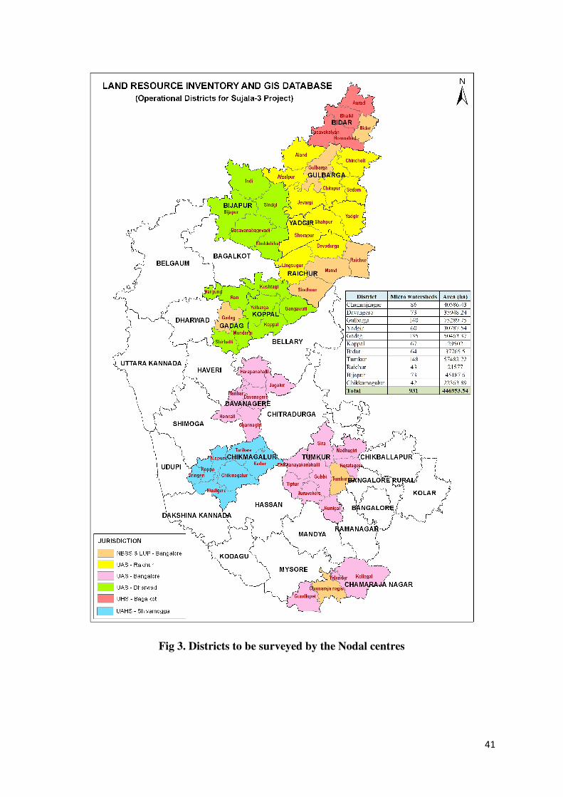
Four Agricultural Universities and one Horticultural University in different
zones/Districts of the project (Fig 3) will act as Nodal Centres for LRI field inventory.
Each university will have four trained field parties to carry out field work for land
resource assessment. Standard protocols will be followed in the execution of the
38
inventory (See Annexure V). The IISc and B.U will provide the details of Hydrological
parameters to be surveyed during LRI.
Primary data will be organized through field surveys. Secondary data will be collated
from Departments of Agriculture, Horticulture, Animal Husbandry, Minor Irrigation,
and Economics and Statistics. The Karnataka Watershed Development Department will
facilitate the above efforts of the partners.
The following Remote Sensing data required will be procured by KSRSAC and
provided to the NBSS&LUP for the use in LRI by the consortium partners.
• Digitised, geo-referenced cadastral base maps and remote sensing datasets, maps
and outputs pertaining to the micro-watershed area.
• Cartosat 1 imagery (Pan+LISS IV, ortho) for the Sujala watershed area first and
later for the entire state (hard and soft copy).
• Required remote sensing Imageries for the entire state (Present and legacy data) at
different scales, (soft and hard copy).
• Temporal data of suitable resolution (1:12,500) for three seasons for the watershed
area
• DEM at the micro-watershed and sub-watershed levels for the operational area
Role of the Nodal centres in acquiring primary and secondary data, mapping and
digitisation.
The Universities of Agricultural Sciences (Bangalore, Dharwad and Raichur),
University of Horticultural Sciences (Bagalkot) and University of Agriculture and
Horticulture Sciences (Shimoga) will be the Nodal Centres for LRI field investigation.
Each nodal centre will have four field parties of trained manpower and they will be
deployed for field work in the identified districts, as per the schedule given below. The
NBSS&LUP will train the field partners besides undertaking LRI works.
39
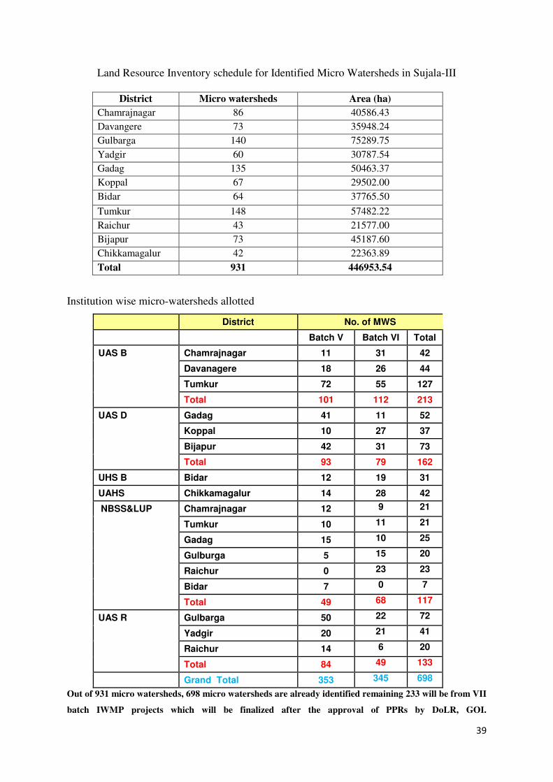
Land Resource Inventory schedule for Identified Micro Watersheds in Sujala-III
District Micro watersheds Area (ha)
Chamrajnagar 86 40586.43
Davangere 73 35948.24
Gulbarga 140 75289.75
Yadgir 60 30787.54
Gadag 135 50463.37
Koppal 67 29502.00
Bidar 64 37765.50
Tumkur 148 57482.22
Raichur 43 21577.00
Bijapur 73 45187.60
Chikkamagalur 42 22363.89
Total 931 446953.54
Institution wise micro-watersheds allotted
District No. of MWS
Batch V Batch VI Total
UAS B Chamrajnagar 11 31 42
Davanagere 18 26 44
Tumkur 72 55 127
Total 101 112 213
UAS D Gadag 41 11 52
Koppal 10 27 37
Bijapur 42 31 73
Total 93 79 162
UHS B Bidar 12 19 31
UAHS Chikkamagalur 14 28 42
NBSS&LUP Chamrajnagar 12 9 21
Tumkur 10 11 21
Gadag 15 10 25
Gulburga 5 15 20
Raichur 0 23 23
Bidar 7 0 7
Total 49 68 117
UAS R Gulbarga 50 22 72
Yadgir 20 21 41
Raichur 14 6 20
Total 84 49 133
Grand Total 353 345 698
Out of 931 micro watersheds, 698 micro watersheds are already identified remaining 233 will be from VII
batch IWMP projects which will be finalized after the approval of PPRs by DoLR, GOI.
40
Community Inter-phasing
The IWMP NGO in the watersheds will provide necessary community inter-phasing in
close coordination with the WDT. Before commencing the Land Resources Inventory
at Micro-watershed level stakeholder workshops and training programmes will be
organised with audio-visual aids developed by NBSS&LUP.
The NBSS&LUP, will also
• Organize training programmes for field parties,
• Plan and review the progress of survey different watersheds,
• Analyse of soil samples collected from the correlated soil series; and
• Finalisation of maps and reports.
The tools and equipment required and facilities and maps inputs needed to execute the
LRI project in the eleven districts of the state are furnished in Annexure -VI.
41
Fig 3. Districts to be surveyed by the Nodal centres
42
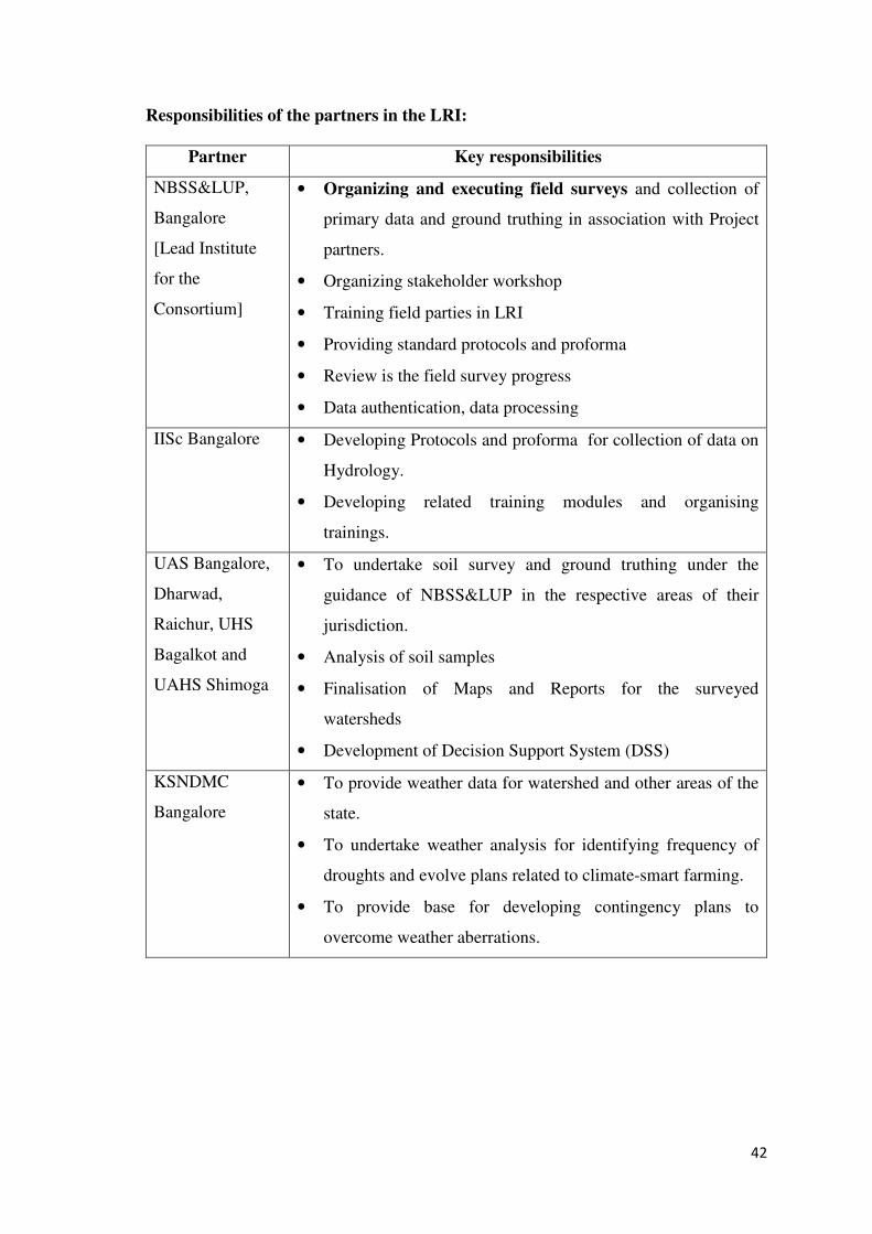
Responsibilities of the partners in the LRI:
Partner Key responsibilities
NBSS&LUP,
Bangalore
[Lead Institute
for the
Consortium]
• Organizing and executing field surveys and collection of
primary data and ground truthing in association with Project
partners.
• Organizing stakeholder workshop
• Training field parties in LRI
• Providing standard protocols and proforma
• Review is the field survey progress
• Data authentication, data processing
IISc Bangalore • Developing Protocols and proforma for collection of data on
Hydrology.
• Developing related training modules and organising
trainings.
UAS Bangalore,
Dharwad,
Raichur, UHS
Bagalkot and
UAHS Shimoga
• To undertake soil survey and ground truthing under the
guidance of NBSS&LUP in the respective areas of their
jurisdiction.
• Analysis of soil samples
• Finalisation of Maps and Reports for the surveyed
watersheds
• Development of Decision Support System (DSS)
KSNDMC
Bangalore
• To provide weather data for watershed and other areas of the
state.
• To undertake weather analysis for identifying frequency of
droughts and evolve plans related to climate-smart farming.
• To provide base for developing contingency plans to
overcome weather aberrations.
43
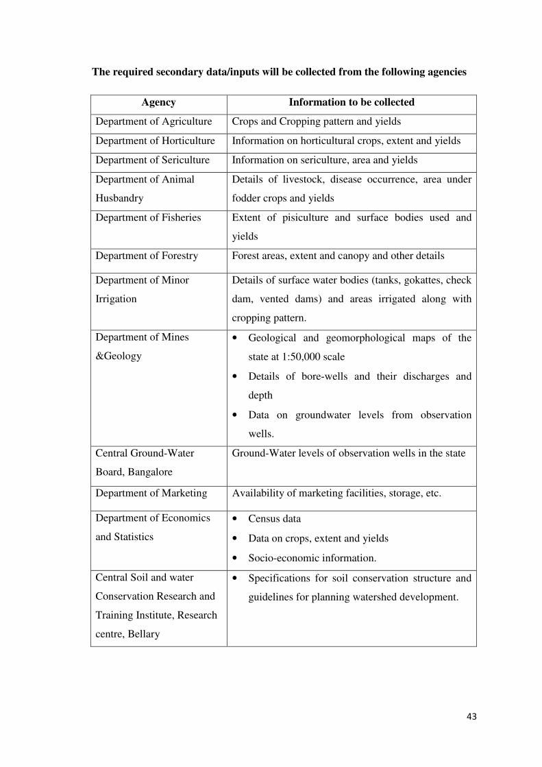
The required secondary data/inputs will be collected from the following agencies
Agency Information to be collected
Department of Agriculture Crops and Cropping pattern and yields
Department of Horticulture Information on horticultural crops, extent and yields
Department of Sericulture Information on sericulture, area and yields
Department of Animal
Husbandry
Details of livestock, disease occurrence, area under
fodder crops and yields
Department of Fisheries Extent of pisiculture and surface bodies used and
yields
Department of Forestry Forest areas, extent and canopy and other details
Department of Minor
Irrigation
Details of surface water bodies (tanks, gokattes, check
dam, vented dams) and areas irrigated along with
cropping pattern.
Department of Mines
&Geology
• Geological and geomorphological maps of the
state at 1:50,000 scale
• Details of bore-wells and their discharges and
depth
• Data on groundwater levels from observation
wells.
Central Ground-Water
Board, Bangalore
Ground-Water levels of observation wells in the state
Department of Marketing Availability of marketing facilities, storage, etc.
Department of Economics
and Statistics
• Census data
• Data on crops, extent and yields
• Socio-economic information.
Central Soil and water
Conservation Research and
Training Institute, Research
centre, Bellary
• Specifications for soil conservation structure and
guidelines for planning watershed development.
44
Relevance and utility of the database:
The detailed and comprehensive database generated through the Land Resource
Inventory, covering all the land holdings in a watershed area will help in
• Identifying site-and area-specific constraints affecting crop production
• Capability of the area for agriculture, horticulture, forestry and other uses
• Suitability for various crops and other uses
• Identifying promising land-use options suited to the location
• Allocating areas for different crops and land uses
• Identifying the extent of wastelands, common lands etc. and measures for their
regeneration
• Identifying the type and location of water conservation structures in the
watershed area
• Strategic planning – identifying areas suitable for the introduction of new or
exotic crops from one area or region to another is possible with the help of the
database.
• Fertilizer requirement through soil fertility maps
• Proactive advice to farmers - Our farmers need proactive advice on various
aspects of land use so that timely action is taken to derive the maximum benefit
from local and global situations. The land resource database in GIS framework
will provide the necessary scientific inputs needed for giving such advice to the
farmers. The extension advisory system, Distance education through AIR,
Doordarshan can make use of the information for advice on scientific farm
planning.
• Monitoring Benchmark sites - It will provide the base line data needed for
monitoring the state of health of the Natural resources through a watch at
Benchmark sites and hot spots, at least at sub-watershed level.
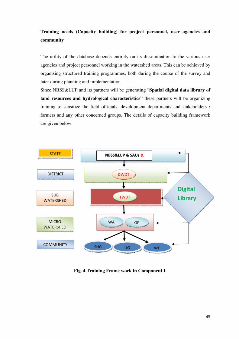
45
STATE NBSS&LUP & SAUs &
NGO’s
Digital
Library
DWDT
TWDT
WA GP
SHG UG WC
SUB
WATERSHED
MICRO
WATERSHED
DISTRICT
COMMUNITY
Training needs (Capacity building) for project personnel, user agencies and
community
The utility of the database depends entirely on its dissemination to the various user
agencies and project personnel working in the watershed areas. This can be achieved by
organising structured training programmes, both during the course of the survey and
later during planning and implementation.
Since NBSS&LUP and its partners will be generating “Spatial digital data library of
land resources and hydrological characteristics” these partners will be organizing
training to sensitize the field officials, development departments and stakeholders /
farmers and any other concerned groups. The details of capacity building framework
are given below:
Fig. 4 Training Frame work in Component I
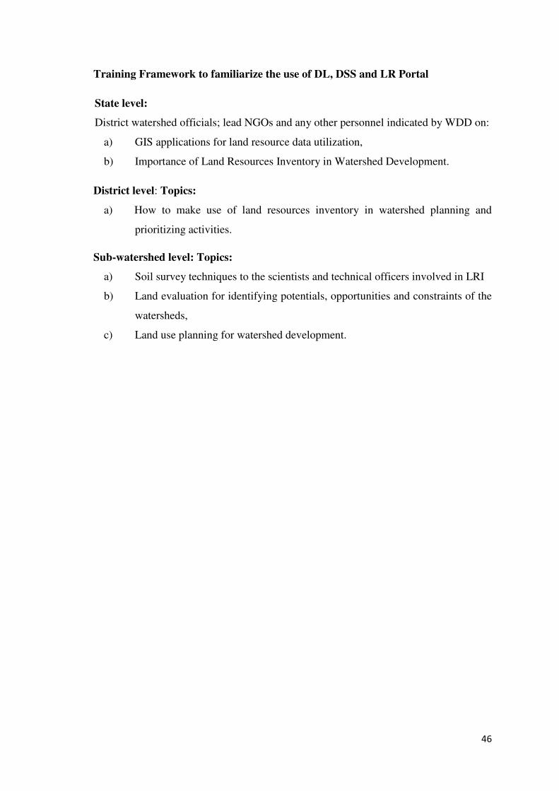
46
Training Framework to familiarize the use of DL, DSS and LR Portal
State level:
District watershed officials; lead NGOs and any other personnel indicated by WDD on:
a) GIS applications for land resource data utilization,
b) Importance of Land Resources Inventory in Watershed Development.
District level: Topics:
a) How to make use of land resources inventory in watershed planning and
prioritizing activities.
Sub-watershed level: Topics:
a) Soil survey techniques to the scientists and technical officers involved in LRI
b) Land evaluation for identifying potentials, opportunities and constraints of the
watersheds,
c) Land use planning for watershed development.
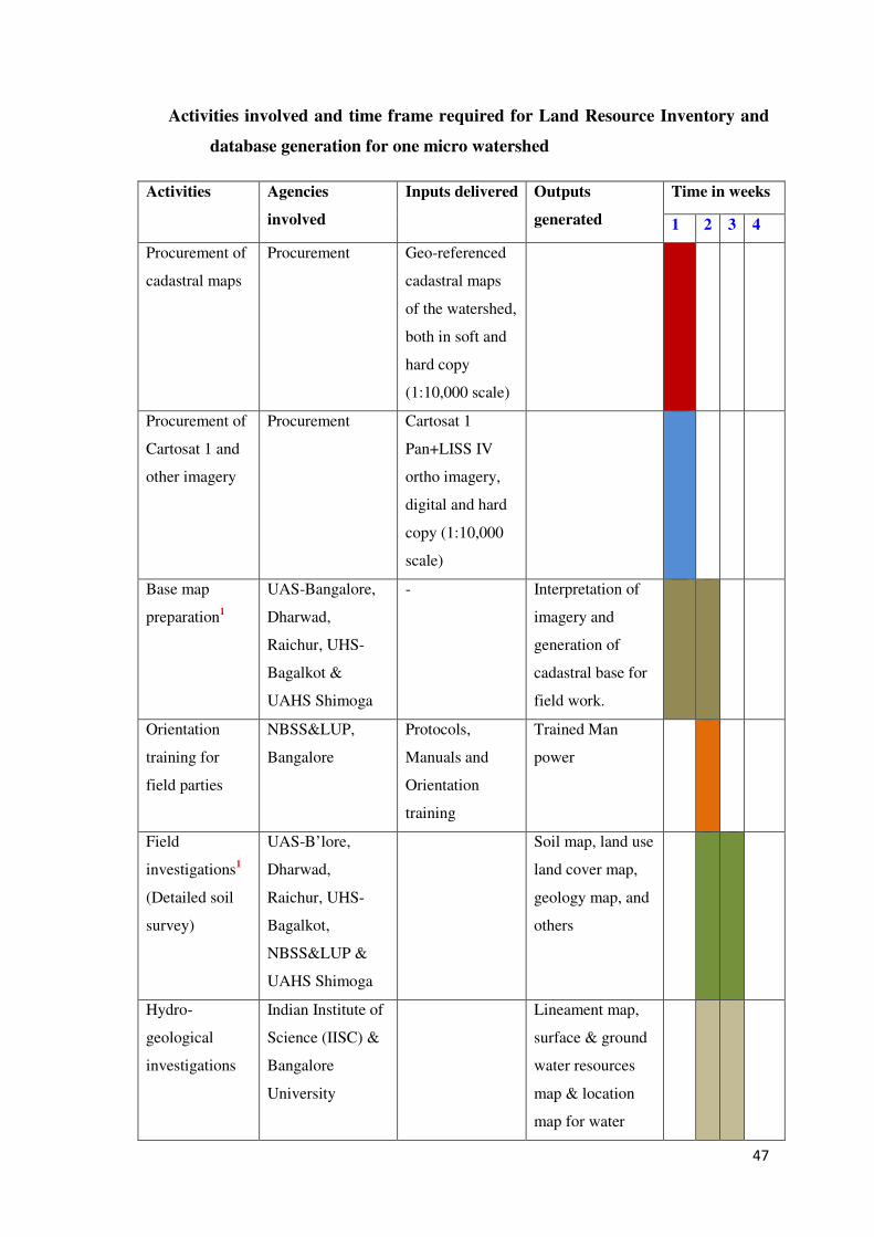
47
Activities involved and time frame required for Land Resource Inventory and
database generation for one micro watershed
Activities Agencies
involved
Inputs delivered Outputs
generated
Time in weeks
1 2 3 4
Procurement of
cadastral maps
Procurement Geo-referenced
cadastral maps
of the watershed,
both in soft and
hard copy
(1:10,000 scale)
Procurement of
Cartosat 1 and
other imagery
Procurement Cartosat 1
Pan+LISS IV
ortho imagery,
digital and hard
copy (1:10,000
scale)
Base map
preparation1
UAS-Bangalore,
Dharwad,
Raichur, UHS-
Bagalkot &
UAHS Shimoga
- Interpretation of
imagery and
generation of
cadastral base for
field work.
Orientation
training for
field parties
NBSS&LUP,
Bangalore
Protocols,
Manuals and
Orientation
training
Trained Man
power
Field
investigations1
(Detailed soil
survey)
UAS-B’lore,
Dharwad,
Raichur, UHS-
Bagalkot,
NBSS&LUP &
UAHS Shimoga
Soil map, land use
land cover map,
geology map, and
others
Hydro-
geological
investigations
Indian Institute of
Science (IISC) &
Bangalore
University
Lineament map,
surface & ground
water resources
map & location
map for water
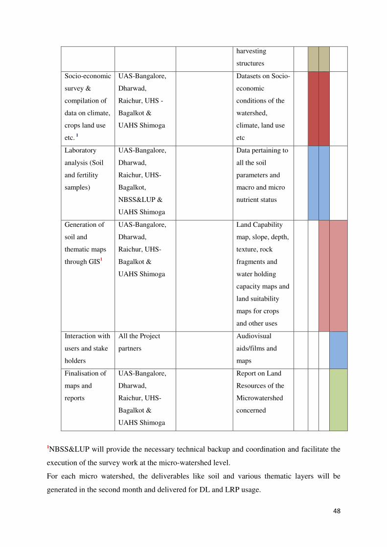
48
harvesting
structures
Socio-economic
survey &
compilation of
data on climate,
crops land use
etc. 1
UAS-Bangalore,
Dharwad,
Raichur, UHS -
Bagalkot &
UAHS Shimoga
Datasets on Socio-
economic
conditions of the
watershed,
climate, land use
etc
Laboratory
analysis (Soil
and fertility
samples)
UAS-Bangalore,
Dharwad,
Raichur, UHS-
Bagalkot,
NBSS&LUP &
UAHS Shimoga
Data pertaining to
all the soil
parameters and
macro and micro
nutrient status
Generation of
soil and
thematic maps
through GIS1
UAS-Bangalore,
Dharwad,
Raichur, UHS-
Bagalkot &
UAHS Shimoga
Land Capability
map, slope, depth,
texture, rock
fragments and
water holding
capacity maps and
land suitability
maps for crops
and other uses
Interaction with
users and stake
holders
All the Project
partners
Audiovisual
aids/films and
maps
Finalisation of
maps and
reports
UAS-Bangalore,
Dharwad,
Raichur, UHS-
Bagalkot &
UAHS Shimoga
Report on Land
Resources of the
Microwatershed
concerned
1NBSS&LUP will provide the necessary technical backup and coordination and facilitate the
execution of the survey work at the micro-watershed level.
For each micro watershed, the deliverables like soil and various thematic layers will be
generated in the second month and delivered for DL and LRP usage.
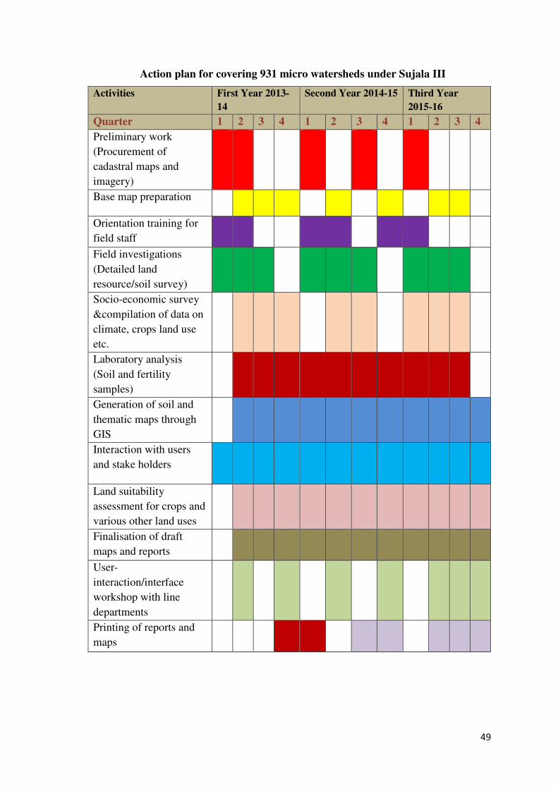
49
Action plan for covering 931 micro watersheds under Sujala III
Activities First Year 2013-
14
Second Year 2014-15 Third Year
2015-16
Quarter 1 2 3 4 1 2 3 4 1 2 3 4
Preliminary work
(Procurement of
cadastral maps and
imagery)
Base map preparation
Orientation training for
field staff
Field investigations
(Detailed land
resource/soil survey)
Socio-economic survey
&compilation of data on
climate, crops land use
etc.
Laboratory analysis
(Soil and fertility
samples)
Generation of soil and
thematic maps through
GIS
Interaction with users
and stake holders
Land suitability
assessment for crops and
various other land uses
Finalisation of draft
maps and reports
User-
interaction/interface
workshop with line
departments
Printing of reports and
maps
50
A. Establishment and Maintenance of Digital Library
Objectives
• Support improved sub-watershed assessment, integrated micro-watershed master
planning, monitoring and evaluation, and relevant research and development.
• Design of a suitable architecture for the integrated digital data base through
technical support
Digital Library
It is the collection, development and management of physical and bio-physical
information of an area, region or state in the electronic form with index creation and a
provision for access, retrieval and facilitation of reference work and preservation.
The information needed for establishing a dynamic digital library to meet the
requirements of various line departments, stakeholders, farmers and other users at
watershed level is so varied and diverse that it cannot be provided by any one single
organization or agency in the state. Apart from the inputs generated from the Land
Resource Inventory, information needs of the users have to be sourced from many other
agencies in the state. The schematic figure indicated below shows the flow of datasets
from different sources to the Digital Library.
Location
NBSS&LUP with the help of Project partners will be responsible for developing the
DL. The DL will be housed in the UAS Bangalore, UAS Dharwad, UAS Raichur, UHS
Bagalkot, NBSS&LUP and UAHS Shimoga which will execute and maintain the DL.
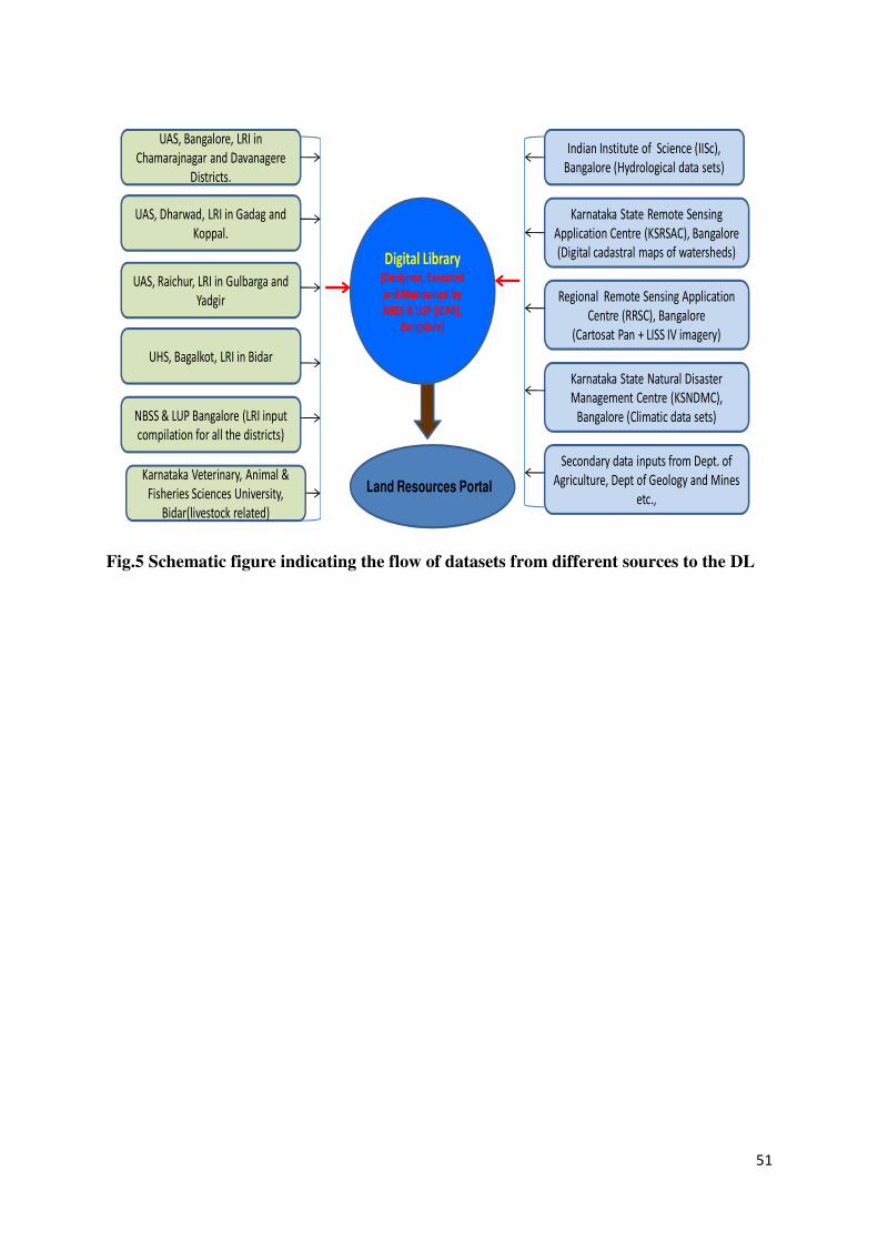
51
Digital Library (Designed, Executed
and Maintained by
NBSS & LUP (ICAR),
Bangalore)
Indian Institute of Science (IISc),
Bangalore (Hydrological data sets)
Karnataka State Remote Sensing
Application Centre (KSRSAC), Bangalore
(Digital cadastral maps of watersheds)
Regional Remote Sensing Application
Centre (RRSC), Bangalore
(Cartosat Pan + LISS IV imagery)
Karnataka State Natural Disaster
Management Centre (KSNDMC),
Bangalore (Climatic data sets)
Secondary data inputs from Dept. of
Agriculture, Dept of Geology and Mines
etc.,Land Resources Portal
UAS, Bangalore, LRI in
Chamarajnagar and Davanagere
Districts.
UAS, Dharwad, LRI in Gadag and
Koppal.
UAS, Raichur, LRI in Gulbarga and
Yadgir
UHS, Bagalkot, LRI in Bidar
Karnataka Veterinary, Animal &
Fisheries Sciences University,
Bidar(livestock related)
NBSS & LUP Bangalore (LRI input
compilation for all the districts)
Fig.5 Schematic figure indicating the flow of datasets from different sources to the DL
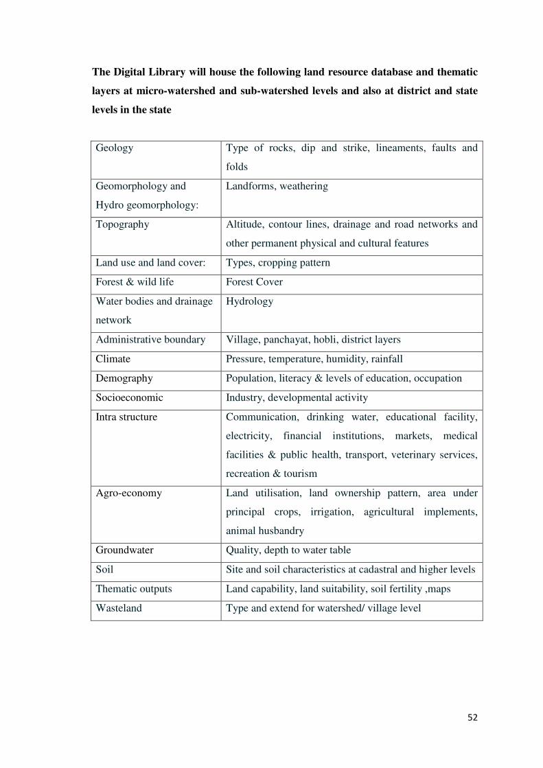
52
The Digital Library will house the following land resource database and thematic
layers at micro-watershed and sub-watershed levels and also at district and state
levels in the state
Geology Type of rocks, dip and strike, lineaments, faults and
folds
Geomorphology and
Hydro geomorphology:
Landforms, weathering
Topography Altitude, contour lines, drainage and road networks and
other permanent physical and cultural features
Land use and land cover: Types, cropping pattern
Forest & wild life Forest Cover
Water bodies and drainage
network
Hydrology
Administrative boundary Village, panchayat, hobli, district layers
Climate Pressure, temperature, humidity, rainfall
Demography Population, literacy & levels of education, occupation
Socioeconomic Industry, developmental activity
Intra structure Communication, drinking water, educational facility,
electricity, financial institutions, markets, medical
facilities & public health, transport, veterinary services,
recreation & tourism
Agro-economy Land utilisation, land ownership pattern, area under
principal crops, irrigation, agricultural implements,
animal husbandry
Groundwater Quality, depth to water table
Soil Site and soil characteristics at cadastral and higher levels
Thematic outputs Land capability, land suitability, soil fertility ,maps
Wasteland Type and extend for watershed/ village level
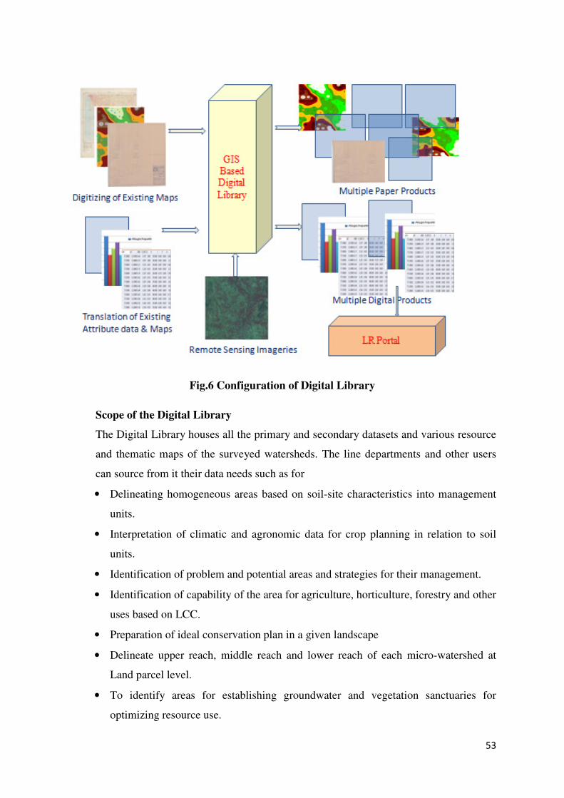
53
Fig.6 Configuration of Digital Library
Scope of the Digital Library
The Digital Library houses all the primary and secondary datasets and various resource
and thematic maps of the surveyed watersheds. The line departments and other users
can source from it their data needs such as for
• Delineating homogeneous areas based on soil-site characteristics into management
units.
• Interpretation of climatic and agronomic data for crop planning in relation to soil
units.
• Identification of problem and potential areas and strategies for their management.
• Identification of capability of the area for agriculture, horticulture, forestry and other
uses based on LCC.
• Preparation of ideal conservation plan in a given landscape
• Delineate upper reach, middle reach and lower reach of each micro-watershed at
Land parcel level.
• To identify areas for establishing groundwater and vegetation sanctuaries for
optimizing resource use.
54
• To develop plans to overcome market fluctuations and identify value added products
through alternative livelihoods.
The result of land resource inventory and secondary data collected will form the basis
for developing the digital library. Consultants will be hired to develop, test and
synchronize the Digital library, maintain and capacity building of users
B. Establishment of Land Resources Portal (LR Portal):
Purpose
The LR Portal for watershed is established to facilitate and coordinate the exchange and
sharing of the disparate spatial and non-spatial data between various stakeholders of
different groups of watershed user. Catalogues and registries that conform to OGC/ISO
specifications play an important role in LR Portal. Staff should be trained for long-term
maintenance and management of the LR Portal.
Location
The UAS (Raichur) will host the LRP in collaboration with NBSS&LUP. The two LRP
nodes will be provided at WDD head quarters and NBSS&LUP.
Services expected from the Portal:
The turnkey solution provider must establish LR Portal which would provide following
services;
• Portal services
The portal services should be made available to address the needs of the viewer,
discovery, management, authentication and access control and exposed services.
• Portrayal services
The portrayal services should include map services, styling services, coverage
services, and the map context services.
• Data services
The data services should include features, coverage, and symbology management.
• Catalogue services.
The catalogue services should include data discovery, service discovery,
catalogue update and query language.
The deliverables and configuration of the LR Portal are presented below.
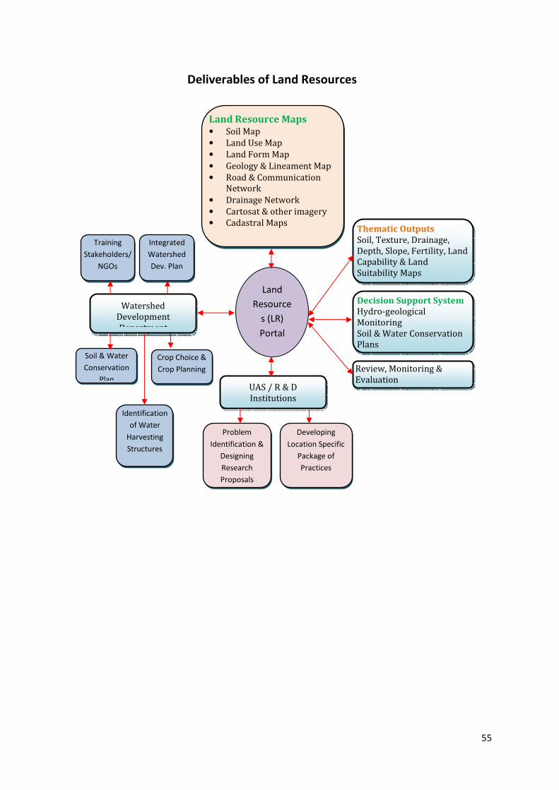
55
Thematic Outputs
Soil, Texture, Drainage,
Depth, Slope, Fertility, Land
Capability & Land
Suitability Maps
Decision Support System
Hydro-geological
Monitoring
Soil & Water Conservation
Plans
Review, Monitoring &
Evaluation
Training
Stakeholders/
NGOs
Watershed
Development
Department
Integrated
Watershed
Dev. Plan
Identification
of Water
Harvesting
Structures
Soil & Water
Conservation
Plan
Crop Choice &
Crop Planning
Deliverables of Land Resources
Portal
Land
Resource
s (LR)
Portal
Land Resource Maps • Soil Map
• Land Use Map
• Land Form Map
• Geology & Lineament Map
• Road & Communication
Network
• Drainage Network
• Cartosat & other imagery
• Cadastral Maps
UAS / R & D
Institutions
Problem
Identification &
Designing
Research
Proposals
Developing
Location Specific
Package of
Practices
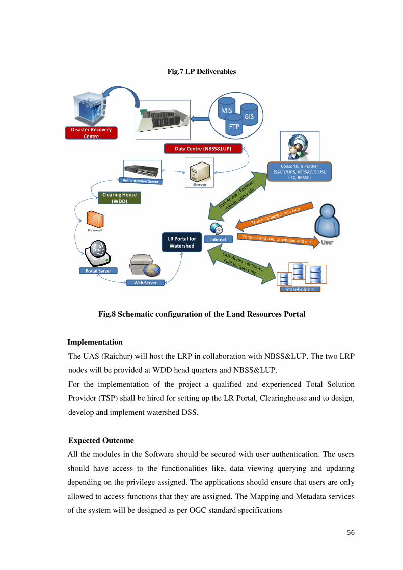
56
Fig.7 LP Deliverables
LR Portal for
Watershed
Clearing House
(WDD)
MISGIS
FTP
Data Centre (NBSS&LUP)
Stakeholders
Web Server
Internet
Consortium Partner
(SAU’s/UHS, KSRSAC, SLUSI,
IISC, RRSSC)
Disaster Recovery
Centre
Portal Server
Fig.8 Schematic configuration of the Land Resources Portal
Implementation
The UAS (Raichur) will host the LRP in collaboration with NBSS&LUP. The two LRP
nodes will be provided at WDD head quarters and NBSS&LUP.
For the implementation of the project a qualified and experienced Total Solution
Provider (TSP) shall be hired for setting up the LR Portal, Clearinghouse and to design,
develop and implement watershed DSS.
Expected Outcome
All the modules in the Software should be secured with user authentication. The users
should have access to the functionalities like, data viewing querying and updating
depending on the privilege assigned. The applications should ensure that users are only
allowed to access functions that they are assigned. The Mapping and Metadata services
of the system will be designed as per OGC standard specifications
57
Sub-component 1.2: Sub-Watershed Assessment (SWA)
Objectives
• To provide information to help set priorities and strategies for designing master
plans at micro-watershed level in the IWMP (sub-component 1.4).
• To develop water availability maps to highlight areas most sensitive to water stress.
• To identify researchable issues which can be addressed by the state and national
level research institutions to evolve best management practices.
Agencies to be engaged:
WDD, DoH and NBSS&LUP as lead partner will deliver the various requirements of
the sub-watershed assessment. The WDT will facilitate community involvement in the
process through the Watershed Committee, GP, User Groups and SHG’s.
Implementation
The process of Land resources inventory and sub watershed assessment will be
undertaken simultaneously. NBSS&LUP will be the lead institution to undertake
watershed assessment. The Agricultural and Horticultural universities will deliver the
watershed assessment products in collaboration with NBSS&LUP, in this process it
will associate with IISc for Hydrology, Bangalore University, KSNDMC for
meteorological information. The NBSS&LUP, IISC, B.U & the SAUs will work in
close co-ordination with the WDT. The WDT facilitates community inter-phasing. The
watershed assessment will commence with the stake holder consultation facilitation by
the WDT
Knowledge of watershed characteristics such as soils and their, physical and chemical
properties, geology, surface water and groundwater, vegetation, land use, topography
and socio-economic data would help to assess the potentials, threats and gaps, and
means to bridge them using the available scientific information.
The data will be made available in public domain through the Land Resource Portal to
provide scientific data base and provide information needed for prioritizing, initiating
and executing development programmes in the watershed.
For identifying researchable issues, an initial reconnaissance survey of the watersheds
by using remote sensing products, historical datasets and traversing the area with the all
the consortium partners along with local facilitators and stakeholders will be carried out
58
along with community participation ensured by WDT. The issues identified at this
stage will be subjected to detailed investigations at the micro watershed level later.
The watershed assessment process will lead to development of broad management
plans in participatory process. The datasets and thematic outputs needed to develop
management plans at sub-watershed level are indicated below.
Land Resource Survey:
The database generated for the micro-watersheds, under the sub-watershed in each
district can be sourced from the digital library established under the sub Component 1.2
in the main Component 1. Using this information, problems, constraints and potentials
of the selected sub-watershed can be identified.
Climate analysis used for identifying periods of onset and withdrawal of the monsoon,
droughts of different duration and intensity, periods of intense rains and occurrence of
floods and other aberrations that affect crop production for developing appropriate
contingency crop plans to mitigate the adversities of climate.
Socio- economic survey will be undertaken by the IWMP and it consists of
• Household survey for demographic details to determine the assets and liabilities
along with their needs and demands.
• Livestock details for determining their health and productive performance so as to
develop plans to promote health and performance using the available knowledge
generated in the Universities.
• Crops and cropping practices followed along with productivity levels so as to
develop appropriate crop and crop management plans in relation to soil
characteristics based on the information generated in research organizations
(Universities of Agricultural Sciences, University of Horticultural Sciences,
Departments of Agriculture, Horticulture, Animal Husbandry, KVKs and RSKs).
• A list of development programmes of various line departments functioning in the
area will be generated so as to plan for the integration of various programmes into
watershed development programme.
59
Thematic outputs needed:
Land Resource maps:
a. Soil map indicating the distribution of soils in the watershed area and land
management units with survey numbers and legend indicating all the details of the
unit using cadastral map.
b. Land Capability map: Land capability map shows the general capability of the
resources. The grouping is based on the inherent soil characteristics, external land
features and environmental factors that limit the use of the land for various uses.
c. Soil slope map: Slope plays an important role in the formation of soils and process
of erosion (and alters the overall use of the land). Slope information provides the
land users the information on the type and extent of soil and water conservation
structures needed.
d. Rock fragments map: Provides information on Gravel content in the soil, stones,
boulders and rock pieces and their distribution, greatly influences hydrological
characteristics of the soils and thereby the crop production.
e. Soil depth map: Soil depth refers to the depth of the soil occurring above the
parent material. It determines the rooting depth, water and nutrient holding
capacity of the soil. It is used to group the various soils occurring in the area into
different soil series.
f. Surface soil and subsoil texture map: Texture indicates the relative proportion of
particles present in the soil. Based on the proportion, the soils are grouped into
various textural classes like sand, loamy sand, sandy loam, sandy clay loam, clay
loam, sandy clay and clay.
g. Soil reaction map: The level of salinity, alkalinity and acidity influences the
quality of soils and has a direct bearing on crop production.
h. Soil erosion map: Erosion due to normal factors like rainfall, slope, soil type etc is
known as natural erosion or geological erosion and the erosion due to human
disturbance to ecosystem is known as accelerated erosion. The intensity of erosion
is assessed based on the physical characters and a map is prepared depicting the
variations observed in the field.
i. Water holding capacity and Available water: The parameter is crucial for
deciding the type of crops under rainfed situations. In climate-smart agriculture the
parameter is of prime importance in selection of crop and management practices.
The amount of water held between saturation and field capacity contributes to
60
groundwater recharge and it is essential to know the total water held and also
available water for determining the groundwater recharges. It is the measure of the
quantity of water stored in soil profile within one meter depth and is readily
available for crop production. This water is held between field capacity (1/3 bar)
and permanent wilting point (15 bar).
j. Soil organic carbon status: The status of soil organic carbon indicates the
inherent fertility and overall health of soils. In tropical countries it is extremely
difficult to maintain good organic matter content particularly in fields subjected to
frequent ploughing and other farming operations. Monitoring of this parameter is
the most important activity when we plan for climate-smart farming, soil carbon
sequestration and other related activities.
k. Soil fertility status map: The content and dynamics of major nutrients (macro and
micro) should be understood for adopting of precision farming. Nutrient level are
influenced by management practices, kind of crops cultivated, changes in soil
reaction (pH), climatic changes and extreme weather events (drought and floods).
Hence this information requires to be updated from time to time.
l. Meteorological map: The information related to climate in terms of extent and
intensities of droughts and areas prone to floods would help to prepare risk
management plans.
Geo-Hydrological survey involves
• Geomorphological studies to determine lineaments and presence of aquifers to
generate lineament map.
• Identification of water bodies, runoff and stream characteristics and building
models to develop potential water resources map for surface water and
groundwater.
• Hydro-geological survey for water quality, aquifer characteristics and
groundwater abstraction and recharge to delineate areas and their status for
locating groundwater sanctuaries.
• Vegetation survey is done for identifying species native to the area and useful to
society to promote livelihoods.
61
Vegetation map depicting the existing vegetation with respect to forestry species,
agriculture and horticulture crops is to be prepared to determine the species native to
the area as well as for identifying the areas that will be used for incorporating new
technologies based on the knowledge generated at the research institutions to promote
vegetative density and productivity.
Livestock map: The density map of different livestock is to be prepared for
determining the carrying capacity and productivity so as to incorporate corrective
measures and management plans to increase the economic levels by building over
native experience with the knowledge generated in the research institutions and
experience of the departments.
Preparation of conservation and Land Use Plan:
Considering the information contained in the above database and thematic maps, a
tentative land use plan for the concerned watershed will be prepared for the use of the
various line departments and implementing agency/agencies, as per the schematic
diagram below. The land use plan highlights the problems, potentials and suitability of
the resources for various agricultural and non-agricultural uses with multiple options to
choose from. This facilitates net planning process and finalization of Action Plan for
implementation (by line departments followed by PRA exercise).
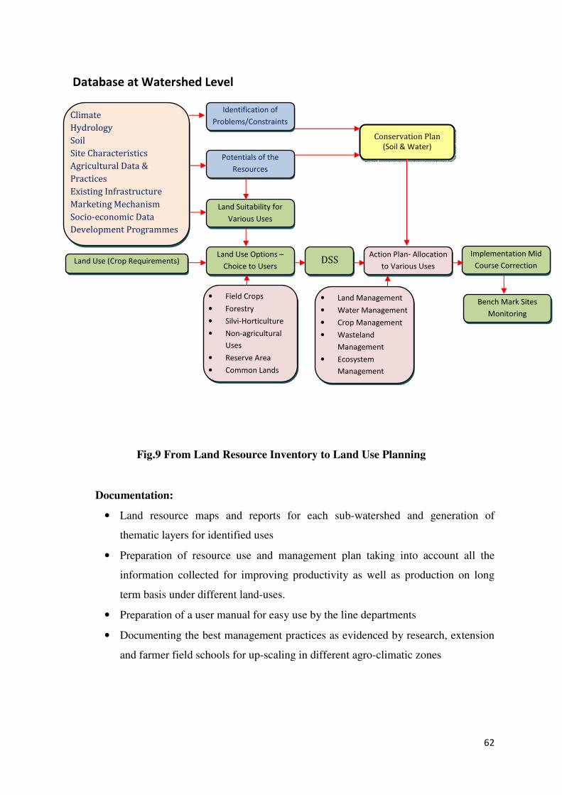
62
Fig.9 From Land Resource Inventory to Land Use Planning
Documentation:
• Land resource maps and reports for each sub-watershed and generation of
thematic layers for identified uses
• Preparation of resource use and management plan taking into account all the
information collected for improving productivity as well as production on long
term basis under different land-uses.
• Preparation of a user manual for easy use by the line departments
• Documenting the best management practices as evidenced by research, extension
and farmer field schools for up-scaling in different agro-climatic zones
Database at Watershed Level
Climate
Hydrology
Soil
Site Characteristics
Agricultural Data &
Practices
Existing Infrastructure
Marketing Mechanism
Socio-economic Data
Development Programmes
Land Use (Crop Requirements)
• Field Crops
• Forestry
• Silvi-Horticulture
• Non-agricultural
Uses
• Reserve Area
• Common Lands
Identification of
Problems/Constraints
Potentials of the
Resources
Land Suitability for
Various Uses
Land Use Options –
Choice to Users
• Land Management
• Water Management
• Crop Management
• Wasteland
Management
• Ecosystem
Management
DSS Action Plan- Allocation
to Various Uses
Implementation Mid
Course Correction
Conservation Plan
(Soil & Water)
Bench Mark Sites
Monitoring

63
Fig.9 Schematic representation of Component 1
Sub-component 1.3: Developing and piloting new decision-support models (DSS)
Purpose: For integrated watershed management and site selection
Objectives:
• Development and piloting of new decision-support systems to assist WDD in
leading integrated watershed programmes.
COMPONENT 1: Support for Improved Programme Integration in
Rainfed Areas
DSS
IWMP & NREGS
• Local Government
• DWDT
• TWDT/Local NGOs
• GPs, Watershed
Committees
• User Groups
LR
Portal
PPMU
PTC DSS Tools
Digital Library
LR Portal
Sub-watershed
Assessment
Micro
watershed
Planning &
Incremental
Capacity
Building &
Convergence
Community
Based M&E
IISc
NBSS&LUP
and
SAU/SHU
Specialized
NGO,
SAU/SHU for
Facilitation
and Training
64
• Integrated decision-support models to help plan and priorities soil and water
conservation measures including land-use practices at sub-watershed level that
can then be downscaled to guide micro-watershed level planning.
Modern agriculture is highly knowledge intensive and requires the support of
Information and Communication Technologies (ICT) for planning and decision
making. Information needs in the agriculture and allied sectors are quite different from
those in other sectors. While the farmer has some control over a few of the resources
e.g., land and water resources, labour, seeds, etc. there are several other variables that
are beyond his control – the weather paremeters, precipitation and market prices, etc.
By establishing connectivity between variables that influence production levels, it is
possible to match with suitable options wherever possible, which can improve the
efficiency of agriculture sector. The Internet, satellite communication, remote sensing,
and GIS are providing new opportunities to connect people with new development
strategies which can bring in a new revolution in agriculture.
The DSS produces simple output from the complex system and large data set in the
form of decisions and plans. The plans may be of different types depending upon the
purpose. Mathematical models such as hydrologic models and groundwater models
crop growth models coupled with the field data are the basis for DSS. The models have
the capability to convert the complex system into simpler ones, making it easy for the
reliable prediction of impacts of changes to the existing system.
The innovative and science-based approaches and convergence between IWMP and
other development programmes can be better achieved through technology. Effective
way to achieve the above is through locally-based planning and management at the
watershed scale by considering spatial and non-spatial information on one hand and
matching the needs and demands of the people on the other. In order to address these
considerations, it is necessary to integrate a large amount of spatial information and
knowledge from several disciplines. To be useful, the information and knowledge must
be made available to stakeholders and decision makers in a rational framework.
Decision Support System
• DSS is a computer-based information system that supports organizational
decision-making easier, DSS serves management at planning and operation levels
and helps to make decisions, which may be rapidly changing and are not easily
specified in advance.
65
• The WMDSS (Watershed Management Decision Support System) is a tool
designed to determine the optimum use of natural resources for improving the
productive capacities under a given set of conditions by selecting appropriate
strategies. It is a multi-dimensional optimization model designed to identify
possible management scenarios that meet multiple resources-allocation objectives
under various hydrologic, ecologic, social, regulatory and economic constraints.
Location
DSS will be located at NBSS&LUP Bangalore and Disaster Recovery Center would
be implemented at UAS (Dharwad).
Implementation
• Research-cum-development initiative for developing the decision support systems
by forming a consortium of various organizations in the state. Many of the
institutions will need handholding support and capacity development before they
can apply appropriate models for IWMP.
• Integrate all the models starting from water available assessment through water
balanced models developing appropriate structures and designing them with
identification of suitable locations, preparing the estimates of various rainwater
harvesting structures, designing watershed interventions by undertaking total
water budgeting and yield gap analysis and designing suitable productivity
enhancement interventions. Use of water impact calculator along with GIS-based
soil nutrient management practices will ensure efficient use of available water
resources for increasing productivity and enhancing the incomes of the farmers by
applying SWAT.
• A Consultant will be hired (if required) for reviewing the performance of existing
decision tools and models available in similar environmental and institutional
context along with the assessment of the capacity to use them in the state. Gaps, if
any, will be identified suitable measures suggested.
• Based on the requirement a software consultant or a Total Solution Provider
(TSP) will be hired by the PTC for the development and implementation of
WMDSS. The consultant may be asked for in-house development for which
consultant may have to depute resource persons to NBBSSLUP/WDD/IISc for a
stipulated period of time.
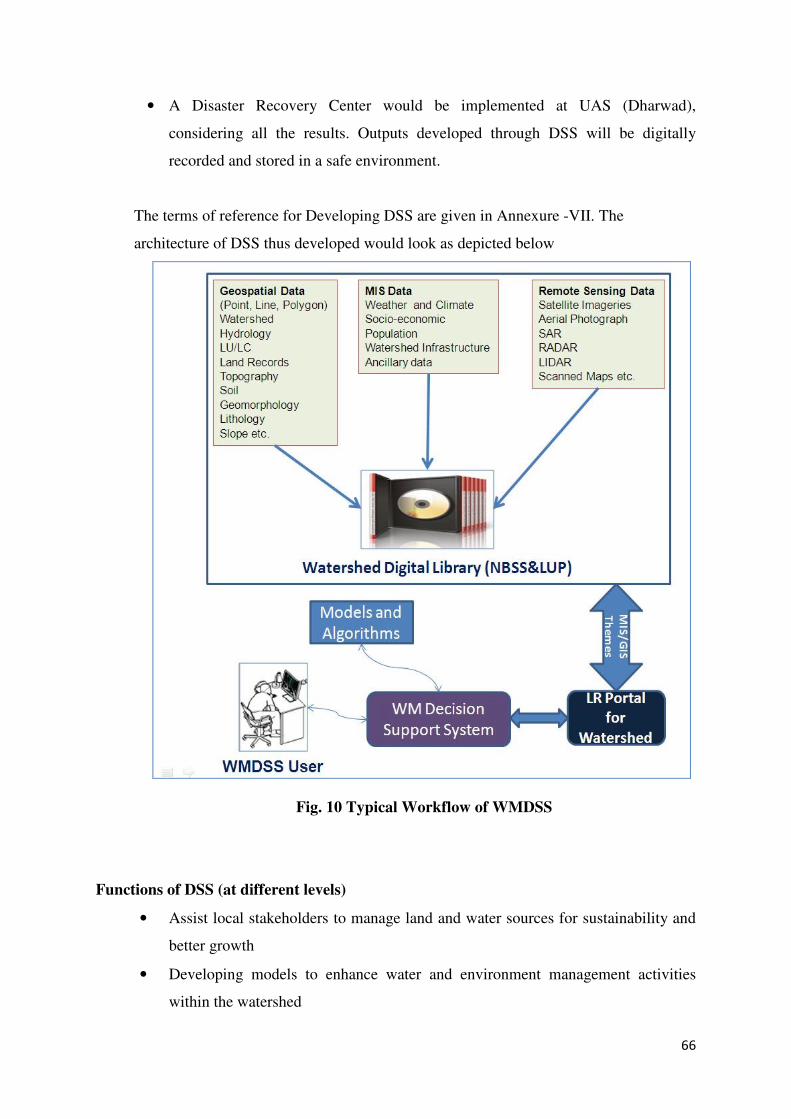
66
• A Disaster Recovery Center would be implemented at UAS (Dharwad),
considering all the results. Outputs developed through DSS will be digitally
recorded and stored in a safe environment.
The terms of reference for Developing DSS are given in Annexure -VII. The
architecture of DSS thus developed would look as depicted below
Fig. 10 Typical Workflow of WMDSS
Functions of DSS (at different levels)
• Assist local stakeholders to manage land and water sources for sustainability and
better growth
• Developing models to enhance water and environment management activities
within the watershed
67
• To provide alternatives through modelling to mitigate drought and manage
disasters
• To determine the trade-offs associated with different interventions within the
watershed
• Develop on-the-ground watershed management strategies given alternative social
constraints
• Provide technical guidance in the watershed by predicting future impacts of
potential strategies, guidance in strategy selection in other watersheds where such
detailed analysis have not been completed, and a framework for organizing
information and predictions to manage watersheds in the most effective way.
• Hydrological models for designing and identifying the locations for rainwater
harvesting structures in the watersheds
• Assess impact of various watershed interventions and rainwater harvesting
structures on crop productivity and increased incomes with soil conservation on-
site as well as off-site downstream impacts through reduced runoff and changes
in groundwater recharging etc.
• Developing water impact calculator for supplemental irrigation and use of water
impact calculator in place of calendar-based irrigation. This experience will also
put together integration of various models for developing the integrated decision
support system.
Utility of the System
The system can integrate spatial and non-spatial data and help farmers, stakeholders
and policy makers to make faster and better analysis based on queries raised by various
users. The WMDSS will be made use of to allow faster decision making, identification
of negative trends, and better allocation of resources of Integrated Watershed
Management System, with a view to
• Managing the natural resources in a sustained manner
• Balancing agricultural growth, environmental protection and economic gains on
sustainable basis
• Scientifically utilizing soil, water, livestock, and other biological and natural
resources for greater benefit of society.
68
• Enabling individual land owners to improve the yield of crops, reduce the
possible production risks, reduce the cost of inputs, reduce the labour
requirement and generally improve efficiency.
Roles / Responsibilities of Partners / Agencies :
• The WDD will enter into Memoranda of Understanding (MoUs) with
NBSS&LUP (National Bureau of Soil Survey and Land Use Planning), Regional
Centre, Bengaluru and Contract IISc (Indian Institute of Science), and also with
the four State Agricultural Universities (SAU), Horticultural University of
Karnataka and UAHS Shimoga.
• The NBSS&LUP will advise and oversee the adaptation in use of technical
decision tools, GIS data bases, monitoring systems, collecting information and
validation.
• The IISc will develop an information infrastructure and adaptation of existing
scientific decision-making tools and models that would inform sub-watershed
assessments and integrated micro-watershed planning concerning hydrological
aspects.
• The SAU’s, UHS and UAHS Shimoga will provide the inputs for modules to be
developed based on the requirement of the farming community and also would
involve in developing protocols / scenarios / workflow to address various
challenges faced by the farmers and suggest various modules to be developed for
DSS to address issues at farmer’s field level.
Tool & Equipments required for establishing WMDSS are given in Annexure - VI
Capacity Building and Training
One of the key tasks for successful implementation of DSS is to build the capacities of
different stakeholders at different levels. This also requires computer and web based
infrastructure development at various levels of implementation, viz. state, district, taluk
and GP/watershed levels. The key areas of capacity building that are to be carried out
by NBSS&LUP for state level Universities, District and Watershed level are detailed
below:
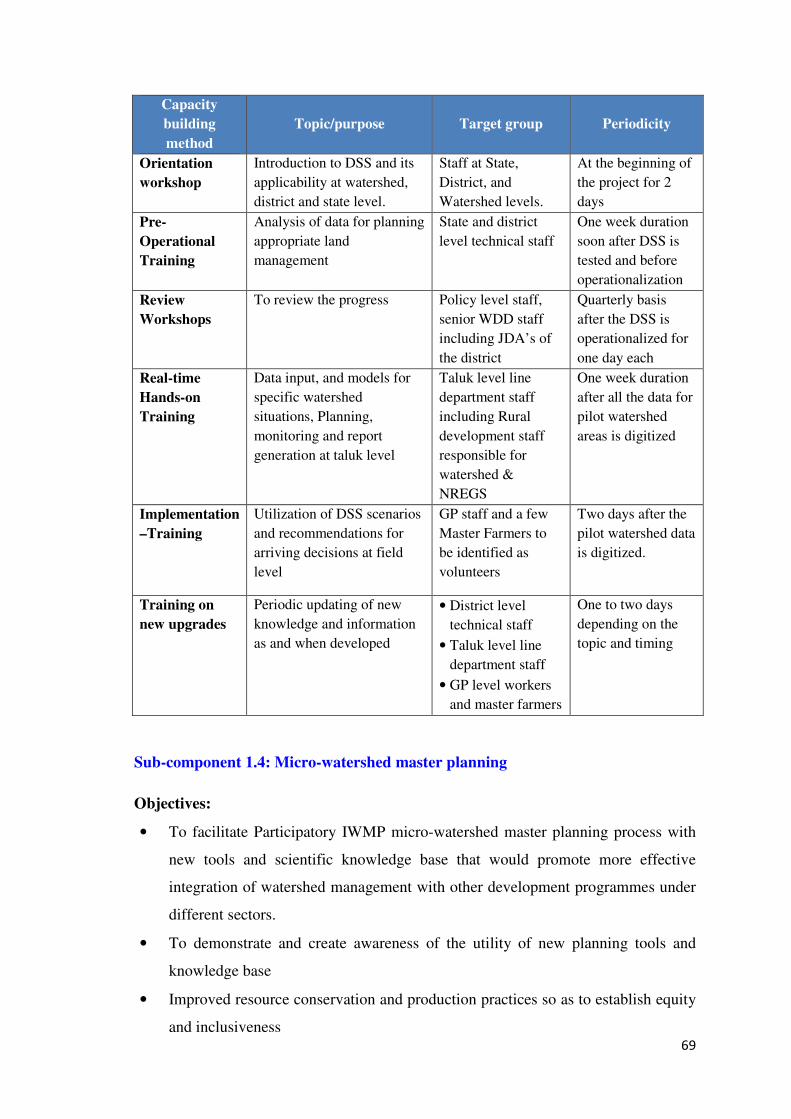
69
Capacity
building
method
Topic/purpose Target group Periodicity
Orientation
workshop
Introduction to DSS and its
applicability at watershed,
district and state level.
Staff at State,
District, and
Watershed levels.
At the beginning of
the project for 2
days
Pre-
Operational
Training
Analysis of data for planning
appropriate land
management
State and district
level technical staff
One week duration
soon after DSS is
tested and before
operationalization
Review
Workshops
To review the progress Policy level staff,
senior WDD staff
including JDA’s of
the district
Quarterly basis
after the DSS is
operationalized for
one day each
Real-time
Hands-on
Training
Data input, and models for
specific watershed
situations, Planning,
monitoring and report
generation at taluk level
Taluk level line
department staff
including Rural
development staff
responsible for
watershed &
NREGS
One week duration
after all the data for
pilot watershed
areas is digitized
Implementation
–Training
Utilization of DSS scenarios
and recommendations for
arriving decisions at field
level
GP staff and a few
Master Farmers to
be identified as
volunteers
Two days after the
pilot watershed data
is digitized.
Training on
new upgrades
Periodic updating of new
knowledge and information
as and when developed
• District level
technical staff
• Taluk level line
department staff
• GP level workers
and master farmers
One to two days
depending on the
topic and timing
Sub-component 1.4: Micro-watershed master planning
Objectives:
• To facilitate Participatory IWMP micro-watershed master planning process with
new tools and scientific knowledge base that would promote more effective
integration of watershed management with other development programmes under
different sectors.
• To demonstrate and create awareness of the utility of new planning tools and
knowledge base
• Improved resource conservation and production practices so as to establish equity
and inclusiveness
70
• To promote effective convergence between the IWMP and NREGS programmes,
particularly for better targeted and higher quality soil and water conservation
investments.
• To promote better integration between watershed planning and agricultural crop
planning.
• Revision of the field IWMP manual in year 1 to incorporate new processes for
watershed planning.
• After implementing, to draw in lessons learned from project implementation and
to diffuse the same on a wider scale for making integrated planning approaches
for sustainable cost effective development.
• Developing incremental training modules that can be integrated into IWMP
planning process with communities and GPs
Integrated Watershed development programmes, initiated under the Hanumanth Rao
committee recommendations, as a strategy for over all development of agriculture in
the country has been in operation since the Seventh Five Year Plan (FYP 89-92) guided
by the pre and post Hariyali Guidelines of GOI.
During this period the Watershed development programmes focused on Soil and Water
Conservation Works, adopting a top-down approach. It was observed that the supply-
demand mismatch resulting in inadequate attention to local needs and aspirations of the
communities leading to inadequate implementation and consequent lack of
sustainability. It was, therefore, felt that there was a need for technology-cum-resource
driven agriculture to achieve region-specific resource-use optimality and gender equity
to make the programme truly people-centred and people-driven. Consequently, rural
development by way of transition from traditional isolation to integration with new
technologies through people’s participation has become the current policy paradigm
and enunciated in the XIth Plan. The KWDP – I (Sujala I) demonstrated the new
socially inclusive participatory Watershed approach. The Common Guidelines 2008
issued by the NRRA, MOA, GOI to a great extent reflect the Sujala learning. The
IWMP planning process revolves around the Common Guidelines. The present Project
intends to expand and refine the Planning process by bringing in the New Scientific
Knowledge base and planning tools developed under various components.
71
Participatory Planning
The IWMP planning process will be complemented by providing science-based inputs.
The Land Resource Inventory coupled with sub-watershed assessment provides a
thorough understanding of Natural resource constraints and potentials at sub-watershed
and micro-watershed level.
The Land Resource Portal and DSS enable more effective understanding of soils,
hydrology, climate etc, leading to various options / alternatives for more advantageous
soil and water conservation strategies including crop planning and crop advisory.
Simple tools for watershed planning, groundwater assessment, water budgeting
tools/educative games developed in components 1 and 2 will help in better local
understanding of watershed potential, constraints, management and hydrology links
with land-use decisions.
This will help stakeholders to make better informed micro-watershed planning
decisions that include hydrological objectives and outcomes. All the products of other
sub-components like the outcomes of thematic study and identified Best Management
Practices (BMPs) will be made use to develop Participatory Micro Watershed Master
Planning.
Based on guidance from the above, WDD facilitates the communities to develop micro-
watershed master plans through the IWMP process by integrating watershed
management for agricultural and economic development through improved resource
conservation and production practices leading to
• Convergence between the IWMP and NREGS programs, particularly around
better targeted and higher quality soil and water conservation measures.
• Investments on agricultural and horticultural crops and silvi-pasture and agro-
forestry systems for increasing bio-diversity.
• Development of community and waste lands, common drainage lines involving
the landless and resource-poor in convergence with National Livelihood
Improvement Programme to address and improve economic stability of vulnerable
groups.
New Planning
Planning activities would be integrated with the on-going IWMP participatory planning
process by:
72
• Incorporating key recommendations from the larger scale sub-watershed
assessments, especially around hydrology, through a GIS platform to support
better decision with respect to surface water use and groundwater management in
micro-watersheds that supports agriculture and its intensification;
• Drawing on the digital library (sub-component 1.2) for thematic maps and
information to help define options for improved integration and coordination
between, agriculture, horticulture, agro-forestry, pisciculture and livestock
programs, and identifying general priorities for post-harvest, marketing, and
income generating activities within the micro-watershed plan;
• Adopting Best Management Practices (BMPs) into programme integration and
convergence
• Developing modules that can be integrated into IWMP planning processes with
communities and GPs, includes material on applying new approaches and tools
for better-integrated planning,
Preparing plans
Watershed Action Plans are prepared by teams of various stakeholders – including the
community (through various CBOs) and the facilitators (NGOs and the Department).
The following teams will be involved at the micro-watershed level for this purpose.
• Executive Committee (EC) of the watershed and GP
• User Groups (UG); and SHGs
• NGO staff, Watershed Assistants and local facilitators
• Watershed Development Team consisting of AO, AHO, RFO, AAo
Role of Various partners / Agencies / Institutions during planning
In order to develop a Watershed Development Plan addressing program integration
across the sectors including NREGS convergence the various agencies are required to
work in close co-ordination:
Following are the responsibilities
Consortium of Partners
• To provide the watershed assessment and land resource inventory outputs along
with various theme maps and land use maps and tentative Land use plan to
facilitate informed planning process
73
• To educate the WDT, Watershed Institutions and Line Departments including GPs
on the usage and utility of Watershed Assessment and LRI outputs and tentative
Land use plan
Role of watershed development team (WDT)
• The WDT will co-ordinate with the consortium partners to obtain the Watershed
assessment and land resource inventory outputs
• To organize and conduct community facilitation process through IWMP NGOs to
educate the watershed institutions and GPs regarding Watershed Assessment and
LRI outputs
• The team supported by NGOs and Watershed Assistants shall discuss the land-use
plans with the respective user groups at individual level for identifying the needs
and demands so as to converge with the schemes under different sectors for
inclusion in the net plans
• Technical facilitation for planning process
• Bring the Net Plans for social approval before the Grama Sabha and DPR before
the ZP
Role of NGO
• To create effective and functional linkages between project partners at district &
community level to implement the program.
• IWMP NGOs will undertake project publicity and awareness creation, formulate
CBOs and undertake capacity building.
• To provide assistance and facilitate involvement of EC, UG, SHG and GP
members and participation of all vulnerable sections of the society in the entire
planning process for resource conservation under the guidance of WDT.
• The NGO in association with WA will collect and collate the information required
for generating management plans for developing common and waste lands
involving EC and SHGs.
• Identify appropriate Income Generation Activities for the landless for achieving
convergence with National Livelihood Improvement Programme and Special
Component Programmes.

74
Role of the Executive Committee (EC);
• Actively participates in the planning process starting from farmer level planning to
the preparation of the Net Plan
• Training facilitation for convergence planning process
• Convergence of watershed Plans with MNREGS and other schemes and
programmes
• Plan for management and maintenance of common property resources
• To ensure participation of all the vulnerable families dependent on the resources of
common property while planning for common lands
Role of the UGs;
The UGs shall participate to take the advantage of science-based land-use planning and
value-addition with their traditional knowledge to make the programme more effective
in order to conserve the resources and manage them efficiently for higher incomes and
achieve sustainability
Role of SHGs
The SHGs will participate in developing the community, common and waste lands for
enlarging their livelihoods and effectively manage the assets created
Role of GPs
• Facilitate participation of GP and the Grama Sabha in the planning process
• Plan for management and maintenance of common property
• Training facilitation for convergence planning process
• Convergence of watershed Plans with MNREGS and other schemes and
programmes
• Convene Grama Sabha for social approval of the Net Plans
The flow diagram for the convergence is as given below:
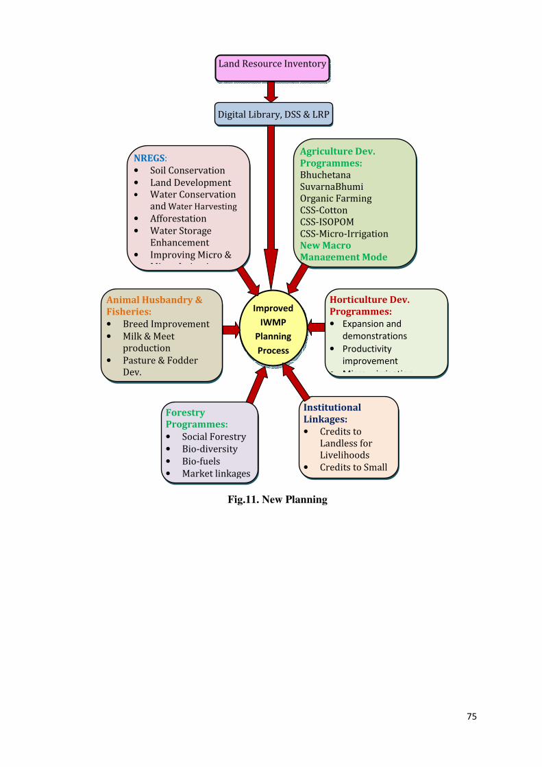
75
Fig.11. New Planning
Digital Library, DSS & LRP
Improved
IWMP
Planning
Process
Land Resource Inventory
NREGS:
• Soil Conservation
• Land Development
• Water Conservation
and Water Harvesting
• Afforestation
• Water Storage
Enhancement
• Improving Micro &
Minor Irrigation, etc.
Agriculture Dev.
Programmes:
Bhuchetana
SuvarnaBhumi
Organic Farming
CSS-Cotton
CSS-ISOPOM
CSS-Micro-Irrigation
New Macro
Management Mode
Horticulture Dev.
Programmes:
• Expansion and
demonstrations
• Productivity
improvement
• Micro – irrigation
Animal Husbandry &
Fisheries:
• Breed Improvement
• Milk & Meet
production
• Pasture & Fodder
Dev.
Forestry
Programmes:
• Social Forestry
• Bio-diversity
• Bio-fuels
• Market linkages
Institutional
Linkages:
• Credits to
Landless for
Livelihoods
• Credits to Small
& Marginal
76
Documentation:
The proposed approaches will be tested in two micro-watersheds in each project
district. Under this sub-component capacities of the local implementers and community
stakeholders will be built through training in use of applications from Digital Library.
Watershed assessment and DSS etc using appropriate tools, such a participatory
initiative would also be an important point for future convergence of different
developmental schemes with watershed management. The lessons learnt while bringing
convergence of different sectoral schemes into IWMP and their impacts on resource
conservation and production changes due to science based technologies will be
documented as part of M & E together with components of equity and inclusiveness for
future adoption in similar agro-climatic and socio-economic conditions.
Synchronizing the Sujala concept into IWMP
It is proposed to develop land use planning using science-based approach to replace the
present subsistence farming. It also provides space to converge other developmental
programmes such as MNREGS for improving quality and quantity of soil and water
conservation programmes, enhancing agricultural, horticultural production and
livelihoods of the asset-less families by dovetailing development programmes under
Departments of Agriculture, Horticulture and Rural Development and Panchayat Raj
respectively. In order to bring synergy in the development, it is proposed to organize a
workshop by the WDT with EC, UG and SHG members/ representatives along with
concerned technical officers of the Departments working in the project area, to explain
about the schemes available and prepare a list of stakeholders who could be
additionally covered using the above during the project cycle. The same will be
incorporated in the DPR before submitting to JDAs for technical approval and then to
CEO for administrative and financial approval.
The farmers coming under a homogeneous unit of land will be familiarised of the
potentials and the limitations of the natural resource. Possible steps for improving
productivity will be discussed and a range of options related to resources presented to
them using the GIS database developed under component-1.
The hydrological situation in the project area will be brought to the farmers’ notice,
based on the information collected under Component-2.The social regulations and
77
options available to improve and maintain groundwater levels will be considered to
achieve the goals of the project.
All opportunities available in different schemes, for improving production and incomes
directly or through value addition will be exploited by incorporating them into the
IWMP during the project period. Similar exercise would be done with respect to
livelihoods and all these will be incorporated to cover large population to establish
equity during the project life cycle.
The Annexure XII indicates the KWDP – II and IWMP integrated watershed
management process.
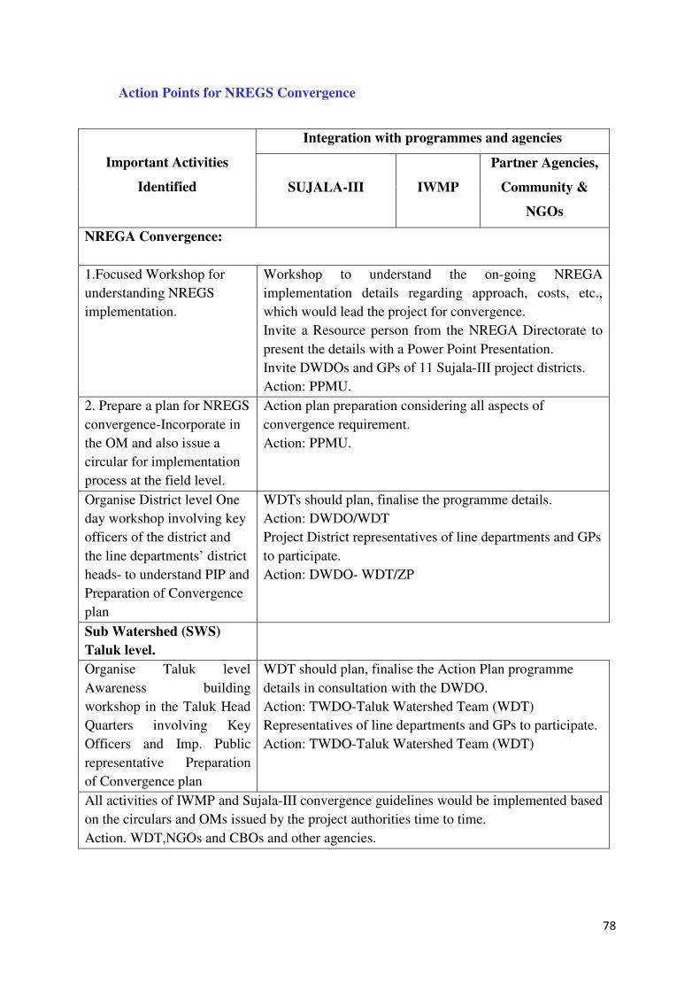
78
Action Points for NREGS Convergence
Important Activities
Identified
Integration with programmes and agencies
SUJALA-III IWMP
Partner Agencies,
Community &
NGOs
NREGA Convergence: To know about the pattern of convergence with IWMP,
linkages with several players.
1.Focused Workshop for
understanding NREGS
implementation.
Workshop to understand the on-going NREGA
implementation details regarding approach, costs, etc.,
which would lead the project for convergence.
Invite a Resource person from the NREGA Directorate to
present the details with a Power Point Presentation.
Invite DWDOs and GPs of 11 Sujala-III project districts.
Action: PPMU.
2. Prepare a plan for NREGS
convergence-Incorporate in
the OM and also issue a
circular for implementation
process at the field level.
Action plan preparation considering all aspects of
convergence requirement.
Action: PPMU.
Organise District level One
day workshop involving key
officers of the district and
the line departments’ district
heads- to understand PIP and
Preparation of Convergence
plan
WDTs should plan, finalise the programme details.
Action: DWDO/WDT
Project District representatives of line departments and GPs
to participate.
Action: DWDO- WDT/ZP
Sub Watershed (SWS)
Taluk level.
Organise Taluk level
Awareness building
workshop in the Taluk Head
Quarters involving Key
Officers and Imp. Public
representative Preparation
of Convergence plan
WDT should plan, finalise the Action Plan programme
details in consultation with the DWDO.
Action: TWDO-Taluk Watershed Team (WDT)
Representatives of line departments and GPs to participate.
Action: TWDO-Taluk Watershed Team (WDT)
All activities of IWMP and Sujala-III convergence guidelines would be implemented based
on the circulars and OMs issued by the project authorities time to time.
Action. WDT,NGOs and CBOs and other agencies.
79
1.5. Intensive monitoring and documentation at local level
Objective:
• To incorporate greater community input to field-level monitoring and
documentation.
• Tracking of performance, social accountability and assessing service delivery
performance.
Strategy:
This will support the implementation of integrated micro-watershed plans
(incorporating some level of NREGS investment) and tracking of performance. It will
follow successful experiences from other Bank financed projects in Karnataka (for
example Health) and elsewhere in India.
This necessitates capacity building of local implementers and community stakeholders
in gathering and sharing specific monitoring data on physical works, stream flow and
water level, groundwater levels, etc.
This will be done through training and technical support for data collection.
Simple tools such as GPS-enabled cameras, manual stream gauge recorders, ground-
water level recorders, soil moisture probes and data recorders will be provided.
This participatory monitoring initiative will also be an important point for converging
IWMP and other schemes such as NREGS with regards to social accountability and
assessing service delivery performance.
4.2 Component 2: Research, Development and Innovation
Objectives:
• To provide new technologies regarding crop selection, planting time, water
management, harvesting, and value addition to rainfed farmers.
• To strengthen extension and information systems.
Introduction:
Rainfed agriculture is characterized by low productivity and high biotic pressure
resulting in reduced vegetative cover, extensive grazing leading to accelerated runoff,
soil erosion and low groundwater recharge. The combined outcome has resulted in land
80
degradation and erosion of productive potential of Natural Resources. It is estimated
that a total of 7.7 M ha of land in Karnataka is suffering from one type of degradation
or the other and about 2.0 M ha have attained the status of waste land; fallow lands
have increased from 0.8 to 1.3 M ha over a period of 30 years from 1960 to 1990.
Consequent to such degradation the averaged yields are low. Unscientific management
of resources, low input use, and need-based farming led to subsistence farming which
cannot provide food and livelihood security.
Agriculture as a livelihood option under such conditions is considered as a rural poverty
trap. Hence there is a need to ensure conservation of natural resources by arresting
degradation, balanced use of inputs to increase water use efficiency through adoption of
innovative technologies based on land capabilities for minimizing the risks of
vulnerability of crops to variations in climate. This would shift subsistence farming to
science-based farming profitable farming venture.
Strategy:
Research development and innovations for best practices in rainfed farming will be led
through four sub components
I. Research for integrated landscape management and agricultural intensification
through thematic studies
II. Integrated Hydrological Assessment and Monitoring
III. Technology transfer and
IV. Strengthening research management
4.2.1 Research for integrated land management and agricultural intensification
Objective
• To undertake applied research studies and identify best management practices for
wider adoption of appropriate technologies under different land uses
• To ensure resource conservation and promote production through appropriate crop
husbandry
Introduction:
Strategies of agricultural intensification depend on quantification of natural resources
along with their existing and potential production levels. The best practices suitable to
different agro-climatic circumstances need to be identified based on the research
outputs generated by various organizations as well as the best farming practices at
81
community and lead-farmer level. Based on the synthesis of various scenarios the
identified packages are to be disseminated through demonstration/Farmers field schools
to educate farmers, so as to trigger the farming community to adopt the new practices
for achieving higher production on a sustained basis. Research is also required to be
undertaken for establishing efficient linkages with market forces as well as value-chain
addition to the products.
The following broad thematic areas for research were identified through a priority
setting workshop in July 2011, chaired by the Principal Secretary, Agriculture
Theme 1: Integrated land management and agricultural intensification:
• Survey and documentation of indigenous knowledge and best practices for
community-based water budgeting and links to cropping patterns from season to
season in drought- integration crop production;
• Lessons learned in mixed farming systems and development of a set of
comprehensive “Lessons Learned” reports to guide the design of more sustainable
and equitable Agricultural Intensification and Watershed Management systems
that can be scaled up to state level;
• Examine issues of participation and local institutional arrangements for integrated
watershed management, including the role of women, and of specific social
groups such as scheduled castes and tribes. Understand the processes and systems
which strengthen more equitable outcomes in watershed management;
• Status of soil resources in watersheds and their constraints in achieving yield
potentials for key agricultural products;
• Best management practices for achieving potential yields and addressing yield
gaps;
• Best-practice institutional arrangements for more sustainable management of
common lands, drawing from experiences in Sujala I, project pilot areas, and
other experiences;
• Policy analysis and recommendations for sector reform;
• Site specific fertilizer recommendation for selected agricultural products;
• Mixed farming and livestock management and input use and yield patterns;
• Integrated pest and nutrient management options;
Theme 2: Strengthening agricultural value chains and support;
82
• Evaluation of promising new farm enterprises and farming systems;
• Assessment of off-farm employment and income potentials for the landless;
• System-based guidelines for post-harvest management and value addition;
• Policy research on agricultural marketing.
Theme 3: Climate-smart agriculture, adaptation and mitigation;
• Potential for soil carbon sequestration and accessing carbon credits in Karnataka;
• Identify the most appropriate integrated farming system models for each Agro-
Climatic zone in the state for targeted socio-economic groups;
• Comprehensive synthesis of climate variability and agricultural production in the
region;
• Synthesis of climate-sensitive livestock and crop diseases.
Steps to revitalize rainfed agricultural production are:
• Undertaking research on Preventing Post harvest losses through value addition
chains and improving marketing facilities.
• Improving water and nutrient use efficiency practices.
• Practice and adoption of appropriate methodologies for conserving and recycling
rainwater.
• Land-use changes to improve base flow even reducing overall runoff.
• Steps to reduce evapotranspiration losses is of immediate concern in the rainfed
tracts.
Implementation:
The WDD will put in place a Research Advisory Group consisting of senior specialists
and officers for Rainfed Agriculture and Watershed and Extension, Private Sector,
NGO and Farmer Representatives to undertake the following.
Priority setting for identified studies:
The REC will convene a workshop at State level for identifying issues and research
priority setting during September 2012. REC will undertake participatory stakeholder
surveys and meetings at the District level in the project Districts to validate and further
refine these research areas during November through December 2012.
83
The REC/WDD will outsource the workshop and stakeholder process to a leading NGO
actively involved in Dry Land Agriculture or to the Dryland Research wing of the
Universities of Agricultural Sciences.
The outcomes of the workshop will be presented in the upcoming DOA zonal Research
workshop and in the DOA/UAS Advisory Council workshop. The REC would convene
additional workshops for review of the needs and priorities based on emerging issues.
Processing of Research Proposals:
The themes and research areas identified in the above prioritization will be advertised
in a “Call for Proposals” by the REC. The potential research organizations will be
required to submit Concept Notes (CNs) which will be peer-reviewed for qualification
for the second evaluation stage. Proposals that qualify in the second stage will be asked
to submit detailed proposals including detailed cost estimates.
Selection criteria:
The criteria for evaluation of research proposals include relevance and scientific quality
of the proposal; expected impact on watershed management, rainfed agricultural
productivity, farm income, sustainability and equity; likelihood of achieving the
expected outputs and impacts; comparative advantage of research institute; and
evidence of a multi-disciplinary and inter-institutional approach. Additional preference
may be given to joint proposals that promote public-private partnerships involving
NGOs or research organizations outside the UASs, and focus on research-extension-
farmer linkages, and practical end-user solutions.
The proposals in each thematic area will be ranked, based on objective and transparent
selection criteria. Only those proposals meeting the prescribed criteria will be approved
for funding.
Funding:
The PPMU shall finance investment and operational costs, including incremental
operating costs; contractual staff (e.g. research associates); goods specifically for
proposed research activity, including need-based small equipment; honoraria for
researchers and institutional charges; training; and travel.
84
Monitoring and Review:
The progress of the approved research sub-projects shall be regularly monitored against
agreed milestones by the REC. In addition, the DOA’s and Universities bi-monthly
Research Workshops at District level will be used for monitoring progress and
overseeing demonstration activities.
Operational guidelines:
Under each theme the agency interested in undertaking the research shall provide up-to-
date review of literature, status of adoption of technologies/best practice, constraints
and future roadmap. This shall be evaluated by the project REC before approval of the
proposal as detailed above. The agencies will provide detailed reports on the best
practices that will be converted into field guides, brochures and training materials. The
outcomes will have to be demonstrated under different scenarios for determining the
area of applicability and organize FFS to train the farmers for its adoption.
Time Period
The duration of the research projects would normally be 1-2 years, extendable by a
maximum of 1 year. Researching for the best practices in a given environment will be a
continuous process and will be organized by the REC through the identified agencies
and the resultant outputs will be demonstrated in farmers’ fields. The successful
practices will then be extended to other areas.
Dissemination of information
WDD through REC will continue the process of disseminating the information in
partnership with DoA, DoH, DoAH, SAU’s, Animal Sciences University, KVK’s and
RSK’s.and other suitable agencies like appropriate NGO’s for its extension. Successful
studies/research results shall be published by the REC in the form of reports and hosted
on the portal/website.
4.2.2 Integrated Hydrological Assessment and Monitoring
Objective:
• To strengthen hydrological monitoring
• Surface and groundwater research and development
• Piloting advanced monitoring systems
• To design effective water conservation structures in a watershed
85
• Developing community Groundwater Management System
Strategy:
• A basic hydrological assessment and monitoring in all project sub-watersheds will
be done with available information and simple tools.
• For monitoring, communities will be trained to measure a small set of indicators
supported by a simple IT-based data-acquisition tool.
• This basic monitoring is a part of Sub-watershed Assessment. Low-cost
monitoring of groundwater levels, key weather parameters, runoff volumes, and
changes in water levels in open water bodies (tanks, farm ponds, etc) will be
undertaken to support improved, integrated sub-watershed and micro-watershed
planning and monitoring.
• This will complement community hydrological monitoring under component 1.5
(participatory monitoring and documentation). The hydrological assessment data
will be used to prioritize watersheds for soil- and water-based interventions and
guide the design of required water conservation practices.
• Advanced field-based hydrological assessment and monitoring will be undertaken
in two micro-watersheds in each project district using integrated models and
decision-support tools, cutting edge equipment, and IT-based data-acquisition
system. Sensors will be installed to monitor weather, outflow in selected
watershed streams, soil physical properties (soil moisture, infiltration rate), soil
nutrient level, groundwater levels and usage in wells, and water storage and usage
in various water-harvesting structures will be monitored.
• Demonstrating an assessment of groundwater potential/recharge based on aquifer
mapping that could be used to guide community-based groundwater management.
There is a need to strengthen the research for effective groundwater management by
identifying areas for groundwater recharge and discharge along with the recuperation
rates in a given hydro-geological unit based on geo-morphological characteristics,
rainfall and surface water bodies. Research is required on:
• Aquifer characteristics in different hydro-geological units
• Location and continuity lineaments using remote-sensing data with proper ground
truthing.
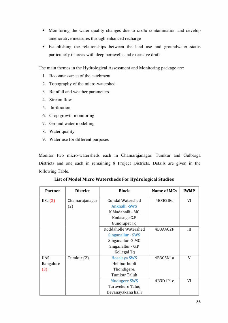
86
• Monitoring the water quality changes due to insitu contamination and develop
ameliorative measures through enhanced recharge
• Establishing the relationships between the land use and groundwater status
particularly in areas with deep borewells and excessive draft
The main themes in the Hydrological Assessment and Monitoring package are:
1. Reconnaissance of the catchment
2. Topography of the micro-watershed
3. Rainfall and weather parameters
4. Stream flow
5. Infiltration
6. Crop growth monitoring
7. Ground water modelling
8. Water quality
9. Water use for different purposes
Monitor two micro-watersheds each in Chamarajanagar, Tumkur and Gulbarga
Districts and one each in remaining 8 Project Districts. Details are given in the
following Table.
List of Model Micro Watersheds For Hydrological Studies
Partner District Block Name of MCs IWMP
IISc (2) Chamarajanagar
(2)
Gundal Watershed
Ankhalli -SWS
K.Madahalli - MC
Kodasoge G.P
Gundlupet Tq
4B3E2IEc VI
Doddaholle Watershed
Singanallur - SWS
Singanallur -2 MC
Singanallur - G.P
Kollegal Tq
4B3A4C2F
III
UAS
Bangalore
(3)
Tumkur (2) Hosalaya SWS
Hebbur hobli
Thondigere,
Tumkur Taluk
4B3C5N1a V
Mudugere SWS
Turuvekere Taluq
Devanayakana halli
4B3D1P1c VI
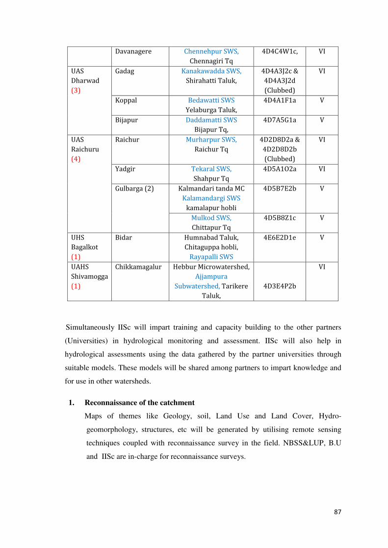
87
Davanagere Chennehpur SWS,
Chennagiri Tq
4D4C4W1c, VI
UAS
Dharwad
(3)
Gadag Kanakawadda SWS,
Shirahatti Taluk,
4D4A3J2c &
4D4A3J2d
(Clubbed)
VI
Koppal Bedawatti SWS
Yelaburga Taluk,
4D4A1F1a V
Bijapur Daddamatti SWS
Bijapur Tq,
4D7A5G1a V
UAS
Raichuru
(4)
Raichur Murharpur SWS,
Raichur Tq
4D2D8D2a &
4D2D8D2b
(Clubbed)
VI
Yadgir Tekaral SWS,
Shahpur Tq
4D5A1O2a VI
Gulbarga (2) Kalmandari tanda MC
Kalamandargi SWS
kamalapur hobli
4D5B7E2b
V
Mulkod SWS,
Chittapur Tq
4D5B8Z1c V
UHS
Bagalkot
(1)
Bidar Humnabad Taluk,
Chitaguppa hobli,
Rayapalli SWS
4E6E2D1e V
UAHS
Shivamogga
(1)
Chikkamagalur Hebbur Microwatershed,
Ajjampura
Subwatershed, Tarikere
Taluk,
4D3E4P2b
VI
Simultaneously IISc will impart training and capacity building to the other partners
(Universities) in hydrological monitoring and assessment. IISc will also help in
hydrological assessments using the data gathered by the partner universities through
suitable models. These models will be shared among partners to impart knowledge and
for use in other watersheds.
1. Reconnaissance of the catchment
Maps of themes like Geology, soil, Land Use and Land Cover, Hydro-
geomorphology, structures, etc will be generated by utilising remote sensing
techniques coupled with reconnaissance survey in the field. NBSS&LUP, B.U
and IISc are in-charge for reconnaissance surveys.
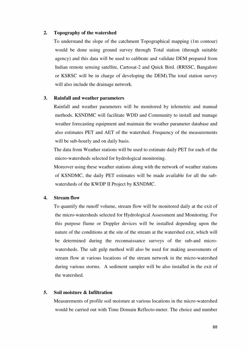
88
2. Topography of the watershed
To understand the slope of the catchment Topographical mapping (1m contour)
would be done using ground survey through Total station (through suitable
agency) and this data will be used to calibrate and validate DEM prepared from
Indian remote sensing satellite, Cartosat-2 and Quick Bird. (RRSSC, Bangalore
or KSRSC will be in charge of developing the DEM).The total station survey
will also include the drainage network.
3. Rainfall and weather parameters
Rainfall and weather parameters will be monitored by telemetric and manual
methods. KSNDMC will facilitate WDD and Community to install and manage
weather forecasting equipment and maintain the weather parameter database and
also estimates PET and AET of the watershed. Frequency of the measurements
will be sub-hourly and on daily basis.
The data from Weather stations will be used to estimate daily PET for each of the
micro-watersheds selected for hydrological monitoring.
Moreover using these weather stations along with the network of weather stations
of KSNDMC, the daily PET estimates will be made available for all the sub-
watersheds of the KWDP II Project by KSNDMC.
4. Stream flow
To quantify the runoff volume, stream flow will be monitored daily at the exit of
the micro-watersheds selected for Hydrological Assessment and Monitoring. For
this purpose flume or Doppler devices will be installed depending upon the
nature of the conditions at the site of the stream at the watershed exit, which will
be determined during the reconnaissance surveys of the sub-and micro-
watersheds. The salt gulp method will also be used for making assessments of
stream flow at various locations of the stream network in the micro-watershed
during various storms. A sediment sampler will be also installed in the exit of
the watershed.
5. Soil moisture & Infiltration
Measurements of profile soil moisture at various locations in the micro-watershed
would be carried out with Time Domain Reflecto-meter. The choice and number
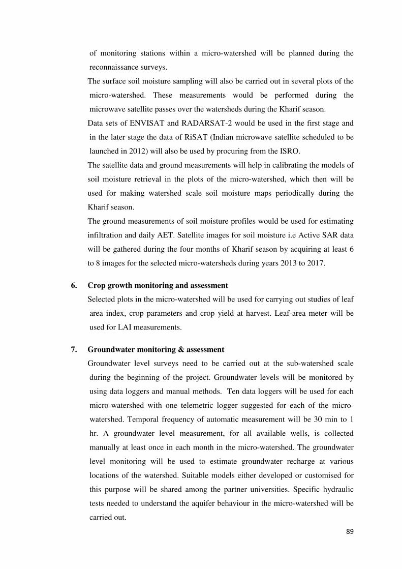
89
of monitoring stations within a micro-watershed will be planned during the
reconnaissance surveys.
The surface soil moisture sampling will also be carried out in several plots of the
micro-watershed. These measurements would be performed during the
microwave satellite passes over the watersheds during the Kharif season.
Data sets of ENVISAT and RADARSAT-2 would be used in the first stage and
in the later stage the data of RiSAT (Indian microwave satellite scheduled to be
launched in 2012) will also be used by procuring from the ISRO.
The satellite data and ground measurements will help in calibrating the models of
soil moisture retrieval in the plots of the micro-watershed, which then will be
used for making watershed scale soil moisture maps periodically during the
Kharif season.
The ground measurements of soil moisture profiles would be used for estimating
infiltration and daily AET. Satellite images for soil moisture i.e Active SAR data
will be gathered during the four months of Kharif season by acquiring at least 6
to 8 images for the selected micro-watersheds during years 2013 to 2017.
6. Crop growth monitoring and assessment
Selected plots in the micro-watershed will be used for carrying out studies of leaf
area index, crop parameters and crop yield at harvest. Leaf-area meter will be
used for LAI measurements.
7. Groundwater monitoring & assessment
Groundwater level surveys need to be carried out at the sub-watershed scale
during the beginning of the project. Groundwater levels will be monitored by
using data loggers and manual methods. Ten data loggers will be used for each
micro-watershed with one telemetric logger suggested for each of the micro-
watershed. Temporal frequency of automatic measurement will be 30 min to 1
hr. A groundwater level measurement, for all available wells, is collected
manually at least once in each month in the micro-watershed. The groundwater
level monitoring will be used to estimate groundwater recharge at various
locations of the watershed. Suitable models either developed or customised for
this purpose will be shared among the partner universities. Specific hydraulic
tests needed to understand the aquifer behaviour in the micro-watershed will be
carried out.
90
8. Water quality
Water quality of the stream and groundwater at various locations will be
determined. B.U will assist the water quality analysis.
9. Water use for different purposes
Bore well meters and power consumption will be considered to quantify
groundwater extraction. For surface water use details will be collected from GP
various records. NBSS&LUP and Partner Universities will be in-charge for
gathering data of water use and surveys.
Watersheds selected for Assessment and Monitoring
Advanced field based Hydrological assessment and monitoring will be implemented in
14 micro-watersheds in the Eleven districts namely, Bidar, Gulbarga, Yadgir, Gadag,
Koppal, Chamarajnagar, Davanagere, Tumkur, Raichur, Bijapur and Chikkamagalur.
Roles and Responsibilities
Partners Key Responsibilities
State level:
Watershed
Development
Department as
Key project
implementing
agency (PIA)
• To oversee the entire project implementation and
coordination between all partners.
• Actions to build institutional capacities in implementing
and partner agencies of the project.
• To release funds for project implementation as and when
required based on the situation.
Indian Institute of
Science (IISc) is
the Lead
consultancy for
hydrological
monitoring.
• To advise and support the WDD in Hydrological
assessment and monitoring related to the project.
• To monitor and assess two pilot watersheds in
Chamarajnagar District.
• To develop preparation of the bid documents for
procurement of equipments relevant to the project.
• To prepare guidelines to Design monitoring setup, advice
required formats for database of each watershed in order to
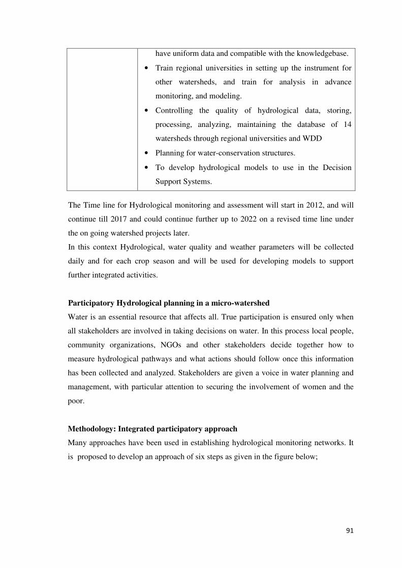
91
The Time line for Hydrological monitoring and assessment will start in 2012, and will
continue till 2017 and could continue further up to 2022 on a revised time line under
the on going watershed projects later.
In this context Hydrological, water quality and weather parameters will be collected
daily and for each crop season and will be used for developing models to support
further integrated activities.
Participatory Hydrological planning in a micro-watershed
Water is an essential resource that affects all. True participation is ensured only when
all stakeholders are involved in taking decisions on water. In this process local people,
community organizations, NGOs and other stakeholders decide together how to
measure hydrological pathways and what actions should follow once this information
has been collected and analyzed. Stakeholders are given a voice in water planning and
management, with particular attention to securing the involvement of women and the
poor.
Methodology: Integrated participatory approach
Many approaches have been used in establishing hydrological monitoring networks. It
is proposed to develop an approach of six steps as given in the figure below;
have uniform data and compatible with the knowledgebase.
• Train regional universities in setting up the instrument for
other watersheds, and train for analysis in advance
monitoring, and modeling.
• Controlling the quality of hydrological data, storing,
processing, analyzing, maintaining the database of 14
watersheds through regional universities and WDD
• Planning for water-conservation structures.
• To develop hydrological models to use in the Decision
Support Systems.
92
Fig.12 Integrated participatory approach in establishing the hydrological
monitoring network
Use of hydrological assessment by the community
• Participation of men and women of a watershed community in decision making at
all levels of water management is essential to achieve sustainability. Integrated
and sustainable water-resource management will contribute greatly to gender
equality by improving access of both women and men to water and water-related
services.
Step 1
Step 2
Step 3
Step 4
Step 5
Inception of Idea (a) What should be the spatial boundaries of
the monitoring system?
(b) What are the key hydrological processes
that need to be monitored and how?
(c) Is there any existing monitoring system?
(d) What is the historical profile of the
system?
End User
Stakeholder Identification (a) Who are key stakeholders
(b) What are their interests?
(c) How should they be involved?
(d) When should they be involved?
Defining the Scope of the Network (a) Establish a range of possible networks
(b) Consider processes that needs to be
monitored, resource available and scope
of existing network
Installation (a) Collect and analyze existing information
(b) Site Surveys
(c) Detailed design and installation
(d) Participation of key stakeholders in
installation
Monitoring (a) Participation of stakeholders
(b) Security of the installed network
Input from Experts &
Key Stakeholder
Expert Knowledge
(Experience from similar
projects Elsewhere &
Literature)
Local Knowledge
Feedback to Key
Stakeholders
Data and Information
sharing (Field days, report
analyzed data)
93
• Equitable, sustainable and guaranteed access to water will result in reduction in
loss of produce caused by disruption in water supply and, consequently, helps
increase incomes and reduce poverty.
• Adequate supply of water in the watershed creates an environment for additional
production, which promotes employment and income enhancement.
• Involvement of many people promotes water education and awareness.
Training Needs
Improved knowledge and skills for a range of stakeholders, planners, and policy makers
at all levels will contribute to more effective integrated watershed management and
agricultural production. The component would be implemented through.
• Training of village-level extension agents (Jala Mitras), community institutions,
Gram Panchayat members and farmers.
• Special emphasis will be given to lead farmers who will form a core group as
champions and peer-to-peer support to other farmers.
• Institutional strengthening at state level, including training to implementing
agencies, with respect to management of surface water and groundwater and of
monitoring systems.
Linking Hydrological Assessment and Monitoring to Watershed planning through
DSS
Results of hydrological assessment and monitoring can be used to address a wide range
of water management issues such as;
• Recharging groundwater and thereby aquifers for ensuring sustainability matching
demand and supply.
• Reducing loss through runoff and evaporation losses through appropriate
interventions.
The data needed for undertaking the above assessment can be sourced from the Digital
Library. The information is also used for developing appropriate models and
incorporates in the decision support system to address complexities involved in
sustainable management of both surface- and ground-water resources.
94
4.2.3 Technology transfer
Objectives:
• Development/adaptation of best-practice models and tools for end-users.
• Developing planning and training tools.
Strategy:
In terms of strengthening extension systems and outreach to rainfed farmers, the REC
will build strengths and links of the existing agricultural extension system. For
technology transfer specialist technical agencies, closely coordinated by the PTC and
REC will be contracted work in consultation with DoA and end users to develop
information and decision tools for end users. For prioritizing and coordinating field
demonstrations, for the adoption of new technologies, Farmer Field Schools approach
will be adopted. The REC will coordinate closely with the DoA’s and UAS field
research and extension wings.
The REC shall ensure that extension units such as district agricultural offices and RSKs
and KVKs in project watersheds are closely involved to feed research results into the
extension training programmes (under Component 3). This work will be coordinated by
the District Agricultural Training Centres through the KVKs and the RSKs.
RSKs will be upgraded to use IT under separate DoA funds. For this the PPMU will
contract a consultant to work closely with the REC and extension units to develop
interactive kiosks for use of extension agents and farmers to access a range of
information. Based on the utilization and feedback on the kiosks, these kiosks could be
rolled out in the second phase project to the MWS also.
Priority Areas of Technology Transfer:
The tools and techniques required to be demonstrated as best-practice models for end
users are in the following areas.
• Land capability maps at micro-watershed level indicating potentials and
constraints of the resources at individual farm level.
• Land suitability maps for cereals, oilseeds, pulses, horticultural crops, tree crops
and farming systems
95
• Contingency plans for managing climate risks such as drought, variations in the
onset and withdrawals of monsoon, and flood.
• Synergizing other developmental programmes such as soil and water conservation
measures with soil topography and rainfall maps generated through Land
resources inventory.
• Using hydro-geological and geo-morphological maps to develop groundwater
management plans
• Monitoring information related to market demands, supplies and prices on the
data base for dissemination.
Methodology for Transfer of Technology:
The new technology will be disseminated by organizing demonstrations on specific
land uses, crops and farming systems, INM, IPM, Water use efficiency, water
conservation through land configuration systems, alternative land uses and livestock
management.
Audio-visual aids, web based information can also be used for intensification of
agriculture and improving water-use efficiency.
Exposure visits to farmers within the District/State will be arranged for better
understanding and adaptation of the technology by them.
In addition to the above, adaptive trials will be conducted on farmers’ fields so as to
train them for sustaining higher production levels and preventing resource degradation.
Specific themes will be selected and farmers’ field schools will be organized through
Lead Farmers for training purposes.
4.2.4. Strengthening research management
The REC will coordinate with local universities and research organizations and ensure
collaboration with other research institutions in India, such as International Crops
Research Institute for the Semi-Arid-Tropics (ICRISAT, under the CGIAR), and where
local/national expertise is not available, from specialized research institutions and
researchers overseas.
The REC will convene a workshop at State level for research identification and priority
setting. Further the REC will collaborate with the Agricultural Research Identification
96
and funding processes existing in the DoA. This includes District level bi-monthly
workshops, and bi-annual Zonal Research and Extension Advisory Council (ZREAC)
meetings in each agro-climatic region, both of which involve university research and
department extension staff. The DoA also has a Research and Development Scheme for
funding research, directed towards the three UAS. The project will augment the
resources dedicated to rainfed agriculture and the range of stakeholders involved with
specific interests in watershed management. For example, the REC would ensure that
the private sector, NGO and community representatives form part of the identification
process for research programmes.
For integrated hydrological monitoring, the IISc through a consultancy shall advise the
PPMU on the purchase of equipment for one micro-watershed where best-practice
monitoring methodology would be demonstrated. The IISc will use the pilot
experiences to train the three UAS institutions in rolling out the advanced system in 14
selected micro-watersheds across all seven project Districts. There would be close
coordination on hydrology and groundwater monitoring through Bangalore University,
which has a network of groundwater monitoring points. An MoU would be signed with
the Karnataka State Natural Disaster Monitoring Centre (KSNDMC) under the State
Department of Science and Technology, for processing and sharing of the agro-climatic
data that this component would generate.
97
Fig.13 Schematic Representation of component 2
SAU/SHU
NGO / Private
Sectors
IISc
Specialized
Technology
Transfer
Agencies
Bangalore
University
DoA & DoH
DoA Districts
Extension Units
KVKs
Hopcoms
RSKs
Agricultural
Systems & Portal
Web Server, etc.
Demonstrations
Field Schools
PPMU
REC
Research
Competitive Research
Process
Hydrological
Monitoring System
Technology
Transfer
98
4.2.5 Pilot Demonstration of Water Harvesting and production technologies
Watershed Development Department is implementing integrated Watershed
Development programmes in the state. The Programme envisages efficient
utilization of Natural Resources like soil, water, bio-diversity for improving
Livelihood of the farmers. Soil & Moisture conservation structures like graded
bunds, Trench cum bund, Farm ponds Check dams, boulder checks, Gully checks,
mini perculation tank etc., have been implemented. To improve the productivity of
the crops several agronomic practices have been adopted. To raise the income of
the farmers Income Generating activities like Animal Husbandry, Poultry, Bee
keeping etc., were undertaken in the projects. The rain water harvested and
collected in Water Harvesting Structures and supplementary irrigation with Bore
wells. High value crops are grown to improve the income of the farmers.
Karnataka Watershed Development Project-II (Sujala-III) World Bank aided
project under component, research development and innovation has earmarked
Rs. 300 lakhs for 2015-16 and Rs. 300 lakhs for 2016-17 and Rs. 400 lakhs for
2017-18 totaling Rs. 1000 lakhs (CBH. ID No. 2133 approved project cost table)
for conducting pilot demonstration of Water Harvesting and Production
Technology. The demonstration will be conducted in one selected Watershed in
each project districts in small and marginal farmers field in utilizing this stored
water for productive purposes.
Objectives :
1. To demonstrate how to utilize the water harvested in the project activity to
enhance the income of the farmers.
2. To demonstrate the ways of other income generation activity and to improve
the lively wood of the farmers.
3. To provide income to the farmers throughout the year in rainfed areas
through the intervention of Horticulture and Animal Husbandry
4.2.6 Pilot demonstrations on watershed treatments saturation gap filling in selected
in micro watersheds
Govt.of India has fixed the cost per hectare of Rs.12000/-in plains and
Rs.15000/-in hilly areas under IWMP projects. Of which amount available for
land based activities is Rs.6720/Ha in plains and Rs.8400/Ha in hilly areas. In
this context, the area planned to be treated may not be fully covered giving thrust
for all the activities required in that parcel on holistic approach may be due to
paucity of funds.
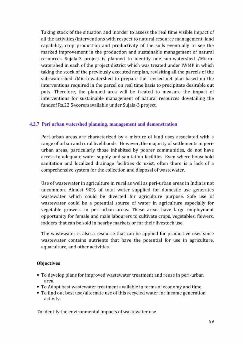
99
Taking stock of the situation and inorder to assess the real time visible impact of
all the activities/interventions with respect to natural resource management, land
capability, crop production and productivity of the soils eventually to see the
marked improvement in the production and sustainable management of natural
resources. Sujala-3 project is planned to identify one sub-watershed /Micro-
watershed in each of the project district which was treated under IWMP in which
taking the stock of the previously executed netplan, revisiting all the parcels of the
sub-watershed /Micro-watershed to prepare the revised net plan based on the
interventions required in the parcel on real time basis to precipitate desirable out
puts. Therefore, the planned area will be treated to measure the impact of
interventions for sustainable management of natural resources dovetailing the
fundsof Rs.22.54corersavailable under Sujala-3 project.
4.2.7 Peri urban watershed planning, management and demonstration
Peri-urban areas are characterized by a mixture of land uses associated with a
range of urban and rural livelihoods. However, the majority of settlements in peri-
urban areas, particularly those inhabited by poorer communities, do not have
access to adequate water supply and sanitation facilities. Even where household
sanitation and localized drainage facilities do exist, often there is a lack of a
comprehensive system for the collection and disposal of wastewater.
Use of wastewater in agriculture in rural as well as peri-urban areas in India is not
uncommon. Almost 90% of total water supplied for domestic use generates
wastewater which could be diverted for agriculture purpose. Safe use of
wastewater could be a potential source of water in agriculture especially for
vegetable growers in peri-urban areas. These areas have large employment
opportunity for female and male labourers to cultivate crops, vegetables, flowers,
fodders that can be sold in nearby markets or for their livestock use.
The wastewater is also a resource that can be applied for productive uses since
wastewater contains nutrients that have the potential for use in agriculture,
aquaculture, and other activities.
Objectives
• To develop plans for improved wastewater treatment and reuse in peri-urban
area.
• To Adopt best wastewater treatment available in terms of economy and time.
• To find out best use/alternate use of this recycled water for income generation
activity.
To identify the environmental impacts of wastewater use
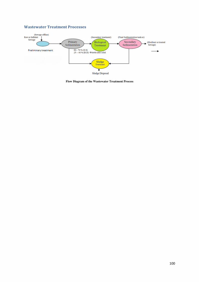
100
Wastewater Treatment Processes
Flow Diagram of the Wastewater Treatment Process
101
4.3 Component - 3. Institutional Strengthening-Capacity Building
The project seeks to demonstrate more effective watershed management through
greater programme integration related to rainfed agriculture, innovative and science-
based approaches, strengthened institutions and increased capacities of the
stakeholders. The project proposes to strengthen science base of watershed
management under IWMP through land management in the light of hydrological
dynamics and climate variability along with Horticulture, value chain & value addition
etc. It is considered that greater participation of small and marginal farmers in the
proposed extension delivery system, agricultural, horticultural schemes, will enhance
their opportunities to adopt new technologies for realizing higher yields and incomes.
In addition, stakeholders require more knowledge and expertise on improved planning
tools and process, land management and productivity in rainfed areas.
The capacity building activities will be organized to improve / enhance the ability of all
stakeholders to achieve the project objectives collectively. The principles of capacity
building are : (i) Institutional development focusing engagement of stakeholders in
relation to the development objectives and ii) Enhancing knowledge base and skill
levels of different stake holders.
The project targets the capacity building of the following:
a) Beneficiary organizations (EC, UG, SHGs, HOPCOMS)
b) Facilitator organizations (WDT, NGOs, WA)
c) Project Management Unit (PPMU, PTC, REC, DWDO, TWDOs)
d) Elected Local Bodies (GP and ZP members)
e) Technical support members (Staff of WDD, DoA, DoH, SAUs, DoAH, UHS,
RSKs, KVKs)
Implementation:
The PPMU will plan, oversee and monitor the comprehensive training needs and
exposure program for the State, District and field level project stakeholders. This task
will be implemented with the assistance of a contracted training NGO having extensive
experience & expertise in participatory watershed management and agricultural
extension activities. Workshops and Trainings including Exposure visits and
development of suitable Training Modules are the integral part of the capacity building
process.
102
Institutional Development achieved through:
• Customised training modules & programs on planning processes.
• Tools & Techniques of integrated watershed management.
• Development and Strengthening of the in-house M&E systems in WDD
• Providing Information Education and Communication (IEC) equipments to farmer
contact centres.
• Study tours / Exposure visits within India and selected countries abroad
• Effective MIS system.
Main Objectives :
• Institutional Strengthening & Capacity Building of Project partners &
implementing agencies.
• Train the stakeholders at all levels for efficient & integrated watershed
management programmes to achieve enhanced Production and Productivity in
rainfed agriculture.
• Integrate the existing training programmes conducted through IWMP
• Strengthen the skills and knowledge of stakeholders at community and state level.
• Scientific, improved & integrated watershed planning & management in rainfed
areas.
• To impart training to the farmer groups about watershed planning programme,
convergence, integration, and participatory agricultural extension, either directly
or through a lead farmer trainer.
• To Train the Village level extension agents (Jala Mitras / Gopalaka Mitras),
community institutions, Gram Panchayat members, and farmers about the benefits
of integrated watershed planning and the importance of effective convergence of
IWMP and MNREGS operations.
• To Train the farmers on integrated crop planning, water management, farming
intensity, environmental management, soil and soil moisture management, and
adaptation to climatic change, etc.
• Incremental training for User Groups / Producer groups on improved harvesting
and post-harvest handling of produce, Primary processing and value addition,
assessing the market potential etc. for Agriculture and Horticulture crops.
103
• Awareness training for the members of Women’s Groups & Self-Help Groups
about the other ongoing Government Schemes and Programs on Agriculture,
Horticulture, Animal Husbandry etc.
• To organise Exposure Visits for community members across the project area for
exchange of information, sharing the Knowledge and adoption of latest
Technology.
Training Material and Tools for CB Activities:
Preparation of Training Materials and Tools and Development of various training
Modules will be the responsibility of the Lead Technical Partner of the respective
component, in association with WDD. In this regard, PTC and REC of WDD will co-
ordinate with all the Technical project partners. While preparing CB Plan care will be
taken to integrate the existing information in the IWMP Training modules. The
proposed major Training Programmes, workshops, training modules and the exposure
visits for Capacity Building are listed in the Table below.
4.3.1 Infrastructure improvements
Necessary steps will be taken to upgrade the District Watershed Training Centres
located at Mysore and Bijapur. Services of these Training Centres will be utilised
to impart trainings to target groups of the project at different levels. To provide
improved Training support, these two institutions will be strengthened for
establishing effective Management Information Systems (MIS) by upgrading the
Technology with latest software and hardware.
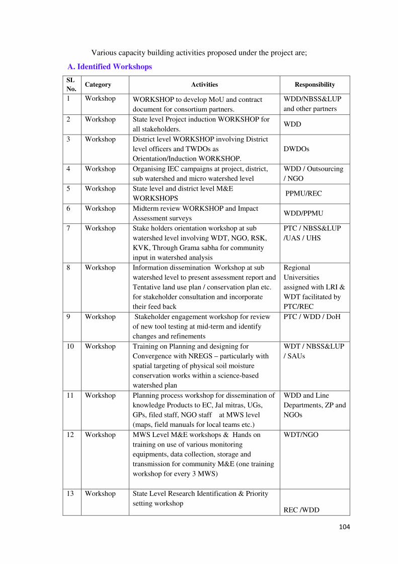
104
Various capacity building activities proposed under the project are;
A. Identified Workshops
SL
No. Category Activities Responsibility
1 Workshop WORKSHOP to develop MoU and contract
document for consortium partners.
WDD/NBSS&LUP
and other partners
2 Workshop State level Project induction WORKSHOP for
all stakeholders. WDD
3 Workshop District level WORKSHOP involving District
level officers and TWDOs as
Orientation/Induction WORKSHOP.
DWDOs
4 Workshop Organising IEC campaigns at project, district,
sub watershed and micro watershed level
WDD / Outsourcing
/ NGO
5 Workshop State level and district level M&E
WORKSHOPS PPMU/REC
6 Workshop Midterm review WORKSHOP and Impact
Assessment surveys WDD/PPMU
7 Workshop Stake holders orientation workshop at sub
watershed level involving WDT, NGO, RSK,
KVK, Through Grama sabha for community
input in watershed analysis
PTC / NBSS&LUP
/UAS / UHS
8 Workshop Information dissemination Workshop at sub
watershed level to present assessment report and
Tentative land use plan / conservation plan etc.
for stakeholder consultation and incorporate
their feed back
Regional
Universities
assigned with LRI &
WDT facilitated by
PTC/REC
9 Workshop Stakeholder engagement workshop for review
of new tool testing at mid-term and identify
changes and refinements
PTC / WDD / DoH
10 Workshop Training on Planning and designing for
Convergence with NREGS – particularly with
spatial targeting of physical soil moisture
conservation works within a science-based
watershed plan
WDT / NBSS&LUP
/ SAUs
11 Workshop Planning process workshop for dissemination of
knowledge Products to EC, Jal mitras, UGs,
GPs, filed staff, NGO staff at MWS level
(maps, field manuals for local teams etc.)
WDD and Line
Departments, ZP and
NGOs
12 Workshop MWS Level M&E workshops & Hands on
training on use of various monitoring
equipments, data collection, storage and
transmission for community M&E (one training
workshop for every 3 MWS)
WDT/NGO
13 Workshop State Level Research Identification & Priority
setting workshop REC /WDD
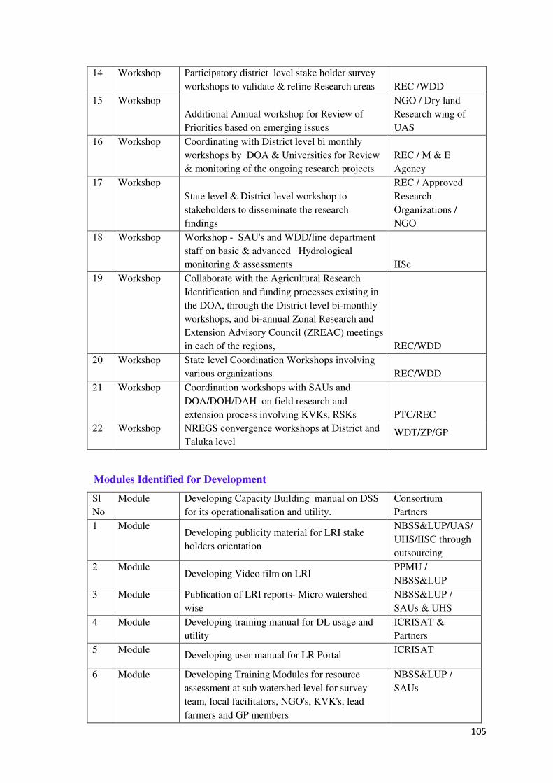
105
14 Workshop Participatory district level stake holder survey
workshops to validate & refine Research areas REC /WDD
15 Workshop
Additional Annual workshop for Review of
Priorities based on emerging issues
NGO / Dry land
Research wing of
UAS
16 Workshop Coordinating with District level bi monthly
workshops by DOA & Universities for Review
& monitoring of the ongoing research projects
REC / M & E
Agency
17 Workshop
State level & District level workshop to
stakeholders to disseminate the research
findings
REC / Approved
Research
Organizations /
NGO
18 Workshop Workshop - SAU's and WDD/line department
staff on basic & advanced Hydrological
monitoring & assessments IISc
19 Workshop Collaborate with the Agricultural Research
Identification and funding processes existing in
the DOA, through the District level bi-monthly
workshops, and bi-annual Zonal Research and
Extension Advisory Council (ZREAC) meetings
in each of the regions, REC/WDD
20 Workshop State level Coordination Workshops involving
various organizations REC/WDD
21 Workshop Coordination workshops with SAUs and
DOA/DOH/DAH on field research and
extension process involving KVKs, RSKs PTC/REC
22 Workshop NREGS convergence workshops at District and
Taluka level WDT/ZP/GP
Modules Identified for Development
Sl
No
Module Developing Capacity Building manual on DSS
for its operationalisation and utility.
Consortium
Partners
1 Module Developing publicity material for LRI stake
holders orientation
NBSS&LUP/UAS/
UHS/IISC through
outsourcing
2 Module Developing Video film on LRI
PPMU /
NBSS&LUP
3 Module Publication of LRI reports- Micro watershed
wise
NBSS&LUP /
SAUs & UHS
4 Module Developing training manual for DL usage and
utility
ICRISAT &
Partners
5 Module Developing user manual for LR Portal
ICRISAT
6 Module Developing Training Modules for resource
assessment at sub watershed level for survey
team, local facilitators, NGO's, KVK's, lead
farmers and GP members
NBSS&LUP /
SAUs
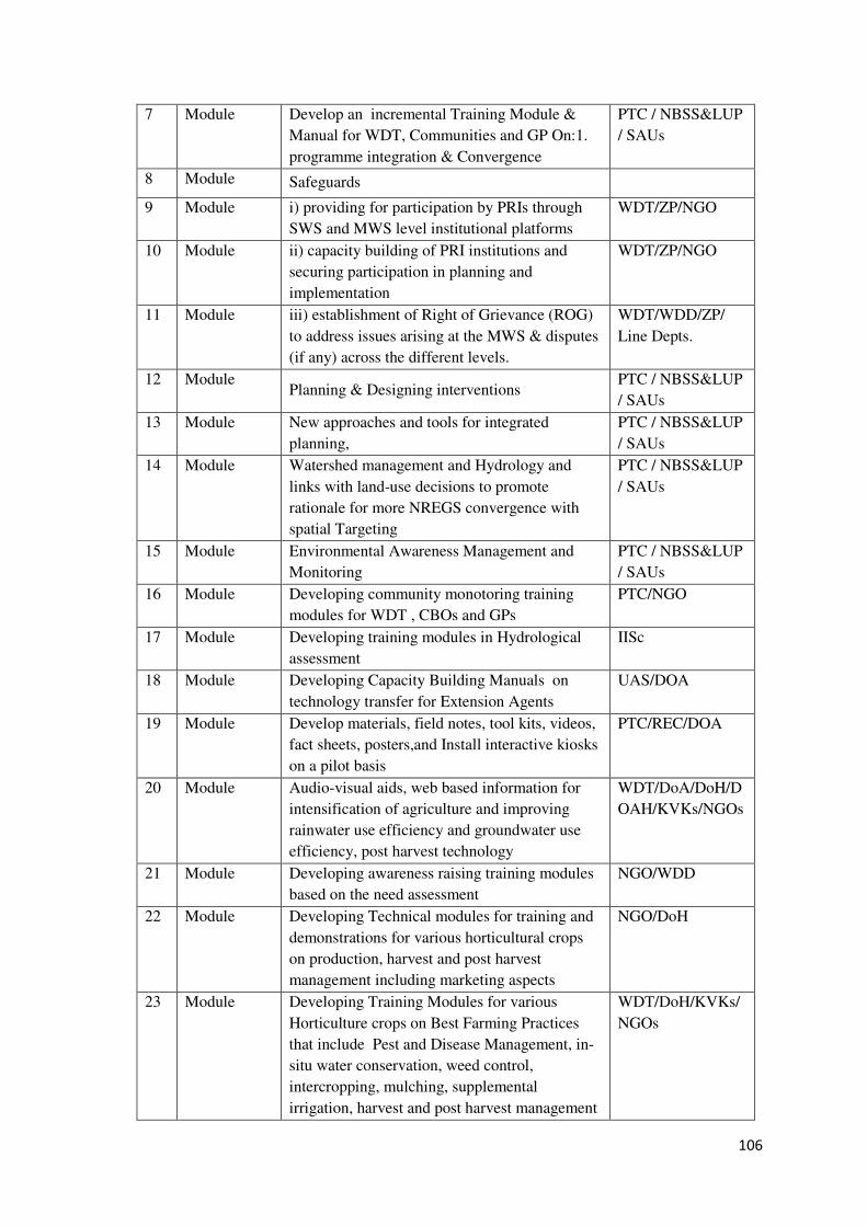
106
7 Module Develop an incremental Training Module &
Manual for WDT, Communities and GP On:1.
programme integration & Convergence
PTC / NBSS&LUP
/ SAUs
8 Module Safeguards
9 Module i) providing for participation by PRIs through
SWS and MWS level institutional platforms
WDT/ZP/NGO
10 Module ii) capacity building of PRI institutions and
securing participation in planning and
implementation
WDT/ZP/NGO
11 Module iii) establishment of Right of Grievance (ROG)
to address issues arising at the MWS & disputes
(if any) across the different levels.
WDT/WDD/ZP/
Line Depts.
12 Module Planning & Designing interventions
PTC / NBSS&LUP
/ SAUs
13 Module New approaches and tools for integrated
planning,
PTC / NBSS&LUP
/ SAUs
14 Module Watershed management and Hydrology and
links with land-use decisions to promote
rationale for more NREGS convergence with
spatial Targeting
PTC / NBSS&LUP
/ SAUs
15 Module Environmental Awareness Management and
Monitoring
PTC / NBSS&LUP
/ SAUs
16 Module Developing community monotoring training
modules for WDT , CBOs and GPs
PTC/NGO
17 Module Developing training modules in Hydrological
assessment
IISc
18 Module Developing Capacity Building Manuals on
technology transfer for Extension Agents
UAS/DOA
19 Module Develop materials, field notes, tool kits, videos,
fact sheets, posters,and Install interactive kiosks
on a pilot basis
PTC/REC/DOA
20 Module Audio-visual aids, web based information for
intensification of agriculture and improving
rainwater use efficiency and groundwater use
efficiency, post harvest technology
WDT/DoA/DoH/D
OAH/KVKs/NGOs
21 Module Developing awareness raising training modules
based on the need assessment
NGO/WDD
22 Module Developing Technical modules for training and
demonstrations for various horticultural crops
on production, harvest and post harvest
management including marketing aspects
NGO/DoH
23 Module Developing Training Modules for various
Horticulture crops on Best Farming Practices
that include Pest and Disease Management, in-
situ water conservation, weed control,
intercropping, mulching, supplemental
irrigation, harvest and post harvest management
WDT/DoH/KVKs/
NGOs
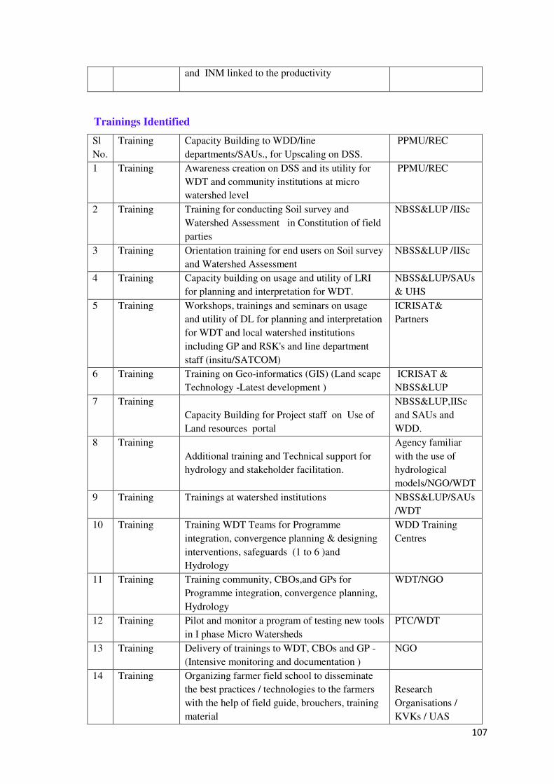
107
and INM linked to the productivity
Trainings Identified
Sl
No.
Training Capacity Building to WDD/line
departments/SAUs., for Upscaling on DSS.
PPMU/REC
1 Training Awareness creation on DSS and its utility for
WDT and community institutions at micro
watershed level
PPMU/REC
2 Training Training for conducting Soil survey and
Watershed Assessment in Constitution of field
parties
NBSS&LUP /IISc
3 Training Orientation training for end users on Soil survey
and Watershed Assessment
NBSS&LUP /IISc
4 Training Capacity building on usage and utility of LRI
for planning and interpretation for WDT.
NBSS&LUP/SAUs
& UHS
5 Training Workshops, trainings and seminars on usage
and utility of DL for planning and interpretation
for WDT and local watershed institutions
including GP and RSK's and line department
staff (insitu/SATCOM)
ICRISAT&
Partners
6 Training Training on Geo-informatics (GIS) (Land scape
Technology -Latest development )
ICRISAT &
NBSS&LUP
7 Training
Capacity Building for Project staff on Use of
Land resources portal
NBSS&LUP,IISc
and SAUs and
WDD.
8 Training
Additional training and Technical support for
hydrology and stakeholder facilitation.
Agency familiar
with the use of
hydrological
models/NGO/WDT
9 Training Trainings at watershed institutions NBSS&LUP/SAUs
/WDT
10 Training Training WDT Teams for Programme
integration, convergence planning & designing
interventions, safeguards (1 to 6 )and
Hydrology
WDD Training
Centres
11 Training Training community, CBOs,and GPs for
Programme integration, convergence planning,
Hydrology
WDT/NGO
12 Training Pilot and monitor a program of testing new tools
in I phase Micro Watersheds
PTC/WDT
13 Training Delivery of trainings to WDT, CBOs and GP -
(Intensive monitoring and documentation )
NGO
14 Training Organizing farmer field school to disseminate
the best practices / technologies to the farmers
with the help of field guide, brouchers, training
material
Research
Organisations /
KVKs / UAS
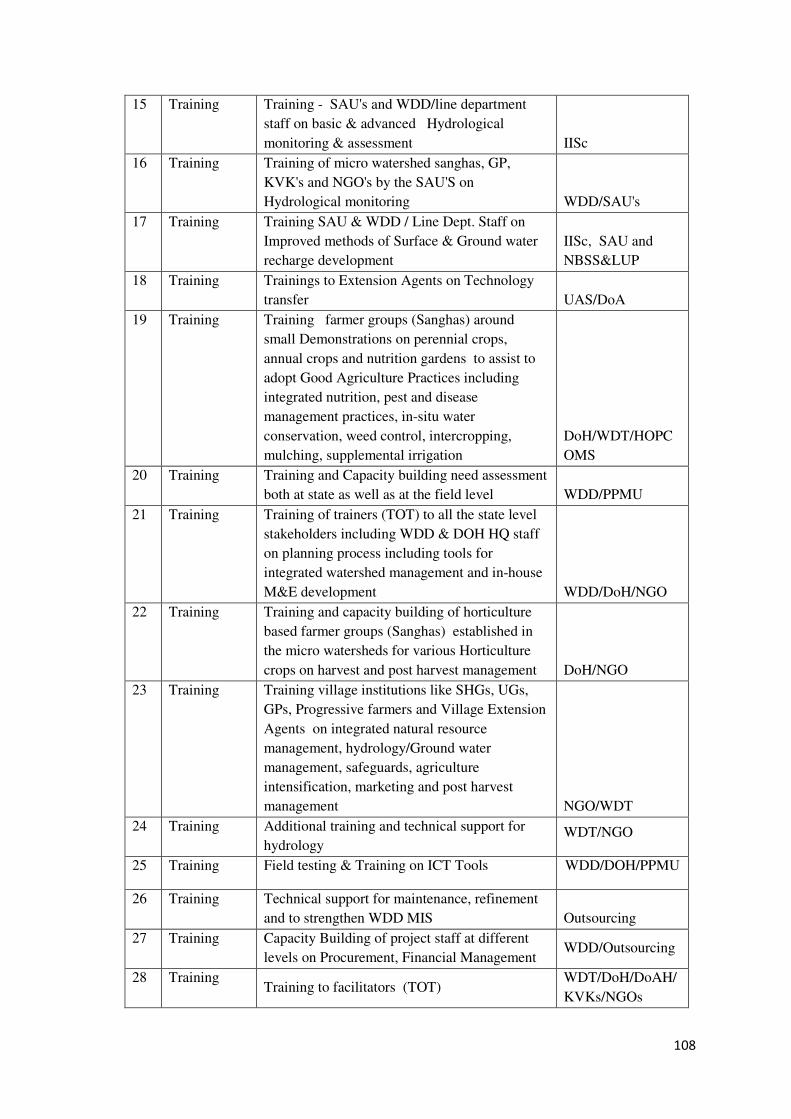
108
15 Training Training - SAU's and WDD/line department
staff on basic & advanced Hydrological
monitoring & assessment IISc
16 Training Training of micro watershed sanghas, GP,
KVK's and NGO's by the SAU'S on
Hydrological monitoring WDD/SAU's
17 Training Training SAU & WDD / Line Dept. Staff on
Improved methods of Surface & Ground water
recharge development
IISc, SAU and
NBSS&LUP
18 Training Trainings to Extension Agents on Technology
transfer UAS/DoA
19 Training Training farmer groups (Sanghas) around
small Demonstrations on perennial crops,
annual crops and nutrition gardens to assist to
adopt Good Agriculture Practices including
integrated nutrition, pest and disease
management practices, in-situ water
conservation, weed control, intercropping,
mulching, supplemental irrigation
DoH/WDT/HOPC
OMS
20 Training Training and Capacity building need assessment
both at state as well as at the field level WDD/PPMU
21 Training Training of trainers (TOT) to all the state level
stakeholders including WDD & DOH HQ staff
on planning process including tools for
integrated watershed management and in-house
M&E development WDD/DoH/NGO
22 Training Training and capacity building of horticulture
based farmer groups (Sanghas) established in
the micro watersheds for various Horticulture
crops on harvest and post harvest management DoH/NGO
23 Training Training village institutions like SHGs, UGs,
GPs, Progressive farmers and Village Extension
Agents on integrated natural resource
management, hydrology/Ground water
management, safeguards, agriculture
intensification, marketing and post harvest
management NGO/WDT
24 Training Additional training and technical support for
hydrology WDT/NGO
25 Training Field testing & Training on ICT Tools WDD/DOH/PPMU
26 Training Technical support for maintenance, refinement
and to strengthen WDD MIS Outsourcing
27 Training Capacity Building of project staff at different
levels on Procurement, Financial Management WDD/Outsourcing
28 Training Training to facilitators (TOT)
WDT/DoH/DoAH/
KVKs/NGOs
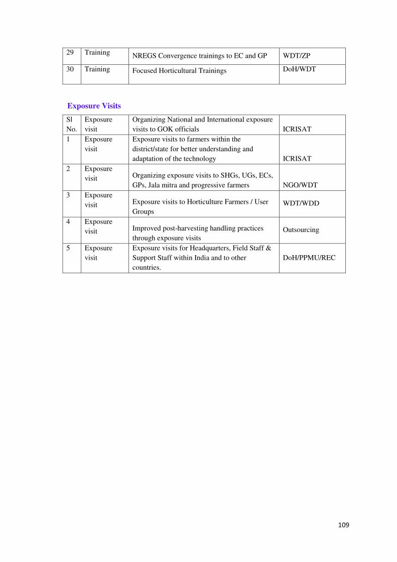
109
29 Training NREGS Convergence trainings to EC and GP WDT/ZP
30 Training Focused Horticultural Trainings DoH/WDT
Exposure Visits
Sl
No.
Exposure
visit
Organizing National and International exposure
visits to GOK officials ICRISAT
1 Exposure
visit
Exposure visits to farmers within the
district/state for better understanding and
adaptation of the technology ICRISAT
2 Exposure
visit Organizing exposure visits to SHGs, UGs, ECs,
GPs, Jala mitra and progressive farmers NGO/WDT
3 Exposure
visit Exposure visits to Horticulture Farmers / User
Groups WDT/WDD
4 Exposure
visit Improved post-harvesting handling practices
through exposure visits Outsourcing
5 Exposure
visit
Exposure visits for Headquarters, Field Staff &
Support Staff within India and to other
countries.
DoH/PPMU/REC
110
4.5 Component 5. Project Management and Coordination
Component 5 will be implemented through three sub components.
4.5.1 Sub-component 5.1. Human resources
The sub-component will support incremental technical staff (both full-time and part-
time) in headquarters and field offices, with specialization in various disciplines such as
agriculture, hydrology/meteorology, GIS/MIS, environment, training, documentation,
procurement, financial management, and legal services. These staff will be mainly
located in the headquarters of the project.
The sub-component will also support incremental administration costs including field
travel, communications and equipment such as rental cars, computers, office furniture,
etc, to support project implementation. The sub-component will cover costs of external
audits and other relevant financial management activities. It will also support the
setting up and maintenance of a project website (built as update to the existing WDD
website) and other project information material. The project will have a comprehensive
communication and review strategy to ensure wide awareness about the project purpose
and lessons, and ensure stakeholders engage in the continuous improvement of the
project. This will include specific information events and workshops, but will largely
build on the M&E and learning system and products, as well as a wide range of
knowledge products emerging from the research and development component.
Management specialists will be hired for strengthening the WDD management and
M&E systems, and upgrading the WDD’s existing MIS system.
In terms of strengthening extension systems and outreach to rainfed farmers, the REC
will build strengths and links of the existing agricultural extension system. This will be
coordinated with the District Agricultural Training Centres through KVKs(under the
Agricultural Universities) in most districts and also the RSKs (or Farmer Contact
Centres) located at the Hobli level.
The RSKs are managed by the Agricultural Officer at the Taluk level, and form a
contact point for farmer facilitators and farmer groups for agricultural inputs,
information on DoA schemes and technologies. One farmer facilitator, with an
allowance from the DoA, provides support on technologies and advice on schemes to
farmers in an area of 500 ha, roughly equivalent to a micro-watershed.
RSKs will have IT upgrading under separate DoA funds, the PPMU will contract a
consultant to work closely with the REC and extension units to develop interactive
111
kiosks on a pilot basis, which extension agents and farmers can use to access a range of
information. Based on the utilization and feedback, these kiosks will then be rolled out
in the second phase project also.
For technology transfer, specialist technical agencies, coordinated by the PTC and REC
and working in consultation with DoA and end users, will be contracted to develop
information decision tools for end users. For prioritizing and coordinating field
demonstrations and field schools for the adoption of new technologies, the REC will
coordinate with the DoA’s and UAS field research and extension processes.
At District and Taluk levels the project will provide support staff, training and
equipment to build capacity and strengthen the arrangements already in place, mainly
the existing DWDTs and WDT under the IWMP.
The REC supported by outsourced specialized NGOs will undertake capacity building
of existing agricultural and horticultural extension units, especially RSKs, so that the
local units can access and use a greater range of information products, decision tools,
and manage field demonstrations.
A web-enabled computerized MIS which will be an integral part of the M&E system,
integrated into the overall WDD MIS systems.
4.5.2 Sub-component 5.2 Financial management and procurement
The sub-component will support consultancies for financial management, procurement,
and internal audit to augment internal WDD capabilities and systems. Costs for staff
training in Bank procurement and financial management will also be supported.
A Finance Management and Procurement Cell (FMPC) will be established in the
WDD under the PPMU for financial and procurement control and reporting of the
project. The project will have a full time qualified Finance Manager at State level and
qualified staff in each of the eleven project Districts. There will be dedicated staff to
assist with the accounts under the horticulture component in Districts.
Financial management and procurement consultancies will be outsourced to assist the
PPMU in designing, establishing, and monitoring the FM systems, software
installation, and processes for handling finance and procurement issues under the Bank
project.
112
4.5.3 Sub-component 5.3 Project monitoring and evaluation
Introduction:
The sub-component will finance the incremental third party monitoring and evaluation
requirements relevant to project activities specifically, complementing the overall
M&E system operating under IWMP. The M&E system shall consist of the following
elements:
i) Baseline studies; ii) concurrent progress monitoring; iii) process monitoring and
pathway analysis; iv) results monitoring, including performance assessments, with
regular local and State project planning and review workshops; v) participatory
monitoring and evaluation; vi) thematic studies and case-studies, with learning and
policy oriented workshops; and vii) impact evaluation.
Input-output monitoring and regular reporting will be supported by a web-enabled
computerized MIS which will be an integral part of the M&E system,
Strategy
In the wake of increasingly emerging concern all over the world for people-centric,
environment- friendly and cost- effective development initiatives, there has been a
paradigm shift in monitoring and evaluation of projects. The thrust is essentially on
participatory monitoring and evaluation. It enables identification of operational
constraints and problems if any in planning and successful implementation of a project
and the department of suitable hands-on corrective measures by involving those
concerned. The project monitoring and evaluation approach as envisaged in the project
provides for the involvement of different stakeholders, implementing agencies and
research organizations in key decisions regarding convergence with other development
programmes in the area, inclusiveness, equity and agricultural intensification with best
farming practices and efforts at up-scaling.
The project M&E system shall a) provide a clear picture of the project, showing the
logical link between inputs, activities, outputs, and the sequence of outcomes; b)
outline an institutional/ governance structure for M&E and the roles and responsibilities
of stakeholders involved; c) describe a strategy to track progress, measure outcomes,
support the evaluation work, and enable continuous learning and improvement; and d)
provide information regarding what the project aims to achieve, identifies the critical
processes and indicators, and how it would measure and report on results. Annexure–X
113
provides project and component outcome indicators and methods for collecting
information.
Monitoring, Evaluation and Learning
• Monitoring is a systematic and continuous assessment of the progress and
direction of all activities throughout the project period, watching closely the
project implementation trajectories and the results achieved. In the process,
shortcomings are identified and brought to the notice of decision-makers, to
facilitate implementation of corrective measures.
• Evaluation consists of determining the net contribution of the project to
agricultural intensification in the project area adopting science-based farming and
benefits that are accrued to the stakeholders, by using a set of indicators.
• Learning comprises the corrective measures identified to bridge the gaps observed
in the programme during the monitoring. The learning insights that emerge in the
process should be documented for generating a knowledge base that will be used
in developing contingency plans to overcome shortcomings in implementation of
similar programmes elsewhere. The learning, therefore, triggers multiplier effects
across space and time.
Impact Assessment
Impact Assessment of the project is done to evaluate the overall impact of the project
on the natural resources and socio-economic aspects.
This is done through 10% sampling (socio-economic & natural resources) with respect
to baseline, mid-term and final assessment.
Impact assessment will be carried out in 3 stages:-
i) Initial stage: The first stage will be initiated with baseline survey, which forms the
benchmark for the mid-term and final assessment. The sample watersheds under
the project taluk will be selected through simple random sampling with ‘control’
watersheds selected outside the project area.
ii) The baseline surveys would draw information from the Digital Library and
Natural Resources Portal and data from other sources.
iii) Mid-term assessment will be carried out to coincide with the half way point of
project implementation. It will make use of baseline information as benchmark.
114
iv) Final assessment: The final evaluation would coincide with the end of the project.
At this stage, the evaluation would focus on the project’s overall objectives of
improved productivity, reduction in poverty across the target population through
scientific land-use, performance of the local level institutions regarding their
ability to manage the resources, level of convergence with other development
programmes to determine equity, inclusiveness and optimum allocation of
financial resources. It will also focus on the best management practices identified
involving research organizations.
Concurrent progress monitoring
The purpose of this activity is to assess progress in implementation against time
progress of and fund use against budgets. It will report on progress of implementation
and expenditure on a quarterly and annual basis. Concurrent monitoring will consist of
two parts:
• Input-output monitoring (updated monthly, reported quarterly and annually) to be
undertaken by project implementation and management units supported by an
MIS; and
• Sample survey (quarterly basis), to be undertaken by an external M&E agency
for validation of internal reports.
Process monitoring and pathway analysis
Process monitoring will deal with critical processes directly related to the project
objectives, viz., formulation of integrated plans, convergence of resources, and so on.
It will be combined with ‘pathway analysis’ to systematically study and analyze the
factors leading to achievement or non-achievement of intermediate project outcomes
and impacts.
Process monitoring responsibilities will be divided between internal and external
auditors, and specific formats and checklists developed to facilitate process monitoring
by internal staff members. To deal with the constraints of lack of capacity for
undertaking such assignment, an external agency will be hired for capacity building of
project team.
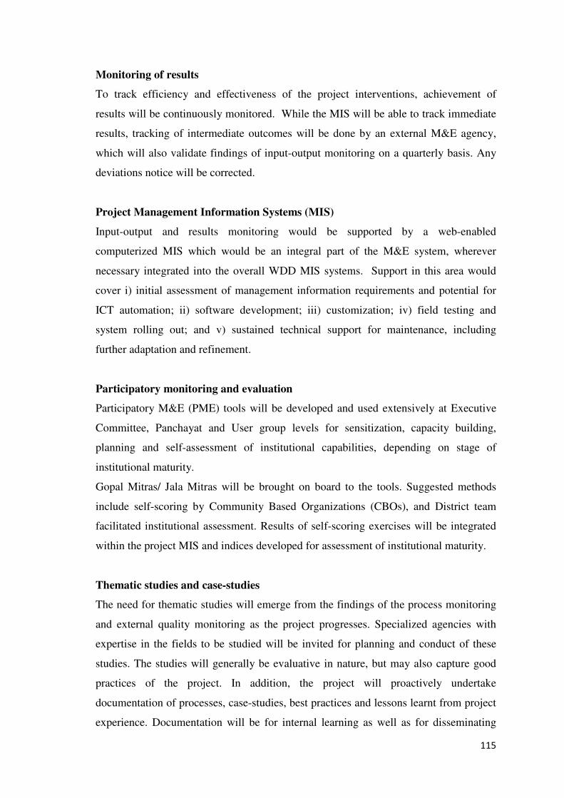
115
Monitoring of results
To track efficiency and effectiveness of the project interventions, achievement of
results will be continuously monitored. While the MIS will be able to track immediate
results, tracking of intermediate outcomes will be done by an external M&E agency,
which will also validate findings of input-output monitoring on a quarterly basis. Any
deviations notice will be corrected.
Project Management Information Systems (MIS)
Input-output and results monitoring would be supported by a web-enabled
computerized MIS which would be an integral part of the M&E system, wherever
necessary integrated into the overall WDD MIS systems. Support in this area would
cover i) initial assessment of management information requirements and potential for
ICT automation; ii) software development; iii) customization; iv) field testing and
system rolling out; and v) sustained technical support for maintenance, including
further adaptation and refinement.
Participatory monitoring and evaluation
Participatory M&E (PME) tools will be developed and used extensively at Executive
Committee, Panchayat and User group levels for sensitization, capacity building,
planning and self-assessment of institutional capabilities, depending on stage of
institutional maturity.
Gopal Mitras/ Jala Mitras will be brought on board to the tools. Suggested methods
include self-scoring by Community Based Organizations (CBOs), and District team
facilitated institutional assessment. Results of self-scoring exercises will be integrated
within the project MIS and indices developed for assessment of institutional maturity.
Thematic studies and case-studies
The need for thematic studies will emerge from the findings of the process monitoring
and external quality monitoring as the project progresses. Specialized agencies with
expertise in the fields to be studied will be invited for planning and conduct of these
studies. The studies will generally be evaluative in nature, but may also capture good
practices of the project. In addition, the project will proactively undertake
documentation of processes, case-studies, best practices and lessons learnt from project
experience. Documentation will be for internal learning as well as for disseminating

116
project experiences to other stakeholders; it will be a continuing process throughout the
project duration and across all the project personnel.
Impact Evaluation
The objective of Impact Evaluation will be to establish the net contribution of the
project to the sustainable livelihoods of the targeted families quasi-experimental time-
series design will proposed for the project impact evaluation. As necessitated by the
nature of the project outcomes and impacts, an appropriate mix of quantitative and
qualitative methods will be adopted for the evaluations.
Action learning, documentation and reflection
Internal learning is crucial for the project to be responsive to the changing context of
the project as it progresses. The effectiveness of internal learning will depend upon the
degree of institutionalization of learning among the various levels of project
organization and the community.
A considerable part of learning will take place through a structured set of participatory
workshops associated with quarterly and annual review and planning, at local, district
and State level.
Institutional Arrangement for M&E
The M&E responsibilities will be distributed across all the project units and staff.
However, primary responsibilities at each level will rest with M&E specialists:
• M&E Coordinator and MIS Coordinator at the state level;
• M&E assigned specialist and MIS Specialist at district level; and
• Hired services for design, development, operation and maintenance of project MIS.
The Results framework table in Annexure outlines responsibilities in relation to
outcome monitoring.
Items to be Monitored
• Convergence between NREGS and IWMP so as to augment finances for
effectively organizing soils and water conservation measures as only 63% of the
allocations under IWMP could be used for soil and water conservation
117
• Micro-watershed plans developed for promoting science-based land-use
management coupled with integrated water resources management based on
hydrological assessment.
• Bridging the yield gaps at the individual farm level in the watersheds that could
be achieved through science-based farming and incorporating the best
management practices are to be identified by organizing bi-monthly and annual
zonal workshops involving research organizations as wells as line departments,
viz, agriculture, horticulture, animal husbandry, fisheries, forestry by WDD.
Annual zonal workshops will distil the best practices and learning for up-scaling.
WDD will take initiative to organize these workshops.
118
Fig.14 Information Flow for Monitoring & Evaluation
Line Departments
1. Agriculture
2. Horticulture
3. Animal
Husbandry
4. Fisheries
Farmer Groups
Schemes
Indigenous Kn-
owledge & Issues
WDD
REC
DWDO
WSC
(User Groups)
BMP
s
Research
Themes
BMPs
UAS-B
UAS-D
UAS-R
UAHS-S
UHS-B
UAHV&FS-B
119
Chapter-5
Pre Project Studies under the KWDP-II (SUJALA-III)
(Disclosed in WDD website www.watershed.kar.nic.in)
The WDD initiated Baseline, Social Assessment and Environmental Assessment studies. The
study reports submitted by the different agencies have made several observations and
recommendations to be considered by the project authorities. The said reports are reviewed
by the PIA-WDD, and suitable recommendations and observations are considered for drafting
implementation concept note and details are given below;
5.1 Comprehensive Base line Survey of the project districts:
Objectives and Scope of Study;
The broad objectives of the baseline study under SUJALA-III considered are to
ascertain the current status of the poor rural households in the 7 Project Districts
(Bidar, Chamarajnagar, Davangere, Gadag, Gulbarga, Koppal &Yadgir) in terms of
their resources, skills, livelihoods, assets and to identify the factors affecting their
current status.
• To establish benchmarks against which project progress will be measured,
• To generate and develop an information base pertaining to socio-economic profile
of targeted households and villages,
• To reflect on power dynamics structure pre-existent in the target areas, and risks
which are likely to be faced by the project; also suggest mitigation strategies for
the risks identified.
• To map the availability and concentration of developmental agencies and inputs in
the project districts, while analysing their socio-economic profiles.
Introduction;
In Karnataka, in general, the area under dry land agriculture is prone to periodic
droughts, severe soil erosion due to erratic rainfall, and depleting groundwater,
significantly hindering agricultural productivity. Sujala Watershed Development
Project (Sujala I), implemented by the Watershed Development Department,
established a model for the participatory integrated Watershed Development. Sujala
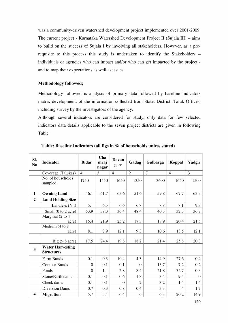
120
was a community-driven watershed development project implemented over 2001-2009.
The current project - Karnataka Watershed Development Project II (Sujala III) – aims
to build on the success of Sujala I by involving all stakeholders. However, as a pre-
requisite to this process this study is undertaken to identify the Stakeholders –
individuals or agencies who can impact and/or who can get impacted by the project -
and to map their expectations as well as issues.
Methodology followed;
Methodology followed is analysis of primary data followed by baseline indicators
matrix development, of the information collected from State, District, Taluk Offices,
including survey by the investigators of the agency.
Although several indicators are considered for study, only data for few selected
indicators data details applicable to the seven project districts are given in following
Table
Table: Baseline Indicators (all figs in % of households unless stated)
Sl.
No Indicator Bidar
Cha
mraj
nagar
Davan
gere Gadag Gulbarga Koppal Yadgir
Coverage (Talukas) 4 3 4 2 7 4 3
No. of households sampled
1750 1450 1650 1350 3600 1650 1500
1 Owning Land 46.1 61.7 63.6 51.6 59.8 67.7 63.3
2 Land Holding Size
Landless (Nil) 5.1 6.5 6.6 6.8 8.8 8.1 9.3
Small (0 to 2 acre) 53.9 38.3 36.4 48.4 40.3 32.3 36.7
Marginal (2 to 4
acre) 15.4 21.9 25.2 17.3 18.9 20.4 21.5
Medium (4 to 8
acre) 8.1 8.9 12.1 9.3 10.6 13.5 12.1
Big (> 8 acre) 17.5 24.4 19.8 18.2 21.4 25.8
20.3
3 Water Harvesting
Structures
Farm Bunds 0.1 0.3 10.4 4.3 14.9 27.6 0.4
Contour Bunds 0 0.1 0.1 0 13.7 7.2 0.2
Ponds 0 1.4 2.8 8.4 21.8 32.7 0.3
Stone/Earth dams 0.1 0.1 0.6 1.3 3.4 9.5 0
Check dams 0.1 0.1 0 2 3.2 1.4 1.4
Diversion Dams 0.7 0.3 0.8 0.4 3.3 4 1.7
4 Migration 5.7 5.4 6.4 6 6.3 20.2 14.9
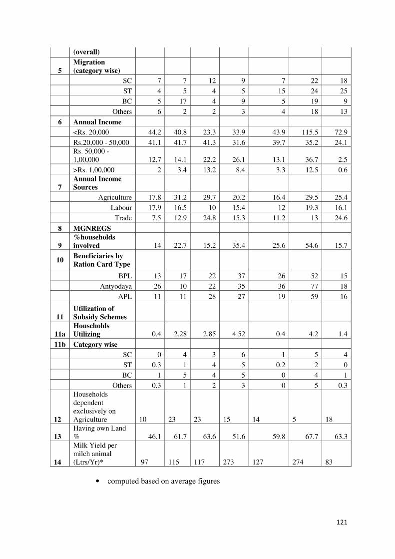
121
(overall)
5
Migration
(category wise)
SC 7 7 12 9 7 22 18
ST 4 5 4 5 15 24 25
BC 5 17 4 9 5 19 9
Others 6 2 2 3 4 18 13
6 Annual Income
<Rs. 20,000 44.2 40.8 23.3 33.9 43.9 115.5 72.9
Rs.20,000 - 50,000 41.1 41.7 41.3 31.6 39.7 35.2 24.1
Rs. 50,000 -1,00,000 12.7 14.1 22.2 26.1 13.1 36.7 2.5
>Rs. 1,00,000 2 3.4 13.2 8.4 3.3 12.5 0.6
7
Annual Income
Sources
Agriculture 17.8 31.2 29.7 20.2 16.4 29.5 25.4
Labour 17.9 16.5 10 15.4 12 19.3 16.1
Trade 7.5 12.9 24.8 15.3 11.2 13 24.6
8 MGNREGS
9
%households
involved 14 22.7 15.2 35.4 25.6 54.6 15.7
10 Beneficiaries by
Ration Card Type
BPL 13 17 22 37 26 52 15
Antyodaya 26 10 22 35 36 77 18
APL 11 11 28 27 19 59 16
11
Utilization of
Subsidy Schemes
11a
Households
Utilizing 0.4 2.28 2.85 4.52 0.4 4.2 1.4
11b Category wise
SC 0 4 3 6 1 5 4
ST 0.3 1 4 5 0.2 2 0
BC 1 5 4 5 0 4 1
Others 0.3 1 2 3 0 5 0.3
12
Households dependent exclusively on Agriculture 10 23 23 15 14 5 18
13
Having own Land % 46.1 61.7 63.6 51.6 59.8 67.7 63.3
14
Milk Yield per milch animal (Ltrs/Yr)* 97 115 117 273 127 274 83
• computed based on average figures

122
Key Observations of the study;
The key observations arrived from the data analysis are;
i. Most of the farmers do not have water harvesting structures in their land to
conserve rain water, which is essential for improving farm productivity.
ii. Only a few households have permanent house structures, with a higher percentage
of households residing in temporary/semi-permanent structures.
iii. In most of the sub-watershed areas, the households rely on firewood and other
fuels for their cooking needs, thus impacting the ecology adversely.
iv. Since there are no toilet facilities either at the household or community level, there
is a possibility for the spread of contagious diseases from open defecation.
v. Most of the households do not give importance to nutritious food and, therefore,
give least priority for expenditure on food.
vi. In the sub watershed areas, more farmers depend on traditional agricultural
equipment & practices, and prefer organic pesticides to chemical pesticides, which
is a positive and encouraging trend in the agricultural practices. However, one of
the disturbing trends is that the farmers are more dependent on hybrid seeds than
using indigenous ones, and, if this trend continues, there is every possibility of the
latter becoming extinct.
vii. In most of the sub-watershed areas, the households depend more on micro finance
institutions and money-lenders for borrowing. Since the rate of interest charged is
high, it leads to distress sale of assets.
viii. Most of the household income is spent on non-productive purposes like marriages
and festivals and they give less priority to child education, food consumption, etc.
ix. The benefits from the Government of India’s flagship poverty alleviation
programme, Mahatma Gandhi National Rural Employment Guarantee Scheme
(MGNREGS), which seeks to create income-generating assets at the local level
through community involvement, rarely manage to reach the target groups.
x. Most of the marginalized households interviewed were not often aware of the
existence of the various government-initiated poverty alleviation programmes /
123
schemes and the SC/ST households have not benefitted much from such
initiatives.
xi. The cattle population appears to be on a declining trend, this can mostly be
attributed to severe drought conditions which affect the project districts almost
every year. Due to this, milk production is less compared to the state average.
xii. Due to lack of proper rainwater management structures, the agricultural output is
way below the state average, if properly augmented, there can be multiple crops
grown in the same land as also for more than one season to increase production.
KWDP-II (SUJALA-III) - View;
After reviewing the above mentioned observations drawn based on the data generated,
it is made clear that, in the KWDP-II project implementation plan (PIP) would be
addressing majority of them with appropriate interventions as a convergence model,
involving concerned line departments, MGNREGA, IWMP and PRIs. Therefore, the
proposed project indicators would be enough to indicate the expected out comes of the
project implementation.
5.2 Social Assessment Study:
Objectives;
Main objectives considered for the Social Assessment study are:
• To carry out a socio-economic, cultural and political/institutional analysis to
identify potential social impacts of the proposed development of the project;
• To identify principal stakeholders, carry out consultations that are well documented
and develop institutional framework for transparent and participatory
implementation;
• Screen the proposed investment and assess whether there will be any adverse social
impacts and to determine the applicability of policies relating to involuntary
resettlement and Indigenous Peoples policies, and,
• To ensure that results of the SA provide inputs for participatory implementation.
124
Social assessment (SA) in the seven project districts ensures that development
initiatives contribute to inclusive development and poverty reduction. It is an approach
for incorporating social analyses and participatory processes into project design and
implementation. SA helps to make the project responsive to social development
concerns including seeking to enhance benefits for the poor and vulnerable people
while minimizing or mitigating risks and adverse impacts.
The following tasks were undertaken during Social Assessment
Beneficiary Assessment; Stakeholder Analysis; Impact Assessments; Safeguards
Analysis; Risks Analysis; Designing Participatory Framework; Human and Institutional
Development; Monitoring and Evaluation; Scope for Financial Participation by
Beneficiaries; Assessing the Legislative and Regulatory Considerations.
The findings of the assessment are as given below;
• Boundary issues are likely to crop up while implementing private land
development activities such as bunding and plantations.
• Convergence evokes mixed reaction from stakeholders. Therefore a detailed
convergence policy is needed (under preparation).
• The issue of what is the right or desirable mix of common land treatment and
private land treatment in a given location needs to be addressed.
• Due to high fluoride content in groundwater, people in several watershed locations
of Yadgir, Koppal, Gadag and Gulbarga districts suffer from dental and skeletal
fluorosis. They expect that watershed development activities would mitigate the
incidence.
KWDP-II (SUJALA-III)’s Views;
The findings of the Social Assessment study reveal that the overall impacts would be
positive but issues related to equity need closer attention.
As per the report, the Social Assessment enquiry has identified the following points as
key social development issues/ principles which should underpin the project’s strategy
and implementation, accordingly following steps are considered for implementation
under project implementation plan(PIP);
i) Participation and inclusion is the central point in the design of the project.
125
ii) The IWMP of WDD aims to assist for mobilizing individuals and institutions
at different levels: from community to state level;
iii) Project would be implemented on Integration and Convergence policy design
to protect the interest of all the project stakeholders while developing the
Watershed Project area on a science based plat form.
iv) Sector related institutions would be strengthened, or if necessary established,
at different levels with explicit capacity, composition and a definite mandate,
with strong emphasis on accountability and service delivery performance;
v) An Information, Education and Communication (IEC) campaign would be
implemented by: publicizing the project rules for open engagement of
partners; establishing a communication platform; and an easily accessible
digital library.
Therefore no Social Safeguard Policies are triggered for the focused action. Further,
• Given the shift in project design from an investment to technical assistance focus,
the investments no longer have any direct bearing on the Bank's Social Safeguard
Policies - Resettlement and Lands.
• No lands are to be acquired for any of the proposed activities, nor any impacts on
the tribals expected.
• However, some risks are possible for example in convergence activities, which
involve new processes, and direct engagement with political bodies. These would
be addressed by providing for participation by Panchayat Raj Institutes (PRIs),
their capacity building, and establishment of a grievance process to address any
disputes.
126
5.3 Environmental Assessment –EMF Report:
Environmental Assessment and Management Frame work (EMF):
Environmental Management Frame Work (EMF) mainly comprises the following
tasks;
• Understanding the project area with respect to the Environmental Situations
existing;
• Analysis of the existing Environmental Situations and Identifying the sensitive
areas which needs attention under the prevailing legal frame work;
• Understanding expected Positive and Negative Impacts due to intervention of
several activities under different components;
• Assigning responsibilities to different stakeholders/Project players for Enhancing
Positive impacts and Mitigation of Negative impacts for assuring safety through
the safeguard measures to the society and the delicate environment.
• Developing and Implementation of Capacity Building Activities to the project
stakeholders/Project players at different levels for Environmental Management.
Objectives;
The specific objectives of the EMF are;
a) To provide a systematic approach for identifying various possible environmental
impacts at different stages of the project cycle,
b) To identify appropriate mitigation measures against the identified environmental
impacts and
c) To devise an institutional arrangement for mainstreaming environmental
management into the project implementation processes.

127
Introduction
Over view of the KWDP-II (Sujala-III) reveals that the project design does not result in
any adverse environmental impacts and leads to enhancement of positive
environmental impacts. KWDP-I of GOK has prepared a detailed EMF and
implemented the model. However, the study agency has provided the Environmental
Assessment Report of the proposed project districts and the EMF has been prepared
based on a detailed; a) Environmental Assessment, b) Stakeholder Consultations and c)
Baseline Assessment.
Review:
Review of available literature, visiting the project area and consulting the respective
DWDO and other line departments to establish the baseline conditions in terms of
physical and biological environment conditions in the proposed project area is done.
Data on key parameters such as hydrological conditions of the watershed, status of
natural resource management, land use pattern within the watershed, etc. are collected.
Based on the information collected the environmental impacts, positive and negative,
on account of the project are identified.
Project stakeholders Consultation:
The project stakeholder’s consultations were held to delineate the appropriate
boundaries of the environmental assessment and to screen potential adverse
environmental issues. Feedback on the expected environmental issues related to the
project impacts and suggested mitigation measures was also received.
Study data Analysis
The important environmental issues identified:
Through stakeholder consultations in the project districts following summarized
environmental issues are identified and listed below.
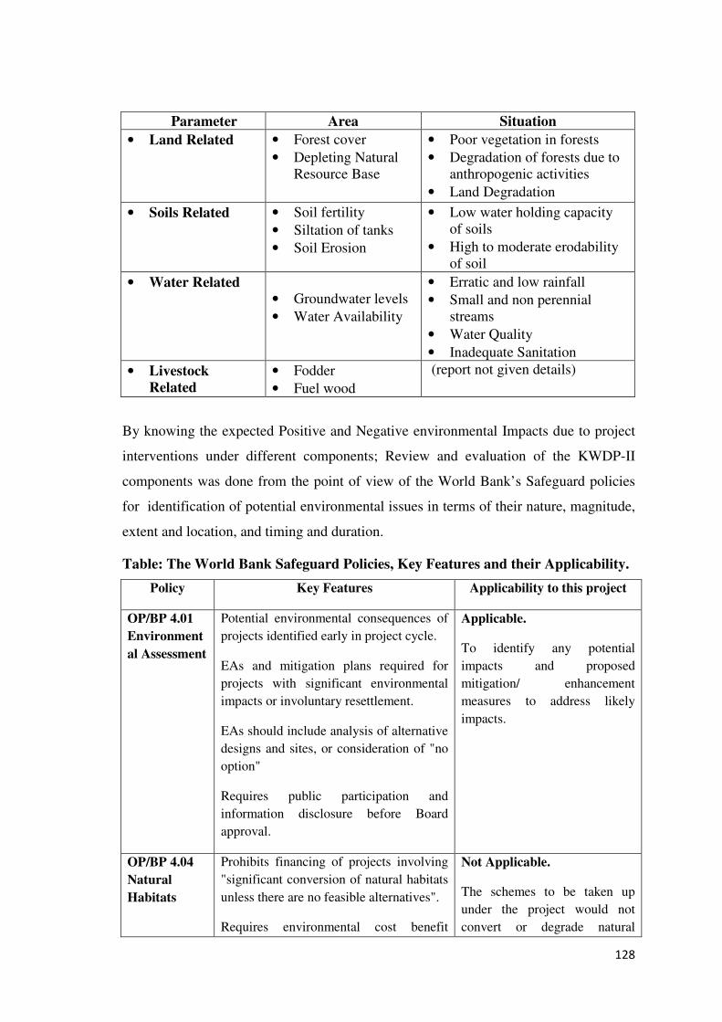
128
Parameter Area Situation
• Land Related
• Forest cover
• Depleting Natural Resource Base
• Poor vegetation in forests
• Degradation of forests due to anthropogenic activities
• Land Degradation
• Soils Related
• Soil fertility
• Siltation of tanks
• Soil Erosion
• Low water holding capacity of soils
• High to moderate erodability of soil
• Water Related
• Groundwater levels
• Water Availability
• Erratic and low rainfall
• Small and non perennial streams
• Water Quality
• Inadequate Sanitation
• Livestock
Related
• Fodder
• Fuel wood
(report not given details)
By knowing the expected Positive and Negative environmental Impacts due to project
interventions under different components; Review and evaluation of the KWDP-II
components was done from the point of view of the World Bank’s Safeguard policies
for identification of potential environmental issues in terms of their nature, magnitude,
extent and location, and timing and duration.
Table: The World Bank Safeguard Policies, Key Features and their Applicability.
Policy Key Features Applicability to this project
OP/BP 4.01
Environment
al Assessment
Potential environmental consequences of
projects identified early in project cycle.
EAs and mitigation plans required for
projects with significant environmental
impacts or involuntary resettlement.
EAs should include analysis of alternative
designs and sites, or consideration of "no
option"
Requires public participation and
information disclosure before Board
approval.
Applicable.
To identify any potential
impacts and proposed
mitigation/ enhancement
measures to address likely
impacts.
OP/BP 4.04
Natural
Habitats
Prohibits financing of projects involving
"significant conversion of natural habitats
unless there are no feasible alternatives".
Requires environmental cost benefit
Not Applicable.
The schemes to be taken up
under the project would not
convert or degrade natural
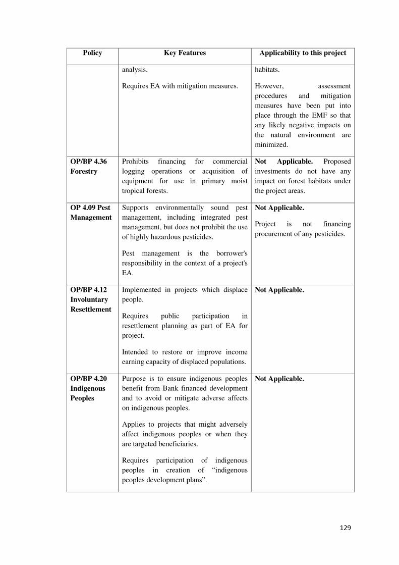
129
Policy Key Features Applicability to this project
analysis.
Requires EA with mitigation measures.
habitats.
However, assessment
procedures and mitigation
measures have been put into
place through the EMF so that
any likely negative impacts on
the natural environment are
minimized.
OP/BP 4.36
Forestry
Prohibits financing for commercial
logging operations or acquisition of
equipment for use in primary moist
tropical forests.
Not Applicable. Proposed
investments do not have any
impact on forest habitats under
the project areas.
OP 4.09 Pest
Management
Supports environmentally sound pest
management, including integrated pest
management, but does not prohibit the use
of highly hazardous pesticides.
Pest management is the borrower's
responsibility in the context of a project's
EA.
Not Applicable.
Project is not financing
procurement of any pesticides.
OP/BP 4.12
Involuntary
Resettlement
Implemented in projects which displace
people.
Requires public participation in
resettlement planning as part of EA for
project.
Intended to restore or improve income
earning capacity of displaced populations.
Not Applicable.
OP/BP 4.20
Indigenous
Peoples
Purpose is to ensure indigenous peoples
benefit from Bank financed development
and to avoid or mitigate adverse affects
on indigenous peoples.
Applies to projects that might adversely
affect indigenous peoples or when they
are targeted beneficiaries.
Requires participation of indigenous
peoples in creation of “indigenous
peoples development plans”.
Not Applicable.
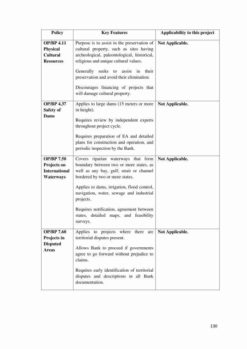
130
Policy Key Features Applicability to this project
OP/BP 4.11
Physical
Cultural
Resources
Purpose is to assist in the preservation of
cultural property, such as sites having
archeological, paleontological, historical,
religious and unique cultural values.
Generally seeks to assist in their
preservation and avoid their elimination.
Discourages financing of projects that
will damage cultural property.
Not Applicable.
OP/BP 4.37
Safety of
Dams
Applies to large dams (15 meters or more
in height).
Requires review by independent experts
throughout project cycle.
Requires preparation of EA and detailed
plans for construction and operation, and
periodic inspection by the Bank.
Not Applicable.
OP/BP 7.50
Projects on
International
Waterways
Covers riparian waterways that form
boundary between two or more states, as
well as any bay, gulf, strait or channel
bordered by two or more states.
Applies to dams, irrigation, flood control,
navigation, water, sewage and industrial
projects.
Requires notification, agreement between
states, detailed maps, and feasibility
surveys.
Not Applicable.
OP/BP 7.60
Projects in
Disputed
Areas
Applies to projects where there are
territorial disputes present.
Allows Bank to proceed if governments
agree to go forward without prejudice to
claims.
Requires early identification of territorial
disputes and descriptions in all Bank
documentation.
Not Applicable.
131
Note: Other World Bank Policies important to Environmental Concerns is the BP
17.50. This policy deals with Disclosure of Operational Information. The Bank’s Policy
on Disclosure of Information, has been incorporated in the project implementation plan.
As part of disclosure plan, the Project would disclose the final environmental
assessment report on its website and at the district headquarters, where the project is to
be implemented. An executive summary of the environmental assessment would be
prepared and translated in the local language and disclosed.
Mitigation measures:
Identified adverse environmental impacts were screened for designing mitigation
measures and included in the Environmental Management and Monitoring Plan
(EMMP). Project will be implemented in accordance with the EMF in a manner
satisfactory to the (IDA) Association; including, the mitigation measures set forth
therein, in a manner satisfactory to the Association; and by
• Ensuring that the environmental performance indicators contained in the EMF are
updated and monitored regularly, in agreement with the Association.
• Environment Management Framework highlighting project activities, impacts,
and mitigation measures with responsibilities, details would be communicated
with a circular for implementation by the PIA-WDD.
Management Arrangements:
In view of the above situation, in order to implement the KWDP-II (SUJALA-III)
efficiently and to facilitate the end users to be more responsible and responsive, aiming
at achieving the watershed development objectives in long run, the project would
contract an Environmental Management and Policy Research consultant who will assist
the PIA - WDD to oversee the implementation of the EMF
Risk and Mitigation:
The project is not financing any on the ground investments, such as, water and soil
conservation works, constructing check dams, erosion prevention structures etc. This
minimizes the risks, if any, emanating from Bank’s investments.
132
• Project is supporting institutional capacities, use of new and innovative
technology for watershed planning and training and capacity building of
stakeholders on science and research based findings.
• The Project’s objective is to improve integration of programs, strengthened
institutions related to rainfed agriculture, and a stronger science-based approach
supported by new innovations, knowledge and technologies that result in
increased productivity of natural resources and incomes for communities in
selected watersheds.
KWDP-II (SUJALA-III)’s Views:
Consequent to the project implementation no potential large scale, significant and/or
irreversible impacts are anticipated. However, the key environmental challenges that
the project addresses are:
(i) Optimal utilization of hydrological resources through improved planning and
collection of hydrological data; and
(ii) Arrest decline of groundwater and reduce soil erosion.
In order to face the possible challenges effectively, at the district level the DWDO will
be overall in charge for the implementation of EMF. DWDO would coordinate with the
Environmental Consultant and take appropriate actions to implement provisions of the
EMF. At the Taluk level the Agricultural Officer/ADA would be in charge of the
implementation of the EMF. These, project players would be suitably capacitated with
Workshops/Trainings.
Under Environmental Management Frame work (EMF), the project plan has an
approach with measures to enhance the potential positive environmental impacts that
the project investments would result in. As part of the project design, new decision-
support tools would be developed and piloted to improve selection of priority
watershed sites that combine biophysical, hydrological, socio-economic, and
environmental criteria. Deployment of such tools is likely to facilitate sustainable
utilisation of natural resources, accurate investment plans to improve the natural
resource base.
133
The Detailed Project Report (DPR) prepared as a part of Watershed Assessment and
consequent planning process would be screened and scanned by the WDT before it is
submitted for approval of the District Level Committee (DLC).
Training and Capacity Building under EMF and Social Framework;
The objectives of the capacity building initiatives are:
• To build and strengthen the capability of Watershed development institutions and
other partners (NGOs) to integrate sound environmental management into
watershed implementation.
• To orient the watershed development staff, participating institutions at watershed
level and communities to the requirements of the project’s environmental
management framework.
Past experience of Sujala-I and with the implementing experience of ongoing IWMP-
Batch-1 & 2, the district and taluk level implementing agencies have clearly gained
awareness, skills and experience regarding the environmental aspects of watershed
planning and implementation. However, in the new project area project stakeholders
have to be trained in a systematic way to build their capacity to safe guard the
Environment. Appropriate Modules will be developed under safeguards as detailed
below. After assessing the Environmental Management Frame work report and the
baseline as well as The Social Assessment study reports the WDD proposes the
following comprehensive capacity building arrangements to address the various Social
and Environmental issues.
Details of Training Programs to be considered during the project period;
i) providing for participation by PRIs through SWS and MWS level institutional platforms
ii) capacity building of PRIs and securing participation in planning and implementation
iii) establishment of Right of Grievance (RoG) to address issues arising at the MWS &
disputes (if any) across different levels.
3. Planning & Designing interventions
4. New approaches and tools for integrated planning,
5. Watershed management and Hydrology and links with land-use decisions to promote
rationale for more NREGS convergence with spatial Targeting
6. Environmental Awareness Management and Monitoring
134
Developing community monitoring training modules for WDT, CBOs and GPs
Developing training modules in Hydrological assessment
Developing Capacity Building Manuals on technology transfer for Extension Agents
Capacity building on usage and utility of LRI for planning and interpretation for WDT.
Workshops, trainings and seminars on usage and utility of DL for planning and interpretation
for WDT and local watershed institutions including GP and RSK's and line department staff
(insitu/SATCOM)
Training on Geo-informatics (GIS) (Landscape Technology -Latest development )
Capacity Building for Project staff on Use of Land resources portal
Additional training and Technical support for hydrology and stakeholder facilitation.
Approach
Systematic capacity building initiatives are planned after the training needs assessment.
The training would be of Top-Down-cascade mode. All the trained staff and others will
in turn conduct further trainings at district, taluk and village levels. However, since
capacity building goes beyond mere imparting training, institutionalization of best
practices becomes a prerequisite for improved watershed management. Therefore,
Capacity building for environmental management will be integrated with overall
capacity building component of the project. Further the Masons, skilled labour, etc.,
and workforce involved in the project will also be trained.
Institutions for Training:
In view of the specialized training and capacity building envisaged under the EMF of
the project, it is necessary to identify nodal training institutes that will closely work
with capacity building wing of WDD for conceptualizing, designing, conducting and
managing training programs on the EMF. Some such specialized institutions are:
• Environmental Management Policy and Research Institute.
• Karnataka RajyaVijnana Parishat, Indian Institute of Science.
• Engineering Staff College of India.
• Selected Staff of Forest Department.
• Selected Staff of Watershed Development Department.
• Other Identified Consultants.
135
Participants: Key officials of the project including TWDT, DWDT, as well as State
Level Environmental Experts and District Resource Persons. DWDO of the district will
be responsible for selection of suitable candidates for the training, and the expense will
be borne by the overall project capacity building budget.
Schedule: The training will include an initial orientation workshop, a main and annual
refresher training workshops on environmental assessment. The main and refresher
training programs will be for duration of 2-3 days each, whereas the initial orientation
workshop will be of one day duration. 10 Training programs will be conducted during
the first year and 5 refresher programs per year will be conducted for the next 4 years.
This will total to 30 programs.
Usage:
This EMF is prepared for implementation by the WDD in the project area in order to
overcome the anticipated adverse impacts of all the direct and indirectly linked
infrastructure related activities and prepare enhancement and mitigation measures for
implementation. Therefore, the PIA would make good use of this EMF and the good
practice guidance note to identify key Environmental issues, as well as plan and
implement mitigation and enhancement measures, as and where applicable.
New Legal Requirements & Updation
As and when required, PIA-WDD would update the EMF on any new legal
requirements – modification of existing legislation or introduction of new legislation –
as and when they are announced or made applicable. PIA-WDD would also ensure that
the design, implementation and operation of all its sub-projects are in line with the new
legal requirements.
In particular, PIA-WDD would update the chapter on legal requirements as and when
required.
Comprehensive EMF Review:
PIA-WDD would undertake one thorough / comprehensive review of the EMF during
the project period. Based on the review, the EMF would be updated if necessary. WDD
would undertake this review and revision prior to Sujala-III’s mid-term review by the
World Bank.
136
Supervision and Monitoring Plan:
The following provisions are considered and the arrangements would be made for the
effective implementation of the EMF with Supervision and Monitoring Plan:
Environmental supervision:
A sample of 10% of the completed schemes will be visited at six monthly intervals by
the WDT to check if all safeguard requirements are met and to identify any issues that
need to be addressed. The selected sample will have representation of both Phase- I and
Phase-II project area. However, internal environmental monitoring will be done as part
of the regular monitoring by the WDD.
Monitoring of Relevant Environmental Parameters
The M&E process to be initiated in by the project will also monitor and prepare a
report of the environmental situation in the project districts including data and analysis
of relevant parameters such as rainfall, depth to water levels, status of groundwater
basins, soil erosion, etc., as well as a listing of relevant new legislation and regulations
that have a bearing on the environmental performance of the project. The EMF will be
suitably revised annually on the basis of situation and data availability.
Environmental Audit
Twice during the project period; mid-term and end-term; the WDD will appoint an
external agency to undertake an independent audit of the environmental performance of
the project. 5% of the completed micro watersheds will be covered in the audit having
representation of both Phase- I and Phase-II project area.
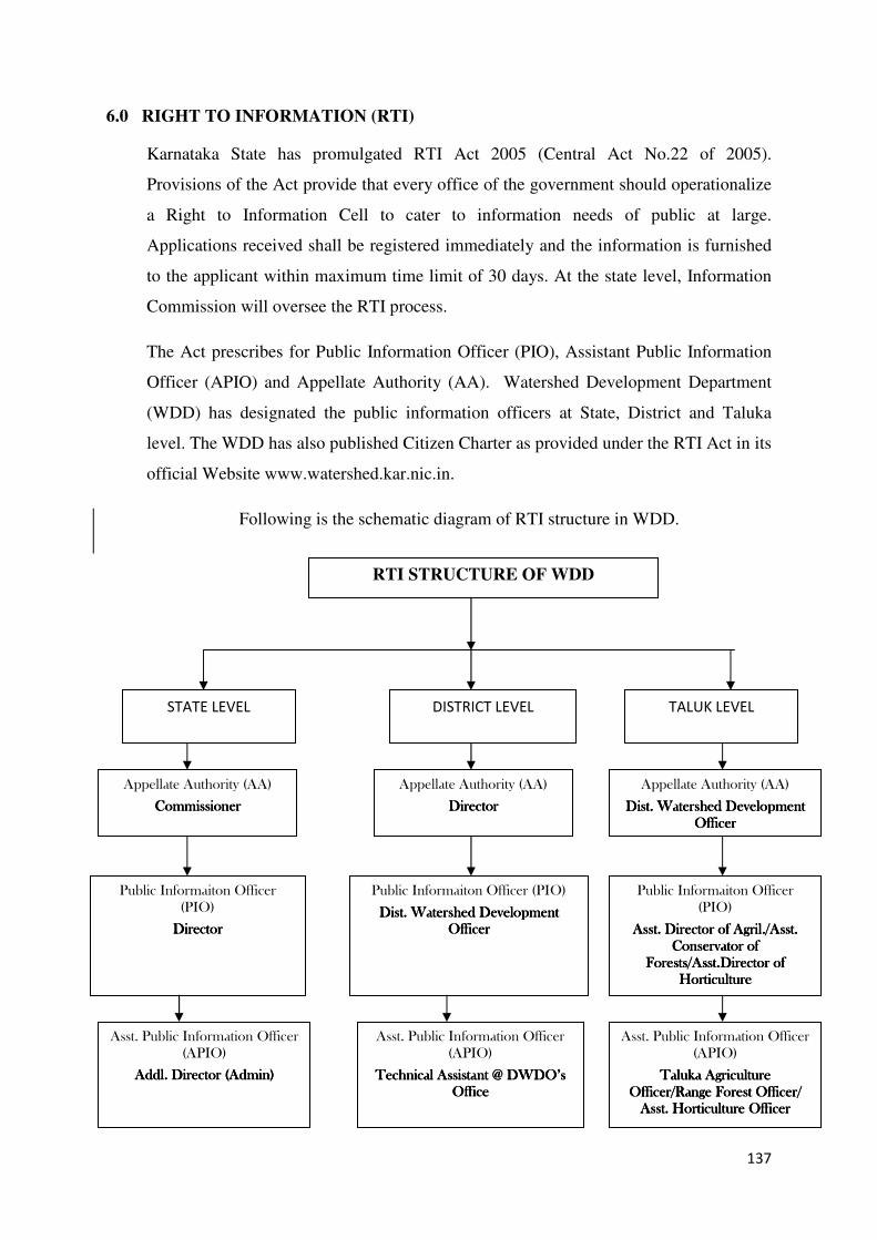
137
6.0 RIGHT TO INFORMATION (RTI)
Karnataka State has promulgated RTI Act 2005 (Central Act No.22 of 2005).
Provisions of the Act provide that every office of the government should operationalize
a Right to Information Cell to cater to information needs of public at large.
Applications received shall be registered immediately and the information is furnished
to the applicant within maximum time limit of 30 days. At the state level, Information
Commission will oversee the RTI process.
The Act prescribes for Public Information Officer (PIO), Assistant Public Information
Officer (APIO) and Appellate Authority (AA). Watershed Development Department
(WDD) has designated the public information officers at State, District and Taluka
level. The WDD has also published Citizen Charter as provided under the RTI Act in its
official Website www.watershed.kar.nic.in.
Following is the schematic diagram of RTI structure in WDD.
RTI STRUCTURE OF WDD
STATE LEVEL DISTRICT LEVEL TALUK LEVEL
Appellate Authority (AA)
CommissionerCommissionerCommissionerCommissioner
Public Informaiton Officer
(PIO)
Asst. Director of Agril./Asst. Asst. Director of Agril./Asst. Asst. Director of Agril./Asst. Asst. Director of Agril./Asst.
Conservator of Conservator of Conservator of Conservator of
Forests/Asst.Director of Forests/Asst.Director of Forests/Asst.Director of Forests/Asst.Director of
HorticultureHorticultureHorticultureHorticulture
Public Informaiton Officer (PIO)
Dist. Watershed Development Dist. Watershed Development Dist. Watershed Development Dist. Watershed Development
OfficerOfficerOfficerOfficer
Public Informaiton Officer
(PIO)
DirectorDirectorDirectorDirector
Appellate Authority (AA)
DirectorDirectorDirectorDirector
Appellate Authority (AA)
Dist. Watershed Development Dist. Watershed Development Dist. Watershed Development Dist. Watershed Development
OfficerOfficerOfficerOfficer
Asst. Public Information Officer
(APIO)
Addl. Director (Admin)Addl. Director (Admin)Addl. Director (Admin)Addl. Director (Admin)
Asst. Public Information Officer
(APIO)
Technical AssistantTechnical AssistantTechnical AssistantTechnical Assistant @ DWDO’s @ DWDO’s @ DWDO’s @ DWDO’s
OfficeOfficeOfficeOffice
Asst. Public Information Officer
(APIO)
Taluka Agriculture Taluka Agriculture Taluka Agriculture Taluka Agriculture
Officer/Range Forest Officer/ Officer/Range Forest Officer/ Officer/Range Forest Officer/ Officer/Range Forest Officer/
Asst. Horticulture OfficerAsst. Horticulture OfficerAsst. Horticulture OfficerAsst. Horticulture Officer

138
The project adopts pro-active step to publicize the various aspects of the project through
project website & extensively use the ITC tools and media to provide information to the
stakeholders and the public at large. The RTI process diagram is furnished herewith.
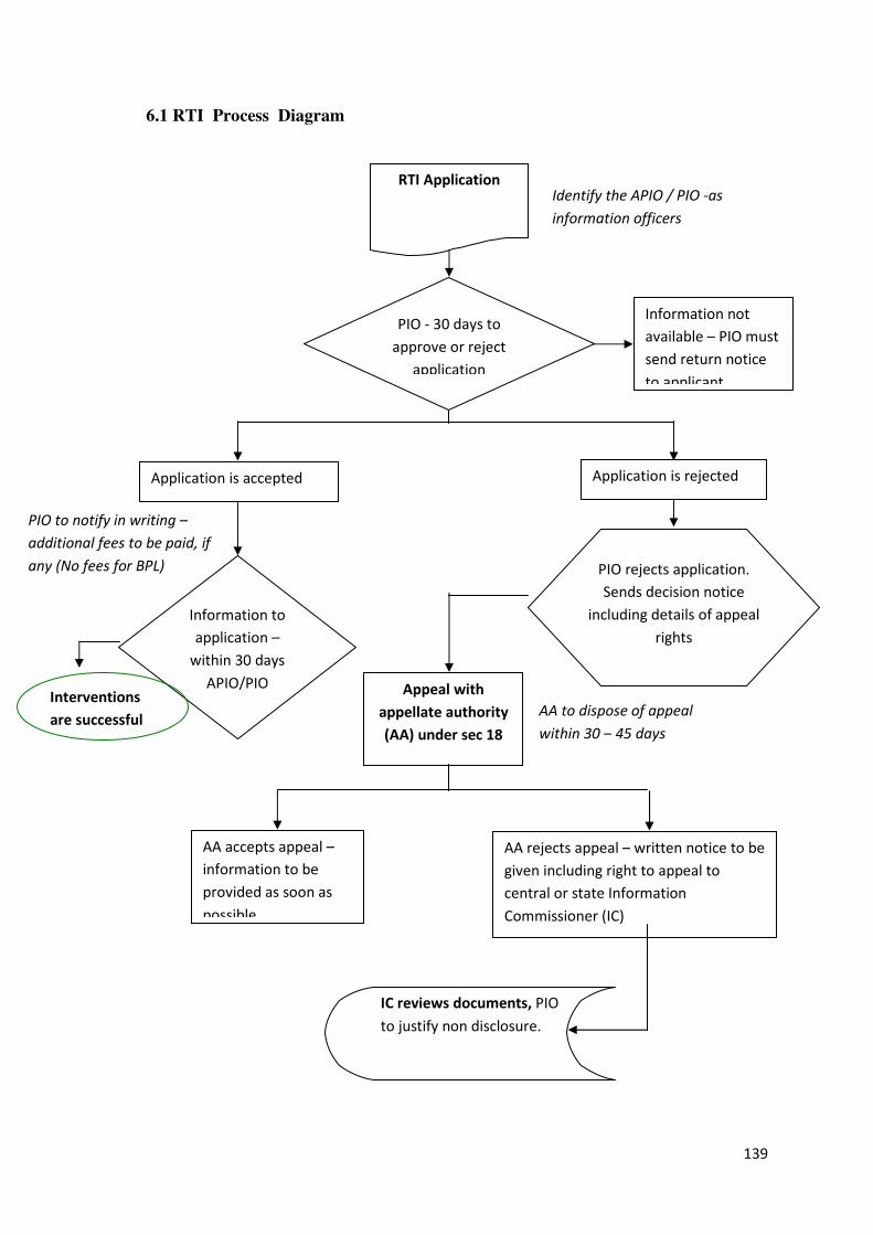
139
6.1 RTI Process Diagram
PIO to notify in writing –
additional fees to be paid, if
any (No fees for BPL)
RTI Application
Information to
application –
within 30 days
APIO/PIO Appeal with
appellate authority
(AA) under sec 18
Information not
available – PIO must
send return notice
to applicant
PIO rejects application.
Sends decision notice
including details of appeal
rights
IC reviews documents, PIO
to justify non disclosure.
Interventions
are successful
Identify the APIO / PIO -as
information officers
PIO - 30 days to
approve or reject
application
Application is accepted Application is rejected
AA to dispose of appeal
within 30 – 45 days
AA accepts appeal –
information to be
provided as soon as
possible
AA rejects appeal – written notice to be
given including right to appeal to
central or state Information
Commissioner (IC)
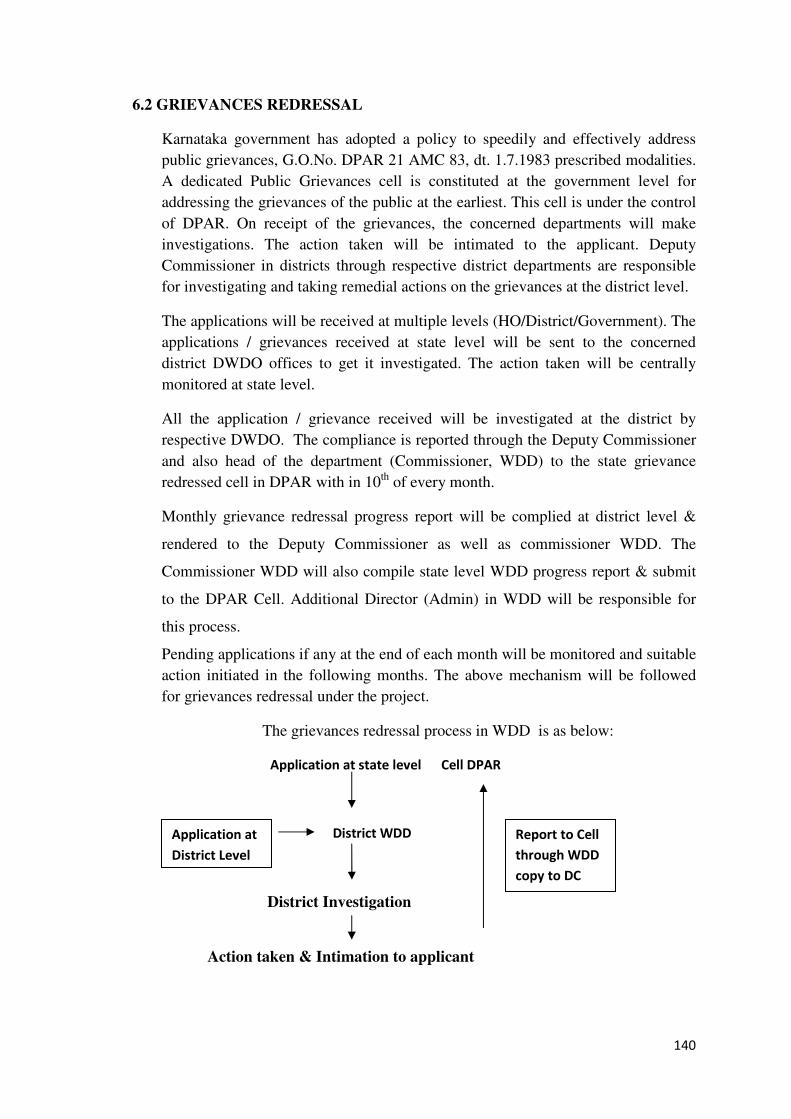
140
6.2 GRIEVANCES REDRESSAL
Karnataka government has adopted a policy to speedily and effectively address
public grievances, G.O.No. DPAR 21 AMC 83, dt. 1.7.1983 prescribed modalities.
A dedicated Public Grievances cell is constituted at the government level for
addressing the grievances of the public at the earliest. This cell is under the control
of DPAR. On receipt of the grievances, the concerned departments will make
investigations. The action taken will be intimated to the applicant. Deputy
Commissioner in districts through respective district departments are responsible
for investigating and taking remedial actions on the grievances at the district level.
The applications will be received at multiple levels (HO/District/Government). The
applications / grievances received at state level will be sent to the concerned
district DWDO offices to get it investigated. The action taken will be centrally
monitored at state level.
All the application / grievance received will be investigated at the district by
respective DWDO. The compliance is reported through the Deputy Commissioner
and also head of the department (Commissioner, WDD) to the state grievance
redressed cell in DPAR with in 10th of every month.
Monthly grievance redressal progress report will be complied at district level &
rendered to the Deputy Commissioner as well as commissioner WDD. The
Commissioner WDD will also compile state level WDD progress report & submit
to the DPAR Cell. Additional Director (Admin) in WDD will be responsible for
this process.
Pending applications if any at the end of each month will be monitored and suitable
action initiated in the following months. The above mechanism will be followed
for grievances redressal under the project.
The grievances redressal process in WDD is as below:
Application at state level Cell DPAR
District WDD
District Investigation
Action taken & Intimation to applicant
Report to Cell
through WDD
copy to DC
Application at
District Level
141
In addition, the grievance redressal particulars will be posted on the Project
Website on monthly basis by 10th of each month. Additional Director (Admin) in
WDD will be responsible for this process.
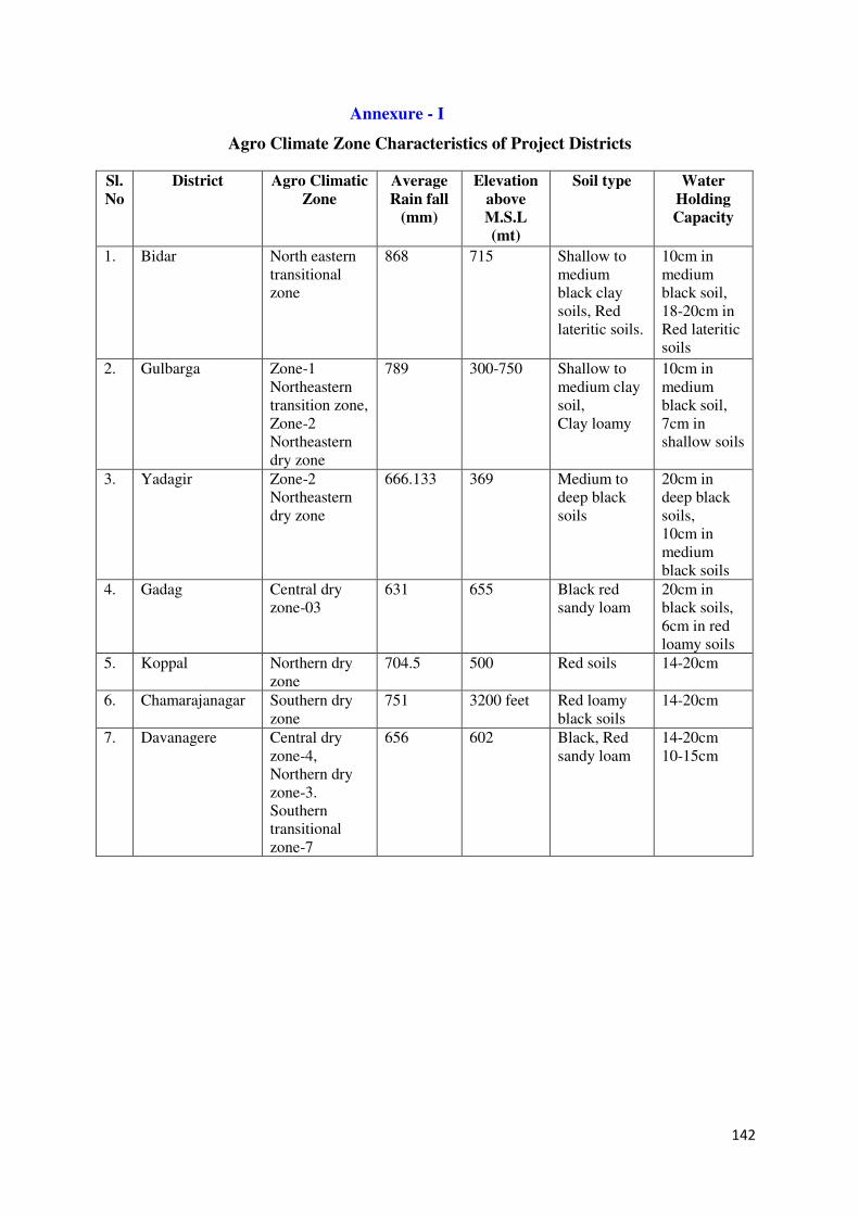
142
Annexure - I
Agro Climate Zone Characteristics of Project Districts
Sl.
No
District Agro Climatic
Zone
Average
Rain fall
(mm)
Elevation
above
M.S.L
(mt)
Soil type Water
Holding
Capacity
1. Bidar North eastern transitional zone
868 715 Shallow to medium black clay soils, Red lateritic soils.
10cm in medium black soil, 18-20cm in Red lateritic soils
2. Gulbarga Zone-1 Northeastern transition zone, Zone-2 Northeastern dry zone
789 300-750 Shallow to medium clay soil, Clay loamy
10cm in medium black soil, 7cm in shallow soils
3. Yadagir Zone-2 Northeastern dry zone
666.133 369 Medium to deep black soils
20cm in deep black soils, 10cm in medium black soils
4. Gadag Central dry zone-03
631 655 Black red sandy loam
20cm in black soils, 6cm in red loamy soils
5. Koppal Northern dry zone
704.5 500 Red soils 14-20cm
6. Chamarajanagar Southern dry zone
751 3200 feet Red loamy black soils
14-20cm
7. Davanagere Central dry zone-4, Northern dry zone-3. Southern transitional zone-7
656 602 Black, Red sandy loam
14-20cm 10-15cm
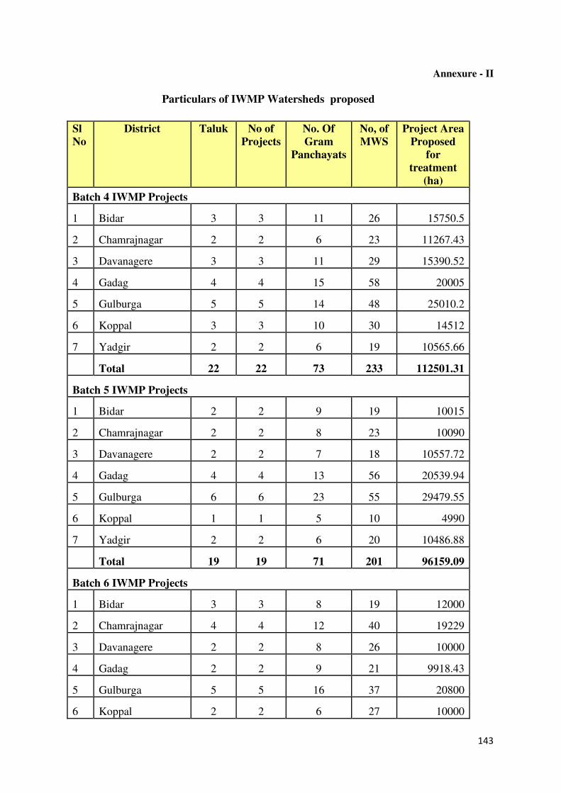
143
Annexure - II
Particulars of IWMP Watersheds proposed
Sl
No
District Taluk No of
Projects
No. Of
Gram
Panchayats
No, of
MWS
Project Area
Proposed
for
treatment
(ha)
Batch 4 IWMP Projects
1 Bidar 3 3 11 26 15750.5
2 Chamrajnagar 2 2 6 23 11267.43
3 Davanagere 3 3 11 29 15390.52
4 Gadag 4 4 15 58 20005
5 Gulburga 5 5 14 48 25010.2
6 Koppal 3 3 10 30 14512
7 Yadgir 2 2 6 19 10565.66
Total 22 22 73 233 112501.31
Batch 5 IWMP Projects
1 Bidar 2 2 9 19 10015
2 Chamrajnagar 2 2 8 23 10090
3 Davanagere 2 2 7 18 10557.72
4 Gadag 4 4 13 56 20539.94
5 Gulburga 6 6 23 55 29479.55
6 Koppal 1 1 5 10 4990
7 Yadgir 2 2 6 20 10486.88
Total 19 19 71 201 96159.09
Batch 6 IWMP Projects
1 Bidar 3 3 8 19 12000
2 Chamrajnagar 4 4 12 40 19229
3 Davanagere 2 2 8 26 10000
4 Gadag 2 2 9 21 9918.43
5 Gulburga 5 5 16 37 20800
6 Koppal 2 2 6 27 10000
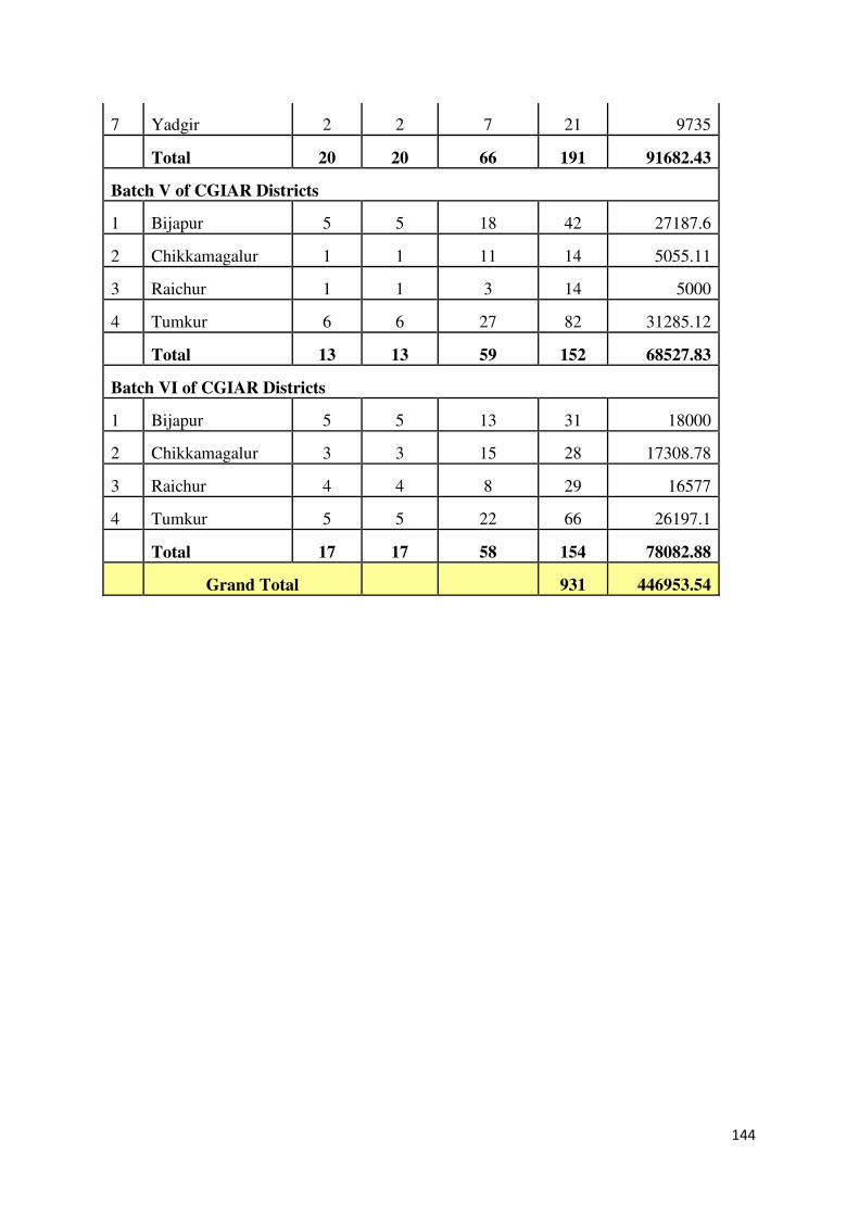
144
7 Yadgir 2 2 7 21 9735
Total 20 20 66 191 91682.43
Batch V of CGIAR Districts
1 Bijapur 5 5 18 42 27187.6
2 Chikkamagalur 1 1 11 14 5055.11
3 Raichur 1 1 3 14 5000
4 Tumkur 6 6 27 82 31285.12
Total 13 13 59 152 68527.83
Batch VI of CGIAR Districts
1 Bijapur 5 5 13 31 18000
2 Chikkamagalur 3 3 15 28 17308.78
3 Raichur 4 4 8 29 16577
4 Tumkur 5 5 22 66 26197.1
Total 17 17 58 154 78082.88
Grand Total 931 446953.54
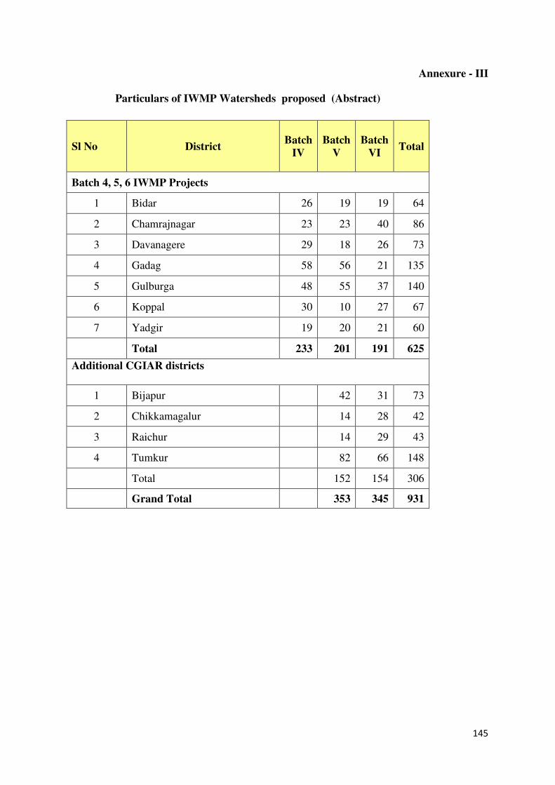
145
Annexure - III
Particulars of IWMP Watersheds proposed (Abstract)
Sl No District Batch
IV
Batch
V
Batch
VI Total
Batch 4, 5, 6 IWMP Projects
1 Bidar 26 19 19 64
2 Chamrajnagar 23 23 40 86
3 Davanagere 29 18 26 73
4 Gadag 58 56 21 135
5 Gulburga 48 55 37 140
6 Koppal 30 10 27 67
7 Yadgir 19 20 21 60
Total 233 201 191 625
Additional CGIAR districts
1 Bijapur 42 31 73
2 Chikkamagalur 14 28 42
3 Raichur 14 29 43
4 Tumkur 82 66 148
Total 152 154 306
Grand Total 353 345 931
146
Annexure - IV
Need for Land Resource Inventory
Karnataka is the eighth largest state in India with an area of 19.17 M ha. It is endowed with
varied climate, fauna and flora, soils, forests, bounty of minerals and many rivers. These
resources enriching the social fabric of the state need to be conserved, protected and
improved. But of late the limited cultivable land area of about 12 M ha in the state is under
severe strain due to population pressure and competing demands of various land uses.
According to various agency reports
♦ Land degradation has affected an area of about 7.7 M ha (40 % of the TGA)
♦ Wastelands occur in about 2. 0 M ha (11 % of TGA)
♦ Over-exploitation of groundwater and consequent drying up of borewells in all districts.
♦ Significant shift in the land-use pattern and diversion of prime lands to non-agricultural
uses
♦ Declining productivity reported for most of the crops in both rainfed and irrigated
agriculture.
♦ Salinity alkalinity has affected about 10 per cent of the total irrigated lands
It is obvious that the neglect and deterioration of the land resources and consequent decline in
the productivity is continuing without much effective intervention in the state. The situation
is expected to worsen in the future and warrants urgent correction. This requires situation
analysis and assessment to come out with remedial solutions.
The challenge is not only to increase the productivity per unit area, which is steadily
declining and showing a fatigue syndrome, but also to prevent or at least reduce the severity
of the degradation, which has reached alarming proportions. The situation needs immediate
attention of all the stakeholders, from policy makers to farmers, particularly involved in the
management of vast stretches of rainfed areas in the state. The root cause for the degradation,
neglect and irrational use of land resources lies at the grassroots or farm level.
In the above background any initiative to address these issues should also rightly start at the
farm/village/watershed level only. This needs detailed farm/cadastral level information on
soil, water, land use and other resources. Land Resource Inventorisation (Modern Soil
Survey) on large scale provides the information required for planning, executing and
monitoring of all land-based activities at the farm or watershed level in the state.
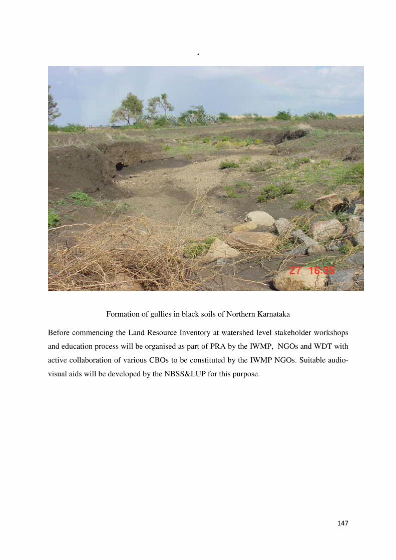
147
.
Formation of gullies in black soils of Northern Karnataka
Before commencing the Land Resource Inventory at watershed level stakeholder workshops
and education process will be organised as part of PRA by the IWMP, NGOs and WDT with
active collaboration of various CBOs to be constituted by the IWMP NGOs. Suitable audio-
visual aids will be developed by the NBSS&LUP for this purpose.
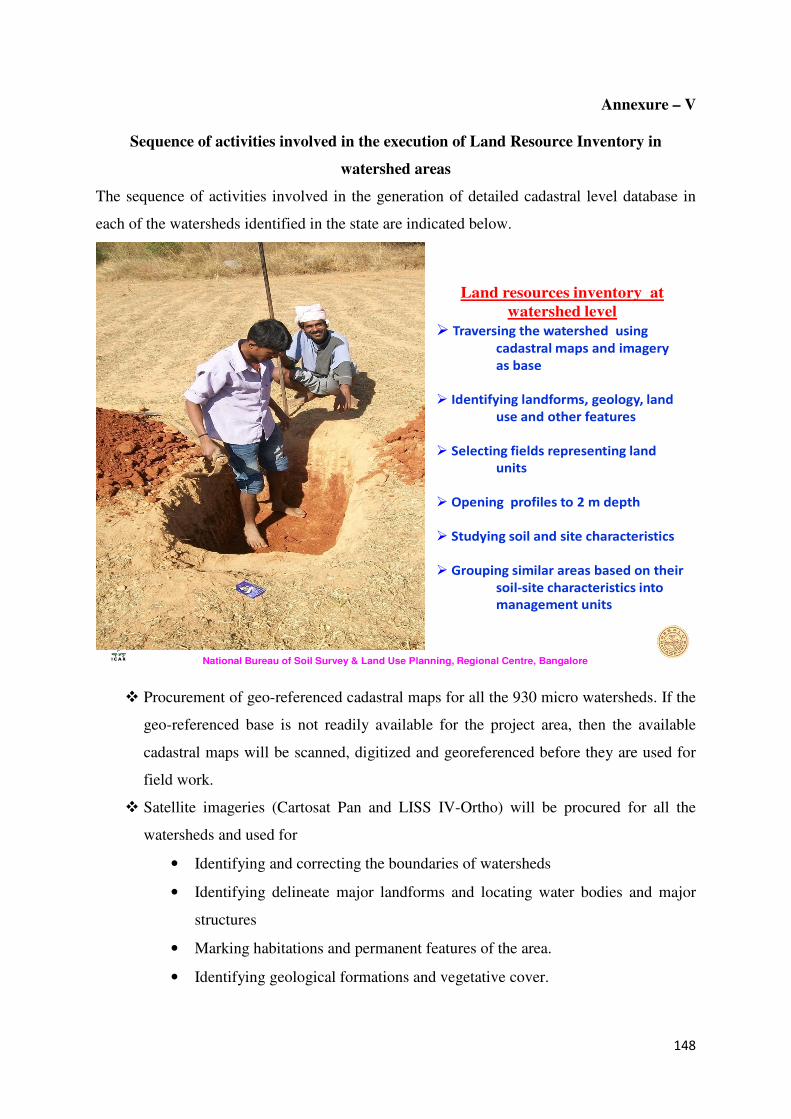
148
Annexure – V
Sequence of activities involved in the execution of Land Resource Inventory in
watershed areas
The sequence of activities involved in the generation of detailed cadastral level database in
each of the watersheds identified in the state are indicated below.
National Bureau of Soil Survey & Land Use Planning, Regional Centre, Bangalore
Land resources inventory at
watershed level
� Traversing the watershed using
cadastral maps and imagery
as base
� Identifying landforms, geology, land
use and other features
� Selecting fields representing land
units
� Opening profiles to 2 m depth
� Studying soil and site characteristics
� Grouping similar areas based on their
soil-site characteristics into
management units
� Procurement of geo-referenced cadastral maps for all the 930 micro watersheds. If the
geo-referenced base is not readily available for the project area, then the available
cadastral maps will be scanned, digitized and georeferenced before they are used for
field work.
� Satellite imageries (Cartosat Pan and LISS IV-Ortho) will be procured for all the
watersheds and used for
• Identifying and correcting the boundaries of watersheds
• Identifying delineate major landforms and locating water bodies and major
structures
• Marking habitations and permanent features of the area.
• Identifying geological formations and vegetative cover.
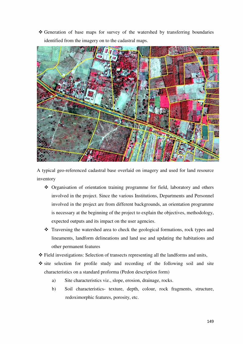
149
� Generation of base maps for survey of the watershed by transferring boundaries
identified from the imagery on to the cadastral maps.
A typical geo-referenced cadastral base overlaid on imagery and used for land resource
inventory
� Organisation of orientation training programme for field, laboratory and others
involved in the project. Since the various Institutions, Departments and Personnel
involved in the project are from different backgrounds, an orientation programme
is necessary at the beginning of the project to explain the objectives, methodology,
expected outputs and its impact on the user agencies.
� Traversing the watershed area to check the geological formations, rock types and
lineaments, landform delineations and land use and updating the habitations and
other permanent features
� Field investigations: Selection of transects representing all the landforms and units,
� site selection for profile study and recording of the following soil and site
characteristics on a standard proforma (Pedon description form)
a) Site characteristics viz., slope, erosion, drainage, rocks.
b) Soil characteristics- texture, depth, colour, rock fragments, structure,
redoximorphic features, porosity, etc.
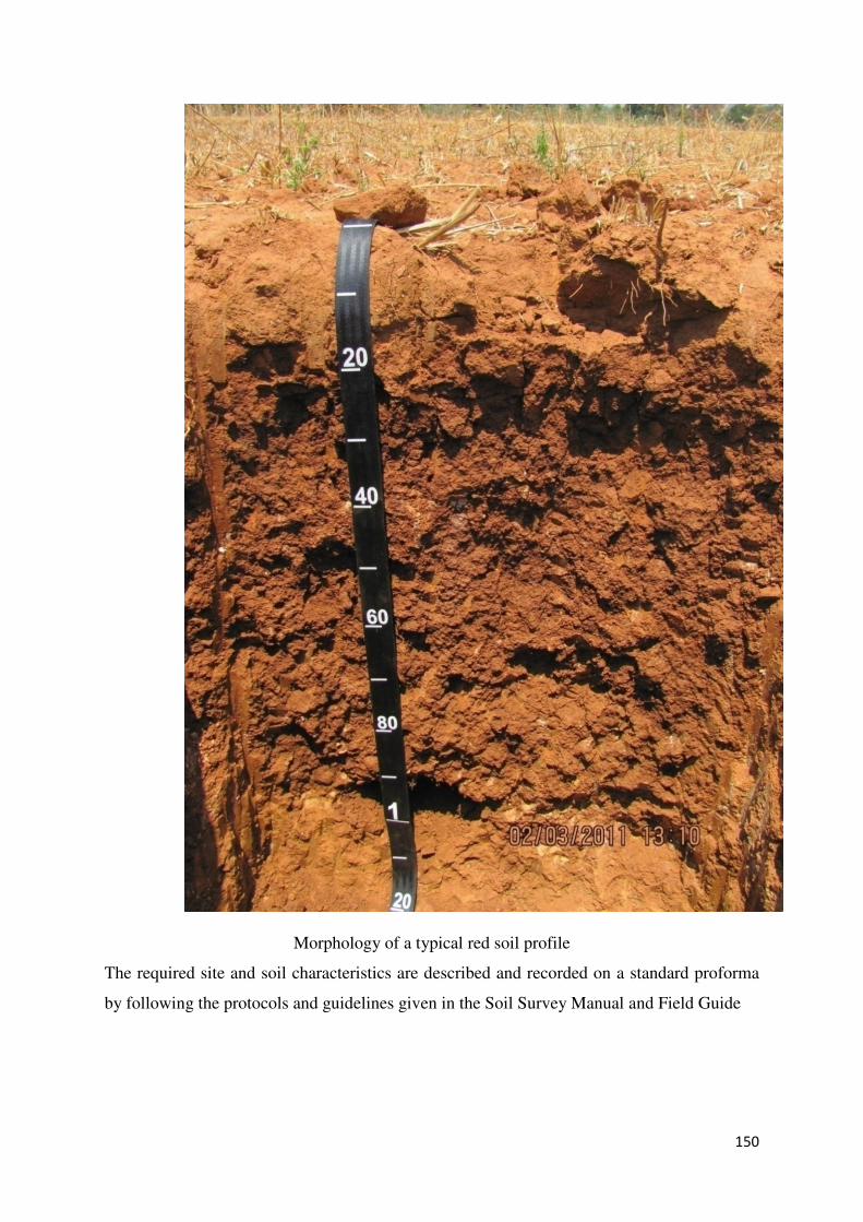
150
Morphology of a typical red soil profile
The required site and soil characteristics are described and recorded on a standard proforma
by following the protocols and guidelines given in the Soil Survey Manual and Field Guide
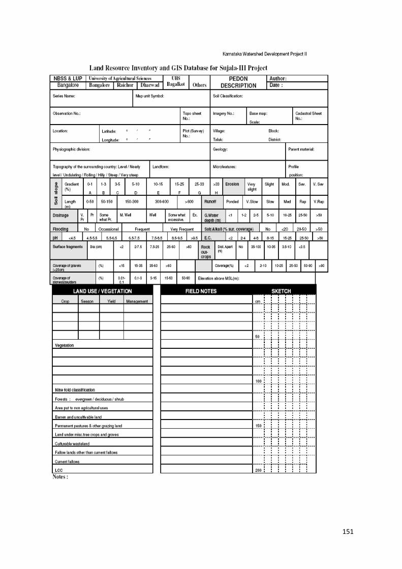
151
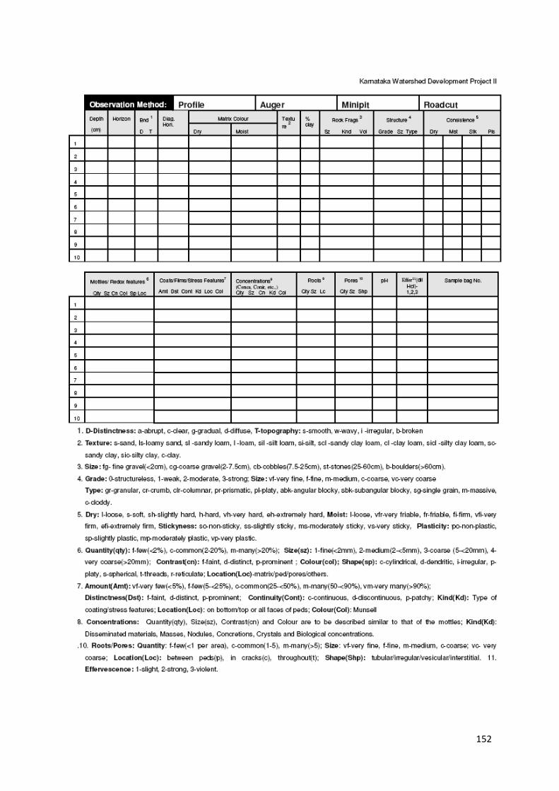
152
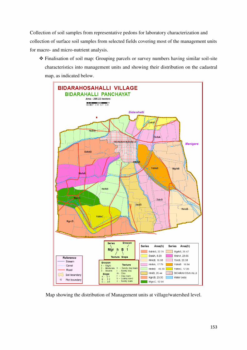
153
Collection of soil samples from representative pedons for laboratory characterization and
collection of surface soil samples from selected fields covering most of the management units
for macro- and micro-nutrient analysis.
� Finalisation of soil map: Grouping parcels or survey numbers having similar soil-site
characteristics into management units and showing their distribution on the cadastral
map, as indicated below.
Map showing the distribution of Management units at village/watershed level.
154
This segregation of survey numbers based on site and soil characteristics into
homogenous units enables participatory watershed planning process to develop
conservation and land use plans on a scientific basis.
� Geological survey as well as hydrogeological surveys will be undertaken to
producelineament maps as well as areas under safe, grey and dark zones with rergard
to groundwater exploitation for selecting appropriate conservation and management
strategies that would bring sustainability in groundwater use.
� Socio-economic survey will be conducted through a questionnaire and the required
data will be collected from farmers and other sections of the society in the village.
� Collection of climatic, land use and other land characteristics – Data on rainfall
and other climatic parameters, land use, crops grown at present and cropping pattern
practised, livestock population details, brads and disease occurrence and data on any
other land characteristics that influences the use of the land will be collected, mostly
along with the socio-economic survey. Only in some cases will survey be conducted
separately to collect the required data on the above parameters.
� Identification of constraints and potentials affecting the land use. The constraints
and potentials like soil erosion, slope, depth of the soil, coarse fragments, soil texture,
salinity and alkalinity, fertility etc will be delineated and shown separately, in the
form of single theme maps for the surveyed area or shown collectively as land
capability maps, indicating the general capability of the area for agriculture and
other purposes.
� Developing soil- site suitability criteria for crops and other land uses. This is very
important if the resources are to be assessed for specific land uses. The suitability
criteria cannot be evolved by any one specialist and the process needs a
multidisciplinary team. The criteria for specific land use is established from the
available information and data derived from the experimental results specific to the
selected land use.
� Evaluating the land for existing and promising land uses. This will be done by
following the guidelines and principles given by the Food and Agriculture
Organaisation (1976) to assess the land resources for specific kinds of land use.
� Identification of viable and sustainable land use types. The evaluation or
suitability assessment will show the suitability or otherwise of the various land uses
selected for the area. Based on the degree of suitability and prevailing economic
condition, the best and sustainable land use can be selected.
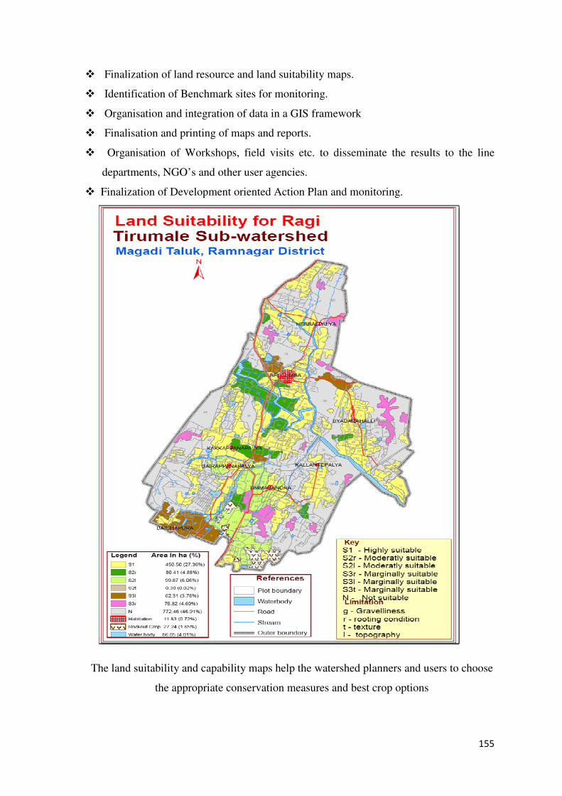
155
� Finalization of land resource and land suitability maps.
� Identification of Benchmark sites for monitoring.
� Organisation and integration of data in a GIS framework
� Finalisation and printing of maps and reports.
� Organisation of Workshops, field visits etc. to disseminate the results to the line
departments, NGO’s and other user agencies.
� Finalization of Development oriented Action Plan and monitoring.
The land suitability and capability maps help the watershed planners and users to choose
the appropriate conservation measures and best crop options
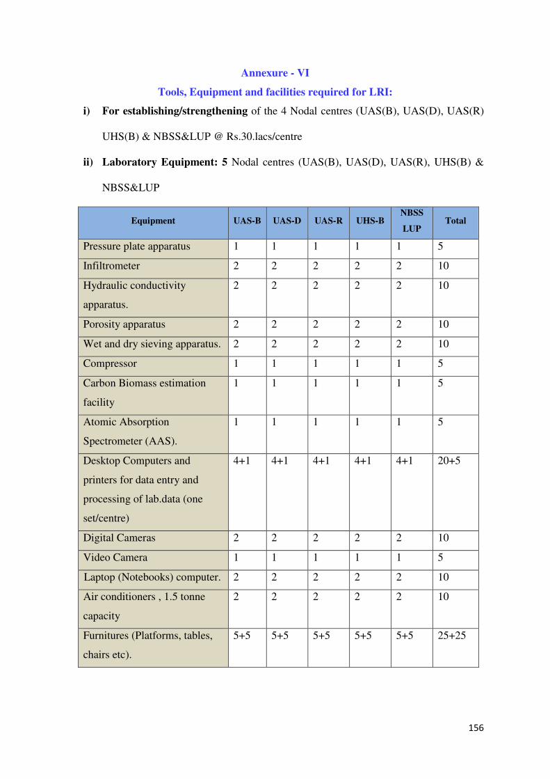
156
Annexure - VI
Tools, Equipment and facilities required for LRI:
i) For establishing/strengthening of the 4 Nodal centres (UAS(B), UAS(D), UAS(R)
UHS(B) & NBSS&LUP @ Rs.30.lacs/centre
ii) Laboratory Equipment: 5 Nodal centres (UAS(B), UAS(D), UAS(R), UHS(B) &
NBSS&LUP
Equipment UAS-B UAS-D UAS-R UHS-B NBSS
LUP Total
Pressure plate apparatus 1 1 1 1 1 5
Infiltrometer 2 2 2 2 2 10
Hydraulic conductivity
apparatus.
2 2 2 2 2 10
Porosity apparatus 2 2 2 2 2 10
Wet and dry sieving apparatus. 2 2 2 2 2 10
Compressor 1 1 1 1 1 5
Carbon Biomass estimation
facility
1 1 1 1 1 5
Atomic Absorption
Spectrometer (AAS).
1 1 1 1 1 5
Desktop Computers and
printers for data entry and
processing of lab.data (one
set/centre)
4+1 4+1 4+1 4+1 4+1 20+5
Digital Cameras 2 2 2 2 2 10
Video Camera 1 1 1 1 1 5
Laptop (Notebooks) computer. 2 2 2 2 2 10
Air conditioners , 1.5 tonne
capacity
2 2 2 2 2 10
Furnitures (Platforms, tables,
chairs etc).
5+5 5+5 5+5 5+5 5+5 25+25
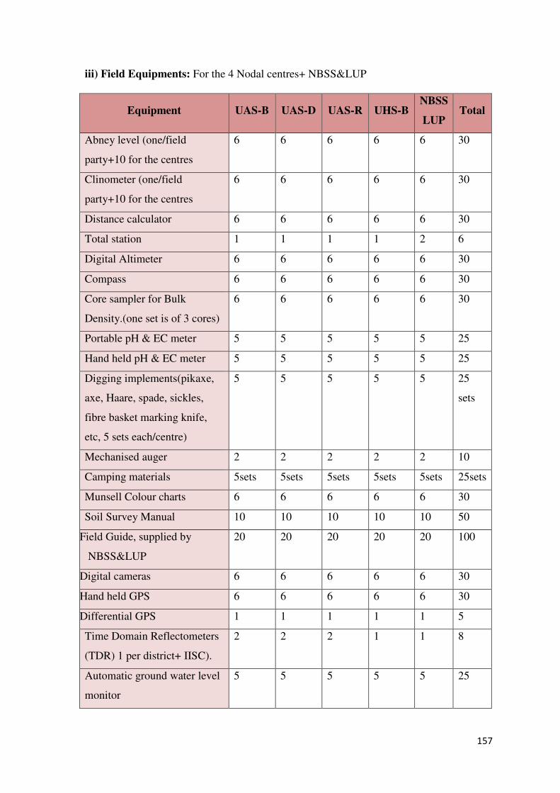
157
iii) Field Equipments: For the 4 Nodal centres+ NBSS&LUP
Equipment UAS-B UAS-D UAS-R UHS-B NBSS
LUP Total
Abney level (one/field
party+10 for the centres
6 6 6 6 6 30
Clinometer (one/field
party+10 for the centres
6 6 6 6 6 30
Distance calculator 6 6 6 6 6 30
Total station 1 1 1 1 2 6
Digital Altimeter 6 6 6 6 6 30
Compass 6 6 6 6 6 30
Core sampler for Bulk
Density.(one set is of 3 cores)
6 6 6 6 6 30
Portable pH & EC meter 5 5 5 5 5 25
Hand held pH & EC meter 5 5 5 5 5 25
Digging implements(pikaxe,
axe, Haare, spade, sickles,
fibre basket marking knife,
etc, 5 sets each/centre)
5 5 5 5 5 25
sets
Mechanised auger 2 2 2 2 2 10
Camping materials 5sets 5sets 5sets 5sets 5sets 25sets
Munsell Colour charts 6 6 6 6 6 30
Soil Survey Manual 10 10 10 10 10 50
Field Guide, supplied by
NBSS&LUP
20 20 20 20 20 100
Digital cameras 6 6 6 6 6 30
Hand held GPS 6 6 6 6 6 30
Differential GPS 1 1 1 1 1 5
Time Domain Reflectometers
(TDR) 1 per district+ IISC).
2 2 2 1 1 8
Automatic ground water level
monitor
5 5 5 5 5 25
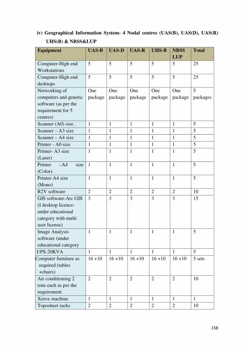
158
iv) Geographical Information System- 4 Nodal centres (UAS(B), UAS(D), UAS(R)
UHS(B) & NBSS&LUP
Equipment UAS-B UAS-D UAS-R UHS-B NBSS
LUP
Total
Computer-High end
Workstations
5 5 5 5 5 25
Computer-High end
desktops
5 5 5 5 5 25
Networking of
computers and generic
software (as per the
requirement for 5
centres)
One
package
One
package
One
package
One
package
One
package
5
packages
Scanner (A0) size . 1 1 1 1 1 5
Scanner – A3 size 1 1 1 1 1 5
Scanner – A4 size 1 1 1 1 1 5
Printer - A0 size 1 1 1 1 1 5
Printer- A3 size
(Laser)
1 1 1 1 1 5
Printer –A4 size
(Color).
1 1 1 1 1 5
Printer-A4 size
(Mono)
1 1 1 1 1 5
R2V software 2 2 2 2 2 10
GIS software-Arc GIS
(I desktop licence-
under educational
category with multi
user license)
3 3 3 3 3 15
Image Analysis
software (under
educational category
1 1 1 1 1 5
UPS-20KVA 1 1 1 1 1 5
Computer furniture as
required (tables
+chairs)
16 +10 16 +10 16 +10 16 +10 16 +10 5 sets
Air conditioning 2
tons each as per the
requirement
2 2 2 2 2 10
Xerox machine 1 1 1 1 1 1
Toposheet racks 2 2 2 2 2 10
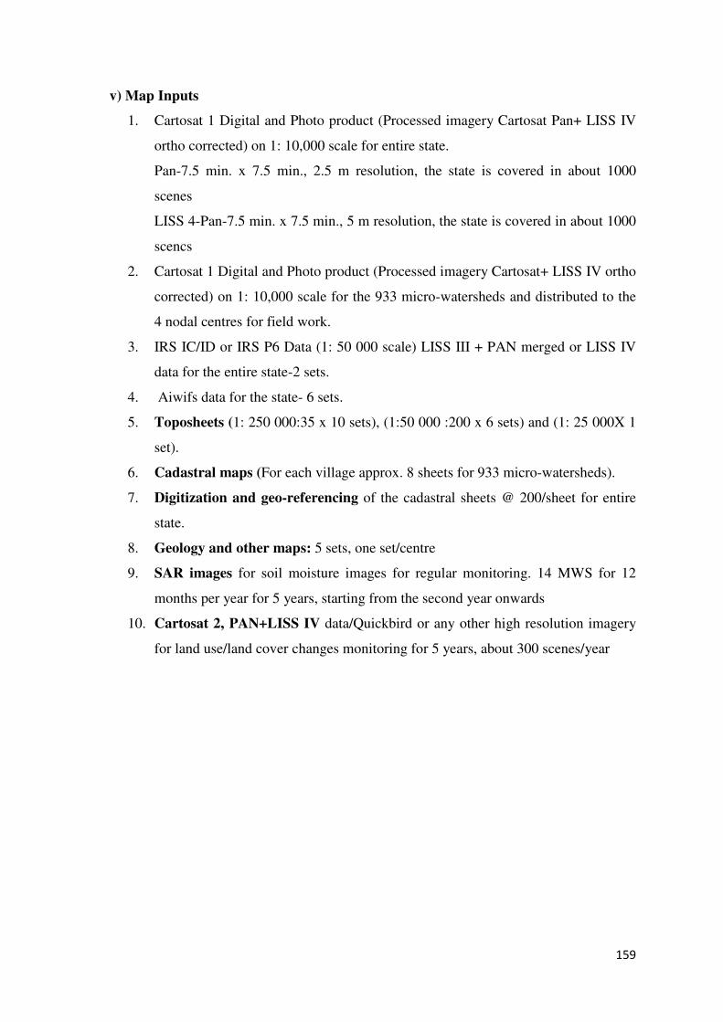
159
v) Map Inputs
1. Cartosat 1 Digital and Photo product (Processed imagery Cartosat Pan+ LISS IV
ortho corrected) on 1: 10,000 scale for entire state.
Pan-7.5 min. x 7.5 min., 2.5 m resolution, the state is covered in about 1000
scenes
LISS 4-Pan-7.5 min. x 7.5 min., 5 m resolution, the state is covered in about 1000
scencs
2. Cartosat 1 Digital and Photo product (Processed imagery Cartosat+ LISS IV ortho
corrected) on 1: 10,000 scale for the 933 micro-watersheds and distributed to the
4 nodal centres for field work.
3. IRS IC/ID or IRS P6 Data (1: 50 000 scale) LISS III + PAN merged or LISS IV
data for the entire state-2 sets.
4. Aiwifs data for the state- 6 sets.
5. Toposheets (1: 250 000:35 x 10 sets), (1:50 000 :200 x 6 sets) and (1: 25 000X 1
set).
6. Cadastral maps (For each village approx. 8 sheets for 933 micro-watersheds).
7. Digitization and geo-referencing of the cadastral sheets @ 200/sheet for entire
state.
8. Geology and other maps: 5 sets, one set/centre
9. SAR images for soil moisture images for regular monitoring. 14 MWS for 12
months per year for 5 years, starting from the second year onwards
10. Cartosat 2, PAN+LISS IV data/Quickbird or any other high resolution imagery
for land use/land cover changes monitoring for 5 years, about 300 scenes/year
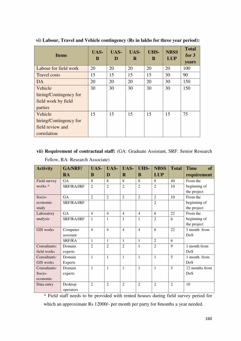
160
vi) Labour, Travel and Vehicle contingency (Rs in lakhs for three year period):
Items UAS-
B
UAS-
D
UAS-
R
UHS-
B
NBSS
LUP
Total
for 3
years
Labour for field work 20 20 20 20 20 100
Travel costs 15 15 15 15 30 90
DA 20 20 20 20 30 150
Vehicle
hiring/Contingency for
field work by field
parties
30 30 30 30 30 150
Vehicle
hiring/Contingency for
field review and
correlation
15 15 15 15 15 75
vii) Requirement of contractual staff: (GA: Graduate Assistant, SRF: Senior Research
Fellow, RA: Research Associate)
Activity GA/SRF/
RA
UAS-
B
UAS-
D
UAS-
R
UHS-
B
NBSS
LUP
Total Time of
requirement
Field survey
works *
GA 8 8 8 8 8 40 From the
beginning of
the project
SRF/RA/JRF 2 2 2 2 2 10
Socio-
economic
study
GA 2 2 2 2 2 10 From the
beginning of
the project
SRF/RA/JRF 2
Laboratory
analysis
GA 4 4 4 4 6 22 From the
beginning of
the project
SRF/RA/JRF 1 1 1 1 2 6
GIS works Computer
assistant
4 4 4 4 6 22 1 month from
DoS
SRF/RA 1 1 1 1 2 6
Consultants:
field works
Domain
experts
2 2 2 1 2 9 1 month from
DoS
Consultants:
GIS works
Domain
Experts
1 1 1 1 1 5 1 month from
DoS
Consultants:
Socio-
economic
Domain
experts
1 1 1 1 1 5 12 months from
DoS
Data entry Desktop
operators
2 2 2 2 2 2 10
* Field staff needs to be provided with rented houses during field survey period for
which an approximate Rs 12000/- per month per party for 8months a year needed.
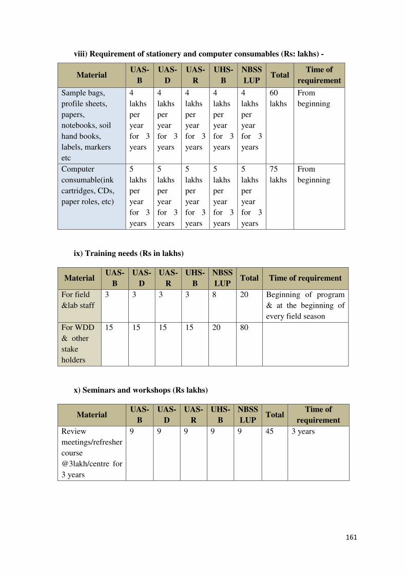
161
viii) Requirement of stationery and computer consumables (Rs: lakhs) -
Material UAS-
B
UAS-
D
UAS-
R
UHS-
B
NBSS
LUP Total
Time of
requirement
Sample bags,
profile sheets,
papers,
notebooks, soil
hand books,
labels, markers
etc
4
lakhs
per
year
for 3
years
4
lakhs
per
year
for 3
years
4
lakhs
per
year
for 3
years
4
lakhs
per
year
for 3
years
4
lakhs
per
year
for 3
years
60
lakhs
From
beginning
Computer
consumable(ink
cartridges, CDs,
paper roles, etc)
5
lakhs
per
year
for 3
years
5
lakhs
per
year
for 3
years
5
lakhs
per
year
for 3
years
5
lakhs
per
year
for 3
years
5
lakhs
per
year
for 3
years
75
lakhs
From
beginning
ix) Training needs (Rs in lakhs)
Material UAS-
B
UAS-
D
UAS-
R
UHS-
B
NBSS
LUP Total Time of requirement
For field
&lab staff
3 3 3 3 8 20 Beginning of program
& at the beginning of
every field season
For WDD
& other
stake
holders
15 15 15 15 20 80
x) Seminars and workshops (Rs lakhs)
Material UAS-
B
UAS-
D
UAS-
R
UHS-
B
NBSS
LUP Total
Time of
requirement
Review
meetings/refresher
course
@3lakh/centre for
3 years
9 9 9 9 9 45 3 years
162
Annexure - VII
Decision Support System
In the context of watershed management, DSS can be framed by coupling multiple data
layers (soils, surface and groundwater, crops, technology, market, farmers’ resources,
knowledge and skills, weather etc.) which can be seamlessly integrated to make most
scientific and practical decisions on problems in farming, and manage resources for
maximum benefit. The development of WMDSS would be done in three defined phases.
Phase I: Acquisition of Pre-requisites for development of WMDSS
A team of Consortium partners of the project will make an initial investigation and describe
the problem at hand, the resources available and the data issue. After rigorous inventory of
the needs and constraints, the team will identify DSS models to be developed as per the needs
of the end user interest from policy maker to the farmer.
• Inventory
• Identify the actors involved in the decision and explore the social context
• Understand the institutional and normative context
• Identify possible constraints
• Arouse user’s interest and initial commitment
• Identify and clearly communicate reasonable expectations
• Decide whether or not a DSS model may be useful for the purposes of the case
Phase II: Development of WMDSS tool
The System Requirement Specifications (SRS) will be drawn from the inventory report from
all the consortium partners. The workflows / protocols will be developed for programming
the DSS modules. State-of-the-art industrial standard developmental tools / programming
languages will be made use in all stages of SDLC (Software Development Life Cycle) for
developing WMDSS tools and modules. Initially the tool will be developed on pilot basis;
after thorough testing the same will be scaled up to the requirement level. Individual modules
will be iteratively tested and output will be verified with the end user to know the potentiality
of the modules. In all the development stages of WMDSS, care will be taken to consider the
end user prospects.
• Involve end users in the DSS development throughout the process
• Define a clear strategy and work programme and include quality assurance
• Adopt tool to the user’s needs
• Assure flexibility and interoperability
163
Phase III: Implementation of WMDSS
Before operationalising WMDSS on a large scale, operational training on pilot basis will be
given to the resource persons and identified end users to make sure that the DSS shall be
made user-friendly. A rigorous extension activity will be made by the SAU’s and UHS for
transferring the technology and its benefits to the end users / stakeholders under their
jurisdiction.
• Provide coherent methodological framework in which the DSS tool should operate
• Provide effective documentation of the outputs / results that can be obtained
• Provide adequate documentation and support materials for using DSS
• Train users
• Exploit the full potential of the tool in supporting the whole process
• Provide the basis for maintenance and further development
• Adopt strategies for dissemination and technology transfer
• The web based WM-DSS should be capable of Integrating Spatial and Non-spatial
data and should fetch the result based on the query / search.
• The application should identify authorized users
• Display Maps and other data sets (Say Watershed boundary, Village boundaries with
census data, Land use map, soil map etc.)
• Allow users to select / assign parameters required for prioritization
• Show unified view of Land Use, Prioritized watershed and various other thematic
layers as selected by the user.
• Web page should have the provision to switch over to local languages like Kannada
and others as per the need of the region
• The application should be made accessible to unlimited number of users
concurrently over the Web/Internet/Intranet
• Facilitate Seamless flow of information and the data and capable of generating
Reports.
164
Annexure – VIII
Preparation of Net Plan and Detailed Project Report in IWMP
The project aims to demonstrate the viability of community based approach for improvement
of rainfed areas on watershed basis and economic improvement to asset-less and vulnerable
groups, where the department plays a facilitating role. The components of the project
envisage an active participation of the different community members living in the village.
With a view to strengthening and sustaining the participation of the community, the
programme provides for formation of Community Based Organizations (EC, UGs and SHGs)
execution of Entry Point Activities, Awareness generation programmes and Capacity
Building to different stakeholder groups.
Stepwise approach is designed to bring awareness among the community and to change their
mind set with respect to planning and implementation of works to develop their lands and
surroundings to re-establish the ecological balance so that the natural resources provide the
required goods and services on a continuing basis.
Step.1 Organizing awareness building programmes in the project area in a language that
will understood by the entire community using and dedicated NGOs experienced in
the field.
Step.2 As a second step, discussions will be held with the Local Institution (GP) members
as well as the community at large to identify any long-felt needs that require
immediate attention so as to benefit them. These activities/works are prioritized in
terms of benefits and undertaken by the WDT. This leads to building rapport with
the community and also creates confidence in them that the programme is real. In
the process, the objectives of the project and roles and responsibilities of different
stakeholders are brought to their notice through informal discussions.
Step.3 As a third step, after noticing that the mood of the community is towards taking up
the project, CBOs such as SHGs, UGs and ECs are formed under each project
cutting across socio-economic barriers for promoting equity and inclusiveness.
These groups are trained at different levels of the project for enabling them to
organize, implement and monitor the activities under the project.
Step.4 PRA exercise is organized by preparing a social map of the village/project to assess
the maladies and likely remedial measures required to overcome and develop
control over the situation.
165
Step.5 At each project level a workshop cum training is arranged for all the department
staff along with the EC members on the process of net planning.
Step.6 Required GIS maps are prepared well in advance and are supplied to each of team.
Step.7 At each project level 2 to 3 teams are formed with WDT along with NGO staff.
These teams along with EC members will conduct transect walks. During the
transect walk required interventions are identified on individual farmers’ field in
consultation with concerned farmer and in common lands with consideration of the
technical feasibility. Technically this process is known as “Net planning”. The net
planning is conducted in the project area starting from upper reaches to lower
reaches covering private land, common land and drainage line area.
Step.8 After collecting the information as indicated above, it will be computerized into
customized software developed in-house by the department. This software helps in
collating the data at ease and simplifies the process of consolidating huge quantity
of data generated during net planning. It helps in analyzing the action plans for
sector wise allocations, equity analysis, and investment across reaches, etc.
Different output formats will be generated as per requirements.
Step.9 After the completion of the net planning, complete information on the identified
interventions will be shared with the community through Participatory Rural
Appraisal (PRA) exercise.
Step.10 The information generated during the net planning will be put forth before the
Executive committee in the form of Action plan for approval. Once approved by the
EC, same will be presented to the Grama Panchayat for its approval. This action
plan will then be forwarded to the district technical committee headed by the
DWDO for technical approval. Finally DPR will be prepared and submitted to
District Level Committee (DLC) Chaired by Chief Executive officer of Zilla
Panchayat and the members are from all the development departments for final
approval.
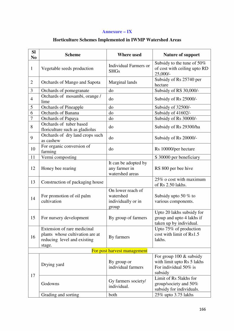
166
Annexure – IX
Horticulture Schemes Implemented in IWMP Watershed Areas
Sl
No Scheme Where used Nature of support
1 Vegetable seeds production Individual Farmers or SHGs
Subsidy to the tune of 50% of cost with ceiling upto RD 25,000/-
2 Orchards of Mango and Sapota Marginal lands Subsidy of Rs 25740 per hectare
3 Orchards of pomegranate do Subsidy of RS 30,000/-
4 Orchards of mosambi, orange / lime
do Subsidy of Rs 25000/-
5 Orchards of Pineapple do Subsidy of 32500/-
6 Orchards of Banana do Subsidy of 41602/-
7 Orchards of Papaya do Subsidy of Rs 30000/-
8 Orchards of tuber based floriculture such as gladiolus
do Subsidy of Rs 29300/ha
9 Orchards of dry land crops such as cashew
do Subsidy of Rs 20000/-
10 For organic conversion of farming
do Rs 10000/per hectare
11 Vermi composting S 30000 per beneficiary
12 Honey bee rearing It can be adopted by any farmer in watershed areas
RS 800 per bee hive
13 Construction of packaging house 25% o cost with maximum of Rs 2.50 lakhs.
14 For promotion of oil palm cultivation
On lower reach of watershed individually or in group
Subsidy upto 50 % to various components.
15 For nursery development By group of farmers Upto 20 lakhs subsidy for group and upto 4 lakhs if taken up by individual.
16
Extension of rare medicinal plants whose cultivation are at reducing level and existing stage.
By farmers
Upto 75% of production cost with limit of Rs1.5 lakhs.
For post harvest management
17
Drying yard By group or individual farmers
For group 100 & subsidy with limit upto Rs 5 lakhs For individual 50% is subsidy
Godowns Gy farmers society/ individual.
Limit of Rs 5lakhs for group/society and 50% subsidy for individuals.
Grading and sorting both 25% upto 3.75 lakhs
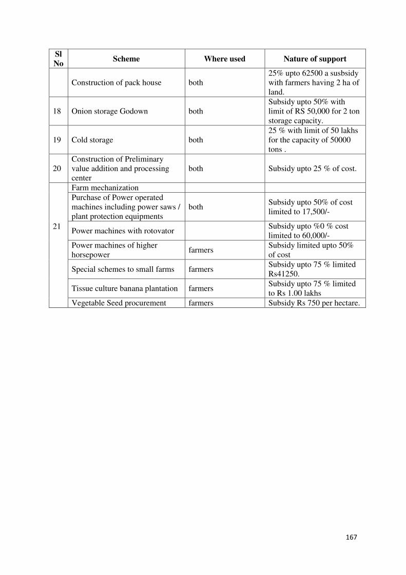
167
Sl
No Scheme Where used Nature of support
Construction of pack house both 25% upto 62500 a susbsidy with farmers having 2 ha of land.
18 Onion storage Godown both Subsidy upto 50% with limit of RS 50,000 for 2 ton storage capacity.
19 Cold storage both 25 % with limit of 50 lakhs for the capacity of 50000 tons .
20 Construction of Preliminary value addition and processing center
both Subsidy upto 25 % of cost.
21
Farm mechanization
Purchase of Power operated machines including power saws / plant protection equipments
both Subsidy upto 50% of cost limited to 17,500/-
Power machines with rotovator Subsidy upto %0 % cost limited to 60,000/-
Power machines of higher horsepower
farmers Subsidy limited upto 50% of cost
Special schemes to small farms farmers Subsidy upto 75 % limited Rs41250.
Tissue culture banana plantation farmers Subsidy upto 75 % limited to Rs 1.00 lakhs
Vegetable Seed procurement farmers Subsidy Rs 750 per hectare.
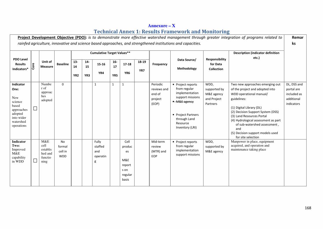
168
Annexure – X
Technical Annex 1: Results Framework and Monitoring Project Development Objective (PDO): is to demonstrate more effective watershed management through greater integration of programs related to
rainfed agriculture, innovative and science based approaches, and strengthened institutions and capacities.
Remar
ks
PDO Level
Results
Indicators* Co
re Unit of
Measure Baseline
Cumulative Target Values**
Frequency
Data Source/
Methodology
Responsibility
for Data
Collection
Description (indicator definition
etc.)
13-
14
YR2
14-
15
YR3
15-16
YR4
16-
17
YR5
17-18
YR6
18-19
YR7
Indicator
One:
New science based approaches adopted into wider watershed operations
Number of approaches adopted
0 1 1 1 Periodic
reviews and
end of
project
(EOP)
• Project reports
from regular
implementation
support missions
• M&E agency
• Project Partners
through Land
Resource
Inventory (LRI)
WDD,
supported by
M&E agency
and Project
Partners
Two new approaches emerging out
of the project and adopted into
WDD operational manual/
guidelines:
(1) Digital Library (DL)
(2) Decision Support System (DSS)
(3) Land Resources Portal
(4) Hydrological assessment as part
of sub-watershed assessment ,
and
(5) Decision support models used
for site selection
DL, DSS and
portal are
included as
additional
indicators
Indicator
Two: Improved M&E capability in WDD
M&E cell established and functioning
No
formal
cell in
WDD
Fully
staffed
and
operatin
g
Cell
produc
es
M&E
report
s on
regular
basis
Mid-term
review
(MTR) and
EOP
• Project reports
from regular
implementation
support missions
WDD,
supported by
M&E agency
Manpower in place, equipment acquired, and operation and maintenance taking place
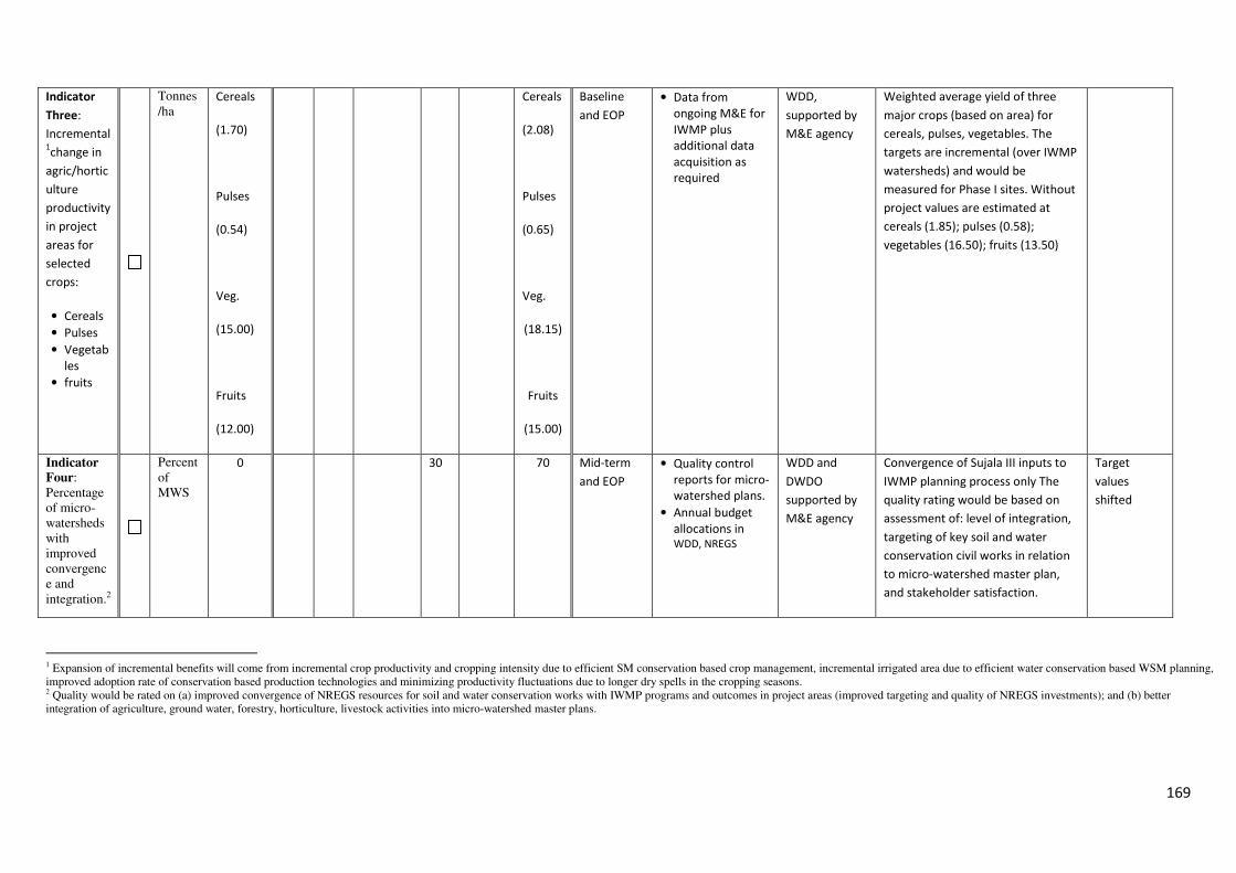
169
Indicator
Three:
Incremental 1change in
agric/hortic
ulture
productivity
in project
areas for
selected
crops:
• Cereals
• Pulses
• Vegetab
les
• fruits
Tonnes/ha
Cereals
(1.70)
Pulses
(0.54)
Veg.
(15.00)
Fruits
(12.00)
Cereals
(2.08)
Pulses
(0.65)
Veg.
(18.15)
Fruits
(15.00)
Baseline
and EOP
• Data from
ongoing M&E for
IWMP plus
additional data
acquisition as
required
WDD,
supported by
M&E agency
Weighted average yield of three
major crops (based on area) for
cereals, pulses, vegetables. The
targets are incremental (over IWMP
watersheds) and would be
measured for Phase I sites. Without
project values are estimated at
cereals (1.85); pulses (0.58);
vegetables (16.50); fruits (13.50)
Indicator
Four: Percentage of micro-watersheds with improved convergence and integration.2
Percent of MWS
0 30 70 Mid-term
and EOP
• Quality control
reports for micro-
watershed plans.
• Annual budget
allocations in WDD, NREGS
WDD and
DWDO
supported by
M&E agency
Convergence of Sujala III inputs to
IWMP planning process only The
quality rating would be based on
assessment of: level of integration,
targeting of key soil and water
conservation civil works in relation
to micro-watershed master plan,
and stakeholder satisfaction.
Target
values
shifted
1 Expansion of incremental benefits will come from incremental crop productivity and cropping intensity due to efficient SM conservation based crop management, incremental irrigated area due to efficient water conservation based WSM planning, improved adoption rate of conservation based production technologies and minimizing productivity fluctuations due to longer dry spells in the cropping seasons. 2 Quality would be rated on (a) improved convergence of NREGS resources for soil and water conservation works with IWMP programs and outcomes in project areas (improved targeting and quality of NREGS investments); and (b) better integration of agriculture, ground water, forestry, horticulture, livestock activities into micro-watershed master plans.
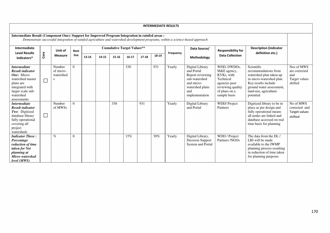
170
INTERMEDIATE RESULTS
Intermediate Result (Component One): Support for Improved Program Integration in rainfed areas :
Demonstrate successful integration of rainfed agriculture and watershed development programs, within a science-based approach
Intermediate
Level Results
Indicators* Co
re Unit of
Measure
Base
line
Cumulative Target Values**
Frequency
Data Source/
Methodology
Responsibility for
Data Collection
Description (indicator
definition etc.) 13-14 14-15 15-16 16-17 17-18 18-19
Intermediate
Result indicator One: Micro-watershed master plans are integrated with larger scale sub-watershed assessments
Number of micro-watersheds
0 330 931 Yearly Digital Library and Portal Report reviewing sub-watershed and micro-watershed plans and implementation
WDD, DWDOs, M&E agency, KVKs, with Technical agencies peer reviewing quality of plans on a sample basis
Scientific recommendations from watershed plan taken up in micro-watershed plan. Key results include ground water assessment, land-use, agriculture potential
Nos of MWS are corrected and Target values shifted
Intermediate
Result indicator
Two: Digitized database library fully operational covering all project watersheds
Number of MWSs
0 330 931 Yearly Digital Library and Portal
WDD/ Project Partners
Digitized library to be in place as per design and fully operational means all nodes are linked and database accessed on real time basis for planning
No of MWS corrected and
Target values
shifted
Indicator Three :
Percentage
reduction of time
taken for Net
planning at
Micro watershed
level (MWS)
% 0 15% 30% Yearly Digital Library, Decision Support System and Portal
WDD / Project Partners /NGOs
The data from the DL / LRI will be made available to the IWMP planning process resulting in reduction of time taken for planning purposes
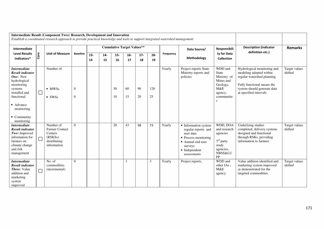
171
Intermediate Result (Component Two): Research, Development and Innovation
Establish a coordinated research approach to provide practical knowledge and tools to support integrated watershed management
Intermediate
Level Results
Indicators* Co
re
Unit of Measure Baseline
Cumulative Target Values**
Frequency
Data Source/
Methodology
Responsibili
ty for Data
Collection
Description (indicator
definition etc.)
Remarks
13-
14
14-
15
15-
16
16-
17
17-
18
18-
19
Intermediate
Result indicator
One: New hydrological monitoring systems installed and functional
• Advance monitoring
• Community monitoring
Number of:
• MWSs
• SWSs
0 0
30 10
60 15
90 20
120 25
Yearly Project reports State Ministry reports and policies
WDD and State Ministry of Mines and Geology, M&E agency, communities
Hydrological monitoring and modeling adopted within regular watershed planning Fully functional means the system should generate data at specified intervals
Target values shifted
Intermediate
Result indicator Two: Improved information for farmers on climate change and risk management
Number of Farmer Contact Centers (RSKSs) distributing information
0 20 43 58 73 Yearly • Information system regular reports and user data
• Process monitoring
• Annual end user surveys
• Independent assessments
WDD, DOA and research agencies 3rd party study agencies, NBSS&LUPP
Underlying studies completed, delivery systems designed and functional through RSKs, providing information to farmers
Target values shifted
Intermediate
Result indicator Three: Value addition and marketing system improved
No. of commodities (incremental)
0 1 3 Yearly Project reports. WDD and other IAs , M&E agency
Value addition identified and marketing system improved as demonstrated for the targeted commodities.
Target values shifted
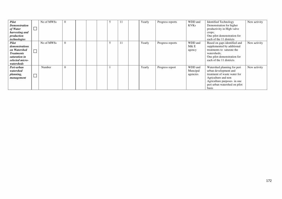
172
Pilot
Demonstration
of Water
harvesting and
production
technologies
No of MWSs 0 5 11 Yearly Progress reports WDD and KVKs
Identified Technology Demonstration for higher productivity in High valve crops; One pilot demonstration for each of the 11 districts
New activity
Pilot
demonstrations
on Watershed
Treatments
saturation in
selected micro-
watersheds
No of MWSs 0 5 11 Yearly Progress reports WDD and M& E agency
Based on gaps identified and supplemented by additional treatments to saturate the watersheds; One pilot demonstration for each of the 11 districts
New activity
Peri-urban
watershed
planning,
management
Number 0 1 Yearly Progress report WDD and Muncipal agencies
Watershed planning for peri urban development and treatment of waste water for Agriculture and non Agriculture purposes in one peri urban watershed on pilot basis
New activity
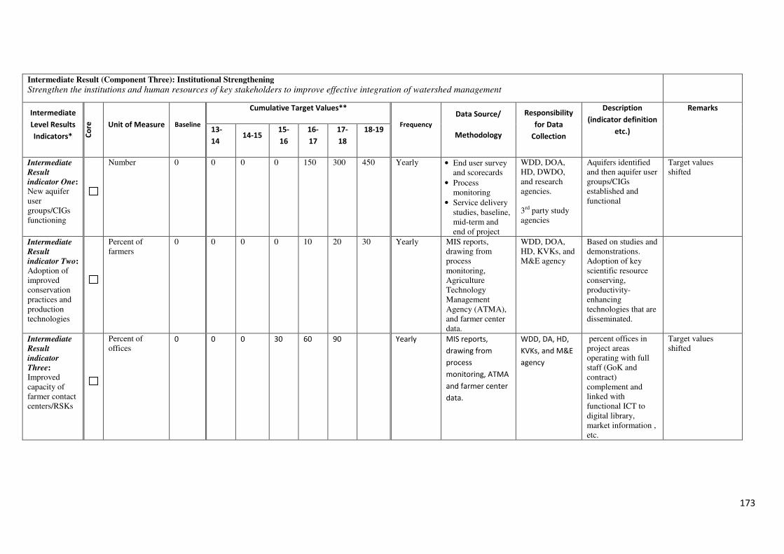
173
Intermediate Result (Component Three): Institutional Strengthening
Strengthen the institutions and human resources of key stakeholders to improve effective integration of watershed management
Intermediate
Level Results
Indicators* Co
re
Unit of Measure Baseline
Cumulative Target Values**
Frequency
Data Source/
Methodology
Responsibility
for Data
Collection
Description
(indicator definition
etc.)
Remarks
13-
14 14-15
15-
16
16-
17
17-
18
18-19
Intermediate
Result
indicator One: New aquifer user groups/CIGs functioning
Number
0 0 0 0 150 300
450 Yearly • End user survey and scorecards
• Process monitoring
• Service delivery studies, baseline, mid-term and end of project
WDD, DOA, HD, DWDO, and research agencies. 3rd party study agencies
Aquifers identified and then aquifer user groups/CIGs established and functional
Target values shifted
Intermediate
Result
indicator Two: Adoption of improved conservation practices and production technologies
Percent of farmers
0 0 0 0 10 20 30 Yearly MIS reports, drawing from process monitoring, Agriculture Technology Management Agency (ATMA), and farmer center data.
WDD, DOA, HD, KVKs, and M&E agency
Based on studies and demonstrations. Adoption of key scientific resource conserving, productivity-enhancing technologies that are disseminated.
Intermediate
Result
indicator
Three: Improved capacity of farmer contact centers/RSKs
Percent of offices
0 0 0 30 60 90 Yearly MIS reports,
drawing from
process
monitoring, ATMA
and farmer center
data.
WDD, DA, HD,
KVKs, and M&E
agency
percent offices in project areas operating with full staff (GoK and contract) complement and linked with functional ICT to digital library, market information , etc.
Target values shifted
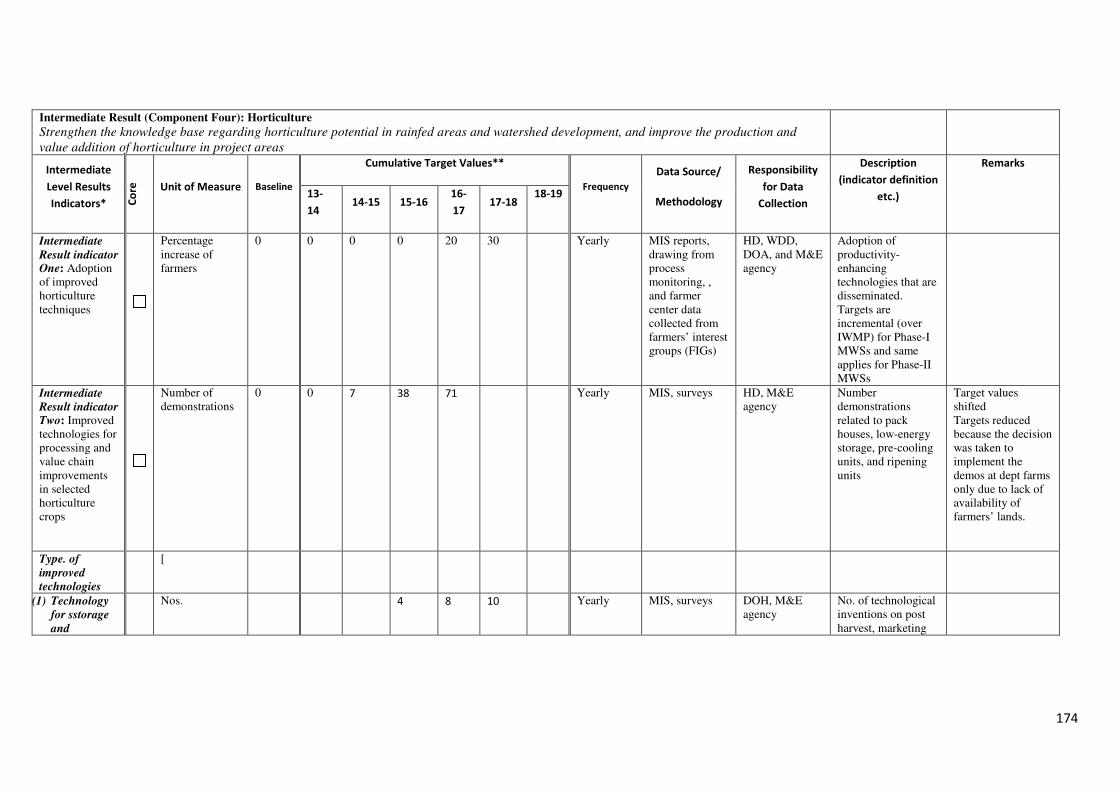
174
Intermediate Result (Component Four): Horticulture
Strengthen the knowledge base regarding horticulture potential in rainfed areas and watershed development, and improve the production and
value addition of horticulture in project areas
Intermediate
Level Results
Indicators* Co
re
Unit of Measure Baseline
Cumulative Target Values**
Frequency
Data Source/
Methodology
Responsibility
for Data
Collection
Description
(indicator definition
etc.)
Remarks
13-
14 14-15 15-16
16-
17 17-18
18-19
Intermediate
Result indicator One: Adoption of improved horticulture techniques
Percentage increase of farmers
0 0 0 0 20 30 Yearly MIS reports, drawing from process monitoring, , and farmer center data collected from farmers’ interest groups (FIGs)
HD, WDD, DOA, and M&E agency
Adoption of productivity-enhancing technologies that are disseminated. Targets are incremental (over IWMP) for Phase-I MWSs and same applies for Phase-II MWSs
Intermediate
Result indicator
Two: Improved technologies for processing and value chain improvements in selected horticulture crops
Number of demonstrations
0 0 7 38 71 Yearly MIS, surveys HD, M&E agency
Number demonstrations related to pack houses, low-energy storage, pre-cooling units, and ripening units
Target values shifted Targets reduced because the decision was taken to implement the demos at dept farms only due to lack of availability of farmers’ lands.
Type. of
improved
technologies
[
(1) Technology
for sstorage
and
Nos. 4 8 10 Yearly MIS, surveys DOH, M&E
agency No. of technological inventions on post harvest, marketing
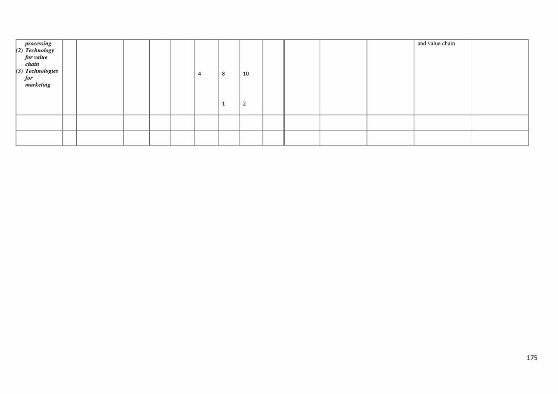
175
processing
(2) Technology
for value
chain
(3) Technologies
for
marketing
4
8
1
10
2
and value chain
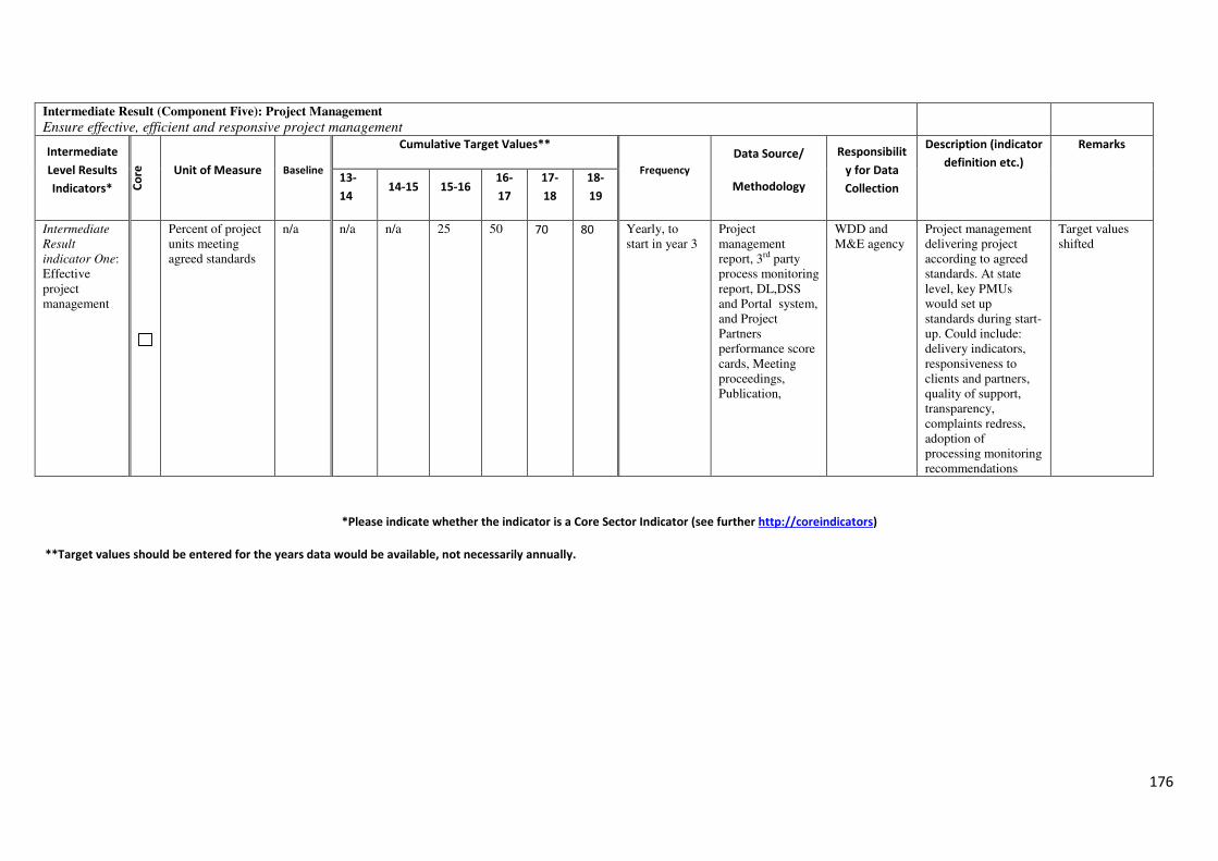
176
Intermediate Result (Component Five): Project Management
Ensure effective, efficient and responsive project management
Intermediate
Level Results
Indicators* Co
re
Unit of Measure Baseline
Cumulative Target Values**
Frequency
Data Source/
Methodology
Responsibilit
y for Data
Collection
Description (indicator
definition etc.)
Remarks
13-
14 14-15 15-16
16-
17
17-
18
18-
19
Intermediate
Result
indicator One: Effective project management
Percent of project units meeting agreed standards
n/a n/a n/a 25 50 70 80 Yearly, to start in year 3
Project management report, 3rd party process monitoring report, DL,DSS and Portal system, and Project Partners performance score cards, Meeting proceedings, Publication,
WDD and M&E agency
Project management delivering project according to agreed standards. At state level, key PMUs would set up standards during start-up. Could include: delivery indicators, responsiveness to clients and partners, quality of support, transparency, complaints redress, adoption of processing monitoring recommendations
Target values shifted
*Please indicate whether the indicator is a Core Sector Indicator (see further http://coreindicators)
**Target values should be entered for the years data would be available, not necessarily annually.
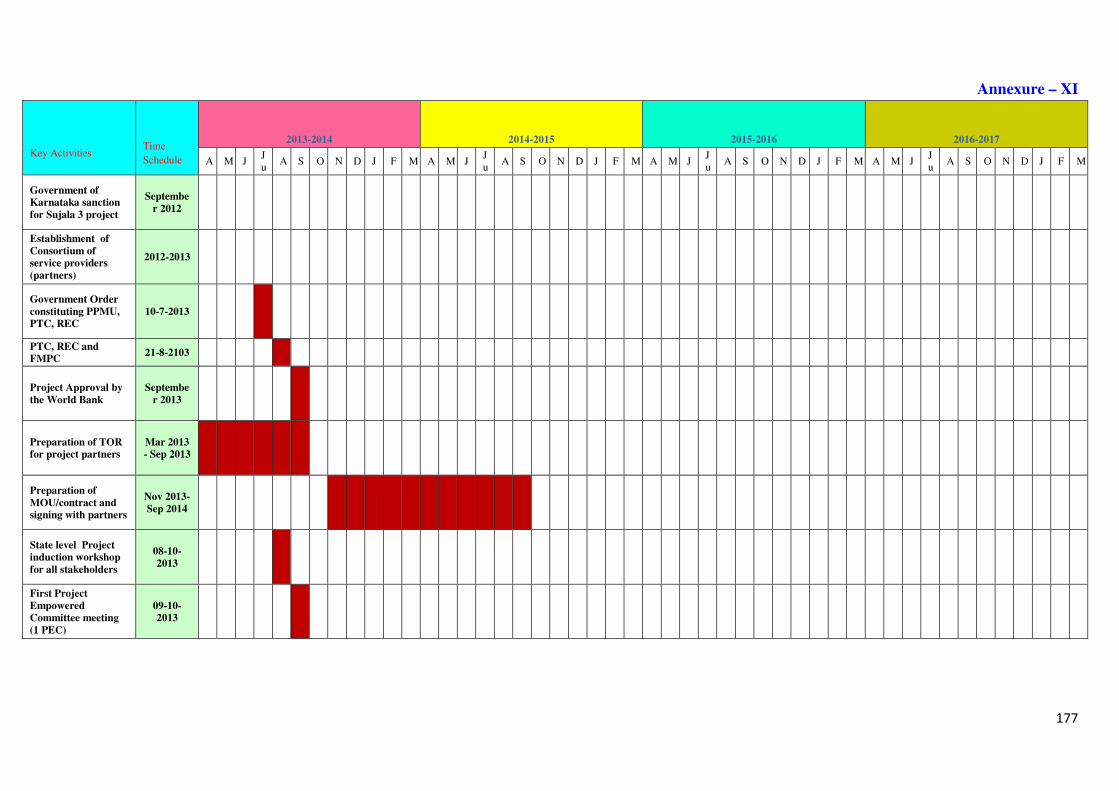
177
Annexure – XI
Key Activities Time
Schedule
2013-2014 2014-2015 2015-2016 2016-2017
A M J Ju
A S O N D J F M A M J Ju
A S O N D J F M A M J Ju
A S O N D J F M A M J Ju
A S O N D J F M
Government of
Karnataka sanction
for Sujala 3 project
Septembe
r 2012
Establishment of
Consortium of
service providers
(partners)
2012-2013
Government Order
constituting PPMU,
PTC, REC
10-7-2013
PTC, REC and
FMPC 21-8-2103
Project Approval by
the World Bank
Septembe
r 2013
Preparation of TOR
for project partners
Mar 2013
- Sep 2013
Preparation of
MOU/contract and
signing with partners
Nov 2013-
Sep 2014
State level Project
induction workshop
for all stakeholders
08-10-
2013
First Project
Empowered
Committee meeting
(1 PEC)
09-10-
2013
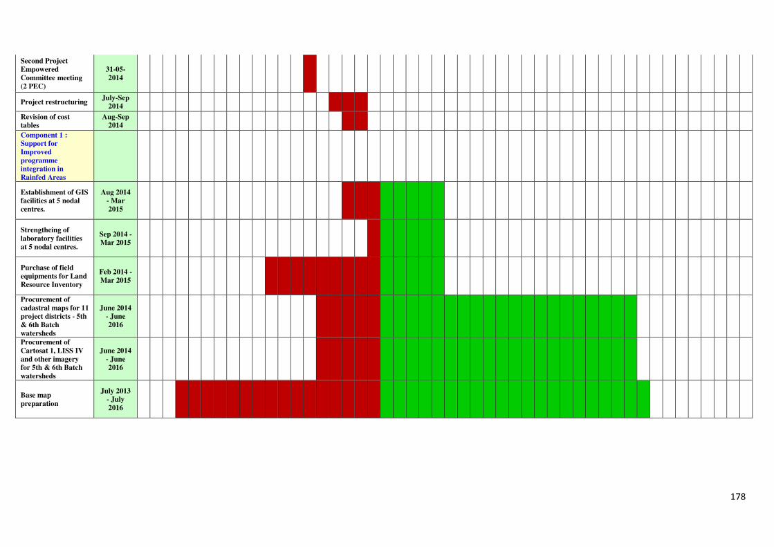
178
Second Project
Empowered
Committee meeting
(2 PEC)
31-05-
2014
Project restructuring July-Sep
2014
Revision of cost
tables
Aug-Sep
2014
Component 1 :
Support for
Improved
programme
integration in
Rainfed Areas
Establishment of GIS
facilities at 5 nodal
centres.
Aug 2014
- Mar
2015
Strengtheing of
laboratory facilities
at 5 nodal centres.
Sep 2014 -
Mar 2015
Purchase of field
equipments for Land
Resource Inventory
Feb 2014 -
Mar 2015
Procurement of
cadastral maps for 11
project districts - 5th
& 6th Batch
watersheds
June 2014
- June
2016
Procurement of
Cartosat 1, LISS IV
and other imagery
for 5th & 6th Batch
watersheds
June 2014
- June
2016
Base map
preparation
July 2013
- July
2016
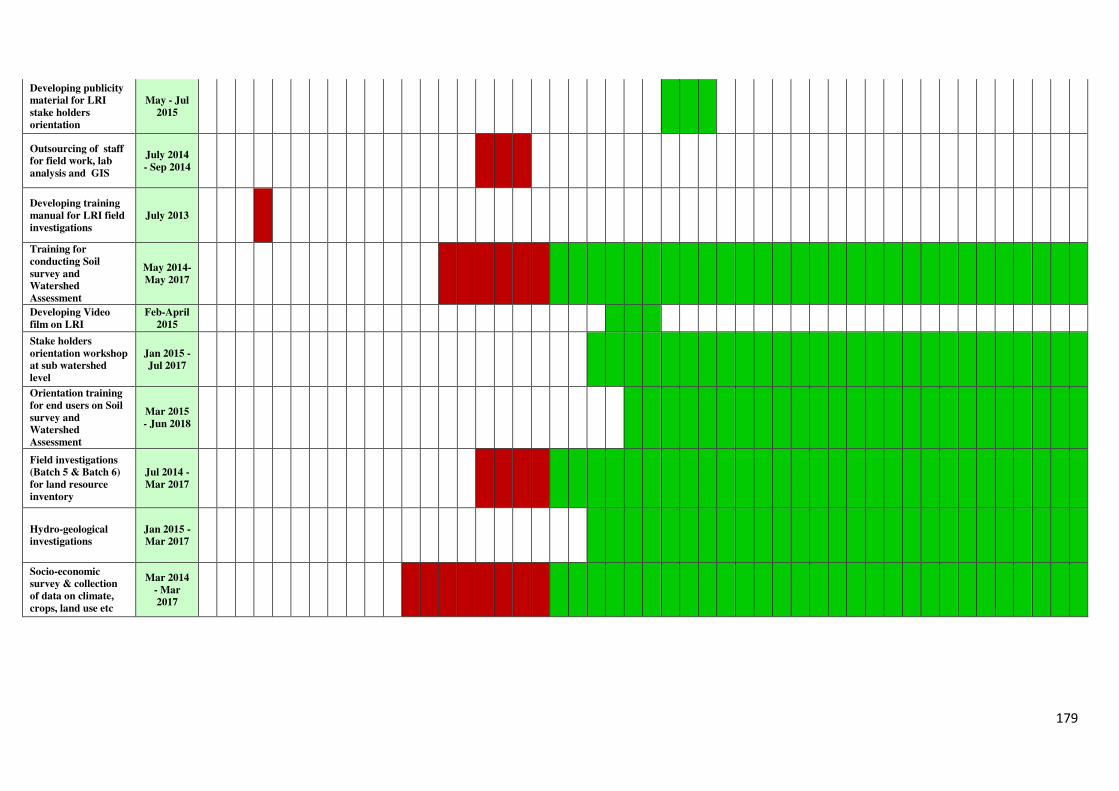
179
Developing publicity
material for LRI
stake holders
orientation
May - Jul
2015
Outsourcing of staff
for field work, lab
analysis and GIS
July 2014
- Sep 2014
Developing training
manual for LRI field
investigations
July 2013
Training for
conducting Soil
survey and
Watershed
Assessment
May 2014-
May 2017
Developing Video
film on LRI
Feb-April
2015
Stake holders
orientation workshop
at sub watershed
level
Jan 2015 -
Jul 2017
Orientation training
for end users on Soil
survey and
Watershed
Assessment
Mar 2015
- Jun 2018
Field investigations
(Batch 5 & Batch 6)
for land resource
inventory
Jul 2014 -
Mar 2017
Hydro-geological
investigations
Jan 2015 -
Mar 2017
Socio-economic
survey & collection
of data on climate,
crops, land use etc
Mar 2014
- Mar
2017
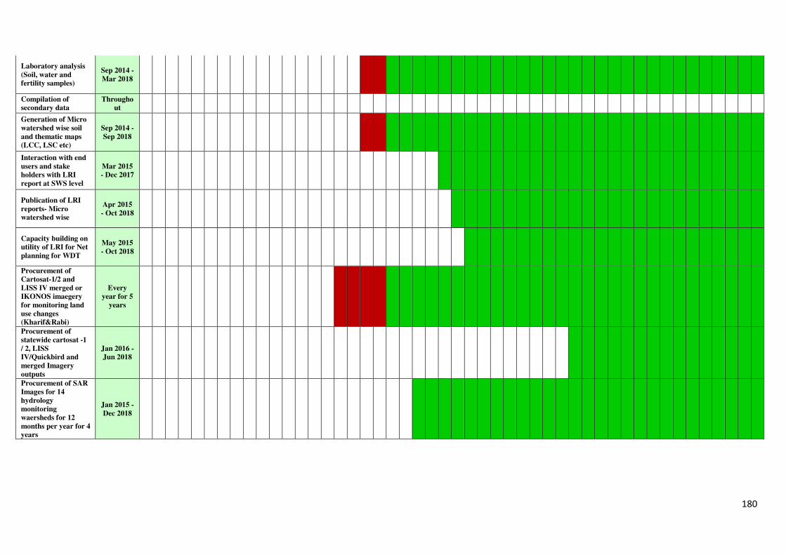
180
Laboratory analysis
(Soil, water and
fertility samples)
Sep 2014 -
Mar 2018
Compilation of
secondary data
Througho
ut
Generation of Micro
watershed wise soil
and thematic maps
(LCC, LSC etc)
Sep 2014 -
Sep 2018
Interaction with end
users and stake
holders with LRI
report at SWS level
Mar 2015
- Dec 2017
Publication of LRI
reports- Micro
watershed wise
Apr 2015
- Oct 2018
Capacity building on
utility of LRI for Net
planning for WDT
May 2015
- Oct 2018
Procurement of
Cartosat-1/2 and
LISS IV merged or
IKONOS imaegery
for monitoring land
use changes
(Kharif&Rabi)
Every
year for 5
years
Procurement of
statewide cartosat -1
/ 2, LISS
IV/Quickbird and
merged Imagery
outputs
Jan 2016 -
Jun 2018
Procurement of SAR
Images for 14
hydrology
monitoring
waersheds for 12
months per year for 4
years
Jan 2015 -
Dec 2018
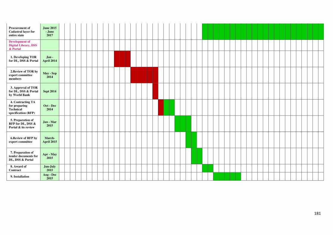
181
Procurement of
Cadastral layer for
entire state
June 2015
- June
2017
Development of
Digital Library, DSS
& Portal
1. Developing TOR
for DL, DSS & Portal
Jan -
April 2014
2.Review of TOR by
expert committee
members
May - Sep
2014
3. Approval of TOR
for DL, DSS & Portal
by World Bank
Sept 2014
4. Contracting TA
for preparing
Technical
specification (RFP)
Oct - Dec
2014
5. Preparation of
RFP for DL, DSS &
Portal & its review
Jan - Mar
2015
6.Review of RFP by
expert committee
March-
April 2015
7. Preparation of
tender documents for
DL, DSS & Portal
Apr - May
2015
8. Award of
Contract
Jun-July
2015
9. Installation Aug - Dec
2015
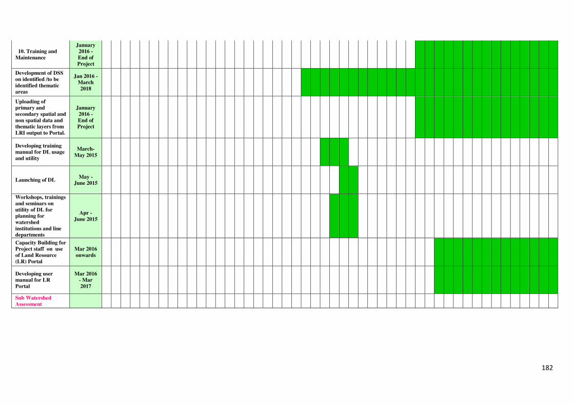
182
10. Training and
Maintenance
January
2016 -
End of
Project
Development of DSS
on identified /to be
identified thematic
areas
Jan 2016 -
March
2018
Uploading of
primary and
secondary spatial and
non spatial data and
thematic layers from
LRI output to Portal.
January
2016 -
End of
Project
Developing training
manual for DL usage
and utility
March-
May 2015
Launching of DL May -
June 2015
Workshops, trainings
and seminars on
utility of DL for
planning for
watershed
institutions and line
departments
Apr -
June 2015
Capacity Building for
Project staff on use
of Land Resource
(LR) Portal
Mar 2016
onwards
Developing user
manual for LR
Portal
Mar 2016
- Mar
2017
Sub Watershed
Assessment
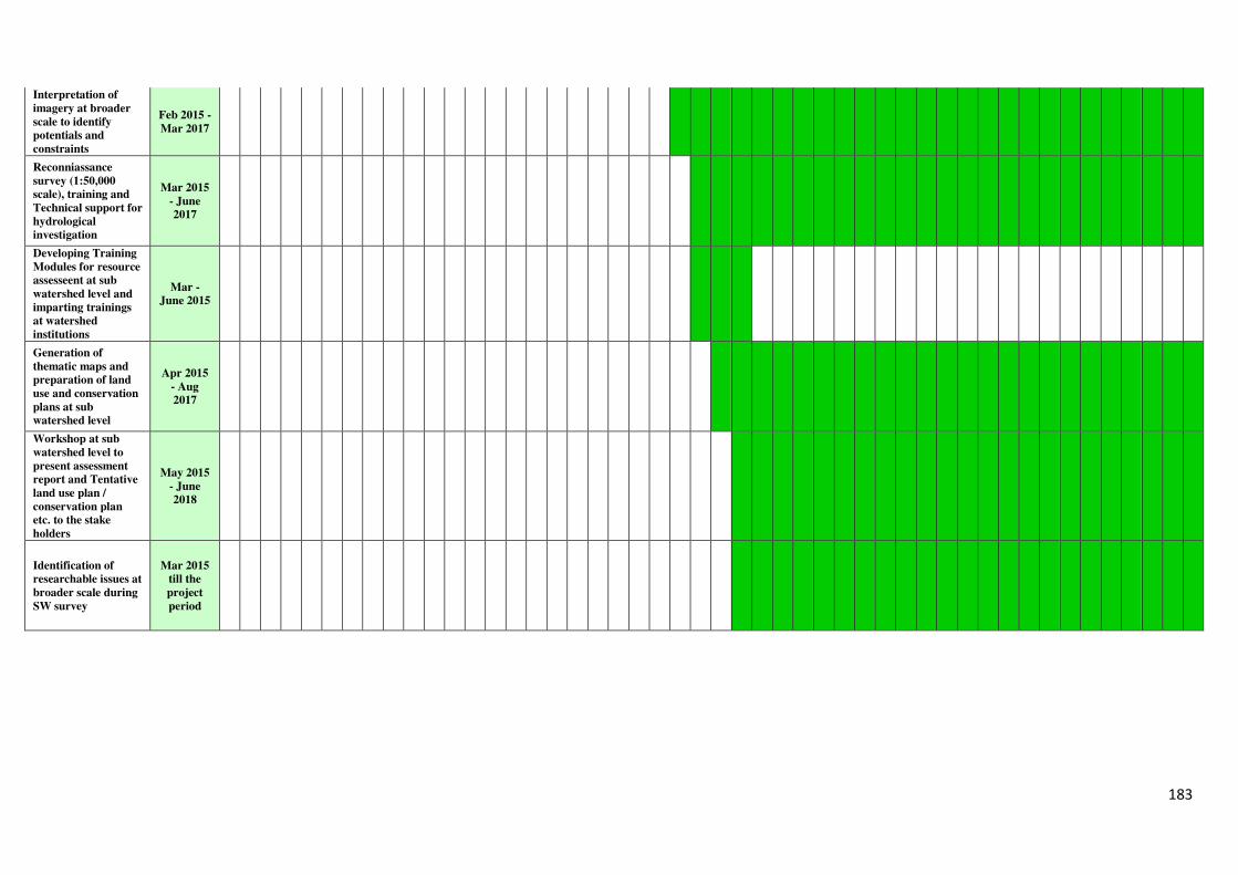
183
Interpretation of
imagery at broader
scale to identify
potentials and
constraints
Feb 2015 -
Mar 2017
Reconniassance
survey (1:50,000
scale), training and
Technical support for
hydrological
investigation
Mar 2015
- June
2017
Developing Training
Modules for resource
assesseent at sub
watershed level and
imparting trainings
at watershed
institutions
Mar -
June 2015
Generation of
thematic maps and
preparation of land
use and conservation
plans at sub
watershed level
Apr 2015
- Aug
2017
Workshop at sub
watershed level to
present assessment
report and Tentative
land use plan /
conservation plan
etc. to the stake
holders
May 2015
- June
2018
Identification of
researchable issues at
broader scale during
SW survey
Mar 2015
till the
project
period
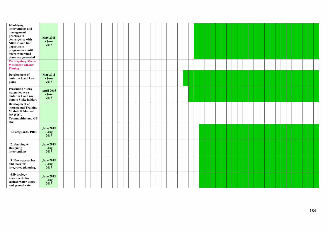
184
Identifying
interventions and
management
practices in
convergence with
NREGS and line
department
programmes until
micro watershed
plans are generated
May 2015
- June
2018
Participatory Micro
Watershed Master
Planing
Development of
tentative Land Use
plans
Mar 2015
- June
2018
Presenting Micro
watershed wise
tentative Land use
plan to Stake holders
April 2015
- June
2018
Development of
incremental Training
Module & Manual
for WDT,
Communities and GP
On:
1. Safeguards, PRIs
June 2015
- Aug
2017
2. Planning &
Designing
interventions
June 2015
- Aug
2017
3. New approaches
and tools for
integrated planning,
June 2015
- Aug
2017
4.Hydrology
assessments for
surface water usage
and groundwater
June 2015
- Aug
2017
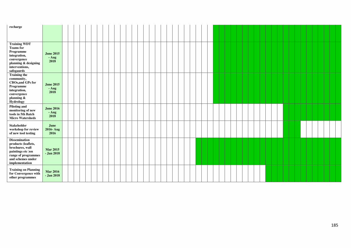
185
recharge
Training WDT
Teams for
Programme
integration,
convergence
planning & designing
interventions,
safegaurds
June 2015
- Aug
2018
Training the
community,
CBOs,and GPs for
Programme
integration,
convergence
planning &
Hydrology
June 2015
- Aug
2018
Piloting and
monitoring of new
tools in 5th Batch
Micro Watersheds
June 2016
- Aug
2018
Stakeholder
workshop for review
of new tool testing
June
2016- Aug
2016
Dissemination
products (leaflets,
brochures, wall
paintings etc )on
range of programmes
and schemes under
implementation
Mar 2015
- Jan 2018
Training on Planning
for Convergence with
other programmes
Mar 2016
- Jan 2018
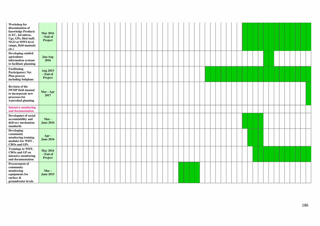
186
Workshop for
dissemination of
knowledge Products
to EC, Jal mitras,
Ugs, GPs, filed staff,
NGO at MWS level
(maps, field manuals
etc.)
Mar 2016
- End of
Project
Developing rainfed
agriculture
information systems
to facilitate planning
Jan-Aug
2016
Facilitating
Participatory Net
Plan process
including Subplans
Aug 2015
- End of
Project
Revision of the
IWMP field manual
to incorporate new
processes for
watershed planning
Mar - Apr
2017
Intensive monitoring
and documentation
Developmet of social
accountability and
delivery mechanism
standards
Mar -
June 2016
Developing
community
monitoring training
modules for WDT ,
CBOs and GPs
Apr -
June 2016
Trainings to WDT,
CBOs and GP on
intensive monitoring
and documentation
May 2016
- End of
Project
Procurement of
community
monitoring
equipments for
surface &
groundwater levels
Mar -
June 2015
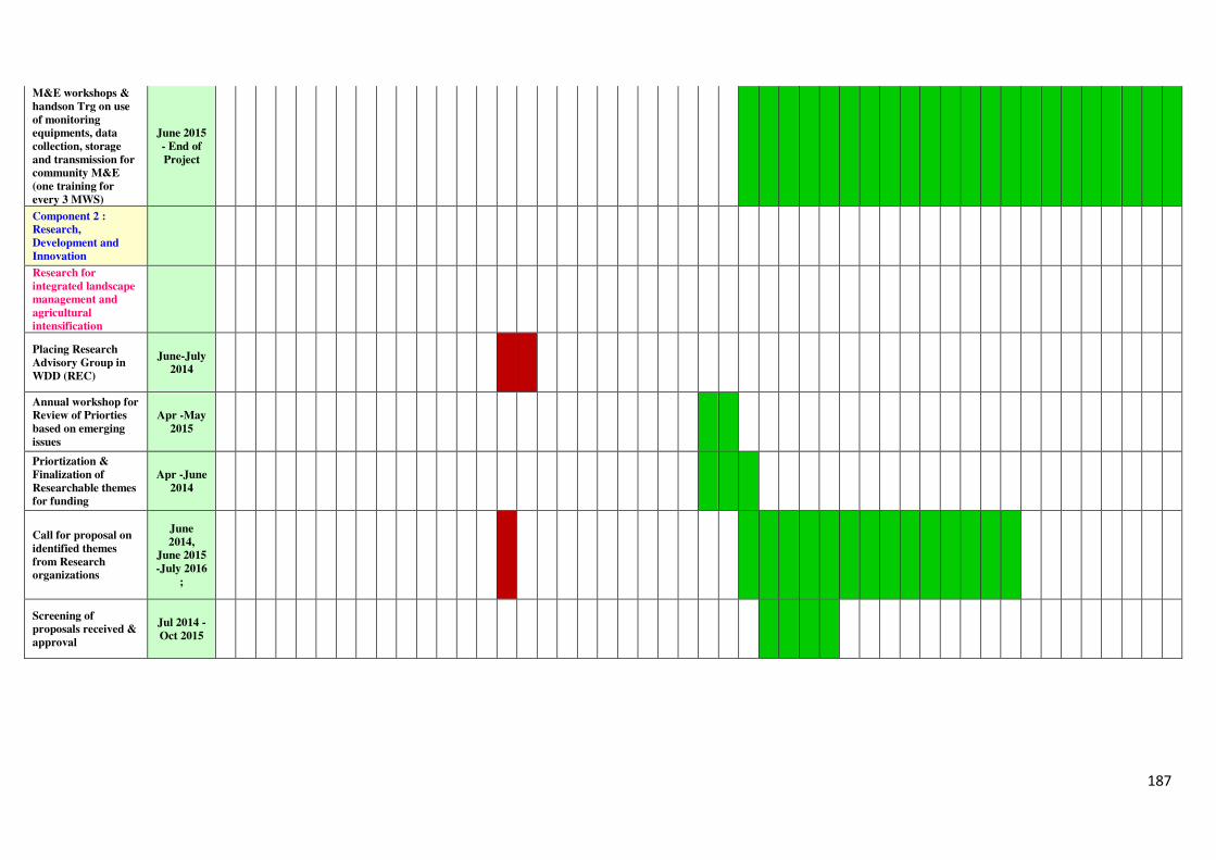
187
M&E workshops &
handson Trg on use
of monitoring
equipments, data
collection, storage
and transmission for
community M&E
(one training for
every 3 MWS)
June 2015
- End of
Project
Component 2 :
Research,
Development and
Innovation
Research for
integrated landscape
management and
agricultural
intensification
Placing Research
Advisory Group in
WDD (REC)
June-July
2014
Annual workshop for
Review of Priorties
based on emerging
issues
Apr -May
2015
Priortization &
Finalization of
Researchable themes
for funding
Apr -June
2014
Call for proposal on
identified themes
from Research
organizations
June
2014,
June 2015
-July 2016
;
Screening of
proposals received &
approval
Jul 2014 -
Oct 2015
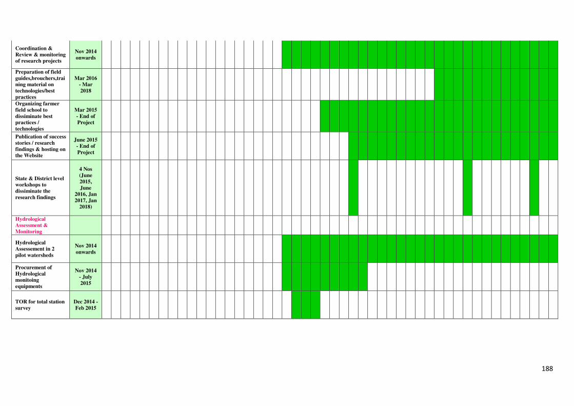
188
Coordination &
Review & monitoring
of research projects
Nov 2014
onwards
Preparation of field
guides,brouchers,trai
ning material on
technologies/best
practices
Mar 2016
- Mar
2018
Organizing farmer
field school to
dissiminate best
practices /
technologies
Mar 2015
- End of
Project
Publication of success
stories / research
findings & hosting on
the Website
June 2015
- End of
Project
State & District level
workshops to
dissiminate the
research findings
4 Nos
(June
2015,
June
2016, Jan
2017, Jan
2018)
Hydrological
Assessment &
Monitoring
Hydrological
Assessement in 2
pilot watersheds
Nov 2014
onwards
Procurement of
Hydrological
monitoing
equipments
Nov 2014
- July
2015
TOR for total station
survey
Dec 2014 -
Feb 2015
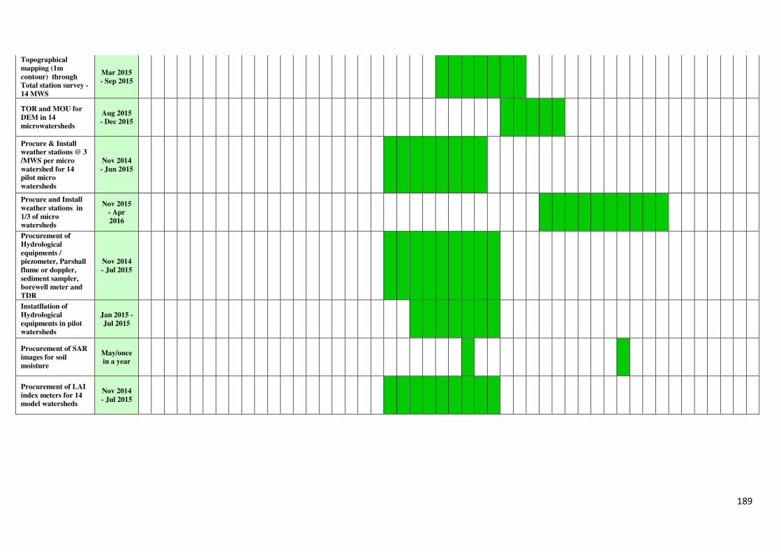
189
Topographical
mapping (1m
contour) through
Total station survey -
14 MWS
Mar 2015
- Sep 2015
TOR and MOU for
DEM in 14
microwatersheds
Aug 2015
- Dec 2015
Procure & Install
weather stations @ 3
/MWS per micro
watershed for 14
pilot micro
watersheds
Nov 2014
- Jun 2015
Procure and Install
weather stations in
1/3 of micro
watersheds
Nov 2015
- Apr
2016
Procurement of
Hydrological
equipments /
piezometer, Parshall
flume or doppler,
sediment sampler,
borewell meter and
TDR
Nov 2014
- Jul 2015
Instatllation of
Hydrological
equipments in pilot
watersheds
Jan 2015 -
Jul 2015
Procurement of SAR
images for soil
moisture
May/once
in a year
Procurement of LAI
index meters for 14
model watersheds
Nov 2014
- Jul 2015
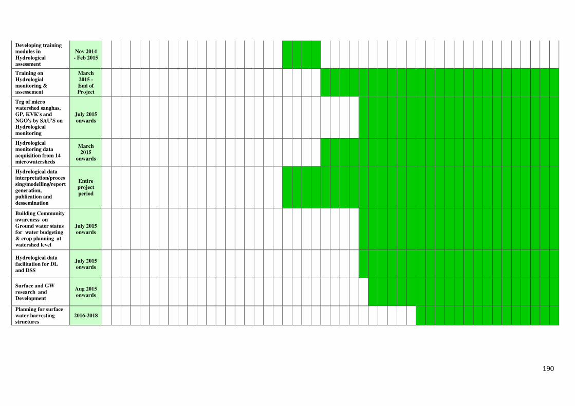
190
Developing training
modules in
Hydrological
assessment
Nov 2014
- Feb 2015
Training on
Hydrologial
monitoring &
assessement
March
2015 -
End of
Project
Trg of micro
watershed sanghas,
GP, KVK's and
NGO's by SAU'S on
Hydrological
monitoring
July 2015
onwards
Hydrological
monitoring data
acquisition from 14
microwatersheds
March
2015
onwards
Hydrological data
interpretation/proces
sing/modelling/report
generation,
publication and
dessemination
Entire
project
period
Building Community
awareness on
Ground water status
for water budgeting
& crop planning at
watershed level
July 2015
onwards
Hydrological data
facilitation for DL
and DSS
July 2015
onwards
Surface and GW
research and
Development
Aug 2015
onwards
Planning for surface
water harvesting
structures
2016-2018
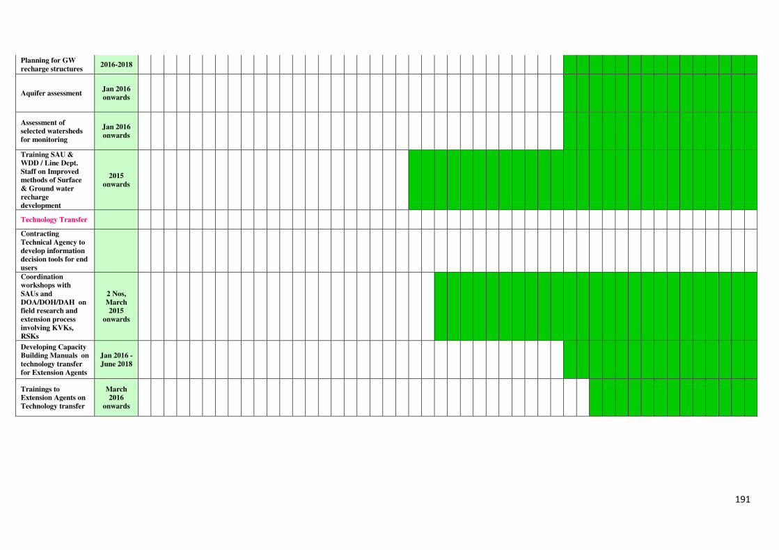
191
Planning for GW
recharge structures 2016-2018
Aquifer assessment Jan 2016
onwards
Assessment of
selected watersheds
for monitoring
Jan 2016
onwards
Training SAU &
WDD / Line Dept.
Staff on Improved
methods of Surface
& Ground water
recharge
development
2015
onwards
Technology Transfer
Contracting
Technical Agency to
develop information
decision tools for end
users
Coordination
workshops with
SAUs and
DOA/DOH/DAH on
field research and
extension process
involving KVKs,
RSKs
2 Nos,
March
2015
onwards
Developing Capacity
Building Manuals on
technology transfer
for Extension Agents
Jan 2016 -
June 2018
Trainings to
Extension Agents on
Technology transfer
March
2016
onwards
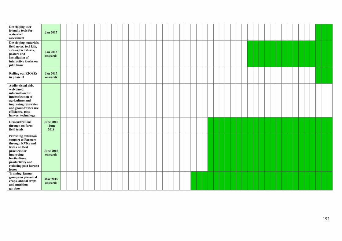
192
Developing user
friendly tools for
watershed
assessment
Jan 2017
Developing materials,
field notes, tool kits,
videos, fact sheets,
posters and
Installation of
interactive kiosks on
pilot basis
Jan 2016
onwards
Rolling out KIOSKs
in phase II
Jan 2017
onwards
Audio-visual aids,
web based
information for
intensification of
agriculture and
improving rainwater
and groundwater use
efficiency, post
harvest technology
Demonstrations
through on-farm
field trials
June 2015
- June
2018
Providing extension
support to Farmers
through KVKs and
RSKs on Best
practices for
improving
horticulture
productivity and
reducing post harvest
losses
June 2015
onwards
Training farmer
groups on perennial
crops, annual crops
and nutrition
gardens
Mar 2015
onwards
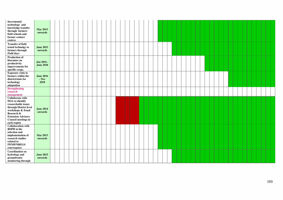
193
Incremental
technology and
knowledge transfer
through farmers
field schools and
farmer contact
centres
Mar 2015
onwards
Transfer of field
tested technolgy to
farmers through
Field days
June 2015
onwards
Production of
literature on
productivity
improvements for
specific crops.
Jan 2016 -
June 2018
Exposure visits to
farmers within the
district/state for
technology
adaptation
June 2016
- Nov
2018
Strengthening
research
management
Collaborate with
DOA to identify
researchable issues
through District level
workshops & Zonal
Research &
Extension Advisory
Council meetings in
each region
June 2014
onwards
Collaboration with
RDPR in the
selection and
implementation of
research studies
related to
IWMP/NREGS
convergence
Mar 2015
onwards
Coordination on
hydrology and
groundwater
monitoring through
June 2015
onwards
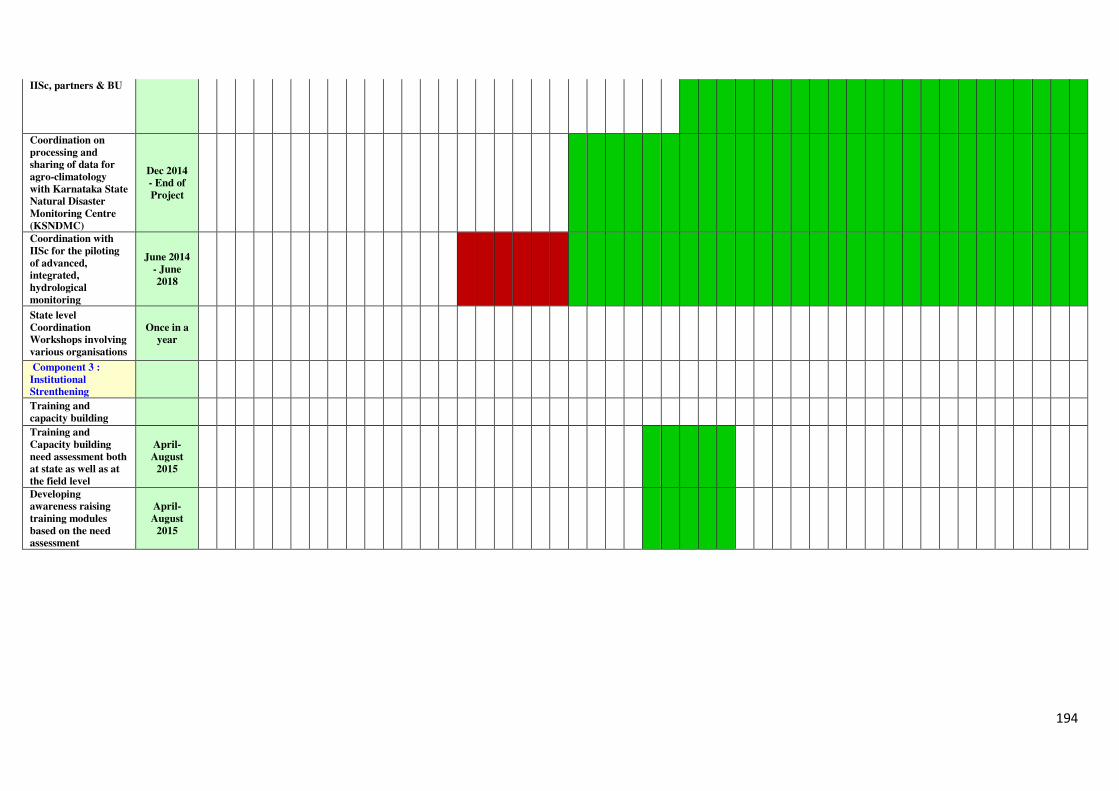
194
IISc, partners & BU
Coordination on
processing and
sharing of data for
agro-climatology
with Karnataka State
Natural Disaster
Monitoring Centre
(KSNDMC)
Dec 2014
- End of
Project
Coordination with
IISc for the piloting
of advanced,
integrated,
hydrological
monitoring
June 2014
- June
2018
State level
Coordination
Workshops involving
various organisations
Once in a
year
Component 3 :
Institutional
Strenthening
Training and
capacity building
Training and
Capacity building
need assessment both
at state as well as at
the field level
April-
August
2015
Developing
awareness raising
training modules
based on the need
assessment
April-
August
2015
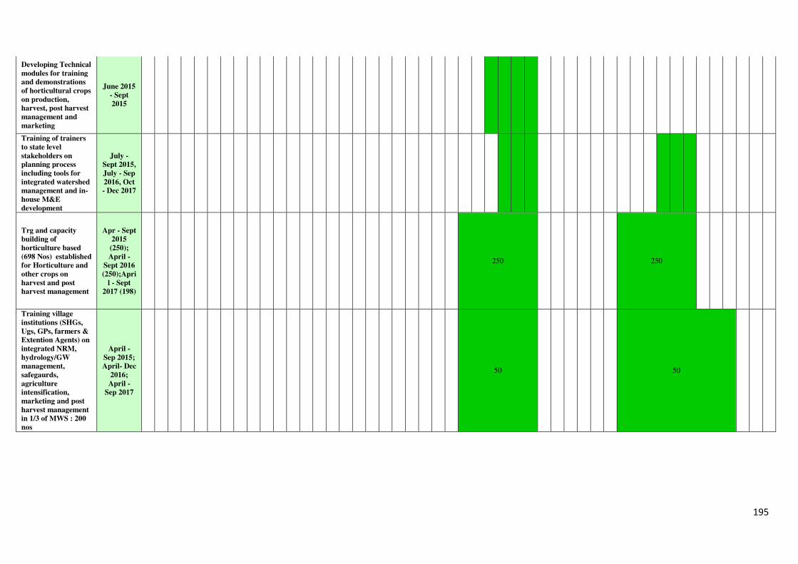
195
Developing Technical
modules for training
and demonstrations
of horticultural crops
on production,
harvest, post harvest
management and
marketing
June 2015
- Sept
2015
Training of trainers
to state level
stakeholders on
planning process
including tools for
integrated watershed
management and in-
house M&E
development
July -
Sept 2015,
July - Sep
2016, Oct
- Dec 2017
Trg and capacity
building of
horticulture based
(698 Nos) established
for Horticulture and
other crops on
harvest and post
harvest management
Apr - Sept
2015
(250);
April -
Sept 2016
(250);Apri
l - Sept
2017 (198)
250 250
Training village
institutions (SHGs,
Ugs, GPs, farmers &
Extention Agents) on
integrated NRM,
hydrology/GW
management,
safegaurds,
agriculture
intensification,
marketing and post
harvest management
in 1/3 of MWS : 200
nos
April -
Sep 2015;
April- Dec
2016;
April -
Sep 2017
50 50
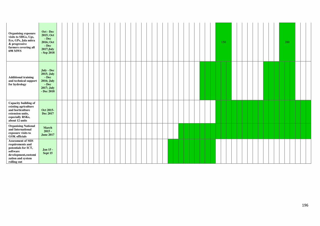
196
Organising exposure
visits to SHGs, Ugs,
Ecs, GPs, Jala mitra
& progressive
farmers covering all
698 MWS
Oct - Dec
2015; Oct
- Dec
2016; Oct
- Dec
2017;July
- Sep 2018
150 200
Additional training
and technical support
for hydrology
July - Dec
2015; July
- Dec
2016; July
- Dec
2017; July
- Dec 2018
Capacity building of
existing agriculture
and horticulture
extension units,
especially RSKs,
about 12 units
Oct 2015-
Dec 2017
Organising National
and International
exposure visits to
GOK officials
March
2015 -
June 2017
Assessment of MIS
requirements and
potentials for ICT,
software
development,customi
zation and system
rolling out
Jan 15 -
Sept 15
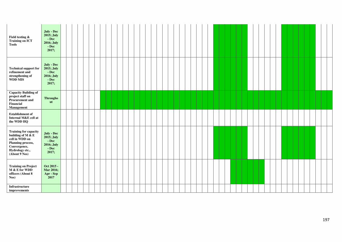
197
Field testing &
Training on ICT
Tools
July - Dec
2015; July
- Dec
2016; July
- Dec
2017;
Technical support for
refinement and
strengthening of
WDD MIS
July - Dec
2015; July
- Dec
2016; July
- Dec
2017;
Capacity Building of
project staff on
Procurement and
Financial
Management
Througho
ut
Establishment of
Internal M&E cell at
the WDD HQ
Training for capacity
building of M & E
cell in WDD on
Planning process,
Convergence,
Hydrology etc.,
(About 9 Nos)
July - Dec
2015; July
- Dec
2016; July
- Dec
2017;
Training on Project
M & E for WDD
officers (About 8
Nos)
Oct 2015 -
Mar 2016;
Apr - Sep
2017
Infrastructure
improvements
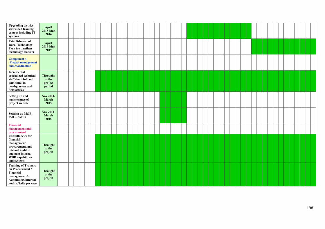
198
Upgrading district
watershed training
centres including IT
systems
April
2015-Mar
2016
Establishment of
Rural Technology
Park to strenthen
technology transfer
April
2016-Mar
2017
Component 4
:Project management
and coordination
Incremental
specialized technical
staff (both full and
part-time) in
headquarters and
field offices
Througho
ut the
project
period
Setting up and
maintenance of
project website
Nov 2014-
March
2015
Settting up M&E
Cell in WDD
Nov 2014-
March
2015
Financial
management and
procurement
Consultancies for
financial
management,
procurement, and
internal audit to
augment internal
WDD capabilities
and systems
Througho
ut the
project
Training of Trainers
on Procurement /
Financial
management &
Accounting, internal
audits, Tally package
Througho
ut the
project
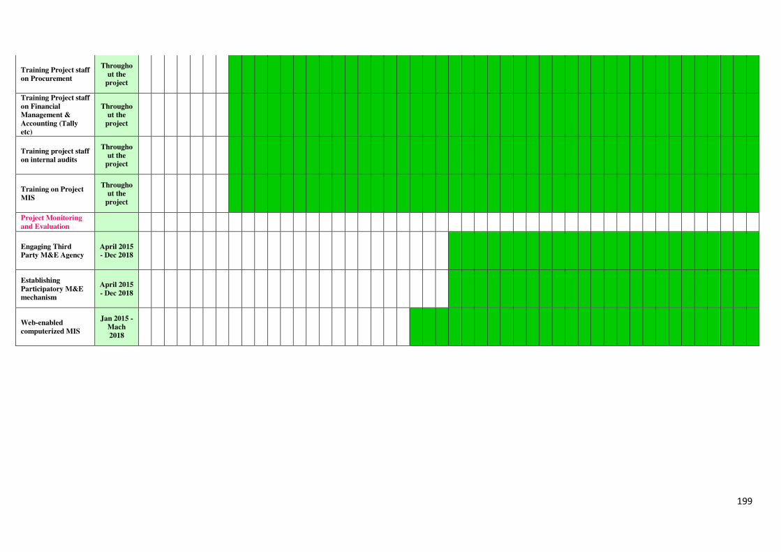
199
Training Project staff
on Procurement
Througho
ut the
project
Training Project staff
on Financial
Management &
Accounting (Tally
etc)
Througho
ut the
project
Training project staff
on internal audits
Througho
ut the
project
Training on Project
MIS
Througho
ut the
project
Project Monitoring
and Evaluation
Engaging Third
Party M&E Agency
April 2015
- Dec 2018
Establishing
Participatory M&E
mechanism
April 2015
- Dec 2018
Web-enabled
computerized MIS
Jan 2015 -
Mach
2018
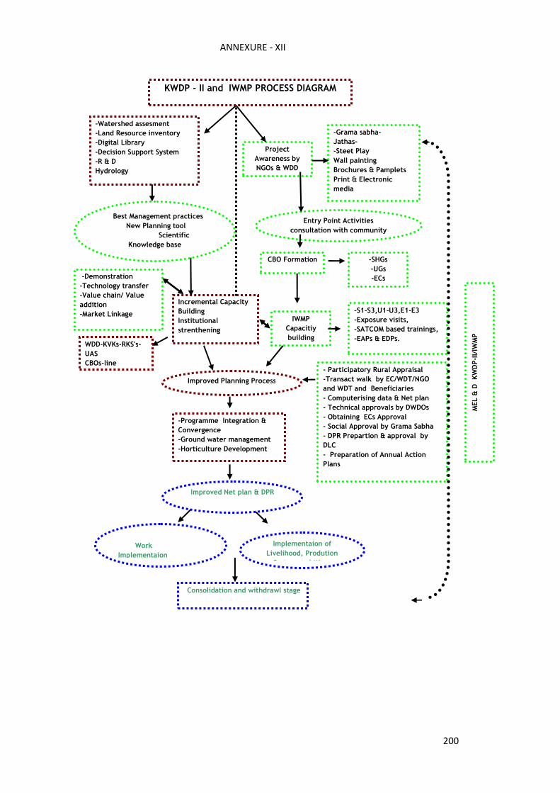
200
Project
Awareness by
NGOs & WDD
Entry Point Activities
consultation with community
IWMP
Capacitiy
building
Work
Implementaion
Consolidation and withdrawl stage
Implementaion of
Livelihood, Prodution
System and Micro
-Grama sabha-
Jathas-
-Steet Play
Wall painting
Brochures & Pamplets
Print & Electronic
media
-SHGs
-UGs
-ECs
-S1-S3,U1-U3,E1-E3
-Exposure visits,
-SATCOM based trainings,
-EAPs & EDPs.
- Participatory Rural Appraisal
-Transact walk by EC/WDT/NGO
and WDT and Beneficiaries
- Computerising data & Net plan
- Technical approvals by DWDOs
- Obtaining ECs Approval
- Social Approval by Grama Sabha
- DPR Prepartion & approval by
DLC
- Preparation of Annual Action
Plans
-Watershed assesment
-Land Resource inventory
-Digital Library
-Decision Support System
-R & D
Hydrology
Incremental Capacity
Building
Institutional
strenthening
WDD-KVKs-RKS's-
UAS
CBOs-line
-Programme Integration &
Convergence
-Ground water management
-Horticulture Development
Improved Planning Process
Improved Net plan & DPR
-Demonstration
-Technology transfer
-Value chain/ Value
addition
-Market Linkage
CBO Formation
Best Management practices
New Planning tool
Scientific
Knowledge base
zScietific Knowledge Base
ANNEXURE - XII
MEL & D KWDP-II/IWMP
KWDP - II and IWMP PROCESS DIAGRAM

201
ANNEXURE - XIII
PROJECT COST TABLE
(KWDP II - Cost tables (May 4, 2015).xlsx)