Embed Size (px)
Citation preview
WATER RESOURCES MANAGEMENT STRATEGY: REVIEW ON THE IMPACTS OF SARA WAK RIVER
BARRAGE ON THE WATER QUALITY
HARTINI BINTI MAHIDIN
A dissertation submitted in partial fulfiUment of the requirements for the degree of
Master of Environmental Science (Land Use and Water Resource Management)
SLUSE-M MASTER PROGRAMME
Faculty of Resource Science and Technology UNlVERSITI MALAYSIA SARA W AK
May 2006
ACKNOWLEDGEMENT
(Bismillahirrahmannirrahim)
In the name ofAllah, All-Merciful, the Mercy-Giving,
First and foremost, I would like to extend my heartfelt appreciation to Associate Professor
Dr Lau Seng, my supervisor for his superb guidance and understanding throughout the
course ofwriting this dissertation. I would also wish to acknowledge and fully ex.press my
gratitude to SLUSE-M Masters Program Coordinator, Dr Siti Rubiah bt Zainuddin for her
generosity, support and her belief in me to complete this dissertation right from the start.
My sincere appreciation is also ex.tended to the list of names below for their generous
assistance in giving ideas plus for making available to me the latest related information
and data during the course of researching for this thesis. Theyare:
1) En. Kalana bin Drahman (Department ofEnvironment - DOE)
2) Pn. Hidayati bt. Ismail (Department of Irrigation and Drainage - DID)
3) Pn. Rahayu bt Ahmad Bohari (Batu Kitang Water Treatment Plant)
4) En. Hitler Edward Dandu (Sarawak Rivers Board - SRB)
5) Capt. Goh Chin Guan (Kuching Barrage Management Sdn.Bhd. -KBM)
6) En. Justin Jok Jau Imang (Natural Resources Environmental Board)
7) En. Ngab Dollah b. Salam (Soil Management Branch, DOA)
I wish to thanks all technical staff of UNIMAS, especially to the Director of Centre for
Technology Transfer and Consultancy (CITC), Dr. Lee Nyanti, Deputy Vice Chancellor
of Research and Innovation, Prof. Murtedza Mohamed, Dean of Centre for Graduate
Study, Prof. Madya Dr. Kopli bin Bujang and Mr. Robert Malong for their great
administrative, technical and management for the program.
III
Thanks are also due to all my colleagues and good friends at Universiti Teknologi Mara
Kampus Samarahan for their interest and valuable suggestions for the improvement of this .. thesis. Thank you Suzana Narawi, Azilawati Banchit, Sh. Zakiah Wan Hassan and an
unmentionable list ofothers.
My love and gratitude is also extended to my Mak, (Pn Hamsiah Yahya), Abah (En
Mahidin Ahmad) and all my brothers and sisters for understanding and giving me the
support [ need to complete the thesis.
Finally, [ would be remiss if [ did not mention the two extraordinary gentlemen who have
given me the strength, support, belief and trust and most importantly my main reason for
living. Firstly, my dear husband, Hj Edmund Shah Bin Tambi. for understanding, caring,
helping and always giving me that shoulder to cry on during those trying times. [really do
love you. And last but definitely not least, without doubt the most precious gift whom
Allah have entrusted me to take care of, the air that [ live to breath in, the joy of my life,
my beautiful son, Emir Hazrln Shah, this is for you dear. [love you with all my heart.
Despite the help and support of.so many able people, [alone accept full responsibility for
any deficiencies this thesis may possess.
Wallahuallam
Thank You
Hartini Bt Mahidin
May 1006
... I
I IV I
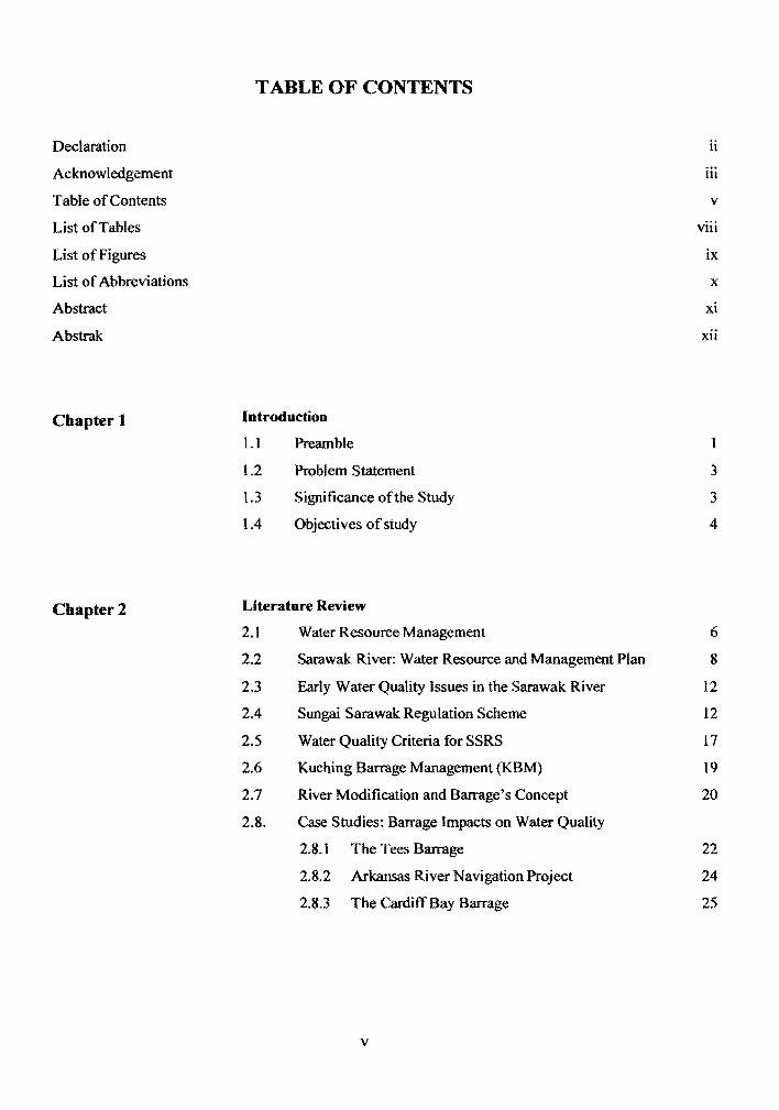
TABLE OF CONTENTS
Declaration ii
Acknowledgement III
Table of Contents v
List of Tables viii
List of Figures ix
List of Abbreviations x
Abstract xi
Abstrak xu
Chapter 1 Introduction
1.1 Preamble
1.2 Problem Statement 3
1.3 Significance ofthe Study 3
1.4 Objectives of study 4
Chapter 2 Literature Review
2.1 Water Resource Management 6
2.2 Sarawak River: Water Resource and Management Plan 8
2.3 Early Water Quality Issues in the Sarawak River 12
2.4 Sungai Sarawak Regulation Scheme 12
2.5 Water Quality Criteria for SSRS 17
2.6 Kuching Barrage Management (KBM) 19
2.7 River Modification and Barrage's Concept 20
2.8. Case Studies: Barrage Impacts on Water Quality
2.8.1 The Tees Barrage 22
2.8.2 Arkansas River Navigation Project 24
2.8.3 The Cardiff Bay Barrage 25
v
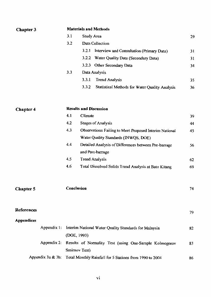
Chapter 3
Chapter 4
ChapterS
References
Appendices
Appendix 1:
Appendix 2:
Appendix 3a & 3b:
Materials aud Methods
3.1 Study Area 29
3.2 Data Collection
3.2.1 Interview and Consultation (primary Data) 31
3.2.2 Water Quality Data (Secondary Data) 31
3.2.3 Other Secondary Data 34
3.3 Data Analysis
3.3.1 Trend Analysis 35
3.3.2 Statistical Methods for Water Quality Analysis 36
Results and Discussion
4.1 Climate 39
4.2 Stages ofAnalysis 44
4.3 Observations Failing to Meet Proposed Interim National 45
Water Quality Standards (INWQS, DOE)
4.4 Detailed Analysis ofDifferences between Pre-barrage 56
and Post-barrage
4.5 Trend Analysis 62
4.6 Total Dissolved Solids Trend Analysis at Batu Kitang 69
Conclusion 74
79
Interim National Water Quality Standards for Malaysia 82
(DOE, 1993)
Results of Normality Test (using One-Sample Kolmogorov 83
Smimov Test)
Total Monthly Rainfall for 5 Stations from 1990 to 2004 86
VI
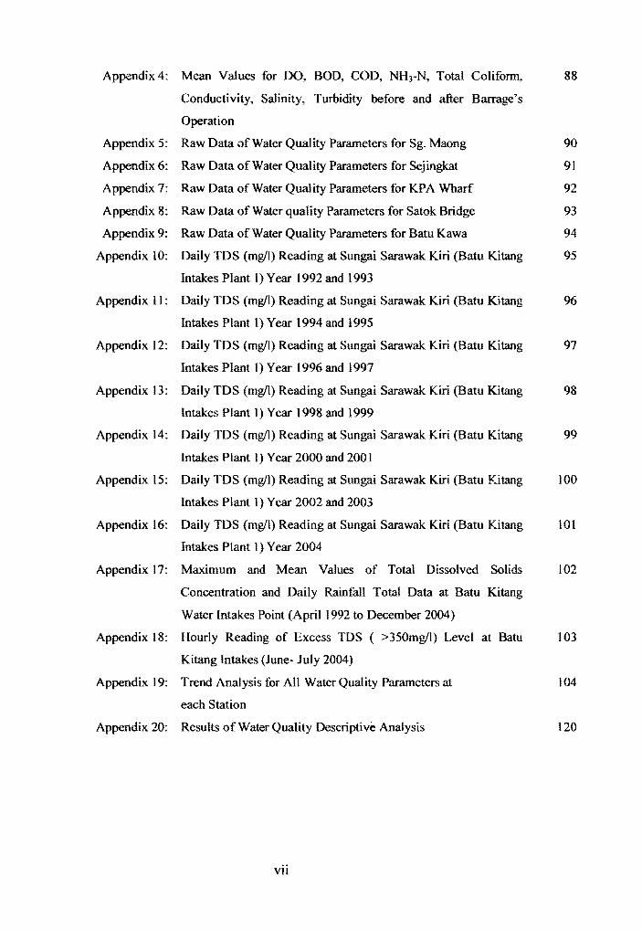
Appendix 4: Mean Values for DO, BOD, COD, NH3-N, Total Coliform, 88
Conductivity, Salinity, Turbidity before and after Barrage's
Operation
Appendix 5: Raw Data of Water Quality Parameters for Sg. Maong 90
Appendix 6: Raw Data of Water Quality Parameters for Sejingkat 91
Appendix 7: Raw Data of Water Quality Parameters for KPA Wharf 92
Appendix 8: Raw Data of Water quality Parameters for Satok Bridge 93
Appendix 9: Raw Data of Water Quality Parameters for Batu Kawa 94
Appendix 10: Daily TDS (mgll) Reading at Sungai Sarawak Kiri (Batu Kitang 95
Intakes Plant 1 ) Year 1992 and 1993
Appendix 11: Daily TDS (mgll) Reading at Sungai Sarawak Kiri (Batu Kitang 96
Intakes Plant 1 ) Year 1994 and 1995
Appendix 12: Daily TDS (mgll) Reading at Sungai Sarawak Kiri (Batu Kitang 97
Intakes Plant I ) Year 1996 and 1997
Appendix 13: Daily TDS (mgll) Reading at Sungai Sarawak Kiri (Batu Kitang 98
Intakes Plant I ) Year 1998 and 1999
Appendix 14: Daily TDS (mgll) Reading at Sungai Sarawak Kiri (Batu Kitang 99
Intakes Plant I ) Year 2000 and 200 I
Appendix 15: Daily TDS (mg/I) Reading at Sungai Sarawak Kiri (Batu Kitang 100
Intakes Plant I ) Year 2002 and 2003
Appendix 16: Daily TDS (mg/I) Reading at Sungai Sarawak Kiri (Batu Kitang 101
Intakes Plant I) Year 2004
Appendix 17: Maximum and Mean Values of Total Dissolved Solids 102
Concentration and Daily Rainfall Total Data at Batu Kitang
Water Intakes Point (April 1992 to December 2004)
Appendix 18: Hourly Reading of Excess TDS ( >350mg/l) Level at Batu 103
Kitang Intakes (June- July 2004)
Appendix 19: Trend Analysis for All Water Quality Parameters at 104
each Station
Appendix 20: Results of Water Quality Descriptive Analysis 120
.. I
VII
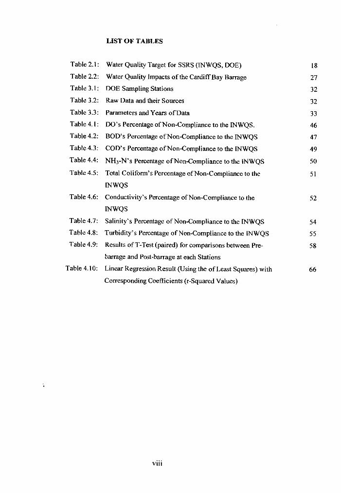
Table 2.1:
Table 2.2:
Table 3.1:
Table 3.2:
Table 3.3:
Table 4.1:
Table 4.2:
Table 4.3:
Table 4.4:
Table 4.5:
Table 4.6:
Table 4.7:
Table 4.8:
Table 4.9:
Table 4.10:
..,
LIST OF TABLES
Water Quality Target for SSRS (INWQS, DOE) 18
Water Quality Impacts of the Cardiff Bay Barrage 27
DOE Sampling Stations 32
Raw Data and their Sources 32
Parameters and Years ofData 33
DO's Percentage ofNon-Compliance to the INWQS. 46
BOD's Percentage ofNon-Compliance to the INWQS 47
COD's Percentage ofNon-Compliance to the INWQS 49
NH3-N'S Percentage ofNon -Compliance to the INWQS 50
Total Coliform's Percentage ofNon-Compliance to the 51
INWQS
Conductivity's Percentage ofNon-Compliance to the 52
INWQS
Salinity's Percentage of Non-Compliance to the INWQS 54
Turbidity's Percentage ofNon -Compliance to the INWQS 55
Results of T -Test (paired) for comparisons between Pre 58
barrage and Post-barrage at each Stations
Linear Regression Result (Using the of Least Squares) with 66
Corresponding Coefficients (r-Squared Values)
VIII
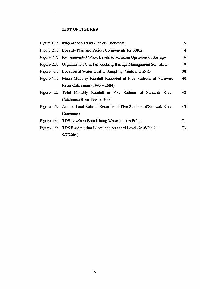
LIST OF FIGURES
Figure 1.1: Map ofthe Sarawak River Catchment 5
Figure 2.1: Locality Plan and Project Components for SSRS 14
Figure 2.2: Recommended Water Levels to Maintain Upstream ofBarrage 16
Figure 2.3: Organization Chart of Kuching Barrage Management Sdn. Bhd. 19
Figure 3.1: Location of Water Quality Sampling Points and SSRS 30
Figure 4.1: Mean Monthly Rainfall Recorded at Five Stations of Sarawak 40
Ri ver Catchment (1990 - 2004)
Figure 4.2: Total Monthly Rainfall at Five Stations of Sarawak River 42
Catchment from 1990 to 2004
Figure 4.3: Annual Total Rainfall Recorded at Five Stations of Sarawak River 43
Catchment
Figure 4.4: TDS Levels at Batu Kitang Water Intakes Point 71
Figure 4.5: TDS Reading that Excess the Standard Level (24/6/2004 73
9/7/2004)
lX
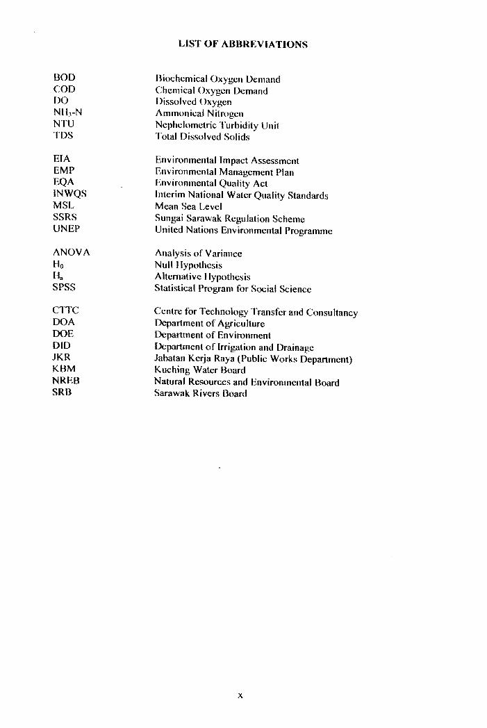
BOD COD DO NH)-N NTU TDS
EIA EMP EQA INWQS MSL SSRS UNEP
ANOVA Ho Ha SPSS
CITC DOA DOE DID JKR KBM NREB SRB
LIST OF ABBREVIATIONS
Biochemical Oxygen Demand Chemical Oxygen Demand Dissolved Oxygen Ammonical Nitrogen Nephelometric Turbidity Unit Total Dissolved Solids
Environmental Impact Assessment Environmental Management Plan Environmental Quality Act Interim National Water Quality Standards Mean Sea Level Sungai Sarawak Regulation Scheme United Nations Environmcntall)rogrammc
Ana lysis or Variance Null Hypothesis Altemativc Ilypothesis Statistical r)rogram for Social Science
Centre for Technology Transfer and Consultancy Department of Agriculture .., Department of Environment Department or Irrigation and Drainage Jabatan Kerja Raya (Public Works Department) Kuching Water Board Natural Resources and Environmental Board Sarawak Rivers Board
x
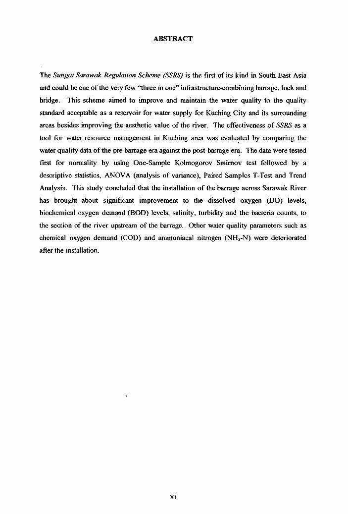
ABSTRACT
The Sungai Sarawak Regulation Scheme (SSRS) is the ftrst of its kind in South East Asia
and could be one of the very few "three in one" infrastructure-combining barrage, lock and
bridge. This scheme aimed to improve and maintain the water quality to the quality
standard acceptable as a reservoir for water supply for Kuching City and its surrounding
areas besides improving the aesthetic value of the river. The effectiveness of SSRS as a
tool for water resource management in Kuching area was evalu~ted by comparing the
water quality data ofthe pre~barrage era against the post~barrage e~. The data were tested
first for nonnality by using One~Sample Kolmogorov Smimov test followed by a
descriptive statistics, ANOVA (analysis of variance), Paired Samples T-Test and Trend
Analysis. This study concluded that the installation of the barrage across Sarawak River
has brought about significant improvement to the dissolved oxygen (00) levels,
biochemical oxygen demand (BOD) levels, salinity, turbidity and the bacteria counts, to
the section of the river upstream of the barrage. Other water quality parameters such as
chemical oxygen demand (COD) and ammoniacal nitrogen (NH3~N) were deteriorated
after the installation.
Xl
ABSTRAK
Skim Pengawalaturan Sungai Sarawak (SPSS) merupakan satu-satunya yang seumpama di
rantau Asia Tenggara yang merangkumi struktur tiga dalam satu; tambak, kekunci dan
'penghalang'. Skim ini diwujudkan bertujuan untuk mempertingkatkan dan mengekalkan
tahap kualiti air mengikut piawaian yang ditetapkan disamping mengekalkan nilai estetika
kawasan sekitar sungai. Keberkesanan SPSS sebagai salah satu medium pengurusan
sumber air di sekitar kawasan Kuching telah dinilai berdasarkan perbandingan kualiti air
era sebelum dan selepas pemasangan tambak Sungai Sarawak. Pada mulanya, ujian
kenormalan menggunakan 'One-Sample Kolmogorov Smirnov' dijalankan, diikuti analisa
statistik secara deskriptif, Ujian ANOVA (Analisis Varians), Ujian T-Berpasangan dan
Analisis TrenIMasa. Hasil kajian ini membuktikan bahawa, pemasangan tambak
merentasi Sungai Sarawak secara signiftkan telah mempertingkatkan mutu paras oksigen
terlarut (DO), BOD, kemasinan (salinity), kekeruhan (turbidity) dan kiraan bakteria
terutamanya di bahagian hilir Sungai Sarawak. Parameter kualiti air yang lain, seperti
COD dan ammonia nitrogen telah menurun selepas pemasangan tambak tersebut.
... ! !
xu
CHAPTERl
INTRODUCTION
1.1 Preamble
Sarawak River has two major tributaries, namely Sungai Sarawak Kiri and Sungai
Sarawak Kanan, which originate from the mountains near the Kalimantan border. Both
streams meet near Batu Kitang approximately 55 kilometres upstream of the river mouth.
From the confluence, the mainstream Sarawak River flows north and through Kuching
City. Further downstream near Pending area, the river splits into two, forming a
distributary called Sungai Santubong. The Bako causeway has now closed this
watercourse, which carries about half the flow. Sarawak River is joined by Sungai Kuap
and Sungai Loba Batu Belat before flowing north east into the South China Sea.
This river has served as one of the most important medium of transportation as well as a
source of water supply for drinking, domestic and industrial uses. It also plays an
important recreational role and contributes to the unique scenic beauty of the city. Within
this catchments area is where the State capital city, Kuching, is located, with its' rapid
growth of human population and land-use development. The exponential development
activities along its' riverbanks have led to the increasing of source and non-source
pollution to the river. Sarawak River has been a recipient of waste and effluent discharges
from both grey and black water of domestic, commercial and industrial activities. Thus,
the water quality was reported to gradually decreased due to rapid economic development
and increase in population, particularly in the river alongside Kuching City .
... r
Many issues relating to water quality resulted directly or indirectly to changes especially
in the physical changes. The construction of structures such as barriers, barrages or weirs,
which are designed to modify or totally prevent the progression of the tide up an estuary or
inlet, may indirectly deteriorate the water quality. Burt and Rees (2001) pointed out that
both upstream and downstream water quality may be affected by the introduction of a tidal
control structure. They also stated that tidal flushing will be altered and the pattern of
salinity variation will be changed as a result of changes to tidal propagation upstream of
the barrage.
On 2ih August 1998, the Sarawak River Barrage, Lock and Bridge were officially opened
under the Sungai Sarawak Regulation Scheme (SSRS). The SSRC:; was planned to assist in
facilitating the development strategies for Kuching City and its environment. It is also the
first step towards future efforts to rehabilitate the coastal beaches and provide an attractive
site with clear shore waters. This scheme also aimed to improve and maintain the water
quality to the quality standard acceptable as a reservoir for water supply for Kuching City
and its surrounding areas besides improving the aesthetic value of the river. All of these
efforts were formulated to enhance best practices management in water resources
especially for Sarawak River Catchment (Figure 1.1).
The objectives of the Scheme were:
1. to provide transport links between the City of Kuching and Sejingkat area, thus
facilitating infrastructural and industrial growth in Kuching region
ii. to regulate the river water level upstream of the barrage
Ill. to mitigate fluvial and tidal flooding in the City of Kuching
iv. to secure Kuching's water supply
,~ v. to reduce the transport of muddy sediments to the foreshores of Santubong and
Damai
2
Based on the Environmental Impact Assessment (EIA) report (VOL I) for the SSRS
project, (Jabatan Kerja Raya, 1994), the implications and effects of the Scheme were
evaluated and the study concluded that the most feasible Scheme to achieve the objectives
would comprise of the following:
I. The Santubong causeway at Jalan Bako
II. The Sarawak causeway at lalan Keruing
Ill. The barrage and ship lock gate at the cut in the isthmus
iv. Bridge over barrage and the Pending-Sejingkat link road
v. Diversion channel with gated barrage structure in the isthmus
between Sejingkat and Pending
VI. Land reclamation and road infrastructure in isthmus
1.2 Problem Statement
An alteration of any riverlfloodplain including channel modifications such as barrage's
construction will either lead to direct or indirect impacts on the biotic environment such as
the loss of existing vegetation and its dependent habitats and fauna, as well as abiotic
factors such as riverbank erosion, nutrient transfer, saline intrusions, sedimentation and
water resources in terms of deterioration of water quality, flooding, drainage and run off.
The impact of the installation of the Barrage on the river environments need to be verified
against the potential impacts suggested in the EIA reports.
. ~ , (
1.3 Significance of the Study
The Sarawak River Catchment is one of the fastest growing regions In the State of
Sarawak. With the state capital of Kuching, located in the catchments and the Country's
vision of forging ahead towards industrialisation, the pace of development is expected to
3
accelerate even further. Added to that, with the SSRS, whereby the barrage has cut off
tidal flushing of the river, it is necessary that such study be carried out to determine the
effectiveness of the barrage performance in terms of water resources practices and its
impact on water quality.
1.4 Objectives of study
The general objective of this study was to review the impact of the Sarawak River Barrage
on water quality, which was planned under the SSRS. The study evaluated the
effectiveness of SSR.'':; as a tool for water resource management in Kuching area.
The specific objectives of this study were:
i. to study the current operation and management practices (for barrage) from the
perspective of water resources management;
It. to compare and analyse the water quality data for the selected station of Sarawak
River (near the barrage area) for pre-barrage operation and post-barrage operation;
and
iii. to determine if there have been improvements in selected water quality parameters
over time (trend analysis).
j, r,
4
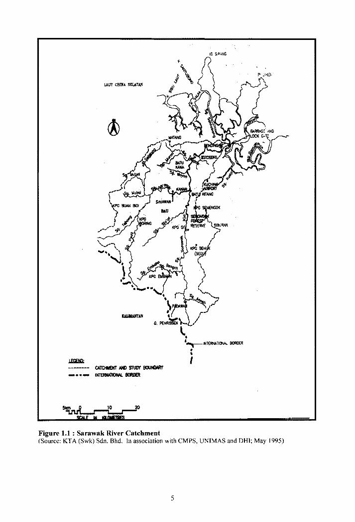
LAtlt CHrNi SELATAN
.L£GElID.: ------- CATCItI£NT /IHO ST\JO'I' 8ClUNDMI' _ •• - 1~'I1OfW.. BORDER
Figure 1.1 : Sarawak River Catchment (Source: KT A (Swk) Sdn. Bhd. In association with CMPS, UNIMAS and DHI; May 1995)
5
CHAPTER 2
LITERATURE REVIEW
2.1 Water Resource Management
Water is one of the most vital resources on earth. Despite its chemical simplicity (H20),
water's properties make it absolutely essential for all life form. Our planet is very rich in
water, which covers over 70% of the planet's surface. Unfortunately, most of this (97.4%)
is saltwater which is not usable by land life. Only 2.6% of earth's water is made up of
fresh water to satisfY most of our needs. About 14 (three-quarter) of freshwater occurs as
ice and is inaccessible. Ninety percent of this ice occurs in Antarctica. Only about 0.6%
of earth's water is fresh water in the readily available liquid state. The vast majority of
this occurs as groundwater. Only a very tiny fraction (less than 0.014%) of earth's water
occurs as freshwater lakes and rivers that we usually associate with water (McKinney &
Schoch, 2003).
An adequate supply of affordable water of suitable quality makes major contribution to
economic and social development. More than a billion people, mostly the poor, still have
no access to clean water. Almost 1.7 billion people are without adequate sanitation. Many
parts of the world are constantly struggling with drought and floods; in addition, many
countries face problems of fast-growing populations, rapid urbanization, rising costs of
supplying water and pollution of inland (fresh) water. All of these problems have
increased the urgency of formulating policies and associated strategies that will ultimately
lead to effective measures to manage water as a social and economic resource with
emphasis on its conservation (Moigne et al., 1994). f
6

.r-.
Water resource management can be looked at from two different viewpoints; non-
structural and structural. The non-structural sections may involved the water resource
strategy, policies, guidelines, law and legislations and other rules and regulations that
enacted on paper. Structural sections may include designing, engineering works and
implementation, which involved operational and monitoring level. This may involved the
engineers who were taught to design the various works for water resource management
from the structural and functional viewpoints. The implementation level seek the
involvement and cooperation from all kind of parties including the government agencies,
private sectors, educational, scientist, sociologist, public and individual.
In the non-structural viewpoint, one of the most important agenda that should be looked
into is the water resource strategy. A water resources management strategy is a set of
medium to long-term action programs to support the achievement of development goals
and to implement water-related policies. Development goals might concern, for example,
aspects of water supply security, population growth, flood mitigation, rural and urban
development, and the role of public and private sectors. Water-related policies might
include government decisions about the preservation and protection of ecosystems, water
quality monitoring programs and water rights (World Bank, 1994).
According to Rast and Thornton (1999), the water regulations should cover land use rights
related to water management, watershed development, environmental quality and pollution
control standards, dam safety standards, service standards for water supply, and financial
and management standards.
Susan S. Seacrest, President of The Groundwater Foundation, Nebraska, (Cech, 2005),
explains that watershed approach to water management has become a template for
7
integrated natural resourees stewardship, and this approach is being adapted on almost
every level: local, state and federal. She added that the growth at grassroots watershed
level may also be part of our need to "act locally, think globally".
The United Nations Environmental Programme (UNEP) has developed a new holistic
approach of freshwater resources management. Its comprehensive water resources
planning approaeh to the management of both water quantity and water quality in
international river and lake basins were formalized by UNEP as the environmentally sound
management of inland waters (EMINW A) process. Through EMINWA, the inventory and
analysis of freshwater resources, water needs and water management in this international
water system extend also to the national rivers and that form an integral part of the
international water systems.
2.2 Sarawak River: Water Resource and Management Plan
Water is one of the major development assets in Sarawak, mainly derived from 23 major
river basins in the State. Sarawak River, which is approximately 120 km long and
navigable up to 34 km eonsist of two principal tributaries namely Sungai Sarawak Kanan
(with catchment area of 691 km2) and Sungai Sarawak Kiri (with catchment area of 524
km2). The catchment areas of Sarawak River is estimated to be 1,423.6 km2 (with SSRS)
comprising multipurpose land use pattern including urban areas, agricultural areas, fishery
and aquaculture areas, mining areas, rural areas and the barrage.
In Sarawak, water resource harvesting and utilisation is reliant on the ability of its
catchment areas. Murtedza Mohamed and Ali Memon (1999) estimated that the total
water resource to be about 460 billion m3 of which 41 % returns to the atmosphere through r evapotranspiration process, 52.3% occurs as surface run-off and 6.5% infiltrate into
I i
8
ground water. Almost 95% of the water supplies for Kuching region are obtain from
Sungai Sarawak Kiri through Kuching Water Boards pumping station at Batu Kitang. (
" Based on paper presented by Sawal (2003), the current State annual aggregate treated
water demand for domestic and industrial sectors is estimated at 180 million m3, serving
about 70% of the State population. The City of Kuching alone needs more than 240 mega
Htres of treated water daily.
According to the Annual Report 2003 produced by Kuching Water Board, a total of
105,732 megalitres of fully treated water was produced representing a 2.8% increase over
2002 production. The average daily consumption rose from 282 megalitres in 2002 to 290
megalitres in 2003, an increase of2.8%.
Within the context of the State of Sarawak, the government has given serious outlook
towards the management of water resources. For example, Sungai Sarawak Kiri has been
gazetted as a water catchments area to protect this important water resource. A lot of
study has been done pertaining to the above matter.
A research done by Murtedza Mohamed and Ali Memon (1999), recommended that the
State's strategy for sustainable water management should have a statutory based to
accomplish the following tasks:
1) formulate State policies and plans for integrated water management on a
catchments basis. Each plan could include a single catchments or more than one
catchments. The scope of these plans should relate to water allocation; water
quality; catchments land management; and flood hazard mitigation;
9
2) develop regional river basin plans for allocating water and protecting water
quality. Such plans should based, amongst other things, on specific policies on
land use regulation, water quality standards, water allocation and pricing,
minimum flows and allocation priorities between different users during low flows;
3) implement river plans and carry out enforcement. It is preferable that the task of
enforcement is decentralised as much as possible;
4) monitor and evaluate the effectiveness of the plans; and
5) encourage participation of user group (e.g. water supply companies and the local
community group in urban and rural areas) in thc planning and implementation
process.
As stated in the EIA report for the SSRS, it was recommended to have an Environmental
Management Plan (EMP) that covers not only the scheme itself but the management of the
whole river and its catchments, including management of land use, wastewater discharges,
water supply, resources and aesthetics. The Sarawak State Government has commissioned
KT A (Sarawak) Sdn Bhd to do a Study of the Sarawak River Catchments, upstream of the
.barrage, focusing on environmental control and river management under post-barrage )
I
I
conditions. The primary delivery of the Study was a River Management Plan (Volume 2).
It was a first step towards ensuring that the quality and amenity of Sarawak River is
maintained at an acceptable level.
The Sungai Sarawak Environmental Control and River Management Study have outlined
the objectives of the study as follows (NREB, 1996):
\) to maintain and enhance the water quality of Sarawak River, particularly in the
post barrage conditions;
10
2) to maintain the hydrological integrity of the river and provide for effective
drainage and flood mitigation;
3) to conserve the ecological resources of the catchments, and in particular, riparian
ecosystem, birds and wildlife, and mangrove forest;
4) to balance the needs of all forms of development (including industrial, urban and
agricultural development) with the requirements of conservation of the catchments
natural resources;
5) to assist and ensure that all relevant parties implement the principles of sustainable
development by establishing stronger links with developers, government agencies,
and the local communities; and
6) to enhance the aesthetics of the river corridor.
The Study draws together the findings and recommendations of the following (NREB,
1996):
I ) Volume 2: The River Management Plan
Describe the River; its current status in respect of particularly
environmental land use conservation, water quality, vegetation,
wildlife, aquatic resources, socio-economic status, public health and
sedimentation.
2) Volume 3: Flood Mitigation Study and Report
3) Volume 4: Floating Waste management Study and Report
4) Volume 5: Urban Drainage Study and Report
5) Volume 6: Sewerage Study and Report
6) Volume 7 : Institutional and Organisational Aspects and Public Health Program
11
T
2.3 Early Water Quality Issues in the Sarawak River
There are four main key issues identified in the Executive Management Plan (EMP)
(NREB, 1996) mainly the water quality, land use, flood management and floating waste
issue.
Based on the study above, the water quality issues generally highlight the major problems
on high heavy metal, poor dissolved oxygen and wastewater pollution from pig ranching.
The heavy metal readings were reported high in the upstream of Sungai Sarawak Kanan
which could be attributed to waste from mines or the one processing plant at Bau. While
the mine has undertaken studies and believes that there is little threat to the river from this
point source there is no enforcement or monitoring programme in place to ensure
sustainability of the water supply in this area and the downstream communities generally.
The general water quality modelling works predicts severe deterioration in quality as
identified by poor dissolved oxygen levels in the river upstream of the barrage during dry
periods. The wastewaters from piggeries are causing high bacteria levels in the river
upstream of Kuching. In order to reduce the pollution levels of the discharges, regulations
need to be implemented on site treatment.
2.4 Sungai Sarawak Regulation Scheme
According to Goh (2004), the original concept of a scheme to regulate the flow in Sarawak
River has been attributed to the Sarawak Chief Minister in the early 1980's. He also
mentioned that, the first serious action towards implementation was made in 1990 within
KTA (Sarawak) Sdn. Bhd. and the Sarawak Government on the proposed concept
adopting the present configuration. This was followed up in May 1991 when consulting
engineers, Rendel Palmer and Tritton (RPT) of the U.K, in association with KTA
12
T
(Sarawak) Sdn. Bhd. and RR Wallingford was commissioned to undertake a feasibility
study of the proposed Sarawak River Regulation Scheme (SSRS). The final report of this
study, which incorporated comments from the steering committee appointed to oversee the
study, was submitted in December 1991.
Based on ElA report (Vol 1) (JKR, 1994), the Scheme has been developed as an initial
objective to reduce the sedimentation nearby coastal beaches of Pasir Pandak, Pasir
Panjang and the Santubong Peninsula. Other than that, SSRS was also formulated to
achieve the following objectives:
i) to improve transport links between the City of Kuching and the Sejingkat area
Ii) to mitigate fluvial and tidal flooding in the City of Kuching
iii) to regulate the river water level upstream of the barrage
iv) to secure Kuching's water supply
v) to enhance the beauty of waterfront through the City
The construction of the SSRS near Kuching has been developed through a three phase
time frame (Figure 2.1). The project comprises the following components:
Phase I The Construction of the Bako Causeway, a rock fill dam across the
Loba Santubong on the Bako Road.
Phase 2 The Construction of the main Barrage Facility comprising:
(i) A tidal exclusion barrage of five radial gates controll ing the
Sarawak River,
(ii) A 125m long by 25m wide ship lock, and
13


![[Proposal] Ujian Proposal Ujian 2015-2016](https://img.pdfslide.us/doc/110x75/577c795b1a28abe054925f89/proposal-ujian-proposal-ujian-2015-2016.jpg)