Embed Size (px)
Citation preview
WATER RELATED ISSUES IN BANGLADESH
Shah Md. Sultan Uddin IqbalJoint Secretary, Ministry of Defence
Government of the People’s Republic of Bangladesh,
Introduction• Water is fundamental to human welfare, to all socio-economic development and for maintaining healthy ecosystems.•There is clear and convincing evidence, however, that the status of its availability and the current patterns of water useand demand are not evaluated and cannot be sustained in the Asian region.•One of the key scientific and social issues of this century is water and its related events.• Because of growing population and human activities on nature, there is scarcity of water and water is being contaminated. The non-uniform distribution of rainfall and its intensity cause either floods or drought in some regions of Asiaalmost every year.
• Climate change issues may also have impact on intensifying the water scarcity and threat to freshwater ecosystems, increasewater-related diseases and associated impacts on society.• It is not possible to control floods and drought completely andthey are leading to large human and socio-economic losses but it is possible to mitigate and reduce the losses by taking proper measure in due time through water resources managements in the regions.
•About 60% of the world population lives in Asia, and their various social activities including agriculture depend on the beneficial monsoon rainfall, which contributes about 70-75% of the total annual rainfall.
• At the same, it can be the cause of floods and droughts, and consequently, may be responsible for an enormous amount of human and economic damage.
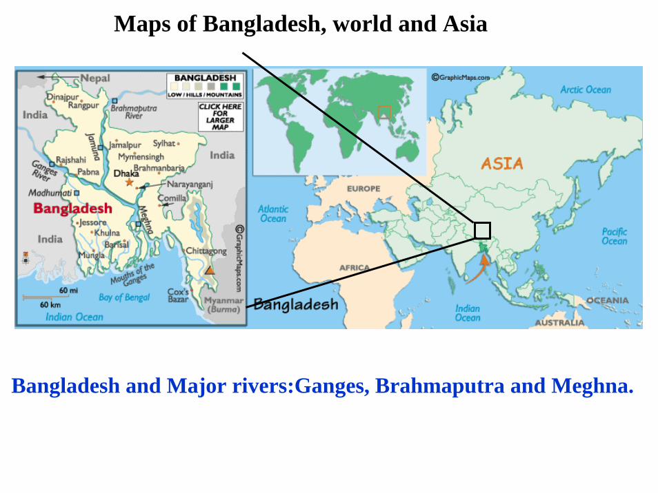
Maps of Bangladesh, world and Asia
Bangladesh and Major rivers:Ganges, Brahmaputra and Meghna.
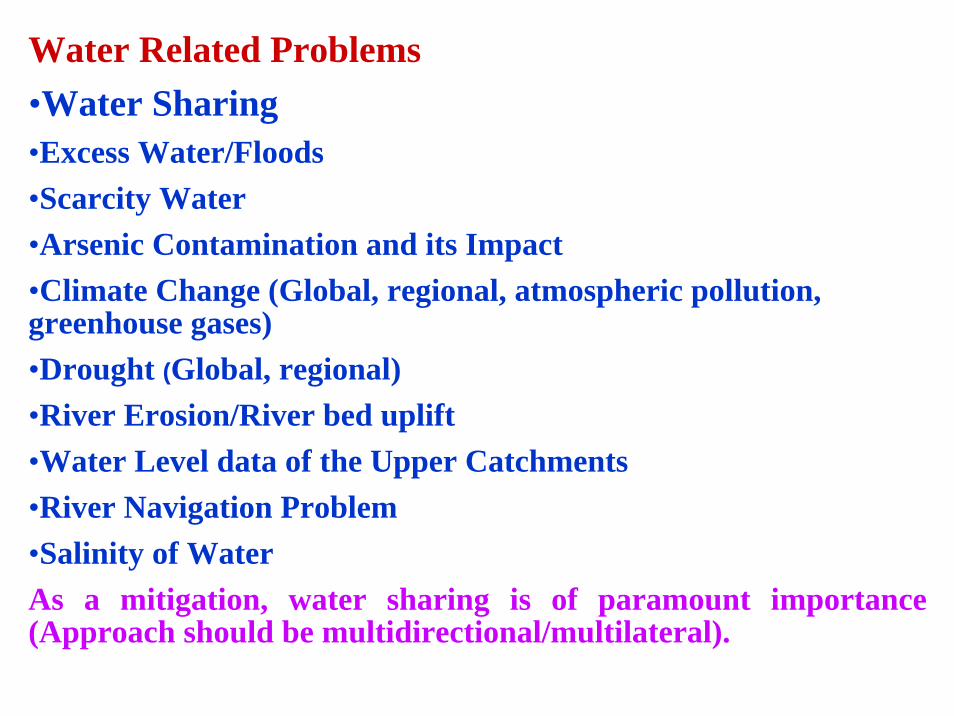
Water Related Problems•Water Sharing•Excess Water/Floods•Scarcity Water•Arsenic Contamination and its Impact•Climate Change (Global, regional, atmospheric pollution, greenhouse gases)•Drought (Global, regional)•River Erosion/River bed uplift•Water Level data of the Upper Catchments•River Navigation Problem•Salinity of WaterAs a mitigation, water sharing is of paramount importance (Approach should be multidirectional/multilateral).

The Ganges-Brahmaputra-Meghna Basins
FlowThe Ganges-Padma: 1,000 ~ 120,000 cumecThe Brahmaputra: 2,400 ~ 102,000 cumecThe Meghna: 500 ~ 30,000 cumec
Annual Sediment TransportAnnual Sediment TransportThe GangesThe Ganges--PadmaPadma:886 :886 MtonsMtonsThe The BrahmaputraBrahmaputra:: 600 600 MtonsMtonsThe The MeghnaMeghna:: 1 1 MtonsMtons
If stored over Bangladesh Plain would have about 9.0 m of standing water depth
If stored over Bangladesh flood plain If stored over Bangladesh flood plain would have about 1.6 cm thick would have about 1.6 cm thick sedimentationsedimentation
1087300 sq-km552,000 sq-km
8,000 sq-km
Total: 1.7 million sqTotal: 1.7 million sq--kmkmAbout 7% within BangladeshAbout 7% within Bangladesh
About 93% of flood water comes from outside the country
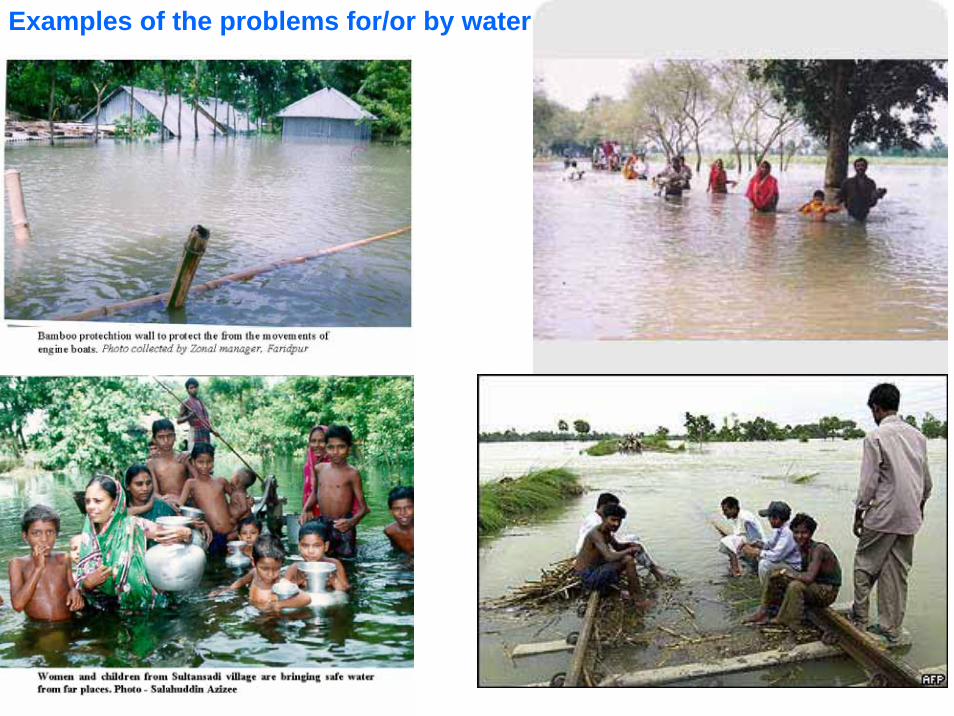
Examples of the problems for/or by water
Snow
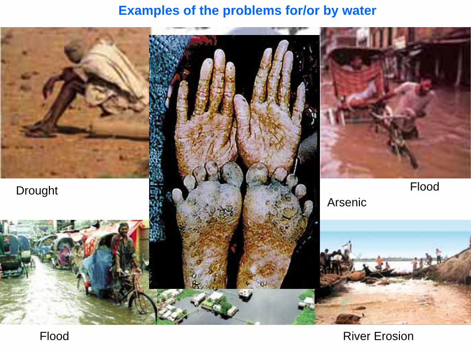
Examples of the problems for/or by water
Drought
River Erosion
ArsenicFlood
Flood
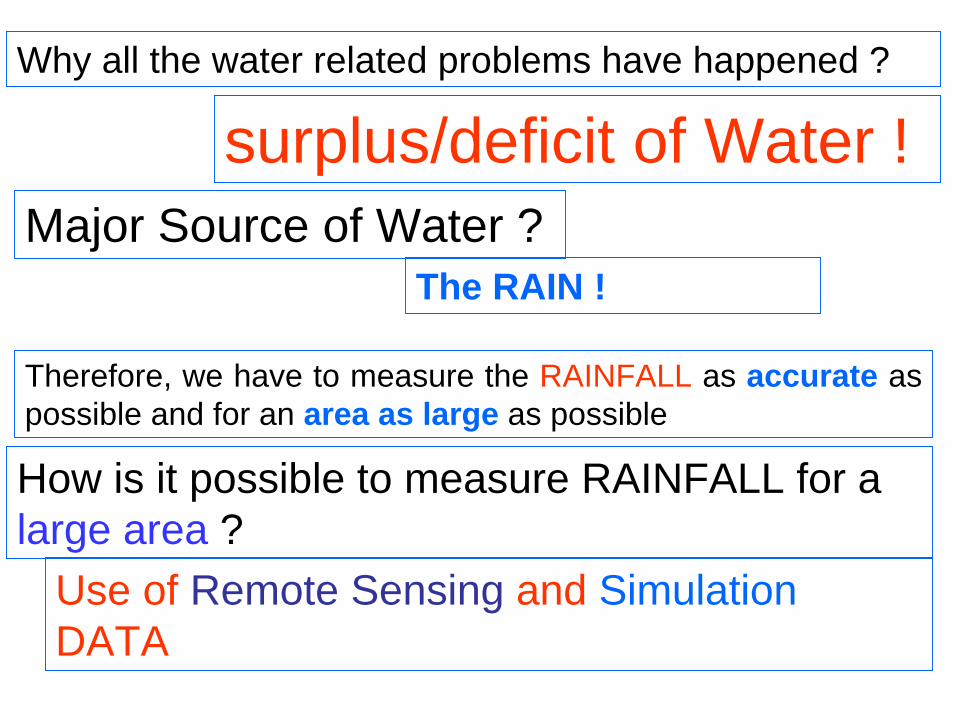
Why all the water related problems have happened ?
surplus/deficit of Water !
Therefore, we have to measure the RAINFALL as accurate as possible and for an area as large as possible
The RAIN ! Major Source of Water ?
How is it possible to measure RAINFALL for a large area ?
Use of Remote Sensing and SimulationDATA
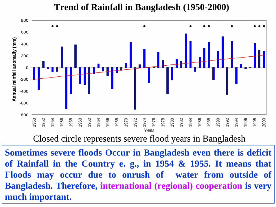
Trend of Rainfall in Bangladesh (1950-2000)
-800
-600
-400
-200
0
200
400
600
800
1950
1952
1954
1956
1958
1960
1962
1964
1966
1968
1970
1972
1974
1976
1978
1980
1982
1984
1986
1988
1990
1992
1994
1996
1998
2000
Year
Annu
al ra
infa
ll an
omal
ly (m
m)
Closed circle represents severe flood years in BangladeshSometimes severe floods Occur in Bangladesh even there is deficit of Rainfall in the Country e. g., in 1954 & 1955. It means that Floods may occur due to onrush of water from outside of Bangladesh. Therefore, international (regional) cooperation is very much important.
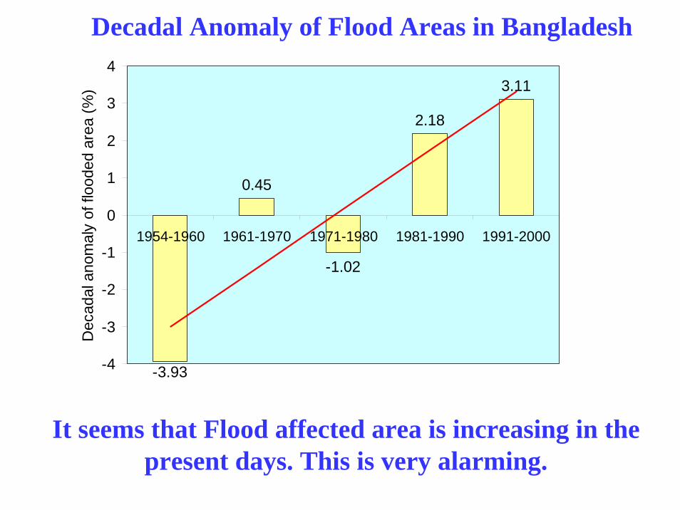
-3.93
0.45
-1.02
2.18
3.11
-4
-3
-2
-1
0
1
2
3
4
1954-1960 1961-1970 1971-1980 1981-1990 1991-2000
Dec
adal
ano
mal
y of
floo
ded
area
(%)
Decadal Anomaly of Flood Areas in Bangladesh
It seems that Flood affected area is increasing in the present days. This is very alarming.

intro
87.44 88.44 89.44 90.44 91.44 92.4421.08
22.08
23.08
24.08
25.08
26.08
4
4.5
5
5.5
6
6.5
7
7.5
8
8.5
9
9.5
10
10.5
11
mm/day
Rain-gauge Rainfall (1950-1999)
LONGITUDE (E)
LATI
TUD
E (N
)
Rainfall over Bangladesh (1950-1999)
Historical (1950-1999) rainfall over the country. The triangles represent the rain-gauge locations in Bangladesh.
The maximum rainfall is over NE and SE parts of the country.
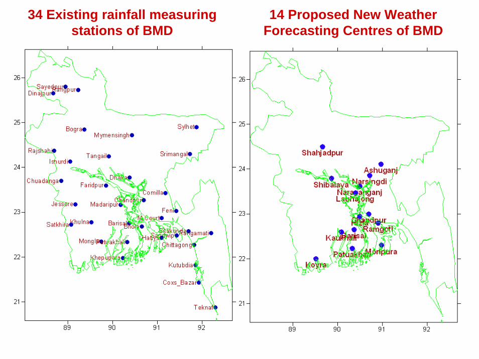
14 Proposed New Weather Forecasting Centres of BMD
34 Existing rainfall measuring stations of BMD
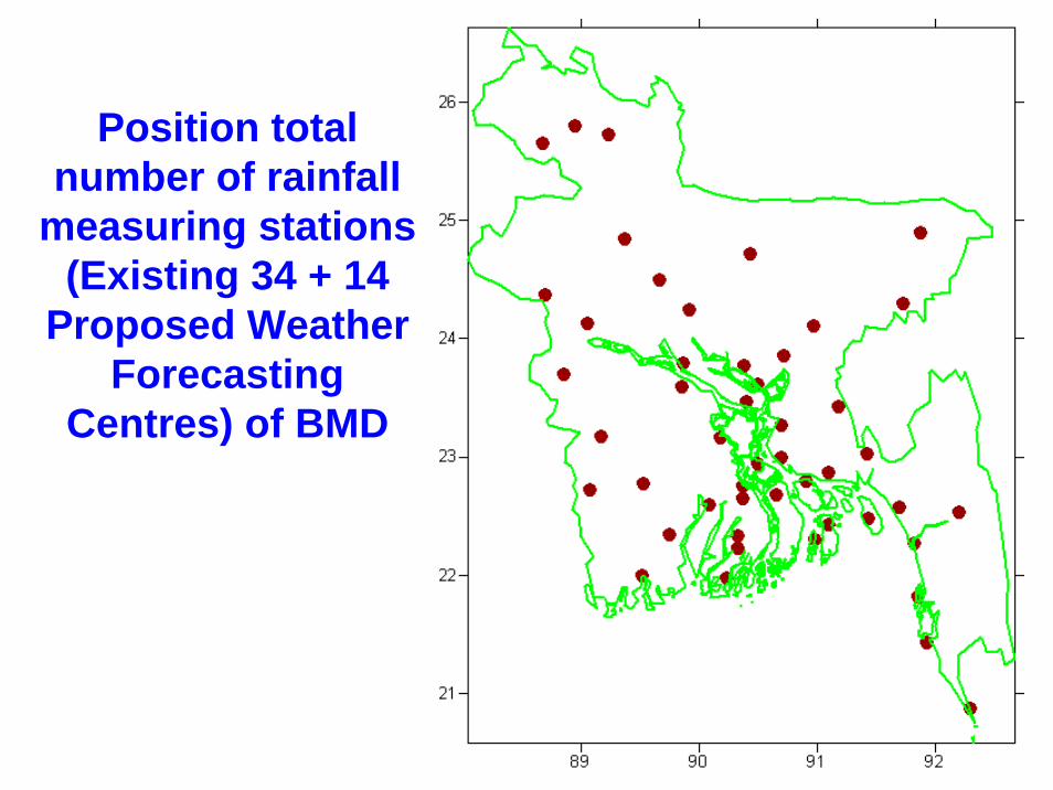
Position total number of rainfall
measuring stations (Existing 34 + 14
Proposed Weather Forecasting
Centres) of BMD
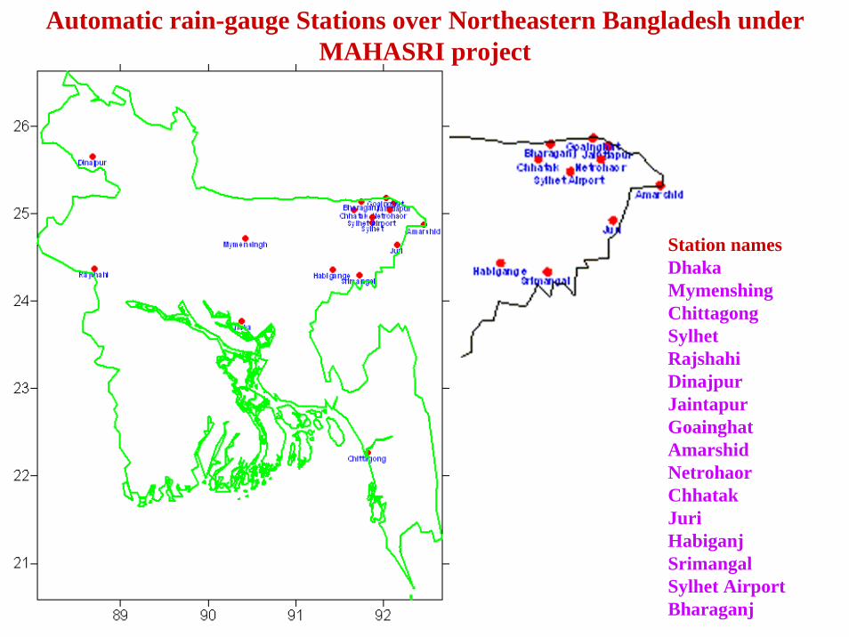
Automatic rain-gauge Stations over Northeastern Bangladesh under MAHASRI project
Station namesDhakaMymenshingChittagongSylhetRajshahiDinajpurJaintapurGoainghatAmarshidNetrohaorChhatakJuriHabiganjSrimangalSylhet AirportBharaganj
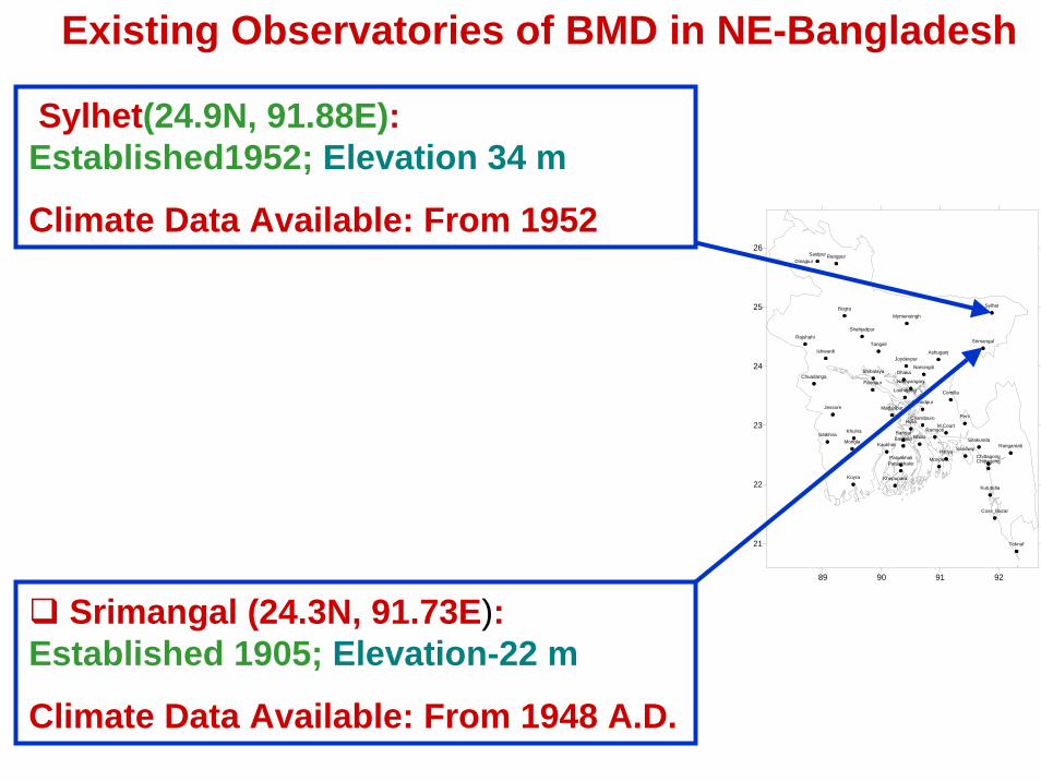
Srimangal (24.3N, 91.73E):Established 1905; Elevation-22 m
Climate Data Available: From 1948 A.D.
Existing Observatories of BMD in NE-Bangladesh
89 90 91 92
21
22
23
24
25
26
Dhaka
Mymensingh
Faridpur
Madaripur
Tangail
ChittagongChittagong
SitakundaRangamati
Coxs_Bazar
Teknaf
Hatiya Sandwip
Kutubdia
Feni
M.Court
Chandpur
Chandpuro
Comilla
Sylhet
SrimangalRajshahi
Bogra
RangpurDinajpur
Ishwardi
Khulna
Jessore
Chuadanga
Satkhira BarisalBarisalo Bhola
PatuakhaliPatuakhalio
Khepupara
Joydevpur
Mongla
Saidpur
Ashuganj
Narsingdi
Narayanganj
Ramgoti
Shibalaya
Kaukhali
Shahjadpur
Lauhajong
Koyra
Hizla
Monpura
Sylhet(24.9N, 91.88E):Established1952; Elevation 34 m
Climate Data Available: From 1952
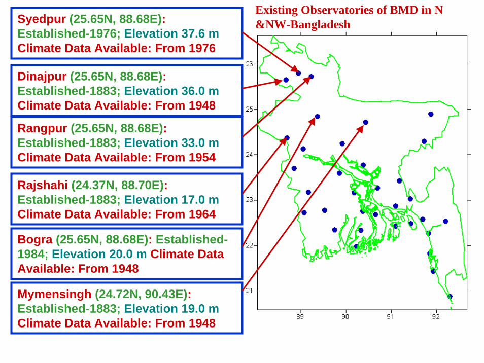
Dinajpur (25.65N, 88.68E):Established-1883; Elevation 36.0 m Climate Data Available: From 1948
Mymensingh (24.72N, 90.43E):Established-1883; Elevation 19.0 m Climate Data Available: From 1948
Rajshahi (24.37N, 88.70E):Established-1883; Elevation 17.0 m Climate Data Available: From 1964
Syedpur (25.65N, 88.68E):Established-1976; Elevation 37.6 m Climate Data Available: From 1976
Rangpur (25.65N, 88.68E):Established-1883; Elevation 33.0 m Climate Data Available: From 1954
Bogra (25.65N, 88.68E): Established-1984; Elevation 20.0 m Climate Data Available: From 1948
Existing Observatories of BMD in N &NW-Bangladesh
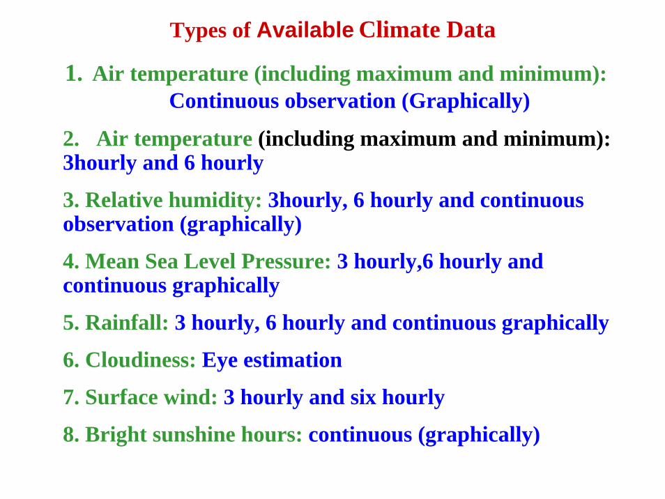
Types of Available Climate Data
1. Air temperature (including maximum and minimum):Continuous observation (Graphically)
2. Air temperature (including maximum and minimum): 3hourly and 6 hourly
3. Relative humidity: 3hourly, 6 hourly and continuous observation (graphically)
4. Mean Sea Level Pressure: 3 hourly,6 hourly and continuous graphically
5. Rainfall: 3 hourly, 6 hourly and continuous graphically
6. Cloudiness: Eye estimation
7. Surface wind: 3 hourly and six hourly
8. Bright sunshine hours: continuous (graphically)
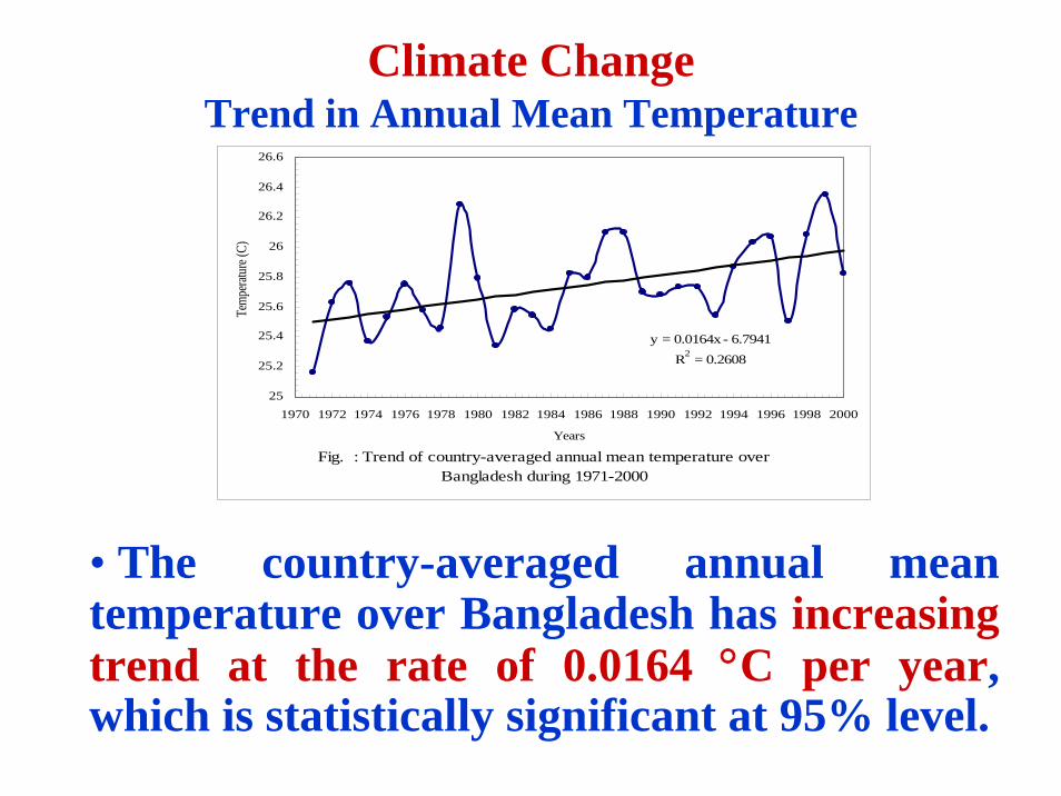
Climate ChangeTrend in Annual Mean Temperature
• The country-averaged annual mean temperature over Bangladesh has increasing trend at the rate of 0.0164 °C per year, which is statistically significant at 95% level.
Fig. : Trend of country-averaged annual mean temperature over Bangladesh during 1971-2000
y = 0.0164x - 6.7941R2 = 0.2608
25
25.2
25.4
25.6
25.8
26
26.2
26.4
26.6
1970 1972 1974 1976 1978 1980 1982 1984 1986 1988 1990 1992 1994 1996 1998 2000
Years
Temp
eratur
e (C)
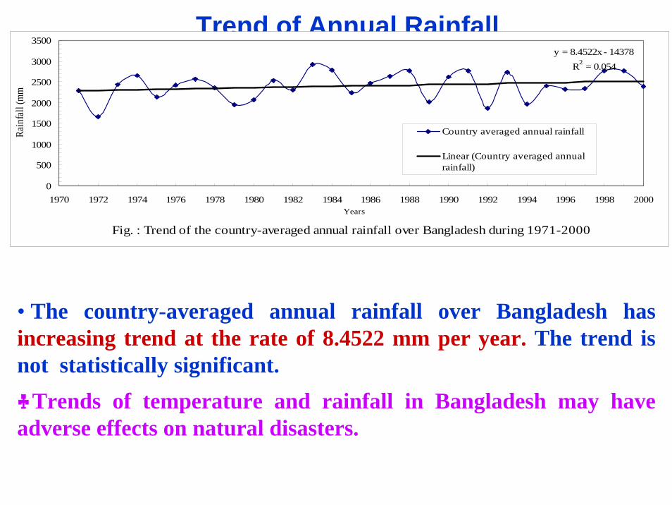
Trend of Annual Rainfall
Fig. : Trend of the country-averaged annual rainfall over Bangladesh during 1971-2000
y = 8.4522x - 14378R2 = 0.054
0
500
1000
1500
2000
2500
3000
3500
1970 1972 1974 1976 1978 1980 1982 1984 1986 1988 1990 1992 1994 1996 1998 2000Years
Rain
fall
(mm
Country averaged annual rainfall
Linear (Country averaged annualrainfall)
• The country-averaged annual rainfall over Bangladesh has increasing trend at the rate of 8.4522 mm per year. The trend is not statistically significant.♣Trends of temperature and rainfall in Bangladesh may have adverse effects on natural disasters.
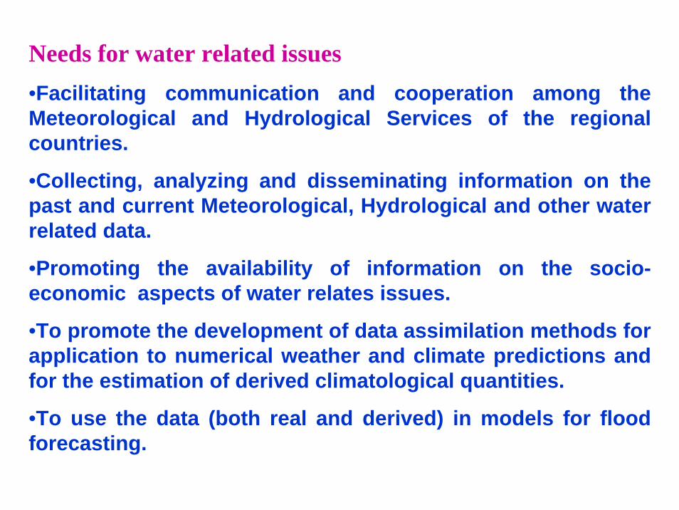
Needs for water related issues•Facilitating communication and cooperation among the Meteorological and Hydrological Services of the regional countries.
•Collecting, analyzing and disseminating information on the past and current Meteorological, Hydrological and other water related data.
•Promoting the availability of information on the socio-economic aspects of water relates issues.
•To promote the development of data assimilation methods for application to numerical weather and climate predictions and for the estimation of derived climatological quantities.
•To use the data (both real and derived) in models for flood forecasting.
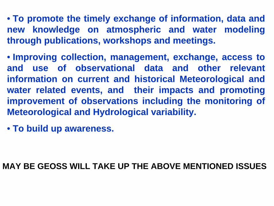
• To promote the timely exchange of information, data and new knowledge on atmospheric and water modeling through publications, workshops and meetings.
• Improving collection, management, exchange, access to and use of observational data and other relevant information on current and historical Meteorological and water related events, and their impacts and promoting improvement of observations including the monitoring of Meteorological and Hydrological variability.
• To build up awareness.
MAY BE GEOSS WILL TAKE UP THE ABOVE MENTIONED ISSUES
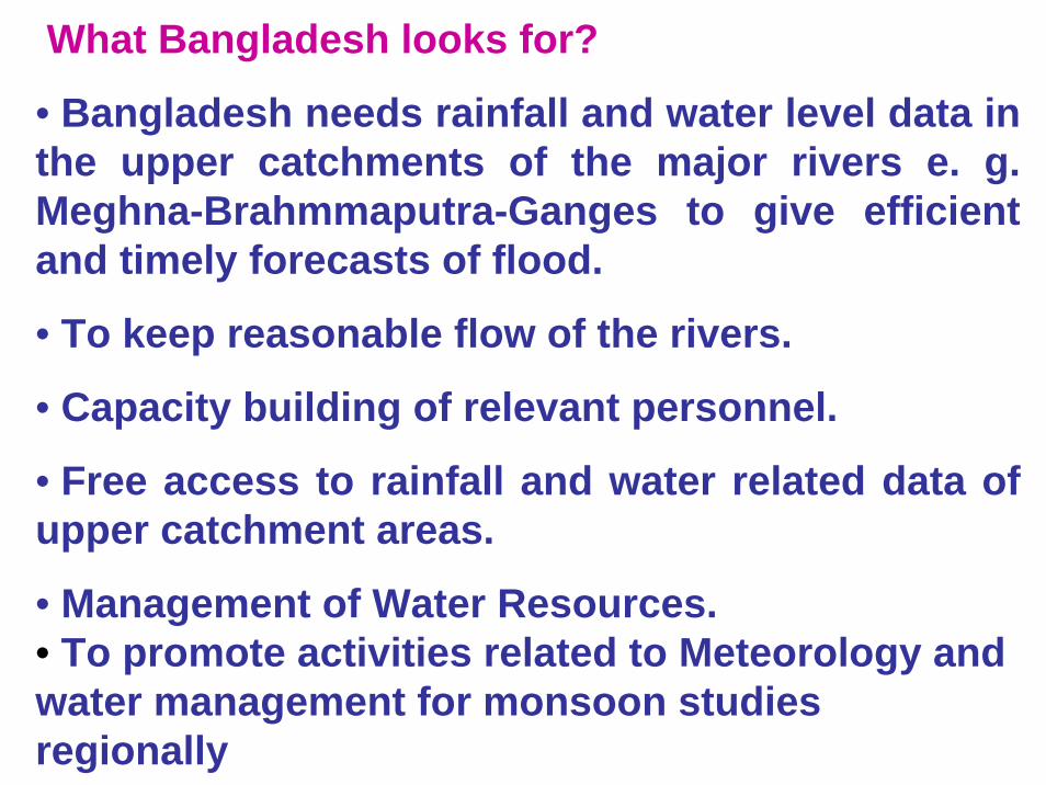
What Bangladesh looks for?
• Bangladesh needs rainfall and water level data in the upper catchments of the major rivers e. g. Meghna-Brahmmaputra-Ganges to give efficient and timely forecasts of flood.
• To keep reasonable flow of the rivers.
• Capacity building of relevant personnel.
• Free access to rainfall and water related data of upper catchment areas.
• Management of Water Resources.• To promote activities related to Meteorology and water management for monsoon studies regionally
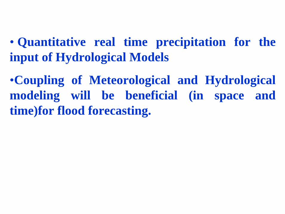
• Quantitative real time precipitation for the input of Hydrological Models
•Coupling of Meteorological and Hydrological modeling will be beneficial (in space and time)for flood forecasting.

THANK YOU


![I pad ed editoria [apcamp]](https://img.pdfslide.us/doc/110x75/558e38b81a28aba4228b4595/i-pad-ed-editoria-apcamp.jpg)