Embed Size (px)
Citation preview

Water impacts of onshore gas developmentNSW research update
J Sreekanth, Trevor Pickett, Tao Cui, Helen Beringen, Luke Connell, Raman Pandurangan, Damian Barrett, Dan Pagendam, Dan O’Sullivan, Matthias Raiber, Axel Suckow, Mat Gilfedder, Kate Holland
CSIRO LAND AND WATER
September 2017

2 |

GISERA – Gas Industry Social and Environmental Research Alliance
Surface and Groundwater projects in NSW
Project 1. Impacts of Coal seam gas depressurization on the Great Artesian Basin (GAB) flux
Project 2. Improving groundwater models to better represent coal seam gas extraction impacts in the Namoi region
Project 3. Water contamination risk assessment on hydraulic fracturing in unconventional gas extraction
Project 4. Data-worth analysis and spatial design of groundwater monitoring networks in the Narrabri Gas Project area
3 |

Questions
Project 1. Risks of water quantity impacts to Great Artesian Basin aquifer? Risks of water being lost from the recharge areas of GAB?
Project 2. What volumes of water will be extracted over the life time of the gas project?
Project 3. Contamination risk due to well bore delamination?
Project 4. When and where to do ongoing monitoring for early detection of water quantity and quality impacts and to improve predictive reliability?
4 |

GISERA water research in the Namoi region
5 |
43 1
2

6 |
Background research• SANTOS
• Hydrochemical and isotopic assessment (Cresswell, 2014)
• Santos LeapFrog model (groundwater)
• UNSW
• research in the Namoi catchment
• Bioregional Assessment• Namoi subregion
• CSIRO
• Great Artesian Basin Water Resources Assessment (2012)
• Faults and Aquitards project
• DPI water studies

Project 1 - GAB flux project
• Pilliga forest is part of the intake bed of GAB in NSW
• The groundwater source in this area is called the Southern Recharge Source (NSW Water Sharing Plan)
7 |
Smerdon and Ransley (Eds, 2012) Water Resources Assessment for the Surat region. CSIRO Great Artesian Basin Water Resources Assessment
Pena-Aranciba et al. 2016 (Bioregional Assessment)

GAB flux project…
8 |
• Improve the conceptual understanding of recharge and groundwater connectivity in the Pilliga region – integrating information from existing conceptual and numerical models, hydrochemical data and new environmental tracer data
• Assess the probability extremes around CSG induced GAB groundwater head and flux changes using modelling and uncertainty analysis techniques

9 |
GAB flux project…
• Investing in measuring and analysing new data (environmental tracers and geochemistry data – new measurements in the new DPI monitoring bores in the Pilliga area/ Santos’ monitoring bores)
• Integrating the knowledge derived from new data and ongoing work (OWS projects BA, FAM) into the conceptual understanding of the Surat and Gunnedah basins
• Testing hypotheses and accept/reject with high confidence potential impacts of CSG development on drawdown and GAB flux

GAB flux project…
• Report on “Uncertainty analysis of and GAB flux and water balance changes induced by CSG development through Narrabri Gas Project” to be published on GISERA website soon
• In the next stage of the project we are doing the field work and analysis for environmental tracers to improve the understanding of recharge
10 |

• Past studies by CSIRO (2015) and Queensland Government (2016) have developed methods for improved representation of dual phase flow in regional scale groundwater models
• This project will develop and apply a similar method for assessing and refining the prediction of impacts from Narrabri Gas Project
• This study will address the gaps around ‘the veracity of the reservoir modelling and associated groundwater abstraction rates’ that IESC has highlighted recently.
11 |
Project 2 – Improving representation of reservoir modelling processes
Single phase simulation (MODFLOW)
Simulated drawdown in the Walloon Coal Measures after 20 years Moore et al. (2015)
Dual phase simulation (ECLIPSE)

Improving representation of reservoir modelling processes…
• CSG production involves a complex coupling of groundwater and gas flow across the well field
• It is difficult to represent these processes in regional groundwater models
• Previous work identified a relationship between saturation and pressure (Herckenrath et al. 2015)
• This project will evaluate this approach for the Namoi and incorporate this into regional groundwater modelling
12 |
X Direction (m)
11,00010,0009,0008,0007,0006,0005,0004,0003,0002,0001,000
Y D
irectio
n (
m)
11,500
11,000
10,500
10,000
9,500
9,000
8,500
8,000
7,500
7,000
6,500
6,000
5,500
5,000
4,500
4,000
3,500
3,000
2,500
2,000
1,500
1,000
500
2849
4143
4791
4791
4791
5438
5438
5438
5438
5438
5438
6085
6085
6085
6085
6732
6732
6732
6732
6732
7380
7380
8027
8674
Well1
Well2
Well3
Well4
Well5
Well6
Well7
Well8
Well9
SIMED II predictions of pore pressure in kPaaround a producing well field
Connell et al. (2016)

Project 3 - Groundwater contamination risk assessment
• Probability of groundwater contamination from well bore delamination
• Potential impacts to local water resources
• The study will use mathematical models that account for the characteristics of the well bore annulus and geological formations and hydraulic pressure around the well to compute the probability of contamination
13 |
Pandurangan et al. (2016)

Project 4 – Data-worth and monitoring network design
• Monitoring of water quantity and quality impacts
• Sentinel monitoring
• Minimising prediction uncertainty
• Data-worth analysis
• Probabilistic modelling of drawdown changes and travel times
14 |
Integrated approach for impact assessment and monitoring
• The improved understanding of the processes and uncertainties in different scales will be integrated to provide comprehensive assessment of risks and monitoring strategies
Presentation title | Presenter name
15 |
Modelling reservoir processes
Probabilities of wellbore delamination and
contamination
Travel times to receptor locations
Regional flux changes
Spatial trends- Pressure changes
- Travel times
- Baseline data- Data-worth for
different predictions
Project 3Project 2
Project 4 Project 1
Data-worth analysis
Monitoring design
Project 4
Project 4
Project 4

CSG induced flux and water balance changes to the GAB aquifer Pilliga Sandstone

Zonation of the numerical model layers and
hydrostratigraphic units for evaluation of flux changes
Zone No: Basin Formation type Model layer
Zone 1 Namoi alluvium alluvium 1 - 2
Zone 3 Surat Basin Inter-burden 3 - 5
Zone 6 Surat Basin Pilliga Sandstone 6
Zone 8 Gunnedah Basin Inter-burden and coal 7 - 15
17 |
RIVER
CSG
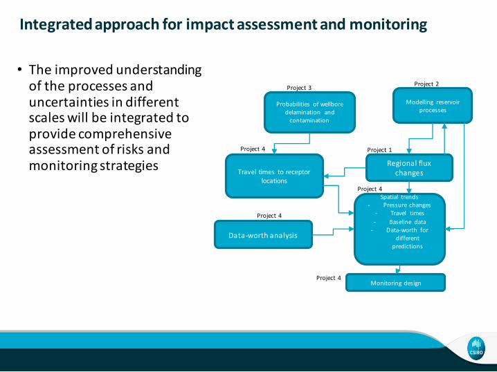
Distribution of simulated CSG water production across 500 model runs
• Water production rates are not hard-wired as a boundary condition in the model
• Instead, the model simulates the water production for a given depressurization target
• Accounts for the uncertainty in CSG water production
18 |
Acknowledgement
• Russell Crosbie
• Luk Peeters
• Jizelle Khoury
• Dirk Mallants
• Neale House
• Sue Hamilton
• Cate Barrett
• Andrew McCallum
• Andrew Druzynski
• Fabienne d’Hautefeuille
• Phil Davies
• Tim Ransley
• Emily Slatter
• Jessica Northey
• Keith Phillipson
• Researchers of the Bioregional Assessment Programme
• David Post
19 |

CSIRO Land and WaterSreekanth JanardhananSenior Research Scientist
t +61 7 3833 5565e [email protected]
Thank you
CSIRO LAND AND WATER