Embed Size (px)
Citation preview

Waste Site Options: Individual Sites Assessment
Waste Sites Appraisal Report September 2013
Torbay Council

Waste Sites Appraisal: September 2013
2 of 143

Table of Contents 1. Appendix 1: Site Options for Recovery ........................................................................... 4
Kerswell Gardens, Torquay ............................................................................................... 5
Torbay Hospital Grounds, Torquay .................................................................................. 18
Brown Bridge Road, Barton Employment Allocation, Torquay ......................................... 31
Occombe Farm, Preston Down Road, Paignton .............................................................. 45
Claylands, Brixham Road, Paignton ................................................................................ 57
Tor Park Road (Blackthorn Way), Yalberton Industrial Estate, Paignton .......................... 69
Yalberton Depot, Borough Road, Paignton ...................................................................... 81
Yalberton Road Employment Allocation, (Yannons Farm) Yalberton Road, Paignton ...... 94
2. Appendix 2: Site Options for Disposal ........................................................................ 106
3. Churston Court Farm, Brixham .................................................................................. 107
4. Appendix 3: Site Options for Recovery and Disposal ................................................. 120
Lummaton Quarry Employment Site, Torquay ............................................................... 121
Yalberton Tor Quarry, Yalberton road, Paignton ............................................................ 132
Waste Sites Appraisal: September 2013
3 of 143

Waste Sites Appraisal: September 2013
1. Appendix 1: Site Options for Recovery
4 of 143

Waste Sites Appraisal: September 2013
Kerswell Gardens, Torquay
Site Location Plan (Scale 1:10,000)
5 of 143

Nature of development
Recovery (Energy from waste) Disposal (Landfill or land raise)*
Nature of operations to be considered at *Part of operation outside of Torbay boundary
site: and employment allocation is currently used for
(Tick all th at apply) inert waste recycling operation and could have
potential for further use.
Waste Sites Appraisal: September 2013
Stage One: General Description of Site
Site Details
Site address: Kerswell Gardens, Newton Road, Torquay TQ!2 4ST
OS Grid Reference: SX 8866
District: Torbay
Parish: N/A Shiphay with the Willows
Total site area (Ha): 2.2 ha
Current land use(s)
Kerswell Gardens is situated between Kingskerswell and Torquay, adjacent to a major roundabout that connects the A380 and the A3022 (Torbay Ring Road). It is a site of mixed uses based on a garden centre but includes garden machinery sales and recycling operation (outside the Torbay Boundary)
Historical land use(s) Garden Centre/Agricultural/small waste operation
Adjacent land use(s) Agricultural, horse grazing, commercial.
Relevant planning history:
The Employment site lies within Torbay however the entire garden centre site operation extends into Teignbridge District Council. The wider site (which extends outside the Torbay boundary) includes the composting of green waste (DCC as WPA.(Ref: 03/4016/DCC, Permitted, Sept 03) from The Landscape (SW) Ltd (part of Kerswell Gardens operation) with no public delivery of domestic green waste. A subsequent application (2004/2219/DCC) for the provision of a waste transfer and recycling facility (stock piling, crushing and screening of inert stone and rubble (inc top soil) has been permitted (to 2016) Torbay Planning History:
2007/0169/EN
2005/0312/EN
Has the site been considered for waste development in the past?
Yes No
6 of 143

Waste Sites Appraisal: September 2013
Availability and market interest
Timescale for site availability.
Immediately Up to 5 years 5-10 years 10-15 years
If the site is not available immediately please state why:
Site is privately owned and is not being promoted (other that the operations described above). Local Plan and Neighbourhood Plan promotes site for employment allocations.
Are there any legal/ownership constraints on the site that might prohibit or delay development? (Please provide details)
Yes No
Is there known waste operator interest in the site?
Yes No
Part of site currently used for small scale waste operation (outside Torbay Boundary) by the Garden Centre.
Access and transportation
Point of access to public highway: A380 (existing Kingskerswell/Newton Road)
Details of any improvements to the public highway that would be required prior to commencement of operations:
Improvement to access road with Kingkerswell Road
Reivew of interaction with new proposed junction for the roundabout (part of new SDLR)
Probable left exit from site only, right hand in filter lane
Means of transportation of waste to/from the site: Road (potential for rail) (e.g. road, rail, water or a combination)
Basic site requirements Y/N
Is the site within the area of search for the preferred spatial option? N*
Is the site of an appropriate size (a minimum of 1ha) to contribute towards the delivery of the Waste Local Plan Strategy?
Y
* Close to the DCC area of search
7 of 143

-
Highest Lower level of Lowest level of A dash was used to
grading/classification grading/classification grading/classification identify when an or defined receptor or a defined receptor or a defined receptor indicator is Not
within waste site adjacent or close to within broad locality Applicable or
potential waste site of the potential waste outside the
site parameters set out (DDC Methodology
Appendix 6)
No. Indicators
Stage 2
Stage 3
Additional Comments
Loss or impact on open space (including recreatio nal
land, tourist attractions, 5 Site is used as a Garden Centre 1
managed woodland, -
with ancillary operations. allotments and playing fiel ds
etc)
Impact on residential
properties, businesses & There are a number of residential services – including all noise, 4 developments within 500m to the
2 dust, air pollution, odour, NE, SE &NW of the site
vibration and visually boundaries. sensitive receptors.
Waste Sites Appraisal: September 2013
Key to Criteria and scoring:
See DCC Site Identification and Appraisal Methodology for further details.
Stage 2: Constraint
Stage 2: Opportunity
-
Highest potential within waste site
Lower level of potential within X
meters of potential waste site
Lower level of potential within X
meters of potential waste site
A dash was used to identify when an indicator is Not Applicable or outside the
parameters set out (DDC Methodology
Appendix 6)
Stage 3 Constraint Criteria:
1 2 3 4 5 High (1) High/medium
(2) Medium (3) Medium/low (4) Low (5)
Stage 3 Opportunity Criteria:
1 2 3 4 5 Low (1) Medium/low (2) Medium (3) High/medium
(4) High (5)
Stages Two and Three Objective 1: To improve human health and opportunities for a healthy lifestyle
8 of 143

No. Indicators
Stage 2
Stage 3
Additional Comments
There are SHLAA sites (T747* & T748) within 500m to the south of
the site boundaries. Other SHLLA
Potential for physical constraints on areas
sites (T799, T853 & T852) are within 1km of the site boundaries.
5 allocated or emerging within
District Development Plans for housing, tourism or
recreation
4 *Scotts Meadow (Currently an
ULPA in the Local Plan) received outline planning consent (at Appeal)
for 155 dwellings and POS. Note: The site is identified for
employment use (E.1) in the adopted Local Plan (See
opportunity criteria below).
6
Impact upon proposed Mineral Safeguarding Area
or adopted Mineral Consultation Area
-
5
The site is not within proposed Mineral Safeguarding Area or adopted Mineral Consultation Area
There is a gas pipeline running parallel to the western boundary of
the site within approximately within 100m.
7 Conflict with utilities
infrastructure (electricity, gas and water)
3 Development of the site might conflict with National Grid
infrastructure. Due to proximity of the pipeline to
the site, National Grid should be consulted should the site put
forward for waste operation.
Conflict with Aerodrome
8 Safeguarding Areas, MOD Safeguarding Areas and Cobbacombe Cross
- 5 The site is outside safeguarded
areas and therefore there is no risk of harm.
(weather radar) Areas
Aggregated score 17
Waste Sites Appraisal: September 2013
5
4
The site is within 1km of a Lower Impact on health deprived Super output Area with health and
_3 wards disability ranking 21203 (not
classifies as health deprived).
There is PROW (TQ/262/1 & Impact on Public Rights of TQ/36/1) within 250m of the site
4 Way and other countryside boundaries. Other footpaths access (TQ/173 & TQ/47/1) run within 1km
to the southern edge of the site.
Aggregated score 18
Objective 2: To encourage sustainable economic growth in Devon’s urban and rural areas
9 of 143
No. Indicators
Stage 2
Stage 3
Additional Comments
For traffic from Torquay – good
9 Capacity of existing
transportation network to 1 deal with additional traffic
4
For traffic from Paignton – good outside of peak times
Any traffic from Newton Abbot poor,
but will improve post SDLR
Turning will cause delays to existing Implication of potential 3 traffic especially at peak times
10 routing of waste to site on dependant on number of vehicle highway network movement associated with the
recovery type.
Aggregated score 7
No. Indicators
Stage 2
Stage 3
Additional Comments
Impact on Special Areas for
11 Conservation (SAC), Special
Protection Areas (SPA) or -
5
There are no international designation within 1km.
Ramsar sites
Impact on South Hams
Special Area for Most of the site is within GH bat
12 Conservation (SAC) greater
horseshoe bat strategic 4 strategic flyway (250m buffer).
A bat survey will be required at the flyways and sustenance project level.
zones
Impact on biological Sites of
13 Special Scientific Interest (SSSI), National Nature
Reserves (NNR) or Local -
5
There are no SSSI, NNR or LNR within 1km of the site.
Nature Reserve.
14 Impact on County Wildlife Sites or non designated
nature reserve
4
There is a Local Wildlife Site (OSWI ref: SX96/025)’ Main Line’ within
250m. Scotts Meadow has wildlife biodiversity of CWS value.
15 Impact on Strategic Nature
Areas (SNA)
5
There is no SNA within 1km of the site boundaries.
Waste Sites Appraisal: September 2013
Objective 3: To reduce the mileage of waste transported by road whilst promoting the use of more sustainable modes of transport
Objective 4: To maintain or enhance Devon's wildlife
1 Between 4 and 50 vehicle movements per day. See DCC methodology Appendix 4 for likely scale
of staff and transport movements
10 of 143

No. Indicators
Stage 2
Stage 3
Additional Comments
20 Impact on the Jurassic Coast
World Heritage Site (WHS) -
- N/A
21 Impact on a Regionally
Important Geological Site -
5
There is no Regionally Important Geological Site within 1km of the
site.
22 Impact on a geological Site
of Special Scientific Interest (SSSI)
-
5 There is
1km of th no g
e sit eological SSSI within
e.
Aggregated score 10
No. Indicators Stage
2 Stage
3 Additional Comments
23
Potential impact on agricultural land (avoiding
the use of Grades 1, 2 and 3a)
-
5
The site is classified as non- agricultural land. Development of
the site would not result in loss of agricultural land of Grade 1-3a.
24 Proximity to areas of
contaminated land -
5 No contaminated land identified.
Waste Sites Appraisal: September 2013
16 Impact on legally protected and BAP priority species
The site is within 2km of cirl bunting (just outside the 1km boundary) feeding zone. Other protected species have been recorded within 500m and 1km of the site boundaries. Project level survey would be required to ascertain the presence of cirl bunting and inform suitable mitigation measures.
4
17 Potential to lead to loss or damage of ancient woodland
-There is no area of ancient woodland within 1km of the site boundaries.
5
18 Impact upon Biodiversity Action Plan (BAP) priority habitats
The site is surrounded by BAP priority habitat: Farmland. Loss of farmland could affect many of the declining species e.g. cirl bunting.
4
19 Impact on Tree Preservation Orders (TPOs) at site
-
The site does not contain any trees with TPOs. And there are no TPOs within 100m of the site. Development on this site would not impact upon TPOs.
5
Aggregated score 41
Objective 5: To protect geodiversity
Objective 6: To improve the quality and usability of the best and most versatile land and soil
11 of 143

No. Indicators Stage
2 Stage
3 Additional Comments
27 Impact on Areas of
Outstanding Natural Beauty (AONB) and/or National Park
5
The site is not within AONB or NP. South Devon AONB is not within
5km visual range of the site.
28
Impact on Coastal Preservation Areas, undeveloped coast and
heritage coast
5
The site is outside of CPA and undeveloped coast and therefore
there is no risk of harm.
The site is located within AGLV. It has been described in the TLCA as
29 Impact on landscape
character and quality 3
type 1 rolling farmland (1A Barton). The site lies in an area open to wide views from most directions
and therefore any significant changes, particularly development,
are likely to be very apparent.
30 Impact on dark skies
4 The site is located within an area
recognised as brighter.
Aggregated score 17
No. Stage Stage
Indicators Additional Comments 2 3
31 Impact upon Registered
Historic Parks and Gardens including setting
-
No Registered Historic Parks and Gardens present within 1km of the
site boundary therefore there is no risk of harm.
5
32 Impact on registered
battlefields including setting -
No registered battlefields present within 1km of the site boundary
therefore there is no risk of harm. 5
Impact on Scheduled
33 Ancient Monuments (SAM)
and archaeology of - 5
There are no SAM within 1km of the site boundaries therefore there is
no risk of harm. equivalent status (including
setting)
Waste Sites Appraisal: September 2013
25 Proximity to areas of land instability
- - Information currently unavailable.
26 Impact on North Devon’s Biosphere Reserve
- - N/A
Aggregated score: 10
Objective 7: To sustain and enhance the valued and distinctive character and quality of Devon's landscape.
Objective 8: To improve the setting and integrity of the historic environment
12 of 143

Impact on Cornwall and 5 No risk of harm due to the distance
involved.
34 West Devon Mining
Landscape World Heritage Site and setting
35 Impact on Grade I / II* and II
listed buildings including setting
4
There are 11 separate designated Grade II listed building complexes;
including Edginswell Hall; Edginswell Farm Buildings on both
sides of Edginswell Road; Edginswell Farm House; and Ivy
Cottage. All are about 400m from the southern boundary of Kerswell
Gardens.
36
Potential loss of or damage to non-designated heritage
assets (including locally listed buildings, locally listed
parks and gardens and archaeology)
4
Parsons Brinkerhof’s The A380 Kingskerswell Bypass Environmental Statement Vol 2,
Chapter 7 & Appendices (November 2004) details a number
of undesignated sites of archaeological value within the
DCC/Teignbridge area. Within the TC area archaeological
resource is largely unknown; this is especially true of the prehistoric
period. An Iron Age hoard of currency bars was discovered
900m north of the site in the 1990s. There are no other known
archaeological sites within the 500m or 1km buffer zones of
significance.
37 Impact on Conservation
Areas -
5
Nothing within 1km of the site boundaries.
No risk of harm.
Aggregated score 33
No. Indicators Stage
2 Stage
3 Additional Comments
The site is adjacent to Aller Brook watercourse (classified as main
Proximity and impact upon 3 river). 38 surface water bodies and Development and associated
surface water courses infrastructure in the area should not increase runoff into local
watercourses.
Aggregated score 3
Waste Sites Appraisal: September 2013
Objective 11: To maintain or improve the quality of ground, river and sea waters
13 of 143

No. Indicators Stage
2 Stage
3 Additional Comments
Proximity and impact on
39 public or private water
sources (ground and surface -
5 The site is not within groundwater source protection zone.
water)
Aggregated score
5
No. Indicators
Stage 2
Stage 3
Additional Comments
The southern edge of the site is
40 Proximity to and impact upon
Flood Zones 2 and 3 -
4 adjacent to fold risk zone 3. Further flood zone 3 is within 1km to the north of the site boundaries.
41 Impact upon ground water
vulnerability -
5
There no risk of groundwater flooding in the site or within 1km of
the site boundaries.
42 Impact upon surface water
2 vulnerability
5
The site is not located in a surface water flood area and therefore there
is no risk of harm.
There has been no historic flooding 43 Historic flooding vulnerability - 5 within the site or in the immediate
surroundings.
Aggregated score 19
No. Indicators Stage
2 Stage
3 Additional Comments
There is adjacent to AQMA in Teignbridge DC. Traffic travelling
Impact on Air Quality to and from the site is likely to go 44 Management Areas 2 through the AQMA. There will be a
(including proposed) negative impact on the AQMA as a result of the waste management
development in this site.
Aggregated score
2
Waste Sites Appraisal: September 2013
Objective 12: To improve the amount of ground and surface waters available for abstraction for other, non-waste management uses
Objective 13: To reduce the risk of flooding (including coastal flooding)
Objective 14: To improve air quality
Locally agreed surface water information is available for Great Torrington, Tavistock, Teignmouth, Horrabridge & Yelverton, Rockbeare and Ottery St Mary (assessed using Areas Susceptible to Surface Water Flooding). Therefore, this more locally specific data will be used at Stage Two for potential sites within areas.
14 of 143
2

No. Indicators Stage
2 Stage
3 Additional Comments
The site is located within an area
45 Impact on level of tranquility
at site -
5 considered for having Low tranquillity due to proximity to and
A379 urban area.
Aggregated score
5
No. Indicators
Stage 2
Stage 3
Additional Comments
46 Located within existing
3 industrial estate
- 4
The site is essential a garden centre but includes commercial, waste and industrial type uses.
The site is allocated (E1.1) for Alignment with District DPD - employment business Park use
47 allocation for employment land (B2 or B8)4
3 (B1) but allows for ancillary B2 and B8 uses. High profile , gateway site
require strategic landscaping.
48 Site within previously
developed land
3 Site PDL as currently operated (as a garden centre)
Potential to restore, or utilise
49 unrestored land at former - 1 Not a former quarry site. quarries
Aggregated score 11
Waste Sites Appraisal: September 2013
Objective 15: To reduce the impact of noise and vibration on tranquility
Aggregated Stage 3 Score for constraints criteria: 187
Opportunity Criteria
Objective 2: To encourage sustainable economic growth in Devon’s urban and rural areas
Objective 3: To reduce the mileage of waste transported by road whilst promoting the use of more sustainable modes of transport
No.
50
Stage Stage Additional Comments Indicators
2 3
Potential for alternative modes of transport (rail or water)
2 The main line railway is within 100m of the site and a new railway halt is proposed at Edginswell.
51 Access to the strategic road network
4
Site is well located to A3022 proposed SDLR is also under construction (due to be completed 2015)
Aggregated score 6
3 Not applicable for consideration of landfill or land raise sites
4 Not applicable for consideration of landfill or land raise sites
15 of 143

No. Indicators Stage
2 Stage
3 Additional Comments
52 Ability to export electricity
and/or gas to the national grid
3 Site is well located to potential
export gas/electricity from site
Site is within Torbay Hospital just within 1km. Allocated employment site Riviera Way South within 500m.
53 Ability to export heat to local 3
However SWEEG study 2006 user Kerswell Gardens was ruled out as
being unsuitable for ATT use due to current or planned uses, presence
of a local heat load.
Aggregated score 6
Waste Sites Appraisal: September 2013
Objective 10: To reduce total waste arisings and the proportion of waste disposed in landfill
Aggregated Stage 3 Score for opportunity criteria: 23
Stage 4: Consideration of cumulative impacts
The site is located within an area which has been identified for future employment development in the Local Plan (Policy E.1). Emerging new Local Plan: Policy SDT1 has significant level of growth planed for the next 20 years. As a result, there are likely to be development impacts and there may be potential for cumulative impacts in relation to transportation, human health, flood risk and increased green house emissions. The employment site is in a strategically important, gateway location and forms part of an important economic drive to deliver 375 pa. in Torquay and is currently being promoted for employment/commercial use. The site has potential to provide opportunities for district heating and is well located to road network the potential rail network access.
If this site was taken forward for disposal and recovery development, these two uses would need to be considered in terms of cumulative impacts.
Torbay Hospital and Barton sites, lie within 1.5 km to the south east of the site, are also being appraised through this process; therefore if any of these sites were to come forward for waste development, cumulative impacts assessment would be required.
Stage 5: Summary of Site Appraisal for Kerswell Gardens
The site scores generally well through the appraisal process. . An existing waste recycling operation occurs on part of the Sites (outside the Torbay Boundary). The site could have high/medium risk on AQMA in Teignbridge DC; however the forthcoming South Devon Link Road could improve the air quality in the area. Most of the site lies within GH bat strategic flyway (250m buffer); therefore a bat survey will be required at the project level. There are some constraints associated with the site in relation to impact upon landscape character, surface water bodies, priority habitats and the site could conflict with National Grid infrastructure.
The prominent gateway site is located on the periphery of a key area of future growth (SD T4)
16 of 143
Waste Sites Appraisal: September 2013
in the emerging local plan and allocated for future employment use. Where high quality well landscaped development is proposed. A strategic waste recovery/landfill facility would conflict with these aspirations.
Recommendation:
The site could be suitable for a waste facility but not immediately. A strategic facility would conflict with the future local plan aspiration for the gateway site and therefore the site should not be taken forward for further consideration in the Local Plan.
17 of 143

Waste Sites Appraisal: September 2013
Torbay Hospital Grounds, Torquay
Site Location Plan (Scale 1:10,000)
18 of 143

Waste Sites Appraisal: September 2013
Stage One: General Description of Site
Site Details
Site address: Torbay Hospital Grounds, Lowes’s (Lawes) Bridge, TorquayTQ2 7AA
OS Grid Reference: SX 8965
District: Torbay
Parish: N/A Shiphay with the Willows Ward
Total site area (Ha): 1 ha
Current land use(s)
The site is located in the SE corner of the wider Torbay Hospital Grounds approximately a 20hectare site (currently administered by The South Devon Healthcare NHS Foundation Trust). The site includes general landscaping and two (staff) car parks (apporox 45 & 160 spaces) adjacent to Lowe’s Bridge and the main railway line and is in close proximity to the existing hospital incinerator. The Hospital Grounds have been previously subject to redevelopment proposals in the part and may be require for the hospital in the event of redevelopment/ expansion of the hospital uses.
Historical land use(s) Car park hospital grounds landscaping.
Adjacent land use(s)
The site lies in the main hospital grounds currently administered by The South Devon Healthcare NHS Foundation Trust) in close proximity to the main road gateway to Torquay and a major road junction at Lowe’s Bridge. The site itself largely consists of car parks and there are further car parks adjacent serving the Horizon Centre (Research Building) ngrove Building and the incinerator block. There is a wide section of wooded landscaping on the eastern frontage next to the main Newton/ Torquay railway line close to a major junction Lowe’s Bridge less than 50m away).
An informal right of way will be upgraded in Summer 2013 by the Council with the agreement of SDHC as land owner to a shared use cycle and walking route, part of the National Cycle Network No 28 connecting Newton Abbot and Torquay
The public highway (the Old Newton Road) lies off the northern tip of the site – the adjacent road is owned by SDHCFT. There are a number of residential properties within 50m (Newton Road and Summerfield Road) to the North and South frontages. There is a commercial (bulky goods) retail area to the east of Lowe’s Bridge Junction/Newton Road including B&Q and ASDA supermarket within 250m.
19 of 143

Waste Sites Appraisal: September 2013
The main land uses within 500m include the Riviera Way and Newton Road gateway and Lowe’s Bridge signalised junction; the residential suburban fringe of Torquay/Barton. There are a number of retail units (Lidl supermarket), car sales showrooms and Fire Station on the old Newton Road. The Bridge Retail Park (containing Staples, Pets at Home, Dunelm Mill and McDonald’s Drive Through) and Woodlands trading estate to east of the Hospital Grounds which includes an Asda supermarket and B&Q on the eastern side of the Newton Road within 250m. The Broomhill trading estate which includes other retail uses (Comet and the Royal Mail Sorting Office) lies to the NE to the east of Riviera Way.
Relevant planning history:
Torbay Hospital has a long and complex history of planning applications. The site in particular
P/2003/1803/OA: Partial Demolition And Redevelopment To Form New Hospital (In Outline) (as revised by letter and drawing received 1/9/2004 and letter received 12/10/2004 (permitted)
P/2006/1366:
P/2006/1057: Variation Of Condition Attached To Planning Ref P/2003/1803/OA To Enable Reserved Matters To Be Submitted Before 18 February 2010
P/2007/0176 : Alterations and Extension to for Disposal hold to theatres.
AT/2011/0099: T1: Elm- Remove (application Permitted)
P/2007/0615: Redevelopment Of Existing Medical Education Centre At SE Corner Of Torbay Hospital Site, Close to Lawes Bridge Entrance. Involving the Demolition of Single Storey Medical Education Centre And The Construction Of A New 3 Storey Education Centre And Research Unit. (Permitted)
Has the site been considered for waste development in the past?
Nature of development
Yes * No *SWEEG study 2006
Nature of operations to be considered at site: (Tick all that apply)
Availability and market interest
Recovery (Energy from waste) Disposal (Landfill or land raise)
Timescale for site availability. Up to 5 years 5-10 years 10-15 years
Immediately
20 of 143

Access and transportation
Point of access to public highway: Newton Road /A3022 Riviera Way
Details of any improvements to the public highway that would be required prior to
commencement of operations:
Lowe’s Bridge Junction Improvement may be necessary for the Newton Road access point.
Means of transportation of waste to/from the site:
(e.g. road, rail, water or a combination) Road (potential rail?)
-
Highest Lower level of Lowest level of A dash was used to
grading/classification grading/classification grading/classification identify when an or defined receptor or a defined receptor or a defined receptor indicator is Not
within waste site adjacent or close to within broad locality Applicable or
potential waste site of the potential waste outside the site parameters set out
(DDC Methodology Appendix 6)
Waste Sites Appraisal: September 2013
If the site is not available immediately please state why:
South Devon D Heath Care Foundation Trust land
Are there any legal/ownership constraints on the site that might prohibit or delay development? (Please provide details)
Yes No
Is there known waste operator interest in the site?
Yes No* *Potential links with existing Hospital facility and incinerator?
Basic site requirements Y/N
Is the site within the area of search for the preferred spatial option? N*
Is the site of an appropriate size (a minimum of 1ha) to contribute towards the delivery of the Waste Local Plan Strategy?
Y
* close proximity to DCC area of search
Key to Criteria and scoring:
See DCC Site Identification and Appraisal Methodology for further details.
Stage 2: Constraint
21 of 143

No. Indicators
Stage 2
Stage 3
Additional Comments
1
Loss or impact on open space (including recreational
land, tourist attractions, managed woodland,
allotments and playing fields etc)
4
The site forms part of the wider Torbay Hospital Grounds general
landscaping and car park. Although there is PROW within the site, it is
not used as an open space
The site forms a functional part (staff parking and landscaping) of the Torbay hospital grounds. There
Impact on residential 2 are a number of residential properties, businesses & properties within 50m (Newton
2 services – including all noise,
dust, air pollution, odour, Road and Summerfield Road) to
the North and South frontages. vibration and visually There is a commercial (bulky sensitive receptors. Goods) retail area to the West of
Lowe’s Bridge Junction/Newton Road including B&Q and ASDA
supermarket within 250m. The site is within 500m of a Lower
3 Impact on health deprived
wards 3
Super Output Area (Tormohun) with health and disability ranking 2068
(classifies as health deprived).
4 Impact on Public Rights of
Way and other countryside access
4
There is a PROW (TQ/46/1) within the site boundaries. A number
footpaths run within 1km to the north, east and south of the site
Waste Sites Appraisal: September 2013
Stage 2: Opportunity
-
Highest potential within waste site
Lower level of potential within X
meters of potential waste site
Lower level of potential within X
meters of potential waste site
A dash was used to identify when an indicator is Not Applicable or outside the
parameters set out (DDC Methodology
Appendix 6)
Stage 3 Constraint Criteria:
1 2 3 4 5 High (1) High/medium
(2) Medium (3) Medium/low (4) Low (5)
Stage 3 Opportunity Criteria:
1 2 3 4 5 Low (1) Medium/low (2) Medium (3) High/medium
(4) High (5)
Stages Two and Three
Objective 1: To improve human health and opportunities for a healthy lifestyle
22 of 143

No. Indicators
Stage 2
Stage 3
Additional Comments
There are SHLAA sites (R363) (and a ‘rejected’ site T868) within 500m
5
Potential for physical constraints on areas
allocated or emerging within District Development Plans
for housing, tourism or recreation
4
to the NW of the site boundaries. There are a number of SHLAA sites within 1km of the site boundaries
including Scotts Meadow given outline permission at Appeal
(approx 155). A recreational field (Kitson Park) lies within 1Km to the
NW abutting the Hospital Gounds.
6
Impact upon proposed Mineral Safeguarding Area
or adopted Mineral Consultation Area
-
5
The site is not within proposed Mineral Safeguarding Area or adopted Mineral Consultation Area.
Conflict with utilities No conflict with utilities 7 infrastructure (electricity, gas - 5 infrastructure and therefore there is
and water) no risk of harm.
Conflict with Aerodrome
8 Safeguarding Areas, MOD Safeguarding Areas and Cobbacombe Cross
5 The site is outside safeguarded areas and therefore there is no risk
of harm. (weather radar) Areas
Aggregated score: 19
No. Indicators Stage
2 Stage
3 Additional Comments
Capacity probably exists outside
9 Capacity of existing
transportation network to deal with additional traffic
3
peak times, although requires modelling to confirm especially the
peak period. Concern re conflict with ambulances, other hospital
traffic, buses, cyclists, pedestrians
Waste Sites Appraisal: September 2013
boundaries. An informal right of way /cycle way (Local Plan Policy T3) will be upgraded in Summer 2013 by the Council with the agreement of SDHC as land owner to a shared use cycle and walking route, part of the National Cycle Network No 28 connecting Newton Abbot and Torquay
Aggregated score: 13
Objective 2: To encourage sustainable economic growth in Devon’s urban and rural areas
Objective 3: To reduce the mileage of waste transported by road whilst promoting the use of more sustainable modes of transport
23 of 143

Stage Stage No. Indicators Additional Comments
2 3
Impact on Special Areas for There is no international
Conservation (SAC), Special 11 - designation within 1km of the site
Protection Areas (SPA) or 5 boundaries.
Ramsar sites
Impact on South Hams Special Area for
There are no bat strategic flyways Conservation (SAC) greater 5
12 - or sustenance zones within 1km of horseshoe bat strategic
the site boundaries. flyways and sustenance
zones
Impact on biological Sites of
Special Scientific Interest There is no geological SSSI or NNR 13 (SSSI), National Nature - 5 within 1km of the site.
Reserves (NNR) or Local Nature Reserve.
There is no CWS within 1km of the site. Note: Site lies immediately
Impact on County Wildlife 5 adjacent to a Local Wildlife Sites
14 Sites or non designated - (OSWI Ref: SX96/025) Mainline
nature reserve Railway embankments deciduous
woodland)
Impact on Strategic Nature There is no SNA within 1km of the
15 5 Areas (SNA) site boundaries.
The site is within 2km of cirl bunting feeding zone. Other protected species have been recorded within 4 500m and 1km of the site
Impact on legally protected 16 boundaries. and BAP priority species
Project level survey would be required to ascertain the presence
of cirl bunting and inform suitable mitigation measures
There is no ancient woodlands Potential to lead to loss or 5 17 - within 1km of the site and therefore
damage of ancient woodland there is no risk of harm.
Impact upon Biodiversity Priority habitats parkland and
18 Action Plan (BAP) priority deciduous woodland is within 500m 3 habitats to the NE of the site boundaries.
The site does not contain any trees Impact on Tree Preservation with TPOs. And there are no TPOs
19 - Orders (TPOs) at site 5 within 100m of the site.
Development on this site would not
Waste Sites Appraisal: September 2013
10 Implication of potential routing of waste to site on highway network
Must avoid Hele Road and the Hele AQMA
2
Aggregated score: 5
Objective 4: To maintain or enhance Devon's wildlife
24 of 143

No. Indicators
Stage 2
Stage 3
Additional Comments
20 Impact on the Jurassic Coast
World Heritage Site (WHS) -
- N/A
21 Impact on a Regionally
Important Geological Site -
5
There is no Regionally Important Geological Site within 1km of the
site.
22 Impact on a geological Site
of Special Scientific Interest (SSSI)
-
5
The site does not contain geological SSSI but Lummaton Quarry
geological SSSI is within 1.5km to the east of the site.
Aggregated score: 10
No. Indicators
Stage 2
Stage 3
Additional Comments
23
Potential impact on agricultural land (avoiding
the use of Grades 1, 2 and 3a)
-
5
The site is classified as non- agricultural land. Development of
the site would not result in loss of agricultural land of Grade 1-3a.
24 Proximity to areas of
contaminated land
4
The site lies within 500m of a contaminated land. Any risk of contamination is likely to be low.
25 Proximity to areas of land
instability -
-
There is no information currently available.
26 Impact on North Devon’s
Biosphere Reserve -
- N/A
Aggregated score: 9
No. Indicators Stage Stage
Additional Comments 2 3
27 Impact on Areas of
Outstanding Natural Beauty (AONB) and/or National Park
The site is not within AONB or NP. South Devon AONB is not within
5km visual range of the site.
5
28
Impact on Coastal Preservation Areas, undeveloped coast and
heritage coast
The site is outside of CPA and
undeveloped coast and therefore there is no risk of harm.
5
Waste Sites Appraisal: September 2013
impact upon TPOs.
Aggregated score: 42
Objective 5: To protect geodiversity
Objective 6: To improve the quality and usability of the best and most versatile land and soil
Objective 7: To sustain and enhance the valued and distinctive character and quality of Devon's landscape.
25 of 143

No. Indicators Stage
2 Stage
3 Additional Comments
Barton Road Cemetery, registered historic park and garden, lies within
Impact upon Registered 4 500m to the east of the site 31 Historic Parks and Gardens boundary. Impacts on long distant
including setting views need be assessed and appropriate mitigation will be
required.
32 Impact on registered
battlefields including setting -
5
N/A
Impact on Scheduled
Ancient Monuments (SAM) St Michael’s Chapel SAM lies 680m 33 and archaeology of 4 to the SSW.
equivalent status (including setting)
Impact on Cornwall and
34 West Devon Mining
Landscape World Heritage 5 No risk of harm due to distance.
Site and setting
The Grade II Torbay Hospital Chapel lies 120m west; the Grade II* Brunel Atmospheric Pumping House lies 440m to the NNW; a group of 5 separately designated grade II buildings and structures are located within Torbay Cemetery 570m east; the grade II listed Penny’s Cottage lies 950m east; 7
35 Impact on Grade I / II* and II
listed buildings including setting
4
grade II listed villas No. 50-64 Teignmouth Road lie 870m
southeast; the grade II Torre Railway Station and bridge lie 950m
SSE; the grade II medieval Shiphay Manor Barn lies 810m southwest; a group of 4 separately designated grade II buildings in Shiphay
Collaton lie 630m to the west
Waste development in this site would have no direct impacts on listed buildings. Possible impacts
Waste Sites Appraisal: September 2013
29 Impact on landscape character and quality
The site is located within Landscape Character Type 9: main cities and towns.
5
The site is located within an area recognised as brighter.
30 Impact on dark skies 4
Aggregated score: 19
Objective 8: To improve the setting and integrity of the historic environment
26 of 143

No. Indicators Stage
2 Stage
3 Additional Comments
Proximity and impact on
39 public or private water
sources (ground and surface -
5 The site is not within groundwater source protection zone.
water)
Aggregated score:
5
Waste Sites Appraisal: September 2013
on setting need to be assessed at planning application stage.
36
Potential loss of or damage to non-designated heritage assets (including locally
-
There are a number of medieval sites in Shiphay Collaton, and post-medieval monuments recorded on the HER whose significance is unlikely to be affected by a waste site. There are no other known archaeological sites within the 500m or 1km buffer zones of significance.
5 listed buildings, locally listed parks and gardens and archaeology)
There is only a small area of the Torre Conservation area to the far South within 1km of the site.
37 Impact on Conservation 4 Areas
Aggregated score: 31
Objective 11: To maintain or improve the quality of ground, river and sea waters
No.
38
Stage Stage Additional Comments Indicators
2 3
Proximity and impact upon surface water bodies and surface water courses
3
The site is located within 500m of Aller Brook watercourse (classified as main river). In addition there is River Fleet (ordinary river) just outside the 1km buffer zone. Development and associated
infrastructure in the area should not increase runoff into local watercourses.
Aggregated score: 3
Objective 12: To improve the amount of ground and surface waters available for abstraction for other, non-waste management uses
27 of 143
No. Indicators
Stage 2
Stage 3
Additional Comments
There is flood zone 3 is within 1km
40 Proximity to and impact upon
Flood Zones 2 and 3 -
5 to the west and NW of the site and additional flood zone 3
approximately 1.2km of the site to the east.
41 Impact upon ground water
vulnerability
4
There is little risk of groundwater flooding in the site or within 1km of
the site boundaries
The site itself is not located in a
42 Impact upon surface water
5 vulnerability -
5
surface water flood area. There is however a potential surface water
flooding within 1km to the east of the site boundary.
There has been no historic flooding 43 Historic flooding vulnerability - 5 within the site or in the immediate
surroundings.
Aggregated score: 19
No. Indicators Stage
2 Stage
3 Additional Comments
The site is located within an area
45 Impact on level of tranquillity
at site -
5 considered for having Low tranquillity due to proximity to
A3022 and urban area.
Aggregated score: 5
Waste Sites Appraisal: September 2013
Objective 13: To reduce the risk of flooding (including coastal flooding)
Objective 14: To improve air quality
No.
44
Stage Stage Indicators Additional Comments
2 3
Impact on Air Quality Management Areas (including proposed)
3
The Hele Road AQMA lies within 1km to the north east of the site. A waste facility in this site could have an impact on the existing AQMA in the Hele Road.
Aggregated score: 3
Objective 15: To reduce the impact of noise and vibration on tranquillity
Aggregated Stage 3 Score for constraints criteria: 183
Locally agreed surface water information is available for Great Torrington, Tavistock, Teignmouth, Horrabridge & Yelverton, Rockbeare and Ottery St Mary (assessed using Areas Susceptible to Surface Water Flooding). Therefore, this more locally specific data will be used at Stage Two for potential sites within areas.
28 of 143
5
No. Indicators
Stage 2
Stage 3
Additional Comments
Torbay Hospital forms an important community facility identified in the - existing Adopted Local Plan (CF 13)
which is also a significant employer
46 Located within existing
6 industrial estate within the district. Some of the uses within the complex could be
2
considered industrial (such as the existing incinerator) however this is
also mixed with high-tech research and sensitive receptor wards
Alignment with District DPD 47 allocation for employment - 2 See comments above
land (B2 or B8)7
48 Site within previously
developed land
2
PDL but in useful operation serving as a landscaped and carparking area for the hospital complex.
Potential to restore, or utilise
49 unrestored land at former - 1 N/A quarries
Aggregated score: 7
No. Indicators Stage
2 Stage
3 Additional Comments
Adjacent to railway, although Potential for alternative significant works required to
50 modes of transport (rail or 3 develop a freight station, and water) Network Rail would need to be
consulted regards capacity issues
Poor – Must pass over a private
51 Access to the strategic road network
3 road first.
Conflicts with significant other forms of traffic. Busy junction
Aggregated score: 6
Waste Sites Appraisal: September 2013
Opportunity Criteria
Objective 2: To encourage sustainable economic growth in Devon’s urban and rural areas
Objective 3: To reduce the mileage of waste transported by road whilst promoting the use of more sustainable modes of transport
6 Not applicable for consideration of landfill or land raise sites
7 Not applicable for consideration of landfill or land raise sites
29 of 143

No. Indicators Stage
2 Stage
3 Additional Comments
Ability to export electricity
52 and/or gas to the national 4 National grid access potential. grid
53 Ability to export heat to local
user
5 Hospital heat load immediately adjacent
Aggregated score: 9
Waste Sites Appraisal: September 2013
Objective 10: To reduce total waste arisings and the proportion of waste disposed in landfill
Aggregated Stage 3 Score for opportunity criteria: 22
Stage 4: Consideration of cumulative impacts
The site is located in proximity to a number of areas which have been identified for potential development within the emerging Torbay Local Plan and therefore there may be potential for cumulative impacts.
Kerswell Gardens and Barton sites, lie within 1.5 km to the north west of the site, is also being appraised through this process, therefore if any of these sites were to come forward for development, cumulative impacts assessment would be required.
Stage 5: Summary of Site Appraisal for Torbay Hospital
The site scores generally well through the appraisal process in relation to the majority of the constraint indicators with only one scoring high/medium and three medium/low risk of harm. These were linked to proximity to a large number of residential/commercial, parkland priority habitats and surface water bodies. There are also air quality issues associated with development of the site as a recovery facility.
The site lies within SDT3 (Torquay Gateway) of the emerging local plan where high quality design and enhance built and natural environment are required. The site forms a functional part of Torbay Hospital ground (staff car parking , controlled by NHS Health Care Trust) and new education research buildings have been constructed in close proximity since the site was considered (SWEEG) in 2006. There may be potential for a recovery facility if the Care Trust would be willing to work in partnership with a suitable operator/provider.
Recommendation:
The site could be suitable for recovery facility subject to ownership issues. However, following further considerations, the site should not be taken forward for further consideration in the Local Plan.
30 of 143

Waste Sites Appraisal: September 2013
Brown Bridge Road, Barton Employment Allocation, Torquay
Site Location Plan (Scale 1:10,000)
31 of 143

Waste Sites Appraisal: September 2013
Stage One: General Description of Site
Site Details
Site address: Brown Bridge Road Barton Employment Allocation, (E1.6) Barton, Torquay.
OS Grid Reference: SX 9066
District: Torbay
Parish: N/A Shiphay with the Willows Ward
Total site area (Ha): 1.7ha
Current land use(s)
The site forms part of the closed/disused landfill site now part of an employment (abutting an open space allocation) allocation (E1.4) in the adopted Local Plan. Owned by TBC the site has contaminated land issues and there is likely to be EH and EA to monitoring required. The site is not required for municipal operational use of TOR2. The TDA are currently promoting this site for future employment /commercial/retail use and seeking funding to assist with the delivery of the site. Accessed off the Browns Bridge District Distributor Road.
Historical land use(s) Former landfill site.
Adjacent land use(s)
The site lies on the north western fringe of Torquay adjacent to the Willows (Scotts Bridge,Barton) and in and close to Riviera Way and the Western Corridor (Ring Road/SDLR) (approximately (1km west).
The site immediately adjacent forms that wider valley area is allocated for open space, sport and recreational use however this also formed part of the former landfill site and is still owned by Torbay Council.
There are likely to be EA licensing issues relating to land stability and contamination for the whole open space/employment land allocations.
The public highway lies on the northern frontage (Browns Bridge Road) with a number of residential properties within 250m (to the northern frontage and under construction to the east of Browns Bridge Road/Barton Hill Way). Further residential development (144 units) is currently under construction (Land Off Beechfield Avenue). A gas protection Barrier has been implemented to the perimeter of the Beechfield residential site.
The main land uses within 500m include the residential suburban Willows and the Retail District Centre (including M&S and Sainsbury’s supermarket). There is an existing industrial site to the south east on
32 of 143

Waste Sites Appraisal: September 2013
Relevant planning history:
The site forms part of the original Scott’s Bridge Barton Application (Phase 1) 1986/2612, approved on appeal. Subsequent applications:
P/2004/1457Variation Of Condition (11) Attached To Planning Ref (86-2612) APP/M140/A/87/062286 And (97/0342/PA) To Enable Reserved Matters To Be Submitted Before 15 March 2011(Withdrawn)
P/2005/0480: Variation Of Condition (ii) Attached To Planning Ref (86-2612) APP/M140/A/87/062286 And (97/0342/PA) To Enable Reserved Matters To Be Submitted Before 15 March 2011(Permitted).
P/1990/1244: Newton Road Land At Barton (Former Tip) N E Of Scotts Bridge Torquay Newton Road Land At Barton (Former Tip) N E Of Scotts Bridge Torquay (Withdrawn)
2004/0027EN (breach of condition). The site is allocated form E1.6 employment use with (B1) with strategic landscaping.
Barton Hill Way including an existing electricity sub-station, coach depot etc.
Has the site been considered for waste development in the past?
Nature of development
Yes No A number of informal search assessments for potential waste transfer /recycling and recovery facilities have included this site. Most recently the SWEEG assessment
Nature of operations to be considered at site: (Tick all that apply)
Recovery (Energy from waste) Disposal (Landfill or land raise)
Timescale for site availability.
Availability and market interest
Immediately Up to 5 years 5-10 years 10-15 years
If the site is not available immediately please state why:
TDA asset based promotion for retail or employment use. Employment allocation in the adopted local plan.
Are there any legal/ownership constraints on the site that might prohibit or delay development? (Please provide details)
Is there known waste operator interest in the site?
Yes No
Yes No
33 of 143

-
Highest Lower level of Lowest level of A dash was used to
grading/classification grading/classification grading/classification identify when an or defined receptor or a defined receptor or a defined receptor indicator is Not
within waste site adjacent or close to within broad locality Applicable or
potential waste site of the potential waste outside the site parameters set out
(DDC Methodology Appendix 6)
Waste Sites Appraisal: September 2013
Point of access to public highway:
Access and transportation
Brown’s Bridge Road/Barton Hill Way
Details of any improvements to the public highway that would be required prior to commencement of operations:
SDLR improvements underway. New Entrance required off Distributor Road. Depending on number of vehicle movements, pedestrian / cycle improvements across / along distributor road
Means of transportation of waste to/from the site: (e.g. road, rail, water or a combination)
Road
Basic site requirements Y/N
Is the site within the Devon area of search for the preferred spatial option? N*
Is the site of an appropriate size (a minimum of 1ha) to contribute towards the delivery of the Waste Local Plan Strategy?
Y
* Close to the DCC area of search
Key to Criteria and scoring:
See DCC Site Identification and Appraisal Methodology for further details.
Stage 2: Constraint
Stage 2: Opportunity
-
Highest potential within waste site
Lower level of potential within X
meters of potential waste site
Lower level of potential within X
meters of potential waste site
A dash was used to identify when an indicator is Not Applicable or outside the
parameters set out (DDC Methodology
Appendix 6)
34 of 143
No. Indicators
Stage 2
Stage 3
Additional Comments
Potential for physical There are SHLAA sites (H1:004 &
5 constraints on areas
allocated or emerging within District Development Plans
H1:003) within 500m to the east and NE of the site boundaries.
H1:004 is the Local Plan residential
4
Waste Sites Appraisal: September 2013
Stage 3 Constraint Criteria:
1 2 3 4 5 High (1) High/medium
(2) Medium (3) Medium/low (4) Low (5)
Stage 3 Opportunity Criteria:
1 2 3 4 5 Low (1) Medium/low (2) Medium (3) High/medium
(4) High (5)
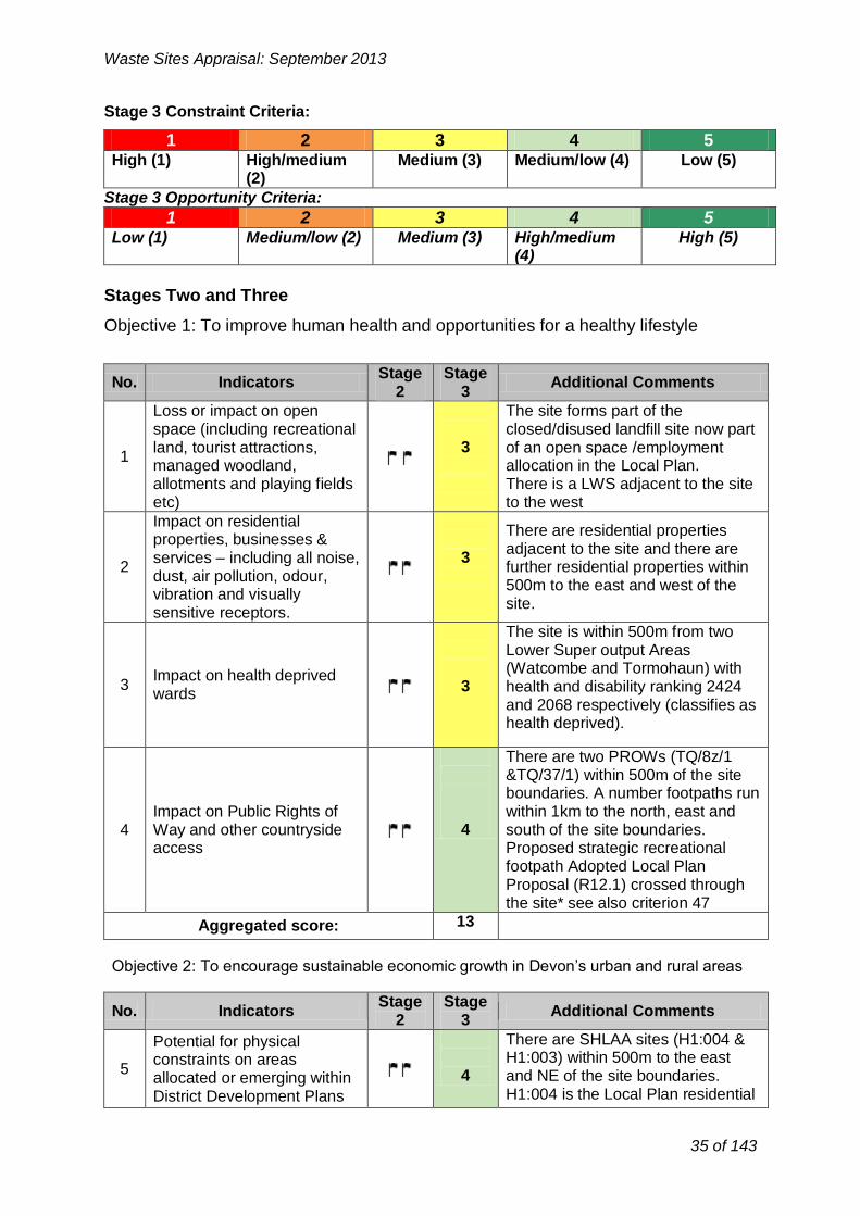
Stages Two and Three
Objective 1: To improve human health and opportunities for a healthy lifestyle
1
No.
land, tourist attractions, managed woodland, allotments and playing fields etc)
Indicators
Loss or impact on open space (including recreational
Stage 2
3
Stage 3
of an open space /employment allocation in the Local Plan. There is a LWS adjacent to the site to the west
Additional Comments
The site forms part of the closed/disused landfill site now part
2 services – including all noise, dust, air pollution, odour, vibration and visually sensitive receptors.
Impact on residential properties, businesses &
3 adjacent to the site and there are further residential properties within 500m to the east and west of the site.
There are residential properties
3 Impact on health deprived wards
3
The site is within 500m from two Lower Super output Areas (Watcombe and Tormohaun) with health and disability ranking 2424 and 2068 respectively (classifies as health deprived).
There are two PROWs (TQ/8z/1 &TQ/37/1) within 500m of the site
4 access
Impact on Public Rights of Way and other countryside
Aggregated score:
4
13
Proposed strategic recreational footpath Adopted Local Plan Proposal (R12.1) crossed through the site* see also criterion 47
boundaries. A number footpaths run within 1km to the north, east and south of the site boundaries.
Objective 2: To encourage sustainable economic growth in Devon’s urban and rural areas
35 of 143

for housing, tourism or allocation H1.4 (The ‘Beechfield’ recreation development has Planning
Permission and 144 dwellings are currently under construction).
There are a number of SHLAA sites within 1km of the site boundaries.
The area immediately abutting is allocated (Local Plan Policies R4.1
&R3.1 for sports/recreational use and R7.4 amenity POS Policy
R12.1)
6
Impact upon proposed Mineral Safeguarding Area
or adopted Mineral Consultation Area
-
5
The site is not within proposed Mineral Safeguarding Area or adopted Mineral Consultation Area.
Conflict with utilities No conflict with utilities 7 infrastructure (electricity, gas - 5 infrastructure and therefore there is
and water) no risk of harm.
Conflict with Aerodrome
8 Safeguarding Areas, MOD Safeguarding Areas and Cobbacombe Cross
5
The site is outside safeguarded areas and therefore there is no risk
of harm. (weather radar) Areas
Aggregated score: 19
No. Indicators Stage
2 Stage
3 Additional Comments
Capacity of existing
9 transportation network to 3 Limited, and requires modelling 8 deal with additional traffic
Undesirable given potential congestion along Barton Road and
Implication of potential 3 at Sainsbury’s and Riviera Way
10 routing of waste to site on junctions at peak times.
highway network
Residential character of the area also encourages more vulnerable road users onto network
Aggregated score: 6
Waste Sites Appraisal: September 2013
Objective 3: To reduce the mileage of waste transported by road whilst promoting the use of more sustainable modes of transport
8 *Between 4 and 50 vehicle movements per day. See DCC methodology Appendix 4 for
likely scale of staff and transport movements.
36 of 143

Stage Stage No. Indicators Additional Comments
2 3
Impact on Special Areas for There is no international
Conservation (SAC), Special 11 - designation within 1km of the site
Protection Areas (SPA) or 5 boundaries.
Ramsar sites
Impact on South Hams Special Area for
There are no bat strategic flyways Conservation (SAC) greater 5
12 - or sustenance zones within 1km of horseshoe bat strategic
the site boundaries. flyways and sustenance
zones
There is no NNR within 1km of the Impact on biological Sites of site and therefore there is no risk of Special Scientific Interest 4 harm But one geological SSSI
13 (SSSI), National Nature (Lummaton Quarry) within 1km of Reserves (NNR) or Local the site. However there is little risk
Nature Reserve. of harm
Impact on County Wildlife No CWS are within 1km of the site 5 14 Sites or non designated boundaries
nature reserve
Impact on Strategic Nature There is no SNA within 1km of the
15 5 Areas (SNA) site boundaries.
The site is within 2km of Cirl bunting feeding zone. Other protected species have been 4 recorded within 500m and 1km of
Impact on legally protected 16 the site boundaries. and BAP priority species
Project level survey would be required to ascertain the presence
of cirl bunting and inform suitable mitigation measures.
There are no ancient woodlands Potential to lead to loss or 5 17 - within 1km of the site and therefore
damage of ancient woodland there is no risk of harm.
Impact upon Biodiversity Priority habitats broadleaved
18 Action Plan (BAP) priority woodlands is within 1km of the site 4 habitats boundaries.
The site does not contain any trees with TPOs. And there are no TPOs
Impact on Tree Preservation 19 - 5 within 100m of the site.
Orders (TPOs) at site Development on this site would not
impact upon TPOs.
Aggregated score:
42
Waste Sites Appraisal: September 2013
37 of 143

No. Indicators
Stage 2
Stage 3
Additional Comments
20 Impact on the Jurassic Coast
World Heritage Site (WHS) -
- N/A
21 Impact on a Regionally
Important Geological Site -
5
There is no Regionally Important Geological Site within 1km of the
site.
22 Impact on a geological Site
of Special Scientific Interest (SSSI)
-
5
Lummaton Quarry SSSI is within 1km of the site to the east however
the risk of harm is unlikely.
Aggregated score: 10
No. Indicators
Stage 2
Stage 3
Additional Comments
23
Potential impact on agricultural land (avoiding
the use of Grades 1, 2 and 3a)
-
5
The site is on a former landfill site identified as non-agricultural.
24 Proximity to areas of
contaminated land
3
The site on and adjacent to Barton Valley Landfill Sites to the north
west of the site. There is a potential for
contamination due to former waste management use. Accordingly any
waste proposal would require further assessment.
25 Proximity to areas of land
instability -
3
The site forms part of the closed/ disused Barton Valley landfill site
and there may be issues associated with land instability. However
further assessment is needed to determine this in detail if the site
have been considered for recovery facility.
26
Impact on North Devon’s Biosphere Reserve
- - N/A
Aggregated score: 11
Waste Sites Appraisal: September 2013
Objective 5: To protect geodiversity
Objective 6: To improve the quality and usability of the best and most versatile land and soil
38 of 143

No. Indicators
Stage 2
Stage 3
Additional Comments
Impact on Areas of The site is not within AONB or NP. 27 Outstanding Natural Beauty 5 South Devon AONB is not within
(AONB) and/or National Park 5km visual range of the site.
28
Impact on Coastal Preservation Areas, undeveloped coast and
heritage coast
5
The site is outside of CPA and undeveloped coast and therefore
there is no risk of harm.
29 Impact on landscape
character and quality
5
The site is located within Landscape Character Type 9: main
cities and towns.
The site is located within an area 30 Impact on dark skies 4 recognise d as brighter.
Aggregated score: 19
No. Indicators Stage
2 Stage
3 Additional Comments
Barton Road Cemetery, registered
31 Impact upon Registered
Historic Parks and Gardens including setting
4
historic park and garden, lies on the cusp of 500m and within 1km to the south of the site boundaries. Waste
development in this site is unlikely to impact on this heritage asset.
32 Impact on registered
battlefields including setting -
5
N/A
33
Impact on Scheduled Ancient Monuments (SAM)
and archaeology of equivalent status (including
setting)
-
5
There are no SAM within 1km of the site boundary and therefore there is
no risk of harm.
Impact on Cornwall and
34 West Devon Mining
Landscape World Heritage
5 No risk of harm due to the distance involved.
Site and setting The Grade II* Brunel Atmospheric Pumping House lies 680m to the south west; the Grade II parish
35 Impact on Grade I / II* and II
listed buildings including setting
4
church of Barton, St Martin’s lies 400m east; The Grade II* Old Manor Farm House lies 460m to the
northeast; the Grade II Torbay Hospital Chapel lies 920m
southwest. Waste development in this site
Waste Sites Appraisal: September 2013
Objective 7: To sustain and enhance the valued and distinctive character and quality of Devon's landscape.
Objective 8: To improve the setting and integrity of the historic environment
39 of 143

No. Indicators
Stage 2
Stage 3
Additional Comments
The site is located within 1km of Aller Brook watercourse (classified as main river). In addition there is
Proximity and impact upon 4 River Fleet (ordinary river) just 38 surface water bodies and outside the 1km buffer zone.
surface water courses Development and associated infrastructure in the area should not
increase runoff into local watercourses.
Aggregated score: 4
No. Indicators Stage
2 Stage
3 Additional Comments
Proximity and impact on
39 public or private water
sources (ground and surface -
5 The site is not within groundwater source protection zone.
water)
Aggregated score:
5
Waste Sites Appraisal: September 2013
would have no direct impacts on listed buildings. Possible impacts on setting need to be assessed at planning application stage.
36
Potential loss of or damage to non-designated heritage assets (including locally listed buildings, locally listed parks and gardens and archaeology)
-
There are a number of post-medieval monuments recorded on the HER whose significance is unlikely to be affected by a waste site. There are no other known archaeological sites within the 500m or 1km buffer zones of significance.
5
37 Impact on Conservation Areas
There are Barton Conservation Areas lies to the NE within 1km of the site. However it is not anticipated that this development would impact upon the CA
4
Aggregated score: 32
Objective 11: To maintain or improve the quality of ground, river and sea waters
Objective 12: To improve the amount of ground and surface waters available for abstraction for other, non-waste management uses
40 of 143

No. Indicators
Stage 2
Stage 3
Additional Comments
There is flood zone 3 is within 1km
40 Proximity to and impact upon
Flood Zones 2 and 3 -
5 to the west and NW of the site and additional flood zone 3
approximately 1.2km of the site to the east.
41 Impact upon ground water
vulnerability
4
There is little risk of groundwater flooding in the site or within 1km of
the site boundaries
The site itself is not located in a
42 Impact upon surface water
9 vulnerability -
5
surface water flood area. There is however a potential surface water
flooding within500m to the SE of the site boundaries.
There has been no historic flooding 43 Historic flooding vulnerability - 5 within the site or in the immediate
surroundings.
Aggregated score: 19
No. Indicators Stage
2 Stage
3 Additional Comments
The site is located within an area
45 Impact on level of tranquillity
at site -
5 considered for having Low tranquillity due to proximity to
A3022 and urban area.
Aggregated score: 5
Waste Sites Appraisal: September 2013
Objective 13: To reduce the risk of flooding (including coastal flooding)
Objective 14: To improve air quality
No.
44
Stage Stage Indicators Additional Comments
2 3
Impact on Air Quality Management Areas (including proposed)
3
The Hele Road AQMA lies within 1km to the south of the site. A waste facility in this site could have an impact on the existing AQMA in the Hele Road.
Aggregated score: 3
Objective 15: To reduce the impact of noise and vibration on tranquillity
Aggregated Stage 3 Score for constraints criteria: 188
41 of 143

-
No. Indicators Stage
2 Stage
3 Additional Comments
Not currently in industrial use. Adopted Local Plan Allocated
- 3 Employment Site E1.4 . Former
46 Located within existing
10 industrial estate
landfill site adjacent to Barton Hill Way industrial units including
Electricity Sub Station, Coach Depot, Skip Hire and former gas holder site. One unit is now used a
sports club facility.
Allocated Employment site E1.4 in the Adopted Local Plan for B1 (high
Alignment with District DPD profile, high quality office/ tech use)
47 (Development Plan)
allocation for employment land (B2 or B8)11
3 with strategic landscaping. Within Area SDT1 Focus Area for Strategic
Delivery in emerging new Local Plan. Torquay aim of providing 375
jobs PA.
48 Site within previously
developed land
5
Good opportunity to reuse and restore Previously Developed Land (former landfill site)
Potential to restore, or utilise
49 unrestored land at former 1 Not a former quarry site quarries
Aggregated score: 12
No. Indicators
Stage 2
Stage 3
Additional Comments
50 Potential for alternative
modes of transport (rail or water)
3
A new Railway Station is safeguarded in the Adopted Local
Plan (Policy T14) at Kerswell Gardens within 1km of the site.
The SDLR is currently under construction and terminates at Kerswell Roundabout (completed 2015) just beyond the 1km buffer to
51 Access to the strategic road network
the SW. Access to the Strategic Road Access via Browns Bridge Road (Policy T18 District
2
Distributor) to Riviera Way (Policy
T20) part of the Major Road Network (approx 800-1km from the
site).
Waste Sites Appraisal: September 2013
Opportunity Criteria
Objective 2: To encourage sustainable economic growth in Devon’s urban and rural areas
Objective 3: To reduce the mileage of waste transported by road whilst promoting the use of more sustainable modes of transport
10 Not applicable for consideration of landfill or land raise sites
11 Not applicable for consideration of landfill or land raise sites
42 of 143

No. Indicators Stage
2 Stage
3 Additional Comments
52 Ability to export electricity
and/or gas to the national grid
SWEEG assessment of site (2006) identified: Housing planned with
district heating potential. HV (132kV) grid 150m and 11kV
underground cables on site boundary. On old landfill site (extra
cost?).
4
53 Ability to export heat to local
user
Housing closet proximity constructed/ Beechfield (H1.4)
under construction but still potential for district heating. Torbay Hospital
with 1km. SWEEG 2006 Assessment identified Torbay
Hospital heat and electricity load. Proximal to existing boilers.
Hospital redevelopment programme planned.
4
Aggregated score: 8
Waste Sites Appraisal: September 2013
Reasonable re road type, difficult re traffic volumes at peak times and nature of road re residential
Aggregated score: 5
Objective 10: To reduce total waste arisings and the proportion of waste disposed in landfill
Aggregated Stage 3 Score for opportunity criteria: 25
Stage 4: Consideration of cumulative impacts
The site is located in proximity to a number of areas which have been identified for potential development within the emerging Torbay Local Plan and therefore there may be potential for cumulative impacts.
Stage 5: Summary of Site Appraisal for Barton Employment Allocation
There are some constraints such as are land contamination, land instability and air quality issues associated with development of the site as a recovery facility. The site is also in proximity to a large residential area, particularly health deprived wards. The site is allocated for employment use and would re-use previously developed land. However, the employment site forms part of an important economic drive to deliver 375pa in Torquay and is currently being promoted for employment/commercial use. The site has potential to provide opportunities for district heating and is well located to road network the potential rail network access. However the very close proximity of residential properties overlooking the site and the allocated recreation space immediately adjacent are recognised as a conflicting uses.
43 of 143

Waste Sites Appraisal: September 2013
There may be unacceptable amenity impacts on a strategic waste facility.
Recommendation:
The site has potential but is a strategic employment delivery site in the Local Plan close to residential properties and allocated recreational facilities. The site should not be taken forward for further consideration in the Local Plan.
44 of 143

Waste Sites Appraisal: September 2013
Occombe Farm, Preston Down Road, Paignton
Site Location Plan (Scale 1:10, 00)
45 of 143

Waste Sites Appraisal: September 2013
Stage One: General Description of Site
Site Details
Site address: Occombe Farm, Preston Down Road, Paignton, Devon (TQ3 1RN)
OS Grid Reference: SX 8662
District: Torbay
Parish: N/A Cockington with Chelston Ward
Total site area (Ha): 1.2ha
Current land use(s)
The site forms part of the Occombe Farm Operation run by TCCT. Owned by TBC. The site has consent for Agricultural use/buildings for food fuel storage. The Trust envisages that this use will continue for the foreseeable future. The Land forms part of a Local Nature Reserve and Local Wildife site.
Historical land use(s) Farm Land
Adjacent land use(s)
The site lies on the western fringe of Paignton Town adjacent to the Western Corridor (Ring Road) and Preston Down Road.
The site was previously farm land and forms part of the Occombe Farm operation run by Torbay Coast and Countryside Trust as a Farm shop, café, educational and visitor facility (permitted in 2006). It currently has agricultural buildings storing wood fuel (chipped timber). The site is owned by Torbay Council but leased to the Trust. Planning permission for construction of timber storage building to store chipped timber (P/2010/1295) refers. This lies adjacent to two farm building permitted in May 2009 (P/2009/0436).
The public highway lies on the southern frontage with a few residential properties within 50m. The Occombe farm visitor complex abuts to the east. The wider farm LN R and SSSI lie to the northern and eastern frontages.
The main land uses within 500m include the residential suburban fringe of Paignton, Burrow Farm Facility. Occombe Community Growing Project and Occombe Valley Woods (POS) to the south of Preston Down Road. Planning Consent has recently been given to Sutton Seeds on land to the east of the Occombe Farm Car Park Preston Down Road (P/2012/0869) for vehicle entry and erection of packing shed, glasshouse and poly-tunnel and horticultural trial ground.
Relevant planning history: To be completed see above.
46 of 143
Waste Sites Appraisal: September 2013
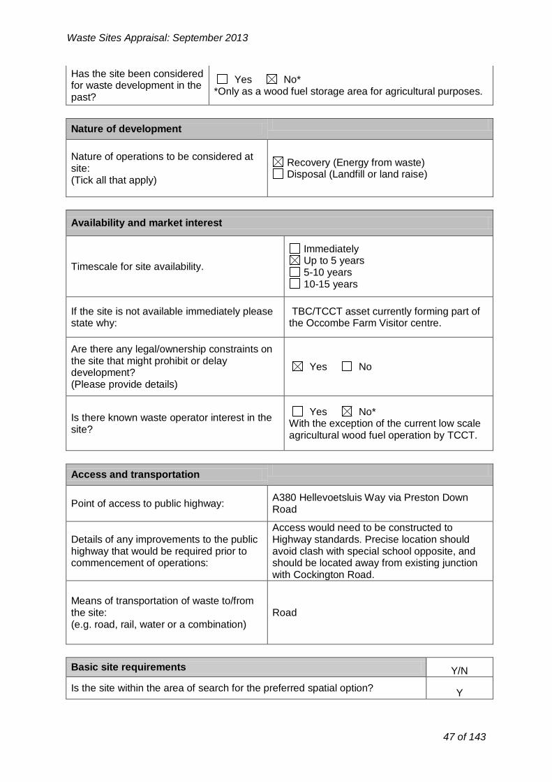
Has the site been considered Yes No*
for waste development in the *Only as a wood fuel storage area for agricultural purposes.
past?
Nature of development
Nature of operations to be considered at Recovery (Energy from waste)
site: Disposal (Landfill or land raise)
(Tick all that apply)
Availability and market interest
Immediately Up to 5 years
Timescale for site availability. 5-10 years 10-15 years
If the site is not available immediately please TBC/TCCT asset currently forming part of state why: the Occombe Farm Visitor centre.
Are there any legal/ownership constraints on the site that might prohibit or delay
Yes No development? (Please provide details)
Yes No* Is there known waste operator interest in the
With the exception of the current low scale site?
agricultural wood fuel operation by TCCT.
Access and transportation
A380 Hellevoetsluis Way via Preston Down Point of access to public highway:
Road
Access would need to be constructed to Details of any improvements to the public Highway standards. Precise location should highway that would be required prior to avoid clash with special school opposite, and commencement of operations: should be located away from existing junction
with Cockington Road.
Means of transportation of waste to/from the site: Road (e.g. road, rail, water or a combination)
Basic site requirements Y/N
Is the site within the area of search for the preferred spatial option? Y
47 of 143
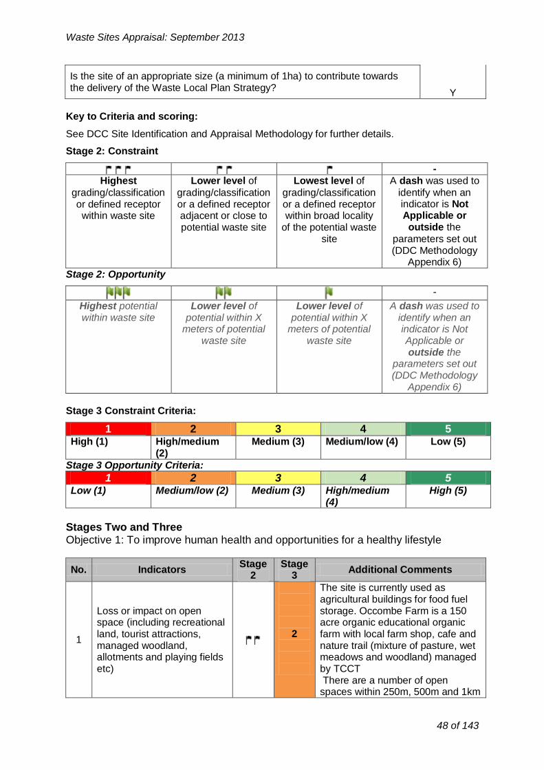
-
Highest Lower level of Lowest level of A dash was used to
grading/classification grading/classification grading/classification identify when an or defined receptor or a defined receptor or a defined receptor indicator is Not
within waste site adjacent or close to within broad locality Applicable or
potential waste site of the potential waste outside the
site parameters set out (DDC Methodology
Appendix 6)
Waste Sites Appraisal: September 2013
Is the site of an appropriate size (a minimum of 1ha) to contribute towards the delivery of the Waste Local Plan Strategy?
Y
Key to Criteria and scoring:
See DCC Site Identification and Appraisal Methodology for further details.
Stage 2: Constraint
Stage 2: Opportunity
-
Highest potential within waste site
Lower level of potential within X
meters of potential waste site
Lower level of potential within X
meters of potential waste site
A dash was used to identify when an indicator is Not Applicable or outside the
parameters set out (DDC Methodology
Appendix 6)
Stage 3 Constraint Criteria:
1 2 3 4 5 High (1) High/medium
(2) Medium (3) Medium/low (4) Low (5)
Stage 3 Opportunity Criteria:
1 2 3 4 5 Low (1) Medium/low (2) Medium (3) High/medium
(4) High (5)
Stages Two and Three Objective 1: To improve human health and opportunities for a healthy lifestyle
No.
1
Indicators
Loss or impact on open space (including recreational land, tourist attractions, managed woodland, allotments and playing fields etc)
Stage 2
Stage 3
2
Additional Comments
The site is currently used as agricultural buildings for food fuel storage. Occombe Farm is a 150 acre organic educational organic farm with local farm shop, cafe and nature trail (mixture of pasture, wet meadows and woodland) managed by TCCT There are a number of open
spaces within 250m, 500m and 1km
48 of 143

of the site boundaries.
2
Impact on residential properties, businesses &
services – including all noise, dust, air pollution, odour,
vibration and visually sensitive receptors.
3
The main land uses within 500m include the residential suburban
fringe of Paignton to the east (and Marldon to the West) with the
Burrow Farm Facility and Occombe Community Growing Project to the
south of Preston Down Road.
3 Impact on health deprived
wards -
5
There are no health deprived wards within 1km of the site and therefore
there is no risk of harm.
There is PROW (PN/15/1) within Impact on Public Rights of 250m to the south of the site
4 Way and other countryside 4 boundaries. Other footpaths run access within 1km to the north of the site
boundaries.
Aggregated score: 14
No. Indicators
Stage 2
Stage 3
Additional Comments
There is phase 2 SHLAA site (T831) within 500m to the east of the site boundaries. This SHLAA
5
Potential for physical constraints on areas
allocated or emerging within District Development Plans
for housing, tourism or recreation
3
site (north of Preston Down Road) is also identified as part of Policy SDP3 for residential development in
the emerging new Local Plan. Other phase 2 SHLAA site (T711) is within 1km to the south of the site
boundaries. Occombe Farm the allocated heritage Farm Country
Park (R10) in the Adopted Local Plan.
6
Impact upon proposed Mineral Safeguarding Area
or adopted Mineral Consultation Area
-
5
the site is not within proposed Mineral Safeguarding Area or adopted Mineral Consultation Area
Conflict with utilities No conflict with utilities 7 infrastructure (electricity, gas - 5 infrastructure and therefore there is
and water) no risk of harm.
Conflict with Aerodrome
8 Safeguarding Areas, MOD Safeguarding Areas and Cobbacombe Cross
5
The site is outside safeguarded areas and therefore there is no risk
of harm. (weather radar) Areas
Aggregated score: 18
Waste Sites Appraisal: September 2013
Objective 2: To encourage sustainable economic growth in Devon’s urban and rural areas
49 of 143

No. Indicators Stage
2 Stage
3 Additional Comments
The site is well located just off the
9 Capacity of existing
transportation network to deal with additional traffic
4 Western Corridor A380. The SDLR (under construction and due for
completion in 2015) should benefit
connectivity.
Implication of potential
4 The site is well located just off the
Western Corridor A380. The SDLR 10 routing of waste to site on (under construction and due for
highway network completion in 2015) should benefit connectivity
Aggregated score: 8
No. Indicators
Stage 2
Stage 3
Additional Comments
Impact on Special Areas for
11 Conservation (SAC), Special
Protection Areas (SPA) or -
5
There are no international designation within 1km.
Ramsar sites
Impact on South Hams
Special Area for South Hams SAC sustenance zone
12 Conservation (SAC) greater
horseshoe bat strategic -
5 is located within 1km to the SW of the site boundaries. Any impacts
flyways and sustenance are highly unlikely. zones
Occombe SSSI is located with Impact on biological Sites of 250m (100m) to the north of the site Special Scientific Interest 2 boundaries.
13 (SSSI), National Nature The NPPF (118) states that Reserves (NNR) or Local planning permission should be
Nature Reserve. refused for development resulting in the loss or degradation of SSSI.
The whole site forms part of a LNR. Occombe Woods CWS lies within
14 Impact on County Wildlife Sites or non designated
nature reserve
3
500m to the SW of the site boundaries. Ramshill (Westerland
Valley) CWS also lies within 1Km to the SE. Occombe Woods LWS is also located within 1km to the SW
of the site boundaries.
The whole site lies within woodland.
15 Impact on Strategic Nature
Areas (SNA) 3 This habitat should be incorporated
with any restoration plan post
project completion.
Waste Sites Appraisal: September 2013
Objective 3: To reduce the mileage of waste transported by road whilst promo ting the use of more sustainable modes of transport
Objective 4: To maintain or enhance Devon's wildlife
50 of 143

No. Indicators
Stage 2
Stage 3
Additional Comments
20 Impact on the Jurassic Coast
World Heritage Site (WHS) -
- N/A
21 Impact on a Regionally
Important Geological Site -
5
There is no Regionally Important Geological Site within 1km of the
site.
22 Impact on a geological Site
of Special Scientific Interest (SSSI)
-
5 There is no geological SSSI within
1km of the site.
Aggregated score: 10
No. Indicators Stage
2 Stage
3 Additional Comments
The site lies in a land classified as Grade 2 & 3a agricultural land.
23
Potential impact on agricultural land (avoiding
the use of Grades 1, 2 and
Development of the site would result in loss best and most
versatile agricultural land. However
2
3a) it should be noted that the site has consent for agricultural
use/buildings for food fuel storage.
Waste Sites Appraisal: September 2013
16 Impact on legally protected and BAP priority species 3
Protected species have been recorded within 250m and 500m of the site. Cril bunting has been recorded with 1km of the site. The whole site is within greater
crested newt 2km buffer zone. Project level survey would be required to ascertain the presence of protected species and inform suitable mitigation measures.
There is no ancient woodland within 1km of the site and therefore there is no risk of harm.
17 Potential to lead to loss or
- 5 damage of ancient woodland
18 Impact upon Biodiversity Action Plan (BAP) priority habitats
3
The site is located within farmland. Priority habitats broadleaved woodlands are within 500m of the sit.
The site does not contain any trees with TPOs. And there are no TPOs within 100m of the site. Development on this site would not impact upon TPOs.
19 Impact on Tree Preservation
- 5 Orders (TPOs) at site
Aggregated score: 34
Objective 5: To protect geodiversity
Objective 6: To improve the quality and usability of the best and most versatile land and soil
51 of 143

No. Indicators
Stage 2
Stage 3
Additional Comments
Impact on Areas of The site is not within AONB or NP. 27 Outstanding Natural Beauty 5 South Devon AONB is not within
(AONB) and/or Nation al Park 5km visual range of the site.
28
Impact on Coastal Preservation Areas, undeveloped coast and
heritage coast
5
The site is outside of CPA and undeveloped coast and therefore
there is no risk of harm.
The site is located within AGLV. It has been described in the TLCA as type 1 rolling farmland (1H
29 Impact on landscape
character and quality
3 Occombe Cross). The area is highly sensitive to development due to
existing uses e.g. Heritage Farm, intact landscape structure, and
visibility.
The site is located within an area 30 Impact on dark skies 4 recognise d as brighter.
Aggregated score: 17
No. Indicators Stage
2 Stage
3 Additional Comments
31 Impact upon Registered
Historic Parks and Gardens including setting
-
5
No Registered Historic Parks and Gardens present within 1km of the
site boundary therefore there is no risk of harm.
32 Impact on registered
battlefields including setting -
5
No registered battlefields present within 1km of the site boundary
therefore there is no risk of harm.
Waste Sites Appraisal: September 2013
24 Proximity to areas of contaminated land
- No contaminated land identified. 5
25 Proximity to areas of land instability
- -There is no information currently available.
26 Impact on North Devon’s Biosphere Reserve
- - N/A
Aggregated score: 7
Objective 7: To sustain and enhance the valued and distinctive character and quality of Devon's landscape.
Objective 8: To improve the setting and integrity of the historic environment
52 of 143

No. Indicators Stage
2 Stage
3 Additional Comments
Proximity and impact on
39 public or private water
sources (ground and surface -
5 The site is not within groundwater source protection zone.
water)
Aggregated score:
5
Waste Sites Appraisal: September 2013
33
Impact on Scheduled Ancient Monuments (SAM) and archaeology of equivalent status (including setting)
-There is no SAM within 1km of the site boundary therefore there is no risk of harm.
5
34
Impact on Cornwall and West Devon Mining Landscape World Heritage Site and setting
No risk of harm due to the distance involved.
5
35 Impact on Grade I / II* and II listed buildings including setting
-The Grade II listed Paignton Windmill lies 850m due south.
5
36
Potential loss of or damage to non-designated heritage assets (including locally listed buildings, locally listed parks and gardens and archaeology)
-
There will be a number of archaeological sites 400m west within the DCC area – details on DCC HER
4
37 Impact on Conservation Areas
-There are no conservation areas within 1km of the site boundaries. No risk of harm.
5
Aggregated score: 34
Objective 11: To maintain or improve the quality of ground, river and sea waters
No.
38
Stage Stage Additional Comments Indicators
2 3
Proximity and impact upon surface water bodies and surface water courses
3
The site is adjacent to Occombe Valley watercourse. Development and associated infrastructure in the area should not increase runoff into local watercourses
Aggregated score: 3
Objective 12: To improve the amount of ground and surface waters available for abstraction for other, non-waste management uses
53 of 143

No. Indicators
Stage 2
Stage 3
Additional Comments
There is flood zone 3 adjacent to the NE and SE of the site 4 boundaries. Further flood zone 3 is
40 Proximity to and impact upon
Flood Zones 2 and 3 -
within 1km to the NW of the site boundaries.
Increased flood flows may cause contamination in terms of
suspended solid and even litter.
41 Impact upon ground water
vulnerability -
5
There no risk of groundwater flooding in the site or within 1km of
the site boundaries.
The site itself is not located in a
42 Impact upon surface water
12 vulnerability
5
surface water flood area. There is however a potential surface water
flooding within1km to the east of the site boundaries.
There has been no historic flooding 43 Historic flooding vulnerability - 5 within the site or in the immediate
surroundings.
Aggregated score: 19
No. Indicators Stage Stage
Additional Comments 2 3
44 Impact on Air Quality
Management Areas (including proposed)
-
There is no AQMA within 1km of the site boundaries.
5
Aggregated score:
5
No. Indicators
Stage 2
Stage 3
Additional Comments
The site is located within an area
45 Impact on level of tranquility
at site -
5 considered for having Low tranquility. The A380 is a particular
source of noise.
Aggregated score: 5
Waste Sites Appraisal: September 2013
Objective 13: To reduce the risk of flooding (including coastal flooding)
Objective 14: To improve air quality
Objective 15: To reduce the impact of noise and vibration on tranquillity
Aggregated Stage 3 Score for constraints criteria: 179
Locally agreed surface water information is available for Great Torrington, Tavistock, Teignmouth, Horrabridge & Yelverton, Rockbeare and Ottery St Mary (assessed using Areas Susceptible to Surface Water Flooding). Therefore, this more locally specific data will be used at Stage Two for potential sites within areas.
54 of 143
12

No. Indicators Stage
2 Stage
3 Additional Comments
52 Ability to export electricity
and/or gas to the national grid
-
Site is beyond 1km of electricity and gas grid
1
53 Ability to export heat to local
user
2
Potential to export to Occombe Farm facility. SDP3 Allocation May
provide further opportunity for CHP
Aggregated score: 3
Waste Sites Appraisal: September 2013
Opportunity Criteria
Objective 2: To encourage sustainable economic growth in Devon’s urban and rural areas
No.
46
Stage Stage Indicators Additional Comments
2 3
Located within existing industrial estate13
-
1
Site currently could be construed as industrial however wood fuel storage operation is currently restricted to farm agricultural purposes
47 Alignment with District DPD allocation for employment land (B2 or B8)14
-1
Ste not identified for employment use.
48 Site within previously developed land
- 1 Agricultural buildings and uses do not count as PDL.
49 Potential to restore, or utilise unrestored land at former quarries
- 1
Not a former quarry
Aggregated score: 3
Objective 3: To reduce the mileage of waste transported by road whilst promoting the use of more sustainable modes of transport
No.
50
Stage Stage Additional Comments Indicators
2 3
Potential for alternative modes of transport (rail or water)
1 No potential for alternative modes of transport
51 Access to the strategic road network
4 Good access to strategic road network
Aggregated score: 5
Objective 10: To reduce total waste arisings and the proportion of waste disposed in landfill
13 Not applicable for consideration of landfill or land raise sites
14 Not applicable for consideration of landfill or land raise sites
55 of 143

Waste Sites Appraisal: September 2013
Aggregated Stage 3 Score for opportunity criteria: 12
Stage 4: Consideration of cumulative impacts
The Local Plan Policies SDT4 and SDP3 will have a significant level of growth in the area during the plan period. As a result, there are likely to be development impacts and there may be potential for cumulative impacts in relation to transportation, biodiversity, flood risk and increased green house emissions.
Stage 5: Summary of Site Appraisal for Occombe Farm:
The site functions well as a wood fuel storage at the relatively small agricultural scale however a commercial biomass/recovery facility is likely to have unacceptable harm to biodiversity (SSSI) , landscape and leisure (recreational) use of Occcombe Farm.
The site scores generally well through the appraisal process and has good access to the Strategic road newtork. It has scored high/medium risk of harm for two indicators: This includes risk of harm to Occombe SSSI and loss of agricultural land Grade 2&3a. There are some constraints associated with the site in relation to impact upon landscape character, surface water bodies, priority habitats and species and Strategic Nature Areas.
Whilst the small scale, rural wood fuel operation functions in a complementary way to the overall Occombe Farm facility (part of a Local Nature Reserve). A strategic recovery facility would conflict with existing and emerging policies in the Local Plan for the protection of biodiversity, landscape and rural setting.
Recommendation:
The site should not be taken forward for further consideration in the Local Plan.
56 of 143

Waste Sites Appraisal: September 2013
Claylands, Brixham Road, Paignton
Site Location Plan (Scale 1:10,000)
57 of 143

Waste Sites Appraisal: September 2013
Stage One: General Description of Site
Site Details
Site address: Claylands. Paignton
OS Grid Reference: SX 8759
District: Torbay
Parish: N/A Goodrington with Roselands Ward
Total site area (Ha): 5.5ha
Current land use(s)
The site forms a disused ‘inert’ landfill site now part of an open storage site now closed. Owned by TBC The site has contaminated land issues and work has been in progress with EH and EA to remediate. The site is not required for the operational use of TOR2. The TDA are promoting this site for future employment use and seeking funding to assist with the delivery of the site.
Historical land use(s) Former quarry and landfill site.
Adjacent land use(s)
The site lies on the western fringe of Paignton Town adjacent to the Western Corridor (Ring Road) and close to a major junction Tweenaway Cross (approximately (300m south).
The site has been previously used as an inert land fill site and is still owned by Torbay Council.
There are EA & EH licensing issues relating to land stability and contamination.
The public highway lies on the western frontage with a number of residential properties within 50m (Battersway Road on the northern frontage and Harbourne Avenue to the South). Paignton Zoo and Morrirson’s supermarket car park about the northern and eastern frontages.
The main land uses within 500m include the residential suburban fringe of Paignton, Paignton Community and Sports College, Paignton Zoo and Morrison’s Supermarket. A Booker wholesale and new supermarket lie on the westertn side of the ring road. Yalberton Industrial estate lies within the 500m including the existing Torbay HWRC and Waste Transfer Station run by Tor2 (the main Municipal facility in Torbay.
Relevant planning history: 2007/0186/EN
Has the site been considered for waste development in the past?
Yes * No *SWEEG Study 2006
58 of 143

Nature of development
Nature of operations to be considered at site: Recovery (Energy from waste) (Tick all that apply) Disposal (Landfill or land raise)
Availability and market interest
Immediately Up to 5 years
Timescale for site availability. 5-10 years 10-15 years
If the site is not available immediately please TDA asset based promotion for state why: e
Are there any legal/ownership constraints on
mployment use?
the site that might prohibit or delay
development? Yes No
(Please provide details)
Yes No Is there known waste operator interest in the
site?
Access and transportation
Point of access to public highway: A3022 Brixham Road (opposite KFC)
Details of any improvements to the public highway that would be required prior to
commencement of operations:
Brixham Road to be upgraded to dual carriageway – new access will need to be from
new signalised crossing at existing traffic lights, at their expense
Means of transportation of waste to/from the site: Road
(e.g. road, ra il, wa ter o r a com bination)
Waste Sites Appraisal: September 2013
Basic site requirements Y/N
Is the site within the area of search for the preferred spatial option? N
Is the site of an appropriate size (a minimum of 1ha) to contribute towards the delivery of the Waste Local Plan Strategy?
Y
59 of 143

-
Highest Lower level of Lowest level of A dash was used to
grading/classification grading/classification grading/classification identify when an or defined receptor or a defined receptor or a defined receptor indicator is Not
within waste site adjacent or close to within broad locality Applicable or
potential waste site of the potential waste outside the
site parameters set out (DDC Methodology
Appendix 6)
-
Highest potential Lower level of Lower level of A dash was used to within waste site potential within X potential within X identify when an
meters of potential meters of potential indicator is Not waste site waste site Applicable or
outside the parameters set out
(DDC Methodology Appendix 6)
No. Indicators Stage
2 Stage
3 Additional Comments
1
Loss or impact on open space (including recreatio
land, tourist attractions, managed woodland,
allotments and playing fiel etc)
nal
ds
4
Paignton Zoo and Clennon woods (CWS) lie within 500m to east and
SE of the site respectively. Primley woods (LWS) lies within
1km to the NE of the site. Paignton Zoo lies within 250m.
2
Impact on residential properties, businesses &
services – including all noise, dust, air pollution, odour,
vibration and visually sensitive receptors.
2
The site is adjacent to residential suburban fringe of Paignton, Paignton Community and Sports
College and Morrison’s Supermarket. A Booker wholesale
and new supermarket lies on the eastern side of the ring road.
Yalberton Industrial estate lies
Waste Sites Appraisal: September 2013
Key to Criteria and scoring:
(See DCC Site Identification and Appraisal Methodology for further details).
Stage 2: Constraint
Stage 2: Opportunity
Stage 3 Constraint Criteria:
1 2 3 4 5 High (1) High/medium
(2) Medium (3) Medium/low (4) Low (5)
Stage 3 Opportunity Criteria:
1 2 3 4 5 Low (1) Medium/low (2) Medium (3) High/medium
(4) High (5)
Stages Two and Three Objective 1: To improve human health and opportunities for a healthy lifestyle
60 of 143

No. Indicators
Stage 2
Stage 3
Additional Comments
5
Potential for physical constraints on areas
allocated or emerging within District Development Plans
for housing, tourism or recreation
4
There are SHLAA sites (T705, T827&T826) H1.15 (Zoo overflow
car park, also allocated in the adopted Local Plan) within 500m to
the west of the site. Other SHLAA sites (T755, T737 &T854) are within
1km of the site.
6
Impact upon proposed Mineral Safeguarding Area
or adopted Mineral Consultation Area
-
5
The site is not within proposed Mineral Safeguarding Area or adopted Mineral Consultation Area
Conflict with utilities No conflict with utilities 7 infrastructure (electricity, gas - 5 infrastructure and therefore there is
and water) no risk of harm.
Conflict with Aerodrome
8 Safeguarding Areas, MOD Safeguarding Areas and
5 The site is outside safeguarded areas and therefore there is no risk
Cobbacombe Cross of harm. (weather radar) Areas
Aggregated score: 19
No. Indicators Stage
2 Stage
3 Additional Comments
9 Capacity of existing
transportation network to
5
Good, but capacity may be an issue from 2021 depending on number of
deal with additional traffic trips likely to be generated
Implication of potential With new dual carriageway, 10 routing of waste to site on 5 capacity should be ok depending on
highway network no. of trips
Waste Sites Appraisal: September 2013
within the 500m including the existing Torbay HWRC and Waste Transfer Station run by Tor2. Paignton Zoo lies within 250m.
3 Impact on health deprived wards
The site is within 1km of a Lower Super output Area with health and disability ranking 10095 (not classifies as health deprived).
4
There is PROW (PN/2/1) within 250m of the site. Other footpaths (PN/1, PN /5/1, PN/3/1 & PN/11/1) run within 1km to the north of the site.
Impact on Public Rights of 4 Way and other countryside 4
access
Aggregated score: 14
Objective 2: To encourage sustainable economic growth in Devon’s urban and rural areas
Objective 3: To reduce the mileage of waste transported by road whilst promoting the use of more sustainable modes of transport
61 of 143

Stage Stage No. Indicators Additional Comments
2 3
Impact on Special Areas for
Conservation (SAC), Special There are no international 11 -
Protection Areas (SPA) or 5 designation within 1km. Ramsar sites
Impact on South Hams The whole site is within South Special Area for Hams SAC sustenance zone.
Conservation (SAC) greater 4 The eastern part of the site is within 12 horseshoe bat strategic 250m bat flyway buffer.
flyways and sustenance A bat survey will be required at the zones project level.
Impact on biological Sites of Special Scientific Interest
There are no SSSI, NNR or LNR 13 (SSSI), National Nature - 5
within 1km of the site. Reserves (NNR) or Local
Nature Reserve.
Clennon woods (CWS) lies within 500m to SE of the site.
Impact on County Wildlife Primley woods (LWS) lies within 14 Sites or non designated 4 1km to the NE of the site. Paigton
nature reserve Zoo grounds also forms part of a LWS (OSWI) broadleaved
woodland and scrub with ponds)
There the whole site is located 3 within woodland. This habitat
Impact on Strategic Nature 15 should be incorporated with any
Areas (SNA) restoration plan post project completion.
The site is within 2km of cirl bunting feeding zone. Protected species have been recorded within 250m, 3 500m and 1km of the site.
Impact on legally protected 16 Project level survey would be and BAP priority species
required to ascertain the presence of protected species and cirl
bunting and inform suitable mitigation measures
Potential to lead to loss or There is an area of ancient 17 4 damage of ancient woodland woodland within 250m of the site.
Impact upon Biodiversity There are no BAP priority habitats
18 Action Plan (BAP) priority - with 1km of the site and therefore
5 habitats there is no risk of harm.
The site does not contain any trees Impact on Tree Preservation with TPOs. And there are no TPOs
19 - Orders (TPOs) at site 5 within 100m of the site.
Development on this site would not
Waste Sites Appraisal: September 2013
Aggregated score: 10
Objective 4: To maintain or enhance Devon's wildlife
62 of 143

No. Indicators
Stage 2
Stage 3
Additional Comments
20 Impact on the Jurassic Coast
World Heritage Site (WHS) -
- N/A
21 Impact on a Regionally
Important Geological Site -
5
The site does not contain RIGS and there are no RIGS within 1km of the
site.
22 Impact on a geological Site
of Special Scientific Interest (SSSI)
-
5 There ar
1km of t e no geological SSSI within he site.
Aggregated score: 10
No. Indicators
Stage 2
Stage 3
Additional Comments
23
Potential impact on agricultural land (avoiding
the use of Grades 1, 2 and -
5
The site is classified as non- agricultural land. Development of
the site would not result in loss of 3a) agricultural land of Grade 1-3a.
The site is likely to be contaminated due to the historic use as a former Quarry and inert landfill.
24 Proximity to areas of
contaminated land
2 GIS data shows the site is within approximately 200m to the west of
a contaminated land. Further contaminated site is within 1km of
the site to the SE. Advice from the EA should be sought.
The historic use of the site as a former Quarry and inert landfill could cause potential land
25 Proximity to areas of land
instability
3
instability. This is likely to have more significant impact on the
potential to deliver recovery facility on the site. Further assessment
would be needed to determine this in detail.
26 Impact on North Devon’s
Biosphere Reserve -
- N/A
Aggregated score: 10
Waste Sites Appraisal: September 2013
impact upon TPOs.
Aggregated score: 38
Objective 5: To protect geodiversity
Objective 6: To improve the quality and usability of the best and most versatile land and soil
63 of 143

No. Indicators Stage Stage
Additional Comments 2 3
Impact on Areas of The site is not within AONB or NP. 27 Outstanding Natural Beauty 5 South Devon AONB is not within
(AONB) and/or Nation al Park 5km visual range of the site.
28
Impact on Coastal Preservation Areas, undeveloped coast and
5
The site is outside of CPA and undeveloped coast and therefore
there is no risk of harm. heritage coast
29 Impact on landscape
character and quality
5
The site is located within Landscape Character Type 9: main
cities and towns.
The site is located within an area 30 Impact on dark skies 4 recognise d as brighter.
Aggregated score: 19
No. Indicators
Stage 2
Stage 3
Additional Comments
31 Impact upon Registered
Historic Parks and Gardens including setting
-
5
No Registered Historic Parks and Gardens present within 1km of the
site boundary therefore there is no risk of harm.
32 Impact on registered
battlefields including setting -
5
No registered battlefields present within 1km of the site boundary
therefore there is no risk of harm.
Impact on Scheduled
Ancient Monuments (SAM) There are no SAM within 1km of the 33 and archaeology of - 5 site boundary therefore there is no
equivalent status (including risk of harm. setting)
Impact on Cornwall and
34 West Devon Mining
Landscape World Heritage
5
No risk of harm due to the distance involved.
Site and setting
There are 2 separate designated Grade II listed buildings 670m
35 Impact on Grade I / II* and II
listed buildings including setting
4
distance to the west: Collaton Farm and its Farmyard complex; the
Grade II listed Primley House lies 470m north. The Grade II listed 109
Totnes Road lies 600m to the northeast
Waste Sites Appraisal: September 2013
Objective 7: To sustain and enhance the valued and distinctive character and quality of Devon's landscape.
Objective 8: To improve the setting and integrity of the historic environment
64 of 143

36
Potential loss of or damage to non-designated heritage
assets (including locally listed buildings, locally listed
parks and gardens and archaeology)
5
The Great Park Leat, Utilised By The Medieval Bishops Of Exeter To
Bring Water To Paignton lies 700m north at its closest point. There are
no other known archaeological sites within the 500m or 1km buffer
zones of significance.
37 Impact on Conservation
Areas -
5
Nothing within 1km of the site boundaries.
No risk of harm.
Aggregated score: 34
No. Indicators Stage
2 Stage
3 Additional Comments
Proximity and impact on
39 public or private water
sources (ground and surface -
5 The site is not within groundwater source protection zone.
water)
Aggregated score:
5
No. Indicators Stage
2 Stage
3 Additional Comments
There is flood zone 3 adjacent to
40 Proximity to and impact upon
Flood Zones 2 and 3 -
4 the eastern boundary of the site. Another flood zone 3 is within 1km
to the west of the site.
41 Impact upon ground water
vulnerability
4
There is little risk of groundwater flooding in the site or within 1km of
the site boundaries.
Waste Sites Appraisal: September 2013
Objective 11: To maintain or improve the quality of ground, river and sea waters
No.
38
Stage Stage Additional Comments Indicators
2 3
Proximity and impact upon surface water bodies and surface water courses
3
The site is adjacent to Clennon Valley watercourse and within 500m of the Yalberton watercourse. Development and associated infrastructure in the area should not increase runoff into local watercourses
Aggregated score: 3
Objective 12: To improve the amount of ground and surface waters available for abstraction for other, non-waste management uses
Objective 13: To reduce the risk of flooding (including coastal flooding)
65 of 143

No. Indicators Stage
2 Stage
3 Additional Comments
According to the 2007 CPRE map,
45 Impact on level of tranquillity
at site -
5 the site is located within an area considered for having low
tranquillity (red on the GIS layer)
Aggregated score:
5
Waste Sites Appraisal: September 2013
42 Impact upon surface water vulnerability 15
3
There are small parts of the site vulnerable to surface water flooding. These parts are situated in the north and waste part of the site. Also to the east of the site boundary there is surface water flooding within 500m. Any associated infrastructure with development could increase the risk of surface water flooding. A surface water drainage strategy is required for all sites to deal with the surface water runoff generated by new development.
There has been no historic flooding within the site or in the immediate surroundings.
43 Historic flooding vulnerability 5
Aggregated score: 16
Objective 14: To improve air quality
No. Stage Stage
Additional Comments Indicators 2 3
There is no AQMA within 1km of the site boundaries.
44 Impact on Air Quality Management Areas -
5 (including proposed)
Aggregated score: 5
Objective 15: To reduce the impact of noise and vibration on tranquillity
Aggregated Stage 3 Score for constraints criteria: 188
Locally agreed surface water information is available for Great Torrington, Tavistock, Teignmouth, Horrabridge & Yelverton, Rockbeare and Ottery St Mary (assessed using Areas Susceptible to Surface Water Flooding). Therefore, this more locally specific data will be used at Stage Two for potential sites within areas.
66 of 143
15

No. Indicators
Stage 2
Stage 3
Additional Comments
46 Located within existing
16 industrial estate 4
Landfill site recently ceased operation.
Old Landfill site run by TBC as part of municipal waste operation now
closed. Whilst inert landfill testing reveals that site contamination
47 Alignment with District DPD allocation for employment
land (B2 or B8)17
-
3
occurred and methane monitoring required. TOR2 do not require site
for their operational uses. Site subject to EA Monitoring system.
Site Allocated in the Torbay Adopted Local Plan for recreational /Tourism, use. The TDA currently
have a project to redevelop the site for employment use.
48 Site within previously
developed land
5 Former landfill site with restoration requirements.
49 Potential to restore, or utilise
unrestored land at former quarries
4
Former quarry used for landfill. Site has restoration needs
Aggregated score: 16
No. Indicators
Stage 2
Stage 3
Additional Comments
50 Potential for alternative
modes of transport (rail or
1 None water)
51 Access to the strategic road network
4
Good. Direct access on to A3022 Brixham Road(Junction
improvements would be required)
Aggregated score: 5
Waste Sites Appraisal: September 2013
Opportunity Criteria
Objective 2: To encourage sustainable economic growth in Devon’s urban and rural areas
Objective 3: To reduce the mileage of waste transported by road whilst promoting the use of more sustainable modes of transport
16 Not applicable for consideration of landfill or land raise sites
17 Not applicable for consideration of landfill or land raise sites
67 of 143

No. Indicators Stage
2 Stage
3 Additional Comments
52 Ability to export electricity
and/or gas to the national grid
Electricity substation with 1km of site.
2
53 Ability to export heat to local
user 5 Paignton zoo within 250m of site.
Aggregated score: 7
Waste Sites Appraisal: September 2013
Objective 10: To reduce total waste arisings and the proportion of waste disposed in landfill
Aggregated Stage 3 Score for opportunity criteria: 28
Stage 4: Consideration of cumulative impacts
The site is located within an area which has been identified for future housing and employment development in the Local Plan. Policies SDP3 & SDP4 will have a significant level of growth in the area during the plan period. As a result, there are likely to be development impacts and there may be potential for cumulative impacts in relation to transportation, human health, flood risk and increased green house emissions.
Torpark Road and Yalberton Depot sites, lie within 500m of the site, are also being appraised through this process; therefore if the two or the three sites were to come forward for development, cumulative impacts assessment would be required.
Stage 5: Summary of Site Appraisal for Claylands:
The site has scored well for the majority of the 45 constraint indicators. Well located (within 250m) to the HWRC, there are constraints associated with land contamination and instability. The site is adjacent to residential area, industrial estate supermarket and Major Tourism facility (Paignton Zoo). It is also adjacent to Clennon Valley watercourse and within 500m of the Yalberton watercourse. There are small parts of the site considered to be vulnerable to surface water flooding.
The site provides an opportunity to export heat and is well located to the Torbay HWRC at Yalberton. However the site is currently allocated for Tourism use (TU2.1) and the TDA/TEDC have ambitions to redevelop and restore the site to bring forward for employment use. This would have the benefit of dealing with expensive site restoration requirements.
Recommendation:
Could be suitable for recovery; however site contamination issues and employment objectives that may override.
68 of 143

Waste Sites Appraisal: September 2013
Tor Park Road (Blackthorn Way), Yalberton Industrial Estate,
Paignton
Site Location Plan (Scale 1:10,000)
69 of 143
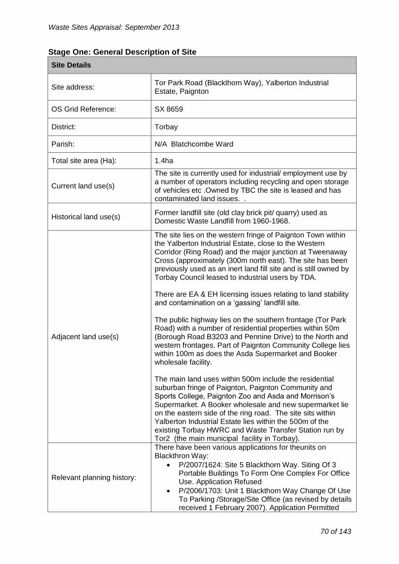
Waste Sites Appraisal: September 2013
Stage One: General Description of Site
Site Details
Site address: Tor Park Road (Blackthorn Way), Yalberton Industrial Estate, Paignton
OS Grid Reference: SX 8659
District: Torbay
Parish: N/A Blatchcombe Ward
Total site area (Ha): 1.4ha
Current land use(s)
The site is currently used for industrial/ employment use by a number of operators including recycling and open storage of vehicles etc .Owned by TBC the site is leased and has contaminated land issues. .
Historical land use(s) Former landfill site (old clay brick pit/ quarry) used as Domestic Waste Landfill from 1960-1968.
Adjacent land use(s)
The site lies on the western fringe of Paignton Town within the Yalberton Industrial Estate, close to the Western Corridor (Ring Road) and the major junction at Tweenaway Cross (approximately (300m north east). The site has been previously used as an inert land fill site and is still owned by Torbay Council leased to industrial users by TDA.
There are EA & EH licensing issues relating to land stability and contamination on a ‘gassing’ landfill site.
The public highway lies on the southern frontage (Tor Park Road) with a number of residential properties within 50m (Borough Road B3203 and Pennine Drive) to the North and western frontages. Part of Paignton Community College lies within 100m as does the Asda Supermarket and Booker wholesale facility.
The main land uses within 500m include the residential suburban fringe of Paignton, Paignton Community and Sports College, Paignton Zoo and Asda and Morrison’s Supermarket. A Booker wholesale and new supermarket lie on the eastern side of the ring road. The site sits within Yalberton Industrial Estate lies within the 500m of the existing Torbay HWRC and Waste Transfer Station run by Tor2 (the main municipal facility in Torbay).
Relevant planning history:
There have been various applications for theunits on Blackthron Way:
P/2007/1624: Site 5 Blackthorn Way. Siting Of 3 Portable Buildings To Form One Complex For Office Use. Application Refused
P/2006/1703: Unit 1 Blackthorn Way Change Of Use To Parking /Storage/Site Office (as revised by details received 1 February 2007). Application Permitted
70 of 143

P/2006/1702; Unit 4 Blackthorn Way Change Of Use To Store Empty Skips On Existing Prepared Site
(Retrospective). Application Permitted
P/2005/1190: Waste Land Blackthorn, Erection Of Buildings And Change Of Use To Waste Transfer
Station And Recycling Depot .Application Refused P/1989/0202: Part Site 36, Blackthorn Way. Siting Of
Portable Office And Storage Accommodation. Application Permitted
P/1988/1043: Site 37 Junc Blackthorn Way, Erection Of Portakabin And Use For Coach Parking,
Refueling, Cleaning With Bay For Routine Maintenance. Application Permitted
2005/0512/EN
2008/0188/EN
Has the site been considered for waste development in the Yes No
past?
Nature of development
Nature of operations to be considered at Recovery (Energy from waste)
site: Disposal (Landfill or land raise)
(Tick all that apply)
Availability and market interest
Immediately Up to 5 years
Timescale for site availability. 5-10 years 10-15 years
If the site is not available immediately please TBC/TDA asset leased and used for state why: industrial employment
Are there any legal/ownership constraints on the site that might prohibit or delay Yes* No
development? *Subject to existing occupied lease holders (Please provide details)
Yes No Is there known waste operator interest in the
site?
Access and transportation
A3022 and Borough Road B3203, Tor Park
Point of access to public highway: Road (unclassified) - must be strictly adhered
to and not use Borough Road from Totnes Road to avoid PCC
Waste Sites Appraisal: September 2013
71 of 143

-
Highest Lower level of Lowest level of A dash was used to
grading/classification grading/classification grading/classification identify when an or defined receptor or a defined receptor or a defined receptor indicator is Not
within waste site adjacent or close to within broad locality Applicable or
potential waste site of the potential waste outside the site parameters set out
(DDC Methodology Appendix 6)
Waste Sites Appraisal: September 2013
Details of any improvements to the public highway that would be required prior to commencement of operations:
Means of transportation of waste to/from the site: (e.g. road, rail, water or a combination)
Signing
Road
Basic site requirements Y/N
Is the site within the area of search for the preferred spatial option? N
Is the site of an appropriate size (a minimum of 1ha) to contribute towards the delivery of the Waste Local Plan Strategy?
Y
Key to Criteria and scoring:
See DCC Site Identification and Appraisal Methodology for further details.
Stage 2: Constraint
Stage 2: Opportunity
-
Highest potential within waste site
Lower level of potential within X
meters of potential waste site
Lower level of potential within X
meters of potential waste site
A dash was used to identify when an indicator is Not Applicable or outside the
parameters set out (DDC Methodology
Appendix 6)
Stage 3 Constraint Criteria:
1 2 3 4 5 High (1) High/medium
(2) Medium (3) Medium/low (4) Low (5)
Stage 3 Opportunity Criteria:
1 2 3 4 5 Low (1) Medium/low (2) Medium (3) High/medium
(4) High (5)
72 of 143

No. Indicators
Stage 2
Stage 3
Additional Comments
The site is currently used for
1
Loss or impact on open space (including recreatio
land, tourist attractions, managed woodland,
allotments and playing fiel etc)
nal
ds
4
industrial/ employment use by a number of operators including
recycling and open storage of vehicles. It is not accessible
publicly for recreational use. There is an area of open space within 1km
to the south and west of the site boundaries.
The site is surrounded by
2
Impact on residential properties, businesses &
services – including all noise, dust, air pollution, odour,
vibration and visually sensitive receptors.
3
residential properties, Paington Community College and commercial facilities from the north
and the east (within 500m). Blackthorn Way forms part of the
wider Yalberton industrial state to the south and west of the site
boundaries.
The site is within 1km of a Lower
3 Impact on health deprived
wards 4
Super output Area with health and disability ranking 2742 (classifies as
health deprived).
4 Impact on Public Rights of
Way and other countryside access
4
There is PROW (PN1 & PN/1/2) within 500m of the site and PN/5/1
run within 1km to the north of the site.
Aggregated score: 15
No. Indicators
Stage 2
Stage 3
Additional Comments
5
Potential for physical constraints on areas
allocated or emerging within District Development Plans
for housing, tourism or recreation
3
There are SHLAA sites adjacent to the SE boundary of the site (T826,
T705, T827). Other SHLAA sites are within 500m (T737) and 1km of the site boundaries. Torbay Local
Plan Allocated Housing Site H1.15 (Zoo Car Park) is also with 500m.
6
Impact upon proposed Mineral Safeguarding Area
or adopted Mineral Consultation Area
-
5
The site is not within proposed Mineral Safeguarding Area or adopted Mineral Consultation Area.
Conflict with utilities No conflict with utilities 7 infrastructure (electricity, gas - 5 infrastructure and therefore there is
and water) no risk of harm.
Waste Sites Appraisal: September 2013
Stages Two and Three Objective 1: To improve human health and opportunities for a healthy lifestyle
Objective 2: To encourage sustainable economic growth in Devon’s urban and rural areas
73 of 143
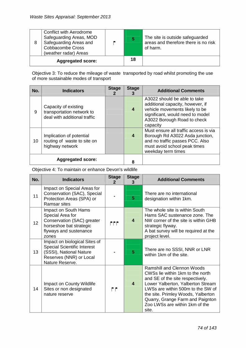
Conflict with Aerodrome Safeguarding Areas, MOD 5 The site is outside safeguarded
8 Safeguarding Areas and areas and therefore there is no risk Cobbacombe Cross of harm.
(weather radar) Areas
Aggregated score: 18
No. Indicators Stage
2 Stage
3 Additional Comments
A3022 should be able to take
9 Capacity of existing
transportation network to deal with additional traffic
4
additional capacity, however, if vehicle movements likely to be
significant, would need to model A3022 Borough Road to check
capacity
Must ensure all traffic access is via Implication of potential 4 Borough Rd A3022 Asda junction,
10 routing of waste to site on and no traffic passes PCC. Also highway network must avoid school peak times
weekday term times
Aggregated score: 8
No. Indicators
Stage 2
Stage 3
Additional Comments
Impact on Special Areas for
11 Conservation (SAC), Special
Protection Areas (SPA) or -
5
There are no international designation within 1km.
Ramsar sites
Impact on South Hams The whole site is within South Special Area for Hams SAC sustenance zone. The
12 Conservation (SAC) greater
horseshoe bat strategic 4 NW corner of the site is within GHB
strategic flyway. flyways and sustenance A bat survey will be required at the
zones project level.
Impact on biological Sites of
13 Special Scientific Interest (SSSI), National Nature
Reserves (NNR) or Local
- 5
There are no SSSI, NNR or LNR within 1km of the site.
Nature Reserve.
Ramshill and Clennon Woods CWSs lie within 1km to the north and SE of the site respectively.
Impact on County Wildlife 4 Lower Yalberton, Yalberton Stream 14 Sites or non designated LWSs are within 500m to the SW of
nature reserve the site. Primley Woods, Yalberton Quarry, Grange Farm and Paignton
Zoo LWSs are within 1km of the site.
Waste Sites Appraisal: September 2013
Objective 3: To reduce the mileage of waste transported by road whilst promoting the use of more sustainable modes of transport
Objective 4: To maintain or enhance Devon's wildlife
74 of 143

No. Indicators
Stage 2
Stage 3
Additional Comments
20 Impact on the Jurassic Coast
World Heritage Site (WHS) -
- N/A
21 Impact on a Regionally
Important Geological Site -
5
The site does not contain RIGS and there are no RIGS within 1km of the
site.
22 Impact on a geological Site
of Special Scientific Interest (SSSI)
-
5 There ar
1km of t e no geological SSSI within he site.
Aggregated score: 10
No. Indicators Stage
2 Stage
3 Additional Comments
23
Potential impact on agricultural land (avoiding
the use of Grades 1, 2 and 3a)
-
5
The site is classified as non- agricultural land. Development of
the site would not result in loss of agricultural land of Grade 1-3a.
24 Proximity to areas of
contaminated land
1
The site has been identified as contaminated land as a result of the historic waste management use.
Waste Sites Appraisal: September 2013
15 Impact on Strategic Nature Areas (SNA)
There is an area of woodland within 1km to the SW of the site. This habitat should be incorporated with any restoration plan post project completion.
4
16 Impact on legally protected and BAP priority species
Protected species have been recorded within 1km of the site. Project level survey would be required to ascertain the presence of protected species and inform suitable mitigation measures.
4
17 Potential to lead to loss or damage of ancient woodland
There is an area of ancient woodland (Clennon Hill Wood) within 1km to the east of the site.
4
18 Impact upon Biodiversity Action Plan (BAP) priority habitats
There Clennon Wood and Ramshill CWS form BAP priority habitats(mixed deciduous woodland) with 1km of the site and therefore there is no risk of harm.
4
19 Impact on Tree Preservation Orders (TPOs) at site
-
The site does not contain any trees subject to TPOs. There are no TPOs within 100m of the site and therefore here is no risk of harm.
5
Aggregated score: 39
Objective 5: To protect geodiversity
Objective 6: To improve the quality and usability of the best and most versatile land and soil
75 of 143

No. Indicators
Stage 2
Stage 3
Additional Comments
27 Impact on Areas of
Outstanding Natural Beauty (AONB) and/or National Park
5
The site is not within AONB or NP. South Devon AONB is not within
5km visual range of the site.
28
Impact on Coastal Preservation Areas, undeveloped coast and
heritage coast
5
The site is outside of CPA and undeveloped coast and therefore
there is no risk of harm.
29 Impact on landscape
character and quality
5
The site is located within Landscape Character Type 9: main
cities and towns.
30 Impact on dark skies
4 The site is located within an area
recognised as brighter.
Aggregated score: 19
No. Indicators
Stage 2
Stage 3
Additional Comments
31 Impact upon Registered
Historic Parks and Gardens including setting
-
5
No Registered Historic Parks and Gardens present within 1km of the
site boundary therefore there is no risk of harm.
32 Impact on registered
battlefields including setting -
5
No registered battlefields present within 1km of the site boundary
therefore there is no risk of harm.
Impact on Scheduled
Ancient Monuments (SAM) There are no SAM within 1km of the 33 and archaeology of - 5 site boundary therefore there is no
equivalent status (including risk of harm. setting)
Waste Sites Appraisal: September 2013
There is also contaminated land adjacent to the site.
25 Proximity to areas of land instability
3
The site is a former landfill and therefore it could potentially cause issues of land instability. Further assessment would be needed to determine this in detail.
26 Impact on North Devon’s Biosphere Reserve
- - N/A
Aggregated score: 9
Objective 7: To sustain and enhance the valued and distinctive character and quality of Devon's landscape.
Objective 8: To improve the setting and integrity of the historic environment
76 of 143

Impact on Cornwall and 5 No risk of harm due to the distance
involved.
34 West Devon Mining
Landscape World Heritage Site and setting
35 Impact on Grade I / II* and II
listed buildings including setting
4
There are 2 separate designated Grade II listed buildings 370m to
the northwest; Collaton Farm and its Farmyard complex; two grade II
Cottages at 391-3 Totnes Road 690m to the northwest; the four
separately designated buildings of the St Mary’s Church Collaton
group - 3 at grade II: Vicarage, lych gate and School House; and the
Grade II* Church. There are 4 separately designated grade II
building complexes at Higher Yelberton 830m to the southwest;
the grade II detached Yalberton Cider barn lies 720m to the
southwest; and the grade II listed King William Cottage.
Waste development in this site would have no direct impacts on listed buildings. Possible impacts
on setting need to be assessed at planning application stage.
36
Potential loss of or damage to non-designated heritage
assets (including locally listed buildings, locally listed
parks and gardens and archaeology)
-
5
There are a number of post- medieval monuments recorded on
the HER whose significance is unlikely to be affected by a waste
site. There are no other known archaeological sites within the
500m or 1km buffer zones of significance.
37 Impact on Conservation
Areas -
5
Nothing within 1km of the site boundaries.
No risk of harm.
Aggregated score: 34
No. Indicators Stage
2 Stage
3 Additional Comments
The site is within 500m of Yalberton watercourse and 1km of Clennon
Proximity and impact upon 3
Valley watercourse, both of which are classified as main rivers.
38 surface water bodies and surface water courses
Development and associated infrastructure in the area should not
increase runoff into local watercourses
Waste Sites Appraisal: September 2013
Objective 11: To maintain or improve the quality of ground, river and sea waters
77 of 143

No. Indicators Stage
2 Stage
3 Additional Comments
Proximity and impact on
39 public or private water
sources (ground and surface water)
5 The site is not within groundwater
source protection zone.
Aggregated score:
5
No. Indicators
Stage 2
Stage 3
Additional Comments
There is flood zone 3 within 500m to the west of the site boundaries.
40 Proximity to and impact upon
Flood Zones 2 and 3 -
4
Further flood zone 3 is within 1km to the east of the site boundaries.
Increased flood flows may cause contamination in terms of
suspended solid and even litter.
41 Impact upon ground water
vulnerability -
4
There is little risk of groundwater flooding in the site or within 1km of
the site boundaries.
42 Impact upon surface water
18 vulnerability
4
There are areas of surface water flooding within 500m to the north of
the site boundary.
There has been no historic flooding 43 Historic flooding vulnerability - 5 within the site or in the immediate
surroundings.
Aggregated score: 17
Waste Sites Appraisal: September 2013
Aggregated score: 3
Objective 12: To improve the amount of ground and surface waters available for abstraction for other, non-waste management uses
Objective 13: To reduce the risk of flooding (including coastal flooding)
Objective 14: To improve air quality
No. Stage Stage
Additional Comments Indicators 2 3
There is no AQMA within 1km of the site boundaries.
Impact on Air Quality 44 Management Areas - 5
(including proposed)
Aggregated score: 5
Locally agreed surface water information is available for Great Torrington, Tavistock, Teignmouth, Horrabridge & Yelverton, Rockbeare and Ottery St Mary (assessed using Areas Susceptible to Surface Water Flooding). Therefore, this more locally specific data will be used at Stage Two for potential sites within areas.
78 of 143
18

No. Indicators Stage Stage
Additional Comments 2 3
45 Impact on level of tranquillity
at site -
5
Low at present due to road noise and close relationship to
development.
Aggregated score:
5
-
No. Indicators Stage
2 Stage
3 Additional Comments
46 Located within existing
19 industrial estate 5
The site current forms part of the Yalberton Industrial Estate. And
Used for B2 & B8 uses.
47 Alignment with District DPD allocation for employment
land (B2 or B8)20
Site lies close to/within new Local Plan SDP3 future growth areas for
Paignton within an existing Industrial Estate
4
Site former landfill. Opportunity to
48 Site within previously
developed land
4 reclaim and reuse. However site currently used by small employment
units (largely open storage)
Potential to restore, or utilise
49 unrestored land at former - 1 Former quarry now land filled. quarries
Aggregated score: 14
Waste Sites Appraisal: September 2013
Objective 15: To reduce the impact of noise and vibration on tranquillity
Aggregated Stage 3 Score for constraints criteria: 187
Opportunity Criteria
Objective 2: To encourage sustainable economic growth in Devon’s urban and rural areas
Objective 3: To reduce the mileage of waste transported by road whilst promoting the use of more sustainable modes of transport
No.
50
Stage Stage Additional Comments Indicators
2 3
Potential for alternative modes of transport (rail or water)
1 No rail or water links within 1km of site
51 Access to the strategic road network
4 Network sufficient though passes by residential areas (by Bill)
Aggregated score: 5
19 Not applicable for consideration of landfill or land raise sites
20 Not applicable for consideration of landfill or land raise sites
79 of 143

No. Indicators
Stage 2
Stage 3
Additional Comments
Little chance to connect to National Ability to export electricity Grid electricity or gas supply
52 and/or gas to the national 3 SWEEG 2006 Study of Yalberton: grid Nearest 11kV underground cable is
within 150m.
Potential heat load within 500m of site with allocated growth areas
53 Ability to export heat to local
user 3
within 1km of site. SWEEG 2006 Study of Yalberton: Heat load Paignton Zoo 700m.
Aggregated score: 6
Waste Sites Appraisal: September 2013
Objective 10: To reduce total waste arisings and the proportion of waste disposed in landfill
Aggregated Stage 3 Score for opportunity criteria: 25
Stage 4: Consideration of cumulative impacts
The site is located within the emerging Local Plan Policy SDP3 and in proximity to a number of areas which have been identified for potential development within the emerging Torbay Local Plan and therefore there may be potential for cumulative impacts.
Yalberton Depot and Claylands sites, lie within 500m of the site, are also being appraised through this process; therefore if the two or the three sites were to come forward for development, cumulative impacts assessment would be required.
Summary of Site Appraisal for Tor Park Road:
Well located (within 600m) to the HWRC, the site scores generally well through the appraisal process. There are some constraints associated with land contamination and instability as it is a ‘gassing’ former landfill site. The site is also in close proximity to a residential area and Paignton Community College. It is also close to Yalberton and Clennon Valley watercourses.
Whilst the site lies within the Yalberton Industrial Estate the site lies immediate adjacent to some residential properties and a further residential development has been developed on the northern frontage. The impact on residential areas is therefore likely to be a significant consideration for any future large scale waste recovery facility on this site.
Recommendation:
The site should not be taken forward for further consideration in the Local Plan.
80 of 143
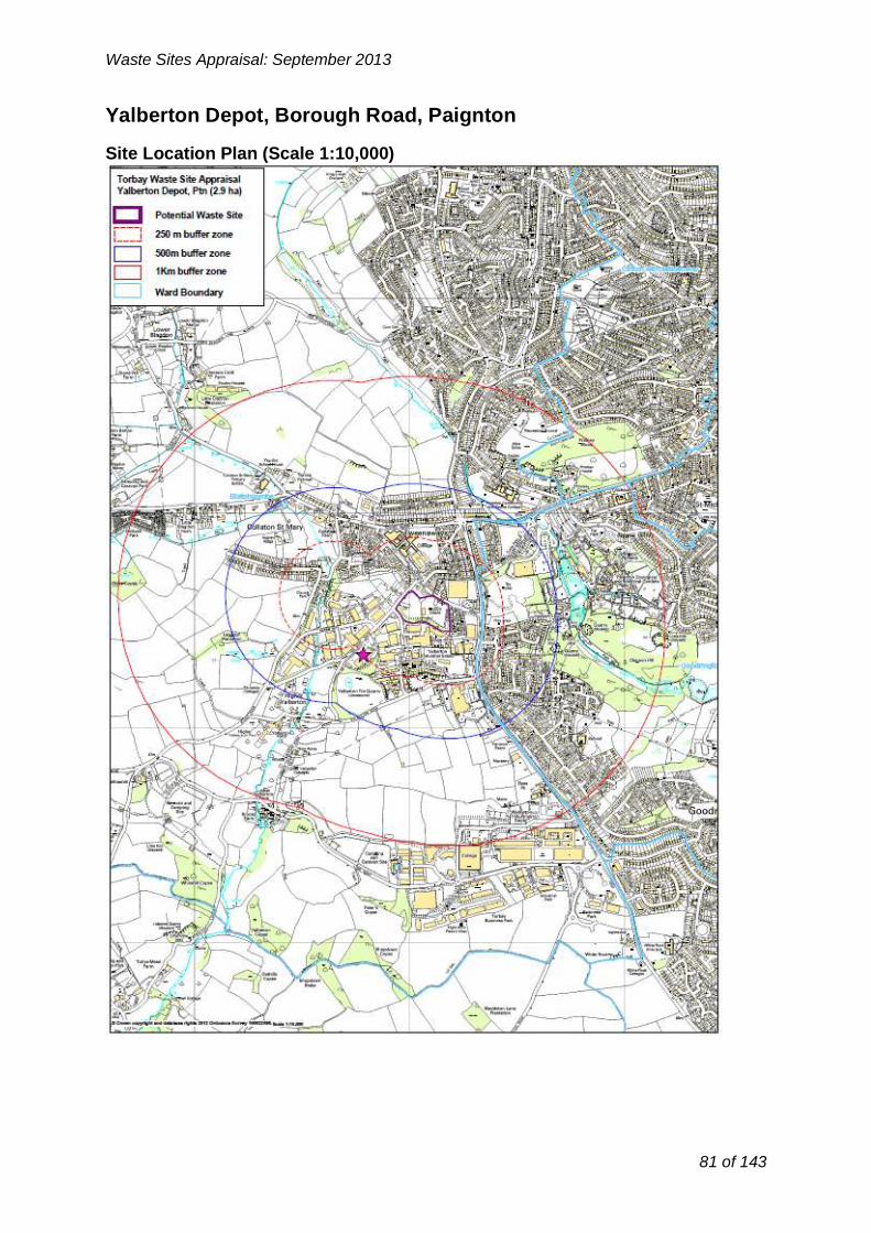
Waste Sites Appraisal: September 2013
Yalberton Depot, Borough Road, Paignton
Site Location Plan (Scale 1:10,000)
81 of 143

Waste Sites Appraisal: September 2013
Stage One: General Description of Site
Site Details
Site address: Yalberton Depot, Borough Road, Paignton
OS Grid Reference: SX 8759
District: Torbay
Parish: N/A Blatchcombe Ward
Total site area (Ha): 2.9ha
Current land use(s)
The site is currently used by Tor2 Depot as part of the current Municipal Waste Collection Service and is largely the open storage of vehicles etc in connection with this service. The western half of the site has consent for car parking. Owned by TBC, the site may have contaminated land issues and is a ‘gassing’ a former landfill. The site currently required for the operational use of TOR2 on contract to 2020 with a 5year renewals after that date.
Historical land use(s) Former landfill site (1968-1970 domestic Waste)..
Adjacent land use(s)
The site lies on the western fringe of Paignton Town adjacent to the Western Corridor (Ring Road) and close the a major junction Tweenaway Cross (approximately (300m north). The site has been previously used as an inert land fill site and is still owned by Torbay Council.
There may be EA& EH licensing issues relating to land stability and contamination.
The public highway lies on the northern frontage (Borough Road) with a number of residential properties within 50m (Borough Road and Longstone Road) on the northern frontage. Yalberton Road and Alders Way about the western site with industrial units. The Grove cul de sac on the west. Part of Paignton Community College lies within 150m as does the Asda Supermarket and Booker wholesale facility.
The main land uses within 500m include the residential suburban fringe of Paignton, Paignton Community and Sports College, Paignton Zoo and Asda and Morrison’s Supermarket. Booker wholesale and new supermarkets lie on the eastern side of the ring road. Yalberton Industrial Estate lies within the 500m including the existing Torbay HWRC and Waste Transfer Station run by Tor2 (the main Municipal facility in Torbay).
Relevant planning history:
P/1991/0273 Construction Of Car Park Application Permitted (10 years from 1992) P/1990/1988 Methane Gas Extraction And Flare Unit : Application Permitted P/20005/0112 Installation Of 15m Lattice Tower With 6 Antennas, 2 Microwave Dishes, 2 Equipment Cabinets,
82 of 143
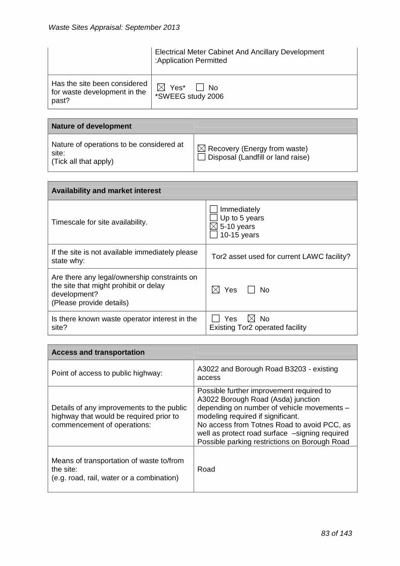
Nature of development
Nature of operations to be considered at Recovery (Energy from waste)
site: Disposal (Landfill or land raise)
(Tick all that apply)
Availability and market interest
Immediately Up to 5 years
Timescale for site availability. 5-10 years 10-15 years
If the site is not available immediately please Tor2 asset used for current LAWC facility?
state why:
Are there any legal/ownership constraints on the site that might prohibit or delay
Yes No development?
(Please provide details)
Is there known waste operator interest in the Yes No site? Existing Tor2 operated facility
Waste Sites Appraisal: September 2013
Electrical Meter Cabinet And Ancillary Development :Application Permitted
Has the site been considered Yes* No
for waste development in the *SWEEG study 2006
past?
Access and transportation
A3022 and Borough Road B3203 - existing Point of access to public highway:
access
Details of any improvements to the public highway that would be required prior to commencement of operations:
Possible further improvement required to A3022 Borough Road (Asda) junction depending on number of vehicle movements – modeling required if significant. No access from Totnes Road to avoid PCC, as well as protect road surface –signing required Possible parking restrictions on Borough Road
Means of transportation of waste to/from the site: Road (e.g. road, rail, water or a combination)
83 of 143

-
Highest Lower level of Lowest level of A dash was used to grading/classification grading/classification grading/classification identify when an
or defined receptor or a defined receptor or a defined receptor indicator is Not
within waste site adjacent or close to within broad locality Applicable or
potential waste site of the potential waste outside the site parameters set out
(DDC Methodology Appendix 6)
No. Indicators
Stage 2
Stage 3
Additional Comments
Loss or impact on open The site is currently used as a
1
space (including recreational land, tourist attractions,
managed woodland,
waste facility by TOR2 and it is not accessible publicly for recreational
use. There is an area of open
4
allotments and playing fields space within 500m of the site etc) boundary. Paignton Zoo lies within
Waste Sites Appraisal: September 2013
Basic site requirements Y/N
Is the site within the area of search for the preferred spatial option? N
Is the site of an appropriate size (a minimum of 1ha) to contribute towards the delivery of the Waste Local Plan Strategy?
Y
Key to Criteria and scoring:
See DCC Site Identification and Appraisal Methodology for further details.
Stage 2: Constraint
Stage 2: Opportunity
-
Highest potential within waste site
Lower level of potential within X
meters of potential waste site
Lower level of potential within X
meters of potential waste site
A dash was used to identify when an indicator is Not Applicable or outside the
parameters set out (DDC Methodology
Appendix 6)
Stage 3 Constraint Criteria:
1 2 3 4 5 High (1) High/medium
(2) Medium (3) Medium/low (4) Low (5)
Stage 3 Opportunity Criteria:
1 2 3 4 5 Low (1) Medium/low (2) Medium (3) High/medium
(4) High (5)
Stages Two and Three
Objective 1: To improve human health and opportunities for a healthy lifestyle
84 of 143

1Km west.
2
Impact on residential properties, businesses &
services – including all noise, dust, air pollution, odour,
vibration and visually sensitive receptors.
3
The site is surrounded by residential properties, Paington Community College and commercial facilities from the north
and the east. Yalberton industrial state lies within 500m to the south
and west of the site boundaries.
The site is within 1km of a Lower
3 Impact on health deprived
wards 4 Super output Area with health and
disability ranking 2742 (classifies as health deprived).
4 Impact on Public Rights of
Way and other countryside access
4
There is PROW (PN1 & PN/1/2) within 250m of the site. Other
footpaths (PN/3/1 & PN/5/1) run within 1km to the north of the site.
Aggregated score: 15
No. Indicators
Stage 2
Stage 3
Additional Comments
The site is a SHLAA site T826) with are SHLAA sites adjacent to the
Potential for physical north boundary of the site (T705). constraints on areas 4 Other SHLLA sites are within 500m
5 allocated or emerging within
District Development Plans and 1km of the site boundaries.
Other SHLAA sites are within 500m for housing, tourism or (T737) and 1km of the site
recreation boundaries. Torbay Local Plan Allocated Housing Site H1.15 (Zoo
Car Park) is also with 500m.
6
Impact upon proposed Mineral Safeguarding Area
or adopted Mineral Consultation Area
-
5
The site is not within proposed Mineral Safeguarding Area or adopted Mineral Consultation Area.
Conflict with utilities No conflict with utilities 7 infrastructure (electricity, gas - 5 infrastructure and therefore there is
and water) no risk of harm.
Conflict with Aerodrome
8 Safeguarding Areas, MOD Safeguarding Areas and
5 The site is outside safeguarded areas and therefore there is no risk
Cobbacombe Cross of harm. (weather radar) Areas
Aggregated score: 19
Waste Sites Appraisal: September 2013
Objective 2: To encourage sustainable economic growth in Devon’s urban and rural areas
85 of 143
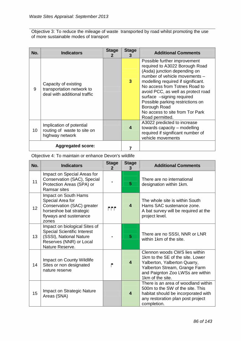
No. Indicators
Stage 2
Stage 3
Additional Comments
9 Capacity of existing
transportation network to deal with additional traffic
3
Possible further improvement required to A3022 Borough Road
(Asda) junction depending on number of vehicle movements –
modelling required if significant. No access from Totnes Road to
avoid PCC, as well as protect road surface –signing required
Possible parking restrictions on Borough Road
No access to site from Tor Park Road permitted.
10 Implication of potential
routing of waste to site on highway network
4
A3022 predicted to increase towards capacity – modelling
required if significant number of vehicle movements
Aggregated score: 7
No. Indicators
Stage 2
Stage 3
Additional Comments
Impact on Special Areas for
11 Conservation (SAC), Special
Protection Areas (SPA) or -
5
There are no international designation within 1km.
Ramsar sites
Impact on South Hams Special Area for The whole site is within South
12 Conservation (SAC) greater
horseshoe bat strategic 4 Hams SAC sustenance zone.
A bat survey will be required at the flyways and sustenance project level.
zones
Impact on biological Sites of
13 Special Scientific Interest (SSSI), National Nature
Reserves (NNR) or Local
- 5
There are no SSSI, NNR or LNR within 1km of the site.
Nature Reserve.
Clennon woods CWS lies within
14 Impact on County Wildlife Sites or non designated
nature reserve
4
1km to the SE of the site. Lower Yalberton, Yalberton Quarry,
Yalberton Stream, Grange Farm and Paignton Zoo LWSs are within 1km of the site.
There is an area of woodland within
15 Impact on Strategic Nature
Areas (SNA)
4
500m to the SW of the site. This habitat should be incorporated with
any restoration plan post project
completion.
Waste Sites Appraisal: September 2013
Objective 3: To reduce the mileage of waste transported by road whilst promoting the use of more sustainable modes of transport
Objective 4: To maintain or enhance Devon's wildlife
86 of 143

-
No. Indicators
Stage 2
Stage 3
Additional Comments
20 Impact on the Jurassic Coast
World Heritage Site (WHS) -
- N/A
21 Impact on a Regionally
Important Geological Site -
5
The site does not contain RIGS and there are no RIGS within 1km of the
site.
22 Impact on a geological Site
of Special Scientific Interest (SSSI)
-
5 There ar
1km of t e no geological SSSI within he site.
Aggregated score: 10
No. Indicators
Stage 2
Stage 3
Additional Comments
23
Potential impact on agricultural land (avoiding
the use of Grades 1, 2 and 3a)
-
5
The site is classified as non- agricultural land. Development of
the site would not result in loss of agricultural land of Grade 1-3a.
The site has been identified as contaminated land as a result of the
24 Proximity to areas of
contaminated land 1 current waste management use of
the site and former landfill site. There is also contaminated land
adjacent to the site.
Waste Sites Appraisal: September 2013
16 Impact on legally protected and BAP priority species
Protected species have been recorded within 500m and 1km of the site Project level survey would be required to ascertain the presence of protected species and inform suitable mitigation measures.
4
17 Potential to lead to loss or damage of ancient woodland
There is an area of ancient woodland within 1km to the east of the site.
4
18 Impact upon Biodiversity Action Plan (BAP) priority habitats
There are no BAP priority habitats with 1km of the site and therefore there is no risk of harm.
5
19 Impact on Tree Preservation Orders (TPOs) at site
The site does not contain any trees subject to TPOs. However, there are TPOs within 100m of the site. The risk of harm considered to medium/low.
4
Aggregated score: 39
Objective 5: To protect geodiversity
Objective 6: To improve the quality and usability of the best and most versatile land and soil
87 of 143

-
No. Indicators Stage
2 Stage
3 Additional Comments
27 Impact on Areas of
Outstanding Natural Beauty (AONB) and/or National Park
5
The site is not within AONB or NP. South Devon AONB is not within
5km visual range of the site.
28
Impact on Coastal Preservation Areas, undeveloped coast and
heritage coast
5
The site is outside of CPA and undeveloped coast and therefore
there is no risk of harm.
29 Impact on landscape
character and quality
5
The site is located within Landscape Character Type 9: main
cities and towns.
30 Impact on dark skies
4 The site is located within an area
recognised as brighter.
Aggregated score: 19
No. Indicators
Stage 2
Stage 3
Additional Comments
31 Impact upon Registered
Historic Parks and Gardens including setting
-
5
No Registered Historic Parks and Gardens present within 1km of the
site boundary therefore there is no risk of harm.
32 Impact on registered
battlefields including setting -
5
No registered battlefields present within 1km of the site boundary
therefore there is no risk of harm.
Impact on Scheduled Ancient Monuments (SAM) There are no SAM within 1km of the
33 and archaeology of - 5 site boundary therefore there is no equivalent status (including risk of harm.
setting)
Impact on Cornwall and
34 West Devon Mining
Landscape World Heritage
5 No risk of harm due to the distance involved.
Site and setting
Waste Sites Appraisal: September 2013
25 Proximity to areas of land instability
3
The site is a former landfill and therefore it could potentially cause issues of land instability. Further work would be needed to determine this in detail.
26 Impact on North Devon’s Biosphere Reserve
- N/A
Aggregated score: 9
Objective 7: To sustain and enhance the valued and distinctive character and quality of Devon's landscape.
Objective 8: To improve the setting and integrity of the historic environment
88 of 143

Impact on Grade I / II* and II
4
There are 2 separate designated Grade II listed buildings 470m
distance to the northwest; Collaton Farm and its Farmyard complex;
the Grade II listed Primley House lies 960m northeast. There are 4
separately designated grade II building complexes at Higher
Yelberton 830m to the southwest; the grade II detached Yalberton
Cider barn lies 690m to the southwest; and the grade II listed
King William Cottage lies 605m southwest.
Waste development in this site would have no direct impacts on listed buildings. Possible impacts
on setting need to be assessed at planning application stage.
35 listed buildings including setting
36
Potential loss of or damage to non-designated heritage
assets (including locally listed buildings, locally listed
parks and gardens and archaeology)
-
5
There are a number of post- medieval monuments recorded on
the HER whose significance is unlikely to be affected by a waste
site. There are no other known archaeological sites within the
500m or 1km buffer zones of significance.
37 Impact on Conservation
Areas -
5
Nothing within 1km of the site boundaries.
No risk of harm.
Aggregated score: 34
No. Indicators
Stage 2
Stage 3
Additional Comments
The site is within 250m of Yalberton watercourse and 1km of Clennon
Proximity and impact upon 3
Valley watercourse, both of which are classified as main rivers.
38 surface water bodies and Development and associated surface water courses
infrastructure in the area should not increase runoff into local
watercourses
Aggregated score: 3
Waste Sites Appraisal: September 2013
Objective 11: To maintain or improve the quality of ground, river and sea waters
89 of 143

No. Indicators
Stage 2
Stage 3
Additional Comments
Proximity and impact on
39 public or private water
sources (ground and surface
5 The site is not within groundwater source protection zone.
water)
Aggregated score:
5
No. Indicators
Stage 2
Stage 3
Additional Comments
There is flood zone 3 within 250m to the west of the site boundaries.
40 Proximity to and impact upon
Flood Zones 2 and 3 -
4
Further flood zone 3 is within 1km to the east of the site boundaries.
Increased flood flows may cause contamination in terms of
suspended solid and even litter.
41 Impact upon ground water
vulnerability -
4
There is little risk of groundwater flooding in the site or within 1km of
the site boundaries. There is small part situated in the north of the site vulnerable to surface water flooding. Also there are areas of surface water flooding within 500m to the north of the site
42 Impact upon surface water
21 vulnerability
3
boundary. Any associated infrastructure with
development could increase the risk of surface water flooding. A surface water drainage strategy is
required for all sites to deal with the surface water runoff generated by
new development.
Surface water flooding map showed the land adjacent to the south boundary of the site has a history of
43 Historic flooding vulnerability - 4 flooding. Historic flood evidence should be
used in conjunction with development proposals.
Aggregated score: 15
Waste Sites Appraisal: September 2013
Objective 12: To improve the amount of ground and surface waters available for abstraction for other, non-waste management uses
Objective 13: To reduce the risk of flooding (including coastal flooding)
Locally agreed surface water information is available for Great Torrington, Tavistock, Teignmouth, Horrabridge & Yelverton, Rockbeare and Ottery St Mary (assessed using Areas Susceptible to Surface Water Flooding). Therefore, this more locally specific data will be used at Stage Two for potential sites within areas.
90 of 143
21

No. Indicators Stage Stage
Additional Comments 2 3
45 Impact on level of tranquillity
at site -
5
Low at present due to road noise and close relationship to
development.
Aggregated score:
5
No. Indicators
Stage 2
Stage 3
Additional Comments
46 Located within existing
22 industrial estate
5 The site current forms part of the
Yalberton Industrial Estate. And Used for B2 & B8 uses.
47 Alignment with District DPD allocation for employment
land (B2 or B8)23
-
Site lies close to/within new Local Plan SDP3 future growth areas for
Paignton within an existing Industrial Estate
4
Site former (1968-1970) domestic
48 Site within previously
developed land
4 waste landfill. Opportunity to reclaim and reuse. However site
currently used by small employment unites (largely open storage)
Potential to restore, or utilise Site was not a former quarry? If part 49 unrestored land at former - 1 of the old clay/brick pit and quarry
quarries now landfilled.
14
Aggregated score:
Waste Sites Appraisal: September 2013
Objective 14: To improve air quality
No. Stage Stage
Additional Comments Indicators 2 3
There is no AQMA within 1km of the site boundaries.
44 Impact on Air Quality Management Areas - 5 (including proposed)
Aggregated score: 5
Objective 15: To reduce the impact of noise and vibration on tranquillity
Aggregated Stage 3 Score for constraints criteria: 185
Opportunity Criteria
Objective 2: To encourage sustainable economic growth in Devon’s urban and rural areas
22 Not applicable for consideration of landfill or land raise sites
23 Not applicable for consideration of landfill or land raise sites
91 of 143

No. Indicators
Stage 2
Stage 3
Additional Comments
Potential for alternative None
50 modes of transport (rail or water)
1 No rail or water links within 1km of site
51 Access to the strategic road network
4 Good
Aggregated score: 5
No. Indicators
Stage 2
Stage 3
Additional Comments
Little chance to connect to National Ability to export electricity Grid electricity or gas supply
52 and/or gas to the national 3 SWEEG 2006 Study of Yalberton: grid Nearest 11kV underground cable is
within 150m.
Potential heat load within 500m Of
53 Ability to export heat to local
3
Site with allocated growth areas within 1km of site. SWEEG 2006
user Study of Yalberton: Heat load Paignton Zoo 700m.
Aggregated score: 6
Waste Sites Appraisal: September 2013
Objective 3: To reduce the mileage of waste transported by road whilst promoting the use of more sustainable modes of transport
Objective 10: To reduce total waste arisings and the proportion of waste disposed in landfill
Aggregated Stage 3 Score for opportunity criteria: 25
Stage 4: Consideration of cumulative impacts
The site is located within the emerging Local Plan Policy SDP3 and in proximity to a number of areas which have been identified for potential development within the emerging Torbay Local Plan and therefore there may be potential for cumulative impacts.
Torpark Road and Claylands sites, lie within 500m of the site, are also being appraised through this process; therefore if the two or the three sites were to come forward for development, cumulative impacts assessment would be required.
Stage 5: Summary of Site Appraisal for Yalberton Depot
Well located (within 600m) to the HWRC, the site scores generally well through the appraisal process. There are some constraints associated with land contamination and instability as it is a ‘gassing’ former landfill site. The site is also in close proximity to a residential area and Yalberton and Clennon Valley watercourses.
Whilst well located (within 250m) to the HWRC, the site is currently used by TOR2 as part of its waste function currently leased until 2020 with renewable 5 year contracts after that (and is not therefore considered available during the first half of the plan period) a new Depot site
92 of 143

Waste Sites Appraisal: September 2013
would therefore need to be found and this is not considered acceptable. The site has also been identified as having residential potential (SHLAA site). The impact on residential areas is therefore likely to be a significant consideration for any future large scale waste recovery facility on this site.
The western half of the site is currently used for car parking, storage area and car wash facility for Tor2, may have potential to accommodate a waste recovery facility in the long-term probably beyond the Local Plan period.
Recommendation:
The site could have potential to accommodate waste recovery facility in the long -term probably beyond the Local Plan period. However, following further considerations, the site should not be taken forward for further consideration in the Local Plan.
93 of 143

Waste Sites Appraisal: September 2013
Yalberton Road Employment Allocation, (Yannons Farm) Yalberton
Road, Paignton
Site Location Plan (Scale 1:10,000)
94 of 143

Waste Sites Appraisal: September 2013
Stage One: General Description of Site
Site Details
Site address: Yalberton Employment Allocation (E1.16Cpart). Paignton
OS Grid Reference: SX 8658
District: Torbay
Parish: N/A Blatchcombe Ward
Total site area (Ha): 8.2ha
Current land use(s)
The site forms a green field allocation in the Torbay Local Plan for employment use (E1.16(c)). Multiple private ownership. The adjacent site immediately abutting the Southern boundary and part of the allocation E1.16 has recently been given planning consent for mixed employment and residential use. The owners of this site are also promoting this site for future residential/employment mixed use.
Historical land use(s) Greenfield/ agricultural use.
Adjacent land use(s)
The site lies on the western fringe of Paignton Town adjacent to the Western Corridor (Ring Road) and close the a major junction Tweenaway Cross (approximately (300m south).
A key proposal currently under construction is the site immediately abutting the southern boundary (P/2010/0289 Land Off Brixham Road, Rear Of Torbay Garden Centre Incorporating Yannons Farm, Adjacent To Little Preston, Short Preston And Woodlands) for mixed use development to form approx 220 dwellings, approx 5,600 SQM gross of employment (B1) floorspace, local centre and public open space with roads and car parking :Permitted This allows for residential and employment use at the boundary.
The main land uses within 500m include the residential suburban fringe of Paignton, Yalberton Tor Quarry and Yalberton Industrial Estate, including the Tor2 main municipal LAWC site. Baytor Industrial estate with car breakers yard and caravan /self storage units. Sainsbury’s supermarket lies within 500m to the east (served by Yalberton Road)
Paignton Zoo and Morrirson’s supermarket car park, Paignton Community and Sports College, Paignton Zoo and Morrison’s Supermarket lie within 1km.
Relevant planning history: See reference to adjacent Planning Application above.
95 of 143

Waste Sites Appraisal: September 2013
Has the site been considered for waste development in the Yes No past?
Nature of development
Nature of operations to be considered at Recovery (Energy from waste)
site: Disposal (Landfill or land raise)
(Tick all that apply)
Availability and market interest
Timescale for site availability.
If the site is not available immediately please state why:
Are there any legal/ownership constraints on the site that might prohibit or delay development? (Please provide details)
Is there known waste operator interest in the site?
Access and transportation
Point of access to public highway:
Details of any improvements to the public highway that would be required prior to commencement of operations:
Means of transportation of waste to/from the site: (e.g. road, rail, water or a combination)
Immediately Up to 5 years 5-10 years 10-15 years
Privately owned allocated for employment use?
Yes No
Yes No
Yalberton Road/Western Corridor Brixham Road
Yalberton Road requires upgrade to 2 lane carriageway from the present country rural lane, together with works to prevent rat running down the rest of the remainder of the rural road. P May be further improvement required to A3022 junction as part of Sainsbury’s redevelopment plans Depending on vehicle trip movements, may be contributions towards further improvements along Western Corridor itself - modelling may be required
Road
96 of 143

-
Highest Lower level of Lowest level of A dash was used to grading/classification grading/classification grading/classification identify when an
or defined receptor or a defined receptor or a defined receptor indicator is Not
within waste site adjacent or close to within broad locality Applicable or
potential waste site of the potential waste outside the site parameters set out
(DDC Methodology Appendix 6)
Waste Sites Appraisal: September 2013
Basic site requirements Y/N
Is the site within the area of search for the preferred spatial option? N
Is the site of an appropriate size (a minimum of 1ha) to contribute towards the delivery of the Waste Local Plan Strategy?
Y
Key to Criteria and scoring:
See DCC Site Identification and Appraisal Methodology for further details.
Stage 2: Constraint
Stage 2: Opportunity
-
Highest potential within waste site
Lower level of potential within X
meters of potential waste site
Lower level of potential within X
meters of potential waste site
A dash was used to identify when an indicator is Not Applicable or outside the
parameters set out (DDC Methodology
Appendix 6)
Stage 3 Constraint Criteria:
1 2 3 4 5 High (1) High/medium
(2) Medium (3) Medium/low (4) Low (5)
Stage 3 Opportunity Criteria:
1 2 3 4 5 Low (1) Medium/low (2) Medium (3) High/medium
(4) High (5)
Stages Two and Three
Objective 1: To improve human health and opportunities for a healthy lifestyle
1
No.
Loss or impact on open space (including recreational land, tourist attractions, managed woodland, allotments and playing fields etc)
Indicators Stage
2
3
Stage 3
The site lies with a greenfield land. The southern and western sides of the site are surrounded by countryside; however the site is not accessible publicly for recreational use.
Additional Comments
97 of 143

No. Indicators
Stage 2
Stage 3
Additional Comments
5
Potential for physical constraints on areas
allocated or emerging within District Development Plans
for housing, tourism or recreation
3
The site is currently allocated in the Local Plan for an employment use. There are a number of SHLAA sites within 500m and 1km of the site
boundaries. The site itself has also been promoted for employment use (T843 rejected)
6
Impact upon proposed Mineral Safeguarding Area
or adopted Mineral Consultation Area
-
5
The site is not within proposed Mineral Safeguarding Area or adopted Mineral Consultation Area.
7 Conflict with utilities
infrastructure (electricity, gas and water)
3
They are high voltage electricity power lines and pylons crossing the
site.
Conflict with Aerodrome
8 Safeguarding Areas, MOD Safeguarding Areas and Cobbacombe Cross
5 The site is outside safeguarded
areas and therefore there is no risk
of harm. (weather radar) Areas
Aggregated score: 16
Waste Sites Appraisal: September 2013
2
Impact on residential properties, businesses & services – including all noise, dust, air pollution, odour, vibration and visually sensitive receptors.
3
There are residential properties located within 500m to the east of the site boundaries and Yalberton industrial state located within 250m to the north of the site boundaries. The site is also adjacent to the allocation E1.16 that has recently been given planning consent for mixed employment and residential use.
There are no health deprived wards within 1km of the site.
3 Impact on health deprived wards
- 5
There is PROW (PN1) within 500m of the site. Other footpaths (PN/1/2 PN/3/1) run within 1km to the north of the site.
4 Impact on Public Rights of Way and other countryside access
4
Aggregated score: 15
Objective 2: To encourage sustainable economic growth in Devon’s urban and rural areas
Objective 3: To reduce the mileage of waste transported by road whilst promoting the use of more sustainable modes of transport
No.
9
Stage Stage Additional Comments Indicators
2 3
Capacity of existing transportation network to deal with additional traffic
Good subject to appropriate modelling if required and / or redevelopment of Sainsbury’s 4
98 of 143

Stage Stage No. Indicators Additional Comments
2 3
Impact on Special Areas for
Conservation (SAC), Special There are no international 11 -
Protection Areas (SPA) or 5 designation within 1km. Ramsar sites
The whole site is within South Impact on South Hams
Hams SAC sustenance zone. GH Special Area for
bat strategic flyway (250m buffer) is Conservation (SAC) greater
12 4 within 250m from the site horseshoe bat strategic boundaries.
flyways and sustenance A bat survey will be required at the
zones project level.
Impact on biological Sites of
Special Scientific Interest There are no SSSI, NNR or LNR
13 (SSSI), National Nature - 5 within 1km of the site.
Reserves (NNR) or Local Nature Reserve.
Clennon woods (CWS) lies within 1km to the east of the site. Lower
Impact on County Wildlife Yalberton (LWS) lies within 500m to 14 Sites or non designated 4 the east of the site. Yalberton
nature reserve Quarry, Yalberton Stream, Grange Farm and Paignton Zoo (CWS) are within 1km of the site.
There is an area of woodland adjacent to the eastern edge of the
Impact on Strategic Nature 15 3 site. This habitat should be
Areas (SNA) incorporated with any restoration
plan post project completion. Protected species have been recorded within 500m and 1km of the site. Cirl bunting has been recorded with 500m and 1km of the
Impact on legally protected 3 site. 16 and BAP priority species Project level survey would be
required to ascertain the presence of protected species and cirl
bunting and inform suitable mitigation measures
There is no ancient woodland within Potential to lead to loss or 5 17 - 1km of the site and therefore there
damage of ancient woodland is no risk of harm.
Waste Sites Appraisal: September 2013
10 Implication of potential routing of waste to site on highway network
3 Capacity of Western Corridor would need to be investigated. Inappropriate traffic down Yalberton Road. Highway improvement is required
Aggregated score: 7
Objective 4: To maintain or enhance Devon's wildlife
99 of 143

No. Indicators
Stage 2
Stage 3
Additional Comments
20 Impact on the Jurassic Coast
World Heritage Site (WHS) -
-
N/A
21 Impact on a Regionally
Important Geological Site -
5
The site does not contain RIGS and there are no RIGS within 1km of the
site.
22 Impact on a geological Site
of Special Scientific Interest (SSSI)
-
5 There ar
1km of t e no geological SSSI within he site.
Aggregated score: 10
No. Indicators
Stage 2
Stage 3
Additional Comments
23
Potential impact on agricultural land (avoiding
the use of Grades 1, 2 and 3a)
3
The site lies in a land classified as Grade 1 & 2 agricultural land.
However, it has been allocated in the Local Plan for other uses.
24 Proximity to areas of
contaminated land
5
There is no record of land contamination at the site. Howe
there is a contaminated land wit ver hin
500m to the north on the site.
25 Proximity to areas of land
instability -
-
There is no information currently available.
26 Impact on North Devon’s
Biosphere Reserve -
- N/A
Aggregated score: 8
Waste Sites Appraisal: September 2013
18 Impact upon Biodiversity Action Plan (BAP) priority -
There are no BAP priority habitats with 1km of the site and therefore there is no risk of harm.
5 habitats
The site does not contain any trees with TPOs. And there are no TPOs within 100m of the site. Development on this site would not impact upon TPOs.
19 Impact on Tree Preservation
- 5 Orders (TPOs) at site
Aggregated score: 39
Objective 5: To protect geodiversity
Objective 6: To improve the quality and usability of the best and most versatile land and soil
100 of 143

No. Indicators
Stage 2
Stage 3
Additional Comments
27 Impact on Areas of
Outstanding Natural Beauty
5
The site is not within AONB or NP. South Devon AONB is not within
(AONB) and/or National Park
5km visual range of the site.
28
Impact on Coastal Preservation Areas, undeveloped coast and
heritage coast
5
The site is outside of CPA and undeveloped coast and therefore
there is no risk of harm.
The site is located with AGLV abutting. It has been described in
the TLCA as type 1 rolling farmland
29 Impact on landscape
character and quality
4 (1N East Yalberton). The area is generally moderately sensitive.
Most sensitive in more elevated areas and less sensitive on fringes
adjacent to existing development.
30 Impact on dark skies
4 The site is located within an area
recognised as brighter.
Aggregated score: 18
No. Indicators
Stage 2
Stage 3
Additional Comments
31 Impact upon Registered
Historic Parks and Gardens including setting
-
5
No Registered Historic Parks and Gardens present within 1km of the
site boundary therefore there is no risk of harm.
32 Impact on registered
battlefields including setting -
5
No registered battlefields present within 1km of the site boundary
therefore there is no risk of harm.
Impact on Scheduled Ancient Monuments (SAM) There are no SAM within 1km of the
33 and archaeology of - 5 site boundary therefore there is no equivalent status (including risk of harm.
setting)
Impact on Cornwall and
34 West Devon Mining
Landscape World Heritage
5 No risk of harm due to the distance involved.
Site and setting
There are 4 separately designated grade II building complexes at
35 Impact on Grade I / II* and II
listed buildings including
Higher Yelberton 670m to the southwest; the grade II detached
setting 4 Yalberton Cider barn lies 510m to the southwest; and the grade II
listed King William Cottage lies
Waste Sites Appraisal: September 2013
Objective 7: To sustain and enhance the valued and distinctive character and quality of Devon's landscape.
Objective 8: To improve the setting and integrity of the historic environment
101 of 143

No. Indicators
Stage 2
Stage 3
Additional Comments
Proximity and impact on
39 public or private water
sources (ground and surface
5 The site is not within groundwater source protection zone.
water)
Aggregated score:
5
Waste Sites Appraisal: September 2013
440m southwest. There are 5 separately designated grade II building complexes at Lower Yelberton 810m to the southwest; There are 2 separate designated Grade II listed buildings 960m distance to the north; Collaton Farm and its Farmyard complex.
36
Potential loss of or damage to non-designated heritage assets (including locally listed buildings, locally listed
-
There are a number of post-medieval monuments recorded on the HER whose significance is unlikely to be affected by a waste site. There are no other known archaeological sites within the 500m or 1km buffer zones of significance.
5 parks and gardens and archaeology)
Nothing within 1km of the site boundaries. No risk of harm.
37 Impact on Conservation
- 5 Areas
Aggregated score: 34
Objective 11: To maintain or improve the quality of ground, river and sea waters
No.
38
Stage Stage Additional Comments Indicators
2 3
Proximity and impact upon surface water bodies and surface water courses
3
The site is within 500m of the Yalberton watercourse and 1km of the Clennon Valley watercourse, both of which are classified as main river. Development and associated infrastructure in the area should not increase runoff into local watercourses
Aggregated score: 3
Objective 12: To improve the amount of ground and surface waters available for abstraction for other, non-waste management uses
102 of 143

Objective 13: To reduce the risk of flooding (including coastal flooding)
No. Indicators
Stage 2
Stage 3
Additional Comments
There is flood zone 3 within 500m adjacent to the east of the site boundaries. Further flood zone 3 is
40 Proximity to and impact upon
Flood Zones 2 and 3 -
4 within 1km to the NW of the site boundaries.
Increased flood flows may cause contamination in terms of
suspended solid and even litter.
41 Impact upon ground water
vulnerability -
4
There is little risk of groundwater flooding in the site or within 1km of
the site boundaries.
The site itself is not located in a
42 Impact upon surface water
24 vulnerability
5
surface water flood area. There is however a potential for surface
water flooding within 500m to the east of the site boundaries.
Surface water flooding map showed the land adjacent to the north 4 boundary of the site has a history of
43 Historic flooding vulnerability - flooding. Historic flood evidence should be
used in conjunction with development proposals.
Aggregated score: 17
No. Indicators Stage Stage
Additional Comments 2 3
45 Impact on level of tranquillity
at site -
Low at present due to road noise and close relationship to
development
5
Waste Sites Appraisal: September 2013
Objective 14: To improve air quality
No. Stage Stage
Additional Comments Indicators 2 3
There is no AQMA within 1km of the site boundaries.
44 Impact on Air Quality Management Areas -
5 (including proposed)
Aggregated score: 5
Objective 15: To reduce the impact of noise and vibration on tranquillity
24 Locally agreed surface water information is available for Great Torrington, Tavistock, Teignmouth,
Horrabridge & Yelverton, Rockbeare and Ottery St Mary (assessed using Areas Susceptible to Surface Water Flooding). Therefore, this more locally specific data will be used at Stage Two for potential sites within areas.
103 of 143

No. Indicators
Stage 2
Stage 3
Additional Comments
Site is not currently in industrial use
46 Located within existing
25 industrial estate
- 3
but does have industrial employment uses to the north
(Yalberton Tor) Electrical Sub Station to the east.
Site is allocated in the adopted Local Plan for Employment use
47 Alignment with District DPD allocation for employment
land (B2 or B8)26
3
(E1.16c) B1, B2, and B8.The new local plan identifies this area SDP3
Paignton west for a mix of housing, employment recreation and local
facilities.
48 Site within previously
developed land
-
1
Agricultural land
Potential to restore, or utilise
49 unrestored land at former - 1 Not a former quarry site. quarries
Aggregated score: 8
No. Indicators
Stage 2
Stage 3
Additional Comments
52 Ability to export electricity
and/or gas to the national grid
4
Site Lies adjacent to Electricity Sub station
Waste Sites Appraisal: September 2013
Aggregated score: 5
Aggregated Stage 3 Score for constraints criteria: 182
Opportunity Criteria
Objective 2: To encourage sustainable economic growth in Devon’s urban and rural areas
Objective 3: To reduce the mileage of waste transported by road whilst promoting the use of more sustainable modes of transport
No.
50
Stage Stage Additional Comments Indicators
2 3
Potential for alternative modes of transport (rail or water)
1 None
51 Access to the strategic road network
4 Good
Aggregated score: 5
Objective 10: To reduce total waste arisings and the proportion of waste disposed in landfill
25 Not applicable for consideration of landfill or land raise sites
26 Not applicable for consideration of landfill or land raise sites
104 of 143

Waste Sites Appraisal: September 2013
53 Ability to export heat to local user
4
Site lies with 500m of Supermarket and site with consent for 220 dwellings and 5000sqm of employment use.
Aggregated score: 8
Aggregated Stage 3 Score for opportunity criteria: 21 Stage 4: Consideration of cumulative impacts
The site is located within the emerging Local Plan Policy SDP3 and in proximity to a number of areas which have been identified for potential development within the emerging Torbay Local Plan and therefore there may be potential for cumulative impacts.
Stage 5: Summary of Site Appraisal for Yalberton Road Emplyment Allocation
Whilst well located (within 250m) to the HWRC, (and the Yalberton Tor Quarry CDEW facility) there are some strong national constraints associated with the site, most notably in relation to potential impacts on agricultural land Grade 1&2. There are potential negative impacts on legally protected species, BAP priority species and Strategic Nature Areas. The site is also in proximity to a residential area; and Yalberton and Clennon Valley watercourses.
The site is allocated for employment use within the Adopted Local Plan (E1.16C) and in the new Local Plan (SDP3) also identifies mixed employment (Class B) and residential development for the land Yalberton Road (Yannons Farm). The new Local Plan for Paignton is expected to deliver 325 jobs per annum with very limited greenfield opportunities for employment development the site has strategic importance for employment within the bay. Residential development with planning consent will immediately abut the southern boundary. For these reasons the site is not considered acceptable.
Recommendation:
The site could be taken forward for further consideration in the Local Plan. However there are employment objectives and residential amenity issues that may override.
105 of 143

Waste Sites Appraisal: September 2013
2. Appendix 2: Site Options for Disposal
106 of 143

Waste Sites Appraisal: September 2013
3. Churston Court Farm, Brixham
Site Location Plan (Scale 1:10,000)
107 of 143

Waste Sites Appraisal: September 2013
Stage One: General Description of Site
Site Details
Site address: Churston Court Farm, Fields at Strawberry Bends, Churston, Brixham
OS Grid Reference: SX 9055
District: Torbay
Parish: N/A (Ward Churston with Galmpton)
Total site area (Ha): 92.9ha
Current land use(s)
The site forms part of a wider agricultural farm operation with Farm shop located in Churston. The site is currently operated under two enforcement notices (until January 2015) for agricultural soil enhancement with use of a crusher and fish waste deliveries for use on site only. Application (P/2011/1037) for formation of a commercial aggregate use i.e. the sale of stone form the above soil recovery operation. Refused. Awaiting appeal?
Historical land use(s) The site lies on agricultural land. Defined as 2
Adjacent land use(s)
The site lies in a rural area within 240 meters of the north western edge of Brixham town and approximately 750m north of New Road (A3022) - the main road serving Brixham.
The site is set within agricultural land forming the rural setting to Brixham Town that form and AONB envelope around the urban area. There is a public highway accessed via a track to the north. The field abuts a County Wildlife Site and lies within a Cirl Bunting breeding site. It falls within the GHB sustenance Zone and GHB 250m fly way.
The main land uses within 500m include the residential suburban fringe of Brixham (largely consisting of bungalows built in the late 60’s) and the surrounding rural hinterland. There are open fields to the North and South of the site and Lupton Historic Park and Gardens set in the Valley system to the South east.
Relevant planning history:
The site was granted a EA licence to control the crushing and screening recycled building stone and soil with the soil being recovered for use in agricultural improvement on Churston Court Farm.
The two enforcement notices dated December 2009 issued by Torbay Council to regulate the operation (including restriction to stone and soil for agricultural purposes only and restricted vehicle deliveries).
The surrounding land is in agricultural use. There is no
108 of 143

explicit permission of for aggregate recycling or soil recovery other than for agricultural purposes within the site.
A planning application (p/2011/1037) for the use and resale of recycled stone from the Churston Soil Recovery
crushing/screening process that was refused primarily on AONB and Highway grounds.
Has the site been considered Yes* No for waste development in the
past? *See p/2001/1037 and enforcement notices
Nature of development
Nature of operations to be considered at Recovery (Energy from waste)
site: Disposal (Landfill or land raise) (inert)
(Tick all that apply)
Availability and market interest
Immediately Up to 5 years
Timescale for site availability. 5-10 years 10-15 years
If the site is not available immediately please Application submitted but refused.
state why:
Are there any legal/ownership constraints on the site that might prohibit or delay
Yes No development?
(Please provide details)
Yes No Is there known waste operator interest in the
site? The site is currently operated by the occupier.
Access and transportation
Point of access to public highway: Access is from (Strawberry Bends) New Road
A3022 and Bascombe Road.
Details of any improvements to the public highway that would be required prior to
commencement of operations:
Access improvements are likely to be required to provide access from both directions on New
Road. Currently HGV access from Brixham requires use of minor residential roads.
Means of transportation of waste to/from the site:
(e.g. road, rail, water or a combination)
Via HGV and road. The Paignton branch line is within approximately of the site to the north.
Waste Sites Appraisal: September 2013
109 of 143
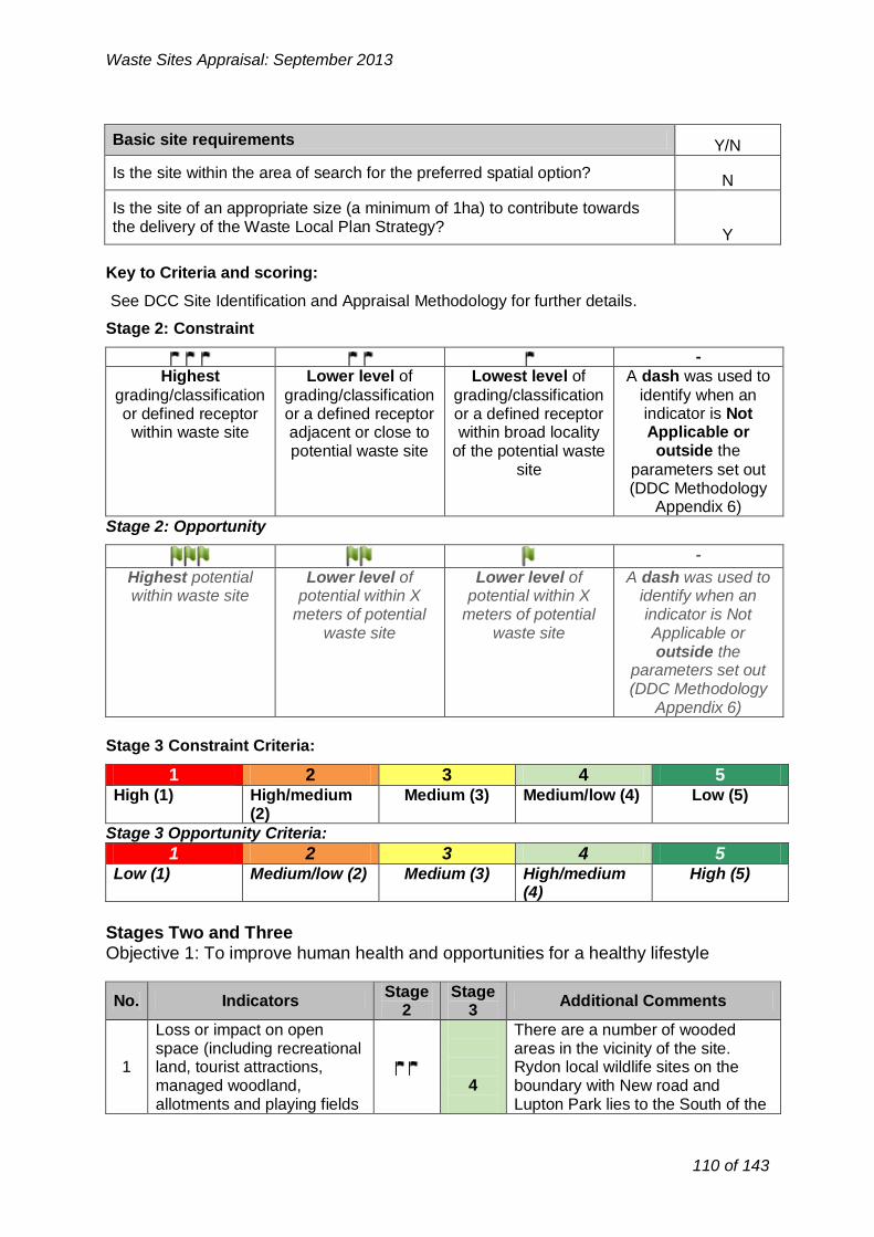
-
Highest Lower level of Lowest level of A dash was used to
grading/classification grading/classification grading/classification identify when an or defined receptor or a defined receptor or a defined receptor indicator is Not
within waste site adjacent or close to within broad locality Applicable or
potential waste site of the potential waste outside the
site parameters set out (DDC Methodology
Appendix 6)
Waste Sites Appraisal: September 2013
Basic site requirements Y/N
Is the site within the area of search for the preferred spatial option? N
Is the site of an appropriate size (a minimum of 1ha) to contribute towards the delivery of the Waste Local Plan Strategy?
Y
Key to Criteria and scoring:
See DCC Site Identification and Appraisal Methodology for further details.
Stage 2: Constraint
Stage 2: Opportunity
-
Highest potential within waste site
Lower level of potential within X
meters of potential waste site
Lower level of potential within X
meters of potential waste site
A dash was used to identify when an indicator is Not Applicable or outside the
parameters set out (DDC Methodology
Appendix 6)
Stage 3 Constraint Criteria:
1 2 3 4 5 High (1) High/medium
(2) Medium (3) Medium/low (4) Low (5)
Stage 3 Opportunity Criteria:
1 2 3 4 5 Low (1) Medium/low (2) Medium (3) High/medium
(4) High (5)
Stages Two and Three Objective 1: To improve human health and opportunities for a healthy lifestyle
No. Stage Stage
Indicators Additional Comments 2 3
Loss or impact on open There are a number of wooded areas in the vicinity of the site. Rydon local wildlife sites on the boundary with New road and Lupton Park lies to the South of the
space (including recreational 1 land, tourist attractions,
managed woodland, allotments and playing fields
4
110 of 143

etc) site within approximately 250m. No open space will directly be lost.
2
Impact on residential properties, businesses &
services – including all noise, dust, air pollution, odour,
vibration and visually sensitive receptors.
3
The residential fringe of Brixham Town lies within 250m to the east of
the site. Churston Ferrers and Churston Village are within 1km to
the NW of the site. Lupton Park (Historic Park and Garden Is within
500m)
The site is within 1km of a Lower
3 Impact on health deprived
wards 5 Super output Area with health and
disability ranking 19740 (not classifies as health deprived).
There is PROW (BX/28/2) within
4 Impact on Public Rights of
Way and other countryside
4
500m of the site boundaries. Other footpaths (BX55 & BX56) run within
access 1km to the north of the site boundaries.
Aggregated score: 16
No. Indicators
Stage 2
Stage 3
Additional Comments
There are SHLAA sites (T717&T719b) within 1km to the
Potential for physical NW of the site. Other SHLAA sites constraints on areas 4 (T849, T704
5 allocated or emerging within
District Development Plans
&T821) are within 1km to the SE of the site.
for housing, tourism or Site lies within SDB3 of the new recreation local plan within the context of the
AONB and Brixham Urban Fringe Study.
6
Impact upon proposed Mineral Safeguarding Area
or adopted Mineral Consultation Area
3
The site lies on an area of Brixham Limestone that is likely to form part
of the New Local Plan Mineral Safeguarding Area.
Conflict with utilities No conflict with utilities 7 infrastructure (electricity, gas - 5 infrastructure and therefore there is
and water) no risk of harm.
Conflict with Aerodrome
8 Safeguarding Areas, MOD Safeguarding Areas and Cobbacombe Cross
5
The site is outside safeguarded areas and therefore there is no risk
of harm. (weather radar) Areas
Aggregated score: 17
Waste Sites Appraisal: September 2013
Objective 2: To encourage sustainable economic growth in Devon’s urban and rural areas
111 of 143

No. Indicators
Stage 2
Stage 3
Additional Comments
9 Capacity of existing
transportation network to deal with additional traffic
2
Comments from the Council Sustainable Transport Officer have
stated that there is very limited capacity given Windy Corner
access is at capacity, Bascombe Road is unsuitable, and New Road
very congested at peak times especially during summer peaks.
10 Implication of potential
routing of waste to site on highway network
3
Comments from the Council Sustainable Transport Officer have
stated that any development on the site require a Transport
Assessment (TA) looking at number of vehicles, size, likely routes to be
used, frequency, hours of operation etc. The TA would need to model the existing network and taken into
account committed development in addition to that modelled within
Saturn including: Noss Marina South Hams
application reference 30/0313/08/F.
Wall Park – Application reference P/2010/0541. The TA gives the
anticipated traffic flows and distribution to Dartmouth Road
White Rock – Application reference
P/2011/0197. The TA gives the anticipated traffic flows and distribution through Windy Corner
The residential development on
Churston Golf Club is now committed.
Aggregated score: 5
No. Indicators
Stage 2
Stage 3
Additional Comments
Impact on Special Areas for The South Hams SAC is located
11 Conservation (SAC), Special
Protection Areas (SPA) or Ramsar sites
- 2km to the SE of the site.
Habitats Regulations Assessment will be required at the project level.
4
Waste Sites Appraisal: September 2013
Objective 3: To reduce the mileage of waste transported by road whilst promoting the use of more sustainable modes of transport
Objective 4: To maintain or enhance Devon's wildlife
112 of 143

Waste Sites Appraisal: September 2013
12
Impact on South Hams Special Area for Conservation (SAC) greater horseshoe bat strategic flyways and sustenance zones
The whole site is within South Hams SAC sustenance zone and bat strategic flyways. A bat survey will be required at the project level.
4
13
Impact on biological Sites of Special Scientific Interest (SSSI), National Nature Reserves (NNR) or Local Nature Reserve.
-There are no SSSI, NNR or LNR within 1km of the site.
5
14 Impact on County Wildlife Sites or non designated nature reserve
The site lies next to Churston Ferrers CWS (within 500m) and the Grove CWS is within 1km to the north and NE of the site respectively. There are LWS within 500m at Lupton Park, Rydons and New Road to the south and SE to the site.
4
15 Impact on Strategic Nature Areas (SNA)
3 The whole site lies within mosaic /wildlife corridor. This habitat should be incorporated with any restoration plan post project completion.
16 Impact on legally protected and BAP priority species
Cirl bunting has been recorded within the site. Project level survey would be required to ascertain the presence of cirl bunting and inform suitable mitigation measures
4
17 Potential to lead to loss or damage of ancient woodland
There is ancient woodland area within 250m to the south of the site. There are additional areas of ancient woodland within 500m of the site to the south and SW. Further ancient woodland is within 1km of the site to the north.
4
18 Impact upon Biodiversity Action Plan (BAP) priority habitats
3
The site is located within a farmland. Priority habitats broadleaved woodland and parkland are within 500m to the south of the site. Additionally there is grassland within 1km to the north of the site.
19 Impact on Tree Preservation Orders (TPOs) at site
-
The site does not contain any trees with TPOs. And there are no TPOs within 100m of the site. Development on this site would not impact upon TPOs.
5
Aggregated score: 36
113 of 143

No. Indicators
Stage 2
Stage 3
Additional Comments
20 Impact on the Jurassic Coast
World Heritage Site (WHS) -
- N/A
21 Impact on a Regionally
Important Geological Site -
5
The site does not contain RIGS and there isn’t RIGS within 1km of the
site.
22 Impact on a geological Site
of Special Scientific Interest (SSSI)
-
5 There is no geological SSSI within
1km of the site.
Aggregated score: 10
No. Indicators
Stage 2
Stage 3
Additional Comments
23
Potential impact on agricultural land (avoiding
the use of Grades 1, 2 and 3a)
1
The site lies within a land classified as Grade 2 agricultural land.
Development of the site would result in loss best and most
versatile agricultural land.
24 Proximity to areas of
contaminated land -
5 No contaminated land identified.
25 Proximity to areas of land
instability -
- There is no information available
currently.
26 Impact on North Devon’s
Biosphere Reserve -
- N/A
Aggregated score: 6
No. Indicators
Stage 2
Stage 3
Additional Comments
27 Impact on Areas of
Outstanding Natural Beauty (AONB) and/or National Park
1 The site is located within South
Devon AONB.
28
Impact on Coastal Preservation Areas, undeveloped coast and
heritage coast
5
The site is outside of CPA and undeveloped coast and therefore
there is no risk of harm.
The site is located within type 2
29 Impact on landscape
character and quality
2 level farmland. It considers being highly visible and forms part of the
policy area preventing the
Waste Sites Appraisal: September 2013
Objective 5: To protect geodiversity
Objective 6: To improve the quality and usability of the best and most versatile land and soil
Objective 7: To sustain and enhance the valued and distinctive character and quality of Devon's landscape.
114 of 143

coalescence of Churston and Brixham.
The site is located within an area recognised as brighter although it is
30 Impact on dark skies 4 in a rural landscape.
Waste development in this location could result in possible cumulative effect in the rural context.
Aggregated score: 12
No. Indicators
Stage 2
Stage 3
Additional Comments
31 Impact upon Registered
Historic Parks and Gardens including setting
3
Lupton Park, a Grade II* historic park and garden, lies to the SW
within 500m of the site boundaries.
32 Impact on registered
battlefields including setting -
5 No impact on battlefields
Comments from the Council Historic Environment officer have stated that there is no SAM within 1km of the site boundaries. However, there are archaeological deposits of equivalent value (Non designated heritage assets of archaeological interest that are demonstrably of equivalent
Impact on Scheduled 3 significance to scheduled Ancient Monuments (SAM) monuments, should be considered
33 and archaeology of subject to the policies for equivalent status (including designated heritage assets. NPPF
setting) 2012, para 139). These extend both sides of the former railway line and
include the Churston Court Farm fields where we are enforcing
archaeological conditions against the land owner. The Historic
Environment Record (HER) monument table in GIS indicates
their spatial disposition, as well as other HER monuments.
Impact on Cornwall and
34 West Devon Mining
Landscape World Heritage 5 No risk of harm due to the distance
involved.
Site and setting
35 Impact on Grade I / II* and II
listed buildings including setting
4
There are grade I & II* listed building within 1km to the NW and
SW of the site. The wider historic landscape need
Waste Sites Appraisal: September 2013
Objective 8: To improve the setting and integrity of the historic environment
115 of 143

No. Indicators
Stage 2
Stage 3
Additional Comments
Proximity and impact on
39 public or private water
sources (ground and surface -
5 The site is not within groundwater source protection zone.
water)
Aggregated score:
5
Waste Sites Appraisal: September 2013
to be assessed.
36
Potential loss of or damage to non-designated heritage assets (including locally listed buildings, locally listed parks and gardens and archaeology)
3
Comments from the Council Historic Environment officer have stated that the two fields immediately adjacent to the west, which known as Fields 16 and 15 are subject to the Churston Court Farm fields archaeological enforcement, have prehistoric lithic scatters revealed in controlled field-walking in 2010, although in lesser concentrations than the fields (60, 61) on the north side of the former railway.
Churston Ferrers Conservation Area lies within 500m of the site
37 Impact on Conservation 4 Areas
Aggregated score: 27
Objective 11: To maintain or improve the quality of ground, river and sea waters
No.
38
Stage Stage Additional Comments Indicators
2 3
Proximity and impact upon surface water bodies and surface water courses
3
The site is located within Lupton watercourses area. Development and associated infrastructure in the area should not increase runoff into local watercourses
Aggregated score: 3
Objective 12: To improve the amount of ground and surface waters available for abstraction for other, non-waste management uses
Objective 13: To reduce the risk of flooding (including coastal flooding)
No. Stage Stage
Additional Comments Indicators 2 3
There is a functional floodplain zone 3b with 500m and 1km to the south and east of the site respectively. The site however is
40 Proximity to and impact upon Flood Zones 2 and 3
-5
116 of 143

No. Indicators
Stage 2
Stage 3
Additional Comments
44 Impact on Air Quality
Management Areas (including proposed)
-
4
There is no AQMA in close proximity to the site. The nearest
AQMA is at Bolton Cross about 1,400m of the site. Traffic travelling
to or from the site could go through the AQMA.
Aggregated score:
4
No. Indicators
Stage 2
Stage 3
Additional Comments
According to the 2007 CPRE map,
45 Impact on level of tranquillity
at site -
5 the site is located within an area considered for having low
tranquillity (orange on the GIS layer)
Aggregated score:
5
Waste Sites Appraisal: September 2013
not with flood zone 2 or 3.
41 Impact upon ground water vulnerability
-There is no or very little risk of groundwater flooding in the site or within 1km of the site boundary.
5
42 Impact upon surface water vulnerability 27
The site itself is not located in a surface water flood area. There is however a potential surface water flooding between 500m and 1km from the site where watercourses emerge.
4
43 Historic flooding vulnerability -There has been no historic flooding within the site or in the immediate surroundings.
5
Aggregated score: 19
Objective 14: To improve air quality
Objective 15: To reduce the impact of noise and vibration on tranquillity
Aggregated Stage 3 Score for constraints criteria: 165
Locally agreed surface water information is available for Great Torrington, Tavistock, Teignmouth, Horrabridge & Yelverton, Rockbeare and Ottery St Mary (assessed using Areas Susceptible to Surface Water Flooding). Therefore, this more locally specific data will be used at Stage Two for potential sites within areas.
117 of 143
27

No. Indicators
Stage 2
Stage 3
Additional Comments
46 Located within existing
28 industrial estate
-
1 Site forms part of AONB green
wedge around Brixham
Although there are no employment
47 Alignment with District DPD allocation for employment
land (B2 or B8)29
-
allocations at the site, there is the potential that the site could be in
close proximity to employment areas which emerge from the Local
2
Plan BPNP as work on it continues.
48 Site within previously
developed land
-
1
The majority of the site is used as agricultural land. As such it is
classified as greenfield.
Potential to restore, or utilise
49 unrestored land at former - 1 Not a former quarry quarries
Aggregated score: 5
No. Indicators Stage
2 Stage
3 Additional Comments
50 Potential for alternative
modes of transport (rail or water)
Although existing infrastructure is not in place to access the site by
alternative modes, the Paignton Steam Railway Line Station is
within 1,400km to the north east of the site.
2
51 Access to the strategic road network
3 The site is within 500m of the A380.
Aggregated score: 5
No. Indicators
Stage 2
Stage 3
Additional Comments
Ability to export electricity
There are no gas pipelines or 52 and/or gas to the national
- overhead lines in the boundary of 1
grid
the site within 1km.
Waste Sites Appraisal: September 2013
Opportunity Criteria
Objective 2: To encourage sustainable economic growth in Devon’s urban and rural areas
Objective 3: To reduce the mileage of waste transported by road whilst promoting the use of more sustainable modes of transport
Objective 10: To reduce total waste arisings and the proportion of waste disposed in landfill
28 Not applicable for consideration of landfill or land raise sites
29 Not applicable for consideration of landfill or land raise sites
118 of 143

Waste Sites Appraisal: September 2013
53 Ability to export heat to local user
-
1
The most significant heat users are approximately 1.1 km away (Brokenbury Quarry Sewage Treatment Works).
Aggregated score: 2
Aggregated Stage 3 Score for opportunity criteria: 12
Stage 4: Consideration of cumulative impacts
Development on this site is likely to result in significant cumulative impacts due to the environmental sensitivity of the area i.e. the site consider being an agricultural land and lies within the AONB.
In addition, Policy SDB3 of the Local Plan has significant level of growth planed for the next 20 years. As a result, there are likely to be development impacts and there may be potential for cumulative impacts in relation to transportation, human health, flood risk and increased green house emissions and therefore contributing towards climate change.
Stage 5: Summary of Site Appraisal for Churston Court Farm
There are some strong national constraints associated with the site, most notably in relation to potential negative impacts on AONB. The site also impacts upon agricultural land, integrity of the South Hams SAC and legally protected habitats and species. Development of the site as a waste facility could also have negative impacts on existing neighbouring residential properties, county wildlife sites, PROW, surface water vulnerability, Lupton Park (Grade II* historic park and garden) and potential loss of or damage to non-designated heritage assets. The development is likely to have a detrimental effect on the environment counter to the NPPF (para 115) which provides for the highest status of protection to the AONB. The site is therefore not considered acceptable.
Recommendation:
The site should not be taken forward for further consideration in the Local Plan.
119 of 143

Waste Sites Appraisal: September 2013
4. Appendix 3: Site Options for Recovery and Disposal
120 of 143

Waste Sites Appraisal: September 2013
Lummaton Quarry Employment Site, Torquay
Site Location Plan (Scale 1:10,000)
121 of 143

Waste Sites Appraisal: September 2013
Stage One: General Description of Site
Site Details
Site address: Lummaton Quarry, Happaway Road, Torquay
OS Grid Reference: SX 8759
District: Torbay
Parish: N/A Watcombe Ward
Total site area (Ha): 1.8 ha
Current land use(s)
The site forms a disused ‘inert’ quarry/landfill site now part of an ‘open storage’ industrial site. Owned by TBC, the site has is operated via TDA for open industrial/storage (metal storage/recycling, Window World, Haulage and Plant higher Karrs sales/ auto repairs etc). The site is allocated in the Adopted Local Plan for Employment use and forms part of a geological SSSI (A key palaeontological site in the Torquay Limestone) which has a management regime associated with it. The TDA are currently operating and promoting this site for future employment use and seeking funding to assist with the delivery of the site.
Historical land use(s) Former Quarry (with an element of inert landfill at base?)
Adjacent land use(s)
The site lies to the north of Torquay near the coastal finge of Watcombe set within the largely residential area served by Happaway Road (identified in the Adopted Local Plan for improvements ‘northern distributor Road’ but this is not identified as a scheme in the new LTP3).The A379 Teighmouth Road lies 500m west .
The site has been previously used as a quarry (and an element of inert land fill site) and is still owned by Torbay Council. There is a Builder’s Merchants (Travis Perkins) immediately adjacent on the NE boundary which is also within the SSSI designation.
There may be EA licensing issues relating to land stability and contamination? There may also be NE licenses required in relation to the SSSI.
The public highway lies on the northern frontage with a number of residential properties within 50m (Happaway Road and Combe Road and Greenway Gardens) with Barton Downs Playing Fields on the southern boundary above the quarry face).
The main land uses within 500m include the residential suburban fringe of Barton and Watcombe with Torquay Golf Club and the Rural Coastal Fringe to the west of the A379. Lummaton Quarry forms part of an existing and wider industrial estate on the northwestern corner but is already
122 of 143

restricted to ensure the important geological quarry face is protected.
Relevant planning history: To be completed
Has the site been considered for waste development in the Yes* No
past?
Nature of development
Recovery (Energy from waste) Nature of operations to be considered at site: Disposal (Landfill or land raise)* (Tick all that apply)
* inert.
Availability and market interest
Immediately Up to 5 years
Timescale for site availability. 5-10 years 10-15 years
If the site is not available immediately please TDA asset currently operated and state why: promoted for employment use.
Are there any legal/ownership constraints on the site that might prohibit or delay Yes* No
development? SSSI &EA /EH Constraints? (Please provide details)
Yes No Is there known waste operator interest in the
site?
Access and transportation
Point of access to public highway: Happaway Distributer Road
Details of any improvements to the public highway that would be required prior to
commencement of operations:
Happaway Road/Northern Distributor Road Improvements?
Means of transportation of waste to/from the site: (e.g. road, rail, water or a combination)
Road
Waste Sites Appraisal: September 2013
123 of 143

-
Highest Lower level of Lowest level of A dash was used to
grading/classification grading/classification grading/classification identify when an or defined receptor or a defined receptor or a defined receptor indicator is Not
within waste site adjacent or close to within broad locality Applicable or
potential waste site of the potential waste outside the
site parameters set out (DDC Methodology
Appendix 6)
1
Waste Sites Appraisal: September 2013
Basic site requirements Y/N
Is the site within the area of search for the preferred spatial option? Y*
Is the site of an appropriate size (a minimum of 1ha) to contribute towards the delivery of the Waste Local Plan Strategy?
Y
* Close to the DCC area of search
Key to Criteria and scoring:
See DCC Site Identification and Appraisal Methodology for further details.
Stage 2: Constraint
Stage 2: Opportunity
-
Highest potential within waste site
Lower level of potential within X
meters of potential waste site
Lower level of potential within X
meters of potential waste site
A dash was used to identify when an indicator is Not Applicable or outside the
parameters set out (DDC Methodology
Appendix 6)
Stage 3 Constraint Criteria:
1 2 3 4 5 High (1) High/medium
(2) Medium (3) Medium/low (4) Low (5)
Stage 3 Opportunity Criteria:
1 2 3 4 5 Low (1) Medium/low (2) Medium (3) High/medium
(4) High (5)
Stages Two and Three
Objective 1: To improve human health and opportunities for a healthy lifestyle
1
No.
Loss or impact on open space (including recreational land, tourist attractions, managed woodland,
Indicators Stage
2 Stage
3 Additional Comments
124 of 143

Waste Sites Appraisal: September 2013
allotments and playing fields etc)
2
Impact on residential properties, businesses & services – including all noise, dust, air pollution, odour, vibration and visually sensitive receptors.
3 Impact on health deprived wards
4 Impact on Public Rights of Way and other countryside access
Aggregated score:
Objective 2: To encourage sustainable economic growth in Devon’s urban and rural areas
No. Indicators Stage
2 Stage
3 Additional Comments
5
Potential for physical constraints on areas allocated or emerging within District Development Plans for housing, tourism or recreation
6
Impact upon proposed Mineral Safeguarding Area or adopted Mineral Consultation Area
7 Conflict with utilities infrastructure (electricity, gas and water)
8
Conflict with Aerodrome Safeguarding Areas, MOD Safeguarding Areas and Cobbacombe Cross (weather radar) Areas
Aggregated score:
Objective 3: To reduce the mileage of waste transported by road whilst promoting the use of more sustainable modes of transport
No. Indicators Stage
2 Stage
3 Additional Comments
9 Capacity of existing transportation network to deal with additional traffic
10 Implication of potential routing of waste to site on highway network
125 of 143

Waste Sites Appraisal: September 2013
Aggregated score:
Objective 4: To maintain or enhance Devon's wildlife
No. Indicators Stage
2 Stage
3 Additional Comments
11
Impact on Special Areas for Conservation (SAC), Special Protection Areas (SPA) or Ramsar sites
12
Impact on South Hams Special Area for Conservation (SAC) greater horseshoe bat strategic flyways and sustenance zones
13
Impact on biological Sites of Special Scientific Interest (SSSI), National Nature Reserves (NNR) or Local Nature Reserve.
14 Impact on County Wildlife Sites or non designated nature reserve
15 Impact on Strategic Nature Areas (SNA)
16 Impact on legally protected and BAP priority species
17 Potential to lead to loss or damage of ancient woodland
18 Impact upon Biodiversity Action Plan (BAP) priority habitats
19 Impact on Tree Preservation Orders (TPOs) at site
Aggregated score:
Objective 5: To protect geodiversity
No. Indicators Stage
2 Stage
3 Additional Comments
20 Impact on the Jurassic Coast World Heritage Site (WHS)
126 of 143

Impact on a Regionally 21
Important Geological Site
The whole site is designated as a geological SSSI and therefore a waste facility would compromise its
Impact on a geological Site 1 value.
22 of Special Scientific Interest The NPPF (118) states that
(SSSI) planning permission should be refused for development resulting in the loss or degradation of SSSI.
Aggregated score:
Waste Sites Appraisal: September 2013
Objective 6: To improve the quality and usability of the best and most versatile land and soil
No. Indicators Stage
2 Stage
3 Additional Comments
23
Potential impact on agricultural land (avoiding the use of Grades 1, 2 and 3a)
24 Proximity to areas of contaminated land
25 Proximity to areas of land instability
26 Impact on North Devon’s Biosphere Reserve
Aggregated score:
Objective 7: To sustain and enhance the valued and distinctive character and quality of Devon's landscape.
No. Indicators Stage
2 Stage
3 Additional Comments
27 Impact on Areas of Outstanding Natural Beauty (AONB) and/or National Park
28
Impact on Coastal Preservation Areas, undeveloped coast and heritage coast
29 Impact on landscape character and quality
30 Impact on dark skies
Aggregated score:
127 of 143

Waste Sites Appraisal: September 2013
Objective 8: To improve the setting and integrity of the historic environment
No. Indicators Stage
2 Stage
3 Additional Comments
31 Impact upon Registered Historic Parks and Gardens including setting
32 Impact on registered battlefields including setting
33
Impact on Scheduled Ancient Monuments (SAM) and archaeology of equivalent status (including setting)
34
Impact on Cornwall and West Devon Mining Landscape World Heritage Site and setting
35 Impact on Grade I / II* and II listed buildings including setting
36
Potential loss of or damage to non-designated heritage assets (including locally listed buildings, locally listed parks and gardens and archaeology)
37 Impact on Conservation Areas
Aggregated score:
Objective 11: To maintain or improve the quality of ground, river and sea waters
No. Indicators Stage
2 Stage
3 Additional Comments
38 Proximity and impact upon surface water bodies and surface water courses
Objective 12: To improve the amount of ground and surface waters available for abstraction for other, non-waste management uses
No. Indicators Stage
2 Stage
3 Additional Comments
39
Proximity and impact on public or private water sources (ground and surface water)
Aggregated score:
128 of 143

No. Indicators
Stage 2
Stage 3
Additional Comments
46 Located within existing
31 industrial estate
Waste Sites Appraisal: September 2013
Objective 13: To reduce the risk of flooding (including coastal flooding)
No. Indicators Stage
2 Stage
3 Additional Comments
40 Proximity to and impact upon Flood Zones 2 and 3
41 Impact upon ground water vulnerability
42 Impact upon surface water vulnerability 30
43 Historic flooding vulnerability
Aggregated score:
Objective 14: To improve air quality
No. Indicators Stage
2 Stage
3 Additional Comments
44 Impact on Air Quality Management Areas (including proposed)
Objective 15: To reduce the impact of noise and vibration on tranquillity
No. Indicators Stage
2 Stage
3 Additional Comments
45 Impact on level of tranquillity at site
Aggregated score:
Aggregated Stage 3 Score for constraints criteria:
Opportunity Criteria
Objective 2: To encourage sustainable economic growth in Devon’s urban and rural areas
30 Locally agreed surface water information is available for Great Torrington, Tavistock, Teignmouth,
Horrabridge & Yelverton, Rockbeare and Ottery St Mary (assessed using Areas Susceptible to Surface Water Flooding). Therefore, this more locally specific data will be used at Stage Two for potential sites within areas. 31
Not applicable for consideration of landfill or land raise sites
129 of 143

Waste Sites Appraisal: September 2013
47 Alignment with District DPD allocation for employment land (B2 or B8)32
48 Site within previously developed land
49 Potential to restore, or utilise unrestored land at former quarries
Aggregated score:
Objective 3: To reduce the mileage of waste transported by road whilst promoting the use of more sustainable modes of transport
No. Stage Stage
Additional Comments Indicators 2 3
50 Potential for alternative modes of transport (rail or water)
51 Access to the strategic road network
Objective 10: To reduce total waste arisings and the proportion of waste disposed i n landfill
No.
52
Stage Stage Indicators Additional Comments
2 3
Ability to export electricity and/or gas to the national grid
53 Ability to export heat to local user
Aggregated score:
Aggregated Stage 3 Score for opportunity criteria:
Stage 4: Consideration of cumulative impacts
Stage 5: Summary of Site Appraisal
The whole site is designated as a geological SSSI and therefore a waste facility would compromise its value.
The NPPF (118) states that planning permission should be refused for development resulting in the loss or degradation of SSSI.
Not applicable for consideration of landfill or land raise sites
130 of 143
32

Waste Sites Appraisal: September 2013
The site therefore fails the ‘absolute constraint criteria’ and is not considered acceptable.
There are also accessibility restrictions associated with the site.
Recommendation:
The site should not be taken forward for further consideration in the Local Plan. The whole site is designated as a geological SSSI and therefore a waste facility would compromise its value.
131 of 143

Waste Sites Appraisal: September 2013
Yalberton Tor Quarry, Yalberton road, Paignton
Site Location Plan (Scale 1:10,000)
132 of 143

Waste Sites Appraisal: September 2013
Stage One: General Description of Site
Site Details
Site address: Yalberton Tor Quarry, Yalberton Road, Paignton
OS Grid Reference: SX 8659
District: Torbay
Parish: N/A Blatchcombe Ward
Total site area (Ha): 3.3ha
Current land use(s)
The site forms a former Limestone Aggregate Quarry adjacent to the Yalberton Industrial Estate and the Yalberton LAWC site, the main municipal facility in Torbay. Previous operations (inert recycling and infilling) have partially filled the void. The has recently been given planning consent for: Phased approach to recovering and disposing of in-situ and imported waste, the progressive land filling of the quarry void with inert waste and the construction of an appropriate geological barrier in conjunction with waste recycling operations and restoration and ceasing of mineral extraction. It is estimated that 150,000tpa of inert material will be accepted for recovery and disposal. (i.e. between 25,000 tpa to 55,000 tpa with a life span of 23 to 29 years)
Historical land use(s) Limestone Quarry/Inert Landfill/recycled aggregate.
Adjacent land use(s)
The site lies on the western fringe of Paignton Town adjacent to the Western Corridor (Ring Road) and close the a major junction Tweenaway Cross (approximately (300m south).
The main land uses within 500m include the residential suburban fringe of Paignton, Yalberton Tor Quarry and Yalberton Industrial Estate, including the Tor2 main municipal LAWC site. Baytor Industrial estate with car breakers yard and caravan /self storage units. Sainsbury’s supermarket lies within 500m to the east (served by Yalberton Road)
The Southern half of the large employment allocation (E1.16c) at Yannons Farm has permission (P/2010/0289) for mixed use development to form approx 220 dwellings, approx 5,600 SQM gross of employment (B1) floorspace, local centre and public open space with roads and car parking.
Paignton Zoo and Morrirson’s supermarket car park, Paignton Community and Sports College, Paignton Zoo and Morrison’s Supermarket lie within 1km.
133 of 143

P/2008/1449 P/2004/0114EN
P/2009/0382 Relevant planning history:
P?1991/1054 P/1988/1988 P/2010/0638.
Has the site been considered for waste development in the Yes No
past?
Nature of development
Nature of operations to be considered at site: Recovery (Energy from waste) (Tick all that apply) Disposal (Landfill or land raise)(inert)
Availability and market interest
Immediately (inert) Up to 5 years
Timescale for site availability. 5-10 years 10-15 years (recovery)
If the site is not available immediately please Privately owned site now operating as inert state why: recycling/landfill.
Are there any legal/ownership constraints on the site that might prohibit or delay
Yes No development?
(Please provide details)
Yes* No Is there known waste operator interest in the
site?
*RF Aggregates (SW)
Access and transportation
Point of access to public highway: Yalberton Road/Western Corridor Brixham
Road
Yalberton Road requires upgrade to 2 lane carriageway from the present country rural
lane, together with works to prevent rat running
Details of any improvements to the public down the rest of the remainder of the rural road. May be further improvement required to
highway that would be required prior to commencement of operations:
A3022 junction as part of Sainsbury’s redevelopment plans
Depending on vehicle trip movements, may be contributions towards further improvements
along Western Corridor itself - modeling may
Waste Sites Appraisal: September 2013
134 of 143

Waste Sites Appraisal: September 2013
be required
Means of transportation of waste to/from the site: (e.g. road, rail, water or a combination)
Road
Basic site requirements Y/N
Is the site within the area of search for the preferred spatial option? N
Is the site of an appropriate size (a minimum of 1ha) to contribute towards the delivery of the Waste Local Plan Strategy?
Y
Key to Criteria and scoring:
See DCC Site Identification and Appraisal Methodology for further details.
Stage 2: Constraint
-
Highest
grading/classification or defined receptor within waste site
Lower level of
grading/classification or a defined receptor adjacent or close to potential waste site
Lowest level of
grading/classification or a defined receptor within broad locality
of the potential waste site
A dash was used to
identify when an indicator is Not Applicable or outside the
parameters set out (DDC Methodology
Appendix 6)
Stage 2: Opportunity
-
Highest potential within waste site
Lower level of potential within X
meters of potential waste site
Lower level of potential within X
meters of potential waste site
A dash was used to identify when an indicator is Not Applicable or outside the
parameters set out (DDC Methodology
Appendix 6)
Stage 3 Constraint Criteria:
1 2 3 4 5 High (1) High/medium
(2) Medium (3) Medium/low (4) Low (5)
Stage 3 Opportunity Criteria:
1 2 3 4 5 Low (1) Medium/low (2) Medium (3) High/medium
(4) High (5)
135 of 143

No. Indicators
Stage 2
Stage 3
Additional Comments
1
Loss or impact on open space (including recreatio
land, tourist attractions, managed woodland,
allotments and playing fiel etc)
nal
ds
3
The site lies with a greenfield land. The southern and western sides of
the site are surrounded by countryside; however the site is not
accessible publicly for recreational use.
There are residential properties located within 500m to the east of
2
Impact on residential properties, businesses &
services – including all noise, dust, air pollution, odour,
vibration and visually sensitive receptors.
3
the site boundaries and Yalberton industrial state located within 250m
to the north of the site boundaries. The site is also adjacent to the
allocation E1.16 that has recently been given planning consent for mixed employment and residential
use.
3 Impact on health deprived
wards -
5
There are no health deprived wards within 1km of the site.
4 Impact on Public Rights of
Way and other countryside access
4
There is PROW (PN1) within 500m of the site. Other footpaths (PN/1/2
PN/3/1) run within 1km to the north of the site.
Aggregated score: 15
No. Indicators
Stage 2
Stage 3
Additional Comments
5
Potential for physical constraints on areas
allocated or emerging within District Development Plans
for housing, tourism or recreation
3
The site is currently allocated in the Local Plan for an employment use. There are a number of SHLAA sites within 500m and 1km of the site
boundaries. The site itself has also been promoted for employment use (T843 rejected)
6
Impact upon proposed Mineral Safeguarding Area
or adopted Mineral Consultation Area
-
5
The site is not within proposed Mineral Safeguarding Area or adopted Mineral Consultation Area.
Conflict with utilities No conflict with utilities 7 infrastructure (electricity, gas - 5 infrastructure and therefore there is
and water) no risk of harm.
Waste Sites Appraisal: September 2013
This is the assessment For Yannon’s Farm Employment allocation: Stages Two and Three
Objective 1: To improve human health and opportunities for a healthy lifestyle
Objective 2: To encourage sustainable economic growth in Devon’s urban and rural areas
136 of 143

Conflict with Aerodrome Safeguarding Areas, MOD 5 The site is outside safeguarded
8 Safeguarding Areas and areas and therefore there is no risk Cobbacombe Cross of harm.
(weather radar) Areas
Aggregated score: 18
No. Indicators
Stage 2
Stage 3
Additional Comments
Impact on Special Areas for
11 Conservation (SAC), Special
Protection Areas (SPA) or -
5
There are no international designation within 1km.
Ramsar sites
Impact on South Hams
Special Area for The whole site is within South
12 Conservation (SAC) greater
horseshoe bat strategic 4 Hams SAC sustenance zone.
A bat survey will be required at the flyways and sustenance project level.
zones
Impact on biological Sites of
13 Special Scientific Interest (SSSI), National Nature
Reserves (NNR) or Local -
5
There are no SSSI, NNR or LNR within 1km of the site.
Nature Reserve.
Clennon woods (CWS) lies within 1km to the east of the site. Lower
Impact on County Wildlife 4 Yalberton (LWS) lies within 500m to 14 Sites or non designated the east of the site. Yalberton
nature reserve Quarry, Yalberton Stream, Grange Farm and Paignton Zoo (CWS) are within 1km of the site.
There is an area of woodland
15 Impact on Strategic Nature
Areas (SNA)
3
adjacent to the eastern edge of the site. This habitat should be
incorporated with any restoration
plan post project completion.
Waste Sites Appraisal: September 2013
Objective 3: To reduce the mileage of waste transported by road whilst promoting the use of more sustainable modes of transport
No.
9
Stage Stage Additional CommentsIndicators
2 3
Capacity of existing transportation network to deal with additional traffic
Good subject to appropriate modelling if required and / or redevelopment of Sainsbury’s 4
10 Implication of potential routing of waste to site on highway network
3 Capacity of Western Corridor needs to be investigated. Inappropriate traffic down Yalberton Road.
Aggregated score: 7
Objective 4: To maintain or enhance Devon's wildlife
137 of 143

No. Indicators
Stage 2
Stage 3
Additional Comments
20 Impact on the Jurassic Coast
World Heritage Site (WHS) -
- N/A
21 Impact on a Regionally
Important Geological Site -
5
The site does not contain RIGS and there are no RIGS within 1km of the
site.
22 Impact on a geological Site
of Special Scientific Interest (SSSI)
-
5 There ar
1km of t e no geological SSSI within he site.
Aggregated score: 10
No. Indicators
Stage 2
Stage 3
Additional Comments
23
Potential impact on agricultural land (avoiding
the use of Grades 1, 2 and 3a)
-
5
The site is classified as non- agricultural land. Development of
the site would not result in loss of agricultural land Grade 1 – 3a.
24 Proximity to areas of
contaminated land
2
The site forms a former limestone quarry and landfill site
Waste Sites Appraisal: September 2013
16 Impact on legally protected and BAP priority species
3
Protected species have been recorded within 500m and 1km of the site. Cirl bunting has been recorded with 500m and 1km of the site. Project level survey would be required to ascertain the presence of protected species and cirl bunting and inform suitable mitigation measures
17 Potential to lead to loss or damage of ancient woodland
-There is no ancient woodland within 1km of the site and therefore there is no risk of harm.
5
18 Impact upon Biodiversity Action Plan (BAP) priority habitats
-There are no BAP priority habitats with 1km of the site and therefore there is no risk of harm.
5
19 Impact on Tree Preservation Orders (TPOs) at site
-
The site does not contain any trees with TPOs. And there are no TPOs within 100m of the site. Development on this site would not impact upon TPOs.
5
Aggregated score: 39
Objective 5: To protect geodiversity
Objective 6: To improve the quality and usability of the best and most versatile land and soil
138 of 143

No. Indicators Stage
2 Stage
3 Additional Comments
27 Impact on Areas of
Outstanding Natural Beauty
5
The site is not within AONB or NP. South Devon AONB is not within
(AONB) and/or National Park
5km visual range of the site.
28
Impact on Coastal Preservation Areas, undeveloped coast and
heritage coast
5
The site is outside of CPA and undeveloped coast and therefore
there is no risk of harm.
The site is located with AGLV abutting. It has been described in
the TLCA as type 1 rolling farmland
29 Impact on landscape
character and quality
4 (1N East Yalberton). The area is generally moderately sensitive.
Most sensitive in more elevated areas and less sensitive on fringes
adjacent to existing development.
30 Impact on dark skies
4 The site is located within an area
recognised as brighter.
Aggregated score: 18
No. Indicators Stage
2 Stage
3 Additional Comments
31 Impact upon Registered
Historic Parks and Gardens including setting
-
5
No Registered Historic Parks and Gardens present within 1km of the
site boundary therefore there is no risk of harm.
32 Impact on registered
battlefields including setting -
5
No registered battlefields present within 1km of the site boundary
therefore there is no risk of harm.
Waste Sites Appraisal: September 2013
25 Proximity to areas of land
The site is former limestone quarry and landfill and therefore it could potentially cause land stability issues. Further work needed to determine this in detail.
1 instability
26 Impact on North Devon’s Biosphere Reserve
- - N/A
Aggregated score: 8
Objective 7: To sustain and enhance the valued and distinctive character and quality of Devon's landscape.
Objective 8: To improve the setting and integrity of the historic environment
139 of 143

Impact on Scheduled Ancient Monuments (SAM) There is no SAM within 1km of the
33 and archaeology of - 5 site boundary therefore there is no equivalent status (including risk of harm.
setting)
Impact on Cornwall and
34 West Devon Mining
Landscape World Heritage
5 No risk of harm due to the distance involved.
Site and setting
There are 4 separately designated grade II building complexes at Higher Yelberton 670m to the southwest; the grade II detached Yalberton Cider barn lies 510m to the southwest; and the grade II
Impact on Grade I / II* and II listed King William Cottage lies 35 listed buildings including 440m southwest. There are 5
setting 4 separately designated grade II building complexes at Lower
Yelberton 810m to the southwest; There are 2 separate designated Grade II listed buildings 960m
distance to the north; Collaton Farm and its Farmyard complex.
There are a number of post- Potential loss of or damage medieval monuments recorded on
to non-designated heritage 5 the HER whose significance is
36 assets (including locally
listed buildings, locally listed -
unlikely to be affected by a waste site. There are no other known
parks and gardens and archaeological sites within the archaeology) 500m or 1km buffer zones of
significance.
37 Impact on Conservation
Areas -
5
Nothing within 1km of the site boundaries.
No risk of harm.
Aggregated score: 34
No. Indicators Stage
2 Stage
3 Additional Comments
The site is within 500m of the Yalberton watercourse and 1km of the Clennon Valley watercourse,
Proximity and impact upon 3 both of which are classified as main 38 surface water bodies and river.
surface water courses Development and associated infrastructure in the area should not
increase runoff into local watercourses
Aggregated score: 3
Waste Sites Appraisal: September 2013
Objective 11: To maintain or improve the quality of ground, river and sea waters
140 of 143
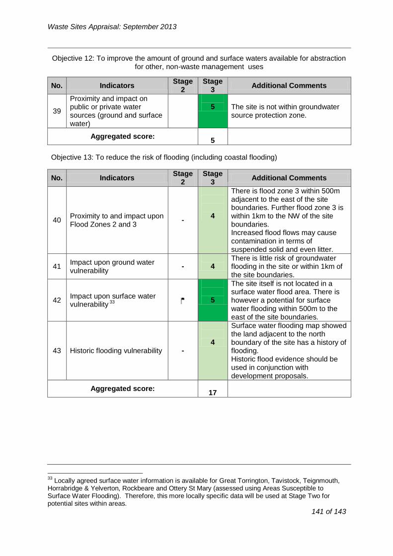
No. Indicators
Stage 2
Stage 3
Additional Comments
Proximity and impact on
39 public or private water
sources (ground and surface
5 The site is not within groundwater source protection zone.
water)
Aggregated score:
5
No. Indicators
Stage 2
Stage 3
Additional Comments
There is flood zone 3 within 500m adjacent to the east of the site boundaries. Further flood zone 3 is
40 Proximity to and impact upon
Flood Zones 2 and 3 -
4 within 1km to the NW of the site boundaries.
Increased flood flows may cause contamination in terms of
suspended solid and even litter.
41 Impact upon ground water
vulnerability -
4
There is little risk of groundwater flooding in the site or within 1km of
the site boundaries.
The site itself is not located in a
42 Impact upon surface water
33 vulnerability
5
surface water flood area. There is however a potential for surface
water flooding within 500m to the east of the site boundaries.
Surface water flooding map showed the land adjacent to the north 4 boundary of the site has a history of
43 Historic flooding vulnerability - flooding. Historic flood evidence should be
used in conjunction with development proposals.
Aggregated score: 17
Waste Sites Appraisal: September 2013
Objective 12: To improve the amount of ground and surface waters available for abstraction for other, non-waste management uses
Objective 13: To reduce the risk of flooding (including coastal flooding)
Locally agreed surface water information is available for Great Torrington, Tavistock, Teignmouth, Horrabridge & Yelverton, Rockbeare and Ottery St Mary (assessed using Areas Susceptible to Surface Water Flooding). Therefore, this more locally specific data will be used at Stage Two for potential sites within areas.
141 of 143
33

No. Indicators Stage
2 Stage
3 Additional Comments
44 Impact on Air Quality Management Areas (including proposed)
-5
There is no AQMA within 1km of the site boundaries.
Aggregated score: 5
No. Indicators Stage
2 Stage
3 Additional Comments
45 Impact on level of tranquillity at site
- 5 Low at present due to road noise and close relationship to development
Aggregated score: 5
No. Indicators Stage
2 Stage
3 Additional Comments
46 Located within existing industrial estate34 - 3
Site is not currently in industrial use but does have industrial employment uses to the north (Yalberton Tor) Electrical Substation to the east.
47 Alignment with District DPD allocation for employment land (B2 or B8)35
3
Site is allocated in the adopted Local Plan for Employment use (E1.16c) B1, B2, and B8.The new local plan identifies this area SDP3 Paignton west for a mix of housing, employment recreation and local facilities.
48 Site within previously developed land - 1
Agricultural land
49 Potential to restore, or utilise unrestored land at former quarries
- 1 Not a former quarry site.
Aggregated score: 8
Waste Sites Appraisal: September 2013
Objective 14: To improve air quality
Objective 15: To reduce the impact of noise and vibration on tranquillity
Aggregated Stage 3 Score for constraints criteria: 185
Opportunity Criteria
Objective 2: To encourage sustainable economic growth in Devon’s urban and rural areas
34 Not applicable for consideration of landfill or land raise sites
35 Not applicable for consideration of landfill or land raise sites
142 of 143

No. Indicators
Stage 2
Stage 3
Additional Comments
Potential for alternative
50 modes of transport (rail or water)
1 None
51 Access to the strategic road network
4 Good
Aggregated score: 5
No. Indicators
Stage 2
Stage 3
Additional Comments
52 Ability to export electricity
and/or gas to the national grid
4 Site Lies adjacent to Electricity Sub
station
53 Ability to export heat to local
user
Site lies with 500m of Supermarket and site with consent for 220
dwellings and 5000sqm of employment use.
4
Aggregated score: 8
Waste Sites Appraisal: September 2013
Objective 3: To reduce the mileage of waste transported by road whilst promoting the use of more sustainable modes of transport
Objective 10: To reduce total waste arisings and the proportion of waste disposed in landfill
Aggregated Stage 3 Score for opportunity criteria: 21
Stage 4: Consideration of cumulative impacts
The site is located within the emerging Local Plan Policy SDP3 and in proximity to a number of areas which have been identified for potential development within the emerging Torbay Local Plan and therefore there may be potential for cumulative impacts. Torpark Road, Yalberton Depot and Claylands sites, lie within 500m of the site, are also being appraised through this process; therefore if the two or the three sites were to come forward for development, cumulative impacts assessment would be required.
Stage 5: Summary of Site Appraisal for Yalberton tor Quarry:
Well located (within 100m) to the HWRC , the site is a former limestone quarry and an inert landfill site and therefore it could potentially cause land contamination and stability issues. The site currently has permission and is operating phased approach to recovering and disposing of in-situ and imported waste, the progressive land filling of the quarry void with inert waste and the construction of an appropriate geological barrier in conjunction with waste recycling operations and restoration and ceasing of mineral extraction. This is operating as a suitable CDEW facility for the Plan Period (23-29 years processing for 150,000 tonnes of material pa). The site has good potential for multiple and complimentary waste uses and therefore it could accommodate a recovery facility in the long-term.
Recommendation:
The site currently operates as Torbay's CDEW. It could accommodate CIW recovery facility in the long-term.
143 of 143