Embed Size (px)
Citation preview
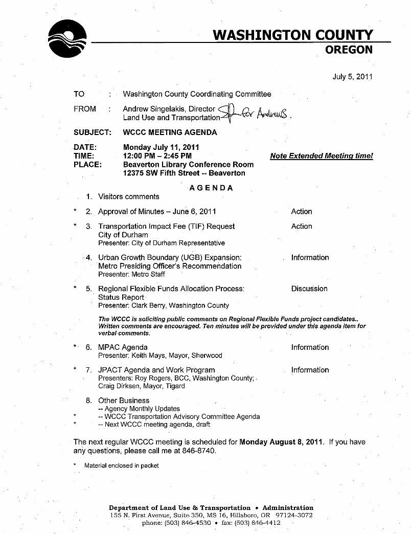
WASHINGTON COUNTY COORDINATING COMMITTEE POLICY GROUP MINUTES
June 6, 2011
Voting Members: Roy Rogers, Washington County, Chair Craig Dirksen, City of Tigard Marc San Soucie, City of Beaverton Rob Dixon, City of Hillsboro Pete Truax, City of Forest Grove Tim Knapp, City of Wilsonville Keith Mays, City of Sherwood Monique Beikman, City of Tualatin Jef Dalin, City of Cornelius Brian Biehl, City of Banks Others in Attendance: Andrew Singelakis, Washington County Andy Back, Washington County Randy Ely, Beaverton Neil McFarlane, TriMet Mark Brown, Washington County Clark Berry, Washington County Kathryn Harrington, Metro Councilor Lise Glancy, Port of Portland Dick Schouten, Washington County BCC Aisha Willits, Washington County Mike McKillip, City of Tualatin Roland Signett, City of Durham Margaret Middleton, City of Beaverton Blair Crumpacker, Washington County Olivia Clark, TriMet JC Vannatta, TriMet Mike Hoglund, Metro John Southgate, City of Hillsboro Ted Leybold, Metro Amy Rose, Metro Rob Foster, City of Forest Grove Don Odermott, City of Hillsboro Tom Pessemier, City of Sherwood Dave Waffle, City of Cornelius Gus Duenas, City of Tigard Hal Bergsma, THPRD Duane Roberts, City of Tigard Doug Meinke, THPRD Susan Peithman, Bicycle Trans. Alliance Lynne Mytrie, Oregon Safe Routes to School John Valley, Senator Merkley’s Office Gary Stockhoff, Washington County Rian Windsheimer, ODOT Kelly Brooks, ODOT Region 1 Jonathan Schlueter, WEA Mark Ottenad, City of Wilsonville Ernie Platt, HBAMP Mary Manseau, CPO 7 Tim McGilvrey, CPO 4m Jason Yurgel, Citizen Roy Rogers called the meeting to order at 12:06 PM. He introduced TriMet General Manager Neil McFarlane and welcomed him to the meeting. Agenda Item 1 – Visitors Comments: No visitors chose to speak. Roy Rogers stated that comments on Regional Flexible Funds projects could be made later in the meeting. Agenda Item 2 – Approval of Minutes, May 9, 2011: Jef Dalin stated that the last paragraph of Agenda Item 7, on page 4 of the minutes, should read that he referred to bicycling on Tualatin Valley Highway, not on Walker Road. With that correction, WCCC members approved the May 9 meeting minutes unanimously. Agenda Item 3 – Regional Flexible Funds Allocation Process: Status Report: Clark Berry provided some background on this item. He stated that Metro had defined a new process and new criteria for the allocation regional flexible funds this year. He described the allocation method summarized in the memorandum in the meeting packet, noting that the schedule calls for the WCCC to recommend a set of projects at its August 8 meeting. Mr. Berry pointed out a spreadsheet in the meeting packet that listed 14 originally proposed
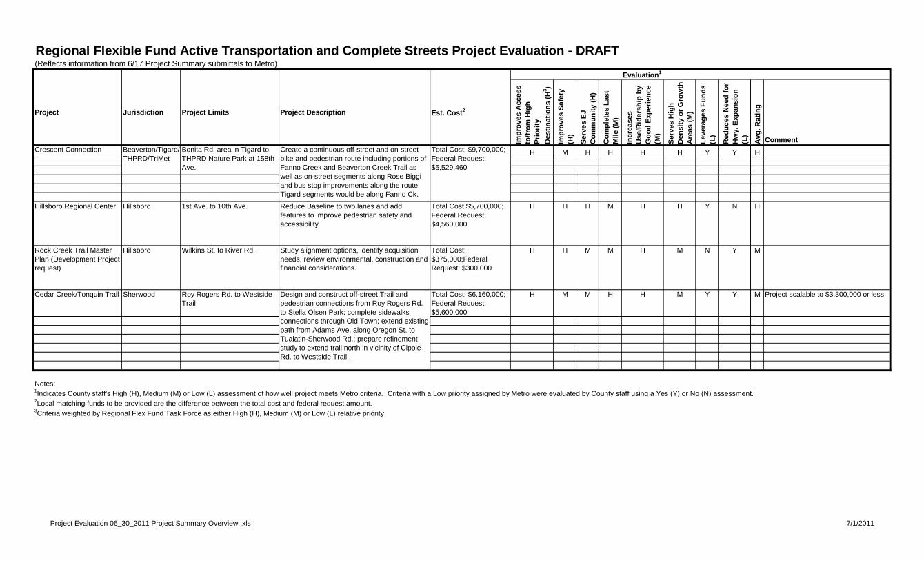
WCCC June 6, 2011 meeting minutes July 5, 2011 Page 2 projects and highlighted the seven projects the WCCC TAC recommended forwarding to Metro for review. He stated that the projects would be reviewed by TPAC to determine whether they met basic eligibility criteria. He stated that staff would do brief presentations on the projects for the WCCC at its July 11 meeting. He stated that, given available funding and minimum project cost criteria, probably only one Active Transportation project, possibly two if enough matching funds are available, and one freight project could be funded with dollars available to Washington County local governments. Mr. Berry stated that final nominations are due to Metro on August 29, and that JPACT is scheduled to act on proposed projects on September 8. Roy Rogers asked whether the Port of Portland and TriMet had been involved in project selection. Mr. Berry stated that TriMet had been very involved in discussions. Neil McFarlane stated that TriMet was providing match for transit elements in the Crescent Connection proposal and would be looking at participation opportunities in other projects. Mr. Berry stated that the Port had been involved in discussions but had not submitted proposals at this point. Lise Glancy stated that the Port is working on some projects with the City of Portland, but that it is also supportive of Washington County local governments’ efforts. Marc San Soucie clarified that there is $5.6 million available for active transportation/complete streets projects and $1.3 million for green economy/freight in Washington County, and that this round of projects would be funded in 2014-15. Roy Rogers asked whether others wanted to comment. Susan Peithman of the Bicycle Transportation Alliance (BTA) distributed a letter of support for forwarding the following active transportation projects to Metro for review: the Crescent Connection, the Rock Creek Trail Master Plan, the Cedar Creek/Tonquin Trail and the Hillsboro Regional Center project. She also stated the BTA’s support for the 10th Avenue Green Economy & Freight project in Cornelius. She stated that active transportation facilities should be easy and comfortable to use, and that while it is important to provide on-street facilities, off-street or separated facilities are viewed as more attractive by most users. Tim McGilvrey stated that parts of the Crescent Connection project don’t seem to be particularly important for most transportation-related bicycling. He stated that he is a bit confused regarding the purpose of the projects, since his understanding is that these were supposed to fulfill a transportation purpose. He stated that two of the seven projects seem to have very localized benefits for only low-skilled, recreational riders and don’t support longer-distance trips for commuting or other purposes – which he called “trans-jurisdictional” trips. He stated that the Tigard Trail might be a good park project, but that it wouldn’t do anything for transportation, since there’s no compelling reason for cyclists to leave Tigard Street to take the trail instead. Mr. McGilvrey stated that Beaverton’s section of the Crescent Connection is very important, but the facilities stop at King and Denney Road. He stated that the Fanno Creek crossing at Hall Boulevard is the important element. Tigard planner Duane Roberts stated that the Crescent Connection gap between Woodard and Main streets in Tigard would be filled by a project in 2012. He stated that these funds being discussed today would be available in 2014-15. He stated that the Brown Connection element is identified through a master planning process, and that it is
WCCC June 6, 2011 meeting minutes July 5, 2011 Page 3 included because low income, ethnic populations in the area ranked it as their highest priority. He stated that the Tigard Street trail provides direct access to the Tigard Transit Center and WES services. Hal Bergsma stated that THPRD is in the process of looking at options for the Hall Street mid-block crossing mentioned by Mr. McGilvrey. Craig Dirksen stated that while Mr. McGilvrey is correct that some serious commuter or long-distance bicyclists are not likely to benefit from some elements of the project, that the trails sections do provide a safer and more protected route that is attractive to other types of bicyclists. Roy Rogers asked if there were any other comments on the projects. There were none. The WCCC voted unanimously to forward the seven projects to Metro for review. Agenda Item 6 – Indicators Project: Metro: Metro’s Mike Hoglund summarized an information piece on the Indicators Project that was in the meeting packet. He stated that the project, which had been underway for about a year, is focused on identifying and determining how to measure factors that are primary influences on achieving the outcomes identified as desirable through the Region’s planning processes. He noted that the information piece provides a good summary of the outcomes and identified factors, or “drivers”, of these outcomes. He stated that existing standards and targets are included in cases where they have been identified through planning processes. He stated that Metro was interested in the county’s opportunities maps, and noted that the project is looking into equity and environmental justice issues. Neil McFarlane stated that there is a lot of similarity between this work Metro is doing and the transit analysis presented to the WCCC the previous month. He stated that he believed the work put into these efforts now will pay dividends later. Agenda Item 4 -- Bicycle and Pedestrian System of Countywide Interest: Blair Crumpacker stated that the WCCC had been interested in how identification of a Bicycle and Pedestrian System of Countywide Interest (SCWI) would be integrated with work soon to begin on the Washington County Transportation Plan Update. Mr. Crumpacker stated that a preliminary schedule for the transportation plan update is included in a memo in the meeting packet, and that based on that schedule identification of a SCWI would likely occur between November 2011 and May 2012, as the plan update is going through system needs identification and alternatives development. He stated that he expected members of a citizen advisory committee and local government representatives on an intergovernmental coordinating committee would weigh in on SCWI development issues, and that there would be a couple of opportunities for the WCCC to review and offer comments as the process proceeds. Mr. Crumpacker noted that the plan update schedule and scope of work are preliminary and subject to further refinement once the County has a consultant team on board and additional discussion regarding the process and schedule can occur. Kathryn Harrington asked Mr. Crumpacker to clarify some of the acronyms in the memorandum, which he did. Roy Rogers observed that every city has a transportation plan, as does the county, and wondered why it would take so long to develop this map. Andrew Singelakis stated that staff could provide draft work documents along the way, and that the schedule discussed applies to final adoption of an updated transportation plan.
WCCC June 6, 2011 meeting minutes July 5, 2011 Page 4 Jef Dalin stated that he appreciated Mr. McGilvrey’s comments on “trans-jurisdictional cyclists.” He stated that these people will use the existing roadway system, but that to increase the number of cyclists we need to do different things. He stated that improving trails would get people to ride and increasing their confidence so they can move onto other parts of the system. He said that minor elements of the system can have broad benefits, noting that if minor off street trails enable cyclists to get to transit, then these trips become regional trips. He stated that we need to have more discussions with cities and to engage more users of the bicycle and pedestrian system. Rob Dixon stated that Hillsboro City Councilor Mike Castillo had suggested a strategic approach to bicycle and pedestrian system that focuses on where we want or need to go – the backbones of the system – to prioritize gaps that need to be filled. Marc San Soucie stated that the decision to formalize a bicycle and pedestrian SCWI may be lost if it is delayed until November and interest in developing it loses momentum over the next several months. Kathryn Harrington stated that the county should tap into valuable resources in cities to identify needed linkages between communities. Jef Dalin stated that staff should be inclusive, asking lots of people for their input. The timeframe does provide an opportunity to gather data. He stated he agreed that it would be important to be strategic in identifying improvement priorities. Monique Beikman stated that the city of Tualatin was starting its transportation plan update with citizen involvement, then planning to retain a transportation consultant later. She agreed that county staff should tap into cities planning work to facilitate development of the county’s transportation system plan. Agenda Item 5 – ARRA Grant Projects: Assessment: Gary Stockhoff stated that a memorandum identifying American Recovery and Reinvestment Act (ARRA) projects completed during the past two years by Washington County local governments was included in the meeting packet. He stated that the projects’ costs totaled approximately $14 million. Rob Dixon stated that in addition to these projects the city of Hillsboro’s partnership with TriMet and the Federal Transit Administration (FTA) in constructing the Intermodal Transit Facility had been very successful. There was some uncertainty about the city of Cornelius project identified as costing $50. It was noted that a bike and ride would open at the Beaverton Transit Center on July 18. Agenda Item 7 – MPAC Agenda: Keith Mays provided an overview of the MPAC agenda, noting that the committee would be asked to provide direction on High Capacity Transit (HCT) System Expansion and to review an approach to development of Climate Smart Communities. Kathryn Harrington noted that some Climate Smart Communities scenarios had been considered at the previous MPAC meeting. Agenda Item 8 – JPACT Agenda and work program: Mark Brown summarized the JPACT agenda, noting the committee would also be considering HCT system expansion, and would be asked to recommend approval to move forward with the Climate Smart Communities analysis. Agenda Item 9 – Other Business: Lise Glancy urged WCCC members to support the Columbia River Crossing (CRC) resolution in the JPACT meeting packet, which states that a specified set of CRC issues have been successfully addressed.
Regional Flexible Fund Active Transportation and Complete Streets Project Evaluation - DRAFT (Reflects information from 6/17 Project Summary submittals to Metro)
Evaluation1
Project Jurisdiction Project Limits Project Description Est. Cost2
Imp
rove
s A
cces
s to
/fro
m H
igh
P
rio
rity
D
esti
nat
ion
s (H
3 )
Imp
rove
s S
afet
y (H
)
Ser
ves
EJ
Co
mm
un
ity
(H)
Co
mp
lete
s L
ast
Mile
(M
)
Incr
ease
s U
se/R
ider
ship
by
Go
od
Exp
erie
nce
(M
)
Ser
ves
Hig
h
Den
sity
or
Gro
wth
A
reas
(M
)
Lev
erag
es F
un
ds
(L)
Red
uce
s N
eed
fo
r H
wy.
Exp
ansi
on
(L
)
Avg
. Rat
ing
CommentCrescent Connection H M H H H H Y Y H
Hillsboro Regional Center Hillsboro 1st Ave. to 10th Ave. Reduce Baseline to two lanes and add features to improve pedestrian safety and accessibility
Total Cost $5,700,000; Federal Request: $4,560,000
H H H M H H Y N H
Rock Creek Trail Master Plan (Development Project request)
Hillsboro Wilkins St. to River Rd. Study alignment options, identify acquisition needs, review environmental, construction and financial considerations.
Total Cost: $375,000;Federal Request: $300,000
H H M M H M N Y M
Cedar Creek/Tonquin Trail Sherwood Roy Rogers Rd. to Westside Trail
Total Cost: $6,160,000; Federal Request: $5,600,000
H M M H H M Y Y M Project scalable to $3,300,000 or less
Notes:1Indicates County staff's High (H), Medium (M) or Low (L) assessment of how well project meets Metro criteria. Criteria with a Low priority assigned by Metro were evaluated by County staff using a Yes (Y) or No (N) assessment.2Local matching funds to be provided are the difference between the total cost and federal request amount.3Criteria weighted by Regional Flex Fund Task Force as either High (H), Medium (M) or Low (L) relative priority
Total Cost: $9,700,000; Federal Request: $5,529,460
Beaverton/Tigard/THPRD/TriMet
Bonita Rd. area in Tigard to THPRD Nature Park at 158th Ave.
Design and construct off-street Trail and pedestrian connections from Roy Rogers Rd. to Stella Olsen Park; complete sidewalks connections through Old Town; extend existing path from Adams Ave. along Oregon St. to Tualatin-Sherwood Rd.; prepare refinement study to extend trail north in vicinity of Cipole Rd. to Westside Trail..
Create a continuous off-street and on-street bike and pedestrian route including portions of Fanno Creek and Beaverton Creek Trail as well as on-street segments along Rose Biggi and bus stop improvements along the route. Tigard segments would be along Fanno Ck.
Project Evaluation 06_30_2011 Project Summary Overview .xls 7/1/2011
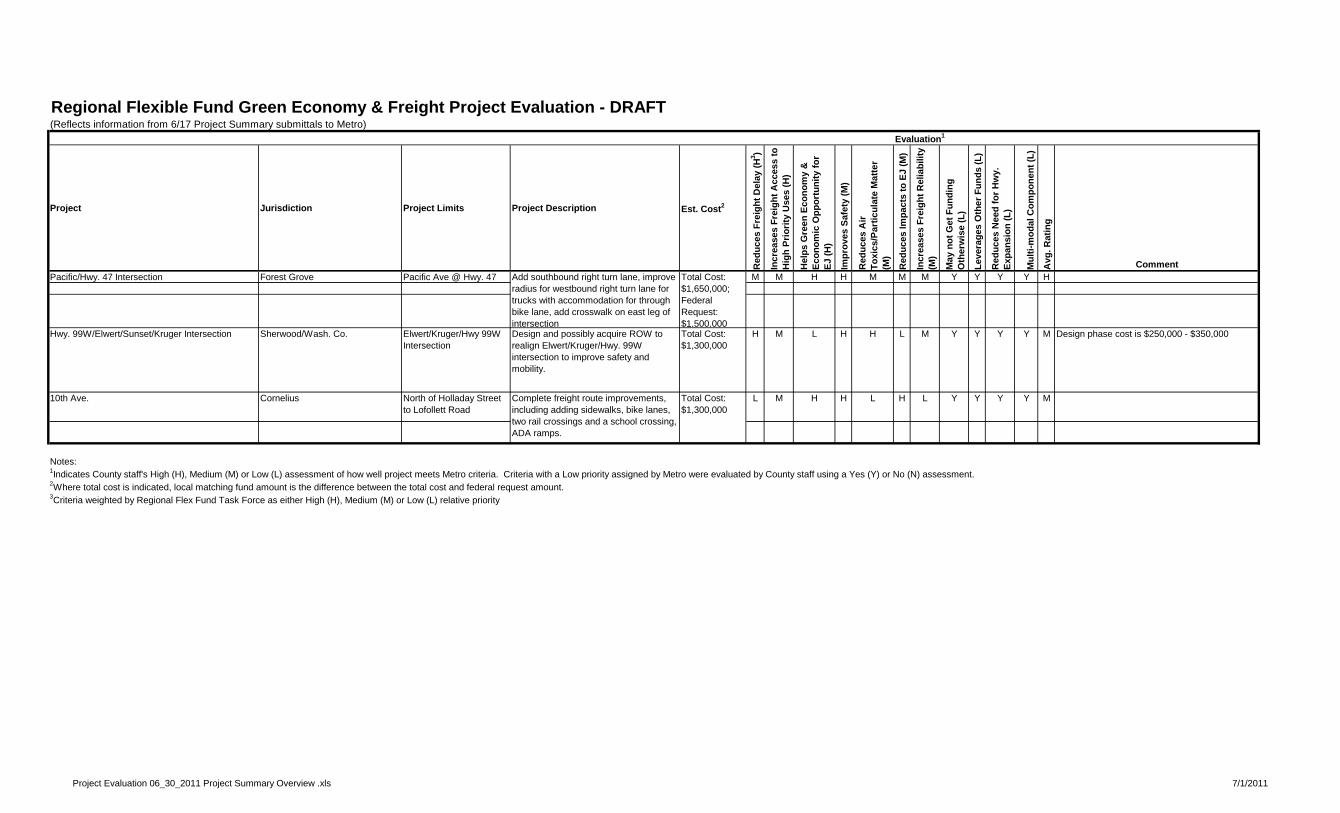
Regional Flexible Fund Green Economy & Freight Project Evaluation - DRAFT (Reflects information from 6/17 Project Summary submittals to Metro)
Evaluation1
Project Jurisdiction Project Limits Project Description Est. Cost2
Red
uce
s F
reig
ht
Del
ay (
H3 )
Incr
ease
s F
reig
ht
Acc
ess
to
Hig
h P
rio
rity
Use
s (H
)
Hel
ps
Gre
en E
con
om
y &
E
con
om
ic O
pp
ort
un
ity
for
EJ
(H)
Imp
rove
s S
afet
y (M
)
Red
uce
s A
ir
To
xics
/Par
ticu
late
Mat
ter
(M)
Red
uce
s Im
pac
ts t
o E
J (M
)
Incr
ease
s F
reig
ht
Rel
iab
ility
(M
)
May
no
t G
et F
un
din
g
Oth
erw
ise
(L)
Lev
erag
es O
ther
Fu
nd
s (L
)
Red
uce
s N
eed
fo
r H
wy.
E
xpan
sio
n (
L)
Mu
lti-
mo
dal
Co
mp
on
ent
(L)
Avg
. Rat
ing
CommentPacific/Hwy. 47 Intersection Forest Grove Pacific Ave @ Hwy. 47 M M H H M M M Y Y Y Y H
Hwy. 99W/Elwert/Sunset/Kruger Intersection Sherwood/Wash. Co. Elwert/Kruger/Hwy 99W Intersection
Design and possibly acquire ROW to realign Elwert/Kruger/Hwy. 99W intersection to improve safety and mobility.
Total Cost: $1,300,000
H M L H H L M Y Y Y Y M Design phase cost is $250,000 - $350,000
10th Ave. Cornelius North of Holladay Street to Lofollett Road
L M H H L H L Y Y Y Y M
Notes:1Indicates County staff's High (H), Medium (M) or Low (L) assessment of how well project meets Metro criteria. Criteria with a Low priority assigned by Metro were evaluated by County staff using a Yes (Y) or No (N) assessment.2Where total cost is indicated, local matching fund amount is the difference between the total cost and federal request amount.3Criteria weighted by Regional Flex Fund Task Force as either High (H), Medium (M) or Low (L) relative priority
Total Cost: $1,300,000
Total Cost: $1,650,000; Federal Request: $1,500,000
Add southbound right turn lane, improve radius for westbound right turn lane for trucks with accommodation for through bike lane, add crosswalk on east leg of intersection
Complete freight route improvements, including adding sidewalks, bike lanes, two rail crossings and a school crossing, ADA ramps.
Project Evaluation 06_30_2011 Project Summary Overview .xls 7/1/2011
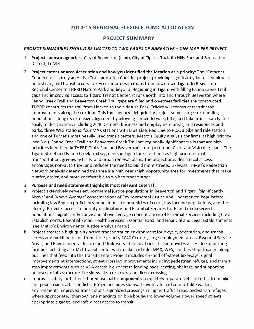
2014‐15 REGIONAL FLEXIBLE FUND ALLOCATION
PROJECT SUMMARY
PROJECT SUMMARIES SHOULD BE LIMITED TO TWO PAGES OF NARRATIVE + ONE MAP PER PROJECT
1. Project sponsor agencies: City of Beaverton (lead), City of Tigard, Tualatin Hills Park and Recreation District, TriMet
2. Project extent or area description and how you identified the location as a priority: The “Crescent Connection” is truly an Active Transportation Corridor project providing significantly increased bicycle, pedestrian, and transit access to key corridor destinations from downtown Tigard to Beaverton Regional Center to THPRD Nature Park and beyond. Beginning in Tigard with filling Fanno Creek Trail gaps and improving access to Tigard Transit Center, it runs north into and through Beaverton where Fanno Creek Trail and Beaverton Creek Trail gaps are filled and on‐street facilities are constructed. THPRD constructs the trail from Hocken to their Nature Park. TriMet will construct transit stop improvements along the corridor. This four‐agency high priority project serves large surrounding populations along its extensive alignment by allowing people to walk, bike, and take transit safely and easily to designations including 2040 Centers, business and employment areas, and residences and parks, three WES stations, four MAX stations with Blue Line, Red Line to PDX, a bike and ride station, and one of TriMet’s most heavily used transit centers. Metro’s Equity Analysis confirms its high priority (see 3.a.). Fanno Creek Trail and Beaverton Creek Trail are regionally significant trails that are high priorities identified in THPRD Trails Plan and Beaverton’s transportation, Civic, and Visioning plans. The Tigard Street and Fanno Creek trail segments in Tigard are identified as high priorities in its transportation, greenway trails, and urban renewal plans. The project provides critical access, encourages non‐auto trips, and reduces the need to build more streets. Likewise TriMet’s Pedestrian Network Analysis determined this area is a high need/high opportunity area for investments that make it safer, easier, and more comfortable to walk to transit stops.
3. Purpose and need statement (highlight most relevant criteria): a. Project extensively serves environmental justice populations in Beaverton and Tigard: ‘Significantly
Above’ and ‘Above Average’ concentrations of Environmental Justice and Underserved Populations including low English proficiency populations, communities of color, low income populations, and the elderly. Provides access to priority destinations and Essential Services for EJ and underserved populations: Significantly above and above average concentrations of Essential Services including Civic Establishments, Essential Retail, Health Services, Essential Food, and Financial and Legal Establishments (see Metro’s Environmental Justice Analysis maps).
b. Project creates a high quality active transportation environment for bicycle, pedestrian, and transit access and mobility to and from three priority 2040 Centers, large employment areas, Essential Service Areas, and Environmental Justice and Underserved Populations. It also provides access to supporting facilities including a TriMet transit center with a bike and ride, MAX, WES, and bus stops located along bus lines that feed into the transit center. Project includes on‐ and off‐street bikeways, signal improvements at intersections, street crossing improvements including pedestrian refuges, and transit stop improvements such as ADA accessible concrete landing pads, seating, shelters, and supporting pedestrian infrastructure like sidewalks, curb cuts, and direct crossings.
c. Improves safety: off‐street shared use path components completely separate vehicle traffic from bike and pedestrian traffic conflicts. Project includes sidewalks with safe and comfortable walking environments, improved transit stops, signalized crossings in higher traffic areas, pedestrian refuges where appropriate, ‘sharrow’ lane markings on bike boulevard lower volume slower speed streets, appropriate signage, and safe direct access to transit.
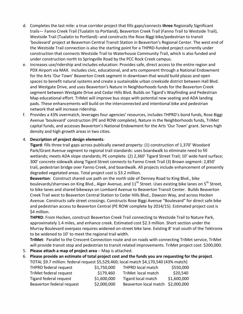
d. Completes the last mile: a true corridor project that fills gaps/connects three Regionally Significant trails— Fanno Creek Trail (Tualatin to Portland), Beaverton Creek Trail (Fanno Trail to Westside Trail), Westside Trail (Tualatin to Portland)‐‐and constructs the Rose Biggi bike/pedestrian to transit ‘boulevard’ project at Beaverton Central Transit Station in Beaverton’s Regional Center. The west end of the Westside Trail connection is also the starting point for a THPRD‐funded project currently under construction that connects Westside Trail to Waterhouse Community Trail, which is also funded and under construction north to Springville Road by the PCC Rock Creek campus.
e. Increases use/ridership and includes education: Provides safe, direct access to the entire region and PDX Airport via MAX. Includes civic, educational, and arts component through a National Endowment for the Arts ‘Our Town’ Beaverton Creek segment in downtown that would build plazas and open spaces to benefit natural systems and create a sustainable urban creekside district between Hall Blvd. and Westgate Drive, and uses Beaverton’s Nature in Neighborhoods funds for the Beaverton Creek segment between Westgate Drive and Cedar Hills Blvd. Builds on Tigard’s Wayfinding and Pedestrian Map educational effort. TriMet will improve bus stops with potential new seating and ADA landing pads. These enhancements will build on the interconnected and intentional bike and pedestrian network that will increase ridership.
f. Provides a 43% overmatch, leverages four agencies’ resources, includes THPRD’s bond funds, Rose Biggi Avenue ‘boulevard’ construction (PE and ROW complete), Nature in the Neighborhoods funds, TriMet capital funds, and accesses Beaverton’s National Endowment for the Arts ‘Our Town’ grant. Serves high density and high growth areas in two cities.
4. Description of project design elements: Tigard: fills three trail gaps across publically owned property: (1) construction of 1,370’ Woodard Park/Grant Avenue segment to regional trail standards: uses boardwalk to eliminate need to fill wetlands; meets ADA slope standards; PE complete. (2) 2,360’ Tigard Street Trail; 10’ wide hard surface; 300’ concrete sidewalk along Tigard Street connects to Fanno Creek Trail (3) Brown segment: 2,850’ trail, pedestrian bridge over Fanno Creek, and boardwalk. All projects include enhancement of presently degraded vegetated areas. Total project cost is $3.2 million. Beaverton: Construct shared use path on the north side of Denney Road to King Blvd., bike boulevards/sharrows on King Blvd., Alger Avenue, and 11th Street. Uses existing bike lanes on 5th Street, to bike lanes and shared bikeways on Lombard Avenue to Beaverton Transit Center. Builds Beaverton Creek Trail west to Beaverton Central Station to Cedar Hills Blvd., Dawson Way, and across Hocken Avenue. Constructs safe street crossings. Constructs Rose Biggi Avenue “Boulevard” for direct safe bike and pedestrian access to Beaverton Central (PE ROW complete by 2014/15). Estimated project cost is $4 million. THPRD: From Hocken, construct Beaverton Creek Trail connecting to Westside Trail to Nature Park, approximately 1.4 miles, and enhance creek. Estimated cost $2.3 million. Short section under the Murray Boulevard overpass requires widened on‐street bike lane. Existing 8’ trail south of the Tektronix to be widened to 10’ to meet the regional trail width. TriMet: Parallel to the Crescent Connection route and on roads with connecting TriMet service, TriMet will provide transit stop and pedestrian to transit related improvements. TriMet project cost: $200,000.
5. Please attach a map of project area – Map is attached. 6. Please provide an estimate of total project cost and the funds you are requesting for the project.
TOTAL $9.7 million: federal request $5,529,460; local match $4,170,540 (43% match) THPRD federal request $1,750,000 THPRD local match $550,000 TriMet federal request $179,460 TriMet local match $20,540 Tigard federal request $1,600,000 Tigard local match $1,600,000 Beaverton federal request $2,000,000 Beaverton local match $2,000,000
SW MCDONALD
H
W
Y
9
9
S
W
S
C
H
O
L
L
S
F
E
R
R
Y
R
O
A
D
2
1
7
SW
H
ALL
SW
M
UR
RA
Y
SW
170T
H
S
W
F
A
R
M
IN
G
T
O
N
S
W
T
V
H
W
Y
SW ALLEN
HILLSDALE
SW BEAVER
TON
S
W
W
A
L
K
E
R
2
1
7
H
W
Y
26
H
W
Y
2
6
S
W
M
U
R
R
A
Y
217
SW DENNEY
S
W
H
A
LL
S
W
C
A
N
Y
O
N
SW
158T
H
C
E
D
A
R
H
I
L
L
S
B
L
V
D
D
A
W
S
O
N
SW CENTER
S
W
1
S
T
KIN
G
W
A
LN
U
T S
T
M
A
I
N
S
T
B
U
R
N
H
A
M
G
R
E
E
N
B
U
R
G
R
D
TIGARD ST
NIM
BU
S A
VE
1
5
3
R
D
D
R
MU
RR
AY
B
LV
D
H
A
L
L
M
I
L
L
I
K
A
N
L
O
M
B
A
R
D
S
W
5
T
H
ALG
ER
A
VE
SW 11TH
LE
E
M
I
L
T
O
N
C
T
G
R
A
N
T
A
V
E
HO
CK
EN
WESTGATE
PROPOSED TRAIL
LEGEND
EXISTING TRAIL
TRAIL CONNECTION POINT
N
BEAVERTON TRANSIT CTR
TIGARD TRANSIT CENTER
AREA FOR BUS STOP
INVESTMENTS
MAX/WES STATION
LIGHTRAIL
B
T
T
B
R
O
S
E
B
IG
G
I
E
X
T
E
N
S
IO
N
N
A
TU
R
E
P
A
R
K
2014‐15 REGIONAL FLEXIBLE FUND ALLOCATION
PROJECT SUMMARY
PROJECT SUMMARIES LIMITED TO TWO PAGES OF NARRATIVE + ONE MAP PER PROJECT
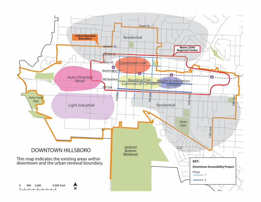
1. Project sponsor agency: City of Hillsboro, in consultation with ODOT, Washington
County, Metro, and TriMet
2. Project extent or area description and how you identified the location as a priority:
The project extent includes Baseline Street between 1st and 10th Avenues in the
Hillsboro Regional Center. (see attached map)
The area was identified as a priority for investment by the Hillsboro community through
an extensive community outreach process that was completed as part of the Downtown
Framework Plan (adopted November, 2009). The City identified the project as eligible
for urban renewal funding as part of the Downtown Hillsboro Urban Renewal Plan
(adopted May, 2010). In cooperation with Metro, the City refined its objectives by
developing a visionary concept‐level “road diet” plan for Oak and Baseline and a two‐
way conversion plan for the downtown core, known collectively as the Downtown
Hillsboro Accessibility Project.
3. Purpose and need statement (highlight most relevant criteria):
The requested MTIP funds would support the Baseline road diet as a first phase. The
MTIP funds would provide approximately 75% of the funding necessary to achieve this
phase of the Downtown Hillsboro Accessibility Project. Hillsboro is endeavoring to
commence with the two‐way “core conversion” project using primarily local funds.
The Oak/Baseline road diet will enhance safety by providing traffic calming features,
reducing vehicle speeds, and improving pedestrian and bicycle access. It will reduce the
barrier effect of Oak and Baseline for the low‐income, ethnically diverse community on
the south side of downtown. The project is located within the Hillsboro Regional Center
which is targeted for high density job growth and residential/mixed use development.
Specifically, the project will increase access to priority community services destinations
such as City and County offices, the Tuality/Pacific Health & Education District, and
other employment and retail centers within the downtown area, as well as the Main
Street district, with its arts and entertainment venues and other attractors. The project
will also enhance access to the regional light‐rail system located in the heart of the
district, as well as bus access to the TriMet Line 57 Frequent Service route, and routes
46, 47, and 48, and the Yamhill County fixed‐route bus service at Max Central Station.
The area is a prime location for future growth targeted for high‐quality compact mixed‐
use and transit‐oriented development. The project will enhance livability in the
downtown by making walking, biking, and access to transit safer and more comfortable,
and increase the aesthetics of this critical gateway route through the downtown. The
project will support new investment, increasing job opportunities for the surrounding
community and producing more property tax revenues – in turn generating enhanced
urban renewal funding to support the regional center. The project will leverage federal,
local, state, regional and private funds. State, County, regional and local staff are
working to secure the needed approvals so that the project can move forward as soon
as funding is in place.
The proposed project will result in dramatic changes to the streetscape on Oak and
Baseline. Because of this visionary plan, significant partnerships are already underway
with ODOT to establish a Special Transportation Area (STA) in downtown Hillsboro and
to develop a Signal Modification Plan for the revised lane alignment along both streets.
The City is working toward an agreement with ODOT to ensure that ODOT’s plans for
pavement preservation along Highway 8 and the Road Diet are coordinated.
The City is firmly committed to working with its transportation partners at ODOT,
Washington County, Tri‐Met, and Metro, key stakeholders such as business and
property owners within the project area, and political leaders to ensure that the goals of
the Downtown Framework Plan are met. The City is committed to responding to citizen
requests to enhance these streets for its citizens and business owners and will address
their concerns in a meaningful way.
Metro’s Development Center is working with the City of Hillsboro to organize and fund
the Downtown Hillsboro Accessibility project concept plan and is a financial partner in a
joint Transit Oriented Development adjacent to the Hillsboro Transit Center (located
between 3rd and 4th Avenues on Washington Street). The City of Hillsboro also recently
adopted an Urban Renewal Plan and is actively working to enhance development
opportunities in the downtown. Local residents and business owners have been
engaged throughout the concept planning process.
4. Description of project design elements:
The Oak and Baseline Road Diet will result in significant pedestrian infrastructure such
as curb extensions, on‐street parallel parking, enhanced pedestrian crossings, new ADA
compliant sidewalks where necessary, a reduction of the number of travel lanes, bike
facilities, bus stop enhancements, ornamental street lights, and street trees/planters. It
will also include traffic signal modifications necessary to support the City’s plans to
convert local streets to two‐way north‐south operation.
5. Please attach a map of project area (attached)
6. Please provide an estimate of total project cost and the funds you are requesting. We are requesting $4,560,000 to implement the Baseline Road Diet. The total project cost has been estimated at $5,700,000.
ÁÁÁ
Á
0 1,000 2,000500 Feet
SW Baseline
SW Oak
Main St
1st A
ve
Dairy Creek Park
JacksonBottom
Wetlands
ÁÁÁÁ
ShutePark
10th
Ave
13th
Ave
18th
Ave
MaMM
Light Industrial
Auto-OrientedRetail
Downtown core
Residential
Residential
Health & education campus
Baseline/Oak Commercial Corridor
DOWNTOWN HILLSBOROThis map indicates the existing areas within downtown and the urban renewal boundary.
N
5th
Ave
Washington St.
Lincoln St.
Jackson St.
Grant St.
Urban Renewal Boundary
Metro 2040 Regional Center
KEY:
Downtown Accessibility Project
Phase 1 2
2014‐15 REGIONAL FLEXIBLE FUND ALLOCATION
PROJECT SUMMARY – ROCK CREEK REGIONAL TRAIL PROJECT DEVELOPMENT
PROJECT SUMMARIES LIMITED TO TWO PAGES OF NARRATIVE + ONE MAP PER PROJECT
1. Project sponsor agency: City of Hillsboro
2. Project extent or area description and how you identified the location as a priority:
The goal of this project is to develop a master plan for the most feasible trail alignment and
construction options for future sections of the Rock Creek Trail to guide property acquisitions
and trail development. The Rock Creek Regional Trail was identified as the #1 priority for bike/
pedestrian improvements by the Hillsboro Bike and Pedestrian Task Force and is a featured in
the Hillsboro TSP and Parks & Trails Master plan as well as the Regional Trails and Greenways
Plan. It serves as the primary trail spine to which other trail segments are connected. The trail
links employment centers with neighborhoods, parks and other transportation modes,
including Light Rail, bus and on‐street bike lanes. When completed, the greenway trail will
extend over 8 miles from north of US 26 to the confluence with the Tualatin River. Biking and
walking paths are the most requested recreational feature according to a survey conducted in
2008. Several sections of the trail have been completed, and the City owns some lands along
the greenway corridor but will need additional acquisitions to close the gaps. The existing
trail is hugely popular across all segments of the population, and there is strong support for
completing the trail all along the Rock Creek Greenway.
3. Purpose and need statement (highlight most relevant criteria): Developing a trail in a
greenway corridor is extremely challenging because of environmental and land use constraints.
Careful planning is needed to assess physical conditions, access and land use patterns to
identify the most feasible alignment for the trail, including boardwalks over wetlands and
floodplains, bridge crossings over Rock Creek and major road crossings. This analysis can guide
future acquisitions to close the gaps and ensure the trail can be built. The public is very
supportive of the greenway trail concept because of its off road safety, scenic beauty and
connection to nature, providing enhancing livability in a dense urban area. The trail service area
crosses all economic sectors of the community and will provide needed infrastructure for active
transportation linking to employment, retail, parks and alternative transportation modes.
Extending the trail to the south and west will provide access to underserved economic justice
areas so they can be part of the trail network system. The project development plan will define
the preferred trail alignment and is a critical step toward actual implementation.
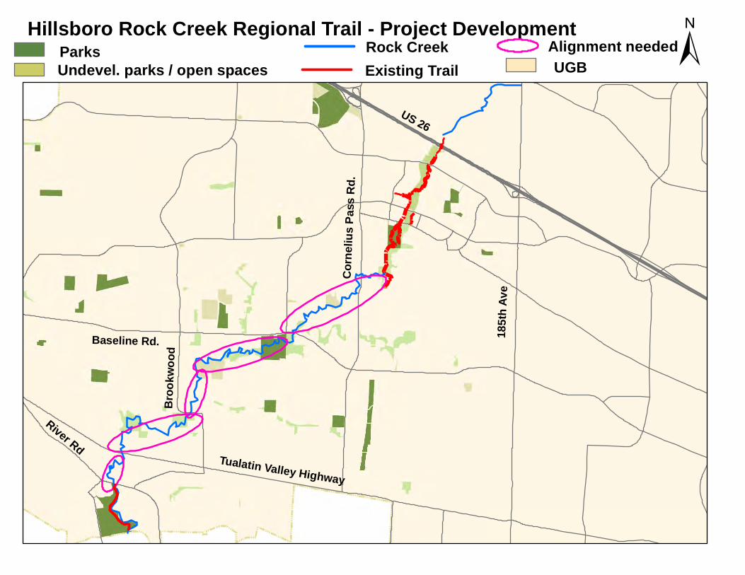
4. Description of project design elements: By 2012, the trail will be completed to NW
Wilkins Street / Cornelius Pass Road, about ¼ of the distance through Hillsboro. The City owns
significant portions of greenway corridor west and south of Cornelius Pass Road including
undeveloped park sites and open space tracts, but there are gaps between ownership. Some
parcels, although in public ownership, may have significant development constraints due to the
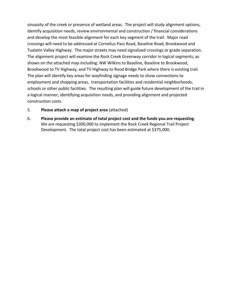
sinuosity of the creek or presence of wetland areas. The project will study alignment options,
identify acquisition needs, review environmental and construction / financial considerations
and develop the most feasible alignment for each key segment of the trail. Major road
crossings will need to be addressed at Cornelius Pass Road, Baseline Road, Brookwood and
Tualatin Valley Highway. The major streets may need signalized crossings or grade separation.
The alignment project will examine the Rock Creek Greenway corridor in logical segments, as
shown on the attached map including: NW Wilkins to Baseline, Baseline to Brookwood,
Brookwood to TV Highway, and TV Highway to Rood Bridge Park where there is existing trail.
The plan will identify key areas for wayfinding signage needs to show connections to
employment and shopping areas, transportation facilities and residential neighborhoods,
schools or other public facilities. The resulting plan will guide future development of the trail in
a logical manner, identifying acquisition needs, and providing alignment and projected
construction costs.
5. Please attach a map of project area (attached)
6. Please provide an estimate of total project cost and the funds you are requesting. We are requesting $300,000 to implement the Rock Creek Regional Trail Project Development. The total project cost has been estimated at $375,000.
US 26
Corn
elius
Pass
Rd.
Broo
kwoo
d
Tualatin Valley Highway
Baseline Rd. 185th
Ave
River Rd
Hillsboro Rock Creek Regional Trail - Project DevelopmentUGB ±Existing Trail
Rock CreekParksUndevel. parks / open spaces
Alignment needed
2014‐15 REGIONAL FLEXIBLE FUND ALLOCATION
PROJECT SUMMARY
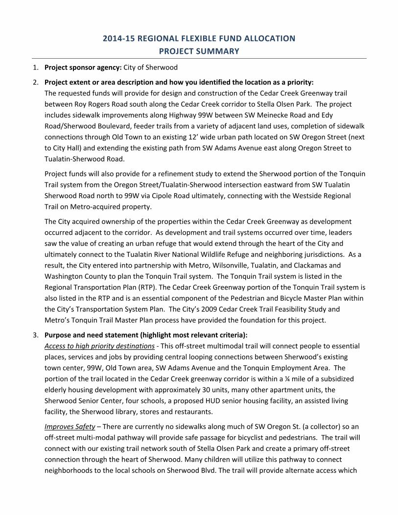
1. Project sponsor agency: City of Sherwood
2. Project extent or area description and how you identified the location as a priority:
The requested funds will provide for design and construction of the Cedar Creek Greenway trail
between Roy Rogers Road south along the Cedar Creek corridor to Stella Olsen Park. The project
includes sidewalk improvements along Highway 99W between SW Meinecke Road and Edy
Road/Sherwood Boulevard, feeder trails from a variety of adjacent land uses, completion of sidewalk
connections through Old Town to an existing 12’ wide urban path located on SW Oregon Street (next
to City Hall) and extending the existing path from SW Adams Avenue east along Oregon Street to
Tualatin‐Sherwood Road.
Project funds will also provide for a refinement study to extend the Sherwood portion of the Tonquin
Trail system from the Oregon Street/Tualatin‐Sherwood intersection eastward from SW Tualatin
Sherwood Road north to 99W via Cipole Road ultimately, connecting with the Westside Regional
Trail on Metro‐acquired property.
The City acquired ownership of the properties within the Cedar Creek Greenway as development
occurred adjacent to the corridor. As development and trail systems occurred over time, leaders
saw the value of creating an urban refuge that would extend through the heart of the City and
ultimately connect to the Tualatin River National Wildlife Refuge and neighboring jurisdictions. As a
result, the City entered into partnership with Metro, Wilsonville, Tualatin, and Clackamas and
Washington County to plan the Tonquin Trail system. The Tonquin Trail system is listed in the
Regional Transportation Plan (RTP). The Cedar Creek Greenway portion of the Tonquin Trail system is
also listed in the RTP and is an essential component of the Pedestrian and Bicycle Master Plan within
the City’s Transportation System Plan. The City’s 2009 Cedar Creek Trail Feasibility Study and
Metro’s Tonquin Trail Master Plan process have provided the foundation for this project.
3. Purpose and need statement (highlight most relevant criteria):
Access to high priority destinations ‐ This off‐street multimodal trail will connect people to essential
places, services and jobs by providing central looping connections between Sherwood’s existing
town center, 99W, Old Town area, SW Adams Avenue and the Tonquin Employment Area. The
portion of the trail located in the Cedar Creek greenway corridor is within a ¼ mile of a subsidized
elderly housing development with approximately 30 units, many other apartment units, the
Sherwood Senior Center, four schools, a proposed HUD senior housing facility, an assisted living
facility, the Sherwood library, stores and restaurants.
Improves Safety – There are currently no sidewalks along much of SW Oregon St. (a collector) so an
off‐street multi‐modal pathway will provide safe passage for bicyclist and pedestrians. The trail will
connect with our existing trail network south of Stella Olsen Park and create a primary off‐street
connection through the heart of Sherwood. Many children will utilize this pathway to connect
neighborhoods to the local schools on Sherwood Blvd. The trail will provide alternate access which
will reduce vehicle trips at already congested intersections along 99W and Tualatin‐Sherwood Road.
Improvements to the sidewalk system along 99W between Meinecke and Edy/Sherwood Boulevard
to access this trail system will increase safety across and along the highway.
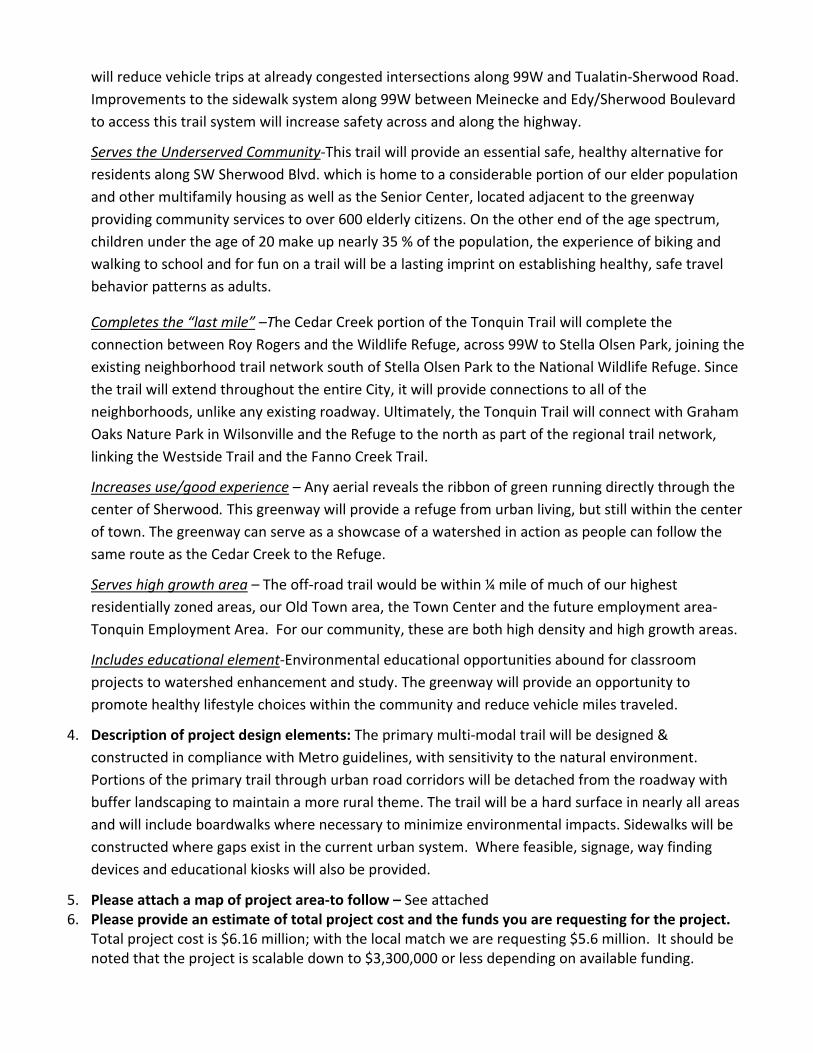
Serves the Underserved Community‐This trail will provide an essential safe, healthy alternative for
residents along SW Sherwood Blvd. which is home to a considerable portion of our elder population
and other multifamily housing as well as the Senior Center, located adjacent to the greenway
providing community services to over 600 elderly citizens. On the other end of the age spectrum,
children under the age of 20 make up nearly 35 % of the population, the experience of biking and
walking to school and for fun on a trail will be a lasting imprint on establishing healthy, safe travel
behavior patterns as adults.
Completes the “last mile” –The Cedar Creek portion of the Tonquin Trail will complete the
connection between Roy Rogers and the Wildlife Refuge, across 99W to Stella Olsen Park, joining the
existing neighborhood trail network south of Stella Olsen Park to the National Wildlife Refuge. Since
the trail will extend throughout the entire City, it will provide connections to all of the
neighborhoods, unlike any existing roadway. Ultimately, the Tonquin Trail will connect with Graham
Oaks Nature Park in Wilsonville and the Refuge to the north as part of the regional trail network,
linking the Westside Trail and the Fanno Creek Trail.
Increases use/good experience – Any aerial reveals the ribbon of green running directly through the
center of Sherwood. This greenway will provide a refuge from urban living, but still within the center
of town. The greenway can serve as a showcase of a watershed in action as people can follow the
same route as the Cedar Creek to the Refuge.
Serves high growth area – The off‐road trail would be within ¼ mile of much of our highest
residentially zoned areas, our Old Town area, the Town Center and the future employment area‐
Tonquin Employment Area. For our community, these are both high density and high growth areas.
Includes educational element‐Environmental educational opportunities abound for classroom
projects to watershed enhancement and study. The greenway will provide an opportunity to
promote healthy lifestyle choices within the community and reduce vehicle miles traveled.
4. Description of project design elements: The primary multi‐modal trail will be designed &
constructed in compliance with Metro guidelines, with sensitivity to the natural environment.
Portions of the primary trail through urban road corridors will be detached from the roadway with
buffer landscaping to maintain a more rural theme. The trail will be a hard surface in nearly all areas
and will include boardwalks where necessary to minimize environmental impacts. Sidewalks will be
constructed where gaps exist in the current urban system. Where feasible, signage, way finding
devices and educational kiosks will also be provided.
5. Please attach a map of project area‐to follow – See attached 6. Please provide an estimate of total project cost and the funds you are requesting for the project.
Total project cost is $6.16 million; with the local match we are requesting $5.6 million. It should be noted that the project is scalable down to $3,300,000 or less depending on available funding.
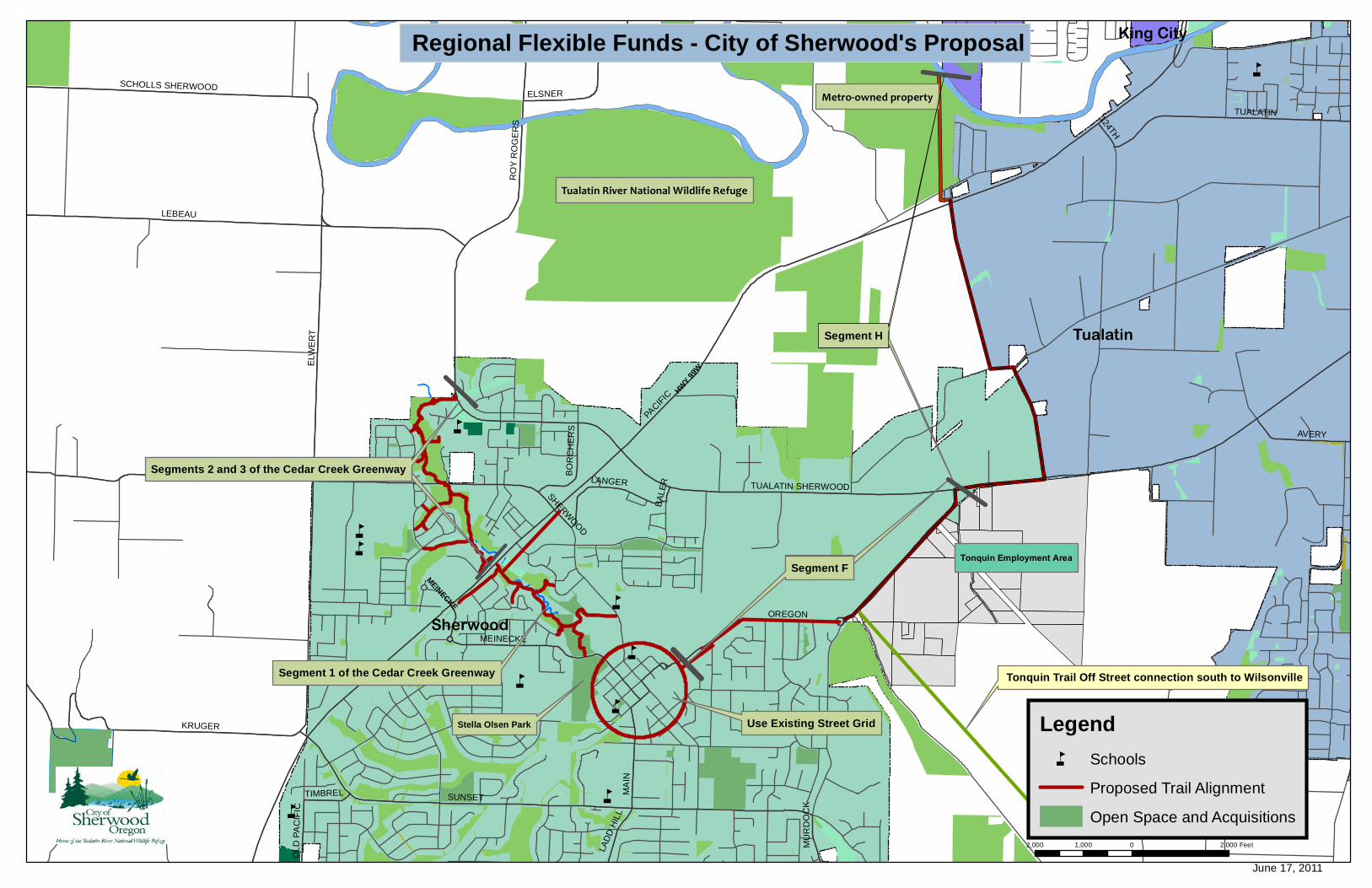
åå
å
å
å
å
å
å
å
å
å
å
Use Existing Street Grid
Segment H
Sherwood
Tualatin
King CityKing City
PACIF
IC
EDY
ELW
ER
T
SUNSET
LEBEAU
OREGON
TUALATIN SHERWOOD
RO
Y R
OG
ER
S
KRUGER
TUALATIN
SCHOLLS SHERWOOD
MA
IN
ELSNER
AVERY
LANGER
MEINECKE
BO
RC
HE
RS
LAD
D H
ILL
TIMBREL
OL
D P
AC
IFIC
124TH
BA
LE
R
SHERWO
OD
MU
RD
OC
K
Regional Flexible Funds - City of Sherwood's Proposal
²
2,000 0 2,0001,000 Feet
Tualatin River National Wildlife Refuge
Metro-owned property
June 17, 2011
Segment F
Tonquin Trail Off Street connection south to WilsonvilleSegment 1 of the Cedar Creek Greenway
Segment 2 and 3 of the Cedar Creek Greenway
Segment F
Segment H
Segments 2 and 3 of the Cedar Creek Greenway
Tonquin Employment Area
Legendå Schools
Proposed Trail Alignment
Open Space and Acquisitions
Stella Olsen Park
MEINECKE
HWY 99W
2014‐15 RFFA Proposal: Hwy 8/47 Intersection Improvements 1 of 2
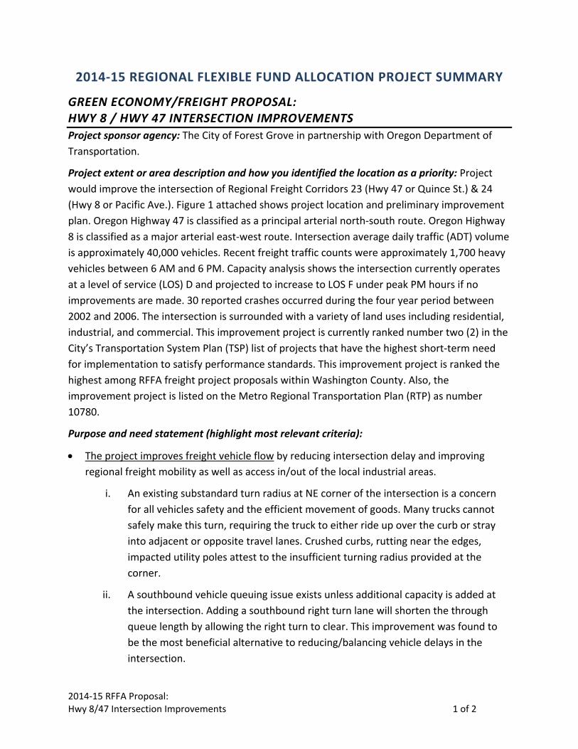
2014‐15 REGIONAL FLEXIBLE FUND ALLOCATION PROJECT SUMMARY
GREEN ECONOMY/FREIGHT PROPOSAL: HWY 8 / HWY 47 INTERSECTION IMPROVEMENTS
Project sponsor agency: The City of Forest Grove in partnership with Oregon Department of
Transportation.
Project extent or area description and how you identified the location as a priority: Project
would improve the intersection of Regional Freight Corridors 23 (Hwy 47 or Quince St.) & 24
(Hwy 8 or Pacific Ave.). Figure 1 attached shows project location and preliminary improvement
plan. Oregon Highway 47 is classified as a principal arterial north‐south route. Oregon Highway
8 is classified as a major arterial east‐west route. Intersection average daily traffic (ADT) volume
is approximately 40,000 vehicles. Recent freight traffic counts were approximately 1,700 heavy
vehicles between 6 AM and 6 PM. Capacity analysis shows the intersection currently operates
at a level of service (LOS) D and projected to increase to LOS F under peak PM hours if no
improvements are made. 30 reported crashes occurred during the four year period between
2002 and 2006. The intersection is surrounded with a variety of land uses including residential,
industrial, and commercial. This improvement project is currently ranked number two (2) in the
City’s Transportation System Plan (TSP) list of projects that have the highest short‐term need
for implementation to satisfy performance standards. This improvement project is ranked the
highest among RFFA freight project proposals within Washington County. Also, the
improvement project is listed on the Metro Regional Transportation Plan (RTP) as number
10780.
Purpose and need statement (highlight most relevant criteria):
• The project improves freight vehicle flow by reducing intersection delay and improving
regional freight mobility as well as access in/out of the local industrial areas.
i. An existing substandard turn radius at NE corner of the intersection is a concern
for all vehicles safety and the efficient movement of goods. Many trucks cannot
safely make this turn, requiring the truck to either ride up over the curb or stray
into adjacent or opposite travel lanes. Crushed curbs, rutting near the edges,
impacted utility poles attest to the insufficient turning radius provided at the
corner.
ii. A southbound vehicle queuing issue exists unless additional capacity is added at
the intersection. Adding a southbound right turn lane will shorten the through
queue length by allowing the right turn to clear. This improvement was found to
be the most beneficial alternative to reducing/balancing vehicle delays in the
intersection.
2014‐15 RFFA Proposal: Hwy 8/47 Intersection Improvements 2 of 2
• The project improves overall access and safety by removing conflicts with active
transportation and provides adequate mitigation for any potential conflicts.
i. Adding the fourth crosswalk to the intersection removes a barrier to pedestrian
access between a large multi family residential area to the NE of the intersection
and increasing pedestrian travel needs to the SE.
ii. Widening the Westbound Right Turn Lane will allow room to continue westbound
bike lane through the intersection. Currently there is a gap in the westbound bike
lane at the intersection as it becomes a shared lane with westbound right turn
vehicle movement at the intersection.
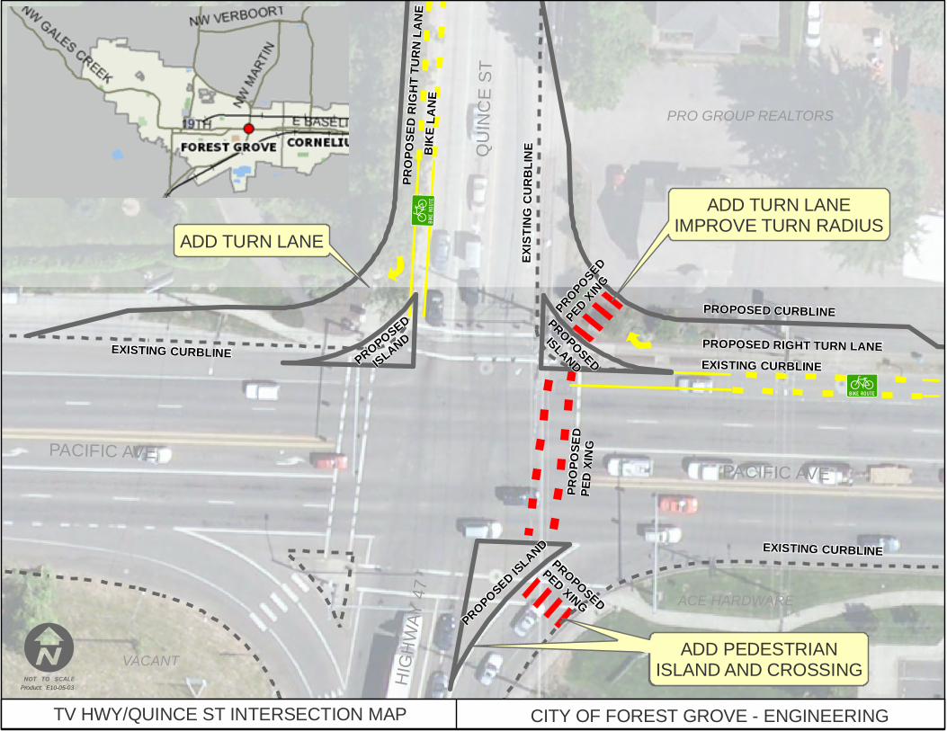
Description of project design elements:
Widen Westbound Right Turn Lane and Increase Radius – Currently the right turn lane is
operating with a substandard turn radius and shared with the bike lane. This project will
eliminate issues encountered with freight traffic having to negotiate a tight turn radius. This
project will also separate vehicle right turn movement with westbound bicycle traffic.
Provide Southbound Right Turn Lane – Currently the north leg of the intersection is operating
with vehicle queue lengths close to available storage limits. The southbound vehicle queuing
issue remains unless additional capacity is added at the intersection. Adding a southbound right
turn lane was found to be the most beneficial alternative. This shortens the through queue
length by allowing the right turn to clear.
Provide a Crosswalk on East Leg of Intersection – Currently the intersection is operating with a
pedestrian crossing gap on the east leg. Currently the large multi family residential area to the
NE of the intersection experiences delay having to travel out of direction travel. This project
provides better access to pedestrian travel needs including an existing TriMet bus stop, school,
health center, and bank.
Estimate of total project cost and the funds requested for the project: Total project cost estimate: $1,650,000 (funds requested + local match) Funds requested: $1,500,000
©̈©̈
ACE HARDWARE
PACIFIC AVE
HIG
HW
AY
47
TV HWY/QUINCE ST INTERSECTION MAP CITY OF FOREST GROVE - ENGINEERING
Product: E10-05-03
ADD PEDESTRIANISLAND AND CROSSING
ADD PEDESTRIANISLAND AND CROSSING
EXISTING CURBLINE
PROPOSED
PED XINGPROPOSED ISLAND
PROP
OSED
PED
EXISTING CURBLINE
PROPOSEDISLANDPROPOSED
ISLANDEXISTING CURBLINE
VACANT
MCMENAMINSPRO GROUP REALTORS
QU
INC
E S
T
PROPOSED RIGHT TURN LANE
PROPOSED CURBLINE
ADD TURN LANEIMPROVE TURN RADIUS
PROPOSED
PED XING
PACIFIC AVE
EXIS
TING
CURB
LINE
ADD TURN LANE
BIKE
LANE
PROP
OSED
RIG
HT TU
RN LA
NE
ACE HARDWARE
J
2014‐15 REGIONAL FLEXIBLE FUND ALLOCATION
PROJECT SUMMARY
PROJECT SUMMARIES SHOULD BE LIMITED TO TWO PAGES OF NARRATIVE + ONE MAP PER
PROJECT
1. Project sponsor agency:
City of Cornelius
2. Project extent or area description and how you identified the location as a priority:
The project encompasses 10th Avenue in Cornelius from just north of Holladay Street on
the north to Lafollette Road on the south. It fills in the gaps and completes high priority
improvements to the arterial freight connection of Cornelius‐Schefflin/Highway 26 and
Golf Course Road/Highways 47/219.
3. Purpose and need statement (highlight most relevant criteria):
10th Avenue through Cornelius serves as the key north‐south freight connection
between Hwy 26/center of the urban region/northern Washington County agricultural
land and Hwy 219/southern portion of Washington County and beyond. 10th also
provides a critical connection for freight traffic needing to access Hwy. 8, the primary
east‐west route in western Washington County and protects the Hillsboro and Cornelius
Main Street Districts from excessive freight traffic.
In addition to being an important truck route, 10th also serves as a critical part of the
city’s transportation infrastructure. It connects industries and neighborhoods, primarily
consisting of low‐moderate income residents, with public transit on Hwy. 8. It also
connects to the city’s pedestrian‐oriented main street district and regional bikeways.
While most of 10th in its 1.4 mile length in Cornelius is fully improved with 12‐foot travel
lanes, bike lanes, curb and gutter, and sidewalks, significant portions of this arterial
remain unimproved outside the 24‐feet of pavement; this hinders efficient and safe
freight transport. Compounding this problem is the fact that these substandard
portions of the road are primarily in areas developed more than 30 years ago which are
unlikely to be redeveloped and thus be improved by private development.
Over $16 million in public improvements to this RTP/WCTSP/Cornelius TSP designated
arterial is leveraged by this capstone project, including:
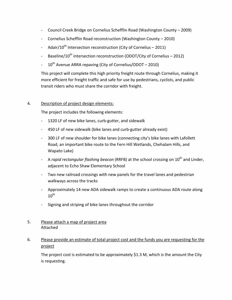
‐ Council Creek Bridge on Cornelius Schefflin Road (Washington County – 2009)
‐ Cornelius Schefflin Road reconstruction (Washington County – 2010)
‐ Adair/10th Intersection reconstruction (City of Cornelius – 2011)
‐ Baseline/10th intersection reconstruction (ODOT/City of Cornelius – 2012)
‐ 10th Avenue ARRA repaving (City of Cornelius/ODOT – 2010)
This project will complete this high priority freight route through Cornelius, making it
more efficient for freight traffic and safe for use by pedestrians, cyclists, and public
transit riders who must share the corridor with freight.
4. Description of project design elements:
The project includes the following elements:
‐ 1320 LF of new bike lanes, curb‐gutter, and sidewalk
‐ 450 LF of new sidewalk (bike lanes and curb‐gutter already exist)
‐ 300 LF of new shoulder for bike lanes (connecting city’s bike lanes with Lafollett
Road, an important bike route to the Fern Hill Wetlands, Chehalam Hills, and
Wapato Lake)
‐ A rapid rectangular flashing beacon (RRFB) at the school crossing on 10th and Linder,
adjacent to Echo Shaw Elementary School
‐ Two new railroad crossings with new panels for the travel lanes and pedestrian
walkways across the tracks
‐ Approximately 14 new ADA sidewalk ramps to create a continuous ADA route along
10th
‐ Signing and striping of bike lanes throughout the corridor
5. Please attach a map of project area Attached
6. Please provide an estimate of total project cost and the funds you are requesting for the
project
The project cost is estimated to be approximately $1.3 M, which is the amount the City
is requesting.
©2011 Google - Map data ©2011 Google -
To see all the details that are visible on the screen, use the "Print" link next to the map.
Page 1 of 210th and Baseline, Cornelius, OR - Google Maps
5/3/2011http://maps.google.com/maps?hl=en&tab=wl
Regional Flexible Funding Request City of Sherwood 2011
Regional Flexible Funding Program Request 2014-15 Potential Freight Project & Active Transportation
City of Sherwood Elwert Road/Kruger Road/Highway 99W Intersection Improvements
1. Project sponsor agency: City of Sherwood
2. Project extent or area description and how you identified the location as a priority:
Elwert Road is shown in the Sherwood Transportation System Plan (TSP) as having an arterial road functional classification. By definition, an arterial road provides interconnectivity and support to a principal arterial highway, which in this case is Highway 99W. Elwert Road acts as a commuter bypass around Highway 99W, a principal arterial through Sherwood, going to and from Newburg or Wilsonville, and traveling to or from Tigard, Tualatin, Beaverton or Hillsboro. While the majority of the traffic using Elwert Road is bypass-commuter traffic, the effect on freight transport along Highway 99W could be significant, if this intersection remains in its current configuration.
The City’s TSP, adopted in 2005, identifies this intersection as experiencing current circulation and capacity needs, and Washington County SPIS ranks this intersection as the 24th highest safety priority intersection in the County. In a 2008 Transportation Study by the Sherwood School District for the Area 59 Schools, the Elwert Road/Kruger Road/Highway 99W intersection was operating at that time, near capacity during the PM peak hour with a V/C of 0.99, based on Metro’s 2030 travel demand forecast model. For statewide freight route corridors within the Metro area, intersections are required to operate a V/C of 0.99 or better for both the first and second hours. In 2008, it was also noted that queuing lengths of 20 cars or more were observed on Elwert Road at this intersection. The length of this queue extends around the southbound horizontal curve and creates a condition where rear end collisions may occur due to limited sight distance and stopping reaction times.
As traffic continues to increase due to expected future development of rural areas south and west of Sherwood, and if the intersection configuration remains unchanged, the amount of commuter bypass traffic utilizing Elwert Road is expected to remain static with Highway 99W having to absorb the increase flow. This would have a direct impact on the ability of freight transport to move along the Highway 99W corridor within a reasonable level of service, and would most likely increase the V/C above the 0.99 limit. The near future development of the Brookman Road Concept Plan area and the UGB area west of Elwert Road will place significant additional traffic demand on this intersection, Elwert Road, and Highway 99W.
This intersection is unique in that the impacts involve three jurisdictional agencies: namely ODOT, Washington County, and Sherwood. All three agencies have indicated support for the reconfiguration of the intersection and see it as a critical component of the continued freight transportation growth of Highway 99W.
3. Purpose and need statement (highlight most relevant criteria):
Regional flexible funds are requested to provide for the design study and possible right-of-way purchase for the re-alignment of the Elwert Road/Kruger Road and Highway 99W intersection to address significant safety and mobility issues. The intersection design study would also identify
Regional Flexible Funding Request City of Sherwood 2011
need for the installation or modification of traffic signals, pedestrian crossings and sidewalks, street lighting, and signage and striping. By addressing these safety and design issues, vehicle delay will be reduced, thereby reducing emissions. As stated previously, as this intersection exceeds capacity, commuters will be forced to choose alternate routes including Highway 99W. Addressing capacity issues at this intersection will delay impacts to freight transport on Highway 99W and delay the need for highway expansion to accommodate this increase in traffic.
4. Description of project design elements:
Based on a preliminary analysis and existing system configuration, the following design elements have been identified and recommended:
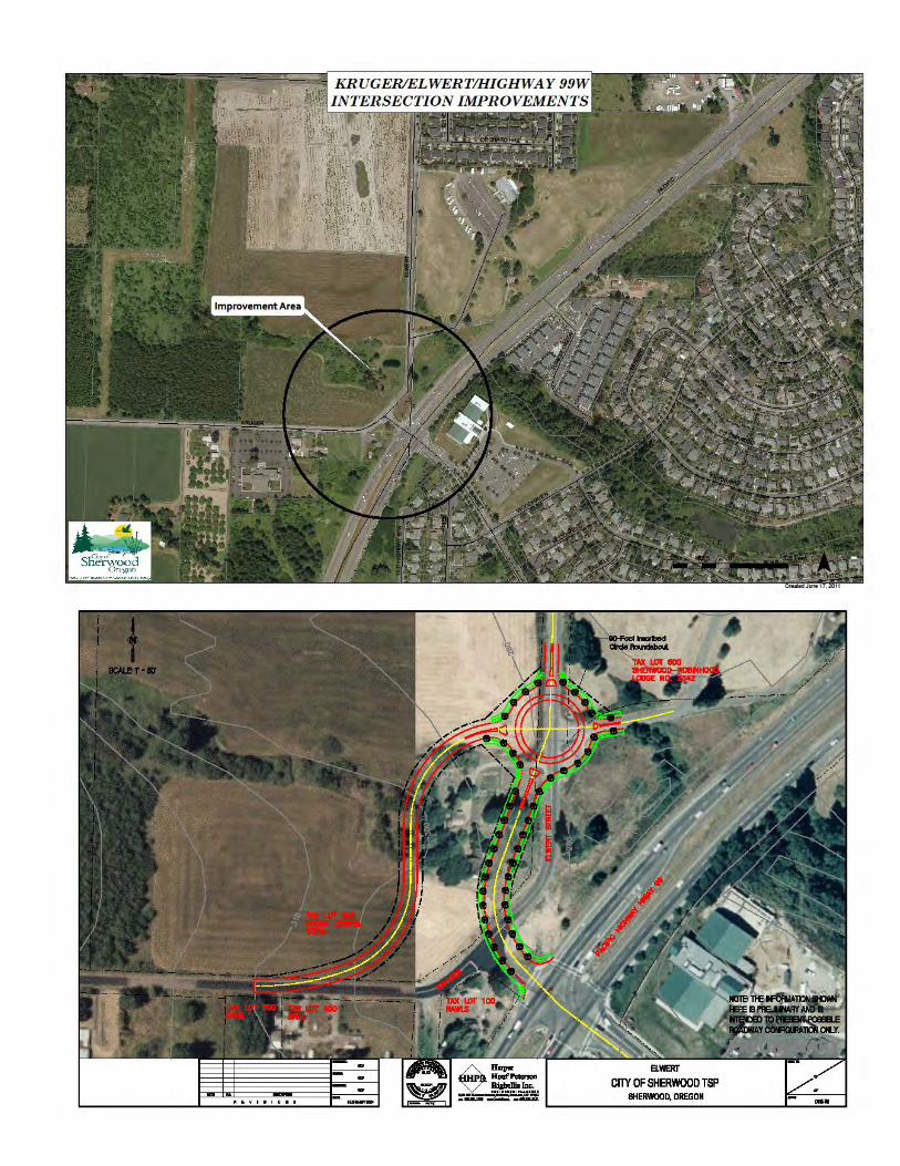
a. A single lane roundabout has been offered as the recommended intersection upgrade. b. The Elwert Road approach to Highway 99W would be realigned so the intersection at
Highway 99W is closer to 90 degrees. c. The Kruger Road intersection with Elwert Road would be relocated to be at least 500
feet away from the intersection of Elwert Road and Highway 99W. 5. Please attach a map of project area
SEE ATTACHED
6. Please provide an estimate of total project cost and the funds you are requesting for the project.
The proposed project consists of two phases. Phase 1 is the design study which would include a traffic study and preliminary design of the proposed roundabout and reconfiguration of the affected roads. The estimated value of the Phase 1 component is between $250,000 and $350,000. Phase 2 is the negotiation and purchase of the needed right-of-way for the roundabout and realigned roadways. The estimated value of the Phase 2 component is between $950,000 and $1,050,000. The estimated combined cost of Phase 1 and Phase 2 is $1,300,000. These project costs include consultant and sub-consultant contract costs, project management costs, necessary permit acquisition costs, and overhead costs. Construction of the proposed improvements would be handled by other funding sources including local, regional, and state funds.
1 Regional Freight/Passenger Rail Investment Strategy – RFFA Proposal for Green Economy/Freight Strategy Development
RFFA REGIONAL STRATEGY DEVELOPMENT – Submitted for comments June 17, 2011 Regional Freight/Passenger Rail Investment Strategy
Description of Issue: Both freight and passenger rail need to be successful in our region, to support our regional aspirations for economic development as well as livability and environmental sustainability.
There is both a hope and expectation in the Metro region –and statewide—that freight rail will carry a significant share of existing and future commodities both into and out of the region, connecting us to the rest of the United States and Canada and providing critical transportation links to the world though our ports as our region recovers from the Great Recession.
Metro Council adopted the Regional Freight Plan as part of the Regional Transportation Plan in June, 2010. The RTP includes a Regional Freight Plan, which calls out a need for a regional freight rail strategy, and an economic development/industrial development strategy that would guide project development and implementation for all freight modes, including rail. The RTP also includes a High Capacity Transit System Plan, which calls out regional priorities for passenger transit corridors for which some of the lower cost options assume shared right‐of‐way with freight railroads.
Several years ago, Metro and project partners also participated in the I‐5 Trade and Transportation Study, which identified rail needs and projects, and noted the cost to our regional economy of failing to act. Some of those projects have been built, though much remains to be done. Because freight rail operates as a system or network, it is important to keep this context regarding the absolute importance of maintaining a robust freight rail program because of the economic benefits that it provides to our region. In recent months, we’ve seen renewed interest in rail at all levels: a first National Rail Plan is being completed by the Federal rail Administration, an ODOT State Rail Study that prepares the path for a statewide rail plan; ODOT Statewide Freight Plan adopted by the Oregon Transportation Commission on June 15, 2011, that references and integrates rail issues as part of a multimodal freight system; Metro’s High‐Capacity Transit System Plan, the Clark County (WA) Freight Mobility Study; a City of Portland Freight Master Plan and various projects and plans at the Port of Portland (discussed below) and the Port of Vancouver. ODOT Rail will be proceeding with an alternatives analysis for High Speed Intercity Passenger Rail in accordance with the National Environmental Policy Act (NEPA) under the Federal Rail Administration (FRA). Additionally, the State of Washington has developed a Freight Rail Plan that includes the importance of working with Oregon and in particular the Portland Metro area. Notwithstanding all these efforts, however, much of the analysis and policy issues relevant to the region require more detailed investigation, nuance, attention, development, and sensitivity to local and regional trends, needs and emerging opportunities.
Need for regional strategy. In order to leverage both that funding and other non‐monetary resources within the region, a common, updated and more robust understanding of rail challenges and opportunities is needed. Recently, the Port of Portland has engaged a consultant to examine mainline access to the Port and other issues. The regional freight/passenger rail investment strategy proposed here would pick up where the Port leaves off, incorporating findings and would be scoped to complement, not compete with, the work occurring at national, state, city and port scales.
More specifically, this regional strategy will pivot off the findings of the 2011/12 Port of Portland Rail Plan, and work in tandem with the wider scope of the ODOT Rail Plan that will likely begin in late 2011 or early 2012. With Metro Council President Tom Hughes sitting on the ODOT Rail Funding Task Force, Metro is well‐
2 Regional Freight/Passenger Rail Investment Strategy – RFFA Proposal for Green Economy/Freight Strategy Development
positioned to include and integrate Task Force findings relative to funding, into the regional context of rail‐related needs and resources. Together, these state, regional and port‐specific work will identify priority freight rail projects for future funding. That new list would benefit from a well‐considered regional‐scale understanding of industrial and employment land use needs and opportunities, commuter and intercity passenger rail needs, as well as a regional economic development perspective to guide rail‐related investment of public funds, and/or develop and fund other programs and policies that can help regional freight rail carry more of the load. The investments would be based on a refined understanding of how better rail service can help our regional economic development profile in a targeted and specific way, providing access to local shippers and accommodating passenger rail.
Step 1: Refine Scope Because the work for this regional rail strategy will begin after the completion of the Port of Portland Rail Plan, after findings of the ODOT Rail Funding Task Force are finalized, and near the end of the ODOT Rail Plan, a revised and refined scope of work will be the first task. The refinement process will engage relevant stakeholders before and after development of the work plan, consultant scopes of work, and final work task details, to ensure consistency of approach, identification of gaps and opportunities, and to avoid any duplication of work. Although a final scope will be refined when this strategy is funded, based on the then‐available outcomes of the studies and plans identified above, the focus of work efforts would likely include:
Market analysis to focus rail strategy work efforts. This initial task would pivot off and expand the work of the Port of Portland, and would engage shippers, carriers and operators to identify economically viable opportunities to expand freight rail’s role in regional economic development. This would necessarily expand the perspective taken by the Port of Portland, and would be more detailed than the statewide rail plan work.
Rail access for local shippers. The need for addressing access to the Class I freight rail network to support local industrial land uses was identified in the Business Interview Results of the Working Harbor Reinvestment Strategy which identified "overcommitted rail as the areas most pressing competitive need." This study was conducted by the Portland Development Commission, the Portland Bureau of Planning and the Port of Portland, which conducted interviews with 25 businesses and four focus groups in Portland Working Harbor area which includes the Rivergate, Swan Island, Lower Albina and Northwest Industrial Districts.
Rail corridors as industrial land uses. Recently, the concept of cargo‐oriented development (COD) has taken hold in industrial land use circles, and some thinkers have begun to conceptualize rail corridors not merely as transportation facilities, but as industrial land use corridors and treated differently than we treat roadway right‐of‐way (ROW). Statewide planning Goal 9 supports the buffering of industrial lands. Buffering, however, typically cannot be achieved on the rail ROW, but must instead be accomplished on adjacent properties. This may require local and regional land use actions or other coordinated policies and investments. See http://www.envisionfreight.com/ (Tools) for a good discussion of rail/land use conflicts and how the region could approach these issues.
These corridors could be developed to include “bulb‐outs” where Class Is could better serve groups of local shippers. This kind of coordination must be facilitated by discussions with all stakeholders, including rail operators, shippers, and all levels of government.
Regional freight and passenger rail needs in shared corridors. A fast‐emerging issue central to those identified above is the need to prevent conflict between freight and passenger needs on a near‐capacity system. The integrated evaluation of freight and passenger rail transportation, community and economic development and land use must occur at all scales within the Pacific Northwest. Application of a regional lens to these issues is important to achieving Metro’s 2040 regional land use goals, which must be supported by non‐roadway passenger travel opportunities, as well as the need for a robust economy supported by well‐planned freight infrastructure. This work element will take as
3 Regional Freight/Passenger Rail Investment Strategy – RFFA Proposal for Green Economy/Freight Strategy Development
inputs ODOT’s Rail Plan as well as the findings available from the Oregon Rapid Passenger Rail Corridor Plan alternatives analysis.
Funding strategy. This component of the work will integrate our regional needs and potential (as yet uncertain) funding programs and resources into an appropriately layered (federal/state/regional) strategy to promote stable and sufficient funding for the publicly supported elements of the passenger and freight rail systems. Among the goals of this strategy will be maximum leveraging of private funds for rail investment.
Stakeholder engagement. To accomplish all these goals, we need accurate and relevant information and close collaboration between agencies and jurisdictions, between the operators (Class 1, regional rail, short lines and passenger transit) and between public and private sectors. The region also needs to develop an effective model for private‐public and freight‐passenger stakeholder engagement in designing mutually acceptable solutions to which all contribute and from which all benefit.
Stakeholders have been engaged in the application development process to make sure tasks are additive and required to accomplish our goals and objectives; that engagement will continue and expand during refinement and final scoping.
Project Objectives/Expected Outcomes: This proposal will be developed to ensure that investment matches the expectations and results in solutions to the issues described above. It will seek to produce increases in rail capacity, safety, land use compatibility and operational efficiencies, is important to our long‐term economic and environmental sustainability and will help to maintain the region's competitive advantage in a global marketplace.
The Regional Freight Rail Investment Strategy will not include preliminary engineering but will test the feasibility of concepts, and identify the rail mode, function and general location of scenarios considered, and develop a list of projects for refinement. It will build off the Port of Portland effort now underway, and the state study and plan, as appropriate.
Through a better definition of regional questions, and closer examination of regional freight (and related passenger) rail issues within or immediately outside Metro regional boundaries, but also including issues in Vancouver and Port of Vancouver, the proposed study targets the following objectives and outcomes:
Preliminary Objectives: Identify regional targets for investment in economically viable rail‐supported or supportable land uses
Allow rail freight to remain competitive for shippers, and maintain or increase rail mode share relative to other freight modes, particularly trucking (though trucking will continue its primary freight mode split based on current projections)
Boost the competitive advantage of our regional businesses and shipping facilities, including our ports, by maintaining and/or improving quality, accessibility and cost of freight rail service
Develop and understanding of freight‐passenger‐High Capacity Transit/intercity/commuter rail tradeoff policies
Move as much tonnage from truck to rail as is feasible, given customer requirements and specifications for service, in order to preserve and enhance the reliability of major freight truck routes, including I‐5 and I‐84) by:
o Improving short line access to Class 1 rail system (thus improving regional business shipping choices)
o Improving efficiency on the Class 1 and short line system within the Portland‐Vancouver area o Improving freight rail corridors of national significance that connect our region to the rest of
the US and Canada and them to the world marketplace
4 Regional Freight/Passenger Rail Investment Strategy – RFFA Proposal for Green Economy/Freight Strategy Development
Increase multimodal access to, and thus efficiency and utilization of industrial lands within the urban growth boundary, which will delay needs for expansion of freight highway routes
Reduce emissions and land use impacts, through appropriate investments in the more energy‐efficient rail mode
Re‐conceptualize rail corridors as industrial land use corridors, with alignment‐adjacent development, o For example, examine potential of cargo‐oriented development and logistics parks – carload
hubs where onesies and twosies service is provided for smaller shippers
Increase funding available for short‐line railroad investment, such as modernizing switches on the short line system
Guide local transportation system planning and regional land use planning along freight rail corridors, to prevent incompatible uses, community impacts, higher costs and reduced efficiency for shippers and rail operators, and safety or security problems.
Outcomes of the proposed study: Identification of economically viable opportunities to develop short line intermodal hubs or logistics
parks or other cargo‐oriented development
Identification of alternative all‐rail routes within the Portland‐Vancouver metro area in support of regional economic development and ensuring capacity for regional freight and passenger movements, through potential means such as an all‐rail route for through‐trains designed to avoid and relieve congestion in the Portland Triangle;
A strategy to identify, develop and position top projects for confirmed and potential future federal and state funding, as appropriate, including
o An updated, re‐prioritized list of regional freight rail projects focused on removing capacity constraints and improving industrial access to rail lines;
o A funding strategy for regional freight/passenger rail bottlenecks (in coordination with ODOT Task Force and outputs of the High Speed Intercity Passenger Rail Tier 1 EIS: Eugene to Portland, which will begin sometime in 2011, depending on FRA funding priorities)
o A strategy to fund needed grade separations o A strategy to fund critical modernization projects on short lines
A common understanding of the full range of benefits of public and private rail investment, including jobs created or retained, and avoided highway costs, for all key stakeholders;
Fact‐based guidance for stakeholders to use in negotiating claims over passenger/freight conflicts, balancing passenger and freight goals, and a viable set of solutions to meet those goals;
Regional guidance for public/private investment partnerships to guide investment of regional and national pots of money in identifying and developing freight rail corridors of national significance; and
Specific guidance for local jurisdictions as they develop their transportation system plans (TSPs) in order to avoid or minimize conflicts, and preserve or enhance the functionality of rail facilities and connected industrial land uses
BUDGET: $400,000 (depending on scope)
- 1 - 6/23/2011
2014‐15 REGIONAL STRATEGY DEVELOPMENT – PROJECT SUMMARY
REGIONAL OVER‐DIMENSIONAL TRUCK ROUTE PLAN
Project Name: Regional Over‐Dimensional Truck Route Plan
Project Sponsor: Metro
Project Extent: Area within Metro planning boundary
Background The Oregon Department of Transportation (ODOT) requires motor carriers transporting oversize or overweight loads to obtain a variance permit prior to departure (for loads originating in‐state) or entering Oregon from another state. Under Oregon Revised Statue (ORS) 818 – Vehicle Limits, drivers operating on Oregon roads must obtain a state‐issued over‐dimension (single‐trip or annual) variance permit to haul any single, non‐divisible load meeting the following condition:
Height: Vehicle or vehicle combination and load exceeds 14 feet. Width: Load or hauling equipment exceeds 8 feet 6 inches. Length: Load greater than 40 feet, exceeding 5 feet beyond the end of the semi‐
trailer, or load less than or equal to 40 feet, exceeding one‐third of the wheelbase of the combination, whichever is less.
Truck operators obtain an over‐dimensional variance permit from the State when their vehicle exceeds any of the legal limits. The permits provide routing plans and restrictions on travel. In addition, the City of Portland and Washington County also require a permit for the use of their streets by over‐dimensional vehicles exceeding the weight or size limitations set forth in ORS 818. In 2007, the Portland Bureau of Transportation conducted an analysis of over 6,000 state and city permit records issued in 2006 to define the existing nature of over‐dimensional movements and the clearance requirements of permitted loads. The analysis found that construction equipment (cranes and excavators) along with log loaders and steel plates as the most commonly permitted commodities and account for more than half of the over‐dimension loads transported. The analysis also identified both the median and largest sized trucks using city streets to move these commodities in order to provide insight on the appropriate routing and minimum clearance requirements for these vehicles. While the orderly and efficient movement of these over‐sized and over‐weight commodities are crucial to the economic well being of the Metro region, their transport can create negative impacts to the local neighborhoods in respect to excessive roadway damage, noise, pollution and traffic congestion. For example, N Columbia Blvd and NE Lombard St (US 30 Bypass) are the two primary east/west truck routes linking the adjacent industrial properties to the Interstate Highway System. These two facilities serve as the only viable east/west routes for over‐dimensional vehicles in the Columbia Corridor Industrial area. However, current height restrictions and other operational constraints force over‐dimension truck traffic through the St. Johns Town Center on the US 30 Bypass rather than taking the preferred route along N. Columbia Blvd. In Washington County, the Oregon St./Tonquin
- 2 - 6/23/2011
Rd./Grahams Ferry/Day Rd./Boones Ferry Road route poses significant safety and operational challenges for over‐dimensional loads traveling between Tualatin‐Sherwood Rd. and I‐5. Most freight moved into, out of, within, and through the Metro region is by truck. While various factors influence freight mode selection, over‐dimensional loads are unique in respect door‐to‐door origin and destination and typically rely on trucks for the entire delivery. Based on the Commodity Flow Forecast, 67 percent of all freight in the region moves by truck and projected to grow to 73 percent by 2030, an increase of 93 percent.
Purpose and Need The Washington County 2020 Transportation Plan strategy 16.1 calls for coordination of planning, development, maintenance and operation of an efficient and safe freight system with the private sector and government agencies in the Portland metropolitan area. Moreover, the adopted Portland Freight Master Plan calls for preparing a strategy for truck routes that serve the movement of over‐dimensional loads as an implementing action. Developing a strategy to transfer the US 30 Bypass designation from Lombard to Columbia Blvd is also a recommended action in the Freight Master Plan to improve freight mobility and to enhance community livability in the St. Johns neighborhood. Since ODOT, Washington County and the City of Portland all issue separate permits for oversize and overweight loads, there is a need for a more comprehensive and consistent regional approached for routing over‐dimensional vehicles throughout the metro region and to identify current height restrictions and other operational constraints on the regional transportation network. This project will identify the most commonly used and the preferred routes for the movement of over‐dimensional vehicles and document the minimum clearance requirements to accommodate over‐sized loads in the Metro region. The focus of the project will be to develop a seamless over‐dimensional vehicle route system that transcends jurisdictional boundaries. Physical and operational constraints that impede safe and efficient freight movement on identified regional truck routes will be defined and recommend transportation improvements and planning‐level cost estimates to remove these constraints will be developed.
Description of Project Design Elements A project consultant will conduct the technical planning and engineering, cost analysis, and final report preparation. The consultant will also participate in all stakeholder and public involvement activities to provide technical support. Metro will provide overall project management responsibilities, review technical reports and related materials, and facilitate stakeholder meetings and public involvement activities. Metro will coordinate with its regional partners to provide consultant with relevant transportation data, vehicle classification counts, background materials and related data and permitting information for over‐dimensional truck movements. The following are the major project tasks: Task 1: Project Management Provide status reports, cost reports and reimbursement requests. Review consultant invoices, completion reports, cost summaries and list of final products. Review and edit consultant deliverables. Prepare summaries of public involvement events including agendas, public
- 3 - 6/23/2011
information materials provided at meetings, and summary of comments. Prepare completion of project close‐out. Task 2: Public Involvement Develop a review structure for Metro staff, stakeholder interests and partnering agencies to engage in the analysis and planning process. Provide adequate opportunity for stakeholder participation and input throughout the project duration and respond to stakeholder values and issues. Deliverable: Formation of Stakeholder Working Group (SWG) membership and meeting schedule.
Task 3: Background and Existing Conditions Analysis Prepare assessment of existing transportation infrastructure affecting over‐dimensional truck movements (bridge structures, overhead signals, sign bridges, weight‐restricted bridges, etc). Inventory existing bridge clearances and document the minimum clearance requirements to accommodate over‐sized vehicles. Document existing local, State and regional policies and regulations affecting freight mobility and over‐dimensional trucks within the Metro region. Deliverable: Background and Existing Conditions Analysis Technical Memo with associated maps and graphics. Task 4: Identify Needs, Constraints, Opportunities and Solutions Identify existing physical and operational constraints that impede safe and efficient over‐dimensional truck movements within the Metro region. Identify conflicts between freight mobility and community livability issues based on existing local, State and regional policies, regulations and other conditions. Identify the constraints, opportunities, and related issues associated with transferring the US 30 Bypass to Columbia Blvd. Identify a range of potential solutions for addressing both over‐dimension freight mobility and community livability needs within the Metro region. Deliverable: Needs, Constraints, Opportunities, and Solutions Technical Memo.
Task 5: Define and Evaluate Alternatives Define and evaluate both potential capital transportation and operational improvements based on identified needs, constraints, opportunities, and solutions. Describe the required transportation improvements to accommodate the regional movement of over‐dimensional vehicles. Deliverable: Alternatives Evaluation Technical Memo. Task 6: Capital Improvements and Cost Analysis Identify capital transportation improvements based on the evaluation of identified alternatives and prepare planning‐level costs estimates. Conduct cost feasibility analysis of the identified capital improvements based on freight mobility and community livability needs. Deliverable: Capital Improvements and Cost Analysis Technical Memo.
Task 7: Recommended Improvements and Actions Recommend both short and long‐term capital transportation system improvements and/or other policy and operational strategies based on evaluation of alternatives and cost feasibility analysis. Deliverable: Recommended Improvements and Actions Technical Memo.
Estimated Cost: $ 110,000 Requested Funds: $100,000
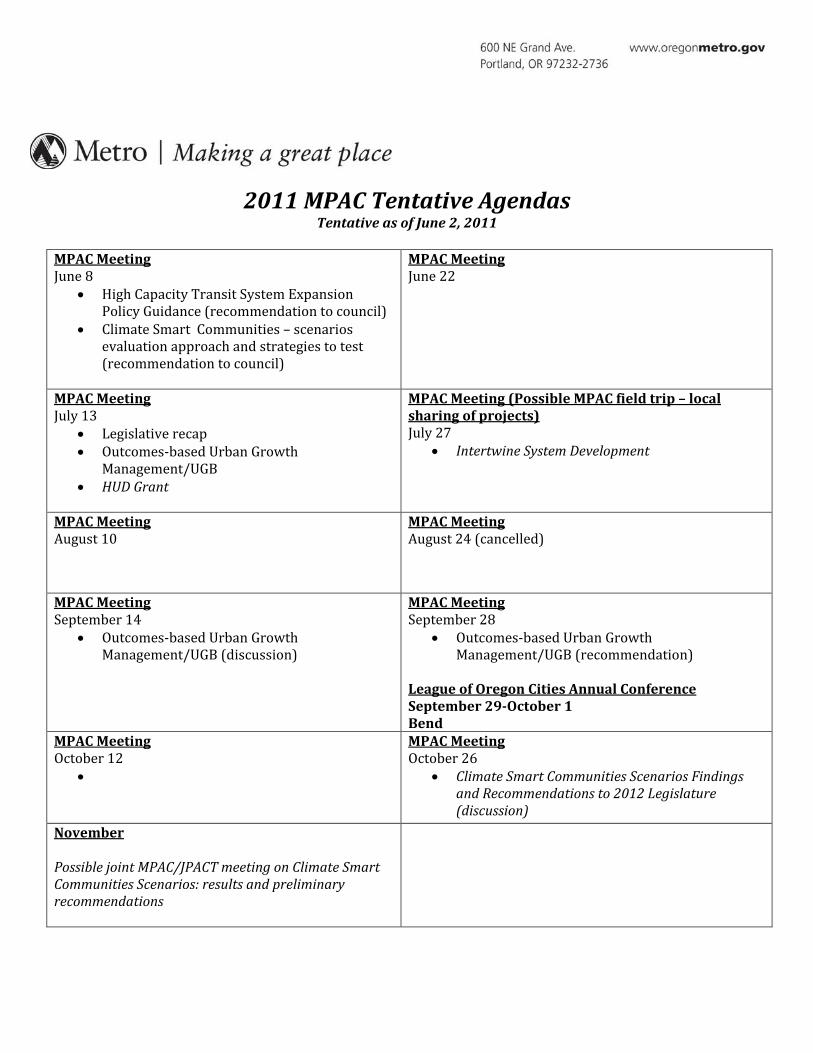
2011 MPAC Tentative Agendas Tentative as of June 2, 2011
MPAC Meeting June 8
• High Capacity Transit System Expansion Policy Guidance (recommendation to council)
• Climate Smart Communities – scenarios evaluation approach and strategies to test (recommendation to council)
MPAC Meeting June 22
MPAC Meeting July 13
• Legislative recap • Outcomes-based Urban Growth
Management/UGB • HUD Grant
MPAC Meeting (Possible MPAC field trip – local sharing of projects) July 27
• Intertwine System Development
MPAC Meeting August 10
MPAC Meeting August 24 (cancelled)
MPAC Meeting September 14
• Outcomes-based Urban Growth Management/UGB (discussion)
MPAC Meeting September 28
• Outcomes-based Urban Growth Management/UGB (recommendation)
League of Oregon Cities Annual Conference September 29-October 1 Bend
MPAC Meeting October 12
•
MPAC Meeting October 26
• Climate Smart Communities Scenarios Findings and Recommendations to 2012 Legislature (discussion)
November Possible joint MPAC/JPACT meeting on Climate Smart Communities Scenarios: results and preliminary recommendations
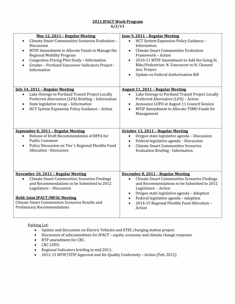
2011 JPACT Work Program 6/2/11
May 12, 2011 – Regular Meeting
• Climate Smart Communities Scenarios Evaluation – Discussion
• MTIP Amendment to Allocate Funds to Manage the Regional Mobility Program
• Congestion Pricing Pilot Study – Information • Greater – Portland Vancouver Indicators Project -
Information
June 9, 2011 – Regular Meeting • HCT System Expansion Policy Guidance –
Information • Climate Smart Communities Evaluation
Framework – Action • 2010-11 MTIP Amendment to Add the Going St.
Bike/Pedestrian: N. Vancouver to N. Channel Ave. Project
• Update on Federal Authorization Bill
July 14, 2011 – Regular Meeting • Lake Oswego to Portland Transit Project Locally
Preferred Alternative (LPA) Briefing – Information • State legislative recap – Information • HCT System Expansion Policy Guidance – Action
August 11, 2011 – Regular Meeting • Lake Oswego to Portland Transit Project Locally
Preferred Alternative (LPA) – Action • Announce LUFO at August 11 Council Session • MTIP Amendment to Allocate TSMO Funds for
Management
September 8, 2011 – Regular Meeting • Release of Draft Recommendation of RFFA for
Public Comment • Policy Discussion on Tier 1 Regional Flexible Fund
Allocation - Discussion
October 13, 2011 – Regular Meeting • Oregon state legislative agenda – Discussion • Federal legislative agenda – Discussion • Climate Smart Communities Scenarios
Evaluation Briefing - Information
November 10, 2011 – Regular Meeting • Climate Smart Communities Scenarios Findings
and Recommendations to be Submitted to 2012 Legislature – Discussion
Hold: Joint JPACT/MPAC Meeting Climate Smart Communities Scenarios Results and Preliminary Recommendations
December 8, 2011 – Regular Meeting • Climate Smart Communities Scenarios Findings
and Recommendations to be Submitted to 2012 Legislature - Action
• Oregon state legislative agenda – Adoption • Federal legislative agenda – Adoption • 2014-15 Regional Flexible Fund Allocation –
Action
Parking Lot:
• Update and discussion on Electric Vehicles and ETEC charging station project • Discussion of subcommittees for JPACT – equity, economy and climate change response • RTP amendment for CRC. • CRC LUFO. • Regional Indicators briefing in mid 2011. • 2012-15 MTIP/STIP Approval and Air Quality Conformity – Action (Feb. 2012)
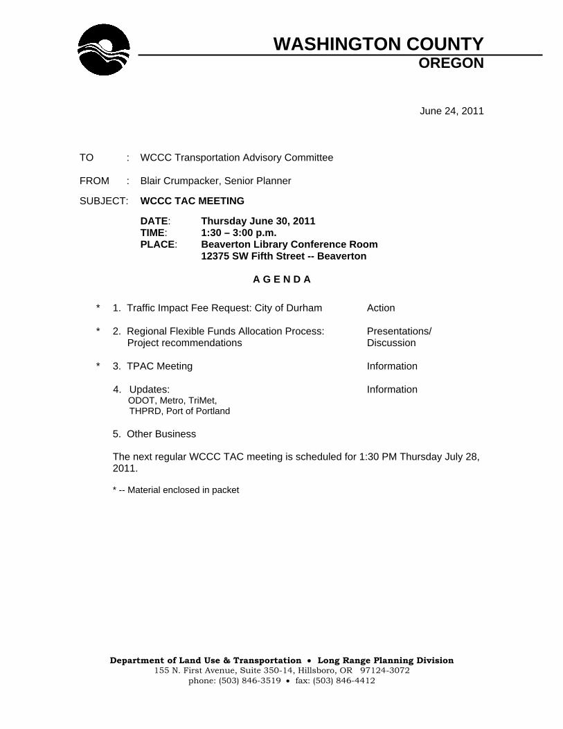
WASHINGTON COUNTY OREGON
Department of Land Use & Transportation Long Range Planning Division
155 N. First Avenue, Suite 350-14, Hillsboro, OR 97124-3072 phone: (503) 846-3519 fax: (503) 846-4412
June 24, 2011 TO : WCCC Transportation Advisory Committee FROM : Blair Crumpacker, Senior Planner
SUBJECT: WCCC TAC MEETING
DATE: Thursday June 30, 2011 TIME: 1:30 – 3:00 p.m. PLACE: Beaverton Library Conference Room 12375 SW Fifth Street -- Beaverton
A G E N D A
* 1. Traffic Impact Fee Request: City of Durham Action * 2. Regional Flexible Funds Allocation Process: Presentations/ Project recommendations Discussion * 3. TPAC Meeting Information 4. Updates: Information ODOT, Metro, TriMet, THPRD, Port of Portland 5. Other Business
The next regular WCCC TAC meeting is scheduled for 1:30 PM Thursday July 28,
2011.
* -- Material enclosed in packet
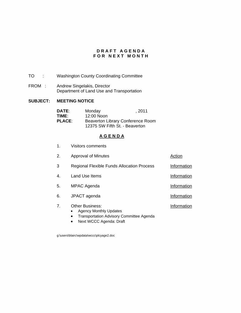
D R A F T A G E N D A F O R N E X T M O N T H
TO : Washington County Coordinating Committee FROM : Andrew Singelakis, Director Department of Land Use and Transportation SUBJECT: MEETING NOTICE DATE: Monday , 2011 TIME: 12:00 Noon PLACE: Beaverton Library Conference Room 12375 SW Fifth St. - Beaverton A G E N D A 1. Visitors comments 2. Approval of Minutes Action
3 Regional Flexible Funds Allocation Process Information 4. Land Use Items Information 5. MPAC Agenda Information 6. JPACT agenda Information
7. Other Business: Information Agency Monthly Updates Transportation Advisory Committee Agenda Next WCCC Agenda: Draft
g:\users\blairc\wpdata\wccc\plcyage2.doc