Embed Size (px)
Citation preview

CITY OF DuPONT WASHINGTON
ORDINANCE NO. 13- 9 SO
AN ORDINANCE REVISING the DUPONT SHORELINE MASTER PROGRAM AND ADOPTING A SUMMARY FOR PUBLICATION.
WHEREAS, on May 22,2012, DuPont repealed the existing and adopted a new Shoreline Master Program (SMP), a project funded by the Washington State Department of Ecology (Ecology); and
WHEREAS, on June 12, 2012, DuPont submitted the adopted SMP and background documents to Ecology for review and adoption, as required by Ecology; and
WHEREAS, on December 13, 2012, Ecology notified DuPont that 11 changes were required to the SMP in order for it to be consistent with Shoreline Management Act policy; and
WHEREAS, on January 8, 2013, DuPont agreed to make the required changes.
NOW, THEREFORE, THE CITY COUNCIL OF THE CITY OF DUPONT DOES HEREBY ORDAIN AS FOLLOWS:
Section 1. Adoption. The existing DuPont Shoreline Master Program is hereby amended as required by Ecology and adopted as indicated in the attached Exhibit A.
Section 2. Severability. Should any section, paragraph, sentence, clause or phrase of this Ordinance, or its application to any person or circumstance, be declared unconstitutional or otherwise invalid for any reason, or should any portion of this Ordinance be pre-empted by state or federal law or regulation, such decision or preemption shall not affect the validity of the remaining portions of this Ordinance or its application to other persons or circumstances.
Section 17. Effective Date. The attached Ordinance Summary shall be published in the official newspaper of the City. This ordinance shall be effective fourteen days from the date of Ecology's written notice of final approval.
1

THE ADOPTED BY THE CITY COUNCIL AT A REGULAR MEETING THEREOF ON ,2 DAY OF £ebn1Qj 2013.
CITY OF DUPON
C]
APPROVED AS TO FORM:
--ra-:r: t . ~ Bob Sterbank, City Attorney
Ordinance No.: 13- Cf 50 Filed with the City Clerk: ;;;L - 1'3>- 13 Passed by the City Council: :2 - t-;;{. - I ~ Date ~f Publication: .;2 - IS - {.3 Effective Date: ;2 -;;2 0 - 13
2

SUMMARY FOR PUBLICATION
ORDINANCE NO. XXX)( CITY OF DuPONT
The City Council of the City of DuPont, Washington, on XXX, XX, 2013, passed Ordinance No. XXXX, entitled "AN ORDINANCE AMENDING THE DUPONT SHORELINE MASTER PROGRAM" AND ADOPTING A SUMMARY FOR PUBLICATION."
The main points of the Ordinance are described as follows:
1. The Ordinance amends the DuPont Shoreline Master Program as required by the Washington State Department of Ecology.
2. The Ordinance will guide development within the Shoreline Management Act jurisdictional lands located within the City of DuPont.
3. The Ordinance approves this Summary for publication.
A copy of the full text of this Ordinance will be posted on the City of DuPont website and will be mailed to any person requesting the same from the City Clerk of the City of DuPont at the Requestor's cost.
Published: XXX, XX, 2013.
3
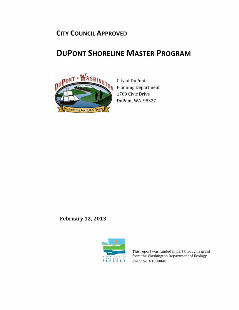
CITY COUNCIL APPROVED
DUPONT SHORELINE MASTER PROGRAM
City of DuPont Planning Department 1700 Civic Drive DuPont, WA 98327
February 12, 2013
This report was funded in part through a grant from the Washington Department of Ecology. Grant No. G1000040

DuPont Shoreline Master Program i February 2013
P R E S E N T E D T O A N D A U T H O R I Z E D B Y :
Michael Grayum, Mayor Penny Coffey, Councilmember Mike Courts, Councilmember John Ehrenreich, Councilmember Kathleen Trotter, Councilmember Roger Westman, Councilmember Larry Wilcox, Councilmember
R E C O M M E N D E D B Y :
Planning Agency Tammy Corey Don Dresser Linda Jordan, Chair Jeff Mitchell Brian Shrader
T E C H N I C A L P R E P A R A T I O N B Y :
Linda Bentley, Sole Proprietor, Project Manager BERK 2025 First Avenue, Suite 800 Seattle, WA 98121 Contact: Lisa Grueter, Built Environment Topics The Watershed Company 750 Sixth Street South Kirkland, WA 98033 Contact: Amy Summe, Natural Environment Topics
Linda Bentley et al. 2012. DuPont Shoreline Master Program. City Council Approved. May. Prepared for City of DuPont.

City of DuPont
DuPont Shoreline Master Program ii February 2013
Contents
List of Tables ........................................................................................................................................... v
List of Acronyms and Abbreviations ...................................................................................................... vi
1. Introduction .............................................................................................................. 1
1.1 Background ......................................................................................................................... 1
1.2 Contents .............................................................................................................................. 1
2. Authority and Purpose ............................................................................................... 2
2.1 Authority ............................................................................................................................. 2
2.2 Applicability ........................................................................................................................ 2
2.3 Findings ............................................................................................................................... 3
2.4 Purpose ............................................................................................................................... 4
2.5 Relationship to Other Codes, Ordinances and Plans .......................................................... 5
2.6 Liberal Construction ............................................................................................................ 5
2.7 Severability ......................................................................................................................... 5
2.8 Effective Date ...................................................................................................................... 6
3. Goals and Objectives .................................................................................................. 6
3.1 General ................................................................................................................................ 6
3.2 Economic Development ...................................................................................................... 7
3.3 Public Access ....................................................................................................................... 8
3.4 Recreation ........................................................................................................................... 9
3.5 Circulation ........................................................................................................................... 9
3.6 Shoreline Use .................................................................................................................... 10
3.7 Conservation ..................................................................................................................... 10
3.8 Historic, Cultural, Scientific, and Educational ................................................................... 11
3.9 Flood Hazard Reduction .................................................................................................... 12
4. Shoreline Jurisdiction and Environment Designations ............................................... 12
4.1 Shoreline Jurisdiction ........................................................................................................ 12
4.2 Environment Designations ................................................................................................ 13
4.2.1 Aquatic .............................................................................................................................. 13
4.2.2 Conservancy ...................................................................................................................... 14
4.2.3 Tatsolo Point Special Management Unit .......................................................................... 16
4.3 Shorelines of Statewide Significance ................................................................................ 17
4.3.1 Introduction and Designation ........................................................................................... 17
4.3.2 Use Preferences ................................................................................................................ 17

City of DuPont
DuPont Shoreline Master Program iii February 2013
4.3.3 Management Policies........................................................................................................ 18
4.3.4 Shoreline Environment Designation Interpretation ......................................................... 19
4.4 Permitted Uses and Development Standards ................................................................... 20
4.4.1 Permitted Uses.................................................................................................................. 20
4.4.2 Development Standards ................................................................................................... 23
5. General Policies and Regulations .............................................................................. 26
5.1 Archaeological and Historic Resources ............................................................................. 26
5.1.1 Policies .............................................................................................................................. 26
5.1.2 Regulations ....................................................................................................................... 26
5.2 Environmental Protection and Critical Areas.................................................................... 27
5.2.1 Policies .............................................................................................................................. 27
5.2.2 Regulations ....................................................................................................................... 28
5.3 Flood Hazard Reduction .................................................................................................... 47
5.3.1 Policies .............................................................................................................................. 47
5.3.2 Regulations ....................................................................................................................... 47
5.4 Public Access ..................................................................................................................... 49
5.4.1 Policies .............................................................................................................................. 50
5.4.2 Regulations ....................................................................................................................... 50
5.5 Shoreline Vegetation Conservation .................................................................................. 51
5.5.1 Policies .............................................................................................................................. 52
5.5.2 Regulations ....................................................................................................................... 52
5.6 Water Quality, Stormwater, and Nonpoint Pollution ....................................................... 54
5.6.1 Policies .............................................................................................................................. 54
5.6.2 Regulations ....................................................................................................................... 54
6. Shoreline Modifications and Uses ............................................................................. 55
6.1 Aquaculture ...................................................................................................................... 55
6.1.1 Policies .............................................................................................................................. 56
6.1.2 Regulations ....................................................................................................................... 56
6.2 Fill and Excavation ............................................................................................................ 57
6.2.1 Policies .............................................................................................................................. 57
6.2.2 Regulations ....................................................................................................................... 58
6.3 In-Stream Structures ......................................................................................................... 59
6.3.1 Policies .............................................................................................................................. 59
6.3.2 Regulations ....................................................................................................................... 59
6.4 Recreational Uses and Development ................................................................................ 60
6.4.1 Policies .............................................................................................................................. 60
6.4.2 Regulations ....................................................................................................................... 61

City of DuPont
DuPont Shoreline Master Program iv February 2013
6.5 Shoreline Habitat and Natural Systems Enhancement Projects ....................................... 63
6.5.1 Policies .............................................................................................................................. 63
6.5.2 Regulations ....................................................................................................................... 63
6.6 Shoreline Stabilization ...................................................................................................... 64
6.6.1 Policies .............................................................................................................................. 64
6.6.2 Regulations ....................................................................................................................... 65
6.7 Signage .............................................................................................................................. 67
6.7.1 Policies .............................................................................................................................. 67
6.7.2 Regulations ....................................................................................................................... 67
6.8 Tatsolo Point Special Management Unit Uses .................................................................. 68
6.8.1 General Regulations .......................................................................................................... 68
6.8.2 Sand and Gravel Barge Transshipment Facility................................................................. 68
6.8.3 Industrial ........................................................................................................................... 69
6.9 Transportation: Trails, Railroads, Roads and Parking ....................................................... 71
6.9.1 Policies .............................................................................................................................. 71
6.9.2 Regulations ....................................................................................................................... 71
6.10 Utilities .............................................................................................................................. 73
6.10.1 Policies ........................................................................................................................ 73
6.10.2 Regulations ................................................................................................................. 73
6.11 Dredging and Dredge Material Disposal ........................................................................... 74
6.11.1 Policies ........................................................................................................................ 74
6.11.2 Regulations ................................................................................................................. 75
7. Nonconforming Use and Development Standards ..................................................... 76
8. Shoreline Permits, Procedures, and Administration .................................................. 77
8.1 Roles and Responsibilities ................................................................................................. 77
8.1.1 SMP Administrator ............................................................................................................ 77
8.1.2 Hearing Examiner .............................................................................................................. 77
8.1.3 Planning Agency ................................................................................................................ 77
8.1.4 City Council ....................................................................................................................... 78
8.2 Interpretation ................................................................................................................... 78
8.3 Statutory Noticing Requirements ..................................................................................... 78
8.4 Application Requirements ................................................................................................ 78
8.5 Exemptions from Shoreline Substantial Development Permits ....................................... 79
8.5.1 Compliance with Applicable Regulations Required .......................................................... 79
8.5.2 Interpretation of Exemptions ........................................................................................... 79
8.5.3 Exemptions ....................................................................................................................... 79
8.6 Shoreline Substantial Development Permits .................................................................... 80

City of DuPont
DuPont Shoreline Master Program v February 2013
8.7 Shoreline Conditional Use Permits ................................................................................... 80
8.7.1 Determinations of Conditional Use Permits ..................................................................... 80
8.7.2 Review Criteria .................................................................................................................. 80
8.7.3 Conditions of Approval ..................................................................................................... 81
8.8 Shoreline Variance Permits ............................................................................................... 81
8.8.1 Purpose ............................................................................................................................. 81
8.8.2 Review Criteria .................................................................................................................. 81
8.9 Filing of Permits ................................................................................................................ 82
8.10 Duration of Permits........................................................................................................... 82
8.11 Initiation of Development ................................................................................................. 82
8.12 Review Process ................................................................................................................. 83
8.13 Appeals ............................................................................................................................. 83
8.14 Amendments to Permits ................................................................................................... 84
8.15 Enforcement ..................................................................................................................... 84
8.16 SMP Amendment .............................................................................................................. 84
8.17 Monitoring ........................................................................................................................ 85
9. Definitions ............................................................................................................... 86
Appendix A Map: City of DuPont Environment Designations
Appendix B 1994 Lonestar Settlement Agreement implemented by City Ordinance 95-521, Exhibit B
City of DuPont
DuPont Shoreline Master Program vi February 2013
Tables
Table Table 4.4-1 Use and Modifications Table ............................................................................................................. 21 Table 4.4-2 Development Standards Table ......................................................................................................... 24 Table 4.4-3 Conservancy Environment – New Use Location Preferences .............................................. 25 Table 5.2-1 Replacement Ratios .............................................................................................................................. 36

City of DuPont
DuPont Shoreline Master Program vii February 2013
Acronyms and Abbreviations
BMPs Best management practices CFS Cubic feet per second City City of DuPont
Ecology Washington State Department of Ecology OHWM Ordinary high water mark
PSDDA Puget Sound Dredged Disposal Analysis RCW Revised Code of Washington
SEPA State Environmental Policy Act SMA Shoreline Management Act SMP Shoreline Master Program
TESC Temporary erosion and sediment control TPSMU Tatsolo Point Special Management Unit
WAC Washington Administrative Code WDFW Washington State Department of Fish and Wildlife
WRIA Water Resource Inventory Area

DuPont Shoreline Master Program 1 January 2013
1. Introduction
1.1 Background Washington State’s citizens voted to approve the SMA (SMA) of 1971 in November 1972. The SMA seeks to provide environmental protection for shorelines, preserve and enhance shoreline public access, and encourage appropriate development that supports water-oriented uses, particularly on shorelines of statewide significance such as the marine waters of Puget Sound and its associated shorelands.
A Shoreline Master Program (SMP) contains goals, policies, regulations, and a use map that guide the development of shorelines in accordance with the SMA (RCW 90.58), Washington State Department of Ecology (Ecology) SMP Guidelines (WAC 173-26) and Shoreline Management Permit and Enforcement Procedures (WAC 173-27).
By law the SMP applies to shorelines of the state, generally including all marine waters, lakes greater than 20 acres, and streams with a flow greater than 20 cubic feet per second (cfs), together with shorelands within 200 feet of the ordinary high water mark (OHWM), associated wetlands, floodways, and some floodplains (RCW 90.58.030). The City of DuPont’s (City’s) shoreline jurisdiction consists of Puget Sound, including the Brackish Marsh at the downstream end of Sequalitchew Creek, and lands 200 feet landward of the OHWM.
The City adopted a SMP in 1975 and has amended it over time. Consistent with the SMA and SMP Guidelines, the City updated its SMP January 25, 2013, to be consistent with SMP Guidelines adopted in 2003. The SMP reflects a partnership and must be developed by the City and approved by both the City and Ecology. In recognition of the SMA and citizen ideas collected through a local shoreline planning process, the City has developed this SMP, and will continually implement and administer it through shoreline permits and reviews. Ecology reviews and approves local SMPs and certain local permit decisions. Once adopted by both the City and Ecology, the SMP goals and policies will be considered an element of the City’s comprehensive plan and the SMP regulations will be considered part of the City’s development regulations.
1.2 Contents This SMP contains the following Chapters:
1. Introduction
2. Authority and Purpose
3. Goals and Objectives
4. Shoreline Jurisdiction and Environment Designations

City of DuPont
DuPont Shoreline Master Program 2 January 2013
5. General Policies and Regulations
6. Shoreline Modifications and Uses
7. Nonconforming Use and Development Standards
8. Shoreline Permits, Procedures, and Administration
9. Definitions
When reading the SMP, it is useful to consider the definitions of the following terms that are based on definitions in the SMP Guidelines:
Shall or must: means a mandate; the action must be done. (WAC 173-26-020(32))
Should: means that the particular action is required unless there is a demonstrated, compelling reason, based on policy of the SMA and SMP, against taking the action. (WAC 173-26-020(35))
May: means the action is acceptable, provided it conforms to the provisions of this SMP and the SMA. (WAC 173-26-020(25))
In general, this SMP uses the word “should” in goals, objectives, and policies, and “shall” in the regulations. Additional definitions are located in Chapter 9.
2. Authority and Purpose
2.1 Authority The SMA (SMA) of 1971, Chapter 90.58 RCW, is the authority for the enactment and administration of this SMP.
2.2 Applicability All proposed uses, activities, and development occurring within shoreline jurisdiction must conform to the intent and requirements of Chapter 90.58 RCW, the SMA, and this SMP whether or not a permit or other form of authorization is required. See Chapter 3 for the definition of shoreline jurisdiction.
Direct federal agency activities affecting shoreline jurisdiction must be consistent to the maximum extent practicable with the SMA, SMP Guidelines, and this SMP.
As recognized by RCW 90.58.350, the provisions of this SMP shall not affect treaty rights of Indian Nations or tribes.

City of DuPont
DuPont Shoreline Master Program 3 January 2013
2.3 Findings The SMP is based on a Shoreline Analysis Report 1and a public visioning process2
Finding-1 The City is located in Pierce County in the Puget Sound Region, and contains marine shoreline associated with Washington State’s Water Resource Inventory Area (WRIA) 11 - Nisqually and WRIA 12 – Chambers-Clover.
, which provide the basis for the SMP. Key findings are identified below.
Finding-2 The City is surrounded by the Joint Base Lewis-McChord on the east and south, steep bluffs leading down to Puget Sound on the north and west, and an isolated area of unincorporated Pierce County immediately adjacent to the Nisqually River flats and delta area.
Finding-3 The City’s upland shoreline jurisdiction subject to the SMP, including the marine shoreline and the Sequalitchew Creek Brackish Marsh is approximately 89 acres extending about 3.5 lineal miles.
Finding-4 The Nisqually River and its delta are outside of the City’s shoreline jurisdiction. However, the City’s shoreline is within the Nisqually Reach. The Nisqually nearshore environment encompasses those areas within the Nisqually Reach where terrestrial environments interact with marine environments.
Finding-5 Historically, DuPont and the surrounding area have been used by several Indian tribes known collectively as Salish people, the Hudson’s Bay Company (and its subsidiary the Puget Sound Agricultural Company), and the E.I. du Pont de Nemours Company which operated a munitions and explosives plant.
Finding-6 The nearshore environment, including shoreline areas within DuPont, has been altered by human activity. In 1912, the Point Defiance line of the Northern Pacific Railway Company was installed along the base of the bluff, with large amounts of rip-rap to protect the grade from erosion. Between the delta and Tatsolo Point, rip-rap has been placed along the entire 19,000 linear feet of shoreline along the waterline or a short distance landward. Such rip-rap protection interferes with the natural progression of bluff erosion and sediment recruitment. It can also alter substrate composition waterward of the rip-rap, increase the slope of the beach, and alter the natural progression of plant communities.
Finding-7 Within the City’s shoreline jurisdiction, sediment from the Nisqually migrates northward along the shoreline, creating broad, gently sloping, fine-grained beaches in the southern portion of shoreline jurisdiction. A spit formed at the old DuPont
1 The Watershed Company and ICF International. February 2011. FINAL Shoreline Analysis Report for the City of DuPont’s Shoreline: Puget Sound. Prepared for the City of DuPont Planning Department, DuPont, WA. 2 Bentley, Linda, on behalf of the City of DuPont. Community Visioning Process Report for the City of DuPont Shoreline Master Program Update – October 2010.

City of DuPont
DuPont Shoreline Master Program 4 January 2013
pier location appears to function as a groin, interfering with the migration of sediment northward.
Finding-8 Sequalitchew Creek has mean annual flows too low to be considered part of the City’s shoreline jurisdiction, but it plays an important role in the nearshore environment of the Nisqually Reach, providing fresh water and sediment inputs, and supporting runs of anadromous fish.
Finding-9 Sequalitchew Creek enters Puget Sound via a culvert under the railroad track. This culvert is a fish passage barrier at extreme low flow events, and adult salmon have been observed. Immediately upstream of this culvert is a tidally influenced wetland locally referred to as Brackish Marsh. As an associated wetland, the Brackish Marsh is considered part of the marine shoreline jurisdiction.
Finding-10 In the City’s Shoreline Analysis Report, shoreline conditions have been rated moderate to high or high given the high quality intertidal and shoreline habitat.
Finding-11 Current land uses in shoreline jurisdiction include a railroad, a dock associated with a mining operation, and passive recreational activities.
Finding-12 The City is now a master planned community once under the single ownership of the Weyerhaeuser Corporation and developed according to a comprehensive land use plan developed by Calthorpe Associates. Future development is likely to locate outside of shoreline jurisdiction since the shoreline area is generally designated as “Open Space/Sensitive Area” in the Comprehensive Plan.
Finding-13 DuPont citizens value the shoreline views, beauty, natural areas, and the quiet and desire to maintain/enhance good, but limited, public access to the shoreline; maintain/restore the wildlife, habitat and natural areas; and provide additional opportunities for water enjoyment. Protection and restoration of natural areas is a key consideration.
Finding-14 Recognize in the Shoreline Master Program the designation of the U.S. Nisqually National Wildlife Refuge extending to the mouth of Sequalitchew Creek, as well as the recently approved Washington State Department of Natural Resources Nisqually Reach Aquatic Reserve.
2.4 Purpose The purposes of this SMP are:
A. To promote the public health, safety, and general welfare of the City by providing comprehensive policies and effective, reasonable regulations for development, use and protection of jurisdictional shorelines; and

City of DuPont
DuPont Shoreline Master Program 5 January 2013
B. To further assume and carry out the local government responsibilities established by the SMA in RCW 90.58.050 including planning and administering the regulatory program consistent with the policy and provisions of the SMA in RCW 90.58.020; and
C. To give preference to those uses that are consistent with the control of pollution and prevention of damage to the natural environment, or are unique to or dependent upon uses of the state's shoreline areas; and
D. Apply special conditions to those uses which are not consistent with the control of pollution and prevention of damage to the natural environment or are not unique to or dependent upon use of the state's shoreline; and
E. Assure no net loss of ecological functions associated with the shoreline.
2.5 Relationship to Other Codes, Ordinances and Plans
Consistent with RCW 36.70A.480, the goals and policies of this SMP approved under chapter 90.58 RCW shall be considered an element of the City’s comprehensive plans; the portions of the SMP considered an element of the Comprehensive Plan consist of Chapter 3 goals and objectives and the policies of Chapters 4, 5, and 6; policies are numbered with a “P-“ prefix. All regulatory elements of this SMP, including, but not limited to definitions, use environments, and use regulations, shall be considered a part of the City’s development regulations; this pertains to Chapters 1, 2, and 4 through 9, as well as Appendix A. Regulations are numbered with a “R-“ prefix. All use environment purposes, objectives, and management policies in Chapter 4 and Appendix A are considered both part of the Comprehensive Plan and development regulations.
All applicable federal, state, and local laws shall apply to properties in the shoreline jurisdiction.
In the event provisions of this SMP conflict with provisions of federal, state, county or City regulations, the provision that is most protective of shoreline resources shall prevail, when consistent with policies set out in the SMA.
2.6 Liberal Construction As provided for in RCW 90.58.900, the SMA is exempted from the rule of strict construction; the SMA and this SMP shall therefore be liberally construed to give full effect to the purposes, goals, objectives, and policies for which they were enacted.
2.7 Severability Should any section or provision of this SMP be declared invalid, such decision shall not affect the validity of this SMP as a whole.
City of DuPont
DuPont Shoreline Master Program 6 January 2013
2.8 Effective Date The SMP is hereby adopted on the 12th day of February, 2013. This SMP and all amendments thereto shall become effective immediately upon final approval and adoption by Ecology.
3. Goals and Objectives
This section contains shoreline goals and objectives. Goals express the ultimate aim of the City along its shorelines. An objective identifies a measurable step that moves toward achieving a long-term goal. Goals and objectives provide a framework upon which the more detailed SMP shoreline use environments, policies, regulations, and administrative procedures are based in subsequent chapters.
3.1 General
Goal A. Recognize DuPont’s natural resources values and its unique aesthetic qualities offered by water, topography, vegetation, and views. New uses, development, or shoreline alterations should return to the community, state, private property owners, and public-at-large the greatest good compatible with the least possible disturbance to the environment.
Objective 1. Maximize efforts to control and eliminate shoreline pollution – air, water, and land.
Objective 2. Consistent with the 1994 Lonestar Settlement Agreement3
Objective 3. Promote new and enhanced recreational facilities.
implemented by City Ordinance 95-521, restrict mineral extraction or exploration in DuPont's shoreline jurisdiction while allowing for a sand and gravel barge transshipment facility at Tatsolo Point in recognition of the mineral resources in the City.
Objective 4. Encourage preservation and enhancement of fish and wildlife in this area for future generations in cooperation with State and Federal agencies.
3 A 2011 Agreement builds on and is consistent with the objectives of the 1994 Settlement Agreement, and only controls when the 2011 Agreement is inconsistent with the 1994 Settlement Agreement.

City of DuPont
DuPont Shoreline Master Program 7 January 2013
Objective 5. Define appropriate shoreline uses and to assure that all such uses are compatible with the site, the surrounding area and the environment.
Objective 6. For that portion of the shoreline jurisdiction that is designated as ”Shorelines of Statewide Significance,” apply the following specific priorities:
Recognize and protect the state-wide interest over local interest.
Preserve the natural character of the shoreline.
Result in long-term over short-term benefit.
Protect the resources and ecology of shorelines.
Increase public access to publicly owned areas of the shorelines.
Increase recreational opportunities for the public on the-shorelines.
Provide for any other element as defined in RCW 90.58.100 deemed appropriate or necessary.
Objective 7. Periodically review and update the SMP to ensure consistency with the SMA, Ecology SMP Guidelines, the DuPont Comprehensive Plan, and the DuPont Municipal Code.
3.2 Economic Development
Goal B. Recognize current and planned economic uses such as transportation, industrial, and recreation.
Objective 8. Provide for water dependent industrial uses at Tatsolo Point, and allow the Tatsolo Point sand and gravel barge transshipment operations, consistent with the 1994 Lonestar Settlement Agreement implemented by City Ordinance 95-521.
Objective 9. Recognize ongoing railroad operations in shoreline jurisdiction.
Objective 10. Consider DuPont’s shoreline as a both a local and regional destination for shoreline recreation, education, cultural, and scientific study as part of the Nisqually National Wildlife Refuge and consistent with the City’s Parks, Recreation, and Open Space Plan.

City of DuPont
DuPont Shoreline Master Program 8 January 2013
3.3 Public Access
Goal C. Provide a comprehensive network of trails and pathways to improve community walkability, connectivity, and park access.
Objective 11. Maintain unique physical features of the City as passive open spaces in order to ensure their protection while providing for public access and enjoyment.
Objective 12. Establish walking trails that access the Puget Sound consistent with the City’s Parks, Recreation, and Open Space Plan.
Objective 13. Provide for public access and establish viewpoints along the Puget Sound bluff.
Objective 14. Consider providing a community park at the shoreline area north of the Sequalitchew Creek ravine along Puget Sound consistent with the City’s critical area regulations in Section 5.2 of this SMP.
Objective 15. Coordinate the trail system with natural area preservation areas, responding to environmental conditions and preservation priorities while providing public access where feasible.
Objective 16. Secure public access to the Sequalitchew Creek corridor to preserve and protect this significant community resource and to provide access to the Puget Sound.
Objective 17. Provide a public trail access to unique local points of interest, including trails on the Puget Sound bluff, through the Sequalitchew Creek corridor, and to the historic fort site and Old Fort Lake.
Objective 18. Develop new pathways and fill in missing trail links to connect parks, open space, schools, neighborhoods, and other key destinations in the community. Ensure the location, type, width and materials of the pathway reflect environmental conditions as well as respect private property.
Objective 19. Link the DuPont trail system with the regional trail system and provide connections to regional points of interest, such as the Nisqually National Wildlife Refuge.
Objective 20. Increase public awareness of the trail system.

City of DuPont
DuPont Shoreline Master Program 9 January 2013
3.4 Recreation
Goal D. Make the shoreline an asset to the citizens of DuPont and to its visitors.
Objective 21. Integrate natural resources and open spaces, including Sequalitchew Creek and Puget Sound, into the park system.
Objective 22. Insofar as possible, assure convenient and adequate water-related recreational opportunities along the shoreline of the City with maximum preservation of the natural environment.
Objective 23. Develop a natural area management strategy so that resources are maintained and preserved. The management strategy should address issues such as staff expertise and capacity, long term funding, and community volunteerism.
3.5 Circulation
Goal E. Provide a system for the efficient movement of goods and people, encouraging facilities for pedestrian circulation, as well as allowing vehicular circulation for service vehicles and access for the disabled.
Objective 24. Focus new circulation improvements on interconnected trails consistent with the City’s Parks, Recreation, and Open Space Plan.
Objective 25. Allow current railroad facilities to continue providing regional service through shoreline jurisdiction.
Objective 26. Develop circulation systems that provide for safety and accessibility, respect the natural environment, and exist in harmony with the land use and shoreline planning.
Objective 27. Locate some roads along the edges of sensitive areas, including areas of steep slopes, in order to provide views for motorists.
Discussion: The City recognizes a balance between the need to protect natural areas and the need for the public to have visual access.

City of DuPont
DuPont Shoreline Master Program 10 January 2013
3.6 Shoreline Use
Goal F. Promote the best possible pattern of land and water uses beneficial to the natural and human environments.
Objective 28. Make the primary use of DuPont’s shoreline jurisdiction shoreline passive recreation.
Objective 29. Recognize existing railroad and sand and gravel transshipment uses and allow for water dependent industrial uses, consistent with the 1994 Lonestar Settlement Agreement implemented by City Ordinance 95-521. Assure that all such uses are compatible with the site, the surrounding area and the environment.
Objective 30. Require that all shoreline uses conform to all applicable federal, state and local laws and regulations relating to environmental quality and resource protection.
Objective 31. Establish and maintain appropriate development standards for DuPont's shoreline jurisdiction.
Objective 32. Encourage water-dependent uses where appropriate that are consistent with control of pollution and prevention of damage to the natural environment, and are dependent upon use of a shoreline.
3.7 Conservation
Goal G. Ensure continuous sound management in the preservation of unique, fragile, and scenic elements, and of non-renewable natural resources; and encourage the best management practices for the continued utilization of renewable resources of the shorelines.
Objective 33. Attain no net loss of ecological functions within shoreline jurisdiction through preservation of high-value sensitive areas and open space and mitigation of unavoidable impacts to low- and moderate-value natural features.
Objective 34. Recognize unique environments, such as springs and seeps, along the Puget Sound shoreline.

City of DuPont
DuPont Shoreline Master Program 11 January 2013
Objective 35. Support strict enforcement of air, water, noise and other pollution laws and regulations.
Objective 36. Support and enforce laws, regulations and programs designed to protect wildlife and other natural resources.
Objective 37. Cooperate and coordinate with state, federal, and tribal agencies having jurisdiction or management interest local and regional fish and wildlife resources, including the Nisqually National Wildlife Refuge.
Objective 38. Sponsor and support public information programs regarding environmental protection.
Objective 39. Institute measures which promote development and construction practices that minimize impact on the City's natural systems.
Objective 40. Protect nearshore habitats for aquatic plants, fish, shellfish and crustaceans by limiting the activities allowed along the DuPont shoreline.
3.8 Historic, Cultural, Scientific, and Educational
Goal H. Encourage the identification, protection, preservation and restoration of shoreline sites or structures having historical, cultural, educational, or scientific value with maximum preservation of the natural environment.
Goal I. Preserve, enhance and share the City's natural and historic resources so that they are known regionally and enjoyed for generations to come.
Goal J. Recognize cultural and historical resources as an essential part of DuPont’s identity and heritage.
Objective 41. Insofar as possible, preserve historical sites along the shoreline.
Objective 42. Recognize the varying recreational and cultural needs of all age, ethnic and economic groups in the development and implementation of shoreline uses, particularly shoreline recreation facilities.
Objective 43. Bring together and work collaboratively with other interested parties to recognize and develop the rich history found within the City limits of DuPont.
City of DuPont
DuPont Shoreline Master Program 12 January 2013
Discussion: The City will identify and mark historic roads and trails to help preserve area history. Where possible, these trails may be incorporated into the public trail system.
Objective 44. Development policies and procedures for the City will be in accordance with all laws, ordinances, rule, and regulations that deal with the protection and preservation of Cultural Resources.
Objective 45. Identify and protect historic and cultural resources to enhance community identity.
Objective 46. Maximize historical and cultural interpretation within DuPont’s park system and recreation programs.
Objective 47. Locate trails and viewpoints to facilitate access to cultural and historical resources.
Objective 48. Consider DuPont’s cultural heritage in all recreation master planning, including park design concepts, park and facility names, and facility development.
3.9 Flood Hazard Reduction
Goal K. Discourage development in frequently-flooded areas.
Objective 49. Consider mapped floodplains and any adopted flood hazard regulations in the location of permanent improvements on the shoreline.
4. Shoreline Jurisdiction and Environment Designations
4.1 Shoreline Jurisdiction As defined by the SMA of 1971, shorelines include certain waters of the state plus their associated “shorelands.” At a minimum, the waterbodies designated as shorelines of the state are streams whose mean annual flow is 20 cfs or greater, lakes whose area is greater than 20 acres, and all marine waters. Shorelands are defined as:
“those lands extending landward for 200 feet in all directions as measured on a horizontal plane from the ordinary high water mark; floodways and contiguous floodplain areas landward 200 feet

City of DuPont
DuPont Shoreline Master Program 13 January 2013
from such floodways; and all wetlands and river deltas associated with the streams, lakes, and tidal waters which are subject to the provisions of this chapter…Any county or City may determine that portion of a one-hundred-year-floodplain to be included in its master program as long as such portion includes, as a minimum, the floodway and the adjacent land extending landward two hundred feet therefrom… Any City or county may also include in its master program land necessary for buffers for critical areas (RCW 90.58.030)”
All marine shorelines throughout Puget Sound are included under shoreline jurisdiction. In addition, the Nisqually Delta between the extreme low tide line and the landward extent of associated shorelands is a Shoreline of Statewide Significance from the DeWolf Bight to the northern City limits at Tatsolo Point.
According to RCW 35.21.160 (Jurisdiction over adjacent waters), the City’s shoreline jurisdiction extends waterward to the middle of Puget Sound:
“The powers and jurisdiction of all incorporated cities and towns of the state having their boundaries or any part thereof adjacent to or fronting on any bay or bays, lake or lakes, sound or sounds, river or rivers, or other navigable waters are hereby extended into and over such waters and over any tidelands intervening between any such boundary and any such waters to the middle of such bays, sounds, lakes, rivers, or other waters in every manner and for every purpose that such powers and jurisdiction could be exercised if the waters were within the City or town limits.”
An estuarine wetland known locally as Brackish Marsh is located at the downstream end of Sequalitchew Creek, just upstream of the railroad berm that parallels the marine shoreline. The wetland is connected to the Sound by a culvert that allows for inundation by marine waters at ordinary high water. Accordingly, the wetland is considered part of the marine shoreline waterbody (rather than an associated wetland), and the 200-foot shoreland jurisdiction extends outward from the wetland edge.
4.2 Environment Designations The following environment designations have been developed based on current shoreline conditions, including railroad use, sand and gravel barge transshipment, critical saltwater habitats, shoreline vegetation, and critical areas; SMP Guidelines; and the 1994 Lonestar Settlement Agreement addressing Tatsolo Point sand and gravel barge transshipment operations implemented by City Ordinance 95-521. A map of the environment designations is included in Appendix A of this SMP.
4.2.1 Aquatic
4.2.1.1 Purpose
The purpose of the Aquatic environment designation is to protect, restore, and manage the unique characteristics and resources of those areas of the shoreline jurisdiction waterward of the OHWM.

City of DuPont
DuPont Shoreline Master Program 14 January 2013
4.2.1.2 Designation Criteria
The Aquatic environment designation shall be applied to all lands within the shoreline jurisdiction located waterward of the OHWM, with the exception of those subtidal lands included in the Tatsolo Point Special Management Unit, as described in Section 4.2.3.
4.2.1.3 Location
The Aquatic designation is assigned to all lands waterward of the OHWM, except for those lands included in the Tatsolo Point Special Management Unit.
4.2.1.4 Management Policies P-1 Uses within the Aquatic environment should be limited to water-dependent uses, public
access, or ecological restoration.
P-2 All uses in the Aquatic environment should be designed to prevent degradation of water quality or negative changes in local hydrologic processes, including sediment transport.
P-3 All developments and uses on navigable waters or their beds should be located and designed to minimize interference with surface navigation and to consider impacts to public views.
P-4 Uses and modifications in the Aquatic environment should be designed to prevent obstruction of fish and wildlife movement.
P-5 Any new over-water structures in the Aquatic environment should be limited to the minimum size necessary to support the intended use. Multiple uses of over-water facilities should be encouraged.
P-6 Uses that adversely impact the ecological functions of critical saltwater and freshwater habitats should not be allowed except where necessary to achieve the objectives of RCW 90.58.020, and then only when their impacts are mitigated according to the sequence described in Section 5.2, Environmental Protection and Critical Areas, as necessary to assure no net loss of ecological functions.
4.2.2 Conservancy
4.2.2.1 Purpose
The purpose of the “Conservancy” environment is to retain shoreline ecological functions and processes by avoiding forms of development or uses that would be incompatible with existing functions and processes, conserve existing natural resources and valuable historic and cultural areas in order to provide for sustained resource use, achieve natural shoreline processes, provide low-intensity recreational opportunities, and recognize existing transportation facilities, particularly the railroad, the most prominent historic and current use of the City’s shoreline. Within the Conservancy environment, new intense uses or development shall be prohibited, thereby maintaining the area's natural character.
City of DuPont
DuPont Shoreline Master Program 15 January 2013
4.2.2.2 Designation Criteria
The Conservancy designation consists of valuable natural, cultural, or historical resources or environmental conditions that should be protected, conserved, and managed so that those resources and areas remain available for the benefit of the public. The Conservancy designation is assigned to appropriate shoreline areas, that are compatible with maintaining or restoring ecological functions of the area, and that are generally not suitable for extensive new development or uses, including those areas:
A. That are open space, floodplain or other sensitive areas that should not be developed;
B. That retain important ecological functions or have potential for ecological restoration; or
C. Where the shoreline is unable to support new development or uses without significant adverse impacts to ecological functions or risk to human safety.
4.2.2.3 Location
The Conservancy designation is assigned to all upland areas of the City’s shoreline outside of the Tatsolo Point Special Management Unit environment, including the upland 200 feet from the OHWM, Brackish Marsh, and the upland area of shoreline jurisdiction adjacent to Brackish Marsh.
4.2.2.4 Management Policies P-7 Uses that preserve the natural character of the area or promote preservation of open space
or sensitive lands either directly or over the long term should be the primary allowed uses in the environment.
P-8 Authorized uses should be limited to those compatible with each other and with conservation of shoreline ecological processes and resources.
P-9 Natural ecological processes should be protected, and renewable resources managed so that ecological functions and the resource base are maintained.
P-10 Opportunities for ecological restoration should be pursued, prioritizing those areas with the greatest potential to restore ecosystem-wide processes and functions.
P-11 Recreational or scenic values should be protected.
P-12 Public access and public recreation objectives should be implemented in the Conservancy environment whenever feasible.
P-13 Use regulations should allow for railroad operations, maintenance, and repair. New uses directly associated with the railroad may be allowed, provided that no feasible non-shoreline location is available.
City of DuPont
DuPont Shoreline Master Program 16 January 2013
4.2.3 Tatsolo Point Special Management Unit
4.2.3.1 Purpose
The purpose of the Tatsolo Point Special Management Unit (TPSMU) is to ensure that the shoreline resources of the TPSMU and the Shoreline of Statewide Significance associated with the Nisqually Delta are protected while providing the City with a location for access to Puget Sound for appropriate water-dependent uses and activities and water-related passive recreational uses and activities.
4.2.3.2 Designation Criteria
The TPSMU designation is assigned to upland and aquatic areas dedicated to operation of an existing sand and gravel barge transshipment use.
4.2.3.3 Location
The TPSMU designation is assigned to a 750-foot length of shoreline extending west from a point 250 feet west of the City limits, landward 200 feet from the OHWM and waterward 300 feet from the OHWM.
4.2.3.4 Management Policies P-14 Development within the TPSMU should not be visible from anywhere within the Nisqually
National Wildlife Refuge.
P-15 Uses within the TPSMU should be limited to water-dependent uses and water-related passive recreational uses. Water-dependent uses should be limited to those uses associated with public transportation or with sand and gravel barge transshipment.
P-16 Uses directly associated with the railroad may be allowed, provided that no feasible non-shoreline location is available.
P-17 All uses, developments and activities should be designed, developed and conducted in a manner that minimizes the impact to the natural and human environment, the aesthetic character of the area, and the public use and enjoyment of the area. Appropriate compensatory mitigation should be required for all unavoidable adverse impacts associated with permitted development.
P-18 Passive recreational uses and an industrial use may occur concurrently within the TPSMU. However, only one industrial use utilizing one dock may be permitted and operating within the TPSMU at any time. Other than expansion of the existing dock, no other new over-water structures should be allowed.
P-19 The size of expanded over-water structures should be limited to the minimum necessary to support the structure's intended use.

City of DuPont
DuPont Shoreline Master Program 17 January 2013
P-20 In order to reduce the impacts of shoreline development and increase effective use of water resources, multiple uses of over-water facilities should be encouraged.
P-21 All developments and uses on navigable waters or their beds should be located and designed to minimize interference with surface navigation, to consider impacts to public views, and to allow for the safe, unobstructed passage of fish and wildlife, particularly those species dependent on migration.
P-22 Uses that adversely impact the ecological functions of critical saltwater habitats should not be allowed. Where those uses are necessary to achieve the objectives of RCW 90.58.020, their impacts should be mitigated according to the sequence defined in Section 5.2.2.1, Regulation 23, as necessary to assure no net loss of ecological functions.
P-23 Shoreline uses and modifications should be designed and managed to prevent degradation of water quality and alteration of natural hydrographic conditions.
4.3 Shorelines of Statewide Significance
4.3.1 Introduction and Designation The SMA designates certain shoreline areas as “shorelines of statewide significance,” and puts added emphasis on these areas to ensure that they are protected for the long-term interests of the people of the state.
The SMA states that the interests of all of the people of the state shall be paramount in the management of Shorelines of Statewide Significance.
Within the City’s shoreline jurisdiction, all areas waterward of the extreme low tide throughout Puget Sound are considered Shorelines of Statewide Significance. In addition, the Nisqually Delta between the extreme low tide line and the landward extent of associated shorelands is a Shoreline of Statewide Significance from the DeWolf Bight to the northern City limits at Tatsolo Point. Brackish Marsh and its associated shorelands are also considered a Shoreline of Statewide Significance.
4.3.2 Use Preferences In accordance with RCW 90.58.020, the following management and administrative policies are hereby adopted for all Shorelines of Statewide Significance in the City, as defined in RCW 90.58.030(2)(e). Consistent with the policy contained in RCW 90.58.020, preference shall be given to the uses in the following order of preference that are consistent with the statewide interest in such shorelines. These are uses that:
P-24 Recognize and protect the statewide interest over local interest;
P-25 Preserve the natural character of the shoreline;
P-26 Result in long term over short term benefit;

City of DuPont
DuPont Shoreline Master Program 18 January 2013
P-27 Protect the resources and ecology of the shoreline;
P-28 Increase public access to publicly owned areas of the shorelines;
P-29 Increase recreational opportunities for the public in the shoreline;
P-30 Provide for any other element as defined in RCW 90.58.100 deemed appropriate or necessary. (WAC 173-26-251(2))
Uses that are not consistent with these preferences should not be permitted on Shorelines of Statewide Significance.
4.3.3 Management Policies Consistent with the use preferences for Shorelines of Statewide Significance contained in RCW 90.58.020 and identified in Section 4.3.2, the City will base decisions administering this SMP on the following policies in order of decreasing priority:
P-31 Recognize and protect the state-wide interest over local interest.
A. Solicit comments and opinions from groups and individuals representing state-wide interests by circulating amendments to the SMP, and any proposed amendments affecting Shorelines of Statewide Significance, to state agencies, affected Tribes, adjacent jurisdictions, citizen's advisory committees and local officials, and state-wide interest groups.
B. Recognize and take into account state agencies' policies, programs and recommendations in developing and administering use regulations and in approving shoreline permits.
C. Solicit comments, opinions and advice from individuals with expertise in ecology and other scientific fields pertinent to shoreline management.
P-32 Preserve the natural character of the shoreline.
A. Designate and administer shoreline environments and use regulations to protect and restore the ecology and environment of the shoreline as a result of human intrusions on shorelines.
B. Restore, enhance, and/or redevelop those areas where intensive development or uses already exists in order to reduce adverse impact on the environment and to accommodate future growth rather than allowing high-intensity uses to extend into low-intensity use or underdeveloped areas.
C. Protect and restore existing diversity of vegetation and habitat values, wetlands, and riparian corridors associated with shoreline areas.
D. Protect and restore habitats for State-listed “priority species.”
P-33 Support actions that result in long-term benefits over short-term benefits.
A. Evaluate the short-term economic gain or convenience of developments or uses relative to the long-term and potentially costly impairments to the natural shoreline.

City of DuPont
DuPont Shoreline Master Program 19 January 2013
B. Preserve resources and values of shorelines of statewide significance for future generations and restrict or prohibit development or uses that would irretrievably damage shoreline resources.
C. Ensure the long-term protection of ecological resources of statewide importance, such as anadromous fish habitats, forage fish spawning and rearing areas, and unique environments.
P-34 Protect the resources and ecology of the shoreline.
A. All shoreline development or uses should be located, designed, constructed and managed consistent with mitigation sequencing provisions outlined in Section 5.2.2.1, Regulation 23, to minimize adverse impacts to regionally important wildlife resources, including spawning, nesting, rearing and habitat areas, and migratory routes and result in no net loss of shoreline ecological functions and ecosystem-wide processes.
B. Actively promote aesthetic considerations when contemplating new uses, development, redevelopment of existing facilities, or general enhancement of shoreline areas.
P-35 Increase public access to publicly owned areas of the shoreline.
A. Give priority to developing paths and trails to shoreline areas and linear access along the shorelines.
B. Locate development landward of the OHWM so that access is enhanced and opportunities for access are not precluded.
P-36 Increase recreational opportunities for the public on the shoreline by:
A. Planning for and encouraging public recreational use of the shoreline.
4.3.4 Shoreline Environment Designation Interpretation R-1 Minor Mapping Inaccuracies. Shoreline jurisdiction maps are approximate. The ordinary
high water mark and resultant upland, lateral extent of shoreline jurisdiction will need to be determined on a site-specific basis at the time of application. Any areas within shoreline jurisdiction that are not mapped and/or designated due to minor mapping inaccuracies in the upland extent of shoreline jurisdiction are automatically assigned the category of the contiguous upland shoreline environment designation.
R-2 Other Unmapped Areas. All other areas that were neither mapped in the shoreline jurisdiction but which do meet Section 4.1 Shoreline Jurisdiction shall be assigned a Conservancy designation until the shoreline can be redesignated through a SMP Amendment.
R-3 Property Not Meeting Criteria. Property shown in shoreline jurisdiction that does not meet the definitions of shoreline or shoreland found in RCW 90.58.030 and Chapter 9 of this SMP, or the applicability criteria in Section 4.1 Shoreline Jurisdiction, shall not be subject to the requirements of this SMP. The actual location of the OHWM must be determined at the time a development or use is proposed. Such determinations are valid for two years.

City of DuPont
DuPont Shoreline Master Program 20 January 2013
R-4 Mapping Error. Where the SMP update or amendment record, including the public hearing process, is clear in terms of the correct environment designation to apply to a property, the Shoreline Administrator shall apply the environment designation approved through the SMP Update or Amendment process and correct the map. If the use environment criteria were misapplied, but the map does not show an unintentional error, a SMP amendment may be obtained consistent with WAC 173-26-100 and Section 8.15.
R-5 Interpretation of Boundaries. Boundaries indicated as approximately following lot, tract, or section lines shall be so construed. Boundaries indicated as approximately following roads or railways shall be respectively construed to follow the nearest right-of-way edge.
4.4 Permitted Uses and Development Standards
4.4.1 Permitted Uses R-6 Uses Allowed and Prohibited. Table 4.4-1 indicates which new, altered or expanded shoreline
activities, uses, developments and modifications are allowed or are prohibited in shoreline jurisdiction within each shoreline environment designation. Activities, uses, developments, and modifications identified as “Permitted Uses” require a Shoreline Substantial Development Permit or a Shoreline Exemption, and those identified as “Conditional Uses” require a Conditional Use Permit per Section 8, Shoreline Permits, Procedures, and Administration. Activities, uses, developments, and modifications identified as “Prohibited” are not allowed. An assignment of “Conditional Use” or “Prohibited” does not apply to repair and maintenance of all existing legal structures, when consistent with applicable Shoreline Exemptions in Section 8.5.3 of this SMP.
R-7 Accessory Uses. Unless separately identified on Table 4.4-1, accessory uses shall be subject to the same shoreline permit process as its primary use.
R-8 Conflict between Text and Table. Where there is a conflict between the chart and the written provisions in this SMP, the written provisions shall apply.
R-9 Underlying Zoning. Authorized uses and modifications are only allowed in shoreline jurisdiction where the underlying zoning also allows for it; authorized uses and modifications are subject to the policies and regulations of this SMP.
R-10 Unclassified Uses. A use is considered unclassified when it is not listed in Table 4.4-1 or defined in Chapter 9, Definitions. Unclassified uses shall require a Shoreline Conditional Use Permit.
R-11 Prohibited Uses. The following uses are prohibited in all shoreline environments and thus have no use standards in Chapters 5 and 6:
A. Agriculture
City of DuPont
DuPont Shoreline Master Program 21 January 2013
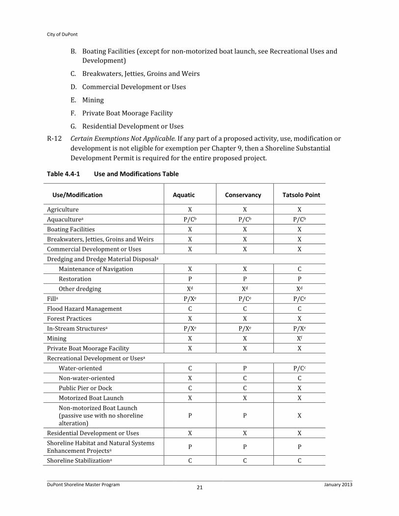
B. Boating Facilities (except for non-motorized boat launch, see Recreational Uses and Development)
C. Breakwaters, Jetties, Groins and Weirs
D. Commercial Development or Uses
E. Mining
F. Private Boat Moorage Facility
G. Residential Development or Uses
R-12 Certain Exemptions Not Applicable. If any part of a proposed activity, use, modification or development is not eligible for exemption per Chapter 9, then a Shoreline Substantial Development Permit is required for the entire proposed project.
Table 4.4-1 Use and Modifications Table
Use/Modification Aquatic Conservancy Tatsolo Point
Agriculture X X X Aquaculturea P/Cb P/Cb P/Cb Boating Facilities X X X Breakwaters, Jetties, Groins and Weirs X X X Commercial Development or Uses X X X Dredging and Dredge Material Disposala
Maintenance of Navigation X X C Restoration P P P Other dredging Xd Xd Xd
Filla P/Xe P/Ce P/Ce Flood Hazard Management C C C Forest Practices X X X In-Stream Structuresa P/Xe P/Xe P/Xe Mining X X Xf Private Boat Moorage Facility X X X Recreational Development or Usesa
Water-oriented C P P/Cc Non-water-oriented X C C Public Pier or Dock C C X Motorized Boat Launch X X X Non-motorized Boat Launch (passive use with no shoreline alteration)
P P X
Residential Development or Uses X X X Shoreline Habitat and Natural Systems Enhancement Projectsa P P P
Shoreline Stabilizationa C C C
City of DuPont
DuPont Shoreline Master Program 22 January 2013
Use/Modification Aquatic Conservancy Tatsolo Point
Signagea P/Xg P/Xg P/Cg Tatsolo Point Development or Usesa
Industry (including one industrial pier or dock) X X C
Sand and gravel barge transshipment facility X X C
Transportationa Bridges or culverts
Maintenance, improvement, or expansion P P P
In association with restoration project P P P
Other X X X Railroadsj
Maintenance, improvement, or expansion C P P/Cc
New C C P/Cc Roads
Maintenance, improvement, or expansion
See bridges or culverts P P
For purposes of emergency vehicle/ service/repair
See bridges or culverts P P/Cc
Accessory to a water-enjoyment or railroad use X C P/Cc
Other X X P/Cc Trails
Maintenance, improvement, or expansion X P P/Cc
New X P P/Cc Parking
Maintenance, improvement X P P Accessory to a water-enjoyment or railroad use X P/Ch Pi
Parking to support an authorized use X P/Ch Pi
Utilitiesa Accessory, new C P P/Cc Primary or Regionalj, new X C P/Cc Existing, maintenance, improvement or expansion P P P
P = Permitted Uses with Shoreline Substantial Development Permit or Shoreline Exemption; C = Conditional Uses; X = Prohibited Uses; NA = Not Applicable a = Development policies and standards in Chapter 6.
City of DuPont
DuPont Shoreline Master Program 23 January 2013
b = Permitted when associated with facilities for fish and wildlife related research and/or enhancement, conditionally permitted otherwise. c = Permitted landward of OHWM. Conditional Use Permit required when waterward of OHWM. d = Dredging for any other purpose, other than minor dredging accessory to other authorized uses and modifications, shall be prohibited. e = Permitted when part of an approved ecological restoration activity, otherwise conditionally permitted or prohibited as identified in the matrix. f = Mining excludes sand and gravel barge transshipment facilities, which are allowed as listed in the matrix with Tatsolo Point Development or Uses. g = Non-illuminated signs are permitted. Illuminated signs are permitted for navigational purposes. Illuminated signs for non-navigation purposes are conditionally permitted in Tatsolo Point and prohibited in other use environments as identified in the matrix. h = Roads and parking facilities may be allowed in the Conservancy environment with a Shoreline Substantial Development Permit if proposed only for emergency vehicle/service/repair functions or may be allowed with a Shoreline Conditional Use Permit if accessory to a water-enjoyment or railroad use. Parking to support an authorized use may be allowed subject to a Shoreline Conditional Use Permit. i = Permitted only when landward of OHWM. j = Uses shall provide shoreline applications consistent with this SMP unless pre-empted by federal or state law.
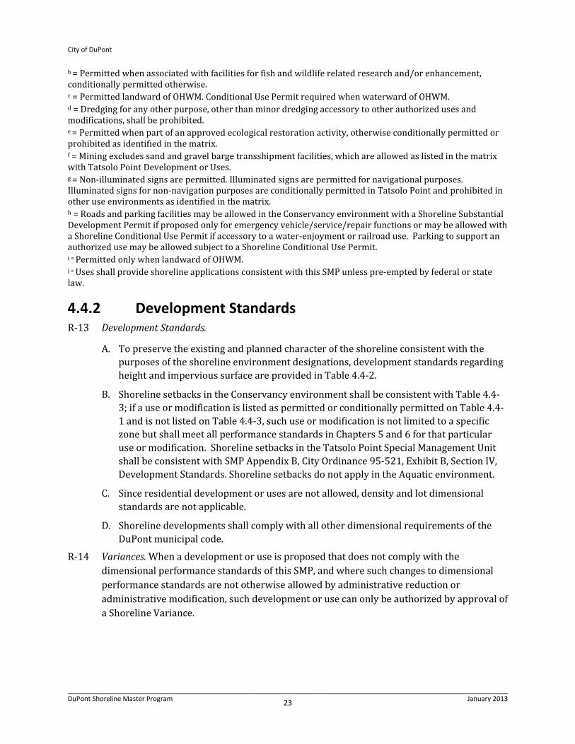
4.4.2 Development Standards R-13 Development Standards.
A. To preserve the existing and planned character of the shoreline consistent with the purposes of the shoreline environment designations, development standards regarding height and impervious surface are provided in Table 4.4-2.
B. Shoreline setbacks in the Conservancy environment shall be consistent with Table 4.4-3; if a use or modification is listed as permitted or conditionally permitted on Table 4.4-1 and is not listed on Table 4.4-3, such use or modification is not limited to a specific zone but shall meet all performance standards in Chapters 5 and 6 for that particular use or modification. Shoreline setbacks in the Tatsolo Point Special Management Unit shall be consistent with SMP Appendix B, City Ordinance 95-521, Exhibit B, Section IV, Development Standards. Shoreline setbacks do not apply in the Aquatic environment.
C. Since residential development or uses are not allowed, density and lot dimensional standards are not applicable.
D. Shoreline developments shall comply with all other dimensional requirements of the DuPont municipal code.
R-14 Variances. When a development or use is proposed that does not comply with the dimensional performance standards of this SMP, and where such changes to dimensional performance standards are not otherwise allowed by administrative reduction or administrative modification, such development or use can only be authorized by approval of a Shoreline Variance.

City of DuPont
DuPont Shoreline Master Program 24 January 2013
Table 4.4-2 Development Standards Table
Standard Aquatic Conservancy Tatsolo Point
Building Height: maximum, feet 35 35 35-65a Impervious Surface: maximum, percent of lot area
Not Applicable 10% 10%b
Shoreline Setbacks Not Applicable Consistent with Table 4.4-3.
Consistent with Appendix B, City Ordinance 95-521, Exhibit B, Section IV, Development Standards.
a = Docks and associated structures = 35 feet; conveyor structure 60 feet; barge loading tower 60 feet. b = See footprint limitation regarding minimum area necessary to accomplish the authorized use in Section 6.8.

City of DuPont
DuPont Shoreline Master Program 25 January 2013
Table 4.4-3 Conservancy Environment – New Use Location Preferences
Zone Illustration Use Location Preferences by Zone
Zone 1: Puget Sound, OHWM to landward edge of railroad right of way; Sequalitchew Creek, OHWM to 50 feet • Aquaculture • Bridges and culverts when facilitating shoreline
restoration projects • Recreational Development or Uses, Public Pier
or Dock, Public Non-Motorized Boat Launch • Recreational Development or Uses, Water-
Oriented • Signage, when consistent with Section 6.7.2 • Trails, new, perpendicular • Transportation, existing, maintenance,
expansion or improvement of trails or railroads, including reconfigurations in association with restoration projects
• Utilities, accessory Zone 2: Landward edge of Zone 1 to 100 feet from OHWM • Recreational Development or Uses, Water-
Oriented • Bridges and culverts when facilitating shoreline
restoration projects • Signage, when consistent with Section 6.7.2 • Trails, new, perpendicular • Transportation, existing, maintenance,
expansion or improvement of trails or railroads, including reconfigurations in association with restoration projects
• Transportation, new: roads and parking, only for emergency vehicle/service/repair functions or if accessory to a water-enjoyment use or accessory to existing railroad use
• Utilities, accessory Zone 3 Landward edge of Zone 2 to 200 feet from OHWM or landward edge of shoreline jurisdiction • Bridges and culverts when facilitating shoreline
restoration projects • Recreational Development or Uses, Water-
Oriented or Non-Water Oriented • Signage, when consistent with Section 6.7.2. • Trails • Transportation, existing or new: roads and
parking consistent with Table 4.4-1 and Chapters 5 and 6
• Utilities, accessory or regional
OHWM
Zone 1
Zone 2
Zone 3

City of DuPont
DuPont Shoreline Master Program 26 January 2013
5. General Policies and Regulations
5.1 Archaeological and Historic Resources In shoreline jurisdiction, there are cultural resources associated with the Native American tribes and later white settlements. Along other portions of the Sequalitchew Creek and marine shoreline bluffs are prehistoric middens. The Inskip Observatory, at the mouth of Sequalitchew Creek on the bluff, was used to help survey and chart the South Sound; it is no longer present due to past road and railroad construction. Portions of the historic Ox Road that allowed movement of goods from ships to Fort Nisqually remain on the bluffs above the Puget Sound. Due to the wealth of cultural resources, the State of Washington Department of Archaeology and Historic Preservation and the City require cultural resources assessments when development, uses, or activities are proposed that may affect archaeological or historic resources.
5.1.1 Policies P-37 Prevent Destruction or Damage. Shoreline applicants should prevent the destruction of or
damage to any site having historic, cultural, scientific, or educational value as formally designated by federal, state, local, or tribal agencies or as may be uncovered. Any proposed uses, site development, and/or associated site demolition work should be planned and carried out so as to avoid impacts to the cultural resource or to provide appropriate mitigation.
P-38 Agency and Tribal Consultation. Consultation with professional archaeologists and historians is encouraged to identify areas containing potentially valuable archaeological data, and to establish procedures for salvaging data. Appropriate agencies to consult include, but are not limited to, the Washington State Department of Archaeology and Historic Preservation and the Nisqually Indian Tribe.
P-39 Adjacent Cultural Resources. If uses, development, or demolition is proposed adjacent to an identified historic, cultural or archaeological site, then the proposed uses or development should be designed and operated so as to be compatible with continued protection of the historic, cultural or archaeological site.
5.1.2 Regulations R-15 Map of Resources. The City shall maintain a map showing potential cultural resource areas,
and shall review every proposal to ensure appropriate measures are taken to protect such areas.
R-16 Inspection or Evaluation of Archaeological Resources. The City shall require that permits issued in areas documented to contain archaeological resources require a site inspection or evaluation by a professional archaeologist. The site inspection results and/or evaluation conducted in association with permits shall be sent to the Washington State Department of Archaeology and Historic Preservation and the Nisqually Indian Tribe. Auger tests may be

City of DuPont
DuPont Shoreline Master Program 27 January 2013
required before construction and representatives of the Washington State Department of Archaeology and Historic Preservation and the Nisqually Indian Tribe may be invited to observe any tests and construction work. If auger or historical data indicate probable presence of cultural resources which may be disturbed by excavation, the City shall meet the developer and may impose conditions on any plat, site plan or permit to assure that such resources are protected, preserved, or collected.
R-17 Uncovered Archaeological Resources and Stop Work. Developers and property owners shall immediately stop work and notify the City, the Washington State Department of Archaeology and Historic Preservation, and the Nisqually Indian Tribe if archaeological resources are uncovered during excavation.
R-18 Historic Resources. Where a professional archaeologist or historian, recognized by the State of Washington, has identified an area or site as having significant value, or where an area or site is listed in national, state or local historical registers, the City may require an evaluation of the resource, and appropriate conditions, which may include preservation and/or retrieval of data, proposal modifications to reduce impacts, or other mitigation authorized through the State Environmental Policy Act, or other local, state, or federal laws.
R-19 Setbacks from Markers. No structures, roads or utilities are permitted within 50 feet of the markers identifying cultural resource sites designated by City ordinance or code.
5.2 Environmental Protection and Critical Areas The following policies and regulations, including critical areas regulations found in Sections 5.2.2.2 and 5.2.2.3, apply only within shoreline jurisdiction.
5.2.1 Policies P-40 Assure No-Net-Loss of Ecological Function. Shoreline use and development within shoreline
jurisdiction should be carried out in a manner that prevents or mitigates adverse impacts so that the resulting ecological condition is not degraded from the current condition. For each proposal, this means assuring no net loss of ecological functions and processes relative to the existing condition throughout the City’s shoreline jurisdiction, including upland and aquatic areas, channel migration zones, hyporheic zones, and protecting critical areas.
P-41 Types of Impacts. In assessing the potential for net loss of ecological functions or processes, project-specific and cumulative impacts should be considered.
P-42 Prevent Adverse Impacts. Protect the public health, safety and welfare by preventing the adverse environmental impacts of development or uses in critical areas and their buffers within shoreline jurisdiction, and by:
A. Preserving and protecting critical areas by regulating development within them and their buffers;

City of DuPont
DuPont Shoreline Master Program 28 January 2013
B. Educating the public as to the long-term importance of critical areas and the responsibilities of the City to protect and preserve the natural environment for future generations;
C. Requiring no net loss of wetland and stream function, value and area within the City’s shoreline jurisdiction;
D. Preventing adverse cumulative impacts to water quality, wetlands, stream corridors, and fish and wildlife habitats;
E. Protecting the public from injury, loss of life, property damage or financial loss due to erosion, landslides, soil subsidence or steep slope failures;
F. Providing the City with information necessary to approve, condition, or deny public or private proposals; and
G. Alerting appraisers, assessors, owners and potential buyers or lessees to the development and use limitations of critical areas.
5.2.2 Regulations
5.2.2.1 General Environmental Protection R-20 SEPA. All project proposals, including those for which a Shoreline Substantial Development
permit is not required, are subject to Chapter 43.21C RCW, the Washington State Environmental Policy Act, where applicable.
R-21 Ecological Impacts and Mitigation. Projects that cause significant ecological impacts, as defined in Chapter 9, Definitions, are not allowed unless mitigated according to Regulation 23 below to avoid reduction or damage to ecosystem-wide processes and ecological functions.
R-22 Mitigation Measures or Permit Conditions. The City shall require mitigation measures and/or permit conditions based on the provisions of this SMP in order to mitigate impacts. In order to determine acceptable mitigation or permit conditions, the Shoreline Administrator may require the applicant to provide the necessary environmental information and analysis, including a description of existing conditions/ecological functions and anticipated shoreline impacts, along with a mitigation plan outlining how proposed mitigation measures would result in no net loss of shoreline ecological functions.
R-23 Mitigation Sequencing. Applicants shall apply the following sequence of steps in order of priority, with A being top priority:
A. Avoiding the impact altogether by not taking a certain action or parts of an action;
B. Minimizing impacts by limiting the degree or magnitude of the action and its implementation by using appropriate technology or by taking affirmative steps to avoid or reduce impacts;
C. Rectifying the impact by repairing, rehabilitating, or restoring the affected environment;
City of DuPont
DuPont Shoreline Master Program 29 January 2013
D. Reducing or eliminating the impact over time by preservation and maintenance operations;
E. Compensating for the impact by replacing, enhancing, or providing substitute resources or environments; and
F. Monitoring the impact and the compensation projects and taking appropriate corrective measures.
Application of the mitigation sequence shall achieve no net loss of ecological functions for each new development or use proposal and shall not result in required mitigation in excess of that necessary to assure that development or establishment of uses will result in no net loss of shoreline ecological functions and not have a significant adverse impact on other shoreline functions fostered by the policies of the Act.
R-24 Location of Mitigation. When compensatory measures are appropriate pursuant to the mitigation priority sequence above, preferential consideration shall be given to measures that replace the impacted functions directly and in the immediate vicinity of the impact. However, alternative compensatory mitigation within the watershed that addresses limiting factors or identified critical needs for shoreline resource conservation based on watershed or comprehensive resource management plans, including the Shoreline Restoration Plan, applicable to the area of impact may be authorized. Authorization of compensatory mitigation measures may require appropriate safeguards, terms or conditions as necessary to ensure no net loss of ecological functions. Further, if mitigation is located outside of the City but within the watershed, an inter-local agreement or memorandum of understanding may be required to be completed prior to shoreline permit approval if such agreement or memorandum is necessary to ensure the mitigation is accomplished.
R-25 Mitigation Plan Requirements. In addition to any requirements for specific critical areas found below, mitigation plans for any impacts to ecological functions resulting from use, activity or development in shoreline jurisdiction, both inside and outside of critical areas, shall address the following:
A. Inventory existing shoreline environment including the physical, chemical and biological elements and provide an assessment of their condition;
B. A discussion of the project's compliance with mitigation sequencing requirements and remaining unavoidable impacts on the ecological functions;
C. A discussion of any federal, state, or local special management recommendations which have been developed for critical areas or other nearshore species or habitats located on the site;
D. A discussion of measures to preserve existing habitats and opportunities to restore habitats that were degraded prior to the proposed land use activity;
E. A discussion of proposed measures which mitigate the impacts of the project to ensure no net loss of shoreline ecological functions;

City of DuPont
DuPont Shoreline Master Program 30 January 2013
F. Scaled drawings of existing and proposed conditions, materials specifications, and a five-year maintenance and monitoring plan, including performance standards;
G. A discussion of proposed management practices which will protect fish and wildlife habitat both during construction, and after the project site has been fully developed;
H. Contingency plan if the mitigation fails to meet established success criteria; and
I. Any additional information necessary to determine the impacts of a proposal and mitigation of the impacts.
R-26 Nonindigenous Species. No plant, wildlife, or fish species not indigenous to the region shall be introduced into shoreline jurisdiction.
5.2.2.2 General Critical Area Development or Use Restrictions R-27 Undevelopable Critical areas. Except as provided in Section 5.2.2.3, no action, use, or
development may take place in the following critical areas within shoreline jurisdiction:
A. Wetlands and Their Buffers. The edge of the wetland and the outside edge of its buffer as determined and field marked by a professional wetland biologist or similarly qualified professional;
B. Streams and Their Buffers. The top of the upper bank of the stream and the outside edge of its buffer as determined and field marked by a professional biologist, ecologist, or similarly qualified professional;
C. Geologically Hazardous Areas. Those areas susceptible to erosion, sliding, earthquake, or other geological event, including channel migration, and the outside edge of their buffers as determined and field marked by a qualified geotechnical engineer or similarly qualified professional; and
D. Other Fish and Wildlife Habitat Conservation Areas. Priority habitats, critical saltwater habitats, critical freshwater habitats, and any associated buffers as mapped or as determined by a qualified professional.
R-28 Developable Critical Areas. Slopes of 15 percent to 40 percent may be developed pursuant to Section 5.2.2.3. Slopes of less than 15 percent are not subject to the provisions in Section 5.2.2.3.B.
R-29 Critical Areas Report. Proposals located on sites that may contain critical areas or within 200 feet of critical areas shall prepare a critical areas report that includes, but is not limited to, the following except as modified by the Shoreline Administrator:
A. The name and contact information of the applicant; the name, qualifications, and contact information for the primary author(s) of the critical area report; a description of the proposal; identification of all the local, state, and/or federal critical area-related permit(s) required for the project; and a vicinity map for the project.
B. Identification and description of critical areas and any buffers located on the subject property or within 200 feet of the proposed project, including, but not limited to, vegetation, topography, soils/geology, hydrology, known or potential fish or wildlife use

City of DuPont
DuPont Shoreline Master Program 31 January 2013
or habitat, and ecological functions. A summary of the methodology used to identify and/or classify the critical areas should be included.
C. A professional survey depicting any delineated critical area boundaries and any required buffers on the site, and general map of any known off-site critical areas or buffers.
D. Documentation of any fieldwork performed on the site, including field data sheets. When the site includes wetlands, the report shall include a completed rating form using the Washington State Wetland Rating System for Western Washington – Revised (Washington State Department of Ecology Publication # 04-06-025, or latest version).
E. A description of the proposed actions, including an estimation of area of impacts to critical areas and buffers based on the field delineation and survey.
F. A discussion of how the proposed project will utilize mitigation sequencing to avoid, minimize, and mitigate impacts to critical areas and associated buffers. The applicant shall seek to avoid, minimize and mitigate overall impacts based on the functions and values of all relevant critical areas.
R-30 Trails. Walkways and trails are allowed, provided that those pathways have no adverse impact on water quality or ecological function. They should be generally parallel to the wetland or stream critical area, located only in the outer 25 percent of the standard wetland or stream buffer except as necessary to cross the critical area (see Regulation 31 below) or provide a single viewing point, and located to avoid removal of native vegetation to the maximum extent practicable. If reduced wetland or stream buffers are approved consistent with Sections 5.2.2.3.A and C below, proposed new trails may be located no closer to the critical area than what would be allowed under the standard buffer. They should be limited to pervious surfaces no more than five (5) feet in width for non-motorized use only. Trail crossings of wetlands or streams must be raised boardwalks utilizing non-treated pilings.
R-31 Railroad and Trail Crossings. Modification or expansion of existing and construction of new railroad and trail crossings of streams and wetlands may be authorized subject to the following minimum standards:
A. Bridges are required for crossings of streams that support salmonids, unless culvert design and construction ensures proper passage opportunities for fish, 100-year flood flows, and large woody debris;
B. All crossings using culverts shall use superspan or oversized culverts, and be designed consistent with the Washington Department of Fish and Wildlife’s Design of Road Culverts for Fish Passage (2003, or as amended) or other relevant technical guidance documents;
C. Crossings shall not occur in or over salmonid spawning areas unless no other feasible crossing site exists;
D. Bridge piers or abutments shall not be placed in the floodway, between the ordinary high water marks, or in wetlands unless no other feasible alternative placement exists;
E. Crossings shall not diminish flood carrying capacity; and

City of DuPont
DuPont Shoreline Master Program 32 January 2013
F. The applicant shall provide the necessary critical area report consistent with requirements of Sections 5.2.2.2 and 5.2.2.3 that documents compliance with mitigation sequencing requirements, including preparation of any necessary mitigation plans, and demonstrates the project will not result in net loss of ecological functions.
R-32 Fencing. Fencing installed as part of a proposed activity for either safety or protection of a critical area or buffer shall be designed so as to not interfere with species migration, including fish runs, and shall be constructed in a manner that minimizes impacts to critical areas.
A. Fencing shall be located at the upland edge of a critical area buffer, unless a location closer to the critical area is necessary because of the location of an existing or approved use (e.g., a fence may be installed along an existing trail, even though that trail may located in a buffer).
B. Preferred fencing material is unpainted wood in a split-rail design, unless another material would provide better protection of the critical area or buffer or is necessary for safety.
5.2.2.3 Specific Critical Area Development Standards
A. Wetlands R-33 Delineation. Wetlands in shoreline jurisdiction will be delineated in accordance with the
procedure outlined in the approved federal wetland delineation manual and applicable regional supplements.
R-34 Wetland Rating. Wetlands shall be rated according to the Washington State Wetland Rating System for Western Washington (Department of Ecology 2004, Ecology publ. # 04-06-025, or as revised). This document contains the definitions, methods and a rating form for determining the categorization of wetlands below:
A. Category I wetlands are those that 1) represent a unique or rare wetland type; or 2) are more sensitive to disturbance than most wetlands; or 3) are relatively undisturbed and contain ecological attributes that are impossible to replace within a human lifetime; or 4) provide a high level of functions. Category I wetlands include Natural Heritage wetlands, bogs, mature and old growth forested wetlands, and wetlands that score at least 70 points on the rating form.
B. Category II wetlands are difficult, though not impossible, to replace, and provide high levels of some functions. These wetlands occur more commonly than Category I wetlands, but still need a relatively high level of protection. Category II wetlands score between 51 and 69 points on the rating form.
C. Category III wetlands have a moderate level of function, scoring between 30 and 50 points on the rating form.
D. Category IV wetlands have the lowest levels of functions (scores less than 30 points on the rating form) and are often heavily disturbed. These are wetlands that can often be replaced, and in some cases improved. However, replacement cannot be guaranteed in

City of DuPont
DuPont Shoreline Master Program 33 January 2013
any specific case. These wetlands may provide some important functions and also need to be protected.
R-35 Development Standards. If a wetland is located on or adjacent to the site of a proposal, all actions on the site shall be in compliance with the following requirements and restrictions:
A. Wetland Buffers. The following buffers shall be provided:
1) Category I Wetlands: 200-foot buffer.
2) Category II Wetlands: 100-foot buffer.
3) Category III Wetlands: 75-foot buffer.
4) Category IV Wetlands: 40-foot buffer.
B. Additional Buffers. The City may require either additional native vegetation to achieve the purposes of this SMP or increased buffer widths when environmental information indicates the necessity for greater buffers in order to achieve the purposes and interpretation identified in Chapter 2, Sections 2.4 to 2.6. In cases where additional buffers are not feasible, the City may require the applicant to undertake alternative on-site or off-site mitigation measures, including but not limited to a financial contribution to projects or programs which seek to protect and increase the wetland resources within the City.
C. Buffer Averaging to Improve Function. Buffer averaging to improve wetland protection may be permitted when all of the following conditions are met:
1) The wetland has significant differences in characteristics that affect its habitat functions, such as a wetland with a forested component adjacent to a degraded emergent component or a “dual-rated” wetland with a Category I area adjacent to a lower-rated area.
2) The buffer is increased adjacent to the higher-functioning area of habitat or more-sensitive portion of the wetland and decreased adjacent to the lower-functioning or less-sensitive portion as demonstrated by a critical areas report from a qualified wetland professional.
3) The total area of the buffer after averaging is equal to the area required without averaging.
4) The buffer at its narrowest point is never less than 75 percent of the required width specified in R-35.A.
D. Buffer Averaging to Accommodate Allowed Use. Averaging to allow reasonable use of a parcel may be permitted when all of the following are met:
1) There are no feasible alternatives to the site design that could be accomplished without buffer averaging.
2) The averaged buffer will not result in degradation of the wetland’s functions and values as demonstrated by a critical areas report from a qualified wetland professional.
City of DuPont
DuPont Shoreline Master Program 34 January 2013
3) The total buffer area after averaging is equal to the area required without averaging.
4) The buffer at its narrowest point is never less than 75 percent of the required width specified in R-35.A.
E. Buffer Enhancement and Mitigation Plan. The City shall approve a wetland buffer enhancement and mitigation plan before issuing any permits for development activity or uses on a lot upon which a wetland buffer modification is proposed. The buffer mitigation plan shall:
1) Be prepared by a qualified wetland professional using accepted methodologies; and
2) Include a discussion of the wetland’s existing functional values; and
3) Describe how the buffer’s protective value will be enhanced and when mitigation will occur relative to project construction; and
4) Provide for adequate monitoring to ensure success of the mitigation plan; and
5) Include a contingency plan specifying what corrective measures will be taken if the buffer enhancement is unsuccessful.
F. Building Setback Lines. On properties subject to the provisions of this SMP, minimum building setbacks from the edge of a wetland buffer shall be 15 feet.
G. Wetland and Buffer Alteration. Alterations of wetlands and buffers are only allowed to enhance or restore wetland ecological function or to provide a public benefit, such as a trail for public access. These alterations may be approved only when it can be demonstrated by the applicant through a critical areas report and mitigation plan that the following conditions can be met:
1) The alteration would result in no net loss of wetland function or value, or would provide net improvement in ecological functions; and
2) The extent and degree of alteration is the minimum necessary to provide the ecological or public benefit, consistent with mitigation sequencing as required under Section 5.2.2.1, Regulation 23.
R-36 Requirements for Compensatory Wetland Mitigation.
A. Compensatory mitigation for alterations to wetlands shall be used only for impacts that cannot be avoided or minimized and shall achieve equivalent or greater biologic functions. Compensatory mitigation plans shall be consistent with Wetland Mitigation in Washington State – Part 2: Developing Mitigation Plans (Version 1), Ecology Publication #06-06-011b, Olympia, WA, March 2006 or as revised.
B. Mitigation ratios shall be consistent with Subsection F of this regulation.
C. Mitigation requirements and mitigation ratios may also be determined using the credit/debit tool described in “Calculating Credits and Debits for Compensatory Mitigation in Wetlands of Western Washington: Operational Draft” (Ecology Publication #10-06-011, February 2011, or as revised) consistent with subsection H of this Chapter.

City of DuPont
DuPont Shoreline Master Program 35 January 2013
D. Type and Location of Compensatory Mitigation. Unless it is demonstrated that a higher level of ecological functioning would result from an alternative approach, compensatory mitigation for ecological functions shall be either in kind and on site, or in kind and within the same stream reach, sub-basin, or drift cell (if estuarine wetlands are impacted). Compensatory mitigation actions shall be conducted within the same sub-drainage basin and on the site of the alteration except when all of the following apply:
1) There are no reasonable opportunities on site or within the sub-drainage basin (e.g., on-site options would require elimination of high-functioning upland habitat), or opportunities on site or within the sub-drainage basin do not have a high likelihood of success based on a determination of the capacity of the site to compensate for the impacts. Considerations should include: anticipated replacement ratios for wetland mitigation, buffer conditions and proposed widths, available water to maintain anticipated hydrogeomorphic classes of wetlands when restored, proposed flood storage capacity, and potential to mitigate riparian fish and wildlife impacts (such as connectivity);
2) Off-site mitigation has a greater likelihood of providing equal or improved wetland functions than the impacted wetland; and
3) Off-site locations shall be in the same sub-drainage basin unless watershed goals for water quality, flood storage or conveyance, habitat, or other wetland functions have been established by the City and strongly justify location of mitigation at another site; or credits from a state-certified wetland mitigation bank are used as compensation, and the use of credits is consistent with the terms of the bank’s certification.
4) The design for the compensatory mitigation project needs to be appropriate for its location (i.e., position in the landscape). Therefore, compensatory mitigation should not result in the creation, restoration, or enhancement of an atypical wetland. An atypical wetland refers to a compensation wetland (e.g., created or enhanced) that does not match the type of existing wetland that would be found in the geomorphic setting of the site (i.e., the water source(s) and hydroperiod proposed for the mitigation site are not typical for the geomorphic setting). Likewise, it should not provide exaggerated morphology or require a berm or other engineered structures to hold back water. For example, excavating a permanently inundated pond in an existing seasonally saturated or inundated wetland is one example of an enhancement project that could result in an atypical wetland. Another example would be excavating depressions in an existing wetland on a slope, which would require the construction of berms to hold the water.
E. Timing of Compensatory Mitigation. It is preferred that compensatory mitigation projects be completed prior to activities that will disturb wetlands. At the least, compensatory mitigation shall be completed immediately following disturbance and prior to use or occupancy of the action or development. Construction of mitigation projects shall be timed to reduce impacts to existing fisheries, wildlife, and flora.

City of DuPont
DuPont Shoreline Master Program 36 January 2013
The Administrator may authorize a one-time temporary delay in completing construction or installation of the compensatory mitigation when the applicant provides a written explanation from a qualified wetland professional as to the rationale for the delay. An appropriate rationale would include identification of the environmental conditions that could produce a high probability of failure or significant construction difficulties (e.g., project delay lapses past a fisheries window, or installing plants should be delayed until the dormant season to ensure greater survival of installed materials). The delay shall not create or perpetuate hazardous conditions or environmental damage or degradation; the delay shall not be injurious to the health, safety, or general welfare of the public; and the delay shall not be greater than one (1) year. The request for the temporary delay must include a written justification that documents the environmental constraints that preclude implementation of the compensatory mitigation plan. The justification must be verified and approved by the City.
F. Mitigation ratios. A mitigation proposal must utilize the mitigation ratios specified below.
Table 5.2-1 Replacement Ratios
Cate
gory
and
Typ
e of
W
etla
nd Im
pact
s
Re-e
stab
lishm
ent
or
Crea
tion
Reha
bilit
atio
n O
nlya
Re-e
stab
lishm
ent
or
Crea
tion
(R/C
) and
Re
habi
litat
ion
(RH
)1
Re-e
stab
lishm
ent
or
Crea
tion
(R/C
) and
En
hanc
emen
t (E
)1
Enha
ncem
ent O
nly1
All Category IV 1.5:1 3:1 1:1 R/C and 1:1RH
1:1 R/C and 2:1 E 6:1
All Category III 2:1 4:1 1:1 R/C and 2:1 RH
1:1 R/C and 4:1 E 8:1
Category II 3:1 6:1 1:1 R/C and 4:1 RH
1:1 R/C and 8:1 E 12:1
Category I Forested 6:1 12:1 1:1 R/C and
10:1 RH 1:1 R/C and 20:1 E 24:1
Category I - based on score for functions
4:1 8:1 1:1 R/C and 6:1 RH
1:1 R/C and 12:1 E 16:1
Category I Natural Heritage site
Not allowed
6:1 Rehabilitation of a Natural Heritage site
Not allowed Not allowed Case-by-case
Category I Bog Not allowed 6:1 Rehabilitation of a bog
Not allowed Not allowed Case-by-case
a These ratios are based on the assumption that the rehabilitation or enhancement actions implemented represent the average degree of improvement possible for the site. Proposals to implement more effective rehabilitation or enhancement actions may result in a lower ratio, while less effective actions may result in a higher ratio. The distinction between rehabilitation and

City of DuPont
DuPont Shoreline Master Program 37 January 2013
enhancement is not clear-cut. Instead, rehabilitation and enhancement actions span a continuum. Proposals that fall within the gray area between rehabilitation and enhancement will result in a ratio that lies between the ratios for rehabilitation and the ratios for enhancement.
G. Compensating for Lost or Affected Functions. Compensatory mitigation shall address the functions affected by the proposed project, with an intention to achieve functional equivalency or improvement of functions. The goal shall be for the compensatory mitigation to provide similar wetland functions as those lost, except when either:
1) The lost wetland provides minimal functions, and the proposed compensatory mitigation action(s) will provide equal or greater functions or will provide functions shown to be limiting within a watershed through a formal Washington state watershed assessment plan or protocol; or
2) Out-of-kind replacement of wetland type or functions will best meet watershed goals formally identified by the City, such as replacement of historically diminished wetland types.
H. Preference of Mitigation Actions. Methods to achieve compensation for wetland functions shall be approached in the following order of preference:
1) Restoration (re-establishment and rehabilitation) of wetlands.
2) Creation (establishment) of wetlands on disturbed upland sites such as those with vegetative cover consisting primarily of non-native species. This should be attempted only when there is an adequate source of water and it can be shown that the surface and subsurface hydrologic regime is conducive to the wetland community that is anticipated in the design.
3) Enhancement of significantly degraded wetlands in combination with restoration or creation. Enhancement alone will result in a loss of wetland acreage and is less effective at replacing the functions lost. Enhancement should be part of a mitigation package that includes replacing the impacted area and meeting appropriate ratio requirements.
4) Preservation. Preservation of high-quality, at-risk wetlands as compensation is generally acceptable when done in combination with restoration, creation, or enhancement, provided that a minimum of 1:1 acreage replacement is provided by re-establishment or creation.
I. Mitigation Plan. The following additional information should be provided, supplementing the general mitigation plan requirements listed in Regulation 25 above in Section 5.2.2.2.
1) Description of how the project design has been modified to avoid, minimize, or reduce adverse impacts to wetlands.
2) Description of the existing wetland and buffer areas proposed to be impacted. Include acreage (or square footage), water regime, vegetation, soils, landscape position, surrounding lands uses, and functions. Also describe impacts in terms of acreage by Cowardin classification, hydrogeomorphic classification, and wetland rating.
City of DuPont
DuPont Shoreline Master Program 38 January 2013
3) Description of the compensatory mitigation site, including location and rationale for selection. Include an assessment of existing conditions: acreage (or square footage) of wetlands and uplands, water regime, sources of water, vegetation, soils, landscape position, surrounding land uses, and functions. Estimate future conditions in this location if the compensation actions are NOT undertaken (i.e., how would this site progress through natural succession?).
4) A description of the proposed actions for compensation of wetland and upland areas affected by the project. Include overall goals of the proposed mitigation, including a description of the targeted functions, hydrogeomorphic classification, and categories of wetlands.
5) A description of the proposed mitigation construction activities and timing of activities.
6) A discussion of ongoing management practices that will protect wetlands after the project site has been developed, including proposed monitoring and maintenance programs (for remaining wetlands and compensatory mitigation wetlands).
7) A bond estimate for the entire compensatory mitigation project, including the following elements: site preparation, plant materials, construction materials, installation oversight, maintenance twice per year for up to five (5) years, annual monitoring field work and reporting, and contingency actions for a maximum of the total required number of years for monitoring.
8) Proof of establishment of Notice on Title for the wetlands and buffers on the project site, including the compensatory mitigation areas.
9) Scaled plan sheets for the compensatory mitigation must contain, at a minimum:
a) Surveyed edges of the existing wetland and buffers, proposed areas of wetland and/or buffer impacts, location of proposed wetland and/or buffer compensation actions.
b) Existing topography, ground-proofed, at two-foot contour intervals in the zone of the proposed compensation actions if any grading activity is proposed to create the compensation area(s). Also existing cross-sections of on-site wetland areas that are proposed to be impacted, and cross-section(s) (estimated one-foot intervals) for the proposed areas of wetland or buffer compensation.
c) Surface and subsurface hydrologic conditions, including an analysis of existing and proposed hydrologic regimes for enhanced, created, or restored compensatory mitigation areas. Also, illustrations of how data for existing hydrologic conditions were used to determine the estimates of future hydrologic conditions.
d) Conditions expected from the proposed actions on site, including future hydrogeomorphic types, vegetation community types by dominant species (wetland and upland), and future water regimes.

City of DuPont
DuPont Shoreline Master Program 39 January 2013
e) Required wetland buffers for existing wetlands and proposed compensation areas. Also, identify any zones where buffers are proposed to be reduced or enlarged outside of the standards identified in this Chapter.
f) A plant schedule for the compensation area, including all species by proposed community type and water regime, size and type of plant material to be installed, spacing of plants, typical clustering patterns, total number of each species by community type, timing of installation.
g) Performance standards (measurable standards reflective of years post-installation) for upland and wetland communities, monitoring schedule, and maintenance schedule and actions by each biennium.
J. Monitoring. Mitigation monitoring shall be required for a period necessary to establish that performance standards have been met, but not for a period less than five years. If a scrub-shrub or forested vegetation community is proposed, monitoring may be required for ten years or more. The project mitigation plan shall include monitoring elements that ensure certainty of success for the project’s natural resource values and functions. If the mitigation goals are not obtained within the initial five-year period, the applicant remains responsible for restoration of the natural resource values and functions until the mitigation goals agreed to in the mitigation plan are achieved.
R-37 Wetland and Buffer Tracts. As a condition of any permit issued pursuant to this SMP, the applicant shall be required to create a critical areas tract or tracts containing the areas determined to be wetlands and/or wetlands buffers. Critical area tracts are legally created tracts containing wetlands and their buffers that shall remain undeveloped in perpetuity. Critical area tracts are an integral part of the lot in which they are created, are not intended for sale, lease or transfer to any other than a public agency, and may not be subdivided. The City shall require that the critical area tracts created pursuant to this SMP be protected by one of the following methods:
A. The applicant shall convey an irrevocable offer to dedicate the tract to the City or other public or nonprofit entity approved by the City; or
B. The applicant shall establish and record a permanent and irrevocable deed restriction on the property title of all lots containing a critical area tract or tracts created as a condition of an approved permit. Such deed restriction shall prohibit in perpetuity the development, alteration, or disturbance of vegetation within the critical area tract except for purposes of habitat enhancement as part of an enhancement project, which has received prior written approval from the City.
R-38 Signs.
A. Temporary markers. The outer perimeter of the wetland buffer and the clearing limits identified by an approved permit or authorization shall be marked in the field with temporary “clearing limits” fencing in such a way as to ensure that no unauthorized intrusion will occur. The marking is subject to inspection by the Administrator prior to the commencement of permitted activities. This temporary marking shall be maintained
City of DuPont
DuPont Shoreline Master Program 40 January 2013
throughout construction and shall not be removed until permanent signs, if required, are in place.
B. Permanent signs. As a condition of any permit or authorization, the Shoreline Administrator may require the applicant to install permanent signs along the boundary of a wetland or buffer. Permanent signs shall be made of an enamel-coated metal face and attached to a metal post or another non-treated material of equal durability. Signs must be posted at appropriate intervals, but no less than one per lot, and must be maintained by the property owner in perpetuity. The signs shall be worded as follows or with alternative language approved by the Shoreline Administrator: “Protected Wetland Area Do Not Disturb Contact City of DuPont Regarding Uses, Restrictions, and Opportunities for Stewardship”
B. Geologically Hazardous Areas R-39 Definition. Geologically hazardous areas are those areas subject to erosion or landslide
based on a combination of geologic, topographic, and hydrologic factors. They include any areas susceptible to landslide because of any combination of bedrock, soil, slope (gradient), slope aspect, structure, hydrology, or other factors, and include, at a minimum, the following:
A. Areas likely to become unstable, such as bluffs, steep slopes, and areas with unconsolidated soils.
B. Areas of historic failures, including those designated as such as quaternary slumps, earthflows, mudflows, or landslides.
C. Areas with all three of the following characteristics:
1) Slopes steeper than 15 percent;
2) Hillsides intersecting geologic contacts with a relatively permeable sediment overlying a relatively impermeable sediment or bedrock; and
3) Springs or groundwater seepage.
D. Areas that have shown movement during the holocene epoch (from ten thousand years ago to the present) or which are underlain or covered by mass wastage debris of this epoch;
E. Slopes that are parallel or subparallel to planes of weakness (such as bedding planes, joint systems, and fault planes) in subsurface materials;
F. Slopes having gradients steeper than eighty percent subject to rockfall during seismic shaking;
G. Areas potentially unstable as a result of rapid stream incision, stream bank erosion, and undercutting by wave action;
H. Areas located in a ravine or on an active alluvial fan, presently or potentially subject to inundation by debris flows or catastrophic flooding; and

City of DuPont
DuPont Shoreline Master Program 41 January 2013
I. Any area with a slope of 40 percent or steeper and with a vertical relief of ten or more feet except areas composed of bedrock. A slope is delineated by establishing its toe and top and measured by averaging the inclination over at least ten feet of vertical relief.
R-40 Buffers. A 50-foot undisturbed buffer of native vegetation shall be established from the top, toe and sides of all geologically hazardous areas.
R-41 Increased Buffers. The City may require increased buffers if a critical areas report indicates such increases are necessary to mitigate landslide, seismic and erosion hazards, or are otherwise necessary to protect the public health, safety and welfare.
R-42 Buffer Reduction. The City may allow reduction of a buffer to not less than 25 feet if the City approves a geotechnical report which demonstrates that:
A. The proposed development or use will not create a hazard to the subject property, surrounding properties, erosion, or sedimentation to off-site properties or bodies of water; and
B. The proposal addresses the existing geological constraints of the site, including an assessment of soils and hydrology; and
C. The proposed methods of construction will minimize erosion and landslide potential and will improve or not adversely affect the stability of the ravine sidewall, bluff, or slope; and
D. The proposal uses construction techniques which minimize disruption of existing topography and natural vegetation.
R-43 Development Conditions. As part of any approval of development or use near a geologically hazardous area, the City may require:
A. All impacts identified in the geotechnical report be mitigated; and
B. All utilities and roadways to and within the site be located so as to require the minimum amount of modification to the slope; and
C. The City may retain consultants at the applicant’s expense to ensure that the mitigation measures are implemented.
R-44 Geologically Hazardous Area Tracts. As a condition of any permit issued pursuant to this SMP, the applicant shall be required to create a critical areas tract or tracts containing the areas determined to be a geologically hazardous area or related buffer. Critical area tracts are legally created tracts containing geologically hazardous areas and their buffers that shall remain undeveloped in perpetuity. Critical area tracts are an integral part of the lot in which they are created, are not intended for sale, lease or transfer to any other than a public agency, and may not be subdivided. The City shall require that the critical area tracts created pursuant to this SMP be protected by one of the following methods:
A. The applicant shall convey an irrevocable offer to dedicate the tract to the City or other public or nonprofit entity approved by the City; or
City of DuPont
DuPont Shoreline Master Program 42 January 2013
B. The applicant shall establish and record a permanent and irrevocable deed restriction on the property title of all lots containing a critical area tract or tracts created as a condition of an approved permit. Such deed restriction shall prohibit in perpetuity the development, alteration, or disturbance of the critical area tract except for purposes of habitat enhancement as part of an enhancement project which has received prior written approval from the City.
R-45 Additional Development Standards for Non-Geologically Hazardous Slopes. Improper development or construction on non-geologically hazardous slopes (e.g, slopes of more than 15 percent and less than 40 percent that do not meet criteria in Regulation R-39.C.2-3) can cause erosion, soil subsidence, property damage and damage to critical areas regulated by this SMP. Development or uses on non-geologically hazardous slopes shall be subject to Regulations R-46, R-47 and R-48.
R-46 Additional Critical Area Report Requirements. Applications for projects proposed within geologically hazardous areas and non-geologically hazardous slopes greater than 15 percent that do not meet criteria in Regulation R-39.C.2-3 or that are adjacent to such areas shall provide the following information unless the City waives specific submittal requirements as unnecessary for review of a specific application. Such studies shall contain the following information and be prepared by a licensed professional engineer or geologists who has professional expertise about the regional and local shoreline geology and processes:
A. A description of the ground and surface hydrology and geology, and the susceptibility of the area(s) susceptibility to mass wasting, erosion and other geologic hazards or processes.
B. A description of how the proposed project and its associated grading plan will or will not impact: slope stability, erosion, and landslide hazard; drainage, surface and subsurface hydrology, and water quality; existing vegetation as it relates to steep slopes, soil stability, and natural habitat value of the subject property and adjoining properties.
C. Conclusions and recommendations regarding the effect of the proposed development or use on geologic conditions, the adequacy of the site to be developed, the impacts of the proposed development or use, alternative approaches to the proposed development or use, and measures to mitigate potential site-specific and cumulative geological and hydrological impacts of the proposed development or use, including the potential adverse impacts to adjacent and down-current properties.
D. The City may retain consultants at the applicant’s expense to review the mitigation plan and to ensure that the mitigation measures are implemented.
R-47 Foreseeable Risk. New development or the creation of new lots or uses that would cause foreseeable risk from geological conditions to people or improvements during the life of the development or activity is prohibited.
R-48 Stabilization Necessity. New development or uses that would require structural shoreline stabilization over the life of the development or activity is prohibited except when the

City of DuPont
DuPont Shoreline Master Program 43 January 2013
applicant can demonstrate in a geotechnical analysis that stabilization is necessary to protect allowed uses where no alternative locations are available and no net loss of ecological functions will result.
C. Streams R-49 Buffers. A 100-foot buffer is required on each side of a stream bank.
A. Increased Buffer Width. The City may require increased buffer widths as necessary to protect streams when the stream is particularly sensitive to disturbances or the development or use poses unusual impacts. Circumstances which require buffers beyond minimum requirements may include but are not limited to:
1) The stream reach affected by the proposal serves as a critical fish habitat for spawning or rearing as determined by the City using information from sources such as but not limited to the Washington State Department of Fish and Wildlife, U.S. Fish and Wildlife Service, National Marine Fisheries Service, and native tribes; or
2) The land adjacent to the stream and its associated buffer is classified as a geologically hazardous or unstable area; or
3) The riparian corridor is underlain with highly infiltrative soils that provide ground water which nourishes the stream or by till soils that produce high runoff if cleared of vegetation; or
4) A trail or utility corridor is proposed within the buffer.
R-50 Decreased Buffer Width. The City may reduce the required buffer width on a case-by-case basis, but by no more than 25% of the standard buffer, where it can be demonstrated that:
A. The adjacent land contains extensive undisturbed vegetation and has less than 15 percent slopes and that no adverse impact to the stream system will result from the proposed reduction; or
B. The proposal includes a buffer enhancement plan using native vegetation which substantiates that an enhanced buffer will improve the functional values of the buffer to provide additional protection of the stream system; or
C. There has previously been substantial alteration of the buffer for the stream on the subject lot or property and a lesser buffer than that required by this section will incorporate buffer enhancement measures which will actually improve the functions and values of the existing stream buffer.
R-51 Streams and Stream Buffer Tracts. As a condition of any permit issued pursuant to this SMP, the applicant shall be required to create a critical areas tract or tracts containing the areas determined to be streams and/or stream buffers. Critical area tracts are legally created tracts containing streams and their buffers that shall remain undeveloped in perpetuity. Critical area tracts are an integral part of the lot in which they are created, are not intended for sale, lease or transfer to any other than a public agency, and may not be subdivided. The

City of DuPont
DuPont Shoreline Master Program 44 January 2013
City shall require that the critical area tracts created pursuant to this SMP be protected by one of the following methods:
A. The applicant shall convey an irrevocable offer to dedicate the tract to the City or other public or nonprofit entity specified approved by the City; or
B. The applicant shall establish and record a permanent and irrevocable deed restriction on the property title of all lots containing a critical area tract or tracts created as a condition of an approved permit. Such deed restriction shall prohibit in perpetuity the development, alteration, or disturbance of the critical area tract except for purposes of habitat enhancement as part of an enhancement project which has received prior written approval from the City.
D. Other Fish and Wildlife Habitat Conservation Areas R-52 Designation. In addition to stream and wetland habitat, other fish and wildlife habitat
conservation areas that may be found currently or in the future in the City’s shoreline jurisdiction and are designated as critical areas whenever found, include the following:
A. Areas where endangered, threatened, and sensitive species have a primary association;
B. All public and private tidelands or bedlands suitable for commercial and recreational shellfish harvest;
C. Kelp and eelgrass beds; herring, smelt, and other forage fish spawning areas;
D. State natural area preserves, natural resource conservation areas, and state wildlife areas.
R-53 New Alterations. A habitat conservation area may be altered only if the proposed alteration of the habitat and any mitigation proposed does not degrade the quantitative and qualitative functions and values of the habitat. All new structures and land alterations shall be prohibited from habitat conservation areas, except in accordance with this SMP.
R-54 Approvals of Activities. Conditions may be established based on professional scientific analysis and may include, but are not limited to, the following:
A. Establishment of buffer zones;
B. Preservation of critically important vegetation and/or habitat features such as snags and downed wood;
C. Limitation of access to the habitat area, including fencing and/or signage to deter unauthorized access;
D. Seasonal restriction of construction activities;
E. Establishment of a duration and timetable for periodic review of mitigation activities; and
F. Requirement of a performance bond, when necessary, to ensure completion and success of proposed mitigation.

City of DuPont
DuPont Shoreline Master Program 45 January 2013
R-55 Mitigation and Equivalent or Greater Biological Functions. Mitigation of alterations to habitat conservation areas shall achieve equivalent or greater biologic and hydrologic functions and shall include mitigation for adverse impacts upstream or downstream of the proposal site. Mitigation shall address each function affected by the alteration to achieve functional equivalency or improvement on a per function basis.
R-56 Scientific Basis for Approvals. Any approval of alterations or impacts to a habitat conservation area shall be supported by a professional scientific analysis.
R-57 Buffers.
A. Establishment of Buffers. The City shall require the establishment of buffer areas for activities adjacent to habitat conservation areas on a case by case basis when needed to protect habitat conservation areas. Buffers shall consist of an undisturbed area of native vegetation or areas identified for restoration established to protect the integrity, functions, and values of the affected habitat. Required buffer widths shall reflect the nature of the existing vegetation, sensitivity of the habitat, and the type and intensity of human activity proposed to be conducted nearby. Habitat conservation areas and their buffers shall be preserved in perpetuity through the use of native growth protection easements and critical area tracts.
B. Seasonal Restrictions. When a species is more susceptible to adverse impacts during specific periods of the year, typically during a species’ breeding season, seasonal restrictions on certain construction activities or uses may apply to minimize disturbance of the species. Larger buffers may be required and activities may be further restricted during the specified season.
C. Habitat Buffer Averaging. The Administrator may allow the recommended habitat area buffer width to be reduced no more than 25 percent in any location in accordance with a critical area report including professional scientific analysis only if:
1) It will not reduce stream or habitat functions;
2) It will not adversely affect salmonid habitat;
3) It will provide additional natural resource protection, such as buffer enhancement;
4) The total area contained in the buffer area after averaging is no less than that which would be contained within the standard buffer; and
5) Isolated buffers may not be included in any buffer averaging calculation.
R-58 Bald Eagle Habitat. Bald eagle habitat shall be protected pursuant to the Washington State Bald Eagle Protection Rules (WAC 232-12-292). Whenever activities are proposed adjacent to a verified nest territory or communal roost, a habitat management plan shall be developed by a qualified professional. Approval of the activity shall not occur prior to approval of the habitat management plan by the Washington Department of Fish and Wildlife.

City of DuPont
DuPont Shoreline Master Program 46 January 2013
R-59 Critical Salt Water Habitats.
A. Inventory required. Unless an inventory of critical saltwater habitat has already been completed, applicants proposing a use or modification waterward of the OHWM of Puget Sound or within 50 feet shall submit inventory of the site and adjacent areas to assess the presence of critical saltwater habitats and functions. The methods and extent of the inventory shall be consistent with methodology established by Washington State Department of Fish and Wildlife.
B. Development standards. Any proposed uses or modifications shall not intrude into or over critical saltwater habitats except when all of the conditions below are met:
1) The public's need for such an action or structure is clearly demonstrated and the proposal is consistent with protection of the public trust, as embodied in RCW 90.58.020;
2) Avoidance of impacts to critical saltwater habitats by an alternative alignment or location is not feasible or would result in unreasonable and disproportionate cost to accomplish the same general purpose;
3) The project, including any required mitigation, will result in no net loss of ecological functions associated with critical saltwater habitat; and
4) The project is consistent with the state's interest in resource protection and species recovery.
5.2.2.4 Notice and Performance Securities and Bonds R-60 Notice. The owner of any property containing critical areas or buffers on which a project is
submitted shall file for record with Pierce County a notice approved in form by the City. Such notice shall provide notice in the public record of the presence of any critical areas or buffers. The owner shall submit proof to the City that the notice has been filed for record within 30 days after the approval of a permit. The notice shall run with the land, and failure to provide such notice to any purchase prior to transferring any interest in the property shall be a violation of this SMP.
R-61 Performance Securities. The City may require the applicant of a proposal to post a cash performance bond or other acceptable security in a form and amount determined sufficient to guarantee satisfactory workmanship, materials, and performance of structures and improvements allowed or required by application of this SMP. The City shall release the security upon determining that all structures and improvements have been satisfactorily completed.
R-62 Bonds. The City may require the applicant whose proposal is subject to a mitigation plan to post a maintenance/monitoring bond or other security instrument in a form and amount determined sufficient to guarantee satisfactory performance for a period of up to five years. The duration of maintenance/monitoring obligations shall be established by the City after consideration of the nature of the proposed mitigation and the likelihood and expense of mitigation failures. The City shall release the security upon determining that the

City of DuPont
DuPont Shoreline Master Program 47 January 2013
effectiveness and success of the mitigation plan has been satisfactory. The performance standards of the mitigation plan shall be agreed upon by the City and the applicant during the review process.
5.3 Flood Hazard Reduction The Shoreline Analysis Report maps flood hazards along the marine shoreline based on Federal Emergency Management Agency data. The City has adopted regulations regarding National Flood Insurance Compliance in its municipal code. To protect shoreline resources, this section prefers the use of non-structural flood control measures to structural flood control measures.
5.3.1 Policies P-43 No net loss of ecological functions. Flood hazard protection measures should result in no net
loss of ecological functions and ecosystem-wide processes associated with marine shorelines and associated wetlands.
P-44 Non-structural methods preferred. Where feasible, non-structural methods to protect, enhance, and restore shoreline ecological functions and processes and other shoreline resources should be encouraged as an alternative to structural flood control works. Non-structural methods may include, but are not limited to, shoreline buffers, land use controls, use relocation, wetland restoration, dike removal, biotechnical measures, stormwater management programs, land or easement acquisition, voluntary protection and enhancement projects, or incentive programs.
P-45 When non-structural flood control is infeasible. New structural flood control works should only be allowed in shoreline jurisdiction when it can be demonstrated by a scientific and engineering analysis that they are necessary to protect existing uses or development or to mitigate or resolve existing stormwater problems, that impacts to ecological functions and priority species and habitats can be successfully mitigated so as to assure no net loss, that appropriate vegetation conservation actions are undertaken, and where non-structural flood hazard reduction measures are infeasible.
P-46 Avoid damage to other properties. Flood control works and shoreline uses, development, and modifications should be located, designed, constructed and maintained so their resultant effects on geo-hydraulic shoreline processes will not cause significant damage to other properties or shoreline resources, and so that the physical integrity of the shoreline is maintained.
5.3.2 Regulations R-63 Flood Hazard Management – Conditional Use. Flood hazard management shall be a
conditional use in all shoreline environments.
City of DuPont
DuPont Shoreline Master Program 48 January 2013
R-64 Avoid Increasing Flood Hazard. Development or uses in floodplains shall, consistent with applicable flood hazard plans and regulations, avoid significantly or cumulatively increasing flood hazards.
R-65 New Structural Flood Hazard Reduction – When Allowed. New structural flood hazard reduction measures may be allowed in shoreline jurisdiction only when it can be demonstrated by a scientific and engineering analysis that they are necessary to protect existing development or uses, that nonstructural measures identified in P-44 are not feasible, that impacts to ecological functions and priority species and habitats can be successfully mitigated so as to assure no net loss, and that appropriate vegetation conservation actions are undertaken consistent with Section 5.5. Structural flood hazard reduction measures shall be consistent with an adopted comprehensive flood hazard management plan approved by the Department of Ecology that evaluates cumulative impacts to the watershed system.
R-66 New Structural Flood Hazard Reduction – Location. New structural flood hazard reduction measures shall be placed landward of associated wetlands and designated vegetation conservation areas, except for actions that increase ecological functions, such as wetland restoration, or as noted below.
R-67 Uses and Activities Authorized. The following uses and activities may be authorized in floodways when allowed by Section 4.4.1 Permitted Uses:
A. Actions that protect or restore the ecosystem-wide processes or ecological functions or development with a primary purpose of protecting or restoring ecological functions and ecosystem-wide processes.
B. Bridges, utility lines, public stormwater facilities and outfalls, and other public utility and transportation structures where no other feasible alternative exists or the alternative would result in unreasonable and disproportionate costs and the long-term maintenance or repair costs are not significantly different between options inside or outside of the floodway. Where such structures are allowed, mitigation shall address impacted functions and processes in the affected shoreline.
C. Repair and maintenance of an existing legally established use, provided flood hazards to other uses are not increased, and that the new development includes appropriate protection of ecological functions.
D. Development, as defined in Chapter 36.70A RCW, where structures exist that prevent active channel movement and flooding and where necessary for protection of existing structures or public safety.
E. Modifications or additions to an existing nonagricultural legal use, provided that channel migration is not further limited and that the new development includes appropriate protection of ecological functions.
F. Measures to reduce shoreline erosion, provided that it is demonstrated that the erosion rate exceeds that which would normally occur in a natural condition, that the measures do not interfere with fluvial hydrological and geo-morphological processes normally

City of DuPont
DuPont Shoreline Master Program 49 January 2013
acting in natural conditions, and that the measures include appropriate mitigation of impacts to ecological functions associated with the river or stream.
R-68 The removal of gravel for flood management purposes is prohibited.
R-69 Information Required. The City shall require the applicant to provide the following information during its review of shoreline flood management projects and programs.
A. Flood hazard area characteristics up and downstream or up/downcurrent from the project area;
B. Existing shoreline stabilization and flood protection works within the area;
C. Physical, geological and soil characteristics of the area;
D. Biological resources and predicted impact to fish, vegetation and animal habitat associated with shoreline ecological systems;
E. Predicted impact upon area shore and hydraulic processes, adjacent properties, and shoreline and water uses; and
F. Analysis of alternative flood protection measures, both structural and nonstructural.
R-70 Engineered Design. The City shall require engineered design of flood protection works where such projects may cause interference with normal geo-hydraulic processes leading to erosion or adverse effects to shoreline resources and uses.
5.4 Public Access City plans identify physical and visual access to Puget Sound as a priority. The DuPont Comprehensive Plan and the Parks, Recreation, and Open Space Plan provide an emphasis on acquiring land along Sequalitchew Creek, particularly near the mouth of the creek in order to provide public access via a trail between Center Drive and Puget Sound. In addition, the City’s Parks, Recreation, and Open Space Plan identifies two future parks to the north and south of the mouth of Sequalitchew Creek. The City has also identified future extension of the existing Puget Sound Bluff Trail on top of the bluff outside of the shoreline jurisdiction. The City’s current and proposed parks and recreation facilities constitute a connected shoreline public access plan.
The level of expected change in land use patterns along the City’s marine shoreline and mouth of Sequalitchew Creek is low because the area is designated as “Open Space/Sensitive Areas” in the Comprehensive Plan and zoned “Open Space.” The allowable uses in the implementing zone include: nature preserves, historic and cultural preserves, passive and active recreation, and utilities. Residential, commercial, and industrial uses are not allowed in the Open Space zone. Shoreline conditions and City land use plans have been recognized in the extensive application of the Conservancy use environment along the marine shoreline, except at Tatsolo Point where sand and gravel barge operations including a dock are found. In

City of DuPont
DuPont Shoreline Master Program 50 January 2013
Tatsolo Point, one industrial use is allowed at a time, consistent with the 1994 Lonestar Settlement Agreement implemented by City Ordinance 95-521.
Due to the City’s coordinated master planning and the lack of private residential or commercial development or uses and the minimal industrial uses allowed, the SMP public access policies and regulations focus on public access on public lands.
5.4.1 Policies P-47 Increase Public Access. The City should seek to increase the amount and diversity of public
access to shorelines consistent with its parks and recreation plan, the natural shoreline character, property rights, public rights under the Public Trust Doctrine, and public safety.
P-48 Environmental Sensitivity. The City should determine the level of public access and use of natural areas based on the environmental sensitivity of the site.
P-49 Least Impact. Public access and use of the shoreline should be kept to those activities and facilities that have the least impact on the shoreline environment, such as walking and picnicking and be limited to specific locations.
P-50 Buffers, Trails, and Viewpoints. Maintain buffers around wetlands and streams with limited intrusions to accommodate trails and viewpoints for education, scientific, and recreation activities where such activities do not conflict with wetland or stream protection and are consistent with all regulations found in Section 5.2.
P-51 Wayfinding and Viewpoints. Incorporate interpretative signage and viewpoints of local natural resources throughout the park system.
P-52 User Facilities. Provide user facilities, such as trailheads, signage, seating, viewpoints and overlooks.
5.4.2 Regulations R-71 Public Access Required. Physical and visual shoreline public access shall be required for the
following shoreline uses and activities:
A. Non-water-dependent industrial uses as regulated in Section 6.8.4;
B. Shoreline recreation;
C. New structural public flood hazard reduction measures; and
D. Shoreline development or uses by public entities.
R-72 Consistency with City Plans. Shoreline recreation uses or development proposals along designated trail routes in the City’s adopted Parks, Recreation, and Open Space Plan shall be designed to incorporate designated trail routes as part of the project.

City of DuPont
DuPont Shoreline Master Program 51 January 2013
R-73 When Not Required. Public access shall not be required when demonstrated to be infeasible due to reasons of incompatible uses, safety, security, or impact to the shoreline environment or due to constitutional or other legal limitations that may be applicable.
R-74 Physical Access. Physical public access is preferred to solely visual access. Physical public access may consist of a dedication of land or easement and a physical improvement in the form of a trail, park, or other area serving as a means of physical approach to public waters.
R-75 Visual Access. Where physical public access is not feasible, the applicant shall incorporate visual public access. Visual public access may consist of view corridors, viewpoints, or other means of visual approach to public waters.
R-76 Off-Site Public Access. Off-site public access may be permitted by the City where it results in an equal or greater public benefit than on-site public access, or when on-site limitations of security, environment, or feasibility are present. Off-site public access may be visual or physical in nature. Off-site public access may include, but is not limited to, enhancing a nearby public property in accordance with City standards; providing, improving or enhancing public access on another property under the control of the applicant/proponent; or another equivalent measure.
R-77 Fee-In-Lieu. Instead of on-site or off-site public access improvements, the City may require or an applicant may propose a fee-in-lieu. A fee-in-lieu may be assessed through the SEPA process, where appropriate, such as where the off-site improvement is best accomplished by the City or another agency at a later date or better implements the City Parks, Recreation, and Open Space Plan. The cost of providing the off-site public access shall be proportionate to the total long-term cost of the proposed development or use. The fee-in-lieu agreements or mitigation measures shall address the responsibility and cost for operation and maintenance.
5.5 Shoreline Vegetation Conservation Vegetation conservation includes activities to protect and restore aquatic and terrestrial vegetation in shoreline jurisdiction that contributes to ecological functions. Vegetation conservation provisions include the prevention or restriction of plant clearing and earth grading, vegetation restoration, and the control of invasive weeds and nonnative species.
Unless otherwise stated, vegetation conservation does not include those activities covered under the Washington State Forest Practices Act, except for conversion to other uses and those other forest practice activities over which local governments have authority. Vegetation conservation provisions apply even to those shoreline uses and developments that are exempt from the requirement to obtain a permit. Vegetation conservation standards do not apply retroactively to existing uses and structures.

City of DuPont
DuPont Shoreline Master Program 52 January 2013
5.5.1 Policies P-53 Conserve Vegetation. Where new developments, uses and/or redevelopments are proposed,
native shoreline vegetation should be conserved to maintain shoreline ecological functions and processes. Vegetation conservation and restoration should be used to mitigate the direct, indirect and cumulative impacts of shoreline development or uses, wherever feasible. Important functions of shoreline vegetation include, but are not limited to:
A. Providing shade necessary to maintain water temperatures required by salmonids and other organisms that require cool water for all or a portion of their life cycles.
B. Regulating microclimate in riparian and nearshore areas.
C. Providing organic inputs necessary for aquatic life, including providing food in the form of various insects and other benthic macroinvertebrates.
D. Stabilizing banks, minimizing erosion and sedimentation, and reducing the occurrence and severity of landslides.
E. Reducing fine sediment input into the aquatic environment by minimizing erosion, aiding infiltration, and retaining runoff.
F. Improving water quality through filtration and vegetative uptake of nutrients and pollutants.
G. Providing a source of large woody debris to moderate flows, create hydraulic roughness, form pools, and increase structural diversity for salmonids and other species.
H. Providing habitat elements for riparian-associated species, including downed wood, snags, migratory corridors, food, and cover.
P-54 Limit Alteration. Limit alteration of the natural landscape to the minimum necessary to accommodate the shoreline development or use or to remove invasive vegetation.
P-55 Tree Removal Minimized. Tree removal is to be minimized on City shorelines. Shoreline developments or uses should place priority on retention of snags and live trees that provide nesting or perching for eagles, other raptors, or priority species.
P-56 Noxious and Invasive Weeds. The City should encourage management and control of noxious and invasive weeds. Control of such species should be done in a manner that retains onsite native vegetation, provides for erosion control, and protects water quality. Use of non-toxic or natural controls is preferred.
5.5.2 Regulations R-78 Compliance. Shoreline developments or uses shall address conservation and maintenance of
vegetation through compliance with this Section, Table 4.4-3 in Section 4.4, the environmental protection and critical area regulations in Section 5.2, and any other regulations specific to vegetation management contained in other chapters of this SMP.

City of DuPont
DuPont Shoreline Master Program 53 January 2013
R-79 Clearing Minimized. Vegetation clearing within shoreline jurisdiction shall be limited to the minimum necessary to accommodate approved shoreline development or uses.
R-80 Mitigation Plan. Where impacts to shoreline vegetation are permitted after mitigation sequencing has been applied as outlined in Section 5.2.2.1 Regulation 23 above, new developments, uses, or site alterations shall be required to develop and implement a mitigation plan. Mitigation plans shall be prepared by a qualified professional and shall contain information required in Section 5.2.2.1 Regulation 25 above. Mitigation measures shall be maintained over the life of the use and/or development.
R-81 Safety or View Protection. Selective pruning of trees for safety or view protection is allowed. Where trees pose a significant safety hazard as indicated in a written report by a certified arborist or other qualified professional, they may be removed if the hazard cannot be eliminated by topping or other technique that maintains some habitat function. All other tree removal in shoreline jurisdiction shall be minimized through site design, and mitigated.
R-82 Unauthorized Removal. Vegetation removal conducted without the appropriate review and approvals requires the submittal and approval of a restoration plan prepared by a qualified professional. The mitigation plan must utilize only native vegetation, and should be designed to compensate for temporal loss of function and address the specific functions adversely impacted by the unauthorized vegetation removal.
R-83 Non-Native Vegetation. With the exception of hand removal or spot-spraying of invasive or noxious weeds on shorelands, the determination of whether non-native vegetation removal may be allowed in shoreline jurisdiction must be evaluated in conformance with this Section and Section 5.2 above. Such removal of noxious weeds and/or invasive species shall be incorporated in mitigation plans, as necessary, to prevent erosion and facilitate establishment of a stable community of native plants.
R-84 Existing Uses and Developments. Vegetation conservation standards shall not apply retroactively to existing uses and developments. Existing structures, uses and developments may be maintained, repaired, and operated within shoreline jurisdiction.
R-85 Shoreline Vegetation Removal. New structures, uses, or developments that require removal of native shoreline vegetation are prohibited except as necessary to accommodate water-oriented uses, shoreline restoration or enhancement, or other uses that support public access, and provided those uses and their locations are consistent with Tables 4.4-1 and 4.4-3 and all other provisions of this SMP. Mitigation sequencing shall be applied so that the design and location of the structure, use, or development minimizes native vegetation removal. Where native or non-native shoreline vegetation must be removed to accommodate a temporary staging area necessary to implement an allowed use, the area must be immediately stabilized and restored with native vegetation once construction is complete.
City of DuPont
DuPont Shoreline Master Program 54 January 2013
R-86 Allowed Activities. Education, scientific research, and passive recreational activities, including, but not limited to, fishing, bird watching, hiking, boating, horseback riding, swimming, canoeing, and bicycling, are allowed within shoreline jurisdiction.
R-87 Trails and Trail-Related Facilities. Construction of public trails may be authorized within shoreline jurisdiction, subject to the location standards in Table 4.4-3 and the following minimum design standards:
A. Trail facilities shall, to the extent feasible, be placed on existing road grades, utility corridors, or any other previously disturbed areas;
B. Trail facilities shall minimize the removal of trees, shrubs, snags and important habitat features; and
C. All facilities shall be constructed with materials complementary to the surrounding environment.
5.6 Water Quality, Stormwater, and Nonpoint Pollution
5.6.1 Policies P-57 Avoid Impacts. All shoreline uses and activities should be located, designed, constructed, and
maintained to avoid significant ecological impacts that alter water quality, quantity, hydrologic connections, or hydrology.
P-58 Assess and Mitigate Impacts. New uses or developments, or expansions or retrofits of existing uses or developments should assess the effects of additional stormwater runoff volumes and velocities, and mitigate potential adverse effects on shoreline ecological functions through design and implementation of appropriate stormwater management facilities.
P-59 Minimize Chemical Treatments. Shoreline uses and developments, including invasive or noxious weed control, should minimize the need for chemical fertilizers, pesticides or other similar chemical treatments to prevent contamination of surface and ground water and/or soils and adverse effects on shoreline ecological functions and values.
P-60 Runoff Treatment. All measures to treat runoff in order to maintain or improve water quality should be conducted on-site before shoreline development or uses create impacts to water.
5.6.2 Regulations R-88 Protection Measures. Shoreline uses and developments shall incorporate measures to
protect and maintain surface and groundwater quantity and quality in accordance with all applicable laws.

City of DuPont
DuPont Shoreline Master Program 55 January 2013
R-89 Applicable Manual. New uses or developments shall provide stormwater management facilities designed, constructed, and maintained in accordance with the current Stormwater Management Manual for Western Washington, as adopted in DMC 22.01, including the use of best management practices.
R-90 Best management practices. Best management practices (BMPs) for control of erosion and sedimentation shall be implemented for all uses and developments in shoreline jurisdiction through an approved temporary erosion and sediment control (TESC) plan, identified in the Stormwater Management Manual for the Puget Sound Basin, as adopted, in accordance with the current federal, state, and/or local stormwater management standards in effect at the time.
R-91 Materials. All structures that may come in contact with water shall be constructed of materials that will not adversely affect water quality or aquatic plants or animals, such as untreated wood, cured concrete, approved plastic composites or steel,. Materials used for decking or other structural components shall be approved by applicable state agencies for contact with water to avoid discharge of pollutants from wave splash, rain, or runoff. Wood treated with creosote, copper chromium arsenic, or pentachlorophenol is prohibited in the water.
R-92 Chemical Treatments. For allowed vegetation management activities that require the use of fertilizers, pesticides, or other chemicals, the applicant shall submit plans demonstrating the best management practices and methods to be used to prevent these chemical applications and resultant leachate from entering adjacent waterbodies. Non-chemical management methods are preferred over chemical management where feasible and practical.
R-93 Water Quality Protection. Extreme care shall be taken to ensure that no petroleum products, hydraulic fluid, fresh cement, sediments, sediment-laden water, chemicals, or any other toxic or deleterious materials are allowed to enter or leach into the waterbody during in- or over-water activities. Necessary refueling of motorized equipment, other than watercraft, shall be done as far from the adjacent waterbody as is possible. Appropriate spill clean-up materials must be on-site at all times, and any spills must be contained and cleaned immediately after discovery.
6. Shoreline Modifications and Uses
6.1 Aquaculture Aquaculture includes the growing and harvesting of aquatic organisms, such as shellfish, finfish, and aquatic plants. While aquaculture facilities provide valuable resources, their presence can have a strong effect on the character of the shoreline environment.

City of DuPont
DuPont Shoreline Master Program 56 January 2013
6.1.1 Policies P-61 Tideland Protection. Preference should be shown to aquaculture operations that do not
require permanent disruption of tideland substrate. To the greatest extent possible, aquaculture facilities should leave tidelands in their natural condition and limit the use of in-water or over-water structures.
P-62 Aquatic Habitat. Aquaculture facilities should avoid areas where operations would result in loss of or damage to aquatic habitat.
P-63 Water Quality. Aquaculture facilities should avoid areas where water quality is poor or water circulation is insufficient to disperse waste products from cultivated organisms.
P-64 Public Access. Aquaculture facilities should be designed and located to minimize disruption of public use of the shoreline and obstruction of visual access to the water.
P-65 Navigation. Aquaculture facilities should not obstruct shipping channels or recreation access.
6.1.2 Regulations R-94 Permitted and Conditional Uses. Aquaculture facilities are permitted when associated with
facilities for fish and wildlife related research and/or enhancement and otherwise shall require a Shoreline Conditional Use Permit. See Table 4.4-1 Use and Modifications Table.
R-95 Critical Saltwater Habitat. Aquaculture shall not be permitted in any critical saltwater habitat area within the Nisqually National Wildlife Refuge boundaries. Aquaculture facilities, which include permanent and temporary structures, shall not be permitted in other critical saltwater habitats if placement or operation would damage native aquatic vegetation or interfere with forage fish spawning or holding.
R-96 Marine Navigation. Aquaculture facilities shall not be constructed in areas where marine navigation would be impeded.
R-97 Materials. Aquaculture structures and equipment that come in contact with the water shall contain no substances that are toxic to aquatic life, and aquaculture activities that would degrade water quality shall be prohibited.
R-98 Ecological Function. The placement of aquaculture structures in shoreline jurisdiction shall be subject to conditioning by the Shoreline Administrator and requirements for mitigation to ensure no net loss of ecological function.
R-99 Visual Quality. Aquaculture facilities shall be designed and located in a manner that minimizes negative impacts to the visual quality of shoreline jurisdiction. Aquaculture facilities shall be subject to conditions by the Shoreline Administrator to minimize visual impacts on adjacent shoreline areas.
City of DuPont
DuPont Shoreline Master Program 57 January 2013
R-100 Tideland Protection. Aquaculture facilities shall be designed and located in a manner that minimizes permanent disturbance of tideland substrate. Construction of aquaculture facilities in intertidal and subtidal areas may be subject to conditioning by the Shoreline Administrator and requirements for mitigation to ensure no net loss of ecological function.
R-101 Use of Bulkhead. Aquaculture facilities requiring the construction of a bulkhead are prohibited.
6.2 Fill and Excavation Fill regulations in this section apply to fills in aquatic and upland environments. “Fill” is the addition of soil, sand, rock, gravel, sediment, earth retaining structure, or other material to an area waterward of the OHWM, in wetlands, or on shorelands in a manner that raises the elevation or creates dry land.
Excavation regulations in this section apply to excavation anywhere in shoreline jurisdiction. “Excavation” is the disturbance or displacement of unconsolidated earth material such as silt, sand, gravel, soil, rock or other material. In addition to upland excavation, this section is intended to cover excavations waterward of the ordinary high water mark that are incidental to construction of an otherwise authorized use or modification (e.g., bulkhead replacements, large woody debris installations, boat launch ramp installation, pile placement). See Section 6.11, Dredging and Dredge Material Disposal for dredging for purposes of maintaining operational use of the existing Tatsolo Point sand and gravel barge transshipment facility and/or restoration whose primary project element is removal of material waterward of the OHWM.
All fill and excavation on state-owned aquatic lands must also comply with Washington Department of Natural Resources standards and regulations.
6.2.1 Policies P-66 No net loss of function required. Fill and excavation should only be permitted to the
minimum extent necessary to accommodate an approved shoreline use or development and with assurance of no-net-loss of shoreline ecological functions and processes. Enhancement and voluntary restoration of landforms and habitat are encouraged.
P-67 Location. Fills and excavation should be located and developed so that water quality, hydrologic and runoff patterns are not altered.
P-68 Shoreline stabilization. Fill should not be allowed where shoreline stabilization would be required to maintain the materials placed.
P-69 Restoration. Excavation and grading may be permitted landward of the OHWM for projects with the primary purpose of restoring ecological functions and natural character.
P-70 Creation of uplands. Fill waterward of the OHWM, or within floodways and/or wetlands should not be permitted for creation of new uplands, unless it is part of an approved ecological restoration activity.

City of DuPont
DuPont Shoreline Master Program 58 January 2013
P-71 Permitted. Fill should be permitted in limited instances to restore uplands where recent erosion has rapidly reduced upland area, to build protective berms and nourish beaches for shore stabilization or recreation, to restore or enhance degraded shoreline ecological functions and processes, or to moderately elevate low uplands to make such uplands more suitable for purposes consistent with this SMP.
P-72 Benefits and impacts. The predicted economic benefits of fills and excavation should be weighed against long-term cumulative impacts on ecological processes and functions.
6.2.2 Regulations R-102 Protect ecological function. All fills shall be located, designed and constructed to protect
shoreline ecological functions and ecosystem-wide processes, including channel migration. Fill shall be minimized to the maximum extent practicable and necessary to accommodate approved shoreline uses and development activities that are consistent with this SMP.
R-103 Permissible fill and excavation. Fill is permitted when part of an approved ecological restoration activity; otherwise fill is conditionally permitted in the Conservancy and Tatsolo Point environments and prohibited in the Aquatic environment. Fill and excavation within wetlands, floodways, or waterward of the OHWM shall only be allowed in limited instances for the following purposes and when other required state or federal permits have been obtained, with due consideration given to specific site conditions, and only along with approved shoreline use and development activities that are consistent with this SMP, such as:
A. Water-dependent uses, public access, and cleanup and disposal of contaminated sediments as part of an interagency environmental clean-up plan;
B. Disposal of dredged material considered suitable under, and conducted in accordance with, the Dredged Material Management Program of the Department of Natural Resources;
C. Expansion or alteration of transportation facilities of statewide significance currently located on the shoreline where alternatives to fill are infeasible; or
D. Ecological restoration or enhancement, including, but not limited to, beach nourishment, habitat creation, culvert upgrades to improve fish and flow passage, or bank restoration when consistent with an approved restoration plan.
R-104 Shoreline stabilization. Fills or excavation shall not be located where shoreline stabilization will be necessary to protect materials placed or removed.
R-105 Physical and visual consistency. Fills, beach nourishment and excavation shall be designed to blend physically and visually with existing topography whenever possible, so as not to interfere with long-term appropriate use including lawful access and enjoyment of scenery.
R-106 Erosion control. A TESC plan, including BMPs, consistent with the Stormwater Management Manual for the Puget Sound Basin, as adopted, shall be provided for all proposed fill and excavation activities, and approved by the Shoreline Administrator prior to commencement

City of DuPont
DuPont Shoreline Master Program 59 January 2013
of activity. Disturbed areas shall be immediately protected from erosion using weed-free straw, mulches, hydroseed, or similar methods and revegetated, as applicable.
6.3 In-Stream Structures Policies and regulations for in-stream structural uses in this section apply to those structures placed within that portion of Sequalitchew Creek or other freshwater drainages located within shoreline jurisdiction. "In-stream structure" means a structure placed by humans within a stream waterward of the OHWM that either causes or has the potential to cause water impoundment or the diversion, obstruction, or modification of water flow. In-stream structures may include those for hydroelectric generation, irrigation, water supply, flood control, transportation, utility service transmission, fish habitat enhancement, or other purpose.
6.3.1 Policies P-73 Restoration. In-stream structures in shoreline jurisdiction should be limited to those
purposes that serve to restore ecological functions or processes within Sequalitchew Creek and the adjacent Brackish Marsh, other freshwater drainages, or Puget Sound, including aquaculture that facilitates recovery of native fish or aquatic life.
P-74 Long-term Compatibility. In-stream structures should be planned and designed to be compatible with appropriate multiple uses of resources over the long-term. Appropriate multiple uses include, but are not limited to, public access, recreation, and fish migration.
P-75 Siting and Design. The location, design, construction and maintenance of in-stream structures should give due consideration to the full range of public interests; watershed processes, including prevention of damage to other properties and other shoreline resources from alterations to geologic and hydrologic processes; and ecological functions, with special emphasis on protecting and restoring priority habitats and species.
P-76 Non-structural and Non-regulatory Alternatives. Non-structural and non-regulatory methods to protect, enhance, and restore shoreline ecological functions and processes and other shoreline resources should be encouraged as an alternative to in-stream structures. Non-regulatory and non-structural methods may include public facility and resource planning, land or easement acquisition, education, voluntary protection and enhancement projects, or incentive programs.
6.3.2 Regulations R-107 Allowed and Prohibited Projects. See Table 4.4-1 Use and Modifications Table. In-stream
structures that are associated with a restoration activity or with aquaculture that facilitates recovery of native fish or aquatic life shall be permitted. In-stream structures not associated with a restoration activity or with aquaculture that facilitates recovery of native fish or aquatic life shall be prohibited. This prohibition includes, but is not limited to, hydroelectric generation facilities, irrigation structures, water supply facilities, flood control
City of DuPont
DuPont Shoreline Master Program 60 January 2013
structures, transportation facilities other than bridges or culverts that support restoration objectives, and utilities.
R-108 Incorporate Vegetation. In-stream structure proposals should incorporate native vegetation to enhance ecological functions, create a more natural appearance, improve ecological processes, and stabilize any exposed soils resulting from construction.
R-109 Protect Water Quality. In-stream structures shall be constructed and maintained in a manner that does not degrade the quality of affected waters. The City shall require reasonable conditions to achieve this objective.
R-110 Prohibited Materials. No motor vehicles, appliances, other similar structures or parts thereof; nor structure demolition debris; nor any other solid waste shall be used as in-stream structures.
R-111 Retain Natural Features. Natural in-stream features such as woody debris shall be left in place.
R-112 Consistency. In-stream structures shall be sited and designed consistent with applicable guidelines of the Washington Department of Fish and Wildlife, and incorporate elements from applicable watershed management and restoration plans and/or surface water management plans.
R-113 Design. In-stream structures shall be designed by a qualified professional. In-stream structures shall allow for natural groundwater movement and surface runoff, and shall preserve valuable recreation resources and aesthetic values. In-stream structures shall not be a safety hazard.
R-114 Permits Required. Construction of in-stream structures may not commence without having obtained all applicable Federal, State, and local permits and approvals.
6.4 Recreational Uses and Development Recreation is the refreshment of body and mind through forms of play, amusement or relaxation. This section applies to commercial and public facilities designed and used to provide recreational opportunities to the public.
6.4.1 Policies P-77 Priority Uses. Priority should be given to uses and developments which provide recreational
uses and other improvements facilitating public access to shorelines.
P-78 Parking and Vehicular Traffic. To avoid wasteful use of the limited supply of recreational shoreland, parking areas should be located inland away from the immediate edge of the water and of beaches. Access should be provided by walkways or other methods. Vehicular traffic on beaches and fragile shoreline areas should be prohibited.

City of DuPont
DuPont Shoreline Master Program 61 January 2013
P-79 Location Outside of Jurisdiction. Non-water-related recreational facilities should be located outside of the shoreline jurisdiction.
P-80 Best Management Practices. The City should require best management practices to prevent chemicals, fertilizers, and other pollutants from entering waters.
P-81 Navigable Waters. The public's right to the use of navigable waters should be strongly protected.
P-82 Recognition of Natural Characteristics. Diversity of recreational uses should be based on the natural characteristics of the shorelines.
P-83 Scenic Views and Vistas. Scenic views and vistas should be preserved in the design of recreational facilities, wherever practical.
P-84 Over-water Structure. Any over-water recreational structure designed for public access and enjoyment should be located and designed to minimize potential impacts to ecological functions and critical saltwater habitats.
6.4.2 Regulations
A. General Recreational Regulations R-115 Design. Recreational uses and facilities shall be designed to be primarily related to access,
enjoyment and use of the water and shorelines of the state. The following guiding principles shall be considered in the design of recreational facilities:
A. Locate water-oriented uses immediately upland of the OHWM;
B. Locate non-water-oriented uses upland of a water-oriented uses.
R-116 Use consistency. Proposed recreation uses shall be designed, located and operated consistent with the purpose and intensity of the shoreline environment designation and environmental conditions. See Table 4.4-1 Use and Modifications Table for permits.
R-117 Accessory uses. Accessory uses and support facilities such as maintenance facilities and parking lots shall be consolidated and located in upland areas outside shoreline, wetland and riparian buffers to the extent feasible.
R-118 Fertilizer and chemical management. For recreation uses or developments that require the use of fertilizers, pesticides, or other chemicals, the applicant shall submit plans demonstrating the best management practices and methods to be used to prevent these chemical applications and resultant leachate from entering adjacent waterbodies. Non-chemical management methods are preferred over chemical management where feasible and practical.
R-119 Compatibility with adjacent private properties. Recreational facilities shall make adequate provisions, such as screening, buffer strips, fences, and signs, to prevent overflow onto adjacent private properties.

City of DuPont
DuPont Shoreline Master Program 62 January 2013
R-120 Adequate utilities and services. Proposals for recreational development shall include facilities for water supply, wastewater, and garbage disposal in conformance with City standards.
R-121 Environmental protection. Recreational development shall be located, designed, and constructed in a manner that assures no net loss of shoreline ecological functions.
B. Public Pier R-122 Only one over-water recreational structure may be constructed in Puget Sound in DuPont’s
Aquatic or Conservancy environment designations, and that structure must be permitted as a Shoreline Conditional Use. See Table 4.4-1 Use and Modifications Table.
R-123 The City shall consult with State and Federal agencies, the Nisqually National Wildlife Refuge, and the Nisqually Indian Tribe, at a minimum, regarding design and location of an over-water recreational structure.
R-124 An over-water recreational structure shall have the smallest footprint and use the smallest pile sizes necessary to provide safe public use. Grating shall be used in the decking of over-water structures to the maximum extent practicable to further minimize the effective over-water footprint.
R-125 Critical saltwater habitats, such as kelp and eelgrass beds, and priority habitats and species, such as forage fish spawning areas, shall be avoided to the maximum extent practicable.
R-126 If the over-water recreational structure includes a floating element, it shall be designed such that the float never grounds on the substrate.
R-127 Mitigation shall be provided for impacts to ecological functions.
C. Boat Launch R-128 Motorized boat launches are prohibited in DuPont’s shoreline jurisdiction.
R-129 One public non-motorized boat launch may be approved in Puget Sound in DuPont’s Aquatic or Conservancy environment designations, and that use must be permitted as a Shoreline Substantial Development Permit or Exemption if consistent with Section 8.5 of this SMP. See Table 4.4-1 Use and Modifications Table.
R-130 A non-motorized boat launch use may not entail any modification of vegetation or land, and no other developments may be constructed in support of that use.

City of DuPont
DuPont Shoreline Master Program 63 January 2013
6.5 Shoreline Habitat and Natural Systems Enhancement Projects
Shoreline habitat and natural systems enhancement projects include those activities proposed and conducted specifically for the purpose of establishing, restoring, or enhancing habitat for priority species in shorelines.
6.5.1 Policies P-85 Design. Restoration and enhancement of shorelines should be designed using principles of
landscape and conservation ecology and should restore or enhance chemical, physical, and biological watershed processes that create and sustain shoreline habitat structures and functions.
P-86 Improve Ecological Functions. Restoration and enhancement actions should improve shoreline ecological functions and processes and should target meeting the needs of sensitive plant, fish and wildlife species as identified by Washington Department of Fish and Wildlife, Washington Department of Natural Resources, National Marine Fisheries Service and/or U.S. Fish and Wildlife Service.
P-87 Pursue Funding. The City should, and private entities are encouraged to, seek funding from state, federal, private and other sources to implement restoration, enhancement, and acquisition projects, particularly those that are identified in the Restoration Plan of this SMP or the local watershed plans.
P-88 Coordination. Restoration and enhancement projects should be coordinated with local Tribes and conservation organizations.
P-89 Alternative Mechanisms. The City should allow for the use of tax incentive programs, mitigation banking, grants, land swaps, or other programs, as they are developed, to encourage restoration and enhancement of shoreline ecological functions and to protect habitat for fish, wildlife and plants.
6.5.2 Regulations R-131 Permitted. Shoreline restoration and ecological enhancement projects are permitted in all
shoreline environments, provided the project’s purpose is the restoration of the natural character and ecological functions of the shoreline. See Table 4.4-1 Use and Modifications Table.
R-132 Plan Required. Restoration and enhancement shall be carried out in accordance with an approved shoreline restoration plan prepared by a qualified professional, containing applicable mitigation plan requirements as listed in Section 5.2.2.1.
R-133 Protect Adjacent Resources. All shoreline restoration and enhancement projects shall protect the integrity of adjacent natural resources, including aquatic habitats and water quality.

City of DuPont
DuPont Shoreline Master Program 64 January 2013
R-134 Maintenance and Monitoring. Long-term maintenance and monitoring shall be included in restoration or enhancement proposals.
R-135 Adverse Effects. Shoreline restoration and enhancement may be allowed if the project applicant demonstrates that no significant change to sediment transport will result and that the enhancement will not adversely affect ecological function, ecosystem-wide processes, properties, or habitat. Restoration activities that damage fish and wildlife resources, degrade recreation and aesthetic resources, result in a net loss of ecological functions, or result in high flood stages and velocities are prohibited.
R-136 Use of Best Information and BMPs. Restoration and enhancement projects shall be designed using the best available scientific and technical information, and implemented using best management practices. Applicants should consult manuals produced by the Washington Department of Fish and Wildlife, including but not limited to the Stream Habitat Restoration Guidelines Final Draft (2004, as amended) and Integrated Streambank Protection Guidelines (2002, as amended).
R-137 Public Use. Shoreline restoration and enhancement shall not significantly interfere with the normal public use of the navigable waters of the state without appropriate mitigation.
6.6 Shoreline Stabilization Shoreline stabilization includes actions taken to address erosion impacts to property and structures caused by natural processes, such as current, flood, tides, wind, or wave action. These actions include structural and nonstructural methods. Nonstructural methods include shoreline buffers or setbacks, relocation of the structure to be protected, groundwater management, planning and regulatory measures to avoid the need for structural stabilization.
6.6.1 Policies P-90 New Stabilization Discouraged. Discourage new shoreline stabilization structures while
allowing for repair and maintenance of existing structures.
P-91 Protect Existing Structures. Shoreline stabilization structures should be allowed only where demonstrated to be necessary to support or protect permitted shoreline uses or where an existing structure or use is in imminent danger from shoreline erosion.
P-92 Protect Human Values and Use. Avoid and minimize impacts on aesthetic qualities of the shoreline, public access and use of the water.
P-93 Replace with Soft Stabilization. Encourage replacement of existing hard structural shoreline stabilization measures (e.g., rip-rap) with soft structural shoreline stabilization measures (e.g., rock and wood assemblages that stabilize while providing habitat) or non-structural shoreline stabilization (e.g., vegetation).
City of DuPont
DuPont Shoreline Master Program 65 January 2013
P-94 No Net Loss. Potential impacts that proposed shoreline stabilization measures have on ecosystem-wide processes (e.g., sand movement) and functions (e.g., habitat) must be evaluated. Make provisions to avoid and minimize impacts where feasible. Mitigation must be provided to achieve no net loss of ecological functions.
6.6.2 Regulations R-138 New development. New development, including subdivision of land, shall be located and
designed to avoid the need for future shoreline stabilization. New development on steep slopes or bluffs shall be set back sufficiently to ensure that shoreline stabilization is unlikely to be necessary during the life of the structure, as demonstrated by a geotechnical analysis. If new development or subdivision could cause significant impacts to adjacent or down-current properties or shoreline areas and cannot be designed to avoid the need for future shoreline stabilization, then it shall be prohibited.
R-139 No Net Loss Required. All shoreline stabilization measures shall be designed, located, sized, and constructed to assure no net loss of ecological functions. Any adverse impacts shall be mitigated consistent with the mitigation sequencing provisions outlined in Section 5.2.2.1, Regulation 23. In particular, new and replacement shoreline stabilization or other actions that would have adverse impacts on feeder bluffs, other beach sediment-producing areas, and sediment conveyance systems shall be avoided to the extent feasible.
R-140 When New Stabilization Allowed. New shoreline stabilization, which includes additions to or increases in size of existing stabilization, may be allowed according to permits identified on Table 4.4-1 Use and Modifications Table, and only in the following circumstances:
A. When there is conclusive evidence, documented by a geotechnical analysis, that a legally established structure or use is in danger from shoreline erosion caused by tidal action, currents, or waves. Normal sloughing, erosion of steep bluffs, or shoreline erosion itself, without a scientific or geotechnical analysis, is not demonstration of need.
B. When necessary for reconfiguration of the shoreline for mitigation or enhancement purposes.
C. To protect projects for the restoration of ecological functions or hazardous substance remediation projects pursuant to chapter 70.105D RCW, when:
1) Nonstructural measures, planting vegetation, or installing on-site drainage improvements, are not feasible or not sufficient.
2) The erosion control structure will not result in a net loss of shoreline ecological functions.
D. When mitigated according to R-136, including use of native vegetation when feasible and appropriate based on site-specific conditions.
R-141 Evaluation of Replacement Structures. For purposes of this section, "replacement" means the construction of a new structure to perform a shoreline stabilization function of an existing structure that can no longer adequately serve its purpose. Replacements, additions to or

City of DuPont
DuPont Shoreline Master Program 66 January 2013
increases in size of existing shoreline stabilization measures shall be evaluated and permitted as new structures.
R-142 When Replacement Allowed. An existing shoreline stabilization structure may be replaced with a similar structure if there is a demonstrated need to protect principal uses or structures from erosion caused by currents, tidal action, or waves.
R-143 Use Soft Measures When Feasible. Soft structural shoreline stabilization measures shall be used to the maximum extent practicable for new or replacement shoreline stabilization measures, limiting hard structural shoreline stabilization measures to the portion or portions of the site where necessary to protect or support existing shoreline structures, uses, or trees.
R-144 Stabilization Relative to OHWM. New and replacement shoreline stabilization measures shall not encroach waterward of the OHWM or waterward of any existing shoreline stabilization measure. Fill placed waterward of the OHWM may be allowed if it would provide enhancement of shoreline ecological functions and is an element of a soft shoreline stabilization measures.
R-145 Minimize Size. All shoreline stabilization measures shall be designed to the minimum dimensions necessary to adequately protect the development or use.
R-146 Construction Impacts. All approved new, enlarged, repair, or replacement shoreline stabilization measures must minimize and mitigate any adverse impacts to ecological functions resulting from short-term construction activities. Impact minimization techniques may include compliance with appropriate timing restrictions, use of BMPs to prevent water quality impacts related to upland or in-water work, and stabilization of exposed soils following construction.
R-147 Public Access. Shoreline stabilization measures shall be designed to ensure that they do not restrict appropriate public access to the shoreline, except where such access is determined to be infeasible because of incompatible uses, safety, security, or harm to ecological functions. When a structural shoreline stabilization measure is required at a public access site, provisions for safe access to the water shall be incorporated into the shoreline stabilization structure design.
R-148 Geotechnical Report. Geotechnical reports pursuant to this section that address the need to prevent potential damage to a primary structure shall address the necessity for shoreline stabilization by estimating time frames and rates of erosion and report on the urgency associated with the specific situation. Hard structural shoreline stabilization solutions should not be authorized except when a report confirms that that there is a significant possibility that such a structure will be damaged within three years as a result of shoreline erosion in the absence of such hard armoring measures, or where waiting until the need is that immediate, would foreclose the opportunity to use measures that avoid impacts on ecological functions. Thus, where the geotechnical report confirms a need to prevent potential damage to a primary structure, but the need is not as immediate as the three
City of DuPont
DuPont Shoreline Master Program 67 January 2013
years, that report may still be used to justify more immediate authorization to protect against erosion using soft measures.
6.7 Signage While a necessary means of communication, inappropriately designed or located signage can create visual obstructions that impede visual access to the shoreline.
6.7.1 Policies P-95 Public Access and Ecological Function. Signage in shoreline jurisdiction should be designed
and located in a manner that does not obstruct public access to the shoreline, including visual access, and should not result in any net loss of ecological function.
P-96 Preservation of Views. When possible, signs should be affixed to existing structures, buildings or fences to minimize obstruction of visual access to the shoreline.
6.7.2 Regulations R-149 Illuminated Signage. See Table 4.4-1 Use and Modifications Table. Non-illuminated signs are
permitted in all use environments. Illuminated signs are permitted for navigational purposes in all use environments. Illuminated signage for non-navigational purposes shall be prohibited in the Conservancy and Aquatic environments. Non-navigation related signage that is illuminated shall require a Shoreline Conditional Use Permit within the Tatsolo Point environment.
R-150 Safety and Security. Signs necessary for safety and security and incidental to the primary use of the property shall be permitted.
R-151 Parks, Pedestrian and Bicycle Signage. Signs associated with parks or pedestrian or bicycle trails, such as wayfinding or interpretive signage, shall be permitted in all shoreline environments, except Aquatic, where it shall be prohibited.
R-152 Sign Height. Signs affixed to existing buildings or structures shall not exceed the maximum height of the building or structure. Signs affixed to building roofs shall also be prohibited.
R-153 Permitting Requirements. Proposals for signage shall submit plans for signage at the time of application for shoreline permits, including shoreline exemptions.
R-154 Sign Review and Conditioning. The Shoreline Administrator may condition signage within the Tatsolo Point environment, specifically regarding size, illumination, and placement, to ensure that signage is compatible with adjacent shoreline environments.

City of DuPont
DuPont Shoreline Master Program 68 January 2013
6.8 Tatsolo Point Special Management Unit Uses This section is based on the 1994 Lonestar Settlement Agreement implemented in City Ordinance 95-521 regarding the Tatsolo Point Sand and Gravel Barge Transshipment operation. A 2011 Agreement builds on and is consistent with the objectives of the 1994 Settlement Agreement, and only controls when the 2011 Agreement is inconsistent with the 1994 Settlement Agreement. The following use and modifications are exclusive to the Tatsolo Point Special Management Unit, which contains the City’s only water-dependent facility, a sand and gravel barge transshipment facility.
6.8.1 General Regulations R-155 Minimize Footprint and Disturbance. The footprint, shadow, and disturbed area of any
development or use shall be restricted to the minimum size necessary to meet the needs of the authorized use, and shall not be oversized to accommodate speculative use.
R-156 Design to Blend Visually. All structures shall be designed and constructed to blend visually with the background as viewed from the water, unless the applicant fully demonstrates a need otherwise.
R-157 Avoid Visibility from Refuge. Development shall to the maximum extent feasible avoid visibility from the Nisqually National Wildlife Refuge and shall minimize any unavoidable impacts to views from the Refuge while accomplishing the intended purpose of the development.
R-158 Minimize Lighting. Lighting shall be the minimum necessary for the permitted purpose. Lighting shall be designed and constructed to minimize illumination of the water and adjacent shorelands, and to minimize visibility from the water and adjacent shorelands. Lighting shall meet applicable safety standards.
R-159 Height Restrictions. The height of all structures shall be the minimum necessary to accomplish the permitted activity. Height shall be measured from mean higher high water if the structure is over water. Unless the applicant fully demonstrates a need and obtains a Shoreline Conditional Use Permit, the following height limitations apply:
A. Any dock and associated structures: 35 feet
B. Any barge loading tower: 65 feet
C. Any conveyor structure: 60 feet above the railroad tracks
6.8.2 Sand and Gravel Barge Transshipment Facility References in the following section to the “facility” encompass all structural elements of the existing sand and gravel barge transshipment facility located waterward of the OHWM, to include a pier, dock, barge loader, mooring dolphins, conveyor, and necessary utilities.
City of DuPont
DuPont Shoreline Master Program 69 January 2013
6.8.2.1 Policies P-97 Maintenance. The existing facility should be maintained in a manner as to prevent or
decrease the need for future maintenance/repair activities.
P-98 Navigation and Public Use. Repairs and/or enlargements/reconfigurations of the existing facility should not be constructed so as to obstruct navigable waters or to significantly reduce public use of the water, including visual enjoyment.
P-99 Mitigate Impacts. Facility repair, enlargement or reconstruction should mitigate for impacts to ecological processes and functions.
6.8.2.2 Regulations R-160 New Structures Prohibited. New over-water and in-water structures shall be prohibited.
R-161 Repair and Maintenance Allowed. Repair and/or maintenance of the existing facility may be allowed through a Shoreline Exemption when consistent with exemption provisions; if activities do not meet exemption provisions such activities may be allowed according to appropriate permits consistent with Section 4.4.1.
R-162 Demonstrate Need for Enlargement. Enlargement or reconfiguration of the existing facility may be allowed, so long as the applicant demonstrates that there is a specific need for the enlargement/reconfiguration. However, the facility may not extend farther waterward than 255 feet from the OHWM, and requires a Shoreline Conditional Use Permit.
R-163 Avoid Dredging and Stabilization. In- and over-water structures and activities shall be sited and designed to avoid the need for future shoreline stabilization activities and dredging, giving due consideration to watershed functions and processes, with special emphasis on protecting and restoring priority habitat and species.
R-164 Chemical Treatment. Wood products treated with creosote or pentachlorophenol are prohibited on all repair and/or enlargement projects. Use of other treated wood containing toxic compounds should only be used where non-toxic materials are deemed impracticable.
R-165 Permits Required. Projects involving in-water or over-water work must obtain all applicable state and federal permits or approvals, including, but not limited to, those from the U.S. Army Corps of Engineers, Ecology, Washington Department of Fish and Wildlife, or Washington Department of Natural Resources.
6.8.3 Industrial
6.8.3.1 Policies P-100 Compatibility. Industries are an appropriate land use along shorelines where compatible
with existing land use plans and zoning.
P-101 Water-dependent Allowed. Water-dependent industries which require frontage on navigable water should be allowed.

City of DuPont
DuPont Shoreline Master Program 70 January 2013
P-102 Non-water-dependent Prohibited. The City should prohibit non-water-dependent industrial development unless it provides a public benefit per the Act.
P-103 Location. Lands designated for industrial development should not include shoreline areas with severe environmental limitations.
P-104 Restoration. Industrial development and redevelopment should be encouraged to incorporate environmental cleanup and restoration of the shoreline.
6.8.3.2 Regulations R-166 One Industrial Use Allowed. Industrial uses shall be allowed in conformance with City zoning
requirements and the provisions of this SMP, provided that only one industrial use may be allowed at a time, and requires a Shoreline Conditional Use Permit. See Table 4.4-1 Use and Modifications Table. Any other industrial use proposed must demonstrate fully that it would have less adverse environmental impact than the existing sand and gravel barge transshipment facility.
R-167 Waste Storage and Disposal Prohibited. Storage and/or disposal of industrial and solid wastes are prohibited within shoreline jurisdiction.
R-168 No Net Loss of Ecological Functions. Industrial development will be located, designed, constructed, and maintained in a manner that assures no net loss of shoreline ecological functions and such that it does not have significant adverse impacts to other shoreline resources and values.
R-169 Location of Accessory Development. Accessory industrial uses that do not require a shoreline location shall be located outside of shoreline jurisdiction if feasible, and otherwise upland of the water-dependent or water-related portions of the development. Accessory development includes, but is not limited to, parking, warehousing, open-air storage, waste storage and treatment, and transportation corridors.
R-170 Public Access. New industrial developments shall consider incorporating public access as mitigation for impacts to shoreline resources and values unless public access cannot be provided in a manner that does not result in significant interference with operations, or hazards to life or property, or adverse impacts to ecological functions that cannot be mitigated.
R-171 New Non-Water-Oriented Industrial Development. On properties fronting the shoreline, new non-water-oriented industrial development is prohibited in shoreline jurisdiction, except when:
A. The use is part of a mixed-use project that includes water-dependent uses and provides a significant public benefit with respect to SMA objectives such as providing public access and ecological restoration; or
B. Navigability is severely limited at the proposed site and is not available for commercial navigation, and when the proposed non-water-oriented development will provide a

City of DuPont
DuPont Shoreline Master Program 71 January 2013
significant public benefit with respect to SMA objectives such as providing public access and ecological restoration.
6.9 Transportation: Trails, Railroads, Roads and Parking
Transportation facilities facilitate the movement of people and goods to, from, and through shoreline jurisdiction. These facilities can be managed in a way that is consistent with the City’s adopted transportation plan and minimizes impacts to the shoreline’s ecological functions.
6.9.1 Policies P-105 Ecological Protection. New transportation facilities within shoreline jurisdiction should be
designed to the minimum size necessary to reduce their impact on the ecological function of the shoreline.
P-106 Existing Railroad. The existing rail line passing through the City’s shoreline environment provides visual access to the water and should be maintained in a manner that minimizes future impacts on the ecological function of the shoreline.
P-107 Pedestrian Access. Pedestrian trails that provide recreational access to the shoreline should be encouraged.
P-108 Location of Parking. The City should discourage parking in the shoreline jurisdiction, and encourage its location as far from the OHWM as possible.
6.9.2 Regulations R-172 Permitted and Conditional Uses. See Table 4.4-1 Use and Modifications Table.
A. Roads within the Tatsolo Point Special Management Unit shall be permitted landward of the OHWM. Roads waterward of the OHWM are prohibited. Within the Tatsolo Point Special Management Unit, parking is permitted landward of the OHWM if shown to be a necessary accessory or ancillary use associated with a listed permitted or conditional use where the need for a shoreline location is fully demonstrated.
B. Roads and parking facilities may be allowed in the Conservancy environment with a Substantial Development Permit if proposed only for emergency vehicle/service/repair functions or may be allowed with a Shoreline Conditional Use Permit if accessory to a water-enjoyment or railroad use. Parking to support an authorized use may be allowed subject to a Conditional Use Permit.
C. Bridges and culverts proposed in all environments are permitted when facilitating, or in association with, shoreline restoration projects or if maintaining, improving or expanding an existing facility. Otherwise they shall be prohibited. Existing bridges or culverts may be maintained, improved or expanded with a Shoreline Substantial

City of DuPont
DuPont Shoreline Master Program 72 January 2013
Development Permit or exemption if meeting requirements for exemptions in Section 8.5 of this SMP and any referenced laws or rules.
D. Roads and parking in the Aquatic Environment shall be prohibited. See Subsection C regarding bridges.
E. Trails are permitted in the Conservancy environment. Trails within the Tatsolo Point Special Management Unit shall be permitted landward of the OHWM or if waterward of the OHWM shall require a Shoreline Conditional Use Permit. Formal developed trails are prohibited in the Aquatic environment; passive recreation, such as walking on tidelands during low tide, is not restricted.
F. New railroad construction or expansion of the existing rail line within shoreline jurisdiction shall require a Shoreline Conditional Use Permit in the Conservancy or Aquatic environments. Maintenance, improvement, or expansion of an existing railroad is permitted in the Conservancy environment and conditionally permitted in the Aquatic environment. Railroads are permitted landward of the OHWM and conditionally permitted waterward of the OHWM in the Tatsolo Point Special Management Unit. Unless preempted by state or federal law, applicants shall provide the appropriate application consistent with this SMP.
R-173 Existing Facilities. Maintenance or repair of existing trails, roads and parking facilities within all shoreline environments shall be permitted as a Shoreline Exemption, if applicable, or otherwise with a Shoreline Substantial Development Permit. Expansion of existing facilities may be permitted, conditionally permitted, or prohibited per Table 4.4-1. Parking areas over water are prohibited.
R-174 Transportation and Parking Feasibility. For any new transportation or parking facilities, the applicant must demonstrate either that construction of such facilities outside shoreline jurisdiction is not feasible or that the purpose is for emergency/service vehicle access.
R-175 Parking to Support Authorized Uses. Parking is allowed only to support an authorized use per Section 4.4.1 and when consistent with the performance standards of Chapters 5 and 6.
R-176 Design Parameters. New vehicle, rail, non-motorized, and pedestrian transportation systems, as well as expansions of such existing facilities, shall be designed to avoid adverse impacts on existing or planned water-dependent uses; minimize clearing, grading, and alteration of the natural topography; and achieve no net loss of shoreline ecological functions. Use of low impact development design techniques is encouraged where feasible.
R-177 Public Access. Public access shall be provided when required by Section 5.4. If new or expanded transportation infrastructure would result in an obstruction of public access to the shoreline, pedestrian crossings shall be provided. Transportation infrastructure within shoreline jurisdiction shall be designed to minimize obstruction of visual access to the shoreline.

City of DuPont
DuPont Shoreline Master Program 73 January 2013
R-178 Railroad Construction Methods. Construction methods shall be designed to protect adjacent shorelines from erosion, and all overburden and construction waste shall be removed from shoreline jurisdiction upon completion.
6.10 Utilities Utilities consist of generation and transmission facilities for electricity, water, natural gas, wastewater, petroleum and communications services. Utility facilities can easily damage the shoreline environment or obstruct public access, making it necessary to carefully managed their development in shoreline areas.
6.10.1 Policies P-109 Location of Utilities. New public or private utilities should be located outside shoreline
jurisdiction unless alternative locations are unfeasible, the utility requires a shoreline location, or the utility is necessary to support an approved shoreline use.
P-110 Use of Existing Right-of-Way. New utilities should utilize existing transportation and utility rights-of-way or existing cleared areas to the greatest extent feasible.
P-111 Public Access and Views. Utility structures should be designed and located to minimize disruption of public access to the shoreline, obstruction of visual access to the water, and loss of shoreline ecological function.
6.10.2 Regulations R-179 Permitted and Conditional Uses. See Table 4.4-1 Use and Modifications Table. New or
expanded accessory utility facilities within shoreline jurisdiction shall require a Shoreline Conditional Use Permit in the Aquatic environment, are permitted in the Conservancy environment, and permitted when landward of the OHWM or conditionally permitted if waterward of the OHWM in the Tatsolo Point environment. Unless preempted by state or federal law, new primary or regional utility facilities are prohibited in the Aquatic environment, conditionally permitted in the Conservancy environment, and permitted when landward of the OHWM or conditionally permitted if waterward of the OHWM in the Tatsolo Point environment. Maintenance, improvement, or expansion of existing primary/regional or accessory utilities is permitted in all environments. Applicants shall demonstrate why alternate locations are unfeasible, how the utility requires a shoreline location, and how the utility is necessary to support an approved shoreline use.
R-180 Ecological Protection. Utility projects within shoreline jurisdiction shall be designed to achieve no-net-loss of shoreline ecological function.
R-181 Underwater Utilities. If an underwater location is necessary, the design, installation and operation of utilities shall minimize adverse ecological impacts.

City of DuPont
DuPont Shoreline Master Program 74 January 2013
R-182 Shoreline Utility Crossings. Where utility corridors must cross shoreline jurisdiction, such crossings shall be designed to take the shortest, most direct route feasible, unless such a route would result in loss of ecological function, disrupt public access to the shoreline, or obstruct visual access to the shoreline.
R-183 Use of Existing Right-of-Way. Utility projects within shoreline jurisdiction shall be located within existing transportation or utility corridors or existing cleared areas to the greatest extent feasible.
R-184 Utility Production and Processing Facilities. Utility production and processing facilities, such as power plants and sewage treatment plants, or parts of those facilities that are non-water-oriented shall not be allowed in shoreline areas unless it can be demonstrated that no other feasible option is available.
R-185 Vegetation Conservation and Restoration. Upon completion of utility system installation, and any maintenance project, the disturbed area shall be regraded to compatibility with the natural terrain and replanted to prevent erosion and provide appropriate vegetative cover, including meeting standards of Section 5.5, Shoreline Vegetation Conservation and Section 5.2, Critical Areas.
6.11 Dredging and Dredge Material Disposal Dredging is the removal of earth, sand, gravel, silt, or debris from the bottom of a waterbody or associated wetlands. This section of the SMP addresses dredging for purposes of maintaining navigation in the Tatsolo Point Special Management Unit and for implementing restoration in all environment designations. This section is not intended to cover other excavations waterward of the OHWM that are incidental to construction of an otherwise authorized use or modification (e.g., shoreline stabilization, recreational over-water structure). These types of minor dredging which are accessory to another shoreline modification should be conducted pursuant to regulations found in those specific sections.
6.11.1 Policies P-112 Allowed for Maintenance. Dredging should be permitted only for restoration purposes and
for maintaining operational use of the existing Tatsolo Point sand and gravel barge transshipment facility. All other dredging, other than minor dredging accessory to other authorized uses and modifications, should be prohibited.
P-113 Extent of Dredging. Maintenance dredging should be restricted to maintaining previously dredged and/or existing authorized locations, depths and widths.
P-114 Upland Spoil Disposal. Spoil disposal on land outside of shoreline jurisdiction is generally preferred over open water disposal. Open water disposal should occur at a state regulated disposal site.

City of DuPont
DuPont Shoreline Master Program 75 January 2013
P-115 Encourage Beneficial Use. Beneficial use of dredge material for environmental remediation projects, ecological enhancement, and restoration should be encouraged.
P-116 Locate to Minimize Dredging. New or expanded development should be sited and designed to avoid or, where avoidance is not possible, to minimize the need for new maintenance dredging.
P-117 Avoid Impacts. Dredging and dredge material disposal shall be done in a manner that avoids or minimizes significant ecological impacts. Impacts that cannot be avoided should be mitigated in a manner that assures no net loss of shoreline ecological functions.
6.11.2 Regulations R-186 When Allowed. See Table 4.4-1 Use and Modifications Table. Dredging shall be permitted
only for the purposes of maintaining previously dredged and/or existing authorized location, depth, and width at the Tatsolo Point sand and gravel barge transshipment facility, or for restoration purposes in any shoreline environment designation. Dredging for any other purpose, other than minor dredging accessory to other authorized uses and modifications, shall be prohibited.
R-187 Dredging for Fill. Dredging waterward of the ordinary high-water mark for the primary purpose of obtaining fill material shall not be allowed, except when the material is necessary for the restoration of ecological functions. When allowed, the site where the fill is to be placed must be located waterward of the ordinary high-water mark. The project must be either associated with a MTCA or CERCLA habitat restoration project or, if approved through a Shoreline Conditional Use Permit, any other significant habitat enhancement project.
R-188 Maintenance Dredging. Proposals for maintenance dredging and dredge spoil disposal, when permitted, shall:
A. Be kept to the minimum necessary to accommodate the proposed use;
B. Include all feasible mitigating measures to protect habitats and to minimize adverse impacts such as turbidity, release of nutrients, heavy metals, sulfides, organic materials, or toxic substances, depletion of oxygen, disruption of food chains, loss of benthic productivity, and disturbance of fish runs and important localized biological communities;
C. Be scheduled so as to not materially interfere with the migratory movements of anadromous fish;
D. Utilize techniques that cause minimum dispersal and broadcast of bottom material; hydraulic dredging shall be used wherever feasible in preference to agitation dredging;
E. Not interfere with geohydraulic processes;
F. Be found, through analysis by qualified professional, to be minimally or non-polluting;
G. Demonstrate that dredging is the least environmentally impacting alternative; and

City of DuPont
DuPont Shoreline Master Program 76 January 2013
H. Meet all requirements of applicable regulatory agencies.
R-189 Disposal. Disposal of dredge material on shorelands or wetlands within a stream's channel migration zone shall be discouraged. In the limited instances where it is allowed, such disposal shall require a Shoreline Conditional Use Permit.
R-190 Submittal Requirements. Applications for dredging operations shall include the following information:
A. Location, depth, width, and total volume of material to be dredged;
B. Projected frequency and quantity of future maintenance dredging;
C. Information on stability of bedlands adjacent to the proposed dredge area;
D. Timing and method of dredging and dredged material disposal;
E. Dredged material disposal area (non – PSDDA [Puget Sound Dredged Disposal Analysis] site): location, size, capacity; methods of stabilization; hydrology of site;
F. Dredged materials; existing biological communities or resources in areas to be dredged, and the physical, chemical, and biological makeup of the dredged materials;
G. Hydraulic analysis, including tidal flows and potential impacts on ecological functions; and
H. Description of conformance with the no net loss standard for ecological processes and functions, including impact avoidance and minimization measures consistent with mitigation sequencing principles, and a description of and plan for any necessary mitigation.
R-191 Locate to Minimize Dredging. New or expanded development shall be sited and designed to avoid or, if that is not possible, to minimize the need for new and maintenance dredging.
R-192 Avoid Impacts. Dredging and dredge material disposal shall be done in a manner that avoids or minimizes significant ecological impacts. Impacts that cannot be avoided shall be mitigated in a manner that assures no net loss of shoreline ecological functions.
7. Nonconforming Use and Development Standards
The provisions of WAC 173-27-070 shall apply to substantial development undertaken prior to the effective date of the SMA. The provisions of WAC 173-27-080 shall apply to nonconforming uses.

City of DuPont
DuPont Shoreline Master Program 77 January 2013
8. Shoreline Permits, Procedures, and Administration
8.1 Roles and Responsibilities
8.1.1 SMP Administrator The City’s Community Development Director or his/her designee shall serve as the SMP Administrator. The SMP Administrator is hereby vested with the authority to:
R-193 Administer this SMP.
R-194 Grant or deny exemptions from Shoreline Substantial Development Permit requirements of this SMP.
R-195 Make field inspections as needed, and prepare or require reports on shoreline permit applications.
R-196 Make written recommendations to the Hearing Examiner, Planning Agency, and/or City Council, as appropriate.
R-197 Advise interested persons and prospective applicants as to the administrative procedures and related components of this SMP.
R-198 Collect fees for all necessary permits as provided in responsible local government ordinances or resolutions. The determination of which fees are required shall be made by the responsible local government.
R-199 Make administrative decisions and interpretations of the policies and regulations of this SMP and the SMA.
8.1.2 Hearing Examiner The Hearing Examiner shall have the authority to:
R-200 Decide on Shoreline Substantial Development Permits, as well as decide on appeals from administrative decisions issued by the Administrator of this SMP.
R-201 Grant or deny variances from this SMP.
R-202 Grant or deny conditional uses under this SMP.
8.1.3 Planning Agency The Planning Agency is vested with the responsibility to review the SMP as part of regular SMP updates required by RCW 90.58.080 as a major element of the City’s planning and regulatory program, and make recommendations for amendments thereof to the City Council.

City of DuPont
DuPont Shoreline Master Program 78 January 2013
8.1.4 City Council The City Council is vested with authority to:
R-203 Initiate an amendment to this SMP according to the procedures prescribed in WAC 173-26-100.
R-204 Adopt all amendments to this SMP, after consideration of the recommendation of the planning agency, where established. Substantive amendments shall become effective fourteen days from the date of the department’s written notice of final approval by Ecology.
8.2 Interpretation R-205 The application of this SMP is intended to be consistent with constitutional and other legal
limitations on the regulation of private property. The SMP Administrator shall give adequate consideration to mitigation measures, dimensional variances, and other possible methods to prevent undue or unreasonable hardships upon property owners.
R-206 The City shall consult with Ecology to ensure that any formal written interpretations are consistent with the purpose and intent of chapter 90.58 RCW and 173-26 WAC.
8.3 Statutory Noticing Requirements R-207 Applicants shall follow the noticing requirements of the City. At a minimum, the City shall
provide notice in accordance with WAC 173-27-110, and may provide for additional noticing requirements.
R-208 Per WAC 173-27-120 the City shall comply with special procedures (public notice timelines, appeal periods, etc.) for limited utility extensions and bulkheads.
8.4 Application Requirements R-209 A complete application for a Shoreline Substantial Development, Shoreline Conditional Use,
or Shoreline Variance Permit shall contain, at a minimum, the information listed in WAC 173-27-180.
R-210 (Intentionally left blank)
R-211 The SMP Administrator may require additional specific information depending on the nature of the proposal and the presence of sensitive ecological features or issues related to compliance with other City requirements, and the provisions of this SMP.
City of DuPont
DuPont Shoreline Master Program 79 January 2013
8.5 Exemptions from Shoreline Substantial Development Permits
8.5.1 Compliance with Applicable Regulations Required An exemption from the Shoreline Substantial Development Permit process is not an exemption from compliance with the SMA or this SMP, or from any other regulatory requirements. To be authorized, all uses and development must be consistent with the policies, requirements and procedures of this SMP and the SMA.
8.5.2 Interpretation of Exemptions R-212 Exemptions shall be construed narrowly. Only those developments that meet the precise
terms of one or more of the listed exemptions may be granted exemption from the Shoreline Substantial Development Permit process.
R-213 A development or use that is listed as a conditional use pursuant to this SMP or is an unlisted use, must obtain a Shoreline Conditional Use Permit even though the development or use does not require a Shoreline Substantial Development Permit. When a development or use is proposed that does not comply with the bulk, dimensional and performance standards of this SMP, such development or use can only be authorized by approval of a Shoreline Variance.
R-214 The burden of proof that a development or use is exempt from the permit process is on the applicant.
R-215 If any part of a proposed development is not eligible for exemption, then a Shoreline Substantial Development Permit is required for the entire proposed development project.
R-216 The City may attach conditions to the approval of exempted developments and/or uses as necessary to assure consistency of the project with the SMA and this SMP. Additionally, nothing shall interfere with each responsible local government’s ability to require compliance with all other applicable laws and plans.
8.5.3 Exemptions R-217 The City shall exempt from the Shoreline Substantial Development Permit requirement the
shoreline developments listed in WAC 173-27-040 and RCW 90.58.030 (3)(e), 90.58.140(9), 90.58.147, 90.58.355 and 90.58.515.
R-218 Letters of exemption shall be issued by the City when an exemption per Regulation R-217 applies or when a letter of exemption is required by the provisions of WAC 173-27-050.

City of DuPont
DuPont Shoreline Master Program 80 January 2013
8.6 Shoreline Substantial Development Permits R-219 A Shoreline Substantial Development Permit shall be required for all development of
shorelines, unless the proposal is specifically exempt per Section 8.5.3. Shoreline Substantial Development permits shall be processed with a Type III procedure as set forth in DMC 25.175.010.
R-220 A substantial development permit shall be granted only when the development proposed is consistent with:
A. The policies and procedures of the SMA;
B. The provisions of WAC 173-27; and
C. This SMP.
R-221 The City may attach conditions to the approval of permits as necessary to assure consistency of the project with the SMA and this SMP.
R-222 Nothing shall interfere with the City’s ability to require compliance with all other applicable plans and laws.
8.7 Shoreline Conditional Use Permits
8.7.1 Determinations of Conditional Use Permits R-223 Uses specifically classified or set forth in this SMP as conditional uses shall be subject to
review and condition by the Hearing Examiner and by Ecology. Shoreline Conditional Use Applications shall be processed with a Type III procedure as set forth in DMC 25.175.010.
R-224 Other uses which are not classified or listed or set forth in this SMP may be authorized as conditional uses provided the applicant can demonstrate consistency with the requirements of this Section and the requirements for conditional uses contained in this SMP.
R-225 Uses which are specifically prohibited by this SMP may not be authorized as a conditional use.
8.7.2 Review Criteria R-226 Uses which are classified or set forth in the applicable master program as conditional uses
may be authorized provided that the applicant demonstrates all of the following:
A. That the proposed use is consistent with the policies of RCW 90.58.020 and the master program;
B. That the proposed use will not interfere with the normal public use of public shorelines;
C. That the proposed use of the site and design of the project is compatible with other authorized uses within the area and with uses planned for the area under the comprehensive plan and SMP;

City of DuPont
DuPont Shoreline Master Program 81 January 2013
D. That the proposed use will cause no significant adverse effects to the shoreline environment in which it is to be located; and
E. That the public interest suffers no substantial detrimental effect.
R-227 In the granting of all conditional use permits, consideration shall be given to the cumulative impact of additional requests for like actions in the area. For example, if conditional use permits were granted for other developments in the area where similar circumstances exist, the total of the conditional uses shall also remain consistent with the policies of RCW 90.58.020 and shall not produce substantial adverse effects to the shoreline environment.
8.7.3 Conditions of Approval R-228 In authorizing a conditional use, special conditions may be attached to the permit by the
City or Ecology to prevent undesirable effects of the proposed use and/or to assure consistency of the project with the SMA and this SMP.
R-229 Nothing shall interfere with the City’s ability to require compliance with all other applicable plans and laws.
8.8 Shoreline Variance Permits
8.8.1 Purpose The purpose of a variance is to grant relief to specific bulk or dimensional requirements set forth in this SMP where there are extraordinary or unique circumstances relating to the property such that the strict implementation of this SMP would impose unnecessary hardships on the applicant or thwart the policies set forth in RCW 90.58.020. Variances from the use regulations of the SMP are prohibited. Shoreline Variance Applications shall be processed with a Type III procedure as set forth in DMC 25.175.010.
8.8.2 Review Criteria R-230 Variance permits should be granted in circumstances where denial of the permit would
result in a thwarting of the policy enumerated in RCW 90.58.020. In all instances the applicant must demonstrate that extraordinary circumstances shall be shown and the public interest shall suffer no substantial detrimental effect.
R-231 Variance permits for development and/or uses that will be located landward of the OHWM, as defined in RCW 90.58.030 (2)(b), and/or landward of any wetland as defined in RCW 90.58.030 (2)(h), may be authorized provided the applicant can demonstrate all of the following:
A. That the strict application of the bulk, dimensional or performance standards set forth in the SMP precludes, or significantly interferes with, reasonable use of the property;
B. That the hardship described in criterion A of this subsection is specifically related to the property, and is the result of unique conditions such as irregular lot shape, size, or

City of DuPont
DuPont Shoreline Master Program 82 January 2013
natural features and the application of the SMP, and not, for example, from deed restrictions or the applicant's own actions;
C. That the design of the project is compatible with other authorized uses within the area and with uses planned for the area under the comprehensive plan and SMP and will not cause adverse impacts to the shoreline environment;
D. That the variance will not constitute a grant of special privilege not enjoyed by the other properties in the area;
E. That the variance requested is the minimum necessary to afford relief; and
F. That the public interest will suffer no substantial detrimental effect.
R-232 Variance permits for development and/or uses that will be located waterward of the OHWM, as defined in RCW 90.58.030 (2)(b), or within any wetland as defined in RCW 90.58.030 (2)(h), may be authorized provided the applicant can demonstrate all of the following:
A. That the strict application of the bulk, dimensional or performance standards set forth in the applicable master program precludes all reasonable use of the property;
B. That the proposal is consistent with the criteria established under Regulation 228; and
That the public rights of navigation and use of the shorelines will not be adversely affected.
R-233 In the granting of all variance permits, consideration shall be given to the cumulative impact of additional requests for like actions in the area. For example if variances were granted to other developments and/or uses in the area where similar circumstances exist the total of the variances shall also remain consistent with the policies of RCW 90.58.020 and shall not cause substantial adverse effects to the shoreline environment.
8.9 Filing of Permits All applications for a permit or a permit revision shall be submitted by the City to Ecology upon a final decision by the City. Final decision by the City shall mean the order or ruling, whether it be an approval or denial, which is established after all local administrative appeals related to the permit have concluded or the opportunity to initiate such appeals have lapsed. Filing shall occur consistent with WAC 173-27-130.
8.10 Duration of Permits The duration of permits shall be consistent with WAC 173-27-090.
8.11 Initiation of Development R-234 Each permit for a Substantial Development, Shoreline Conditional Use or Shoreline
Variance, issued by local government shall contain a provision that construction pursuant to

City of DuPont
DuPont Shoreline Master Program 83 January 2013
the permit shall not begin and is not authorized until twenty-one (21) days from the date of receipt with Ecology as defined in RCW 90.58.140(6) and WAC 173-27-130, or until termination of all review proceedings initiated within twenty-one (21) days from the date of receipt of the decision, except as provided in RCW 90.58.140 (5)(a) and (b). The date of receipt for a Substantial Development Permit means that date the applicant receives written notice from Ecology that it has received the decision. With regard to a permit for a Shoreline Variance or a Shoreline Conditional Use, date of receipt means the date a responsible local government or applicant receives the written decision of Ecology.
R-235 Permits for Substantial Development, Shoreline Conditional use, or Shoreline Variance may be in any form prescribed and used by the City including a combined permit application form. Such forms will be supplied by the City.
R-236 A permit data sheet shall be submitted to Ecology with each shoreline permit. The permit data sheet form shall be consistent with WAC 173-27-990.
8.12 Review Process R-237 After the City’s final decision of a conditional use or variance permit, the City shall submit
the decision to the department for Ecology’s approval, approval with conditions, or denial. Ecology shall render and transmit to the City and the applicant its final decision approving, approving with conditions, or disapproving the permit within thirty days of the date of submittal by the City pursuant to WAC 173-27-110.
R-238 Ecology shall review the complete file submitted by the City on conditional use and variance permits and any other information submitted or available that is relevant to the application. Ecology shall base its determination to approve, approve with conditions or deny a conditional use permit or variance on consistency with the policy and provisions of the SMA and, except as provided in WAC 173-27-210, the criteria in WAC 173-27-160 and 173-27-170.
R-239 The City shall provide appropriate notification of the Ecology’s final decision to those interested persons having requested notification from local government pursuant to WAC 173-27-130.
8.13 Appeals R-240 Regarding administrative appeals of SMP Administrator interpretations, see Section 8.1.2.
R-241 All requests for review of any final permit decisions under chapter 90.58 RCW and chapter 173-27 WAC are governed by the procedures established in RCW 90.58.180 and chapter 461-08 WAC, the rules of practice and procedure of the shorelines hearings board.

City of DuPont
DuPont Shoreline Master Program 84 January 2013
8.14 Amendments to Permits R-242 A permit revision is required whenever the applicant proposes substantive changes to the
design, terms or conditions of a project from that which is approved in the permit. Changes are substantive if they materially alter the project in a manner that relates to its conformance to the terms and conditions of the permit, the SMP and/or the policies and provisions of chapter 90.58 RCW. Changes which are not substantive in effect do not require approval of a revision.
R-243 Revisions to permits shall be considered consistent with WAC 173-27-100.
8.15 Enforcement R-244 The City shall apply 173-27 WAC Part II, Shoreline Management Act Enforcement, to
enforce the provisions of this SMP.
8.16 SMP Amendment R-245 This SMP shall be reviewed and amended as appropriate in accordance with the review
periods required in the Act and in order to:
A. Assure that the master program complies with applicable law and guidelines in effect at the time of the review; and
B. Assure consistency of the master program with the local government's comprehensive plan and development regulations adopted under chapter 36.70A RCW, if applicable, and other local requirements.
R-246 This SMP and all amendments thereto shall become effective fourteen days from the date of the department’s written notice of final approval by Ecology.
R-247 Amendment Process and Criteria
A. Initiation. Future amendments to this SMP may be initiated by any person, resident, property owner, business owner, governmental or non-governmental agency, Shoreline Administrator, Planning Agency, or City Council as appropriate.
B. Application. Applications for SMP amendments shall specify the changes requested and all reasons therefore. Applications shall be made on forms specified by the Shoreline Administrator. The applications shall contain information specified in the City’s procedures for Comprehensive Plan and development regulation amendments pursuant to RCW 36.70A, the Growth Management Act, and information necessary to meet minimum public review procedures in Subsection C.
C. Public Review Process – Minimum Requirements. The City shall accomplish the amendments in accordance with the procedures of the Shoreline Management Act, Growth Management Act, and implementing rules including, but not limited to, RCW

City of DuPont
DuPont Shoreline Master Program 85 January 2013
90.58.080, WAC 173-26-100, RCW 36.70A.106 and 130, and Part Six, Chapter 365-196 WAC.
D. Roles and Responsibilities. Proposals for amendment of the SMP shall be heard by the Planning Agency and considered for adoption by the City Council per Section 8.1 of this SMP.
E. Finding. Prior to approval, the City shall make a finding that the amendment would accomplish #1 or #2, and must accomplish #3:
1) The proposed amendment would make this SMP more consistent with the Act and/or any applicable Ecology Guidelines;
2) The proposed amendment would make this SMP more equitable in its application to persons or property due to changed conditions in an area;
3) This SMP and any future amendment shall ensure no net loss of shoreline ecological functions and processes on a programmatic basis in accordance with the baseline functions present as of the effective date of this SMP on January 25, 2013.
F. After approval or disapproval of a SMP amendment by Ecology as provided in RCW 90.58.090, the City shall publish a notice that the SMP amendment has been approved or disapproved by Ecology pursuant to the notice publication requirements of RCW 36.70A.290.
8.17 Monitoring R-248 The City will track all shoreline permits and exemption activities to evaluate whether the
SMP is achieving no net loss of shoreline ecological functions. Activities to be tracked using the City’s permit system include development, conservation, restoration and mitigation, such as:
A. New shoreline development
B. Shoreline Variances and the nature of the variance
C. Compliance issues
D. Net changes in impervious surface areas, including associated stormwater management
E. Net changes in fill or armoring
F. Net change in linear feet of flood hazard structures
G. Net changes in vegetation (area, character)
R-249 Using the information collected in R-245 a no net loss report shall be prepared every eight years as part of the City’s Shoreline Master Program evaluation or Comprehensive Plan Amendment process. Should the no net loss report show degradation of the baseline
City of DuPont
DuPont Shoreline Master Program 86 January 2013
condition documented in the City’s Shoreline Analysis Report4
9. Definitions
changes to the SMP and/or Shoreline Restoration Plan shall be proposed at the time of the eight-year update to prevent further degradation and address the loss in ecological functions.
For the purpose of this SMP, certain terms and their derivations shall be construed as specified in this section. Some terms used in this SMP may have a different definition and application under other City regulations. Words in the singular include the plural, and the plural, the singular. Additional definitions applicable to this SMP and adopted by reference herein, are found in RCW 90.58 and applicable sections of the Washington Administrative Code. The following definitions apply throughout this SMP, unless otherwise indicated.
If a definition is not included here, the City shall rely on definitions found in applicable citations in the Revised Code of Washington (RCW), Washington Administrative Code (WAC), the DuPont Municipal Code (DMC), and finally a standard dictionary, in that order. In case of conflict with DMC, definitions within the RCW, WAC, and/or this SMP shall prevail.
Accretion The growth of a beach by the addition of material transported by wind and/or water. Included are such shoreforms as barrier beaches, points, spits, hooks and tombolos.
Activity An occurrence associated with a use; the use of energy toward a specific action or pursuit. Examples of shoreline activities include but are not limited to fishing, swimming, boating, dredging, fish spawning, wildlife nesting, or discharging of materials.
Adjacent Lands Lands adjacent to the shorelines of the state (outside of shoreline jurisdiction). The SMA directs local governments to develop land use controls (i.e., zoning, comprehensive planning) for such lands consistent with the policies of the SMA, related rules and the local SMP (see Chapter 90.58.340 RCW).
Administrator The City Director of Community Development or his/her designee, charged with the responsibility of administering the DuPont Shoreline SMP.
Agricultural Activities Agricultural uses and practices including, but not limited to: Producing, breeding, or increasing agricultural products; rotating and changing agricultural crops; allowing land used for agricultural activities to lie fallow in which it is plowed and tilled but left unseeded; allowing land used for agricultural activities to lie dormant as a result of adverse agricultural market conditions; allowing land used for agricultural activities to lie dormant because the land is enrolled in a local, state, or federal conservation program, or the land is subject to a conservation easement; conducting agricultural operations; maintaining, repairing, and replacing agricultural equipment; maintaining, repairing, and replacing agricultural facilities, provided that the
4 The Watershed Company and ICF International. February 2011. FINAL Shoreline Analysis Report for the City of DuPont’s Shoreline: Puget Sound. Prepared for the City of DuPont Planning Department, DuPont, WA.

City of DuPont
DuPont Shoreline Master Program 87 January 2013
replacement facility is no closer to the shoreline than the original facility; and maintaining agricultural lands under production or cultivation.
Agricultural Products Includes, but is not limited to, horticultural, viticultural, floricultural, vegetable, fruit, berry, grain, hops, hay, straw, turf, sod, seed, and apiary products; feed or forage for livestock; Christmas trees; hybrid cottonwood and similar hardwood trees grown as crops and harvested within twenty years of planting; and livestock including both the animals themselves and animal products including, but not limited to, meat, upland finfish, poultry and poultry products, and dairy products.
Agricultural Equipment and Agricultural Facilities include, but are not limited to:
A. The following used in agricultural operations: Equipment; machinery; constructed shelters, buildings, and ponds; fences; upland finfish rearing facilities; water diversion, withdrawal, conveyance, and use equipment and facilities including, but not limited to, pumps, pipes, tapes, canals, ditches, and drains;
B. Corridors and facilities for transporting personnel, livestock, and equipment to, from, and within agricultural lands;
C. Farm residences and associated equipment, lands, and facilities; and
D. Roadside stands and on-farm markets for marketing fruit or vegetables.
Agricultural Land Those specific land areas on which agricultural activities are conducted as of the date of adoption of this SMP as evidenced by aerial photography or other documentation. After the effective date of this SMP land converted to agricultural use is subject to compliance with the requirements of this SMP.
Alteration Any human-induced action that adversely impacts the functions and values of the shoreline, sensitive area, or required buffer. Alteration includes, but is not limited to:
A. Grading, filling, dredging, draining, channelizing, cutting, topping;
B. Clearing, relocating or removing vegetation;
C. Paving, construction, modifying for surface water management purposes;
D. Human activity that impacts the existing topography, vegetation, hydrology, or wildlife habitat.
Alteration does not include walking, passive recreation, or similar activities.
Anadromous Fish Species, such as salmon, which are born in fresh water, spend a large part of their lives in the sea, and return to freshwater rivers and streams to procreate.
Applicable SMP The SMP approved or adopted by the Washington State Department of Ecology pursuant to RCW 90.58.090 or RCW 90.58.190.
Aquaculture The culture or farming of food fish, shellfish, or other aquatic plants or animals. Aquaculture does not include the harvest of wild geoduck associated with the state managed wildstock geoduck fishery.
Aquatic All water bodies, including marine waters, lakes, rivers, and streams and their respective water columns and underlying lands waterward of the ordinary high water mark..

City of DuPont
DuPont Shoreline Master Program 88 January 2013
Associated Wetlands Those wetlands that are in proximity to and either influence, or are influenced by tidal waters or a lake or stream subject to the SMA (WAC 173-22-030(1)).
Beach enhancement/restoration Process of restoring a beach to a state more closely resembling a natural beach, using beach feeding, vegetation, drift sills and other nonintrusive means as applicable. See also ENHANCEMENT.
Best Management Practices (BMPs) BMPs are methods of improving water quality that can have a great effect when applied by numerous individuals. BMPs encompass a variety of behavioral, procedural, and structural measures that reduce the amount of contaminants in stormwater runoff and in receiving waters. The term "best management practices" is typically applied to nonpoint source pollution controls and is considered a subset of the AKART requirement.
Bioengineering The practice of using natural vegetative materials to stabilize shorelines and prevent erosion. This may include use of bundles of stems, root systems, or other living plant material, soft gabions, fabric or other soil stabilization techniques, and limited rock toe protection where appropriate. Bioengineering projects often include fisheries habitat enhancement measures in project design (e.g., anchored logs, root wads, etc.). This use of bioengineering as a shoreline stabilization technique is seen as an alternative to riprap, concrete, and other structural solutions.
Boating Facility: Boating facilities accommodate motorized and non-motorized boats and may include improvements for storing, launching, mooring, and servicing boats.
City The incorporated City of DuPont, Washington.
Clearing The destruction or removal of vegetation, ground cover, shrubs and trees including, but not limited to, root material removal that affects the erosive potential of the soils on the site. This includes such activities as clear-cutting or selective harvest of trees, chipping of stumps and hauling off of shrubs, slash piles, etc.
Critical Areas For the purposes of this SMP, "critical areas" include wetlands; streams; ravine sidewalls, bluffs, and slopes of 40 percent or greater; and other fish and wildlife habitat conservation areas. Under the GMA, critical areas are to be classified, designated and protected. In designating and protecting critical areas, the City shall use the best available science, consistent with RCW 36.70A.172.
Critical freshwater habitats Critical freshwater habitats include stream channels, associated channel migration zones, wetlands, the floodplain, and hyporheic zones to the extent such areas are in shoreline jurisdiction.
Critical saltwater habitats Critical saltwater habitats include all kelp and eelgrass beds; spawning and holding areas for forage fish, such as herring, smelt and sandlance; subsistence, commercial and recreational shellfish beds; mudflats; intertidal habitats with vascular plants; and areas with which priority species have a primary association.
Cumulative Impact The impact on the environment which results from the incremental impact of the action when added to other past, present, and reasonably foreseeable future actions regardless of what agency or person undertakes such other actions. Cumulative impacts can result from individually minor but collectively significant actions taking place over a period of time.
City of DuPont
DuPont Shoreline Master Program 89 January 2013
Development A use consisting of the construction or exterior alteration of such structures; dredging; drilling; dumping; filling, removal of any sand, gravel, or minerals; bulkheading; driving of pilings; placing of obstructions; or any project of a permanent or temporary nature which interferes with the normal public use of the surface of the waters overlying lands subject to this chapter at any state of water level.
Dock A dock or pier is a landing and moorage facility for watercraft that abuts the shoreline. This definition does not include recreational decks, storage facilities, or other appurtenances which may be associated with the dock or pier.
Dolphin Piles Structural members that are driven into the waterbody substrate to serve as a stationary moorage point. They are typically used as a supplementary attachment point for moorage of large boats next to a dock or pier.
Dredge Spoil or Dredge Material The material removed by dredging.
Dredging The removal of earth, sand, gravel, silt, or debris from the bottom of a stream, river, lake, bay, or other waterbody and associated wetlands.
Ecological Functions "Ecological functions" or "shoreline functions" means the work performed or role played by the physical, chemical, and biological processes that contribute to the maintenance of the aquatic and terrestrial environments that constitute the shoreline's natural ecosystem. See WAC 173-26-201(2)(c).
The beneficial roles served by ecological functions include, but are not limited to, water quality protection and enhancement, fish and wildlife habitat, food chain support, flood storage, conveyance and attenuation, ground water recharge and discharge, erosion control, wave attenuation, protection from hazards, historical and archaeological and aesthetic value protection, educational opportunities, and recreation. These beneficial roles are not listed in order of priority. Functions can be used to help set targets (species composition, structure, etc.) for managed areas, including mitigation sites.
Ecology (when Capitalized) The Washington State Department of Ecology.
Ecosystem-wide processes The suite of naturally occurring physical and geologic processes of erosion, transport, and deposition; and specific chemical processes that shape landforms within a specific shoreline ecosystem and determine both the types of habitat and the associated ecological functions.
Enhancement Alteration of an existing resource to improve or increase its characteristics and processes without degrading other existing functions. Enhancements are to be distinguished from resource creation or restoration projects.
Environmental Impacts The effects or consequences of actions on the natural and built environments. Environmental impacts include effects upon the elements of the environment listed in the State Environmental Policy Act (SEPA) (WAC 197-11-600 and WAC 197-11-444)
Environment(s) (Shoreline Environment(s)) Designations given specific shoreline areas based on the existing development pattern, the biophysical capabilities and limitations, and the goals and aspirations of local citizenry, as part of a SMP.

City of DuPont
DuPont Shoreline Master Program 90 January 2013
Erosion The group of natural processes including weathering, dissolution, abrasion, corrosion, and transporting by which earthy or rocky material is removed from any part of the earth's surface.
Estuary That portion of a coastal stream influenced by the tide of marine waters into where it flows and where the seawater is diluted with fresh water derived from land drainage.
Excavation The disturbance or displacement of unconsolidated earth material such as silt, sand, gravel, soil, rock or other material. In addition to upland excavation, this definition covers excavations waterward of the ordinary high water mark that are incidental to construction of an otherwise authorized use or modification (e.g., bulkhead replacements, large woody debris installations, pile placement).
Extreme Low Tide The lowest line of the land reached by a receding tide.
Feasible When an action, such as a development project, mitigation, or preservation requirement, meets all of the following conditions:
A. The action can be accomplished with technologies and methods that have been used in the past in similar circumstances, or studies or tests have demonstrated in similar circumstances that such approaches are currently available and likely to achieve the intended results;
B. The action provides a reasonable likelihood of achieving its intended purpose; and
C. The action does not physically preclude achieving the project's primary intended legal use.
In cases where certain actions are required unless they are infeasible, the burden of proving infeasibility is on the applicant.
In determining an action's infeasibility, the City may weigh the action's relative public costs and public benefits, considered in the short- and long-term time frames.
Feeder Bluff A shore or sea bluff whose eroding material is transported by longshore drift and provides the building blocks and nourishment for spits, bars, hooks, and other accretion shore forms.
Fill The addition of soil, sand, rock, gravel, sediment, earth retaining structure, or other material to an area waterward of the OHWM, in wetlands, or on shorelands in a manner that raises the elevation or creates dry land.
First Class Tidelands The shores of navigable tidal waters belonging to the state, lying within or in front of the corporate limits of any City, or within one mile of either side and between the line of ordinary high tide and the inner harbor line; and within two miles of the corporate limits on either side and between the line of ordinary high tide and the line of extreme low tide.
Float A floating structure, that may or may not be connected to the shoreline, that is moored, anchored, or otherwise secured in the water.
Flood Control Any undertaking for the conveyance, control, and dispersal of floodwaters caused by abnormally high direct precipitation or stream overflow.
Floodplain A term synonymous with the hundred-year floodplain, meaning that land area susceptible to inundation with a one percent chance of being equaled or exceeded in any given year.

City of DuPont
DuPont Shoreline Master Program 91 January 2013
The limit of this area shall be based upon flood ordinance regulation maps or a reasonable method that meets the objectives of the SMA.
Floodway The area that has been established in federal emergency management agency flood insurance rate maps or floodway maps. . The floodway shall not include those lands that can reasonably be expected to be protected from flood waters by flood control devices maintained by or maintained under license from the federal government, the state, or a political subdivision of the state.
Forest Practices Any activity conducted on or directly pertaining to forest land and relating to growing, harvesting, or processing timber, including but not limited to: road and trail construction; harvesting, final and intermediate; precommercial thinning; reforestation; fertilization; prevention and suppression of diseases and insects; salvage of trees; and brush control. Forest practice shall not include preparatory work such as tree marking, surveying and road flagging, and removal or harvesting of incidental vegetation from forest lands such as berries, ferns, greenery, mistletoe, herbs, mushrooms, and other products which cannot normally be expected to result in damage to forest soils, timber, or public resources.
Functions and Values (see “Ecological Functions”)
Gabions Structures composed of masses of rocks, rubble, or masonry held tightly together usually by wire mesh so as to form blocks or walls. Sometimes used on heavy erosion areas to retard wave action or as foundations for breakwaters or jetties.
Geotechnical report or geotechnical analysis A scientific study or evaluation conducted by a qualified expert that includes a description of the ground and surface hydrology and geology, the affected land form and its susceptibility to mass wasting, erosion, and other geologic hazards or processes, conclusions and recommendations regarding the effect of the proposed development on geologic conditions, the adequacy of the site to be developed, the impacts of the proposed development, alternative approaches to the proposed development, and measures to mitigate potential site-specific and cumulative geological and hydrological impacts of the proposed development, including the potential adverse impacts to adjacent and down-current properties. Geotechnical reports shall conform to accepted technical standards and must be prepared by qualified professional engineers or geologists who have professional expertise about the regional and local shoreline geology and processes.
GMA Growth Management Act – Washington State House Bill 2929 adopted in 1990 and amendments thereto. Codified largely within Chapter 36.70A RCW.
Grading The movement or redistribution of the soil, sand, rock, gravel, sediment, or other material on a site in a manner that alters the natural contour of the land. .
Guidelines [in context of the Shoreline SMP Guidelines] Those standards adopted by Ecology to implement the policy of chapter 90.58 RCW for regulation of use of the shorelines of the state prior to adoption of master programs. Such standards shall also provide criteria for local governments and the department in developing and amending master programs.
Habitat The place or type of site where a plant or animal naturally or normally lives and grows.
City of DuPont
DuPont Shoreline Master Program 92 January 2013
Hard Structural Shoreline Stabilization Shoreline erosion control practices using hardened structures that armor and stabilize the shoreline from further erosion. Hard structural shoreline stabilization typically uses concrete, boulders, dimensional lumber or other materials to construct linear, vertical or near-vertical faces. These include bulkheads, rip-rap, groins, and similar structures.
Hearings Board The State Shorelines Hearings Board established by SMA.
HPA - Hydraulic Project Approval The permit issued by the Washington State Department of Fish and Wildlife pursuant to the State Hydraulic Code Chapter 77.55 RCW.
Hydric Soil Hydric soil means soil that formed under conditions of saturation, flooding, or ponding long enough during the growing season to develop anaerobic conditions in the upper soil horizon(s), thereby influencing the growth of plants.
Industry Facilities for processing, manufacturing, and storage of finished or semi-finished goods, including but not limited to oil, metal or mineral product refining, power generating facilities, boat repair or storage, or similar uses together with necessary accessory uses such as parking, loading, and waste storage and treatment.
In-kind Replacement To replace wetlands, biota or other organisms with substitute flora or fauna whose characteristics closely match those destroyed, displaced, or degraded by an activity.
In-stream Structures A structure placed by humans within a stream or river waterward of the ordinary high water mark that either causes or has the potential to cause water impoundment or the diversion, obstruction, or modification of water flow. In-stream structures may include those for hydroelectric generation, irrigation, water supply, flood control, transportation, utility service transmission, fish habitat enhancement, or other purpose.
Marine Pertaining to tidally influenced waters, including oceans, sounds, straits, marine channels, and estuaries, including the Pacific Ocean, Puget Sound, Straits of Georgia and Juan de Fuca, and the bays, estuaries and inlets associated therewith.
Marine bluffs Slopes greater than 40 percent that exceed a vertical height of 10 feet within the marine shoreline jurisdiction.
SMP The comprehensive use plan for a described area and the use regulations together with maps, diagrams, charts, or other descriptive material and text; a statement of desired goals and standards developed in accordance with the policies enunciated in the SMA pursuant to RCW 90.58.020.
May The action is acceptable, provided it conforms to the provisions of these regulations.
Mean high tide The average of all the high water heights observed over the National Tidal Datum Epoch. For stations with shorter series, comparison of simultaneous observations with a control tide station is made in order to derive the equivalent datum of the National Tidal Datum Epoch.
Mean higher high tide The average of the higher high water height of each tidal day observed over the National Tidal Datum Epoch. For stations with shorter series, comparison of simultaneous observations with a control tide station is made in order to derive the equivalent datum of the National Tidal Datum Epoch.

City of DuPont
DuPont Shoreline Master Program 93 January 2013
Mining or Mineral Extraction Mineral extraction means all mine-related activities, including:
A. The mining or extraction of rock, stone, gravel, sand, earth, and other minerals;
B. On-site mineral processing including sorting, washing, crushing and loading, concrete batching, concrete recycling, and other aggregate recycling;
C. Equipment maintenance;
D. On-site road maintenance, road maintenance for roads used extensively for surface mining activities, traffic safety, and traffic control.
This definition excludes sand and gravel barge transshipment facilities.
Mitigation or Mitigation Sequencing The process necessary to avoid, minimize or reduce, or compensate for the environmental impact(s) of a proposal (see WAC 197-11-768 and WAC 173-26-201(2.e)). Mitigation or mitigation sequencing means the following sequence of steps listed in order of priority, with (a) of this subsection being top priority:
A. Avoiding the impact altogether by not taking a certain action or parts of an action;
B. Minimizing impacts by limiting the degree or magnitude of the action and its implementation by using appropriate technology or by taking affirmative steps to avoid or reduce impacts;
C. Rectifying the impact by repairing, rehabilitating, or restoring the affected environment;
D. Reducing or eliminating the impact over time by preservation and maintenance operations;
E. Compensating for the impact by replacing, enhancing, or providing substitute resources or environments; and
F. Monitoring the impact and the compensation projects and taking appropriate corrective measures.
Must A mandate; the action is required.
National Tidal Datum Epoch The specific 19-year period adopted by the US National Ocean Service as the official time segment over which tide observations are taken and reduced to obtain mean values (e.g., mean lower low water, etc.) for tidal datums.
Native Plants or Native Vegetation Plant species that are indigenous to Puget Sound lowlands.
Normal Maintenance Those usual acts to prevent a decline, lapse, or cessation from a lawfully established condition. See also “Normal Repair”.
Normal Repair Activities that restore the character, size or scope of a project only to the previously authorized condition within a reasonable period after decay or partial destruction, excepting that repair involving total replacement which is not common practice or causes substantial adverse effects to the shoreline resource or environment shall not be construed as normal repair (WAC 173-27-040(2b) See also “Normal Maintenance”.
Noxious Weed Any plant which is invasive, such as Himalayan blackberries, nettles, Scotch broom, Spartina, and listed on the state noxious weed list in Chapter 16-750 WAC.

City of DuPont
DuPont Shoreline Master Program 94 January 2013
Ordinary High Water Mark (often abbreviated OHWM) That mark on all lakes, streams, and tidal waters that will be found by examining the bed and banks and ascertaining where the presence and action of waters are so common and usual, and so long continued in all ordinary years, as to mark upon the soil a character distinct from that of the abutting upland in respect to vegetation as that condition exists on June 1, 1971 or as it may naturally change thereafter; or as it may change thereafter in accordance with permits issued by the local government or the Washington State Department of Ecology; provided that in any area where the ordinary high water mark cannot be found, the ordinary high water mark adjoining salt water shall be the line of mean higher high tide, and the ordinary high water mark adjoining fresh water shall be the line of mean high water.
Performance Standard Regulations, which include bulk and dimensional standards that are applied to the design and function of a development or use.
Permit (or Shoreline Permit) Any substantial development, variance or conditional use permit, or revision, or any combination thereof, authorized by SMA (WAC 173-27-030(13)).
Pier A fixed, pile-supported structure in the water.
Pollutant Any substance that has been or may be determined to cause or tend to cause injurious, corrupt, impure, or unclean conditions when discharged to surface water, air, ground, sanitary sewer system, or storm drainage system.
Priority Habitat A habitat type with unique or significant value to one or more species. An area classified and mapped as priority habitat must have one or more of the following attributes: Comparatively high fish or wildlife density; Comparatively high fish or wildlife species diversity; Fish spawning habitat; Important wildlife habitat; Important fish or wildlife seasonal range; Important fish or wildlife movement corridor; Rearing and foraging habitat; Important marine mammal haul-out; Refuge habitat; Limited availability; High vulnerability to habitat alteration; Unique or dependent species; or Shellfish bed. A priority habitat may be described by a unique vegetation type or by a dominant plant species that is of primary importance to fish and wildlife (such as oak woodlands or eelgrass meadows). A priority habitat may also be described by a successional stage (such as, old growth and mature forests). Alternatively, a priority habitat may consist of a specific habitat element (such as a consolidated marine/estuarine shoreline, caves, snags) of key value to fish and wildlife. A priority habitat may contain priority and/or non-priority fish and wildlife.
Priority Species Species requiring protective measures and/or management guidelines to ensure their persistence at genetically viable population levels. Priority species are those that meet any of the criteria listed below. (a) Criterion 1. State-listed or Candidate species. State-listed species are those native fish and wildlife species legally designated as endangered (WAC 232-12-014), threatened (WAC 232-12-011), or sensitive (WAC 232-12-011). State Candidate species are those fish and wildlife species that will be reviewed by the Department of Fish and Wildlife (POL-M-6001) for possible listing as endangered, threatened, or sensitive according to the process and criteria defined in WAC 232-12-297. (b) Criterion 2. Vulnerable aggregations. Vulnerable aggregations include those species or groups of animals susceptible to significant population declines, within a specific area or statewide, by virtue of their inclination to congregate. Examples include heron colonies, seabird concentrations, and marine mammal congregations. (c) Criterion 3. Species of
City of DuPont
DuPont Shoreline Master Program 95 January 2013
recreational, commercial, and/or tribal importance. Native and nonnative fish, shellfish, and wildlife species of recreational or commercial importance and recognized species used for tribal ceremonial and subsistence purposes that are vulnerable to habitat loss or degradation. (d) Criterion 4. Species listed under the federal Endangered Species Act as either proposed, threatened, or endangered.
Priority Use The SMA and this SMP give preference to shoreline uses that are water-dependent or water-related, provide public access and recreational use of the shoreline, as well as other uses which provide an opportunity for substantial numbers of people to enjoy the shoreline and to single-family residences (See RCW 90.58.020)
Private Boat Moorage Facility An overwater structure whose primary purpose is to provide long-term boat moorage for non-public and non-industrial use.
Proposed, Threatened and Endangered (PTE) Species Those native species that are proposed to be listed or are listed in rule by the Washington State Department of Fish and Wildlife as threatened or endangered, or that are proposed to be listed as threatened or endangered or that are listed as threatened or endangered under the federal Endangered Species Act.
Public Access A means of physical approach to and along the shoreline available to the general public. This may also include visual approach.
Public Interest The interest shared by the citizens of the state or community at large in the affairs of government, or some interest by which their rights or liabilities are affected such as an effect on public property or on health, safety, or general welfare resulting from a use or development. [WAC 173-27-030(14)]
Public Use Public use means to be made available daily to the general public on a first-come, first-served basis, and may not be leased to private parties on any more than a day use basis. (WAC 332-30-106(56))
Qualified Professional. A person with expertise and training appropriate for the relevant subject. A qualified professional must have obtained a B.S. or B.A. or equivalent degree in biology, soil science, engineering, environmental studies, fisheries, geology, hydrology, geomorphology or related field, and at least five years of related work experience. Specific qualified professionals must also meet the following criteria, or any other criteria included in this SMP:
A. A qualified professional providing a geotechnical analysis as required under Section 6.6 of this Master Program must be a licensed engineer in the state of Washington, with specific training in geology, hydrology and/or geomorphology.
B. A qualified professional for wetlands means a biologist who has a degree in biology, ecology, botany, or a closely related field, or has been certified as a Professional Wetland Scientist, and has a minimum of five (5) years of professional experience in wetland identification and assessment in Western Washington.
D. A qualified professional for habitat conservation areas means a biologist who has a degree in wildlife biology, ecology, fisheries, or closely related field and a minimum of five (5) years professional experience related to the subject species/habitat type.

City of DuPont
DuPont Shoreline Master Program 96 January 2013
E. A qualified professional for geologically hazardous areas must be an engineer or engineering geologist licensed in the state of Washington. An engineer must be licensed as a civil engineer pursuant to Chapter 18.43 RCW, to qualify. An engineering geologist must be a practicing geologist licensed as a professional geologist pursuant to Chapter 18.22, RCW.
F. A qualified professional for vegetation management must be a registered landscape architect, certified arborist, biologist, or professional forester with a corresponding degree or certification.
RCW Revised Code of Washington.
Recreation An experience or activity in which an individual engages for personal enjoyment and satisfaction. Most shore-based outdoor recreation such as fishing and beach combing,; various forms of boating, swimming, hiking, bicycling, horseback riding, picnicking, watching or recording activities such as photography, painting, bird watching or viewing of water or shorelines, nature study and related activities.
Recreational Uses Uses which offer activities, pastimes, and experiences that allow for the refreshment of mind and body. Examples include, but are not limited to, parks, viewpoints, trails, public access facilities, public parks, and other low-intensity use outdoor recreation areas. Recreational uses that do not require a shoreline location, nor are related to the water, nor provide significant public access, are considered nonwater-oriented. For example, a recreation use solely offering indoor activities would be considered nonwater-oriented.
Repair (See Normal Repair)
Restore, "restoration" or "ecological restoration" The reestablishment or upgrading of impaired ecological shoreline processes or functions. This may be accomplished through measures including, but not limited to, revegetation, removal of intrusive shoreline structures and removal or treatment of toxic materials. Restoration does not imply a requirement for returning the shoreline area to aboriginal or pre-European settlement conditions (WAC 173-26-020(27)).
Restoration of ecological functions, above and beyond that which may be required as mitigation for project impacts, is considered a water-dependent use under this SMP.
Revegetation The planting of vegetation to cover any land areas that have been disturbed during construction. This vegetation shall be maintained to insure its survival and shall be consistent with planting requirements of the DuPont Municipal Code.
Revetment A revetment is a sloped shoreline structure built to protect an existing eroding shoreline or newly placed fill against currents and wave action. Revetments are most commonly built of randomly placed boulders (riprap) but may also be built of sand cement bags, paving, or building blocks, gabions (rock filled wire baskets) or other systems and materials. The principal features of a revetment, regardless of type is a heavy armor layer, a filter layer, and toe protection. See also “bulkheads.”
Riprap A layer, facing, or protective mound of stone placed on shoulders, slopes, or other such places to protect them from erosion, scour, or sloughing of a structure or embankment; also, the stone so used.

City of DuPont
DuPont Shoreline Master Program 97 January 2013
Runoff Water that is not absorbed into the soil but rather flows along the ground surface following the topography.
Sediment The fine-grained material deposited by water or wind.
SEPA See State Environmental Policy Act.
SEPA Checklist A checklist is required of some projects under SEPA to identify the probable significant adverse impacts on the quality of the environment. The checklist will also help to reduce or avoid impacts from a proposal, and help the responsible governmental agency decide whether a full environmental impact statement (EIS) is required (WAC 197-11-960).
Shall Indicates a mandate; the particular action must be done, unless a variance is secured or another appropriate exception applies.
Shoreland Areas or Shorelands Those lands extending landward for two hundred (200) feet in all directions as measured on a horizontal plane from the ordinary high water mark, including all wetlands associated with the shoreline which are subject to the provisions of this SMP; the same to be designated as to location by the Washington Department of Ecology (see also RCW 90.58.030).
Shoreline Administrator See Administrator.
Shoreline areas and shoreline jurisdiction All "shorelines of the state" and "shorelands" as defined in RCW 90.58.030.
Shoreline Environment(s) See Environment
SMA A law passed by the Washington State Legislature in 1971 and ratified by the voters in 1972, as amended (reference RCW 90.58).
Shoreline Master Program (SMP) The comprehensive use plan for a described area, and the use regulations together with maps, diagrams, charts, or other descriptive material and text, a statement of desired goals, and standards developed in accordance with the policies enunciated in RCW 90.58.020. As provided in RCW 36.70A.480, the goals and policies of a SMP approved under chapter 90.58 RCW shall be considered an element of the City's comprehensive plan. All other portions of the SMP adopted under chapter 90.58 RCW, including use regulations, shall be considered a part of the City's development regulations.
Shoreline Modifications Those actions that modify the physical configuration or qualities of the shoreline area, usually through the construction of a physical element such as a dike, breakwater, pier, weir, dredged basin, fill, bulkhead, or other shoreline structure. They can include other actions, such as clearing, grading, or application of chemicals.
Shoreline Permit A permit to conduct a development or use as defined by RCW 90.58 and this SMP. A shoreline permit means any form of permission required under RCW 90.58 prior to undertaking activity on shorelines of the state, including substantial development, conditional use or variance permits.
Shoreline Stabilization Actions taken to address erosion impacts to property and dwellings, businesses, or structures caused by natural processes, such as current, flood, tides, wind, or wave action.

City of DuPont
DuPont Shoreline Master Program 98 January 2013
Shorelines All the water area of the City, including their associated wetlands, together with lands underlying them, except:
A. Shorelines of statewide significance.
B. Shorelines or segments of streams upstream of a point where the mean annual flow is twenty cubic feet per second or less and the wetlands associated with such upstream segments.
C. Shorelines on lakes less than twenty acres in size and wetlands associated with such small lakes.
Shorelines Hearings Board A state-level quasi-judicial body, created by the SMA, which hears appeals by any aggrieved party on the issuance of a shoreline permit, enforcement penalty and appeals by local government on DOE approval of master programs, rules, regulations, guidelines or designations under the SMA. See RCW 90.58.170; 90.58.180; and WAC 173-27-220 and 173-27-290.
Shorelines of the State The total of all shorelines and shorelines of statewide significance.
Shorelines of Statewide Significance The following shorelines of the state are Shorelines of Statewide Significance: 1) Those areas of Puget Sound and adjacent salt waters between the ordinary high water mark and the line of extreme low tide on the Nisqually Delta from DeWolf Bight to Tatsolo Point; 2) those areas of Puget Sound and the Strait of Juan de Fuca and adjacent salt waters north to the Canadian line and lying seaward from the line of extreme low tide; and 3) those shorelands associated with 1).
Should A particular action is required unless there is a demonstrated, compelling reason, based on policy of the SMA and this SMP, against taking the action.
Sign Any device, structure, fixture, or placard that uses colors, words, letters, numbers, symbols, logos or trademarks for the purpose of providing information or directions, or identifying or advertising any place, establishment, product, good, or service and includes all supports, braces, guy wires and anchors associated with such signs.
Significant Vegetation Removal The removal or alteration of trees, shrubs, and/or ground cover by clearing, grading, cutting, burning, chemical means, or other activity that causes significant ecological impacts to functions provided by such vegetation. The removal of invasive or noxious weeds does not constitute significant vegetation removal. Tree pruning, not including tree topping, where it does not affect ecological functions, does not constitute significant vegetation removal.
Soft Shoreline Stabilization Shoreline erosion control and restoration practices that contribute to restoration, protection or enhancement of shoreline ecological functions. Soft structural shoreline stabilization typically includes a mix of gravels, cobbles, boulders, logs and native vegetation placed to provide shore stability in a non-linear, generally sloping arrangement.
State Environmental Policy Act (SEPA) A state law at RCW 43.21C which requires state agencies, local governments and other lead agencies to consider environmental impacts when making most types of permit decisions, especially for development proposals of a significant scale.
State master program The cumulative total of all SMPs and amendments thereto approved or adopted by rule by the department.
City of DuPont
DuPont Shoreline Master Program 99 January 2013
Stream A body of running water; especially such a body moving over the earth's surface in a channel or bed, as a brook, rivulet, or river.
Structure A permanent or temporary edifice or building, or any piece of work artificially built or composed of parts joined together in some definite manner on, above, or below the surface of the ground or water, except for vessels.
Substantial Development Any development that:
A. The total cost or fair market value exceeds the amount specified in WAC 173-27-040(2)(a); or
B. Materially interferes with the normal public use of the water or shorelines of the state.
A list of developments not considered substantial development is provided in WAC 173-27-040 and RCW 90.58.030 (3)(e), 90.58.140(9), 90.58.147, 90.58.355 and 90.58.515.
Transportation Roads and railways, related bridges and culverts, fills, embankments, causeways, parking areas, and trails.
Upland The area above and landward of the ordinary high water mark.
Use or Use Activity The purpose or activity for which the land, or building thereon, is designed, arranged or intended, or for which it is occupied or maintained and shall include any manner of performance or operation of such activity with respect to the provision of this title. The definition of "use" also includes the definition of "development."
Utility A service or facility that produces, transmits, stores, processes, or disposes of electrical power, gas, water, sewage, communications, oil, and the like.
A. “Regional or primary facilities” serve more than one community (e.g. more than one neighborhood, town, city or other defined place) or major attractions. Examples include, but are not limited to, natural gas transmission lines, water transmission lines, or regional sewer collectors and interceptors, switching stations, and municipal sewer, water, and storm water facilities. These utilities are considered a primary use of a parcel, easement, or right-of-way and generally do not provide local services to adjacent properties as a primary purpose.
B. “Accessory facilities” lie onsite or serve adjacent properties from rights-of-way and include, but are not limited to, local power, gas, water, sanitary sewer, and storm water facilities, fiber optic cable, hydrants, switching boxes, and other similar structures.
Variance A means of granting relief from specific bulk, dimensional or performance standards set forth in the applicable SMP to a particular piece of property, which property, because of special circumstances is deprived of privileges commonly enjoyed by other properties in the same vicinity and environmental designation, and not a means to vary from the permitted uses of a shoreline.
Vegetation Removal See “significant vegetation removal.”
Vegetation Stabilization Planting of water-loving land vegetation upon shoreline banks, slopes, or berms to retain soil and retard erosion from surface run-off; planting of aquatic vegetation offshore to reduce wave action and retain bottom materials; and utilizing temporary structures or netting to enable plants to establish in unstable areas.

City of DuPont
DuPont Shoreline Master Program 100 January 2013
Vessel Ship, boat, barge, or any other floating craft that is designed and used for navigation and does not interfere with the normal public use of the water.
Water-dependent Use A use or a portion of a use, which, as its primary characteristic, cannot exist in any other location than on the water because it is dependent on the water by the intrinsic nature of its operations.
Water-enjoyment Use A recreational use or other use that facilitates public access to the shoreline as a primary characteristic of the use; or a use that provides for recreational use or aesthetic enjoyment of the shoreline for a substantial number of people as a general characteristic of the use and which through location, design, and operation ensures the public's ability to enjoy the physical and aesthetic qualities of the shoreline. In order to qualify as a water-enjoyment use, the use must be open to the general public and the shoreline-oriented space within the project must be devoted to the specific aspects of the use that fosters shoreline enjoyment.
Water-oriented Use A use or a portion of a use which is either a water-dependent, water-related, or water-enjoyment use, or any combination thereof. All uses which do not meet the definition of water-dependent, water-related, or water-enjoyment are classified as non-water-oriented uses.
Water-related Use A use or portion of a use which is not intrinsically dependent on a waterfront location but whose economic viability is dependent upon a waterfront location because:
A. The use has a functional requirement for a waterfront location such as the arrival or shipment of materials by water or the need for large quantities of water; or
B. The use provides a necessary service supportive of the water-dependent uses and the proximity of the use to its customers makes its services less expensive and/or more convenient
Watershed Restoration Plan A plan, developed or sponsored by the Department of Fish and Wildlife, the Department of Ecology, the Department of Natural Resources, the Department of Transportation, a federally recognized Indian tribe acting within and pursuant to its authority, a City, a county, or a conservation district that provides a general program and implementation measures or actions for the preservation, restoration, re-creation, or enhancement of the natural resources, character, and ecology of a stream, stream segment, drainage area, or watershed for which agency and public review has been conducted pursuant to chapter 43.21C RCW, the State Environmental Policy Act.
Wetlands or Wetland Areas Areas that are inundated or saturated by surface or ground water at a frequency and duration sufficient to support, and that under normal circumstances do support, a prevalence of vegetation typically adapted for life in saturated soil conditions. Wetlands generally include swamps, marshes, bogs, and similar areas. Wetlands do not include those artificial wetlands intentionally created from nonwetland sites, including, but not limited to, irrigation and drainage ditches, grass-lined swales, canals, detention facilities, wastewater treatment facilities, farm ponds, and landscape amenities, or those wetlands created after July 1, 1990, that were unintentionally created as a result of the construction of a road, street, or highway. Wetlands may include those artificial wetlands intentionally created from nonwetland areas to mitigate the conversion of wetlands if permitted by the City (RCW 36.70A.030(21)).
APPENDIX A: ENVIRONMENT DESIGNATION
MAP

Pu
ge
t
So
un
d
B r a c k i s hM a r s h
S e q u a l i t ch
ew
Cr e
e
k
Shoreline jurisdiction boundaries depicted on this map are approximate.They have not been formally delineated or surveyed and are intended forplanning purposes only. Additional site-specific evaluation may be neededto confirm/verify information shown on this map.
Environment DesignationConservancyTatsolo Point Special Management UnitPotential Shoreline JurisdictionCity Boundary
0 0.125 0.25
Miles
January 19, 2011Data: WA DNR, WA DOE,
Pierce County, City of DuPont.
City of Dupont Environment DesignationCity of DuPont Shoreline Master Program
All areas waterward of the ordinary high water mark
have an Aquatic designation.
Note: All areas waterward of the ordinary high water mark have an Aquatic designation.

City of DuPont
APPENDIX B: 1994 LONESTAR SETTLEMENT
AGREEMENT IMPLEMENTED BY CITY
ORDINANCE 95-521, EXHIBIT B

EXHIBIT B
Tatsolo Point Special Management Unit
I. Purpose
The purpose of the Tatsolo Point Special Management Unit is t o ensure t h a t the shorel ine resources of the Special Management Unit and t h e shore l ine of statewide signif i~cance associa ted with t h e Niscpally D e l t a a r e protected while providing t h e Ci ty of DuPont wi th a loca t ion f o r access t o Puget Sound f o r appropriate water dependent uses and a c t i v i t i e s and water re la ted pass ive rec rea t iona l uses and a c t i v i t i e s .
11. Policy
The Special Management Unit is located outside the shore l ine of statewide signif icance. Development within the Special Management Unit should not be v i s ib l e from anywhere within the Nisqually National Wildl ife Refuge.
Uses i n t h e Special Management Unit should be limited t o water dependent uses and water r e l a t ed passive recreat ional uses. Water dependent uses should be limited t o those uses associated with pub l ic t ranspor ta t ion o r with sand and gravel barge transshipment. U s e s d i r e c t l y associated with the r a i l road may be allowed, provided t h a t no feas ib le non-shoreline loca t ion is avai lable.
A l l u s e s and a c t i v i t i e s should be designed, developed and conducted i n a manner t h a t minimizes t h e impact to: t h e natura l and human environment; the ae s the t i c character of t h e area; and t h e pub l ic use and enjoyment of t h e area. Appropriate o f f s e t t i ng mi t igat ion should be required fo r a l l unavoidable adverse impacts associated with permitted development.
Passive r ec rea t i ona l uses and. an indus t r i a l use may occur concurrently within t h e Tatsolo Point Special Management Unit. However,.only one i n d u s t r i a l use u t i l i z i n g one dock may be permitted and operat ing within t h e Tatsolo Point Special Management Unit a t any t i m e .

111. U s e Regulations
A . pe rmi t t ed U s e s : The following uses and a c t i v i t i e s a r e pe rmi t t ed w i t h i n t h e Specia l Management Unit s u b j e c t t o compliance wi th the development s tandards contained i n S e c t i o n IV below:
- Pass ive r e c r e a t i o n a l uses.
- F a c i l i t i e s assoc ia ted w i t h such p a s s i v e r e c r e a t i o n a l use, such a s parking and restrooms, t h a t a r e l oca t ed landward of t h e ordinary high wate r mark.
- Fish and w i l d l i f e r e l a t e d research a c t i v i t i e s and developments.
- Fish and w i l d l i f e r e l a t e d na tu ra l resource enhancement activities and developments.
- Roads and r a i l r o a d s when located landward of the ord inary h igh water marX.
- U t i l i t i e s when located landward of t h e ord inary high water mark.
B. Condi t iona l U s e s : The following uses and a c t i v i t i e s may be a l lowed on ly upon approval of a condi t iona l u s e permi t subject t o compliance wi th t h e condi t ions of Sec t ion I V below:
- F a c i l i t i e s assoc ia ted w i t h pass ive r e c r e a t i o n a l use t h a t are loca ted waterward of t h e ord inary h igh water mark.
- Aquaculture f a c i l i t i e s and uses except when such f a c i l i t i e s are f o r f i s h and w i l d l i f e r e l a t e d r e sea rch and/or enhancement a s provided i n t h e Subsection A above.
- U t i l i t i e s when loca ted waterward of t h e o rd ina ry high water m a r k .
- Roads and r a i l r o a d s when located waterward of the o rd ina ry high water mark.
- F a c i l i t i e s f o r t h e loading and unloading of passengers and/or veh ic l e s c a r r i e d by f e r ry .
- Tra in s t a t i o n provided t h a t t h e f a c i l i t y is loca ted landward of t he ordinary high water mark.

- F a c i l i t i e s f o r t he barge shipment of sand and gravel, including such uses a s a p ie r , a dock, mooring dolphins, mooring buoys fo r barge staging, a barge loader, a conveyor, necessary u t i l i t i e s , and an access road.
- Necessary accessory o r anc i l l a ry uses associated with a l i s t e d permitted o r conditional use where the need fo r a shoreline locat ion i s f u l l y demonstrated.
- Necessary shore l ine s t a b i l i z a t i o n a c t i v i t i e s associated with e x i s t i n g o r proposed uses.
- Maintenance dredging may,only be authorized provided t h a t it is f u l l y demonstrated t h a t there is no f ea s ib l e a l t e r n a t i v e that w i l l have l e s s environmental impact than t h e proposed dredging.
I ndus t r i a l f a c i l i t i e s t h a t a r e f u l l y dexonstrated t o have l e s s adverse impact t o t h e natura l and human environment than a sand and gravel barge transshipment f a c i l i t y t h a t may be permitted within the Special Management Unit.
C. Prohibited U s e s : The following uses a r e expressly prohibi ted i n t h e Tatsolo Point Special Management Unit:
- A l l uses and a c t i v i t i e s not spec i f i ca l ly l i s t e d above a s permitted o r condi t ional use.
- More than one i n d u s t r i a l u s e within t he Special Management Unit.
- More than 'one i n d u s t r i a l dock within the Special Management Unit.
IV. Development Standards
I n order t o ensure t h a t a l l uses and ac t i v , i t i e s within t he Specia l Management Unit minimize adverse impacts t o the natural and human environment; the a e s t h e t i c character of t he area; and the pub l ic use and enjoyment of the area, the following regula t ipns and development s tandards apply:
- The foo tp r in t , shadow and disturbed area caused by a development o r associa ted construction sha l l be the minimum necessary t o accomplish t h e authorized use, and s h a l l not be oversized t o accommodate speculative fu tu re uses.

- A l l s t r u c t u r e s s h a l l b e designed and constructed t o blend v i s u a l l y with t h e background a s viewed from t h e water, un less t h e a p p l i c a n t f u l l y demonstrates a need otherwise. Development s h a l l t o the maximum exten t p r a c t i c a b l e avoid v i s i b i l i t y from t h e N i s p a l l y National Wi ld l i fe Refuge and s h a l l minimize any unavoidable impacts t o v i s i b i l i t y from the Refuge while accomplishing t h e intended purpose of t h e permitted development.
- No dock may extend waterward more t h a n 2 5 5 f e e t from t h e ord inary high wate r mark.
- The he igh t of a l l s t r u c t u r e s s h a l l be t h e minimum necessary t o accomplish the permi t ted a c t i v i t y . Height s h a l l be measured from mean higher high water if t h e structure is ove r water and from above average grade l e v e l i f over l and . Unless t h e appl ican t f u l l y demonstrates a need otherwise , t h e fol lowing height l i m i t a t i o n s apply:
a. Any dock and a s soc i a t ed s t r u c t u r e : 35 f e e t
b. Any barge load ing tower: 65 feet
c. Any conveyor structure: maximum 60 f e e t above t h e r a i l r o a d t r a c k s
- Lighting s h a l l be t h e minimum necessary f o r t h e permitted purpose. L igh t ing s h a l l be designed and constructed t o minimize, l ight incj of t h e shore l ine , upland, and water areas and t o minimize v i s i b i l i t y from sho re l ine , upland, and wate r a reas . Lighting s h a l l m e e t app l icab le s a f e t y s tandards .
- ~ l t e r a t i o n and d i s tu rbance of t h e e x i s t i n g bathymetry, land contours , and upland and aquatic vegeta t ion w i t h i n sho re l ine j u r i s d i c t i o n s h a l l be minimized.
- Any i n d u s t r i a l use o r a c t i v i t y s h a l l be loca ted t o minimize i n t e r f e r e n c e wi th t r i b a l f i sh ing .
- Obstruction and i n t e r f e r e n c e w i t h r e c r e a t i o n a l and commercial navigat ion and use of the water and sho re l ine a r e a s s h a l l b e minimized.

- Dredging for the creation of berthing areas is prohibited. Berths shall be located to minimize the potential for maintenance dredging. Maintenance dredging may be authorized only by conditional.use permit provided that the applicant fully demonstrates that there is no feasible alternative that will have less environmental impact than the proposed 'dredging.
- shoreline stabilization activities shall only be authorized when the applicant fully demonstrates that: the stabilization design and method used is compatible with and uses the natural shore processes and conditions present on the site to the greatest extent possible; and that the materials used are compatible with the natural conditions of the site.
- No aquatic or upland vegetation within shoreline jurisdiction shall be disturbed or removed nor any land form altered except as authorized by the specific terns of a shoreline permit.
- Compensatory mitigation shall be provided for.al1 identified adverse impacts to the human and natural environment. This shall include mitigation Eor impacts caused by the ongoing operation of any use or activity and potential impacts caused by accidents.