Embed Size (px)
Citation preview

WALLOWA COUNTY STATE PARKS MASTER PLAN
MINAM STATE RECREATION AREA WALLOWA LAKE HIGHWAY STATE SCENIC CORRIDOR
WALLOWA LAKE STATE PARK
JUNE 2001

Wallowa County State Parks Master Plan – June 2001
ACKNOWLEDGMENTS
Contacts: The state park properties located in Wallowa County are administered through the Wallowa Lake Management Unit at Wallowa Lake State Park headquarters. You may also contact the Area 6 Manager’s office in Baker City, or the Master Planning Team Leader in the Salem office of Oregon Parks and Recreation Department (503-378-4168 X 265).
OPRD Director: Michael Carrier, Director Laurie Warner, Deputy Director OPRD Staff: Rick Taylor, Area 6 Manager
Ken Phifer, Manager Wallowa Lake Cindy Vergari, Area 6 Coordinator Wallowa Lake Unit Park Staff Kathy Schutt, Master Planning Team Leader Kristen Stallman, Master Planning Coordinator Ron Campbell, Master Planning Coordinator Tammy Baumann, Master Planning Assistant
Steering Committee: Harold Amidon, Wallowa Lake Service District
Kim Dahlman, Enterprise Hospital Administrator Charles and Gabriel Fleeser, Landowner reps, Minam Marty Gardner & Tom Carlson, US Forest Service Kaye Garver, Wallowa Lake Camp Manager Michael Gillespie MD, Blue Mountain Council, Boy Scouts of America Bill Harris, Pacific Power and Light Mike Hayward, Director, Wallowa County Chamber of Commerce Lisa Jean Hoefner, Methodist Church, Camping Program Director Floyd Hoofard, Wallowa Lake Home Owners Kevin McCoy, Bureau of Land Management Tim Nitz, National Park Service, Nez Perce National Historic Park Bill Oliver, Wallowa County Planning Director Harold Black, Wallowa County Planning Gwen Thornberg, Wallowa Lake Tourism Committee

Wallowa County State Parks Master Plan – June 2001
TABLE OF CONTENTS
Summary: Wallowa County State Parks Master Plan..................................................................................1
Highlights of the Plan: ............................................................................................................................ 1 I. Introduction.........................................................................................................................................5
Useful Products from a State Park Master Planning Effort ...................................................................... 6 Process of Completing a Master Plan ...................................................................................................... 7 What Triggers a Master Planning Process? .............................................................................................. 7
OPRD Master Planning Process ..........................................................................................................8 State & Local Adoption Process ...........................................................................................................9
Why Do the Wallowa County State Parks Master Plan Now?............................................................... 10 II. OPRD's Role .....................................................................................................................................11
The Planning Context:.......................................................................................................................... 14 III. Recreation Needs and Opportunities..................................................................................................17
Needs:................................................................................................................................................... 17 Other Recreation Demand Information................................................................................................ 18 OPRD Manager Information................................................................................................................ 18 1998 OPRD Visitors Survey Summary ................................................................................................. 19 Opportunities for Recreation in Wallowa County................................................................................. 19
IV. Assessments and Suitability ................................................................................................................21 State Parks Master Plan......................................................................................................................... 21 Suitability: ............................................................................................................................................ 21 Suitability Matrix.................................................................................................................................. 23 Endowment .......................................................................................................................................... 24 Areas of Concern .................................................................................................................................. 24
V. Issues..................................................................................................................................................25 Relevant to the Master Plan: ................................................................................................................. 25 Typically Not Relevant to the Master Plan:........................................................................................... 25 Pertinent Issues Typically Addressed in Master Plans: ........................................................................... 25
VI. Goals.................................................................................................................................................27 Typical OPRD Master Planning Goals: ................................................................................................ 27
VII. Development Concepts ....................................................................................................................29 Design Parameters ................................................................................................................................ 29
VIII.Land Use Approval Requirements .....................................................................................................31 Development Permits ........................................................................................................................... 31 Variations From the Master Plan .......................................................................................................... 32 Rehabilitation of Existing Park Facilities ............................................................................................... 32
IX. Resource Management Guidelines......................................................................................................33 Natural Resource Management Objectives ............................................................................................ 33 Cultural Resource Management Guidelines: ......................................................................................... 34 Interpretive Goals/Guidelines: .............................................................................................................. 35 Scenic Management Guidelines: ........................................................................................................... 35
Minam State Recreation Area................................................................................................................38 Existing Facilities: ................................................................................................................................. 41 Other Classifications: ............................................................................................................................ 41 Ownership: ........................................................................................................................................... 41 Heritage Assessment- Minam State Recreation Area.............................................................................. 42 Areas of Concern: ................................................................................................................................. 45 Issues: Minam State Recreation Area.................................................................................................... 46 Goals - Minam State Recreation Area.................................................................................................... 48

Wallowa County State Parks Master Plan – June 2001
Development Concepts - Minam State Recreation Area........................................................................ 53 Minam State Recreation Area Summary of Proposed Visitor Capacities ................................................ 54 Development Proposals Minam State Recreation Area .......................................................................... 56 Resource Management Guidelines - Minam State Recreation Area ....................................................... 78
Wallowa Lake Highway State Scenic Corridor..........................................................................................82 Heritage Assessment- Wallowa Lake Highway State Scenic Corridor .................................................... 86 Issues: Wallowa Lake State Scenic Corridor .......................................................................................... 90 Goals - Wallowa Lake Highway State Scenic Corridor .......................................................................... 91 Development Concepts:........................................................................................................................ 91 Resource Management Guidelines: ....................................................................................................... 91
Wallowa Lake State Park ..........................................................................................................................96 Heritage Assessment- Wallowa Lake State Park................................................................................... 102 Areas of Concern: ............................................................................................................................... 106 Recreation Need - Wallowa Lake State Park........................................................................................ 108 Issues - Wallowa Lake State Park......................................................................................................... 109 Areas of Concern ................................................................................................................................ 110 GOALS - Wallowa Lake State Park..................................................................................................... 111 Development Concepts- Wallowa Lake State Park .............................................................................. 116

Wallowa County State Parks Master Plan – June 2001
TABLE OF ILLUSTRATIONS
Figure 1: OPRD Properties within Wallowa County...................................................................................... 5 Figure 2: OPRD Master Planning Process...................................................................................................... 8 Figure 3: State & Local Adoption Process ...................................................................................................... 9 Table: Suitability Matrix ............................................................................................................................. 23 Figure 4: Minam S.R.A. Existing Facilities ................................................................................................... 39 Figure 5: Minam S.R.A. Resource Composite Suitability Map ..................................................................... 43 Figure 6: Minam S.R.A. Townsite Development Concept .......................................................................... 65 Figure 7: Minam S.R.A. Terrace Area Alternatives ....................................................................................... 67 Figure 8: Minam SRA Campground Development Concept ........................................................................ 75 Figure 9: Wallowa Lake Highway State Scenic Corridor Existing Facilities Map .......................................... 83 Figure 10: Wallowa Lake Highway State Scenic Corridor Resource Composite Suitability Map................... 87 Figure 11: Wallowa Lake State Park Existing Facilities ............................................................................... . 99Figure 12: Wallowa Lake State Park Resource Composite Suitability ......................................................... 103 Figure 13: Wallowa Lake State Park and Vicinity Trail Development Concept ......................................... 117 Table: Development Proposals Wallowa Lake State Park – Map C: Marina Development Proposals........ 119Figure 14: Wallowa Lake State Park; Marina Development Concept Map C............................................. 127Table: Development Proposals Wallowa Lake State Park – Map D: Campground and Day Use
Development Concept....................................................................................................................... 129Figure 15: Wallowa Lake State Park; Campground and Day Use Development Concept, Administration
Area and Group Camp Alternative #1; Map D.................................................................................. 137Table: Development Proposals Wallowa Lake State Park – Map E: Campground and Day Use Development
Alternative Concept........................................................................................................................... 139Figure 16: Wallowa Lake State Park; Campground and Day Use Development Concept, Administration
Area and Group Camp Alternative #2; Map E................................................................................... 141Figure 17: Trailhead Day Use Area & Boy Scout Camp Development Concept........................................ 145

Wallowa County State Parks Master Plan – June 2001
List of other Wallowa County State Parks Master Plan Documents The following documents are incorporated into the Wallowa County State Parks Master Plan.
• Land Use Findings for the Wallowa County State Parks Master Plan
Maps: Minam State Recreation Area
• Resource Composite Suitability • Plant Communities (Includes analysis for wetlands and wildlife habitats) • Cultural Resources • Scenic Resources
Wallowa Lake Highway State Scenic Corridor
• Resource Composite Suitability • Plant Communities (Includes analysis for wetlands and wildlife habitats)
Wallowa Lake State Park and Vicinity
• Resource Composite Suitability • Plant Communities (Includes analysis for wetlands and wildlife habitats) • Scenic Resources • Ecosystem
Background Reports:
• Vegetation Inventory of Minam State Recreation Area, Maxim Technologies, November 8, 1999
• Vegetation Inventory of Wallowa Lake Highway State Scenic Corridor, Maxim Technologies, November 8, 1999
• Vegetation Inventory of Wallowa Lake State Park, Maxim Technologies, November 8, 1999. • Results of an Archaeological Study of the Minam State Recreation Site, Wallowa County, Oregon;
Applied Archaeological Research, October 18, 1999. (CONFIDENTIAL) • Results of a Shovel Test Survey of Portions of the Minam State Recreation Area, Wallowa County,
Oregon; Applied Archaeological Research, June 14, 2000. (CONFIDENTIAL) The above documents are available for viewing at the following locations:
Oregon Parks and Recreation Department Salem Headquarters Office 1115 Commercial St NE Salem OR 97301-1002
Wallowa Lake State Park Office 722214 Marina Lane Joseph OR 97846
OPRD Area 6 Office 2034 Auburn Baker City OR 97814
Wallowa County Planning Department 101 S River St., Rm B-1 Enterprise OR 97828

Wallowa County State Parks Master Plan – June 2001 1
SUMMARY: WALLOWA COUNTY STATE PARKS MASTER PLAN Wallowa County is a recreation destination for visitors from all over Oregon, as well as from neighboring states and even internationally. The county's beautiful mountains, lakes, rivers, forests and communities provide a pleasant backdrop to recreational pursuits in the area. The Oregon Parks and Recreation Department (OPRD) plays an important role in this area by providing parks for enjoying and protecting some of Wallowa County's natural wonders. Those parks are the focus of this master plan, including Wallowa Lake State Park, Minam State Recreation Area and Wallowa Lake Highway State Scenic Corridor. This summary mentions some of the highlights of the plan. More detailed explanations of the OPRD master planning processes follow. For a detailed look at the issues, goals, management guidelines, and development concepts for each park see the individual park chapters.
Highlights of the Plan:
Minam State Recreation Area: Entering Wallowa County from the west Highway 82 descends out of the Blue Mountains down the Minam grade to the confluence of the Minam and Wallowa Rivers and the community of Minam. This approximate route has been used for centuries, first as Native American trails, then by early fur trappers and settlers, and eventually by the railroad and modern motorists. People have come to consider this route the "Gateway to the Wallowa Valley". Minam State Recreation Area is a part of that “Gateway” with its location just off of Highway 82 at the bottom of the Minam grade. The park includes the "Minam Launch," a popular raft launch, and a small primitive campground located two miles down an unpaved road. It also includes over 600 acres of natural forest and grassland on both sides of the Wallowa and Minam Rivers. About a quarter mile of the Minam River and almost two and half miles of the Wallowa River flow through the park. This master plan emphasizes largely retaining the natural, low key character of the park while somewhat enhancing and expanding the existing facilities for appropriate uses. Proposals include minor expansion of the existing campground and river access parking, creation of a riverside day use area and bivouac camp/campground alternatives, creation of trail head parking, and trail and pedestrian bridge connections across the rivers to recreational opportunities outside the park. It also proposes an information pull-off, additional park entrance and use area signs, a caretaker site and overflow parking area. The plan relies on the very interesting historic and natural resource themes of the area for interpretation and related sign structures. The community of Minam includes several privately-owned parcels as well as OPRD-owned lands. OPRD recognizes the efforts of its Minam neighbors and Wallowa County in designating the town site as an unincorporated community, and will cooperate with that effort as far as state mandates allow, and as is compatible with the purpose of the park. The adjacent potential rail-trail fate will not be decided in this master plan, but the plan will address likely trailhead connections should the rail-trail become an OPRD-managed property.

Wallowa County State Parks Master Plan – June 2001 2
Wallowa Lake Highway State Scenic Corridor: Wallowa Lake Highway State Scenic Corridor, locally known as “the wayside” , fronts Highway 82 for about 4 miles beyond Minam. The Wallowa River adjoins the corridor as well. In 1927, this scenic corridor was one of the park system’s earliest purchases. Early park acquisitions were often associated with highway development and scenic driving opportunities when “State Parks” was a part of the State Highway Department. Even though OPRD is now a separate agency from the current highway department, ODOT, we retain the responsibility for maintaining many scenic highway corridors around the state. For Wallowa Lake Highway Scenic Corridor this includes maintaining the wayside facilities as well as the natural vegetation along the road and river, while providing several pull-offs used mostly for fishing the Wallowa River. The master plan is making no development recommendations for this park, but does include some riparian and forest enhancement guidelines.

Wallowa County State Parks Master Plan – June 2001 3
Wallowa Lake State Park and Vicinity:
If Minam is the “gateway” for Wallowa County, Wallowa Lake State Park is the ultimate destination. Visitors reach it after driving through the county’s stunningly scenic landscape and charming towns. Visitors then pass through the moraine outside of the town of Joseph to see one of the best views in Oregon, Wallowa Lake flanked by “Oregon’s Alps”, the peaks of the Wallowa Mountains. The park is located at the far side of the lake alongside cabins, motels and other attractions of the longtime resort community there. The park is known for boating access, swimming, lakeside picnicking, camping and the wilderness trail head on the far end of the community. It is a well loved annual destination for many Oregonians and visitors from adjacent states, often filled beyond capacity during the peak season. The master plan focuses on some enhancement of existing facilities, although there is little space within the main park parcel for expansion. Future partnerships with other landowners could provide opportunities for additional public recreation here. These potential partnership areas include the current OPRD lease area and surrounding Pacific Power and Light land, the Boy Scout Camp and the Methodist Church Camp. Group use and trail access are addressed in the plan in regard to the Boy Scout Camp. However, the plan cannot determine what will occur on those properties not owned by the department. Only follow-up agreements or other arrangements can implement the concepts in the plan for the partnership sites. For OPRD-owned parcels at the lake the plan proposes an improved administration/public information area, additional yurts, a couple of cabins, an improved day-use area, trails and trail connections, emergency access, marina area improvements and wildlife management guidelines.
The Wallowa River from the Boy Scout Camp

Wallowa County State Parks Master Plan – June 2001 5
I. INTRODUCTION
This document outlines the master planning process and products for the OPRD park properties located within Wallowa County, Oregon. The plan focuses on the following properties.
A. Minam State Recreation Area. B. Wallowa Lake Highway State Scenic Corridor. C. Wallowa Lake State Park.
Figure 1: OPRD Properties within Wallowa County

Wallowa County State Parks Master Plan – June 2001 6
Useful Products from a State Park Master Planning Effort
• A written and illustrated document is produced including a narrative that describes the master planning purpose and process. This document also contains descriptions of the existing facilities, future recreation demand, suitability of the land for public recreational uses, issues related to public use and management, and recommended goals and objectives for the future use and development of the property. The plan provides a good reference for information about the park and long term plans for the park. Each master plan is intended to address 20 years of the park’s future. The master planning process is mandated by state law and rule, and the adoption of the master plans is further mandated and clarified by certain state land use rules. ORS 390.18, as amended by House Bill 2924, OAR 736-018.
• Resource and facility mapping is completed to show various natural, cultural and scenic resources
within OPRD properties. The maps are an invaluable planning tool used frequently by the rangers in the field, policy makers and members of the public or "Friends" groups. Excellent resource maps are the basis for sound resource management and development decisions. Without a master plan, recent aerial photography is not usually available for the park. In the case of this plan, recent aerial photography and resource inventories were formatted for OPRD as a part of the master plan effort.
• Development concepts show how to fit needed facilities into the park. These concepts will provide
the "blueprint" for the parks over the next 20 years. The development concepts reflect resource constraints, as well as, demand and address the goals as determined in the planning process. They reflect appropriate type, size, location and access for the proposed facilities as shown in the concept drawings and described in the concept chapter text. Illustrating these concepts provides the public and the department a unified vision for the future of the park.
• Long term certainty for OPRD and local jurisdictions results from master plan approval through
the land use process. State parks are subject to land use laws much the same, as those required for private property owners. For any major development, OPRD must obtain all appropriate permits from local and state jurisdictions. All of the projects proposed in the master plan can be granted conceptual land use approval through a single application to Wallowa County. Without a locally approved master plan, park staff would need to obtain separate approvals for each proposed development prior to construction, which generally takes much more time and costs more. An approved master plan lays out the comprehensive view of the future of the park and ensures compliance with land use laws over many years. A master plan provides certainty about the future uses in the park.
• Future partnerships to pursue are identified with those who have interests in the future of the park or
surrounding properties. Partners could include other government agencies, "Friends" groups, neighbors, major landowners in the area or other community groups. The Wallowa County Master Plan provides an excellent opportunity to help strengthen and define new and existing partnerships with those who care about the future of public recreation in the area.
• A public discussion occurs regarding the future of the parks. The master planning process is an
excellent opportunity for the public to discuss and provide input on the future of the parks. The master planning process includes several public meetings and mailings, and invites the public to provide written comment on both issues associated with the plan and proposals/guidelines established by the master plan.

Wallowa County State Parks Master Plan – June 2001 7
Process of Completing a Master Plan The chart on the following page illustrates the basic steps for completing an OPRD master plan. First steps include information gathering regarding natural, cultural and scenic resources and existing facilities, recreation and interpretive needs and information about the local community. Issues involving the use, development, or management of the parks are collected through meetings with department staff, an appointed steering committee, and the general public. A set of goals for the future use and development of the park and management of its resources are then completed. More detailed resource management guidelines and development concepts are also done. All of the information mentioned above is compiled into a draft master plan document that is reviewed by department staff, the steering committee, public meetings and by the Director and Oregon Parks and Recreation Commission. Comments are collected and guidance is sought from the Director and Commission on edits to be made to the draft plan. Commission review of the draft follows steering committee and public meetings on the draft plan. The plan is edited to create a final draft, which is taken through the local land use approval process and the state rule adoption process roughly at the same time. Land use findings are added to address the compatibility of the master plan with land use regulations. A final master plan results from the local land use and state rule approvals. For those interested in a more detailed description of the process contact the Master Planning Unit at the Salem headquarters of OPRD. Detailed directions on how to complete OPRD master plans are outlined in OAR 736, Division 18 and OAR 660, Division 34. Detailed criteria are also available from the Master Planning Unit.
What Triggers a Master Planning Process? Once the master plan is adopted as a rule and granted land use approval, any development in the park must be consistent with the master plan. Minor variations from the adopted master plan may be allowed if such variations are determined by OPRD and Wallowa County to be consistent with the master plan in accordance with OAR 736-018-0040. Any use that is not consistent with the master plan requires a master plan amendment. Master plan amendments must follow the same process used to adopt the master plan, as described in OAR 660 Division 34 and OAR 736 Division 18, which includes re-adoption as a state rule and land use approval by the County. Park master plans are amended when changes in circumstances are significant enough to merit changing the plan. The OPRD director considers the recommendations of OPRD staff and outside interests in prioritizing the park master plans to be adopted or amended each biennium. The director’s decisions are based on consideration of the following factors:
1. Significant changes in: a. Impacts on or condition of the natural, scenic or cultural resources within or surrounding
the park. b. Knowledge of and need for best management practices for natural, cultural, or scenic
resources within the park. c. Recreation demand, needs and crowding within the park, or the vicinity of the park. d. Partnership opportunities for the state park or its management. e. Impacts or potential for impacts from surrounding land uses.
2. Alternatives to master plan amendments that will address changes, such as interagency
management agreements, non-OPRD managed partnerships, etc.

Wallowa County State Parks Master Plan – June 2001 8
OPRD MASTER PLANNING PROCESS Figure 2: OPRD Master Planning Process

Wallowa County State Parks Master Plan – June 2001 9
STATE PARK MASTER PLAN STATE & LOCAL ADOPTION PROCESS
Figure 3: State & Local Adoption Process

Wallowa County State Parks Master Plan – June 2001 10
Why Do the Wallowa County State Parks Master Plan Now? Several factors are considered in determining what park will be master planned each year within the State Park system. OPRD's Director sets master plan completion priorities after a review of staff recommendations. The Wallowa County State Parks Master Plan was chosen to be completed this year for the following reasons: Coincides with County Planning Efforts - Various planning efforts are currently underway in Wallowa County. Several of these planning efforts relate directly to OPRD's State Park master planning efforts, including:
• Periodic Review of the County's Comprehensive Plan and Zoning Ordinance - Wallowa County is
in the midst of updating its Comprehensive Land Use Plan and Land Development Ordinance. As part of periodic review, the county is taking a closer look at the zoning for rural communities. Both Minam and Wallowa Lake qualify as unincorporated rural communities under state land use laws. OPRD owns property within and/or next to both of these communities. Future plans for the state parks and these communities should be coordinated in an effort to complement each other’s uses.
• Transportation System Planning - As the state parks master plan looks at interior circulation and access within the park properties, Wallowa County is taking a broader look at the transportation connections within the larger community. The state parks master plans coordinate with the county’s efforts to determine the best alignment for roads, pedestrian routes and emergency access planning to the parks and neighborhood connections to them.
• Facility Planning - Much of the planning work Wallowa County is doing involves studying the
capacity for growth. Much of the future growth is dependant upon the availability of services such as sewer and water. A master plan for the parks within Wallowa County will help both the county and OPRD make informed decisions regarding future needs for facilities.
Meets Partnership Opportunity Schedules - Two of the larger non-profit property owners within the Wallowa Lake area, the Boy Scouts of America and the Methodist Church, have approached OPRD seeking assistance in either the management and/or improvement of their facilities. This plan provides an opportunity for our agency to take a closer look at the feasibility of such partnerships. In addition, to working with the non-profit land holders, the master planning process will allow OPRD to work closely with other land managers and service providers including the county, various service districts, US Forest Service, Bureau of Land Management, Pacific Power and Light, and the National Park Service to ensure we are providing a comprehensive approach to recreation in Wallowa County. Recreation Needs and Conflicts Require Attention - Needs and conflicts have increased to a level meriting a master planning approach. The master plan will identify recreation needs and conflicts occurring in relation to the parks and will consider potential solutions. Funding Priority is Needed - Funding is needed to be able to implement any solutions or proposals outlined in the master plan. Having a current master plan is desirable for seeking funding for OPRD major projects or partnerships. Having the master plan completed during 1999-2000 allows the department to consider funding some of the proposals in the next few years.

Wallowa County State Parks Master Plan – June 2001 11
II. OPRD'S ROLE
Our Mission: “Protect and provide outstanding natural, scenic, cultural, historic and recreational sites for the enjoyment and education of present and future generations.” OPRD’s master plans accomplish our mission by outlining future park goals and concepts which strike a balance between development and resource protection.
OPRD: A Statewide Recreation Provider The Oregon State Parks System has provided Oregon’s residents and visitors with reputable park services since its initiation in 1929. Originally the department saw its role as a protector of scenic resources related to highway travel and emphasized land acquisition. From the department's first land acquisition in 1929 until now, OPRD has acquired over 92,000 acres of diverse, historic and scenically treasured public land. This is largely due to OPRD’s origin within the early State Highway Division. OPRD did not become a separate department from the later Oregon Transportation Department until 1979. Much of OPRD’s role has been shaped by its connection with Oregon’s highway locations and their enjoyment. The early park system was built upon a framework of roadside rest areas and scenic corridor preserves. The Wallowa Lake Highway State Scenic Corridor was one of those early purchases by the highway department. The system served the road traveler first and foremost and in essence continues to cater to vehicular access to its parks. Developed overnight camping facilities were not available at state parks until the 1950s. In the ‘50s demand exploded for such facilities in the post WWII boom. OPRD expanded its role to include recreation development beyond just rest area facilities to include campgrounds and more developed day use areas and swim areas. Wallowa Lake State Park was purchased in the 1950's to provide camping and day use near the lake via the highway. Today OPRD has 50 parks with overnight accommodations. As life styles have changed, so have approaches to camping and OPRD has tried to diversify the types of camping provided in its parks. The current OPRD role for camping includes providing tent sites, full RV hookup sites, hiker-biker sites and close by, walk-in tent camping. Only a very few OPRD properties offer dispersed, or pack-in camping. Generally OPRD camps are considered to be “high amenity” within a scenic setting, including flush toilets, showers and access to water, garbage and electricity somewhere in the camp. The camps are generally not far from a state highway. In recent years OPRD has been constructing yurts or cabins in many of its larger camping parks in an effort to extend the camping season. Group camping and horse camping are also popular and growing in state parks across the state. Another common OPRD role is providing high quality grounds and facilities for accessing adjacent resources such as lakes, ocean beaches, rivers and other attractions. Again, the parks are generally not far from a state highway and include developed facilities with vehicular access. Minam State Recreation Area is such a place with emphasis on river access. In the 1970's, with the advent of a variety of natural and cultural resource protection laws, OPRD discovered that its scenic lands and traditional access sites were also high quality natural and cultural resources. Master planning for protection and public access to OPRD’s sites began in the 1970's to address this emerging dual role.

Wallowa County State Parks Master Plan – June 2001 12
In Wallowa County, the three OPRD parks reflect three categories of our role as a resource protector and recreation provider.
• Minam State Recreation Area’s primary purpose is providing river access and related recreational facilities including day use, raft launch and camping. Its double identity as a portion of the Wild and Scenic River classification emphasizes the scenic and natural resources as seen from the water, as well. Due to its setting and resource constraints, Minam has a much more primitive experience than most OPRD recreation areas.
• Wallowa Lake Highway State Scenic Corridor continues to have a primary purpose similar to the
original reason for acquisition in 1929, providing a scenic driving experience and simple wayside facilities. Riverside areas within the scenic corridor benefit from OPRD’s attention to protection primarily for scenic and habitat purposes.
• Wallowa Lake State Park combines several factors to create a classic state park. It has exceptional
scenic opportunities, highly developed camping and day use facilities, and a variety of recreational activities from which to choose. It is one of the premier destination parks in the state.
In general, OPRD’s parks have always had a family recreation focus, and will continue to for its parks in Wallowa County. Other Recreation Providers in Wallowa County: OPRD shares the responsibility of providing recreational opportunities with a number of other providers in Wallowa County. Those providers are mentioned below along with their respective roles. U.S. Forest Service - USFS property surrounds the resort community at Wallowa Lake, including the state park. This agency is an important provider of recreation within the county, especially for dispersed and/or remote experiences. Much of the USFS land near Wallowa Lake State Park is wilderness and must be managed to keep the numbers of visitors low enough to ensure a primitive setting and experience for its visitors. At the lake, OPRD is involved in management of that setting since the main trailhead into the wilderness is located on the lease portion of the state park. Generally the number of parking spaces at trailheads controls the numbers of visitors on the trails and in the wilderness area. At Wallowa Lake the tram contributes to the visitor load on the trails in addition to the trailheads. The USFS manages a portion of the land nearby being considered for a future ski resort. OPRD must rely on the USFS Scoping and Environmental Assessment process and local land use approval to determine whether that development would proceed. Construction of such a facility could greatly change the winter visitation levels in Wallowa County, especially at the Wallowa Lake Community and the state park. OPRD will need to monitor the USFS review process closely to ensure that no adverse impacts would occur to uses at Wallowa Lake State Park. OPRD has the following questions and concerns regarding the Ski Resort proposal and is relying on the Scoping and EIS process to address them.
• Would OPRD's undeveloped parcel (Wiggin's property) be protected from pollutants and trespass? -This site is important to the community’s watershed.
• How would snow making impact the water supply? • Would wildlife habitat be protected? What would be the impact on the winter deer habitat? • What would the impact of development be on the neighboring wilderness area setting? • Would there be visual impacts from key viewing areas? • What would the impact be on park management during the off-season especially if state park parking
lot is used by skiers?

Wallowa County State Parks Master Plan – June 2001 13
Bureau of Land Management - The BLM is a partner with OPRD in managing Minam Recreation Area and the Wallowa and Grand Ronde Rivers through the state scenic waterway and federal wild and scenic river program. The BLM supervises the Minam Launch activities and has a seasonal office and storage area located within the state recreation area. OPRD manages the camping currently occurring at the recreation area. Future recreational uses and facilities at this site will need to be compatible with the Wild and Scenic River and State Scenic Waterway requirements and with BLM management needs. National Park Service - The NPS is involved in Wallowa County recreation through their management of the Nez Perce National Historic Park sites there. They are also involved in a number of forums discussing ways to protect the historic views and settings in the area. Of particular note for OPRD is their site at the foot of Wallowa Lake and concern about future development in that area. OPRD may have opportunities for interpretive signs at any of its three Wallowa County parks regarding the Nez Perce and other Native American stories. The NPS can assist OPRD in making the appropriate contacts with the tribes regarding potential Native American interpretation on OPRD lands, and coordinating OPRD interpretation with the interpretive intent of the Nez Perce National Historic Park Management Plan. Wallowa County - The county and volunteers manage and maintain the north swim beach at Wallowa Lake which includes a picnic area and boat launch. OPRD is interested in seeing the recreational opportunities offered by this site continue into the future. The Associated Ditch Companies - The local irrigation companies are indirectly related to providing recreation opportunities as they control the level of Wallowa Lake and the Wallowa River through its management of the dam and the uses of the stored water. The Associated Ditch Companies have the legal right to raise the level of the lake to 4384.06 feet elevation. Plans are currently underway to rehabilitate the dam and enable water storage at the legally allowed pool level. This would flood areas of the marina parking and day use area in Wallowa Lake State Park. OPRD will need to coordinate with the Associated Ditch Companies to assure that the plans for the park are addressed as part of the dam rehabilitation plans and vice versa. Pacific Power and Light (Pacific Corp.)- The utility company owns the land at the end of the highway where the main wilderness trailhead is located. Part of that property is leased to OPRD and is currently considered as part of the state park. PPL runs a very popular but small camp next to the state day use area there. In the course of examining their current interests and fiduciary responsibilities, PPL is currently undertaking an in depth analysis of their lease and a review of the possibilities the site offers with an eye to enhancing its value while seeking to make a contribution to the area. Their decisions will greatly affect future opportunities for public recreational use of this site. OPRD will need to keep in close contact with PPL to monitor the situation. This property provides the best opportunity to provide future horse staging, group camping, bivouac camping, maintenance shop and trailhead related facilities within the Wallowa Lake Community. The only protected recreational access through the property is the Forest Service easement, which retains access to parking and trail connections. Private RV Parks - There are a few private RV parks in the county, mostly in the Wallowa Valley. They are important partners in attempting to meet high summer time demand for camping. Both the state parks and private parks at the lake fill and have to turn campers away in recent years during July and August. There appears to be enough camping demand to support some private RV park growth, especially in the Joseph/Hurricane Creek area.

Wallowa County State Parks Master Plan – June 2001 14
Boy Scout Camp - The Boy Scouts of America, Blue Mountain Council have operated a youth camp for many years adjacent to the wilderness area along Wallowa River. The camp attracts youth from throughout the region, including the tri-state area. The camp is used by local Boy Scout troops as well. Methodist Church Camp - This church camp is seen as an important component of and asset in the mix of types of hospitality opportunities available in Wallowa County.
The Planning Context: History and Economy: Prior to early European settlement, the Wallowa Valley was the seasonal home of the Nez Perce Indians. The Wallowa Imnaha bands, like most Nez Perce, left their lowland winter refuges and went to the Wallowa Plateau for root gathering and hunting. The groups wintered on the Grande Ronde and Snake Rivers then went to the Wallowa River basin and Wallowa Lake where they fished between Joseph and Enterprise. The Wallowa-Imnaha bands fished at their weirs at Enterprise, Joseph, Wallowa Lake and at the Grande Ronde River for many hundreds of years. The Lewis and Clark Expedition ushered in the era of development by Euro-Americans. The Wallowa Mountains and the Grande Ronde River were mentioned in Lewis and Clark's diaries. The first fur traders to come through the region were the Astorians, a party of men working for John Jacob Astor's Pacific Fur Company. Beavers in the Wallowa Valley were so few that over the next 50 years, Wallowa County was little influenced by early fur trade or the mountain men. Due to the difficult access to the valley few missionaries or settlers ventured into Nez Perce country until the second half of the 19th century. The first families arrived in the 1870's. The first school began on Bear Creek in 1874. Soon after four major towns were platted: Joseph (1882), Enterprise (1886) Wallowa (1889) and Lostine (early 1880's). The Joseph band of the non-treaty Nez Perce was ordered out of the Wallowa Valley in early 1877, due to treaty agreements made by other factions of the tribe. The Nez Perce War, the famous fighting retreat of Chief Joseph and the non-treaty Nez Perce, took place that year. Sheep and wool became the dominant industry after an initial homesteading period. Small, numerous homesteads gave way to more consolidated ranches. Population jumped in the 1890's. Mining also became a large county industry in the early 1900s. Population grew as the railroad reached the valley. In 1908, a railroad branch was extended from Elgin down through the Wallowa Canyon and Valley to Joseph. Together the railroad and the National Forest changed the economic base of the area. The National Forest helped to stabilize the area's stock industry and by 1910 began to reduce the number of animals grazing on forestland. The railroad made commercial ranching more feasible. The railroad also stimulated large-scale commercial lumber operations in the local area. Eastern Oregon Lumber Company, which had a large mill in Enterprise, ceased operations in 1928, severely impacting the local economy. Features: Today, Wallowa County has a population of 7,200. The two largest cities include Enterprise, the county seat, with a population of 2,020 and Joseph, closest to the lake, with a population of 1,085. Tourism is a fast growing industry within the county. On peak weekends the population at the resort community at Wallowa Lake rivals the population of Enterprise.

Wallowa County State Parks Master Plan – June 2001 15
Beautiful Wallowa Lake is Wallowa County's most recognizable landmark and the most visited of all Wallowa County's attractions. Wallowa Lake is second only to Crater Lake in clarity. The foot of the lake lies two miles south of Joseph, within a resort area -- including Wallowa Lake State Park, the tramway up Mt. Howard and a trailhead into the Eagle Cap Wilderness -- located at its head. Set in the Eagle Cap Mountains, this area is often compared to the Swiss Alps. The county is also a gateway to the Hells Canyon National Recreation Area. Geology: Wallowa Lake is fed by the glaciers of the snowcapped Wallowa Mountains. Wallowa Lake is about four miles long, a mile wide, and almost 300 feet deep near the south end. The lake was formed many thousands of years ago when the whole Wallowa Mountain area was covered by an immense ice cap. The action of the giant glacier grinding its way slowly out of the mountains scooped and gouged out the lake bed, piling up high ridges, or moraines, on both the east and west sides to a height of about 800 feet above the waters of the lake. Geologists have proclaimed these moraines the most impressive example of glacial moraines in the world. Wallowa Lake is extraordinary in being the only lake in the continental United States created entirely by glacial action of compound, lateral and terminal moraines. The Wallowa Mountains are an important geographical feature of the county. They are unlike the other volcanic mountains within the state due to their granitic composition. Climate: The high peaks of the Wallowa Mountains protect Wallowa County from severe storms and intercept a substantial portion of the rain, leaving the valley rather dry. Most of the rain falls in the spring and fall, coming from thunderstorms. Heavy storms produce heavy snow pack in the mountains. Most of the snow in the valley falls between late November and continues into April. The snow usually melts within days. Overall the area is characterized by short, dry summers and long, cold winters. Ecological Region: Wallowa County is generally considered to be a part of the Blue Mountains Ecoregion, although the eastern portion of the county has many characteristics of the Rocky Mountain region. The region is quite diverse due to its varied topography and geology. The flora includes both east Cascades and western Rocky Mountain species. Grassland steppes, juniper reaches, ponderosa pine woodlands and high elevation mixed conifers comprise the general types of vegetation in the county. The northern portion of the county has extensive grasslands. In fact the Imnaha-Zumwalt area is recognized as a very high quality and diverse natural area worthy of special management. Wildlife typical of the plant associations occurring there are found in the county. Columbia sharp tail grouse restoration experimentation is occurring in the Wallowa Valley.
Wallowa County State Parks Master Plan – June 2001 17
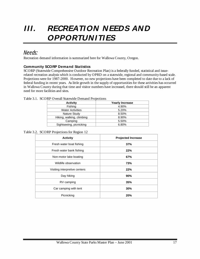
III. RECREATION NEEDS AND OPPORTUNITIES
Needs: Recreation demand information is summarized here for Wallowa County, Oregon. Community SCORP Demand Statistics SCORP (Statewide Comprehensive Outdoor Recreation Plan) is a federally funded, statistical and issue-related recreation analysis which is conducted by OPRD on a statewide, regional and community-based scale. Projections were for 1987-2000. However, no new projections have been completed to date due to a lack of federal funding in recent years. As little growth in the supply of opportunities for these activities has occurred in Wallowa County during that time and visitor numbers have increased, there should still be an apparent need for more facilities and sites. Table 3.1. SCORP Overall Statewide Demand Projections
Activity Yearly Increase Fishing 4.90%
Water Activities 5.20% Nature Study 8.50%
Hiking, walking, climbing 8.90% Camping 5.50%
Sightseeing, picnicking 6.80%
Table 3.2. SCORP Projections for Region 12
Activity Projected Increase
Fresh water boat fishing 37%
Fresh water bank fishing 22%
Non-motor lake boating 67%
Wildlife observation 73%
Visiting interpretive centers 22%
Day hiking 90%
RV camping 35%
Car camping with tent 30%
Picnicking 20%

Wallowa County State Parks Master Plan – June 2001 18
In 1993, a survey of Oregonians was completed to measure demand for recreational activity opportunities within and near communities. Widespread support was voiced for the following activities:
• Historic exhibits • Outdoor concerts • Wildlife and nature education • Walking and jogging trails • Picnicking • Biking • Beach swimming • Boat fishing • Driving for pleasure and sightseeing • Overall, respondents preferred to recreate in natural to primitive settings.
It can be assumed that these activities would be desired in Wallowa County for local use as well as visitors.
Other Recreation Demand Information According to the study, "Market and Competition in Private and Public Campground Sectors of Oregon, Implications from the 1997 Inventory and Campground Questionnaire", the most popular activities in Eastern Oregon include relaxing, viewing wildlife, sightseeing, and hiking.
OPRD Manager Information Park managers have a good understanding for what the public wants in their parks based on observation of attendance and on conversations with visitors and volunteers. Here are a few ideas pertaining to recreation needs for the parks located within Wallowa County.
• More demand for group camping. • Large demand for interpretation. • Winter recreation opportunities exist. • Demand for short trails or loops close to the campground with connections to the Wilderness Areas. • Demand for more group day use shelters and areas. • Demand for more amenities and choices in overnight accommodations within the parks. • Full hook up sites at Wallowa Lake are needed. • Swimming is sought. • Disabled accessible sites are needed. • Bathrooms which are accessible throughout the year are needed. • Event area at Wallowa Lake is desired. • Primitive walk in tent sites at Minam are desired. • Larger raft launch area at Minam is desired. • Horse facilities.

Wallowa County State Parks Master Plan – June 2001 19
1998 OPRD Visitors Survey Summary Each year OPRD does a visitor survey to help determine needs within the parks system. The 1998 survey revealed the following pertaining to recreation needs within Wallowa County, namely Wallowa Lake State Park:
• While other parks in Wallowa County enjoy a wide range of visitor use, Wallowa Lake State Park is the primary destination.
• People chose Wallowa Lake primarily because of its location and natural setting. • A majority of the park visitors stay 3-5 nights. • Many come to the lake for viewing scenery and wildlife, relaxing, hiking, camping with the family
and picnicking. • Many of the campers felt that expansion of the following would improve their visit:
o Natural, undeveloped areas o Wildlife viewing o Rustic cabins o Swimming areas o Museums or visitor centers o Campground o Nature trails o Tent only camping
Opportunities for Recreation in Wallowa County Opportunities for recreation abound in Wallowa County. The county is renowned for its scenic splendor, including views of mountains, rivers and lakes. In addition to the natural beauty many people are attracted to Wallowa County because of its rich history, seasonal events such as Chief Joseph Days, and it’s growing art enclave. Nearby trails lead to the expansive Eagle Cap Wilderness Area. A gondola transports visitors to the summit of Mt. Howard. Guided horseback trips are available from the Wallowa Lake community into the wilderness area. The OPRD park properties primarily serve as jumping off points to many recreational pursuits and associated attractions. Wallowa Lake State Park provides the primary access to the lake for boating, fishing, swimming and picnicking. The park also provides RV and tent camping and group camping. Some interpretation is offered, primarily through the evening camp talk programs. The park has potential for more trail connections to the community and to the wilderness. Existing facilities have a potential to be redesigned for a better visitor experience. At the main trailhead there is potential for trail access staging areas for horse back use and back packing on the lease parcel. Nearby partnership properties mostly offer potential for additional group uses. Minam State Recreation Area offers river access for rafting, fishing, day use and camping. It has some potential for the expansion of these uses, as well as trail connections. Wallowa Lake Highway State Scenic Corridor is popular for fishing. It has very limited potential for additional recreational use. OPRD is interested in options for attracting visitors during the shoulder and winter seasons. The increased use of yurts and small cabins has been successful in attracting shoulder season visitors at Wallowa Lake State Park as well as statewide. Discovery Season (October - April) camping has increased for its third consecutive year despite Oregon having one of its wettest winters on record ever followed by an usually cold early spring. The yurt occupancy rate was almost triple the rate for standard sites. Yurts alone will not increase off season use of the area. Coupled with winter activities provided by some other agency or group may be a strategy to attract more winter use. This plan touches on possible future partnerships for winter attractions such as the ice skating rink and parking for a nearby ski area.

Wallowa County State Parks Master Plan – June 2001 21
IV. ASSESSMENTS AND SUITABILITY
Resource Inventories and Assessments: OPRD prepares resource inventories and assessments for its master plans. Detailed mapping of key resources contribute to the creation of a Suitability Map, which is provided in the master plan document. Detailed resource maps, inventories and background information are not included in the document, but are available for viewing at the OPRD headquarter office. The following list describes the resource inventories that were completed for the Wallowa County State Parks Master Plan.
Plant Communities Based on Oregon Natural Heritage Program community names. Names include reference to dominant tree, shrub and or herbal plant species.
Wildlife Habitat Based on generalizations of the plant communities.
Wetlands Based on Natural Heritage Program community names and National
Wetland Inventory names. Protected Species Any state or federally listed or candidate plant or animal species and
associated habitat known or likely to occur in the park. Water/Hazards Areas of slump topography, rock fall hazard, flood plains, and water
features, etc.. Cultural Resources Prehistoric or historic sites, objects, structures, buildings, districts or
landscapes. National Register listed, nomination eligible or likely to be eligible.
Composite Suitability Generally shows areas suitable for different levels of development intensity
- Levels 1 & 2: Least suitable for development - Levels 3 & 4: Most suitable for development
Scenic Resources Important viewpoints and view corridors and the OPRD Recreation
Opportunity Spectrum scenic designations. Current Ecosystems Existing park ecosystem types, core areas, edges and corridors. Desired Ecosystems Changes desired through management to enhance ecosystems.
Suitability: Existing and future recreational uses should coexist with and complement natural and cultural resources within the OPRD properties located in Wallowa County. Areas within these properties have been assessed for their suitability for public recreational use and for the need for resource protection. Areas have been mapped where intensive activities or facility development can occur without negatively impacting important resources. For the Wallowa County State Parks Master Plan, OPRD recognizes four resource suitability levels for several resources. These resources include Vegetation, Wildlife Habitat, Protected Species, Water Features and

Wallowa County State Parks Master Plan – June 2001 22
Hazards, Wetlands and Cultural Resources1. Each of these resources has been mapped and classified with respect to the four suitability levels that are based on the following criteria: Quality or condition which includes amount of disturbance by historic human activities or invasion by non-native species, having a representative Oregon native species composition, being rare or of a protected or special concern status, being vigorous or highly functional in structure and productivity, or possessing a potential for major hazards to facilities such as 100 year floods. For cultural resources criteria include their significance and integrity and their importance for interpretation. Once suitability levels were mapped for each resource category, the resource categories were overlaid and composite suitability levels were determined for areas of the park. The composite suitability of each area within Wallowa County State Park Master Plan is determined by the most restrictive resource suitability level within that area. In addition, a Cultural Resource or flood plain overlay may be applied where appropriate. This overlay means that protection of the cultural resource or flood plain in that area is important but may not preclude appropriate development. The Composite Suitability Map is shown in the specific park chapters.
1 Cultural resources can include prehistoric or historic sites, structures, buildings, objects, districts or landscapes.

Wallowa County State Parks Master Plan – June 2001 23
Suitability Matrix Protection/Low intensity use
Management/ Moderate Development
Major Development
Resources
Criteria
Level 1
Level 2
Level 3
Level 4
Excellent/ Special Emphasis
•
Very Good
•
Moderate
•
Plant Communities and Wildlife Habitat
Poor
•
Wetlands
All Known
•
Rare/Protected Species
All Known
•
Geologic & Water Features
Outstanding/ Severe
•
National/State Significance & high integrity
•
Local significance & important interpretation
•
Historic Prehistoric
Archeological likelihood
• Overlay
Table: Suitability Matrix

Wallowa County State Parks Master Plan – June 2001 24
Endowment In addition to Resource Suitability assessments, OPRD completes ownership and adjacent use suitability assessments. This can determine which areas, currently owned by OPRD, may not meet OPRD needs for resource protection or recreational use and should be designated as "Endowment" for non-traditional use, sale or trade.
Areas of Concern Adjacent properties that are determined through the master planning process to be important for recreational use or for the protection of important resources are designated as "Areas of Concern." Areas of Concern may be protected or used for recreation under current zoning or by joint agreements between the land owners and OPRD, or by OPRD acquisition or easement. Except in instances of emergency or overwhelming state interest, acquisition is intended to occur only with the agreement of willing sellers. A development concept for the Boy Scout Camp, an Areas of Concern, is shown in the respective development chapter with the consent of property owners. This master plan does not include any development concepts for the Methodist Church Camp because the church is completing its own concepts and is currently pursuing year-round management of their camp without OPRD assistance. If circumstance were to change in the future, the Church Camp may again open to partnership discussions with OPRD regarding the church camp and the potential future improvements to it.

Wallowa County State Parks Master Plan – June 2001 25
V. ISSUES OPRD field and planning staff with input from both the steering committee and the public have identified issues pertaining to the master plan for OPRD properties within Wallowa County. Issue lists were generated through comments obtained at the several public meetings as well as written comment. Certain issues are within the realm of a state park master plan. Other issues are not considered relevant and not addressed in the plan. Issues which fall into the “not relevant” category are noted and passed on to the appropriate department but are not addressed in the master plan.
Relevant to the Master Plan: • Natural, cultural, and scenic resource management issues. • Issues pertaining to recreation facility development. • Issues concerning major partnerships.
Typically Not Relevant to the Master Plan: • Routine facility maintenance and rehabilitation issues. • People management issues. • Administration issues. • Issues concerning project costs and funding prioritization. • Master Plans do not determine the outcome of properties not owned or managed by OPRD.
Pertinent Issues Typically Addressed in Master Plans: The following listing includes a summary of issues typically relevant to state park master planning.
• Determining what is appropriate development and uses for each park. • Determining what major natural, cultural and scenic resource management actions should be taken
in each park. • Determining what resources need protection from intensive development. • Identifying possible land ownership and partnership opportunities.
Listing of issues specific to the parks contained within the Wallowa County State Park Master Plan are contained within the individual park chapters.

Wallowa County State Parks Master Plan – June 2001 27
VI. GOALS Specific goals are listed for each OPRD property in the specific park chapters. The goals are important because the development concepts and management guidelines must correspond with them. A certain amount of flexibility with the concepts and guidelines is allowed as long as changes correspond with the goals, and with relevant land use and other permitting requirements. OPRD establishes a series of goals stated in the master plan, for guiding the appropriate management and use of Wallowa County State Parks. The goals are based on the suitability assessment and preferred solutions taken from issue scoping and staff analysis.
Typical OPRD Master Planning Goals:
GOAL I. PROTECT AND ENHANCE OUTSTANDING NATURAL, CULTURAL AND SCENIC RESOURCES.
GOAL II. IMPROVE PARK MAINTENANCE AND MANAGEMENT. GOAL III. ENHANCE PARK VISITATION AND PARTNERSHIPS. GOAL IV. PROVIDE FOR RECREATIONAL NEEDS. GOAL V. IMPROVE PARK ACCESS AND ORIENTATION. GOAL VI. IMPROVE INTERPRETATION AND EDUCATION OPPORTUNITIES. GOAL VII. OUTSIDE THE PARK

Wallowa County State Parks Master Plan – June 2001 29
VII. DEVELOPMENT CONCEPTS Development concepts for each OPRD property in Wallowa County are listed in the specific chapter for that park. The following describes a general overview of OPRD’s use of Development Concepts in master planning. OPRD is dedicated to proposing facilities that are needed to support park recreation, and which are appropriate to the Department's role as a recreation provider in Oregon. Park proposal locations are selected so that important resources would not be significantly harmed by the development or recreational uses. Conceptual designs are prepared by the Department to show the appropriate location, layout, size and type of the proposed facilities. The concepts are intended to fit within the goals and suitability assessments of the master plan, but are to be flexible within those limits. Final designs may change somewhat as plans are implemented.
Design Parameters • Avoiding conflicts with existing park uses and facilities; • Providing good access and circulation for vehicles and non-motorized travel within the park; • Placing facilities, roads and trails in a manner which is understandable by the public to find activities
they are interested in; • Avoiding significant impacts on important natural or cultural resources in or adjacent to the park; • Presenting an appearance that is harmonious with the setting of the park and the region of the state; • Providing choices for park visitors who may have different desires for park amenities and settings; • Avoiding or mitigating conflicts with local services or adjacent uses; • Avoiding or mitigating potential impacts on the park by adjacent uses; • Achieving compliance with regulatory requirements including the state land use goals, local
comprehensive plans, building codes, resource laws, etc.; • Providing opportunities for access by visitors with disabilities or different economic or cultural
backgrounds.
Wallowa County State Parks Master Plan – June 2001 31
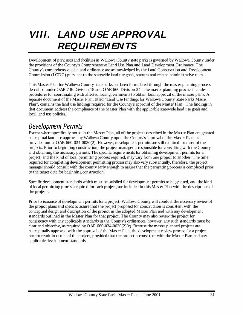
VIII. LAND USE APPROVAL REQUIREMENTS
Development of park uses and facilities in Wallowa County state parks is governed by Wallowa County under the provisions of the County’s Comprehensive Land Use Plan and Land Development Ordinance. The County’s comprehensive plan and ordinance are acknowledged by the Land Conservation and Development Commission (LCDC) pursuant to the statewide land use goals, statutes and related administrative rules. This Master Plan for Wallowa County state parks has been formulated through the master planning process described under OAR 736 Division 18 and OAR 660 Division 34. The master planning process includes procedures for coordinating with affected local governments to obtain local approval of the master plans. A separate document of the Master Plan, titled “Land Use Findings for Wallowa County State Parks Master Plan”, contains the land use findings required for the County’s approval of the Master Plan. The findings in that document address the compliance of the Master Plan with the applicable statewide land use goals and local land use policies.
Development Permits Except where specifically noted in the Master Plan, all of the projects described in the Master Plan are granted conceptual land use approval by Wallowa County upon the County’s approval of the Master Plan, as provided under OAR 660-034-0030(2). However, development permits are still required for most of the projects. Prior to beginning construction, the project manager is responsible for consulting with the County and obtaining the necessary permits. The specific requirements for obtaining development permits for a project, and the kind of local permitting process required, may vary from one project to another. The time required for completing development permitting process may also vary substantially, therefore, the project manager should consult with the county early enough to assure that the permitting process is completed prior to the target date for beginning construction. Specific development standards which must be satisfied for development permits to be granted, and the kind of local permitting process required for each project, are included in this Master Plan with the descriptions of the projects. Prior to issuance of development permits for a project, Wallowa County will conduct the necessary review of the project plans and specs to assure that the project proposed for construction is consistent with the conceptual design and description of the project in the adopted Master Plan and with any development standards outlined in the Master Plan for that project. The County may also review the project for consistency with any applicable standards in the County’s ordinances, however, any such standards must be clear and objective, as required by OAR 660-034-0030(2)(c). Because the master planned projects are conceptually approved with the approval of the Master Plan, the development review process for a project cannot result in denial of the project, provided that the project is consistent with the Master Plan and any applicable development standards.

Wallowa County State Parks Master Plan – June 2001 32
Variations From the Master Plan Under the provisions of OAR 736-018-0040, OPRD may pursue construction of a park use that varies from an adopted master plan without first amending the master plan provided that the variation is minor, unless the master plan language specifically precludes such variation. Any specific project design elements that cannot be changed by applying the “Minor Variation” rule are indicated in the development standards for the projects in the Master Plan. The OPRD Director must determine that a proposed variation from a master plan is “minor” using the criteria in OAR 736-018-0040. A minor variation from a master plan, which is approved by the Director, is considered to be consistent with the master plan, contingent upon the concurrence of the affected local government. A minor variation from a use or facility described in the Master Plan may be allowed through the County approval procedures specified in the Master Plan for the use or facility which is being varied.
Rehabilitation of Existing Park Facilities State law allows OPRD to continue any state park use or facility that existed on July 25, 1997. (See ORS 195.125 and OAR 660-034-0030(8).) The law allows the repair and renovation of facilities, the replacement of facilities including minor location changes, and the minor expansion of uses and facilities. Rehabilitation projects are allowed whether or not they are described in an adopted state park master plan. These projects are subject to any clear and objective siting standards required by the affected local government, provided that such standards do not preclude the projects. Prior to applying for development permits for a project involving a minor location change of an existing facility or a minor expansion of an existing use or facility, the OPRD Director must determine that the location change or expansion is "minor" using the criteria in OAR 736-018-0043. The Director's determination is contingent upon the concurrence of the affected local government.

Wallowa County State Parks Master Plan – June 2001 33
IX. RESOURCE MANAGEMENT GUIDELINES
OPRD prepares guidelines/objectives to direct park managers and staff regarding resource management decisions. Detailed guidelines pertaining to specific park properties are included in the park chapters. General system-wide guidelines include the following topics:
• Natural Resource Management Guidelines • Cultural Resource Management Guidelines • Interpretive Guidelines • Scenic Management Guidelines
Natural Resource Management Objectives The natural resource management guidelines are based on the following system-wide objectives and on summary of the detailed mapping of vegetation, wetland, protected species and wildlife habitat completed for the park and on park-wide ecosystem patterns. A summary of the natural resources in the park can be found in the Heritage Assessment Summary Chapter. Detailed resource mapping for the park is available for viewing at the Department headquarters in Salem or park office. The following objectives have been established by OPRD to guide natural resource management decisions for the Department's properties statewide. These general objectives were considered in combination with the resource situations at Wallowa County State Parks to determine objectives specifically for the park. 1. Protect all existing high quality, healthy, native Oregon ecosystems found within OPRD properties.
(Based on Oregon Natural Heritage ecosystem types and OPRD definition of high quality.) a. Generally, allow successional processes to proceed without intervention. b. Identify and monitor existing high quality ecosystems for the presence of threats to a desired type or
condition. Determine whether there are changes desired in ecosystem type or condition, based on consultation with Oregon Department of Fish and Wildlife, the Oregon Natural Heritage Program, the Oregon Department of Agriculture, Natural Resource Conservation Programs, Wallowa County Natural Resource Advisory Committee and U.S. Fish and Wildlife Service on targeted ecosystems for the region of the park.
c. Manage the resource to eliminate any unacceptable threats or to attain desired ecosystem conditions and types.
d. Following a natural or human-caused catastrophic event, such as major fire, windthrow, landslide or flooding, etc., determine what management actions are needed, if any, to attain a desired ecosystem condition or type.
2. Generally restore/enhance existing low quality OPRD resources, to a higher quality, desired ecosystem
type and condition, based on consultation with ecosystem agencies as to what a desired ecosystem should be for the park, and for the region of the park. Retain some low quality areas for future recreational use and development, as identified in the park master plan.
3. Manage all OPRD properties to protect existing occurrences of state or federally listed or candidate
species to the approval of jurisdictional agencies: a. Broaden species management plans into ecosystem management plans that include the monitoring
and management of indicator species.

Wallowa County State Parks Master Plan – June 2001 34
b. For selected lands, determine in consultation with ecosystem agencies, manage for protected species recovery and related desired ecosystem type and condition.
4. Manage all OPRD lands and uses to keep erosion, sedimentation, and other impacts on important resources low.
5. Identify and acquire additional lands, or enter into management partnerships with landowners, to provide
long term viability for important natural resources found within OPRD properties, as needed 6. In areas of high quality ecosystems or habitats, endeavor to provide opportunities for the public to
experience: a. Sights, sounds, smells and feeling of representative ecosystems. b. Understanding of the ecosystem structure, composition and function. c. Larger views of the landscape of which the ecosystems are a part.
7. In selected areas of low quality natural resources, manage for: a. Popular or attractive native plants or animals, appropriate to the local ecosystems. b. Desired views or settings. c. Desired cultural landscape restorations for interpretation.
8. Place, design and construct facilities for public access to high quality ecosystems or habitats to avoid
significant impacts on the ecosystems. 9. For those OPRD properties or sites which are historically significant and which have been identified by
the Department as priority sites for emphasizing cultural resource protection, management and interpretation, manage the natural resources in the cultural resource areas to support cultural resource interpretation, unless this would result in unacceptable conflicts with protected species or areas of special natural resource concern.
10. Manage OPRD natural resources to protect visitors, staff, facilities and neighboring properties from
harm. 11. Manage OPRD natural resources to protect them from threats from adjacent or nearby properties or their
use. 12. Limit the use of non-native plants to developed facility areas or intensive use areas, and as is needed to
withstand intensive use and to provide desired amenities such as shade, wind breaks etc.. Wherever possible, use native species in landscaping developed sites.
Cultural Resource Management Guidelines: Currently no formal OPRD policy exists pertaining to Cultural Resource Management Guidelines. OPRD follows guidelines established by the National Register of Historic Places through an intra-agency agreement with State Historic Preservation Office (SHPO). The SHPO office is located within our department and is involved throughout the in-house review process. Cultural resource management guidelines or recommendations are particularly important at Minam. This section of the master plan outlines management recommendations for the areas likely to yield additional information.

Wallowa County State Parks Master Plan – June 2001 35
Interpretive Goals/Guidelines: The primary goal of a park interpretive program is to enhance a visitor's experience by communicating any significant information about the resources and events associated with the park to the visitor. The key to providing an interpretive program is to both enhance a visitor's recreational experience and provide information to visitors to assist the agency in management of the resources in the park. The overall OPRD Interpretive Services Program Goal is to heighten and increase public understanding, appreciation and enjoyment of the natural and cultural resources of the OPRD system. However, subordinate goals listed below must also be implemented to aid in future park management and public understanding of the agency and how they can participate in supporting the agency:
1. Promote public understanding of our agency's mission and mandates. 2. Provide visitors with enjoyable and inspirational park experiences. 3. Accomplish management goals by encouraging thoughtful use of resources. 4. Enhance the agency image as competent cultural and natural resource managers. 5. Help generate broad-based agency support.
Scenic Management Guidelines: There is no formal department policy on scenic resource management except for general guidance provided by OPRD's mission statement. OPRD has developed its own scenic setting designation system categories and publishes it in the SCORP. The OPRD scenic designations are applied on the master plan. However, the department has a long history of placing emphasis on acquiring and managing properties for scenic enjoyment.

Wallowa County State Parks Master Plan – June 2001 37
MINAM STATE RECREATION AREA

Wallowa County State Parks Master Plan – June 2001 38
MINAM STATE RECREATION AREA Location: Located off of Highway 82, 15 miles northeast of Elgin in Wallowa County. The property is
located at the confluence of the Minam and Wallowa Rivers. Size: 602.32 acres Classification: Minam is classified as a State Recreation Area. The primary purpose of a recreation area is to
provide access points and facilities to adjacent recreational resources, such as rivers, lakes and mountains.
Description: The park consists of steep pine and grassland banks flanking the Wallowa and Minam
Rivers, with some flats near the rivers, mostly in the vicinity of the historic townsite of Minam. Minam State Recreation Area offers one of OPRD’s more primitive camping experiences. The small campground is located on the west bank of the Wallowa River, and is accessed via two miles of gravel road from Highway 82. There is currently no electric service available at the campground. Near the entrance to the property, off of the highway, there is a popular rafting launch.
Approaching from the west, Minam is considered the "Gateway to the Wallowa Valley.” The area has historically been a cross-roads and remains so today. Indian trails, wagon roads, a railroad, an old highway and the new highway descend down the Blue Mountains to the confluence of the Minam River with the Wallowa. Historically, a natural ford in the Wallowa River provided a crossing to a gently sloping ascent out of the canyon. Annual spring and summer runs of sockeye and other salmon species triggered the seasonal migration of Native Americans into the canyon. Early trappers used the same route as Native Americans to access the valley. Today a visible switchback up the east canyon remains as a reminder of past users of the area. Decades later a road was constructed which followed a similar route. In 1907, the railroad was constructed connecting the Wallowa Valley to La Grande. Minam soon became a community consisting of railroaders, mill-workers, loggers and homesteaders. Several fish hatcheries were formally sited in the area. Today little remains from that era. Forests at the Minam Recreation Area are composed primarily of Douglas fir on east and north facing slopes which is generally considered a western Oregon species. West and south facing slopes are composed primarily of Ponderosa pine and xeric grasslands which are characteristic of the Rocky Mountain vegetation types. Timber harvesting has occurred on and around the park creating a patchwork of second growth and harvested forest stands. Grazing has also occurred in and around the property. The Neighborhood: The property is surrounded by undeveloped lands owned primarily by the BLM and a few
private property owners primarily Boise Cascade. There are a few private properties within the park boundaries, including a store, motel, private residence and the Minam school which has been converted into a residence. The now abandoned IN & P rail line runs through the property along the east bank of the Wallowa River. Old and new Highway 82 cross the southern portion of the property as well. The Wallowa County Weed Control District has a “hay exchange” building on the highway right of way at the entrance to the park. During hunting season non-Wallowa County hay is exchanged for Wallowa County hay to prevent weed seeds from entering the county. The BLM has a seasonal office trailer located on the terrace above the entrance and within the park boundaries.


Wallowa County State Parks Master Plan – June 2001 41
Existing Facilities: Raft Launch: This facility is located near the entrance to the park. It includes a gravel parking lot, informational kiosk and 2 vault toilets, and a gravel launch area into the Wallowa River. Overnight Camp: The overnight camp includes 12 designated overnight sites and several undesignated sites. A small day use area is located along the river bank at the camp. The camp provides water, but a generator must be used to pump it into the tank. The campground has no electric power other than the generator. Toilets are the vault type. BLM Office Area: BLM operates the state site under a “Memorandum of Understanding” for a River Ranger station. This facility is located to the west of the entrance to the property and is generally seasonally staffed. Trails: A segment of a trail runs along the south-east bank of the Minam River through the park. This trail is not maintained. It connects with the wildlife area to the south through private forest land to the National Forest beyond. Current access from the park is difficult.
Other Classifications: • This area was historically used as a camping and fishing area by Native Americans and is within
the traditional lands of the Nez Perce people. • BLM patents apply to northernmost of the park. BLM controls the management of vegetation
and timber removal for those areas. • The Wallowa River through the park is listed as a State Scenic Waterway. which includes 1/4
mile wide corridors from the river. The Minam River through the park to the confluence is designated as a federal Wild & Scenic River. Its corridor is defined by a management plan.
Ownership: The land was acquired between 1964 and 1984 by purchase from private owners, and by patent from the Bureau of Land Management for a majority of the park. A patent is a special type of land conveyance for federal properties and includes certain restrictions on use and management.

Wallowa County State Parks Master Plan – June 2001 42
Heritage Assessment- Minam State Recreation Area
Flood Plain: 100 year flood plain generally follows the tops of the banks of both rivers. Hazards: Bank erosion in some areas. Wetlands: Restricted to a narrow riparian area along both rivers. One wetland area is encompassed within a riparian area and is not separately mapped. This site is located along the Minam River upstream of the bridge where the river bank is wide. Two other independent wetlands exist on the property. These include a cattle pond near the entrance to the park . The second wetland is a fenced pond adjacent to the bridge. Wildlife: Popular fishing spot in spring for spring steel head. Winter habitat for deer and elk. Protected Species: The bull trout in the Wallowa River are federally listed as threatened. There has been a catch and release for bull trout for a number of years. No other protected plant or animal species are known to occur in the park. Scenic Values and Recreational Settings: In general the park is accessible by vehicle, with areas of current and former disturbance, surrounded by relatively natural appearing areas. The area is primarily “roaded natural”. The former townsite can be considered “urban within open space”. The area between the gravel road and the river are “roaded modified” due to the road fill and various former development sites along the river. The area surrounding the old town site is “roaded modified”. The campground is considered “urban within open space” with an area of “roaded modified” on the lower terrace at the former fish hatchery site and raft landing. Suitability Assessment: The majority of the park has been mapped as Suitability Levels 1 (20%) or 2 (67%) meaning that those areas should be protected from moderate to intensive development and use. Most of these areas are undisturbed hillside and riverside areas. Already developed or formally disturbed areas have been identified as suitable for development, although development may not be proposed for all of these areas. Certain disturbed river terraces have the potential for subsurface cultural resources. These areas are identified for potential development with a special overlay indicating the need to protect or mitigate any significant cultural resources found there. A map of the suitability areas follows.


Wallowa County State Parks Master Plan – June 2001 45
Areas of Concern: Idaho Northern and Pacific Rail Corridor Recently OPRD successfully applied for a transportation enhancement grant to fund the purchase of the abandoned IN & P railroad right-of-way. The agency sees the acquisition of the right-of-way as an essential transportation resource to the local communities, the counties, and the State. The grant proposal would preserve approximately 61 miles of abandoned railroad between the town of Elgin in Union County and Joseph in Wallowa County. Purchase would include 60.58 miles of trackage, 766.54 acres of land, bridges, and culverts. If funded OPRD proposes to preserve the railroad corridor and convert it to interim trail use to provide non-motorized access to the communities along the corridor and the renowned scenic and recreation resources of the area. Failure to acquire the railroad in its entirety (rails, ties, property) will result in loss of the transportation corridor as the improvements will be salvaged by the owners and the right-of-way destroyed through piece meal disposal of individual parcels. In this master plan the railroad is recognized as an Area of Concern in relation to the Minam State Recreation Area. If the grant is successful and OPRD is able to purchase the right-of-way a comprehensive master planning effort will be needed to address the issues associated with railroad right-of-way development and use. Unincorporated Rural Community Wallowa County is in the process of re-examining the zoning boundaries of rural communities throughout the county. The rural unincorporated community of Minam includes some portions of the park along with private property. The non-state owned parcels include the old school property, a store, motel and a private residence. OPRD will participate in the county process to ensure that the master plan is compatible with the uses allowed on the private lands by the zoning. Also, as an Area of Concern OPRD will review any acquisition opportunities in the community for fit with park uses and value, and for fit with statewide department acquisition priorities. Old Highway The old highway right of way through Minam is important for providing workable pedestrian and bike access to both sides of the river and to various rural community parcels. Recreation Needs:
• Larger boat launch area. • Power or electricity for host site. • Walk-in tent sites. • More camping. • Separate day use and camping at campground • Trailheads and trails throughout the park. • More interpretation and better signs for location.

Wallowa County State Parks Master Plan – June 2001 46
Issues: Minam State Recreation Area The following issues were gathered from OPRD staff, a local steering committee and public meetings. These issues were then considered as master plan goals, concepts and guidelines were drafted.
• Need for special attention to potential archeological resources and their protection. • Idaho Northern & Pacific: Right -of-way conversion idea offers recreation opportunities and causes
local concern regarding privacy and trespass. • Camping: Better facilities are requested by some including full hookups and showers. Others like the
primitive setting associated with primitive camping. People are not camping at designated sites. Conflicts between day use visitors and campers at the camp. Irrigation and potable water are desired. Campground is most used during spring and summer for fishing and rafting.
• Some OPRD/private property boundaries are in dispute. • Wild and Scenic River & State Scenic Waterway guidelines must be met for development. Views of
the lower terrace from the river are important to protect. • Park road: Gravel entrance road has frost heaves and creates dust in the summer. Narrow gravel
roadway conflicts with bike and pedestrians on roadway. Visitors use passing turnouts as parking areas for river access. Consider speed bumps.
• Highway: Bridge is unsafe for pedestrian use. Excessive speeding on highway bridge. Needs bike
lanes. Unsafe situation for turning into the park. Left turn refuges desired by some. Slow traffic on highway through Minam.
• Park Hosts: Needed at the boat launch and camp. Hard to find a host who will use site with no
utility hookups. Put caretaker up by BLM trailer. • Riverside Day Use (Terrace behind the store): No facilities currently. Lots of trash. Needs shade
trees on Minam townsite terrace. Designated day use area is needed with supervision. Berm along highway is a barrier to river access.
• Interpretation and Signs: Many great historical and natural history stories to be told at Minam.
Better entrance and directional signage is needed. Work with tribes for stories about their people. Provide a central interpretive building to work with any new Rural Community developments.
• Rafting Launch: River access is narrow and crowded during peak season. Access spills over to lower
terrace and to camp where there is no BLM supervision. Need more and better defined parking. Need more staff presence on peak days. New vault toilets needed. The terrace behind the store is unofficially used for overflow. Install a public phone. Concern that a bridge in this location would cause rafting collisions.
• ADA: Need accessible sites along river and along new trails. • Resource protection and management: BLM manages raft launch area. OPRD works with county
weed control program, however, more coordination is needed. Hay check station conflicts with visitor recognition of the park entrance. County needs prominent location during hunting season.

Wallowa County State Parks Master Plan – June 2001 47
Protect plants used by Native Americans. Fire suppression management is critical. Forest management needed for bug infestations. Limit visitor fires. Use well as a hydrant for fire suppression. Consider fish habitat enhancements.
• Setting: Keep nighttime lighting subdued. Research Bend’s ordinance. • OPRD has informally been asked to consider the future placement of a community sewage treatment
plant on OPRD lands to serve the Rural Community zone that may be adopted soon by the county. County planners feel there may not be enough suitable land within the zone boundary to accommodate a plant. They are interested in future placement of a plant on the river terrace behind the store, using a surface wetland package similar to models used extensively in Canada and elsewhere. They may have access to federal funding to complete a system design. OPRD has checked into any legal land use restrictions and has found discrepancies between the Goal 8 language and Goal 11 language regarding whether treatment facilities within state parks can serve users outside the park but within a UGB or Community zone. It is likely that the land use issues could be resolved. OPRD is concerned about committing certain areas of the park, in the master plan, since it is currently not know how large the plant would need to be and what it would look like, and since those areas are also needed for recreation.
• Interpret early settler road. Switchback is still present. Several historic trails and roads traverse the
park property. There is the “Rawhide Road” that was dedicated in 1886. This road starts at the Wallowa and Union County line and then proceeds east through private property to the park and across the Minam River.
• Protect and interpret ancient trail from the west side of the canyon down to the river corridor
crossing. • Provide new loop trail within park property. • If rail trail is created, connect park to it. • An abandoned trail along the Minam River connects the state park properties to ODFW property,
locally known as “Wildlife Flats”. The trail eventually merges with a private road which provides access to the Wilderness Area.

Wallowa County State Parks Master Plan – June 2001 48
Goals - Minam State Recreation Area GOAL I. PROTECT AND ENHANCE THE OUTSTANDING NATURAL, CULTURAL
AND SCENIC RESOURCES. Protecting important riparian, plant communities, views and cultural resources is the
number one goal for the management of this park. Proposed developments and public uses will be located and/or designed to avoid significant impacts on important resources. Enhancement objectives for selected resources are listed below.
A. Implement the forest management plan prescriptions. B. Step up the noxious weed management actions with our partners. C. Plant native/riparian trees along a wider river buffer, except for the launch site. D. Close use areas in winter which would impact wintering deer and elk. E. Complete limited subsurface testing in areas of cultural resource likelihood proposed for
tree planting, signs or facility development. In areas where significant artifacts are found use surface development methods and/or documentation for mitigation prior to construction.
F. Manage to retain the “roaded natural” setting generally for the park (some
improvements may occur along the edges and within existing developed areas). GOAL II. IMPROVE PARK MAINTENANCE AND MANAGEMENT
This is always a priority goal, taking good care of the facilities and grounds that are already developed, and providing adequate staffing for site supervision and visitor services.
Fire prevention and Abatement Fire prevention and abatement is a management goal. OPRD will implement the following management actions to prevent and abate fires at the park. A. Keep a current written agreement on fire protection with the Oregon Department of
Forestry. B. Develop water sources and provide equipment for fire suppression. Development of
groundwater supplies for the campground and day use facilities will provide sufficient flow for fire protection. The river will serve as an emergency back-up source. Construct a small building at a strategic location for storage of fire fighting equipment, including portable pumping equipment, fire hoses and other necessary items. Provide access to the equipment by BLM staff and certain community members as determined through an agreement with Minam residents.
C. Irrigate the campgrounds. D. Provide full time seasonal staff supervision of campgrounds and/or use a full time
seasonal caretaker to supervise visitor compliance with fire management rules. E. Staff will inspect the facility areas weekly and remove any large material that could
be a fire threat. F. Sign facility areas and other use areas that fires are only in official OPRD fire stoves
and threat campfire stoves can be disallowed, if necessary, due to high fire danger. Also provide information on how to build, manage and put out fires in the stoves.
G. Post campfire closures as Department of Forestry directs in use areas.

Wallowa County State Parks Master Plan – June 2001 49
H. Staff will periodically clean out the fire stoves and will daily inspect them to ensure that fires are put out, during the high use season.
I. Staff will host an annual fire inspection by the appropriate agency.
Security A. Establish a full time seasonal caretaker in the park administration area prior to
beginning operation of the proposed new campground. The caretaker will have citation authority.
B. Install park boundary markers and signage as needed to keep park visitors from trespassing on to neighboring private lands. Install security fencing along boundaries where trespass is of particular concern. Install a gate on the access road to private lands where it intersects the old highway.
C. Route trails to avoid conflicts with private properties. Trails will be located only on publicly owned lands unless easements or other agreements are obtained from private landowners.
Camp Fire Smoke Management Campfire smoke will not exceed DEQ air quality standards. OPRD will solicit the help of DEQ to monitor the short-term effects of campfire smoke on air quality. Air quality measurements will be taken in the proposed campground by, or under the guidance of, DEQ in the first summer season of the campground operation and extended longer if necessary to demonstrate that campfire smoke is not exceeding standards during periods of peak campfire use. Specifically, visible air contamination will be measured to assure compliance with the standard set forth in OAR 340-208-0110(2), which requires that emissions from new sources not equal or exceed 20 percent opacity for any period or periods aggregating more than three minutes in any one hour period. At a minimum, measurements will be taken during three evening peak campfire use periods when the campground is full, and when wind conditions represent the most calm evening conditions that are typical of the summer season. OPRD will present the results of the monitoring to the Wallowa County Planning Commission within one year following the beginning of the campground operation and subsequently upon request by the Planning Commission if monitoring is extended beyond the first summer season. If the monitoring indicates that any DEQ standard has been violated, OPRD will take necessary steps to correct the violation through measures agreed upon by Wallowa County.
GOAL III. ENHANCE PARK VISITATION AND PARTNERSHIPS
It is important to make the best use possible of existing facilities. For the Minam SRA this could mean better designation of campsites and other facility areas. Providing cabins to extend seasonal use at Minam is not a priority as it would be at larger parks in the state park system. Work with the Bureau of Land Management toward mutual goals regarding the Minam property and related State Scenic Waterways and Federal Wild and Scenic Rivers. Work with the county on reviewing and commenting on their current planning studies. Work with ODFW, USFS and Boise Cascade toward potential trail improvements along the Minam River.

Wallowa County State Parks Master Plan – June 2001 50
GOAL IV. PROVIDE FOR RECREATIONAL NEEDS
During the peak season Minam’s river access and camping sites are used beyond capacity. As demand and populations grow there will be more use pressure on these sites. Certain facility expansion and improvements are recommended for Minam to meet some of that demand. However, the developments should be limited to the vicinity of current or former developed areas and should include low to moderate amenity levels to retain the current character of the park overall. In addition, a system of multi-use trails should be designated to provide additional opportunities for trail access in the county where appropriate and allowed.
A. Existing Campground and Day Use Area
- More camping, day use and amenity improvements. Specific improvements include delineation of the day use area, designate existing camp sites and new walk in camp sites. - Designate some parking along the entrance road for river access parking. (Access to the river and parking should be designed to avoid runoff and erosion.)
B. Terrace behind store -As an alternative provide a day use parking lot/ trailhead parking with a small bivouac style camp at far end of terrace or an electric RV loop. Provide vault toilets and potable water. - As an alternative construct a full service camp loop with restroom/shower building if it cannot be provided elsewhere in the county. All structures and facilities shall be appropriately set back from the river. - Discourage raft launching. Direct use to the existing launch site. - Designate non-boating, river access site. Enhance riparian corridor in other areas. Screen parking from the river and entrance road. - Pave the access road to the cattle guard. - Enhance riparian vegetation.
C. Rafting launch site - Provide toilet. - Expand and designate parking. Keep entrance road area free of parking. - Protect important vegetation. - Provide connections to trails via bridges.
D. BLM trailer site - Continues as BLM administration area; add OPRD administration including caretaker. - Provide a shared use office and staff/caretaker quarters, with BLM. Provide storage area in the rear. - Provide designated overflow parking in both the front and rear of the buildings.
E. Potential rail-trail related projects
- Select sites within current OPRD ownership for potential trailheads. - Consider needed trail connections. - Provide a small parking lot on remaining ODOT right of way near the motel. - Provide a bridge at campground. Any proposed bridges shall be designed to minimize conflicts with boating activities and support multiple uses such as pedestrians, bicyclists and stock recreation.

Wallowa County State Parks Master Plan – June 2001 51
GOAL V. IMPROVE PARK ACCESS AND ORIENTATION This park needs better definition for motorists traveling from Union County on Highway 82. The standard highway signs are not sufficient visual clues to alert travelers arriving at the park entrance. The following objectives are recommended to improve the visual cues.
A. Hay Station pull-off
- Create a better defined pull-off along the right side of the highway around the hay station building that will forewarn visitors of approaching a state park property. Improvements include landscaping, signs and relocation of the hay check station.
B. Park entrance on highway
- Improve the entrance sequence to the park by use of appropriately placed signs and landscaping. Signs shall be placed to best inform motorists. - Buildings and landscaping shall maintain a “park-like” appearance.
GOAL VI. IMPROVE INTERPRETATION AND EDUCATION OPPORTUNITIES Work with the local partners and Native American groups to determine specific stories to be told at Minam in regard to the themes outlined in the interpretive guidelines section of this plan. Potential interpretive sign structure locations include the hay check station pull-off, and the day use area. Interpretation themes may explore the Native American story, the early townsite, historic transportation routes and the natural environment.
GOAL VII. OUTSIDE THE PARK A. Work with the local community and the county to review prospective development
proposals within the Unincorporated Community zone and recommend conditions which could help to protect the park setting on adjacent OPRD property. Also coordinate with the county regarding future sewage treatment options for the Minam community. Because it is not currently known what the size, final type or appearance would be for the facility, a potential area for it in the State Recreation Area has not been identified in this master plan. As more study is completed by the county or others, OPRD will review the information in regard to the department’s role in the area, resource constraints and recreation needs for the SRA. OPRD will need to be assured through studies that the facility cannot be placed within the current exception area before considering placement outside of that area on OPRD lands. (OPRD currently owns some small areas within the current exception area, and does not feel that those areas need to be removed from the future Rural Community designation.) The proposals shown in this master plan can provide the county with an idea of which areas would be committed to recreational use in the future.
B. Monitor the status of the proposed rail-trail acquisition and development, if any, and prioritize the completion of a trailhead in the park, when and if needed.
C. Review any acquisition opportunities in the community for fit with park uses, value
and fit with statewide department acquisition priorities.
D. Pursue partnership opportunities with US Forest Service, ODFW and Boise Cascade for a potential trail connection along the Minam River to the wilderness area. A successful partnership shall work closely with Boise Cascade, the private property owner, in effort to address their concerns. Any trail connection proposed

Wallowa County State Parks Master Plan – June 2001 52
for this area would require Boise Cascade’s permission. Any new trail connections shall be designed to accommodate multiple uses including pedestrian, bicyclists and recreation stock.
E. Establish a Memorandum of Understanding (MOU) with the existing private
landowners within the Minam unincorporated community. The purpose of the MOU will be to guide future discussions between OPRD and the landowners to address on-going management issues and mitigate or resolve unanticipated conflicts and unintended consequences of park use and operations. The MOU will be made available for review by the Wallowa County Board of Commissioners prior to the County’s final approval of this Master Plan. At a minimum, the MOU will include the following:
- Purpose and intent of the MOU. - Names and addresses of the parties involved. - Items agreed upon by the parties, including steps to be taken to identify, discuss, prevent, mitigate and resolve issues informally and steps to be taken if agreement is not reached through informal discussions. - Provisions for periodic updating of the MOU.

Wallowa County State Parks Master Plan – June 2001 53
Development Concepts - Minam State Recreation Area This section describes the facility development proposal for Minam State Recreation Area in tabular form. The proposals are based on the goals and suitability assessments included within the master plan. The table references maps which indicate the development proposals general locations. The table include design standards, a listing of review and approvals needed prior to construction and the required county approval process. This format is intended to provide the needed information to future project managers and review agencies regarding the design intent of each of the proposals outlined in this plan. Oregon Parks and Recreation Department has prepared the following facility development concepts for implementation over a period of about 20 years. The concepts include a site plan and a narrative of each major proposal. The concepts are intended to fit within the master plan goals and suitability assessments, but are meant to be somewhat flexible within those limits. Final designs may change somewhat from the conceptual design as the projects ready for development. OPRD is dedicated to proposing facilities that fit the site and are needed to support park recreation, and which are appropriate to the department’s role as a recreation provider in Oregon. Park proposal locations are selected where important resource would not be significantly harmed by the development or recreational uses. Conceptual designs are prepared by the department to show the appropriate location, layout, size and type of proposed facilities. All development proposals in the park will be submitted for OPRD Scenic Waterway permitting prior to development. All development proposals will be submitted to SHPO for review and comment prior to permitting. Any developments requiring excavation of native material other than bedrock will require shovel testing and possible pit testing in the proposed excavation areas prior to final design and construction. Permits for subsurface testing will be required from SHPO, as will any related required consultation with affected Native American groups. If necessary, facilities would be designed and installed to avoid subsurface impacts on significant resources. Any proposals within the river shore or waterway will require review and permitting from the Oregon Division of State Lands and the Oregon Department of Fish and Wildlife and consultation with US Fish and Wildlife. Proposals also need to be reviewed by Wallowa County regarding siting criteria and building permits.

Wallowa County State Parks Master Plan – June 2001 54
MINAM STATE RECREATION AREA SUMMARY OF PROPOSED VISITOR CAPACITIES
Project Existing
Parking Spaces
Proposed New Parking Spaces
Total Proposed Parking Spaces
Existing Campsites
Proposed New Campsites
Total Proposed Campsites
A1. Trailhead
Parking 8 undesignated
0 (Designate existing 8)
8
A3. Boat Launch
Parking 16 undesignated
0 (Designate existing 16)
16
A7. Administrative
Area 4 4 8
A8. Overflow
Parking 25 undesignated
0 (Designate existing 25)
25
A9. Alternative #1 A
Day Use/Trailhead Parking & Bivouac or
35 dayuse plus 16 for bivouac sites or
51 or
16 bivouac sites or
16 or
A10. Alternative #1 B
Day Use Trailhead Parking & Camp loop or
35 dayuse only or
35 or
10 drive-in sites or
10 or
A11. Alternative #2
Camp Loop Only
0 0 40 drive-in sites
40
A12. River Access
Parking 0 20 20
B1 & B2
Walk-in Camp Sites
8 for walk-in sites
8 8 walk-in sites
8
B6. Existing Camp
Loop 12 designated
plus 10 undesignated drive-in sites
0 (Designate existing 10 undesignated sites)
22
B8. Day Use Area
Parking 0 8 8
Total
53 existing parking spaces
91 or 75 or 40 new parking spaces
144 or 128 or 93 total parking spaces
22 existing camp sites
24 or 18 or 48 new camp sites
46 or 40 or 70 total camp sites

Wallowa County State Parks Master Plan – June 2001 55
DEVELOPMENT PROPOSALS MINAM STATE RECREATION AREA
MAP A: TOWNSITE DEVELOPMENT PROPOSAL ID# DEVELOPMENT
DESCRIPTION DESIGN STANDARDS
REVIEW/APPROVALS NEEDED
PRIOR TO CONSTRUCTION (In addition to Wallowa County
approval)
COUNTY APPROVAL PROCESS
A1. Proposed Trailhead Parking • Construct a gravel parking
lot adjacent to the proposed IN&P Rail Trail, with a maximum of 8 - 9’ spaces.
• Landscape the parking lot to provide screening and definition.
• Post park rules and regulations. Interpretive sign to educate users of potential impacts to the watershed.
• The parking lot design shall employ professionally accepted methods for surface water run-off detention and filtration to protect water quality.
• Professionally accepted methods will be employed to contain excavated materials and control erosion and sedimentation during construction.
• Complete an integrated pest management plan for the property to control noxious weeds. Consult with the BLM and County Weed Board to determine best method.
• Must comply with DEQ water quality management plan.
• Must comply with Scenic Waterway guidelines.
• If needed, the parking lot will be watered at key times during the summer to prevent dust from affecting visitor experience and water quality.
• If exterior lighting is required, use fixtures that are shielded or hooded in a manner that minimizes glare and impacts on night sky viewing.
• Access easements to this site will need to be negotiated with private landowner.
• Any development within ODOT right-of-way requires ODOT review and approval.
• Minam is within a traditional lands of the Nez Perce people, consultation is not required but should be pursued.
• OPRD review for compliance with scenic waterway guidelines.
• DEQ review
Administrative review through procedures in Ordinance Article 4, for compliance with the Master Plan and Ordinance Article 21 - Rural Service Zone (Note: Wallowa County is currently considering changing the existing Rural Service Zone to another ‘rural community’ zone which would then be applicable to the Master Plan proposals in that zone.).
A2. Proposed bridge for non-vehicular use
• Construct bridge using the abutments from the old highway bridge.
• Design should support multiple users including pedestrians, bicyclists
• Design to minimize conflicts with boating activities.
• Complete an integrated pest management plan for the property to control noxious weeds. Consult with the BLM and County Weed Board to determine best method.
• Professionally accepted methods
• OPRD review for compliance with Scenic Waterway guidelines.
• Minam is within a traditional lands of the Nez Perce people, consultation is not required but should be pursued.
• ODFW, DSL review and
Public hearing review through procedures in Ordinance Article 5, for compliance with the Master Plan and Ordinance Article 21 - Rural Service Zone (Note: Wallowa County is currently considering changing the existing Rural Service Zone to another ‘rural community’ zone which would then be applicable to the Master

Wallowa County State Parks Master Plan – June 2001 56
ID# DEVELOPMENT DESCRIPTION
DESIGN STANDARDS
REVIEW/APPROVALS NEEDED PRIOR TO CONSTRUCTION
(In addition to Wallowa County approval)
COUNTY APPROVAL PROCESS
and stock animals.
will be employed to contain excavated materials and control erosion and sedimentation during construction.
• Must comply with Wallowa County Natural Resources Technical Advisory Committee guidelines.
• Must comply with Scenic Waterway guidelines.
• Coordinate with BLM. Work with river rangers to assure best design for rafters.
• BLM needs to approve any timber or vegetation removal.
approval for in-stream construction.
• Wallowa County Natural Resources Technical Advisory Committee review.
• DSL review if a fill and removal permit required.
• ACOE 404 permit maybe needed.
Plan proposals in that zone.).
A3. Rehab Existing Launch Site • Widen river access by 20
ft through selective shrub removal;
• Minor expansion of the gravel parking lot, Parking lot shall not exceed 16 vehicle/boat trailer sites;
• Install a vault toilet alongside the expanded parking lot.
• Install an informational kiosk alongside the expanded parking lot to help educate recreation users of potential impacts to the watershed.
• Route trails around the parking lot as indicated on the development concept drawing under highway bridge along the Minam River.
• Landscape and screen parking from highway using native plants.
• Comply with requirements of Wallowa County Natural Resources Technical Advisory Committee .
• Must comply with Scenic Waterway guidelines.
• Coordinate with BLM. Work with river rangers to assure best design for rafters.
• BLM needs to approve of any timber or vegetation removal.
• Disturbance of riparian vegetation will be kept to a minimum necessary for the project. Riparian areas disturbed during construction will be rehabilitated using native riparian vegetation within one year following construction. Rehabilitated areas will be monitored and maintained for a period of three years following planting to insure that vegetation is adequately established, and will be replanted as needed.
• Determine use levels of vault toilets and provide appropriate capacity.
• Pave and stripe parking lot for most efficient use.
• Minam is within a traditional lands of the Nez Perce people, consultation is not required but should be pursued.
• ODFW, DSL review and approval for in-stream construction.
• Corps of Engineer 404 permit may be required.
• OPRD review for compliance with Scenic Waterway guidelines.
• Wallowa County Natural Resources Technical Advisory Committee review.
Administrative review through procedures in Ordinance Article 4, for compliance with the Master Plan and Ordinance Article 21 - Rural Service Zone (Note: Wallowa County is currently considering changing the existing Rural Service Zone to another ‘rural community’ zone which would then be applicable to the Master Plan proposals in that zone.).

Wallowa County State Parks Master Plan – June 2001 57
ID# DEVELOPMENT DESCRIPTION
DESIGN STANDARDS
REVIEW/APPROVALS NEEDED PRIOR TO CONSTRUCTION
(In addition to Wallowa County approval)
COUNTY APPROVAL PROCESS
• The trail will be designed to control surface water runoff, erosion, and sedimentation to protect water quality.
• Keep parking out of the area alongside the entrance road from the highway (This narrow level area should be kept in a more naturalistic appearance and help partially screen the launch parking below.)
• The parking design will employ professionally accepted methods for surface water runoff detention and filtration to protect water quality.
• Professionally accepted methods will be employed to contain excavated materials and control erosion, sedimentation and turbidity during construction.
• If needed, the parking lot will be watered at key times during the summer to prevent dust from affecting visitor experience and water quality.
• If exterior lighting is required, use fixtures that are shielded or hooded in a manner that minimizes glare and impacts on night sky viewing.
A4. Proposed Sign Improvements • Install custom park
entrance sign at the park entrance.
• Ensure that the ½ mile and ¼ mile advance park entrance signs on the highway are in place and accurately located.
• At intersection of the park entrance and the old highway, install a park directional sign.
• Design to be compatible with the regional park setting.
• Work with BLM and storeowner to minimize duplication of signs to coordinate signing.
• Coordinate with Department of Forestry and ODOT for posting of fire safety signs.
• Coordinate with county weed management board on posting hay exchange signs.
• New development will require archaeological sub-surface survey if development would penetrate modern fill layer or located within an “Likely Archaeological Area”. Consult June 2000 archaeological survey.
• Any development within ODOT right-of-way requires ODOT review and approval.
• Compliance with OPRD sign manual is required.
Ministerial review through procedures in Ordinance Article 3, for compliance with the Master Plan and Ordinance Article 21 - Rural Service Zone (Note: Wallowa County is currently considering changing the existing Rural Service Zone to another ‘rural community’ zone which would then be applicable to the Master Plan proposals in that zone.).

Wallowa County State Parks Master Plan – June 2001 58
ID# DEVELOPMENT DESCRIPTION
DESIGN STANDARDS
REVIEW/APPROVALS NEEDED PRIOR TO CONSTRUCTION
(In addition to Wallowa County approval)
COUNTY APPROVAL PROCESS
• Allow space for the store/private raft service to provide directional signage as well on this sign.
• Minam is within a traditional lands of the Nez Perce people, consultation is not required but should be pursued.
A5. Reorganize Hay Check Station and Pull-off
• Grade the pull-off to extend further from the highway and to the west of the hay check station and park entrance turn-off.
• Consider the relocation of the hay check station further from the highway as indicated on the development concept.
• Construct several sign shelters with interpretive and information panels.
• Construct a roadside hay exchange kiosk that can be opened during the hunting season and closed during other seasons.
• Remove the old sediment control structures on the far side of the berm. Complete stabilization as needed.
• Investigate opportunities for funding through the Scenic Byway program.
• Shelter design to reflect state park design standards and styling.
• One interpretive panel to focus on weed management within the Wallowa Valley.
• Use native vegetation and grass landscape the berm to create a “park-like” naturalistic appearance.
• Complete an integrated pest management plan for the property to control noxious weeds. Consult with the BLM and County Weed Board to determine best method.
• The road/parking design will employ professionally accepted methods for surface water runoff detention and filtration to protect water quality.
• Professionally accepted methods will be employed to contain excavated materials and control erosion and sedimentation during construction.
• Coordinate with Department of Forestry and ODOT for posting of fire safety signs.
• If exterior lighting is required, use fixtures that are shielded or hooded in a manner that minimizes glare and impacts on night sky viewing.
• New development will require archaeological sub-surface survey outside fill area.
• Any development within ODOT right-of-way requires ODOT review and approval.
• Development requires approval from County Weed Control Board
• Minam is within a traditional lands of the Nez Perce people, consultation is not required but should be pursued.
• Considered a “portal” to Wallowa County. Coordinate with other agencies and organizations such as NPS, Nez Perce Homeland, Dept. of Forestry, and Wallowa County Chamber of Commerce.
Administrative review through procedures in Ordinance Article 4, for compliance with the Master Plan and Ordinance Article 16 - Timber Grazing Zone.

Wallowa County State Parks Master Plan – June 2001 59
ID# DEVELOPMENT DESCRIPTION
DESIGN STANDARDS
REVIEW/APPROVALS NEEDED PRIOR TO CONSTRUCTION
(In addition to Wallowa County approval)
COUNTY APPROVAL PROCESS
A6. Proposed Non-Vehicular Bridge • Construct a non-vehicular
bridge over Minam River to access OPRD and ODFW properties along the Minam River.
• Pursue partnership opportunities with US Forest Service, ODFW and Boise Cascade prior to trail construction along the Minam River to the wilderness area.
• Comply with requirements of Wallowa County Natural Resources Technical Advisory Committee .
• Design to minimize conflicts with boating activities and support multiple uses (pedestrian, bicycles, stock animals).
• Professionally accepted methods will be employed to contain excavated materials and control erosion, sedimentation and turbidity during construction.
• Disturbance of riparian vegetation will be kept to a minimum. Riparian areas disturbed during construction will be rehabilitated using native riparian vegetation within one year following construction. Rehabilitated areas will be monitored and maintained for a period of three years following planting to insure that vegetation is adequately established, and will be replanted as needed.
• Coordinate with BLM. Work with river rangers to assure best design for rafters.
• Wallowa County Natural Resources Technical Advisory Committee review.
• Boise Cascade approval is required for trail connection outside state owned properties. Work closely with Boise Cascade, the private property owner, in effort to address their concerns.
• ODFW and DSL review and approval for any in-stream construction.
• Minam is within a traditional lands of the Nez Perce people, consultation is not required but should be pursued.
• DSL review if a fill and removal permit is needed.
• Corps of Engineer 404 permit may be required.
Public hearing review through procedures in Ordinance Article 5, for compliance with the Master Plan and Ordinance Article 16 – Timber Grazing zone.
A7. Proposed Administrative Area Improvements
• Provide for caretaker trailer site.
• Improve BLM River Ranger station. Coordinate with the BLM for future office/visitor contact station in a permanent structure (Maximum sf=1500 sf, maximum height= 25’).
• Continue to provide agency storage area and staff graveled parking.
• Fence and screen BLM trailer and caretaker site from view of the park entrance at the highway.
• Screen staff parking and agency storage area behind the trailers from park access road and highway.
• Where exterior lighting is required, use fixtures that are shielded or hooded in a manner that minimizes glare and impacts on night sky viewing.
• Must be consistent with existing MOU with BLM.
• If needed, the parking lot will be watered at key times during the
• BLM review. • Minam is within a traditional
lands of the Nez Perce people, consultation is not required but should be pursued.
Administrative review through procedures in Ordinance Article 4, for compliance with the Master Plan and Ordinance Article 21 - Rural Service Zone (Note: Wallowa County is currently considering changing the existing Rural Service Zone to another ‘rural community’ zone which would then be applicable to the Master Plan proposals in that zone.).

Wallowa County State Parks Master Plan – June 2001 60
ID# DEVELOPMENT DESCRIPTION
DESIGN STANDARDS
REVIEW/APPROVALS NEEDED PRIOR TO CONSTRUCTION
(In addition to Wallowa County approval)
COUNTY APPROVAL PROCESS
(Not to exceed 8 spaces).
summer to prevent dust from affecting visitor experience and water quality.
• Work with BLM to change the lighting at the BLM trailer to shielded or hooded lighting with a timer or sensor.
A8. Proposed Overflow Raft Parking • Gravel a parking area and
sign for overflow launch parking in both the front and rear of the buildings. (Not to exceed 25 spaces)
• Screen parking from highway. • Coordinate with BLM. Work with
river rangers to assure best design for rafters.
• BLM needs to approval of any timber or vegetation removal.
• If needed, the parking lot will be watered at key times during the summer to prevent dust from affecting visitor experience and water quality.
• If exterior lighting is required, use fixtures that are shielded or hooded in a manner that minimizes glare and impacts on night sky viewing.
Administrative review through procedures in Ordinance Article 4, for compliance with the Master Plan and Ordinance Article 16 – Timber Grazing Zone.
A9. Alternative #1: Option A Day Use /Trailhead Parking and Bivouac Camp
• Construct a paved parking area for day use and trailhead use. Parking shall not exceed 35 spaces. Screen parking from entrance road and river.
• Convert exiting riverside access road into a paved trail.
• Construct a small bivouac camp with parking for short distance walk-in designated campsites. Bivouac camp parking shall not exceed 16
• Must comply with State Scenic Waterway guidelines.
• Discourage raft launch use. • Bivouac camp setback from
Wallowa River: 100 ft. min. • Parking lot and toilet buildings
setbacks from Wallowa River: 200 ft. min. as proposed by NMFS proposed 4d rules.
• The road/parking design will employ professionally accepted methods for surface water runoff detention and filtration to protect water quality.
• Professionally accepted methods will be employed to contain excavated materials and control erosion and sedimentation during construction.
• New development will require archaeological sub-surface survey and SHPO approval. Consult recommendation contained within archaeological study prior to any development.
• Minam is within a traditional lands of the Nez Perce people, consultation is not required but should be pursued.
• OPRD review for compliance with Scenic Waterway guidelines.
• DEQ review and approval. • Wallowa County Natural
Resources Technical Advisory Committee review.
Public hearing review through procedures in Ordinance Article 5, for compliance with the Master Plan and Ordinance Article 16- Timber Grazing zone.

Wallowa County State Parks Master Plan – June 2001 61
ID# DEVELOPMENT DESCRIPTION
DESIGN STANDARDS
REVIEW/APPROVALS NEEDED PRIOR TO CONSTRUCTION
(In addition to Wallowa County approval)
COUNTY APPROVAL PROCESS
spaces. Campsites should be primitive including a picnic table, fire ring and numbered post or other boundary markers as needed.
• Bivouac Camp and Day Use area each shall have a vault toilet building or on site disposal septic system.
• Enhance riparian corridor with native plantings.
• Provide interpretive signs. Topics may include natural history, cultural history, fire safety salmon habitat, and impacts caused by recreation on the watershed.
• Complete an integrated pest management plan for the property to control noxious weeds. Consult with the BLM and County Weed Board to determine best method.
• The trail will be designed to control surface water runoff, erosion and sedimentation to protect water quality.
• Extent and method of planting and construction allowed will be based on consideration of June 2000 archeological sub-surface survey.
• Campfire management standards as described in this Master Plan under Goal II for Minam and as approved by DOF and Wallowa County.
• Recreation access to river will be designed in a manner that protects the integrity of the riparian zone
• Consider planting conifers to provide for thermal cover.
• If exterior lighting is required, use fixtures that are shielded or hooded in a manner that minimizes glare and impacts on night sky viewing.
• Comply with requirements of Wallowa County Natural Resources Technical Advisory Committee .
A10. (See attached map)
Alternative #1: Option B Day Use Trailhead Parking and Camp Loop
• Construct a paved parking area for day use and trailhead use. Parking shall not exceed 35 spaces.
• Convert existing riverside access road into a paved trail.
• Discourage raft launch use. • Must comply with State Scenic
Waterway guidelines. • Parking lot and campsites setback
from Wallowa River: 200 ft. min. as proposed by NMFS proposed 4d rules.
• The road/parking design will employ professionally accepted methods for surface water runoff detention and filtration to protect water quality.
• New development will require SHPO approval. Consult recommendation contained within archaeological study prior to any development.
• Wallowa County Natural Resources Technical Advisory Committee review.
• Minam is within a traditional lands of the Nez Perce people, consultation is not required but should be pursued.
Public hearing review through procedures in Ordinance Article 5, for compliance with the Master Plan and Ordinance Article 16- Timber Grazing zone.

Wallowa County State Parks Master Plan – June 2001 62
ID# DEVELOPMENT DESCRIPTION
DESIGN STANDARDS
REVIEW/APPROVALS NEEDED PRIOR TO CONSTRUCTION
(In addition to Wallowa County approval)
COUNTY APPROVAL PROCESS
• Construct a partial camp loop with up to 10 RV sites with electrical and water hookups. Pave the loop and parking pads. Provide a picnic table and fire ring at each site. Designate the tent area at each site with numbered posts or other markers.
• Enhance riparian corridor with native plantings.
• Screen parking and camp loop with native vegetation from entrance road and river.
• Provide interpretive signs. Topics may include natural history, cultural history, fire safety salmon habitat, and impacts caused by recreation on the watershed.
• Professionally accepted methods will be employed to contain excavated materials and control erosion and sedimentation during construction.
• The trail will be designed to control surface water runoff, erosion and sedimentation to protect water quality.
• Complete an integrated pest management plan for the property to control noxious weeds. Consult with the BLM and County Weed Board to determine best method.
• Extent and method of planting allowed will be determined by archeological sub-surface survey, to be completed by June 2000.
• Campfire management standards as described in this Master Plan under Goal II for Minam and as approved by DOF and Wallowa County.
• Recreation access to river will be designed in a matter that protects the integrity of the riparian zone
• Consider planting conifers to provide for thermal cover.
• If exterior lighting is required, use fixtures that are shielded or hooded in a manner that minimizes glare and impacts on night sky viewing.
• Comply with requirements of Wallowa County Natural Resources Technical Advisory Committee .
• OPRD review for compliance with Scenic Waterway guidelines.

ID# DEVELOPMENT DESCRIPTION
DESIGN STANDARDS
REVIEW/APPROVALS NEEDED PRIOR TO CONSTRUCTION
(In addition to Wallowa County approval)
COUNTY APPROVAL PROCESS
A11. (See attached map)
Alternative #2: Camp Loop Only • Construct a full service RV
camp loop with a self-service check-in area restroom/shower building and potential dump station with approved on-site disposal (40 sites maximum).
• Convert existing riverside access road into a paved trail.
• Enhance riparian corridor with native plantings.
• Screen camp loop with native vegetation from entrance road and river.
• Provide interpretive signs. Topics may include natural history, cultural history, fire safety salmon habitat, and impacts caused by recreation on the watershed.
• Must comply with State Scenic Waterway guidelines.
• Discourage raft launch use. • Campsites setback from Wallowa
River: 200 ft. min. as proposed by NMFS proposed 4d rules.
• The road/parking design will employ professionally accepted methods for surface water runoff detention and filtration to protect water quality.
• Professionally accepted methods will be employed to contain excavated materials and control erosion and sedimentation during construction.
• The trail will be designed to control surface water runoff, erosion and sedimentation to protect water quality
• Complete an integrated pest management plan for the property to control noxious weeds. Consult with the BLM and County Weed Board to determine best method.
• Extent and method of planting allowed will be based on consideration of June 2000 archeological sub-surface survey.
• Campfire management standards as described in this Master Plan under Goal II for Minam and as approved by DOF and Wallowa County.
• Recreation access to river will be designed in a manner that protects the integrity of the riparian zone.
• Consider planting conifers to provide for thermal cover.
• Where exterior lighting is required, use fixtures that are shielded or hooded in a manner that minimizes glare and impacts on night sky viewing.
• Comply with requirements of Wallowa County Natural Resources Technical Advisory Committee .
• New development will require archaeological sub-surface survey and SHPO approval. Consult recommendation contained within archaeological study prior to any development.
• Wallowa County Natural Resources Technical Advisory Committee review.
• Minam is within a traditional lands of the Nez Perce people, consultation is not required but should be pursued.
• OPRD review for compliance with Scenic Waterway guidelines.
• DEQ review and approval.
Public hearing review through procedures in Ordinance Article 5, for compliance with the Master Plan and Ordinance Article 16 - Timber Grazing zone.

Wallowa County State Parks Master Plan – June 2001 64
ID# DEVELOPMENT DESCRIPTION
DESIGN STANDARDS
REVIEW/APPROVALS NEEDED PRIOR TO CONSTRUCTION
(In addition to Wallowa County approval)
COUNTY APPROVAL PROCESS
A12. (Not mapped)
Proposed River Access Parking • Designate parking along
entrance road between the cattle guard and existing campground to limit the dispersed use that is taking place now. Direct fisherman / recreationists to developed trails and designated parking along the entrance road to allow safe passage of other vehicles.
• Determine location for parking through field investigation.
• Maximum number of spaces: 20 parallel parking spaces.
• The road/parking design will employ professionally accepted methods for surface water runoff detention and filtration to protect water quality.
• Professionally accepted methods will be employed to contain excavated materials and control erosion and sedimentation during construction.
• The river access trail will be designed to control surface water run-off, erosion and sedimentation to protect water quality
• Must comply with State Scenic Waterway guidelines.
• Comply with requirements of Wallowa County Natural Resources Technical Advisory Committee .
• OPRD review for compliance with Scenic Waterway guidelines.
Administrative review through procedures in Ordinance Article 4, for compliance with the Master Plan and Ordinance Article 16 – Timber Grazing Zone.
A13. (Not mapped)
Entrance Road Improvements • Pave entrance road to
cattle guard.
• The road/parking design will employ professionally accepted methods for surface water runoff detention and filtration to protect water quality.
• Must comply with State Scenic Waterway guidelines.
• Professionally accepted methods will be employed to contain excavated materials and control erosion and sedimentation during construction.
• OPRD review for compliance with Scenic Waterway guidelines.
Ministerial review through procedures in Ordinance Article 3, for compliance with the Master Plan and Ordinance Article 16 – Timber Grazing Zone and Article 21 - Rural Service Zone (Note: Wallowa County is currently considering changing the existing Rural Service Zone to another ‘rural community’ zone which would then be applicable to the Master Plan proposals in that zone.).


Wallowa County State Parks Master Plan – June 2001 67
Figure 7: Minam S.R.A. Terrace Area Alternatives

Wallowa County State Parks Master Plan – June 2001 69
MAP B: CAMPGROUND DEVELOPMENT PROPOSAL ID# DEVELOPMENT
DESCRIPTION DESIGN STANDARDS
REVIEW/APPROVALS NEEDED
PRIOR TO CONSTRUCTION
(In addition to Wallowa County approval)
COUNTY APPROVAL PROCESS
B1. Riparian Enhancement • The project area will be
planted with native vegetation.
• The project design, methods, and materials will be determined through consultation with WALLOWA COUNTY NATURAL RESOURCES TECHNICAL ADVISORY COMMITTEE and the Grande Ronde Watershed Council. Plantings will be monitored for a period of three years to insure that vegetation is adequately established, and will be replanted as needed.
• Wallowa County Natural Resources Technical Advisory Committee review.
• Minam is within a traditional lands of the Nez Perce people, consultation maybe required.
Administrative review through procedures in Ordinance Article 4, for compliance with the Master Plan and Ordinance Article 16 – Timber Grazing Zone.
B2. Proposed Walk-in Camp Sites • Maximum # of sites: 8. • Each site would be
designated by the placement of a firebox, table and numbered post.
• Construct trail to walk in sites by upgrading the old roadbed to be used as service vehicle access only.
• Sign trail at parking lot and sites along the trail.
• Must comply with State Scenic Waterway guidelines.
• Views to the sites from the river shall be buffered by native vegetation.
• Campsites setback from Wallowa River: 100 ft. min.
• Locate sites to avoid conflicts with day use activities along the river.
• Campfire management standards as described in this Master Plan under Goal II for Minam and as approved by DOF and Wallowa County.
• Professionally accepted methods will be employed to contain excavated materials and control erosion and sedimentation during construction.
• The trail will be designed to control surface water runoff, erosion and sedimentation to protect water quality.
• Complete an integrated pest management plan for the property
• Wallowa County Natural Resources Technical Advisory Committee review.
• Minam is within a traditional lands of the Nez Perce people, consultation maybe required.
Public hearing review through procedures in Ordinance Article 5, for compliance with the Master Plan and Ordinance Article 16 – Timber Grazing Zone.

Wallowa County State Parks Master Plan – June 2001 70
ID# DEVELOPMENT DESCRIPTION
DESIGN STANDARDS
REVIEW/APPROVALS NEEDED PRIOR TO CONSTRUCTION
(In addition to Wallowa County
approval)
COUNTY APPROVAL PROCESS
to control noxious weeds. Consult with the BLM and County Weed Board to determine best method.
• Comply with requirements of Wallowa County Natural Resources Technical Advisory Committee .
• No lighting in this area. • BLM to approve any timber or
vegetation removal. B2.A Proposed Parking for Walk-In
Sites • Provide paved parking on
camp loop for 8 walk-in sites. Maximum parking spaces: 8.
• The road/parking design will employ professionally accepted methods for surface water runoff detention and filtration to protect water quality.
• Professionally accepted methods will be employed to contain excavated materials and control erosion and sedimentation during construction.
• Screen using native vegetation if necessary to buffer views from river.
• If exterior lighting is required, use fixtures that are shielded or hooded in a manner that minimizes glare and impacts on night sky viewing.
• Minam is within a traditional lands of the Nez Perce people, consultation maybe required.
(Part of B2 review)
B3. Proposed Vault Toilet • Construct vault toilet on
the lower terrace to accommodate walk-in camp use.
• Standard OPRD design or product.
• Place structure so it is not in view from the river
• Structure setback from Wallowa River: 200 ft. min. as proposed by NMFS proposed 4d rules.
• Professionally accepted methods will be employed to contain excavated materials and control erosion and sedimentation during construction.
• Comply with DEQ standards. • Must comply with State Scenic
• OPRD review for compliance with Scenic Waterway guidelines.
• DEQ review. • Wallowa County Natural Resources
Technical Advisory Committee review.
• Minam is within a traditional lands of the Nez Perce people, consultation maybe required.
(Part of B2 review)

Wallowa County State Parks Master Plan – June 2001 71
ID# DEVELOPMENT DESCRIPTION
DESIGN STANDARDS
REVIEW/APPROVALS NEEDED PRIOR TO CONSTRUCTION
(In addition to Wallowa County
approval)
COUNTY APPROVAL PROCESS
Waterway guidelines. • No lighting in this area.
B4. Proposed Service Road Rehab. • Use existing roadbed as
gravel service access to walk-in sites and vault toilet.
• The road/parking design will employ professionally accepted methods for surface water runoff detention and filtration to protect water quality.
• Professionally accepted methods will be employed to contain excavated materials and control erosion and sedimentation during construction.
• The service road/trail will be designed to control surface water run-off, erosion and sedimentation to protect water quality.
• Must comply with State Scenic Waterway guidelines.
• Comply with requirements of Wallowa County Natural Resources Technical Advisory Committee .
• No lighting shall be used.
• OPRD review for compliance with Scenic Waterway guidelines.
• Wallowa County Natural Resources Technical Advisory Committee review.
• Minam is within a traditional lands of the Nez Perce people, consultation maybe required.
(Part of B2 review)
B5. Proposed Septic System and Drain field
• Small septic system could provide sewer hook-ups for host site and a small dump station.
• Comply with DEQ standards. • DEQ review and approval. • Minam is within a traditional lands
of the Nez Perce people, consultation maybe required.
Administrative review through procedures in Ordinance Article 4, for compliance with the Master Plan and Ordinance Article 16 – Timber Grazing Zone.
B6. Designate New Campsites on Existing Camp Loop
• Rehab existing camp loop to designate up to 10 campsites along the existing camp loop. No capacity increase. Area currently used for camping.
• Should electrical service in
• The road/parking design will employ professionally accepted methods for surface water runoff detention and filtration to protect water quality.
• Professionally accepted methods will be employed to contain excavated materials and control erosion and sedimentation during construction.
• OPRD review for compliance with Scenic Waterway guidelines.
• Minam is within a traditional lands of the Nez Perce people, consultation maybe required.
• Wallowa County Natural Resources Technical Advisory Committee review.
Ministerial review through procedures in Ordinance Article 3, for compliance with the Master Plan and Ordinance Article 16 – Timber Grazing Zone.

Wallowa County State Parks Master Plan – June 2001 72
ID# DEVELOPMENT DESCRIPTION
DESIGN STANDARDS
REVIEW/APPROVALS NEEDED PRIOR TO CONSTRUCTION
(In addition to Wallowa County
approval)
COUNTY APPROVAL PROCESS
this area become cost effective, rehab the existing and proposed sites on the camp loop to include electrical service.
• Remove unneeded pavement.
• Must comply with State Scenic Waterway guidelines.
• Comply with requirements of Wallowa County Natural Resources Technical Advisory Committee.
• Where exterior lighting is required, use fixtures that are shielded or hooded in a manner that minimizes glare and impacts on night sky viewing.
• Campfire management standards as described in this Master Plan under Goal II for Minam and as approved by DOF and Wallowa County.
B7. Proposed Day Use Trail Access • Design non-paved trail
access to Wallowa River to avoid conflicts with campground.
• The trail will be designed to control surface water runoff, erosion and sedimentation to protect water quality
• Disturbance of riparian vegetation will be kept to a minimum. Riparian areas disturbed during construction will be rehabilitated using native riparian vegetation within one year following construction. Rehabilitated areas will be monitored and maintained for a period of three years following planting to insure that vegetation is adequately established, and will be replanted as needed.
• Recreation access to river will be designed in a manner that protects the integrity of the riparian zone.
• BLM to approve any timber or vegetation removal.
(Part of B8 review)
B8. Proposed Day Use Area Parking • Allow for day use next to
• Minimize conflicts with day use visitors and campers by separating
• Wallowa County Natural Resources Technical Advisory Committee
Administrative review through procedures in Ordinance Article 4, for

Wallowa County State Parks Master Plan – June 2001 73
ID# DEVELOPMENT DESCRIPTION
DESIGN STANDARDS
REVIEW/APPROVALS NEEDED PRIOR TO CONSTRUCTION
(In addition to Wallowa County
approval)
COUNTY APPROVAL PROCESS
campground in the area to be designated day use parking and picnic area.
• Define trail by using a fence or some other method to prevent further erosion of the riverbank. May also provide fence to separate trail from campground.
uses through design. • The road/parking design will
employ professionally accepted methods for surface water runoff detention and filtration to protect water quality.
• Must comply with State Scenic Waterway guidelines.
• Professionally accepted methods will be employed to contain excavated materials and control erosion and sedimentation during construction.
• The trail will be designed to control surface water runoff, erosion and sedimentation to protect water quality.
• Comply with requirements of Wallowa County Natural Resources Technical Advisory Committee .
review.
compliance with the Master Plan and Ordinance Article 16 – Timber Grazing Zone.
B9. Proposed Non-Vehicular Bridge • Construct bridge
connection to potential rail-trail
• The bridge shall be designed to minimize conflicts with boating activities.
• Professionally accepted methods will be employed to contain excavated materials and control erosion, sedimentation and turbidity during construction.
• Coordinate with BLM. Work with river rangers to assure best design for rafters.
• BLM needs to approve of any timber or vegetation removal.
• Disturbance of riparian vegetation will be kept to a minimum. Riparian areas disturbed during construction will be rehabilitated using native riparian vegetation within one year following construction.
• ODFW and DSL review and approval for in-stream construction.
• DSL review if a fill and removal permit is required.
• Possible ACOE 404 permit may be required.
• Wallowa County Natural Resources Technical Advisory Committee review.
Public hearing review through procedures in Ordinance Article 5, for compliance with the Master Plan and Ordinance Article 16 – Timber Grazing Zone.

Wallowa County State Parks Master Plan – June 2001 74
ID# DEVELOPMENT DESCRIPTION
DESIGN STANDARDS
REVIEW/APPROVALS NEEDED PRIOR TO CONSTRUCTION
(In addition to Wallowa County
approval)
COUNTY APPROVAL PROCESS
Rehabilitated areas will be monitored and maintained for a period of three years following planting to insure that vegetation is adequately established, and will be replanted as needed.
• Comply with requirements of Wallowa County Natural Resources Technical Advisory Committee .

Wallowa County State Parks Master Plan – June 2001 75
Figure 8: Minam SRA Campground Development Concept
Wallowa County State Parks Master Plan – June 2001 77
Resource Management Guidelines - Minam State Recreation Area Natural Resource Management
Forest Management: Encourage BLM to implement needed forest management actions to avert fire danger, and to address insect/disease stressed trees and other hazard trees. (BLM retains jurisdiction over most of the forest resources in the park.) Work with BLM to complete any needed special studies, EIS or permitting to implement the needed solutions. Potentially administer any management contracts if agreed to by BLM. Review the current noxious weed situation at the park, based on recent vegetation quality mapping and field research. Complete and implement an Integrated Pest Management Plan for the property. Negotiate with BLM and the county on how to implement the plan. The following guidelines have been developed to help manage noxious weeds.
Each OPRD Management Unit completes an Integrated Pest Management Plan for the control of weeds and pests. The IMP for this unit is kept at the Wallowa Lake office. A. OPRD management coordinates the completion of any needed weed control measures, which
may include an agreement with another agency, staff labor or contracting. B. OPRD consults with any managing partners and the local weed control office to determine the
priority locations for weed control and preferred methods and timing of implementation. C. Priority areas for weed control will be those around roads, trails and facility areas. D. Funding or some other implementation mechanism will need to be obtained for weed abatement
on a large scale on the more remote areas of the parks.
Enhance riverside corridors in the park by planting a wider area of native tree and shrub species, except for the rafting launch. Obtain any needed permitting to dig holes for planting in cultural resource areas. Protect winter deer and elk habitat - Since winter use is low this is currently not a problem. Future use of trails by snow mobiles and winter camping may need to be regulated to avoid disturbance of deer and elk. Coordinate with ODFW on appropriate measures. Public Education on Bear/Cougar Management - Provide information on OPRD’s approach to increasing number of bear and cougar occurrences in the parks. Appropriate locations for information would include the pull-off shelter, the launch site, the day use site and the camping areas.
Water Quality Management - Maintain water quality for fish habitat through vegetation maintenance and management practices, implementation of development standards for park development projects, and riparian enhancement where appropriate.
Scenic Resource Management On OPRD land provide a naturalistic setting as seen from the state highway and rivers, except where recreational bridges, parking and camp sites must intrude. Buildings should be set back from the rivers and be screened by vegetation. Building colors should be harmonious with the setting. Construction must comply with the State Scenic Waterway rules for the areas along the Minam and Wallowa Rivers within OPRD land. Cultural Resource Management The river confluence and other river terraces at Minam have been used for many hundred of years by Native Americans, based on ethnographic studies of the Wallowa County area. What is not known is the exact

Wallowa County State Parks Master Plan – June 2001 78
location and extent of significant subsurface historic or prehistoric artifacts. Some subsurface testing has been done to narrow the likelihood areas. We know that much of the river terraces within OPRD property, which retain native soil, have a likelihood of subsurface archeological resources. Some areas are covered with fill material, effectively protecting the underlying sites. Other areas have bare rock surfaces due to earlier grading. Exposed rock areas have no likelihood for archeological resources. Within the areas likely to have archeological resources, additional testing and permitting would be needed to proceed with any of the development proposals in those areas. If necessary to protect subsurface resources, facilities could be designed for surface application only. All development in likely areas would be reviewed for approval by SHPO. Interpretive Guidelines A detailed interpretive plan for the park should be completed by park staff, the Salem headquarters interpretive coordinator and any needed consultants and partners. For subjects pertaining to Native American history, the tribes to be discussed should be consulted to assure appropriate perspectives. The National Park Service should also be consulted to assure no conflicts with the Nez Perce National Historic Park Management Plan intentions for interpretive sign placement and stories. For interpretation of the town of Minam, local residents with knowledge of the area should be consulted. Appropriate interpretive themes for Minam include:
• Native American history and use of the area • Historic Crossroads through the Minam area • (Native American, early settler, railroad and highway history) • The History of and Activities at the Minam Townsite • Anadromous Fish: Historic runs, fish hatcheries and recent protection/enhancement.

Wallowa County State Parks Master Plan – June 2001 79
WALLOWA LAKE HIGHWAY STATE SCENIC CORRIDOR

Wallowa County State Parks Master Plan – June 2001 81
WALLOWA LAKE HIGHWAY STATE SCENIC CORRIDOR
Location: Located along both sides of Oregon Highway 82, 2 miles east of Minam. Size: 316.66 acres. Classification: State Scenic Corridor. Description: This linear parcel includes four discontinuous parcels located on both sides of
Highway 82 along the Wallowa River through a low canyon. The corridor protects views from the highway and the river. There are two pull-offs with vault toilets, and several pull-offs for fishing access.
The Wallowa Lake Highway State Scenic Corridor is located along Highway 82 which follows the Wallowa River. This corridor begins west of the town of Wallowa where the river leaves the broad valley and enters a steep sided canyon. The easternmost parcel of the four ends near the mouth of Big Deer Canyon. Downstream of this point, the Wallowa River joins the Minam at the hamlet of Minam.
The property is generally limited to the narrow riparian corridor and uplands within approximately 400 feet of the highway. In general, the portion north of the river is composed of a riparian zone varying in width and dry, south facing slopes above the road. Where slopes are steep, rock talus is abundant and little vegetation is present. On more gentle slopes, ponderosa pine and Douglas fir are present with a mixed shrub under story. South of the river, slopes are generally forested with closed canopies and little riparian zone development.
The Neighborhood: The state corridor shares the canyon bottom with the state highway, an abandoned
railroad track, the Wallowa River and adjacent private timber and grazing lands. Facilities: Two wayside pull-offs with vault toilets. Other Classifications: This portion of the river is not designated as a State Scenic Waterway or federal
Wild and Scenic River. This area was historically used by Native Americans and is within the traditional lands of the Nez Perce people.
Ownership: In 1925 OPRD, through the State Highway Division, purchased the first 47-acre
tract for this corridor. It remains as one of Oregon's earliest highway forest waysides. Later acres were added through 1958.


Wallowa County State Parks Master Plan – June 2001 85
Heritage Assessment- Wallowa Lake Highway State Scenic Corridor
Flood Plain: 100-year flood plain generally follows the tops of the banks of the Wallowa River. Hazards: Some areas of bank erosion. Wetlands: Riparian areas associated with the Wallowa River. Several documented wetlands were contained within riparian cover types. These wetlands were not considered separate from the riparian zone or significant enough to warrant individual polygons on the mapping. Wildlife: Popular fishing spot in spring for spring steel head. Protected Species: The bull trout in the Wallowa River has been federally listed as threatened. There has been a “catch and release” for bull trout for a number of years. Two known eagles nests are located nearby, outside of the park property. Scenic Values and Recreational Settings: “Roaded Natural” is the primary setting. Most of the property is located within 300 feet of Highway 82. Suitability Assessment: The majority of the park has been mapped as high quality (80%) however much of the riverside areas have been mapped as disturbed. This is because of the occurrence of intrusive, non-native plant species, development, or human caused erosion and trampling. Although these areas could technically be considered for development, OPRD is not proposing development for this park. See the Resource Management Guidelines section for statements about enhancing the degraded areas, especially regarding weed control and riparian enhancement. Areas of Concern: The adjacent abandoned railroad track and right of way may be purchased by the state for trail and future rail corridor use. No connections from the Scenic Corridor pull-offs to the future rail-trail are anticipated. Recreation Needs: Continue fishing access as needed. Undesignated camping during hunting season is not encouraged. Such activity is managed by the park manager.


Wallowa County State Parks Master Plan – June 2001 89
Issues: Wallowa Lake State Scenic Corridor The following issues were gathered from OPRD staff, a local steering committee, and public meetings. These issues were then considered as master plan goals, concepts and guidelines were drafted.
• River/riparian area enhancement and protection is needed. Many areas are trampled by overuse. Install fencing in some areas to control access to the river.
• Camping occurs unofficially during hunting season. Garbage accumulates due to insufficient bins for
collecting. OPRD pays for pick- up. • May not need two wayside toilet facilities. Many felt it was important to maintain both. • Pull-offs offer good opportunities for interpretive signs. Tell about fish habitat and enhancement
efforts. • More pull-offs could be improved, better grading, etc. • Bear proof trash receptacles are needed.
Wallowa County State Parks Master Plan – June 2001 90
Goals - Wallowa Lake Highway State Scenic Corridor GOAL I. PROTECT AND ENHANCE THE OUTSTANDING NATURAL, CULTURAL
AND SCENIC RESOURCES. Protecting important riparian, plant communities, views, and cultural resources is the number one goal for the management of this park. Proposed developments and public uses will be located and/or designed to avoid significant impacts on important resources. Enhancement objectives for selected resources are listed below.
A. Implement the forest management plan prescriptions. B. Step up the noxious weed management actions with our partners C. Plant native riparian trees along a wider river buffer.
GOAL II. IMPROVE PARK MAINTENANCE AND MANAGEMENT This is always a priority goal, taking good care of the facilities and grounds that are already developed, and providing adequate staffing for management, site supervision, and the provision of visitor services.
GOAL III. ENHANCE PARK VISITATION AND PARTNERSHIPS
It is important to make the best use possible of existing facilities and to use partners to most efficiently complete maintenance/management tasks. Seek partners to share cost of garbage pickup and wayside maintenance for highway use.
GOAL IV. PROVIDE FOR RECREATIONAL NEEDS
Continue to provide safe pull-offs for fishing and restroom access.
GOAL V. IMPROVE PARK ACCESS AND ORIENTATION Monitor pull-off grading condition and any wash outs and work with ODOT to repair.
GOAL VI. IMPROVE INTERPRETATION AND EDUCATION OPPORTUNITIES
Consider providing an interpretive panel at the main wayside pull-off describing elements of a healthy stream environment. Work with the Wallowa County Natural Resources Technical Advisory Committee and others on the interpretive theme and content.
GOAL VII. OUTSIDE THE PARK
Coordinate with ODOT on corridor management on intervening parcels along highway.
Development Concepts: No development is proposed in the Wallowa Lake Highway State Scenic Corridor therefore no land use approval is required for this portion of the master plan.
Resource Management Guidelines: Natural and Scenic Management: In areas of high erosion and trampling, plant native vegetation. In weedy areas, direct Integrated Pest Management actions in cooperation with ODOT and Wallowa County. The following guidelines have been developed to help manage noxious weeds.
Each OPRD Management Unit completes an Integrated Pest Management Plan for the control of weeds and pests. The IMP for this unit is kept at the Wallowa Lake office.

Wallowa County State Parks Master Plan – June 2001 91
A. OPRD management coordinates the completion of any needed weed control measures,
which may include an agreement with another agency, staff labor, or contracting. B. OPRD consults with any managing partners and the local weed control office to determine
the priority locations for weed control and preferred methods and timing of implementation. C. Priority areas for weed control will be those around roads, trails, and facility areas. D. Funding or some other implementation mechanism will need to be obtained for weed
abatement on a large scale on the more remote areas of the parks.
Water Quality Management: Maintain water quality for fish habitat through vegetation maintenance and management practices and riparian enhancement where appropriate.

Wallowa County State Parks Master Plan – June 2001 93
WALLOWA LAKE STATE PARK

Wallowa County State Parks Master Plan – June 2001 95
WALLOWA LAKE STATE PARK
Location: This Park is located at the south end of Wallowa Lake, six miles south of Joseph, 80
miles east of La Grande via Highway 82. Size: 166 acres Classification: Wallowa Lake is classified as a State Park due to its outstanding scenery, destination
attraction, and diverse opportunities for recreational enjoyment. Description: This property is a lakeside facility designed to support the enjoyment of Wallowa
Lake and access to surrounding USFS properties. The property location takes advantage of a beautiful setting that includes the Wallowa Mountains and the lake. The park is situated in the midst of a resort community. Opportunities for recreation in the community overall abound, including picnicking, camping, hiking, fishing, boating, swimming, gondola rides, horseback riding, go-carts, miniature golf and more. The park caters to its overnight campers and day users from the resort area and the county. The park is well loved by the local community who consider it a traditional part of their lives. At the same time, the park has become a magnet, drawing large numbers of visitors from three states and beyond. This multi-state attraction is unique among parks within the Oregon State Park System.
Wallowa Lake State Park is located at the base of the rugged Wallowa Mountains within an ancient glacial valley. This area has a diverse geologic history. Over the past hundreds of millions of years by means of geologic processes such as sediment deposition under the sea, major volcanic activity, significant uplifting, erosion, and glacial activity, the unique mountain range and surrounding area formed. From these mountains originates the east and west forks of the Wallowa River, flowing to their confluence in an established delta and onward to Wallowa Lake. This broad delta, on which the study area is located, has been formed over hundreds of thousands of years by erosive forces in the mountains, depositing gravel and sediment on the valley floor. This process continues today, causing the problem of gravel deposition in the Wallowa River channel adjacent to the park properties.
Eagle Cap Peak in the Wallowa Mountains reaches 9,995 feet. Many mountain lakes are at elevations of 7,000 and 8,000 feet. Wallowa Lake, elevation 4,390 feet, and 289 feet deep, was formed approximately one million years ago when a great river of ice crept down from the mountains. After the glacier retreated, huge lateral moraines remained creating the east and west sides of the lake. The terminal moraine serves as a dam to contain the water.
Throughout this century, the property on which the park sits was used for recreation. Prior to OPRD ownership, the park property was a resort. In fact, the original Wallowa Lake Resort hotel was located on the property. The resort included an amusement park. Prior to the construction of the road along the east side of the lake, visitors would be ferried to the resort by boat from the foot of the lake.

Wallowa County State Parks Master Plan – June 2001 96
The Neighborhood: This Park is located within the heart of the Wallowa Lake resort community. The
Wallowa Lake community is an unincorporated urban area of both permanent and summer homes and resort accommodations. On peak weekends during the summer, the population of this community can be greater than the city of Enterprise, Wallowa County's seat, and largest incorporated city.
Directly to the south of the main park facility, are summer cottages and cabins. This neighborhood abuts the campground, separated by a chain link fence. National Forest is located to the west of the property. Resort commercial and some residential abuts the property to the east. The Wallowa River is the east boundary of the park. Wallowa Lake is located to the north of the property. The historic Wallowa Lake Lodge is located north east of the park property.
The park is located at the terminus of the park access road. There is only one entrance into this unincorporated community, along the east side of the lake. A private road accesses the properties located along the western bank of the lake but does not continue into the park.
The trailhead day use area is located adjacent to the US Forest Service Trailhead into the Eagle Cap Wilderness Area. The property is surrounded by PP & L (Pacific Power and Light, a subsidiary of Pacific Corp) property from whom the property is leased. A seven-acre parcel owned by Boy Scouts is located to the west of the park-leased land. PP & L operates a private campground south of the parcel. The Boy Scout Camp uses the parking area on occasion. Their property is located to the west of the leased land. The Scouts access their camp via a pedestrian bridge crossing the Wallowa River. A few older cottages are located on their property located on the east side of the Wallowa River.
The undeveloped OPRD parcel is located on the east side slope above the community and surrounded by USFS lands.
Facilities: Campground: 121 full hook-up, 89 tent sites, 2 accessible campsites, laundry
facilities, 2 hard-sided yurts, RV Dump station, play area, camp talk area and registration booth.
Lakeside Day Use Area, Swimming Area and Event Area: A popular picnic area including a picnic shelter with kitchen facilities, 2 restrooms, parking, swimming beach, picnic tables.
Marina: Overnight moorage, concession building, boat rentals and boat ramp.
Group Camp: Three group camps are located in a narrow strip along the Wallowa River. They are set up to accommodate 25 people each, camping in tents. There are two pit toilets to service the estimated 75 people who would camp in the area. There are no RV connections available and one RV per group camp is allowed because of the limited space available for parking. Group Camp A is in an area of trees and is typically occupied at 80% of the weekends over a summer. Group Camp B is occupied about 60% of the weekends over a summer and is located in an open area along the bank of the river. Group C is occupied by about 50% of the weekends and is smaller and less desirable the A or B.

Wallowa County State Parks Master Plan – June 2001 97
Administration Area: Office, manager residence, employee parking, and rental cabin.
Trails: 1 mile nature trail connecting marina to camp talk area
Trailhead Day Use Area: Parking area, restroom. Lease area is approximately 12 acres.
Undeveloped Parcel: OPRD owns 32 acres of undeveloped land. This parcel is very steep and contains springs important to the local water supply.
Maintenance Yard: Shop area, host sites. The maintenance area is located one mile south of the campground at to the east of the trailhead day use area. It is also located within the lease area owned by PP&L.
The park has extensive sewer, water, and electrical infrastructure. Sewer and water charges are based on an engineering study that says that the park has the equivalent of 71 normal household hook-ups. Charges are based on that number. OPRD has 17% projected design capacity of the system set aside for park use.
The Service District has two springs on the west side of the canyon. The lower spring is on park property. The building that is used to treat and control the water from both springs is located on park property. They have their main sewer lift station down in the marina area. There are also some various smaller support structures associated with the building including sumps and transformers. The Service District uses the park spring on the west side of the valley and their water lines come down through the park. The actual spring is on US Forest Service property. They access this area by driving through a campsite and past the camp talk area. The Service District requires year-round access through our day use area to the sewer lift station and year-round access through our overnight camp to the parking nearest the water site. The district is pursuing development of additional municipal water service on the undeveloped OPRD parcel on the east side of the lake.
Roads: The roads within the campground are considered public roads that are maintained by OPRD.
The Wallowa Lake Yacht Club: The Club provides boat moorage within the state park to club members. The moorage includes approximately 40 slips. The yacht club has been in existence since before the state park was established. Since the mid-1970’s, OPRD has acknowledged the yacht club moorage as a permitted use in the park through a miscellaneous use permit. The agreement between OPRD and the yacht club is not well defined, and needs clarification through an updated miscellaneous use permit or other appropriate mechanism.
Other Classifications: The area within 1/4 mile on each side of the Wallowa River from Wallowa Lake
south to the falls at the Boy Scout Camp is closed to big game hunting. This area was historically used for camping and fishing by Native Americans and is within the traditional lands of the Nez Perce people.
Ownership: The north unit of Wallowa Lake State Park was acquired by purchase and litigation
between 1941-54. The Trailhead Day Use Area, located one mile south of the park

Wallowa County State Parks Master Plan – June 2001 98
on the east fork of the Wallowa River has been leased from PP&L since 1954. The undeveloped parcel was donated to State Parks. PP & L owns 142.75 acres surrounding the leased area including the trail access, powerhouse and their group camp.

������������ �����
����������������
������ �����
��� ������� ���
������������
������
������������
���������
��� ������
�� ������ ����!""���
#������$��
#�������������
�����
������������������ ���������������� ���������� ������� ������������� �� ����� ����
������$����
��������������� �
�� � �� ��� ��������

Wallowa County State Parks Master Plan – June 2001 101
Heritage Assessment- Wallowa Lake State Park Flood Plain: Flooding of the Wallowa River. The high water line of the lake changes year to year. Some years the swim beach is inundated. Hazards: None known other than flooding mentioned above. Wetlands: Riparian areas associated with the river and lake. Wildlife: Kokanee habitat needs enhancement. Some occasional black bear problems are present. Cougars are present. Deer are in poor health due to feeding by visitors. They pose a danger to visitors, especially during the rut season, but they are very popular with visitors. Protected Species: Eagles use the cottonwood snags at the mouth of the river in the winter for foraging and roosting perches. Osprey use the snags for nesting. Osprey are protected under the Migratory Bird Protection Act. The undeveloped park property, which was formally the Wiggins property, is an important part of a deer migration corridor. Scenic Values and Recreational Settings: The lakeside park parcel can be considered “park-like within urban”. The trailhead day use area is “roaded natural.” Suitability Assessment: Most of the valley floor within the park has been mapped as already developed, altered or disturbed and is therefore suitable for development. Exceptions include the delta portion of the lakeshore and narrow riparian areas along the river. Steep, undisturbed park hillsides have been mapped as unsuitable for moderate to intensive development, although there are some known small-disturbed areas on the hillside too small for the scale of mapping used for the plan. Currently developed or other recreation use areas associated with the partnership properties including the PP&L lands, the Methodist Church Camp and the Boy Scout Camp are mapped as suitable for development. Undisturbed, mostly hillside lands are mapped as unsuitable for moderate to intensive development or use.


Wallowa County State Parks Master Plan – June 2001 105
Areas of Concern: Property between marina and West Lake Road • Undeveloped parcel is important for trail connections and emergency access if identified as so in the
Wallowa County Transportation System Plan. Cabins between park and church camp • Several cabins are located directly south of the campground. OPRD constructed a chain link fence to
direct access between the residential area and the campground. Many of the people in this residential area would like access through the park to the lake to continue. The residents of this community use the emergency access road through the group camp for routine vehicular access to their properties. This road conflicts with the group camp that is bisected by the road. The construction of a new bridge in 2001 would provide a reliable access for the residents that would not go through the park property. OPRD would like to convert the existing road through the group camp to emergency use only once an upgraded bridge is constructed at the crossing to the south.
• If recreation development occurs at the Church Camp, some residents may sense a feeling of isolation
due to their location between the two recreational areas.
Methodist Church Camp • The Methodist Church owns and operates the property some distance south of the main park
property as a Church Camp during the summer months. The property is surrounded by private cabins except for the west boundary that abuts the National Forest wilderness area. Historically, the camp was much bigger. Much of their land was divided and sold off as needed to generate income for the camp. OPRD is concerned that this parcelization of the property may continue into the future eliminating the opportunities the site provides for group retreat or camping experiences within the resort community.
• The property contains several camp-related structures including a dining hall (Bailey Lodge) which
includes kitchen, dining and overnight accommodations for up to 15; four group cabins which sleep from approximately 10 to 15 persons each; two dorm cabins that sleeps 16 each; a managers house; parking lots, a shower/toilet building, maintenance shop and caretaker apartment and meeting area.
• The Methodist Church asked OPRD to consider future management, development, and
maintenance of some portion of the camp’s facilities. At the same time, the church explored its own plans for expansion and year round management. Currently the church is pursuing expanding their own management of the site. OPRD remains interested in discussing future shared management if the church should decide it was in their best interest.

Wallowa County State Parks Master Plan – June 2001 106
Boy Scout Camp • Similar to the Church Camp this property is one of the few large parcels within the resort
community. In the future if attendance continues to decline and maintenance needs increase, the temptation to divest of this property. OPRD is concerned about the future parcelization of this gorgeous property and would like to see it continue in a similar manner to its current use.
• This scenic property is located primarily on the west bank of the Wallowa River. A picture-perfect
waterfall cascades within view of the dining hall. Many of the buildings are deteriorating and in need of replacement. Access is via a circuitous residential street or a pedestrian bridge across the Wallowa River. The Chief Joseph Trail passes through the property. A second waterfall, BC Falls, is also located on the property.
• The property offers an excellent opportunity for group overnight facilities and meeting space.
Pacific Power and Light (PacificCorp) • PacificCorp is currently undertaking an in depth analysis of their lease to OPRD for the maintenance
shop and review of the possibility this property offers with an eye to enhancing its value while seeking to make a contribution to the needs of the community.
• This property provides the best opportunity to provide horse staging, group camping, bivouac
camping, maintenance shop and trailhead related facilities within the Wallowa Lake Community. The only protected recreational access through the property is the Forest Service easement which retains access to parking and trail connections. OPRD is concerned that PP & L will discontinue the lease agreement and either intensively develop or sell the property to a private entity to develop.
North Lake Access • This property is located along the north shore of the lake adjacent to both the County Swimming
Beach and the Old Chief Joseph Cemetery. The property is owned by the Associated Ditch Company which is considering the sale or lease of a portion of their property to generate income for the required dam reconstruction. The County Parks department has a perpetual lease on approximately 15 acres of the property for recreation use. The property is an important scenic resource and any additional development could impact its scenic qualities. If other funding sources for dam improvement are secured the property may not be sold.
Lake Views • OPRD will make every effort to protect the scenic values of the Wallowa Lake basin and moraines by
complying with County Goal 5 zoning provisions, including visual subordinance.
Ski Resort • Proposed on USFS lands off of Mount Howard and above the tram. Parking areas are needed in the
valley floor. • OPRD will participate in the EIS process, but will rely on USFS to determine the appropriateness of
the proposal for further study. • OPRD has the following questions and concerns regarding the Ski Resort proposal and we are relying
on the Scoping and EIS process to address them. o Would the OPRD's undeveloped parcel (Wiggin's property) be protected from
pollutants and trespass? This site is important to the community’s watershed. o How would snow making impact the water supply? o Would wildlife habitat be protected? What would be the impact on the winter deer
habitat?
Wallowa County State Parks Master Plan – June 2001 107
o What would the impact of development be on neighboring wilderness area setting? o Would there be visual impacts from key viewing areas?" o What would the impact be on park management during the off-season especially if park
parking lot is used by skiers?
Recreation Need - Wallowa Lake State Park • Campground is beyond capacity during the summer peak season. • More winter recreation opportunities are desired. • More trail connections and loops in and from lakeside portion of the park are desired. • Yurts/cabins are popular. More are desired at the park. • More reservable picnic shelters within the day use area are desired. • Access to the wilderness area from the campground is desired. • Horse trails and related staging and camping at the trailhead are desired. • Improved group camping and related facilities at the State Park are desired. • Better event facilities at the state park day use area are desired. • Indoor seating at the marina store is desired. • Fish cleaning station, accessible docks and more boating related amenities are desired. • Existing courtesy docks and overnight moorages are at capacity. • Short distance walk-in camping is desired. • More interpretive signs/programs are needed.
Wallowa County State Parks Master Plan – June 2001 108
Issues - Wallowa Lake State Park The following issues were gathered from OPRD staff, a local steering committee, and public meetings. These issues were then considered as master plan goals, concepts and guidelines were drafted. Access and Circulation
• Trail access around the lake is desirable and sought after. • Oregon Highway 82 Corridor Plan, ODOT 1998, recommends development of a safe bicycle route
between Joseph and the park in cooperation with Wallowa County, the City of Joseph, and Wallowa Lake State Park. Alternatives include widening the shoulder of the existing highway or constructing a route on the west side of the lake.
• Emergency access through the marina area was mentioned as a potential emergency evacuation route in case of forest fire. Currently the only access is on the highway which may have limited capacity. Another option may be water evacuation.
• Two-way pedestrian access to the park from neighboring properties is desired. • County Transportation System Plan – West side trail and emergency road access mentioned. • Resort Loop trail is desired (Bypass neighborhoods to get to the lake) • Conflicts with existing emergency access road and group camp. • Need more ADA access to campsites and campground facilities. • Connections to USFS trails desired, especially from campground. • Resort area is difficult to bike around due to congestion and few paths. • Consider operating the historic boat ferry again. • USFS is encouraging horse use at trailheads outside of resort area. Others feel horses provide easier
access into the wilderness areas for those with hiking limitations. • Need cross county ski trails. • South unit trailhead parking should not be expanded. No more capacity on trails.
Park Layout
• Inefficient layout of administration area. Need better public access. • Office is difficult to locate. • Poor layout of group camp. • Park has little potential for expansion on OPRD property.
Plant and Wildlife Management
• Deer are a dilemma at the park. Campers, residents, and business people love them. People travel long distances to feed them in the campground. Serious attacks have occurred. Mostly bucks are found in campground during the summer months. The does come down with their fawns in early fall. The rut is considered the most dangerous time. This period starts in late October/early November. The presence of deer increases the potential for the transmission of diseases. No confirmed cases of Lyme's disease have been detected. The deer fecal material also has the potential to spread diseases.
• Bears are getting into garbage and food left out by campers. These problems start in the spring and go through the fall or may be just the fall depending upon the year.
• Cougar are in the area. They are mostly seen in the winter. They are probably attracted to the deer that inhabit the park and surrounding area.
• Columbian ground squirrels have been a problem for number of years and their numbers remain high.
• Cottonwood snags are important roosting sites for bald eagles in the wintertime prior to the lake freezing over, in the river delta.

Wallowa County State Parks Master Plan – June 2001 109
• Kokanee salmon spawn in the Wallowa River in early September and provide an important sports fishery.
• Conflicts with flood control and Kokanee habitat. To prevent flooding of the park by the Wallowa River, riprap was installed along portions of the stream bank. This solution did not correct the flooding problem but shifted the stream bank erosion problem to the other side of the river. From the late 1960's and onward OPRD would bulldoze the river to dike the gravel deposits and deepen the channel. This practice was successful in preventing flooding. ODFW has stated concerns about this practice regarding the deteriorating effects on the spawning Kokanee salmon. The Kokanee require pea-sized gravel for spawning which often collects on the inside of meanders. Due to the channel being straightened and a bulldozer periodically removing gravel, the spawning habitat was destroyed. Today the Kokanee habitat is improving but flooding remains a problem.
• Noxious weeds are a problem in the day use area. • Fuel management for fire prevention is a major need. Need a 6" waterline for fire fighting. • Riparian areas need enhancement. Salem’s Mill Creek project is a good example.
Utilities and Infrastructure
• Sewer Capacity - the sewer system is at capacity on peak weekends however overall there is capacity. • Roads and accesses - Old subdivision road never vacated.
Marina
• ADA compliant fishing dock is needed. • Conflicts with boats at the swim beach. • Could use three-fold increase in boat moorages. • Jet skis are a problem with marina and beach. • Break up/beautify marina parking. • Providing gas at marina is an unnecessary environmental risk and conflict with businesses as seen by
some. Others would want convenient access to gas. • If dam is raised, parking could be flooded. Need to negotiate a compromise. • Needs an ADA restroom. • Needs interpretive panels regarding the lake theme.
Areas of Concern • Investments of time and money by state into leased property may be lost if not owned by the state. • OPRD should purchase the private property on the moraine to protect it from development. • OPRD managing the Boy Scout and Methodist camps is a good idea. Currently underused. Use
youth groups to do some work, especially NW Youth Corp trained to do building construction Teach them natural resource issues.
• Associated Ditch company may sell its extra land to OPRD at foot of lake. County has no rights there, but they could buy it. Needs to retain public access.
• PP&L is still gathering information, not necessarily going to develop. They want to do something good for the community. Concern that PP & L will intensively develop their property.
• Concern about the impacts of proposed ski resort parking on existing lot. • Church/Boy Scout Camps requested OPRD to consider management, supervision, and possibly
facility improvements to supplement their facilities to provide them. They want to continue to use their properties for their groups but may be changing for whom and how they cater to the church related or youth-related groups and individuals. Most of their facilities are deteriorating and need improvement or replacement. Each property has certain access problems, vehicular and non-vehicular. Vandalism problems occur. There are trespass and security problems for youth groups.

Wallowa County State Parks Master Plan – June 2001 110
(Conflicts with general public hiking through and gaining access to view the falls). Water and sewer expansion issues. Boy Scout camp has attractive destinations, views for hikers, and the local community. Boy Scouts have declining attendance due to regional reorganization. The Scouts are currently revitalizing their use and management of the camp. Church Camp has improved attendance recently due to their regional reorganization, though they had declining attendance and related revenue over the last 10 years.
• OPRD does not own the maintenance area or trailhead day use area. It is leased from PP&L at their discretion to renew or not. If they chose not to renew that would eliminate the current maintenance area activities. The day-use bathroom is used by PP & L campground visitors. Showers are needed for the campers. Horse use conflicts occur in parking area and road. PP & L is considering resort development which could preclude recreation uses. Day-use area is not currently used as day use area. It has potential for better trail access/staging or other recreation uses such as camping.
• USFS: Concerned about limiting growth of wilderness trail use at trailhead day use and related parking, as well as loss of PP&L for their facilities near the trailhead.
Camping
• Groups rent multiple sites in RV camp creating conflicts with other campers. • Need a better RV group camp with meeting facilities. • Need to control access to group camp area to prevent conflicts. • Consider converting day use at south parcel into group camp. • Bivouac camping at the trailhead could conflict with horse staging. • There is a need for horse camping. • Campfires impact air quality.
Interpretation • Themes need to be broad, include natural resources and history. • Church Camp currently provides a focus on Native American study. • The geology of the area is fascinating story.
Miscellaneous
• Ice rink package is desired in a parking lot. • Wallowa County’s code is not conducive to yurts in resort area. Could also be considered to be
competition with private sector. • Need to extend the season, attract visitors. • Public services are limited. • Use Wallowa County workers to take reservation calls. • Tram parking is full in summer. • OPRD needs to coordinate with county planning efforts.
GOALS - Wallowa Lake State Park GOAL I. PROTECT AND ENHANCE THE OUTSTANDING NATURAL, CULTURAL
AND SCENIC RESOURCES. Protecting important riparian, plant communities, views, and cultural resources is the
number one goal for the management of this park. Proposed developments and public uses will be located and/or designed to avoid significant impacts on important resources. Enhancement objectives for selected resources are listed below.

Wallowa County State Parks Master Plan – June 2001 111
A. Complete forest and fire suppression management actions in partnership with USFS and state forestry.
B. Work with ODFW, DSL, and ACOE to determine best methods for managing
flooding of Wallowa River and related channels in the park for fish enhancement and to protect day use area facilities.
C. Provide information panels throughout the park on how users should relate to deer,
bears, and cougar. Continue to offer brochures and camp talks also. D. Work with county to upgrade noxious weed management actions. E. Plant cottonwoods for snag replacements and protect from deer within the riparian
area at the mouth of the Wallowa River. GOAL II. IMPROVE PARK MAINTENANCE AND MANAGEMENT
This is always a priority goal, taking good care of the facilities and grounds that are already developed, and providing adequate staffing for management, site supervision, and the provision of visitor services.
Fire prevention and Abatement Fire prevention and abatement is a management goal. OPRD will implement the following management actions to prevent and abate fires at the park. A. Keep a current agreement with the appropriate fire-fighting group. For areas
without a fire district, that group will be the Oregon Department of Forestry. B. Have pumping or hydrant available at the developed facilities to use in protecting
developed facilities. Water sources can either be wells or in an emergency situation, the river.
C. Irrigate the campgrounds. D. Provide full time seasonal staff supervision of campgrounds and/or use a full time
seasonal caretaker to supervise visitor compliance with fire management rules. E. Staff will inspect the facility areas weekly and remove any large material that could
be a fire threat. F. Sign facility areas and other use areas that fires are only in official OPRD fire stoves
and that campfire stoves can be disallowed, if necessary, due to high fire danger. Also, provide information on how to build, manage, and put out fires in the stoves.
G. Post campfire closures as Department of Forestry directs in use areas. H. Staff will periodically clean out the fire stoves and will daily inspect them to ensure
that fires are put out, during the high use season. I. Staff will host an annual fire inspection by the appropriate agency.
Camp Fire Smoke Management OPRD staff will monitor campfire smoke for daily abatement during the high use season. If smoke is not cleared from the area by daily winds OPRD management may decide to disallow fires until conditions improve for abating smoke.
GOAL III. ENHANCE PARK VISITATION AND PARTNERSHIPS
It is important to make the best use possible of existing facilities and to use partners to most efficiently complete maintenance/management tasks. A. Install some yurts and cabins to extend the camping season. B. Cooperate with community efforts to construct an ice skating rink without any
commitment from OPRD to fund.

Wallowa County State Parks Master Plan – June 2001 112
C. Work with the Wallowa Lake Yacht Club to establish an updated agreement that continues to allow the yacht club moorage in the park through a miscellaneous use permit, MOU, or other appropriate mechanism.
GOAL IV. PROVIDE FOR RECREATIONAL NEEDS
OPRD cannot provide for much of an increase in recreational capacity within the campground, marina, and day use area and group camp. Within the current lease area, at the trailhead and day-use area, horseback staging and camping and bivouac use could be provided if the lease can be renewed or the land purchased. OPRD can also diversify and improve the use of other facilities such as the day use area and camping. The agency can also prepare for future situations when the agency may not have the lease property for maintenance area. The following goals are listed in regard to a set of outcome scenarios which are essentially outside of the department’s control. However, OPRD will work toward achieving the preferred outcome. A. Marina Area: Do not expand the parking capacity of the marina instead expand and
improve the in-water marina facilities including ADA compliant access points and moorages. Add boating amenities such as fish cleaning and sewerage disposal facilities. Provide for future marina concession building expansion. Beautify the existing large paved area through expanded landscaping. Consider placement of a winter ice rink facility on an existing parking lot, to be provided and maintained by others. Improve trail connections through the marina area. Enhance riparian edges. See Goal V regarding flooding due to dam improvements.
B. Day Use Area & Campground: Do not expand the parking capacity of the day use area or campground. Add group-meeting halls to the day use area, which could also be used by the adjacent group camp and day use visitors. Install a new office building closer to the entrance road and rework the access and staff parking to avoid confusion for visitors regarding the campground entrance. Complete one scenario, in which the office/residence area also includes a maintenance shop and yard, to be implemented if the current lease site is lost to OPRD.
Complete two revised group camp scenarios that include: Emergency exit by vehicles when needed, neighborhood pedestrian connections and improved group camp parking, spaces and shower/toilets. The emergency access alternative should not be implemented until the county rebuilds the up river bridge to higher standards. Complete a small bandstand or stage in day use area for events. Provide trail connections to the wilderness trails and surrounding community. Offer winter season space in one of the day use parking lots for the placement of a package ice rink with coolant capabilities. OPRD will not be investing in this facility, but would support a partnership effort to raise the money to purchase and maintain it. Costs are extremely high for a mechanically cooled version. Purchase cost is estimated at $200,000-300,000. Annual maintenance and utility costs can reach $50,000. The air-cooled version is much more cost effective but is dependent on the weather.
C. Marina and Day Use Area rehab: The Associated Ditch Company is planning to
rehabilitate the Wallowa Lake dam and increase its storage capacity by raising the spillway. This may result in flooding of the marina facilities and day use area at Wallowa Lake State Park. OPRD will work with the Ditch Company and other partners toward completing a dam improvement plan that either avoids flooding of the park facilities or that provides for rebuilding the park facilities with the
Wallowa County State Parks Master Plan – June 2001 113
improvements described in this master plan. Agreements between OPRD, the Ditch Company, and the funding agencies should be secured toward that end. Detailed site plans, local approvals and construction to accommodate higher water at the marina would need to be completed prior to the completion of dam improvements, or at least prior to raising the lake above its current high water level. OPRD would look to dam improvement funding entities and the Oregon Marine Board for funding support for the marina rehab and new construction.
GOAL V. IMPROVE PARK ACCESS AND ORIENTATION
The trail connections through the park and between the park and the community and wilderness trails are intended to improve overall community connections and to correspond with the upcoming county transportation plan. The new office proposal will provide a more visible and accessible public contact station which will not be confused with the campground entrance.
A. Cooperate with County on Emergency Exit Road: OPRD will cooperate with the
county on implementing a vehicular, “emergency use only” route via the marina area to Lake Shore Road. OPRD will also cooperate with the county in implementing a pedestrian/bike path along the same route. Acquisition of an intervening parcel by some party would be needed.
OPRD will also reserve an “emergency access only” route through the group camp from the neighborhood, following the reconstruction of the county bridge up river from the park.
B. Coordinate a west side community hiking path via OPRD, Church Camp, Boy
Scout and PP&L lands: OPRD will work with these partners toward an agreement for the completion of a lower elevation, west side path from the marina area above the residential areas and around the developed portion of the Boy Scout and Church Camps to end at the South Unit day use area parking lot and trailhead.
C. Continue emergency road access through the group camp area: Upon replacement
of the vehicular bridge and redevelopment of the group camp, OPRD will allow road access through the group camp area to private residences, for emergencies only, in perpetuity.
GOAL VI. IMPROVE INTERPRETATION AND EDUCATION OPPORTUNITIES
A. Continue programming at camp talk area. B. Complete a detailed interpretive plan and identify important themes and locations
for installing information and interpretive panels. GOAL VII. OUTSIDE THE PARK
A. Work with the county and the community on cooperating elements of the transportation plan that would occur on OPRD lands and connect outside the park.
B. Maintain relations with the Blue Mountain Council - Boy Scouts of America. Keep
options open with them regarding potential future use of the Boy Scout Camp by OPRD and others.
C. Work with Pacific Power and Light officials toward an agreement or other solution
on future OPRD involvement in the use, management and development for

Wallowa County State Parks Master Plan – June 2001 114
recreation of those portions of the their land not needed for the production and distribution of electrical power.
D. Monitor the progress of the USFS scoping of the proposed ski resort on Mount
Howard and provide comment. OPRD has the following questions and concerns regarding the Ski Resort proposal. We are relying on the Scoping and EIS process to address them.
• Would the OPRD's undeveloped parcel (Wiggin's property) be protected from pollutants and trespass?-This site is important to the community’s watershed.
• How would snow making impact the water supply? • Would wildlife habitat be protected? What would be the impact on the
winter deer habitat? • What would the impact of development be on neighboring wilderness area
setting? • Would there be visual impacts from key viewing areas?" • What would the impact be on park management during the off-season
especially if park parking lot is used by skiers?
E. Work with the local sewer and water districts toward a solution regarding future capacity and service that is agreeable to OPRD.
F. Negotiate with the Ditch Company, the Marine Board, Wallowa County
Commission and any dam improvement partners, and marina rehabilitation regulators toward the objective of the protection or complete mitigation of the marina facilities at Wallowa Lake State Park including any expanded or new development proposals described for that area in this master plan. OPRD will also work with the Associated Ditch Co., the county and others toward ensuring continued public access to the north end swim beach and lakeshore recreation area.
G. Maintain relations with Methodist Church Camp. Keep option open with the
Methodist Church regarding potential future use of the church camp by OPRD and our visitors.
H. OPRD will make every effort to protect the scenic values of the Wallowa Lake basin
and moraines by complying with County Goal 5 zoning provisions, including visual subordinance.

Wallowa County State Parks Master Plan – June 2001 115
Development Concepts- Wallowa Lake State Park This section describes the facility development proposals for Wallowa Lake State Park in tabular form. The proposals are based on the goals and suitability assessments included within the master plan. The table references maps which indicate the development proposals general locations. The table includes design standards, a listing of review and approvals needed prior to construction and the required county approval process. This format is intended to provide the needed information to future project managers and review agencies regarding the design intent of each of the proposals outlined in this plan. Oregon Parks and Recreation Department has prepared the following facility development concepts for implementation over a period of about 20 years. The concepts include a site plan and a narrative of each major proposal. The concepts are intended to fit within the master plan goals and suitability assessments, but are meant to be somewhat flexible within those limits. Final designs may change somewhat from the conceptual design as the projects ready for development. OPRD is dedicated to proposing facilities that fit the site and are needed to support park recreation, and which are appropriate to the department’s role as a recreation provider in Oregon. Park proposal locations are selected where important resource would not be significantly harmed by the development or recreational uses. Conceptual designs are prepared by the department to show the appropriate location, layout, size and type of proposed facilities. The development proposed for Wallowa Lake State Park will not increase the peak visitor capacity of the park. No increase in the existing number of camp sites is proposed, and no additional parking is proposed anywhere in the park.


Wallowa County State Parks Master Plan – June 2001 119
DEVELOPMENT PROPOSALS WALLOWA LAKE STATE PARK
Table: Development Proposals Wallowa Lake State Park – Map C: Marina Development Proposals
MAP C: MARINA DEVELOPMENT PROPOSAL
ID# DEVELOPMENT DESCRIPTION
DESIGN STANDARDS
REVIEW/APPROVALS NEEDED PRIOR TO CONSTRUCTION
(In addition to Wallowa County
approval)
COUNTY APPROVAL PROCESS
C1. Emergency Access Road/Pedestrian Bicycle Connection Alternative
• If constructed, road must be gated to vehicles, reserved emergency vehicle use only.
• If not recommended in the County’s TSP, OPRD shall only construct a trail access to a lake overlook structure (see Concept # C2).
• ADA compliance would be a goal during the peak season.
• Must be consistent with the Wallowa County Transportation System Plan.
• Use existing road alignment as feasible to minimize disturbances. Improve to allow safe passage by passenger and emergency vehicles.
• Professionally accepted methods will be employed to contain excavated materials and control erosion and sedimentation during construction.
• The road/parking design will employ professionally accepted methods for surface water runoff detention and filtration to protect water quality.
• The trail will be designed to control surface water runoff, erosion and sedimentation to protect water quality.
• Comply with requirements of Wallowa County Natural Resources Technical Advisory Committee . Concern for potential impacts to wetlands, seeps and fish habitat relating to the lakeshore.
• Emergency Road would require an easement with adjacent property.
• OPRD would need assurance from county that emergency access road would never be converted into a two-way non-emergency corridor.
• Allow emergency access road construction and/or trail to Lake Shore Road only if directed by Wallowa County’s Transportation Systems Plan.
• Wallowa County Natural Resources Technical Advisory Committee review.
Public hearing review through procedures in Ordinance Article 5, for compliance with the Master Plan and Ordinance Article 18- Recreation Residential Zone.

Wallowa County State Parks Master Plan – June 2001 120
ID# DEVELOPMENT DESCRIPTION
DESIGN STANDARDS
REVIEW/APPROVALS NEEDED PRIOR TO CONSTRUCTION
(In addition to Wallowa County
approval)
COUNTY APPROVAL PROCESS
C2. Proposed Lake Overlook • Construct a lake overlook
point as the terminus or as a point along the trail as proposed in concept C1. Maximum 300 sq ft deck or rock structure with bench.
• ADA trail access would be the goal. • Professionally accepted methods will be
employed to contain excavated materials and control erosion and sedimentation during construction.
• Comply with requirements of Wallowa County Natural Resources Technical Advisory Committee .
• Wallowa County Natural Resources Technical Advisory Committee review.
(Part of C1 review)
C3. This Concept Was Deleted C4. Rehab Existing Boat Ramp
• Construct new concrete boat ramp at the existing ramp site. In conjunction with ramp construct a new ADA compliant gangway and boarding float.
• Refer to Marine Board standards. • Professionally accepted methods will be
employed to contain excavated materials and control erosion, sedimentation and turbidity during construction.
• Comply with DEQ water Quality Management Plan.
• Comply with requirements of Wallowa County Natural Resources Technical Advisory Committee .
• The gangway and boarding float will be visually subordinate to the setting, to the extent possible, through the use of appropriate design, materials and colors.
• ODFW and DSL review and approval for work in lake.
• Wallowa County Natural Resources Technical Advisory Committee review.
• DEQ review.
Administrative review through procedures in Ordinance Article 4, for compliance with the Master Plan and Ordinance Article 18- Recreation Residential Zone.

Wallowa County State Parks Master Plan – June 2001 121
ID# DEVELOPMENT DESCRIPTION
DESIGN STANDARDS
REVIEW/APPROVALS NEEDED PRIOR TO CONSTRUCTION
(In addition to Wallowa County
approval)
COUNTY APPROVAL PROCESS
C5. Expand Overnight Moorage • Enlarge existing campground
related overnight moorage. • Add ADA compliant gangway. • Maximum number of new
slips: 50 • Collect fees for overnight use • Use would be seasonal,
depending on water levels.
• Refer to Marine Board Standards. • Design would require bathymetric survey • ADA access during peak season at a
minimum. • Professionally accepted methods will be
employed to contain excavated materials and control erosion, sedimentation and turbidity during construction.
• The moorage and gangway will be visually subordinate to the setting, to the extent possible, through the use of appropriate design, materials and colors.
• Comply with requirements of Wallowa County Natural Resources Technical Advisory Committee .
• ODFW and DSL review and approval for work in lake.
• Wallowa County Natural Resources Technical Advisory Committee review.
Administrative review through procedures in Ordinance Article 4, for compliance with the Master Plan and Ordinance Article 18- Recreation Residential Zone.
C6. Expand Concession Building • Remodel the concession
building and add a west wing for additional sales and/or café use.
• Add on up to 2 ADA accessible restrooms. Access to the restrooms may be from the exterior of the building. Maximum additional square feet: 1000 sf
• Install ADA accessible gangway to the existing marina docks.
• Building design shall be consistent with design of the existing building.
• The remodeled building and gangway will be visually subordinate to the setting, to the extent possible, through the use of appropriate architectural design, scale, materials, colors, and exterior lighting.
• Any exterior lighting will be with fixtures that are shielded or hooded in a manner that minimizes glare and impacts on night sky viewing.
• Remodeling should include measures for protecting building from flooding.
• ADA access during peak season. • Professionally accepted methods will be
employed to contain excavated materials and control erosion and sedimentation during construction.
• Coordinate physical hook-up with sewer district.
Public hearing review through procedures in Ordinance Article 5, for compliance with the Master Plan and Ordinance Article 18- Recreation Residential Zone.
C7. Rehab Marina Parking Lot • Landscape the marina parking
lot by widening parking
• The project area will be planted with native vegetation. The project design, methods, and materials will be
• Wallowa County Natural Resources Technical Advisory Committee review.
Administrative review through procedures in Ordinance Article 4, for compliance with the Master Plan and Ordinance Article 18- Recreation Residential Zone.

ID# DEVELOPMENT DESCRIPTION
DESIGN STANDARDS
REVIEW/APPROVALS NEEDED PRIOR TO CONSTRUCTION
(In addition to Wallowa County
approval)
COUNTY APPROVAL PROCESS
islands. • Plant native trees and shrubs
along the lakeshore edge of the parking lot in a manner that is compatible with the lakeshore recreation uses. Possibly widen vegetated edges of parking lot.
• Retain space for boat trailer turn around in west lot.
determined through consultation with Wallowa County Natural Resources Technical Advisory Committee . Plantings will be monitored for a period of three years to insure that vegetation is adequately established, and will be replanted as needed.
• Professionally accepted methods will be employed to contain excavated materials and control erosion and sedimentation during construction.
• Comply with requirements of Wallowa County Natural Resources Technical Advisory Committee .
C8. Proposed Gas Pump Concession • Construct above ground tank
pumping station away from lakeshore.
• Construct fish cleaning station in the landscape island.
• Refer to Marine Board Standards • Design of the facility shall reduce risk of
potential spill impacts on water quality to the lake by location and a containment structure.
• Comply with DEQ standards. • Professionally accepted methods will be
employed to contain excavated materials and control erosion and sedimentation during construction.
• Comply with requirements of Wallowa County Natural Resources Technical Advisory Committee.
• Wallowa County Natural Resources Technical Advisory Committee review.
• DEQ review and approval.
Public hearing review through procedures in Ordinance Article 5 for compliance with the Master Plan and Ordinance Article 18- Recreation Residential Zone.
C9. Proposed Breakwater Tie-Up Floats • Construct breakwater/tie up
floats to provide protection to marina floats as well as day use tie-up.
• Refer to Marine Board Standards. • Professionally accepted methods will be
employed to contain excavated materials and control erosion, sedimentation and turbidity during construction.
• Float shall not extend 200 ft. beyond the high-water mark. (Note: Further study is needed to determine if this meets the design intent).
• The floating breakwater will be visually
• Wallowa County Natural Resources Technical Advisory Committee review.
Administrative review through procedures in Ordinance Article 4, for compliance with the Master Plan and Ordinance Article 18- Recreation Residential Zone.

Wallowa County State Parks Master Plan – June 2001 123
ID# DEVELOPMENT DESCRIPTION
DESIGN STANDARDS
REVIEW/APPROVALS NEEDED PRIOR TO CONSTRUCTION
(In addition to Wallowa County
approval)
COUNTY APPROVAL PROCESS
subordinate to the lake setting, to the extent possible considering navigation safety, through the use of appropriate design, materials and colors.
C10. Proposed Marine Pump-Out • Construct marine pump-out
station on breakwater/tie-up floats or adjacent to concession buildings (two alternate locations.)
• Refer to Marine Board Standards. • Comply with requirements of Wallowa
County Natural Resources Technical Advisory Committee .
• Comply with DEQ.
• Wallowa County Natural Resources Technical Advisory Committee review.
• DEQ review and approval.
Administrative review through procedures in Ordinance Article 4, for compliance with the Master Plan and Ordinance Article 18- Recreation Residential Zone.
C11. Rehab Gangways • Provide ADA accessible
gangway to existing moorage facility.
• Refer to Marine Board Standards • Needs to be accessible at least during the
peak season. • The gangway will be visually subordinate
to the setting, to the extent possible, through the use of appropriate design, materials and colors.
Administrative review through procedures in Ordinance Article 4, for compliance with the Master Plan and Ordinance Article 18- Recreation Residential Zone.
C12. Proposed Fishing Pier • Construct ADA accessible
fishing pier to the east of the concession building.
• Location should be separated from boating and swimming activities.
• Professionally accepted methods will be employed to contain excavated materials and control erosion, sedimentation and turbidity during construction.
• The pier will be visually subordinate to the setting, to the extent possible, through the use of appropriate design, materials and colors.
• ODFW & DSL approval
• ACOE 404 permit may be needed • Wallowa County Natural Resources
Technical Advisory Committee review.
Administrative review through procedures in Ordinance Article 4, for compliance with the Master Plan and Ordinance Article 18- Recreation Residential Zone.
C13. Proposed Ice Rink • Offer a portion of the marina
parking lot as a location for the winter placement of an ice skating rink. Options include coolant package or simpler version that relies on air temperature for cooling.
• Facility to be operated and maintained by others through
• Proposed site provides access to restroom facilities.
• Any exterior lighting will be with fixtures that are shielded or hooded in a manner that minimizes glare and impacts on night sky viewing.
An ice rink involving structural development or land alteration will require a public hearing review through procedures in Ordinance Article 5, for compliance with the Master Plan and Ordinance Article 18- Recreation Residential Zone. A rink that involves only temporary use such as with hay bails and plastic to contain seasonally flooded area will require an administrative review through procedures in Ordinance Article 4.

Wallowa County State Parks Master Plan – June 2001 124
ID# DEVELOPMENT DESCRIPTION
DESIGN STANDARDS
REVIEW/APPROVALS NEEDED PRIOR TO CONSTRUCTION
(In addition to Wallowa County
approval)
COUNTY APPROVAL PROCESS
an agreement with OPRD. Seasonal storage will be the responsibility of the operator.
C14. Proposed ADA parking space improvements
• Improve parking at the swim beach by pulling back parking from waters edge and improve existing spaces to meet ADA standards and stripe ADA parking spaces as needed.
• Allow space for boat trailer turn around in the west parking lot
• The road/parking design will include professionally accepted methods for surface water runoff detention and filtration to protect water quality.
• Professionally accepted methods will be employed to contain excavated materials and control erosion and sedimentation during construction.
Administrative review through procedures in Ordinance Article 4, for compliance with the Master Plan and Ordinance Article 18- Recreation Residential Zone.
C15. Proposed Trail Access to Chief Joseph Trail
• Work with partners to construct a trail connection directly from the marina area to the Chief Joseph Trail, located within the Wilderness Area.
• Coordinate with USFS for trail standards.
• No equestrian use. • Day use only. No overnight parking in
marina lot related to trail use. • The trail will be designed to control
surface water runoff, erosion and
sedimentation to protect water
quality.
• Requires USFS approval. Trail would be located within the wilderness area.
Ministerial review through procedures in Ordinance Article 3, for compliance with the Master Plan and Ordinance Article 18- Recreation Residential Zone.
C16. Marina rehab as needed with dam improvements
• Work with affected agencies and organizations to develop detailed plans for the rehabilitation of existing facilities and design of new facilities as necessary to accommodate the high pool level of the lake with the proposed improvements to the dam. The plans will provide for the continuance of all existing uses and all new and
• Refer to Marine Board standards. • The road/parking design will employ
professionally accepted methods for surface water runoff detention and filtration to protect water quality.
• Professionally accepted methods will be employed to contain excavated materials and control erosion and sedimentation during construction.
• Compliance with DEQ water quality management plan.
• Any changes to the marina facilities will be visually subordinate to the setting, to
• Wallowa County Natural Resources Technical Advisory Committee review.
• ODFW and DSL review and approval for work in lake.
• DSL permit maybe required if a fill and removal permit is needed.
• DEQ review and approval if needed. • ACOE 404 permit may be required.
Public hearing review through procedures in Ordinance Article 5, for compliance with the Master Plan and Ordinance Article 18- Recreation Residential Zone.

Wallowa County State Parks Master Plan – June 2001 125
ID# DEVELOPMENT DESCRIPTION
DESIGN STANDARDS
REVIEW/APPROVALS NEEDED PRIOR TO CONSTRUCTION
(In addition to Wallowa County
approval)
COUNTY APPROVAL PROCESS
improved described conceptually in the park master plan.
the extent possible, through the use of appropriate architectural design, scale, materials, colors, and exterior lighting.
• Any exterior lighting will be with fixtures that are shielded or hooded in a manner that minimizes glare and impacts on night sky viewing.


Wallowa County State Parks Master Plan – June 2001 129
MAP D: CAMPGROUND AND DAY USE DEVELOPMENT CONCEPT
Table: Development Proposals Wallowa Lake State Park – Map D: Campground and Day Use Development Concept ID# DEVELOPMENT
DESCRIPTION DESIGN STANDARDS
REVIEW/APPROVALS NEEDED
PRIOR TO CONSTRUCTION (In addition to Wallowa County
approval)
COUNTY APPROVAL PROCESS
D1. Proposed Trail Access to Chief Joseph Trail
• Work with partners to construct a trail connection directly from the camp talk area to the Chief Joseph Trail, located within the Wilderness Area.
• Coordinate with USFS for trail standards.
• No equestrian use. • Day use only. • The trail will be designed to control
surface water runoff, erosion and sedimentation to protect water quality.
• Requires USFS approval. Trail to be located within the wilderness area.
Ministerial review through procedures in Ordinance Article 3, for compliance with the Master Plan and Ordinance Article 18- Recreation Residential Zone.
D2. Proposed Pedestrian/Bike Trail • Construct off road pedestrian
bike trail around the perimeter of the parking area through the park (See Trail Development map for full extent of trail in community).
• Connect with other trails and destinations throughout the Community.
• Promotes off road pedestrian and bicycle access through the park.
• Coordinate with County’s TSP. • The trail will be designed to control
surface water runoff, erosion and sedimentation to protect water quality.
• Coordinate with ODOT regarding access adjacent to state highway
Ministerial review through procedures in Ordinance Article 3, for compliance with the Master Plan and Ordinance Article 18- Recreation Residential Zone.
D3.
Proposed Improvements to Existing Day Use Parking
• Lengthen parking stalls on road to marina to standard park dimensions.
• Retain trees by eliminating stalls that cannot be lengthened to meet the park standards.
• Professionally accepted methods will be employed to contain excavated materials and control erosion and sedimentation during construction.
Ministerial review through procedures in Ordinance Article 3, for compliance with the Master Plan and Ordinance Article 18- Recreation Residential Zone.
D4. Proposed Event Area Stage • Construct a small
bandstand or stage at the
edge of the trees south of
the swim beach. Maximum
sq. ft.: 1200 sf, maximum
height, 25’.
• This unenclosed structure
will be available to the
public by reservation.
• The stage will be visually subordinate to the setting, to the extent possible, through the use of appropriate architectural design, scale, materials, colors, lighting and vegetation.
• Any exterior lighting will be with fixtures that are shielded or hooded in a manner that minimizes glare and impacts on night sky viewing.
• Provide lighting and electrical power.
Public hearing review through procedures in Ordinance Article 5, for compliance with the Master Plan and Ordinance Article 18- Recreation Residential Zone.

Wallowa County State Parks Master Plan – June 2001 130
ID# DEVELOPMENT DESCRIPTION
DESIGN STANDARDS
REVIEW/APPROVALS NEEDED PRIOR TO CONSTRUCTION
(In addition to Wallowa County approval)
COUNTY APPROVAL PROCESS
• Easy access to parking. • Professionally accepted methods will
be employed to contain excavated materials and control erosion and sedimentation during construction.
D5. Proposed Meeting Hall #1 • Construct 1-story structure
with kitchen facilities and to be enclosed to extend use throughout the year. Maximum sq. ft.: 1200 sf.
• Location to compliment the group camp and general day use.
• Design must harmonize with park setting.
• Professionally accepted methods will be employed to contain excavated materials and control erosion and sedimentation during construction.
• The meeting hall will be visually subordinate to the setting, to the extent possible, through the use of appropriate architectural design, scale, materials, colors, exterior lighting and vegetative screening.
• Any exterior lighting will be with fixtures that are shielded or hooded in a manner that minimizes glare and impacts on night sky viewing.
• Removal of trees for the meeting hall will be minimized. The site design will show trees to be removed and trees to be retained at the site.
Administrative review through procedures in Ordinance Article 4, for compliance with the Master Plan and Ordinance Article 18- Recreation Residential Zone.
D6. Proposed Meeting Hall #2 • Construct 1-story structure
with kitchen facilities and to be enclosed to extend use throughout the year. Maximum sq. ft.: 1200 sf.
• Location to compliment the campground and day use.
• Professionally accepted methods will be employed to contain excavated materials and control erosion and sedimentation during construction.
• The meeting hall will be visually subordinate to the setting, to the extent possible, through the use of appropriate architectural design, scale, materials, colors, exterior lighting and vegetative screening.
Administrative review through procedures in Ordinance Article 4, for compliance with the Master Plan and Ordinance Article 18- Recreation Residential Zone.

Wallowa County State Parks Master Plan – June 2001 131
ID# DEVELOPMENT DESCRIPTION
DESIGN STANDARDS
REVIEW/APPROVALS NEEDED PRIOR TO CONSTRUCTION
(In addition to Wallowa County approval)
COUNTY APPROVAL PROCESS
• Any exterior lighting will be with fixtures that are shielded or hooded in a manner that minimizes glare and impacts on night sky viewing.
• Removal of trees for the meeting hall will be minimized. The site design will show trees to be removed and trees to be retained at the site.
D7. Proposed Office/Visitor Contact Station
• Construct new office/visitor contact station. This will include a small lobby and reception counter, clerical space, park manager and assistant park manager offices and one additional staff office. The building will also include a break room, restroom and storage area. Maximum sq. ft.: 1800, maximum height: 25 ft.
• Provide parking for staff and visitors behind the structure.
• This location provides increased visibility near the entrance to the park. Provides less confusing access.
• Professionally accepted methods will be employed to contain excavated materials and control erosion and sedimentation during construction.
• The office/visitor contact station will be visually subordinate to the setting, to the extent possible, through the use of appropriate architectural design, scale, materials, colors, exterior lighting and vegetation.
• Any exterior lighting will be with fixtures that are shielded or hooded in a manner that minimizes glare and impacts on night sky viewing.
• Removal of trees for the facilities will be minimized. The site design will show trees to be removed and trees to be retained at the site.
Administrative review through procedures in Ordinance Article 4, for compliance with the Master Plan and Ordinance Article 18- Recreation Residential Zone.
D8. Proposed Maintenance Yard Alternative (See E1 for other alternative)
• Relocate existing maintenance yard from PP&L lease area to state park.
• Remove the existing office building and replace it with a fenced maintenance yard and
• Professionally accepted methods will be employed to contain excavated materials and control erosion and sedimentation during construction.
• The road/parking design will employ professionally accepted methods for surface water runoff detention and filtration to protect water quality
• The maintenance yard will be visually subordinate to the setting, to the
Administrative review through procedures in Ordinance Article 4, for compliance with the Master Plan and Ordinance Article 18- Recreation Residential Zone.

Wallowa County State Parks Master Plan – June 2001 132
ID# DEVELOPMENT DESCRIPTION
DESIGN STANDARDS
REVIEW/APPROVALS NEEDED PRIOR TO CONSTRUCTION
(In addition to Wallowa County approval)
COUNTY APPROVAL PROCESS
two 3-bay shop buildings (1800 sf each), including staff space. Fence height will not exceed 6.5’.
• Buffer yard from view of campground and entrance road using a combination of vegetation and fencing.
extent possible, through the use of appropriate architectural design, scale, materials, colors, exterior lighting and vegetation.
• Any exterior lighting will be with fixtures that are shielded or hooded in a manner that minimizes glare and impacts on night sky viewing.
• Removal of trees for the maintenance yard will be minimized. The site design will show trees to be removed and trees to be retained at the site.
D9. Relocated Cabin • Move the existing cabin to an
existing campsite near the proposed yurt area (Loop D).
• Professionally accepted methods will be employed to contain excavated materials and control erosion and sedimentation during construction.
• Removal of trees for the cabin will be minimized. The site design will show trees to be removed and trees to be retained at the site.
Administrative review through procedures in Ordinance Article 4, for compliance with the Master Plan and Ordinance Article 18- Recreation Residential Zone.
D10. Proposed RV Group Camp Alternative (See E3 for other alternative location)
• Convert current access road to emergency vehicular access only and trail use.
• Provide up to 12 pull through RV sites.
• Riparian Enhancement
• Final design may be a compilation of the two alternatives (D10 and E3) as long as the maximum group camp occupancy does not exceed 75 persons, the existing capacity.
• Professionally accepted methods will be employed to contain excavated materials and control erosion and sedimentation during construction.
• The road/parking design will employ professionally accepted methods for surface water runoff detention and filtration to protect water quality.
• Removal of trees for the RV camp will be minimized. The site design will show trees to be removed and trees to be retained at the site.
• Any exterior lighting will be with
• Wallowa County Natural Resources Technical Advisory Committee review.
Public hearing review through procedures in Ordinance Article 5, for compliance with the Master Plan and Ordinance Article 18- Recreation Residential Zone.

Wallowa County State Parks Master Plan – June 2001 133
ID# DEVELOPMENT DESCRIPTION
DESIGN STANDARDS
REVIEW/APPROVALS NEEDED PRIOR TO CONSTRUCTION
(In addition to Wallowa County approval)
COUNTY APPROVAL PROCESS
fixtures that are shielded or hooded in a manner that minimizes glare and impacts on night sky viewing.
• Campfire management standards as described in this Master Plan under Goal II for Wallowa Lake and as approved by DOF and Wallowa County.
• Must comply with Wallowa County Natural Resources Technical Advisory Committee guidelines.
D11. Proposed Restroom/Shower Building • Construct new
restroom/shower building
to be associated with group
camp and yurt cluster.
• Professionally accepted methods will be employed to contain excavated materials and control erosion and sedimentation during construction.
• The building will be visually subordinate to the setting, to the extent possible, through the use of appropriate architectural design, scale, materials, colors, exterior lighting and vegetation.
• Any exterior lighting will be with fixtures that are shielded or hooded in a manner that minimizes glare and impacts on night sky viewing.
Administrative review through procedures in Ordinance Article 4, for compliance with the Master Plan and Ordinance Article 18- Recreation Residential Zone.
D12. Proposed Yurts • Add yurts within existing
campsites in D loop. Up to a total of 10 including the 2 existing yurts.
• The yurts will be visually subordinate to the setting, to the extent possible, through the use of appropriate materials and color.
• Any exterior lighting will be with fixtures that are shielded or hooded in a manner that minimizes glare and impacts on night sky viewing.
(Development review already completed)
D13. Proposed Wallowa River Trail • Emergency Vehicle Access
Only on the portion of the trail connecting to the neighborhood.
• Discontinue through routine
• Prerequisite for implementation is the completion of the county bridge (estimated date of completion 2001-maybe later depending on funding).
• Professionally accepted methods will be employed to contain excavated
• Wallowa County Natural Resources Technical Advisory Committee review.
(Part of D10 and/or E3 review)

Wallowa County State Parks Master Plan – June 2001 134
ID# DEVELOPMENT DESCRIPTION
DESIGN STANDARDS
REVIEW/APPROVALS NEEDED PRIOR TO CONSTRUCTION
(In addition to Wallowa County approval)
COUNTY APPROVAL PROCESS
vehicle access after upgrade bridge is constructed into central neighborhood.
• Trail will be open to public use as a neighborhood access. Rustic fence will define the public trail from the group camp.
• Enhance river’s edge with riparian plantings.
• Trail setback: 25’ minimum measured at right angles.
• Emergency access will be provided to emergency groups.
materials and control erosion and sedimentation during construction.
• The trail will be designed to control surface water runoff, erosion and sedimentation to protect water quality.
• Disturbance of riparian vegetation for trail construction will be kept to the minimum necessary for the project. Riparian areas disturbed during construction will be rehabilitated using native riparian vegetation within one year following construction. Rehabilitated areas will be monitored and maintained for a period of three years following planting to insure that vegetation is adequately established, and will be replanted as needed.
• The riparian enhancement project area will be planted with native vegetation. The project design, methods, and materials will be determined through consultation with Wallowa County Natural Resources Technical Advisory Committee . Plantings will be monitored for a period of three years to insure that vegetation is adequately established, and will be replanted as needed.
• Must comply with Wallowa County Natural Resources Technical Advisory Committee guidelines.
D14. Proposed Registration Booth Improvements
• Construct or rehab existing registration booth to meet ADA standards. (Maximum sq. ft.: 600 sf)
• Include an employee restroom.
• Professionally accepted methods will be employed to contain excavated materials and control erosion and sedimentation during construction.
• The building will be visually subordinate to the setting, to the extent possible, through the use of appropriate architectural design, scale, materials, colors, exterior lighting and
Administrative review through procedures in Ordinance Article 4, for compliance with the Master Plan and Ordinance Article 18- Recreation Residential Zone.

Wallowa County State Parks Master Plan – June 2001 135
ID# DEVELOPMENT DESCRIPTION
DESIGN STANDARDS
REVIEW/APPROVALS NEEDED PRIOR TO CONSTRUCTION
(In addition to Wallowa County approval)
COUNTY APPROVAL PROCESS
vegetation. • Any exterior lighting will be with
fixtures that are shielded or hooded in a manner that minimizes glare and impacts on night sky viewing.


Wallowa County State Parks Master Plan – June 2001 139
MAP E: CAMPGROUND AND DAY USE DEVELOPMENT ALTERNATIVE CONCEPT Table: Development Proposals Wallowa Lake State Park – Map E: Campground and Day Use Development Alternative Concept
ID# DEVELOPMENT DESCRIPTION
DESIGN STANDARDS
REVIEW/APPROVALS NEEDED PRIOR TO CONSTRUCTION
(In addition to Wallowa County approval)
COUNTY APPROVAL PROCESS
E1. Proposed Administrative Area Improvements Alternative (See D8.)
• Retain maintenance shop and yard with the caretaker site at the PP&L lease site.
• Keep the existing office building for staff and storage use.
• Construct new park office same as in D7.
• Move staff and park vehicle parking to be accessed from a new entrance.
• Fence the parking area with a harmonious wooden fence to keep the area screened from the campground and the park entrance road. Fence height will not exceed 6.5’.
• Professionally accepted methods will be employed to contain excavated materials and control erosion and sedimentation during construction.
• Any exterior lighting will be with fixtures that are shielded or hooded in a manner that minimizes glare and impacts on night sky viewing.
Administrative review through procedures in Ordinance Article 4, for compliance with the Master Plan and Ordinance Article 18- Recreation Residential Zone.
E2. Manager’s Residence Improvements • Remove existing access road
to office and convert area into a yard.
• Install fence for privacy to the west of the residence.
• Remodel garage for access from other side.
• Fence height will not exceed 6.5’.
• Professionally accepted methods will be employed to contain excavated materials and control erosion and sedimentation during construction.
• Any exterior lighting will be with fixtures that are shielded or hooded in a manner that minimizes glare and impacts on night sky viewing.
Ministerial review through procedures in Ordinance Article 3, for compliance with the Master Plan and Ordinance Article 18- Recreation Residential Zone.
E3. Proposed Group Camp Alternative (See D10)
• Provide up to 24 parking spaces for tent camping.
• Final design may be a compilation of the two alternatives (E3 and D10) as long as the maximum group camp occupancy does not exceed 75 persons, the existing capacity.
• Professionally accepted methods will be
• Wallowa County Natural Resources Technical Advisory Committee review.
Public hearing review through procedures in Ordinance Article 5, for compliance with the Master Plan and Ordinance Article 18- Recreation Residential Zone.

Wallowa County State Parks Master Plan – June 2001 140
ID# DEVELOPMENT DESCRIPTION
DESIGN STANDARDS
REVIEW/APPROVALS NEEDED PRIOR TO CONSTRUCTION
(In addition to Wallowa County approval)
COUNTY APPROVAL PROCESS
employed to contain excavated materials and control erosion and sedimentation during construction.
• The road/parking design will employ professionally accepted methods for surface water runoff detention and filtration to protect water quality.
• Removal of trees for the RV camp will be minimized. The site design will show trees to be removed and trees to be retained at the site.
• Campfire management standards as described in this Master Plan under Goal II for Wallowa Lake and as approved by DOF and Wallowa County.
• Must comply with Wallowa County Natural Resources Technical Advisory Committee guidelines.
E4. Proposed Low Elevation Trail • Work with partners to
construct a hiking trail on the west slope above the state park marina and campground, and above the developed portions of the Methodist Church Camp and Boy Scout Camp.
• The trail should connect with the existing OPRD nature trail; camp talk area and the Chief Joseph trail through the Boy Scout Camp.
• Professionally accepted methods will be employed to contain excavated materials and control erosion and sedimentation during construction.
• The trail will be designed to control surface water runoff, erosion and sedimentation to protect water quality.
• Must comply with Wallowa County Natural Resources Technical Advisory Committee guidelines.
• Requires approval from the Boy Scouts, Methodist Church, and the USFS.
• Wallowa County Natural Resources Technical Advisory Committee review.
Public hearing review through procedures in Ordinance Article 5, for compliance with the Master Plan and Ordinance Article 18- Recreation Residential Zone.


Wallowa County State Parks Master Plan – June 2001 143
Boy Scout Camp Potential Partnership (Not be considered for OPRD land use approval with approval of the master plan)
• Construct a main parking lot for up to 80 cars and 3 buses on the Boy Scout owned parcel adjacent to the South Unit day use area. Remove the two northernmost cabins to accommodate the new parking lot. Retain and refurbish the southernmost cabin to be used as a caretaker residence. Provide a fenced yard and parking for that cabin. Install new entrance signs and an information station at the parking lot.
• • Upgrade the trail to the pedestrian bridge and provide a lockable gate on the bridge, for use during
youth camps for security. • • Construct a second 20 car parking lot at the upper site at the end of the residential access road. • • Remodel the dining hall and site to provide service and delivery access to the rear of the building.
Construct a deck and terrace on the river side. Provide space for a trail to pass by. Consider remodeling the interior to heighten the ceiling and provide more inviting connections between the dining room and the proposed deck. Construct new storage in the rear, if needed.
• Construct a small caretaker cabin for year-round use, behind the dining hall (800 sf maximum).
• Install up to 9 single yurts and 1 group use yurt behind the dining hall. Construct a shower/toilet building near the yurt cluster and dining hall.
• Construct up to 3 bunkhouses to the north of the dining hall. One should be ADA accessible. Use the recent group cabin design for Silver Falls as a model, although two of them could be built without showers/toilets inside. Construct a large covered picnic shelter on the east side of the Wallowa River.
• Rehabilitate the group camping area across the small bridge and south from the dining hall. Replace/rehab the old building at the open area with a small, new group meeting building, up to 1000 sf. Construct a new camp talk circle in the edge of the open space. Construct a yurt cluster on the terrace above the open space and to the west, up to 9 single yurts and 1 group yurt. Construct a new shower/toilet building near the location of the current one. Improve 3 group tent sites to the east of the open space, and two cabin tent/Adirondack shelter areas to the south of the open space. Connect by internal trails. remove and restore areas impacted by unnecessary trails. Construct a 1000 sf storage building. Construct a large, covered picnic shelter.
• Improve the sign to the trail to BC falls.
• Construct a public trail through the developed portion of the site with gates and harmonious fencing where the trails meet the boundary. These gates would be locked during youth camps. Provide a trail branch down to the river’s edge.


Wallowa County State Parks Master Plan – June 2001 147
Natural, Scenic and Cultural Resource Management Guidelines – Wallowa Lake State Park
Natural Resource Management Guidelines:
• Control noxious weeds through integrated pest management at day use area.
• Deposition at the mouth of the Wallowa River causes frequent movement of the channel and annual
flooding in the park. In the past, to reduce the occurrence of flooding, OPRD channelized the river, which destroyed valuable Kokanee habitat. OPRD has since ceased this practice, and annual flooding in the park has resumed. Current plans to raise the high pool level of the lake are expected to change the deposition pattern at the river mouth. A hydrologic study is needed to determine what changes will result from this project, and what management actions will be needed to protect recreation facilities from annual flooding without adversely affecting fish habitat.
• Work with the Ditch Company, ODFW, the County and other affected parties to complete a hydrologic study and river management plan as a basis for future river management actions that protect fish habitat and park facilities.
• Deer, Bear and Cougar Management: Install interpretive panels in the day use area and campground explaining the effect of feeding deer on their health and the potential for attacks. Explain correct visitor behavior to prevent incidents with bears or cougars. Provide brochures to campers. Target younger park users through the Jr. Ranger Program
• Remove and replace any hazard trees as needed. Retain woody debris in the river to promote fish habitat. Consult with ODFW and the WALLOWA COUNTY NATURAL RESOURCES TECHNICAL ADVISORY COMMITTEE.
• Plant snag replacements along the lake. Enhance riparian corridors around the parking areas at the marina.
• Complete a forest fire fuel management plan with USFS, church camp, Boy Scouts and PP&L and implement with partners, for lands surrounding Wallowa Lake resort.
Cultural Resource Management Guidelines: The area in and around the park was used historically by native Americans and early settlers. However, it is highly unlikely that significant cultural resources are present in the park. The lake and river shore areas have been dramatically disturbed by periodic flooding and human activity, and significant artifacts are not likely to be present in the shallow or disturbed soils. No development is proposed in the undisturbed areas of the park. The existing park structures have no historic significance. Scenic Resource Management Guidelines: Retain and replant riparian trees along the lake shore and in the marina parking lot. Retain many trees at the day use area, but thin and remove stumps as needed for health and proposed development. Interpretive Guidelines: Important themes to address in this park through interpretive panel placement and camp talks include the history of the park and resort area and historical Nez Perce activities related to the lake, such as the use of their fish traps, called “Wallowas”.