Embed Size (px)
DESCRIPTION
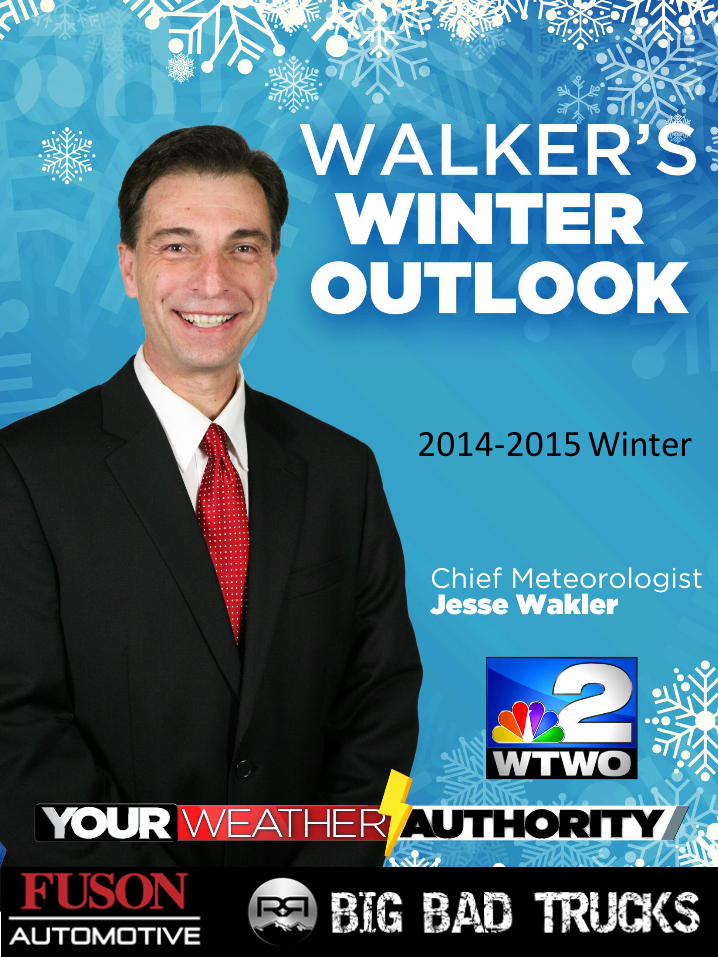
Walker's Winter Outlook 2014-2015: Follow Jesse all winter long as he grades himself on the upcoming winter.
Citation preview
2014-2015 Winter
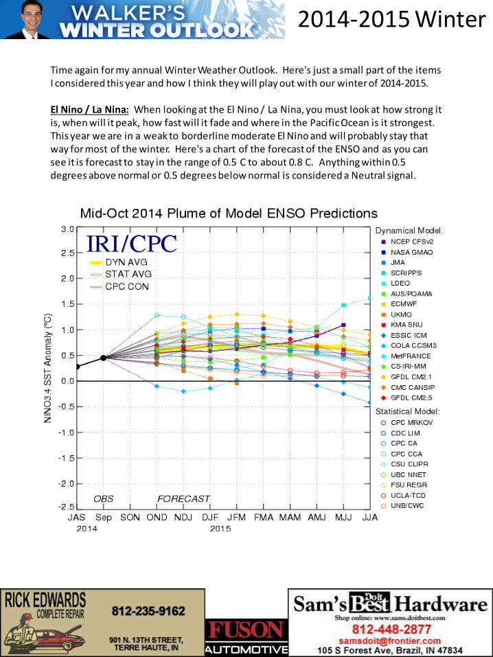
Time again for my annual Winter Weather Outlook. Here's just a small part of the items I considered this year and how I think they will play out with our winter of 2014-2015. El Nino / La Nina: When looking at the El Nino / La Nina, you must look at how strong it is, when will it peak, how fast will it fade and where in the Pacific Ocean is it strongest. This year we are in a weak to borderline moderate El Nino and will probably stay that way for most of the winter. Here's a chart of the forecast of the ENSO and as you can see it is forecast to stay in the range of 0.5 C to about 0.8 C. Anything within 0.5 degrees above normal or 0.5 degrees below normal is considered a Neutral signal.
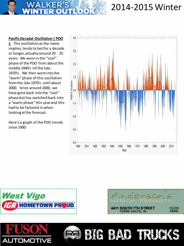
Pacific Decadal Oscillation ( PDO ): This oscillation as the name implies, tends to last for a decade or longer, actually around 20 - 25 years. We were in the "cool" phase of the PDO from about the middle 1940's till the late 1970's. We then went into the "warm" phase of this oscillation from the late 1970's until about 2000. Since around 2000, we have gone back into the "cool" phase but has switched back into a “warm phase" this year and this had to be factored in when looking at the forecast. Here's a graph of the PDO trends since 1900:
2014-2015 Winter
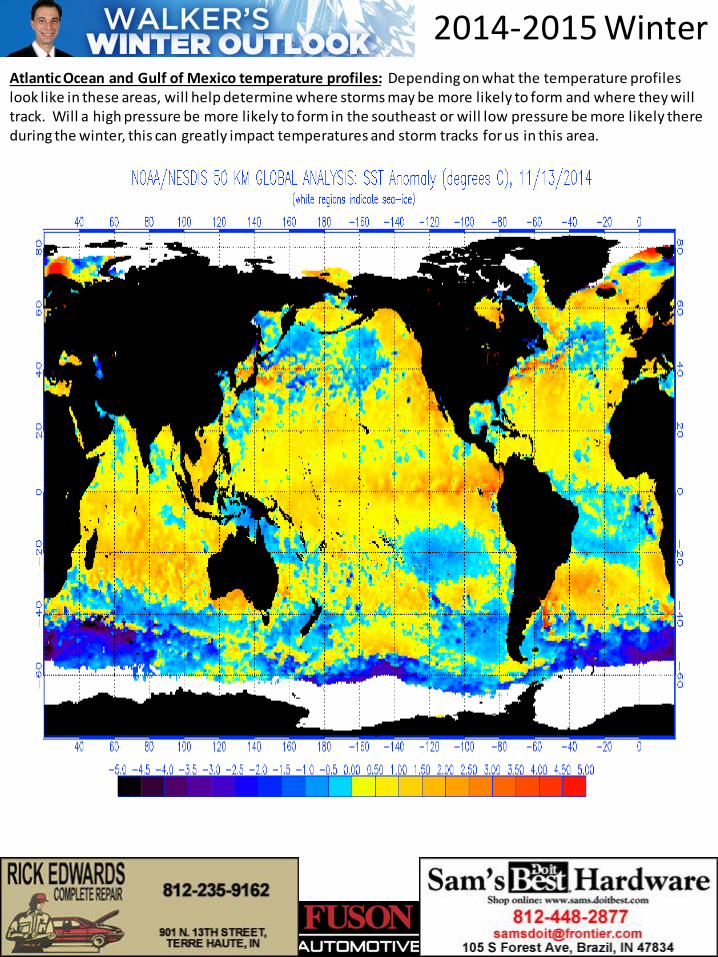
Atlantic Ocean and Gulf of Mexico temperature profiles: Depending on what the temperature profiles look like in these areas, will help determine where storms may be more likely to form and where they will track. Will a high pressure be more likely to form in the southeast or will low pressure be more likely there during the winter, this can greatly impact temperatures and storm tracks for us in this area.
2014-2015 Winter
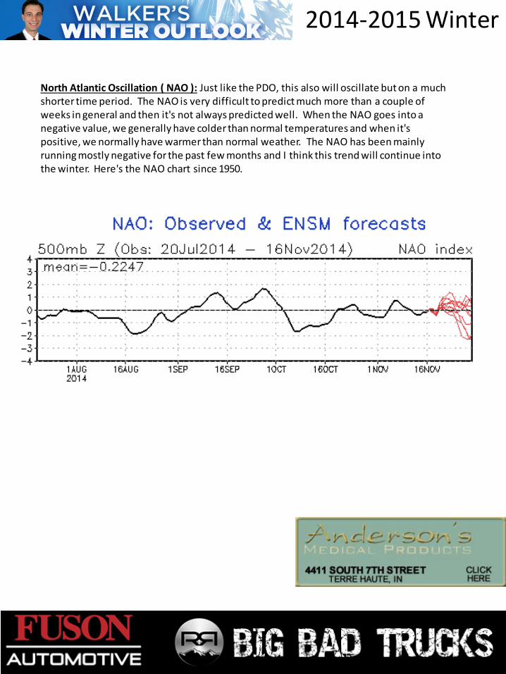
North Atlantic Oscillation ( NAO ): Just like the PDO, this also will oscillate but on a much shorter time period. The NAO is very difficult to predict much more than a couple of weeks in general and then it's not always predicted well. When the NAO goes into a negative value, we generally have colder than normal temperatures and when it's positive, we normally have warmer than normal weather. The NAO has been mainly running mostly negative for the past few months and I think this trend will continue into the winter. Here's the NAO chart since 1950.
2014-2015 Winter
2014-2015 Winter
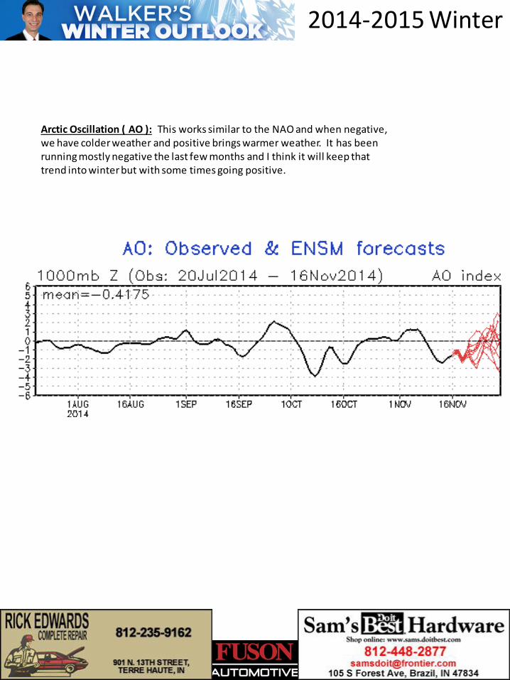
Arctic Oscillation ( AO ): This works similar to the NAO and when negative, we have colder weather and positive brings warmer weather. It has been running mostly negative the last few months and I think it will keep that trend into winter but with some times going positive.
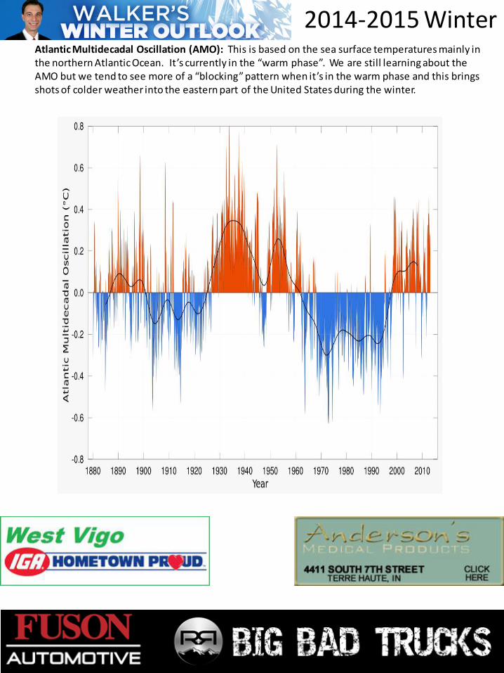
Atlantic Multidecadal Oscillation (AMO): This is based on the sea surface temperatures mainly in the northern Atlantic Ocean. It’s currently in the “warm phase”. We are still learning about the AMO but we tend to see more of a “blocking” pattern when it’s in the warm phase and this brings shots of colder weather into the eastern part of the United States during the winter.
2014-2015 Winter
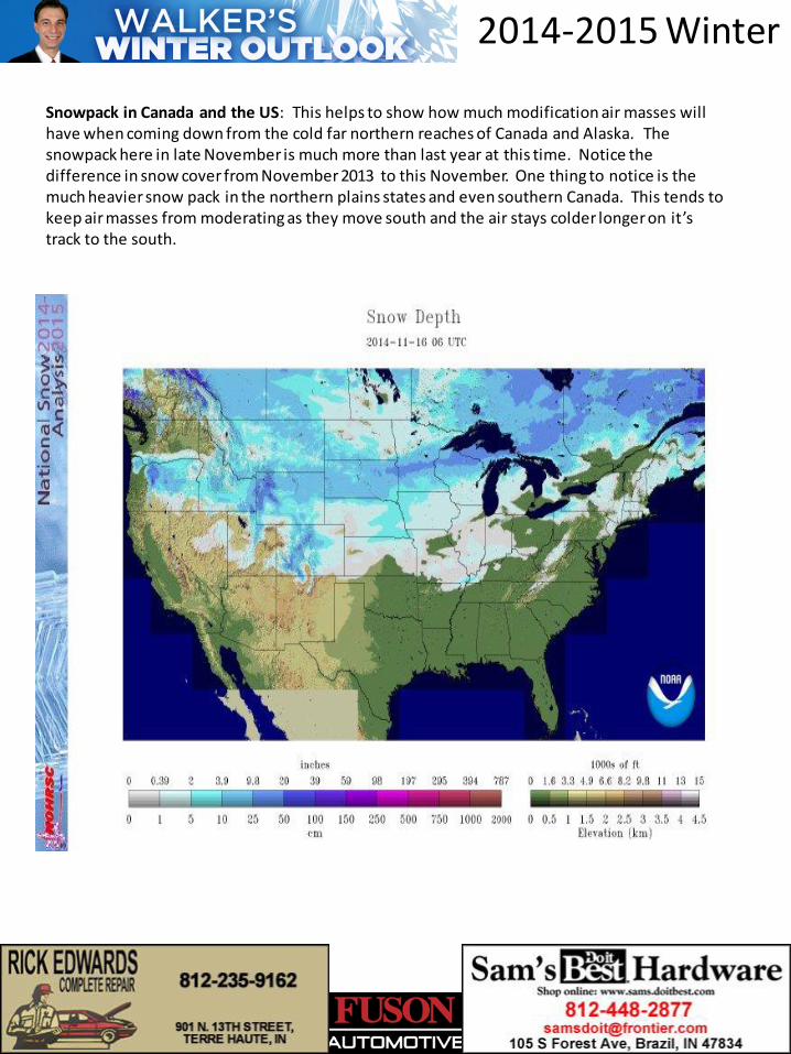
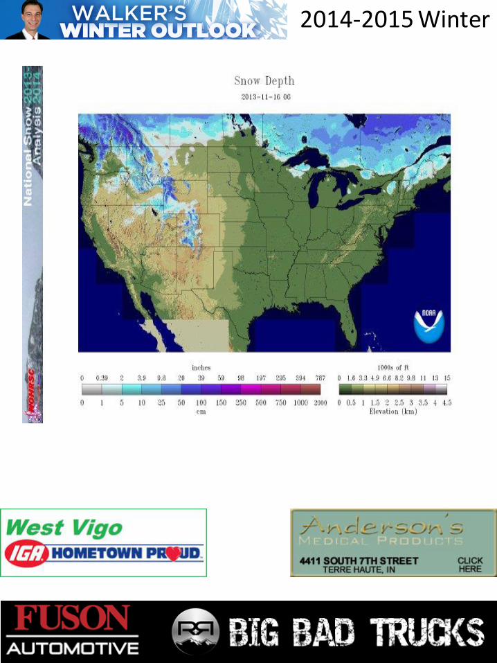
Snowpack in Canada and the US: This helps to show how much modification air masses will have when coming down from the cold far northern reaches of Canada and Alaska. The snowpack here in late November is much more than last year at this time. Notice the difference in snow cover from November 2013 to this November. One thing to notice is the much heavier snow pack in the northern plains states and even southern Canada. This tends to keep air masses from moderating as they move south and the air stays colder longer on it’s track to the south.
2014-2015 Winter
2014-2015 Winter
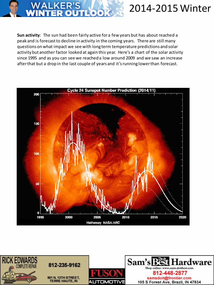
Sun activity: The sun had been fairly active for a few years but has about reached a peak and is forecast to decline in activity in the coming years. There are still many questions on what impact we see with long term temperature predictions and solar activity but another factor looked at again this year. Here's a chart of the solar activity since 1995 and as you can see we reached a low around 2009 and we saw an increase after that but a drop in the last couple of years and it’s running lower than forecast.
2014-2015 Winter
Fall trends: I look at how weather patterns in October and November from the past compare to this year and how past winters in those years turned out. Many times we find that a warm November brings a warmer than normal winter and a colder November will many times bring on a colder than normal winter and this November is on track to be one of the coldest on record. We can sometimes get a clue to the storm tracks we will see in the winter based on what happens in the Fall. After taking all those things into consideration along with a few others, I came up with what we call "analog years." These are years when things like El Nino, PDO, hurricane season, volcanic activity and so on are similar. I came up with the following analog years that I used: '76-’77, '77-’78, '86-'87' , '93-’94, '94-’95, '02-’03, '04-’05, ‘09-’10, '13-’14. Interesting that some of you may notice the first two analog years. Those were the two coldest winters on record for this area. So you probably know where I’m going with this forecast! I then give each analog year a weight value based on how close I think it is and come up with a formula to produce some numbers to be used in my winter outlook.
2014-2015 Winter
So after much work on it this year, here is my Winter Outlook. Walker's Winter Outlook 2014-2015 ------------------------------------------------------- 1. Not as bad as last winter 2. Overall still a pretty tough winter 3. Warmer start to December than November 4. December will be closest to normal on temperatures compared to Jan. and Feb. 5. There WILL be a white Christmas (at least 1“ of snow on the ground Christmas morning ) 6. Fewer windy days than last winter ( storm track farther away from us many times ) 7. Smaller temperature swings than last winter ( 79 degree swing last winter - 65 this year ) 8. Coldest part of winter will be the second half 9. Low chance of a major severe t-storm outbreak ( two last year ) 10. January BELOW normal temperatures 11. At least five sub zero days ( average is 4 ) 12. Could hit at least -10 this winter 13. Low chance of a major ice storm 14. Best big ice storm chances will stay south of here 15. At least 2 record or near record low temperature 16. A temperature lock ( staying above or below normal ) of at least 10 days in a row 17. February will have BELOW normal temperatures 18. Temperature will be BELOW normal Forecast is 28.0 Normal is 31.1 19. Precipitation will be BELOW normal Forecast is 7.88" Normal is 8.88“ 20. Snowfall will be ABOVE normal Forecast is 22.0“ Normal is 16.5" Need to print just this page: CLICK HERE
2014-2015 Winter