Embed Size (px)
Citation preview

AmpthillThe name ‘Ampthill’ is reputed to be of Anglo-Saxon origin from the first settlement called ‘Aemethyll’, which means either ‘ant-heap’ or ‘ant infested hill’.
The town has a large conservation area, part of which comprises Church Square with its historic almshouses, some of which date back to the 15th century.
Much of Ampthill’s unique charm can be credited to Lord Upper Ossory who reorganised the layout of the Market Square, built the charming thatched Ossory Cottages and erected Katherine’s Cross in Ampthill Park.
Church Street has a fine selection of historic buildings including Avenue House once home to Sir Albert Richardson, an eminent early 20th century architect, writer and past president of the Royal Academy.
The Parish Church of St. Andrew the Apostle, dates back to the 10th century and is especially notable for a marble memorial that commemorates the life of Colonel Richard Nicolls who was the man responsible for giving New York its name as its acclaimed first British Colonial Governor.
Ampthill ParkClose to the route, Ampthill Park can be traced back to 1086 when it was part of the manor of Ampthill. In the 15th century Ampthill Castle, a fortified stately home rather than a defensive castle, was built by Sir John Cornwall and in the early 16th century both the
castle and the park became royal property, bought by King Henry VIII so that he could enjoy ‘marvellous good health and cleanness of air’. Queen Catherine of Aragon lived at the castle from 1531 until the annulment of her marriage to King Henry VIII in 1553, when she moved to Kimbolton.
The castle fell in to disrepair and was reported as totally demolished in 1649. The site is now marked with Katherine’s Cross erected in 1770.
The park also received acclaim in 1982 when a site close to Katherine’s Cross was chosen as the location for the burial of the Golden Hare, a treasure to be discovered after solving clues hidden in the children’s book Masquerade by artist and author Kit Williams.
Much of the landscape of the park can be accredited to the skills of Capability Brown who was employed to transform the formal gardens of Park House to an open landscape.
Houghton HouseThis was completed in 1621 as a hunting lodge for the Countess of Pembroke and is alleged to be the inspiration for House Beautiful in John Bunyan’s ‘The Pilgrim’s Progress’. The property passed into the hands of the Bruce family as their main country seat, and was later sold to the Duke of Bedford. It was dismantled in 1794, and the Earl of Ossory acquired the park and the ruins in 1804.
Maulden The village is referred to in the Domesday Book as Meldone and there are various meanings given for the name including ‘cross on the hill’, ‘high down’ and ‘place of meeting’.
The Parish Church of St. Mary the VirginThe church stands high on the Greensand Ridge, a short distance from the village and with good views over the surrounding countryside. Though largely rebuilt in 1859, the base of the tower dates from the 14th century, and the oldest surviving part of the north wall of the church may date back even further to the mid 13th century. In the churchyard there is an impressive octagonal mausoleum and crypt known as the Ailesbury Mausoleum. It was built in 1656 by Thomas, Earl of Elgin, in memory of his second wife Diana. However, the crypt had been used for burials prior to that date and may have been used as a meeting place for worship before the reformation.
Maulden Wood The wood lies to the east of the village and is made up of 183 hectares of mixed woodland, with pine trees to the south and oak and ash on the northern side. The area is a Site of Special Scientific Interest (SSSI) due to the remnants of ancient woodland and its rare and unique insect species.
This walk will give you the opportunity to explore the historic market town of Ampthill and the surrounding countryside, as well as parts of the Greensand Ridge Walk, Central Bedfordshire’s premier long distance route.
lifestyles
Walk
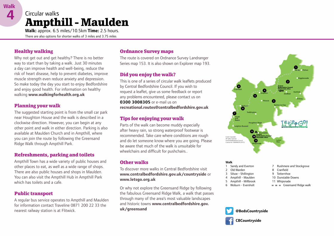
4 Circular walksAmpthill - MauldenWalk: approx. 6.5 miles/10.5km Time: 2.5 hours. There are also options for shorter walks of 3 miles and 3.75 miles
Crown Copyright. All rights reserved. Central Bedfordshire Council. Licence No 100049029 (2013)
11
10
9
8
6
5
4
3
2
1
7
Shefford
Walk1 Sandy and Everton 2 Old Warden3 Silsoe - Shillington4 Ampthill - Maulden5 Ampthill - Millbrook 6 Woburn - Eversholt
7 Rushmere and Stockgrove8 Cranfield9 Totternhoe10 Dunstable Downs11 Whipsnade Greensand Ridge walk
@BedsCountryside
CBCountryside
Walk
4 Circular walksAmpthill - MauldenWalk: approx. 6.5 miles/10.5km Time: 2.5 hours. There are also options for shorter walks of 3 miles and 3.75 miles
Healthy walkingWhy not get out and get healthy? There is no better way to start than by taking a walk. Just 30 minutes a day can improve health and well-being, reduce the risk of heart disease, help to prevent diabetes, improve muscle strength even reduce anxiety and depression. So make today the day you start to enjoy Bedfordshire and enjoy good health. For information on healthy walking www.walkingforhealth.org.uk
Planning your walkThe suggested starting point is from the small car park near Houghton House and the walk is described in a clockwise direction. However, you can begin at any other point and walk in either direction. Parking is also available at Maulden Church and in Ampthill, where you can join the route by following the Greensand Ridge Walk through Ampthill Park.
Refreshments, parking and toiletsAmpthill Town has a wide variety of public houses and other places to eat, as well as a wide range of shops. There are also public houses and shops in Maulden. You can also visit the Ampthill Hub in Ampthill Park which has toilets and a cafe.
Public transport A regular bus service operates to Ampthill and Maulden for information contact Traveline 0871 200 22 33 the nearest railway station is at Flitwick.
Ordnance Survey mapsThe route is covered on Ordnance Survey Landranger Series map 153. It is also shown on Explorer map 193.
Did you enjoy the walk? This is one of a series of circular walk leaflets produced by Central Bedfordshire Council. If you wish to request a leaflet, give us some feedback or report any problems encountered, please contact us on 0300 3008305 or e-mail us on [email protected]
Tips for enjoying your walkParts of the walk can become muddy especially after heavy rain, so strong waterproof footwear is recommended. Take care where conditions are rough and do let someone know where you are going. Please be aware that much of the walk is unsuitable for wheelchairs and difficult for pushchairs..
Other walksTo discover more walks in Central Bedfordshire visit www.centralbedfordshire.gov.uk/countryside or www.letsgo.org.uk
Or why not explore the Greensand Ridge by following the fabulous Greensand Ridge Walk, a walk that passes through many of the area’s most valuable landscapes and historic towns www.centralbedfordshire.gov.uk/greensand
Key
The walkFootpath
BridlewayGreensand Ridge Walk
Circular walks
Ampthill - Maulden Walk: approx. 6.5 miles/10.5km Time: 2.5 hours. There are also options for shorter walks of 3 miles and 3.75 miles
Countryside Code● Be safe – plan ahead and follow any signs ● Leave gates and property as you find them● Protect plants and animals, and take your litter home ● Consider other people
Maulden
Ampthill
Laurel Wood
Green EndFarm
KingsFarm
Green End
Russett’sPlantation
Lodge
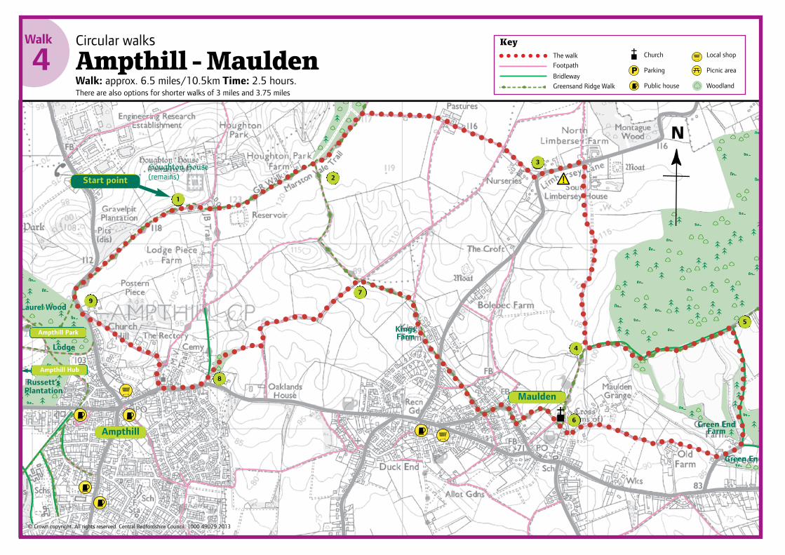
Start pointHoughton House(remains)
From the car park, follow the wide track for a short distancetowards Houghton House. Immediately past the cottages turn
right along the farm track, and follow the Greensand Ridge Walksignposts as far as a small pasture that leads to King’s Wood. For ashort walk of three miles, turn right at this point and follow the signsfor the Greensand Ridge walk, rejoining the main route at Point 8.
Follow the track to the right of the wood for about 300 metres,and turn right along the farm track, and past the farm at
Brickhill Pastures to Limbersey Lane. For a shorter walk of three andthree quarter miles, turn right past Brickhill Pastures and follow thefield boundary paths, rejoining the main route at Point 7.
Turn left, taking care as you walk along the lane, before takinga footpath on your right heading across a small pasture. At the
next kissing gate turn left, then almost immediately right along thegrass field track to another kissing gate and into a large pasturefollowing the hedge-line on the left.
At the next kissing gate head into the rough grass area knownas Church Fields, taking care to avoid the boggy areas to the
left. After a short distance, turn left through the kissing gate in thehedge-line. Follow the woodland path into Maulden Wood andcontinue on to the top of a rise, close to the Round House.
Turn right, away from the house, along the bridleway to GreenEnd. Turn right and follow the road until you reach a flight of
steps cut into the grass bank on the right. Head along the narrowpath between gardens, and then follow the grass path across ameadow heading to the right of Old Farm, following the fence-line.Beyond the buildings, follow the right hand hedge-line throughsome small pastures, and then down through the trees to an accessroad. Turn left along the road for about 50 metres, then turn rightinto the meadow heading towards the church.
Walk through the churchyard, keeping the church to your rightand following the surfaced path to the end gate. The path
continues on for a short distance, and then bears left until it reachesGeorge Street at a staggered barrier. Turn right and follow the roadround the corner and on to an "alleyway" between gardens. Crossthe road called The Brache "over a stile" and bear right across themeadow to a kissing gate in the left hand hedge-line and thenthrough a gate. Do not cross the next "gate", but instead walk alongthe farm track.
At the next farm gate, leave the Greensand Ridge Walk and turnleft across the field corner, following the left hedgeline. Keep to
the track along the field edges before turning right just before somebarns, and follow a path through a wooded area and down the hill toGas House Lane.
Turn left along Gas House Lane and then right into ChurchStreet (if you parked in Ampthill, continue along Church Street
to the town centre). At Rectory Lane turn right and follow the pathpast St Andrew’s Church until you reach the cottages in front of you.Turn left along Holly Walk, a narrow path lined with thick hollyhedges.
Carefully cross Bedford Street and turn right up the hill. At thetop, cross the road again and turn left, following the surfaced
track left, back to the Houghton House car park.
1
2
3
4
5
6
7
8
9
1
2
3
4
5
6
7
8
9
N
Church
Parking
Public house
Local shop
Picnic area
Woodland
© Crown copyright. All rights reserved. Central Bedfordshire Council. 1000 49029 2013
Ampthill Park
Ampthill Hub
Walk
4
Always keep you dog in sight and train it tocome back when called.Never let your dog chase wildlife or grazinganimals - it could get injured too.
Unless you’re already friends, keep you dogaway from other people and either dogs –not everyone loves your dog as much as you do!
Always clean up after your dog.Look out for horses, cyclists and runners –for everybody’s safety its best to put yourdog on a lead as they come by.Follow all local signs about grazing animals.
Please follow these tips to keep you and your dog safe:
RG005-13 Walk 4 Ampthill-Maulden map V1 CS2290_Layout 1 17/04/2015 10:11 Page 1
Walk
4Circular walksAmpthill - MauldenWalk: approx. 6.5 miles/10.5km Time: 2.5 hours. There are also options for shorter walks of 3 miles and 3.75 miles
KeyThe walkFootpath
BridlewayGreensand Ridge Walk
Circular walks
Ampthill - Maulden Walk: approx. 6.6 miles/10.7km Time: 2.5 hours. There are also options for shorter walks of 3 miles and 3.75 miles
Countryside Code� Be safe – plan ahead and follow any signs� Leave gates and property as you find them� Protect plants and animals, and take your litter
home� Keep dogs under close control� Consider other people
www.countrysideaccess.gov.uk
Dogs are welcome on all our sites and rights of way, but do keep them under control and awayfrom any grazing animals as well as other visitors.Please be a considerate owner and clean up if yourdog leaves a mess.
Maulden
Ampthill
Laurel Wood
Green EndFarm
KingsFarm
Green End
Russett’sPlantation
Lodge
Start pointHoughton House(remains)
From the car park, follow the wide track for a short distancetowards Houghton House. Immediately past the cottages turn
right along the farm track, and follow the Greensand Ridge Walksignposts as far as a small pasture that leads to King’s Wood. For ashort walk of three miles, turn right at this point and follow the signsfor the Greensand Ridge walk, rejoining the main route at Point 7.
Follow the track to the right of the wood for about 300 metres,and turn right along the farm track, and past the farm at
Brickhill Pastures to Limbersey Lane. For a shorter walk of three andthree quarter miles, turn right past Brickhill Pastures and follow thefield boundary paths, rejoining the main route at Point 7.
Turn left, taking care as you walk along the lane, before takinga footpath on your right heading across a small pasture. At the
next kissing gate turn left, then almost immediately right along thegrass field track to another kissing gate and into a large pasturefollowing the hedge-line on the left.
At the next kissing gate head into the rough grass area knownas Church Fields, taking care to avoid the boggy areas to the
left. After a short distance, turn left through the kissing gate in thehedge-line. Follow the woodland path into Maulden Wood andcontinue on to the top of a rise, close to the Round House.
Turn right, away from the house, along the bridleway to GreenEnd. Turn right and follow the road until you reach a flight of
steps cut into the grass bank on the right. Head along the narrowpath between gardens, and then follow the grass path across ameadow heading to the right of Old Farm, following the fence-line.Beyond the buildings, follow the right hand hedge-line throughsome small pastures, and then down through the trees to an accessroad. Turn left along the road for about 50 metres, then turn rightinto the meadow heading towards the church.
Walk through the churchyard, keeping the church to your rightand following the surfaced path to the end gate. The path
continues on for a short distance, and then bears left until it reachesGeorge Street at a staggered barrier. Turn right and follow the roadround the corner and on to an "alleyway" between gardens. Crossthe road called The Brache "over a stile" and bear right across themeadow to a kissing gate in the left hand hedge-line and thenthrough a gate. Do not cross the next "gate", but instead walk alongthe farm track.
At the next farm gate, leave the Greensand Ridge Walk and turnleft across the field corner, following the left hedgeline. Keep to
the track along the field edges before turning right just before somebarns, and follow a path through a wooded area and down the hill toGas House Lane.
Turn left along Gas House Lane and then right into ChurchStreet (if you parked in Ampthill, continue along Church Street
to the town centre). At Rectory Lane turn right and follow the pathpast St Andrew’s Church until you reach the cottages in front of you.Turn left along Holly Walk, a narrow path lined with thick hollyhedges.
Carefully cross Bedford Street and turn right up the hill. At thetop, cross the road again and turn left, following the surfaced
track left, back to the Houghton House car park.
1
2
3
4
5
6
7
8
9
1
2
3
4
5
6
7
8
9
N
Church
Parking
Public house
Local shop
Picnic area
Woodland
© Crown copyright. All rights reserved. Central Bedfordshire Council. 1000 49029 2013
Ampthill Park
Ampthill Hub
Walk
4

1 From the car park, follow the wide track for a short distance towards Houghton House. Immediately past the cottages turn right along the farm track, and follow the Greensand Ridge Walk signposts as far as a small pasture that leads to King’s Wood. For a short walk of three miles, turn right at this point and follow the signs for the Greensand Ridge walk, rejoining the main route at Point 7.
2 Follow the track to the right of the wood for about 300 metres, and turn right along the farm track, and past the farm at Brickhill Pastures to Limbersey Lane. For a shorter walk of three and three quarter miles, turn right past Brickhill Pastures and follow the field boundary paths, rejoining the main route at Point 7.
3 Turn left, taking care as you walk along the lane, before taking a footpath on your right heading across a small pasture. At the next kissing gate turn left, then almost immediately right along the grass field track to another kissing gate and into a large pasture following the hedge-line on the left.
4 At the next kissing gate head into the rough grass area known as Church Fields, taking care to avoid the boggy areas to the left. After a short distance, turn left through the kissing
gate in the hedge-line. Follow the woodland path into Maulden Wood and continue on to the top of a rise, close to the Round House.
5 Turn right, away from the house, along the bridleway to Green End. Turn right and follow the road until you reach a flight of steps cut into the grass bank on the right. Head along the narrow path between gardens, and then follow the grass path across a meadow heading to the right of Old Farm, following the fence-line. Beyond the buildings, follow the right hand hedge-line through some small pastures, and then down through the trees to an access road. Turn left along the road for about 50 metres, then turn right into the meadow heading towards the church.
6 Walk through the churchyard, keeping the church to your right and following the surfaced path to the end gate. The path continues on for a short distance, and then bears left until it reaches George Street at a staggered barrier. Turn right and follow the road round the corner and on to an “alleyway” between gardens. Cross the road called The Brache “over a stile” and bear right across the meadow to a kissing gate in the left hand hedge-line and then through a gate. Do not cross the next “gate”, but instead walk along the farm track.
7 At the next farm gate, leave the Greensand Ridge Walk and turn left across the field corner, following the left hedgeline. Keep to the track along the field edges before turning right just before some barns, and follow a path through a wooded area and down the hill to Gas House Lane.
8 Turn left along Gas House Lane and then right into Church Street (if you parked in Ampthill, continue along Church Street to the town centre). At Rectory Lane turn right and follow the path past St Andrew’s Church until you reach the cottages in front of you. Turn left along Holly Walk, a narrow path lined with thick holly hedge.
9 Carefully cross Bedford Street and turn right up the hill. At the top, cross the road again and turn left, following the surfaced track left, back to the Houghton House car park.
Walk
4 Circular walksAmpthill - MauldenWalk: approx. 6.5 miles/10.5km Time: 2.5 hours. There are also options for shorter walks of 3 miles and 3.75 miles
Countryside code l Be safe – plan ahead and follow any signsl Leave gates and property as you find theml Protect plants and animals, and take your litter home
l Keep dogs under close controll Consider other people.
Always keep you dog in sight and train it to come back when called.
Never let your dog chase wildlife or grazing animals – it could get injured too.
Unless you’re already friends, keep you dog away from other people and either
dogs – not everyone loves your dog as much as you do!
Always clean up after your dog.
Look out for horses, cyclists and runners – for everybody’s safety its best to put
your dog on a lead as they come by.
Follow all local signs about grazing animals.
Please follow these tips to keep you and your dog safe: