Embed Size (px)
Citation preview
An Investigation of 2013 Mw 7.7 Awaran Earthquake, Pakistan
Irfan Mahmood1, a *, Muhammad Farooq Iqbal1, b, Muhammad Rizwan Mughal1, c, Muhammad Imran Shahzad1, d,
Shahina Tariq 1, e, Kalim Ullah1, f
1COMSATS Institute of Information Technology, Islamabad, Pakistan
*a [email protected], b [email protected], c [email protected], d [email protected],
e [email protected], f [email protected]
Keywords: Awaran earthquake, Hoshab fault, Makran Subduction Zone, Strike-slip movement, Chaman fault, Seismic hazard
Abstract. Earthquake is a major disaster responsible for vast losses both life and infrastructure.
Pakistan is one of the highly earthquake prone areas in Asia. The present study is carried out to
investigate the dynamics of disastrous Awaran earthquake. The 2013 Mw 7.7 Awaran earthquake
and its Mw 6.8 aftershock caused numerous loss of lives and vast infrastructure damages. The
earthquake triggered along Hoshab fault rupturing 230 km of the fault. The rupture propagated at
3 Km/s on average and was concentrated in top 10 km with no major displacement in the
underlying decollement. The rupture released a cumulative moment of 5.4 x 10²⁰ Nm. This study
reveals that although Hoshab fault originated as thrust fault, the slip was purely strike slip during
the earthquake and that the rigid block rotation of southeastern Makran is responsible for the
Awaran earthquake. The study concludes that the earthquake significantly increased the coulomb
stress on Makran mega thrust and strike slip faults in Chaman fault system, hence increasing the
risk of a major seismic event. Therefore, in order to prevent major loss of lives and infrastructure
damages; designing of new building codes, reassessing the seismic hazard of the region and
marking of hidden faults is of utmost importance.
1. Introduction
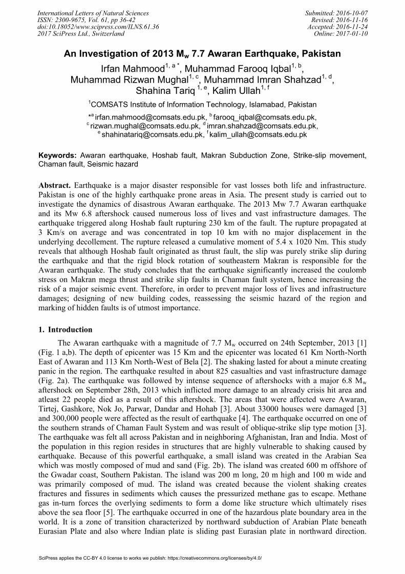
The Awaran earthquake with a magnitude of 7.7 Mw occurred on 24th September, 2013 [1]
(Fig. 1 a,b). The depth of epicenter was 15 Km and the epicenter was located 61 Km North-North
East of Awaran and 113 Km North-West of Bela [2]. The shaking lasted for about a minute creating
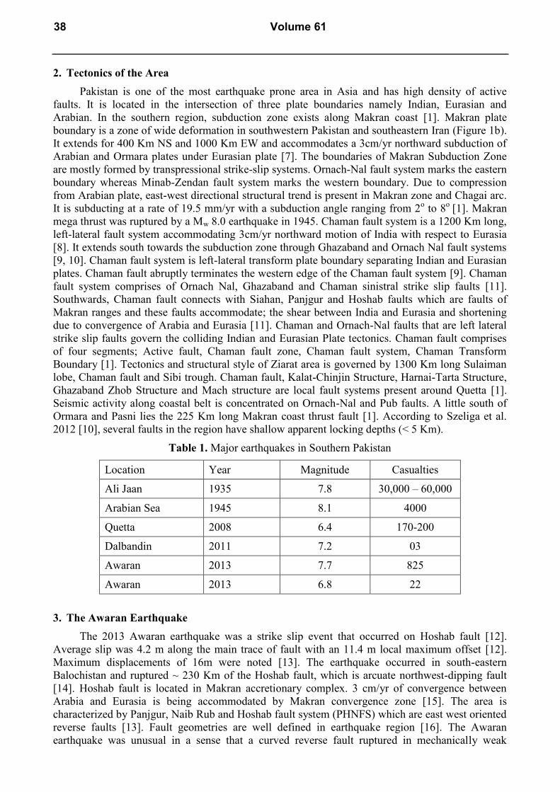
panic in the region. The earthquake resulted in about 825 casualties and vast infrastructure damage
(Fig. 2a). The earthquake was followed by intense sequence of aftershocks with a major 6.8 Mw
aftershock on September 28th, 2013 which inflicted more damage to an already crisis hit area and
atleast 22 people died as a result of this aftershock. The areas that were affected were Awaran,
Tirtej, Gashkore, Nok Jo, Parwar, Dandar and Hohab [3]. About 33000 houses were damaged [3]
and 300,000 people were affected as the result of earthquake [4]. The earthquake occurred on one of
the southern strands of Chaman Fault System and was result of oblique-strike slip type motion [3].
The earthquake was felt all across Pakistan and in neighboring Afghanistan, Iran and India. Most of
the population in this region resides in structures that are highly vulnerable to shaking caused by
earthquake. Because of this powerful earthquake, a small island was created in the Arabian Sea
which was mostly composed of mud and sand (Fig. 2b). The island was created 600 m offshore of
the Gwadar coast, Southern Pakistan. The island was 200 m long, 20 m high and 100 m wide and
was primarily composed of mud. The island was created because the violent shaking creates
fractures and fissures in sediments which causes the pressurized methane gas to escape. Methane
gas in-turn forces the overlying sediments to form a dome like structure which ultimately rises
above the sea floor [5]. The earthquake occurred in one of the hazardous plate boundary area in the
world. It is a zone of transition characterized by northward subduction of Arabian Plate beneath
Eurasian Plate and also where Indian plate is sliding past Eurasian plate in northward direction.
International Letters of Natural Sciences Submitted: 2016-10-07ISSN: 2300-9675, Vol. 61, pp 36-42 Revised: 2016-11-16doi:10.18052/www.scipress.com/ILNS.61.36 Accepted: 2016-11-242017 SciPress Ltd., Switzerland Online: 2017-01-10
SciPress applies the CC-BY 4.0 license to works we publish: https://creativecommons.org/licenses/by/4.0/
Many major earthquakes have occurred in this region inflicting widespread damage (Table 1). The
largest recorded event in the region is the Mw 8.1, 1945 Makran earthquake that generated a
significant Tsunami. The event ruptured the subduction mega thrust. The second most significant
event was Mw 7.5 Quetta earthquake that occurred on the Ghazaband fault. This study focuses on
the review of Awaran earthquake dynamics.
Figure 1a. Tectonic Map of Balochistan, Pakistan. Black circle represents location of Awaran
Earthquake
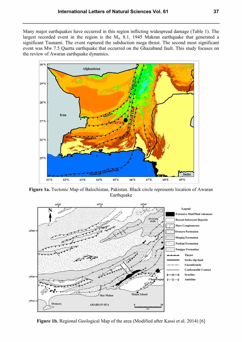
Figure 1b. Regional Geological Map of the area (Modified after Kassi et al. 2014) [6]
International Letters of Natural Sciences Vol. 61 37
2. Tectonics of the Area
Pakistan is one of the most earthquake prone area in Asia and has high density of active
faults. It is located in the intersection of three plate boundaries namely Indian, Eurasian and
Arabian. In the southern region, subduction zone exists along Makran coast [1]. Makran plate
boundary is a zone of wide deformation in southwestern Pakistan and southeastern Iran (Figure 1b).
It extends for 400 Km NS and 1000 Km EW and accommodates a 3cm/yr northward subduction of
Arabian and Ormara plates under Eurasian plate [7]. The boundaries of Makran Subduction Zone
are mostly formed by transpressional strike-slip systems. Ornach-Nal fault system marks the eastern
boundary whereas Minab-Zendan fault system marks the western boundary. Due to compression
from Arabian plate, east-west directional structural trend is present in Makran zone and Chagai arc.
It is subducting at a rate of 19.5 mm/yr with a subduction angle ranging from 2o to 8
o [1]. Makran
mega thrust was ruptured by a Mw 8.0 earthquake in 1945. Chaman fault system is a 1200 Km long,
left-lateral fault system accommodating 3cm/yr northward motion of India with respect to Eurasia
[8]. It extends south towards the subduction zone through Ghazaband and Ornach Nal fault systems
[9, 10]. Chaman fault system is left-lateral transform plate boundary separating Indian and Eurasian
plates. Chaman fault abruptly terminates the western edge of the Chaman fault system [9]. Chaman
fault system comprises of Ornach Nal, Ghazaband and Chaman sinistral strike slip faults [11].
Southwards, Chaman fault connects with Siahan, Panjgur and Hoshab faults which are faults of
Makran ranges and these faults accommodate; the shear between India and Eurasia and shortening
due to convergence of Arabia and Eurasia [11]. Chaman and Ornach-Nal faults that are left lateral
strike slip faults govern the colliding Indian and Eurasian Plate tectonics. Chaman fault comprises
of four segments; Active fault, Chaman fault zone, Chaman fault system, Chaman Transform
Boundary [1]. Tectonics and structural style of Ziarat area is governed by 1300 Km long Sulaiman
lobe, Chaman fault and Sibi trough. Chaman fault, Kalat-Chinjin Structure, Harnai-Tarta Structure,
Ghazaband Zhob Structure and Mach structure are local fault systems present around Quetta [1].
Seismic activity along coastal belt is concentrated on Ornach-Nal and Pub faults. A little south of
Ormara and Pasni lies the 225 Km long Makran coast thrust fault [1]. According to Szeliga et al.
2012 [10], several faults in the region have shallow apparent locking depths (< 5 Km).
Table 1. Major earthquakes in Southern Pakistan
Location Year Magnitude Casualties
Ali Jaan 1935 7.8 30,000 – 60,000
Arabian Sea 1945 8.1 4000
Quetta 2008 6.4 170-200
Dalbandin 2011 7.2 03
Awaran 2013 7.7 825
Awaran 2013 6.8 22
3. The Awaran Earthquake
The 2013 Awaran earthquake was a strike slip event that occurred on Hoshab fault [12].
Average slip was 4.2 m along the main trace of fault with an 11.4 m local maximum offset [12].
Maximum displacements of 16m were noted [13]. The earthquake occurred in south-eastern
Balochistan and ruptured ~ 230 Km of the Hoshab fault, which is arcuate northwest-dipping fault
[14]. Hoshab fault is located in Makran accretionary complex. 3 cm/yr of convergence between
Arabia and Eurasia is being accommodated by Makran convergence zone [15]. The area is
characterized by Panjgur, Naib Rub and Hoshab fault system (PHNFS) which are east west oriented
reverse faults [13]. Fault geometries are well defined in earthquake region [16]. The Awaran
earthquake was unusual in a sense that a curved reverse fault ruptured in mechanically weak
38 Volume 61
Makran Accretionary Prism. World View 2 high-resolution satellite imagery analysis also confirms
a left-lateral surface rupture. Arcuate rupture corresponding to slip along the Hoshab fault was also
confirmed using Landsat-8 imageries [13]. A portion of the accretionary prism where the slab is
only 20 Km deep was also ruptured thereby suggesting that almost no crystalline crust ruptured in
the earthquake. The earthquake ruptured a structurally segmented fault and involved a ~ 6:1 strike-
slip to dip-slip ratio [14]. The rupture was associated to shallow depths from 0-7 Km. Most of
energy (almost 80%) was released on south side of hypocenter whereas there is reduced slip in the
north. Slower rupture propagation towards the north side is also confirmed by Teleseismic Inversion
results [13]. The rupture released a cumulative moment of 5.4 x 10²⁰
Nm hence corresponding to a
Mw 7.75. It begins on a 70o westward dipping fault and then propagated to the 40
o northwestward
dipping fault segments to the southwest. The study confirms that during the seismic phase,
measured slip occurred excluding the possibility of afterslip following the earthquake. The study
also shows non-double couple moment. [17] (Fig. 3).
According to Jolivet et al. 2014 [8], the 2013 rupture was majorly left-lateral strike slip
and involves a minor oblique reverse motion. The majority of slip occurred at shallow depths of
< ~ 10 Km. Large Mw > 7 upper plate earthquakes have not been observed in the region before. The
earthquake was triggered on a 45o dipping fault plane and depicts strike-slip movement. These
faults, which are regional and moderate angle, initially originated as thrust faults but now depicts
near horizontal slip [18]. According to Avouac et al. 2014 [17] and Barnhart et al. 2015 [14], there
is a switch between thrust and strike slip faulting in the kinematics of Hoshab fault slip during
successive earthquake cycles and that the fault ruptured in left lateral motion for 200+ Km and it
dips between 47o & 73
o to the northwest. Studies by Zhou et al. 2015 [12] suggests that the failure
is not solely constrained to Hoshab fault but occurs in a distributed fashion thus providing an
explanation to lack of seismicity previously and also to long repeat times. Younger and thicker
sediments have more off-fault deformation [15]. Both reverse slip and strike slip deformation in
rupture area was depicted by Quaternary geomorphic indicators. Arcuate geometry of Hoshab fault
along with weak friction of Makran Accretionary Prism and time variable loading condition from
plate interactions and adjacent earthquakes are responsible for the quaternary bimodal slip along the
Hoshab fault [14]. Barnhart et al. 2015 [14] derived horizontal surface displacement fields by
applying sub-pixel correlation to high-resolution optical imagery. The results showed that two
structurally dissimilar sections of the Hoshab fault were ruptured due to the 2013 event.
Geomorphic indicators express that the strike-slip fault trace geomorphology is pre-dominant along
the northern sections, reverse-displacement along the southern section and reverse-type to strike-
slip morphologies in center of rupture. The study expresses that variable slip with strike-slip
motion, dip-slip motion or through going rupture may occur in individual sections of Hoshab fault
as was the case in 2013 event. This study signifies that in the upper plate of Makran Subduction
Zone bimodal slip might have accommodated strain portioning on a single fault. The 2013 surface
rupture does not extend onto adjacent en-echelon faults but is rather restricted to single continuous
trace [14].
Figure 2. 2013 Mw 7.7 Awaran Earthquake. (a) Aerial view of destruction in Awaran area.
(b) View of Island created due to Awaran earthquake [1]
International Letters of Natural Sciences Vol. 61 39
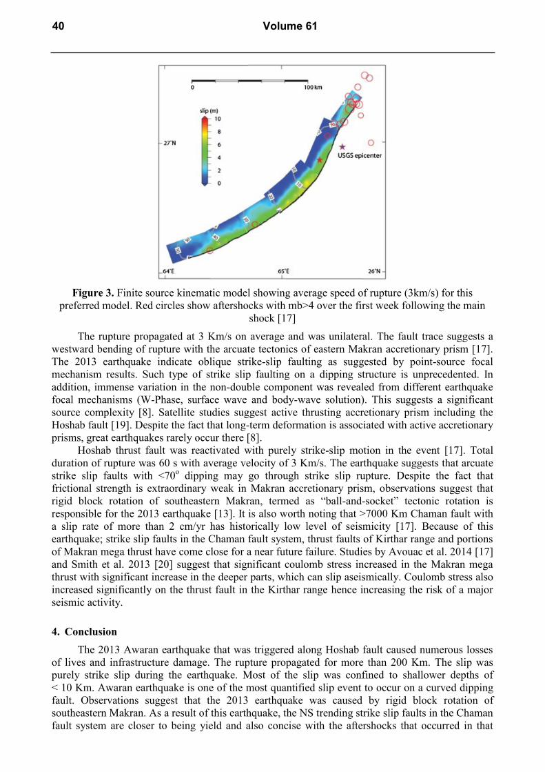
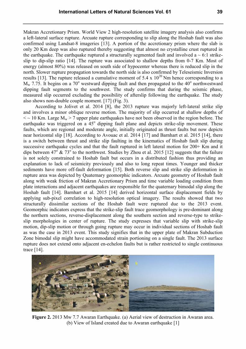
Figure 3. Finite source kinematic model showing average speed of rupture (3km/s) for this
preferred model. Red circles show aftershocks with mb>4 over the first week following the main
shock [17]
The rupture propagated at 3 Km/s on average and was unilateral. The fault trace suggests a
westward bending of rupture with the arcuate tectonics of eastern Makran accretionary prism [17].
The 2013 earthquake indicate oblique strike-slip faulting as suggested by point-source focal
mechanism results. Such type of strike slip faulting on a dipping structure is unprecedented. In
addition, immense variation in the non-double component was revealed from different earthquake
focal mechanisms (W-Phase, surface wave and body-wave solution). This suggests a significant
source complexity [8]. Satellite studies suggest active thrusting accretionary prism including the
Hoshab fault [19]. Despite the fact that long-term deformation is associated with active accretionary
prisms, great earthquakes rarely occur there [8].
Hoshab thrust fault was reactivated with purely strike-slip motion in the event [17]. Total
duration of rupture was 60 s with average velocity of 3 Km/s. The earthquake suggests that arcuate
strike slip faults with <70o dipping may go through strike slip rupture. Despite the fact that
frictional strength is extraordinary weak in Makran accretionary prism, observations suggest that
rigid block rotation of southeastern Makran, termed as “ball-and-socket” tectonic rotation is
responsible for the 2013 earthquake [13]. It is also worth noting that >7000 Km Chaman fault with
a slip rate of more than 2 cm/yr has historically low level of seismicity [17]. Because of this
earthquake; strike slip faults in the Chaman fault system, thrust faults of Kirthar range and portions
of Makran mega thrust have come close for a near future failure. Studies by Avouac et al. 2014 [17]
and Smith et al. 2013 [20] suggest that significant coulomb stress increased in the Makran mega
thrust with significant increase in the deeper parts, which can slip aseismically. Coulomb stress also
increased significantly on the thrust fault in the Kirthar range hence increasing the risk of a major
seismic activity.
4. Conclusion
The 2013 Awaran earthquake that was triggered along Hoshab fault caused numerous losses
of lives and infrastructure damage. The rupture propagated for more than 200 Km. The slip was
purely strike slip during the earthquake. Most of the slip was confined to shallower depths of
< 10 Km. Awaran earthquake is one of the most quantified slip event to occur on a curved dipping
fault. Observations suggest that the 2013 earthquake was caused by rigid block rotation of
southeastern Makran. As a result of this earthquake, the NS trending strike slip faults in the Chaman
fault system are closer to being yield and also concise with the aftershocks that occurred in that
40 Volume 61
area. Therefore, there is a strong probability of a major seismic event in the Chaman fault system
that can be devastating. It is very important; to reassess the seismic hazard of the region, designing
of new building codes and marking of hidden faults, in order to prevent future loss of life and
damages to infrastructure.
Acknowledgement
We are thankful to our colleagues at COMSATS Institute of Information Technology, who were
very supportive throughout the writing of this paper.
References
[1] I. Mahmood et al., Revisiting major earthquakes in Pakistan, Geology Today. 31 (2015) 33–
38.
[2] USGS Report, Information on http://earthquake.usgs.gov/earthquakes/eventpage/usb-
000jyiv#general_summary [accessed 15 July, 2016]
[3] NDMA Report, Awaran Earthquake Balochistan, 2013.
[4] Information on http://www.redcross.org.hk/en/disaster-
relief_prepard/appeal_update_detail.html?year=2013&id=1694 [accessed 15 July, 2016].
[5] A. Kumar, Balochistan Earthquake of September, 2013 and birth of islands off the Makran
Coast of southern Pakistan, Earth Science India. Popular Issue, VII(I) (2014) 1-12.
[6] A.M. Kassi et al., Newly discovered mud volcanoes in the Coastal Belt of Makran, Pakistan –
tectonic implications, Arabian Journal of Geosciences. 7(11) (2014) 4899-4909.
[7] R. Reilinger et al., GPS constraints on continental deformation in the Africa‐Arabia‐Eurasia
continental collision zone and implications for the dynamics of plate interactions, Journal of
Geophysical Research: Solid Earth. 111(B5) (2006).
[8] R. Jolivet et al., The 2013 Mw7.7 Balochistan earthquake: Seismic potential of an
accretionary wedge, Bulletin of the Seismological Society of America. 104(2) (2014) 1020-
1030.
[9] N. Ambraseys, R. Bilham, Earthquakes and associated deformation in northern Baluchistan
1892-2001, Bulletin of the Seismological Society of America. 93(4) (2003) 1573-1605.
[10] W.R. Szeliga et al., Interseismic strain accumulation along the western boundary of the Indian
subcontinent, Journal of Geophysical Research: Solid Earth. 117(B8) (2012).
[11] H. Fattahi et al., Coseismic and postseismic deformation due to the 2007 M5. 5 Ghazaband
fault earthquake, Balochistan, Pakistan, Geophysical Research Letters. 42(9) (2015) 3305-
3312.
[12] Y. Zhou et al., The 2013 Balochistan earthquake: An extraordinary or completely ordinary
event?, Geophysical Research Letters. 42(15) (2015) 6236-6243.
[13] W.D. Barnhart et al., Evidence for slip partitioning and bimodal slip behavior on a single
fault: Surface slip characteristics of the 2013 Mw7.7 Balochistan, Pakistan earthquake, Earth
and Planetary Science Letters. 420 (2015) 1-11.
[14] W.D. Barnhart et al., Ball-and-socket tectonic rotation during the 2013 Mw7.7 Balochistan
earthquake, Earth and Planetary Science Letters. 403 (2014) 210-216.
[15] R. Zinke, J. Hollingsworth, J.F. Dolan, Surface slip and off‐fault deformation patterns in the
2013 MW 7.7 Balochistan, Pakistan earthquake: Implications for controls on the distribution
of near‐surface coseismic slip, Geochemistry, Geophysics, Geosystems. 15(12) (2014) 5034-
5050.
International Letters of Natural Sciences Vol. 61 41

[16] A. Van Horne et al., Strike-slip earthquakes on moderately-dipping faults, In: EGU General
Assembly Conference Abstracts. 16 (2014) 4547.
[17] J.P. Avouac et al., The 2013, Mw7.7 Balochistan earthquake, energetic strike-slip reactivation
of a thrust fault, Earth and Planetary Science Letters. 391 (2014) 128-134.
[18] R.D. Lawrence et al., Thrust and strike slip fault interaction along the Chaman transform
zone, Pakistan, Geological Society, London, Special Publications. 9(1) (1981) 363–370.
[19] N. Haghipour et al., Rate of crustal shortening and non-Coulomb behaviour of an active
accretionary wedge: The folded fluvial terraces in Makran (SE, Iran), Earth and Planetary
Science Letters. 355 (2012) 187-198.
[20] G.L. Smith et al., Thermal structure and megathrust seismogenic potential of the Makran
subduction zone, Geophysical Research Letters. 40(8) (2013) 1528-1533.
42 Volume 61