Embed Size (px)
Citation preview
Chapter 3.7 Read- Pattillo Elementary School New Smyrna Beach, FL
Volusia County MPO
November 2008
Volusia County MPO School Bicycle and Pedestrian Review Study, Phase 3B
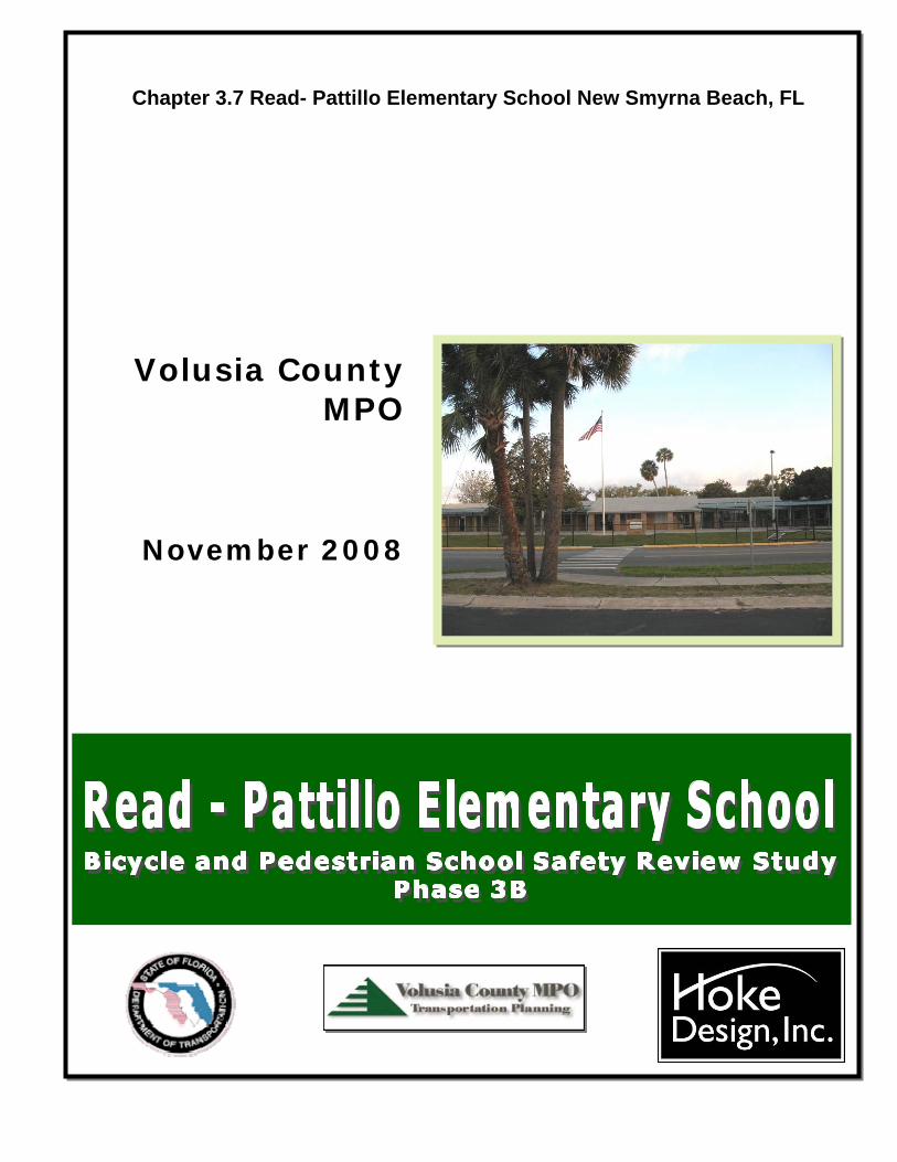
School Summary Read - Pattillo Elementary School is located along U.S. Hwy. 1 in the City of New Smyrna Beach. The designated walk zone for this school extends north to Chisholm Elementary School, resulting in the need for some students to travel long distances and cross the railroad and U.S. Hwy. 1. Of the 485 students attending this school, 104 live within the designated walk zone area. During the 2007/2008 school year, approximately fifteen of these students walked or rode bicycles to school. Some students who live near Chisholm Elementary School have variances to attend Read-Pattillo Elementary. Read – Pattillo Elementary School includes a student drop-off/pick-up area along the north side of the 6th Street right of way and a second drop-off/pick-up area near the school. Due to limited space for queuing, many parents park in the shopping center located south of the school and cross 6th Street with their children at various locations to reach the school. At the time of this Study, there were no crossing guards serving Read - Pattillo Elementary School. A guard designated for Chisholm Elementary School may assist some Read-Pattillo students crossing U.S. Hwy. 1. No reported bicycle or pedestrian crashes during estimated school travel times and involving elementary school age children have been reported within the walk zone during the last three years. Due to hazardous conditions from the railroad and US Hwy. 1, students living south of S.R. 44 and west of the railroad are provided bus transportation. This Study does not recommend a specific Priority Project but includes several sidewalk sections that will provide sidewalk continuity within the walk zone area.
Figure 3.7.1
Chapter 3.7 Page 1
Read - Pattillo Elementary School
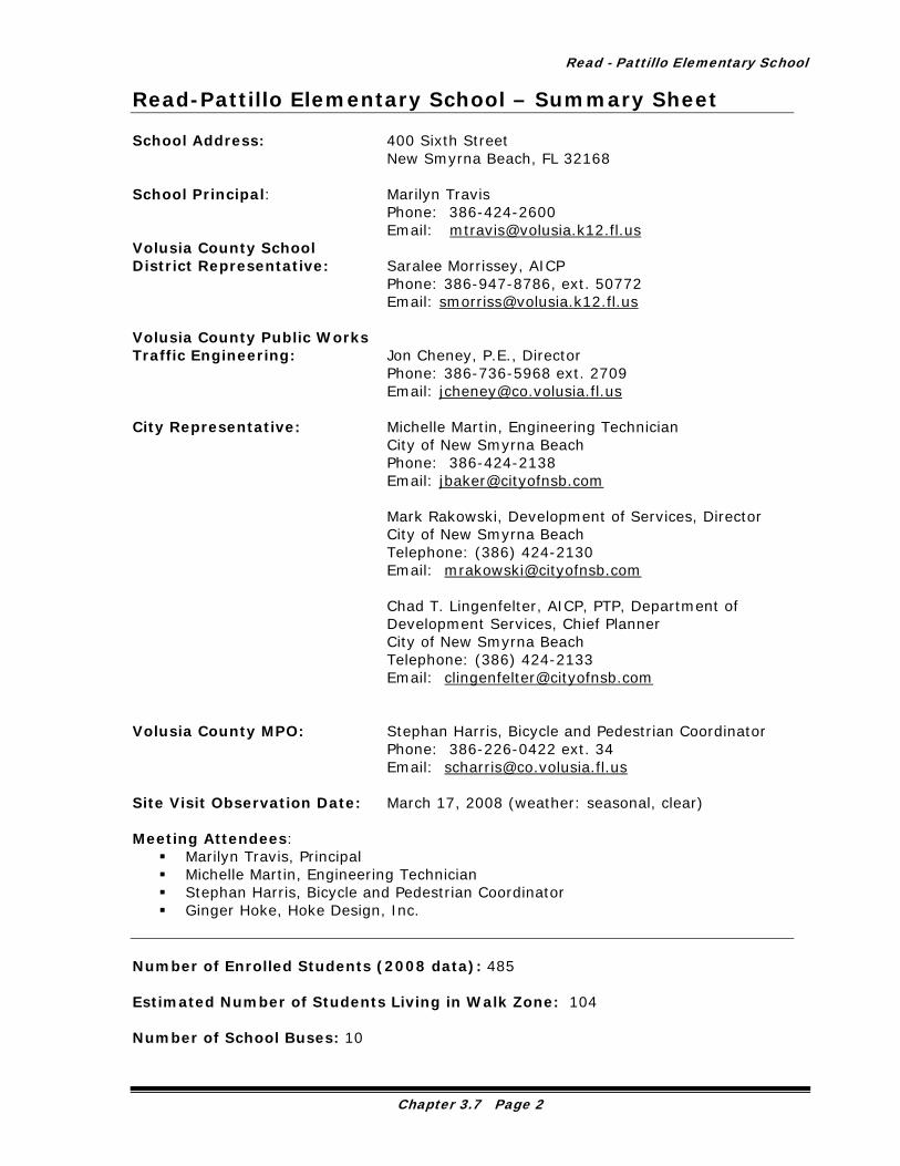
Read-Pattillo Elementary School – Summary Sheet School Address: 400 Sixth Street
New Smyrna Beach, FL 32168 School Principal: Marilyn Travis
Phone: 386-424-2600 Email: [email protected]
Volusia County School District Representative: Saralee Morrissey, AICP Phone: 386-947-8786, ext. 50772 Email: [email protected] Volusia County Public Works Traffic Engineering: Jon Cheney, P.E., Director Phone: 386-736-5968 ext. 2709 Email: [email protected] City Representative: Michelle Martin, Engineering Technician
City of New Smyrna Beach Phone: 386-424-2138 Email: [email protected]
Mark Rakowski, Development of Services, Director City of New Smyrna Beach Telephone: (386) 424-2130 Email: [email protected] Chad T. Lingenfelter, AICP, PTP, Department of Development Services, Chief Planner City of New Smyrna Beach Telephone: (386) 424-2133 Email: [email protected]
Volusia County MPO: Stephan Harris, Bicycle and Pedestrian Coordinator Phone: 386-226-0422 ext. 34 Email: [email protected] Site Visit Observation Date: March 17, 2008 (weather: seasonal, clear) Meeting Attendees:
Marilyn Travis, Principal Michelle Martin, Engineering Technician Stephan Harris, Bicycle and Pedestrian Coordinator Ginger Hoke, Hoke Design, Inc.
Number of Enrolled Students (2008 data): 485 Estimated Number of Students Living in Walk Zone: 104 Number of School Buses: 10
Chapter 3.7 Page 2
Volusia County MPO School Bicycle and Pedestrian Review Study, Phase 3B
Number of Aftercare Buses/Vans: 1 (YMCA) Estimated Number of Walkers/Bicycle Riders: 10-15 Number of Bicycles on Site: 2 Number of Helmets on Site (stored with bicycle): 1 Estimated Number of Students Attending Breakfast: 200 Number of Students for School Site Aftercare: 81 Teachers Assisting in Arrival and Dismissal Safety: Arrival: 9 Dismissal: 5 Title One School: Yes (62%) Backpack Policy: No rolling backpacks allowed Summary of Principal Comments:
Would like the rear access to the school from Palmetto Street to be paved Would like signage along 6th Street indicating “no left turn” onto U.S. Hwy. 1
Number of Bicycle and Pedestrian Crash Events within the Existing Walk Zone (elementary age, during estimated school travel times, 2005-2007): 0 Planned Road, Sidewalk, or other Improvements:
10th Street will be widened west of the intersection with U.S. Hwy. 1 Streetscaping is planned for Canal Street within the Read-Pattillo walk zone
Planned Development in Walk Zone: None Number of Students Transported (Designated as Hazardous): 55 Votran Route in Walk Zone: Yes
Chapter 3.7 Page 3
Read - Pattillo Elementary School
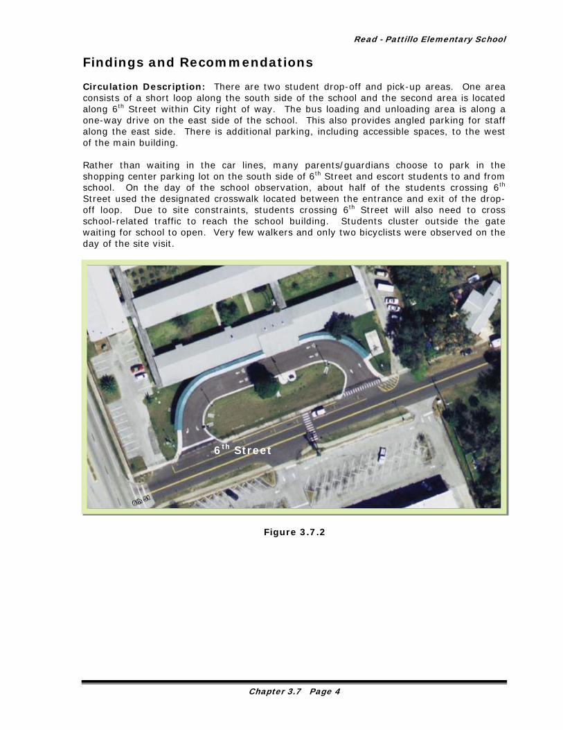
Findings and Recommendations Circulation Description: There are two student drop-off and pick-up areas. One area consists of a short loop along the south side of the school and the second area is located along 6th Street within City right of way. The bus loading and unloading area is along a one-way drive on the east side of the school. This also provides angled parking for staff along the east side. There is additional parking, including accessible spaces, to the west of the main building. Rather than waiting in the car lines, many parents/guardians choose to park in the shopping center parking lot on the south side of 6th Street and escort students to and from school. On the day of the school observation, about half of the students crossing 6th Street used the designated crosswalk located between the entrance and exit of the drop-off loop. Due to site constraints, students crossing 6th Street will also need to cross school-related traffic to reach the school building. Students cluster outside the gate waiting for school to open. Very few walkers and only two bicyclists were observed on the day of the site visit.
6th Street
Figure 3.7.2
Chapter 3.7 Page 4
Volusia County MPO School Bicycle and Pedestrian Review Study, Phase 3B
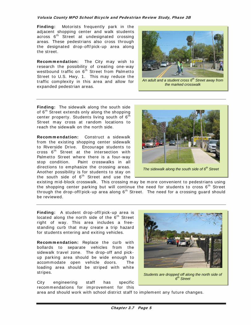
Finding: Motorists frequently park in the adjacent shopping center and walk students across 6th Street at undesignated crossing areas. These pedestrians also cross through the designated drop-off/pick-up area along the street.
Students are dropped off along the north side of
6th Street
The sidewalk along the south side of 6th Street
An adult and a student cross 6th Street away from
the marked crosswalk
Recommendation: The City may wish to research the possibility of creating one-way westbound traffic on 6th Street from Palmetto Street to U.S. Hwy. 1. This may reduce the traffic complexity in this area and allow for expanded pedestrian areas. Finding: The sidewalk along the south side of 6th Street extends only along the shopping center property. Students living south of 6th Street may cross at random locations to reach the sidewalk on the north side. Recommendation: Construct a sidewalk from the existing shopping center sidewalk to Riverside Drive. Encourage students to cross 6th Street at the intersection with Palmetto Street where there is a four-way stop condition. Paint crosswalks in all directions to emphasize the crossing areas. Another possibility is for students to stay on the south side of 6th Street and use the existing mid-block crosswalk. This crossing may be more convenient to pedestrians using the shopping center parking but will continue the need for students to cross 6th Street through the drop-off/pick-up area along 6th Street. The need for a crossing guard should be reviewed. Finding: A student drop-off/pick-up area is located along the north side of the 6th Street right of way. This area includes a free-standing curb that may create a trip hazard for students entering and exiting vehicles. Recommendation: Replace the curb with bollards to separate vehicles from the sidewalk travel zone. The drop-off and pick-up parking area should be wide enough to accommodate open vehicle doors. The loading area should be striped with white stripes. City engineering staff has specific recommendations for improvement for this area and should work with school district staff to implement any future changes.
Chapter 3.7 Page 5

Read - Pattillo Elementary School
If this roadway is modified into a one-way road, additional right of way will be available for bicyclists and pedestrians.
The bus exit area is located near the pedestrian gate
Stephan Harris, MPO Bicycle and Pedestrian Coordinator, examines the free-standing curb
that may create a trip hazard
Finding: Students wait outside of the closed gate for school to open. The waiting area is flush and adjacent to the paved area on 6th Street. A yellow striped area is painted to guide bus drivers and other motorists away from the gate entrance. During the site visit, motorists were observed encroaching into this area, so additional measures may be required to protect students waiting in this area.
Students wait outside the gate near parent drop-
off and the bus exit
Recommendations: If possible, create a raised sidewalk matching the existing painted area. Alternatively, the fence could be relocated to provide a larger waiting area for students and bollards could be used to separate motorists from the pedestrian areas. The school may wish to consider allowing students waiting for the start of school to wait within the fenced area.
Chapter 3.7 Page 6
Volusia County MPO School Bicycle and Pedestrian Review Study, Phase 3B
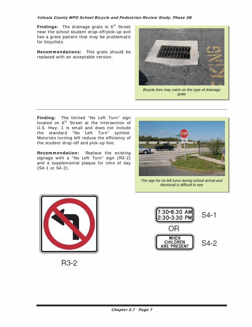
Findings: The drainage grate in 6th Street near the school student drop-off/pick-up exit has a grate pattern that may be problematic for bicyclists.
Bicycle tires may catch on this type of drainage
grate
Recommendations: This grate should be replaced with an acceptable version.
The sign for no left turns during school arrival and dismissal is difficult to see
Finding: The limited “No Left Turn” sign located on 6th Street at the intersection of U.S. Hwy. 1 is small and does not include the standard “No Left Turn” symbol. Motorists turning left reduce the efficiency of the student drop-off and pick-up line. Recommendation: Replace the existing signage with a “No Left Turn” sign (R3-2) and a supplemental plaque for time of day (S4-1 or S4-2).
Chapter 3.7 Page 7

Read - Pattillo Elementary School
Finding: During the 2007/2008 school year, students living west of U.S. Hwy. 1 were provided with bus transportation due to hazardous conditions. Although no students cross U.S. Hwy. 1, the principal was concerned with motorists’ rate of speed so close to the school. The posted speed limit along U.S. Hwy. 1 is 35 mph.
U.S. Hwy. 1 looking north near Read-Pattillo Elementary School
Recommendation: The enforcement of the existing 35 mph speed limit is recommended with emphasis on patrolling at school arrival and dismissal times. Finding: The right of way along Palmetto Street north of 6th Street has a roped off area to protect the grass. This encroachment into the right of way encourages pedestrians to walk in the roadway.
A bicyclists rides across Magnolia Street
near 7th Street
A student and an adult move into the roadway to
avoid right of way encroachments
Recommendation: A sidewalk should be constructed to connect to the 6th Street sidewalk and “no parking or stopping” signs should be posted. Encroachments into City right of way should be removed. Finding: Magnolia Street does not have sidewalks south of 6th Street within the walk zone. The roadway is 31’ wide. Recommendation: The City of New Smyrna Beach should review the possibility of adding sidewalks along Magnolia Street to continue the sidewalk connection to U.S. Hwy. 1. If right of way is limited, a cost effective way to improve this area for bicyclists and pedestrians would be to add painted shoulders or bicycle lanes on both sides of the road.
Chapter 3.7 Page 8

Volusia County MPO School Bicycle and Pedestrian Review Study, Phase 3B
Finding: The walk zone for Read – Pattillo Elementary School extends north of Canal Street to Ronnoc Lane. Students living near Chisholm Elementary School who walk or ride bicycles to and from school must cross S.R. 44 (Lytle Avenue), Canal Street and U.S. Hwy. 1 and the railroad. Some students may use the existing mid-block crossing over Canal Street at Myrtle Avenue.
Myrtle Avenue looking north from Canal Street
Recommendation: If possible, modify the school attendance zone to allow students living near Chisholm Elementary to attend that school. Several of these students have a variance to attend Chisholm Elementary School. As an interim measure, students who walk or ride bicycles to and from Read-Pattillo Elementary School from the Chisholm Elementary area should be instructed to use the safest route available. Finding: The wide sidewalk along the north side of Canal Street west of U.S. Hwy. 1 has a driveway cut without curb ramps. Recommendation: Construct a sidewalk section to create a continuous level sidewalk. A curb ramp, if necessary, should extend into the sidewalk as little as possible to allow for a wider level area for sidewalk users. Finding: The route along Myrtle Avenue does not include a sidewalk on the east side of the roadway from Canal Street to Ronnoc Lane with the exception of a short section of sidewalk along the Babe James Community Center. School District budget limitations have eliminated bus transportation for students attending the Babe James Community Center for after school programs.
Canal Street sidewalk looking east at a level change
in the sidewalk
Chapter 3.7 Page 9

Read - Pattillo Elementary School
Recommendations: Despite the very limited right of way, the City of New Smyrna Beach should provide a clear walking area along the roadside to serve students, pedestrians and bicyclists using this route. Specific recommendations are listed below.
Right of way is very limited along the east side of Myrtle Avenue near the Babe James Community
Center
Myrtle Avenue looking north along the east side of the roadway
1. Paint a crosswalk along the paved right of way to designate a walking zone within the parking area for the laundry business. Replace or reposition the grate to increase safety for bicyclists. 2. Remove vegetation between the Myrtle Avenue pavement edge and the building. Provide a sidewalk, grass or mulch to allow a clear area for pedestrians and bicyclists.
Myrtle Avenue looking north
3. A fence along the east side of Myrtle Avenue encloses a large vegetable garden. If this is a community garden, perhaps the fence could be shifted to the east to allow sufficient room for a sidewalk or walking surface for pedestrians and bicyclists using this route.
Chapter 3.7 Page 10
Volusia County MPO School Bicycle and Pedestrian Review Study, Phase 3B
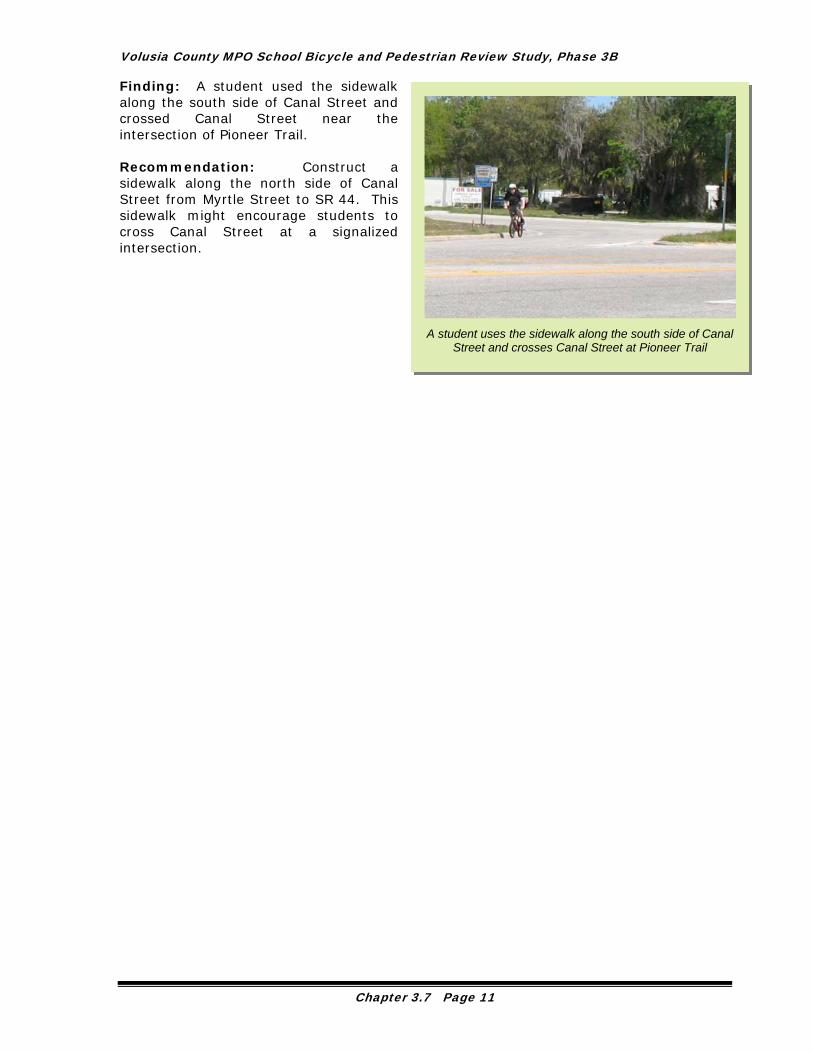
Finding: A student used the sidewalk along the south side of Canal Street and crossed Canal Street near the intersection of Pioneer Trail.
A
Recommendation: Construct a sidewalk along the north side of Canal Street from Myrtle Street to SR 44. This sidewalk might encourage students to cross Canal Street at a signalized intersection.
A student uses the sidewalk along the south side of Canal
Street and crosses Canal Street at Pioneer Trail
Chapter 3.7 Page 11

Read - Pattillo Elementary School
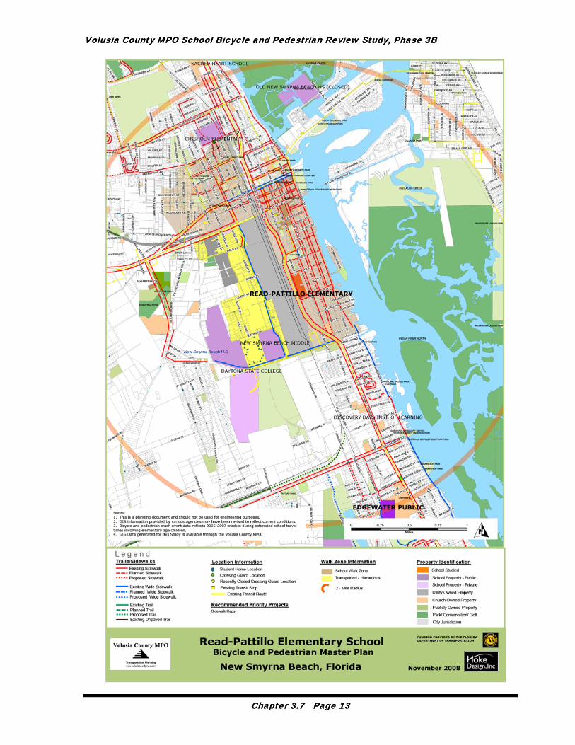
Master Plan The following Bicycle and Pedestrian Master Plan specifies a network of sidewalks and trails that, if implemented, will greatly increase the convenience and safety of travel for pedestrians and bicyclists. A 24”x36” fold-out map is included as a deliverable with this Study. The Bicycle and Pedestrian Master Plan includes the following information: Existing Conditions:
Existing Walk Zone area from School District GIS (shaded tan) Courtesy Transportation Zone from School District, if applicable (shaded blue) Hazardous Transportation Zone from School District, if applicable (shaded yellow) Student Home Locations from School District (dark blue dot) Existing Trails from County GIS and field review (solid green line) Existing Wide Sidewalk 6-8’ from field review (solid blue line) Existing Sidewalks 3-5’ from field review (solid red line) Existing Crossing Guard Locations from County GIS and field observations (green
cross for existing to remain and yellow cross for existing to be closed) Bicycle or Pedestrian Crash Event Locations from 2005-2007 from County GIS
data, during estimated school travel times and involving an elementary age bicyclist or pedestrian (pink star).
Existing Votran Routes and stops from Volusia County MPO (yellow lines along roadway centerline with yellow squares at bus stops).
Planned Conditions:
Planned trail (long dashed dark green line) Planned wide sidewalk (long dashed blue line) Planned sidewalk (long dashed red line)
Recommendations of this Study:
Proposed Trails (dashed dark green line) Proposed Sidewalks 6-8’ wide (dashed blue line) Proposed Sidewalks 5’ (dashed red line)
This Master Plan and supplemental information supplied within the Implementation Report are meant as a guideline for sidewalk and trail planning. The Master Plan is not an engineering document.
Chapter 3.7 Page 12
Volusia County MPO School Bicycle and Pedestrian Review Study, Phase 3B Volusia County MPO School Bicycle and Pedestrian Review Study, Phase 3B
Chapter 3.7 Page 13 Chapter 3.7 Page 13