Embed Size (px)
Citation preview

Application for Approval of the BlackGold Expansion Project Volume 1 – Project Description
December 2009
Table of Contents
SECTION 3.0 – CONSERVATION AND RECLAMATION PLAN TABLE OF CONTENTS
PAGE
3.0 CONSERVATION AND RECLAMATION PLAN ...........................................................3-1 3.1 Introduction.........................................................................................................3-1
3.1.1 Environmental Protection and Enhancement Act Approval Request..............................................................................................3-1
3.1.2 Facility Overview................................................................................3-1 3.1.3 Project Evaluation and Design Level Mitigation.................................3-4 3.1.4 Ecological and Physiographic Setting................................................3-5 3.1.5 Soils and Terrain................................................................................3-5
3.2 Environmental Regional Initiatives and Stakeholder Consultation .....................3-6 3.2.1 Environmental Regional Initiatives.....................................................3-6 3.2.2 Stakeholder Consultation...................................................................3-7 3.2.3 Regional Sustainable Development Strategy ....................................3-7
3.3 Reclamation Planning Concepts ........................................................................3-8 3.3.1 Reclamation Goals and Objectives....................................................3-8 3.3.2 Reclamation Guidelines .....................................................................3-9 3.3.3 General Reclamation Procedures....................................................3-10 3.3.4 Restoration of Capability..................................................................3-11 3.3.5 Operational issues ...........................................................................3-20
3.4 Conceptual Conservation and Reclamation Plan.............................................3-27 3.4.1 Development Plan............................................................................3-28 3.4.2 Disturbances for the Project.............................................................3-28 3.4.3 Reclamation Sequencing .................................................................3-28 3.4.4 Soil Handling Plan............................................................................3-35 3.4.5 Revegetation....................................................................................3-38 3.4.6 Closure Phase Reclamation ............................................................3-42
3.5 Conclusion........................................................................................................3-45

Application for Approval of the BlackGold Expansion Project Volume 1 – Project Description
December 2009
Table of Contents
TABLE OF CONTENTS (cont) PAGE
LIST OF TABLES
Table 3.1-1: Project Development Components and Associated Surface Disturbance.........3-4 Table 3.3-1: Applicable Reclamation Guideline Documents ..................................................3-9 Table 3.3-2: Timber Productivity Index (TPI) Ratings for the Local Study Area ...................3-13 Table 3.3-3: Predicted Areas of Ecosite Phases in the TLSA Following Reclamation .........3-17 Table 3.4-1: Disturbances from the Project ..........................................................................3-29 Table 3.4-2: Development and Reclamation Schedule for the BlackGold Project................3-30 Table 3.4-3: Reclamation Material Available for the Expansion Project ...............................3-36 Table 3.4-4: Physical and Chemical Characteristics of Reclaimed Soil Profiles ..................3-38 Table 3.4-5: Planting Prescription by Target Ecosite Phases ..............................................3-41
LIST OF FIGURES
Figure 3.1-1: Project Location..................................................................................................3-2 Figure 3.1-2: Layout of Project Facilities .................................................................................3-3 Figure 3.3-1: Land Capability Classification for Forest Ecosystems Baseline Case .............3-12 Figure 3.3-2: Distribution of Ecological Land Classes (ELC) Baseline Case.........................3-14 Figure 3.3-3: Distribution of Ecological Land Classes (ELC) Post Reclamation Case ..........3-15 Figure 3.3-4: Flow Diagram of Adaptive Management Process ............................................3-21 Figure 3.3-5: Typical Single Well Pad Layout ........................................................................3-22 Figure 3.3-6: Typical Double Well Pad Layout ......................................................................3-23 Figure 3.3-7: Typical Well Pad Access/Utility Corridor Cross-section (Single Pipeline) ........3-24 Figure 3.4-1: Development Areas at Start of Operations (2013) ...........................................3-32 Figure 3.4-2: Reclamation Areas at Peak Net Disturbance (2034)........................................3-33 Figure 3.4-3: Reclamation Areas at Project End (2043) ........................................................3-34 S:\Project Ce\Ce03745\EIA\Vol 1\fnl rpt-Sec 3 c&r plan vol 1 EIA-ce03745_100-10dec09.doc

Application for Approval of the BlackGold Expansion Project Volume 1 – Project Description
December 2009
Page 3-1
3.0 CONSERVATION AND RECLAMATION PLAN
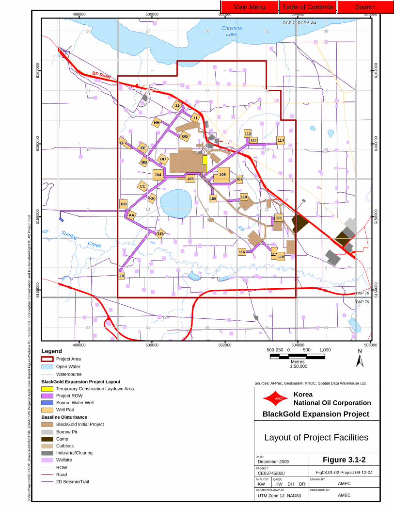
3.1 Introduction KNOC is proposing to expand bitumen extraction from its oil sands leases in northeastern Alberta. The Expansion Project is scheduled to begin construction in 2013 and will be located within the same lease as the Initial Project, about 140 km southeast of Fort McMurray (Twp 76, Rge 7 W4M) in the Regional Municipality of Wood Buffalo (RMWB) (Figure 3.1-1). The project is designed to produce an additional 3 180 m3/d (20 000 b/d) of bitumen over a timeframe of approximately 25 years and will include up to 27 additional well pads. Combined with production from the Initial Project, total production design capacity is 4 770 m3/d (30 000 b/d). Additional infrastructure to support the project will include access roads, power lines and source water wells. KNOC plans to begin construction of well pads for the Expansion Project in 2013 with subsequent production start-up expected in 2015. The Conservation and Reclamation (C&R) plan, which is described in this section, provides the project-specific conservation, mitigation and reclamation measures (ALCRC 1991) to be implemented throughout the development of the project. The purpose of the C&R plan is to document environmental mitigation measures identified in the Environmental Impact Assessment (EIA) intended to achieve equivalent land capability after reclamation. The Terms of Reference (TOR), included below, specifies information required in the C&R plan as part of the Application. 3.1.1 Environmental Protection and Enhancement Act Approval Request KNOC is applying for approval to construct, operate and reclaim the Expansion Project. KNOC has reviewed C&R plans for current and planned developments within the RMWB to assist in the development of the C&R plan for the expanded project. To supplement and update this conceptual C&R plan, site-specific pre-disturbance assessments will be conducted prior to construction of project facilities, and a detailed Annual C&R report will be prepared to outline development and reclamation work completed each year along with activities planned for the following year, in fulfillment of anticipated Terms and Conditions in the project approval. 3.1.2 Facility Overview The footprint of the project within the Terrestrial Local Study Area (TLSA) will cover approximately 228 ha (Figure 3.1-2). The design of the project footprint has considered technical engineering and environmental considerations in an effort to utilize existing disturbances, where possible, and thereby reduce the amount of new land disturbance.

S:\G
is\P
roje
cts\
CE
\KN
OC
_B
lack
Go
ld\C
E03
745
_EIA
\Arc
GIS
Pro
ject
s\A
ppl
icat
ion
Re
port
Fig
ure
s\S
ect
ion
03
- C
once
ptu
al C
onse
rva
tion
and
Rec
lam
atio
n\F
ig03
.01-
01 P
rj L
oc
Ft
McM
.mxd
Sources: © Department of Natural Resources Canada. All rightsreserved, GeoBase®, KNOC, Spatial Data Warehouse Ltd.
Project Location
BlackGold Expansion Project
QA/QC:
KW
December 2009
CE03745/410
UTM Zone 12 NAD83
PROJECT:
PROJECTION/DATUM:
ANALYST:
Figure 3.1-1
TM
Fig03.01-01 Prj Loc Ft McM09-12-04
DATE:
DH DR
KoreaNational Oil Corporation
AMECPREPARED BY:
DRAWN BY:
AMEC
!(
!(Chard/Janvier
Fort McMurray
Lac La Biche
Pelican Portage
PrimroseLake
Lac LaLoche
GordonLake
WinefredLake
Lac LaBiche
Ath
abas
ca
River
Saskatch
ewan
Alb
erta
Conklin
!(63
!(36
TWP 90
TWP 80
TWP 70
RGE 1 RGE 25 W4 W3
RGE 20RGE 10RGE 20
!!881
350000
350000
400000
400000
450000
450000
500000
500000
550000
550000
600000
600000
6100
000
6100
000
6150
000
6150
000
6200
000
6200
000
6250
000
6250
000
6300
000
6300
000
±20 0 20 4010
Kilometres
LegendProject Area
Open Water
Watercourse
1:1,500,000
Edmonton
Calgary
Map Extent
Fort McMurray
KNOC
S:\G
is\P
roje
cts\
CE
\KN
OC
_B
lack
Go
ld\C
E03
745
_EIA
\Arc
GIS
Pro
ject
s\A
ppl
icat
ion
Re
port
Fig
ure
s\V
olum
e 0
1 -
Se
ctio
n 03
- C
once
ptua
l Con
serv
atio
n a
nd
Rec
lam
atio
n\F
ig03
.01
-02
Pro
ject
.mxd
113
RGE 7 RGE 6 W4
TWP 76
TWP 75
ChristinaLake
SundayCreek
BP Road
106
117
104
112
105
108
DD
EE
GG
CC
114FF
111
I I
JJ
HH
BB
AA
116
110109KK
107
115
119
118
9
4 3 2 1
7
6
28 27 26 25
24232221
16 15 14 13
121110
36353433
30
19
18
31
498000
498000
500000
500000
502000
502000
504000
504000
506000
506000
6156
000
6156
000
6158
000
6158
000
6160
000
6160
000
6162
000
6162
000
LegendProject Area
Open Water
Watercourse
BlackGold Expansion Project Layout
Temporary Construction Laydown Area
Project ROW
Source Water Well
Well Pad
Baseline Disturbance
BlackGold Initial Project
Borrow Pit
Camp
Cutblock
Industrial/Clearing
Wellsite
ROW
Road
2D Seismic/Trail
±Sources: Al-Pac, GeoBase®, KNOC, Spatial Data Warehouse Ltd.
Layout of Project Facilities
BlackGold Expansion Project
QA/QC:
KW
December 2009
CE03745/800
UTM Zone 12 NAD83
PROJECT:
PROJECTION/DATUM:
ANALYST:
Figure 3.1-2
KW
Fig03.01-02 Project 09-12-04
DATE:
DH DR
KoreaNational Oil Corporation
AMECPREPARED BY:
DRAWN BY:
AMEC
500 0 500 1,000250
Metres1:50,000

Application for Approval of the BlackGold Expansion Project Volume 1 – Project Description
December 2009
Page 3-4
Components associated with the development of the project include the following:
• temporary construction laydown area beside the Central Processing Facility (CPF); • 27 well pads for steam injection and extraction of the bitumen; • above ground pipelines to transport steam from the CPF to the well pads, and return
produced fluids and produced gas from the well pads to the CPF; and • associated infrastructure to support the project including access roads, power lines, gas
supply pipelines and source water wells (Table 3.1-1).
Table 3.1-1: Project Development Components and Associated Surface Disturbance
Project Development Total Area (ha)
% of Total Footprint
Temporary Construction Laydown Area 3 1.4 27 Well Pads 143 62.7 Project Gathering Lines Corridors 81 35.5 1 Source Water Well 1 0.4 Total 228 100.0
3.1.3 Project Evaluation and Design Level Mitigation
The baseline environmental information compiled for the EIA was used to identify environmental constraints in the TLSA, on the conceptual project design. The conceptual engineering was then designed around the constraints, to the extent practicable, and completed to assess facility layouts and locations. A primary consideration in selecting possible wellsite locations was to provide optimal drilling accessibility to the desired bitumen resource zones. The first level of mitigation was to use constraints mapping to design around environmental sensitivities. Where practicable, alterations to the first proposed layout were made based on the following considerations:
• creeks, streams, rivers and drainage patterns were avoided so as to reduce the extent of surface water impact that could result from the proposed development;
• sites with potentially unique vegetation conditions (e.g., rare plant locations) were avoided;
• traditional land use areas were avoided; • bogs and fens with a high water table were avoided where possible in favour of upland
sites; • locations that required a minimum amount of new ground disturbance were preferred
(i.e., locate facilities within existing cleared areas such as stratigraphic wells, seismic lines, winter roads);

Application for Approval of the BlackGold Expansion Project Volume 1 – Project Description
December 2009
Page 3-5
• access and utility routings were brought into a common corridor to reduce the number of linear disturbances (e.g., well pad access road, steam, bitumen, produced gas, water supply pipelines, and electrical transmission lines in a common corridor); and
• use of above ground pipe racks to reduce soil disturbance. A key strategy employed during the planning phase to reduce environmental impacts involved the use of existing disturbances for locating project facilities. Approximately 29.5 ha (13%) of the planned development footprint for the project will utilize existing disturbances. During the design stage, discussions with other resource users in the area were held with respect to the application of principles and objectives of integrated land management. These discussions will continue through the planning process and into project operations to facilitate integration of land use plans for coordinated renewable and non-renewable resource development within the project development area.
3.1.4 Ecological and Physiographic Setting
The project is located within the Central Mixedwood Subregion of Alberta’s Boreal Natural Region (Natural Regions Committee 2006). The Central Mixedwood is the largest subregion in Alberta. The terrain is characterized by low relief with level to undulating terrain. The climate is cool and moist with long, cold winters and short, wet summers. Vegetation in the subregion is characterized by a mixture of aspen dominated forests, mixed white spruce and aspen forests, and jack pine forests on sandy uplands. Moist, rich sites associated with river valleys are characterized by balsam poplar, aspen and white spruce forests. Poorly drained fens and bogs occur in lowlands and constitute almost half of the subregion. Lowlands comprise treed bogs and fens dominated by black spruce and tamarack, shrubby fens dominated by willows and dwarf birch, and graminoid fens dominated by sedges. Surface expression is variable in the project development area, ranging from level in areas of peat accumulation to gently undulating to undulating rolling in morainal areas. Slope gradients range from 0 to less than 5% in the lowland and level areas with slopes up to 10% in the mineral uplands.
3.1.5 Soils and Terrain
Soils occurring within the TLSA are described in detail in Volume 2, Section 10.0. Soil and terrain features of the TLSA include extensive lowland areas of cold and poorly drained fens and bogs with tamarack and black spruce tree cover, and uplands characterized by kettled to dissected, deep, loamy to clayey-textured till, with inclusions of coarse, fluvioglacial deposits (Ecological Stratification Working Group 1996). Well to moderately well-drained Gray Luvisolic soils are dominant on glacial till (Horse River or Winefred), with significant Brunisols occurring either on eolian (Marguerite), glaciofluvial (Mildred) or glacial till (Sutherland) materials in the upland areas. The Horse River till is a medium to moderately fine (loam to clay loam) textured, moderately calcareous material with some coarse fragments. The glaciofluvial materials are very coarse textured (loamy sand to sand) and typically occur as veneers (i.e., depths of less than 1 m)

Application for Approval of the BlackGold Expansion Project Volume 1 – Project Description
December 2009
Page 3-6
overlying the till deposits. Organic soils, primarily Typic and Terric Mesisols and Fibrisols, are dominant in low-lying wetland areas. Major inclusions are peaty-phase Gleysols that occupy poorly drained depressions. Organic terrain occupies 36% of the TLSA in the form of shallow, deep bog and fen organic accumulations. Bogs represent 14% of the TLSA whereas fens represent 22% of organic soils in the TLSA. Upland terrain covers 51% of the TLSA. A large portion of the upland terrain is dominated by glaciofluvial deposits and covers 29% of the TLSA. Till materials, which dominate the uplands, represent 20% of the TLSA with the remaining portion of the TLSA comprising eolian (0.4%) and alluvial (2%) materials. Soils in the TLSA are classified as mineral subgroups (Brunisolic, Luvisolic, Gleysolic, Regosolic) or organic subgroups (Typic and Terric Mesisols and Terric Fibrisols). Mineral soils constitute 51% of the TLSA, organics 36% of the TLSA and non-soil 14% of the TLSA. Of the mineral soils, Luvisols predominate, occupying 27% of the TLSA, with Brunisols at 8% and Regosols and Gleysols at 2% and 14%, respectively. Well drained Brunisols are observed on coarse textured materials throughout the study area whereas moderately well to imperfectly drained Gray Luvisols are found to be dominant on medium textured till. Organic soils are primarily Typic and Terric Mesisols and Terric Fibrisols, and are observed in the low-lying wetland areas. Significant peaty-phase inclusions associated with Gleysols are observed in poorly drained depressions and terrain transitions from upland to peatland. The effect of the project on soil disturbances are presented in Volume 2, Section 10.0. Based on the project description, 75% of the baseline soil series (organic and mineral) identified will be affected by the project. The total change in TLSA distribution for each organic and mineral soil series is approximately 1%.
3.2 Environmental Regional Initiatives and Stakeholder Consultation
3.2.1 Environmental Regional Initiatives The project is located in a region that has and is expected to continue to experience substantial growth. The Alberta Government recently announced that the current project-by-project environmental management process will shift to a Regional Strategic Environmental Assessment (RSEA) approach that concentrates on management of regional, cumulative effects. Over the next three years, the RSEA approach presented in the recently released Land Use Framework (LUF) will be implemented, providing the regulatory structure within which Provincial agencies will manage development in Alberta. KNOC understands that successful implementation of the LUF will establish regional thresholds, guidelines, limits and/or criteria. These metrics will be based on societal and scientific guidance, including consideration of technological limits and economic factors. KNOC will monitor the development of these regional metrics and the emerging RSEA approach for the oil sands area and integrate these into future development plans.

Application for Approval of the BlackGold Expansion Project Volume 1 – Project Description
December 2009
Page 3-7
Several oil sands projects are either operating, under construction or have filed regulatory applications within a 35 km radius of Conklin. KNOC closely monitors all developments in the region. This includes participation on the Oil Sands Developers Group (OSDG) Southern Athabasca Oil Sands Producers Committee, as well as the Conklin Resource Developers Advisory Committee. Participation in these groups will allow the identification of cooperative development opportunities such as airfield and pipelines joint venture initiatives. 3.2.2 Stakeholder Consultation KNOC is committed to consultation with its stakeholders about its development plans for the Expansion Project, and has initiated a consultation program. Consultation provides stakeholders with an opportunity to learn about the project and how it may affect them, informs KNOC of the interests and concerns of its stakeholders, and allows KNOC to address those concerns during project planning. Consultation enhances relationships with KNOC’s neighbours and contributes to responsible development. A detailed description of the consultation program, including discussion of the issues and concerns raised to date is provided in Volume 1, Section 4.0. Stakeholder consultation is an ongoing commitment of KNOC. The company will continually endeavour to keep its stakeholders, and potentially affected Aboriginal communities constructively engaged through effective communication and action to address concerns. 3.2.3 Regional Sustainable Development Strategy A broad environmental management system for the area is set out in the Regional Sustainable Development Strategy for the Athabasca Oil Sands Area (AENV 1999). The regional sustainable development strategy (RSDS) provides a framework for balancing development with environmental protection. The boundary of the RSDS is coincident with that of the RMWB and thus encompasses the project site. The RSDS creates a framework for:
• identifying regionally important environmental issues; • ensuring the environment is protected; • providing support for sustainable economic growth in the region that is consistent with
environmental protection and natural resource sustainability; and • collecting information to assist in making regional management decisions; and creating
an environmental management system that will adapt to the changing needs of the area. Issues listed in the RSDS are being addressed in large part regionally through Cumulative Environmental Management Association (CEMA) and its working groups, and KNOC will consider these applicable initiatives as operations commence, in order to foster a coordinated approach to development and reclamation.

Application for Approval of the BlackGold Expansion Project Volume 1 – Project Description
December 2009
Page 3-8
3.3 Reclamation Planning Concepts Reclamation planning is used to direct the implementation of mitigation methods and approaches towards returning land to an equivalent capability. Reclamation planning incorporates state-of-the-art practices, knowledge and technology to achieve regional and local end land use objectives identified for the reclaimed landscape. This section outlines the objectives for restoring equivalent land capability for the project development area. It also identifies features that will be created during the development phases of the project and how these changes will be integrated into the final reclaimed landscape. The C&R plan is an important tool in the mitigation process for the project. As part of the development and decommissioning process, site-specific conservation and reclamation plans and activities based on this conceptual C&R plan will be applied, which will be instrumental in achieving reclamation objectives. Reclamation occurs in stages, as active site development progresses. As early as is practical, infrastructure is removed, final surface contouring is completed, surface drainage is re-established, soil is redistributed, and vegetation is established on the reclaimed lands. Effective land management and reclamation planning also includes:
• use of low impact seismic during resource delineation programs; • low impact construction techniques where possible (e.g., limit pad size, utilize existing
disturbances, mulching); • systematic evaluation of the biophysical resources and terrain features of the area; • planning of development activities and integration within the surrounding terrain, for
which constraints mapping is a primary tool; and • post-reclamation monitoring of reclaimed ecosystem components. Once active reclamation of a disturbed site is complete and initial vegetation has been re-established, KNOC will monitor progress towards land stabilization and ecological maturation.
3.3.1 Reclamation Goals and Objectives
The reclamation goals and objectives for the project are as follows:
• developed lands will be reclaimed to a state which will provide equivalent land capability, compatible with the surrounding environment; and
• reclaimed lands will provide a range of end land uses including but not limited to forestry, wildlife habitat, and traditional and recreational uses.
Consideration will be given to available Traditional Environmental Knowledge (TEK) and further stakeholder discussions (e.g., Aboriginal, local community representatives, regulators and other members of the public) as the reclamation process proceeds in the determination of post-development land uses that will be subject to regulatory approval.

Application for Approval of the BlackGold Expansion Project Volume 1 – Project Description
December 2009
Page 3-9
The project conceptual C&R plan follows the format set out in Guidelines for Development and Reclamation Applications for In-Situ Oil Sands Schemes (Section 9) (Alberta Land Conservation and Reclamation Council 1991).
3.3.2 Reclamation Guidelines
KNOC will follow reclamation guidelines applicable to the project that are endorsed by regulators and that are in alignment with Alberta Sustainable Resource Development’s (SRD’s) land management goals. Principal guidelines that may apply to the development include but are not limited to those listed in Table 3.3-1.
Table 3.3-1: Applicable Reclamation Guideline Documents
Guideline or Document Reference Management of Wood Chips on Public Land (SD 2009-01) SRD 2009 Guideline for Wetland Establishment on Reclaimed Oil Sands Leases (revised second edition). CEMA 2007 A Guide To: Reclamation Criteria for Wellsites and Associated Facilities: 2007 – Forested Lands in the Green Area update. April 2007
AENV 2007
Fort McMurray-Athabasca Oil Sands Subregional Integrated Resource Plan AENV 2006a Land Capability Classification System for Forest Ecosystems in the Oil Sands, 3rd Edition AENV 2006b Water Act: Code of Practice for Pipelines and Telecommunication Lines Crossing a Waterbody AENV 2001a Water Act: Code of Practice for Watercourse Crossings AENV 2001b Borrow Excavations (C&R/IL/00-3) AENV 2000a Environmental Protection Guideline for Roadways AENV 2000b A Guide to the Code of Practice for Pits AENV 2004 Environmental Protection Guidelines for Oil Production Sites (C&R/IL/02-1) AENV 2002 Revegetation Using Native Plant Materials: Guidelines for Industrial Development Sites (R&R/03-03)
AENV 2003a
Environmental Protection Guidelines for Pipelines (C&R/IL/94-5) AEP 1994a Guide for Oil Production Sites: Pursuant to the Environmental Protection and Enhancement Act AEP 1994b Environmental Protection Guidelines for Electric Transmission Lines (C&R/IL/95-2) AEP 1995a Reclamation Criteria for Wellsites and Associated Facilities – 1995 Update (C&R/IL/95-3) (for Peatlands)
AEP 1995b
Conservation and Reclamation Regulation (Alberta Regulation 115/93, EPEA) AEP 1996a Guideline for Monitoring and Management of Soil Contamination Under EPEA Approvals (Environmental Regulatory Service)
AEP 1996b
Environmental Protection Guidelines for Pits (C&R/IL/96-5) AEP 1996c Reclamation Certificates for Overlapping Activities (C&R/IL/97-6) AEP 1997 Land Capability Classification for Forest Ecosystems in the Oil Sands Region (C&R/IL/98-7) AEP 1998 Guide to the Preparation of Applications and Reports for Coal and Oil Sands Operations ALC&R Council
1991 Well Abandonment Guide - revised (Directive 020) ERCB 2007 Guidelines for Reclamation to Forest Vegetation in the Athabasca Oil Sands Region (C&R/IL/99-1)
OSVRC 1998

Application for Approval of the BlackGold Expansion Project Volume 1 – Project Description
December 2009
Page 3-10
3.3.3 General Reclamation Procedures
A progressive reclamation approach will be utilized during the course of the project. For example, well pads that have completed production will be reclaimed as later phase well pads are being constructed. The following general procedures will be implemented in reclaiming project disturbances:
• prior to the initiation of reclamation activities, meetings will be held with the local reclamation inspector to confirm the land use and reclamation procedures that are planned;
• surface structures and equipment will be removed. Wells will be cemented, cut off 1.2 m below the surface, and blanked off. Steel piping will also be cut off 1.2 m below the surface;
• all production, geotechnical and hydrogeological monitoring wells will be abandoned according to Energy Resources Conservation Board (ERCB) and Alberta Environment (AENV) standards;
• access roads will be reclaimed and the culverts will be removed; • following removal of infrastructure from the facility, gravel will be salvaged for use on
subsequent development areas, to the extent practicable; • contaminated areas, if any, will be delineated, characterized and remediated; • in upland areas, fill material will be removed to expose the native subsoil. In peatlands,
fill and geotextile will be removed to expose the native peat surface; • the site will be re-contoured to re-establish natural drainage patterns. All drainage and
runoff-control structures will be removed during site recontouring. Where geotextiles and fill were used for construction in wetland areas, these materials will be removed to expose the native peat surface. Swales or ditches will be installed where culverts have been removed and where additional drainage is required;
• all roads that are not required for other ongoing projects in the project area will be closed to vehicle traffic and will be reclaimed. Access routes for quads and snowmobiles required for monitoring will be restricted to a width of 2 m and will follow the former access road to the CPF. These access routes will be physically blocked and revegetated as necessary upon completion of monitoring;
• well pads, roadways, and facility pad areas will be worked (e.g., deep ripped, paratilled, harrowed), as required, to alleviate surface compaction and to create stable grades compatible with surrounding areas;
• salvaged topsoil will be replaced over the disturbed area; the average replacement depths will be similar to pre-project conditions;
• natural recovery will be promoted as the primary means of ground cover re-establishment. Where necessary, specific sites will be seeded with either a nurse crop or longer-lived, non-invasive vegetation cover and planted with tree species consistent with the revegetation plan;

Application for Approval of the BlackGold Expansion Project Volume 1 – Project Description
December 2009
Page 3-11
• following revegetation, regular monitoring and maintenance activities will be undertaken to assess reclamation success and identify areas requiring maintenance; and
• a post-reclamation site assessment will be undertaken to determine the status of the site prior to applying for a reclamation certificate.
3.3.4 Restoration of Capability
The following sections reference and compare the anticipated pre-disturbance and reclamation capability changes for ecological attributes and land uses including forestry, surface waters, biodiversity, wildlife, traditional land use, vegetation and recreation. In general, reclamation will take the approach of returning developed areas to an equivalent land capability.
3.3.4.1 Land Capability for Forestry
The forest types currently present as well as types that will be developed on reclaimed project areas are determined by soil parent material, topography and drainage of the area, and are influenced by the encroachment of adjacent vegetation. Because lands disturbed by the project are planned to be returned to an equivalent land capability by removal of fill over peatland areas and the recontouring and topsoil salvage and replacement in upland areas, the predicted net change in land capability for forestry over the long-term is predicted to be negligible. The current distribution of soils by capability class for forestry is illustrated in Figure 3.3-1. Ratings for soil capability for forestry are based on the Land Capability Classification for Forest Ecosystems in the Oil Sands (AENV 2006b) and are presented in Volume 2, Section 10.0. Approximately 36% of the TLSA is rated as Class 5. Land capability classification (LCC) Classes of 2, 3, 4 comprise 25%, 12% and 13% of the TLSA, respectively. Class 1 areas are not present in the TLSA. Soil disturbances will occur mostly on Class 5 (103 ha; 1.0% change in the TLSA), followed by Class 4 (3 ha; 0.3% change in the TLSA) and Class 3 (27 ha; 0.3% of the TLSA) land capability ratings.
3.3.4.2 Forest Productivity
Development of reclamation areas with suitable commercial forest potential has been based on the document Guidelines for Reclamation to Forest Vegetation in the Athabasca Oil Sands Region (Oil Sands Vegetation Reclamation Committee 1998). A commercial forest is defined in the guidelines as:
• land with a land capability class of 1 to 3 that can support sustainable forest growth; • land stocked with native tree species such as white spruce, black spruce, jack pine,
aspen poplar, balsam poplar, white birch or tamarack; and • forest stands not limited by operating requirements such as stream buffers, potential
recreation lakes, stand size or accessibility.

S:\G
is\P
roje
cts\
CE
\KN
OC
_B
lack
Go
ld\C
E03
745
_EIA
\Arc
GIS
Pro
ject
s\A
ppl
icat
ion
Re
port
Fig
ure
s\V
olum
e 0
1 -
Se
ctio
n 03
- C
once
ptua
l Con
serv
atio
n a
nd
Rec
lam
atio
n\F
ig03
.03
-01
B T
LSA
LC
C.m
xd
RGE 7 RGE 6 W4RGE 8 RGE 7
TWP 77
TWP 76
TWP 76
TWP 75
Jackfish River
Sunday Cr e
ek
Birch C
reek Christina
Lake
!!881
BP Road
Conklin
7
61
798
6124 35
11
19
30
24
31 33 3432
25
36
3336 31 32 313634 35
12
13
1210
18
2421 19232220
3635 31
29
2830 2925 302527 26
13 1816 141517
2528 26 3027
495000
495000
500000
500000
505000
505000
6155
000
6155
000
6160
000
6160
000
6165
000
6165
000
LegendTerrestrial Local Study Area
Open Water
Watercourse
Baseline Disturbance
BlackGold Initial Project
Borrow Pit
Camp
Industrial/Clearing
Wellsite
ROW
Road
Land Capability Classification for Forest Ecosystems
2
2V
3F
3FV
3V
4WV
4XF
4XV
5S
5WF
Not Rated
±Sources: GeoBase®, KNOC, Spatial Data Warehouse Ltd.
Land Capability Classificationfor Forest Ecosystems
Baseline Case
BlackGold Expansion Project
QA/QC:
KW
December 2009
CE03745/800
UTM Zone 12 NAD83
PROJECT:
PROJECTION/DATUM:
ANALYST:
Figure 3.3-1
KW
Fig03.03-01 B TLSA LCC09-11-23
DATE:
SR DR
KoreaNational Oil Corporation
AMECPREPARED BY:
DRAWN BY:
AMEC
1 0 1 20.5
Kilometres1:80,000

Application for Approval of the BlackGold Expansion Project Volume 1 – Project Description
December 2009
Page 3-13
Reclaimed lands in upland areas generally should have the potential for commercial forestry based on the planned reclamation practices and management inputs. The revegetation plan, which calls for outplanting of tree species included in the commercial forest species list, is discussed below. To define areas as acceptable for commercial forestry, factors such as slope, subsoil matrix, tree species, stand width and stand size are considered. The potential for commercial forestry in the development area has been assessed using the Alberta Vegetation Inventory (AVI) system. The AVI dataset was first used to produce an ecological land classification (ELC) map for the TLSA, and was then queried to determine the baseline Timber Productivity Index (TPI) of lands in the TLSA on the basis of ELC map units. A summary of the existing and predicted timber productivity indices is presented in Table 3.3-2. Based on the baseline and predicted post-reclamation ecosite landscape (Figures 3.3-2 and 3.3-3), a small net increase in forest productivity is predicted for the TLSA. Specifically, a 2.6% increase in forest productivity is estimated in areas as having moderate TPI over the TLSA. This is attributed primarily to the reclamation of former disturbed lands and secondly to non-productive forest (burn areas) and areas having a fair TPI, into upland forest ecosites with a TPI rated as moderate.
Table 3.3-2: Timber Productivity Index (TPI) Ratings for the Local Study Area
Net Change Timber Productivity Index Pre-Disturbance
Area (ha)1 Post-Disturbance
Area (ha)1 % Change in Rating Category
% Change in TLSA
Good 2 327.2 2 260.9 -2.8 -0.6 Moderate 3 928.4 4 193.8 +6.8 +2.6 Fair 951.1 931.2 -2.1 -0.2 Non-productive Forest 1 300.2 1 283.2 -1.3 -0.2 Non-forested Vegetated 29.8 29.1 -2.4 0.0 Disturbed Lands 1 013.2 851.6 -15.9 -1.6 Water 746.0 746.0 0.0 0.0 Total LSA 10 295.9 10 295.9 N/A 0.0
1 Unclassified indicates that TPI is not known. Non-forested vegetated areas indicate a k3 ecosite phase. Disturbed lands are cutblock, industrial/clearing, seismic lines, trails and wellsite areas. Water refers to flooded, lake and river areas.
3.3.4.3 Vegetation
Delineation of vegetation communities was based on AVI map units that were classified as ecosite phases (Beckingham and Archibald 1996). Ecosite units are determined from soil nutrient and moisture regimes (e.g., medium, mesic) while dominant tree species or tallest vegetation layer (e.g., trembling aspen) determines ecosite phase units. Subdivision of plant community types is determined from understorey species composition and abundance (e.g., Low Bush Cranberry).

S:\G
is\P
roje
cts\
CE
\KN
OC
_B
lack
Go
ld\C
E03
745
_EIA
\Arc
GIS
Pro
ject
s\A
ppl
icat
ion
Re
port
Fig
ure
s\V
olum
e 0
1 -
Se
ctio
n 03
- C
once
ptua
l Con
serv
atio
n a
nd
Rec
lam
atio
n\F
ig03
.03
-02
B T
LSA
EL
C.m
xd
RGE 7 RGE 6 W4RGE 8 RGE 7
TWP 77
TWP 76
TWP 76
TWP 75
Jackfish River
Sunday Cr e
ek
Birch C
reek Christina
Lake
!!881
BP Road
Conklin
7
61
798
6124 35
11
19
30
24
31 33 3432
25
36
3336 31 32 313634 35
12
13
1210
18
2421 19232220
3635 31
29
2830 2925 302527 26
13 1816 141517
2528 26 3027
495000
495000
500000
500000
505000
505000
6155
000
6155
000
6160
000
6160
000
6165
000
6165
000
LegendTerrestrial Local Study Area
Open Water
Watercourse
Baseline Disturbance
BlackGold Initial Project
Borrow Pit
Camp
Cutblock
Industrial/Clearing
Wellsite
ROW
Road
2D Seismic/Trail
Recent Burn
±Sources: AB SRD, Al-Pac, GeoBase®, KNOC, Spatial Data WarehouseLtd.
Distribution of EcologicalLand Classes (ELC)
Baseline Case
BlackGold Expansion Project
QA/QC:
KW
December 2009
CE03745/800
UTM Zone 12 NAD83
PROJECT:
PROJECTION/DATUM:
ANALYST:
Figure 3.3-2
KW
Fig03.03-02 B TLSA ELC 09-11-23
DATE:
MAJ DR
KoreaNational Oil Corporation
AMECPREPARED BY:
DRAWN BY:
AMEC
1 0 1 20.5
Kilometres1:80,000
Ecological Land Class (ELC)
a1
b1
b2
b3
b4
c1
d1
d2
d3
e1
e2
e3
f1
f3
g1
h1
i2
j1
j2
k1
k2
k3
Shrubland/Regeneration
Note: AVI 2.1

S:\G
is\P
roje
cts\
CE
\KN
OC
_B
lack
Go
ld\C
E03
745
_EIA
\Arc
GIS
Pro
ject
s\A
ppl
icat
ion
Re
port
Fig
ure
s\S
ect
ion
11 -
Veg
eta
tion\
Fig
03-
03-0
3 B
TL
SA
EL
C.m
xd
RGE 7 RGE 6 W4RGE 8 RGE 7
TWP 77
TWP 76
TWP 76
TWP 75
Jackfish River
Sunday Cr e
ek
Birch C
reek Christina
Lake
!!881
BP Road
Conklin
7
61
798
6124 35
11
19
30
24
31 33 3432
25
36
3336 31 32 313634 35
12
13
1210
18
2421 19232220
3635 31
29
2830 2925 302527 26
13 1816 141517
2528 26 3027
495000
495000
500000
500000
505000
505000
6155
000
6155
000
6160
000
6160
000
6165
000
6165
000
LegendTerrestrial Local Study Area
Open Water
Watercourse
Borrow Pit
Camp
Cutblock
Industrial/Clearing
Wellsite
ROW
Road
2D Seismic/Trail
Burn
±Sources: AB SRD, Al-Pac, GeoBase®, KNOC, Spatial Data WarehouseLtd.
Distribution of EcologicalLand Classes (ELC)
Post Reclamation Case
BlackGold Expansion Project
QA/QC:
KW
December 2009
CE03745/800
UTM Zone 12 NAD83
PROJECT:
PROJECTION/DATUM:
ANALYST:
Figure 3.3-3
CF
Fig03.03-03 PR TLSA ELC09-12-08
DATE:
MAJ DR
KoreaNational Oil Corporation
AMECPREPARED BY:
DRAWN BY:
AMEC
1 0 1 20.5
Kilometres1:80,000
Ecological Land Class (ELC)
a1
b1
b2
b3
b4
c1
d1
d2
d3
e1
e2
e3
f1
f3
g1
h1
i2
j1
j2
k1
k2
k3
Shrubland/Regeneration
Note: AVI 2.1

Application for Approval of the BlackGold Expansion Project Volume 1 – Project Description
December 2009
Page 3-16
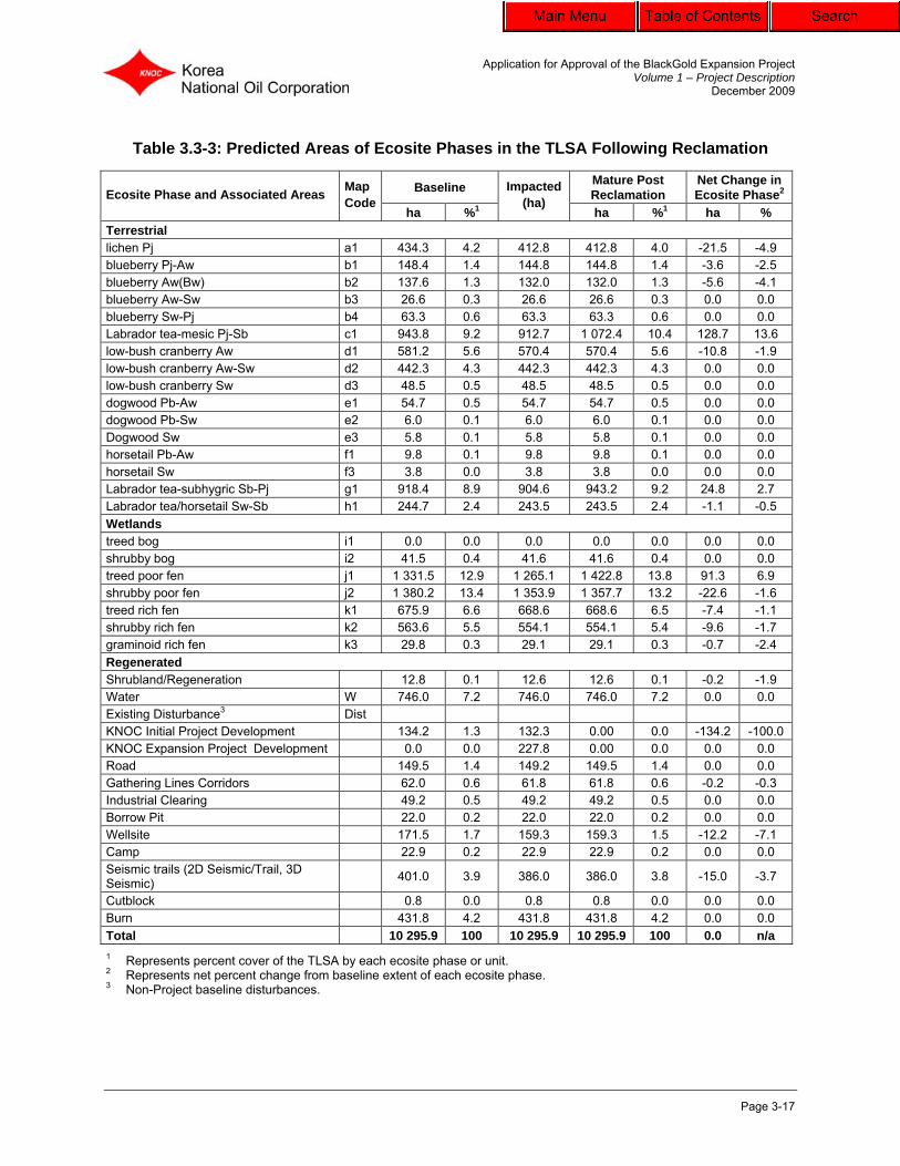
Eight terrestrial ecosite phase types and three wetland ecosites phase types have been classified in the project TLSA. These are as follows.
• Terrestrial: Lichen (a); Blueberry (b); Labrador tea-mesic (c); Low-bush cranberry (d); Dogwood (e); Horsetail (f); Labrador tea-subhygric (g); and Labrador tea/horsetail (h).
• Wetland: Bog (i); Poor fen (j); and Rich fen (k).
The area and percent coverage of the ecosite phases for the project are presented in Table 3.3-3. The pre-development and conceptual post-reclamation ecosite phases are illustrated in Figures 3.3-2 and 3.3-3, respectively.
3.3.4.4 Fisheries
A detailed description of fisheries resources and aquatic habitat in the project area is provided in Volume 2, Section 9.0. Work will be conducted according to the appropriate Fisheries and Oceans Canada (DFO) Operational Statements and AENV regulations and guidelines. In-stream disturbances will be limited as appropriate to prevent impacts to fish and fish habitat. Road construction and the installation of buried source and disposal water pipelines will occur under frozen conditions, and will use crossing techniques recommended by the applicable Codes of Practice and best available practices to minimize bank and in-stream erosion.
3.3.4.5 Wetlands
The changes in wetland capability associated with the project are discussed in Volume 2, Sections 11.0 and 13.0 and development considerations for wetland areas are discussed in Section 3.4 of this plan. KNOC recognizes the challenges associated with reclaiming disturbed peatlands and the regional nature of this issue, as it affects developments throughout the region. KNOC will consider participating in regional initiatives once operations begins to investigate appropriate strategies and methods for reclaiming fens and bogs disturbed by in-situ oil sands developments. Wetlands in the project area will have drainage patterns maintained to minimize the impact on hydrology. Culverts will be installed across access roads at appropriate locations and spacing to facilitate natural drainage movements.
Application for Approval of the BlackGold Expansion Project Volume 1 – Project Description
December 2009
Page 3-17
Table 3.3-3: Predicted Areas of Ecosite Phases in the TLSA Following Reclamation
Baseline Mature Post Reclamation
Net Change in Ecosite Phase2 Ecosite Phase and Associated Areas Map
Codeha %1
Impacted (ha)
ha %1 ha % Terrestrial lichen Pj a1 434.3 4.2 412.8 412.8 4.0 -21.5 -4.9 blueberry Pj-Aw b1 148.4 1.4 144.8 144.8 1.4 -3.6 -2.5 blueberry Aw(Bw) b2 137.6 1.3 132.0 132.0 1.3 -5.6 -4.1 blueberry Aw-Sw b3 26.6 0.3 26.6 26.6 0.3 0.0 0.0 blueberry Sw-Pj b4 63.3 0.6 63.3 63.3 0.6 0.0 0.0 Labrador tea-mesic Pj-Sb c1 943.8 9.2 912.7 1 072.4 10.4 128.7 13.6 low-bush cranberry Aw d1 581.2 5.6 570.4 570.4 5.6 -10.8 -1.9 low-bush cranberry Aw-Sw d2 442.3 4.3 442.3 442.3 4.3 0.0 0.0 low-bush cranberry Sw d3 48.5 0.5 48.5 48.5 0.5 0.0 0.0 dogwood Pb-Aw e1 54.7 0.5 54.7 54.7 0.5 0.0 0.0 dogwood Pb-Sw e2 6.0 0.1 6.0 6.0 0.1 0.0 0.0 Dogwood Sw e3 5.8 0.1 5.8 5.8 0.1 0.0 0.0 horsetail Pb-Aw f1 9.8 0.1 9.8 9.8 0.1 0.0 0.0 horsetail Sw f3 3.8 0.0 3.8 3.8 0.0 0.0 0.0 Labrador tea-subhygric Sb-Pj g1 918.4 8.9 904.6 943.2 9.2 24.8 2.7 Labrador tea/horsetail Sw-Sb h1 244.7 2.4 243.5 243.5 2.4 -1.1 -0.5 Wetlands treed bog i1 0.0 0.0 0.0 0.0 0.0 0.0 0.0 shrubby bog i2 41.5 0.4 41.6 41.6 0.4 0.0 0.0 treed poor fen j1 1 331.5 12.9 1 265.1 1 422.8 13.8 91.3 6.9 shrubby poor fen j2 1 380.2 13.4 1 353.9 1 357.7 13.2 -22.6 -1.6 treed rich fen k1 675.9 6.6 668.6 668.6 6.5 -7.4 -1.1 shrubby rich fen k2 563.6 5.5 554.1 554.1 5.4 -9.6 -1.7 graminoid rich fen k3 29.8 0.3 29.1 29.1 0.3 -0.7 -2.4 Regenerated Shrubland/Regeneration 12.8 0.1 12.6 12.6 0.1 -0.2 -1.9 Water W 746.0 7.2 746.0 746.0 7.2 0.0 0.0 Existing Disturbance3 Dist KNOC Initial Project Development 134.2 1.3 132.3 0.00 0.0 -134.2 -100.0 KNOC Expansion Project Development 0.0 0.0 227.8 0.00 0.0 0.0 0.0 Road 149.5 1.4 149.2 149.5 1.4 0.0 0.0 Gathering Lines Corridors 62.0 0.6 61.8 61.8 0.6 -0.2 -0.3 Industrial Clearing 49.2 0.5 49.2 49.2 0.5 0.0 0.0 Borrow Pit 22.0 0.2 22.0 22.0 0.2 0.0 0.0 Wellsite 171.5 1.7 159.3 159.3 1.5 -12.2 -7.1 Camp 22.9 0.2 22.9 22.9 0.2 0.0 0.0 Seismic trails (2D Seismic/Trail, 3D Seismic) 401.0 3.9 386.0 386.0 3.8 -15.0 -3.7
Cutblock 0.8 0.0 0.8 0.8 0.0 0.0 0.0 Burn 431.8 4.2 431.8 431.8 4.2 0.0 0.0 Total 10 295.9 100 10 295.9 10 295.9 100 0.0 n/a 1 Represents percent cover of the TLSA by each ecosite phase or unit. 2 Represents net percent change from baseline extent of each ecosite phase. 3 Non-Project baseline disturbances.

Application for Approval of the BlackGold Expansion Project Volume 1 – Project Description
December 2009
Page 3-18
KNOC plans to reclaim areas developed on peatlands by removing fill and geotextile from the underlying native peat. KNOC will consider reclamation trials as a part of the progressive reclamation program for the Expansion Project as a contribution to a regional research program, wherein selected sites within the project development area could be used as study locations. KNOC will follow the principles outlined in the Guideline for Wetland Establishment on Reclaimed Oil Sands Leases (revised 2nd edition) (CEMA 2007) to meet the goal of reclaiming wetlands on the disturbed lease trial plots. An adaptive management approach would be applied to wetland reclamation efforts, as with all reclamation activities associated with the project, to determine the most suitable methods for achieving reclamation targets (Figure 3.3-4).
3.3.4.6 Biodiversity
A focused reclamation approach will allow for disturbed project areas to be reclaimed to different target ecosite phases as described in Section 3.4.6 to reflect the vegetation types and associated biodiversity potential that currently exists in the region. Because these disturbed areas are interspersed throughout the landscape and will be actively reclaimed, native plants and animals are expected to use and colonize these areas soon after reclaimed areas have been established. Fens will be integrated with the surrounding landscape by facilitating natural drainage through the installation of culverts and by undertaking appropriate erosion control measures in uplands to prevent sedimentation of wetlands.
3.3.4.7 Wildlife
The project is located in an area of moderate habitat diversity. Species that can potentially be affected by the project development include forest songbirds, amphibians, bats, moose and woodland caribou as a result of vegetation clearing in habitats such as mixed wood, deciduous and fens. Wildlife will return to the reclaimed areas once vegetative communities that reflect natural surrounding areas and provide wildlife habitat is re-established. Native herbaceous species will provide a source of food and low-growing cover for wildlife. As this habitat develops, wildlife utilization is expected to increase as food and shelter become available on the reclamation sites (i.e., with maturing vegetation).
3.3.4.8 Hydrogeology
Spill prevention and containment measures along access corridors and in facilities areas will be designed to prevent groundwater contamination during operations. Monitoring wells will be installed at appropriate locations, to evaluate the performance of these measures and to provide any indication of deterioration of water quality or change in water table depth. Additional information on hydrogeology can be found in Volume 2, Section 6.0.

Application for Approval of the BlackGold Expansion Project Volume 1 – Project Description
December 2009
Page 3-19
3.3.4.9 Traditional Land Use The Athabasca oil sands region has a long history of use by Aboriginal people. Resource use in the region by Aboriginal people includes hunting, trapping, fishing, plant collection, and the use of trail networks and cabins. Information regarding traditional and historical uses of lands and TEK in the project area is provided in Volume 2 (Sections 15.0 and 16.0). Areas that are cleared for development will be reclaimed to vegetation communities that will include a variety of plant species with potential value for traditional uses. For example, woody stem species used for traditional purposes by people of the region are incorporated (pending availability) as part of the planting prescriptions for reclaiming areas to target ecosite phases. Such species include jack pine, black spruce, tamarack, blueberry, bog and lowbush cranberry, green alder, Labrador tea and bog cranberry. Reclamation of the disturbed areas within the TLSA will foster re-establishment of wildlife habitat in uplands and wetlands, restoring capability for traditional hunting and trapping activities. The restoration of natural drainage and the establishment of upland vegetation along former access roads during reclamation will restrict new access to the area for recreational hunting.
3.3.4.9 Recreation
Recreational use of the TLSA is highly seasonal, and concentrated during the summer months from May to September, which corresponds to the recreational camping season and popularity of sportfishing during this time on Christina Lake. This, in conjunction with limited access south of Christina Lake, could contribute to low non-consumptive use of the area in the spring months. Christina Lake Lodge is located in close proximity to the TLSA on the far west side of Christina Lake. Non-consumptive recreational activities associated with the Christina Lake Lodge include the use of all-terrain vehicle (ATV) trails for snowmobiling, ATV use, cross-country skiing, snowshoeing, hiking and recreational camping. Primary sportfishing locations in the TLSA include Christina Lake and Sunday Creek. Christina Lake supports several sportfishing species, including whitefish, perch, northern pike, arctic grayling, and walleye, whereas Sunday Creek only supports one type of sports species, northern pike (EnCana 2001). Additional information related to consumptive recreational land use is described in Volume 2, Section 14.0. Reclamation efforts will incorporate measures to return capability for recreational uses. Target recreational uses of reclaimed lands could be consumptive (e.g., hunting, berry picking) and non-consumptive (e.g., nature observation). Annual site-specific reclamation planning will incorporate these target uses in consultation with regulatory and stakeholder groups to define and meet regional planning objectives.

Application for Approval of the BlackGold Expansion Project Volume 1 – Project Description
December 2009
Page 3-20
3.3.5 Operational issues
3.3.5.1 Development Consideration for Bogs and Fens
Some of the project facilities will be located within peatland areas including fens and bogs. Seismic lines and pipelines that occur within peatlands are expected to naturally return to pre-disturbance conditions over time, since seismic development involves only vegetation clearing but no excavation of organic soils (winter access development). Buried water supply and disposal pipelines will require ditchline excavation of organic soil and this soil will be replaced directly over the ditchline. Since maintaining water movement is critical to retaining the biological integrity of fens, the following measures will typically be applied in constructing facilities in wetland ecosites where practicable:
• peat will be left intact in areas of deep peat (>40 cm depth) to maintain surficial stability for construction. Geotextile will be placed over this peat and overlain with mineral fill for the construction of stable roads and well pads;
• culverts will be installed across roads in wetlands to maintain cross-drainage; • ditches will be constructed to control and direct the flow of surface water from the
development area; and • erosion control measures will be implemented over developed areas to prevent
sedimentation of wetland areas. Access roads and well pad working surface areas will be capped with a gravel layer where required, which will be maintained throughout the operation phase. The typical well pad layout (in peatlands and uplands) is illustrated in Figure 3.3-5 and Figure 3.3-6. Typical configurations of the well pad access road and utility/access corridor are presented in Figure 3.3-7. As part of progressive development and reclamation, the surface layer of gravel and fill material will be recovered as practicable for re-use on subsequent phases of well pad construction. Following reclamation of the final phase of well pads, mineral fill may either be removed from peatland areas and hauled to other developments in the region or placed in active borrow pits excavated for the project as part of their reclamation in accordance with the reclamation criteria and practices in place at the time of reclamation. Typically following fill removal over peatlands, the underlying geotextile will be removed, resulting in a slightly depressed open water wetland that is expected to rebound and revegetate from the periphery over time. These areas may either be allowed to recover naturally (AENV 2003b), or may be enhanced as appropriate by installation of plantings around wetland margins. Final prescriptions for reclaiming these areas will be made in consultation with SRD prior to final reclamation.

AMECDRAWN BY:
PREPARED BY:
AMECDRDH
DATE: Fig03.03-04 Flow Diagram09-12-01
KW
Figure3.3-4
ANALYST:
PROJECT:
CE03745\800
December 2009
KWQA/QC:
Flow Diagram of AdaptiveManagement Process
S:\G
is\P
roje
cts\
CE
\KN
OC
_Bla
ckG
old\
CE
0374
5_E
IA\C
orel
Dra
w\S
ectio
n03
- Con
cept
ual C
onse
rvat
ion
and
Rec
lam
atio
n\Fi
g03.
03-0
4FD
\Fig
03.0
3-04
Flow
Dia
gram
.cdr
KoreaNational Oil Corporation
BlackGold ProjExpansion ect
STEP 1Identify Target Ecosites
that can be Establishedon Reclaimed Landscape
STEP 2
Identify Techniques
to Establish Ecosites
On Reclaimed Landscape
STEP 3
Identify Terrestrial Land Use
Objectives for Reclaimed
Landscape
STEP 4
Identify Design Criteriafor Wildlife Habitat
Identify Target Ecosites and
Landscape Patternsfor Wildlife Habitat
Wildlife Habitat
STEP 4
Identify Design Criteriafor Commercial Forest
Identify Target Ecosites and
Landscape Patternsfor Commercial Forest
Commercial Forest
STEP 4
Identify Design Criteriafor Other Land Uses
Identify Target Ecosites and
Landscape Patterns
Other Land Uses
STEP 5
Integrate Design Criteriafor All Land-Use Objectives for Reclamation of
Oil Sands Lease(s)
STEP 7
Design Research Program
STEP 6
Design Monitoring Programto Verify Success of Meeting Commercial Forest
Objectives, Wildlife Habitat Objectives, Biodiversityand/or Other Land Use Objectives
A
D
A
P
T
I
V
E
M
A
N
A
G
E
M
E
N
T

AMECFigure3.3-5
DRAWN BY:
PREPARED BY:
WorleyParsonsDRDH
Fig03.03-05 TWell Pad BW 09-12-11
KWANALYST:
PROJECT:
CE03745/800
December 2009
KWQA/QC:
S:\G
is\P
roje
cts\
CE
\KN
OC
_Bla
ckG
old\
CE
0374
5_E
IA\C
orel
Dra
w\S
ectio
n03
- Con
cept
ual C
onse
rvat
ion
and
Rec
lam
atio
n\Fi
g03.
03-0
5Ty
pica
l Wel
l\Fig
03.0
3-05
TWel
l Pad
BW
.cdr
DATE:
Typical Single Well Pad LayoutKoreaNational Oil Corporation
BlackGold ProjExpansion ect
Topsoiland
SubsoilStockpile

AMECDRAWN BY:
PREPARED BY:
WorleyParsonsDRDH
Fig03.03-06 Well Pad BW 09-12-01
KW
Figure3.3-6
ANALYST:
PROJECT:
CE03745/800
December 2009
KWQA/QC:
S:\G
is\P
roje
cts\
CE
\KN
OC
_Bla
ckG
old\
CE
0374
5_E
IA\C
orel
Dra
w\V
olum
e01
- Sec
tion
03- C
once
ptua
l Con
serv
atio
nan
dR
ecla
mat
ion\
Fig0
3.03
-06
Wel
l\Fig
03.0
3-06
Wel
l Pad
BW
.cdr
DATE:
Typical Double Well Pad LayoutKoreaNational Oil Corporation
BlackGold ProjExpansion ect

AMECDRAWN BY:
PREPARED BY:
WorleyParsonsDRDH
Fig03.03-07 ROW X-Sec BW 09-12-01
KW
Figure3.3-7
ANALYST:
PROJECT:
CE03745/800
December 2009
KWQA/QC:
S:\G
is\P
roje
cts\
CE
\KN
OC
_Bla
ckG
old\
CE
0374
5_E
IA\C
orel
Dra
w\V
olum
e01
- Sec
tion
03- C
once
ptua
l Con
serv
atio
nan
dR
ecla
mat
ion\
Fig0
3.03
-07
RO
W\F
ig03
.03-
07R
OW
X-S
ecB
W.c
dr
DATE:
Typical Well Pad Access/Utility CorridorCross-section (Single Pipeline)
KoreaNational Oil Corporation
BlackGold ProjExpansion ect

Application for Approval of the BlackGold Expansion Project Volume 1 – Project Description
December 2009
Page 3-25
3.3.5.2 Site Drainage
Stormwater runoff on well pads will be controlled and collected to prevent erosion and sedimentation of adjacent areas. Runoff on and around well pads will be controlled by a system of adequately sized and, if necessary, armoured perimeter ditches and culverts, as appropriate. Runoff will be to adjacent areas via a ditch, along natural drainage contours. Culverts will be located at regular intervals on access roads and will be properly maintained to ensure drainage across the roadways. Accumulated surface water will be tested and, if suitable, released to the natural environment. If not suitable for release to the environment, the water will be transported back to the CPF for recycling.
3.3.5.3 Soil and Surface Water Contamination from Spills
The CPF is designed to contain spills on-site. A system of open and closed drains is installed inside of select process buildings. Open drains are used in areas where the risk for potential hydrocarbon spills to enter the drain system is minimal. The open drain system discharges to a building sump and is recycled as process water. A closed drain system is incorporated into the process system for draining equipment and pipework containing hydrocarbons. Contaminated water may be treated on-site or disposed in a manner approved by AENV. Operational procedures are established to minimize potential soil contamination. In the event that a spill occurs, appropriate measures developed as part of the Spill Contingency Plan will be implemented. Should soils become contaminated, a phased environmental site assessment approach will be used to assess the site, with comparison of values against applicable criteria at that time. At the time of site abandonment, contaminated subsoil deemed unsuitable for reclamation will also be managed using the applicable criteria. Bitumen leaks will be repaired and any released bitumen removed. Contamination from bitumen leaks will be very localized, since raw bitumen will solidify at ambient temperatures. Thus, leaks from project pipelines will likely be short-term in duration and extent, thereby limiting releases that could potentially enter into the surface water environment beyond the development area.
3.3.5.4 Weed Control
A combination of mechanical and chemical methods will be used to control noxious weeds within the development area. Training will be provided to appropriate field staff through KNOC’s Safety, Health and Environment program and field orientations. The weed management program includes weed awareness and prevention, prompt revegetation of disturbed areas with appropriate native species, site monitoring and record keeping, and ongoing species-specific control measures. Key aspects of the program include ensuring earth moving equipment is weed free, rapid response to infestation, and careful use of herbicides.

Application for Approval of the BlackGold Expansion Project Volume 1 – Project Description
December 2009
Page 3-26
SRD Directive 2001-06: Weed Management in Forestry Operations (SRD 2001) and the list of restricted and noxious weeds, as listed pursuant to the Alberta Weed Control Act, will be consulted as part of implementation measures and updating the weed control plan.
3.3.5.5 Fire Control
Improved access to an area, by whatever mode of transportation, is generally perceived to increase the potential for human-caused fire, regardless of the condition of the host landscape or measures in place to minimize that risk. KNOC acknowledges the potential for these linkages and the need to introduce measures supportive of sustainable management of the affected landscape. KNOC will therefore undertake measures that will contribute to prevention of forest fires. Construction and site reclamation will be managed to prevent accumulation of fuels and fire spread through continuous fuels.
3.3.5.6 Gravel and Borrow Excavations
Construction of well pads, roadways and the development facilities will require grading of upland areas to obtain and distribute mineral fill material. All-weather roads and facilities requiring a surface to support all-weather traffic will normally be surfaced with a minimum of 15 cm of gravel. Facility sites and well pads will also require fill to provide a stable surface for construction. Three potential borrow pits have been identified for the Initial Project and may provide fill material for the Expansion Project. Fill material from earlier phases of development (well pads, roadways) will be reclaimed and re-used on subsequent phases where practicable to minimize the amount of borrow excavation required. Borrow pits will be progressively reclaimed, to the extent practical, and completed as part of final reclamation.
3.3.5.7 Timber and Brush Management
Vegetation clearing will be minimized to the extent practical, and the buffer zones from sensitive areas (e.g., watercourse, rare plants) will be minimized. Avoidance of rare plants populations is the primary goal. If it is not possible to relocate a pad to avoid an identified rare plant, KNOC will assess the feasibility of transplanting the specimen to an adjacent suitable habitat.
3.3.5.8 General Guidelines for Clearing Timber and Brush
Land will be cleared according to Timber Management Regulations of the Forest and Prairie Protection Act Regulations, Parts 1 and 2 (SRD 2001b) and guidelines as they apply to site clearing, debris disposal and on-site firefighting equipment.
Application for Approval of the BlackGold Expansion Project Volume 1 – Project Description
December 2009
Page 3-27
Merchantable Timber
Merchantable timber is defined as having a diameter at breast height (DBH) of 15 cm or greater. If any merchantable timber is present in the KNOC project area, it will be removed from the site for disposition as per the agreement between KNOC and third parties.
Non-Merchantable Timber and Brush
Non-merchantable timber (e.g., burnt timber, small diameter stems, grubbed stumps, standing dead wood or deadfall) will be cleared with a bulldozer equipped with a cutter blade or shredded with a hydro axe or similar equipment, as appropriate, to maintain ground surface integrity, particularly in areas where grading is not required. Non-merchantable timber will be used in accordance with ERCB 2009, and may involve the following uses:
• applied as coarse woody debris over replaced topsoil to enhance microsite creation and moisture retention;
• burned, with the required approvals in place; • chipped or mulched and used for erosion control; and • mulched and/or used as a corduroy to support road and well pad bases when
constructing in peatland areas.
3.4 Conceptual Conservation and Reclamation Plan
KNOC will use the following objectives as the basis for the operational and reclamation program design:
• well pads, roadways, pipelines, and other facilities will be constructed to a configuration that will provide a stable surface for operational activities;
• reclamation will be designed to re-establish stable and sustainable systems with no long-term management input required;
• following soil replacement, vegetation will be established that develops into self-sustaining ecosites similar to those occurring within the region;
• drainage patterns during operations and following reclamation will be established to maintain natural flow patterns and volumes into the streams that originate and flow out of the TLSA; and
• reclaimed lands will meet SRD reclamation criteria. Areas disturbed by construction activities will be progressively reclaimed to reduce post-construction impacts such as soil erosion. Final reclamation will be undertaken when the project is decommissioned and all of the facilities removed. KNOC will, through adaptive management practices, review and, where practicable, incorporate emerging reclamation techniques as they are developed for application in the oil sands region.

Application for Approval of the BlackGold Expansion Project Volume 1 – Project Description
December 2009
Page 3-28
3.4.1 Development Plan
KNOC has proposed a layout for the temporary construction laydown area, well pads, roadways and related project infrastructure. The development schedule for the Expansion Project includes specific plans for construction of facilities in 2013, with operations commencing in 2015. KNOC will undertake progressive reclamation for facilities that are decommissioned prior to final reclamation. Interim or temporary reclamation activities will also be completed for some areas. Examples include the edges of roads and corridors, around and under above-ground pipelines, around the outside edges of well pads and on reclamation material stockpiles.
3.4.2 Disturbances for the Project
The development areas covered in this conceptual C&R Plan include:
• temporary construction laydown area; • well pads with road/utility corridors; • source water wells; and • gathering lines corridors. The total disturbance from the project will be 228 ha (Table 3.4-1) with net new disturbance estimated at 198.3 ha. New disturbance includes approximately 3.9 ha of vegetation-only disturbance, and 194.4 ha of vegetation and soils disturbance. Existing disturbances associated with the project account for 29.5 ha or 13% of total project disturbance. While soil disturbance necessitates removal of the vegetative cover, removal of the vegetation does not necessarily mean that the soils will be affected. Activities where both soils and vegetation will undergo disturbance generally include the plant site and related access and the production well pads and access roads. Activities for which only vegetation will be cleared consist primarily of utility corridors (pipelines, transmission lines) and access to water wells.
3.4.3 Reclamation Sequencing
The project is expected to commence production in 2015 and will maintain bitumen production as more well pads are developed. The production life of each well pad is expected to be approximately 7 to 15 years. The well pads will be reclaimed sequentially as they are decommissioned from the project. Table 3.4-2 summarizes the conceptual development and reclamation schedule for the BlackGold Project. Figures 3.4-1 through 3.4-3 illustrate the progressive development and reclamation sequencing for the project to 2043, when it is expected final reclamation of the project will be completed.

Application for Approval of the BlackGold Expansion Project Volume 1 – Project Description
December 2009
Page 3-29
Table 3.4-1: Disturbances from the Project
Existing Vegetation Disturbed Areas1 Existing Soil Disturbed Areas1
Project Components Seismic (ha)
Wellsite (ha)
Vegetation Disturbance2
(ha)
Seismic (ha)
Wellsite (ha)
Initial Project
(ha)
Soil Disturbance
(ha) Temporary Construction Laydown Area 0.0 0.0 0.0 0.1 0.4 0.1 0.5 Well Pads 0.0 0.0 0.0 9.4 7.8 1.6 18.6 Project Gathering Lines Corridors 0.1 0.0 0.1 5.4 3.7 0.7 9.8 Source Water Well 0.0 0.0 0.0 0.0 0.3 0.3 Subtotal (Existing Disturbance) 0.1 0.0 0.1 14.9 12.2 2.4 29.5 Total Disturbance from Project 4.0 223.8 Less: Existing Disturbances Utilized -0.1 -29.5 New Disturbance from the Project3 3.9 194.4
1 Existing Vegetation and Soil Disturbance relates to disturbance from non-project activities completed on the project lease prior to project start-up (e.g., seismic activities, trails, wellsites, Initial Project).
2 Vegetation disturbance areas relates to activities where only vegetation is removed, and soils are not disturbed. 3 The net new disturbance relates to those areas of the project that do not overlap existing disturbances.

Application for Approval of the BlackGold Expansion Project Volume 1 – Project Description
December 2009
Page 3-30
Table 3.4-2: Development and Reclamation Schedule for the BlackGold Project
Development Area Reclaimed Areas Area Disturbed (ha)
Area Reclaimed (ha)
Year Well Pad Names
# A
ctiv
e W
ell
Pads
1
CPF
Tem
pora
ry
Con
stru
ctio
n La
ydow
n A
rea
Sour
ce W
ater
W
ell
Cam
ps
Wel
l Pad
s R
ecla
imed
No.
of W
ell
Pads
R
ecla
imed
1
CPF
Tem
pora
ry
Con
stru
ctio
n La
ydow
n A
rea
Sour
ce W
ater
W
ell
Cam
ps
Ann
ual
Tota
l
Ann
ual
Tota
l
Net Disturbance
(ha)
2011 101, 102, 103 0 1 0 2 1 0 0 0 0 0 0 134 134 0 0 134 2012 3 0 0 0 1 0 0 0 0 0 0 0 134 0 0 134 2013 104, 105 3 0 1 0 0 0 0 0 0 0 0 21 155 0 0 155 2014 106 3 0 0 2 0 0 0 0 0 0 0 25 180 0 0 180 2015 6 0 0 0 0 0 0 0 0 0 0 0 180 0 0 180 2016 6 0 0 0 0 0 0 0 1 0 1 0 180 0 0 180 2017 103, 111 6 0 0 0 0 0 0 0 0 0 0 6 186 0 0 186 2018 111 7 0 0 0 0 0 0 0 0 0 0 0 186 0 0 186 2019 109 7 0 0 0 0 0 0 0 0 0 0 7 193 0 0 193 2020 117, 118 8 0 0 0 0 0 0 0 0 0 0 12 205 0 0 205 2021 118, 110 10 0 0 0 0 0 0 0 0 0 0 5 210 0 0 210 2022 114 9 0 0 0 0 101, 102 2 0 0 0 0 17 227 24 24 203 2023 112, 113 10 0 0 0 0 0 0 0 0 0 0 9 236 0 24 212 2024 116 12 0 0 0 0 0 0 0 0 0 0 7 243 0 24 219 2025 107 10 0 0 0 0 104, 105,
106 3 0 0 0 0 8 251 31 55 196
2026 108 11 0 0 0 0 0 0 0 0 0 0 13 264 0 55 209 2027 DD 11 0 0 0 0 103 1 0 0 0 0 8 272 0 55 217 2028 EE, FF 11 0 0 0 0 111 1 0 0 0 0 16 288 12 67 221 2029 CC 12 0 0 0 0 109 1 0 0 0 0 6 294 7 74 220 2030 KK 12 0 0 0 0 117 1 0 0 0 0 4 298 4 78 220 2031 AA, BB 11 0 0 0 0 110, 118 2 0 0 0 0 10 308 14 92 216 2032 115, 119 12 0 0 0 0 114 1 0 0 0 0 20 328 9 101 227 2033 EE, GG 12 0 0 0 0 112, 113 2 0 0 0 0 12 340 17 118 222 2034 HH, II 13 0 0 0 0 116 1 0 0 0 0 15 355 7 125 230 2035 JJ 13 0 0 0 0 107, DD 2 0 0 0 0 6 361 8 133 228 2036 12 0 0 0 0 108, FF 2 0 0 0 0 0 361 13 146 215

Application for Approval of the BlackGold Expansion Project Volume 1 – Project Description
December 2009
Page 3-31
Development Area Reclaimed Areas Area Disturbed (ha)
Area Reclaimed (ha)
Year Well Pad Names
# A
ctiv
e W
ell
Pads
1
CPF
Tem
pora
ry
Con
stru
ctio
n La
ydow
n A
rea
Sour
ce W
ater
W
ell
Cam
ps
Wel
l Pad
s R
ecla
imed
No.
of W
ell
Pads
R
ecla
imed
1
CPF
Tem
pora
ry
Con
stru
ctio
n La
ydow
n A
rea
Sour
ce W
ater
W
ell
Cam
ps
Ann
ual
Tota
l
Ann
ual
Tota
l
Net Disturbance
(ha)
2037 11 0 0 0 0 CC 1 0 0 0 0 0 361 6 152 209 2038 10 0 0 0 0 KK 1 0 0 0 0 0 361 4 156 205 2039 8 0 0 0 0 AA, BB 2 0 0 0 0 0 361 9 165 196 2040 8 0 0 0 0 0 0 0 0 0 0 0 361 0 165 196 2041 6 0 0 0 0 EE, GG 2 0 0 0 0 0 361 14 179 182
2042 2 0 0 0 0 115, 119, HH, II 4 0 0 0 0 0 361 32 211 150
2043 0 0 0 0 0 JJ 1 1 0 4 1 0 361 150 361 0 Total at Final Reclamation – 0 0 0 0 0 – 30 1 1 4 2 0 0 0 361 0
1 Includes associated access roads and utility corridors.

S:\G
is\P
roje
cts\
CE
\KN
OC
_B
lack
Go
ld\C
E03
745
_EIA
\Arc
GIS
Pro
ject
s\A
ppl
icat
ion
Re
port
Fig
ure
s\V
olum
e 0
1 -
Se
ctio
n 03
- C
once
ptua
l Con
serv
atio
n a
nd
Rec
lam
atio
n\F
ig03
.04
-01
Dev
elo
pmen
t S
tart
.mxd
RGE 7 RGE 6 W4
TWP 76
TWP 75
ChristinaLake
SundayCreek
BP Road
9
4 3 2 1
7
6
28 27 26 25
24232221
16 15 14 13
121110
36353433
30
19
18
31
498000
498000
500000
500000
502000
502000
504000
504000
506000
506000
6156
000
6156
000
6158
000
6158
000
6160
000
6160
000
6162
000
6162
000
LegendTerrestrial Local Study Area
Project Area
Undisturbed
Developed
Open Water
Watercourse
Baseline Disturbance
Borrow Pit
Camp
Cutblock
Industrial/Clearing
Wellsite
ROW
Road
2D Seismic/Trail
±Sources: Al-Pac, GeoBase®, KNOC, Spatial Data Warehouse Ltd.
Development Areas at Start of Operations (2013)
BlackGold Expansion Project
QA/QC:
KW
December 2009
CE03745/800
UTM Zone 12 NAD83
PROJECT:
PROJECTION/DATUM:
ANALYST:
Figure 3.4-1
CF
Fig03.04-01 Development Start 09-12-11
DATE:
DH DR
KoreaNational Oil Corporation
AMECPREPARED BY:
DRAWN BY:
AMEC
500 0 500 1,000250
Metres1:50,000
Ecological Land Class (ELC)
a1
b1
b2
b3
b4
c1
d1
d2
d3
e1
e2
e3
f1
f3
g1
h1
i2
j1
j2
k1
k2
k3
Shrubland/Regeneration
Note: AVI 2.1

S:\G
is\P
roje
cts\
CE
\KN
OC
_B
lack
Go
ld\C
E03
745
_EIA
\Arc
GIS
Pro
ject
s\A
ppl
icat
ion
Re
port
Fig
ure
s\V
olum
e 0
1 -
Se
ctio
n 03
- C
once
ptua
l Con
serv
atio
n a
nd
Rec
lam
atio
n\F
ig03
.04
-02
Dev
elo
pmen
t P
eak.
mxd
RGE 7 RGE 6 W4
TWP 76
TWP 75
ChristinaLake
SundayCreek
BP Road
9
4 3 2 1
7
6
28 27 26 25
24232221
16 15 14 13
121110
36353433
30
19
18
31
498000
498000
500000
500000
502000
502000
504000
504000
506000
506000
6156
000
6156
000
6158
000
6158
000
6160
000
6160
000
6162
000
6162
000
LegendTerrestrial Local Study Area
Project Area
Undisturbed
Developed
Reclaimed
Open Water
Watercourse
Baseline Disturbance
Borrow Pit
Camp
Cutblock
Industrial/Clearing
Wellsite
ROW
Road
2D Seismic/Trail
±Sources: Al-Pac, GeoBase®, KNOC, Spatial Data Warehouse Ltd.
Reclamation Areas at Peak Net Disturbance (2034)
BlackGold Expansion Project
QA/QC:
KW
December 2009
CE03745/800
UTM Zone 12 NAD83
PROJECT:
PROJECTION/DATUM:
ANALYST:
Figure 3.4-2
CF
Fig03.04-02 Development Peak09-11-23
DATE:
DH DR
KoreaNational Oil Corporation
AMECPREPARED BY:
DRAWN BY:
AMEC
500 0 500 1,000250
Metres1:50,000
Ecological Land Class (ELC)
a1
b1
b2
b3
b4
c1
d1
d2
d3
e1
e2
e3
f1
f3
g1
h1
i2
j1
j2
k1
k2
k3
Shrubland/Regeneration
Note: AVI 2.1

S:\G
is\P
roje
cts\
CE
\KN
OC
_B
lack
Go
ld\C
E03
745
_EIA
\Arc
GIS
Pro
ject
s\A
ppl
icat
ion
Re
port
Fig
ure
s\V
olum
e 0
1 -
Se
ctio
n 03
- C
once
ptua
l Con
serv
atio
n a
nd
Rec
lam
atio
n\F
ig03
.04
-03
Dev
elo
pmen
t E
nd.m
xd
RGE 7 RGE 6 W4
TWP 76
TWP 75
ChristinaLake
SundayCreek
BP Road
9
4 3 2 1
7
6
28 27 26 25
24232221
16 15 14 13
121110
36353433
30
19
18
31
498000
498000
500000
500000
502000
502000
504000
504000
506000
506000
6156
000
6156
000
6158
000
6158
000
6160
000
6160
000
6162
000
6162
000
LegendTerrestrial Local Study Area
Project Area
Reclaimed
Open Water
Watercourse
Baseline Disturbance
Borrow Pit
Camp
Cutblock
Industrial/Clearing
Wellsite
ROW
Road
2D Seismic/Trail
±Sources: Al-Pac, GeoBase®, KNOC, Spatial Data Warehouse Ltd.
Reclamation Areas atProject End (2043)
BlackGold Expansion Project
QA/QC:
KW
December 2009
CE03745/800
UTM Zone 12 NAD83
PROJECT:
PROJECTION/DATUM:
ANALYST:
Figure 3.4-3
CF
Fig03.04-03 Development End 09-11-23
DATE:
DH DR
KoreaNational Oil Corporation
AMECPREPARED BY:
DRAWN BY:
AMEC
500 0 500 1,000250
Metres1:50,000
Ecological Land Class (ELC)
a1
b1
b2
b3
b4
c1
d1
d2
d3
e1
e2
e3
f1
f3
g1
h1
i2
j1
j2
k1
k2
k3
Shrubland/Regeneration
Note: AVI 2.1

Application for Approval of the BlackGold Expansion Project Volume 1 – Project Description
December 2009
Page 3-35
3.4.4 Soil Handling Plan
3.4.4.1 Soil Salvage Plan
Surface soil in upland areas of the TLSA generally consists of LFH (duff) and A horizons on the Luvisolic (Horse River), and Brunisolic soils (Sutherland, Mildred, Marguerite series). Thin peat often overlies the mineral horizons of Gleysolic soils (Bitumount, Steepbank series) in lowlying areas but may also be present in transitional areas as peaty variants of upland mineral soils as described in the pre-disturbance assessment (PDA) report for Initial Project facilities (KNOC 2009). Subsoil comprises B horizons on upland mineral soils. The upper horizons of organic soils (Muskeg, Mariana, Hartley and McClelland series) consist of peat (Of, Om horizons) greater than 40 cm. The soil salvage plan will encompass salvaging all suitable upper lift material from areas constructed on mineral soils. Upper lift material is defined for the project as all LFH and/or surficial peat (for mineral soils) plus all underlying A horizon (Ah, Ae, Ahe) mineral material. All upper lift material will be salvaged over development areas in areas of mineral soils. The average upper lift thickness on mineral soils in the TLSA is estimated to be 24 cm (LFH plus A horizon) for moderately well to rapidly drained upland soils (including Sutherland, Mildred, Marguerite, Winefred and Horseriver series) and 51 cm (peaty layer plus A horizon) for imperfectly to poorly drained transitional upland soils (peaty Gleysols; Bitumount, Steepbank or peaty variants of upland mineral soils) (refer to Volume 2, Section 10.0 for a description of soils in the LSA). The above estimates were used in calculating the reclamation material available and applied to Pads 107 and above, and associated roads. Organic soils will typically be left in place for facilities constructed on organic soils containing deep peat (>60 cm; Muskeg, Mariana, Hartley and McClelland series) to permit construction of stable pads in these areas. Where shallow peat (generally <40 cm) is encountered over stable mineral soil as in peaty Gleysols and in peaty variants of upland mineral soils near organic soils, the peat will be salvaged to 40 cm or to lithic contact for use as surface soil during reclamation. In situations where the organic depth of the peat is greater that 40 cm and less than 60 cm, the peat will either be capped or salvaged depending on the surrounding topography and the construction technique. The balance of upper lift soil materials for reclamation is summarized in Table 3.4-3. Estimates are based on average LFH (duff) and peat depths associated with each of the soils map units occurring within components of the project footprint. Actual quantities may change based on variations in the actual depth of LFH/peat for mineral soils or depth to mineral contact for organic soils. This materials balance reflects the proposed approach of direct replacement of salvaged materials over their respective areas of disturbance, and therefore, regardless of actual materials volumes salvaged and replaced, a net balance (i.e., material available minus material required) of zero is anticipated.

Application for Approval of the BlackGold Expansion Project Volume 1 – Project Description
December 2009
Page 3-36
Table 3.4-3: Reclamation Material Available for the Expansion Project
Salvaged Material (BCM)2 Replaced Material (BCM) Project Component1
Peat Surface MineralMaterial Peat Surface Mineral
Material Temporary Construction Laydown Area (3 ha) 760 4 540 760 4 540 27 Well pads (104 ha) 83 020 165 730 83 020 165 730 Project Gathering Lines Corridors (81 ha) 24 460 50 140 24 460 50 140 Source Water Well (1 ha) 1 290 1 130 1 290 1 130 Total 109 530 221 540 109 530 221 540 1 Soil salvage and replacement associated with pipeline and transmission line construction are short-term
and are not calculated in balances. 2 All volumes estimated as BCM (bank cubic meters) or in-situ volume and bulk density.
Prior to construction and per anticipated project approval conditions, KNOC plans to undertake facility-specific, detailed PDAs. The PDAs for each site will be used to more accurately confirm topsoil and subsoil conditions and available salvage volumes, vegetation types and rare plant occurrences. Site-specific C&R plans will be prepared using this data, and will describe site-specific soil salvage and handling requirements, soil storage locations, baseline and reclamation target land capability classifications and ecosites, erosion/sediment/weed control measures and revegetation specifications. The typical soil salvage plan developed for the expansion project will be as follows:
• surface soil salvage on upland mineral soils (including peaty Gleysols) will consist of all LFH and/or surficial peat up to mineral contact (<40 cm) plus all underlying A horizon mineral material (described above). Topsoil stockpiles will be stored at locations designated on the central plant site and well pads;
• in situations where the organic depth of the peat is greater that 40 cm and less than 60 cm, the peat will either be capped or salvaged depending on the surrounding topography or the construction technique;
• KNOC will undertake suitable subsoil salvage as defined in the Soil Quality Criteria to Disturbance and Reclamation (Alberta Agriculture 1987) to a maximum of depth of 30 cm. No subsoil will be salvaged from wet (i.e., organic or Gleysolic) soils;
• facilities constructed on organic soils having deep peat (≥60 cm) will be capped with geotextile and fill for construction of stable foundations; and
• material salvaged from the roadway will be stockpiled at the nearest well pad. Surface soil salvaged for pipeline construction will be replaced immediately following construction.
Site-specific soil storage plans will be developed for each facility based on soil handling specifications described in the PDA prepared for each facility. Whenever possible, soil removal will be scheduled to avoid periods of high winds and precipitation to prevent erosion (wind, water) and to help maintain soil structure. Cut and fill necessary to construct a level, stable well pad or plant site will be balanced on-site wherever possible. When borrow material is required, it will be taken from the approved operational borrow pits.

Application for Approval of the BlackGold Expansion Project Volume 1 – Project Description
December 2009
Page 3-37
3.4.4.2 Stripping of Frozen Surface Soil
Removal of organic soils for reclamation purposes is generally best completed in frozen conditions. However, as it is expected that peat salvage may occur on some mineral soils (e.g., peaty Gleysols), the salvage of these soils during non-frozen conditions may also be possible. Frozen organic soils will be excavated and hauled for placement on areas to be reclaimed or will be stockpiled and stabilized until needed. Spreading of the organic materials may be completed in the winter, or following thaw and before drying of the materials in the spring/early summer. KNOC will monitor the soil stripping activities such that soil salvage in either frozen or wet field conditions minimizes any degradation in topsoil quality.
3.4.4.3 Reclamation of Compacted Areas
Areas receiving gravel surface treatment, such as the working surface areas of access roads and well pads will all have been subjected to load applications and traffic. These soils will become relatively compacted, compared to the soil density of undisturbed adjacent lands. Compacted subgrade will be deep-ripped and will be re-graded prior to replacement of topsoil. These activities will help ensure that the soil densities of the formerly compacted areas are not materially different from the soil density of the subsoil on nearby undisturbed lands.
3.4.4.4 Soil Replacement Plan
The goal of the soil replacement plan is to reconstruct soils to an equivalent land capability as that which existed prior to disturbance. Reconstructed soil is a mixture capable of sustaining an initial erosion-controlling plant cover, and of supporting vegetation species found in adjacent forest communities. Thus, the replacement soil will provide:
• adequate moisture supply; • adequate nutrient supply; and • land capability to support an erosion-resistant vegetative cover. Soil salvage, and its placement on reclamation areas, is designed to follow the guidelines provided in Land Capability Classification System for Forest Ecosystems in the Oil Sands, 3rd Edition (AENV 2006b). Forest capability development is the primary consideration for soil reclamation. This focus is not expected to drastically alter soil salvage criteria, but it will assist in managing the appropriate placement of reclamation amendments. A summary of predicted physical and chemical characteristics of reclaimed soils is outlined in Table 3.4-4.

Application for Approval of the BlackGold Expansion Project Volume 1 – Project Description
December 2009
Page 3-38
Table 3.4-4: Physical and Chemical Characteristics of Reclaimed Soil Profiles
Land Capability Rating for Forestry Reclaimed Soil Properties1 Class 2 Class 3 Class 4 Class 5 Texture (UL/LL)2 Si-SiL/Si-SiL SiL-SL/C-HC LS-S/LS-S peat/peat pH (UL/LL) 5-7/5-6.5 5-7/5-6.5 4.5-6/4.5-5.5 3.5-6/3.5-6
Structure (UL/LL) Loose-friable/ friable-firm
Loose-friable/ friable-firm
Loose-friable/ loose-friable Peat
Salinity/Sodicity (UL/LL) Non-saline Non-saline Non-saline Non-saline Nutrient Regime Medium-rich Medium-rich Poor-very poor Poor
Drainage Class Well to moderately well
Well to moderately well Rapidly to well Poorly to very poorly
1 UL = Upper Lift; LL = Lower Lift. 2 Si = silt; SiL = silty loam; SL = sandy loam; C = clay; HC = hard clay; LS = loamy sand; S = sand.
Source: EnCana 2001 (adapted from OSVRC 1998). For the well pads and other facilities constructed on muskeg, fill material and geotextile will be removed from over the muskeg, resulting in a marsh or open water wetland area with a land capability for forestry classification of 5, equivalent to that which existed at these sites prior to development. For the well pads and other facilities constructed on mineral soils that include peaty Gleysols, soil replacement will consist of the application of 24 cm surface soil (LFH, A horizon) or 27 cm (average) of peat previously salvaged and stored at the sites. Soil, with or without peat, will be spread as evenly as possible across the ground surface and depth will be consistent with control points taken from around the facility. For the portions of access roads that were constructed on mineral soil, soil replacement will consist of 24 cm of surface lift material (LFH, A horizon) stockpiled. For the portions of access roads constructed on peatland, salvaged peat will be replaced over the disturbed areas. Additional mineral and peat material will be available from the removal of culverts on the roads and from any excess material from salvage in other areas. The mineral fill will be spread over the roadbed on either side of the culvert. Shallow peat encountered will also be used as surface soil material.
3.4.5 Revegetation
KNOC will integrate the applicable findings provided by the Soil and Vegetation Working Group of the Oil Sands Developers Group under CEMA (formerly the Oil Sands Vegetation Reclamation Committee) in preparation of site-specific revegetation programs. The committee’s report Guidelines for Reclamation to Forest Vegetation in the Alberta Oil Sands Region (OSVRC 1998) forms the basis for future revegetation activities on reclaimed sites. The primary objective of KNOC's revegetation program is to establish a permanent, viable plant community at the start of reclamation which will be capable of developing into a self-sustaining cover of plant species suitable for commercial forestry, traditional land uses, wildlife use, and with possibilities for recreation and other end uses.

Application for Approval of the BlackGold Expansion Project Volume 1 – Project Description
December 2009
Page 3-39
The revegetation plan is intended to follow an ecosystem approach for the establishment of a suitable cover type on each of the following developments:
• project facilities (well pads); • water source wells; • roads; and • gathering lines corridors. These developments will be revegetated to appropriate target upland or wetland ecosite phases following soil replacement, recontouring and site preparation. The revegetation plans will be specific for each development area based on pre-disturbance vegetation, surrounding vegetation and the type of disturbance. Natural recovery methods, whereby the local seed bank contained in the replaced surface layer is allowed to re-establish naturally, will be considered where erosion risk is low. An annual grass or seed mix compatible with the final reclamation ecosite phases will be used in areas that require erosion control.
3.4.5.1 Revegetation Practices
Revegetation of reclaimed landform surfaces is dictated by the nature of landform morphology, slope, aspect, soil type, nutrient and moisture regime and soil drainage conditions. The types of vegetation communities that will successfully establish and develop under various combinations of these factors has been the subject of research and monitoring programs conducted over the last twenty-five years in the oil sands region. The focus of the reclamation program is to encourage revegetation of disturbed areas by natural recovery, through topsoil, mulch and/or coarse woody debris replacement and by invasion by adjacent native vegetation (OSVRC 1998). KNOC will periodically review and consult with SRD on the current state of knowledge, technology and regulatory requirements in using natural recovery for reclamation. Planting of shrub and/or tree species will be undertaken on a site-specific trial basis, expanding with increased availability of local indigenous shrubs. Revegetation of disturbances will be phased to coincide with construction activities to limit the area of exposed soil at any one time. Seeding of areas susceptible to erosion will be undertaken upon completion of construction to limit erosion where necessary. Re-establishment of vegetation for different land use objectives through natural recovery from seeds and propagules in replaced topsoil and vegetative mulch/debris forms the primary basis of the revegetation program, with consideration for supplemental planting of woody species where appropriate towards enhancing establishment of the target vegetative community. Selection of species and the proportion of each species that may be used in supplemental plantings will consider:

Application for Approval of the BlackGold Expansion Project Volume 1 – Project Description
December 2009
Page 3-40
• vegetation type or types desired for development on the site, based on end land use objectives and terrain features;
• reclaimed site conditions; • expected growth of woody-stemmed species from seeds and root propagules in the
mulch and surface soil layer; • success of establishing desired species in previous revegetation programs to target
ecosite phases; and • availability of quality seed, shrub and/or tree materials of desired species. Development areas will be revegetated to target ecosite phases (upland or wetland) following soil replacement, recontouring and site preparation. Revegetation plans will be prepared for each development area based on pre-disturbance vegetation, surrounding vegetation and the type of development. Where supplemental plantings are considered, the availability of plant materials for revegetation will be reviewed by KNOC well in advance of revegetation. Table 3.4-5 outlines a conceptual planting prescription, which is modified from Table 3.4 in OSVRC (1998) and will be used as a guideline. The prescription was modified to accommodate an in-situ operation. The planting prescription, as presented in Table 3.4-5, only details the tree and shrub species for target ecosite phases or wetland classes within the project C&R Plan.
3.4.5.2 Biodiversity Potential
Some of the areas disturbed due to project development will be reclaimed to a target g1 subhygric ecosite phase of Labrador tea, black spruce, jack pine or to a submesic c1 ecosite phase consisting of Labrador tea, jack pine, black spruce (Section 3.4.6). Other areas, such as reclaimed roadways and well pads in muskeg, may be reclaimed to a long-term target of poor fen (subhydric j) or marsh/shallow open water wetlands. These reclamation vegetation types will reflect the vegetation types and associated biodiversity potential that currently exists in the region. Because these areas of reclamation will be interspersed throughout the landscape and will be actively reclaimed, it is expected native plants and animals will use and colonize these areas soon after the reclaimed areas are established. Surface drainage for fens and bogs in the project area will be facilitated by the installation of culverts across roads and by revegetating newly exposed upland soils to control erosion. These measures will help to maintain the function of wetland areas during and following development.
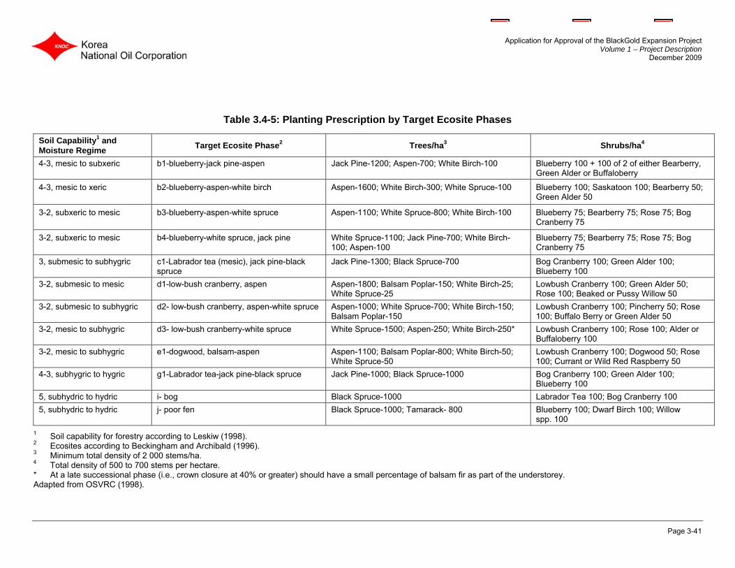
Application for Approval of the BlackGold Expansion Project Volume 1 – Project Description
December 2009
Page 3-41
Table 3.4-5: Planting Prescription by Target Ecosite Phases
Soil Capability1 and Moisture Regime Target Ecosite Phase2 Trees/ha3 Shrubs/ha4
4-3, mesic to subxeric b1-blueberry-jack pine-aspen Jack Pine-1200; Aspen-700; White Birch-100 Blueberry 100 + 100 of 2 of either Bearberry, Green Alder or Buffaloberry
4-3, mesic to xeric b2-blueberry-aspen-white birch Aspen-1600; White Birch-300; White Spruce-100 Blueberry 100; Saskatoon 100; Bearberry 50; Green Alder 50
3-2, subxeric to mesic b3-blueberry-aspen-white spruce Aspen-1100; White Spruce-800; White Birch-100 Blueberry 75; Bearberry 75; Rose 75; Bog Cranberry 75
3-2, subxeric to mesic b4-blueberry-white spruce, jack pine White Spruce-1100; Jack Pine-700; White Birch-100; Aspen-100
Blueberry 75; Bearberry 75; Rose 75; Bog Cranberry 75
3, submesic to subhygric c1-Labrador tea (mesic), jack pine-black spruce
Jack Pine-1300; Black Spruce-700 Bog Cranberry 100; Green Alder 100; Blueberry 100
3-2, submesic to mesic d1-low-bush cranberry, aspen Aspen-1800; Balsam Poplar-150; White Birch-25; White Spruce-25
Lowbush Cranberry 100; Green Alder 50; Rose 100; Beaked or Pussy Willow 50
3-2, submesic to subhygric d2- low-bush cranberry, aspen-white spruce Aspen-1000; White Spruce-700; White Birch-150; Balsam Poplar-150
Lowbush Cranberry 100; Pincherry 50; Rose 100; Buffalo Berry or Green Alder 50
3-2, mesic to subhygric d3- low-bush cranberry-white spruce White Spruce-1500; Aspen-250; White Birch-250* Lowbush Cranberry 100; Rose 100; Alder or Buffaloberry 100
3-2, mesic to subhygric e1-dogwood, balsam-aspen Aspen-1100; Balsam Poplar-800; White Birch-50; White Spruce-50
Lowbush Cranberry 100; Dogwood 50; Rose 100; Currant or Wild Red Raspberry 50
4-3, subhygric to hygric g1-Labrador tea-jack pine-black spruce Jack Pine-1000; Black Spruce-1000 Bog Cranberry 100; Green Alder 100; Blueberry 100
5, subhydric to hydric i- bog Black Spruce-1000 Labrador Tea 100; Bog Cranberry 100 5, subhydric to hydric j- poor fen Black Spruce-1000; Tamarack- 800 Blueberry 100; Dwarf Birch 100; Willow
spp. 100 1 Soil capability for forestry according to Leskiw (1998). 2 Ecosites according to Beckingham and Archibald (1996). 3 Minimum total density of 2 000 stems/ha. 4 Total density of 500 to 700 stems per hectare. * At a late successional phase (i.e., crown closure at 40% or greater) should have a small percentage of balsam fir as part of the understorey. Adapted from OSVRC (1998).

Application for Approval of the BlackGold Expansion Project Volume 1 – Project Description
December 2009
Page 3-42
3.4.6 Closure Phase Reclamation Final reclamation of the disturbed sites will commence soon after decommissioning and has the objective of returning disturbed sites to ecosite phases and land uses the same as, or similar to the pre-disturbance conditions. The underlying objective is to promote compatibility with the surrounding vegetation and to foster re-establishment of biodiversity. Long-term disturbed sites will be revegetated through natural recovery on native herbaceous vegetation supplemented by tree and shrub planting of low natural invasion. An SRD approved native seed mix will be applied in areas of high erosion potential. Illustrations of pre and post reclamation phases for facilities located on upland forested,, transitional and, peatland areas are provided in Attachment 1 (1-1 to 1-5). This phased reclamation approach is similar to that described in KNOC (2009). 3.4.6.1 Reclamation for Upland Forested Sites On a conceptual basis, surface disturbances on uplands will be reclaimed to a “c1” ecosite phase with a LCC of 3. This assignment will be re-assessed in the PDA and prior to reclamation to confirm site-specific conditions (soils, terrain features) and realistic ecosite development goals. The suggested planting prescription for a “c1” ecosite target phase is provided in Table 3.4-5. The general approach to reclamation on upland forested areas will include the following:
• consultation with the local reclamation inspector to discuss the target land use and reclamation objectives;
• removal of all infrastructure and surface gravel; reuse of gravel elsewhere, as appropriate;
• remove any contaminated material; determine need for contaminated site remediation; • re-contouring subsoil for compatibility with surrounding land and drainage (including
removal of berms and ditches) and leaving a stable surface; • alleviation of compaction on operational surfaces as needed; • replacement of salvaged soil; • preparation of replaced soil for revegetation; • addition of amendments (e.g., peat) if required; • re-vegetation in consultation with stakeholders (e.g., SRD); and • monitor to assess reclamation success and implement remedial measures (e.g., weed
control, amelioration of drainage or erosion problems) as required. 3.4.6.2 Reclamation for Transitional Areas between Upland and Lowland Transitional areas between upland and organic areas that are imperfectly to poorly drained will be reclaimed to a transitional “g1” ecosite target phase or LCC 4 as this is expected to develop over time. This assignment will be re-assessed in the PDA and prior to reclamation to confirm site-specific conditions and realistic ecosite development goals. The suggested planting prescription for a “g1” ecosite phase is provided in Table 3.4-5.

Application for Approval of the BlackGold Expansion Project Volume 1 – Project Description
December 2009
Page 3-43
The general approach to reclamation on g1 transitional areas will include the following:
• consultation with the local reclamation inspector to discuss the target land use and reclamation objectives;
• removal of facility, infrastructure, gravel and initial decompaction (e.g., ripping) of the target transition zone;
• re-countering of the edges of the upland area to a stable, gentle slope to minimize concentrated surface water flow. Microsite contouring will be considered to promote reclamation goals;
• replacement of peat and topsoil in the transition zone to form a poorly drained shallow replaced peat surface similar to the adjacent undisturbed peatland area;
• re-vegetation in consultation with stakeholders; and • monitor to assess reclamation success and implement remedial measures (e.g., weed
control, amelioration of drainage or erosion problems) as required.
3.4.6.3 Reclamation for Peatland Areas
Production well pads located on peatlands (i, j, k ecosite phases) will be reclaimed by removing fill and geotextile from the peat surface resulting in shallow depressional areas of open water. These disturbances are expected to remain LCC 5 and to support a “j” ecosite phase from the encroachment of natural vegetation and the potential rebound of the compressed peat from underneath the former pad. The suggested planting prescription for a ”j” ecosite phase is provided in Table 3.4-5.
3.4.6.4 Reclamation for Access Roads
All roads not required for ongoing activities will be closed to vehicular traffic and reclaimed and re-vegetated to native species. The reclamation of access roads will follow AENV requirements (AENV 1995a, 2000b).
3.4.6.5 Reclamation for Gathering Lines Corridors and Utilities
For reclamation of above ground gathering lines corridors will be removed and any reclamation required at those locations will be carried out. Power supply lines and poles will also be removed, and any reclamation necessary at those locations will be carried out. Natural recovery is planned for these small areas. For any underground pipelines, salvaged surface soil will be replaced at the completion of pipeline construction subsequent to alleviation of compaction. Areas with erosion potential will be protected (e.g., seeding SRD-approved seed mix, erosion matting, silt fencing). Re-vegetation will be done in consultation with SRD. Natural regeneration is preferred for re-vegetation of these narrow disturbances.

Application for Approval of the BlackGold Expansion Project Volume 1 – Project Description
December 2009
Page 3-44
3.4.6.6 Erosion Control Procedures
Where necessary, appropriate measures will be implemented to control erosion, and may include a combination of re-contouring disturbed areas, use of water bars and other means to channel surface runoff, and prompt revegetation using appropriate species. The intent is to stabilize the land as rapidly as possible while encouraging the invasion of native plants from the adjacent undisturbed sites. Thus overly aggressive or competitive grass seed will be avoided, with preference given to non-invasive and/or short-lived grass species. On disturbances immediately adjacent to watercourses, watershed protection will take priority over other vegetation objectives. Mitigation options will protect watershed by preventing erosion, and encourage vegetative development for long term protection. KNOC will commit to the following mitigation options for protection of watercourses:
• Clearing – 100 m buffer will be maintained beside watercourses with defined bed and bank, and as little vegetation as possible will be removed at watercourse crossings;
• Erosion Control – temporary berms will be installed on approach slopes to watercourse crossings and erect silt fences following grading. All erosion control structures will be inspected if installed on approach slopes and repaired immediately to ensure efficacy;
• Preferred Method of Construction – watercourse crossings will be open cut if dry or frozen. Open construction will be postponed in the event of heavy rain;
• Seeding – water quality will be protected by not fertilizing as part of the revegetation of watercourse crossings; and
• Monitoring – watercourse crossings will be inspected annually as well as following high flows to observe any channel erosion, scour development, debris jams and beaver activity.
3.4.6.7 Fertilizer Application
Fertilizer may be applied and incorporated into the surface if reclamation monitoring indicates that nutrient deficiencies (in the context of forest soils) may exist. Annual fertilization is not intended to be part of the standard revegetation program to prevent herbaceous species from becoming overly competitive with invading tree and shrub species, and to discourage rapid establishment by weed species. Application rates will be determined through annual monitoring of cover performance and cover objectives.
3.4.6.8 Reclamation Monitoring Program
KNOC will, as a condition of approval, monitor its reclaimed sites to ensure successful reclamation and report the monitoring results to the regulators, as required. If the monitoring identifies areas of reclaimed footprint that require mitigation, KNOC will take appropriate actions.

Application for Approval of the BlackGold Expansion Project Volume 1 – Project Description
December 2009
Page 3-45
In general, reclamation monitoring will include assessment of surface soil (quantity and visual assessment for quality problems, and profile restrictions) and landscape characteristics (e.g., drainage, erosion, surface stability, rocks, over-accumulation of woody debris in an area, and industrial debris). The reclamation monitoring program will evaluate the success of reclamation over time to ensure reclamation addresses the following objectives:
• acceptable landscape characteristics (drainage, erosion, slope stability, gravel and rocks, and debris);
• soil quality (e.g., texture, structure/compaction) and quantity (e.g., depth of surface replacement soil). Soils will be sampled and analyzed where needed to confirm any potential soil quality issues. Soil analytical parameters may include texture, structure, compaction, pH, electrical conductivity, sodium adsorption ratio and macronutrient levels;
• re-vegetation of disturbed areas; • weed control; • demonstrated progress towards re-establishment of wildlife habitat; • adequate progress in achieving desired reclamation targets (e.g., ecosite phase); • fish and fish habitat post-construction monitoring (e.g., road/bridge stream crossings)
where required by DFO and AENV regulations; and • reclamation is progressing in a manner likely to satisfy the reclamation certification
criteria at that time. Site-specific monitoring plans will be prepared to satisfy applicable Project Approval conditions, site-specific end land use objectives and to satisfy the applicable reclamation certification criteria in effect at the time of reclamation.
3.5 Conclusion
The conceptual C&R Plan for the project outlines plans for reclaiming areas disturbed through the life of this project. KNOC has provided an overview of the development and reclamation aspects of this project along with detailed information relating to:
• alteration of landforms; • restoration of land capability; • surface drainage; • soil salvage and replacement; • revegetation plans; • waste management;

Application for Approval of the BlackGold Expansion Project Volume 1 – Project Description
December 2009
Page 3-46
• decommissioning and abandonment; and • reclamation monitoring, mitigation and reporting. The information contained in the conceptual C&R Plan has been prepared to satisfy the requirements outlined in the project final EIA terms of reference. Based on the objectives, approaches and plans contained herein, KNOC requests approval for the conceptual C&R Plan.