Embed Size (px)
Citation preview

spring 2013 issue 33
In This Issue...Volcanoes of the Rio Grande Rift • Volcano or Not a Volcano?
Earth Briefs: Volcanic Hazards
Volcanoes Crossword Puzzle • New Mexico’s Most Wanted Minerals—Spinel
New Mexico’s Enchanting Geology
Classroom Activity: Building a Flour Box Caldera Model, New Mexico Style!
Through the Hand Lens • Short Items of Interest
LiteVolcanoes of the Rio Grande Rift
http://geoinfo.nmt.edu/publications/periodicals/litegeology/current.html
Ute Mountain is a volcano located nine miles southwest of Costilla, New Mexico that rises about 2,500 feet above the Taos Plateau. It is a lava dome composed of a volcanic rock called dacite, about 2.7 million years old. Photo courtesy of Paul Bauer.
NEW MEXICO BUREAU OF GEOLOGY & MINERAL RESOURCES A DIVISION OF NEW MEXICO TECH
new mexico bureau of geology & mineral resources lite geology spring 2013 2
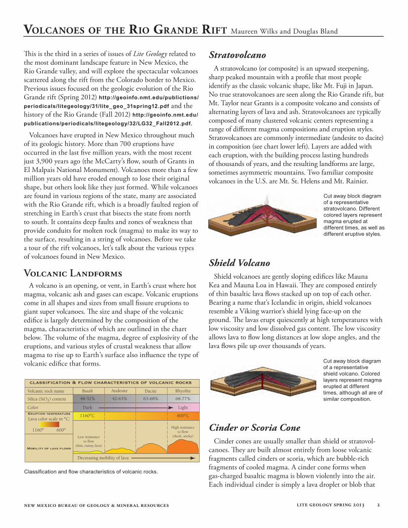
StratovolcanoA stratovolcano (or composite) is an upward steepening,
sharp peaked mountain with a profile that most people identify as the classic volcanic shape, like Mt. Fuji in Japan. No true stratovolcanoes are seen along the Rio Grande rift, but Mt. Taylor near Grants is a composite volcano and consists of alternating layers of lava and ash. Stratovolcanoes are typically composed of many clustered volcanic centers representing a range of different magma compositions and eruption styles. Stratovolcanoes are commonly intermediate (andesite to dacite) in composition (see chart lower left). Layers are added with each eruption, with the building process lasting hundreds of thousands of years, and the resulting landforms are large, sometimes asymmetric mountains. Two familiar composite volcanoes in the U.S. are Mt. St. Helens and Mt. Rainier.
Shield VolcanoShield volcanoes are gently sloping edifices like Mauna
Kea and Mauna Loa in Hawaii. They are composed entirely of thin basaltic lava flows stacked up on top of each other. Bearing a name that’s Icelandic in origin, shield volcanoes resemble a Viking warrior’s shield lying face-up on the ground. The lavas erupt quiescently at high temperatures with low viscosity and low dissolved gas content. The low viscosity allows lava to flow long distances at low slope angles, and the lava flows pile up over thousands of years.
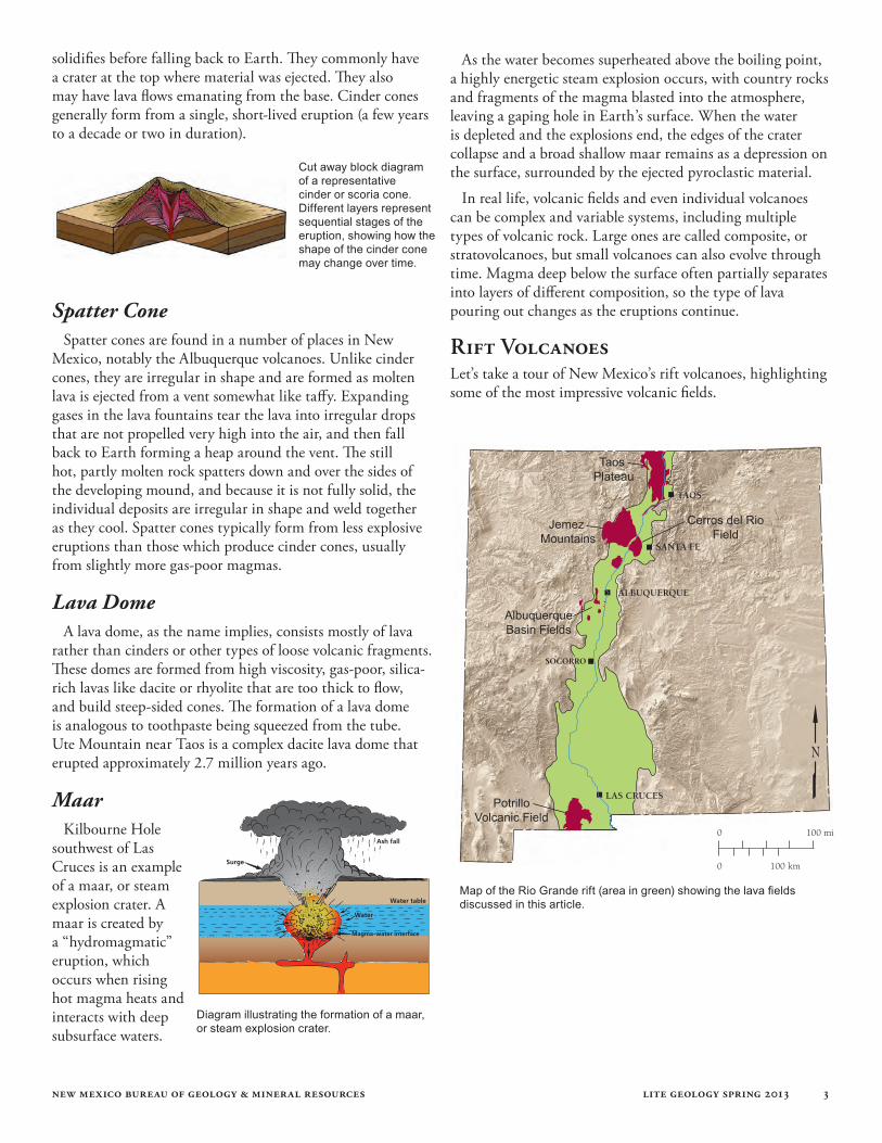
Cinder or Scoria ConeCinder cones are usually smaller than shield or stratovol-
canoes. They are built almost entirely from loose volcanic fragments called cinders or scoria, which are bubble-rich fragments of cooled magma. A cinder cone forms when gas-charged basaltic magma is blown violently into the air. Each individual cinder is simply a lava droplet or blob that
This is the third in a series of issues of Lite Geology related to the most dominant landscape feature in New Mexico, the Rio Grande valley, and will explore the spectacular volcanoes scattered along the rift from the Colorado border to Mexico. Previous issues focused on the geologic evolution of the Rio Grande rift (Spring 2012) http://geoinfo.nmt.edu/publictions/ periodicals/litegeology/31/lite_geo_31spring12.pdf and the history of the Rio Grande (Fall 2012) http://geoinfo.nmt.edu/publications/periodicals/litegeology/32/LG32_Fall2012.pdf.
Volcanoes have erupted in New Mexico throughout much of its geologic history. More than 700 eruptions have occurred in the last five million years, with the most recent just 3,900 years ago (the McCarty’s flow, south of Grants in El Malpais National Monument). Volcanoes more than a few million years old have eroded enough to lose their original shape, but others look like they just formed. While volcanoes are found in various regions of the state, many are associated with the Rio Grande rift, which is a broadly faulted region of stretching in Earth’s crust that bisects the state from north to south. It contains deep faults and zones of weakness that provide conduits for molten rock (magma) to make its way to the surface, resulting in a string of volcanoes. Before we take a tour of the rift volcanoes, let’s talk about the various types of volcanoes found in New Mexico.
Volcanic LandformsA volcano is an opening, or vent, in Earth’s crust where hot
magma, volcanic ash and gases can escape. Volcanic eruptions come in all shapes and sizes from small fissure eruptions to giant super volcanoes. The size and shape of the volcanic edifice is largely determined by the composition of the magma, characteristics of which are outlined in the chart below. The volume of the magma, degree of explosivity of the eruptions, and various styles of crustal weakness that allow magma to rise up to Earth’s surface also influence the type of volcanic edifice that forms.
Volcanoes of the Rio GRande Rift Maureen Wilks and Douglas Bland
Classification and flow characteristics of volcanic rocks.
Cut away block diagram of a representative stratovolcano. Different colored layers represent magma erupted at different times, as well as different eruptive styles.
Cut away block diagram of a representative shield volcano. Colored layers represent magma erupted at different times, although all are of similar composition.
new mexico bureau of geology & mineral resources lite geology spring 2013 3
solidifies before falling back to Earth. They commonly have a crater at the top where material was ejected. They also may have lava flows emanating from the base. Cinder cones generally form from a single, short-lived eruption (a few years to a decade or two in duration).
Spatter ConeSpatter cones are found in a number of places in New
Mexico, notably the Albuquerque volcanoes. Unlike cinder cones, they are irregular in shape and are formed as molten lava is ejected from a vent somewhat like taffy. Expanding gases in the lava fountains tear the lava into irregular drops that are not propelled very high into the air, and then fall back to Earth forming a heap around the vent. The still hot, partly molten rock spatters down and over the sides of the developing mound, and because it is not fully solid, the individual deposits are irregular in shape and weld together as they cool. Spatter cones typically form from less explosive eruptions than those which produce cinder cones, usually from slightly more gas-poor magmas.
Lava DomeA lava dome, as the name implies, consists mostly of lava
rather than cinders or other types of loose volcanic fragments. These domes are formed from high viscosity, gas-poor, silica-rich lavas like dacite or rhyolite that are too thick to flow, and build steep-sided cones. The formation of a lava dome is analogous to toothpaste being squeezed from the tube. Ute Mountain near Taos is a complex dacite lava dome that erupted approximately 2.7 million years ago.
MaarKilbourne Hole
southwest of Las Cruces is an example of a maar, or steam explosion crater. A maar is created by a “hydromagmatic” eruption, which occurs when rising hot magma heats and interacts with deep subsurface waters.
As the water becomes superheated above the boiling point, a highly energetic steam explosion occurs, with country rocks and fragments of the magma blasted into the atmosphere, leaving a gaping hole in Earth’s surface. When the water is depleted and the explosions end, the edges of the crater collapse and a broad shallow maar remains as a depression on the surface, surrounded by the ejected pyroclastic material.
In real life, volcanic fields and even individual volcanoes can be complex and variable systems, including multiple types of volcanic rock. Large ones are called composite, or stratovolcanoes, but small volcanoes can also evolve through time. Magma deep below the surface often partially separates into layers of different composition, so the type of lava pouring out changes as the eruptions continue.
Rift VolcanoesLet’s take a tour of New Mexico’s rift volcanoes, highlighting some of the most impressive volcanic fields.
Map of the Rio Grande rift (area in green) showing the lava fields discussed in this article.
Diagram illustrating the formation of a maar, or steam explosion crater.
Cut away block diagram of a representative cinder or scoria cone. Different layers represent sequential stages of the eruption, showing how the shape of the cinder cone may change over time.
Taos Plateau
Jemez Mountains
Cerros del RioField
AlbuquerqueBasin Fields
PotrilloVolcanic Field
SOCORRO
new mexico bureau of geology & mineral resources lite geology spring 2013 4
Jemez MountainsThe Jemez Mountains, near Los Alamos, were initially
formed by repeated small volcanic eruptions over at least the past 15 million years. However, most of the rocks exposed in the many radial canyons around the central crater were formed by two very large rhyolitic eruption cycles that took place 1.6 and 1.2 million years ago. Both eruptions began with immensely powerful explosive eruptions creating pumice and ash that fell across much of New Mexico, and as far away as Lubbock, Texas. This was followed by a series of pyroclas-tic flows composed of fast-moving clouds of superheated gas, pumice, ash, and crystals. This formed layers of welded tuff hundreds of feet thick, called the Bandelier Tuff. Following the end of the last main eruptive sequence, the top of the mountain collapsed, forming a caldera 13 miles across. A ring of smaller domes later developed on the margins of the caldera, creating the landscape we see today.
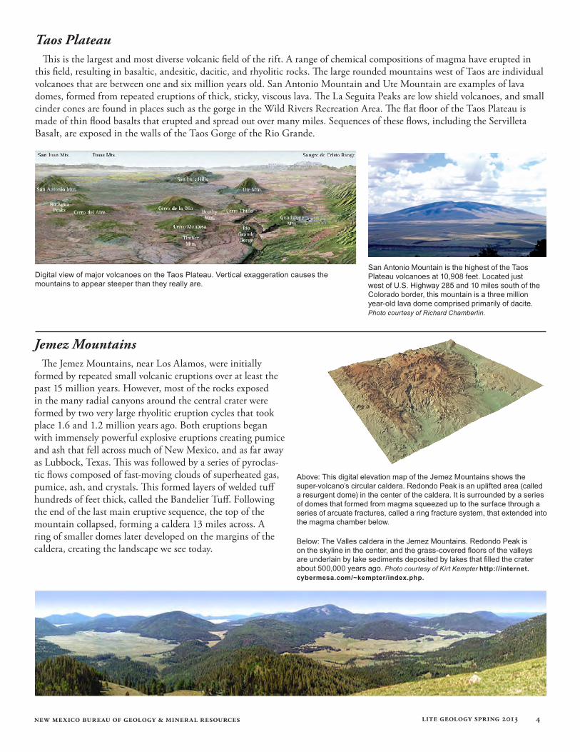
Taos PlateauThis is the largest and most diverse volcanic field of the rift. A range of chemical compositions of magma have erupted in
this field, resulting in basaltic, andesitic, dacitic, and rhyolitic rocks. The large rounded mountains west of Taos are individual volcanoes that are between one and six million years old. San Antonio Mountain and Ute Mountain are examples of lava domes, formed from repeated eruptions of thick, sticky, viscous lava. The La Seguita Peaks are low shield volcanoes, and small cinder cones are found in places such as the gorge in the Wild Rivers Recreation Area. The flat floor of the Taos Plateau is made of thin flood basalts that erupted and spread out over many miles. Sequences of these flows, including the Servilleta Basalt, are exposed in the walls of the Taos Gorge of the Rio Grande.
San Antonio Mountain is the highest of the Taos Plateau volcanoes at 10,908 feet. Located just west of U.S. Highway 285 and 10 miles south of the Colorado border, this mountain is a three million year-old lava dome comprised primarily of dacite. Photo courtesy of Richard Chamberlin.
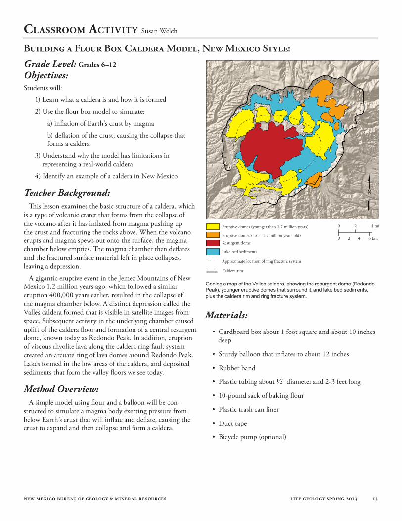
Above: This digital elevation map of the Jemez Mountains shows the super-volcano’s circular caldera. Redondo Peak is an uplifted area (called a resurgent dome) in the center of the caldera. It is surrounded by a series of domes that formed from magma squeezed up to the surface through a series of arcuate fractures, called a ring fracture system, that extended into the magma chamber below.
Below: The Valles caldera in the Jemez Mountains. Redondo Peak is on the skyline in the center, and the grass-covered floors of the valleys are underlain by lake sediments deposited by lakes that filled the crater about 500,000 years ago. Photo courtesy of Kirt Kempter http://internet.cybermesa.com/~kempter/index.php.
Digital view of major volcanoes on the Taos Plateau. Vertical exaggeration causes the mountains to appear steeper than they really are.
new mexico bureau of geology & mineral resources lite geology spring 2013 5
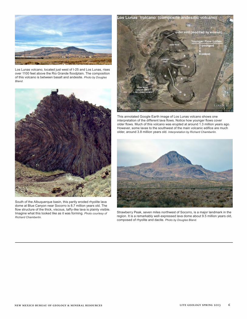
Albuquerque Basin
The Albuquerque Basin contains a series of volcanic fields including the San Felipe, Albuquerque, Wind Mesa, and Cat Hills fields. Some are several million years old, but the Albuquerque volcanoes were active as recently as 156,000 years ago, and the Cat Hills are thought to be as young as 90,000 years old. These features include cinder cones, spatter cones, and fluid lava flows. Most of the rocks are of basaltic composition. Many of the features in the Albuquerque-Los Lunas area erupted along north-south trending fissures associated with major faults of the Rio Grande rift. The Albuquerque volcanoes include five main vents visible from Albuquerque as small cones on the western skyline, which fall along a fissure six miles long.
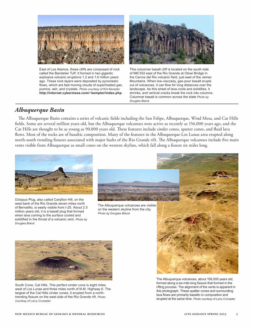
East of Los Alamos, these cliffs are composed of rock called the Bandelier Tuff. It formed in two gigantic explosive volcanic eruptions 1.2 and 1.6 million years ago. These rock layers were deposited by pyroclastic flows, which are fast moving clouds of superheated gas, pumice, ash, and crystals. Photo courtesy of Kirt Kempter http://internet.cybermesa.com/~kempter/index.php.
This columnar basalt cliff is located on the south side of NM 502 east of the Rio Grande at Otowi Bridge in the Cerros del Rio volcanic field, just east of the Jemez Mountains. When low-viscosity, gas-poor basalt erupts out of volcanoes, it can flow for long distances over the landscape. As this sheet of lava cools and solidifies, it shrinks, and vertical cracks break the rock into columns. Columnar basalt is common across the state Photo by Douglas Bland.
Octopus Plug, also called Canjillon Hill, on the west bank of the Rio Grande seven miles north of Bernalillo, is easily visible from I-25. About 2.5 million years old, it is a basalt plug that formed when lava coming to the surface cooled and solidified in the throat of a volcanic vent. Photo by Douglas Bland.
The Albuquerque volcanoes, about 156,000 years old, formed along a six-mile long fissure that formed in the rifting process. The alignment of the vents is apparent in this photograph. These spatter cones and surrounding lava flows are primarily basaltic in composition and erupted at the same time. Photo courtesy of Larry Crumpler.
South Cone, Cat Hills. This perfect cinder cone is eight miles west of Los Lunas and three miles north of N.M. Highway 6. The largest of the Cat Hills cinder cones, it erupted from a north-trending fissure on the west side of the Rio Grande rift. Photo courtesy of Larry Crumpler.
The Albuquerque volcanoes are visible on the western skyline from the city. Photo by Douglas Bland.
new mexico bureau of geology & mineral resources lite geology spring 2013 6
Los Lunas volcano, located just west of I-25 and Los Lunas, rises over 1100 feet above the Rio Grande floodplain. The composition of this volcano is between basalt and andesite. Photo by Douglas Bland.
This annotated Google Earth image of Los Lunas volcano shows one interpretation of the different lava flows. Notice how younger flows cover older flows. Much of this volcano was erupted at around 1.3 million years ago. However, some lavas to the southwest of the main volcanic edifice are much older, around 3.8 million years old. Interpretation by Richard Chamberlin.
South of the Albuquerque basin, this partly eroded rhyolite lava dome at Blue Canyon near Socorro is 8.7 million years old. The flow structure of the thick, viscous, taffy-like lava is plainly visible. Imagine what this looked like as it was forming. Photo courtesy of Richard Chamberlin.
Strawberry Peak, seven miles northwest of Socorro, is a major landmark in the region. It is a remarkably well-expressed lava dome about 9.5 million years old, composed of rhyolite and dacite. Photo by Douglas Bland.
new mexico bureau of geology & mineral resources lite geology spring 2013 7
Will volcanoes erupt again in New Mexico? Absolutely. When? No one knows. One estimate based on recent eruption frequency indicates there is a one percent chance of an eruption in the next 100 years, and a ten percent chance in the next 1,000 years. Seismic monitoring should give us plenty of warning.
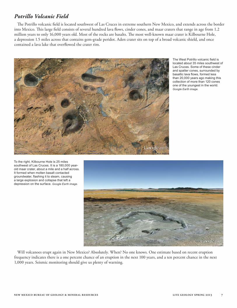
Potrillo Volcanic FieldThe Potrillo volcanic field is located southwest of Las Cruces in extreme southern New Mexico, and extends across the border
into Mexico. This large field consists of several hundred lava flows, cinder cones, and maar craters that range in age from 1.2 million years to only 16,000 years old. Most of the rocks are basalts. The most well-known maar crater is Kilbourne Hole, a depression 1.5 miles across that contains gem-grade peridot. Aden crater sits on top of a broad volcanic shield, and once contained a lava lake that overflowed the crater rim.
The West Potrillo volcanic field is located about 35 miles southwest of Las Cruces. Some of these cinder and spatter cones, surrounded by basaltic lava flows, formed less than 20,000 years ago making this collection of more than 120 cones one of the youngest in the world. Google Earth image.
To the right, Kilbourne Hole is 25 miles southwest of Las Cruces. It is a 180,000 year-old maar crater, about a mile and a half across. It formed when molten basalt contacted groundwater, flashing it to steam, causing a large explosion and collapse that left a depression on the surface. Google Earth image.
new mexico bureau of geology & mineral resources lite geology spring 2013 8
Volcano oR not a Volcano? Douglas Bland
Most of us would recognize Japan’s Mt. Fuji or Mt. Hood in Oregon as a volcano. However, most volcanoes don’t have that perfect conical shape with a crater at the summit. Many volcanoes erupt lava from more than one vent, creating lopsided structures with multiple peaks and lobes. In other cases, several volcanoes overlap, creating a series of hills or mountains that run together. However, most mountains on the planet are not volcanic in origin, and are composed of
completely different types of rocks. New Mexico has many different kinds of mountains. Do you know which ones are volcanic? The Jemez are, but the Sandias are not – think about the differences in their appearance. The forces of erosion oper-ate on all mountains regardless of rock type, and this process changes their original shape. Given all this, it can be difficult to determine which hills and mountains are volcanoes at first sight. The following examples illustrate this point.
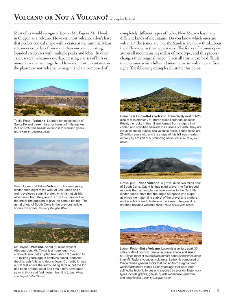
Tetilla Peak—Volcano. Located ten miles south of Santa Fe and three miles northwest of mile marker 271 on I-25, this basalt volcano is 2.6 million years old. Photo by Douglas Bland.
Cerro de la Cruz—Not a Volcano. Immediately east of I-25, also at mile marker 271, (three miles southeast of Tetilla Peak), the rocks in this hill are formed from magma that cooled and solidified beneath the surface of Earth. They are intrusive, not extrusive, like volcanic rocks. These rocks are 25 million years old, and the shape of this hill was created entirely by erosion of surrounding rocks. Photo by Douglas Bland.
South Cone, Cat Hills—Volcano. This very young cinder cone eight miles west of Los Lunas has a well-developed summit crater, which is not visible when seen from the ground. From this perspective, the crater rim appears to give the cone a flat top. The aerial photo of South Cone in the previous article shows the crater. Photo by Douglas Bland.
Gravel pile—Not a Volcano. A gravel mine two miles east of South Cone, Cat Hills, has piled gravel into flat-topped mounds that, at first glance, look similar to the Cat Hills cinder cones. Note that the angle of repose (the slope at which the material is stable) of the gravel and cinders on the sides of each feature is the same. The gravel is crushed basaltic volcanic rock. Photo by Douglas Bland.
Mt. Taylor—Volcano. About 50 miles west of Albuquerque, Mt. Taylor is a huge long-lived stratovolcano that erupted from about 3.5 million to 1.5 million years ago. It contains basalt, andesite, rhyolite, ash falls, and debris flows. Currently it rises 4,000 feet above the surrounding terrain, but the top has been eroded, so at one time it may have been several thousand feet higher than it is today. Photo courtesy of Colin Cikoski.
Ladron Peak—Not a Volcano. Ladron is a solitary peak 30 miles north of Socorro. Similar in overall shape and size to Mt. Taylor, most of its rocks are almost a thousand times older than Mt. Taylor’s youngest volcanics. Ladron is composed of Precambrian igneous rocks that cooled from magma deep within Earth more than a billion years ago that were later uplifted by tectonic forces and exposed by erosion. Major rock types include granite, gneiss, quartz monzonite, quartzite, and amphibolite. Photo by Douglas Bland.
new mexico bureau of geology & mineral resources lite geology spring 2013 9
The volcanoes of the Rio Grande rift in New Mexico are all extinct, but new eruptions will occur sometime in the future. If one were to erupt, what kind of hazards would we face? Examples from other parts of the world can give us clues.
The East African rift is a similar geologic environment to the Rio Grande rift, although presently more active. The landscape in the western branch of this rift is dominated by lakes and volcanoes. Nyiragongo volcano in the Democratic Republic of the Congo is a huge stratovolcano that contains the world’s largest lava lake in its summit caldera. Magma moving upward towards the surface in the thinned crust under the rift valley fuels the volcano. The lava lake is currently active, and it periodically either overflows or drains out through fissures in the side of the volcano. In 2002, it erupted and the thin lavas raced down the flanks of the mountain and into the city of Goma. Almost 150 people died, and thousands of build-ings were damaged or destroyed. Goma sits on the edge of Lake Kivu, and the lava from this eruption flowed into it.
The land has subsided in the rift, and a series of lakes has formed in the depressions, including Lake Kivu. Almost 50 miles long, it straddles the border between the Democratic Republic of the Congo and Rwanda. Carbon dioxide from the magma chamber below continually seeps into the bottom of the lake and dissolves in its waters. Bacteria in the lake convert
some of the carbon dioxide into methane (natural gas). Eventually the water becomes supersaturated, and can hold no more gas. A disruption such as an earthquake, underwater landslide, or lava flowing into the lake can cause a tremen-dous outpouring of gas, and this very likely has occurred periodically in the past. Such an emission from Lake Nyos in Cameroon in 1986 expelled a cloud of carbon dioxide that flowed down a nearby valley, killing over 1700 people.
Most of the gas in Lake Kivu is carbon dioxide, but it is estimated that more than 15 cubic miles of methane is dissolved in the lower layers of the lake. A facility is being constructed to extract methane from the lake and pipe it to an electric generating station on-shore in Rwanda, supplying the region with much-needed electricity. Phase 1 will generate 25 megawatts, with a possible expansion to 100 mega-watts. This project will reduce the gas content of the lake, possibly reducing the likelihood of a danger-ous gas eruption. It is the first project of its kind in
the world.
Volcanic disasters have occurred throughout his-tory, and many countries
have taken steps to reduce damage from these hazards. Seismic monitoring stations and volcano observations can help predict eruptions, but can not eliminate loss of life and destruction of property. If the city of Albuquerque had existed when the Albuquerque volcanoes erupted, lava flows would have caused considerable damage. However, carbon dioxide outflows from lakes are relatively rare, so that type of hazard carries a lower risk.
eaRth BRiefs—Volcanic hazaRds: laVa and lakes Douglas Bland
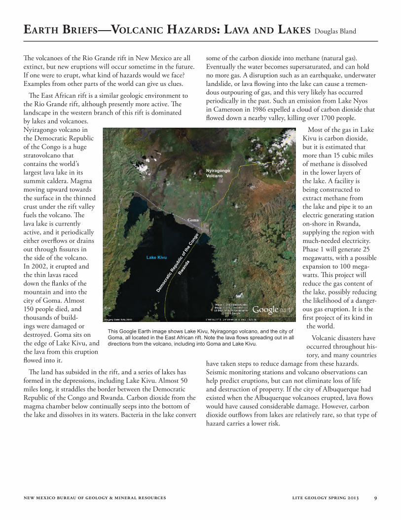
This Google Earth image shows Lake Kivu, Nyiragongo volcano, and the city of Goma, all located in the East African rift. Note the lava flows spreading out in all directions from the volcano, including into Goma and Lake Kivu.
Lake Kivu
NyiragongoVolcano
Dem
ocra
tic R
epub
lic o
f the
Con
go
Rwan
da
Goma
new mexico bureau of geology & mineral resources lite geology spring 2013 10
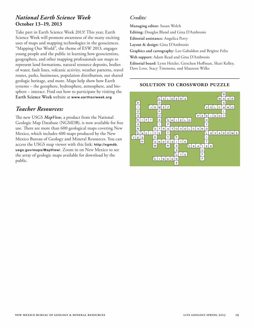
Volcanoes Crossword Puzzle Douglas Bland
1. thinnest type of lava2. Mt. Taylor is this type of volcano 4. river in New Mexico’s rift 8. lava type in the Jemez volcano10. type of cone in Albuquerque volcanoes11. a maar forms when this explodes13. one of the components of tuff16. Albuquerque volcanoes formed along this19. pyroclastic flows form this
Across Down
The answers to the clues are located in the Volcanoes of the Rio Grande article in this issue of Lite Geology.The solution to the puzzle is found on page 19 of this issue.
2. this one in the Jemez is 13 miles across 3. Kilbourne Hole is this volcano type5. supervolcano in New Mexico6. opening in Earth’s crust emitting magma7. gemstone found in Kilbourne Hole9. region of stretching in Earth’s crust10. volcano type associated with Vikings11. same as composite volcano12. one of two types of intermediate magma14. volcano formed from “toothpaste” lava15. will volcanoes erupt in New Mexico again?17. one of two types of intermediate magma18. many volcanoes have this at the top20. this volcano is a lava dome21. bubble-rich fragment of cooled magma
1
2 3
4
5 6
7 8
9 10
11
12 13 14
15 16
17
18 19
20
21
new mexico bureau of geology & mineral resources lite geology spring 2013 11
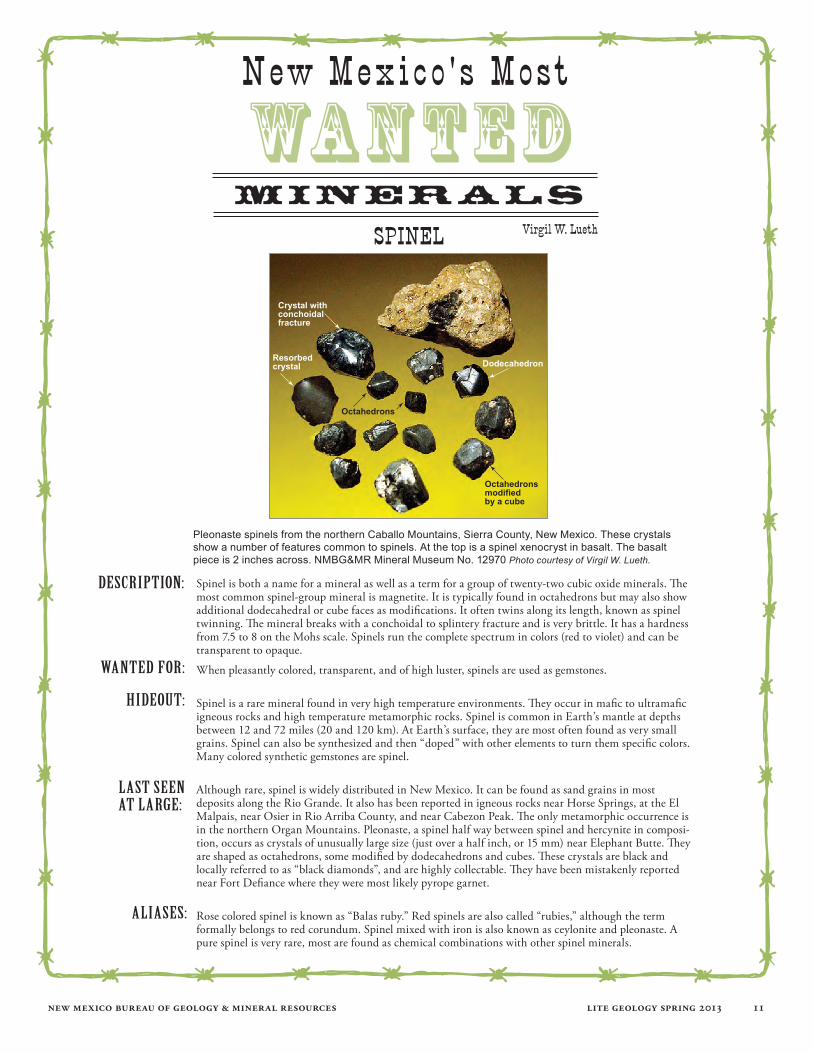
Spinel is both a name for a mineral as well as a term for a group of twenty-two cubic oxide minerals. The most common spinel-group mineral is magnetite. It is typically found in octahedrons but may also show additional dodecahedral or cube faces as modifications. It often twins along its length, known as spinel twinning. The mineral breaks with a conchoidal to splintery fracture and is very brittle. It has a hardness from 7.5 to 8 on the Mohs scale. Spinels run the complete spectrum in colors (red to violet) and can be transparent to opaque.
When pleasantly colored, transparent, and of high luster, spinels are used as gemstones.
Spinel is a rare mineral found in very high temperature environments. They occur in mafic to ultramafic igneous rocks and high temperature metamorphic rocks. Spinel is common in Earth’s mantle at depths between 12 and 72 miles (20 and 120 km). At Earth’s surface, they are most often found as very small grains. Spinel can also be synthesized and then “doped” with other elements to turn them specific colors. Many colored synthetic gemstones are spinel.
Although rare, spinel is widely distributed in New Mexico. It can be found as sand grains in most deposits along the Rio Grande. It also has been reported in igneous rocks near Horse Springs, at the El Malpais, near Osier in Rio Arriba County, and near Cabezon Peak. The only metamorphic occurrence is in the northern Organ Mountains. Pleonaste, a spinel half way between spinel and hercynite in composi-tion, occurs as crystals of unusually large size (just over a half inch, or 15 mm) near Elephant Butte. They are shaped as octahedrons, some modified by dodecahedrons and cubes. These crystals are black and locally referred to as “black diamonds”, and are highly collectable. They have been mistakenly reported near Fort Defiance where they were most likely pyrope garnet.
Rose colored spinel is known as “Balas ruby.” Red spinels are also called “rubies,” although the term formally belongs to red corundum. Spinel mixed with iron is also known as ceylonite and pleonaste. A pure spinel is very rare, most are found as chemical combinations with other spinel minerals.
Description:
wanteD for:
hiDeout:
last seen at large:
aliases:
New Mexico ' s Most
WANTEDminerals
Virgil W. LuethSpiNeL
Pleonaste spinels from the northern Caballo Mountains, Sierra County, New Mexico. These crystals show a number of features common to spinels. At the top is a spinel xenocryst in basalt. The basalt piece is 2 inches across. NMBG&MR Mineral Museum No. 12970 Photo courtesy of Virgil W. Lueth.
Crystal withconchoidalfracture
Resorbedcrystal
Octahedrons
Octahedronsmodifiedby a cube
Dodecahedron
new mexico bureau of geology & mineral resources lite geology spring 2013 12
new Mexico’s enchantinG GeoloGy
Shari Kelley
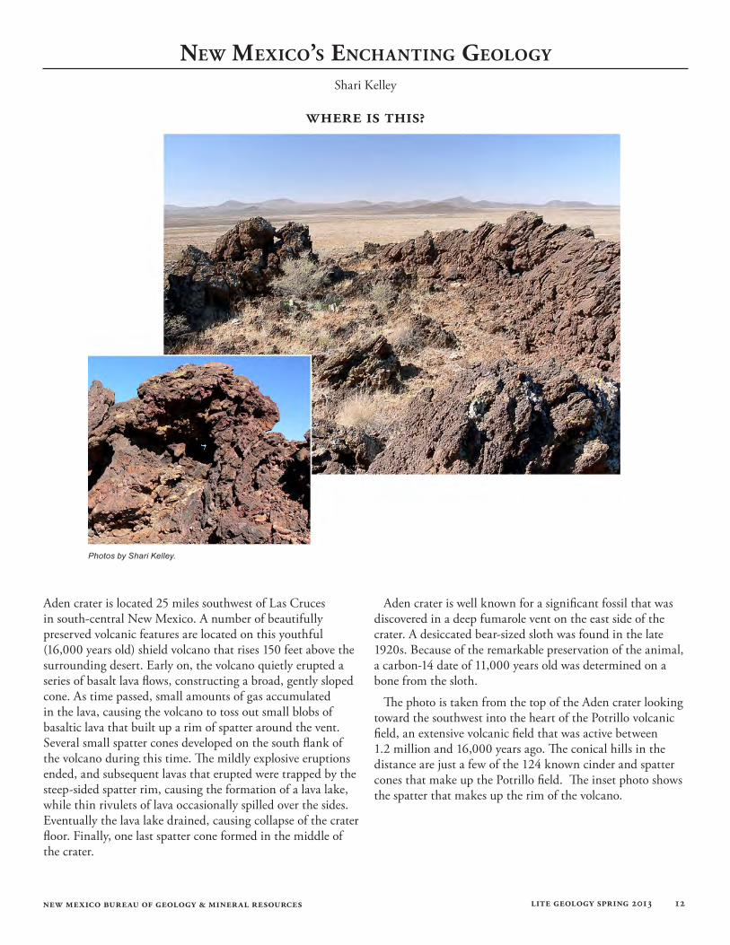
Aden crater is located 25 miles southwest of Las Cruces in south-central New Mexico. A number of beautifully preserved volcanic features are located on this youthful (16,000 years old) shield volcano that rises 150 feet above the surrounding desert. Early on, the volcano quietly erupted a series of basalt lava flows, constructing a broad, gently sloped cone. As time passed, small amounts of gas accumulated in the lava, causing the volcano to toss out small blobs of basaltic lava that built up a rim of spatter around the vent. Several small spatter cones developed on the south flank of the volcano during this time. The mildly explosive eruptions ended, and subsequent lavas that erupted were trapped by the steep-sided spatter rim, causing the formation of a lava lake, while thin rivulets of lava occasionally spilled over the sides. Eventually the lava lake drained, causing collapse of the crater floor. Finally, one last spatter cone formed in the middle of the crater.
Aden crater is well known for a significant fossil that was discovered in a deep fumarole vent on the east side of the crater. A desiccated bear-sized sloth was found in the late 1920s. Because of the remarkable preservation of the animal, a carbon-14 date of 11,000 years old was determined on a bone from the sloth.
The photo is taken from the top of the Aden crater looking toward the southwest into the heart of the Potrillo volcanic field, an extensive volcanic field that was active between 1.2 million and 16,000 years ago. The conical hills in the distance are just a few of the 124 known cinder and spatter cones that make up the Potrillo field. The inset photo shows the spatter that makes up the rim of the volcano.
Photos by Shari Kelley.
where is this?
new mexico bureau of geology & mineral resources lite geology spring 2013 13
classRooM actiVity Susan Welch
Grade Level: Grades 6–12
Objectives: Students will:
1) Learn what a caldera is and how it is formed
2) Use the flour box model to simulate:
a) inflation of Earth’s crust by magma
b) deflation of the crust, causing the collapse that forms a caldera
3) Understand why the model has limitations in representing a real-world caldera
4) Identify an example of a caldera in New Mexico
Teacher Background: This lesson examines the basic structure of a caldera, which
is a type of volcanic crater that forms from the collapse of the volcano after it has inflated from magma pushing up the crust and fracturing the rocks above. When the volcano erupts and magma spews out onto the surface, the magma chamber below empties. The magma chamber then deflates and the fractured surface material left in place collapses, leaving a depression.
A gigantic eruptive event in the Jemez Mountains of New Mexico 1.2 million years ago, which followed a similar eruption 400,000 years earlier, resulted in the collapse of the magma chamber below. A distinct depression called the Valles caldera formed that is visible in satellite images from space. Subsequent activity in the underlying chamber caused uplift of the caldera floor and formation of a central resurgent dome, known today as Redondo Peak. In addition, eruption of viscous rhyolite lava along the caldera ring-fault system created an arcuate ring of lava domes around Redondo Peak. Lakes formed in the low areas of the caldera, and deposited sediments that form the valley floors we see today.
Method Overview:A simple model using flour and a balloon will be con-
structed to simulate a magma body exerting pressure from below Earth’s crust that will inflate and deflate, causing the crust to expand and then collapse and form a caldera.
Materials:
• Cardboard box about 1 foot square and about 10 inches deep
• Sturdy balloon that inflates to about 12 inches
• Rubber band
• Plastic tubing about ½” diameter and 2-3 feet long
• 10-pound sack of baking flour
• Plastic trash can liner
• Duct tape
• Bicycle pump (optional)
Building a Flour Box Caldera Model, New Mexico Style!
Geologic map of the Valles caldera, showing the resurgent dome (Redondo Peak), younger eruptive domes that surround it, and lake bed sediments, plus the caldera rim and ring fracture system.

new mexico bureau of geology & mineral resources lite geology spring 2013 14
Method: 1) Construct the model (See illustration of box assembly before flour is added):
a. Punch a hole in the side of the box near the bottom to allow the plastic tubing to pass through.
b. Attach the balloon to one end of the tubing with a rubber band so that it will be airtight.
c. Insert the open end of the tubing outward through the hole in the box and center the balloon in the center of the box. Tape the tubing to the bottom of the box, allowing the balloon to move freely. Attach pump (if using) to end of tubing.
d. Line the box with a plastic trash bag making sure there is some excess around the balloon so it can expand without restriction.
e. Pour the flour into the box and tap the box to level the flour. Compact the flour gently using a block or similar object.
2) Demonstrate the formation of the caldera:a. Designate a magma inflation operator (balloon techni-cian) to blow air into the balloon.
b. Gently inflate and deflate the model in gradual steps to illustrate the stages of fractures that form. Instruct the students to observe changes in Earth’s crust (surface of the compacted flour) at each stage.
c. You should see some radial cracks form (these extend out from the center) with just a little inflation of the magma.
d. As the magma inflates further, some curved ring fractures will cut through the radial fractures.
e. Finally when the magma inflates to a maximum state, and then is allowed to deflate rapidly, steep cliffs will form as the crust deflates and a caldera is created.
3) Observations and discussions:Ask students to make notes and sketches as they observe the flour box caldera model in action. See the Volcanoes Alive link below for a worksheet to record comments and images of the different stages of fracture formation and collapse of the caldera. Discussion questions are also included at this link.
Discuss why this model has limitations when compared to real world volcanoes. See the UNVACO (University Navstar Consortium) link in the Lessons and Other Resources section for some discussion points about using the flour box model.
This sequence of photos on the right illustrates construction of the model and steps in the development of the caldera. Photos courtesy of Leo Gabaldon.
new mexico bureau of geology & mineral resources lite geology spring 2013 15
Lessons and Other Resources:
• Activity: Flour Box Volcano Deformation Model, 2012; Compiled and hosted by UNAVCO at the website: http://cws.unavco.org:8080/cws/modules/yellowstone/version-2012/teacher-materials/FlourBoxVolcano_LessonPlan.pdf
• Flour Box Calderas; 2001/2007, University of Alaska Geophysical Institute, hosted at the website: http://www.volcanoesalive.com/Lessons/VA%20Unit%206/6_5Flour_Box_Calderas.pdf
Additional information about the Valles caldera in New Mexico:
• See the FAQ section of the New Mexico Bureau of Geology website at: http://geoinfo.nmt.edu/faq/volcanoes/home.html
• The Geology of Northern New Mexico Parks, Monuments, and Public Lands, 2010, New Mexico Bureau of Geology and Mineral Resources, edited by L. Greer Price. Available for purchase at this link: http://geoinfo.nmt.edu/publications/fieldguides/nmparks/1/home.cfm
thRouGh the hand lens Susan Welch
profile of a new mexico earth science teacher Becky Kerr started her science career as a medical technolo-gist. After 20 years, machines began replacing much of the lab analyses she had been doing, so she decided to go back to school to get her teaching certificate. Becky’s first teaching job was at Heights Middle School in Farmington, where she acquired the outdoor classroom, an environmental educa-tion easement of land adjacent to the school, from the New Mexico State Land Office. Becky developed an environmen-tal curriculum that brought the students outdoors to conduct experiments and make observations in their journals about weather, erosion, animal and human alterations, and seasonal changes to a small tract that each student monitored. She re-alized that these hands-on, outdoor sessions made the science lessons they were learning more meaningful.
After teaching life and earth science at the secondary level for 14 years, Becky got her dream job training other teachers in place-based instruction that relates to the environment the students are in contact with every day. She is the New Mexico Regional Coordinator for the Bioregional Outdoor Education Project (BOEP) at Four Corners School of Outdoor Education.
Educational background:Teaching Certificate, Secondary Science, University of Northern Colorado, 1992.
Bachelor of Science, Microbiology/Medical Technology, Colorado State University, 1972.
This picture of Becky Kerr is from a trip down the San Juan River with the BOEP teachers, which is the final phase of the year-long training. This is a great relaxing way to get firsthand experience living in nature while observing the river and its erosion, rock formations, and cultural sites. Photo courtesy of Becky Kerr.
new mexico bureau of geology & mineral resources lite geology spring 2013 16
Service and outreach:I am currently serving on a number of local
and statewide science and environmental education boards. Also, each year I attend and present at several annual conferences on various topics including science teaching, environmental education, outdoor education, mining education, and Science, Technology, Engineering, and Mathematics (STEM).
Describe the Bioregional Outdoor Education Project: The Four Corners School of Outdoor Education covers the Colorado Plateau region of Utah, Colorado, New Mexico, and Arizona. Teachers and schools who participate must be located on the Colorado Plateau. In New Mexico that area ranges as far south as Zuni and extends east to the Rio Grande. However, all of the lessons and resources are available for anyone to use on the website in the links section below.
A new group of teachers begins the program each summer by attending the Summer Institute at a base camp, which was a pioneer home in Eastland, Utah. They live on site and learn about using place-based education as a path to become active citizens and stewards of the environment and place where they live. The camp has a log cabin, bunkhouse, and even a hogan classroom where the teachers train for five days. Teachers experience an exciting “vertical journey” by traveling up Abajo Mountain to see the changes in the ecosystems as they ascend to the top.
During the school year, I visit each teacher twice a month. I help teachers adapt their teaching style to include place-based, hands-on, outdoor, cross curricular lessons and activities appropriate for their local environment. The first weekend of March every year we hold a conference to bring together teachers and other educators from the Colorado Plateau Bioregion to learn how to better incorporate place-based, hands-on, outdoor education into their classrooms. Finally, the year-long program ends with a rafting trip on the San Juan River where the teachers learn about the geology, ecosystems, and cultural history, along with rafting and outdoor living skills.
Why is it important for students to learn about earth science? Students today are dependent on technology, yet many of them do not understand the interdependence of all things. We can educate children about the resources we will need in the future so we can provide food and shelter, along with clean air and water for all organisms on Earth.
Remember that if it is not grown, it is mined. We need to keep all the limiting factors in balance in order to survive.
Advice or suggestions for other earth science teachers: Engage your students. Help them connect directly with your subject. Take them outside to experience science firsthand, because if they have no personal experience, they will just memorize and then forget. Also, as an educator, I love serving on boards because it allows me to network with others in the same field.
You have been one of our veteran teachers in the summer geology workshop, Rockin’ Around New Mexico. What were your favorite locations for Rockin’ sessions? I loved going to Grants and learning about the volcanic activity there. I also enjoyed walking the bridge over the Royal Gorge near Taos, and going to the City of Rocks near Deming. Every year there are new locations around the state, informative instructors, interesting new content, and fantastic hands-on activities. Rockin’ Around New Mexico is one of the best professional development opportunities available to New Mexico teachers.
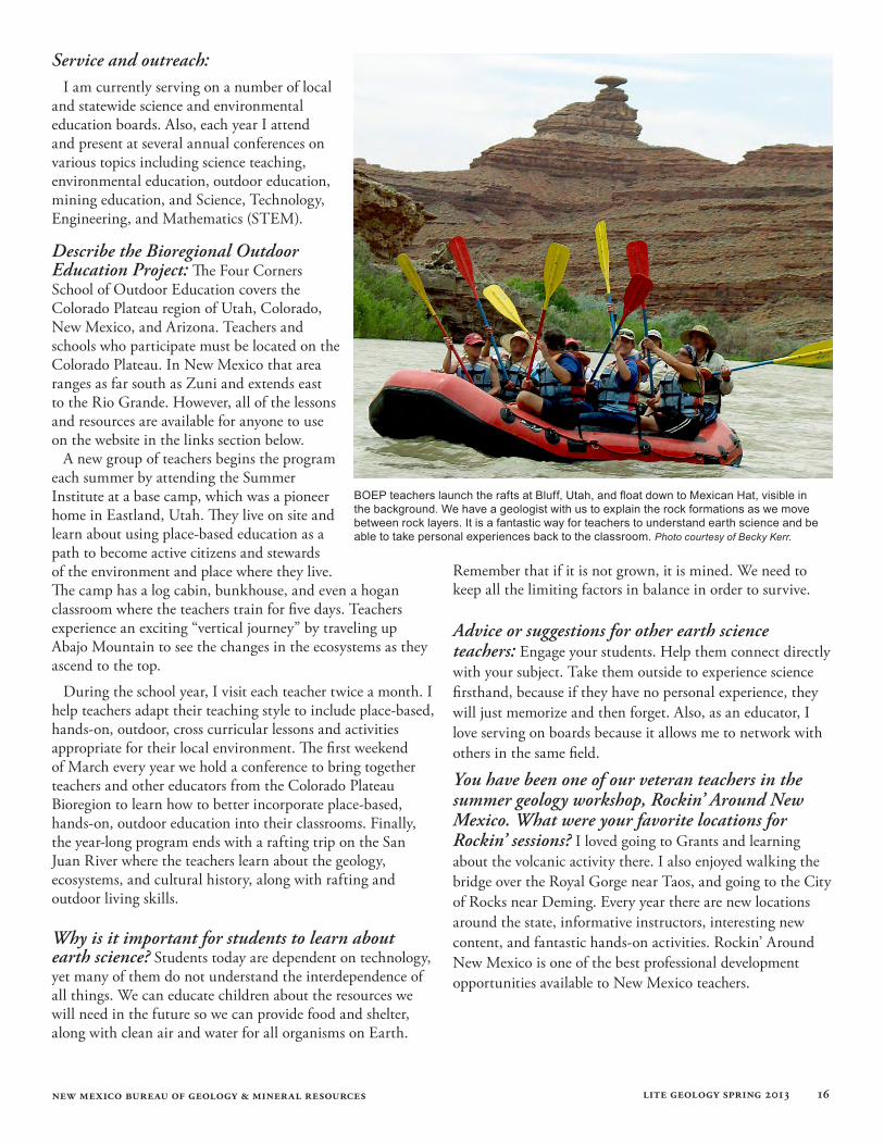
BOEP teachers launch the rafts at Bluff, Utah, and float down to Mexican Hat, visible in the background. We have a geologist with us to explain the rock formations as we move between rock layers. It is a fantastic way for teachers to understand earth science and be able to take personal experiences back to the classroom. Photo courtesy of Becky Kerr.
new mexico bureau of geology & mineral resources lite geology spring 2013 17
Favorite lesson in Earth Science: The Rock Cycle Dice Game can be found at this link on the BOEP website:http://www.fourcornersschool.org/images/stories/boep/boep-lesson-plans/The_Rock_Cycle_Dice.doc
Students experience the rock cycle by rolling “dice” and visiting stations represented by the various stages of the rock cycle. Directions on creating the materials are included. There are dozens of other lessons on the www.boep.org website.
How did you fall in love with geology? When I was a kid I fell in love with geology. I would go with my dad fishing. He would fish, and I would literally catch rocks. Over the years, I just realized how beautiful they are. But now with my earth science training, I understand how they formed. Knowing more about the geological features makes driving from Farmington to Albuquerque so much fun.
What hobbies do you have that relate to your science teaching? I have explored photography for many years. Anyone who has experienced a road trip with me knows that I brake for rocks, stopping frequently to photograph the geology and collect rocks on the roadside. On my recent vacation to the Pacific Northwest, I brought a waterproof and a regular camera with a great zoom feature to be sure I could take pictures in any conditions. Our vacation included a drive through the Mojave Desert, Death Valley, and Yosemite. After heading to Sequoia National Park we drove north along the Pacific coast on Highway 1. In Seattle we boarded a ship for an Alaskan cruise. The glaciers were breathtaking! On the way home we took a volcano tour. We visited Mt. Rainier,
Mt. St. Helens, Mt. Hood, Lava Park, and finally, Crater Lake. On the entire trip, I did what my children always complain about: I took pictures of rocks and weeds!
What is your favorite geologic feature in New Mexico? My favorite geologic feature is Shiprock, on the Navajo Nation near the Four Corners. I am reminded of the wonder of nature as I ponder the processes that have made this iconic rock visible to us today. Shiprock also has cultural importance, symbolizing to me how appreciation of Earth is incorporated into everyone’s life and culture.
What are your favorite web links for science resources?The Four Corners School of Outdoor Education/Bioregional Outdoor Education Program website with lessons and information about our programs and annual conference. www.boep.org
National Science Teacher Association website, which has professional development opportunities and many other resources. www.nsta.org
This site has wonderful lessons and lots of other resources. www.windows2universe.org/
Lunar and Planetary Institute. http://www.lpi.usra.edu/education/
Women in Mining with great resources. http://www.womeninmining.org/
cd
new mexico bureau of geology & mineral resources lite geology spring 2013 18
To Schedule a Museum Tour, Contact:Susie Welch Manager, Geologic Extension Service [email protected] 575-835-5112
the publication sales office at the new mexico bureau of geology and mineral resources (on the campus of New Mexico Tech) Open 9 a.m. to 4 p.m. (closed for lunch from 12 to 1), Monday through Friday.
Call 575-835-5490 for phone orders or information, or visit our website at: http://geoinfo.nmt.edu/publications
The Publication Sales Office has many resources for teachers, including publications on New Mexico’s geology. Many are written for the amateur geologist and general public.
Check out our New Pubs at: geoinfo.nmt.edu/publications/new/
We offer:• Topographic maps for the entire state of New Mexico • Geologic maps for selected areas of New Mexico• Popular and educational geologic publications • U.S. Forest Service maps• A 20% discount for teachers
upcoming events for teachers and the publicRockin’ Around New Mexico July 10–12, 2013Basic training in rocks, minerals, and map skills, along with seismic and volcanic hazards, will be the focus of this year’s three-day summer geology workshop for teachers. We will explore how minerals combine to build the various rock types. We will take a field trip to collect samples of each rock type, while examining evidence of seismic and volcanic events that have shaped the local landscape. Teachers can build map skills by working with topographic and geologic maps, and construct a three-dimensional model of a New Mexico landscape. An optional one-hour of graduate credit through the Masters of Science for Teachers at New Mexico Tech is available. Teachers can request an application to participate by sending an e-mail to Susie Welch at [email protected].
the mineral museum on the campus of new mexico tech in socorro, new mexicoHours: 8 a.m. to 5 p.m., Monday through Friday
10 a.m. to 3 p.m., Saturday and Sunday
Closed on New Mexico Tech holidays
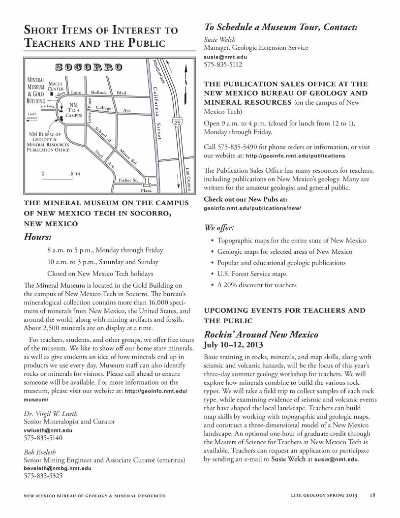
The Mineral Museum is located in the Gold Building on the campus of New Mexico Tech in Socorro. The bureau’s mineralogical collection contains more than 16,000 speci-mens of minerals from New Mexico, the United States, and around the world, along with mining artifacts and fossils. About 2,500 minerals are on display at a time.
For teachers, students, and other groups, we offer free tours of the museum. We like to show off our home state minerals, as well as give students an idea of how minerals end up in products we use every day. Museum staff can also identify rocks or minerals for visitors. Please call ahead to ensure someone will be available. For more information on the museum, please visit our website at: http://geoinfo.nmt.edu/museum/
Dr. Virgil W. Lueth Senior Mineralogist and Curator [email protected] 575-835-5140
Bob Eveleth Senior Mining Engineer and Associate Curator (emeritus) [email protected] 575-835-5325
shoRt iteMs of inteRest to teacheRs and the PuBlic
new mexico bureau of geology & mineral resources lite geology spring 2013 19
National Earth Science Week October 13–19, 2013 Take part in Earth Science Week 2013! This year, Earth Science Week will promote awareness of the many exciting uses of maps and mapping technologies in the geosciences. “Mapping Our World”, the theme of ESW 2013, engages young people and the public in learning how geoscientists, geographers, and other mapping professionals use maps to represent land formations, natural resource deposits, bodies of water, fault lines, volcanic activity, weather patterns, travel routes, parks, businesses, population distribution, our shared geologic heritage, and more. Maps help show how Earth systems – the geosphere, hydrosphere, atmosphere, and bio-sphere – interact. Find out how to participate by visiting the Earth Science Week website at www.earthsciweek.org
Teacher Resources:The new USGS MapView, a product from the National Geologic Map Database (NGMDB), is now available for free use. There are more than 600 geological maps covering New Mexico, which includes 400 maps produced by the New Mexico Bureau of Geology and Mineral Resources. You can access the USGS map viewer with this link: http://ngmdb.usgs.gov/maps/MapView/. Zoom in on New Mexico to see the array of geologic maps available for download by the public.
solution to crossword puzzle
Credits:
Managing editor: Susan WelchEditing: Douglas Bland and Gina D’AmbrosioEditorial assistance: Angelica PerryLayout & design: Gina D’AmbrosioGraphics and cartography: Leo Gabaldon and Brigitte FelixWeb support: Adam Read and Gina D’AmbrosioEditorial board: Lynn Heizler, Gretchen Hoffman, Shari Kelley, Dave Love, Stacy Timmons, and Maureen Wilks
B1
C2
A L D E R A M3
A RR
4O S
I J5
E M E Z V6
O L C A N OO P LG O P
7E R
8I D O T
R9
I F T S S10
H I E L D HA I P YN S
11T R A T O V O L C A N O
D12
A13
C I T E T L14
A V A D O M EY
15E S E T F
16I
H A17
N D E S I T E TM R S C
18R T
19E R
S U
U20
T E F
C21
I N D E FE
A
A
R
new mexico bureau of geology & mineral resources lite geology spring 2013 20
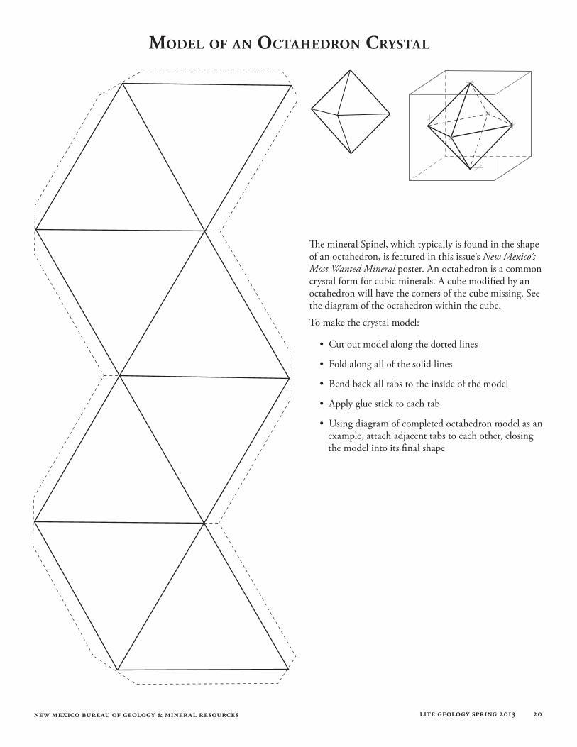
The mineral Spinel, which typically is found in the shape of an octahedron, is featured in this issue’s New Mexico’s Most Wanted Mineral poster. An octahedron is a common crystal form for cubic minerals. A cube modified by an octahedron will have the corners of the cube missing. See the diagram of the octahedron within the cube.
To make the crystal model:
• Cut out model along the dotted lines
• Fold along all of the solid lines
• Bend back all tabs to the inside of the model
• Apply glue stick to each tab
• Using diagram of completed octahedron model as an example, attach adjacent tabs to each other, closing the model into its final shape
Model of an octahedRon cRystal