Embed Size (px)
DESCRIPTION
Volcanoes
Citation preview
Learning Objectives There are about 1,500 active volcanoes on Earth, almost 400 of which have erupted in the last century. While you are reading this paragraph at least 20 volcanoes are erupting on our planet. Volcanoes occur on all seven continents as well as in the middle of the ocean. When human beings live in the path of an active volcano, the results can be devastating. In this chapter we focus on the following learning goals:
• Know the different types of volcanoes and their associated features
• Understand the relationship of volcanoes to plate tectonics
• Know what geographic regions are at risk from volcanoes
• Know the effects of volcanoes and how they are linked to other natural hazards
• Recognize the potential benefits of volcanic eruptions
• Understand how we can minimize the volcanic hazard
• Know what adjustments we can make to avoid death and damage from volcanoes
68
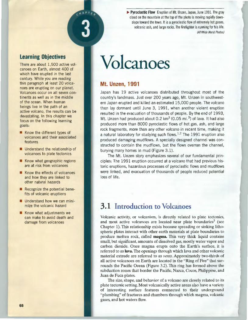
.,.. Pyroclastic Flow Eruption of Mt. Unzen, Japan, June 1991. The gray cloud on the mountain at the top of the photo is moving rapidly down
slope toward the town. It is a pyroclastic flow of extremely hot gases, volcanic ash, and large rocks. The firefighter is running for his life.
(AP/Wide World Photos)
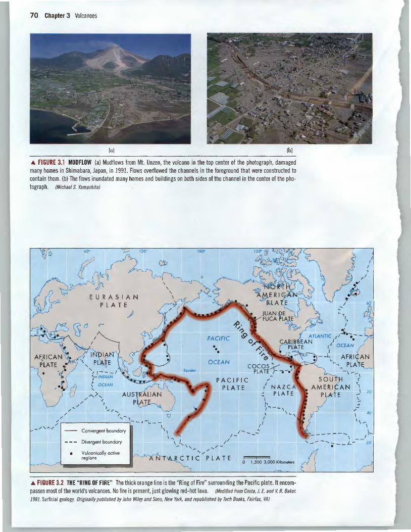
Volcanoes Mt. Unzen, 1991 Japan has 19 active volcanoes distributed throughout most of the country's landmass. Just over 200 years ago, Mt. Unzen in southwestern Japan erupted and killed an estimated 15,000 people. The volcano then lay dormant until June 3, 1991, when another violent eruption resulted in the evacuation of thousands of people. By the end of 1993, Mt. Unzen had produced about 0.2 km3 (0.05 mi. 3) of lava. It had also produced more than 8000 pyroclastic flows of hot gas, ash, and large rock fragments, more than any other volcano in recent time, making it a natural laboratory for studying such flows. 1·2 The 1991 eruption also produced damaging mudflows. A specially designed channel was constructed to contain the mudflows, but the flows overran the channel, burying many homes in mud (Figure 3.1).
The Mt. Unzen story emphasizes several of our fundamental principles: The 1991 eruption occurred at a volcano that had previous historic eruptions, hazardous processes of pyroclastic flows and mudflows were linked, and evacuation of thousands of people reduced potential loss of life.
3.1 Introduction to Volcanoes Volcanic activity, or volcanism, is directly related to plate tectonics, and most active volcanoes are located near plate boundaries3 (see Chapter 1). This relationship exists because spreading or sinking lithospheric plates interact with other earth materials at plate boundaries to produce molten rock, called magma. This very thick liquid contains small, but significant, amounts of dissolved gas, mostly water vapor and carbon dioxide. Once magma erupts onto the Earth's surface, it is referred to as lava. The openings through which lava and other volcanic material extrude are referred to as vents. Approximately two-thirds of all active volcanoes on Earth are located in the "Ring of Fire" that surrounds the Pacific Ocean (Figure 3.2). This ring has formed above the subduction zones that border the Pacific, Nazca, Cocos, Philippine, and Juan de Fuca plates.
The size, shape, and behavior of a volcano are closely related to its plate tectonic setting. Most volcanically active areas also have a variety of interesting surface features connected to their underground "plumbing" of fractures and chambers through which magma, volcanic gases, and hot waters flow.
Volcano Types Each type of volcano has a characteristic eruptive style that is due, in part, to how resistant the magma is to flowing. This resistance to flow is called viscosity. Fluids such as cool, refrigerated honey or peanut butter have a high resistance to flow and thus a high viscosity. In contrast, fluids such as water or warm honey have a lower viscosity. Magma viscosity is determined by its silica (Si02) content and by its temperature. The higher the silica content and the cooler the temperature of a magma, the more viscous it is. Highly viscous magma often erupts explosively, as opposed to less viscous magma, which tends to flow rather than explode.
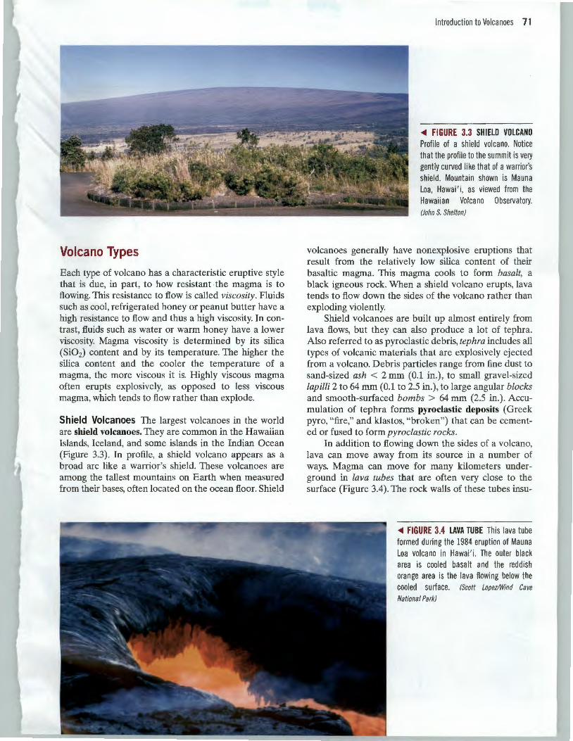
Shield Volcanoes The largest volcanoes in the world are shield volcanoes. They are common in the Hawaiian Islands, Iceland, and some islands in the Indian Ocean (Figure 3.3). In profile, a shield volcano appears as a broad arc like a warrior's shield. These volcanoes are among the tallest mountains on Earth when measured from their bases, often located on the ocean floor. Shield
Introduction to Volcanoes 71
<0111 FIGURE 3.3 SHIELD VOLCANO Profile of a shield volcano. Notice that the profile to the summit is very gently curved like that of a warrior's shield. Mountain shown is Mauna Loa, Hawai' i, as viewed from the Hawaiian Volcano Observatory. (John S. Shelton)
volcanoes generally have nonexplosive eruptions that result from the relatively low silica content of their basaltic magma. This magma cools to form basalt, a black igneous rock. When a shield volcano erupts, lava tends to flow down the sides of the volcano rather than exploding violently.
Shield volcanoes are built up almost entirely from lava flows, but they can also produce a lot of tephra. Also referred to as pyroclastic debris, tephra includes all types of volcanic materials that are explosively ejected from a volcano. Debris particles range from fine dust to sand-sized ash < 2 mm (0.1 in.) , to small gravel-sized lapilli 2 to 64 mm (0.1 to 2.5 in.), to large angular blocks and smooth-surfaced bombs > 64 mm (2.5 in.). Accumulation of tephra forms pyroclastic deposits (Greek pyro, "fire," and klastos, "broken") that can be cemented or fused to form pyroclastic rocks.
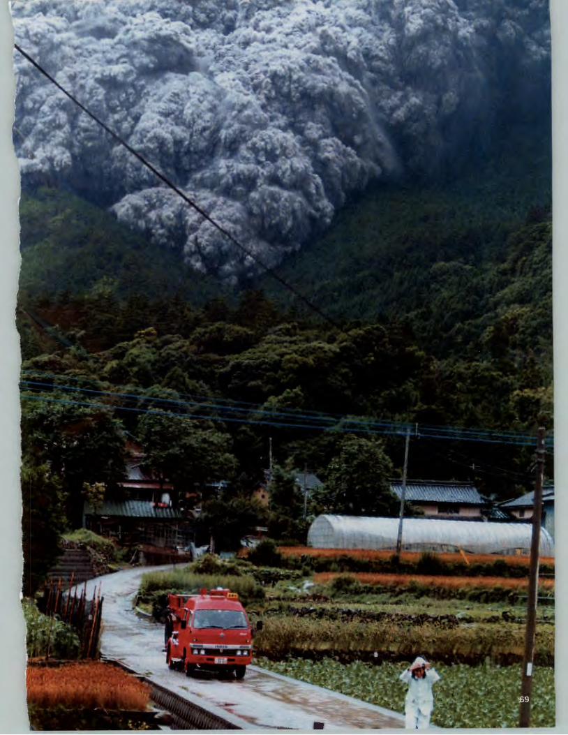
In addition to flowing down the sides of a volcano, lava can move away from its source in a number of ways. Magma can move for many kilometers underground in lava tubes that are often very close to the surface (Figure 3.4). The rock walls of these tubes insu-
<Ill FIGURE 3.4 LAVA TUBE This lava tube formed during the 1984 eruption of Mauna Loa volcano in Hawai 'i. The outer black area is cooled basalt and the reddish orange area is the lava flowing below the cooled surface. (Scott Lopez/Wind Cave
National Park)
70 Chapter 3 Volcanoes
!al !bl
.&. FIGURE 3.1 MUDFLDW (a) Mudflows from Mt. Unzen, the volcano in the top center of the photograph, damaged many homes in Shimabara, Japan, in 1991. Flows overflowed the channels in the foreground that were constructed to contain them. (b) The flows inundated many homes and buildings on both sides of the channel in the center of the photograph. (MichaelS. Yamashita)
•
60
EUR A SI A N P LA T E
Convergent boundary
Divergent boundary
Volcanically active regions
.)
120 180
C TIC
PACIFIC
• • • OCEAN
~ -.... ., ~
0/ ,I:' •
.... ..... 6l l
cocos~ • PLATE , --. -.J
PACIFIC " PLATE
PL A TE 0 1,500 3,000 Kilometers
.&. FIGURE 3.2 THE "RING OF FIRE" The thick orange line is the "Ring of Fire" surrounding the Pacific plate. It encompasses most of the world 's volcanoes. No fire is present, just glowing red-hot lava. (Modified from Costa, J. E. and V. R. Baker.
1981. Surficial geology. Originally published by John Wiley and Sons, New York, and republished by Tech Books, Fairfax, VA)
-\--1 r
\
r' I
60
) 20"
\ _. _.
I 40"
\\-I
r)... \ --
'------- _ L~ 60 •
72 Chapter 3 Volcanoes
late the magma, keeping it hot and fluid. After the lava cools and crystallizes to rock, the lava tubes may be left behind as long, sinuous cavern systems. They form natural pipes for movement of groundwater and may cause engineering problems when they are encountered during construction projects.
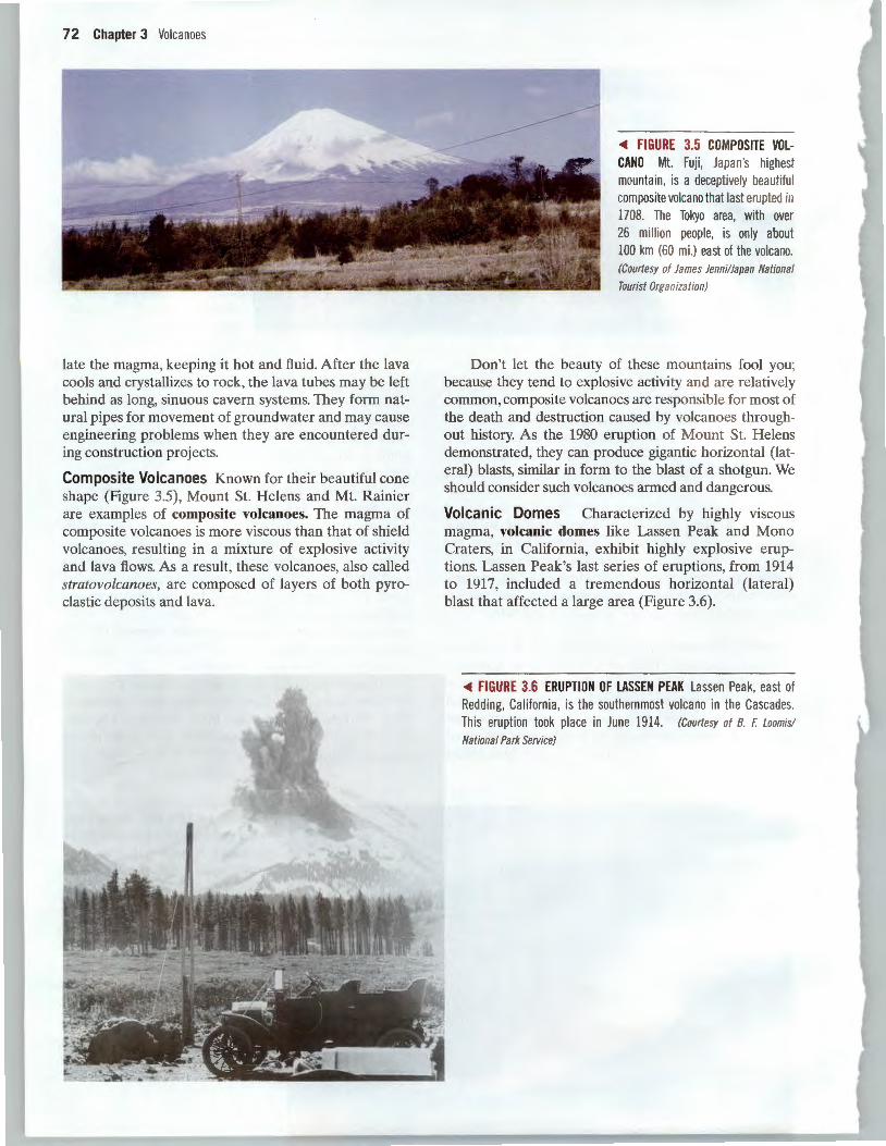
Composite Volcanoes Known for their beautiful cone shape (Figure 3.5), Mount St. Helens and Mt. Rainier are examples of composite volcanoes. The magma of composite volcanoes is more viscous than that of shield volcanoes, resulting in a mixture of explosive activity and lava flows. As a result, these volcanoes, also called stratovolcanoes, are composed of layers of both pyroclastic deposits and lava.
~ FIGURE 3.5 COMPOSITE VOLCANO Mt. Fuji , Japan's highest mountain, is a deceptively beautiful composite volcano that last erupted in 1708. The Tokyo area, with over 26 million people, is only about 100 km (60 mi.) east of the volcano. (Courtesy of James lenni/Japan National
Tourist Organization)
Don't let the beauty of these mountains fool you· because they tend to explosive activity and are relatively common, composite volcanoes are responsible for most of the death and destruction caused by volcanoes throughout history. As the 1980 eruption of Mount St. Helens demonstrated, they can produce gigantic horizontal (lateral) blasts, similar in form to the blast of a shotgun. We should consider such volcanoes armed and dangerous.
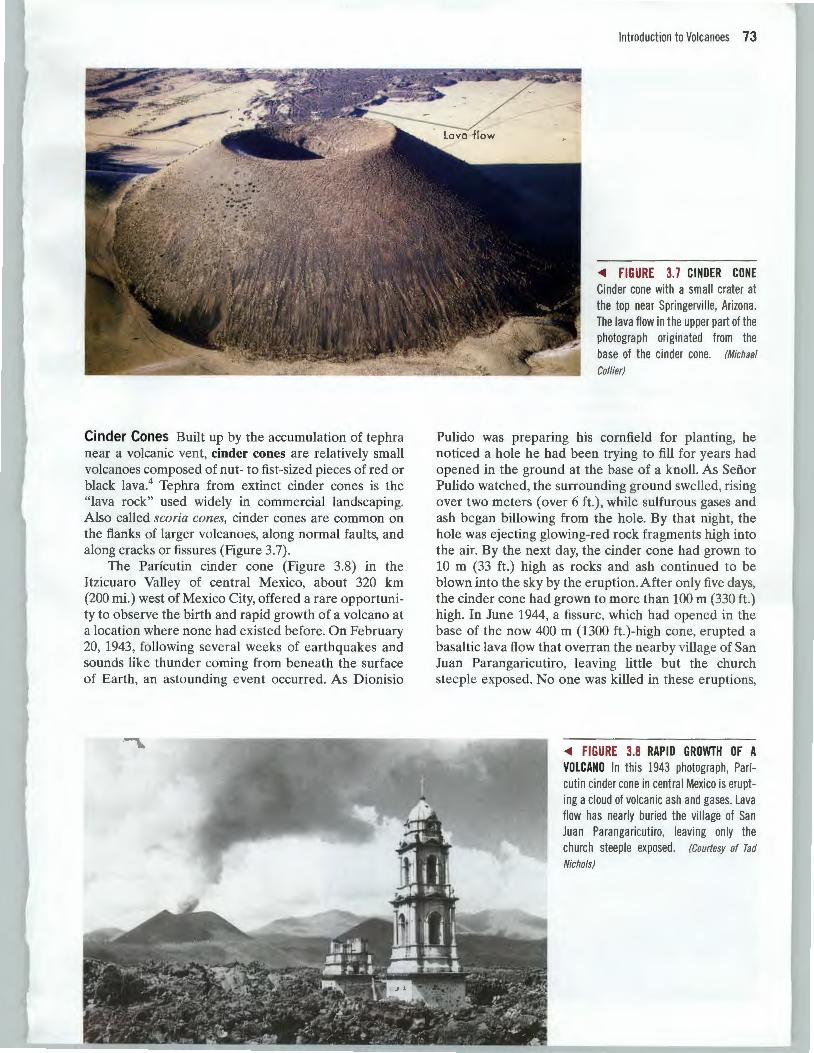
Volcanic Domes Characterized by highly viscous magma, volcanic domes like Lassen Peak and Mono Craters, in California, exhibit highly explosive eruptions. Lassen Peak's last series of eruptions, from 1914 to 1917, included a tremendous horizontal (lateral) blast that affected a large area (Figure 3.6) .
~ FIGURE 3.6 ERUPTION OF LASSEN PEAK Lassen Peak, east of Redding, California, is the southernmost volcano in the Cascades. This eruption took place in June 1914. (Courtesy of B. F. Loomis/
National Park Service)
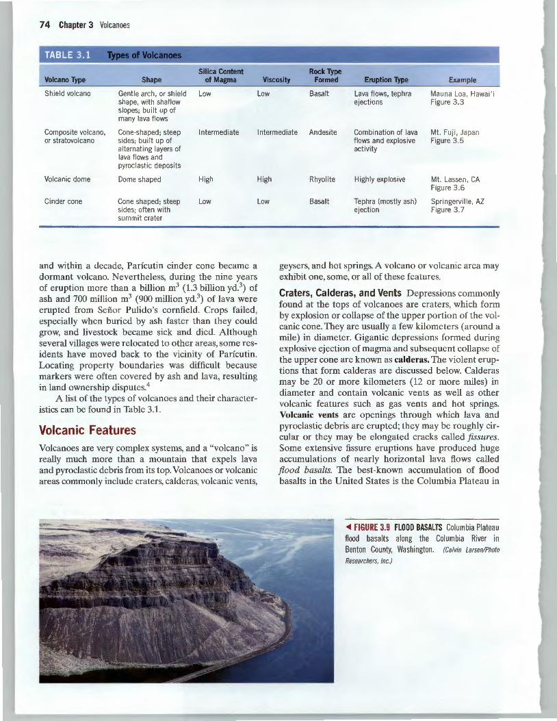
Cinder Cones Built up by the accumulation of tephra near a volcanic vent, cinder cones are relatively small volcanoes composed of nut- to fist-sized pieces of red or black lava.4 Tephra from extinct cinder cones is the "lava rock" used widely in commercial landscaping. Also called scoria cones, cinder cones are common on the flanks of larger volcanoes, along normal faults, and along cracks or fissures (Figure 3.7).
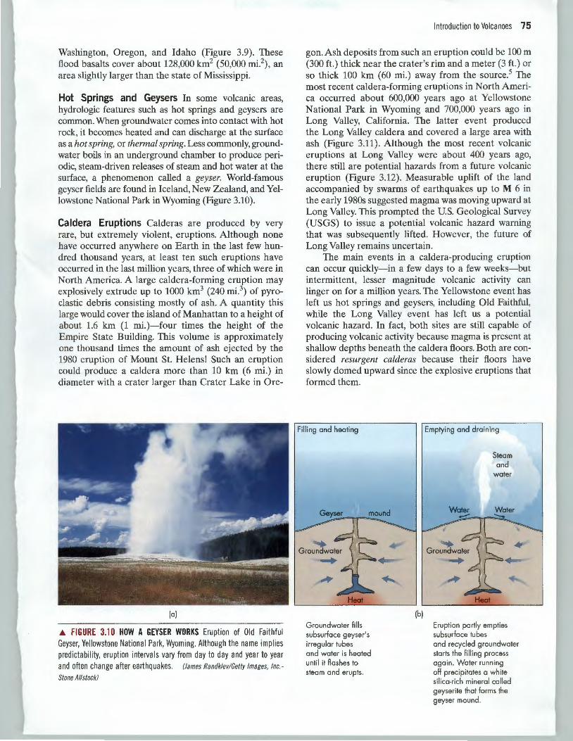
The Paricutin cinder cone (Figure 3.8) in the Itzicuaro Valley of central Mexico, about 320 km (200 mi.) west of Mexico City, offered a rare opportunity to observe the birth and rapid growth of a volcano at a location where none had existed before. On February 20, 1943, following several weeks of earthquakes and sounds like thunder coming from beneath the surface of Earth, an astounding event occurred. As Dionisio
Introduction to Volcanoes 73
<411 FIGURE 3.7 CINDER CONE Cinder cone with a small crater at the top near Springerville, Arizona. The lava flow in the upper part of the photograph originated from the base of the cinder cone. (Michael
Collier)
Pulido was preparing his cornfield for planting, he noticed a hole he had been trying to fill for years had opened in the ground at the base of a knoll. As Sefi.or Pulido watched, the surrounding ground swelled, rising over two meters (over 6 ft.) , while sulfurous gases and ash began billowing from the hole. By that night, the hole was ejecting glowing-red rock fragments high into the air. By the next day, the cinder cone had grown to 10 m (33 ft.) high as rocks and ash continued to be blown into the sky by the eruption. After only five days, the cinder cone had grown to more than 100m (330ft.) high. In June 1944, a fissure, which had opened in the base of the now 400 m (1300 ft.)-high cone, erupted a basaltic lava flow that overran the nearby village of San Juan Parangaricutiro, leaving little but the church steeple exposed. No one was killed in these eruptions,
<411 FIGURE 3.8 RAPID GROWTH OF A VOLCANO In this 1943 photograph, Paricutin cinder cone in central Mexico is erupting a cloud of volcanic ash and gases. Lava flow has nearly buried the village of San Juan Parangaricutiro, leaving only the church steep le exposed. (Courtesy of Tad
Nichols)
74 Chapter 3 Volcanoes
Silica Content Rock Type Volcano Type Shape of Magma Viscosity Formed Eruption Type Example
Shield volcano Gentle arch , or shield Low Low Basalt Lava flows, tephra Mauna Loa , Hawai ' i shape, with shallow ejections Figure 3.3 slopes; built up of many lava flows
Composite volcano, Cone-shaped ; steep Intermediate Intermediate Andesite Combination of lava Mt. Fu ji, Japan or stratovolcano sides; built up of
alternating layers of lava flows and pyroclastic deposits
Volcanic dome Dome shaped High High
Cinder cone Cone shaped; steep Low Low sides; often with summit crater
and within a decade, Parfcutin cinder cone became a dormant volcano. Nevertheless, during the nine years of eruption more than a billion m3 (1.3 billion yd.3) of ash and 700 million m3 (900 million yd.3) of lava were erupted from Senor Pulido's cornfield. Crops failed , especially when buried by ash faster than they could grow, and livestock became sick and died. Although several villages were relocated to other areas, some residents have moved back to the vicinity of Parfcutin. Locating property boundaries was difficult because markers were often covered by ash and lava, resulting in land ownership disputes.4
A list of the types of volcanoes and their characteristics can be found in Table 3.1.
Volcanic Features Volcanoes are very complex systems, and a "volcano" is really much more than a mountain that expels lava and pyroclastic debris from its top. Volcanoes or volcanic areas commonly include craters, calderas, volcanic vents,
flows and explosive Figure 3.5 activity
Rhyolite Highly explosive Mt. Lassen, CA Figure 3 .6
Basalt Tephra (mostly ash) Springervi lle, AZ ejection Figure 3.7
geysers, and hot springs. A volcano or volcanic area may exhibit one, some, or all of these features.
Craters, Calderas, and Vents Depressions commonly found at the tops of volcanoes are craters, which form by explosion or collapse of the upper portion of the volcanic cone. They are usually a few kilometers (around a mile) in diameter. Gigantic depressions formed during explosive ejection of magma and subsequent collapse of the upper cone are known as calderas. The violent eruptions that form calderas are discussed below. Calderas may be 20 or more kilometers (12 or more miles) in diameter and contain volcanic vents as well as other volcanic features such as gas vents and hot springs. Volcanic vents are openings through which lava and pyroclastic debris are erupted; they may be roughly circular or they may be elongated cracks called fissures. Some extensive fissure eruptions have produced huge accumulations of nearly horizontal lava flows called flood basalts. The best-known accumulation of flood basalts in the United States is the Columbia Plateau in
<Ill FIGURE 3.9 FLOOD BASALTS Columbia Plateau flood basalts along the Columbia River in Benton County, Washington. (Calvin Larsen/Photo
Researchers, Inc.)
Washington, Oregon, and Idaho (Figure 3.9). These flood basalts cover about 128,000 km2 (50,000 mi.2), an area slightly larger than the state of Mississippi.
Hot Springs and Geysers In some volcanic areas, hydrologic features such as hot springs and geysers are common. When groundwater comes into contact with hot rock, it becomes heated and can discharge at the surface as a hot spring, or thermal spring. Less commonly, groundwater boils in an underground chamber to produce periodic, steam-driven releases of steam and hot water at the surface, a phenomenon called a geyser. World-famous geyser fields are found in Iceland, New Zealand, and Yellowstone National Park in Wyoming (Figure 3.10).
Caldera Eruptions Calderas are produced by very rare, but extremely violent, eruptions. Although none have occurred anywhere on Earth in the last few hundred thousand years, at least ten such eruptions have occurred in the last million years, three of which were in North America. A large caldera-forming eruption may explosively extrude up to 1000 km3 (240 mi.3) of pyroclastic debris consisting mostly of ash. A quantity this large would cover the island of Manhattan to a height of about 1.6 km (1 mi.)-four times the height of the Empire State Building. This volume is approximately one thousand times the amount of ash ejected by the 1980 eruption of Mount St. Helens! Such an eruption could produce a caldera more than 10 km (6 mi.) in diameter with a crater larger than Crater Lake in Ore-
(a)
~ FIGURE 3.10 HOW A GEYSER WORKS Eruption of Old Faithful Geyser, Yellowstone National Park, Wyoming. Although the name implies predictability, eruption intervals vary from day to day and year to year and often change after earthquakes. (James Randklev! Getty Images, Inc.
Stone Allstack)
Introduction to Volcanoes 75
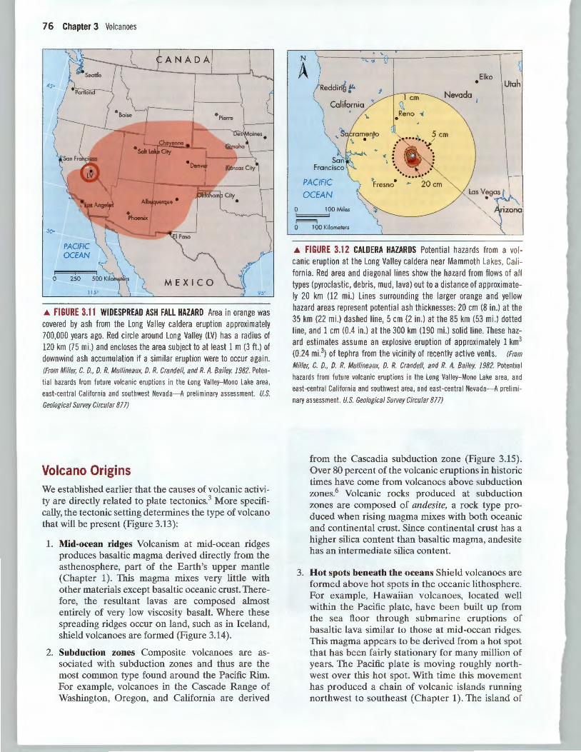
gon. Ash deposits from such an eruption could be 100 m (300ft.) thick near the crater's rim and a meter (3ft.) or so thick 100 km (60 mi.) away from the source.5 The most recent caldera-forming eruptions in North America occurred about 600,000 years ago at Yellowstone National Park in Wyoming and 700,000 years ago in Long Valley, California. The latter event produced the Long Valley caldera and covered a large area with ash (Figure 3.11). Although the most recent volcanic eruptions at Long Valley were about 400 years ago, there still are potential hazards from a future volcanic eruption (Figure 3.12). Measurable uplift of the land accompanied by swarms of earthquakes up to M 6 in the early 1980s suggested magma was moving upward at Long Valley. This prompted the U.S. Geological Survey (USGS) to issue a potential volcanic hazard warning that was subsequently lifted. However, the future of Long Valley remains uncertain.
The main events in a caldera-producing eruption can occur quickly-in a few days to a few weeks-but intermittent, lesser magnitude volcanic activity can linger on for a million years. The Yellowstone event has left us hot springs and geysers, including Old Faithful, while the Long Valley event has left us a potential volcanic hazard. In fact, both sites are still capable of producing volcanic activity because magma is present at shallow depths beneath the caldera floors. Both are considered resurgent calderas because their floors have slowly domed upward since the explosive eruptions that formed them.
Groundwater fills subsurface geyser's irregular tubes and water is heated until it flashes to steam and erupts.
(b)
Emptying and draining
Steam and
water
Eruption partly empties subsurface tubes and recycled groundwater starts the filling process again . Water running off precipitates a wh ite silica·rich mineral called geyserite that forms the geyser mound.
76 Chapter 3 Volcanoes
PACIFIC OCEAN
0 250
115"
M E X I C O 95
.A. FIGURE 3.11 WIDESPREAD ASH FALL HAZARD Area in orange was covered by ash from the Long Valley caldera eruption approximately 700,000 years ago. Red circle around Long Valley (LV) has a radius of 120 km (75 mi.) and encloses the area subject to at least 1 m (3ft.) of downwind ash accumulation if a simi lar eruption were to occur again . (From Miller, C. D., D. R. Mullineaux, D. R. Crandell, and R. A. Bailey 1982. Poten
tial hazards from future volcanic eruptions in the Long Valley-Mono Lake area,
east-central California and southwest Nevada-A preliminary assessment. U.S.
Geological Survey Circular 871)
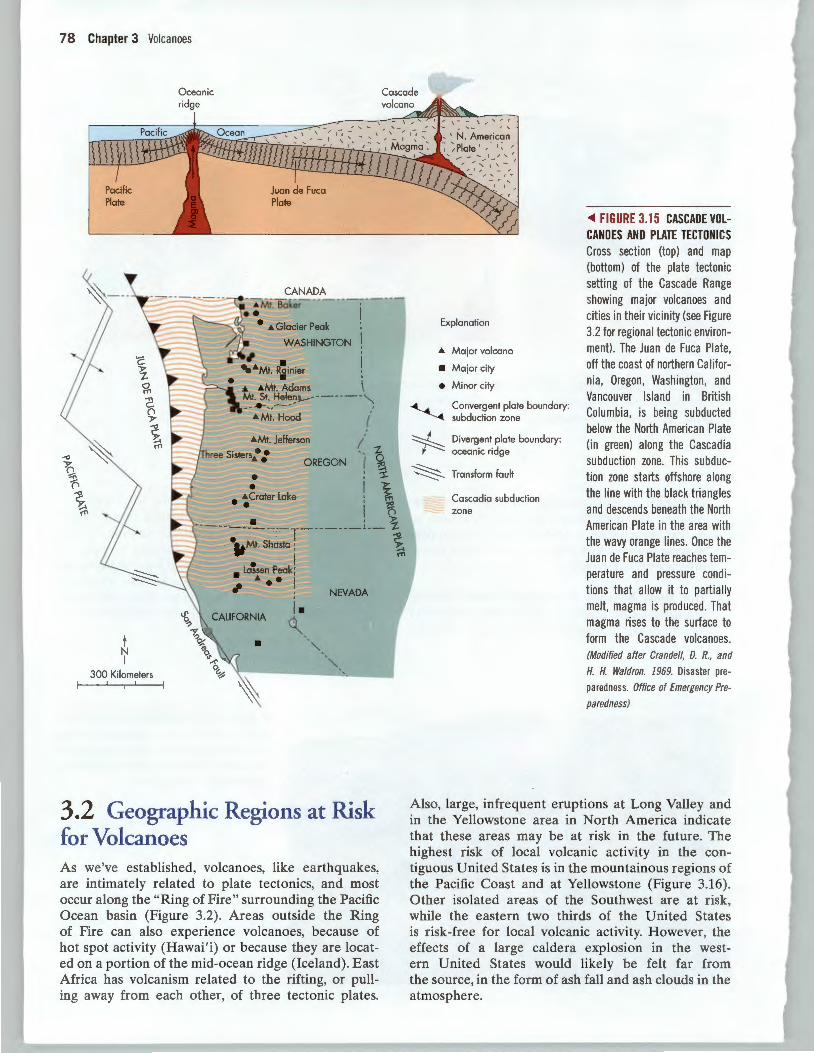
Volcano Origins We established earlier that the causes of volcanic activity are directly related to plate tectonics.3 More specifically, the tectonic setting determines the type of volcano that will be present (Figure 3.13):
1. Mid-ocean ridges Volcanism at mid-ocean ridges produces basaltic magma derived directly from the asthenosphere, part of the Earth's upper mantle (Chapter 1). This magma mixes very little with other materials except basaltic oceanic crust. Therefore, the resultant lavas are composed almost entirely of very low viscosity basalt. Where these spreading ridges occur on land, such as in Iceland, shield volcanoes are formed (Figure 3.14).
2. Subduction zones Composite volcanoes are associated with subduction zones and thus are the most common type found around the Pacific Rim. For example, volcanoes in the Cascade Range of Washington, Oregon, and California are derived
N
A Reddin~ f'
Californ ia "
\.
Elko • Nevada
PACIFIC
OCEAN
0 lOOMiles
!==='~ 0 1 00 Kilometers
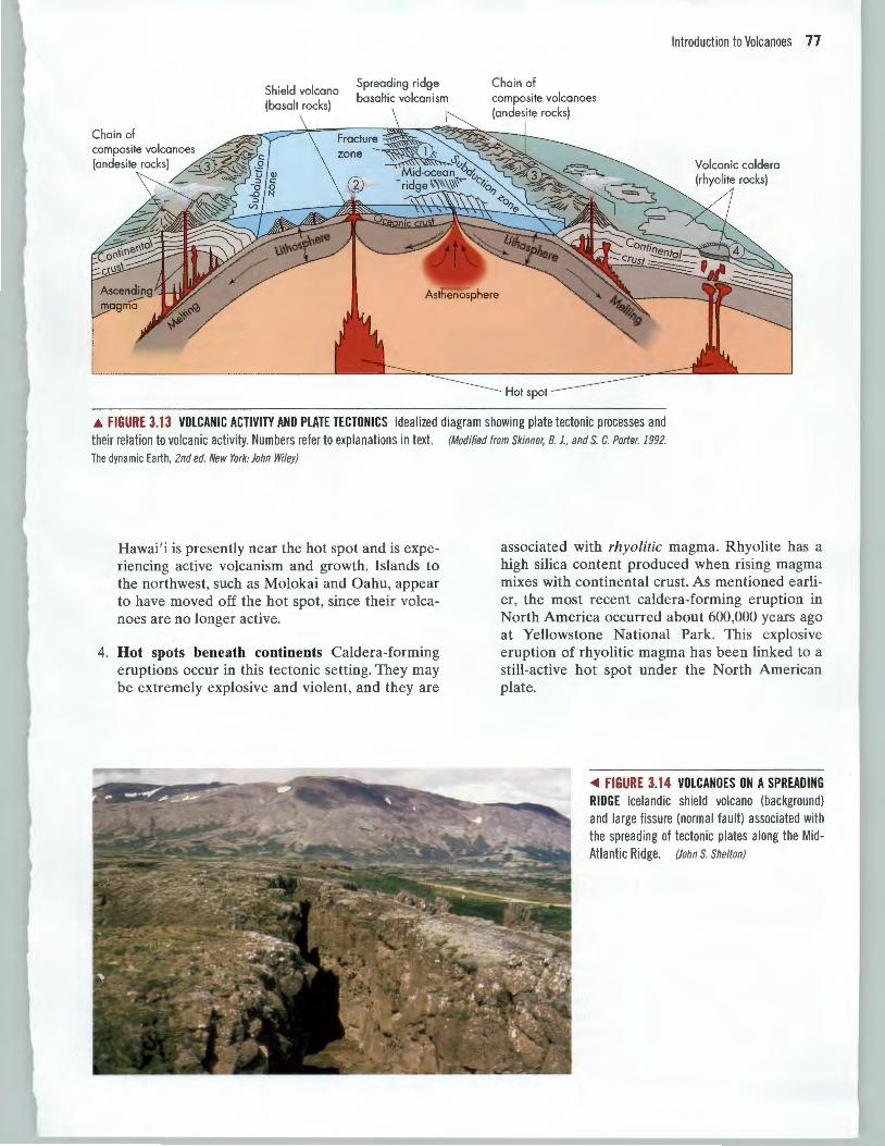
.A. FIGURE 3.12 CALDERA HAZARDS Potential hazards from a volcanic eruption at the Long Valley caldera near Mammoth Lakes, California . Red area and diagonal lines show the hazard from flows of all types (pyroclastic, debris, mud , lava) out to a distance of approximately 20 km (12 mi.) Lines surrounding the larger orange and yellow hazard areas represent potential ash thicknesses: 20 em (8 in.) at the 35 km (22 mi .) dashed line, 5 em (2 in .) at the 85 km (53 mi .) dotted line, and 1 em (0.4 in.) at the 300 km (190 mi.) solid line. These hazard estimates assume an explosive eruption of approximately 1 km3
(0.24 mi.3) of tephra from the vicinity of recent ly active vents. (From
Miller, C. D., D. R. Mullineaux, D. R. Crandell, and R. A. Bailey. 1982. Potential
hazards from future volcanic eruptions in the Long Valley-Mono Lake area, and
east-central California and southwest area , and east-central Nevada-A prelimi
nary assessment. U.S. Geological Survey Circular 877)
from the Cascadia subduction zone (Figure 3.15). Over 80 percent of the volcanic eruptions in historic times have come from volcanoes above subduction zones.6 Volcanic rocks produced at subduction zones are composed of andesite, a rock type produced when rising magma mixes with both oceanic and continental crust. Since continental crust has a higher silica content than basaltic magma, andesite has an intermediate silica content.
3. Hot spots beneath the oceans Shield volcanoes are formed above hot spots in the oceanic lithosphere. For example, Hawaiian volcanoes, located well within the Pacific plate, have been built up from the sea floor through submarine eruptions of basaltic lava similar to those at mid-ocean ridges. This magma appears to be derived from a hot spot that has been fairly stationary for many million of years. The Pacific plate is moving roughly northwest over this hot spot. With time this movement has produced a chain of volcanic islands running northwest to southeast (Chapter 1). The island of
Spreading ridge basaltic volcanism
Chain of
Introduction to Volcanoes 77
.& FIGURE 3.13 VOLCANIC ACTIVITY AND PLATE TECTONICS Idealized diagram showing plate tectonic processes and their relation to volcanic activity. Numbers refer to explanations in text. (Modified from Skinner, B. J., and s. c. Porter. 1992.
The dynamic Earth, 2nd ed. New York: John Wiley)
Hawai'i is presently near the hot spot and is experiencing active volcanism and growth. Islands to the northwest, such as Molokai and Oahu, appear to have moved off the hot spot, since their volcanoes are no longer active.
4. Hot spots beneath continents Caldera-forming eruptions occur in this tectonic setting. They may be extremely explosive and violent, and they are
associated with rhyolitic magma. Rhyolite has a high silica content produced when rising magma mixes with continental crust. As mentioned earlier, the most recent caldera-forming eruption in North America occurred about 600,000 years ago at Yellowstone National Park. This explosive eruption of rhyolitic magma has been linked to a still-active hot spot under the North American plate.
<1111 FIGURE 3.14 VOLCANOES ON A SPREADING RIDGE Icelandic shield volcano (background) and large fissure (normal fault) associated with the spreading of tectonic plates along the Mid-Atlantic Ridge. (JohnS. Shelton)
78 Chapter 3 Volcanoes
Oceanic ridge
Cascade
Pacific Plate
t N I
300 Kilometers
CANADA -~t. Bake-r ----:-
1
----
•• • .a. Glacier Peak :
WASHINGTON ! , . ..... MI. Rainier • .a. .t.Mt. Adams \ MI. St. Hel~~~-------"' -· ..... ,, I
.t. Mt. Hood '
.t.Mt. Jefferson I ', -z. OREGON ( ~
• • • ~Crater Lake
~ 1\ I ~
--------~---T _______ ; __ ~ •ltMt. Shasta : ~
• I • Lassen Peak:
.a. ·• I , . . I• ~-•
NEVADA
·,, -,,,
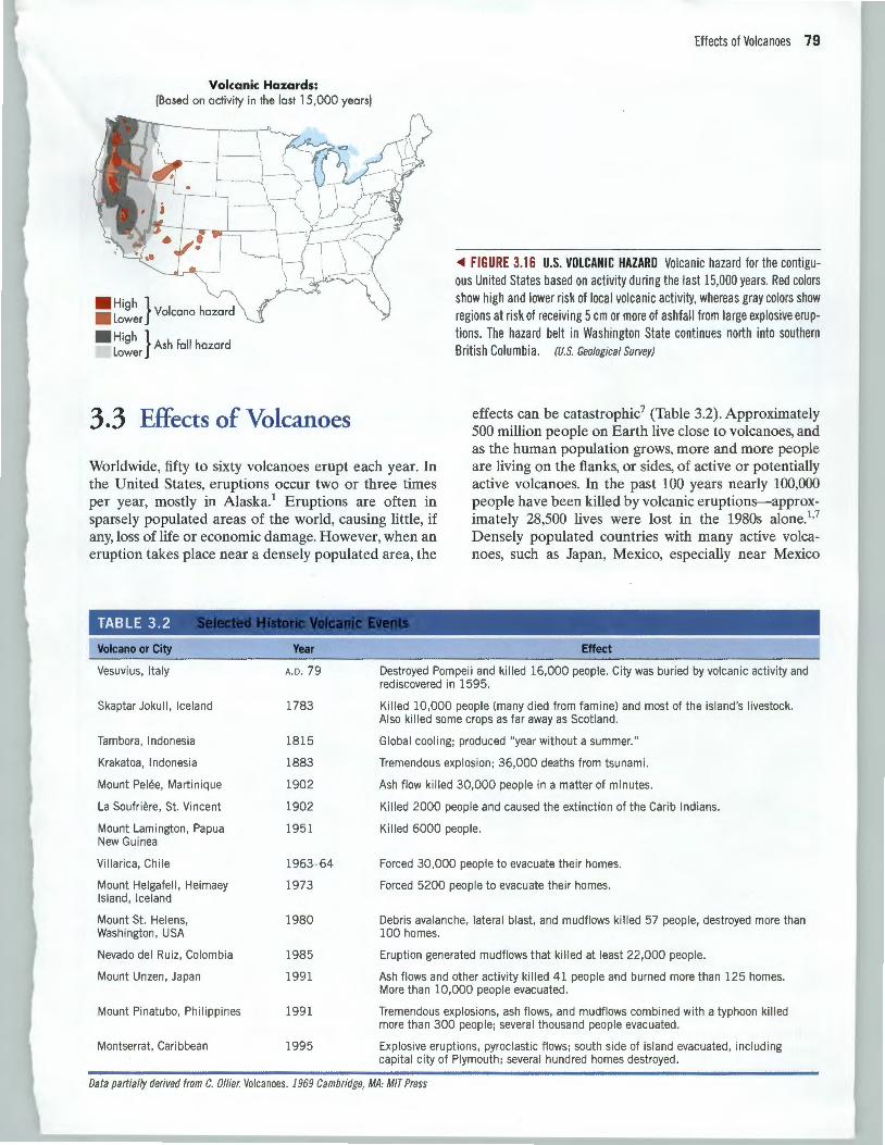
3 .2 Geographic Regions at Risk for Volcanoes As we've established, volcanoes, like earthquakes, are intimately related to plate tectonics, and most occur along the "Ring of Fire" surrounding the Pacific Ocean basin (Figure 3.2). Areas outside the Ring of Fire can also experience volcanoes, because of hot spot activity (Hawai'i) or because they are located on a portion of the mid-ocean ridge (Iceland). East Africa has volcanism related to the rifting, or pulling away from each other, of three tectonic plates.
Explanation
.a. Major volcano
• Major city
• Minor city
Convergent plate boundary: subduction zone
Divergent plate boundary: oceanic ridge
Transform fault
Cascadia subduction zone
~ FIGURE 3.15 CASCADE VO LCANOES AND PLATE TECTONICS Cross section (top) and map (bottom) of the plate tectonic setting of the Cascade Range showing major volcanoes and cities in their vicinity (see Figure 3.2 for regional tectonic environment). The Juan de Fuca Plate, off the coast of northern California, Oregon, Washington, and Vancouver Island in British Columbia, is being subducted below the North American Plate (in green) along the Cascadia subduction zone. This subduction zone starts offshore along the line with the black triangles and descends beneath the North American Plate in the area with the wavy orange lines. Once the Juan de Fuca Plate reaches temperature and pressure conditions that allow it to partially melt, magma is produced. That magma rises to the surface to form the Cascade volcanoes. (Modified after Crandell, D. R., and
H. H. Waldron. 1969. Disaster pre
paredness. Office of Emergency Pre
paredness)
Also, large, infrequent eruptions at Long Valley and in the Yellowstone area in North America indicate that these areas may be at risk in the future. The highest risk of local volcanic activity in the contiguous United States is in the mountainous regions of the Pacific Coast and at Yellowstone (Figure 3.16). Other isolated areas of the Southwest are at risk, while the eastern two thirds of the United States is risk-free for local volcanic activity. However, the effects of a large caldera explosion in the western United States would likely be felt far from the source, in the form of ash fall and ash clouds in the atmosphere.
Volcanic Hazards: (Based on activity in the last 15,000 years)
. Hi h} • L
9 Volcano hazard ower
. Hi h} L
9 Ash fall hazard ower
3.3 Effects of Volcanoes
Effects of Volcanoes 79
<Ill FIGURE 3.16 U.S. VOLCANIC HAZARD Volcanic hazard for the contiguous United States based on activity during the last 15,000 years. Red colors show high and lower risk of local volcanic activity, whereas gray colors show regions at risk of receiving 5 em or more of ashfall from large explosive eruptions. The hazard belt in Washington State continues north into southern British Columbia. (US. Geological Survey)
Worldwide, fifty to sixty volcanoes erupt each year. In the United States, eruptions occur two or three times per year, mostly in Alaska.1 Eruptions are often in sparsely populated areas of the world, causing little, if any, loss of life or economic damage. However, when an eruption takes place near a densely populated area, the
effects can be catastrophic7 (Table 3.2). Approximately 500 million people on Earth live close to volcanoes, and as the human population grows, more and more people are living on the flanks, or sides, of active or potentially active volcanoes. In the past 100 years nearly 100,000 people have been killed by volcanic eruptions-approximately 28,500 lives were lost in the 1980s alone.1
•7
Densely populated countries with many active volcanoes, such as Japan, Mexico, especially near Mexico
TABLE 3.2
Volcano or City
Vesuvius, Italy
Skaptar Jokull, Iceland
Tambora , Indonesia
Krakatoa, Indonesia
Mount Peh§e, Martinique
La Soufriere, St. Vincent
Mount Lamington , Papua New Guinea
Villarica , Chile
Mount Helgafell, Heimaey Island, Iceland
Mount St. Helens, Washington, USA
Nevada del Ruiz, Colombia
Mount Unzen , Japan
Mount Pinatubo, Philippines
Montserrat. Caribbean
Year
A. D. 79
1783
1815
1883
1902
1902
1951
1963- 64
1973
1980
1985
1991
1991
1995
Effect
Destroyed Pompeii and killed 16,000 people. City was buried by volcanic activity and rediscovered in 1595.
Killed 10,000 people (many died from famine) and most of the island 's livestock. Also killed some crops as far away as Scotland.
Global cooling; produced "year without a summer."
Tremendous explosion; 36,000 deaths from tsunami.
Ash flow killed 30,000 people in a matter of minutes.
Killed 2000 people and caused the extinction of the Carib Indians.
Killed 6000 people.
Forced 30,000 people to evacuate their homes.
Forced 5200 people to evacuate their homes.
Debris avalanche , lateral blast, and mudflows killed 57 people, destroyed more than 100 homes.
Eruption generated mudflows that killed at least 22 ,000 people .
Ash flows and other activity killed 41 people and burned more than 125 homes. More than 10,000 people evacuated .
Tremendous explosions, ash flows, and mudflows combined with a typhoon killed more than 300 people; several thousand people evacuated .
Explosive eruptions, pyroclastic flows; south side of island evacuated , including capital city of Plymouth ; several hundred homes destroyed.
Data partially derived from C. Oilier. Volcanoes. 1969 Cambridge, MA: MIT Press
80 Chapter 3 Volcanoes
A
B
RUSSIA
' Bering Sea •
ALASKA
Augustine • Novarupta~~ook Inlet
Akutan ,,~~~!.'r~~~Triden.' k ~ Ukmrek Moge.k ...,~.Kis 0 Bogoslof~ Chiginogak- .• Ugashik . Peulik
Lillie Sitkin• .II. Cerberus Kagamil mmons Lake ~ anrarm Ji. v , h. c 1. I ~ Dullon~Amakchak PACIFIC "oso,oc 1 or 1s e . h -........... \1' • • f
Gareloi .ll. .II. \ Amukta \\ Frs er~~ Pavlaf vemam~no OCEAN Tanaga ,?.tJ:.~ "- re \ . ~ \ Ji. ~ Shishaldin lsanotskr
Kanaga I f'-- Py AA.11. '*"~akushin Westdahl v . I f V ._, f Okmok 1\.0fOVIn SeVIQO
. . Cleveland 0
180" Great Srtkm Yunaska
• Volcano active during Population centers the post 2000 years • 50,000 _ 99,999
• Potentially active volcano • 100,000 _ 349,999
• Area of potential 350 OOO 999 999 volcanic activity • ' - ' e 1 ,000,000 and greater
CANA D A
160"
40' PACIFIC OCEAN
Inset( 20' G HAWAI'I
180' 160
159'
. e KAUAI
~1/HAU
140'
158
250
120'
157
500 Kilometers
140"
100"
:· • Denver 21
MOLOKAI ~
0 250
COLORADO • •
• e Albuq
Bone/era Field NEW
MEXICO
TEXAS
20
19
c
PACIFIC OCEAN
0 50 1 00 Kilometers
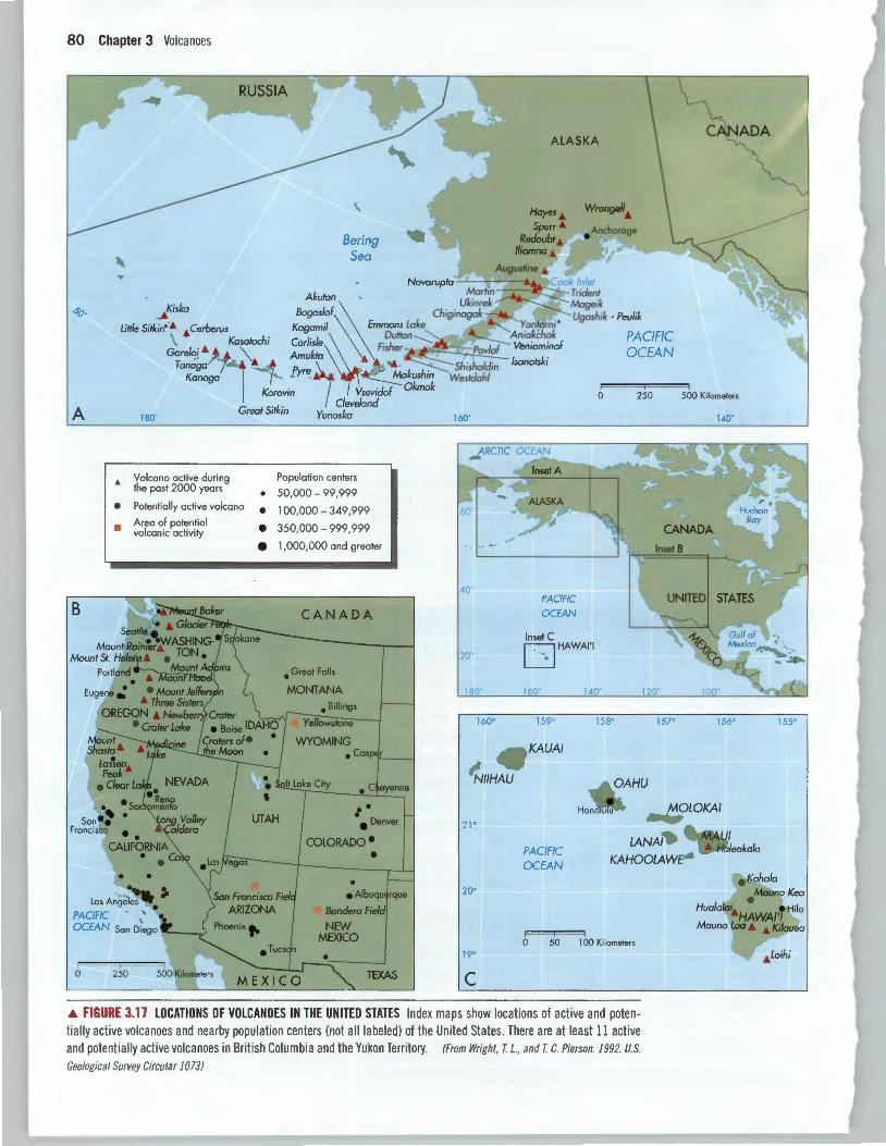
• FIGURE 3.17 LOCATIONS OF VOLCANO ES IN THE UNITED STATES Index maps show locations of active and potentially active volcanoes and nearby population centers (not all labeled) of the United States. There are at least 11 active and potentially active volcanoes in British Columbia and the Yukon Territory. (From Wright, T. L. , and T. c. Pierson. 1992. U.S.
Geological Survey Circular 1073)
155
City, the Philippines, and Indonesia, are particularly vulnerable.2 Several active or potentially active volcanoes in the western United States are near cities with populations of over 500,000 people (Figure 3.17).
Volcanic hazards include the primary effects of volcanic activity that are the direct results of an eruption, and secondary effects, which may be caused by the primary effects. Lava flows, pyroclastic activity such as ash fall, pyroclastic flows, and lateral blasts, and release of volcanic gases are primary effects. Secondary effects include debris flows, mudflows, landslides, or debris avalanches, floods, fires, and tsunamis (discussed in Chapter 8) and at the planetary level, large eruptions that can cause global cooling of the atmosphere for a year or so.5•8
Lava Flows Lava flows are one of the most familiar products of volcanic activity. They result when magma reaches the surface and overflows the central crater or erupts from a volcanic vent along the flank of the volcano. The three major types of lava take their names from the volcanic rocks they form: basaltic, by far the most abundant of the three, andesitic, and rhyolitic.
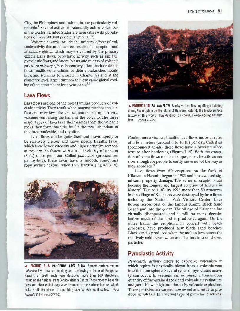
Lava flows can be quite fluid and move rapidly or be relatively viscous and move slowly. Basaltic lavas, which have lower viscosity and higher eruptive temperatures, are the fastest with a usual velocity of a meter (3 ft.) or so per hour. Called pahoehoe (pronounced pa-hoy-hoy), these lavas have a smooth, sometimes ropy surface texture when they harden (Figure 3.18).
.A FIGURE 3.18 PAHOEHOE LAVA FLOW Smooth-surface-texture pahoehoe lava flow surrounding and destroying a home at Kalapana, Hawai ' i, in 1990. Such flows destroyed more than 100 structures, including the National Park Service Visitors Center. These types of basaltic flows are often called ropy lava because of the surface texture, which looks a bit like pieces of rope lying side by side as if coiled . (Paul
Richards!@ Bettmann!CORBIS)
Effects of Volcanoes 81
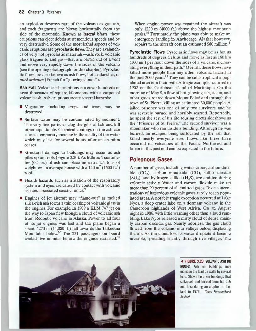
.A FIGURE 3.19 AA LAVA FLOW Blocky a a lava flow engulfing a building during the eruption on the island of Heimaey, Iceland. The blocky surface texture of this type of flow develops on cooler, slower-moving basaltic lava. (Solarfilma ehf)
Cooler, more viscous, basaltic lava flows move at rates of a few meters (around 6 to 10ft.) per day. Called aa (pronounced ah-ah) , these flows have a blocky surface texture after hardening (Figure 3.19). With the exception of some flows on steep slopes, most lava flows are slow enough for people to easily move out of the way as they approach.9
Lava flows from rift eruptions on the flank of Kilauea in Hawai'i began in 1983 and have caused significant property damage. This series of eruptions has become the longest and largest eruption of Kilauea in history3 (Figure 3.18). By 1992, more than 50 structures in the village of Kalapana were destroyed by lava flows, including the National Park Visitors Center. Lava flowed across part of the famous Kaimu Black Sand Beach and into the ocean. The village of Kalapana has virtually disappeared, and it will be many decades before much of the land is productive again. On the other hand, the eruptions, in concert with beach processes, have produced new black sand beaches. Black sand is produced when the molten lava enters the relatively cold ocean water and shatters into sand-sized particles.
Pyroclastic Activity Pyroclastic activity refers to explosive volcanism in which tephra is physically blown from a volcanic vent into the atmosphere. Several types of pyroclastic activity can occur. In volcanic ash eruptions a tremendous quantity of fine-grained rock and volcanic glass shatters, and gas is blown high into the air by volcanic explosions. These particles are carried downwind and settle to produce an ash fall. In a second type of pyroclastic activity,
82 Chapter 3 Volcanoes
an explosion destroys part of the volcano as gas, ash, and rock fragments are blown horizontally from the side of the mountain. Known as lateral blasts, these eruptions can eject debris at tremendous speeds and be very destructive. Some of the most lethal aspects of volcanic eruptions are pyroclastic flows. They are avalanches of very hot pyroclastic materials-ash, rock, volcanic glass fragments, and gas-that are blown out of a vent and move very rapidly down the sides of the volcano (see the opening photograph for this chapter) . Pyroclastic flows are also known as ash flows, hot avalanches, or nuee ardentes (French for "glowing clouds").
Ash Fall Volcanic ash eruptions can cover hundreds or even thousands of square kilometers with a carpet of volcanic ash. Ash eruptions create several hazards:
• Vegetation, including crops and trees, may be destroyed.
• Surface water may be contaminated by sediment. The very fine particles clog the gills of fish and kill other aquatic life. Chemical coatings on the ash can cause a temporary increase in the acidity of the water which may last for several hours after an eruption ceases.
• Structural damage to buildings may occur as ash piles up on roofs (Figure 3.20). As little as 1 centimeter (0.4 in.) of ash can place an extra 2.5 tons of weight on an average house with a 140m2 (1500 ft. 2
)
roof.
• Health hazards, such as irritation of the respiratory system and eyes, are caused by contact with volcanic ash and associated caustic fumes. 9
• Engines of jet aircraft may "flame-out" as melted silica-rich ash forms a thin coating of volcanic glass in the engines. For example, in 1989 a KLM 747 jet on the way to Japan flew though a cloud of volcanic ash from Redoubt Volcano in Alaska. Power to all four of its jet engines was lost and the plane began a silent, 4270 m (14,000 ft.) fall towards the Talkeetna Mountains below.10 The 231 passengers on board waited five minutes before the engines restarted.10
When engine power was regained the aircraft was only 1220 m ( 4000 ft.) above the highest mountain peaks.1° Fortunately the plane was able to make an emergency landing in Anchorage, Alaska; however, repairs to the aircraft cost an estimated $80 million.4
Pyroclastic Flows Pyroclastic flows may be as hot as hundreds of degrees Celsius and move as fast as 160 km (100 mi.) per hour down the sides of a volcano, incinerating everything in their path.4 Overall, these flows have killed more people than any other volcanic hazard in the past 2000 years.11 They can be catastrophic if a populated area is in their path. A tragic example occurred in 1902 on the Caribbean island of Martinique. On the morning of May 8, a flow of hot, glowing ash, steam, and other gases roared down Mount Pelee and through the town of St. Pierre, killing an estimated 30,000 people. A jailed prisoner was one of only two survivors, and he was severely burned and horribly scarred. Reportedly, he spent the rest of his life touring circus sideshows as the "Prisoner of St. Pierre." The second survivor was a shoemaker who ran inside a building. Although he was burned, he escaped being suffocated by the ash that killed nearly everyone else. Flows like these have occurred on volcanoes of the Pacific Northwest and Japan in the past and can be expected in the future.
Poisonous Gases A number of gases, including water vapor, carbon dioxide (C02), carbon monoxide (CO), sulfur dioxide (S02), and hydrogen sulfide (H2S), are emitted during volcanic activity. Water and carbon dioxide make up more than 90 percent of all emitted gases. Toxic concentrations of hazardous volcanic gases rarely reach populated areas. A notable tragic exception occurred at Lake Nyos, a deep crater lake on a dormant volcano in the Cameroon highlands of West Africa. On an August night in 1986, with little warning other than a loud rumbling, Lake Nyos released a misty cloud of dense, mainly carbon dioxide, gas. Nearly odorless, the gas cloud flowed from the volcano into valleys below, displacing the air. As the cloud lost its water droplets it became invisible, spreading silently through five villages. The
<011 FIGURE 3.20 VOLCANIC ASH ON ROOFS Ash on buildings may increase the load on walls by several tons. Shown here are buildings that collapsed and burned from hot ash and lava during an eruption in Iceland in 1973. (Owen Franken/Stock
Boston)
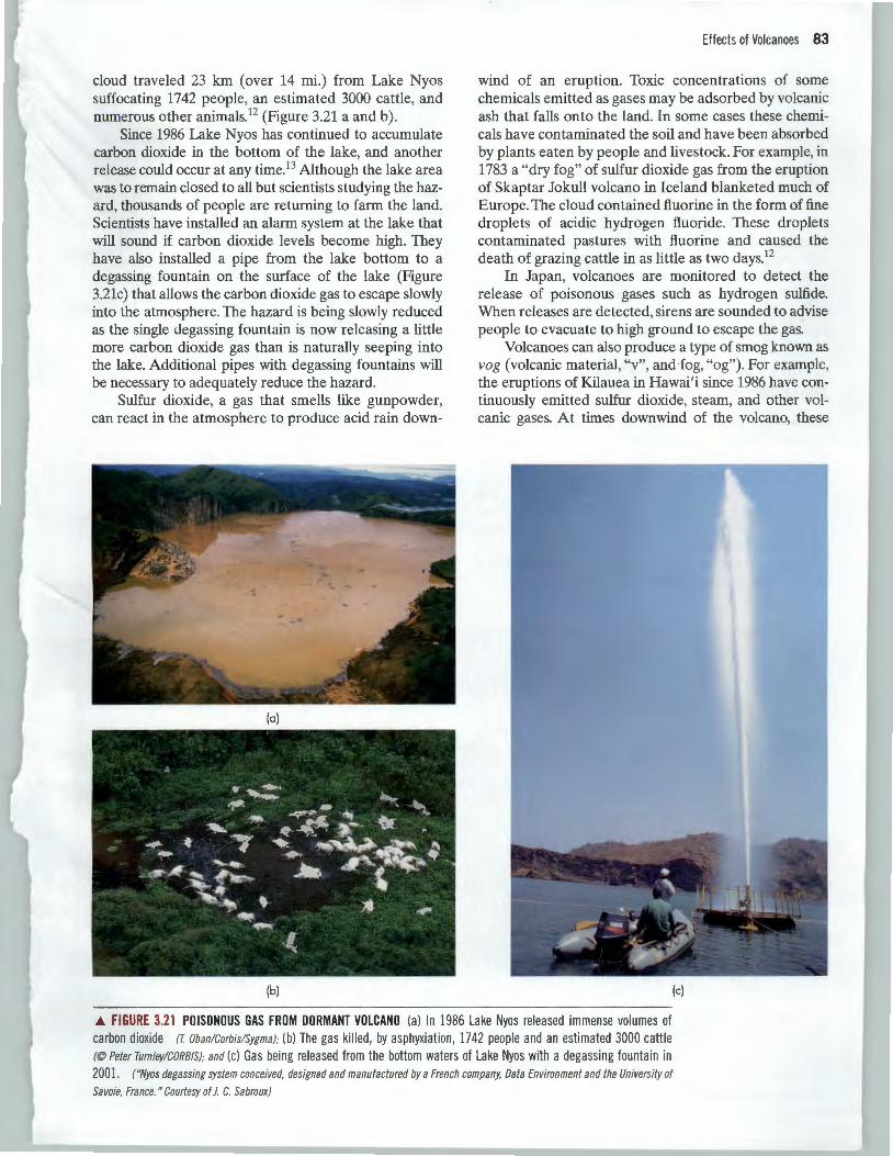
cloud traveled 23 km (over 14 mi.) from Lake Nyos suffocating 1742 people, an estimated 3000 cattle, and numerous other animalsP (Figure 3.21 a and b) .
Since 1986 Lake Nyos has continued to accumulate carbon dioxide in the bottom of the lake, and another release could occur at any time.13 Although the lake area was to remain closed to all but scientists studying the hazard, thousands of people are returning to farm the land. Scientists have installed an alarm system at the lake that will sound if carbon dioxide levels become high. They have also installed a pipe from the lake bottom to a degassing fountain on the surface of the lake (Figure 3.21c) that allows the carbon dioxide gas to escape slowly into the atmosphere. The hazard is being slowly reduced as the single degassing fountain is now releasing a little more carbon dioxide gas than is naturally seeping into the lake. Additional pipes with degassing fountains will be necessary to adequately reduce the hazard.
Sulfur dioxide, a gas that smells like gunpowder, can react in the atmosphere to produce acid rain down-
(a)
(b)
Effects of Volcanoes 83
wind of an eruption. Toxic concentrations of some chemicals emitted as gases may be adsorbed by volcanic ash that falls onto the land. In some cases these chemicals have contaminated the soil and have been absorbed by plants eaten by people and livestock. For example, in 1783 a "dry fog" of sulfur dioxide gas from the eruption of Skaptar Jokull volcano in Iceland blanketed much of Europe. The cloud contained fluorine in the form of fine droplets of acidic hydrogen fluoride. These droplets contaminated pastures with fluorine and caused the death of grazing cattle in as little as two days.12
In Japan, volcanoes are monitored to detect the release of poisonous gases such as hydrogen sulfide. When releases are detected, sirens are sounded to advise people to evacuate to high ground to escape the gas.
Volcanoes can also produce a type of smog known as vog (volcanic material, "v", and fog, "og"). For example, the eruptions of Kilauea in Hawai 'i since 1986 have continuously emitted sulfur dioxide, steam, and other volcanic gases. At times downwind of the volcano, these
(c)
.6. FIGURE 3.21 POISONOUS GAS FROM DORMANT VOLCANO (a) In 1986 Lake Nyos relea sed immense volumes of carbon dioxide IT. Oban!Corbis!Sygma); (b) The gas ki lled , by asphyxiation, 1742 people and an estimated 3000 cattle (©Peter Turnley!CORBIS); and (c) Gas being released from the bottom waters of Lake Nyos with a degassing fountain in 2001 . ("Nyos degassing system conceived, designed and manufactured by a French company, Data Environment and the University of
Sa voie, France. " Courtesy of J. C. Sabroux)
84 Chapter 3 Volcanoes
gases react to produce vag mixed with acid rain. This combination can cover the southeastern part of the Big Island with a thick, blue acidic haze that far exceeds air quality standards for sulfur dioxide. Public health warnings have been issued because small, acidic aerosol particulates and sulfur dioxide concentrations, like those in vag, can induce asthma attacks and cause other respiratory problems. Residents and visitors have reported breathing difficulties, headaches, sore throats, watery eyes, and flu-like symptoms when exposed to vag. In addition, acid rain has made the water in some shallow wells and household rainwater-collection systems undrinkable. The acidic rainwater has extracted lead from metal roofing and water pipes and may have caused elevated lead levels in the blood of some residents.14
Debris Flows, Mudflows and Other Mass Movements The most serious secondary effects of volcanic activity are debris flows and mudflows, known collectively by their Indonesian name of lahar. Lahars are produced when large amounts of loose volcanic ash and other tephra are saturated with water, become unstable, and suddenly move downslope (Figure 3.1). Debris flows differ from mudflows in that they are coarser; more than half of their particles are larger than sand grains. Unlike pyroclastic flows, lahars can occur without an eruption and are generally low-temperature flows.
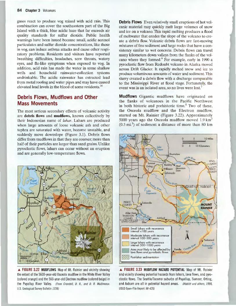
.a. FIGURE 3.22 MUDFLOWS Map of Mt. Rainier and vicinity showing the extent of the 5600-year-old Osceola mudflow in the White River Valley (colored orange) and the 560-year-old Electron mudflow (colored beige) in the Puyallup River Valley. (From Crandell, D. R., and D. R. Mullineaux.
U.S. Geological Survey Bulletin 1238)
Debris Flows Even relatively small eruptions of hot volcanic material may quickly melt large volumes of snow and ice on a volcano. This rapid melting produces a flood of meltwater that erodes the slope of the volcano to create a debris flow. Volcanic debris flows are fast-moving mixtures of fine sediment and large rocks that have a consistency similar to wet concrete. Debris flows can travel many kilometers down valleys from the flanks of the volcano where they formed. 9 For example, early in 1990 a pyroclastic flow from Redoubt volcano in Alaska moved across Drift Glacier. It rapidly melted snow and ice to produce voluminous amounts of water and sediment. This slurry created a debris flow with a discharge comparable to the Mississippi River at flood stage. Fortunately, the event was in an isolated area, so no lives were lost.7
Mudflows Gigantic mudflows have originated on the flanks of volcanoes in the Pacific Northwest in both historic and prehistoric time.8 Two of these, the Osceola mudflow and the Electron mudflow, started on Mt. Rainier (Figure 3.22). Approximately 5000 years ago the Osceola mudflow moved 1.9 km3
(0.5 rni.3) of sediment a distance of more than 80 km
• Small lahars with recurrence interval < 1 00 years
Moderate lahars with recu rrence interval 100-500 years
D Large lahars with recurrence interval 500-1000 years
Area most likely to be affected by lava flows and pyroclastic flows
~ Post·lahar sedimentation
0 5 lOMi\es
0 5 1 0 Kilometers
N
A • Packwood
~ Packwood Lake
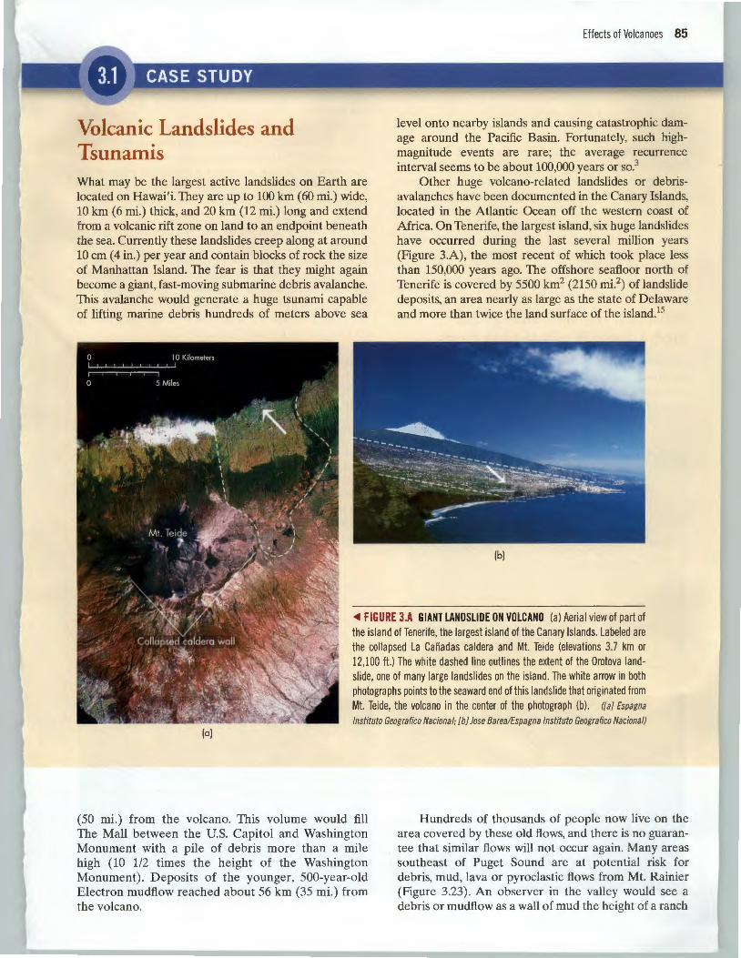
.a. FIGURE 3.23 MUDFLOW HAZARD POTENTIAL Map of Mt. Rainier and vicinity showing potential hazards from lahars, lava flows, and pyroclastic flows. The Seattleffacoma suburbs of Puya llu p, Sumner, Orting, and Auburn are all in potential hazard areas. (Hob/itt and others, 1998,
USGS Open-File Report 98-428)
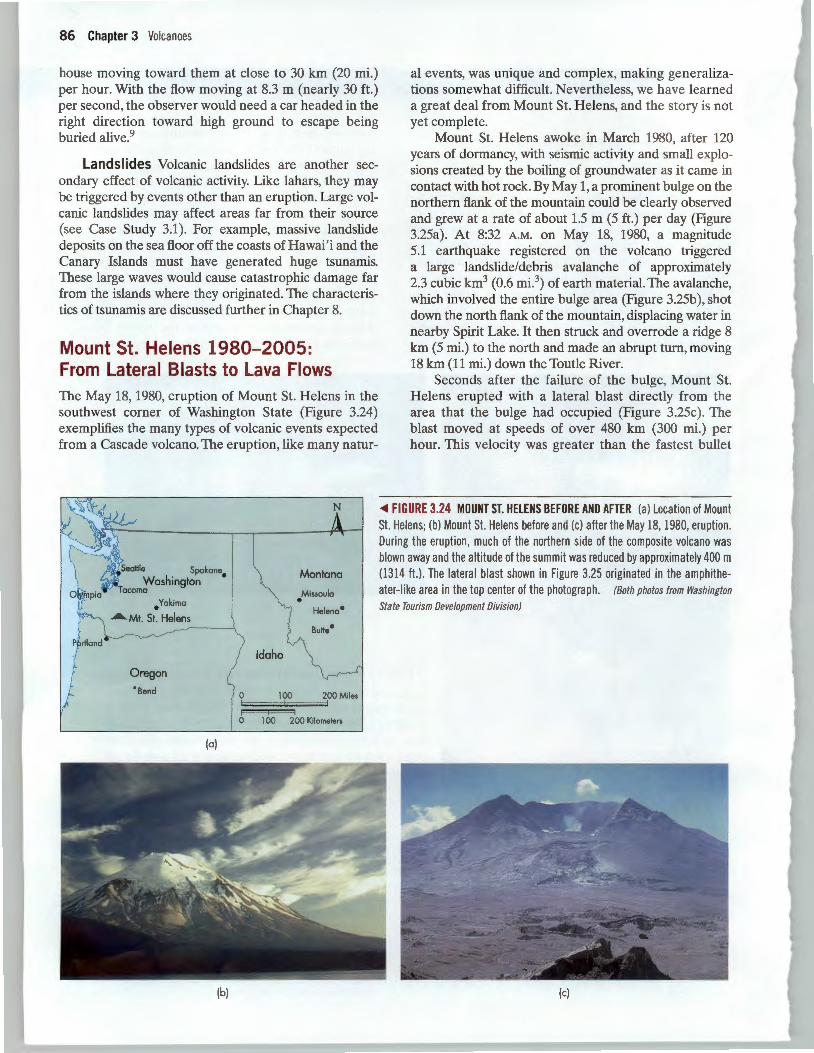
Volcanic Landslides and Tsunamis What may be the largest active landslides on Earth are located on Hawai'i. They are up to 100 km (60 mi.) wide, 10 km (6 mi.) thick, and 20 km (12 mi.) long and extend from a volcanic rift zone on land to an endpoint beneath the sea. Currently these landslides creep along at around 10 em (4 in.) per year and contain blocks of rock the size of Manhattan Island. The fear is that they might again become a giant, fast-moving submarine debris avalanche. This avalanche would generate a huge tsunami capable of lifting marine debris hundreds of meters above sea
Effects of Volcanoes 85
level onto nearby islands and causing catastrophic damage around the Pacific Basin. Fortunately, such highmagnitude events are rare; the average recurrence interval seems to be about 100,000 years or so.3
Other huge volcano-related landslides or debrisavalanches have been documented in the Canary Islands, located in the Atlantic Ocean off the western coast of Africa. On Tenerife, the largest island, six huge landslides have occurred during the last several million years (Figure 3.A), the most recent of which took place less than 150,000 years ago. The offshore seafloor north of Tenerife is covered by 5500 km2 (2150 mi.2
) of landslide deposits, an area nearly as large as the state of Delaware and more than twice the land surface of the island.15
(b)
~ FIGURE J.A GIANT LANDSLIDE ON VOLCANO (a) Aerial view of part of the island of Tenerife, the largest island of the Canary Islands. Labeled are the collapsed La Canadas caldera and Mt. Teide (elevations 3.7 km or 12,100 ft.) The white dashed line outlines the extent of the Orotova landslide, one of many large landslides on the island. The white arrow in both photographs points to the seaward end of this landslide that originated from Mt. Teide, the volcano in the center of the photograph (b) . ([a] Espagna
lnstituto Geografico Nacional; [b] Jose Barea/Espagna lnstituto Geografico Nacional) (a)
(50 mi.) from the volcano. This volume would fill The Mall between the U.S. Capitol and Washington Monument with a pile of debris more than a mile high (10 1/2 times the height of the Washington Monument). Deposits of the younger, 500-year-old Electron mudflow reached about 56 km (35 mi.) from the volcano.
Hundreds of thousands of people now live on the area covered by these old flows, and there is no guarantee that similar flows will not occur again. Many areas southeast of Puget Sound are at potential risk for debris, mud, lava or pyroclastic flows from Mt. Rainier (Figure 3.23). An observer in the valley would see a debris or mudflow as a wall of mud the height of a ranch
86 Chapter 3 Volcanoes
house moving toward them at close to 30 km (20 mi.) per hour. With the flow moving at 8.3 m (nearly 30ft.) per second, the observer would need a car headed in the right direction toward high ground to escape being buried alive.9
Landslides Volcanic landslides are another secondary effect of volcanic activity. Like lahars, they may be triggered by events other than an eruption. Large volcanic landslides may affect areas far from their source (see Case Study 3.1). For example, massive landslide deposits on the sea floor off the coasts of Hawai 'i and the Canary Islands must have generated huge tsunamis. These large waves would cause catastrophic damage far from the islands where they originated. The characteristics of tsunamis are discussed further in Chapter 8.
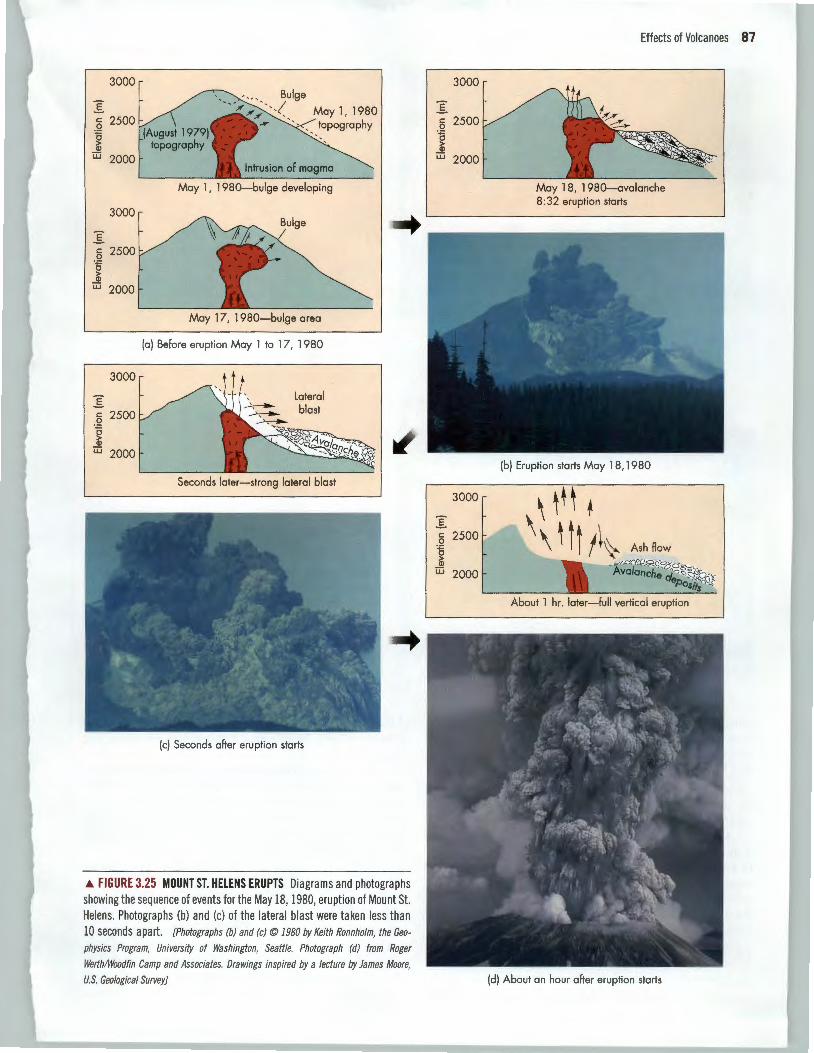
Mount St. Helens 1980-2005: From Lateral Blasts to Lava Flows The May 18, 1980, eruption of Mount St. Helens in the southwest corner of Washington State (Figure 3.24) exemplifies the many types of volcanic events expected from a Cascade volcano. The eruption, like many natur-
• Yakima
..A.. Mt. St. Helens
Oregon
• send
(a)
(b)
Idaho
N
Montana
Missoula •
\ (
0 100 200 Miles
~~==J 0 1 00 200 Kilometers
al events, was unique and complex, making generalizations somewhat difficult. Nevertheless, we have learned a great deal from Mount St. Helens, and the story is not yet complete.
Mount St. Helens awoke in March 1980, after 120 years of dormancy, with seismic activity and small explosions created by the boiling of groundwater as it came in contact with hot rock. By May 1, a prominent bulge on the northern flank of the mountain could be clearly observed and grew at a rate of about 1.5 m (5 ft.) per day (Figure 3.25a). At 8:32 A.M. on May 18, 1980, a magnitude 5.1 earthquake registered on the volcano triggered a large landslide/debris avalanche of approximately 2.3 cubic km3 (0.6 mi.3) of earth material. The avalanche, which involved the entire bulge area (Figure 3.25b ), shot down the north flank of the mountain, displacing water in nearby Spirit Lake. It then struck and overrode a ridge 8 km (5 mi.) to the north and made an abrupt turn, moving 18 km (11 mi.) down the Toutle River.
Seconds after the failure of the bulge, Mount St. Helens erupted with a lateral blast directly from the area that the bulge had occupied (Figure 3.25c). The blast moved at speeds of over 480 km (300 mi.) per hour. This velocity was greater than the fastest bullet
<Ill FIGURE 3.24 MOUNT ST. HELENS BEFORE AND AFTER (a) Location of Mount St. Helens; (b) Mount St. Helens before and (c) after the May 18, 1980, eruption. During the eruption, much of the northern side of the composite volcano was blown away and the altitude of the summit was reduced by approximately 400 m (1314 ft.) . The lateral blast shown in Figure 3.25 originated in the amphitheater-like area in the top center of the photograph. (Both photos from Washington
State Tourism Development Division)
(c)
3000
E c 2500
.Q 0 > Q)
;:u 2000 Intrusion of magma
May 1, 1980-bulge developing
3000
E c 2500
.Q 0 > Q)
;:u 2000
May 17, 1980-bulge area
(a) Before eruption May 1 to 17, 1980
3000
E Lateral
c 2500 blast .Q 0 > Q)
;:u 2000
.A FIGURE 3.25 MOUNT ST. HELENS ERUPTS Diagrams and photographs showing the sequence of events for the May 18, 1980, eruption of Mount St. Helens. Photographs (b) and (c) of the lateral blast were taken less than 10 seconds apart. [Photographs (b) and (c)© 1980 by Keith Ronnholm, the Geo
physics Program, University of Washington, Seattle. Photograph (d) from Roger
Werth/Woodfin Camp and Associates. Drawings inspired by a lecture by James Moore,
U.S. Geological Survey]
Effects of Volcanoes 87
3000
E c 2500
.Q 0 > Q)
;:u 2000
May 18, 1980-avalanche 8:32 eruption starts
3000 \ ~t ~ + E
\ 1\l A .. c 2500 .Q Ash flow 0 > Q)
;:u 2000
(d) About an hour after eruption starts
88 Chapter 3 Volcanoes
0 2.5 5 Miles
~ 0 2.5 5Ki~s
(a)
j
Debris-<Jvalanche deposits
Down-timber zone Scorch zone Pyroclastic flow deposit
Mudflow deposits, scoured areas
40
Jo
PACIFIC OCEAN
120
(b)
200 400 Miles
= 0 250 500 Kilometers
90
train. Effects of the blast were felt nearly 30 km (19 mi.) from its source. The blast devastated about 600 km2
(more than 230 mi.2), an area the size of Chicago, Illi
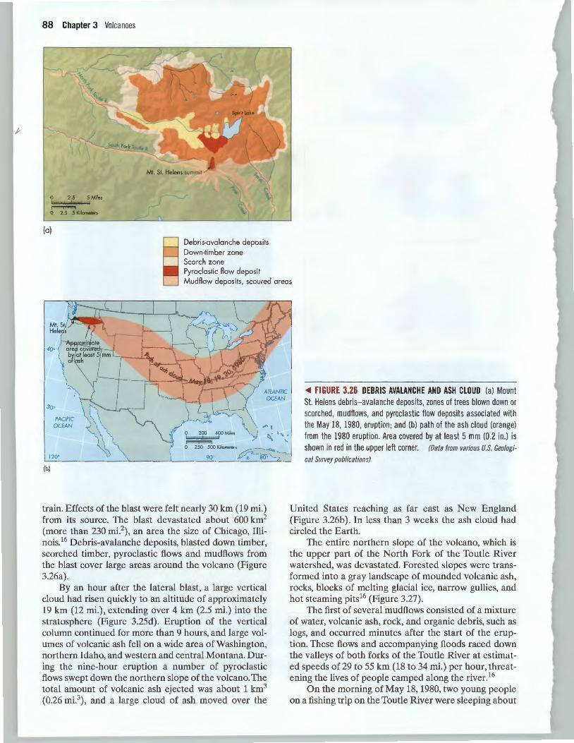
nois.16 Debris-avalanche deposits, blasted down timber, scorched timber, pyroclastic flows and mudflows from the blast cover large areas around the volcano (Figure 3.26a).
By an hour after the lateral blast, a large vertical cloud had risen quickly to an altitude of approximately 19 km (12 mi.), extending over 4 km (2.5 mi.) into the stratosphere (Figure 3.25d). Eruption of the vertical column continued for more than 9 hours, and large volumes of volcanic ash fell on a wide area of Washington, northern Idaho, and western and central Montana. During the nine-hour eruption a number of pyroclastic flows swept down the northern slope of the volcano. The total amount of volcanic ash ejected was about 1 km3
(0.26 mi.3) , and a large cloud of ash moved over the
<1111 FIGURE 3.26 DEBRIS AVALANCHE AND ASH CLOUD (a) Mount St. Helens debris-avalanche deposits, zones of trees blown down or scorched, mudflows, and pyroc lastic fl ow depos its associated with the May 18, 1980, eruption; and (b) path of the ash cloud (orange) from the 1980 eru ption. Area covered by at least 5 mm (0.2 in.) is shown in red in the upper left corner. (Data from various U.S. Geologi
cal Survey publications}
United States reaching as far east as New England (Figure 3.26b ). In less than 3 weeks the ash cloud had circled the Earth.
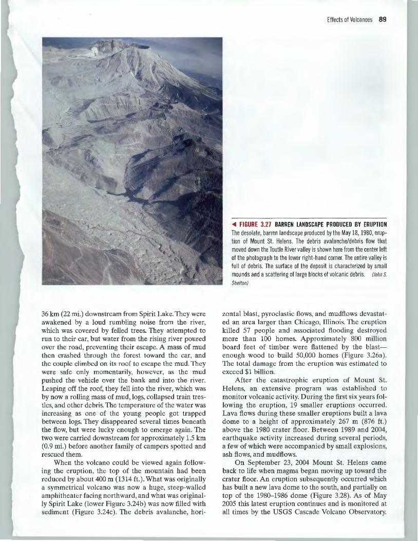
The entire northern slope of the volcano, which is the upper part of the North Fork of the Toutle River watershed, was devastated. Forested slopes were transformed into a gray landscape of mounded volcanic ash, rocks, blocks of melting glacial ice, narrow gullies, and hot steaming pits16 (Figure 3.27).
The first of several mudflows consisted of a mixture of water, volcanic ash, rock, and organic debris, such as logs, and occurred minutes after the start of the eruption. These flows and accompanying floods raced down the valleys of both forks of the Toutle River at estimated speeds of 29 to 55 km (18 to 34 mi.) per hour, threatening the lives of people camped along the river.16
On the morning of May 18, 1980, two young people on a fishing trip on the Toutle River were sleeping about
36 km (22 mi.) downstream from Spirit Lake. They were awakened by a loud rumbling noise from the river, which was covered by felled trees. They attempted to run to their car, but water from the rising river poured over the road, preventing their escape. A mass of mud then crashed through the forest toward the car, and the couple climbed on its roof to escape the mud. They were safe only momentarily, however, as the mud pushed the vehicle over the bank and into the river. Leaping off the roof, they fell into the river, which was by now a rolling mass of mud, logs, collapsed train trestles, and other debris. The temperature of the water was increasing as one of the young people got trapped between logs. They disappeared several times beneath the flow, but were lucky enough to emerge again. The two were carried downstream for approximately 1.5 km (0.9 mi.) before another family of campers spotted and rescued them.
When the volcano could be viewed again following the eruption, the top of the mountain had been reduced by about 400 m (1314 ft.). What was originally a symmetrical volcano was now a huge, steep-walled amphitheater facing northward, and what was originally Spirit Lake (lower Figure 3.24b) was now filled with sediment (Figure 3.24c). The debris avalanche, hori-
Effects of Volcanoes 89
~ FIGURE 3.27 BARREN LANDSCAPE PRODUCED BY ERUPTION The desolate, barren landscape produced by the May 18, 1980, eruption of Mount St. Helens. The debris avalanche/debris flow that moved down the Toutle River valley is shown here from the center left of the photograph to the lower right-hand corner. The entire valley is full of debris. The surface of the deposit is characterized by small mounds and a scattering of large blocks of volcanic debris. (Johns.
Shelton)
zontal blast, pyroclastic flows, and mudflows devastated an area larger than Chicago, Illinois. The eruption killed 57 people and associated flooding destroyed more than 100 homes. Approximately 800 million board feet of timber were flattened by the blastenough wood to build 50,000 homes (Figure 3.26a). The total damage from the eruption was estimated to exceed $1 billion.
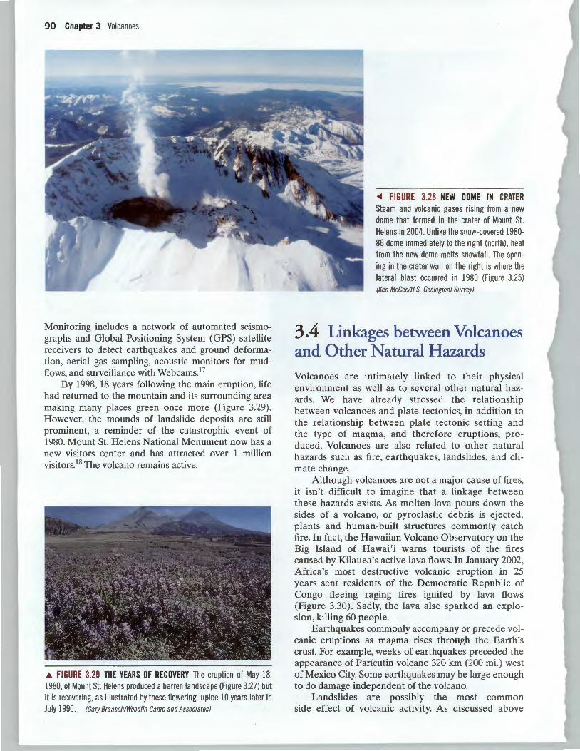
After the catastrophic eruption of Mount St. Helens, an extensive program was established to monitor volcanic activity. During the first six years following the eruption, 19 smaller eruptions occurred. Lava flows during these smaller eruptions built a lava dome to a height of approximately 267 m (876 ft.) above the 1980 crater floor. Between 1989 and 2004, earthquake activity increased during several periods, a few of which were accompanied by small explosions, ash flows, and mudflows.
On September 23, 2004 Mount St. Helens came back to life when magma began moving up toward the crater floor. An eruption subsequently occurred which has built a new lava dome to the south, and partially on top of the 1980-1986 dome (Figure 3.28). As of May 2005 this latest eruption continues and is monitored at all times by the USGS Cascade Volcano Observatory.
90 Chapter 3 Volcanoes
Monitoring includes a network of automated seismographs and Global Positioning System (GPS) satellite receivers to detect earthquakes and ground deformation, aerial gas sampling, acoustic monitors for mudflows, and surveillance with WebcamsP
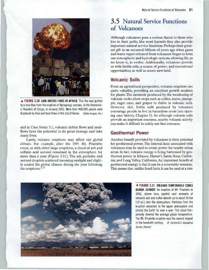
By 1998, 18 years following the main eruption, life had returned to the mountain and its surrounding area making many places green once more (Figure 3.29). However, the mounds of landslide deposits are still prominent, a reminder of the catastrophic event of 1980. Mount St. Helens National Monument now has a new visitors center and has attracted over 1 million visitors.18 The volcano remains active.
~ FIGURE 3.29 THE YEARS OF RECOVERY The eruption of May 18, 1980, of Mount St. Helens produced a barren landscape (Figure 3.27) but it is recovering, as illustrated by these flowering lupine 10 years later in July 1990. (Gary Braasch/Woodfin Camp and Associates)
~ FIGURE 3.28 NEW DOME IN CRATER Steam and volcanic gases rising from a new dome that formed in the crater of Mount St. Helens in 2004. Unlike the snow-covered 1980-86 dome immed iately to the right (north), heat from the new dome melts snowfall. The opening in the crater wall on the right is where the lateral blast occurred in 1980 (Figure 3.25) (Ken McGee/U.S. Geological Survey)
3.4 Linkages between Volcanoes and Other Natural Hazards Volcanoes are intimately linked to their physical environment as well as to several other natural hazards. We have already stressed the relationship between volcanoes and plate tectonics, in addition to the relationship between plate tectonic setting and the type of magma, and therefore eruptions, produced. Volcanoes are also related to other natural hazards such as fire, earthquakes, landslides, and climate change.
Although volcanoes are not a major cause of fires, it isn 't difficult to imagine that a linkage between these hazards exists. As molten lava pours down the sides of a volcano, or pyroclastic debris is ejected, plants and human-built structures commonly catch fire. In fact , the Hawaiian Volcano Observatory on the Big Island of Hawai'i warns tourists of the fires caused by Kilauea's active lava flows. In January 2002, Africa 's most destructive volcanic eruption in 25 years sent residents of the Democratic Republic of Congo fleeing raging fires ignited by lava flows (Figure 3.30). Sadly, the lava also sparked an explosion, killing 60 people.
Earthquakes commonly accompany or precede volcanic eruptions as magma rises through the Earth's crust. For example, weeks of earthquakes preceded the appearance of Parfcutin volcano 320 km (200 mi.) west of Mexico City. Some earthquakes may be large enough to do damage independent of the volcano.
Landslides are possibly the most common side effect of volcanic activity. As discussed above
A FIGURE 3.30 LAVA IGNITES FIRES IN AFRICA This fire was ignited by a lava flow from the eruption of Nyiragongo volcano, in the Democratic Republic of Congo, in January 2002. More than 400,000 people were displaced by fires and lava flows in the city of Goma. (Getty Images, Inc.)
and in Case Study 3.1, volcanic debris flows and mudflows have the potential to do great damage and take many lives.
Lastly, volcanic eruptions may affect our global climate. For example, after the 1991 Mt. Pinatubo event, as with other large eruptions, a cloud of ash and sulfuric acid aerosol remained in the atmosphere for more than a year (Figure 3.31). The ash particles and aerosol droplets scattered incoming sunlight and slightly cooled the global climate during the year following the eruptions.2.19
Natural Service Functions of Volcanoes 91
3.5 Natural Service Functions of Volcanoes
Although volcanoes pose a serious threat to those who live in their paths, like most hazards they also provide important natural service functions. Perhaps their greatest gift to us occurred billions of years ago when gases and water vapor released from volcanoes began to form our atmospheric and hydrologic systems allowing life, as we know it, to evolve. Additionally, volcanoes provide us with fertile soils, a source of power, and recreational opportunities, as well as create new land.
Volcanic Soils From an agricultural perspective, volcanic eruptions are quite valuable, providing an excellent growth medium for plants. The nutrients produced by the weathering of volcanic rocks allow crops such as coffee, maize, pineapple, sugar cane, and grapes to thrive in volcanic soils. However, rich, fertile soils produced by volcanoes encourage people to live in hazardous areas (see opening case history, Chapter 1). So although volcanic soils provide an important resource, nearby volcanic activity can make it difficult to safely use that resource.
Geotherma I Power Another benefit provided by volcanoes is their potential for geothermal power. The internal heat associated with volcanoes may be used to create power for nearby urban areas. In fact, volcanic energy is being harnessed by geothermal power in Kilauea, Hawai'i; Santa Rosa, California; and Long Valley, California. An important benefit of geothermal energy is that it can be a renewable resource. This means that, unlike fossil fuels, it can be used at a rate
<1111 FIGURE 3.31 VOLCANO TEMPORARILY COOLS GLOBAL CLIMATE An eruption of Mt. Pinatubo in 1991, shown here, ejected vast amounts of volcanic ash and sulfur dioxide up to about 30 km (19 mi.) into the atmosphere. Particles from the eruption remained in the upper atmosphere and circled the Earth for over a year. This cloud temporarily lowered the average global temperature. The Mt. Pinatubo eruption was the second largest in the twentieth century. (D. Harlow/U.S. Geological
Survey, Denver)
92 Chapter 3 Volcanoes
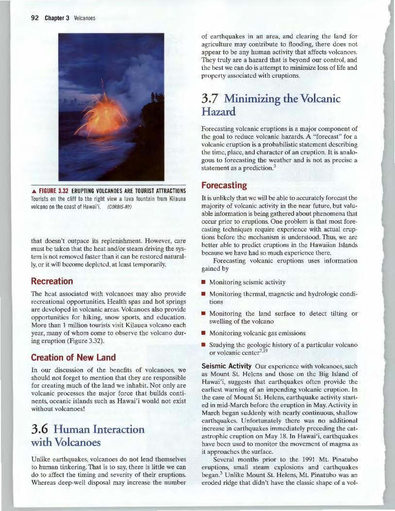
.A. FIGURE 3.32 ERUPTING VOLC AN OES ARE TOURIST ATTRACTIONS Tourists on the cliff to the right view a lava fountain from Kilauea volcano on the coast of Hawai'i . (CORBIS-NYJ
that doesn't outpace its replenishment. However, care must be taken that the heat and/or steam driving the system is not removed faster than it can be restored naturally, or it will become depleted, at least temporarily.
Recreation The heat associated with volcanoes may also provide recreational opportunities. Health spas and hot springs are developed in volcanic areas. Volcanoes also provide opportunities for hiking, snow sports, and education. More than 1 million tourists visit Kilauea volcano each year, many of whom come to observe the volcano during eruption (Figure 3.32).
Creation of New Land In our discussion of the benefits of volcanoes, we should not forget to mention that they are responsible for creating much of the land we inhabit. Not only are volcanic processes the major force that builds continents, oceanic islands such as Hawai'i would not exist without volcanoes!
3.6 Human Interaction with Volcanoes Unlike earthquakes, volcanoes do not lend themselves to human tinkering. That is to say, there is little we can do to affect the timing and severity of their eruptions. Whereas deep-well disposal may increase the number
of earthquakes in an area, and clearing the land for agriculture may contribute to flooding, there does not appear to be any human activity that affects volcanoes. They truly are a hazard that is beyond our control, and the best we can do is attempt to minimize loss of life and property associated with eruptions.
3.7 Minimizing the Volcanic Hazard Forecasting volcanic eruptions is a major component of the goal to reduce volcanic hazards. A "forecast" for a volcanic eruption is a probabilistic statement describing the time, place, and character of an eruption. It is analogous to forecasting the weather and is not as precise a statement as a prediction?
Forecasting It is unlikely that we will be able to accurately forecast the majority of volcanic activity in the near future, but valuable information is being gathered about phenomena that occur prior to eruptions. One problem is that most forecasting techniques require experience with actual eruptions before the mechanism is understood. Thus, we are better able to predict eruptions in the Hawaiian Islands because we have had so much experience there.
Forecasting volcanic eruptions uses information gained by
• Monitoring seismic activity
• Monitoring thermal, magnetic and hydrologic conditions
• Monitoring the land surface to detect tilting or swelling of the volcano
• Monitoring volcanic gas emissions
• Studying the geologic history of a particular volcano or volcanic center7
•19
Seismic Activity Our experience with volcanoes, such as Mount St. Helens and those on the Big Island of Hawai'i, suggests that earthquakes often provide the earliest warning of an impending volcanic eruption. In the case of Mount St. Helens, earthquake activity started in mid-March before the eruption in May. Activity in March began suddenly with nearly continuous, shallow earthquakes. Unfortunately there was no additional increase in earthquakes immediately preceding the catastrophic eruption on May 18. In Hawai'i, earthquakes have been used to monitor the movement of magma as it approaches the surface.
Several months prior to the 1991 Mt. Pinatubo eruptions, small steam explosions and earthquakes began.3 Unlike Mount St. Helens, Mt. Pinatubo was an eroded ridge that didn't have the classic shape of a val-
cano. Furthermore, it hadn 't erupted in 500 years so the majority of people living near it didn't even know it was a volcano! After the initial steam explosions, scientists began monitoring earthquakes on the volcano and studying past volcanic activity, which was determined to be explosive. Earthquakes increased in number and magnitude prior to the catastrophic eruption, and foci migrated from deep beneath the volcano to shallow depths beneath the summit.3
Thermal, Magnetic, and Hydrologic Monitoring Prior to a volcanic eruption, a large volume of magma moves into a holding reservoir beneath the volcano. The hot material changes the local magnetic, thermal, hydrologic, and geochemical conditions. As the surrounding rocks heat, the rise in temperature of the surficial rock may be detected by satellite remote-sensing or infrared aerial photography.
Volcano
Volcano surface before inflation
(a)
/ I ; \-
'~-I - "' ' ' ' '
Stable point
-~~~ : , : .: - Earthquakes
Minimizing the Volcanic Hazard 93
Increased heat may melt snowfields or glaciers; thus, periodic remote sensing of a volcanic chain may detect new hot places related to volcanic activity. This method was used with some success at Mount St. Helens prior to the main eruption on May 18, 1980.
When older volcanic rocks are heated by new magma, magnetic properties, originally imprinted when the older rocks cooled and crystallized, may change. These changes can be detailed by ground or aerial magnetic surveys.7
•20
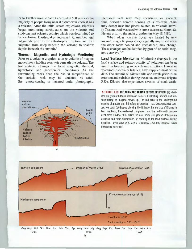
Land Surface Monitoring Monitoring changes in the land surface and seismic activity of volcanoes has been useful in forecasting some volcanic eruptions. Hawaiian volcanoes, especially Kilauea, have supplied most of the data. The summit of Kilauea tilts and swells prior to an eruption and subsides during the actual outbreak (Figure 3.33). Kilauea also experiences swarms of small earth-
~ FIGURE 3.33 INFLATION AND TILTING BEFORE ERUPTION (a) Idealized diagram of Kilauea volcano in Hawai'i illustrating inflation and surface tilting as magma moves up. The red area is the underground magma chambers that fill before an eruption (U.S. Geological Survey Circu
lar 1073, 1992) (b) Graphs showing the tilting of the surface of Kilauea in two directions, the east-west component and the north-south component, from 1964 to 1966. Notice the slow increase in ground tilt before an eruption and rapid subsidence, or lowering of the land surface, during eruption. (From Fiske, R. S., and R. Y. Koyanagi. 1968. U.S. Geological Survey
Profess ional Paper 607)
East-west component Eruption of Morch 1965 Eruption of December 1965
North-south component
1 microradian ;: 5.7 x 1 o-So
Aug Sept Oct Nov Dec Jon Feb Mar Apr May June July Aug Sept Oct Nov Dec Jon Feb Mar Apr
1964 1965 1966 (b)
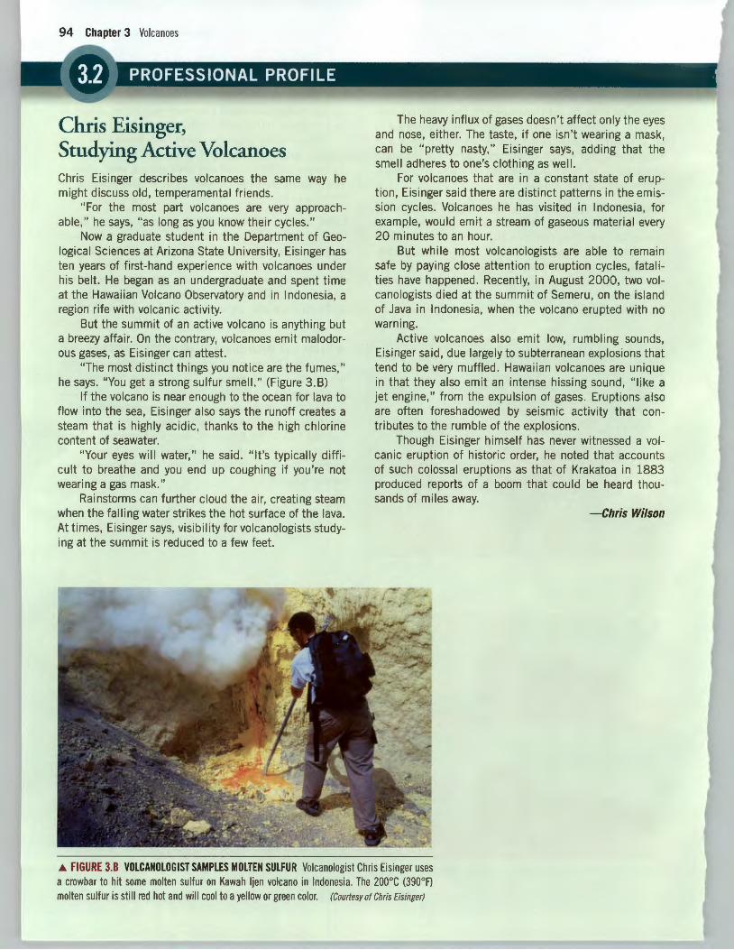
Chris Eisinger, Studying Active Volcanoes Chris Eisinger describes volcanoes the same way he might discuss old, temperamental friends.
"For the most part volcanoes are very approachable," he says, "as long as you know their cycles."
Now a graduate student in the Department of Geological Sciences at Arizona State University, Eisinger has ten years of first-hand experience with volcanoes under his belt. He began as an undergraduate and spent time at the Hawaiian Volcano Observatory and in Indonesia, a region rife with volcanic activity.
But the summit of an active volcano is anything but a breezy affair. On the contrary, volcanoes emit malodorous gases, as Eisinger can attest.
"The most distinct things you notice are the fumes," he says. "You get a strong sulfur smell. " (Figure 3.B)
If the volcano is near enough to the ocean for lava to flow into the sea , Eisinger also says the runoff creates a steam that is highly acidic, thanks to the high chlorine content of seawater.
"Your eyes will water, " he said. "It's typically difficult to breathe and you end up coughing if you're not wearing a gas mask."
Rainstorms can further cloud the air, creating steam when the falling water strikes the hot surface of the lava. At times, Eisinger says, vis ibi I ity for volcanologists studying at the summit is reduced to a few feet.
The heavy influx of gases doesn't affect only the eyes and nose, either. The taste, if one isn't wearing a mask, can be "pretty nasty," Eisinger says, adding that the smell adheres to one's clothing as well.
For volcanoes that are in a constant state of eruption , Eisinger said there are distinct patterns in the emission cycles. Volcanoes he has visited in Indonesia, for example, would emit a stream of gaseous materia l every 20 minutes to an hour.
But wh i le most volcanologists are able to remain safe by paying close attention to eruption cycles, fatalities have happened . Recently, in August 2000, two volcanologists died at the summit of Semeru, on the island of Java in Indonesia, when the volcano erupted with no warn ing.
Active volcanoes also emit low, rumbling sounds, Eisinger said, due largely to subterranean explosions that tend to be very muffled. Hawaiian volcanoes are unique in that they also emit an intense hissing sound , "like a jet engine," from the expulsion of gases. Eruptions also are often foreshadowed by seismic activity that contributes to the rumble of the explosions.
Though Eisinger himself has never witnessed a volcanic eruption of historic order, he noted that accounts of such colossal eruptions as that of Krakatoa in 1883 produced reports of a boom that could be heard thousands of miles away.
-Chris Wilson
.a. FIGURE 3.8 VOLCANOLOGIST SAMPLES MOLTEN SULFUR Volcanologist Chris Eisinger uses a crowbar to hit some molten sulfur on Kawah ljen volcano in Indonesia. The 200°C (390°F) molten sulfur is still red hot and will cool to a yellow or green color. (Courtesy of Chris Eisinger)
quakes from the underground movement of magma shortly before an eruption. The tilting of the summit, in conjunction with earthquake swarms, was used to predict a volcanic eruption in the vicinity of the farming community of Kapoho on the flank of the volcano, 45 km (28 mi.) from the summit. As a result, the inhabitants were evacuated before the event, in which lava overran and eventually destroyed most of the village.21 Because of the characteristic swelling and earthquake activity before eruptions, scientists expect the Hawaiian volcanoes to continue to be more predictable than others. Monitoring of ground movements such as tilting, swelling, and opening of cracks, or changes in the water level of lakes on or near a volcano, can identify movement that might indicate a forthcoming eruption.7 Today
Minimizing the Volcanic Hazard 95
satellite-based radar and a network of Global Positioning System (GPS) satellite receivers can be used to monitor change in volcanoes, including surface deformation, without sending people into a hazardous area.22
Monitoring Volcanic Gas Emissions The primary objective of monitoring volcanic gas emissions is to recognize changes in chemical composition (see Professional Profile 3.2). Changes in the relative amounts of carbon dioxide and sulfur dioxide, as well as changes in gas emission rates, are thought to correlate with subsurface volcanic processes. These changes may indicate movement of magma toward the surface. This technique was useful in studying eruptions at Mount St. Helens and Mt. Pinatubo. The volume of sulfur
. . -
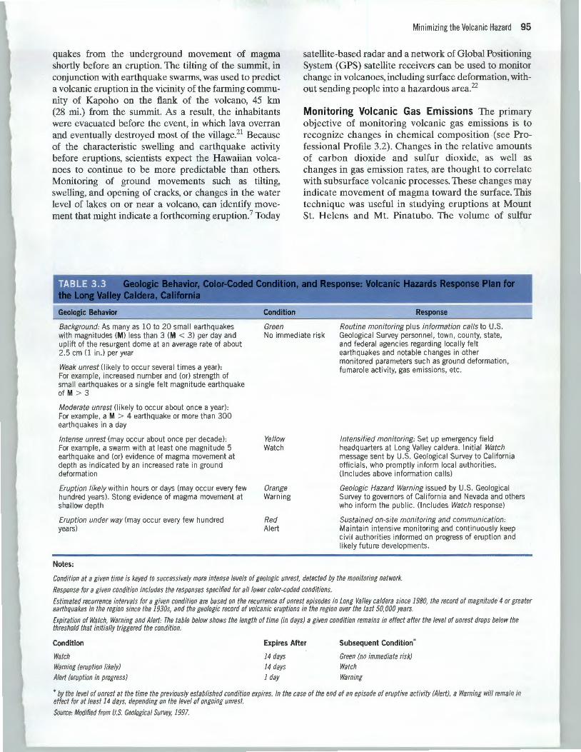
TABLE 3.3
Geologic Behavior
Background: As many as 10 to 20 small earthquakes with magnitudes (M) less than 3 (M < 3) per day and uplift of the resurgent dome at an average rate of about 2.5 em (1 in.) per year
Weak unrest (likely to occur several times a year): For example, increased number and (or) strength of small earthquakes or a single felt magnitude earthquake of M > 3
Moderate unrest (likely to occur about once a year) : For example, a M > 4 earthquake or more than 300 earthquakes in a day
Intense unrest (may occur about once per decade): For example, a swarm with at least one magnitude 5 earthquake and (or) evidence of magma movement at depth as indicated by an increased rate in ground deformation
Eruption likely within hours or days (may occur every few hundred years). Stong evidence of magma movement at shallow depth
Eruption under way (may occur every few hundred years)
Notes:
Condition
Green No immediate risk
Yellow Watch
Orange Warning
Red Alert
Response
Routine monitoring plus information calls to U.S. Geological Survey personnel, town, county, state, and federal agencies regarding locally felt earthquakes and notable changes in other monitored parameters such as ground deformation, fumarole activity, gas emissions, etc.
Intensified monitoring: Set up emergency field headquarters at Long Valley caldera. Init ial Watch message sent by U.S. Geological Survey to California officials, who promptly inform local authorities. (Includes above information cal ls)
Geologic Hazard Warning issued by U.S. Geological Survey to governors of California and Nevada and others who inform the public. (Includes Watch response)
Sustained on-site monitoring and communication: Maintain intensive monitoring and continuously keep civil authorities informed on progress of eruption and likely future developments.
Condition at a given time is keyed to successively more intense levels of geologic unrest, detected by the monitoring network.
Response for a given condition includes the responses specified for all/ower color-coded conditions.
Estimated recurrence intervals for a given condition are based on the recurrence of unrest episodes in Long Valley caldera since 1980, the record of magnitude 4 or greater earthquakes in the region since the 1930s, and the geologic record of volcanic eruptions in the region over the last 50,000 years.
Expiration of Watch, Warning and Alert: The table below shows the length of time (in days) a given condition remains in effect after the level of unrest drops below the threshold that initially triggered the condition.
Condition
Watch Warning (eruption likely) Alert (eruption in progress)
Expires After
14 days 14 days 1 day
Subsequent Condition*
Green (no immediate risk) Watch Warning
• by the level of unrest at the time the previously established condition expires. In the case of the end of an episode of eruptive activity (Alert), a Warning will remain in effect for at least 14 days, depending on the level of ongoing unrest.
Source: Modified from U.S. Geological Survey, 1997.
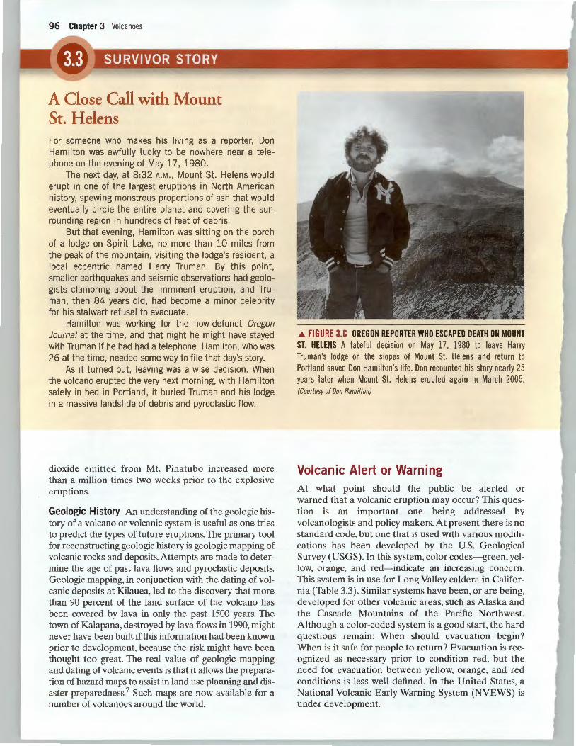
A Close Call with Mount St. Helens For someone who makes his living as a reporter, Don Hamilton was awfully lucky to be nowhere near a telephone on the evening of May 17, 1980.
The next day, at 8 :32A.M. , Mount St. Helens would erupt in one of the largest erupt ions in North American history, spewing monstrous proportions of ash that would eventually circle the entire planet and covering the surrounding region in hundreds of feet of debris.
But that evening, Hamilton was sitting on the porch of a lodge on Sp irit Lake, no more than 10 miles from the peak of the mountain, visiting the lodge's resident, a local eccentric named Harry Truman. By this point, smaller earthquakes and se ismic observations had geologists clamoring about the imminent eruption , and Truman, then 84 years old, had become a minor celebrity for his stalwart refusal to evacuate.
Hamilton was working for the now-defunct Oregon Journal at the time, and that night he might have stayed with Truman if he had had a telephone. Hamilton , who was 26 at the time, needed some way to file that day's story.
As it turned out, leaving was a wise decision. When the volcano erupted the very next morning, with Hamilton safely in bed in Portland, it buried Truman and his lodge in a massive landslide of debris and pyroclastic flow.
dioxide emitted from Mt. Pinatubo increased more than a million times two weeks prior to the explosive eruptions.
Geologic History An understanding of the geologic history of a volcano or volcanic system is useful as one tries to predict the types of future eruptions. The primary tool for reconstructing geologic history is geologic mapping of volcanic rocks and deposits. Attempts are made to determine the age of past lava flows and pyroclastic deposits. Geologic mapping, in conjunction with the dating of volcanic deposits at Kilauea, led to the discovery that more than 90 percent of the land surface of the volcano has been covered by Java in only the past 1500 years. The town of Kalapana, destroyed by Java flows in 1990, might never have been built if this information had been known prior to development, because the risk might have been thought too great. The real value of geologic mapping and dating of volcanic events is that it allows the preparation of hazard maps to assist in land use planning and disaster preparedness.7 Such maps are now available for a number of volcanoes around the world.
.A. FIGURE 3.C OREGON REPORTER WHO ESCAPED DEATH ON MOUNT ST. HELENS A fateful decision on May 17, 1980 to leave Harry Truman 's lodge on the slopes of Mount St. Helens and return to Portland saved Don Hamilton's life. Don recounted his story nearly 25 years later when Mount St. Helens erupted again in March 2005. (Courtesy of Don Hamilton)
Volcanic Alert or Warning At what point should the public be alerted or warned that a volcanic eruption may occur? This question is an important one being addressed by volcanologists and policy makers. At present there is no standard code, but one that is used with various modifications has been developed by the U.S. Geological Survey (USGS). In this system, color codes- green, yellow, orange, and red-indicate an increasing concern. This system is in use for Long Valley caldera in California (Table 3.3). Similar systems have been, or are being, developed for other volcanic areas, such as Alaska and the Cascade Mountains of the Pacific Northwest. Although a color-coded system is a good start, the hard questions remain: When should evacuation begin? When is it safe for people to return? Evacuation is recognized as necessary prior to condition red, but the need for evacuation between yellow, orange, and red conditions is Jess well defined. In the United States, a National Volcanic Early Warning System (NVEWS) is under development.
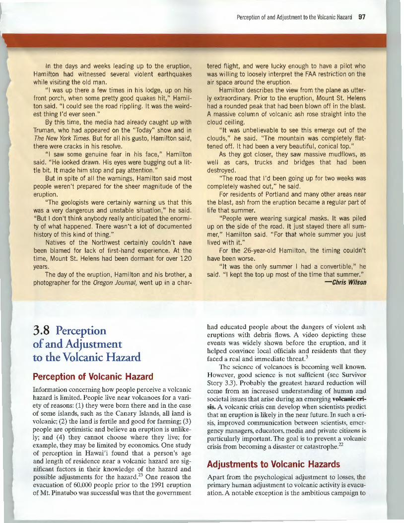
In the days and weeks leading up to the eruption, Hamilton had witnessed several violent earthquakes while visiting the old man .
" I was up there a few times in his lodge, up on his front porch, when some pretty good quakes hit," Hamilton sa id. " I coul d see the road rippling. It was the weirdest thing I'd ever seen ."
By this time, the media had already caught up with Truman, who had appeared on the "Today" show and in The New York Times. But for all his gusto, Hamilton said, there were cracks in his resolve.
"I saw some genuine fear in his face," Hamilton said . " He looked drawn. His eyes were bugging out a little bit. It made him stop and pay attention. "
But in spite of all the warnings, Hamilton said most people weren 't prepared for the sheer magnitude of the eruption .
"The geologists were certainly warning us that this was a very dangerous and unstable situation, " he said. "But I don't think anybody really anticipated the enormity of what happened. There wasn't a lot of documented history of this kind of thing."
Natives of the Northwest certainly couldn't have been blamed for lack of first-hand experience. At the time, Mount St. Helens had been dormant for over 120 years.
The day of the eruption, Hamilton and his brother, a photographer for the Oregon Journal, went up in a char-
3.8 Perception of and Adjustment to the Volcanic Hazard
Perception of Volcanic Hazard Information concerning how people perceive a volcanic hazard is limited. People live near volcanoes for a variety of reasons: (1) they were born there and in the case of some islands, such as the Canary Islands, all land is volcanic; (2) the land is fertile and good for farming; (3) people are optimistic and believe an eruption is unlikely; and ( 4) they cannot choose where they live; for example, they may be limited by economics. One study of perception in Hawai' i found that a person's age and length of residence near a volcanic hazard are significant factors in their knowledge of the hazard and possible adjustments for the hazard.23 One reason the evacuation of 60,000 people prior to the 1991 eruption of Mt. Pinatubo was successful was that the government
Perce ption of and Adjustment to the Volcanic Hazard 97
tered flight, and were lucky enough to have a pilot who was wi IIi ng to loosely interpret the FAA restriction on the air space around the eruption.
Hamilton describes the view from the plane as utterly extraordinary. Prior to the eruption , Mount St. Helens had a rounded peak that had been blown off in the blast. A massive column of volcanic ash rose straight into the cloud ceiling.
"It was unbelievable to see this emerge out of the clouds, " he said. "The mountain was completely flattened off. It had been a very beautiful, conical top."
As they got closer, they saw massive mudflows , as well as cars, trucks and bridges that had been destroyed .
"The road that I'd been going up for two weeks was completely washed out, " he said .
For residents of Portland and many other areas near the blast, ash from the eruption became a regular part of life that summer.
"People were wearing surgical masks. It was piled up on the side of the road. It just stayed there all summer," Hamilton said . "For that whole summer you just I ived with it."
For the 26-year-old Hamilton , the timing couldn 't have been worse .
"It was the only summer I had a convertible," he said . "I kept the top up most of the time that summer."
-Chris Wilson
had educated people about the dangers of violent ash eruptions with debris flows. A video depicting these events was widely shown before the eruption, and it helped convince local officials and residents that they faced a real and immediate threat.3
The science of volcanoes is becoming well known. However, good science is not sufficient (see Survivor Story 3.3). Probably the greatest hazard reduction will come from an increased understanding of human and societal issues that arise during an emerging volcanic crisis. A volcanic crisis can develop when scientists predict that an eruption is likely in the near future. In such a crisis, improved communication between scientists, emergency managers, educators, media and private citizens is particularly important. The goal is to prevent a volcanic crisis from becoming a disaster or catastrophe.22
Adjustments to Volcanic Hazards Apart from the psychological adjustment to losses, the primary human adjustment to volcanic activity is evacuation. A notable exception is the ambitious campaign to
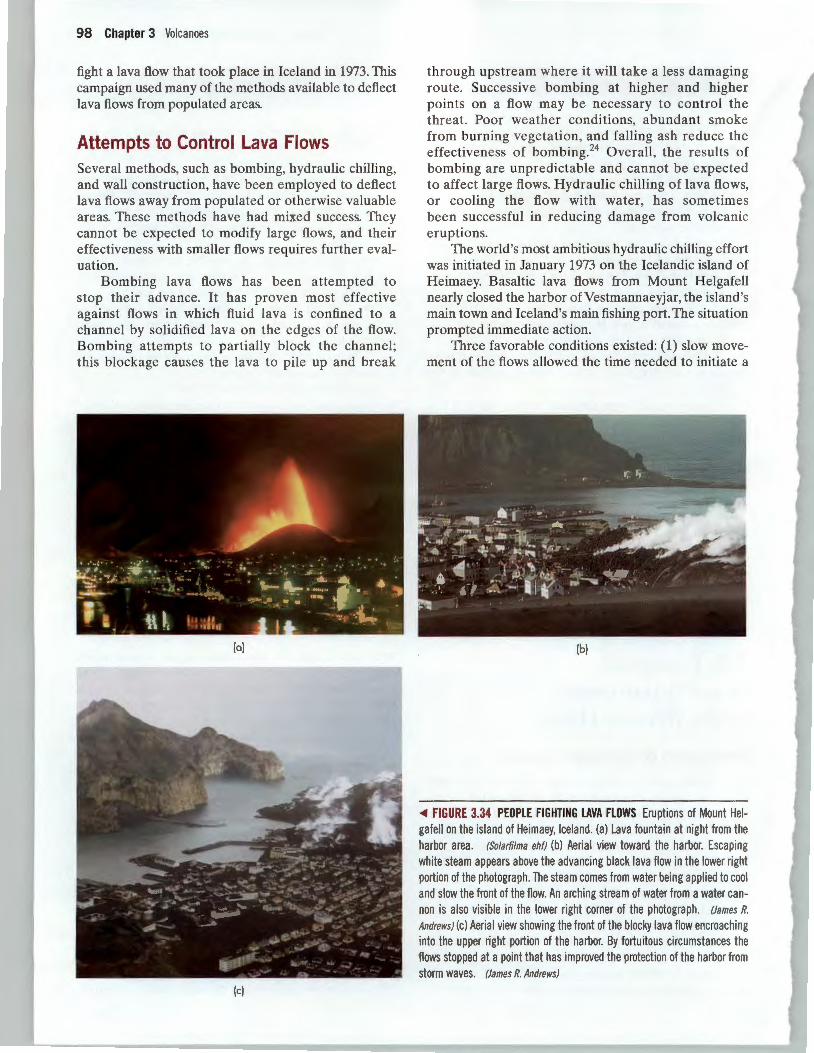
98 Chapter 3 Volcanoes
fight a lava flow that took place in Iceland in 1973. This campaign used many of the methods available to deflect lava flows from populated areas.
Attempts to Control Lava Flows Several methods, such as bombing, hydraulic chilling, and wall construction, have been employed to deflect lava flows away from populated or otherwise valuable areas. These methods have had mixed success. They cannot be expected to modify large flows, and their effectiveness with smaller flows requires further evaluation.
Bombing lava flows has been attempted to stop their advance. It has proven most effective against flows in which fluid lava is confined to a channel by solidified lava on the edges of the flow. Bombing attempts to partially block the channel; this blockage causes the lava to pile up and break
(a)
(c)
through upstream where it will take a less damaging route. Successive bombing at higher and higher points on a flow may be necessary to control the threat. Poor weather conditions, abundant smoke from burning vegetation, and falling ash reduce the effectiveness of bombing.24 Overall, the results of bombing are unpredictable and cannot be expected to affect large flows. Hydraulic chilling of lava flows, or cooling the flow with water, has sometimes been successful in reducing damage from volcanic eruptions.
The world's most ambitious hydraulic chilling effort was initiated in January 1973 on the Icelandic island of Heimaey. Basaltic lava flows from Mount Helgafell nearly closed the harbor ofVestmannaeyjar, the island 's main town and Iceland's main fishing port. The situation prompted immediate action.
Three favorable conditions existed: (1) slow movement of the flows allowed the time needed to initiate a
(b)
<Ill FIGURE 3.34 PEOPLE FIGHTING LAVA FLOWS Eruptions of Mount Helgafell on the island of Heimaey, Iceland. (a) Lava fountain at night from the harbor area. (Solarfilma ehf) (b) Aerial view toward the harbor. Escaping white steam appears above the advancing black lava flow in the lower right portion of the photograph. The steam comes from water being applied to cool and slow the front of the flow. An arching stream of water from a water cannon is also visible in the lower right corner of the photograph. (James R.
Andrews) (c) Aerial view showing the front of the blocky lava flow encroaching into the upper right portion of the harbor. By fortuitous circumstances the flows stopped at a point that has improved the protection of the harbor from storm waves. (James R. Andrews)
control effort; (2) transport by sea and roads allowed for the delivery of pipes, pumps, and heavy equipment; and (3) water was readily available. Initially the edges and surface of the flow were cooled with water from numerous fire hoses (Figure 3.34).
Then bulldozers were moved up on the slowly advancing flow to make a path for a large water pipe. The plastic pipe did not melt as long as water was flowing in it, and small holes in the pipe allowed the cooling of hot spots along parts of the flow. Watering had little
Summary
Lava is magma that has been extruded from a volcano. Its viscosity, a characteristic related to the temperature and silica content, is important in determining the eruptive style of the different types of volcanoes. The largest volcanoes, shield volcanoes, are common at mid-ocean ridges, such as Iceland, and over mid-plate hot spots, such as the Hawaiian Islands. They are characterized by nonexplosive lava flows of basalt. Most volcanic eruptions are from the classic, cone-shaped composite volcanoes that occur above subduction zones, particularly around the Pacific Rim. Many of the volcanoes in the Aleutian Islands of Alaska and the Cascade Mountains of the U.S. Pacific Northwest are of this type. These volcanoes are characterized by explosive eruptions and are composed largely of andesite rocks. Volcanic domes are generally smaller, highly explosive volcanoes that occur inland of subduction zones. They include Lassen Peak in California and are composed largely of rhyolite rock.
Features of volcanoes include vents, craters, and calderas. Other features related to volcanic activity are hot springs and geysers. Calderas form from infrequent large and violent eruptions. Following an explosive beginning, they often resurge and may present a volcanic hazard for a million years or longer. Recent uplift and earthquakes at the Long Valley caldera in eastern California are reminders of the potential hazard.
Volcanic activity is directly related to plate tectonics. Most volcanoes are located at plate boundaries, where magma is produced in the spreading or sinking of lithospheric plates. Two thirds of the world's volcanoes are associated with the sinking of lithospheric plates along the "Ring of Fire" surrounding most of the Pacific Ocean. Specific geographic regions of North America at risk from volcanoes include the northwest coast of California, Oregon, Washington, and parts of British Columbia and Alaska, Long Valley, and the Yellowstone area.
Primary effects of volcanic activity include lava flows, pyroclastic hazards and, occasionally, the emission of poisonous gases. Bombing, hydraulic chilling, and the construction
Summary 99
effect the first day, but then the back edge flow began to slow down and in some cases stopped.
These actions undoubtedly had an important effect on the lava flows from Mt. Helgafell. They restricted lava movement, reduced property damage, and allowed the harbor to remain open. When the eruption stopped five months later the harbor was still usable.25 In fact , by fortuitous circumstances, the shape of the harbor was actually improved because the cooled lava provided additional protection from the sea.
of walls have been used in attempts to control lava flows. These methods have had mixed success and require further evaluation. Pyroclastic hazards include volcanic ash falls, which may cover large areas with carpets of ash; pyroclastic flows that move as fast as 160 km (100 mi.) per hour down the side of a volcano; and lateral blasts, which can be very destructive. Secondary effects of volcanic activity include debris flows and mudflows, generated when melting snow and ice or precipitation mix with volcanic ash. These flows can devastate an area many kilometers from the volcano. All of these effects have occurred in the recent history of the Cascade Range of the Pacific Northwest and will occur there in the future.
Volcanoes are linked to other natural hazards such as fire, earthquakes, landslides, and climate change. However, they also provide us with natural service functions: fertile soils, a source of power, recreational opportunities, and newly created land.
Efforts to meet the goal of reducing volcanic hazards are focusing on human and societal issues of communication; the objective is to prevent a volcanic crisis from becoming a disaster or catastrophe. Sufficient monitoring of seismic activity; thermal, magnetic, and hydrologic properties; and changes in the land surface, combined with knowledge of the recent geologic history of volcanoes, may eventually result in reliable forecasting of volcanic activity. Forecasts of eruptions have been successful, particularly for Hawaiian volcanoes and Mt. Pinatubo in the Philippines. Worldwide, however, it is unlikely that we will be able to accurately forecast most volcanic activity in the near future.
Perception of the volcanic hazard is apparently a function of age and length of residency near the hazard. Some people have little choice but to live near a volcano. Community-based education plays an important role in informing people about the hazards of volcanoes. Apart from psychological adjustment to losses, the primary human adjustment to volcanic activity is evacuation. Some attempts to control lava flows once an eruption has begun have been successful.
100 Chapter 3 Volcanoes
Key Terms
ash fall (p. 81) caldera (p. 74) cinder cone (p. 73) composite volcano (p. 72) debris flow/mudflow (p. 84)
Review Questions 1. What is magma?
lateral blast (p. 82) lava (p. 68) lava flows (p. 81) magma (p. 68) pyroclastic flow (p. 82)
2. What is viscosity, and what determines it? 3. List the major types of volcanoes and the type of magma
associated with each. 4. List the major types of volcanoes and their eruption
style. Why do they erupt the way they do? 5. What is the relationship between plate tectonics and
volcanoes? 6. How do lava tubes help move magma far from the erupt
ing vents? 7. What is the relationship between the Hawaiian Islands
and the hot spot below the Big Island of Hawai ' i?
. Critical Thinkin uest1ons
1. While looking through some old boxes in your grandparents' home, you find a sample of volcanic rock collected by your great-grandfather. No one knows where it was collected. You take it to school, and your geology professor tells you that it is a sample of andesite. What might you tell your grandparents about the type of volcano from which it probably came, its geologic environment, and the type of volcanic activity that likely produced it?
2. In our discussion of perception of and adjustment to volcanic hazards, we established that people's perceptions and what they will do in case of an eruption are associat-
Selected Web Resources
Hawai'i Volcanoes National Park: www.nps.gov/havolhome.htm- safety considerations and pictures of an erupting volcano
How Volcanoes Work: www.geology.sdsu.edu/how volcanoes work- general site on volcanoes from San Diego State University
pyroclastic deposits (p. 71) shield volcano (p. 71) volcanic crisis (p. 97) volcanic dome (p. 72) volcanic vent (p. 74)
8. What is the origin of a geyser? 9. Why are caldera eruptions so dangerous?
10. List the primary and secondary effects of volcanic eruptions.
11. What methods have been attempted to control lava flows? 12. Differentiate between ash falls, lateral blasts, and ash
flows. 13. What are the major gases emitted in a volcanic eruption,
and which are most hazardous? 14. How are volcanic eruptions able to produce gigantic
mudflows? 15. What are some methods for forecasting volcanic eruption?
ed with both their proximity to the hazard and their knowledge of volcanic processes and necessary adjustments. With this association in mind, develop a public relations program that could alert people to a potential volcanic hazard. Keep in mind that the tragedy associated with the eruption of Nevada del Ruiz was in part due to political and economic factors that influenced the apathetic attitude toward the hazard map prepared for that area. Some people were afraid that the hazard map would lower property values in high-risk areas.
Volcano Products: www.ssd.noaa.gov/VAAC/- volcano links from the National Oceanic and Atmospheric Administration
Volcanoes of Canada: www. nrcan.gc. cal gsc!pacific!vancouver/volcanoes -from Natural Resources Canada
U.S. Geological Survey Volcano Hazards Program: volcanoes.usgs.gov- general U.S. Geological Survey site with general information on volcanic hazards, reducing risk, the Volcano Disaster Assistance Program, online USGS pamphlets and books, and links to great sources of information at the five volcano observatories (Alaska, Cascades, Hawai'i, Long Valley, and Yellowstone)
Weekly Volcano Activity Report: www. volcano.si.edu/reports/usgs/- up-to-date reports on volcanic activity worldwide from the Smithsonian Institution and the U.S. Geological Survey
Hazard City: Volcanic Hazard Assessment 101
VolcanoCams of the World: vulcan. wr.usgs.gov!Photo!volcano_cams.html-links to near real-time pictures of volcanoes from the USGS Cascade Volcano Observatory
Volcanoes of the World: www.educeth.ch/stromboli/- general volcano site from Stromboli online
Volcano World: volcano.und.edu!- general site on volcanoes from the University of North Dakota
- HAZARD CITY: ASSIGNMENTS IN APPLIED GEOLOGY
Volcanic Hazard Assessment
The Issue: Three small earthquakes have shaken Hazard City in the past two weeks. Upon learning that the earthquakes were epicentered in the Lava Mountain area, concern among the citizens ranges from indifference to alarm. The mayor realizes that information is the most important requirement for developing an appropriate response.
Your Task: The mayor has hired you and two other geologists to investigate. Your job is to conduct a preliminary hazard assessment for Downtown and Ralston. A good preliminary assessment must consider all of the potentially hazardous products of a volcanic eruption, which for Lava Mountain include: tephra,
lahars, pyroclastic flows, lava flows, and volcanic gases. It must also include a determination of which part(s) of Hazard City could be affected by each different hazard.
This is not a trivial assignment. Expect to visit every field location, learn about the different parts of Hazard City, and use the links to learn about the different volcanic hazards. Because the geography of the deposits and the town are very important, you may want to print the maps and write notes on them while you do fieldwork and research.
Average Completion Time: 2 hours