Embed Size (px)
Citation preview

Vol. 2
SECTORAL ANALYSIS
1

2PROPOSED CHRONOLOGY (137slides v. 562+ pages of HLURB)
08:30 – 10:00
10:00 – 10:30
10:30 – 12:00
Morning Session
Sectoral Planning: Special Area Studies (35)
Snacks (Q & A)
Sectoral Planning 01: Infrastructure (22)Sample Questions: Areas I, II & III (24)
12:00 – 01:30 Lunch
01:30 – 03:00
03:00 – 03:30
03:30 – 05:00
Afternoon Session Sectoral Planning 02: Institutional (14)Sectoral Planning 03: Economic (39)
Snacks (Q & A)
Sectoral Planning 04: Environment (5)Sectoral Planning 05: Social (22)
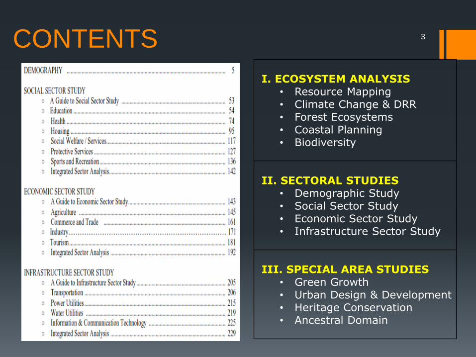
CONTENTS
I. ECOSYSTEM ANALYSIS• Resource Mapping• Climate Change & DRR• Forest Ecosystems• Coastal Planning• Biodiversity
II. SECTORAL STUDIES• Demographic Study• Social Sector Study• Economic Sector Study• Infrastructure Sector Study
III. SPECIAL AREA STUDIES• Green Growth• Urban Design & Development• Heritage Conservation• Ancestral Domain
3

ECOSYSTEM ANALYSIS
• Resource Mapping• Climate Change & DRR• Forest Ecosystems• Coastal Planning• Biodiversity

ECOSYSTEM ANALYSISResource Mapping
(Land, Water, Air)

LAND
▪ Soil Type: clay, loam, sand, silt, etc.─ Rural: is it suitable for agriculture?─ Urban: is it suitable for high-rise?
▪ Slope Category: ─ 0-3% slope: flat terrain; less cost─ >18% slope: forest use
▪ Land Classification: ─ alienable & disposable─ timberland, mineraland
▪ Land Cover: ─ Vegetation: mangrove, cropland─ Others: quarry, barren, built-up
▪ Location of Fault: hazard risk▪ Land Parcels: titled/untitled
─ cadastre: a register of property showing the extent, value, and ownership of land for taxation
▪ Current use: ─ Protection─ Production─ Settlement─ Infrastructure
ECOSYSTEM ANALYSIS• RESOURCE MAPPINGo Land o Water o Air
• Climate Change & DRR• Forest Ecosystems• Coastal Planning• Biodiversity
6
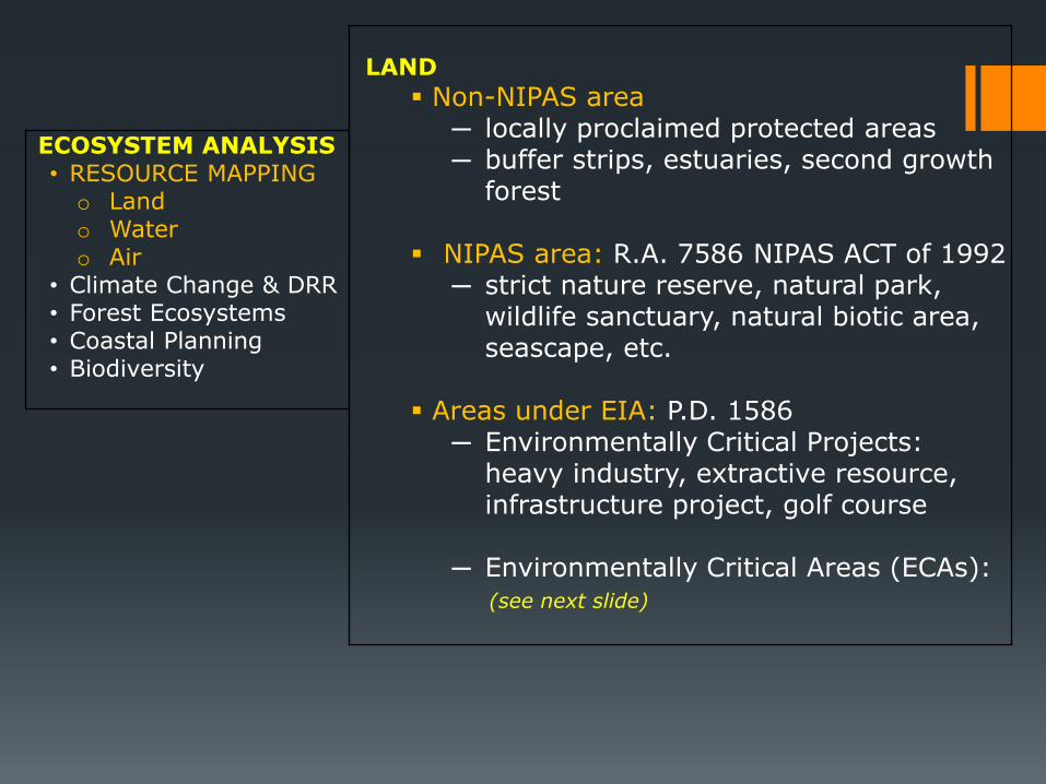
LAND
▪ Non-NIPAS area─ locally proclaimed protected areas─ buffer strips, estuaries, second growth
forest
▪ NIPAS area: R.A. 7586 NIPAS ACT of 1992─ strict nature reserve, natural park,
wildlife sanctuary, natural biotic area, seascape, etc.
▪ Areas under EIA: P.D. 1586 ─ Environmentally Critical Projects:
heavy industry, extractive resource, infrastructure project, golf course
─ Environmentally Critical Areas (ECAs): (see next slide)
ECOSYSTEM ANALYSIS• RESOURCE MAPPINGo Land o Water o Air
• Climate Change & DRR• Forest Ecosystems• Coastal Planning• Biodiversity

LAND
▪ Areas under EIA: P.D. 1586 ─ Environmentally Critical Areas (ECAs):
A: areas declared by law as national park, watershed / wildlife reserve, sanctuary
B: (potential) tourist spotC: habitat of endangered / threatened speciesD: unique historic, archeological, geological or
scientific interestE: areas of Indigenous Cultural Communities
(ICCs)F: areas frequented by geologic hazards,
typhoons, volcanic activityG: area with critical slopeH: area classified as prime agricultural landsI: recharge areas of aquifersJ: waterbodyK: mangrove areaL: coral reef
ECOSYSTEM ANALYSIS• RESOURCE MAPPINGo Land o Water o Air
• Climate Change & DRR• Forest Ecosystems• Coastal Planning• Biodiversity

ECOSYSTEM ANALYSIS• RESOURCE MAPPINGo Land o Water o Air
Civil Reservations
165,946 has. (0.55 %)
Land Classification Status of the Philippines
TLA of the Phils.
30M has.
Alienable and Disposable Lands
(14,1117,244 has. or 47.06%)
Non-A&D
(15.88 M has. or 52.94%)
Titled Lands
(8.11 M has (27.06%)
Untitled6.0 M has. (20%)
Classified Forest Lands
15.0 M has. (50%)
Unclassified Forest Land
881,157 has. (2.94%)
Military Reservations
130,330 has. (0.43%)
National Parks
1.34 M has. (4.47%)
Fishponds
75,548 has. (0.25%)
Timberland
10.0 M has. (33.39%)
Established Forest Reserves
3.27 M has. (10.91%)
Agricultural Lands
4.2 M has. (14%)
Non Agri. Lands
1.800 M Has.
Private Lands
Administratively
titled
6.0 M Has.
Judicially
titled
2.0 M Has.
Gov’t-owned
Lands
DENR-
Administered
Lands
Non DENR-
Administered
Lands
Patrimonial Lands
160,000 has.
Friar Lands
Source: Lands Management Bureau, 1998 - 2-A -
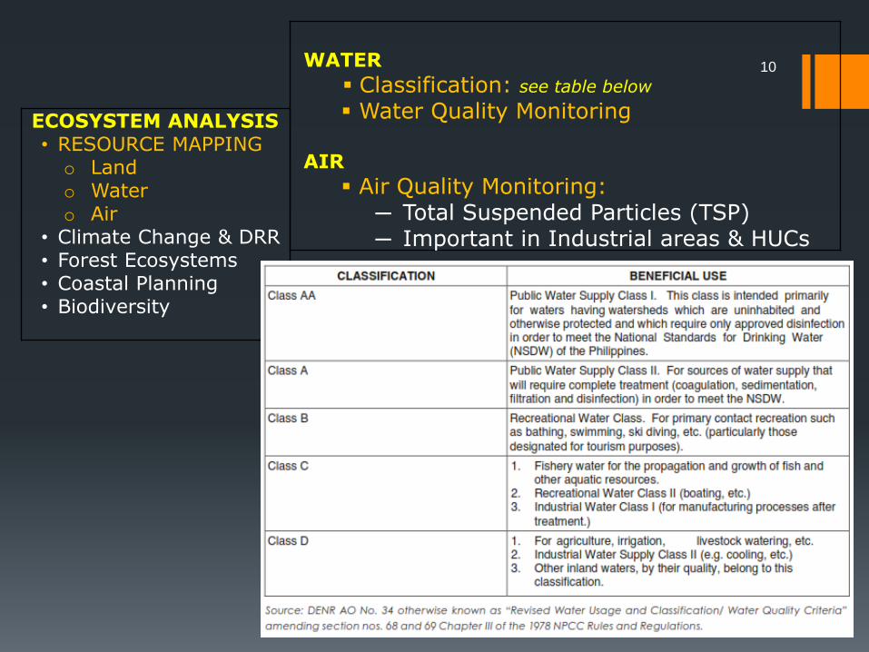
WATER
▪ Classification: see table below
▪ Water Quality Monitoring
AIR
▪ Air Quality Monitoring: ─ Total Suspended Particles (TSP)─ Important in Industrial areas & HUCs
ECOSYSTEM ANALYSIS• RESOURCE MAPPINGo Land o Water o Air
• Climate Change & DRR• Forest Ecosystems• Coastal Planning• Biodiversity
10

ECOSYSTEM ANALYSIS
Climate Change and DRR

General Trend
• All areas in the Philippines will get warmer2020: temperature of 0.9 – 1.10C2050: temperature of 1.8 – 2.20C
• Rainfall Change Rainfall in MAM Rainfall in JJA Trend in rainfall in Mindanao (2050)
• Extreme Events # of hot days (temp. Exceeding 350C More frequent extreme rainfall
• Changes in Annual Mean Rainfall2020 Luzon & Visayas: by 2% - 17%2050 Mindanao: by 0.5 – 11%
• Sea Level Rise: 6 – 10mm / year (1993) 4-7 cm in 2020 22 – 37 cm in 2050
12
ECOSYSTEM ANALYSIS• Resource Mapping• CLIMATE CHANGE &
DRR• Forest Ecosystems• Coastal Planning• Biodiversity

13
ECOSYSTEM ANALYSIS• Resource Mapping• CLIMATE CHANGE &
DRR• Forest Ecosystems• Coastal Planning• Biodiversity
STEPS (Overview)
1. Identify & characterize hazards w/c can affect your LGU.− (rain/earthquake-induced) Landslide, flooding,
storm surge, tsunami, ground rupture, liquefaction, ground shaking, volcano hazards
2. Analyze the potential impact of the hazards (consequence analysis)− residents & businesses w/c will be affected− Critical facilities: power, water, transport
routes, landfill, schools, etc.
3. Estimate the degree of risk per area (risk estimation) high, moderate, low risk
4. Conduct a climate change vulnerability assessment
5. Assess high risk areas and vulnerable sectors in more detail
6. Summarize & incorporate in land use planning & zoning

ECOSYSTEM ANALYSISForest Ecosystems
15
ECOSYSTEM ANALYSIS• Resource Mapping• Climate Change & DRR• FOREST ECOSYSTEMS• Coastal Planning• Biodiversity
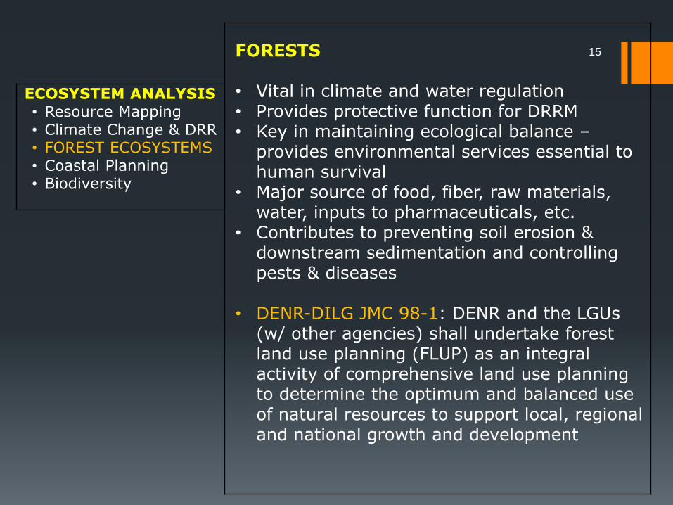
FORESTS
• Vital in climate and water regulation • Provides protective function for DRRM• Key in maintaining ecological balance –
provides environmental services essential to human survival
• Major source of food, fiber, raw materials, water, inputs to pharmaceuticals, etc.
• Contributes to preventing soil erosion & downstream sedimentation and controlling pests & diseases
• DENR-DILG JMC 98-1: DENR and the LGUs (w/ other agencies) shall undertake forest land use planning (FLUP) as an integral activity of comprehensive land use planning to determine the optimum and balanced use of natural resources to support local, regional and national growth and development
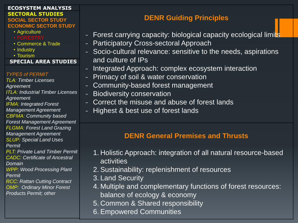
DENR Guiding Principles
- Forest carrying capacity: biological capacity ecological limits
- Participatory Cross-sectoral Approach
- Socio-cultural relevance: sensitive to the needs, aspirations
and culture of IPs
- Integrated Approach: complex ecosystem interaction
- Primacy of soil & water conservation
- Community-based forest management
- Biodiversity conservation
- Correct the misuse and abuse of forest lands
- Highest & best use of forest lands
DENR General Premises and Thrusts
1. Holistic Approach: integration of all natural resource-based
activities
2. Sustainability: replenishment of resources
3. Land Security
4. Multiple and complementary functions of forest resources:
balance of ecology & economy
5. Common & Shared responsibility
6. Empowered Communities
ECOSYSTEM ANALYSISSECTORAL STUDIESSOCIAL SECTOR STUDY
ECONOMIC SECTOR STUDY
• Agriculture
• FORESTRY
• Commerce & Trade
• Industry
• Tourism
SPECIAL AREA STUDIES
TYPES of PERMIT
TLA: Timber Licenses
Agreement
ITLA: Industrial Timber Licenses
Agreement
IFMA: Integrated Forest
Management Agreement
CBFMA: Community based
Forest Management Agreement
FLGMA: Forest Land Grazing
Management Agreement
SLUP: Special Land Uses
Permit
PLT: Private Land Timber Permit
CADC: Certificate of Ancestral
Domain
WPP: Wood Processing Plant
Permit
RCC: Rattan Cutting Contract
OMP: Ordinary Minor Forest
Products Permit; other

17HLURB 2014 FLUP (pp. 73 – 102)
1. Data Gathering, Mapping & Validation
− Socio-economic: population, tenure, mining rights,
CBFM
− Biophysical: biodiversity, condition of watershed &
vegetation
2. Situational Analysis
− How are forestlands being managed?
− Are land uses compatible?
− Are resources sustainably utilized?
3. Forests & Forestlands Zoning
− Protection Forest: strict (critical habitat) & multiple use
(tourism)
− Production Forest: agro-forestry development,
industrial tree plantation, settlements, etc.
4. Strategic Direction Setting & Investment
Planning
ECOSYSTEM ANALYSISSECTORAL STUDIESSOCIAL SECTOR STUDY
ECONOMIC SECTOR STUDY
• Agriculture
• FORESTRY
• Commerce & Trade
• Industry
• Tourism
SPECIAL AREA STUDIES
DENR FLUP
Framework
1. Data Collection
2. Watershed
Delineation
3. ID of current uses: ID
protection and
production areas
4. ID conflict /
opportunity areas
5. Selection of best
option
6. Land use planning
7. Report Preparation
8. Plan Legitimization
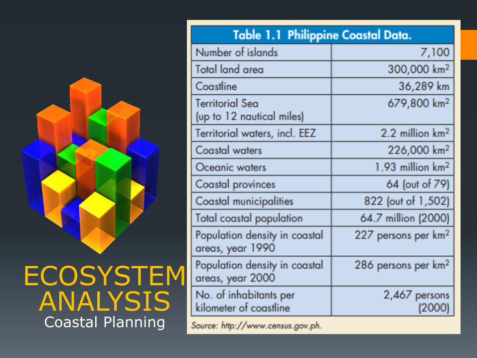
ECOSYSTEM ANALYSISCoastal Planning

19
ECOSYSTEM ANALYSIS• Resource Mapping• Climate Change & DRR• Forest Ecosystems• COASTAL PLANNING• Biodiversity
COASTS
• Coral reefs, seagrass & mangroves protect the coast from strong waves by buffering the high energy coming from waves.
• Added protection from sea level rise and high-energy storm events
• Co-management of adjacent municipalities contribute to protection of coastal resources
Steps: Integrated Coastal Management (ICM)
1. Delineate watershed boundaries (bet. LGUs)2. Delineate municipal waters (local vs. nat.)3. Delineate coastal boundaries & layers 4. Make an assessment of resources5. Integrate coastal management into CLUP
20
ECOSYSTEM ANALYSIS• Resource Mapping• Climate Change & DRR• Forest Ecosystems• COASTAL PLANNING• Biodiversity
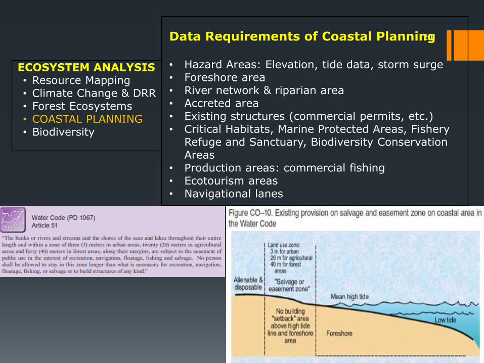
Data Requirements of Coastal Planning
• Hazard Areas: Elevation, tide data, storm surge • Foreshore area• River network & riparian area• Accreted area• Existing structures (commercial permits, etc.)• Critical Habitats, Marine Protected Areas, Fishery
Refuge and Sanctuary, Biodiversity Conservation Areas
• Production areas: commercial fishing• Ecotourism areas• Navigational lanes

ECOSYSTEM ANALYSIS
Biodiversity
Isarog shrew rat
Water monitor lizard
Spiny tree frog

22
ECOSYSTEM ANALYSIS• Resource Mapping• Climate Change & DRR• Forest Ecosystems• Coastal Planning• BIODIVERSITY
Fact Sheet
• Philippines Ranks 5th in diversity of plant species• 49% of Philippines’ wildlife is endemic• Inland waters host at least 121 endemic freshwater
species• 207 animal and 526 plant species are threatened
with extinction (DENR)• There are 128 Key Biodiversity Areas (KBAs) in the
country – areas where endangered species are mostly found.

SPECIAL AREA STUDIES
• Green Growth• Urban Design &
Development• Heritage Conservation• Ancestral Domain

SPECIAL AREA
STUDIESGreen Growth
25
SPECIAL AREA STUDIES
• GREEN GROWTH• Urban Design &
Development• Heritage
Conservation• Ancestral Domain
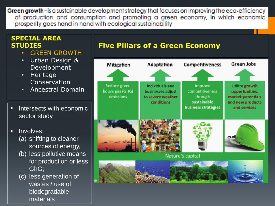
Five Pillars of a Green Economy
▪ Intersects with economic
sector study
▪ Involves:
(a) shifting to cleaner
sources of energy,
(b) less pollutive means
for production or less
GhG;
(c) less generation of
wastes / use of
biodegradable
materials

SPECIAL AREA
STUDIESUrban Design

27
SPECIAL AREA STUDIES
• Green Growth• URBAN DESIGN &
DEVELOPMENT• Heritage
Conservation• Ancestral Domain
Principles of Urban Design▪ Design for all: Collaborate w/ stakeholders including the elderly, women,
children, persons with disability▪ Create places for people: design various activities - athletics, artists, food▪ Conserve heritage▪ Enrich the existing▪ Make connections: transportation routes are integrated with footpaths, bike
lanes, continuity of public transportation▪ Work with nature: following the terrain▪ Mix uses and forms: varied densities and efficient use of space▪ Manage the investment: ensure long-term commitment to develop the area▪ Design for change: make room for future development
Is concerned with the
arrangement, appearance, and
functionality of whole towns and
cities
• shape and form of city blocks
• uses of urban public space
• articulation of physical features

SPECIAL AREA
STUDIESCultural Heritage

29
SPECIAL AREA STUDIES
• Green Growth• Urban Design &
Development• HERITAGE
CONSERVATION• Ancestral Domain
Cultural Heritage: refers to the totality of cultural property preserved and developed through time and passed on to posterity
R.A. 10066: National Cultural Heritage Act of 2009 was enacted specifically to protect, preserve, conserve and promote the nation’s cultural heritage, its property and histories, and the ethnicity of local communities.
- Provides for the designation of heritage zones to protect the historical and cultural integrity of the area
Overview of Steps (abridged):
1. Conduct an inventory of historical and heritage resources and socio-cultural practices of the LGU
2. Consider the ancestral legacy’s uniqueness and self identity in the LGU’s vision and goals
3. Assess the vulnerability of cultural resources to hazards
4. Seek assistance from Nat. Historical Commission5. Asses economic viability of improving the resource6. Recommend interventions such as policy options
and appropriate strategies

SPECIAL AREA
STUDIESAncestral Domain
31
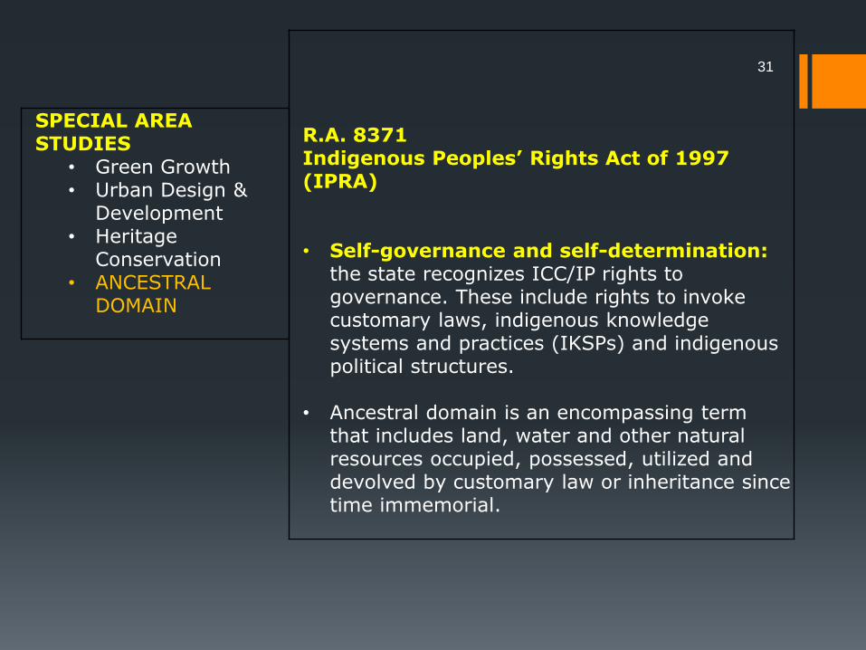
SPECIAL AREA STUDIES
• Green Growth• Urban Design &
Development• Heritage
Conservation• ANCESTRAL
DOMAIN
R.A. 8371Indigenous Peoples’ Rights Act of 1997(IPRA)
• Self-governance and self-determination: the state recognizes ICC/IP rights to governance. These include rights to invoke customary laws, indigenous knowledge systems and practices (IKSPs) and indigenous political structures.
• Ancestral domain is an encompassing term that includes land, water and other natural resources occupied, possessed, utilized and devolved by customary law or inheritance since time immemorial.

32
SPECIAL AREA STUDIES
• Green Growth• Urban Design &
Development• Heritage
Conservation• ANCESTRAL
DOMAIN
Ancestral Domain Sustainable Development and Protection Plan (ADSDPP) Process
1. Baseline Survey: participatory survey focusing on existing population, natural resources and development projects
2. Development Needs Assessment: determine what kind of development the community will pursue in terms of livelihood, education, infrastructure, self-governance, environment & natural resources, culture, etc.
3. Formulation of the ADSDPP• Part I : current situation of the community & 5-year
visioning• Part II: Inventory of Resources, Current Use, Other usage
and Technology needed• Part III: Problem & Concerns, Possible Solutions and
Assisting Agencies
4. Validation of the Plan: multi-sectoral groups
5. Submission of the Plan to NCIP: for information & concurrence
6. Submission of the Plan to LGU: incorporation in the Provincial Development Plan, CDP investment programs
7. Dissemination of the ADSDPP

RECAP
I. ECOSYSTEM ANALYSIS• Resource Mapping• Climate Change & DRR• Forest Ecosystems• Coastal Planning• Biodiversity
✓
II. SECTORAL STUDIES• Demographic Study• Social Sector Study• Economic Sector Study• Infrastructure Sector Study
to be discussed
III. SPECIAL AREA STUDIES• Green Growth• Urban Design & Development• Heritage Conservation• Ancestral Domain
✓
33