Embed Size (px)
Citation preview

190722_redraft_CP_Cascadia_CEMP_Final.docx
July 22, 2019
Prepared for:
Canadian Pacific Railway Building 9 1670 Lougheed Highway Port Coquitlam, BC V3B 5C8
Viterra-Cascadia Terminal Capacity Expansion Project – Construction Environmental Management Plan
Prepared by:
Hemmera Envirochem Inc. 18th Floor, 4730 Kingsway Burnaby, BC V5H 0C6 T: 604.669.0424 F: 604.669.0430 hemmera.com
Pertains to: VFPA file No.: 19-006 DFO file No.: 19-HPAC-00243

Canadian Pacific Railway Viterra-Cascadia Terminal Capacity Expansion Project – Construction Environmental Management Plan 19-HPAC-00243
July 2019 Page | i
190722_redraft_CP_Cascadia_CEMP_Final.docx
TABLE OF CONTENTS
LIST OF ACRONYMS AND ABBREVIATIONS.......................................................................................... IV
LIST OF SYMBOLS AND UNITS OF MEASURE ........................................................................................ V
1.0 INTRODUCTION .............................................................................................................................. 1
2.0 PROJECT INFORMATION .............................................................................................................. 4 2.1 Project Location .................................................................................................................. 4 2.2 Project Description .............................................................................................................. 4
Project Dates .......................................................................................................... 6 2.3 Project Area Description ..................................................................................................... 6
History .................................................................................................................... 6 Present and Future Land Use ................................................................................ 7 Surrounding Land Use ........................................................................................... 7 Geology .................................................................................................................. 7 Weather and Climate ............................................................................................. 7 Contamination ........................................................................................................ 8 Baseline Air & Noise Quality .................................................................................. 8
3.0 CONTACTS AND RESPONSIBILITIES .......................................................................................... 9 3.1 CP/Contractor Responsibilities ........................................................................................... 9 3.2 Environmental Monitor Responsibilities .............................................................................. 9 3.3 Cultural Monitor Responsibilities ....................................................................................... 10
4.0 REGULATORY FRAMEWORK ..................................................................................................... 12
5.0 PROJECT COMPONENTS AND MECHANISMS WITH POTENTIAL TO AFFECT ENVIRONMENTALLY OR CULTURALLY SENSITIVE RECEPTORS ........................................ 13 5.1 Aquatic Resources ............................................................................................................ 13
Changes in Sediment Concentrations ................................................................. 14 Changes in Contaminant Concentrations ............................................................ 14 Changes in Habitat Structure and Cover ............................................................. 14 Incidental Injury or Mortality of Fish ..................................................................... 15 Injury, Mortality or Disturbance of Species at Risk .............................................. 15 Disturbance of Marine Mammals ......................................................................... 15 Cultural Resources .............................................................................................. 15 Air and Noise ........................................................................................................ 16
6.0 MEASURES TO AVOID OR MITIGATE EFFECTS TO FISH, FISH HABITAT, AND OTHER ENVIRONMENTAL AND CULTURAL VALUES ............................................................. 17 6.1 General Practices .............................................................................................................. 17 6.2 Access, Mobilization, and Laydown Areas ....................................................................... 17

Canadian Pacific Railway Viterra-Cascadia Terminal Capacity Expansion Project – Construction Environmental Management Plan 19-HPAC-00243
July 2019 Page | ii
190722_redraft_CP_Cascadia_CEMP_Final.docx
6.3 Air Quality .......................................................................................................................... 18 6.4 Noise and Vibration ........................................................................................................... 18 6.5 Water Quality .................................................................................................................... 19
General Best Practices ........................................................................................ 19 Erosion and Sediment Control ............................................................................. 20 Water Quality Monitoring Plan ............................................................................. 22 Water Quality Contingency Plan .......................................................................... 23
6.6 Machinery and Equipment ................................................................................................ 24 6.7 Contaminated Soil and Groundwater Management .......................................................... 24 6.8 Vegetation and Wildlife Management ............................................................................... 25 6.9 Marine and Foreshore Resources .................................................................................... 25
Marine Lifeform Salvage ...................................................................................... 26 Marine Mammal Monitoring Plan ......................................................................... 27
6.10 Freshwater Habitat Management ...................................................................................... 27 6.11 Archaeological and Cultural Resources ............................................................................ 28 6.12 Sensitive Habitat Features and Species ........................................................................... 28 6.13 Emergency Response Plan .............................................................................................. 29
Emergency Communication ................................................................................. 29 Environmental Emergency Plan ........................................................................... 30 Spill Response Plan ............................................................................................. 31
6.14 Fuel Management ............................................................................................................. 32 6.15 Use of Fuels, Lubricants, and Hydraulic Fluids ................................................................ 32 6.16 Waste Management .......................................................................................................... 33 6.17 Mitigation Contingency Measures ..................................................................................... 34
7.0 CLOSURE ...................................................................................................................................... 35
8.0 REFERENCES ............................................................................................................................... 36
LIST OF TABLES (WITHIN TEXT)
Table 1 Project Area Climate Information ........................................................................................ 8 Table 2 Project Assessment Using DFO’s Defined Activities and Timing of Potential Effects ...... 13 Table 3 Emergency Contacts ......................................................................................................... 29 Table 4 Spill Reporting Matrix ........................................................................................................ 32
LIST OF FIGURES (WITHIN TEXT)
Figure 1 Viterra-Cascadia Terminal Capacity Expansion Project, located in the Burrard Inlet, Burnaby, BC ........................................................................................................................ 2
Figure 2 Project Footprint and Fish Habitat Impact Summary .......................................................... 3

Canadian Pacific Railway Viterra-Cascadia Terminal Capacity Expansion Project – Construction Environmental Management Plan 19-HPAC-00243
July 2019 Page | iii
190722_redraft_CP_Cascadia_CEMP_Final.docx
LIST OF APPENDICES
Appendix A Appendix B Appendix C Appendix D Appendix E
Design Drawing Sets (AECOM 2019a) Typical Construction Sequencing (AECOM 2019b) Construction Schedule Archeological Impact Assessment Interim Report – CP Rail Cascadia Track Expansion Project & Chance Find Procedure. (Terra Archaeology 2019) Para. 35(2) Fisheries Act Authorization (DFO File:19-HPAC-00243)

Canadian Pacific Railway Viterra-Cascadia Terminal Capacity Expansion Project – Construction Environmental Management Plan 19-HPAC-00243
July 2019 Page | iv
190722_redraft_CP_Cascadia_CEMP_Final.docx
LIST OF ACRONYMS AND ABBREVIATIONS
Acronym / Abbreviation Definition
Ausenco Ausenco Engineering Canada Inc.
BCTC British Columbia Transmission Corporation
BMP Best Management Practice
CCG Canadian Coast Guard
CCME Canadian Council of Ministers of the Environment
CEMP Construction Environmental Management Plan
CP Canadian Pacific Railway
CRA commercial, recreational, and Aboriginal
DFO Fisheries and Oceans Canada
EIR Environmental Incident Report
EM Environmental Monitor
FA Fisheries Act
FAA Fisheries Act Authorization
FREMP Fraser River Estuary Management Program
GPS Geographic Positioning System
Hemmera Hemmera Envirochem Inc.
HHWLT higher high-water large tide
LLWLT lower low-water large tide
MCTS Marine Communications and Traffic Services
MECCS Ministry of Environment and Climate Change Strategy
MMO Marine Mammal Observer
MSDS Material Safety Data Sheet
MWL mean water level
MWLAP Ministry of Water, Land, and Air Protection
PCB polychlorinated biphenyl
PER Project and Environmental Review
PLA Permits, Licenses and Approvals
PMV Vancouver Fraser Port Authority
POEs Pathways of Effects
QEP Qualified Environmental Professional
SAR Species at Risk
SDS safety data sheets
TSS total suspended solids
VFPA Vancouver Fraser Port Authority
VHF very high frequency
WHMIS Workplace Hazardous Materials Information System

Canadian Pacific Railway Viterra-Cascadia Terminal Capacity Expansion Project – Construction Environmental Management Plan 19-HPAC-00243
July 2019 Page | v
190722_redraft_CP_Cascadia_CEMP_Final.docx
LIST OF SYMBOLS AND UNITS OF MEASURE
Symbol / Unit of Measure Definition
CD chart datum
cm centimeter
g gram
ha hectare
km kilometre
m metre
mm millimetre
ug microgram
Canadian Pacific Railway Viterra-Cascadia Terminal Capacity Expansion Project – Construction Environmental Management Plan 19-HPAC-00243
July 2019 Page | 1
190722_redraft_CP_Cascadia_CEMP_Final.docx
1.0 INTRODUCTION
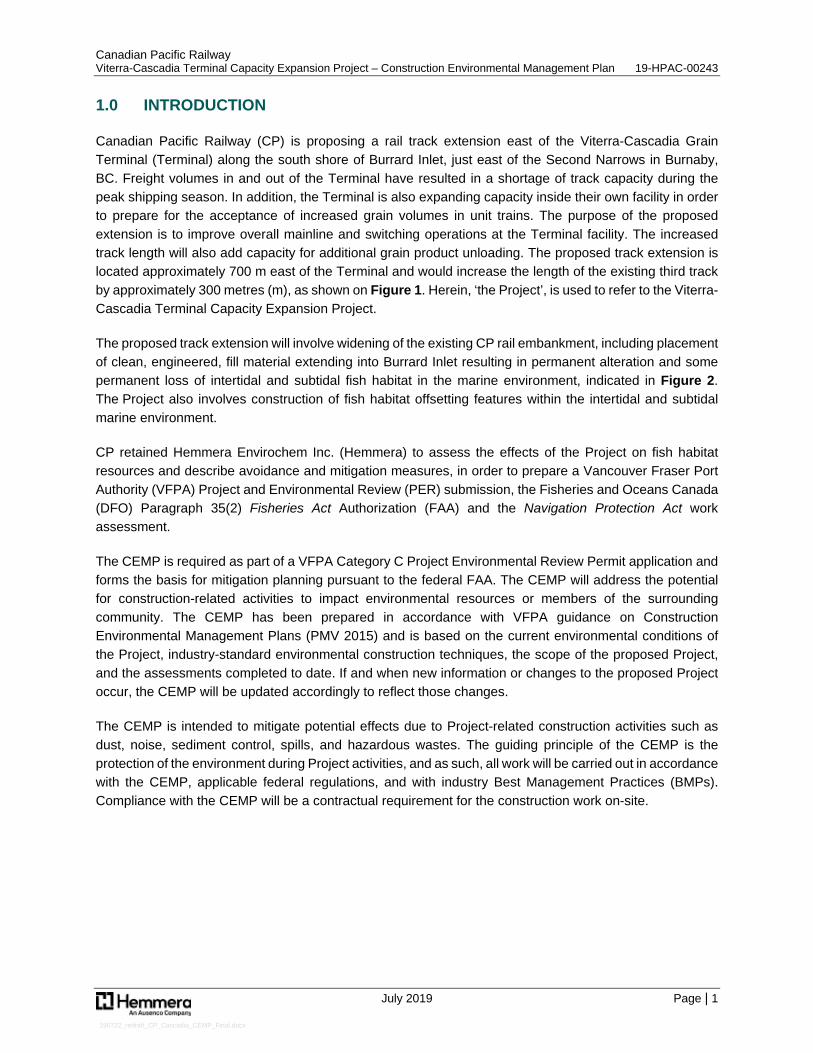
Canadian Pacific Railway (CP) is proposing a rail track extension east of the Viterra-Cascadia Grain Terminal (Terminal) along the south shore of Burrard Inlet, just east of the Second Narrows in Burnaby, BC. Freight volumes in and out of the Terminal have resulted in a shortage of track capacity during the peak shipping season. In addition, the Terminal is also expanding capacity inside their own facility in order to prepare for the acceptance of increased grain volumes in unit trains. The purpose of the proposed extension is to improve overall mainline and switching operations at the Terminal facility. The increased track length will also add capacity for additional grain product unloading. The proposed track extension is located approximately 700 m east of the Terminal and would increase the length of the existing third track by approximately 300 metres (m), as shown on Figure 1. Herein, ‘the Project’, is used to refer to the Viterra-Cascadia Terminal Capacity Expansion Project.
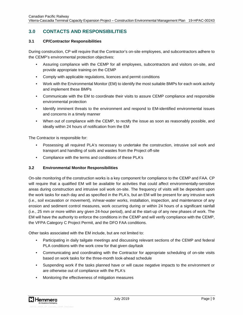
The proposed track extension will involve widening of the existing CP rail embankment, including placement of clean, engineered, fill material extending into Burrard Inlet resulting in permanent alteration and some permanent loss of intertidal and subtidal fish habitat in the marine environment, indicated in Figure 2. The Project also involves construction of fish habitat offsetting features within the intertidal and subtidal marine environment.
CP retained Hemmera Envirochem Inc. (Hemmera) to assess the effects of the Project on fish habitat resources and describe avoidance and mitigation measures, in order to prepare a Vancouver Fraser Port Authority (VFPA) Project and Environmental Review (PER) submission, the Fisheries and Oceans Canada (DFO) Paragraph 35(2) Fisheries Act Authorization (FAA) and the Navigation Protection Act work assessment.
The CEMP is required as part of a VFPA Category C Project Environmental Review Permit application and forms the basis for mitigation planning pursuant to the federal FAA. The CEMP will address the potential for construction-related activities to impact environmental resources or members of the surrounding community. The CEMP has been prepared in accordance with VFPA guidance on Construction Environmental Management Plans (PMV 2015) and is based on the current environmental conditions of the Project, industry-standard environmental construction techniques, the scope of the proposed Project, and the assessments completed to date. If and when new information or changes to the proposed Project occur, the CEMP will be updated accordingly to reflect those changes.
The CEMP is intended to mitigate potential effects due to Project-related construction activities such as dust, noise, sediment control, spills, and hazardous wastes. The guiding principle of the CEMP is the protection of the environment during Project activities, and as such, all work will be carried out in accordance with the CEMP, applicable federal regulations, and with industry Best Management Practices (BMPs). Compliance with the CEMP will be a contractual requirement for the construction work on-site.

Path: S:\Geomatics\Projects\103396\02\mxd\Cascadia - Viterra Capacity Improvement Project\Fig1__103396_02_ProjectLocation_190618.mxd
Pro ductio n Date: Jun 18, 2019
Pa ge Size: 11" x 17"
103396-02 Figure 1
NAD 1983 CSR S UTM Zo n e 10N
Burrard Inlet
CASCADIATER MINAL
CP R O W
CA-124
CA-125
N WILLINGDO N AVE
SECOND NARROWS BRIDGE
R AILWAY ST
FR ANKLIN ST
N GAMMA AVE
EDINBUR GH ST
BETA AVE
FELLO WES ST
ALPHA AVE
N RO SSER AVE
ALBER T ST
N SKEENA ST
MILLER DR
TRANS-CANADA HWY
AMHER ST AVE
BRIDGEWAY
MACDO NALD AVE
ESMOND AVE
MAIN ST
CANBERR A AVE
GAMMA AVER OSSER AVE
N INGLETON AVE
N CARLETON AVE
N BOUNDAR Y RD
GILMO RE AVE
N GILMO RE AVE
MADISON AVE
CASSIAR ST
SKEENA ST
WILLINGDO N AVE
N ESMO ND AVE N M
ACDONALD AVE
KOOTENAY ST
CAR LETO N AVE
INGLETO N AVE
N MADISON AVE
N KO OTENAY ST
N CASSIAR ST
R IVER SIDE DR W
ORWELL ST
TR IUMPH ST
TR INITY ST
HARBO UR AVE
BOUNDAR Y RD
SPICER RD
EMPIR E DR
PENZANCE DR
PANDO R A ST
MOUNTAIN HWY
YALE ST
DO MINIO N ST
BAY ST
BAR R O W ST
UNNAMED LANE
CAMBR IDGE ST
ETO N ST
O XFO R D ST
DUNDAS ST
MCGILL ST
CO LUMBIA ST
Project Location
Map Exten t
0 2.5 5Kilo m etres
Legen d
±1:10,000
0 100 200 300 400 500Metres
- Co n ta in s in fo rm a tio n licen sed un der the O pen Go vern m en t Licen ces -Pro vin ce o f British Co lum b ia a n d City o f Va n co uver- Pro po sed Pro ject Features: AECO M, 2019- Aeria l Im a ge: City o f Va n co uver, 2015; ESR I World Im a gery- In set Basem a p: ESR I Wo rld To po graphic Map
So urces
1. All m apped fea tures are appro xim a te a n d sho uld b e used fo r discussio npurposes o n ly.2. This m ap is n o t in ten ded to b e a “sta n d-a lo n e” do cum en t, b ut a visua l a ido f the in fo rm a tio n co n ta in ed within the referen ced R epo rt. It is in ten ded tob e used in co n jun ctio n with the sco pe o f services a n d lim itatio n s describ edtherein .
No tes
Pro po sed Track Exten sio nPro ject Fo o tprin tCP Milea geExistin g CP R a ilwa y
Viterra-Casca diaTerm in a l Capacity Expa n sio n Pro ject
Burrard In let, Burn a b y, BC

Path: S:\Geomatics\Projects\103396\02\mxd\Fig2__103396_02_FishHabitatImpactSummary_190724.mxd
P roduction Da te: Jul 24, 2019
P a ge Size: 11" x 17"
103396-02 Figure 2
N AD 1983 CSRS UTM Z one 10N
Burrard Inlet
N EW HHW LT
LLW MTMW LHHW MT
LLW LT
HHW LT
HHW LT
LLW LT
HHW MTMW L
LLW MT
DESTRUCTION - RIPARIAN1,500 m 2
P ERMAN EN T ALTERATION - MARIN E IN TERTIDAL3,389 m 2
DESTRUCTION - MARIN E IN TERTIDAL1,679 m 2
P ERMAN EN T ALTERATION - MARIN E SUBTIDAL (W ITHIN KELP BED)331 m 2
P ERMAN EN T ALTERATION - MARIN E IN TERTIDAL (W ITHIN KELP BED)214 m 2
CASCADIA TERMIN AL
CP LEASE ROW
[P LAN V-4324(02)]
Project Footprintand Fish Habitat Impact Summary
Viterra -Ca sca dia Term ina l Ca pa city Expa nsion P roject
Burra rd Inlet, Burna by, BC
Legend
±1:1,000
0 10 20 30 40 50Metres
Construction Z one Lim itP roposed Tra ck ExtensionKelp Bed Extent (2019)Shorewa rd Kelp Ded Extent (2019)Exca va tion Area Beyond Gra ding StructureP roposed Ripra pP roposed Tra ck Rem ova lP roposed W a lkwa y for TurnoutTem pora ry P a d ExtensionExisting CP Ra ilwa yP roposed Higher High W a ter La rge Tide (HHW LT)Tide LineCP Right-of-W a yCP Lea se Right-of-W a y
Fish Habitat ImpactDestruction - Ma rine Intertida lDestruction - Ripa ria nP erm a nent Altera tion - Ma rine Intertida lP erm a nent Altera tion - Ma rine Intertida l (W ithin Kelp Bed)P erm a nent Altera tion - Ma rine Subtida l (W ithin Kelp Bed)
- Conta ins inform a tion licensed under the Open Governm ent Licences -P rovince of British Colum bia a nd City of Va ncouver- P roposed P roject Fea tures: AECOM, 2019- Aeria l Im a ge: City of Va ncouver, 2015
Sources
1. All m a pped fea tures a re a pproxim a te a nd should be used for discussionpurposes only.2. This m a p is not intended to be a “sta nd-a lone” docum ent, but a visua l a idof the inform a tion conta ined within the referenced Report. It is intended tobe used in conjunction with the scope of services a nd lim ita tions describedtherein.
N otes

Canadian Pacific Railway Viterra-Cascadia Terminal Capacity Expansion Project – Construction Environmental Management Plan 19-HPAC-00243
July 2019 Page | 4
190722_redraft_CP_Cascadia_CEMP_Final.docx
2.0 PROJECT INFORMATION
2.1 Project Location
The Project is approximately centred at 49° 17’ 36.34” N latitude and 123° 01’03.05” W longitude, east of Viterra’s Cascadia Terminal at about CP Mile 124.0 Cascade Subdivision, within the City of Burnaby. The Project encompasses the area of infilling required for the track expansion, over a distance of approximately 300 m along the shoreline and extending into Burrard Inlet, just over 20 m in width at its widest point. The Project is bordered by Montrose Park to the south, Second Narrows Bridge and Cascadia Terminal to the west (700 m), Parkland Refining Plant to the east (1,000 m), and the north is open to Burrard Inlet. The Project location is presented in Figure 1.
The tidal range at this location is approximately 5 m from the lower low-water large tide (LLWLT) at 0 m Chart Datum (CD) and the higher high-water large tide (HHWLT) at + 5 m CD, with a mean water level (MWL) of +3 m CD. The intertidal zone (0 m – + 5 m CD) is primarily rocky, transitioning up to a steep rip rap embankment leading to approximately 5 m of patchy riparian vegetation that borders the gravel bed of the two existing active CP rail lines. The Viterra-Cascadia Terminal Capacity Expansion Project – Marine Fish and Fish Habitat Assessment (Habitat Assessment; Hemmera 2019a) describes baseline conditions, potential effects (i.e., residual serious harm to fish), and recommended avoidance, mitigation measures, and monitoring for the core Project (i.e., placement of fill for widening of the existing CP rail embankment).
2.2 Project Description
The Project involves construction of a rail track extension to the Terminal along the south shore of Burrard Inlet, just east of the Second Narrows in Burnaby, BC. The proposed track extension is located approximately 700 m east of the Terminal and would increase the length of the existing third track by approximately 300 metres (m).
Anticipated Project components and construction approach are as follows:
· Early works to establish access, equipment and material laydown areas will include vegetation clearing, mobilisation, and creation of a temporary work pad
▫ Construction of the temporary work/material unloading pad will commence in October/November 2019 and is expected to take 10 days to complete
▫ The pad will be constructed of an estimated 6,800 m3 of well-graded structural fill material comprised of a flat top area (61 m x 18.3 m) surrounded by 2:1 rip rap slopes (approximately 1,285 m3)
▫ The pad will be built on the western side of the site, largely overlapping with the footprint, to serve as an unloading area where a marine scow and derrick may be tied for efficient transfer of materials. This is the only component of the Project, apart from offsetting (see below), that will encroach into the subtidal zone
▫ Construction materials will arrive to the site by marine scow and will be unloaded on the temporary work pad by a crane-mounted marine derrick
· Removal of additional vegetation (including riparian vegetation) along the construction corridor (i.e., clearing, grubbing, and stripping)

Canadian Pacific Railway Viterra-Cascadia Terminal Capacity Expansion Project – Construction Environmental Management Plan 19-HPAC-00243
July 2019 Page | 5
190722_redraft_CP_Cascadia_CEMP_Final.docx
· Marine work is anticipated to include a derrick with a track-mounted crane containing a clam shell bucket (or alternatively an excavator with long reach arm and bucket with thumb), supply scow, marine tug and small work vessels
· Dredging will be conducted to prepare the seabed for fill placement. Dredgeate will be transported to and disposed of at an approved facility
· Well-graded structural fill (50 mm max, approximately 9,620 m3 in volume) will be used during infilling along the construction corridor to support rail sidings (i.e., on seaward side on the existing rail mainline)
· Following fill placement, the new track grade will be constructed followed by installation of the new track and switch infrastructure
· The temporary work pad will be reduced in size and graded to conform to the footprint before rip rap placement
· Approximately 3,057 m3 of rip rap will be placed as a 2:1 slope
· Construction of all required offsetting
Further details on offsetting are provided in the Viterra-Cascadia Terminal Capacity Expansion Project – Offsetting Plan (Offsetting Plan; Hemmera 2019b). Although informed by the Habitat Assessment (Hemmera 2019a), the Offsetting Plan provides a supplemental assessment of effects and required mitigation and monitoring that relates directly to proposed offsetting. The following documents have been included as appendices:
· Appendix A provides the design drawings for the Project, including the “Issued for Regulatory Review” (Version C) Mapset (regulatory review drawings: 60587181-CT-301-C; 60587181-CT-310-C; 60587181-CT-311-C) (AECOM 2019a)
· Appendix B provides typical cross section views and infilling methodology (AECOM 2019b)
· Appendix C provides the proposed construction schedule (AECOM 2019c)
· Appendix D provides the Archeological Impact Assessment (AIA) and Chance Find Procedure (Terra Archeology 2019)
· Appendix E is intentionally left blank and will include the FAA Authorization (DFO File:19-HPAC-00243), once received from DFO
The six phases of construction for the Project are:
Phase 1 – Toe Construction
Lower tides will be used (to the extent possible) to excavate the required volume of material for off-site permitted disposal, install the required geo textile, and install the rip rap protection material. With consideration towards available day-time low tides during the anticipated construction period, it is understood that toe construction will involve extensive in-water work.
The remaining work day coinciding with less optimal, higher tides is expected to be used to manage on-site material and prepare for the next low tide window. The hours of work will be consistent with the Port Authority’s standard work hours of Monday to Saturday 7:00 am to 8:00 pm. If it becomes necessary to work outside of these hours, a request for extended work hours will be submitted to VFPA after issuance of the PER permit.

Canadian Pacific Railway Viterra-Cascadia Terminal Capacity Expansion Project – Construction Environmental Management Plan 19-HPAC-00243
July 2019 Page | 6
190722_redraft_CP_Cascadia_CEMP_Final.docx
Phase 2 – Slope Construction (From Toe to HHWLT)
The installation of construction fill from the installed toe to above HHWLT, including the installation of slope armouring, will occur during lower tides to the extent possible. The daily work will be left in a “slope protected” state.
Phase 3 – Platform Construction (From HHWLT to Subgrade)
The installation of the platform will not be affected by any considerations with respect to tidal inundation and will only be limited by the daily placement limits of the contractor.
Phase 4 – Installation of Subgrade
The installation of the subgrade will not be any considerations with respect to tidal inundation and will only be limited by the daily placement limits of the contractor.
Phase 5 – Removal of Temporary Work Pad
The temporary work pad will be reduced in size, graded and rip rap placed during lower tides, to the extent possible. With consideration towards available day-time low tides during the anticipated construction period, it is understood that removal of the temporary work pad will involve extensive in-water work.
Phase 6 - Offsetting Construction
All of the offsetting construction will be undertaken including the construction of intertidal and shallow rock reefs and riparian planting. Installation of the shallow rock reefs will involve in-water work (i.e., shallow subtidal reefs placed via barge mounted crane); however, work will be undertaken in the dry as much as feasible (i.e., intertidal reefs). With consideration towards available day-time low tides during the anticipated construction period, it is also understood that some portions of the proposed intertidal reefs will involve in-water work. Final offsetting works will involve soil placement and planting with native plants (shrubs and trees) along the foreshore, once all other construction activities have been completed.
As noted previously, further details on offsetting including potential effects (i.e., residual serious harm to fish), and recommended avoidance, mitigation measures, and monitoring are provided separately in the Offsetting Plan (Hemmera 2019b).
Project Dates
Construction of the Project is scheduled to commence in October/November 2019 (subject to receipt of all Permits, Licenses and Approvals (PLA’s)) and is estimated to take up to four months to complete (i.e., finish by February 28, 2020), with the exception of riparian planting. Riparian planting work will be undertaken in the spring of 2020 (currently scheduled to occur in early April), consistent with the Offsetting Plan.
2.3 Project Area Description
History
Burrard Inlet has been occupied and utilised for thousands of years by several First Nations, including: Cowichan Tribes, Halalt First Nation, Kwikwetlem First Nation, Lake Cowichan First Nation, Lyackson First

Canadian Pacific Railway Viterra-Cascadia Terminal Capacity Expansion Project – Construction Environmental Management Plan 19-HPAC-00243
July 2019 Page | 7
190722_redraft_CP_Cascadia_CEMP_Final.docx
Nation, Musqueam Indian Band, Penelakut Tribe, Squamish Nation, Stó:lō Nations, Stz’uminus First Nation, Tsleil-Waututh Nation.
The upland portion of the Project Area is believed to have been historically filled around 1886 when the CP rail line was constructed and again in the 1990’s to accommodate the Westcoast Express track construction (Hemmera 2015, Chris Dane, pers. comm.). From the early 1900s to the late 1950s, the Project Area overlapped with a small community called “Crabtown”, settled by nearby sawmill workers. Residents constructed houses built on pilings, creating a small town for several decades before their eviction in 1957.
An oil refinery (currently the Parkland Refining Plant) has been located approximately 400 m east of the Project Area since as early as 1949 (Hemmera 2015). The existing Terminal, located approximately 200 m southeast of the Project Area and adjacent to Burrard Inlet, was originally the Alberta Wheat Pool and has been in place since 1928 (Hemmera 2015).
Present and Future Land Use
The Project Area is currently active and contains existing rail infrastructure. Upland portions of the foreshore are within VFPA proprietary jurisdiction and are currently “undesignated” in the Port’s Land Use Plan (PMV 2014) and a portion of the Project Area is currently under an existing lease to CP (Plan V-4324(02)). Marine portions of the Project are located entirely on federal lands designated by the Port of Vancouver’s Land Use Plan as “undesignated” (PMV 2014). CP will be obtaining a lease from VFPA for all areas not already within the existing lease area, including land portions and also waterlot areas in support of the proposed offsetting (shallow rock reefs).
Surrounding Land Use
The Project Area is bordered by Montrose Park to the south, Second Narrows Bridge and the Terminal to the west (200 m), Parkland Refining Plant to the east (400 m), and the north is open to Burrard Inlet. South of Montrose Park, existing land use is residential (distance to nearest houses is approximately 180 m) and institutional (distance to nearest school approximately 950 m).
Geology
The Project Area is characterized by Tertiary bedrock including sandstone, siltstone, shale, conglomerate, and minor volcanic rocks; where bedrock is not exposed it is covered by glacial deposits and colluvium.
Weather and Climate
The Project is situated within the Pacific Maritime Pacific climate zone. A summary of weather and climatic conditions for this climate zone are summarized in Table 1 below. Vancouver International Airport was selected as the weather station most similar to the Project Area. Typical of this climate zone, the highest average annual precipitation (1,113 mm) and associated runoff occurs during the winter months, and the driest months on average are July and August (~40 mm each month).

Canadian Pacific Railway Viterra-Cascadia Terminal Capacity Expansion Project – Construction Environmental Management Plan 19-HPAC-00243
July 2019 Page | 8
190722_redraft_CP_Cascadia_CEMP_Final.docx
Table 1 Project Area Climate Information
Climate Zone Pacific Maritime Ecozone
Average Temperature Range 5oC to 20oC
Average Total Annual Precipitation 1113 mm at YVR, 19km to the West
Weather Forecasts www.weather.gc.ca www.theweathernetwork.com
Weather Phone (Environment Canada) 604.885.4100
Weather Notices (Environment Canada) www.weatheroffice.pyr.ec.gc.ca/e-products
Contamination
Based on the findings presented in a Phase 1 Environmental Site Assessment (Hemmera 2015), no evidence of actual and potential environmental contamination associated with CP operations during the course of the lease agreement was identified at the Project Area. No further investigation was considered warranted.
Baseline Air & Noise Quality
CP completed a Noise Assessment Screening Worksheet of the VFPA PER Guidelines - Environmental Noise (VFPA 2015) for the proposed Project construction activities. Based on the assessment results, the Weighted Project Score is 29.6, which is below the 30 points threshold and; therefore, a detailed noise assessment is not required. There are no recorded noise complaints specific to Project Area (i.e., Mile 124.15 to 124.3 Cascade Subdivision). Most noise complaints within the general setting (i.e., outside the Project Area) are west of Mile 125 where the Cascadia Terminal is located, with Columbia Containers and CP’s K and L Yards also in the vicinity.
Canadian Pacific Railway Viterra-Cascadia Terminal Capacity Expansion Project – Construction Environmental Management Plan 19-HPAC-00243
July 2019 Page | 9
190722_redraft_CP_Cascadia_CEMP_Final.docx
3.0 CONTACTS AND RESPONSIBILITIES
3.1 CP/Contractor Responsibilities
During construction, CP will require that the Contractor’s on-site employees, and subcontractors adhere to the CEMP’s environmental protection objectives:
· Assuring compliance with the CEMP for all employees, subcontractors and visitors on-site, and provide appropriate training on the CEMP
· Comply with applicable regulations, licences and permit conditions
· Work with the Environmental Monitor (EM) to identify the most suitable BMPs for each work activity and implement these BMPs
· Communicate with the EM to coordinate their visits to assure CEMP compliance and responsible environmental protection
· Identify imminent threats to the environment and respond to EM-identified environmental issues and concerns in a timely manner
· When out of compliance with the CEMP, to rectify the issue as soon as reasonably possible, and ideally within 24 hours of notification from the EM
The Contractor is responsible for:
· Possessing all required PLA’s necessary to undertake the construction, intrusive soil work and transport and handling of soils and wastes from the Project off-site
· Compliance with the terms and conditions of these PLA’s
3.2 Environmental Monitor Responsibilities
On-site monitoring of the construction works is a key component for compliance to the CEMP and FAA. CP will require that a qualified EM will be available for activities that could affect environmentally-sensitive areas during construction and intrusive soil work on-site. The frequency of visits will be dependent upon the work tasks for each day and as specified in the PLA’s, but an EM will be present for any intrusive work (i.e., soil excavation or movement), in/near-water works, installation, inspection, and maintenance of any erosion and sediment control measures, work occurring during or within 24 hours of a significant rainfall (i.e., 25 mm or more within any given 24-hour period), and at the start-up of any new phases of work. The EM will have the authority to enforce the conditions in the CEMP and will verify compliance with the CEMP, the VFPA Category C Project Permit, and the DFO FAA conditions.
Other tasks associated with the EM include, but are not limited to:
· Participating in daily tailgate meetings and discussing relevant sections of the CEMP and federal PLA conditions with the work crew for that given day/task
· Communicating and coordinating with the Contractor for appropriate scheduling of on-site visits based on work tasks for the three-month look-ahead schedule
· Suspending work if the tasks planned have or will cause negative impacts to the environment or are otherwise out of compliance with the PLA’s
· Monitoring the effectiveness of mitigation measures
Canadian Pacific Railway Viterra-Cascadia Terminal Capacity Expansion Project – Construction Environmental Management Plan 19-HPAC-00243
July 2019 Page | 10
190722_redraft_CP_Cascadia_CEMP_Final.docx
· Communicating with the Contractor on any issues with their work schedule or planned tasks that may have adverse environment effects (e.g., work outside fish window, or in areas with nesting migratory birds)
· Completing incident reports (e.g., spills, stop work orders), and reporting incidents to the appropriate contacts on-site
· Helping guide the Contractor in achieving a high standard of environmental management during Project construction
The EM will complete and submit environmental monitoring reports to CP, the VFPA and DFO in accordance the conditions of the VFPA Project Permit and the DFO FAA. Typically, the EM will complete daily reports for each day on-site for internal distribution and will prepare monthly summaries for external distribution to the VFPA and DFO. After each week on site, the EM will complete a report to be sent to CP and the Contractor concurrently for review and comment. Any incident reports and follow-up action reports will also be completed digitally in the field as necessary and uploaded once completed. The content of EM reports will include the following, at a minimum:
· Monitoring dates and times · Weather over the reporting period · Construction activities undertaken on each alignment · Any issues identified · Environmental protection and mitigation measures recommended and implemented and an update
regarding maintenance of these items · Outstanding items, including non-compliances with recommendations from the EM, regulatory
agencies, or regulatory documents · Monitoring plan for the following week
Upon completion of the construction work on-site, the EM will prepare a final report that will document the work completed, any discharges from the Project Area (waste, spills, water, soil), as well as remedial actions taken to rectify any issues on-site. The report will also include an as-built summary of the Project. This report will be sent to VFPA and DFO in accordance with PLA conditions.
In the event of any circumstances that result in non-compliance, the EM will determine if a suspension of work is necessary in consultation with the Contractor, CP and relevant authorities. The Contractor must implement all appropriate mitigation measures to address the non-compliance or until conditions change such that construction activities can once again be initiated in compliance with all environmental obligations.
3.3 Cultural Monitor Responsibilities
No archaeological sites were identified within the Project area and the potential for undiscovered archaeological remains was considered to be low in the AIA (Terra Archeology, 2019 (Appendix D)). To help ensure continued appropriate and respectful treatment of Indigenous cultural resources, including potential archaeological sites, CP will retain a Cultural Monitor during appropriate phases of construction. The Cultural Monitor will be responsible for overseeing applicable construction activities to help prevent adverse impacts to cultural resources or interests that may be identified during construction. Specifically, the Cultural Monitor will be required to be familiar with the AIA and the Chance Find Procedures and will be responsible for implementing these procedures, as appropriate (Appendix D).

Canadian Pacific Railway Viterra-Cascadia Terminal Capacity Expansion Project – Construction Environmental Management Plan 19-HPAC-00243
July 2019 Page | 11
190722_redraft_CP_Cascadia_CEMP_Final.docx
Key duties and responsibilities of a Cultural Monitor include the following:
· Communicating and coordinating with the Contractor to schedule Project visits based on work tasks, including identifying any construction activities that could adversely affect cultural resources
· Traveling to and from the Project Area, as needed
· Observing Project health and safety protocols while on-site
· Assisting in providing Project personnel with an understanding of Indigenous interests related to cultural resources
· Identifying any concerns with potential impacts to cultural resources while on-site and communicating these to Project Personnel in a timely, and appropriate manner
· Maintaining a strong knowledge of the Archaeological Chance Find Procedure and implementing these procedures while on site, as needed
· Keeping detailed field notes, including documenting any concerns regarding potential impacts to cultural resources, recommended mitigation measures, and mitigation measures employed
· Conveying any concerns the Cultural Monitor may have to both the Contractor, Project Manager, and First Nation they represent
· Producing and providing monitoring activity reports to the Project Manager, and the First Nation they represent, as needed

Canadian Pacific Railway Viterra-Cascadia Terminal Capacity Expansion Project – Construction Environmental Management Plan 19-HPAC-00243
July 2019 Page | 12
190722_redraft_CP_Cascadia_CEMP_Final.docx
4.0 REGULATORY FRAMEWORK
The following section describes the regulatory and policy framework under which construction work on-site is to be completed. The Project Area is on Federal land (administered by VFPA) such that federal, and VFPA regulations and policies are applicable; therefore, the Project is subject to a Category C Project Permit (VFPA). Furthermore, it has been determined that the Project will require receipt of a FAA from DFO. Any discharges and wastes removed from the Project Area are subject to applicable federal, provincial, municipal, and VFPA regulations and policies.
Federal legislation applicable to the CEMP for the Project is listed below, as well as provincial legislation that may be applicable where the Project Area or activities interface with non-federal land:
Federal:
· Canada Marine Act (S.C. 1998, c. 10)
· Canada Shipping Act, 2001 (S.C. 2001, c.26)
· Canadian Environmental Protection Act, 1999 (S.C. 1999 c. 33)
· Fisheries Act (R.S.C. 1985, c. F-14)
· Migratory Birds Convention Act (SC 1994, c. 22)
· Species at Risk Act (SC 2002, c. 29)
· Transportation of Dangerous Goods Act (S.C. 1992, C.34)
Provincial:
· Water Sustainability Act (SBC 2014, c. 154) and associated Water Sustainability Regulation (BC Reg. 36/2016)
· Wildlife Act (RSBC 1996)
· Emergency Program Act, 1996
· Environmental Management Act, Spill Reporting Regulation. BC Reg. 263/90, including amendments up to B.C. Reg. 376/2008, effective December 9, 2008
· Environmental Management Act, Hazardous Waste Regulation, Table 1, Leachate Quality Standards, amended April 1, 2009

Canadian Pacific Railway Viterra-Cascadia Terminal Capacity Expansion Project – Construction Environmental Management Plan 19-HPAC-00243
July 2019 Page | 13
190722_redraft_CP_Cascadia_CEMP_Final.docx
5.0 PROJECT COMPONENTS AND MECHANISMS WITH POTENTIAL TO AFFECT ENVIRONMENTALLY OR CULTURALLY SENSITIVE RECEPTORS
This section provides an overview of the potential Project-related effects on the identified environmental components (i.e., aquatic and riparian resources), during the construction phase of the Project. Although the focus of this description is on potential fish and fish habitat effects, it is acknowledged that there is some potential for effects on wildlife and wildlife habitat as well (e.g., disturbance of marine mammals or nesting birds). As such, mitigation measures described in Section 6.0 also include measures to protect wildlife and other values including those that might otherwise impact the natural, human or cultural environment.
5.1 Aquatic Resources
This section describes potential effects on those aquatic resources that could occur as a result of proposed Project activities. Effects are also documented and further quantified in the Habitat Assessment (Hemmera 2019a) and in the Offsetting Plan (Hemmera 2019b).
Potential effects from construction activities on aquatic resources, specifically fish and fish habitat associated with the Burrard Inlet, have been defined by using DFO (Pathways of Effects, POEs1). These effects can be used to evaluate project-related activities with respect to the type of cause-effect relationships that are known to exist, including the mechanisms by which stressors can ultimately lead to effects on fish and fish habitat (DFO 2015).
Potential effects that may be expected to occur as a result of the proposed Project have been summarized in Table 2. The table rows list the different land-based or in-water activities identified by DFO as potential sources of effects on fish and fish habitat (DFO 2016), which might occur as a result of the proposed Project and; therefore, have potential to result in an adverse effect in the absence of mitigation. The columns in this table describe potential adverse effects to fish and fish habitat.
This discussion on environmental effects on fish and fish habitat is followed by a description of mitigation measures for the potential effects in Section 6.0, which also includes mitigation for other environmental and cultural values (i.e., in addition to fish and fish habitat).
Table 2 Project Assessment Using DFO’s Defined Activities and Timing of Potential Effects
DFO Activities
Potential Effects to Fish and Fish Habitat
Change in sediment
concentrations
Change in contaminant
concentrations
Change in habitat structure and cover Mortality of fish
Use of industrial equipment ü ü ü ü
Vegetation Clearing ü N/A ü N/A
Dredging ü ü ü ü
Placement of materials and structures in water ü ü ü ü
1 Adapted from DFO guidance, available online (DFO 2013).

Canadian Pacific Railway Viterra-Cascadia Terminal Capacity Expansion Project – Construction Environmental Management Plan 19-HPAC-00243
July 2019 Page | 14
190722_redraft_CP_Cascadia_CEMP_Final.docx
Changes in Sediment Concentrations
Land-based and in-water construction activities, such as dredging and the placement of material below the HHWLT, have the potential to release sediment-laden water into Burrard Inlet. Increased concentration of sediments may affect water quality and negatively affect fish by decreasing visibility, damaging fish gills, and reducing habitat quality.
Changes in Contaminant Concentrations
The use of construction equipment near and in Burrard Inlet may potentially result in the release of contaminants into the aquatic environment due to accidental spills. Changes in contaminant concentrations have the potential to cause fish mortality, affect growth or reproductive success, and modify in-water habitat values.
Changes in Habitat Structure and Cover
Marine work is anticipated to include a derrick with a track-mounted crane containing a clam shell bucket (or alternatively an excavator with long reach arm and bucket with thumb), supply scow, marine tug and small work vessels. Operation of this equipment may result in some temporary impacts on habitat structure and cover (e.g., macroalgae), through activities overlapping with the bull kelp bed within the Project Area. It is noted that bull kelp is considered sensitive to impact and furthermore that bull kelp plants may be directly or indirectly impacted by equipment activities. Direct impacts may include damage or displacement of kelp stipes/fronds by derrick activities (including anchored derrick spuds) or marine vessel activities (e.g., propeller operation). Bull kelp is, however, an annual plant and its spore-producing plant phase coincides with late spring through late fall months. Peak bull kelp spore release is early August in Tacoma, Washington, USA, and July in Barkley Sound, Vancouver Island (Maxell and Miller 1996, Springer et al. 2010). Furthermore, at this location it appears that senescent individuals do not persist through the winter months.
Although work during the winter months is likely most optimal, impacts on bull kelp plants following latter stages of the growth and primary spore-production season (e.g., September) is unlikely to result in persistent damage to the bull kelp bed. This includes consideration towards presence of gametophytes within the bed, which are produced following spore deposition and in turn produce gametes resulting in adult bull kelp plants during the following growing season. Even if there were any measurable effects from these construction-related activities, changes in habitat structure and cover are unlikely to persist past one growing season given the propensity for spore deposition by tidal current action from nearby and extensive kelp beds.
An estimated 1,500 m2 of lower value riparian vegetation will be destroyed by Project activities.
Approximately 5,613 m2 of marine habitat will be affected by Project activities (Figure 2). Of this, 1,679 m2 of the intertidal habitat will be permanently lost through conversion to backshore (upland) area while 2,052 m2 will be replaced with modified intertidal habitat comprised of a 2:1 rip rap slope (estimated new slope area: 2,750 m2) on the outer (seaward) side of the new infill. Dredging will alter a further ~733 m2 of intertidal habitat beyond the permanent infill area (grading structure). Establishment of the temporary work pad (total of 1,874 m2) will also result in some additional permanent alteration of approximately 560 m2 of marine habitats, including 372 m2 intertidal habitat; and 331 m2 will be in the subtidal zone. Of the permanent

Canadian Pacific Railway Viterra-Cascadia Terminal Capacity Expansion Project – Construction Environmental Management Plan 19-HPAC-00243
July 2019 Page | 15
190722_redraft_CP_Cascadia_CEMP_Final.docx
alteration of marine habitats, approximately 214 m2 of the 372 m2 intertidal habitat and all of the 331 m2 within the subtidal zone overlaps with a bull kelp bed (total overlap with kelp bed: 545 m2).
The Project includes the proposed creation of restorative riparian habitat through a planting plan and new and/or enhanced intertidal and subtidal areas composed of primarily hard substrates (i.e., rip rap slopes of new fill and shallow rock reef complexes). As detailed in the Offsetting Plan, planting is proposed to include planting native shrubs and trees within an area of 600 m2 within newly established upland portions of the foreshore. Furthermore, artificial reef construction will involve the installation of 22 separate reefs with an overall footprint of approximately 2,178 m2 and a net final surface area of 3,109 m2 providing enhanced intertidal and shallow subtidal marine fish habitats.
Incidental Injury or Mortality of Fish
Direct injury or mortality of fish (including eggs, ova, and larvae) may result from physical disruption from industrial equipment in fish-bearing waters. For example, Dungeness or red rock crabs could be crushed during fill or rock placement during both Project fill works and subsequent offsetting habitat construction (i.e., shallow rock reefs). Similarly, crabs could be physically impacted (injured or killed) by dredging activities.
Injury, Mortality or Disturbance of Species at Risk
As described in the Habitat Assessment, the majority of any listed species (including SARA-listed species), are unlikely to be found within or in close proximity to the Project Area. Furthermore, the Project works are very unlikely to affect terrestrial species (common species, or species at risk) and unlikely to affect any SARA-listed aquatic species including fish or marine mammals. Marine mammals and SAR, (e.g., Northeast Pacific Southern Resident Killer Whales (listed as Endangered under SARA)), are anticipated to have a low likelihood of utilizing the Project Area while the Project is under construction. In the unlikely event that any SAR occur within or in close proximity to the Project Area during construction, there is some potential for a negative interaction. In the unlikely event that any SAR species are present, the effect without appropriate monitoring and mitigation would be disturbance.
Disturbance of Marine Mammals
As noted in the Habitat Assessment, pinnipeds, including harbour seals, California sea lions and Steller sea lions, are known to occur in Burrard Inlet year-round. Of these, Steller sea lions are special concern under SARA. There is even more limited potential for killer whales to be present (refer to Section 5.1.5). As noted for marine mammals that are SAR-listed, disturbance could result without appropriate monitoring and mitigation.
Cultural Resources
No archaeological sites are located within the project footprint, although nine sites are located within 3 km of the Project Area. A pre-construction archaeological assessment by Terra Archaeology Limited (Terra) and participants from Tsleil-Waututh Nation and Kwikwetlem First Nation was completed in March 2019. No archaeological sites were identified within the Project Area and the potential for undiscovered archaeological remains within the project footprint is considered to be low (Appendix D). However, there is some minor potential for unanticipated archaeological values to be present and for construction activities to impact these values.

Canadian Pacific Railway Viterra-Cascadia Terminal Capacity Expansion Project – Construction Environmental Management Plan 19-HPAC-00243
July 2019 Page | 16
190722_redraft_CP_Cascadia_CEMP_Final.docx
Air and Noise
Air and underwater noise generated during Project activities may temporarily disturb fish and other wildlife through:
· Industrial equipment operating within the upland
· Dredging and marine vessel movements
· These activities are not expected to result in underwater sound pressure in excess of 30 kilopascal (kPa, which could result in injury to or death of fish present in the area during the works)
Canadian Pacific Railway Viterra-Cascadia Terminal Capacity Expansion Project – Construction Environmental Management Plan 19-HPAC-00243
July 2019 Page | 17
190722_redraft_CP_Cascadia_CEMP_Final.docx
6.0 MEASURES TO AVOID OR MITIGATE EFFECTS TO FISH, FISH HABITAT, AND OTHER ENVIRONMENTAL AND CULTURAL VALUES
Mitigation measures and specifications for the Project are outlined below.
6.1 General Practices
All work on-site will be conducted in a manner that minimizes the negative impacts to the local community and environment. This requires that work is completed in compliance with VFPA PER permit and DFO FAA conditions. Work should also follow accepted industry standards, BMPs, as well all applicable federal regulations and standards. All personnel, employees, contractors, and subcontractors will review the mitigation measures, applicable guidelines to ensure compliance.
The following guidance documents have been considered, in the development of these general work practices:
· Land Development Guidelines for the Protection of Aquatic Habitat (Chilibeck et al. 1993)
· Standards and Best Practices for Instream Works (MWLAP 2004)
· Measures to Avoid Causing Harm to Fish and Fish Habitat (DFO 2013c)
· Canadian Water Quality Guidelines for the Protection of Aquatic Life (CCME 2014)
· British Columbia Approved Water Quality Guidelines: Aquatic Life, Wildlife and Agriculture (MECCS 2018)
· A Field Guide to Fuel Handling, Transportation and Storage (MWLAP 2002)
· Summary of Environmental Standards and Guidelines for Fuel Handling, Transportation, and Storage (Hollenberg 1995)
· BC Guidelines for Industry Emergency Response Plans (MOE 2002)
· Viterra-Cascadia Terminal Capacity Expansion Project – Marine Fish and Fish Habitat Assessment (Hemmera 2019a)
· Appendix E - DFO FAA (once available)
6.2 Access, Mobilization, and Laydown Areas
All construction access for transport of construction materials, equipment and supplies to and from the Project Area is anticipated to be by marine barge. Debris, wastes, and other materials will be removed by barge.
The main access point will be via marine derrick and barge through Burrard Inlet. A construction marine communications plan will be prepared by Ausenco and provided to the Contractor. Marine vessels will follow the applicable laws and regulations regarding the loading and transport of their materials, (e.g., Transportation of Dangerous Goods Act), and any other applicable regulations. Figure 1 shows the Project location and construction boundary. The main access point for transporting materials on- and off-site will be the temporary pad extension (Figure 2). This will also act as the main construction laydown area.

Canadian Pacific Railway Viterra-Cascadia Terminal Capacity Expansion Project – Construction Environmental Management Plan 19-HPAC-00243
July 2019 Page | 18
190722_redraft_CP_Cascadia_CEMP_Final.docx
6.3 Air Quality
The objective of air quality management is to minimize air emissions associated with construction and intrusive soil activities. This includes mitigation for air emissions such as vehicle/equipment exhaust, dust, and vapours associated with on-site activities to avoid adverse health, safety, nuisance, and other environmental effects. The following air management actions will occur on-site:
· Equipment and vehicles will be turned off when not in use and can only idle if it will be used within a reasonable amount of time (e.g., 5 minutes). Exceptions include mobile light plants for lighting, mobile dewatering equipment, and any health and safety equipment required for safe operation during construction.
· All construction equipment and vehicles will be well-maintained. Maintenance logs will be updated, and daily logs completed following inspections to ensure they are in good working order.
· Dust-generating activities (e.g., earthworks) will be monitored and managed during dry periods and periods of high wind to avoid generation and transport of dust off-site. Suppression agents (e.g., water) may be used in instances where work cannot be rescheduled to a more appropriate time, following VFPA acceptance of suppression agent and application method prior to its use on-site. Run-off due to use of suppression agents should be contained and treated as necessary.
· Stockpiled soil will be kept in an appropriate laydown area, covered with poly, and active stockpiles shall be secured (e.g., covered with anchored poly) at the end of each shift; where stockpiles will be left inactive for several weeks or more, the method of securing them shall be appropriate for preventing sedimentation and weed establishment (e.g., hydroseeding or more permanent cover).
· All vessels leaving the Project Area with soil will be covered to prevent dust generation and loose gravel release to the marine environment.
6.4 Noise and Vibration
Noise generation and vibrations resulting from equipment and associated activities during construction will be addressed by the Contractor through the following mitigation measures:
· Equipment and vehicles will be turned off when not in use and can only idle if it will be used within a reasonable amount of time (i.e. less than 5 minutes). Exceptions include mobile light plants for lighting, mobile dewatering equipment, and any health and safety equipment required for safe operation during construction.
The hours of work during construction will be consistent with the Port Authority’s standard work hours of Monday to Saturday 7:00 am to 8:00 pm. If it becomes necessary to work outside of these hours the following information will be prepared and submitted with a request for extended work hours to VFPA after issuance of the PER permit:
· Rationale for extended work hours request.
· Construction methodology as outlined in the CEMP including, but not be limited to: ▫ Project components/tasks associated with the extended work hours request. ▫ Construction methods (e.g. equipment, number of personnel. ▫ Description of the potential offsite noise disturbances from the work. ▫ Types of noise.

Canadian Pacific Railway Viterra-Cascadia Terminal Capacity Expansion Project – Construction Environmental Management Plan 19-HPAC-00243
July 2019 Page | 19
190722_redraft_CP_Cascadia_CEMP_Final.docx
▫ Location on site where noise will be generated. ▫ Proximity to residents and neighbours that may be affected. ▫ Dates and times of proposed work. ▫ Proposed mitigations that can be applied to minimize or prevent disturbances, such as limiting
noise-generating activities to daytime hours, shrouding the work area, altering construction methods, or use of broadband backup alarms.
▫ Map of proposed work area and surrounding properties that may be affected by project noise, generally within one (1) kilometer of work site.
▫ Site plan showing structures, buildings, and topography. ▫ A completed screening level noise worksheet.
The affected community and municipality will be notified of the nature and likely duration of any particularly noisy operations, pursuant to the VFPA requirements, that may be forthcoming and when it will be necessary to work outside daytime and early evening hours.
6.5 Water Quality
The recommendations presented below are intended to be used as a guide to mitigate potential Project effects on water quality and monitor to ensure water quality objectives are met.
General Best Practices
The following is a summary of general best practices for the Project, to mitigate potential adverse effects on water quality. This summary is followed by specific erosion and sediment control measures in Section 6.5.2 and proposed monitoring in Section 6.5.3.
· The Contractor will not permit sediment, sediment-laden waters, or other deleterious substances to enter Burrard Inlet during the Project.
· Machinery will only work from the dry foreshore (during low tide), top of bank, temporary work pad, or barge.
· Wheels and tracks of land-based equipment shall not enter the water at any time. If working in the intertidal zone, this will require careful monitoring of the change in tide levels.
· Operate machinery in a manner that minimizes disturbance to intertidal and subtidal habitats outside the immediate construction limits.
· Operate marine vessels to avoid seabed grounding and propeller wash. Propeller wash can be avoided by operating vessels in water with a minimum clearance of 1.5 m between the propeller and the seabed.
· The Proponent will carry out all physical activities in a manner that prevents induced sedimentation of foreshore and near shore areas and induced turbidity of local waters, and the release of sediment, sediment-laden waters, and turbid waters to the aquatic environment.
· Dredging operators will be properly trained and operate equipment based on best industry practices which include utilizing techniques that minimize the re-suspension of sediments in the water column.
· Dredging will only be conducted at locations to be infilled with rip rap as part of marine infilling. Dredging is to be conducted for the sole purpose of keying rip rap into the native marine substrate to stabilize the new slope.
Canadian Pacific Railway Viterra-Cascadia Terminal Capacity Expansion Project – Construction Environmental Management Plan 19-HPAC-00243
July 2019 Page | 20
190722_redraft_CP_Cascadia_CEMP_Final.docx
· Marine fill is to be placed using a crane and clamshell bucket in areas outlined in the design drawings only. To ensure accuracy of fill placement, the crane will be positioned using GPS prior to the placement of any fill, and continually through the shift. The crane will also be equipped with a clamshell bucket to allow material to be placed with a minimal disturbance to the substrate and with high accuracy.
· Subtidal fill will be composed of clean, fractured blast rock in order to increase the interlock of the fill structure and minimize erosion, slumping or movement of the material.
· All physical activities will be in compliance with the following water quality criteria outlined in Section 6.5.3.
· Environmental monitoring during all works below the HHWLT. Monitoring plans and requirements are outlined in Section 6.5.3 below.
Erosion and Sediment Control
Erosion and sediment control (ESC) will be implemented on-site to isolate the work area, decrease the amount of soil particle detachment, and avoid or minimize any potential sediment-laden runoff resulting from construction activities from entering Burrard Inlet.
The Contractor shall prepare a site-specific environmental protection plan that describes the erosion and sediment control methods that will be implemented, maintained, and inspected when Project activities, (e.g., clearing vegetation, moving soil, excavating, or placing fill) have the potential to disturb ground and/or contribute sediments to Burrard Inlet. The Contractor shall communicate the concept of “no erosion = no sedimentation” to all workers.
The Contractor will implement the following mitigation measures to prevent erosion and manage sediment during construction, as determined with the EM to be applicable:
· Give priority to erosion source control techniques over sediment control techniques as erosion control techniques are more effective and cheaper in the long run.
· Apply ESC measures as soon as soil disturbance or vegetation clearing has occurred. Erosion control measures include, but are not limited to: straw mulching; erosion control blankets; mats; rock lined channels; and polyethylene sheeting.
· Make ESC materials available and easily accessible for use on-site.
· Train Contractor on-site staff in the use, installation, and maintenance of ESC measures. The EM will review installation and approve placement and use prior to work beginning.
· Where possible, schedule earthworks to be conducted and completed during dry weather. When significant wet weather is predicted or encountered, erect additional control measures promptly to minimize erosion potential.
· Minimize areas of exposed soil at any one time by: ▫ Planning and phasing construction activities. ▫ Retaining vegetation as much as possible. ▫ Stabilizing any exposed soils as soon as possible using temporary erosion control measures
or planting long-term vegetation (if during the appropriate time of year).
Canadian Pacific Railway Viterra-Cascadia Terminal Capacity Expansion Project – Construction Environmental Management Plan 19-HPAC-00243
July 2019 Page | 21
190722_redraft_CP_Cascadia_CEMP_Final.docx
· Remove and dispose of temporary erosion and sediment control measures when no longer required, as determined by the EM.
· No discharge of petroleum hydrocarbons, solvents, heavy metal particulate, concrete, etc. or any material that could be characterized as a deleterious substance as defined by the Fisheries Act is permitted. If water is discharged from the Project Area, the EM will verify that the water meets the appropriate water quality standards (civic, provincial, municipal, federal). Discharge to another property requires permission from the property owner and tenure holders. Water quality will be monitored in accordance with Section 6.5.3.
· No mud or dust will be tracked onto civic lands or streets.
Foreshore works will occur at a location that is subject to high current velocities, characterized at times with some natural turbidity. As such, use of in water sediment control measures such a sediment curtains are not considered necessary or practicable, especially given the strong currents. Only in exceptional cases, for instance if foreshore construction activities were permitted to occur outside of the designated construction period (i.e., August 16 to February 28), should this be revisited. Best management practices to control sediment runoff from upland areas should be employed throughout the construction period. Some of these BMPs or mitigation measures may include:
· Cover exposed areas to prevent soil erosion and sediment run-off, particularly bare slopes which can be covered with coco-matting or mulch. Avoid clearing during heavy rainfall when sediment run-off potential is greatest.
· Utilize silt fencing, hay bales, geotextile fabric or other run-off management systems to control and contain soil erosion and sediment run-off from entering the marine environment.
· Cover material stockpiles with temporary coverings (geotextile fabric, plastic sheets) and store in upland areas protected from tidal inundation.
· Marine derricks, barges and any tending vessels should be operated and manoeuvred in such a way as to prevent disturbance to seabed materials, particularly areas adjacent to during dredging activities, which could otherwise result from grounding of barges and re-suspension of solids from propeller wash. Propeller wash can be minimized by operating vessels in water with a minimum clearance of 1.5 m between the propeller and the seabed.
· Sediment run-off should be controlled/prevented from occurring on material supply barges. Barges should not be washed or hosed-down to remove residual supply materials (i.e., gravel/sand for beach construction), as this could result in sedimentation/turbidity of the water column from finer fractions and the potential for toxic deleterious materials (e.g., residues from oils, fuel etc.) to enter the marine environment.
· Sediment run-off should be controlled/prevented from occurring on temporary pad extension.
· Monitor continued effectiveness of all implemented measures and replace, repair or improve as needed. Continually monitor for new sources of soil erosion and sediment run-off, and implement measures to control runoff and erosion, as needed. Control measures should remain in place until the affected work areas are stabilized and there is no longer a risk of sediment run-off, sedimentation or soil erosion.

Canadian Pacific Railway Viterra-Cascadia Terminal Capacity Expansion Project – Construction Environmental Management Plan 19-HPAC-00243
July 2019 Page | 22
190722_redraft_CP_Cascadia_CEMP_Final.docx
Water Quality Monitoring Plan
Any water discharged from the Project Area will be monitored to confirm that suspended solids, pH, and other water quality parameters meet required environmental performance indicators. The water quality monitoring program will comply with the conditions of permits/approvals issued by the regulatory agencies, BMPs, and BC Water Quality Guidelines.
Both total suspended solids (TSS) and turbidity can be used to assess total particulate matter in water. TSS is a measure of the dry weight mass of non-dissolved organic and inorganic solids suspended per unit volume of water, expressed in milligrams per litre (mg/L). Turbidity is a measure of water clarity, specifically the amount light scattered as it passes through a sample of water and is measured in Nephelometric Turbidity Units (NTU). During a successful water quality monitoring program, the turbidity levels of the most downstream (down-current) sampling location should remain near those of background and within the CCME guidelines at all times, regardless of upstream (up-current) events.
Often, water quality monitoring is conducted using turbidity (NTU) as a surrogate for TSS, because it can be measured in situ. Following laboratory analysis of TSS samples, a linear regression analysis can be completed to establish the site-specific relationship between NTU and TSS, if needed.
The BC MOE turbidity guideline for freshwater, marine and estuarine habitats (measured in NTU) will be applied during water quality monitoring and are as follows:
· Change from the background of 8 NTU at any one time for a duration of 24 hours in all waters during clear flows or in clear waters (BC MOE 2017, CCME 2007).
· Change from the background of 2 NTU at any one time for a duration of 30 days in all waters during clear flows or in clear waters (BC MOE 2017, CCME 2007).
· Change from the background of 5 NTU at any one time when background is 8-50 NTU during high flows or in turbid waters. Change from background of 10% when background is > 50 NTU at any time during high flows or in turbid waters (BC MOE 2017).
· Maximum increase of 8 NTU from background levels at any one time when background levels are between 8 and 80 NTU. Should not increase more than 10% of background levels when background is greater than 80 NTU (CCME 2007).
Based on water quality measurements taken in the field and our knowledge of the area’s hydrodynamics, the last bullet point/guideline is the most likely applicable guideline that should be applied to this Project.
The preliminary water quality monitoring plan is as follows:
· Sampling sites will be established by the EM prior to the commencement of water quality monitoring or any works requiring EM.
· The first monitoring site shall be established < 10 m down-current (depending on tides) from the work area. In the unlikely event that a turbidity curtain is deployed, the first monitoring site should be located < 10 m down-current from the curtain.
· A pair of monitoring sites should be established 30 m (1 up-current and 1 down-current) the work site.
Canadian Pacific Railway Viterra-Cascadia Terminal Capacity Expansion Project – Construction Environmental Management Plan 19-HPAC-00243
July 2019 Page | 23
190722_redraft_CP_Cascadia_CEMP_Final.docx
· Additional paired monitoring sites should be established at distances of 100 m, 200 m, 500 m, and 1000 m as needed (1 up-current and 1 down-current to form a paired monitoring site) from the work site.
· Samples will be collected from approximately mid-water depth to avoid contaminating samples with detritus from the surface (dust, pollen, etc.) or with substrate (silt, fines, sand). Where not feasible to collect from mid water depth, the EM will use their discretion to sample from a depth sufficient to meet the above criteria.
· Samples will be collected minimum twice a day during the first week of work: prior to start-up and mid-morning during normal construction activities.
· For construction activities that are likely to temporarily increase turbidity (infilling below the HHWLT), water quality samples will be collected at 2-hr intervals while construction is underway.
· Collect samples every second day at the same two times of day when the on-site spatial and temporal variations in water quality are understood, from the second week of work until completion. The number of monitoring locations will be adjusted based on initial findings and the site conditions.
Background conditions will be established in two ways. The samples collected prior to the daily start-up will reflect undisturbed conditions in Burrard Inlet, as will samples taken 100 m away on the up-current side of construction activity (depending on direction of tidal currents).
The monitoring site locations will be continually adjusted as construction is moved throughout the Project footprint. Turbidity levels of the most down-current sampling location should always remain near those of background and within the CCME guidelines, regardless of up-current events. Impacts to adjacent habitats are not expected, in part, because of natural site conditions (high currents and tidal exchange, existing sedimentation levels) and mitigative project re-design reducing sediment volume.
Water Quality Contingency Plan
· If water quality guideline exceedances are detected or deemed likely to occur, the following mitigation measures should be implemented: The EM will communicate the results of ongoing water quality monitoring regularly with the Contractor. Any spike or exceedance of water quality guidelines will be communicated immediately.
· If an exceedance is detected, and/or a visual turbidity plume is detected, the EM will collect additional samples (and the corresponding GPS location(s)) from all sampling locations and, if necessary, from the middle of the plume and as close to the source as possible (within safety limits).
· In the event of an exceedance, the relevant construction activity will stop immediately. The EM will collect samples and measure water quality parameters in situ until all sampling locations are within guideline levels.
· Prior to restarting construction, the EM and Contractor will identify the reason for the exceedance and implement additional mitigation measures that may include, but are not limited to: ▫ Deploying turbidity curtains around the work site (if feasible). ▫ Reducing the rate of work (infill or dredge). ▫ Washing materials prior to in-water installation (rip rap).
Canadian Pacific Railway Viterra-Cascadia Terminal Capacity Expansion Project – Construction Environmental Management Plan 19-HPAC-00243
July 2019 Page | 24
190722_redraft_CP_Cascadia_CEMP_Final.docx
6.6 Machinery and Equipment
The work on-site will require various equipment and machinery to complete construction tasks ranging from dredging, transportation, grading, etc. The Contractor will need to implement the following mitigation measures, in conjunction with the requirements of Section 6.13, to prevent and respond to spills:
· Maintain a list of equipment and machinery that will be in use on-site, including the equipment type, fuel type, year of manufacture, and engine power rating, prior to mobilization to the Project Area.
· Maintain a machinery and equipment maintenance log and make available for review by the EM.
· Ensure that equipment to be used on-site is in good mechanical condition with no leaks, excess oil or grease, invasive species and noxious weeds. Daily checks shall be completed and recorded on each piece of equipment prior to operation.
· Equipment that is working near water shall use biodegradable hydraulic oil and grease.
· Refuel equipment in compliance with A Field Guide to Fuel Handling, Transportation and Storage (MWLAP 2002). Complete all refueling with a spill kit in the immediate vicinity, with personnel trained in the use of spill kits.
· Ensure spill kits are readily available on-site at all times and well stocked with a list of materials included in each kit. Spill kits will be kept on each piece of heavy equipment used within the Project Area.
· All personnel should be trained in the maintenance, use of and the locations of spill kits and keep records of such training.
6.7 Contaminated Soil and Groundwater Management
Contaminated soil and groundwater has not been identified on-site during previous investigations, and as such, works on-site are not anticipated to encounter impacted soil and/or groundwater. All excavated material will be retained and managed within the Project Area and that the material shall be managed accordingly.
In the unlikely event that contaminated soil or groundwater are encountered, the Contractor shall manage soil and potentially contaminated groundwater as follows:
· Soil will be stockpiled and covered in an appropriate temporary soil storage area, which has a continuous impermeable surface and appropriate grading to assist in managing run-off during periods of rainfall.
· The temporary soil storage area will be bermed to control any run-off and have appropriate water control needed as necessary (i.e., pumps and tanks available if needed).
· Once soil is classified it will be disposed of or reused, as appropriate, based on analytical results, and under the direction of an appropriately trained Qualified Environmental Professional (QEP).
· Any water encountered in open excavations will be treated as contaminated until analytical data shows otherwise. Excavations will be dewatered and water pumped into holding tanks. Water should be treated appropriately if/as necessary prior to discharge. Any permits for discharge should be received prior to discharge, or prior to removal.
Canadian Pacific Railway Viterra-Cascadia Terminal Capacity Expansion Project – Construction Environmental Management Plan 19-HPAC-00243
July 2019 Page | 25
190722_redraft_CP_Cascadia_CEMP_Final.docx
6.8 Vegetation and Wildlife Management
As the majority of the Project Area is currently armored with rip rap and characterized by lower value marine riparian vegetation (low density native shrubs and trees, with some invasive plants), risk to vegetation and wildlife habitat values is relatively low. Vegetation and wildlife management therefore focuses on protection of breeding birds during construction and preventing the spread of invasive and noxious plants. For marine vegetation and wildlife management please refer to Section 6.9.
General guidelines for the protection of breeding birds is as follows:
· Limit areas of vegetation clearing and flag clearing boundaries. · Avoid the bird breeding period (i.e., March 15 to August 15). · A preclearing nest survey should be considered required if vegetation clearing takes place after
March 14 or before August 16. · If active nests of species protected by the Migratory Birds Convention Act are encountered during
the nest survey, no-disturbance buffers will be flagged by the EM. No activity will be permitted within this buffer while the nest is active and occupied. Any active nests will need to be monitored by the QEP until birds have fledged and the nest is confirmed to be inactive.
General guidelines for invasive plant management during vegetation removal are as follows:
· Dispose of invasive plant species material appropriately: bag and/or designated green waste bin and remove material off-site to a landfill location. Do not compost on-site.
· Remove blackberry prior to fruit development to prevent spread of seeds, ideally before late July. · Use mechanical control, such as hand-pulling and shovels to remove any invasive plants. · Waste containers to be taken to a municipal waste facility. · Clean machinery and equipment thoroughly after use. · Prevent the spread of invasive and noxious plant species on and off site by using truck wash station
and inspecting vehicles for plant material prior to entering the Project Area. · Ensure any soil or fill coming into the Project Area comes from a location that is free of noxious
weeds, specifically Japanese knotweed (Fallopia japonica). · Materials brought on-site to be used for backfilling, site preparation, or other uses should be from
sources demonstrated to be clean and free of environmental contamination, invasive species and noxious weeds.
6.9 Marine and Foreshore Resources
During marine and foreshore work activities, the Contractor will minimize the potential effects to aquatic resources. Marine activities will be undertaken by both marine and land-based equipment. Marine activities will include vessel movement, dredging by clamshell, fill placement and grading, rip rap placement, and the proposed offsetting works (including shallow rock reef construction).
The proposed recommendations presented below are intended to address and mitigate potential adverse effects on marine fish and fish habitat.
· The Contractor will not, directly or indirectly: (a) deposit or permit the deposit of a deleterious substance of any type in water frequented by fish in a manner contrary to p.36(3) of the Fisheries Act; or (b) adversely affect fish or fish habitat in a manner contrary to p.35(1) of the Fisheries Act.
Canadian Pacific Railway Viterra-Cascadia Terminal Capacity Expansion Project – Construction Environmental Management Plan 19-HPAC-00243
July 2019 Page | 26
190722_redraft_CP_Cascadia_CEMP_Final.docx
· All in-water construction and maintenance activities will be timed to occur within the DFO Burrard Inlet reduced risk work window of August 16 – February 28, 2020.
· Work will need to be completed following accepted industry standards, BMPs, as well as applicable regulations and standards.
· Barges and water-borne construction equipment will be positioned with enough clearance to prevent damage to fish habitat, where feasible (e.g., minimize overlap with kelp bed).
· Operate machinery in a manner that minimizes disturbance to intertidal and subtidal habitats, including bull kelp habitat. Specific care will be taken to minimize unnecessary disturbance by marine vessels or equipment both within and outside the Project Area, especially within the bull kelp bed. This will include avoiding unnecessary and excessive disturbance of hard bottom substrates within any bull kelp habitat areas to limit potential impacts on deposited spores and/or gametophytes.
· To minimize in-water work and avoid exposure of unarmoured fill to tidal inundation, fill installation below the high tide line will be completed using a stepwise technique and limited on a daily basis to a shoreline length within which all fill stages (including final rip rap armouring) can be completed. See Appendix B for detailed drawings, which show the various steps that will be involved in proposed fill installation.
· During intertidal construction works, including those shallow rock reefs which are to be situated within the intertidal, efforts will be made to minimize the extent to which material is placed directly into the water to the extent feasible given the available day-time tides.
· All fill will be placed in such a way that temporary tidal pools or areas in which fish and marine organisms can become trapped by periods of tidal inundation are not created. Should the EM or Contractor observed tidal pools or areas of entrapment being created, the Contractor shall immediately work to remedy the area before continuing with infilling.
· A marine lifeform salvage shall be conducted in subtidal areas prior to installation of fill during construction of temporary work pad. In addition, focused salvages for sea stars will be implemented within intertidal areas during appropriate low tide periods. Further details are provided in Section 6.9.1. Monitoring plans and requirements are outlined in Section 3.2.
· During lower tides, the EM will monitor for and immediately salvage any fishes or other motile marine organisms (especially CRA species and sea stars from any natural tidal pools or refugia (e.g., under boulders) that may otherwise be affected by construction. Salvages will be completed using hand nets and/or seine nets if required and any salvaged species will be relocated to an unaffected area outside the construction zone.
Marine Lifeform Salvage
A marine lifeform salvage will be conducted in subtidal areas overlapping with the temporary work pad immediately prior to fill placement, including construction of shallow rock reefs within the intertidal, when placement in-the-dry during low tide periods is not feasible or practicable. This subtidal footprint will be salvaged via SCUBA diving within 24 hr of temporary work pad placement. Intertidal salvages will occur during low tide periods, staged in concordance with the along-shore progression of fill placement.
Sea stars are to be targeted during both intertidal and subtidal salvage efforts, given their ecological role and reduced abundance, resulting from a recent occurrence of Sea Star Wasting Syndrome (SWSS) in Burrard Inlet. Sea stars play an important role in the maintenance of healthy kelp beds and intertidal

Canadian Pacific Railway Viterra-Cascadia Terminal Capacity Expansion Project – Construction Environmental Management Plan 19-HPAC-00243
July 2019 Page | 27
190722_redraft_CP_Cascadia_CEMP_Final.docx
community dynamics and are currently recovering in abundance from several years of impact from SWSS. Other species to be targeted during subtidal salvage efforts will include CRA crabs (Dungeness and red rock), sea cucumbers and urchins. Any salvaged species will be relocated to an unaffected area outside the construction zone (i.e., at least 500 m away from any active marine construction activities). Fin fish will not be targeted by the salvage as they are highly mobile and likely to move out of the works area once work commences.
This salvage work will need to be undertaken in accordance and compliance with appropriate permits for fish salvage.
The following information will be recorded by the EM and reported to DFO:
· Date, capture methods, number, and location of each salvage effort.
· Number of each species captured during each salvage effort.
· Locations that salvaged marine life are released.
· Total number of each marine life species released during all salvage efforts.
If trapped fish (finfish or invertebrates) are observed but the chosen method for salvage proves ineffective for their capture or release, construction may need to be halted and appropriate alternative mitigation methods developed and implemented (e.g., different salvage methods; adaptations to construction methods).
Marine Mammal Monitoring Plan
Marine mammals are known to frequent the Project location, primarily, but not limited to, harbour seals. The risk of marine mammal interactions with the Project is considered low as all barges and tugs will be stationary while construction is taking place. In addition, the work will be occurring along a busy foreshore area (i.e., existing railway line corridor, with frequent marine traffic) and is not adjacent to any particularly important marine mammal transiting or foraging areas. The EM, when on-site, will scan the work area prior to the commencement of and ongoing during works and document the presence of marine mammals in the area, their numbers, and behaviours. If cetaceans (whales, dolphins, and porpoises) or sea lions are sighted then a temporary work stoppage will be implemented. Work may only resume once the marine mammal has not been sighted for 30 minutes. If harbour seals are present and appear disturbed, the EM will advise the Contractor to stop or modify construction activities until they have cleared the area.
6.10 Freshwater Habitat Management
There are four non-fish bearing culverts crossing under the railway infrastructure within the Project footprint. The following steps ensure that required culvert extension works will not result in harmful disturbance to fish habitat. The Contractor will adhere to environmental protection measures outlined in other subsections within Section 6.0 (e.g., Section 6.5.2).
· Site isolation of the seaward side culvert will be achieved by installing a culvert block upstream of the existing culvert, using a combination of polyethylene sheeting and sand bags, road plate(s), or alternative method.
· While the isolation is in place, freshwater levels of the up-gradient watercourse will be monitored to ensure they do not rise beyond the existing natural high-water mark. When the water levels rise to the high-water mark, the flow will be temporarily resumed to release excess water and avoid upland flooding.

Canadian Pacific Railway Viterra-Cascadia Terminal Capacity Expansion Project – Construction Environmental Management Plan 19-HPAC-00243
July 2019 Page | 28
190722_redraft_CP_Cascadia_CEMP_Final.docx
· Work will be conducted at periods of low flow during periods of limited precipitation and during low tidal periods when the work area will be above the tide water height.
· All water discharged to/from the Project Area will comply with relevant regulations. Environmental protection measures associated with discharging water are outlined in Sections 6.5.3 and 6.5.4.
· For all non-fish bearing watercourses that are dry at the time of construction, culvert extensions shall be affixed during low tide periods.
6.11 Archaeological and Cultural Resources
CP retained Terra Archeology Ltd to carry out the Archaeological Impact Assessment (Terra Archeology, 2019) under Heritage Inspection Permit 2018-0282. Terra completed a field assessment along with participants from Tsleil-Waututh and Kwikwetlem First Nations on March 25 and April 1. No archaeological resources were identified in the project area and Terra indicated that no further archaeological studies were needed. A report describing the results of the AIA (and prior desk-based assessment) was produced on April 29, 2019 and is provided in Appendix D.
All on-site personnel will attend an on-site presentation by a professional archeologist in collaboration with local First Nations. Periodic cultural monitoring will also occur. A Chance Find Procedure (CFP) document has been developed by Terra in collaboration with the participant First Nations and is attached as Appendix D. The Contractor will be responsible to ensure familiarity with and an ability to effectively implement the CFP, if required.
6.12 Sensitive Habitat Features and Species
Sensitive habitat features and species shall be managed via the application of mitigation measures by the Contractor during construction to minimize adverse effects due to the Project. Sensitive habitat features and species present include kelp beds, that occur throughout and adjacent to the Project Area, and several sensitive marine species known to occur in Burrard Inlet (e.g., marine mammals); as identified in the Habitat Assessment.
Although work during the winter months is likely most optimal, impacts on bull kelp plants following latter stages of the growth and primary spore-production season (e.g., early August) is unlikely to result in persistent damage to the bull kelp bed. This includes consideration towards presence of gametophytes within the bed, which appear following spore deposition and in turn produce gametes resulting in adult bull kelp plants the following growth season. Even if there were any measurable effects from these construction-related activities, changes in habitat structure and cover are unlikely to persist past one growing season given the propensity for spore deposition from the adjacent and extensive kelp beds by tidal current action.
Mitigation will therefore primarily be timing of construction and avoiding/minimising unnecessary disturbance to adult plants or underlying marine substrates (Section 6.9).Other applicable mitigation measures include, but are not limited to, Section 6.5 (Water Quality), particularly Section 6.5.2 (Erosion and Sediment Control).
Marine mammals will be managed through the measures outlined in Section 6.9.2 (Marine Mammal Monitoring Plan).

Canadian Pacific Railway Viterra-Cascadia Terminal Capacity Expansion Project – Construction Environmental Management Plan 19-HPAC-00243
July 2019 Page | 29
190722_redraft_CP_Cascadia_CEMP_Final.docx
In addition, the EM shall be notified immediately if sensitive species or encroachment on sensitive habitats are observed during construction and the EM may identify additional mitigation as appropriate to the activity and sensitive feature encountered.
6.13 Emergency Response Plan
The goal of this plan is to identify the potential hazards on-site, develop systems for preventing accidents including appropriate training, provide mechanisms for minimizing risks, loss and damage from any incidents, and provide an incident management structure to guide response activities in the event of an accidental release.
The Contractor will ensure that all personnel are aware of the plan, have been trained in the plan, and are capable of implementing the plan in the event of an emergency. Prior to initiation of physical activities, the Emergency Contacts will be updated.
Emergency Communication
Table 3 outlines the emergency contacts for the Project. During construction, the Contractor will be responsible for maintaining a current emergency contact list.
In the event of an emergency, the initial reporting shall be to the Contractor’s Superintendent who will immediately assume the role of Incident Commander and will communicate the incident as required.
Table 3 Emergency Contacts
Viterra Cascadia Capacity Expansion Project Emergency Contacts
Location CP Viterra, Cascade Subdivision, Mile 124.16, Vancouver, BC
Hospital Burnaby Hospital 3935 Kincaid St, Burnaby, BC Non-Emergency: 604-434-4211
Ambulance 911 Non-Emergency: 604-872-5151
Burnaby Police 911 Non-Emergency: 604-649-9999
Fire 911 Non-Emergency: 604-873-7000
VFPA Operations Centre 604-665-9086
Local Authorities (Provincial Emergency Coordination Centre/MOE) 1-800-663-3456
Emergency Water Problems – City of Burnaby 604-294-7200
CP Calgary Network Management Center 1-800-795-7851
CP Police Services 1-800-716-9132
Project Manager TBD
Site Supervisor TBD
Site Foreman TBD
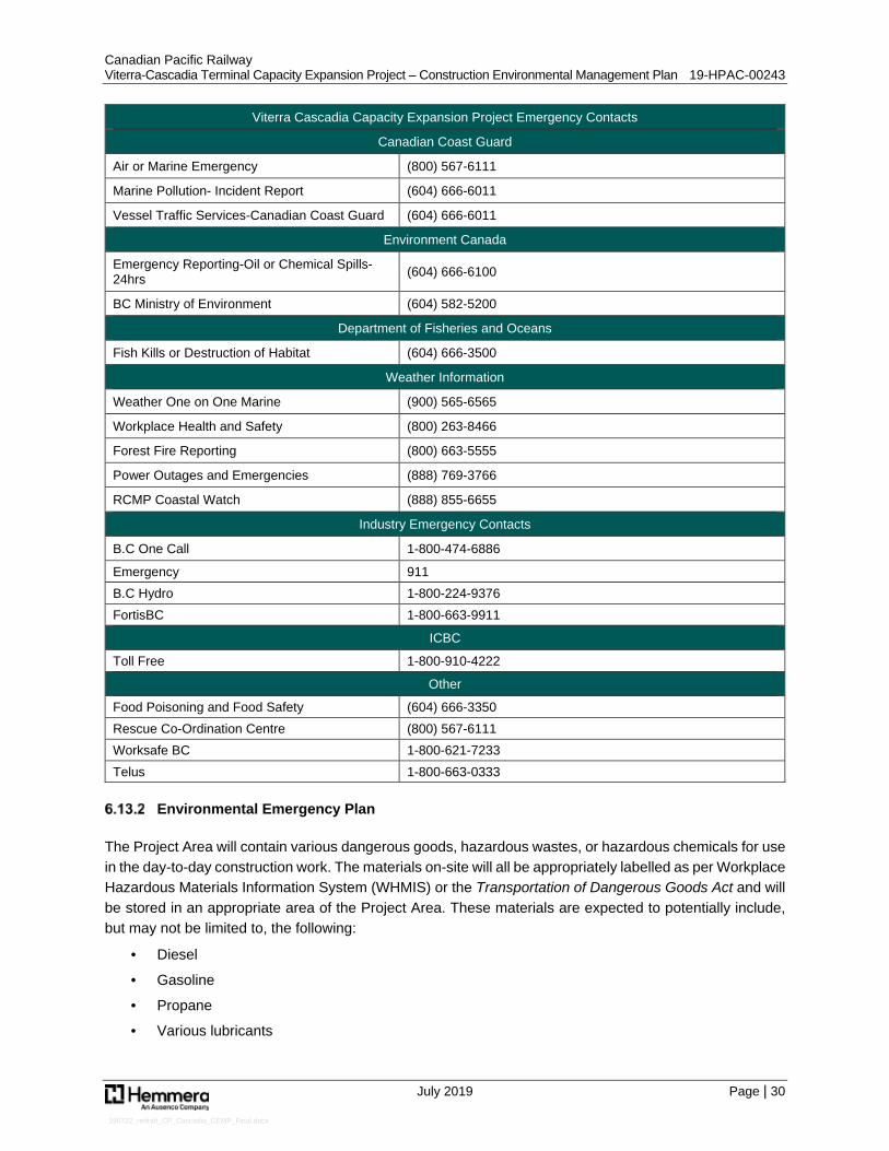
Canadian Pacific Railway Viterra-Cascadia Terminal Capacity Expansion Project – Construction Environmental Management Plan 19-HPAC-00243
July 2019 Page | 30
190722_redraft_CP_Cascadia_CEMP_Final.docx
Viterra Cascadia Capacity Expansion Project Emergency Contacts
Canadian Coast Guard
Air or Marine Emergency (800) 567-6111
Marine Pollution- Incident Report (604) 666-6011
Vessel Traffic Services-Canadian Coast Guard (604) 666-6011
Environment Canada
Emergency Reporting-Oil or Chemical Spills-24hrs (604) 666-6100
BC Ministry of Environment (604) 582-5200
Department of Fisheries and Oceans
Fish Kills or Destruction of Habitat (604) 666-3500
Weather Information
Weather One on One Marine (900) 565-6565
Workplace Health and Safety (800) 263-8466
Forest Fire Reporting (800) 663-5555
Power Outages and Emergencies (888) 769-3766
RCMP Coastal Watch (888) 855-6655
Industry Emergency Contacts
B.C One Call 1-800-474-6886
Emergency 911 B.C Hydro 1-800-224-9376 FortisBC 1-800-663-9911
ICBC
Toll Free 1-800-910-4222
Other
Food Poisoning and Food Safety (604) 666-3350 Rescue Co-Ordination Centre (800) 567-6111 Worksafe BC 1-800-621-7233 Telus 1-800-663-0333
Environmental Emergency Plan
The Project Area will contain various dangerous goods, hazardous wastes, or hazardous chemicals for use in the day-to-day construction work. The materials on-site will all be appropriately labelled as per Workplace Hazardous Materials Information System (WHMIS) or the Transportation of Dangerous Goods Act and will be stored in an appropriate area of the Project Area. These materials are expected to potentially include, but may not be limited to, the following:
· Diesel
· Gasoline
· Propane
· Various lubricants
Canadian Pacific Railway Viterra-Cascadia Terminal Capacity Expansion Project – Construction Environmental Management Plan 19-HPAC-00243
July 2019 Page | 31
190722_redraft_CP_Cascadia_CEMP_Final.docx
The Contractor shall review and update this inventory prior to the onset of construction, append Safety Data Sheets (SDS) to these mitigation measures for the inventory, and amend as new products are brought on-site or old products are withdrawn from use on-site.
To mitigate the potential for spills on-site, the Contractor will need to adhere to all requirements of Sections 6.13, 6.14 and 6.15, and store hazardous substances in appropriate containers/storage areas as per regulatory requirements. Any release will be reported to the EM Contractor who will determine the course of action required to mitigate and clean-up any release.
Spill Response Plan
In the event of a release of any deleterious substances (i.e., hydrocarbon products) on-site, the following procedures will be implemented:
· Ensure Safety: ▫ Ensure that personnel are safe from the release, as well as the public, equipment, property,
and environment are at no other immediate risk due to the release. ▫ Wear appropriate personal protective equipment to manage the release. ▫ Take a step back and re-evaluate the situation. Do not rush and ensure you are adequately
protected before entering a spill area with appropriate knowledge (i.e., check Material Safety Data Sheet, MSDS, for spilled product).
▫ Notify people in the immediate vicinity of the incident. ▫ Ensure there are no ignition sources in the area if the spill is a flammable material.
· Remove Source: ▫ Act quickly to reduce the amount of product spilled and the environmental impact where
possible. ▫ Close valves, shut off equipment, or plug any holes/leaks as appropriate. ▫ Stop the flow at its source.
· Secure the Area: ▫ Limit access to the spill area. ▫ Prevent unauthorized entry into the Project Area.
· Contain the Spill: ▫ Prevent migration of the spill off-site, into any water bodies, or into any drainage structures
(i.e., storm sewers). ▫ Use sorbent materials (i.e., booms or pads) to contain the spill, or where appropriate soil berms
to contain it. ▫ Spill kits should be located on-site within 100 m of any hazardous material storage area and
should be readily accessible in the even that they are needed. ▫ If necessary, use a dyke or any other method to prevent the migration of the material. ▫ Attempt to minimize the contamination on-site.
· Notify and Report: ▫ Notify the appropriate internal managers of the spill. ▫ Notify the Provincial Emergency Coordination Centre (1-800-663-3456), as required (see
Table 4 below). ▫ Provide details of the spill to any other external agency. ▫ Complete the internal incident report.
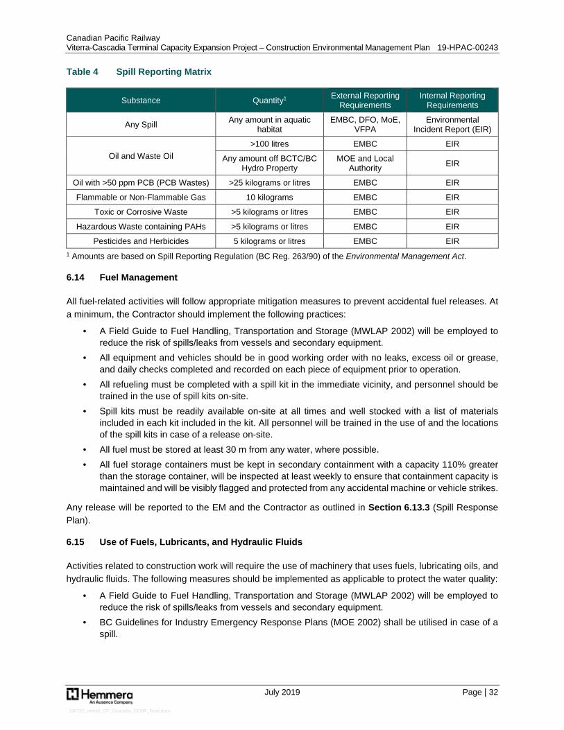
Canadian Pacific Railway Viterra-Cascadia Terminal Capacity Expansion Project – Construction Environmental Management Plan 19-HPAC-00243
July 2019 Page | 32
190722_redraft_CP_Cascadia_CEMP_Final.docx
Table 4 Spill Reporting Matrix
Substance Quantity1 External Reporting Requirements
Internal Reporting Requirements
Any Spill Any amount in aquatic habitat
EMBC, DFO, MoE, VFPA
Environmental Incident Report (EIR)
Oil and Waste Oil >100 litres EMBC EIR
Any amount off BCTC/BC Hydro Property
MOE and Local Authority EIR
Oil with >50 ppm PCB (PCB Wastes) >25 kilograms or litres EMBC EIR
Flammable or Non-Flammable Gas 10 kilograms EMBC EIR
Toxic or Corrosive Waste >5 kilograms or litres EMBC EIR
Hazardous Waste containing PAHs >5 kilograms or litres EMBC EIR
Pesticides and Herbicides 5 kilograms or litres EMBC EIR 1 Amounts are based on Spill Reporting Regulation (BC Reg. 263/90) of the Environmental Management Act.
6.14 Fuel Management
All fuel-related activities will follow appropriate mitigation measures to prevent accidental fuel releases. At a minimum, the Contractor should implement the following practices:
· A Field Guide to Fuel Handling, Transportation and Storage (MWLAP 2002) will be employed to reduce the risk of spills/leaks from vessels and secondary equipment.
· All equipment and vehicles should be in good working order with no leaks, excess oil or grease, and daily checks completed and recorded on each piece of equipment prior to operation.
· All refueling must be completed with a spill kit in the immediate vicinity, and personnel should be trained in the use of spill kits on-site.
· Spill kits must be readily available on-site at all times and well stocked with a list of materials included in each kit included in the kit. All personnel will be trained in the use of and the locations of the spill kits in case of a release on-site.
· All fuel must be stored at least 30 m from any water, where possible. · All fuel storage containers must be kept in secondary containment with a capacity 110% greater
than the storage container, will be inspected at least weekly to ensure that containment capacity is maintained and will be visibly flagged and protected from any accidental machine or vehicle strikes.
Any release will be reported to the EM and the Contractor as outlined in Section 6.13.3 (Spill Response Plan).
6.15 Use of Fuels, Lubricants, and Hydraulic Fluids
Activities related to construction work will require the use of machinery that uses fuels, lubricating oils, and hydraulic fluids. The following measures should be implemented as applicable to protect the water quality:
· A Field Guide to Fuel Handling, Transportation and Storage (MWLAP 2002) will be employed to reduce the risk of spills/leaks from vessels and secondary equipment.
· BC Guidelines for Industry Emergency Response Plans (MOE 2002) shall be utilised in case of a spill.

Canadian Pacific Railway Viterra-Cascadia Terminal Capacity Expansion Project – Construction Environmental Management Plan 19-HPAC-00243
July 2019 Page | 33
190722_redraft_CP_Cascadia_CEMP_Final.docx
· Refueling should be conducted with absorbent pads on hand and done in such a way that contaminants do not enter any drainage, groundwater or water bodies.
· All vessels and equipment should be kept clean and in working order to reduce risk of spills and leaks into the marine environment.
· Plan activities near water so that materials such as paint, primers, blasting abrasives, rust solvents, degreasers, or other chemicals do not enter the waterbody.
· Foam material should be encapsulated so it cannot break up and be released into the water. · All machinery working in the foreshore should be cleaned in advance and free of contaminants and
be in good working condition; spill kits should be maintained in accessible locations on site and all site personnel trained in spill response.
· Tires will not be used as fenders.
6.16 Waste Management
Waste management for the site may trigger application legislation including the following: BC Hazardous Waste Regulations, Spill Reporting Regulations, Workers’ Compensation Board Regulations, and Transportation of Dangerous Goods Regulations.
The Contractor will need to consider the end destination of all products and materials brought onto the construction site. This will include hazardous wastes such as fuels and lubricants and their empty containers following use, as well as used oily rags and used spill kit products, but also non-hazardous construction wastes and general refuse (e.g., wood, cigarette butts, coffee cups, water bottles etc.). Hazardous wastes generated could include waste petroleum products (engine oils, lubricants) from machinery and equipment, spent batteries, solvents and cleaning agents, etc.
The Contractor shall ensure that debris and waste material resulting from the Project is contained, collected, and disposed of at suitable upland locations using standards, practices, methods and procedures to a good commercial standard, conforming to applicable law and using that degree of skill and care, diligence, prudence and foresight which would be reasonably and ordinarily expected from a qualified, skilled and experienced person engaged in a similar type of undertaking under the same or similar circumstances.
The Contractor shall prepare a Waste Management Plan to deal with such wastes that includes the following minimum requirements:
· A figure identifying specific locations for waste collection and sorting, as appropriate. · A list of best practices that will be adhered to that meet all applicable legislation with respect to the
handling, transportation, and/or disposal of all materials related to this project (waste or otherwise). · Planning for the storage and handling of hazardous wastes including provision for labelled separate
container(s) for potentially hazardous waste such as oily rags and hydrocarbon absorbent pads. · All hydrocarbon products and other hazardous wastes potentially present during Project activities
should be identified and the associated WHMIS and SDS made available to all team members. · All recyclable or compostable materials should be collected separately from general waste as per
Metro Vancouver requirements.
Canadian Pacific Railway Viterra-Cascadia Terminal Capacity Expansion Project – Construction Environmental Management Plan 19-HPAC-00243
July 2019 Page | 34
190722_redraft_CP_Cascadia_CEMP_Final.docx
6.17 Mitigation Contingency Measures
During construction the EM will verify the effectiveness of measures to avoid or mitigate harm to fish, fish habitat, wildlife (including birds and marine mammals) and other relevant environmental values. Should the EM identify that implemented or deployed measures are ineffective, in that they do not, or are not expected to, achieve their objective(s), contingency measures to improve their effectiveness will be considered.
Contingency measures may include, but are not likely to be limited to, the following:
· Adjustment or retrieval, maintenance, and redeployment of ineffective measures (e.g., maintenance of a turbidity curtain to improve the effectiveness in limiting sediment dispersal from the work site, in the event that a turbidity curtain is warranted and feasible).
· Implementation of other measures that are more suitable to achieve objectives.
· Changes to the methods or timing of construction activities to better achieve objectives.
If the EM identifies that monitoring methods are insufficient to appropriately measure the effectiveness of mitigation measures as they relate to objectives, the following contingency measures may be taken:
· Changes to the frequency or spatial distribution of monitoring (e.g., water quality monitoring).
· Replacement or recalibration of devices used for monitoring.
· Replacement by or addition of alternative monitoring methods.

Canadian Pacific Railway Viterra-Cascadia Terminal Capacity Expansion Project – Construction Environmental Management Plan 19-HPAC-00243
July 2019 Page | 35
190722_redraft_CP_Cascadia_CEMP_Final.docx
7.0 CLOSURE
This work was performed in accordance with the Contract (Number 5600015425) between Hemmera, a wholly owned subsidiary of Ausenco, and Canadian Pacific Railway, dated December 1, 2018. This report has been prepared by Hemmera, based on fieldwork conducted by Hemmera, for sole benefit and use by Canadian Pacific Railway. In performing this work, Hemmera has relied in good faith on information provided by others and has assumed that the information provided by those individuals is both complete and accurate. This work was performed to current industry standard practice for similar environmental work, within the relevant jurisdiction and same locale. The findings presented herein should be considered within the context of the scope of work and project terms of reference; further, the findings are time sensitive and are considered valid only at the time the report was produced. The conclusions and recommendations contained in this report are based upon the applicable guidelines, regulations, and legislation existing at the time the report was produced; any changes in the regulatory regime may alter the conclusions and/or recommendations.
If there are any questions, please do not hesitate to contact the undersigned by phone at 604.669.0424.
Report prepared by: Report prepared by: Hemmera Envirochem Inc. Hemmera Envirochem Inc.
Simon Phillips, M.Sc., R.P.Bio. Madeline Cashion, M.Sc. Biologist Biologist Report reviewed by: Hemmera Envirochem Inc.
Jim Roberts, B.Sc., R.P.Bio. Senior Fisheries Biologist

Canadian Pacific Railway Viterra-Cascadia Terminal Capacity Expansion Project – Construction Environmental Management Plan 19-HPAC-00243
July 2019 Page | 36
190722_redraft_CP_Cascadia_CEMP_Final.docx
8.0 REFERENCES
AECOM Canada Ltd. 2019a. Version A Mapset (CP Rail – Viterra Cascadia Terminal - Viterra East Plan and Profile. Sheet # 60587-CT-301. Issued 2019-01-25) and Version C Mapset (CP Rail – Viterra Cascadia Terminal - Viterra East Plan and Profile. Sheet # 60587181-CT-301-C; 60587181-CT-310-C; 60587181-CT-311-C. Issued 2019-06-19).
AECOM Canada Ltd. 2019b. Version A Mapset (CP Rail – Viterra Cascadia Terminal - Typical Sections. Sheet # 60587-CT-001. Issued 2019-03-01).
AECOM Canada Ltd. 2019c. CP Capacity Enhancement - Viterra Cascadia – Construction Schedule (Viterra East). Issued 2019-04-24.
Chilibeck, B., Chislett, G., and Norris, G. 1992. Land Development Guidelines for the Protection of Aquatic Habitat. Habitat Management Division, Fisheries and Oceans Canada.
Fisheries and Oceans Canada (DFO). 2003. Guidebook Environmentally Sustainable Log Handling Facilities in British Columbia (Appendix 4. Marine Foreshore Environmental Assessment Procedures). Available at http://www.dfo-mpo.gc.ca/Library/274124.pdf. Accessed June 2016.
Fisheries and Oceans Canada (DFO). 2013. Fisheries Productivity Investment Policy: A Proponent’s Guide to Offsetting. Ecosystem Programs Policy. 19 pp.
Fisheries and Oceans Canada (DFO). 2013. Measures to Avoid Causing Harm to Fish and Fish Habitat. Fisheries and Oceans Canada (DFO). http://www.dfo-mpo.gc.ca/pnw-ppe/measures-mesures/index-eng.html
Fisheries and Oceans Canada (DFO). 2014. Projects Near Water: Pathways of Effects. Accessed on March 4, 2019 from: http://www.dfo-mpo.gc.ca/pnw-ppe/pathways-sequences/index-eng.html
Fisheries and Oceans Canada (DFO). 2015. Rockfish Conservation Areas - Area 28. Accessed February 26, 2019 from: http://www.pac.dfo-mpo.gc.ca/fm-gp/maps-cartes/rca-acs/areas-secteurs/28-eng.html
Fraser River Estuary Management Program (FREMP). 2013. Burrard Inlet Environmental Action Program & Fraser River Estuary Management Program Habitat Atlas. Accessed February 25, 2019 from: www.cmnmaps.ca/FREMP/
Haggarty, D. R. 2001. An evaluation of fish habitat in Burrard Inlet, British Columbia (Thesis). University of British Columbia. Accessed March 4, 2019 from https://open.library.ubc.ca/collections/ubctheses/831/items/1.0074846
Hemmera Envirochem Inc. 2015. Phase 1 Environmental Site Assessment and General Biophysical Assessment Second Narrows Lease Property, Burnaby, BC. Prepared for Canadian Pacific. 32 pp.
Hemmera Envirochem Inc. 2019a. Viterra-Cascadia Capacity Expansion Project – Marine Fish and Fish Habitat Assessment. Prepared for Canadian Pacific Railway.
Canadian Pacific Railway Viterra-Cascadia Terminal Capacity Expansion Project – Construction Environmental Management Plan 19-HPAC-00243
July 2019 Page | 37
190722_redraft_CP_Cascadia_CEMP_Final.docx
Hemmera Envirochem Inc. 2019b. Viterra-Cascadia Capacity Expansion Project – Offsetting Plan. Prepared for Canadian Pacific Railway.
Hollenberg, R. 1995. Summary of Environmental Standards & Guidelines for Fuel Handling, Transportation and Storage -- 2d Ed. BC Environment, British Columbia. 65 pp.
Kerr Wood Leidal Associated Ltd. (KWL). 2017. Burrard Inlet Action Plan. A science-based First Nations-led initiative to improve the health of the Burrard Inlet ecosystem by 2025. Prepared for the Tsleil-Waututh Nation.
Maxell, B.A. and Miller, K.A. 1996. Demographic studies of the annual kelps Nereocystis luetkeana and Costaria costata (laminariales, phaeophyta) in Puget Sound, Washington. Botanica Marina 39, 479-489.
Meidinger, D., & Pojar, J. 1991. Ecosystems of British Columbia. Special Report Series-Ministry of Forests, British Columbia, (6).
Millennium EMS Solutions Ltd. 2010. Guide to the Code of Practice for the BC Concrete and Concrete Products Industry. Available at: http://www.concretebc.ca/wp-content/uploads/2017/09/Guide-to-the-Code-of-Practice-2010.pdf
Ministry of Environment and Climate Change Strategy (CCME). 2014. British Columbia Approved Water Quality Guidelines: Aquatic Life, Wildlife, and Agriculture. Government of British Columbia. Available at: https://www2.gov.bc.ca/assets/gov/environment/air-land-water/water/waterquality/wqgs-wqos/approved-wqgs/wqg_summary_aquaticlife_wildlife_agri.pdf
Ministry of Water, Land and Air Protection (MWLAP). 2002. A Field Guide to Fuel Handling, Transportation and Storage. Ecosystem Standards and Planning Biodiversity Branch, Government of British Columbia. Available at: https://www2.gov.bc.ca/gov/content/environment/waste-management/industrial-waste/fuel-tanks
Ministry of Water, Land and Air Protection (MWLAP). 2004. Standards and Best Practices for Instream Works. Ecosystem Standards and Planning Biodiversity Branch, Government of British Columbia. Available at: https://www2.gov.bc.ca/assets/gov/environment/natural-resource-stewardship/best-management-practices/iswstdsbpsmarch2004.pdf
Morris, M. 2001. Bio-mapping and field verification report Burrard Inlet, Vancouver, BC. Prepared for: Coastal & Ocean Resource, Sidney BC, Victoria, BC.
Naito, B. and J. Hwang. 2000. Timing and Distribution of Juvenile Salmonids in Burrard Inlet, British Columbia: February to August 1992. Can. Data Report of Fish. and Aqu. Sci. 1069.
Nijman, R.A. 1990. Coquitlam-Pitt River Area, Burrard Inlet water quality assessment and objectives. Ministry of Environment, Canada. Water Management Division.
Pacific Fisheries Resource Conservation Council. 2011. Strait of Georgia biodiversity in relation to bull kelp abundance. Accessed on March 5 from: http://www.dfo-mpo.gc.ca/Library/347489.pdf
Schroeder, S. 2018. Burrard Inlet bull kelp survey. Produced for the Tsleil-Waututh Nation.11 pp.
Canadian Pacific Railway Viterra-Cascadia Terminal Capacity Expansion Project – Construction Environmental Management Plan 19-HPAC-00243
July 2019 Page | 38
190722_redraft_CP_Cascadia_CEMP_Final.docx
Springer, Y.P., Hays, C.G., Carr, M.H., Mackey, M.R. 2010. Toward ecosystem-based management of marine macroalgae – the bull kelp, Nereosystis luetkeana. Oceanography and Marine Biology: An Annual Review. 48, 1-42pp.
Stacey, M. W., and Pond, S. 2003. Dependence of currents and density on the spring–neap cycle and the diurnal inequality in Burrard Inlet, British Columbia: Simulations and observations. Journal of physical oceanography,33(11), 2366-2374.
Stantec. 2009. Burrard Inlet Shoreline Change – Baseline Assessment: Final Report. Prepared by Stantec, Burnaby, BC for the Burrard Inlet Environmental Action Program (BIEAP), Burnaby, BC. 19 pp.
Stantec Consulting Ltd. 2013. Fish Habitat Compensation Plan: Fairview terminal phase II Expansion Project. Burnaby, B.C.
Terra Archeology Ltd. 2019. Archeological Impact Assessment Interim Report – CP Rail Cascadia Track Expansion Project. Prepared April 29, 2019.
Trans Mountain Pipeline ULC. 2017. Westridge Marine Terminal Upgrade and Expansion Project Application to Vancouver Fraser Port Authority. Kinder Morgan Canada Inc. May 2017.
Vancouver Fraser Port Authority (VFPA). 2015. Guidelines – Environmental Noise Assessment. Prepared by Vancouver Fraser Port Authority Environmental Programs Department. July 2015.
Vancouver Fraser Port Authority (VFPA). 2018. Guidelines – Shoreline Protection: Inspection, Maintenance, Design and Repair (Vancouver Harbour) v1.0. Prepared by Vancouver Fraser Port Authority Engineering & Maintenance Department. April 2018.
Wentworth, C. K. 1922. A scale of grade and class terms for clastic sediments. Journal of Geology 30: 377-392.

APPENDIX A Design Drawing Sets (AECOM 2019a)

N
220.5m [723'-5 1/4"] EXTENSION LENGTH0+
000
0+02
5
0+05
0
0+07
5
0+10
0
0+12
5
0+15
0
0+17
5
0+20
0
0+22
50+
227
BC:1
+50.
34
EC:1
+68.
57
BURRARD INLET
R=194.400
12.015
-5.00
-6.00
-4.00
-3.00
-2.00
-1.00
-5.00
0.00
-7.00
-6.00
-4.00
-3.00
-2.00-1.00
0.001.00
2.003.004.00
Alignment=K9 - surveyChainage=???
Offset=???Northing=Easting=
K MAIN
EXIST. MAIN TRACK
55m TRACK REMOVAL
EXIST. (K09) TIE-IN
EXIST. No 11 LHSWITCH CLEARING EQUIPMENTTO BE RELOCATED CLEAR OFEXENSION TRACK
CP ROW
CP ROW
PROPOSED PROPERTYACQUISITION (2,230 sq.m.)
1261m (4140') CLEARANCE FROM DUMPER(LAST INDEXED MOVEMENT)
PROPOSED SWITCH DERAIL50' TO FOULING POINT
No 11 RH
PROPOSED WALKWAYFOR TURNOUT
PROPOSED GRADINGEXTENT
EXIST. No. 20 LH
EXIST. No.20 LHEXIST. No.11 RH
EXIST. No.11 RH
EXIST. No.9 RHTO BE REMOVED
EXIST. #9TURNOUT
2:1 GRADED SLOPEWITH RIPRAP
14' CLEARANCESTA. 0+142.85
CP ROW
CP ROW
CONCRETE CULVERTSTATION=1+24.210DIAMETER: 48"LENGTH: 51'
CMP CULVERTSTATION=1+24.180DIAMETER= 24"LENGTH= 40'
CMP CULVERTSTATION=1+24.120DIAMETER= 24"LENGTH= 40'
PIPE CROSSINGSTATION=1+24.110CITY OF BURNABYW
WW
WW
WW
WW
WW
WW
WW
WW
W
CONC 750ØCOMBINED MAIN31%
CONC 750ØCOMBINED MAIN0%
CONC 450ØCOMBINED MAIN69.2%
CPR LEASE LINE
AS PER V-4324 (02)
PROP. TRACK
EXIST. TRACK
RIGHT OF WAY
LEGEND - ALL DWGS
000+
000
000+
000
000+
000
EXIST. MILEAGE
0+00
0
0+00
0
0+00
0
118
PROP. TURNOUT
EXIST. TURNOUT
EXIST. TRACKREGRADED AND/OR RE-ALIGNED
EXIST. TRACKREMOVED
PROP. T.O.R.PROFILEEXISTING T.O.R.PROFILE
K09-Extension Viterra EAST
3.00
4.00
5.00
6.00
7.00
8.00
9.00
10.00
3.00
4.00
5.00
6.00
7.00
8.00
9.00
10.00
-0+025 0+000 0+025 0+050 0+075 0+100 0+125 0+150 0+175 0+200 0+225
0.23% 0.04%
LVC:30.480
BVC
S: 0
+069
.19
BVC
E: 5
.760
EVC
S: 0
+099
.67
EVC
E: 5
.801
5.59
8
5.65
7
5.71
5
5.77
2
5.80
1
5.81
1
5.82
1
5.83
1
5.84
0
5.85
0
5.60
9
5.84
5
PRO
P.T.
O.R
.EX
IST.
T.O
.R.
TIE IN TO EXIST. TRACKTIE IN TO EXIST.MAIN T.O.R.
BP: 0
+00.
00
SHEET TITLE
VITERRA EASTPLAN AND PROFILE
SHEET NUMBER
6058718-CT-301
PLAN Scale 1:750
I/R YY-MM-DD DESCRIPTION
ISSUE/REVISION
A 2019/01/25 ISSUED FOR 50% DESIGN
Printed on ___% Post-ConsumerRecycled Content Paper
This
drawin
g has
been
prep
ared f
or the
use o
f AEC
OM's
client
and m
ay no
t be u
sed,
reprod
uced
or re
lied u
pon b
y thir
d part
ies, e
xcep
t as a
greed
by AE
COM
and i
ts clie
nt, as
requ
ired b
y law
or fo
r use
by go
vernm
ental
revie
wing a
genc
ies. A
ECOM
acce
pts no
resp
onsib
ility, a
nd de
nies a
ny lia
bility
wha
tsoev
er, to
any p
arty t
hat m
odifie
s this
draw
ing w
ithou
t AEC
OM's
expre
ss w
ritten
cons
ent. D
o not
scale
this
docu
ment.
All m
easu
remen
ts mu
st be
obtai
ned f
rom st
ated d
imen
sions
.
ANSI
D 8
64m
m x
559
mm
CONSULTANT
AECOM3292 Production WayBurnaby, BC, Canada V5A 4R4604.444.6400 tel 604.294.8597 faxwww.aecom.com
CLIENT
Canadian Pacific Railway Company7550 Ogden Dale Road S.E.Calgary, Alberta T2C 4X91-888-333-6370 tel www.cpr.ca
PROJECT
CP RailVITERRA CASCADIATERMINALCASCADE SUBDIVISIONMILE 124.16 to 125.84
PROJECT NUMBER
60587181
0 12.5 25
1:500m

CP LEASE ROW
[ PLAN V-4324(02) ]
N
0+00
0
0+05
0
0+10
0
0+15
0
0+20
0
0+22
7
BURRARD INLET
-5.00
-6.00
-4.00
-3.00
-2.00
-1.00
-5.00
0.00
-7.00
-6.00
-4.00
-3.00
-2.00-1.00
0.001.00
2.003.004.00
K MAIN
EXIST. MAIN TRACK
CP ROWCP ROW
MWLHHWMT
HHWLTCP ROW CP ROW
LLWMT
LLWLT
CONSTRUCTION ZONE
TEMPORARY PAD EXTENSIONAREA = 120 sq. m.
EXCAVATIONAREA = 331 sq. m.BEYOND GRADING STRUCTURE
GRADING STRUCTURETOTAL AREA = 2965 sq. m.OUTSIDE OF ROW
TEMPORARY PAD EXTENSIONTOTAL AREA = 1874 sq. m.
EXCAVATIONAREA = 52 sq. m.BEYOND GRADING STRUCTURE
PROPOSED TRACK EXTENSION
GRADING STRUCTUREAREA = 758 sq. m.INSIDE CPR
SHEET TITLE
VITERRA EASTPLAN AND PROFILE
SHEET NUMBER
SK-001
PLAN Scale 1:750
I/R YY-MM-DD DESCRIPTION
ISSUE/REVISION
Printed on ___% Post-ConsumerRecycled Content Paper
This
drawin
g has
been
prep
ared f
or the
use o
f AEC
OM's
client
and m
ay no
t be u
sed,
reprod
uced
or re
lied u
pon b
y thir
d part
ies, e
xcep
t as a
greed
by AE
COM
and i
ts clie
nt, as
requ
ired b
y law
or fo
r use
by go
vernm
ental
revie
wing a
genc
ies. A
ECOM
acce
pts no
resp
onsib
ility, a
nd de
nies a
ny lia
bility
wha
tsoev
er, to
any p
arty t
hat m
odifie
s this
draw
ing w
ithou
t AEC
OM's
expre
ss w
ritten
cons
ent. D
o not
scale
this
docu
ment.
All m
easu
remen
ts mu
st be
obtai
ned f
rom st
ated d
imen
sions
.
ANSI
D 8
64m
m x
559
mm
CONSULTANT
AECOM3292 Production WayBurnaby, BC, Canada V5A 4R4604.444.6400 tel 604.294.8597 faxwww.aecom.com
CLIENT
Canadian Pacific Railway Company7550 Ogden Dale Road S.E.Calgary, Alberta T2C 4X91-888-333-6370 tel www.cpr.ca
PROJECT
CP RailVITERRA CASCADIATERMINALCASCADE SUBDIVISIONMILE 124.16 to 125.84
PROJECT NUMBER
60587181
0 12.5 25
1:500m

N
BURRARD INLET
C
P
R
L
E
A
S
E
L
IN
E
A
S
P
E
R
V
-4
3
2
4
(0
2
)
220.5m [723'-5 1/4"] EXTENSION LENGTH
R=194.40
0
0+
000
0+
025
0+
050
0+
075
0+
100
0+
125
0+
150
0+
175
0+
200
0+
225
0+
227
BC
: 0+
150.34
EC
: 0+
168.57
K MAIN
EXIST. MAIN TRACK
55m TRACK REMOVAL
EXIST. (K09) TIE-IN
CP ROW
CP RO
W
PROPOSED PROPERTY
ACQUISITION (2,230 sq.m.)
PROPOSED SWITCH DERAIL
50' TO FOULING POINT
STA. 1+65.58
PROPOSED WALKWAY
FOR TURNOUT
PROPOSED
TOE OF RIPRAP
EXIST. #20 LH
EXIST. #20 LH
EXIST. #11 RH
EXIST. #11 RH
EXIST. #9 RH
TO BE REMOVED
EXIST. #9
TURNOUT
2:1 GRADED SLOPE
WITH RIPRAP
14' CLEARANCE
STA. 0+142.85
CP ROW
CP
RO
W
1,261m (4,140') CLEARANCE FROM
DUMPER (LAST INDEXED MOVEMENT)
EXIST. #11 LH
SWITCH CLEARING EQUIPMENT
TO BE RELOCATED CLEAR OF
EXENSION TRACK
HHWLT
NE
W H
HW
LT
124.10124.20124.30
PROPOSED
EXTENT OF
SUBEXCAVATION
EXIST. SW DERAIL
TO BE REMOVED
PROPOSED
#11 RH
K09-Extension Viterra EAST
3.00
4.00
5.00
6.00
7.00
8.00
9.00
10.00
3.00
4.00
5.00
6.00
7.00
8.00
9.00
10.00
-0+025 0+000 0+025 0+050 0+075 0+100 0+125 0+150 0+175 0+200 0+225 0+250 0+2750+280
0.23%
0.04%
LVC:30.480
BV
CS
: 0+
069.19
BV
CE
: 5.760
EV
CS
: 0+
099.67
EV
CE
: 5.801
5.598
5.657
5.715
5.772
5.801
5.811
5.821
5.831
5.840
5.850
5.609
5.845
PR
OP
.
T.O
.R
.
EX
IS
T.
T.O
.R
.
TIE IN TO EXIST. TRACK
No. 11 R
H T
UR
NO
UT
@ S
TA
.0+
226.89
MP
124.16 M
AIN
T
RA
CK
TIE IN TO EXIST.
MAIN T/R
SHEET TITLE
VITERRA EAST
PLAN AND PROFILE
SHEET NUMBER
6058718-CT-301
PLAN
Scale 1:500
I/R YYYY/MM/DD DESCRIPTION
ISSUE/REVISION
A 2019/04/05 ISSUED FOR 50% DESIGN
B 2019/04/30 ISSUED FOR DISCUSSION
C 2019/06/19 ISSUED FOR REG AGENCY REV
Printed on ___% Post-Consumer
Recycled Content Paper
This draw
ing has been prepared for the use of A
EC
OM
's client and m
ay not be used, reproduced or relied upon by third parties, except as agreed by A
EC
OM
and its client, as required by law
or for use by governm
ental review
ing agencies. A
EC
OM
accepts no responsibility, and denies any liability w
hatsoever, to any party that m
odifies this draw
ing w
ithout A
EC
OM
's express w
ritten consent. D
o not scale this docum
ent. A
ll m
easurem
ents m
ust be obtained from
stated dim
ensions.
AN
SI D
86
4m
m x 5
59m
m
CONSULTANT
AECOM
3292 Production Way
Burnaby, BC, Canada V5A 4R4
604.444.6400 tel 604.294.8597 fax
www.aecom.com
CLIENT
Canadian Pacific Railway Company
7550 Ogden Dale Road S.E.
Calgary, Alberta T2C 4X9
1-888-333-6370 tel www.cpr.ca
PROJECT
CP
CAPACITY
ENHANCEMENT
VITERRA CASCADIA
CASCADE SUBDIVISION
MILE 124.16 to 125.84
PROJECT NUMBER
60587181
0 12.5 25
1:500
m

OF
F=
-9
.4
2
EL
=1
.0
8
OF
F=
-1
2.2
7
EL
=-1
.7
5
OF
F=
-2
1.7
0
EL
=-1
.7
5
OF
F=
-2
.4
8
EL
=5
.0
0
OF
F=
-2
0.6
6
EL
=5
.0
0
OF
F=
-2
3.5
7
EL
=4
.0
0
OF
F=
-3
1.6
6
EL
=-4
.0
7
OF
F=
-5
.4
6
EL
=4
.0
0
OF
F=
-7
.3
8
EL
=4
.0
0
OF
F=
-1
8.8
8
EL
=-1
.7
5
OF
F=
-1
7.7
3
EL
=-2
.1
3
OF
F=
-2
9.0
9
EL
=-3
.4
0
OF
F=
-5
.5
7
EL
=4
.0
0
OF
F=
-7
.5
0
EL
=4
.0
0
OF
F=
-1
9.1
9
EL
=-2
.8
1
OF
F=
-2
0.3
4
EL
=-2
.4
2
OF
F=
-0
.4
3
EL
=5
.0
0
OF
F=
-1
8.7
8
EL
=5
.0
0
OF
F=
-2
1.6
9
EL
=4
.0
0
OF
F=
-2
9.3
3
EL
=-3
.6
3
OF
F=
-2
7.2
0
EL
=-3
.3
9
OF
F=
-7
.7
0
EL
=0
.9
8
OF
F=
-1
0.4
4
EL
=-1
.7
5
OF
F=
-1
7.8
0
EL
=-1
.7
5
OF
F=
-5
.6
9
EL
=4
.0
0
OF
F=
-7
.6
1
EL
=4
.0
0
OF
F=
-1
8.9
7
EL
=-1
.6
8
OF
F=
-1
7.8
2
EL
=-2
.0
6
OF
F=
-2
6.6
4
EL
=-2
.7
6
OF
F=
-2
4.2
6
EL
=-2
.4
0
OF
F=
-1
9.4
6
EL
=4
.0
0
OF
F=
-0
.9
9
EL
=4
.0
0
OF
F=
-5
.4
4
EL
=1
.3
0
OF
F=
-8
.5
0
EL
=-1
.7
5
OF
F=
-1
9.1
4
EL
=-1
.7
5
OF
F=
-3.94
EL=
1.51
OF
F=
-7.21
EL=
-1.75
OF
F=
-21.86
EL=
-1.75
OF
F=
-5.99
EL=
4.00
OF
F=
-7.91
EL=
4.00
OF
F=
-19.41
EL=
-1.75
OF
F=
-18.26
EL=
-2.13
OF
F=
-9
.0
2
EL
=4
.0
0
OF
F=
-1
0.9
4
EL
=4
.0
0
OF
F=
-1
9.4
1
EL
=-1
.7
5
OF
F=
-1
8.2
6
EL
=-2
.1
3
OF
F=
-3
.4
6
EL
=1
.5
8
OF
F=
-6
.7
9
EL
=-1
.7
5
OF
F=
-2
2.8
9
EL
=-1
.7
5
OF
F=
-6.00
EL=
4.00
OF
F=
-7.92
EL=
4.00
OF
F=
-19.42
EL=
-1.75
OF
F=
-18.27
EL=
-2.13
OF
F=
-3.52
EL=
1.75
OF
F=
-7.02
EL=
-1.75
OF
F=
-20.45
EL=
-1.75
OF
F=
-8
.2
5
EL
=4
.0
0
OF
F=
-1
0.1
8
EL
=4
.0
0
OF
F=
-2
1.6
8
EL
=-1
.7
5
OF
F=
-2
0.5
3
EL
=-2
.1
3
OF
F=
-3
.1
7
EL
=1
.6
2
OF
F=
-6
.5
5
EL
=-1
.7
5
OF
F=
-2
2.9
4
EL
=-1
.7
5
SHEET TITLE
VITERRA EAST - CROSS SECTIONS
SHEET 1 OF 2
SHEET NUMBER
6058718-CT-310
I/R YYYY/MM/DD DESCRIPTION
ISSUE/REVISION
A 2019/03/01 ISSUED FOR 50% DESIGN
B 2019/04/30 ISSUED FOR DISCUSSION
C 2019/06/19 ISSUED FOR REG AGENCY REV
Printed on ___% Post-Consumer
Recycled Content Paper
This draw
ing has been prepared for the use of A
EC
OM
's client and m
ay not be used, reproduced or relied upon by third parties, except as agreed by A
EC
OM
and its client, as required by law
or for use by governm
ental review
ing agencies. A
EC
OM
accepts no responsibility, and denies any liability w
hatsoever, to any party that m
odifies this draw
ing w
ithout A
EC
OM
's express w
ritten consent. D
o not scale this docum
ent. A
ll m
easurem
ents m
ust be obtained from
stated dim
ensions.
AN
SI D
86
4m
m x 5
59m
m
CONSULTANT
AECOM
3292 Production Way
Burnaby, BC, Canada V5A 4R4
604.444.6400 tel 604.294.8597 fax
www.aecom.com
CLIENT
Canadian Pacific Railway Company
7550 Ogden Dale Road S.E.
Calgary, Alberta T2C 4X9
1-888-333-6370 tel www.cpr.ca
PROJECT
CP
CAPACITY
ENHANCEMENT
VITERRA CASCADIA
CASCADE SUBDIVISION
MILE 124.16 to 125.84
PROJECT NUMBER
60587181

OF
F=
-6
.0
2
EL
=4
.0
0
OF
F=
-7
.9
4
EL
=4
.0
0
OF
F=
-1
9.4
4
EL
=-1
.7
5
OF
F=
-1
8.2
9
EL
=-2
.1
3
OF
F=
-3
.2
1
EL
=1
.3
5
OF
F=
-6
.3
1
EL
=-1
.7
5
OF
F=
-2
1.5
8
EL
=-1
.7
5
MINIMUM 0.6M EXCVATION OF SLOPE
OF
F=
-6
.0
4
EL
=4
.0
0
OF
F=
-7
.9
6
EL
=4
.0
0
OF
F=
-1
9.4
6
EL
=-1
.7
5
OF
F=
-1
8.3
1
EL
=-2
.1
3
OF
F=
-2
2.7
3
EL
=-1
.7
5
OF
F=
-6
.9
5
EL
=-1
.7
5
OF
F=
-2
.9
5
EL
=2
.2
5
OF
F=
-6
.0
5
EL
=4
.0
0
OF
F=
-7
.9
7
EL
=4
.0
0
OF
F=
-1
9.4
7
EL
=-1
.7
5
OF
F=
-1
8.3
2
EL
=-2
.1
3
OF
F=
-5
.2
6
EL
=1
.7
4
OF
F=
-8
.8
3
EL
=-1
.7
5
OF
F=
-2
4.6
8
EL
=-1
.7
5
OF
F=
-5
.8
4
EL
=2
.2
2
OF
F=
-9
.8
1
EL
=-1
.7
5
OF
F=
-2
5.2
7
EL
=-1
.7
5
OF
F=
-6
.7
9
EL
=4
.0
0
OF
F=
-8
.7
1
EL
=4
.0
0
OF
F=
-1
9.0
6
EL
=-2
.1
3
OF
F=
-2
0.2
1
EL
=-1
.7
5
OF
F=
-6
.0
8
EL
=4
.0
0
OF
F=
-8
.0
1
EL
=4
.0
0
OF
F=
-1
9.5
1
EL
=-1
.7
5
OF
F=
-1
8.3
5
EL
=-2
.1
3
OF
F=
-7
.2
7
EL
=1
.8
2
OF
F=
-1
0.8
8
EL
=-1
.7
5
OF
F=
-2
5.6
3
EL
=-1
.7
5
OF
F=
-6
.0
6
EL
=4
.0
0
OF
F=
-7
.9
8
EL
=4
.0
0
OF
F=
-1
9.4
8
EL
=-1
.7
5
OF
F=
-1
8.3
3
EL
=-2
.1
3
OF
F=
-6
.5
9
EL
=1
.8
4
OF
F=
-1
0.1
8
EL
=-1
.7
5
OF
F=
-2
5.1
8
EL
=-1
.7
5
OF
F=
-5
.5
4
EL
=4
.0
0
OF
F=
-7
.4
6
EL
=4
.0
0
OF
F=
-1
7.8
1
EL
=-2
.1
3
OF
F=
-1
8.9
6
EL
=-1
.7
5
OF
F=
-7
.5
2
EL
=1
.3
9
OF
F=
-1
0.4
3
EL
=-1
.4
8
OF
F=
-2
2.1
2
EL
=-1
.7
5
OF
F=
-2
5.1
4
EL
=-1
.7
5
SHEET TITLE
VITERRA EAST - CROSS SECTIONS
SHEET 2 OF 2
SHEET NUMBER
6058718-CT-311
I/R YYYY/MM/DD DESCRIPTION
ISSUE/REVISION
A 2019/03/01 ISSUED FOR 50% DESIGN
B 2019/04/30 ISSUED FOR DISCUSSION
C 2019/06/19 ISSUED FOR REG AGENCY REV
Printed on ___% Post-Consumer
Recycled Content Paper
This draw
ing has been prepared for the use of A
EC
OM
's client and m
ay not be used, reproduced or relied upon by third parties, except as agreed by A
EC
OM
and its client, as required by law
or for use by governm
ental review
ing agencies. A
EC
OM
accepts no responsibility, and denies any liability w
hatsoever, to any party that m
odifies this draw
ing w
ithout A
EC
OM
's express w
ritten consent. D
o not scale this docum
ent. A
ll m
easurem
ents m
ust be obtained from
stated dim
ensions.
AN
SI D
86
4m
m x 5
59m
m
CONSULTANT
AECOM
3292 Production Way
Burnaby, BC, Canada V5A 4R4
604.444.6400 tel 604.294.8597 fax
www.aecom.com
CLIENT
Canadian Pacific Railway Company
7550 Ogden Dale Road S.E.
Calgary, Alberta T2C 4X9
1-888-333-6370 tel www.cpr.ca
PROJECT
CP
CAPACITY
ENHANCEMENT
VITERRA CASCADIA
CASCADE SUBDIVISION
MILE 124.16 to 125.84
PROJECT NUMBER
60587181
APPENDIX B Typical Construction Sequencing (AECOM 2019b)

1V
SUBGRADE
2H
4.27 m MIN.
TYPICAL TRACK FILL SECTION AT
WATERLINE - START
EXISTING RIP-RAP
PROTECTION
UNKNOWN DEPTH
HIGHER HIGH WATER LARGE TIDE
PROPOSED
EXCAVATED MATERIAL
HIGHER HIGH WATER MEAN TIDE
PROPOSED GRADING OUTLINE
PROPOSED GRADING TOE
SUBGRADE
TYPICAL TRACK FILL SECTION AT
WATERLINE - TOE CONSTRUCTION AT LOW
TIDE -WEST
MWL
HHWMT
HHWLT
EXISTING RIP-RAP
REMOVED, SUITABLE
MATERIAL MOVED TO NEW
EMBANKMENT
GEOSYNTHETIC
FABRIC LINING
SUBGRADE
4.27 m MIN.
TYPICAL TRACK FILL SECTION AT
WATERLINE - TOE EXCAVATION AT LOW
TIDE - WEST
MWL
HHWMT
HHWLT
EXCAVATION FOR RIPRAP
TOE (APPROX 0.76 cu.m. / l.m.)
PROPOSED RIPRAP OUTLINE
1V
2H
2V
1H
1V
2H
0.05m DIA. MEDIAN BEDDING ROCK
0.15m MIN. LAYER THICKNESS
-0.045
+2.095
+1.395
+3.020
+5.070
+4.370
-0.045
+2.095
+1.395
+3.020
+5.070
+4.370
-0.045
+2.095
+1.395
+3.020
+5.070
+4.370
MEAN WATER LEVEL
EXISTING
GROUND
2%2%
PROP
SIDING
CPR MAIN
NORTH
CPR MAIN
SOUTH
℄ ℄ ℄
PROP
SIDING
CPR MAIN
NORTH
CPR MAIN
SOUTH
℄ ℄ ℄
PROP
SIDING
CPR MAIN
NORTH
CPR MAIN
SOUTH
℄ ℄ ℄
ELEVATION
GEODETIC
DATUM (m)
ELEVATION
CHART
DATUM (m)
WATER LEVEL EVENT
2%
1V
2H
1V
2H
2%2%
2%
2%2%
2%
4.27 m MIN.
0.305 1.220
4.12
SUBGRADE
230mm BALLAST (TYP)
BELOW TIE BY TRACK CONTRACTOR
132 lb RE RAIL (TYP) BY TRACK CONTRACTOR
8 1/2' X 7" X 9" TIMBER TIE (TYP)
BY TRACK CONTRACTOR
1V
3H MIN
FILL SECTION
TYPICAL SLOPE
1V
2H
0.305
4.27 m MIN.
RIP-RAP ARMOR
PROTECTION (TYP)
AT WATERLINE
TYPICAL TRACK FILL SECTION AT
WATERLINE - SUBBALLAST
MWL
HHWMT
HHWLT
SUBGRADE
4.27 m MIN.
0.35m DIA MEDIAN RIP-RAP
ARMOR PROTECTION (TYP)
0.70m MIN LAYER THICKNESS
TYPICAL TRACK FILL SECTION AT
WATERLINE - INITIAL EMBANKMENT TO
HIGH TIDE - CONSTRUCTION BETWEEN
TIDES - WEST
MWL
HHWMT
HHWLT
EXISTING RIP-RAP AND SOFT MATERIAL
REMOVED, SUITABLE RIPRAP MOVED TO
NEW EMBANKMENT
1.0m FREEBOARD
WELL-GRADED STRUCTURAL FILL
PLACED IN 0.5m LIFTS (MAX)
GEOSYNTHETIC FABRIC LINING
EXTENDED UNDER RIPRAP
0.50m [1
5
8
']
SUBGRADE
UNDERCUT TO PROPOSED DEPTH (TYP)
EX SUB BALLAST TO BE REMOVED
FOR PROPOSED STRUCTURE (TYP)
FILL SECTION
TYPICAL SLOPE
4.27 m MIN.
RIP-RAP ARMOR
PROTECTION (TYP)
AT WATERLINE TO ELEV 4.0m
TYPICAL TRACK FILL SECTION AT WATERLINE -
COMPLETION OF TOP OF EMBANKMENT -
NORMAL CONSTRUCTION SCHEDULE - WEST
MWL
HHWMT
HHWLT
0.91m [3']1.54m [5']
3.38m [11
1
8
']
-0.045
+2.095
+1.395
+3.020
+5.070
+4.370
-0.045
+2.095
+1.395
+3.020
+5.070
+4.370
-0.045
+2.095
+1.395
+3.020
+5.070
+4.370
305mm SUB-BALLAST (TYP)
PROP
SIDING
CPR MAIN
NORTH
CPR MAIN
SOUTH
℄ ℄ ℄
PROP
SIDING
CPR MAIN
NORTH
CPR MAIN
SOUTH
℄ ℄ ℄
PROP
SIDING
CPR MAIN
NORTH
CPR MAIN
SOUTH
℄ ℄ ℄
1V
2H
1V
2H
1V
2H
2%2%
2%
2%2%
2%
2%2%
2%
2.27%
1V
2H
1V
2H
2.27%
1V
2H
I/R YYYY/MM/DD DESCRIPTION
ISSUE/REVISION
A 2019/03/01 ISSUED FOR 50% DESIGN
SHEET TITLE
TYPICAL SECTIONS
SHEET NUMBER
60587181-CT-001
Last saved by: G
AN
G(2019-02-12
) Last P
lotted: 2019-02-25
Filenam
e: P
:\60587181\900-C
AD
_G
IS
\910-C
AD
\20-S
HE
ET
S\60587181-C
T-001.D
WG
Printed on ___% Post-Consumer
Recycled Content Paper
This draw
ing has been prepared for the use of A
EC
OM
's client and m
ay not be used, reproduced or relied upon by third parties, except as agreed by A
EC
OM
and its client, as required by law
or for use by governm
ental review
ing agencies. A
EC
OM
accepts no responsibility, and denies any liability w
hatsoever, to any party that m
odifies this draw
ing w
ithout A
EC
OM
's express w
ritten consent. D
o not scale this docum
ent. A
ll m
easurem
ents m
ust be obtained from
stated dim
ensions.
AN
SI D
86
4m
m x 5
59m
m
CONSULTANT
AECOM
3292 Production Way
Burnaby, BC, Canada V5A 4R4
604.444.6400 tel 604.294.8597 fax
www.aecom.com
CLIENT
Canadian Pacific Railway Company
7550 Ogden Dale Road S.E.
Calgary, Alberta T2C 4X9
1-888-333-6370 tel www.cpr.ca
PROJECT
CP Rail
VITERRA CASCADIA
TERMINAL
CASCADE SUBDIVISION
MILE 124.16 to 125.84
PROJECT NUMBER
60587181

APPENDIX C Construction Schedule

WBS Task Name Duration Start Finish
1 Viterra East - Construction Schedule 115 days Mon 11/4/19 Mon 4/13/20
1.1 Civil Works 58 days Mon 11/4/19 Wed 1/22/20
1.1.1 Mobilization 5 days Mon 11/4/19 Fri 11/8/19
1.1.2 Build Temporary Work Pad 10 days Thu 11/7/19 Wed 11/20/19
1.1.3 Construct Toe 8 days Thu 11/21/19 Mon 12/2/19
1.1.4 Construct Slope (Toe->HHWL) 18 days Tue 12/3/19 Thu 12/26/19
1.1.5 Construct Platform (HHWL->Subballast) 7 days Fri 12/27/19 Mon 1/6/20
1.1.6 Install Subballast 2 days Tue 1/7/20 Wed 1/8/20
1.1.7 Ready for Track Construction 0 days Wed 1/8/20 Wed 1/8/20
1.1.8 Remove Temporary Work Pad/Construct Tidal and Subtidal Offsetting Scope
10 days Thu 1/9/20 Wed 1/22/20
1.2 Rail Works 5 days Thu 1/9/20 Wed 1/15/20
1.2.1 Install Rail and Ballast 5 days Thu 1/9/20 Wed 1/15/20
1.2.2 Signals and Communications 3 days Thu 1/9/20 Mon 1/13/20
1.3 Contingency 10 days Thu 1/16/20 Wed 1/29/20
1.4 Demobilization 3 days Thu 1/30/20 Mon 2/3/20
1.5 Install Riparian Planting/Offsetting 5 days Mon 4/6/20 Fri 4/10/20
1.6 Project Finish 0 days Mon 4/13/20 Mon 4/13/20
27 30 2 5 8 11 14 17 20 23 26 29 2 5 8 11 14 17 20 23 26 29 1 4 7 10 13 16 19 22 25 28 31 3 6 9 12 15 18 21 24 27 1 4 7 10 13 16 19 22 25 28 31 3 6 9 12 15 18November 2019 December 2019 January 2020 February 2020 March 2020 April 2020
CP CAPACITY ENHANCEMENT - VITERRA CASCADIA CONSTRUCTION SCHEDULE (VITERRA EAST) CP RAIL

APPENDIX D Archeological Impact Assessment Interim Report –
CP Rail Cascadia Track Expansion Project & Chance Find Procedure. (Terra Archaeology 2019)
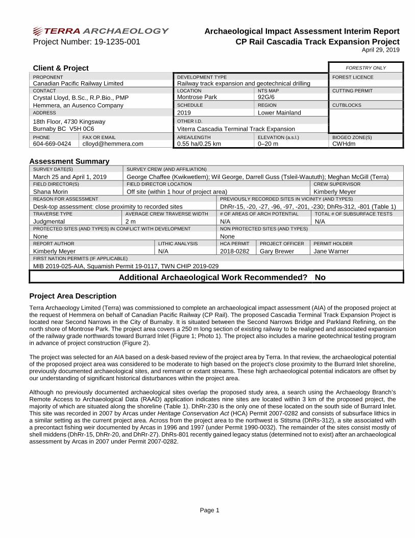
Archaeological Impact Assessment Interim Report Project Number: 19-1235-001 CP Rail Cascadia Track Expansion Project
April 29, 2019
Page 1
Client & Project FORESTRY ONLY
PROPONENT DEVELOPMENT TYPE FOREST LICENCE Canadian Pacific Railway Limited Railway track expansion and geotechnical drilling CONTACT LOCATION NTS MAP CUTTING PERMIT Crystal Lloyd, B.Sc., R.P.Bio., PMP Hemmera, an Ausenco Company
Montrose Park 92G/6 SCHEDULE REGION CUTBLOCKS
ADDRESS 2019 Lower Mainland 18th Floor, 4730 Kingsway Burnaby BC V5H 0C6
OTHER I.D. Viterra Cascadia Terminal Track Expansion
PHONE FAX OR EMAIL AREA/LENGTH ELEVATION (a.s.l.) BIOGEO ZONE(S) 604-669-0424 [email protected] 0.55 ha/0.25 km 0–20 m CWHdm
Assessment Summary SURVEY DATE(S) SURVEY CREW (AND AFFILIATION)
March 25 and April 1, 2019 George Chaffee (Kwikwetlem); Wil George, Darrell Guss (Tsleil-Waututh); Meghan McGill (Terra) FIELD DIRECTOR(S) FIELD DIRECTOR LOCATION CREW SUPERVISOR
Shana Morin Off site (within 1 hour of project area) Kimberly Meyer REASON FOR ASSESSMENT PREVIOUSLY RECORDED SITES IN VICINITY (AND TYPES)
Desk-top assessment: close proximity to recorded sites DhRr-15, -20, -27, -96, -97, -201, -230; DhRs-312, -801 (Table 1) TRAVERSE TYPE AVERAGE CREW TRAVERSE WIDTH # OF AREAS OF ARCH POTENTIAL TOTAL # OF SUBSURFACE TESTS
Judgmental 2 m N/A N/A PROTECTED SITES (AND TYPES) IN CONFLICT WITH DEVELOPMENT NON PROTECTED SITES (AND TYPES)
None None REPORT AUTHOR LITHIC ANALYSIS HCA PERMIT PROJECT OFFICER PERMIT HOLDER
Kimberly Meyer N/A 2018-0282 Gary Brewer Jane Warner FIRST NATION PERMITS (IF APPLICABLE)
MIB 2019-025-AIA, Squamish Permit 19-0117, TWN CHIP 2019-029
Additional Archaeological Work Recommended? No
Project Area Description Terra Archaeology Limited (Terra) was commissioned to complete an archaeological impact assessment (AIA) of the proposed project at the request of Hemmera on behalf of Canadian Pacific Railway (CP Rail). The proposed Cascadia Terminal Track Expansion Project is located near Second Narrows in the City of Burnaby. It is situated between the Second Narrows Bridge and Parkland Refining, on the north shore of Montrose Park. The project area covers a 250 m long section of existing railway to be realigned and associated expansion of the railway grade northwards toward Burrard Inlet (Figure 1; Photo 1). The project also includes a marine geotechnical testing program in advance of project construction (Figure 2). The project was selected for an AIA based on a desk-based review of the project area by Terra. In that review, the archaeological potential of the proposed project area was considered to be moderate to high based on the project’s close proximity to the Burrard Inlet shoreline, previously documented archaeological sites, and remnant or extant streams. These high archaeological potential indicators are offset by our understanding of significant historical disturbances within the project area. Although no previously documented archaeological sites overlap the proposed study area, a search using the Archaeology Branch’s Remote Access to Archaeological Data (RAAD) application indicates nine sites are located within 3 km of the proposed project, the majority of which are situated along the shoreline (Table 1). DhRr-230 is the only one of these located on the south side of Burrard Inlet. This site was recorded in 2007 by Arcas under Heritage Conservation Act (HCA) Permit 2007-0282 and consists of subsurface lithics in a similar setting as the current project area. Across from the project area to the northwest is Stitsma (DhRs-312), a site associated with a precontact fishing weir documented by Arcas in 1996 and 1997 (under Permit 1990-0032). The remainder of the sites consist mostly of shell middens (DhRr-15, DhRr-20, and DhRr-27). DhRs-801 recently gained legacy status (determined not to exist) after an archaeological assessment by Arcas in 2007 under Permit 2007-0282.

Archaeological Impact Assessment Interim Report Project Number: 19-1235-001 CP Rail Cascadia Track Expansion Project
April 29, 2019
Page 2
Table 1: Previously Recorded Sites within 3 km of the Project Area
Borden Number
Distance from
Project Area (km) Site Type(s) Site Size (m)*
Year Recorded
DhRr-15 2.88 Shell midden 135 x 15 1978
DhRr-20 2.28 Shell midden, lithics (subsurface) 110 x 100 1972
DhRr-27 2.05 Shell midden (destroyed) 5 x 5 1974
DhRr-96 2.90 Sweat lodge (traditional use) 5 x 5 1996
DhRr-97 2.76 Marker tree (traditional use) 1 x 1 1996
DhRr-201 2.30 Shipwreck (post contact) 40 x 10 1959
DhRr-230 2.00 Lithics (subsurface) 10 x 10 2007
DhRs-312 1.14 Fishing weir (subsistence feature) 38 x 23 1996
DhRs-801 1.41 Surface lithics (non-cultural/ legacy status) 120 x 70 1963 *As listed on Site Forms, or measured in RAAD where Site Form data was insufficient
Methodology Prior to fieldwork, a desk-based review was conducted for each development location. RAAD was used to identify previously recorded archaeological sites within or near each location and the Provincial Archaeological Report Library (PARL) was searched for detailed reports describing previous archaeological studies in the vicinity. Additionally, topographic data was examined, and aerial images were reviewed, to identify and confirm the location of any drainages and water bodies as well as any lands previously disturbed by commercial, industrial, or agricultural activities. Per Permit 2018-0282: crew members were spaced at approximately 2 m intervals along survey transects, all ground exposures encountered were inspected for archaeological materials, and all trees (all species standing or fallen, including stumps) along survey transects were examined for indications of cultural modification. Survey took place at low tide in order to maximize coverage of the project footprint in the intertidal zone. On-site monitoring of the marine geotechnical testing program was considered impractical due to safety and logistics concerns which restricted on-site inspection of drilling activities; however, excavated samples were examined off site on April 1, 2019, shortly after completion of the drilling program. Archaeological potential was assessed based on: proximity to water, food resources, slope, drainage, forest cover, presence of topographic landforms commonly associated with known archaeological sites in the region (e.g., shoreline, terraces, breaks-in-slope), and local knowledge. Land alterations in the project area from the existing railway which have significantly reduced archaeological potential in the project area were also taken into consideration. A qualified field director was located within an hour of the project area and was available to consult with the crew supervisor at any time.
Survey Results The entire project area was surveyed on foot by a crew of four on March 25, 2019 (Figure 2). The project area extends onto the foreshore on the north side of the CP Rail mainline. Construction of the railway has heavily impacted lands immediately adjacent to the tracks, as indicated by steep embankment cuts and rip-rap. Large-sized rip-rap extends several meters from the north edge of the railway bed onto the rocky beach (Photo 2). The exposed intertidal zone was thoroughly surveyed during low daytime tide (Photo 3). No archaeological remains or features were observed during the pedestrian survey, the survey lands are considered to have low archaeological potential due to the extent of the exposed sandstone bedrock which characterizes the shoreline in this location. Due to logistics and safety concerns associated with the operation of the amphibious drill rig, the archaeological crew was not able to examine sediments from the marine geotechnical testing as they were excavated. Instead, a Terra archaeologist, accompanied by a member of Tsleil-Waututh Nation, examined all bagged sediment samples for BH19-1 and BH19-3 off site on April 1, 2019 (drilling took

Archaeological Impact Assessment Interim Report Project Number: 19-1235-001 CP Rail Cascadia Track Expansion Project
April 29, 2019
Page 3
place overnight on March 26–27, 2019) at the AECOM offices in Burnaby after testing was completed. Samples from BH19-2 were not available for analysis. Descriptions of each sample are provided in Table 2; no archaeological remains were observed in these samples.
Table 2: Geotechnical Borehole Sample Descriptions
Borehole No.
Sample No.
Depth from (feet)
Depth to
(feet)
Depth from (m)
Depth to (m)
Sample Date
Terra Staff Terra Notes
BH19-1
1 0’0” 1’5” 0.0 0.6 26-Mar-19 KDM dark olive grey coarse-grained sand with trace silt and ~20% sub-rounded to subangular pebbles, 10% shell
2 1’5” 2’0” 0.6 1.2 26-Mar-19 KDM olive grey coarse-grained sand and silt, 5% inclusions 3 5’0” 5’9” 1.5 2.1 26-Mar-19 KDM dark brownish grey silt and medium-grained sand, <1% inclusions 4 10’0” 10’4” 3.0 3.7 27-Mar-19 KDM dark brown medium-grained sand with some silt, <1% inclusions
5 15’0” 15’4” 3.8 4.4 27-Mar-19 KDM dark grey brown fine-grained silt with some medium-grained sand, <1% inclusions
6 20’0” 21’5” 5.3 5.9 27-Mar-19 KDM dark grey brown mottled with tan brown silt with coarse-grained sand, <1% inclusions
BH19-3
1 0’0” 0’5” 0.0 0.6 27-Mar-19 KDM dark olive grey silt with medium-grained sand, <1% inclusions 2 5’0” 5’4” 1.5 1.8 27-Mar-19 KDM dark grey silt with medium-grained sand, <1% inclusions 3 10’0” 10’4” 2.3 2.9 27-Mar-19 KDM dark grey and tan brown silt with medium-grained sand, <1% inclusions
4 15’0” 15’6” 0.0 0.9 27-Mar-19 KDM Dark grey fine-grained silt with some medium-grained sand, <1% inclusions
Impact Assessment and Recommendations No archaeological sites were identified within the assessed area and the potential for the project to impact undocumented archaeological sites is considered to be low. No further archaeological work is recommended for the Viterra Cascadia Terminal Track Expansion Project. Should the Cascadia expansion project extend southwards of the existing mainline, outside of the current proposed project area, archaeological inspection during project construction (i.e., archaeological monitoring) is recommended. Although the potential presence of archaeological sites is considered to be low throughout the assessed area, no assessment can guarantee to identify all undocumented sites located in a particular area. Therefore, an archaeological Chance Find Procedure should be in place during construction, and if archaeological materials are observed during any phase of construction, all ground-altering activities in the vicinity of the finds must be halted immediately and a qualified archaeologist and the relevant First Nations contacted. If a qualified archaeologist considers the materials to be protected under the Heritage Conservation Act, ground-altering activities may only resume with approval of the Archaeology Branch. Supervisors and operators should be aware that sites and objects located on public or private land and associated with human habitation or use that might pre-date AD 1846 are automatically protected under Section 13 (2) of the Act and cannot be altered without a permit issued pursuant to Sections 12 or 14 of the Act. Interpretations of the archaeological record are made without prejudice to Aboriginal Interests and are not intended to refute, alter, or recognize any Aboriginal treaty, title, or any other right. This assessment addresses the potential for the existence of physical evidence of past human activity and does not encompass traditional use or other heritage concerns of the First Nations communities. This information should be solicited directly from the First Nations.

Archaeological Impact Assessment Interim Report Project Number: 19-1235-001 CP Rail Cascadia Track Expansion Project
April 29, 2019
Page 4
Photo 1: View east to proposed project footprint at low tide.
Photo 2: View south to the extent of CP rail track grade and rip-rap.
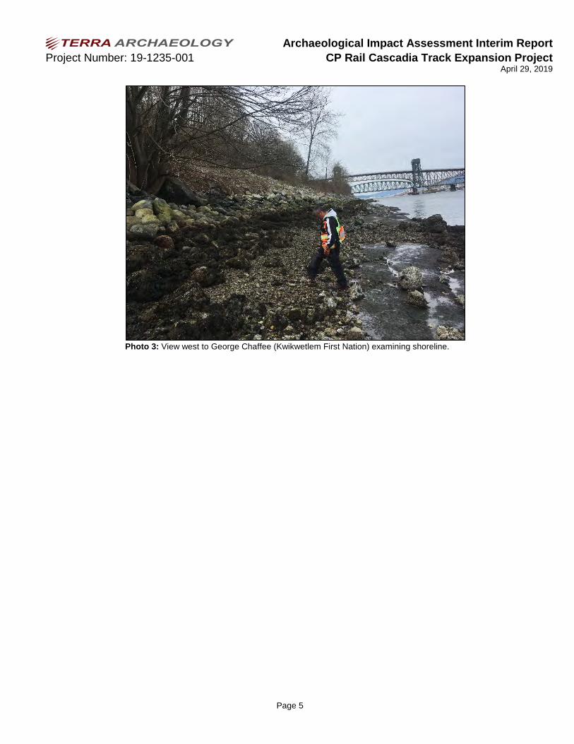
Archaeological Impact Assessment Interim Report Project Number: 19-1235-001 CP Rail Cascadia Track Expansion Project
April 29, 2019
Page 5
Photo 3: View west to George Chaffee (Kwikwetlem First Nation) examining shoreline.
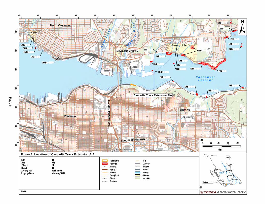
North Vancouver
Vancouver Burnaby
V a n c o u v e rH a r b o u r
Seymour Creek 2Burrard Inlet 3
Mission 1
DhRr-8
DhRr-20
DhRr-15
DhRr-19
DhRr-216
DhRr-18
DhRs-801
DhRr-13
DhRr-231DhRr-212
DhRs-664DhRr-213
DhRs-312DhRr-201
DhRr-230
DhRs-16DhRr-27
DhRs-24
DhRs-1276
DhRr-214
DhRr-354
DhRr-96DhRr-97
DhRs-17
Hwy 7ATr
ans-C
anad
a High
way
Lougheed Highway
L yn n
Cr e
e k
S e y m o ur
Rive
r
Cascadia Track Extension AIA
20
40
80
60
120
100
160
200
240
280
80
160
60
200
40
100
20
40
40
40
120
100
60
120
20
40
80
60
60
60
40
100
40
80
60
80
80
2040
120
160
493000 494000 495000 496000 497000 498000 499000 500000 501000 502000 503000 5040005457000
5458000
5459000
5460000
5461000
5462000
5463000
Kam loops
Vancouver
Fort Nelson
Fort St John
William s Lake
Prince GeorgePrince Rupert
Figure 1. Location of Cascadia Track Extension AIA
0 500 1,000 1,500 2,000Metres
1:50,000
1:40,000,000Study Area
±
T erra ID:Client:HCA Perm it:Date Produced:Coordinate Sy stem :T opographic Data Source:
Service Layer Credits:
Project FootprintArchaeological Site
" BuildingHighwayMain RoadSecondary RoadRailroad
!! !! Power Line
! T railContourBuilt-up AreaRiver/CreekWaterbodyIndian ReserveWooded Area
19-1235-001CP Rail2018-02822019-04-04NAD 1983 UT M Zone 10NCanVec courtesy DataBC – 2017-12-15
Page 6

498650 498700 498750 498800 498850 498900 498950 499000 499050 4991005459950
5460000
5460050
5460100
5460150
Figure 2. Cascadia Track Extension AIA
0 20 40 60 80Me tre s
1:2,000
1:500,000
±
Te rra ID:Clie nt:HCA Pe rm it:Da te Prod uce d :Coord ina te Syste m :Topog ra phic Da ta Source:Im a g e ry Curre ncy:
Se rvice La ye r Cre d its: Source s: Esri, HERE, Ga rm in, Inte rm a p, incre m e nt P Corp., GEBCO , USGS, FAO , NPS, NRCAN, Ge oBa se , IGN, Ka d a ste r NL, O rd na nce Survey, Esri Ja pa n, METI, Esri China (Hong Kong ), swisstopo, ©O pe nStre e tMa p contributors, a nd the GIS Use r Com m unity
Proje ct Footprint!A Borehole
Surve y Cove ra g ePropose d tra ck Exte nsion LineLow Wa te r La rg e Tid eContourCa d a stra l Bound a ry
ÛÚ Photo Loca tion
19-1235-001CP Ra il2018-02822019-04-11NAD 1983 UTM Z one 10NCa nVec courte sy Da ta BC – 2017-12-152017-08-28
Page 7
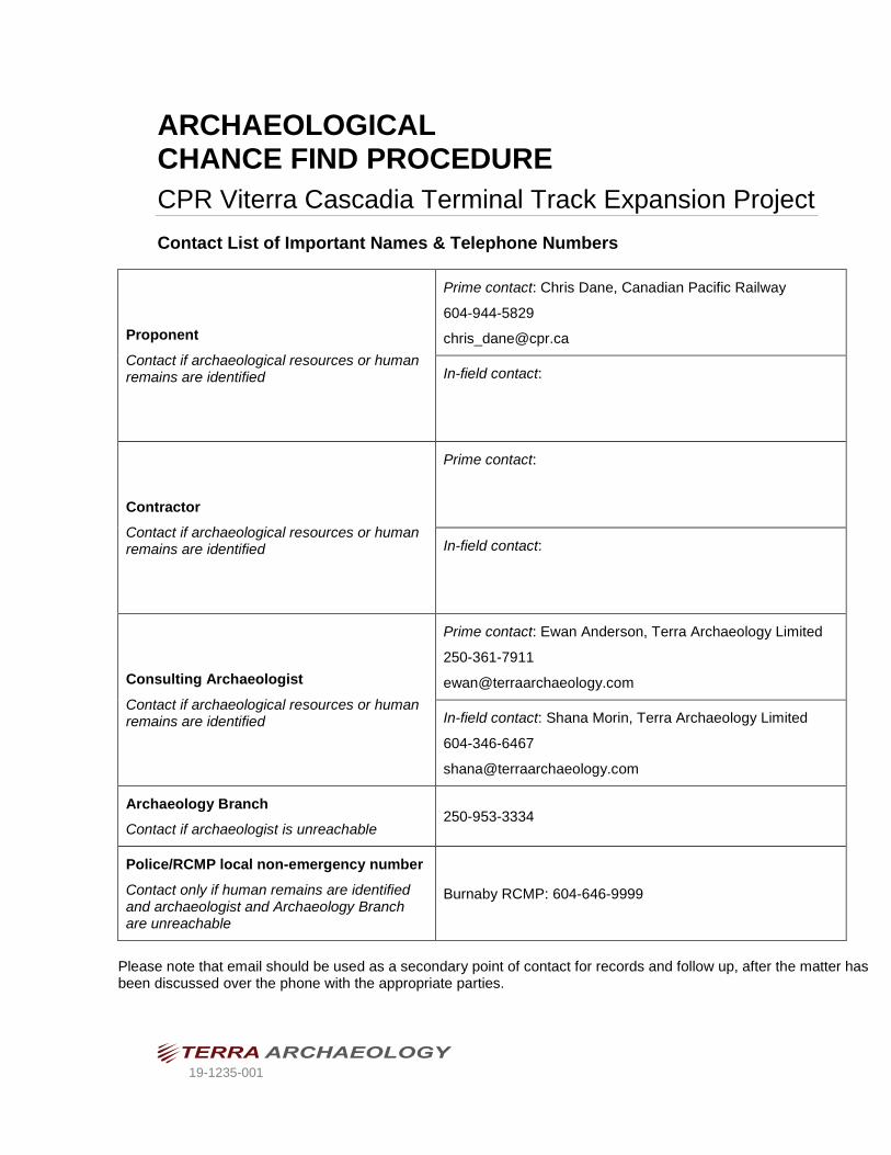
19-1235-001
ARCHAEOLOGICAL CHANCE FIND PROCEDURE CPR Viterra Cascadia Terminal Track Expansion Project
Contact List of Important Names & Telephone Numbers
Proponent Contact if archaeological resources or human remains are identified
Prime contact: Chris Dane, Canadian Pacific Railway
604-944-5829
In-field contact:
Contractor Contact if archaeological resources or human remains are identified
Prime contact:
In-field contact:
Consulting Archaeologist Contact if archaeological resources or human remains are identified
Prime contact: Ewan Anderson, Terra Archaeology Limited
250-361-7911
In-field contact: Shana Morin, Terra Archaeology Limited
604-346-6467
Archaeology Branch Contact if archaeologist is unreachable
250-953-3334
Police/RCMP local non-emergency number Contact only if human remains are identified and archaeologist and Archaeology Branch are unreachable
Burnaby RCMP: 604-646-9999
Please note that email should be used as a secondary point of contact for records and follow up, after the matter has been discussed over the phone with the appropriate parties.

TERRA ARCHAEOLOGY LIMITED Page ii
Table of Contents Table of Contents .......................................................................................................................................... ii 1 Introduction ............................................................................................................................................... 1
2 First Nations Cultural Heritage ................................................................................................................. 3
3 Types of Archaeological Resources......................................................................................................... 4
4 Chance Finds Guidelines ......................................................................................................................... 5
4.1 Initial Action by Proponent and Contractors..................................................................................... 5
4.2 Archaeological Site Management Options ....................................................................................... 5 5 Possible Human Remains Identified ........................................................................................................ 6
5.1 Initial Action by Proponent and Contractors..................................................................................... 6
5.2 Initial Action by Archaeologist .......................................................................................................... 6
5.3 Human Remains Management Options ........................................................................................... 6
6 Legislation ................................................................................................................................................ 7
Appendix A: Site Identification Guide ............................................................................................................ 8 Appendix B: Tsleil-Waututh Nation Ancestral Remains Policy ................................................................... 18
Appendix C: Archaeology Branch Found Human Remains Policy ............................................................. 20

Archaeological Chance Find Procedures
TERRA ARCHAEOLOGY LIMITED Page 1
1 Introduction The proposed Cascadia Terminal Track Expansion Project is located in the City of Burnaby, between the Second Narrows Bridge and Parkland Refining, on the north shore of Montrose Park. The project area covers a 250 m long section of existing railway to be realigned and associated expansion of the railway grade northwards toward Burrard Inlet (Figure 1). No archaeological sites are located within the project footprint, although nine sites are located within 3 km of the project area. A pre-construction archaeological assessment by Terra Archaeology Limited (Terra) and participants from Tsleil-Waututh Nation and Kwikwetlem First Nation was completed in March 2019. No archaeological sites were identified within the project area and the potential for undiscovered archaeological remains within the project footprint is considered to be low. This document outlines how to appropriately manage unanticipated or “chance” archaeological finds made during project construction. The processes described below enable the proponent to manage impacts to protected archaeological sites concurrently with project construction activities. The objective of the Chance Find Procedure is to ensure appropriate and respectful treatment of cultural heritage remains while maintaining project construction timelines. This document is intended to be used as an in-field resource. The project proponent and contractor should become familiar with the processes described below and the types of archaeological remains likely to be encountered in the project area (Appendix A). An emergency contact sheet is provided on the cover page so that the appropriate people can be quickly contacted if necessary. Any cultural materials which pre-date AD 1846 are automatically protected by the Heritage Conservation Act of British Columbia. It is illegal to collect or remove any cultural remains from an archaeological site unless authorized to do so by a permit issued under Section 12 or 14 of the Heritage Conservation Act. Remember:
• This Chance Find Procedure (CFP) is one of several impact management recommendations made by a professional archaeologist, or is part of the proponent’s broader heritage management policies. Project managers should consult these additional documents before implementing this CFP.
• All on-site personnel involved in ground altering activities should be familiar with this policy, including the types of sites described in Appendix A before starting on-site work.
• This CFP, including the content in Appendix A, should be presented to all on-site personnel by a professional archaeologist familiar with the project, in collaboration with local First Nations.

498650 498700 498750 498800 498850 498900 498950 499000 499050 4991005459950
5460000
5460050
5460100
5460150
Figure 1. Cascadia Track Extension
0 20 40 60 80Me tre s
1:2,000
1:500,000
±
Te rra ID:Clie nt:HCA Pe rm it:Da te Prod uce d :Coord ina te Syste m :Topog ra phic Da ta Source:Im a g e ry Curre ncy:
Se rvice La ye r Cre d its: Source s: Esri, HERE, De Lorm e , Inte rm a p, incre m e nt P Corp., GEBCO , USGS, FAO , NPS, NRCAN, Ge oBa se, IGN, Ka d a ste r NL, O rd na nce Surve y, Esri Ja pa n, METI, Esri China (Hong Kong ), swisstopo, Ma pm yInd ia ,© O pe nStre e tMa p contributors, a nd the GIS Use r Com m unity
Proje ct FootprintPropose d tra ck Exte nsion LineLow Wa te r La rg e Tid eContourCa d a stra l Bound a ry
19-1235-001CP Ra il2018-02822019-05-14NAD 1983 UTM Z one 10NCa nVec courte sy Da ta BC – 2017-12-152018-09-05
Page 2

Archaeological Chance Find Procedures
TERRA ARCHAEOLOGY LIMITED Page 3
2 First Nations Cultural Heritage The project area is located within the asserted territories of the Musqueam Nation, Squamish Nation, Stó:lō Nation, Stó:lō Tribal Council, and Tsleil-Waututh Nation, communities whose ancestors have lived here since time immemorial. Indigenous communities have a deep respect for and connection with their cultural heritage. The preservation and protection of the physical remains associated with their ancestors’ lives – in the form of archaeological sites – is an integral part of that respect. Within these nations’ lands are hundreds, or even thousands, of archaeological sites, representing thousands of years of history and hundreds of generations’ experiences on the land. Archaeological sites exist in many contexts, including those that are well-preserved and well-documented, and others which are heavily altered from modern land use, or entirely unrecorded. Regardless of the context, all archaeological sites represent significant connections between Indigenous communities and their lands and ancestors, and must be treated with the utmost respect. Given the sensitive nature of cultural heritage represented by archaeological sites, First Nations expect all project proponents and their contractors to follow these Chance Find Procedures and consult with community leaders regarding archaeological resources within project areas.

Archaeological Chance Find Procedures
TERRA ARCHAEOLOGY LIMITED Page 4
3 Types of Archaeological Resources Archaeological remains can be found in either a disturbed or intact context. Artifacts to watch for include stone tools, as well as bone, antler, and tooth artifacts. Black soil (with or without concentrations of shell), fire-altered rock, hearth features, aligned rocks, or the wet remains of organic materials can also represent archaeological sites. Detailed characteristics of archaeological sites typical to the region are described and illustrated in the Archaeological Site Identification Guide presented as Appendix A. Any discovery of bones that constitute possible human remains demands attention. Tsleil-Waututh Nation’s Ancestral Remains Policy is presented in Appendix B. The Archaeology Branch’s Found Human Remains Policy is presented in Appendix C. An outline of what do to if artifacts or human remains are encountered is provided in following sections.

Archaeological Chance Find Procedures
TERRA ARCHAEOLOGY LIMITED Page 5
4 Chance Finds Guidelines For land-altering activities outside of known site areas it is important to note that work in the area of the discovery must stop immediately no matter what type of archaeological material or feature has been encountered by the proponent or their contractors.
4.1 Initial Action by Proponent and Contractors
1) Stop Work If archaeological materials are believed to have been encountered, all work in the area of the
discovery should cease and the site area safely secured. Do not move any soil from the vicinity of the site, including any spoil material.
2) Contact an Archaeologist
An archaeologist should be contacted as soon as possible. If possible, e-mail notification of chance finds should include photographs of the finds from several angles, from close-up (with an everyday
object, such as a pen, for scale), and from a short distance away.
3) Seek Guidance from the Archaeologist The archaeologist will provide guidance on further action. Where possible a solution will be arrived at over the phone, perhaps supplemented by digital images of the find forwarded to the archaeologist’s
office. If the archaeologist cannot determine the exact nature of the discovery, and/or it cannot be satisfactorily resolved over the telephone or by e-mail, a visit will be arranged so the site can be assessed and mapped. Prior to visiting the area of the discovery, the Archaeology Branch of the
Ministry of Forests, Lands, Natural Resource Operations and Rural Development will be notified of the discovery.
4.2 Archaeological Site Management Options If the archaeologist confirms that an archaeological site has been discovered, there are several management options. Proponents should work collaboratively with First Nations and the archaeologist to determine a management plan if a conflict with an archaeological site is identified. If a Heritage Conservation Act inspection, investigation, or alteration permit is not in place either for the development, or in connection with a known archaeological site, this must first be applied for and obtained. The archaeologist can prepare the application for the appropriate permit which must be signed by an individual representing the development prior to submission. Once the permit has been granted by the Archaeology Branch there are three main archaeological site management options:
Avoid If the boundaries of the site have been delineated, an attempt will be made to redesign the proposed development to avoid the site. It will likely be necessary to have a Heritage Inspection Permit in place to properly delineate site boundaries. Site avoidance is normally the fastest and most cost-effective management option for archaeological sites.
Mitigate If it is not feasible to avoid the site through development redesign, it will be necessary to effectively sample it utilizing a systematic data collection program prior to its loss. This could include a systematic surface collection and/or excavation. Mitigative work is normally the most expensive and time-consuming management option.
Protect It may be possible to protect the site through the installation of barriers during the time of the development and possibly for a longer term. This could include the erection of high visibility fencing around the site or covering the site area with a geotextile and then capping it with fill. The exact prescription would be site-specific.
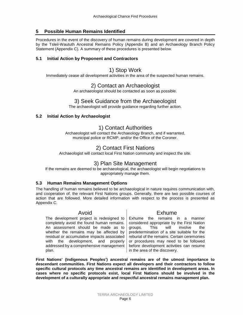
Archaeological Chance Find Procedures
TERRA ARCHAEOLOGY LIMITED Page 6
5 Possible Human Remains Identified Procedures in the event of the discovery of human remains during development are covered in depth by the Tsleil-Waututh Ancestral Remains Policy (Appendix B) and an Archaeology Branch Policy Statement (Appendix C). A summary of these procedures is presented below.
5.1 Initial Action by Proponent and Contractors
1) Stop WorkImmediately cease all development activities in the area of the suspected human remains.
2) Contact an ArchaeologistAn archaeologist should be contacted as soon as possible.
3) Seek Guidance from the ArchaeologistThe archaeologist will provide guidance regarding further action.
5.2 Initial Action by Archaeologist
1) Contact AuthoritiesArchaeologist will contact the Archaeology Branch, and if warranted,
municipal police or RCMP, and/or the Office of the Coroner.
2) Contact First NationsArchaeologist will contact local First Nation community and inspect the site.
3) Plan Site ManagementIf the remains are deemed to be archaeological, the archaeologist will begin negotiations to
appropriately manage them.
5.3 Human Remains Management Options The handling of human remains believed to be archaeological in nature requires communication with, and cooperation of, the relevant First Nations groups. Generally, there are two possible courses of action that are followed. More detailed information with respect to the process is presented as Appendix C.
Avoid The development project is redesigned to completely avoid the found human remains. An assessment should be made as to whether the remains may be affected by residual or accumulative impacts associated with the development, and properly addressed by a comprehensive management plan.
ExhumeExhume the remains in a manner considered appropriate by the First Nation groups. This will involve the predetermination of a site suitable for the reburial of the remains. Certain ceremonies or procedures may need to be followed before development activities can resume in the area of the discovery.
First Nations’ (Indigenous Peoples’) ancestral remains are of the utmost importance to descendant communities. First Nations expect all developers and their contractors to follow specific cultural protocols any time ancestral remains are identified in development areas. In cases where no specific protocols exist, local First Nations should be involved in the development of a culturally appropriate and respectful ancestral remains management plan.

Archaeological Chance Find Procedures
TERRA ARCHAEOLOGY LIMITED Page 7
6 Legislation Most archaeological sites including any site pre-dating AD 1846, all ancestral burials, indigenous rock paintings or carvings, and ship and aircraft wrecks older than 2 years are automatically protected under Section 13 of the Heritage Conservation Act. Whether these sites are recorded or not, they must not be altered in any way without a permit issued by the Archaeology Branch. Other cultural heritage sites may be designated by a local government (e.g., historic buildings) or by agreement between the Province and First Nations. These sites are also protected from alterations of any kind without a permit. Altering an archaeological site without a permit will result in:
1. Immediate stoppage of work, and/or 2. Penalties of up to $1,000,000 or 2 years imprisonment.
Contact information for the Archaeology Branch can be found at the beginning of this document.

Archaeological Chance Find Procedures
TERRA ARCHAEOLOGY LIMITED Page 8
Appendix A: Site Identification Guide A number of site types may occur in the area, including but not limited to:
• artifacts (lithics, bone, antler and teeth), • midden (with or without shell), • wet sites (basketry and wooden objects), • marine harvesting (fishing weirs and clam gardens), • cooking features (hearths and fire-altered rock), • cultural depressions, • mounds or cairns, • painted or carved stone, and • culturally modified trees.
Characteristics typical of some of the sites that may be found in the project area are provided in the text and figures on following pages.

Archaeological Chance Find Procedures
TERRA ARCHAEOLOGY LIMITED Page 9
Artifact Scatters Lithic (stone) scatters from the production and maintenance of stone tools are the most common archaeological site type found in the region. Other materials which may be represented in artifact scatters include bone, antler, and tooth. Descriptions and illustrations are provided below and on the following pages. Lithic Artifacts – What to look for:
• Small, thin, sharp pieces of stone that appear to be out of place with natural stone • Glassy stone • Stone that appears to have been chipped or formed • An obvious bulb and curve on a thin piece of stone • Stress ripples along the faces of flakes and scars • Parallel striations from intentional grinding • Intentional pecking
(a) Four views of a typical stone flake; (b) basic flake characteristics
(a) Lithic scatter uncovered during development; (b) formed flaked lithic artifacts
a b
a b

Archaeological Chance Find Procedures
TERRA ARCHAEOLOGY LIMITED Page 10
Pecked and ground stone artifacts
Bone, Antler, and Tooth Artifacts – What to look for:
• Obvious shaping • Striations • Graving/incising • Unnatural perforations
Bone and antler artifacts

Archaeological Chance Find Procedures
TERRA ARCHAEOLOGY LIMITED Page 11
Midden Middens are large accumulations of household waste, such as shell, bone, and other organic material. Midden appears as very dark (black) layers of soil, most commonly with significant concentrations of shell. In disturbed areas, midden appears in small pockets, while larger intact midden deposits may cover an area the size of a city block. Shell midden also facilitates the preservation of bone and antler artifacts. Midden – What to look for:
• Black, greasy soil • Dense accumulations of broken or whole shell • Fire-altered rock (see next section) and burned bone or wood
(a) Crushed shell and dark soil in an auger test; (b) shell midden eroding from a root exposure.
a
b
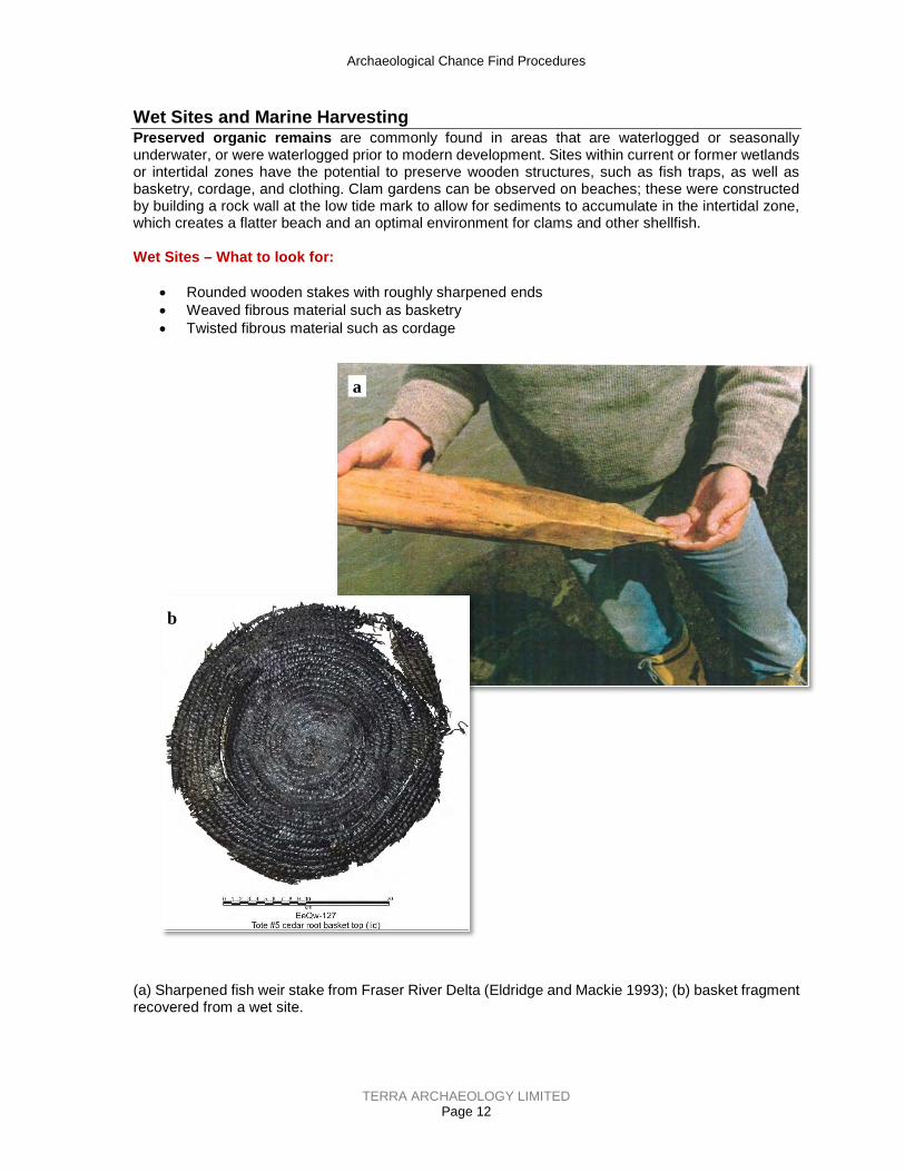
Archaeological Chance Find Procedures
TERRA ARCHAEOLOGY LIMITED Page 12
Wet Sites and Marine Harvesting Preserved organic remains are commonly found in areas that are waterlogged or seasonally underwater, or were waterlogged prior to modern development. Sites within current or former wetlands or intertidal zones have the potential to preserve wooden structures, such as fish traps, as well as basketry, cordage, and clothing. Clam gardens can be observed on beaches; these were constructed by building a rock wall at the low tide mark to allow for sediments to accumulate in the intertidal zone, which creates a flatter beach and an optimal environment for clams and other shellfish. Wet Sites – What to look for:
• Rounded wooden stakes with roughly sharpened ends • Weaved fibrous material such as basketry • Twisted fibrous material such as cordage
(a) Sharpened fish weir stake from Fraser River Delta (Eldridge and Mackie 1993); (b) basket fragment recovered from a wet site.
a
b

Archaeological Chance Find Procedures
TERRA ARCHAEOLOGY LIMITED Page 13
Fire-altered Rock, Hearth Features, and Cultural Depressions Fire-altered rock (FAR) results from the cultural use of fire during cooking, heating, and processing activities. FAR is often associated with other features including hearths and cultural depressions but can also be thinly scattered due to taphonomic processes or concentrated from dumping events away from the features from which they were first associated. Fire-altered Rock – What to look for:
• Concentrations of roughly fractured rock from rapid heating and cooling • Rock showing signs of burning or oxidation • Reddening or blackening of surrounding matrix
Sorted piles of fire-altered rock excavated from a cooking feature.

Archaeological Chance Find Procedures
TERRA ARCHAEOLOGY LIMITED Page 14
Hearth Features – What to look for:
• Fire-altered rock • Reddening or blackening of the matrix • Charcoal • Layering of the above elements • A depression associated with the above elements
(a) Hearth feature uncovered during machine excavation; (b) hearth feature exposed in wall of archaeological excavation with fire-altered rock piled nearby.
a
b

Archaeological Chance Find Procedures
TERRA ARCHAEOLOGY LIMITED Page 15
Cultural Depressions – What to look for:
• Subtle to deep scours on the surface that are circular to rectilinear in shape • A raised rim along the edge of a depression • Depressions associated with artifacts and fire-altered rock • Depressions associated with fire-reddening and blackening
a) Depressions associated with a pit house site; b) the edge of a pit house identified in an excavation unit; c) a cache pit depression in a forested environment; d) a cache pit exposed during development; e) a roasting pit exposed during development; f) a roasting pit exposed and excavated.
a b
c d
e f
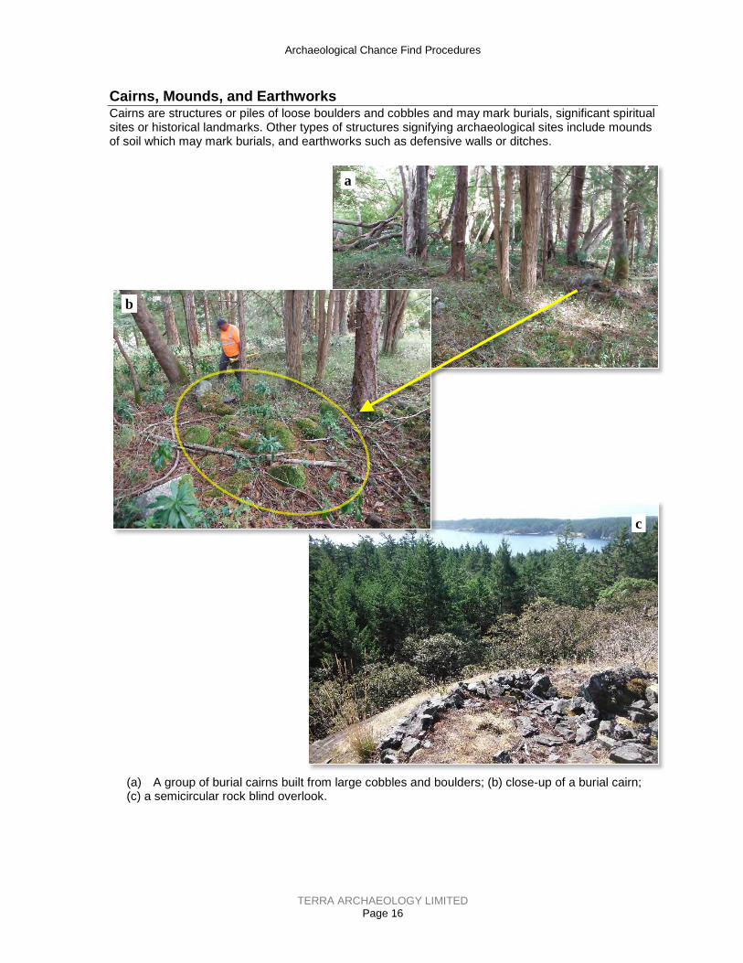
Archaeological Chance Find Procedures
TERRA ARCHAEOLOGY LIMITED Page 16
Cairns, Mounds, and Earthworks Cairns are structures or piles of loose boulders and cobbles and may mark burials, significant spiritual sites or historical landmarks. Other types of structures signifying archaeological sites include mounds of soil which may mark burials, and earthworks such as defensive walls or ditches.
(a) A group of burial cairns built from large cobbles and boulders; (b) close-up of a burial cairn; (c) a semicircular rock blind overlook.
a
b
c

Archaeological Chance Find Procedures
TERRA ARCHAEOLOGY LIMITED Page 17
Culturally Modified Trees Culturally modified trees (CMTs) have been altered by Indigenous people as part of their traditional use of the forest. They can be stripped of bark (leaving a characteristic scar), aboriginally logged, have kindling or pitch removal scars, or modified to mark a trail (blazes, arboglyphs). CMTs – What to look for:
• On lodgepole pine trees, look for a 40–160 cm long and <20 cm wide scar which may have cut marks on the top or bottom of the scar face.
• On cedar trees, look for signs of bark stripping or plank removal or test holes.
(a) Evidence of cultural modification - plank removal scars on western redcedar (CMT Handbook 2001); (b) bark-stripped, lodgepole pine culturally modified tree typical in the interior of B.C.
a b

Archaeological Chance Find Procedures
TERRA ARCHAEOLOGY LIMITED Page 18
Appendix B: Tsleil-Waututh Nation Ancestral Remains Policy

Treaty, Lands and Resources Department - 3075 Takaya Drive North Vancouver, B.C. V7H 3A8
Revised June 2017
TSLEIL-WAUTUTH NATION
People of the Inlet
Tsleil-Waututh Nation has approved a set of procedures regarding encountering ancestral remains; these steps are described below.
Stop Work. Stop work procedures are expected to be enacted every time a burial of human bone is encountered. This includes disarticulated or scattered human remains, not only intact burials.
Contact. Ensure that an appropriate TWN cultural, political, and staff representatives are on site in addition to the TWN archaeological monitor to ensure appropriate handling of ancestral remains.
Protect. If it is necessary to remove ancestral remains from the ground, ensure that they are appropriately packaged and protected. In addition to standard archaeological packaging materials, this also entails wrapping the remains in a blanket and placing them in a cedar box lined with cedar boughs.
Relocate. Ancestral remains can be temporarily relocated to a secure, safe facility that has been approved by TWN. Ensure that ancestral remains are to be transported as little as possible.
Secure. After ancestral remains are located, TWN will work with the developer, Provincial agents, and professional archaeologists to ensure that the site is not further impacted or threatened by looters. TWN requires 24 hour surveillance and security on high profile sites.
Cultural Ceremony. At the conclusion of the archaeological work at these cultural heritage sites, TWN insists that the location is cleansed with an appropriate ceremony by a designated TWN representative.
Reburial. TWN encourages that the ancestral remains are reburied as close to their original placement as possible, but so that they will not be further disturbed (subject to agreement with other First Nations).
Contact Information If ancestral remains are encountered, please contact one of the following individuals in the order provided, AS QUICKLY AS POSSIBLE:
1. Ginevra Toniello: office 604-924-4188, cell 778-227-4709 2. Michael George: office 604-924-4163, cell 604-356-8768 3. Ernie George: office 604-924-4183, cell 604-290-3777
Page 19

Archaeological Chance Find Procedures
TERRA ARCHAEOLOGY LIMITED Page 20
Appendix C: Archaeology Branch Found Human Remains Policy Issued: September 22, 1999 PURPOSE:
The purpose of this directive on found human remains is to provide guidelines to Archaeology Branch staff, archaeologists, other agencies and the public as to branch procedures for handling human remains that may be protected under the Heritage Conservation Act (1996, RSBC, Chap. 187), and to facilitate the respectful treatment of these remains.
MANDATE:
Pursuant to section 13(2)(b) of the Heritage Conservation Act (HCA), a permit is required under section 12 or 14 before a person can undertake any actions affecting a burial place of historical or archaeological value, human remains or associated heritage objects.
AUTHORITY:
The Director of the Archaeology Branch and the Manager, Permitting and Assessment Section, have been authorized to exercise the powers of the Minister to issue permits under sections 12(2) and 14(2), as well as ministerial orders under section 14(4) where necessary for emergency conservation purposes.
POLICY STATEMENT:
Upon notification of the discovery of human remains that are not of forensic concern, the Archaeology Branch will take steps to facilitate the respectful handling and disposition of those remains within the limits of existing funds and program priorities.
PROCEDURES
The following procedures will normally apply in cases where human remains are discovered fortuitously through various land altering activities such as house renovations, road construction or natural erosion; or during archaeological studies conducted under an HCA permit:
1. Fortuitous Discoveries
In cases where the branch has been notified that human remains have been discovered by chance, the following procedures should normally apply:
• the Coroner's Office and local policing authority should be notified as soon as possible.
• the Coroner's Office should determine whether the matter is of contemporary forensic concern. The branch may provide information and advice that may assist in this determination.
• if the Coroner's Office determines the reported remains are not of forensic concern, the branch will attempt to facilitate disposition of the remains.
• if a cultural affiliation for the remains can be reasonably determined, the branch will attempt to contact an organization representing that cultural group.
• if remains are determined to be of aboriginal ancestry, the branch will attempt to contact the relevant First Nation(s).
• generally, if remains are still interred and are under no immediate threat of further disturbance, they will not be excavated or removed.
• if the remains have been partially or completely removed, the branch will facilitate disposition.

Archaeological Chance Find Procedures
TERRA ARCHAEOLOGY LIMITED Page 21
• if removal of the remains is determined to be appropriate, they will be removed under authority of a permit issued pursuant to section 12 or 14, or an order under section 14 of the HCA, respecting the expressed wishes of the cultural group(s) represented to the extent this may be known or feasible.
• if circumstances warrant, the branch may arrange for a qualified physical anthropologist or an archaeologist with training in human osteology to provide an assessment of the reported remains in order to implement appropriate conservation measures.
• analysis should be limited to basic recording and in-field observations until consultation between the branch and appropriate cultural group(s) has been concluded.
2. Permitted Archaeological Projects
In cases where human remains are encountered in the course of a permitted project, the Archaeology Branch should be contacted as soon as possible.
• the remains are to be handled in accordance with the methods specified in the permit, respecting the expressed wishes of the cultural group(s) represented, to the extent that these may be known or feasible.
• if the permit does not specify how remains are to be handled and if the cultural affiliation of the remains can be reasonably determined, the field director or permit-holder should attempt to contact an organization representing that group. The permit-holder or field director should advise the branch of the organization contacted, and any wishes expressed by that organization.
• the branch, in consultation with the appropriate cultural group(s), will determine disposition of the remains.
• analysis should be limited to basic recording and in-field observations, until consultation between the branch and appropriate cultural group(s) has been concluded.

APPENDIX E Para. 35(2) Fisheries Act Authorization
(DFO File:19-HPAC-00243)