Embed Size (px)
Citation preview

City of Richmond
Original Adoption: June 19, 1995 / Plan Adoption: September 14, 2009 City Centre Area Plan 2-23
2.3 Mobility & AccessISSUE:While the City Centre’s population is projected to grow to 120,000 residents by 2100, it is expected to more than double (from 40,000 to 90,000 people) to 2031. From a transportation perspective, meeting the challenge of how best to accommodate the magnitude and rate of this growth in a sustainable manner will be addressed in large part by two key elements:Urban Transit Villages: Six urban transit villages will be developed in the City Centre, based on the principles of transit-oriented development, that will foster a lifestyle change and enable residents to live, work, shop, learn, and play in a pedestrian-friendly environment where a private automobile is seen as an option, not a necessity.
Canada Line: The completion of the Canada Line rapid transit service in 2009 is a critical element in the City Centre’s mobility system and will enable the strengthened integration of land use and transportation strategies.
To ensure a well-connected community that provides sustainable travel options, the City Centre transportation system must meet its mobility needs by:• pursuing a more multi-modal approach that promotes
a culture of walking, cycling and transit use to reduce greenhouse gas emissions and the traffi c burden on City Centre streets;
• putting in place a comprehensive transit service and infrastructure to provide viable and competitive travel choices for movement within the City Centre, as well as to/from the rest of Richmond and other regional destinations;
• providing adequate transportation infrastructure and facilities within the City Centre for all road users, in balance with other competing needs for urban space;
• ensuring adequate accommodation for the delivery of goods and services to support anticipated residential and retail/commercial/industrial development;
• employing transportation demand management (TDM) measures to help shift travel demand away from private automobile use towards more effi cient and sustainable modes.
VISION MANDATE:“Sustainable mobility for a livable, appealing and viable downtown” is a “core value” integral to the growth of Richmond and the City Centre and will help to:• “Build Community”: Meet
the mobility needs of a diverse community with an accessible, continuous, and integrated transportation system, while minimizing the need to travel far for daily services;
• “Build Green”: Improve, optimize and promote travel modes that reduce greenhouse gas emissions, encourage active, healthy living, and allow more responsible and sustainable use of valuable urban space;
• “Build Economic Vitality”: Build upon the convenience of the Canada Line and an enhanced City Centre transportation system to maximize the accessibility of businesses and ensure the effi cient movement of goods and services;
• “Build a Legacy”: Enhance the quality, convenience, and safety of the transportation system while mitigating the negative impacts of traffi c to create a sustainable and livable downtown for future generations.

City of Richmond
Original Adoption: June 19, 1995 / Plan Adoption: September 14, 2009 City Centre Area Plan 2-24
Street NetworkA hierarchy of multi-modal streets that signify desired functions with a tighter grid to provide more direct access.
TransitThe Canada Line is the backbone of transit service supplemented with regional and local bus service.
WalkingA city’s walkability is a critical measure of the quality of its public realm, and of its health and vitality.
CyclingDesignated bike routes actively encourage cycling as a legitimate and viable transportation choice.
Driving & ParkingAchieve a sustainable balance among road capacity requirements and on- and off-street parking.
Goods Movement & Emergency ServicesEffi ciently move goods and give priority to emergency services.
Supporting MeasuresPolicies and incentives support sustainable travel modes and increase transportation effi ciency.
Car-Free MeasuresConcierges, delivery services, and other measures can help make driving unnecessary.
OBJECTIVE:Provide a framework for a “well connected community” designed to promote a culture of walking, cycling, rolling, and transit use through complementary objectives for each of the different components and users of the transportation system:• Street Network: redefi ne and
complete the street network to balance the needs of all road users and create shorter blocks that increase accessibility to destinations;
• Transit: establish a comprehensive hierarchy of transit services and supporting amenities to enable transit to become the preferred travel choice for medium to long distance trips;
• Walking: assist people to move in comfort, safety, and dignity along all City Centre streets;
• Accessibility: establish barrier-free access;
• Cycling: establish a safe, continuous and convenient cycling network that serves cyclists of all ages and abilities;
• Driving & Parking: make driving an option, not a routine choice, and manage parking better to minimize its footprint;
• Goods Movement & Emergency Services: accommodate effi cient goods movement and minimize response times for emergency services;
• Supporting Measures: implement policies and programs that make the transportation system smarter, help to manage travel demand, and encourage a shift to more sustainable travel modes;
• Car-Free Measures: encourage car-free lifestyles.
City of Richmond
Original Adoption: June 19, 1995 / Plan Adoption: September 14, 2009 City Centre Area Plan 2-25
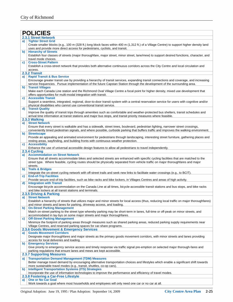
POLICIES2.3.1 Street Networka) Tighter Street Grid
Create smaller blocks (e.g., 100 m (328 ft.) long block faces within 400 m (1,312 ft.) of a Village Centre) to support higher density land uses and provide more direct access for pedestrians, cyclists, and transit.
b) Hierarchy of StreetsEstablish four classes of streets (major thoroughfare, major street, minor street, lane/mew) to support desired functions, character, and travel mode choices.
c) Cross-Street PatternEstablish a cross-street network that provides both alternative continuous corridors across the City Centre and local circulation and access.
2.3.2 Transita) Rapid Transit & Bus Service
Encourage greater transit use by providing a hierarchy of transit services, expanding transit connections and coverage, and increasing service frequencies. Pursue implementation of the future Capstan Station through the development of the surrounding area.
b) Transit VillagesMake each Canada Line station and the Richmond Oval Village Centre a focal point for higher density, mixed use development that offers opportunities for multi-modal integration with transit.
c) Accessible TransitSupport a seamless, integrated, regional, door-to-door transit system with a central reservation service for users with cognitive and/or physical disabilities who cannot use conventional transit service.
d) Transit QualityImprove the quality of transit trips through amenities such as comfortable and weather-protected bus shelters, transit schedules and arrival time information at transit stations and major bus stops, and transit priority measures where feasible.
2.3.3 Walkinga) Street Network
Ensure that every street is walkable and has a sidewalk, street trees, boulevard, pedestrian lighting, narrower street crossings, conveniently timed pedestrian signals, and where possible, curbside parking that buffers traffi c and improves the walking environment.
b) StreetscapeProvide an appealing and animated environment for pedestrians through landscaping, interesting street furniture, gathering places and resting areas, wayfi nding, and building fronts with continuous weather protection.
c) AccessibilityEnhance the use of universal accessible design features to allow all pedestrians to travel independently.
2.3.4 Cyclinga) Accommodation on Street Network
Ensure that all streets accommodate bikes and selected streets are enhanced with specifi c cycling facilities that are matched to the street type. Where feasible, cycling routes should be physically separated from vehicle traffi c on major thoroughfares and major streets.
b) Trails & BridgesIntegrate the on-street cycling network with off-street trails and seek new links to facilitate water crossings (e.g., to BCIT).
c) End-of-Trip FacilitiesProvide secure end-of-trip facilities, such as bike racks and bike lockers, in Villages Centres and areas of high activity.
d) Integration with TransitEncourage bicycle accommodation on the Canada Line at all times, bicycle-accessible transit stations and bus stops, and bike racks and bike lockers at all transit stations and terminals.
2.3.5 Driving & Parkinga) Street Network
Establish a hierarchy of streets that utilizes major and minor streets for local access (thus, reducing local traffi c on major thoroughfares) and minor streets and lanes for parking, driveway access, and loading.
b) On-Street Parking ManagementMatch on-street parking to the street type whereby parking may be short-term in lanes, full-time or off-peak on minor streets, and accommodated in lay-bys on some major streets and major thoroughfares.
c) Off-Street Parking ManagementMinimize the footprint of parking areas through measures such as shared parking areas, reduced parking supply requirements near Village Centres, and reserved parking spaces for car-share programs.
2.3.6 Goods Movement & Emergency Servicesa) Goods Movement Corridors
Designate major thoroughfares and major streets as the primary goods movement corridors, with minor streets and lanes providing access for local deliveries and loading.
b) Emergency ServicesGive priority to emergency service access and timely response via traffi c signal pre-emption on selected major thorough-fares and parking regulations that ensure lanes and mews are kept accessible.
2.3.7 Supporting Measuresa) Transportation Demand Management (TDM) Measures
Better manage travel demand by encouraging alternative transportation choices and lifestyles which enable a signifi cant shift towards more sustainable travel modes (e.g., transit, shuttles, co-op cars).
b) Intelligent Transportation Systems (ITS) StrategiesIncorporate the use of information technologies to improve the performance and effi ciency of travel modes.
2.3.8 Fostering a Car-Free Lifestylea) One or No Car Goal
Work towards a goal where most households and employees will only need one car or no car at all.

City of Richmond
Original Adoption: June 19, 1995 / Plan Adoption: September 14, 2009 City Centre Area Plan 2-26
2.3.1 Street NetworkThe key success indicator for the street network is:A redefi ned street network balances the needs of all road users – pedestrians, cyclists, transit, and drivers – and creates shorter blocks that increase accessibility to destinations.
Challenges• Large block sizes (i.e., block face
length greater than 200 m (656 ft.)) inhibits optimal land uses and adversely affects accessibility.
• Too few continuous major thoroughfares across the City Centre provide alternative routes for through-traffi c.
• Many existing developments are auto-oriented and feature large surface parking lots and multiple access driveways.
• Streets are designed primarily for vehicular movements.
• Unappealing streetscapes and incomplete sidewalk and cycling networks form a hostile environment for pedestrians and cyclists.
Proposed Strategies• At tighter street grid and streetscape
enhancements to support higher density land uses and provide more direct access.
• A hierarchy of streets that signifi es desired functions and character and supports travel mode choices.
• A simple cross-street network that provides alternative continuous corridors across the City Centre, as well as local circulation and access.
• Improved transit, pedestrian, and cycling environments to help offset the reliance on private automobiles and reduce the demand for increased road capacity.
Aerial photo of existing street grid.

City of Richmond
Original Adoption: June 19, 1995 / Plan Adoption: September 14, 2009 City Centre Area Plan 2-27
Street Network Map (2031) Bylaw 95932017/05/08
Sub-Area Plans:A. McLennan North (2.10C)B. McLennan South (2.10D)C. St Albans (2.10A)D. Acheson-Bennett (2.10B)
City of Richmond
Original Adoption: June 19, 1995 / Plan Adoption: September 14, 2009 City Centre Area Plan 2-28
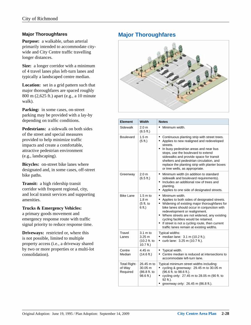
Major ThoroughfaresMajor ThoroughfaresPurpose: a walkable, urban arterial primarily intended to accommodate city-wide and City Centre traffi c travelling longer distances.
Size: a longer corridor with a minimum of 4 travel lanes plus left-turn lanes and typically a landscaped centre median.
Location: set in a grid pattern such that major thoroughfares are spaced roughly 800 m (2,625 ft.) apart (e.g., a 10 minute walk).
Parking: in some cases, on-street parking may be provided with a lay-by depending on traffi c conditions.
Pedestrians: a sidewalk on both sides of the street and special measures provided to help minimize traffi c impacts and create a comfortable, attractive pedestrian environment (e.g., landscaping).
Bicycles: on-street bike lanes where designated and, in some cases, off-street bike paths.
Transit: a high ridership transit corridor with frequent regional, city, and local transit services and supporting amenities.
Trucks & Emergency Vehicles: a primary goods movement and emergency response route with traffi c signal priority to reduce response time.
Driveways: restricted or, where this is not possible, limited to multiple property access (i.e., a driveway shared by two or more properties or a multi-lot consolidation).
Element Width NotesSidewalk 2.0 m
(6.5 ft.)• Minimum width.
Boulevard 1.5 m(5 ft.)
• Continuous planting strip with street trees.• Applies to new realigned and redeveloped
streets.• In busy pedestrian areas and near bus
stops, use the boulevard to extend sidewalks and provide space for transit shelters and pedestrian circulation, and replace the planting strip with planter boxes or tree wells, as appropriate.
Greenway 2.0 m(6.5 ft.)
• Minimum width (in addition to standard sidewalk and boulevard requirements).
• Includes an additional row of trees and planting.
• Applies to one side of designated streets.
Bike Lane 1.5 m to 1.8 m(5 ft. to 6 ft.)
• Minimum width.• Applies to both sides of designated streets.• Widening of existing major thoroughfares for
bike lanes should occur in conjunction with redevelopment or realignment.
• Where streets are not widened, any existing cycling facilities would be retained.
• If street is not a cycling route, then current traffi c lanes remain at existing widths.
Travel Lanes
3.1 m to 3.25 m(10.2 ft. to 10.7 ft.)
Typical widths:• median lane: 3.1 m (10.2 ft.);• curb lane: 3.25 m (10.7 ft.).
Centre Median
4.45 m(14.6 ft.)
• Typical width.• Centre median is reduced at intersections to
accommodate left-turn lane.
Total Right-of-Way Required
26.45 m to 30.05 m(86.8 ft. to 98.6 ft.)
Typical minimum street widths including:• cycling & greenway: 29.45 m to 30.05 m
(96.6 ft. to 98.6 ft.).• cycling only: 27.45 m to 28.05 m (90 ft. to
92 ft.).• greenway only: 26.45 m (86.8 ft.).

City of Richmond
Original Adoption: June 19, 1995 / Plan Adoption: September 14, 2009 City Centre Area Plan 2-29
Major StreetsPurpose: a walkable, urban collector primarily intended to link Village Centres and various neighbourhoods within the City Centre.
Size: a long corridor with 2 to 4 travel lanes plus left-turn lanes at most intersections.
Location: set in a grid pattern that subdivides the major thoroughfare grid to create roughly 400 m (1,312 ft.) square blocks (e.g., a 5 minute walk).
Parking: in some cases, on-street parking may be provided (e.g., during off-peak hours).
Pedestrians: a primary pedestrian route enhanced with sidewalks on both sides of the street and special landscape features and furnishings.
Bicycles: on-street bike lanes on designated streets (but enhanced outside lanes accommodating shared bike/vehicle use may be permitted in some cases).
Transit: a high ridership transit corridor with frequent local services.
Trucks & Emergency Vehicles: a secondary goods movement and emergency response route.
Driveways: discouraged or, where alternative access cannot be secured, limited to multiple property access (i.e., a driveway shared by two or more properties or a multi-lot consolidation).
Major Street (with Cycling)
Element Width NotesSidewalk 2.0 m
(6.5 ft.)• Minimum width.
Boulevard 1.5 m(5 ft.)
• Continuous planting strip with street trees.• Applies to new realigned and redeveloped
streets.• In busy pedestrian areas and near bus
stops, use the boulevard to extend sidewalks and provide space for transit shelters and pedestrian circulation, and replace the planting strip with planter boxes or tree wells, as appropriate.
Greenway 2.0 m(6.5 ft.)
• Minimum width (in addition to standard sidewalk and boulevard requirements).
• Includes an additional row of trees and planting.
• Applies to one side of designated streets.
Bike Lane 1.5 m to 1.8 m(5 ft. to 6 ft.)
• Minimum width.• Bike lanes are preferred on new streets.• Wide curb lanes: 4.3 m (14.1 ft.)
are acceptable where right-of-way is constrained (to the satisfaction of the City).
• Where existing streets are not cycling routes, the streets would not be widened.
Travel Lanes
3.1 m to 3.25 m(10.2 ft. to 10.7 ft.)
Typical widths:• median lane: 3.1 m (10.2 ft.);• curb lane: 3.25 m (10.7 ft.).
Total Right-of-Way Required
25.35 m to 28.85 m(83.2 ft. to 94.7 ft.)
Typical minimum street widths, including:• bike lanes & greenway: 28.25 m to 28.85 m
(92.7 ft. to 94.7 ft.);• bike lanes only: 26.25 m to 26.85 m (87 ft.
to 88 ft.);• new street with wider curb lanes: 25.35 m
(83.2 ft.).

City of Richmond
Original Adoption: June 19, 1995 / Plan Adoption: September 14, 2009 City Centre Area Plan 2-30
Minor Street - Commercial & High Density Residential
Minor Street - Medium & Low Density Residential
Minor StreetsPurpose: a walkable route primarily intended to serve fronting properties and provide for vehicle, bicycle, and pedestrian circulation within each of the City Centre’s villages and neighbourhoods.
Size: a corridor of varying length with 2 travel lanes (or 4 lanes when warranted by traffi c volumes and composition).
Location: set in a grid pattern that subdivides the major thoroughfare and major street grids to create roughly 200 m (656 ft.) square blocks (e.g., a 2½ minute walk).
Parking: on-street parking typical.
Pedestrians: a pedestrian-oriented streetscape design predominates and encourages lower vehicle travel speeds and, in some cases, situations where vehicles, pedestrians and cyclists enjoy “equal” priority in terms of shared road space.
Bicycles: enhanced curb lanes accommodating shared bike/vehicle use are preferred, but in some cases, mixed vehicle/bike lanes may be permitted.
Transit: a possible local transit corridor.
Trucks: local goods movement and emergency response route.
Driveways: direct vehicle access to fronting properties may be permitted where access from a rear lane is not possible impacts on the pedestrian environment are minimized.
Element Width NotesSidewalk 2.0 m
(6.5 ft.)• Minimum width.
Boulevard 1.5 m(5 ft.)
• Continuous planting strip with street trees.• Applies to new realigned and redeveloped
streets.Cycling Part of
Parking/Travel Lanes
• Wide curb lanes: 4.3 m (14.1 ft.) where right-of-way is available, or else in mixed traffi c.
• Some streets will have additional features to be “bicycle-friendly” such as signage and pavement markings, but will not be widened.
Parking 2.25 m to 2.5 m(7.4 ft. to 8.2 ft.)
Typical widths:• Commercial & High Density Residential:
2.5 m to 3.0 m width (8.2 ft. to 10 ft.);• Medium & Low Density Residential: 2.25 m
(7.4 ft.) width.Travel Lanes
3.0 m to 3.2 m(10 ft. to 10.5 ft.)
Typical widths:• Commercial & High Density Residential:
3.2 m (10.5 ft.);• Medium & Low Density Residential: 3.0 m
(10 ft.).Total Right-of-Way Required
18 m to 19.7 m(59 ft. to 64.6 ft.)
Typical minimum street widths:• New Commercial & High Density
Residential: 18.7 m to 19.7 m (61.4 ft. to 64.6 ft.);
• New Medium & Low Density Residential: 18 m (59 ft.).

City of Richmond
Original Adoption: June 19, 1995 / Plan Adoption: September 14, 2009 City Centre Area Plan 2-31
Lanes & MewsPurpose: a mid-block route to support fronting properties in the form of:• Lanes: primarily intended for
vehicle access for loading, parking and servicing purposes;
• Mews: primarily intended as a multi-modal route that is a pedestrian/ bike link with limited or restricted vehicle movement.
Size: a short corridor (e.g., 5 blocks or less), 6 m to 9 m (20 ft. to 30 ft.) in width and typically designed to allow two vehicles to pass (e.g., general purpose, service, and/or emergency).
Location: subdivides larger city blocks (i.e., with one or more block faces longer than 200 m (656 ft.) in one or two directions to create a grid pattern with corridors set at approximately 100 m (328 ft.) intervals (a 1¼ minute walk).
Parking: typically limited to short-term stopping and vehicle loading (where vehicles are permitted).
Pedestrians:• Lane: provides access to fronting
properties with mixed vehicle/bike/ pedestrian traffi c and may include sidewalks along one or both sides.
• Mew: provides a pedestrian route and limited or restricted vehicle movement.
Bicycles:• Lane: provides access to fronting
properties with mixed vehicle/bike/ pedestrian traffi c.
• Mew: may provide a bike route and limited or restricted vehicle movement.
Transit: not applicable.
Trucks: primary location of goods loading/delivery for fronting properties.
Driveways: the preferred location for direct vehicle access to fronting properties (where vehicles are permitted).
Types of Lanes & Mews

City of Richmond
Original Adoption: June 19, 1995 / Plan Adoption: September 14, 2009 City Centre Area Plan 2-32
Key Street Improvements Map (2031)Bylaw 95932017/05/08Roadway Improvement
CPR Corridor • New four-lane road with bike lanes and centre median.
• Enhances access to local businesses as well as to north Richmond for through traffi c.
• Forms western leg of North Loop Road.
• Allows conversion of some sections of River Road to become waterfront park.
Lansdowne Road Extension
• Westward extension from Minoru Blvd. to Hollybridge Way.
• Incorporates a major greenway that is a critical link between Oval site, No. 3 Road and Garden City lands.
Ackroyd Road Extension
• Westward extension from No. 3 Road to Minoru Blvd. that aligns with Elmbridge Way.
• Improves local access and circulation.
No. 3 Road Extension & Streetscape Enhancements
• Realigned and extended at northern end with the creation of a waterfront plaza at its terminus.
• Streetscape enhancements north of Granville Avenue.
New North-South Corridors
• Buswell Street-Hazelbridge Way.
• Cooney Road-Brown Road-Sexsmith Road.
• Continuous streets that enhance cross-town travel.
New East-West Streets
• New streets improve access to the waterfront and local businesses.
North & South Loop Roads
• North Loop Road: CPR Corridor, Capstan Way, Hazelbridge Way, Leslie Road.
• Complements the completed South Loop Road: Minoru Blvd., Lansdowne Road, Cooney Road, Granville Avenue.
• Enhance local traffi c access to City Centre destinations.
These street improvements have a higher priority as they are key to:• establishing a tighter street grid;• enhancing connectivity between City Centre
neighbourhoods;• improving access to local businesses as well as the
waterfront.
City Centre Boundary
Canada Line Station
Village Centre
Garden City Lands
(Further Study Required)North & South Loop
Roads
No. 3 Road Extension &
Streetscape
Russ Baker Way HOV /
HPV / Transit Lane
New East-West StreetsAckroyd Road Extension
Provincial Highway
CPR Corridor
Lansdowne Road
Extension
New North-South
Corridor: Cooney Road-
Brown Road-Sexsmith
Road
New North-South
Corridor: Buswell Street
- Hazelbridge Way
City of Richmond
Original Adoption: June 19, 1995 / Plan Adoption: September 14, 2009 City Centre Area Plan 2-33
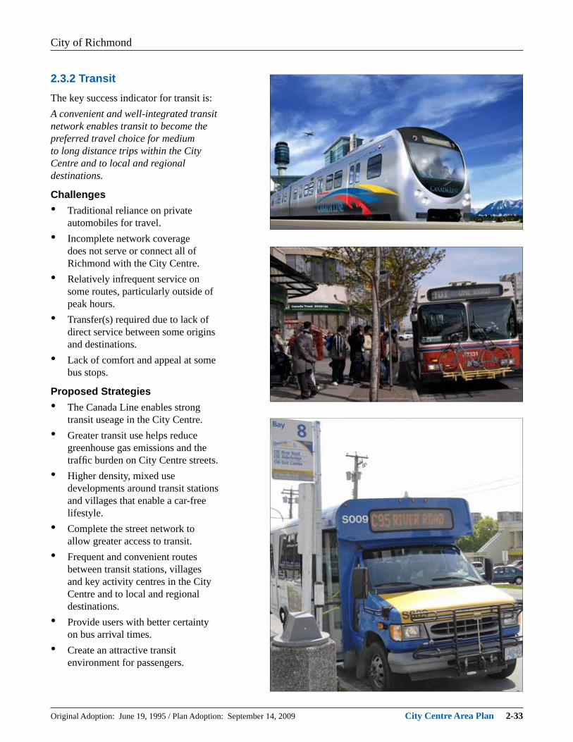
2.3.2 TransitThe key success indicator for transit is:A convenient and well-integrated transit network enables transit to become the preferred travel choice for medium to long distance trips within the City Centre and to local and regional destinations.
Challenges• Traditional reliance on private
automobiles for travel.• Incomplete network coverage
does not serve or connect all of Richmond with the City Centre.
• Relatively infrequent service on some routes, particularly outside of peak hours.
• Transfer(s) required due to lack of direct service between some origins and destinations.
• Lack of comfort and appeal at some bus stops.
Proposed Strategies• The Canada Line enables strong
transit useage in the City Centre.• Greater transit use helps reduce
greenhouse gas emissions and the traffi c burden on City Centre streets.
• Higher density, mixed use developments around transit stations and villages that enable a car-free lifestyle.
• Complete the street network to allow greater access to transit.
• Frequent and convenient routes between transit stations, villages and key activity centres in the City Centre and to local and regional destinations.
• Provide users with better certainty on bus arrival times.
• Create an attractive transit environment for passengers.
City of Richmond
Original Adoption: June 19, 1995 / Plan Adoption: September 14, 2009 City Centre Area Plan 2-34
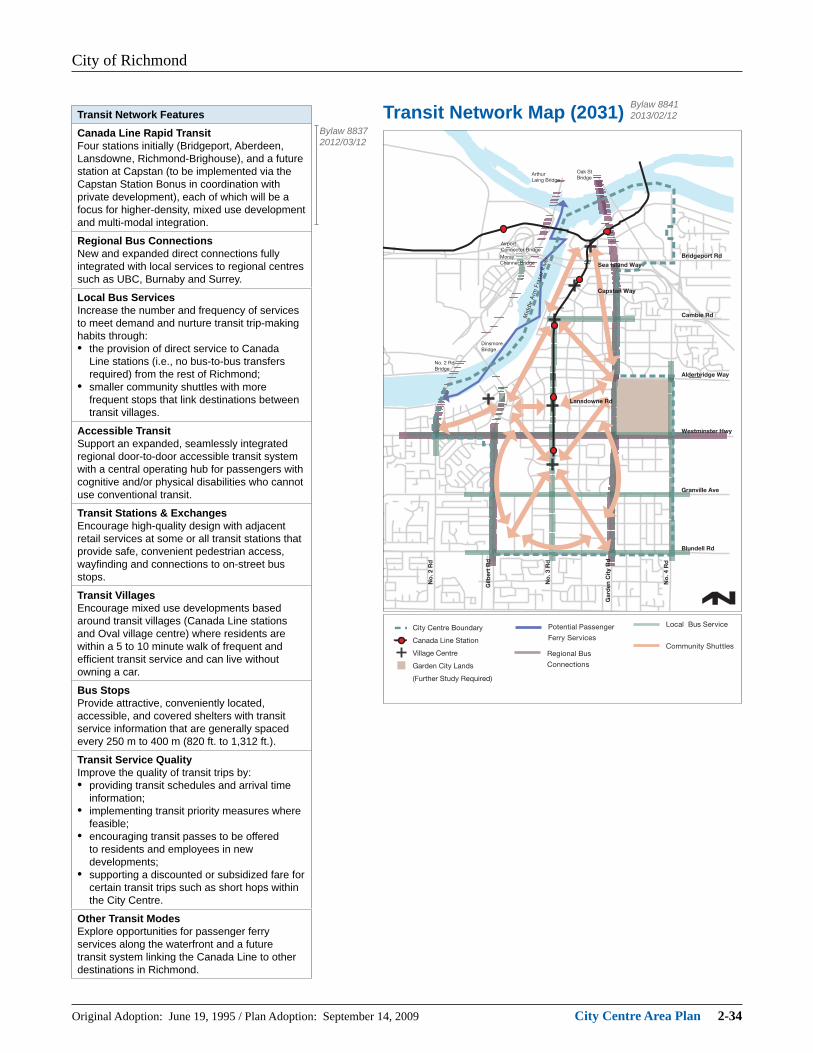
Transit Network Map (2031)Transit Network FeaturesCanada Line Rapid TransitFour stations initially (Bridgeport, Aberdeen, Lansdowne, Richmond-Brighouse), and a future station at Capstan (to be implemented via the Capstan Station Bonus in coordination with private development), each of which will be a focus for higher-density, mixed use development and multi-modal integration.
Regional Bus ConnectionsNew and expanded direct connections fully integrated with local services to regional centres such as UBC, Burnaby and Surrey.
Local Bus ServicesIncrease the number and frequency of services to meet demand and nurture transit trip-making habits through:• the provision of direct service to Canada
Line stations (i.e., no bus-to-bus transfers required) from the rest of Richmond;
• smaller community shuttles with more frequent stops that link destinations between transit villages.
Accessible TransitSupport an expanded, seamlessly integrated regional door-to-door accessible transit system with a central operating hub for passengers with cognitive and/or physical disabilities who cannot use conventional transit.
Transit Stations & ExchangesEncourage high-quality design with adjacent retail services at some or all transit stations that provide safe, convenient pedestrian access, wayfi nding and connections to on-street bus stops.
Transit VillagesEncourage mixed use developments based around transit villages (Canada Line stations and Oval village centre) where residents are within a 5 to 10 minute walk of frequent and effi cient transit service and can live without owning a car.
Bus StopsProvide attractive, conveniently located, accessible, and covered shelters with transit service information that are generally spaced every 250 m to 400 m (820 ft. to 1,312 ft.).
Transit Service QualityImprove the quality of transit trips by:• providing transit schedules and arrival time
information;• implementing transit priority measures where
feasible;• encouraging transit passes to be offered
to residents and employees in new developments;
• supporting a discounted or subsidized fare for certain transit trips such as short hops within the City Centre.
Other Transit ModesExplore opportunities for passenger ferry services along the waterfront and a future transit system linking the Canada Line to other destinations in Richmond.
Bylaw 88372012/03/12
Bylaw 88412013/02/12

City of Richmond
Original Adoption: June 19, 1995 / Plan Adoption: September 14, 2009 City Centre Area Plan 2-35
2.3.3 WalkingThe key success indicator for walking is:The creation of a culture of walking allows people to move in comfort, safety and dignity along shorter blocks that are pedestrian-oriented and accessible.
Challenges• An unappealing pedestrian
environment and incomplete sidewalk network.
• Long city blocks inhibit pedestrian access to destinations.
• Large setbacks of developments from the sidewalk require pedestrians to cross surface parking lots.
Proposed Strategies• A walkable downtown that
encourages and facilitates social interaction, local economic vitality, personal health, and community safety and supports environmental sustainability objectives.
• Shorter city blocks and new pedestrian mews as the street network is completed.
• Appealing and animated streetscapes with resting plazas and gathering places.
• Increased interesting street-facing building fronts that have continuous weather protection.
• A wayfi nding system that directs pedestrians to key amenities, activity centres, transit stations and bus stops.
• Pedestrians favoured in traffi c control at intersections.
• Universal accessible design that allows all pedestrians to travel independently.

City of Richmond
Original Adoption: June 19, 1995 / Plan Adoption: September 14, 2009 City Centre Area Plan 2-36
Pedestrian Environment Map (2031) Bylaw 90412016/07/25Walking Features
Street Network• Every street is walkable and has a sidewalk,
a minimum of 2.0 m (6.5 ft.) wide and preferably 2.5 m (8.2 ft.) wide, with street trees, boulevards and pedestrian lighting.
• Shorter city blocks, narrower street crossings and conveniently timed pedestrian signals.
• Increased curbside parking on minor streets acts as a buffer from adjacent vehicle traffi c.
• A wayfi nding system to guide pedestrians to key destinations.
• An enhanced pedestrian-cyclist crossings at selected locations, particularly near schools.
Streetscape• A creative, fun and welcoming environment
for pedestrians via landscaping, artwork, attractive street furniture, open spaces, gathering places, and resting areas.
• Orient ground level businesses to pedestrian access from the sidewalk.
• Continuous store awnings provide weather protection.
Transit Villages & Connections• Transit schedules and route information
available at transit stations and bus stops.• Fully accessible transit stops conveniently
located and easily recognizable with suffi cient space for waiting passengers.
• Covered walkways provided between transit stops and village centres.
Urban Greenways & Trails• Enhanced streetscape features along urban
greenways and within pedestrian precincts around transit villages.
• Improved trails along the dyke and new links across water boundaries (e.g., Middle and North Arms of the Fraser River).
Accessibility• Enhanced use of universal accessible design
features such as accessible pedestrian signals and tactile wayfi nding.
• Lighting along trail networks where feasible.• Priority given to pedestrian access and safety
through parking lots.• Installation of ramps at all intersections.
City of Richmond
Original Adoption: June 19, 1995 / Plan Adoption: September 14, 2009 City Centre Area Plan 2-37
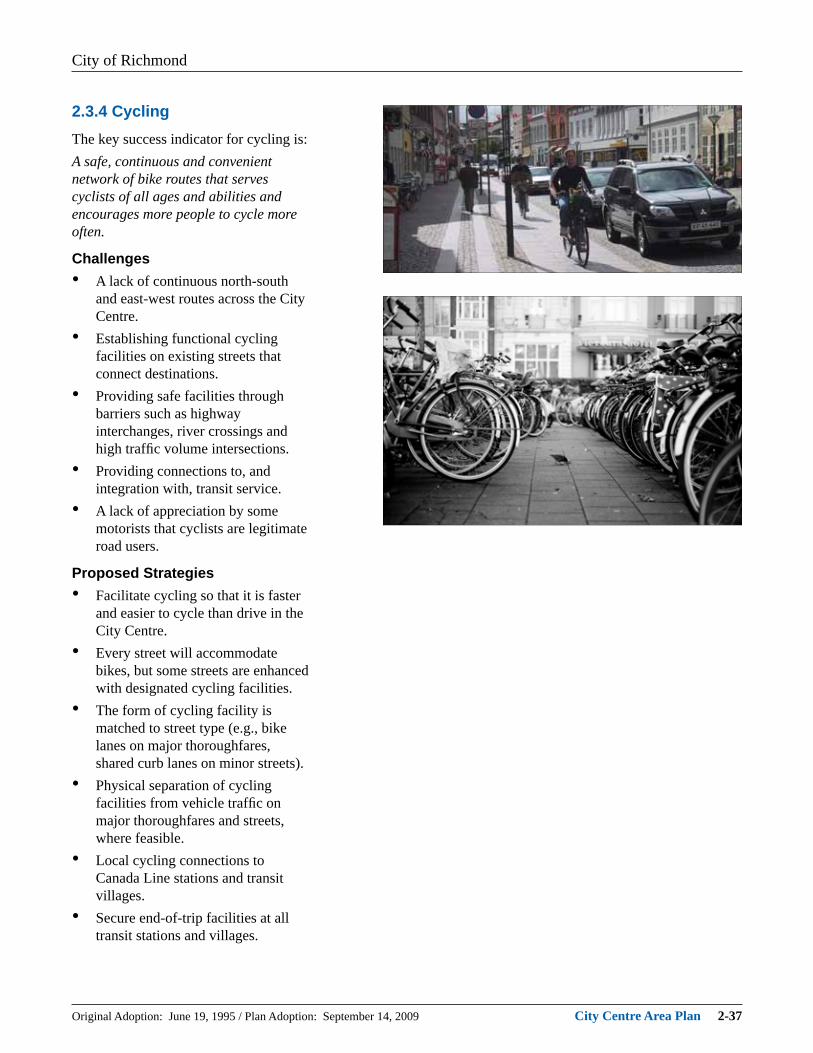
2.3.4 CyclingThe key success indicator for cycling is:A safe, continuous and convenient network of bike routes that serves cyclists of all ages and abilities and encourages more people to cycle more often.
Challenges• A lack of continuous north-south
and east-west routes across the City Centre.
• Establishing functional cycling facilities on existing streets that connect destinations.
• Providing safe facilities through barriers such as highway interchanges, river crossings and high traffi c volume intersections.
• Providing connections to, and integration with, transit service.
• A lack of appreciation by some motorists that cyclists are legitimate road users.
Proposed Strategies• Facilitate cycling so that it is faster
and easier to cycle than drive in the City Centre.
• Every street will accommodate bikes, but some streets are enhanced with designated cycling facilities.
• The form of cycling facility is matched to street type (e.g., bike lanes on major thoroughfares, shared curb lanes on minor streets).
• Physical separation of cycling facilities from vehicle traffi c on major thoroughfares and streets, where feasible.
• Local cycling connections to Canada Line stations and transit villages.
• Secure end-of-trip facilities at all transit stations and villages.

City of Richmond
Original Adoption: June 19, 1995 / Plan Adoption: September 14, 2009 City Centre Area Plan 2-38
Cycling Network Map (2031)Cycling Network FeaturesAccommodation on Street Network• Provide signage and pavement markings to
clearly delineate cycling facilities from other street components.
• Minimize potential confl icts and safely accommodate multiple road users such as transit service and cycling.
• Enhanced pedestrian-cyclist crossings at selected locations, particulary near schools.
Designated Cycling Routes• Designated routes feature signage, pavement
markings and bicycle-friendly traffi c signals.• Designated bike lanes on major
thoroughfares and some major streets with a typical width of 1.5 m to 1.8 m (5 ft. to 6 ft.).
• Cycling routes are physically separated from vehicle traffi c on major thoroughfares and major streets where feasible.
• Shared wide curb lanes on some major streets and on minor streets with typical width of 4.3 m (14.1 ft.).
• Bicycle-friendly routes feature pavement markings, signage and signal loop detectors but road is not widened.
Trails & Bridges• Integration of on-street cycling network with
off-street trails and pathways including the Canada Line Bridge over the North Arm of the Fraser River.
• Off-street pathways have typical width of 3.0 m to 4.0 m (10 ft. to 13.1 ft.).
• Proposed new pedestrian/cycling bridge from the west end of Cambie Road to Sea Island.
End-of-Trip Facilities• Secure end-of-trip facilities (bike racks,
lockers, cages) at civic sites, parks, transit villages, and activity centres.
• Bylaw requirement for all new developments to provide short-term and long-term secure bicycle parking.
Integration with Transit• Bicycle accommodation on the Canada Line
and all buses during all hours of operation.• Bike racks and bike lockers at all rapid transit
stations and transit exchanges.
Promotion & Education• Safe cycling courses for adults and children.• Area-wide event to promote cycling for all
trips.• Education and enforcement programs to
encourage sharing the road among motorists and cyclists.
d R 4 .
o N
d R y t i
C n e d r a
G
d R 3 .
o N
d R 2 .
o N
Airport Connector Bridge
Oak St Bridge
Arthur Laing Bridge
Moray Channel Bridge
reviR resarF
mrA elddi
M
Dinsmore Bridge
No. 2 Rd Bridge
d R t r e
b l i G
Bridgeport Rd Sea Island Way
Cambie Rd
Capstan Way
Lansdowne Rd
Westminster Hwy
Granville Ave
Blundell Rd
Alderbridge Way
City Centre Boundary
Canada Line Station
Village Centre
Garden City Lands
(Further Study Required)
Trails (Existing)
Bike Lanes (Existing)
Designated Routes (Existing)
Proposed Key Routes
Proposed Bicycle- Friendly Routes
Proposed Off-Street Multi-Use Paths
Pedestrian-Cyclist Crossing Enhancements
Major Park (Future)
Major Park (Existing)
Public School Land
Bylaw 88412013/02/12

City of Richmond
Original Adoption: June 19, 1995 / Plan Adoption: September 14, 2009 City Centre Area Plan 2-39
2.3.5 Driving & ParkingThe key success indicator for driving and parking is:Driving is considered an option, not a routine choice and parking is better managed to minimize its footprint on the urban environment.
Challenges• Reversing the current lifestyle
of traditional reliance on private vehicles for travel.
• Broadening the concept of “freedom to travel” to include other modes besides private vehicles.
• Limit the number of continuous major thoroughfares across the City Centre; concentrate vehicle travel on a few streets.
• Alternative travel modes are not competitive with driving in terms of travel time, service and facility availability, and convenience.
• Private parking lot management discourages shared use.
Proposed Strategies• Encourage options to private vehicle
ownership such as car-sharing and home delivery.
• Increase the capacity of the road network without major widening.
• A tighter street grid to minimize unnecessary circulation.
• Balance reduced parking strategies (as incentive to lower auto usage) with accessible, short-term parking in selected areas that supports businesses.
• Promote the concept that having a parking space is not necessarily a part of home ownership.
• Encourage businesses to allow customers to park in one site while shopping at multiple nearby establishments.
• Encourage developers to invest in alternative transporation as opposed to parking infrastructure.
City of Richmond
Original Adoption: June 19, 1995 / Plan Adoption: September 14, 2009 City Centre Area Plan 2-40
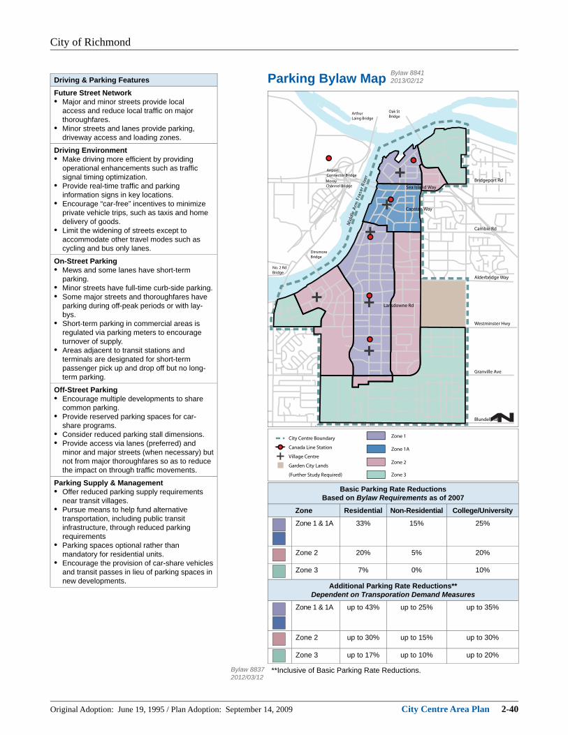
Parking Bylaw Map
Airport Connector Bridge
Oak St Bridge
Arthur Laing Bridge
Moray Channel Bridge
reviR resarF
mrA elddi
M
Dinsmore Bridge
No. 2 Rd Bridge
Bridgeport Rd Sea Island Way
Cambie Rd
Capstan Way
Lansdowne Rd
Westminster Hwy
Granville Ave
Blundell Rd
Alderbridge Way
City Centre Boundary
Canada Line Station
Village Centre
Garden City Lands
(Further Study Required)
Zone 1
Zone 2
Zone 1A
Zone 3
Driving & Parking FeaturesFuture Street Network• Major and minor streets provide local
access and reduce local traffi c on major thoroughfares.
• Minor streets and lanes provide parking, driveway access and loading zones.
Driving Environment• Make driving more effi cient by providing
operational enhancements such as traffi c signal timing optimization.
• Provide real-time traffi c and parking information signs in key locations.
• Encourage “car-free” incentives to minimize private vehicle trips, such as taxis and home delivery of goods.
• Limit the widening of streets except to accommodate other travel modes such as cycling and bus only lanes.
On-Street Parking• Mews and some lanes have short-term
parking.• Minor streets have full-time curb-side parking.• Some major streets and thoroughfares have
parking during off-peak periods or with lay-bys.
• Short-term parking in commercial areas is regulated via parking meters to encourage turnover of supply.
• Areas adjacent to transit stations and terminals are designated for short-term passenger pick up and drop off but no long-term parking.
Off-Street Parking• Encourage multiple developments to share
common parking.• Provide reserved parking spaces for car-
share programs.• Consider reduced parking stall dimensions.• Provide access via lanes (preferred) and
minor and major streets (when necessary) but not from major thoroughfares so as to reduce the impact on through traffi c movements.
Parking Supply & Management• Offer reduced parking supply requirements
near transit villages.• Pursue means to help fund alternative
transportation, including public transit infrastructure, through reduced parking requirements
• Parking spaces optional rather than mandatory for residential units.
• Encourage the provision of car-share vehicles and transit passes in lieu of parking spaces in new developments.
Basic Parking Rate ReductionsBased on Bylaw Requirements as of 2007
Zone Residential Non-Residential College/University
Zone 1 & 1A 33% 15% 25%
Zone 2 20% 5% 20%
Zone 3 7% 0% 10%
Additional Parking Rate Reductions**Dependent on Transporation Demand Measures
Zone 1 & 1A up to 43% up to 25% up to 35%
Zone 2 up to 30% up to 15% up to 30%
Zone 3 up to 17% up to 10% up to 20%
**Inclusive of Basic Parking Rate Reductions.Bylaw 88372012/03/12
Bylaw 88412013/02/12

City of Richmond
Original Adoption: June 19, 1995 / Plan Adoption: September 14, 2009 City Centre Area Plan 2-41
2.3.6 Goods Movement & Emergency ServicesThe key success indicator for goods movement and emergency services is:Goods movement is effi ciently accommodated and special traffi c management systems minimize the response times of emergency service providers.
Challenges• Maintaining the convenient and
timely access for goods movement and emergency services as the City Centre grows.
• Reducing potential confl icts with other road users including pedestrians, cyclists and transit.
Proposed Strategies• Major thoroughfares operate as
primary goods movement corridors with no direct driveway access to properties.
• Delivery and loading activities primarily occur in service lanes to minimize impact on traffi c fl ow and potential on-street parking.
• On-street loading zones consolidated as much as possible.
• Common parking and loading areas shared by several businesses.
• Major thoroughfares include signal pre-emption for emergency service access.
• Future emergency service facilities located to minimize response times.
• Future street network creates more opportunities for alternative forms of police patrol, such as on foot or bike.
• Minimize dangerous goods movement in City Centre

City of Richmond
Original Adoption: June 19, 1995 / Plan Adoption: September 14, 2009 City Centre Area Plan 2-42
Goods Movement & LoadingMap (2031)
Bylaw 95932017/05/08Goods Movement & Emergency Services
FeaturesGoods Movement Corridors• Major thoroughfares and streets act as the
primary goods movement corridors with minor streets and lanes providing access for local deliveries and loading.
• Support other modes of goods movement such as rail in the Bridgeport area and the potential for short-sea shipping routes along the Fraser River.
Loading Locations• Provide off-street loading docks within parking
areas for zones of high trucking activity.• Construction loading zones provided where
feasible to facilitate pick up and drop off of construction materials and minimize traffi c disruption.
• Service lanes and mews are the preferred on-street locations.
• Limited to areas adjacent to on-street parking on minor streets.
• Available on some major streets in off-peak periods but not permitted on major thoroughfares.
Emergency Services• Priority is given to emergency service access
and timely response.• Major thoroughfares and some major and
minor street intersections incorporate traffi c signal pre-emption capability.
• Parking regulations ensure that lanes and mews are kept accessible for emergency vehicles.
• Consider response time requirements for emergency services when identifying priority routes.
Planning & Policy• Maintain liaison with the Provincial Emergency
Program to protect local disaster response routes as part of the regional network.
• Restrict unnessary dangerous goods movement in City Centre.
• Seek to minimize response times when planning the site of future emergency service facilities.
• On-going liaison with stakeholders (e.g., trucking industry) to enhance goods movement.

City of Richmond
Original Adoption: June 19, 1995 / Plan Adoption: September 14, 2009 City Centre Area Plan 2-43
2.3.7 Supporting MeasuresThe key success indicator for transportation supporting measures is:Policies and programs are in place that make the transportation system smarter, manage travel demand and encourage a shift to sustainable travel modes.
Challenges• The full benefi ts of potential
measures require a co-ordinated approach amongst all levels of government and stakeholders.
• Some technology-based measures are still in the development stage.
• Existing lifestyles and policies (e.g., fi xed work hours, few tax incentives for transit use) impede implementation.
Proposed Strategies• Greater use of transportation
demand management (TDM) measures, which are strategies that encourage alternative transportation use in order to increase transportation system effi ciency.
• Greater use of intelligent transportation systems (ITS) strategies, which is the use of information technologies (GPS, telecommunications, the Internet) to improve transportation system performance and effi ciency.
• Work with local, regional, provincial, and federal agencies to collaboratively implement initiatives that are outside the direct control of the City.
Potential Supporting MeasuresIncentives to Use Other Modes & Reduce DrivingKey Measures• Car-share and car co-op programs that reduce private vehicle
ownership and use.• High occupancy vehicle (HOV) lanes that give priority to transit and
rideshare vehicles.• Ride-matching services to enable carpooling.• Community and employer transit pass programs.• Safe and active (e.g., walking and cycling) routes to schools.Additional Measures• Equitable transit fare structure and more convenient fare payment such
as electronic “smart” cards.• Public bike-share system of network of distributed bikes available for
free or nominal charge use.• Home delivery of goods and services.• Marketing and education to promote sustainable travel modes.Workplace TDMKey Measures• Free or discounted transit passes.• Guaranteed ride home on an occasional basis for commuters who
typically do not use a private vehicle.• Secure bike parking with showers and lockers.• Ridesharing using company or privately owned vehicles with reserved
parking.• Cash-out amount equivalent to subsidized benefi t of free workplace
parking in lieu of providing parking.Additional Measures• Alternative workplace schedules such as fl exible hours, compressed
work week and staggered shifts.• Telecommuting and tele- or videoconferencing.• Company shuttle between transit station and workplace.• Reimbursement of business travel expenses for modes other than
vehicles.Parking & Land Use ManagementKey Measures• Park and ride lots at transit stations and terminals.• Reduced and maximum parking bylaw requirements.• Direct user fee for parking with free or discounted parking for rideshare
vehicles.Additional Measures• Variable parking rates that are higher for prime locations and peak
times.• Parking rates that equal or exceed transit fares.• Manage and price the most convenient parking spaces to favour
priority users.• Minimize discounts for long-term parking passes.Policy MeasuresKey Measures• Universal accessible design to ensure barrier-free access.• Review tax policies to encourage sustainable travel modes.• Distance-based vehicle insurance rates.• Consider tax exemptions for employer-provided transit benefi ts.Additional Measures• Explore region-wide road pricing (e.g., tolls, congestion charges).Intelligent Transportation Systems (ITS)Key Measures• On-line and wireless pre-trip and en route traveller information such as
traffi c conditions.• Traffi c signal co-ordination and optimization and transit priority at
intersections.• Participation in a regional transportation management centre.Additional Measures• Encourage telecommunications as a substitute for physical travel
(e.g., telecommuting, distance-learning, on-line shopping).

City of Richmond
Original Adoption: June 19, 1995 / Plan Adoption: September 14, 2009 City Centre Area Plan 2-44
2.3.8 Fostering a Car-Free LifestyleThe principles of transit-oriented development and complete communities together with the complementary policies and key directions for each component of the transportation system jointly seek to foster a “car-free” lifestyle as a viable option for City Centre households over time.
Ideally, with more choices, it will be possible and even desirable for residents to have only one or perhaps no car at all. If an effective range of non-car mobility choices, infrastructure, services, and supporting initiatives are in place, the car-free lifestyle becomes feasible and public investments in the Canada Line and the transit system, as well as the City’s commitment to sustainability, are maximized.
Key to the realization of this vision is the recognition that:• people often make multi-purpose
trips and need to carry groceries and bulky items home, which makes giving up a vehicle diffi cult;
• the City, through the City Centre Area Plan, can encourage people to use alternative modes of travel (walking, cycling, transit);
• by setting the stage now, existing and future generations will be better able to use sustainable travel alternatives.
Checklist for a Car-Free LifestyleTransit Villages
• Compact, mixed use development that enables easy walking to convenient transit linkages.
• The daily needs of City Centre residents and workers are within reach of walking and transit.
Access to Vehicles
• Enable residents to access cars when needed, without having to own a vehicle.
• Encourage all developments to provide or contribute to a car share program.
• Encourage retail and other destination-type uses to provide priority parking for car share use.
Access to Retail Goods and Services
• Encourage retail uses to provide home pick-up and delivery services, ideally at no or minimal cost.
• Encourage retailers to schedule delivery and pick-up at times when residents are most likely to be at home and traffi c volumes are low (e.g., evenings).
• Encourage retailers and other service providers (e.g., furniture movers) to avoid the use of large vehicles that are diffi cult to accommodate in dense urban areas.
• Encourage co-ordinated delivery services for multi-tenant retail developments.
• Ensure that sidewalks and pathways have suffi cient width to accommodate pedestrian modes including scooters and handcarts.
Home Delivery & Pick-Up Services
• Encourage residential developments to provide spaces for concierge services to enable home deliveries and pick-up (e.g., groceries, drycleaning, etc.).
• Ensure suffi cient common space/secure areas for the temporary storage of goods to be picked-up and deliveries until the owner arrives home.
• Ensure that loading areas are publicly accessible for larger delivery trucks and publicly accessible.
• Provide on-street loading zones, where feasible, to allow for home delivery/pick-up in higher density projects without off-street parking or service lanes are not readily available.