Embed Size (px)
Citation preview
NY Rising Community Reconstruction Program
MARCH 2014
NEIGHBORSCLOSE KNIT COMMUNITY
bayVENETIAN SHORE
FRIENDLYPEOPLEbeach town
COMMUNITYbay
neighborhoodgreat waves
BEACHES COMMUNITYVENICE ISLANDS
the bayCOMMUNITYbeach townbay
COMMITTEDpeople
BOATING
VENETIANSHOREPARKS
AND BEACHES
CARINGAND
SUPPORTIVEbay
WATERFRONTBOATING
communityPEOPLE
bay
wavesgreat
BOATINGbeach
committed
PEOPLE
neighborshelping
neighbors
Parks and Beaches
CARING AND SUPPORTIVE
boating
FRIENDLY
friendly
NEIGHBORHOOD
WATER FRONT
BEACH TOWN
VENICE ISLANDS
GREAT WAVESBEACHTHE BAY
great waves
PEOPLEfriendly
BAY
VENETIAN SHORE
VENETIANSHORE
WATERFRONT
beachfriendly
BOATINGPARKS
LINDENHURST
FRIENDLYTOWN
COMMITTED
great waves
VENICE ISLANDS
VENETIAN SHORE beach town
FRIENDLY
VENETIAN ISLANDS NEIGHBORS PEOPLE WATERFRONT COMMUNITY CLOSE KNIT THE BAYBOATING WATERFRONT GREAT WAVES THE BAY COMMITTED NEIGHBORHOOD FRIENDLY BEACH
COASTAL CARING AND SUPPORTIVE FRIENDLY PARKS AND BEACHES PEOPLE COMMUN
NEIGHBORHOOD GREAT WAVES PEOPLE COMMUNITY WATERFRONT BOATING CARINCLOSE KNIT COMMUNITY GREAT WAVES COMMITTED THE BAY BEACH TOWN FRIEND
WATER FRONT
bayNEIGHBORSCLOSE KNIT COMMUNITY
PEOPLE BEACHparks and beachesFRIENDLY
boatingTHE BAY
BAY
NEIGHBORHOOD BAYCARING AND SUPPORTIVE
NEIGHBORS HELPING NEIGHBORS BOATING
GREAT WAVES SHORE
BEACHNEIGHBORS HELPING
NEIGHBORSPEOPLE THE BAYPARKS AND BEACHES
NEIGHBORHOODCOMMUNITY
CLOSE KNIT COMMUNITY
great wavesFRIENDLYSHORE
FRIENDLYPEOPLESHORE
boatingCARING
THE BAY
CLOSE KNIT
COMMUNITYBEACH
COMMUNITYboating COMMITTEDNEIGHBORS HELPING NEIGHBORSNEIGHBORScaring and supportiveWATERFRONT COMMUNITYGREAT WAVES
CLOSE KNIT COMMUNITYPEOPLE BAYboating
friendlyVENICE ISLAND
BEACHCARING
BAY
NEIGHBORS HELPING
NEIGHBORS BOATING
CLOSE KNITCOMMUNITY
CARING AND SUPPORTIVE
BOATING WAVES
PARKS AND BEACHES
WATERFRONTCOMMUNITY
VENICEISLANDS
BEACH TOWNVENETIAN SHORE
GREAT WAVES
V I L L A G E O F L I N D E N H U R S T
NY Rising Community Reconstruction Plan

Page| i
Lindenhurst NY Rising Community Reconstruction Plan Village of Lindenhurst NY Rising Community Reconstruction Plan
NY Rising Community Reconstruction Program Lindenhurst Planning Committee
Committee Role Name
Co-Chair David Collins
Co-Chair Alex Keller
Member Amy Castiglia
Member Shawn Cullinane*
Member Mary Ellen Cunningham*
Member Daniel Horn
Member Jacqueline Milton
Member Belinda Pagdanganan
Member Gloria Sheahan*
Member Maryann Weckerle* * Non-Voting Member
This document was developed by the NYRCR Village of Lindenhurst Planning Committee as part of the NY Rising Community Reconstruction (NYRCR) Program within the Governor’s Office of Storm Recovery. The NYRCR Program is supported by NYS Homes and Community Renewal, NYS Department of State, and NYS Department of Transportation. The document was prepared by the following consulting firms:
Foreword| i
Village of Lindenhurst NY Rising Community Reconstruction Plan
Foreword
Introduction
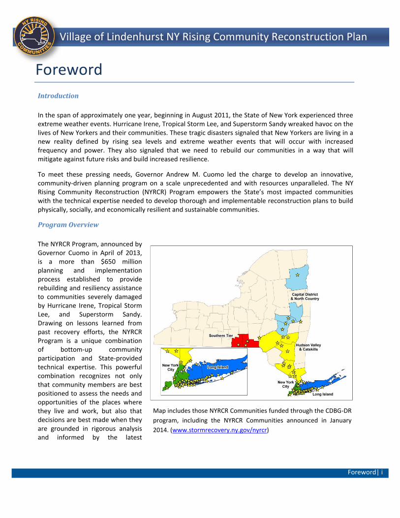
In the span of approximately one year, beginning in August 2011, the State of New York experienced three extreme weather events. Hurricane Irene, Tropical Storm Lee, and Superstorm Sandy wreaked havoc on the lives of New Yorkers and their communities. These tragic disasters signaled that New Yorkers are living in a new reality defined by rising sea levels and extreme weather events that will occur with increased frequency and power. They also signaled that we need to rebuild our communities in a way that will mitigate against future risks and build increased resilience.
To meet these pressing needs, Governor Andrew M. Cuomo led the charge to develop an innovative, community-driven planning program on a scale unprecedented and with resources unparalleled. The NY Rising Community Reconstruction (NYRCR) Program empowers the State’s most impacted communities with the technical expertise needed to develop thorough and implementable reconstruction plans to build physically, socially, and economically resilient and sustainable communities.
Program Overview
The NYRCR Program, announced by Governor Cuomo in April of 2013, is a more than $650 million planning and implementation process established to provide rebuilding and resiliency assistance to communities severely damaged by Hurricane Irene, Tropical Storm Lee, and Superstorm Sandy. Drawing on lessons learned from past recovery efforts, the NYRCR Program is a unique combination of bottom-up community participation and State-provided technical expertise. This powerful combination recognizes not only that community members are best positioned to assess the needs and opportunities of the places where they live and work, but also that decisions are best made when they are grounded in rigorous analysis and informed by the latest
Map includes those NYRCR Communities funded through the CDBG-DR
program, including the NYRCR Communities announced in January
2014. (www.stormrecovery.ny.gov/nyrcr)
Foreword | ii
Lindenhurst NY Rising Community Reconstruction Plan Village of Lindenhurst NY Rising Community Reconstruction Plan
innovative solutions.
One hundred and two storm-affected localities across the State were originally designated to participate in the NYRCR Program. The State has allocated each locality between $3 million and $25 million to implement eligible projects identified in the NYRCR Plan. The funding for these projects is provided through the U.S. Department of Housing and Urban Development (HUD) Community Development Block Grant – Disaster Recovery (CDBG-DR) program.1
Forty-five NYRCR Communities, each comprising one or more of the 102 localities, were created and led by a NYRCR Planning Committee composed of local residents, business owners, and civic leaders. Members of the Planning Committees were identified in consultation with established local leaders, community organizations, and in some cases municipalities. The NYRCR Program sets a new standard for community participation in recovery and resiliency planning, with community members leading the planning process. Across the State, more than 500 New Yorkers represent their communities by serving on Planning Committees. More than 400 Planning Committee Meetings have been held, during which Planning Committee members worked with the State’s NYRCR Program team to develop community reconstruction plans and identify opportunities to make their communities more resilient. All meetings were open to the public. An additional 125-plus Public Engagement Events attracted thousands of community members, who provided feedback on the NYRCR planning process and proposals. The NYRCR Program’s outreach has included communities that are traditionally underrepresented, such as immigrant populations and students. All planning materials are posted on the NYRCR Program’s website (www.stormrecovery.ny.gov/nyrcr), providing several ways for community members and the public to submit feedback on materials in progress.
Throughout the planning process, Planning Committees were supported by staff from the Governor’s Office of Storm Recovery (GOSR), planners from New York State (NYS) Department of State (DOS) and NYS Department of Transportation (DOT), and consultants from world-class planning firms that specialize in engineering, flood mitigation solutions, green infrastructure, and more.
With the January 2014 announcement of the NYRCR Program’s expansion to include 22 new localities, the program comprises over 2.7 million New Yorkers and covers nearly 6,500 square miles, which is equivalent to 14% of the overall State population and 12% of the State’s overall geography.
The NYRCR Program does not end with this NYRCR Plan. Governor Cuomo has allocated over $650 million of funding to the program for implementing projects identified in the NYRCR Plans. NYRCR Communities are also eligible for additional funds through the program’s NY Rising to the Top Competition, which evaluates NYRCR Communities across eight categories, including best use of technology in the planning process, best approach to resilient economic growth, and best use of green infrastructure to bolster resilience. The winning NYRCR Community in each category will be allocated an additional $3 million of implementation funding. The NYRCR Program is also working with both private and public institutions to identify existing funding sources and create new funding opportunities where none existed before.
The NYRCR Program has successfully coordinated with State and Federal agencies to help guide the development of feasible projects. The program has leveraged the Regional Economic Development
1 Five of the 102 localities in the program—Niagara, Herkimer, Oneida, Madison, and Montgomery Counties—are not funded through the CDBG-DR program.
Foreword | iii
Lindenhurst NY Rising Community Reconstruction Plan Village of Lindenhurst NY Rising Community Reconstruction Plan
Council’s State Agency Review Teams (SARTs), comprised of representatives from dozens of State agencies and authorities, for feedback on projects proposed by NYRCR Communities. The SARTs review projects with an eye toward regulatory and permitting needs, policy objectives, and preexisting agency funding sources. The NYRCR Program is continuing to work with the SARTs to streamline the permitting process and ensure shovels are in the ground as quickly as possible.
On the pages that follow, you will see the results of months of thoughtful, diligent work by NYRCR Planning Committees, passionately committed to realizing brighter, more resilient futures for their communities.
The NYRCR Plan
This NYRCR Plan is an important step toward rebuilding a more resilient community. Each NYRCR Planning Committee began the planning process by defining the scope of its planning area, assessing storm damage, and identifying critical issues. Next, the Planning Committee inventoried critical assets in the community and assessed the assets’ exposure to risk. On the basis of this work, the Planning Committee described recovery and resiliency needs and identified opportunities. The Planning Committee then developed a series of comprehensive reconstruction and resiliency strategies, and identified projects and implementation actions to help fulfill those strategies.
The projects and actions set forth in this NYRCR Plan are divided into three categories. The order in which the projects and actions are listed in this NYRCR Plan does not necessarily indicate the NYRCR Community’s prioritization of these projects and actions. Proposed Projects are projects proposed for funding through a NYRCR Community’s allocation of CDBG-DR funding. Featured Projects are projects and actions that the Planning Committee has identified as important resiliency recommendations and has analyzed in depth, but has not proposed for funding through the NYRCR Program. Additional Resiliency Recommendations are projects and actions that the Planning Committee would like to highlight and that are not categorized as Proposed Projects or Featured Projects. The Proposed Projects and Featured Projects found in this NYRCR Plan were voted for inclusion by official voting members of the Planning Committee. Those voting members with conflicts of interest recused themselves from voting on any affected projects, as required by the NYRCR Ethics Handbook and Code of Conduct.
NYRCR Village of Lindenhurst is eligible for up to $6.1 million in CDBG-DR implementation funds.
While developing projects for inclusion in this NYRCR Plan, Planning Committees took into account cost estimates, cost-benefit analyses, the effectiveness of each project in reducing risk to populations and critical assets, feasibility, and community support. Planning Committees also considered the potential likelihood that a project or action would be eligible for CDBG-DR funding. Projects and actions implemented with this source of Federal funding must fall into a Federally-designated eligible activity category, fulfill a national objective (meeting an urgent need, removing slums and blight, or benefiting low to moderate income individuals), and have a tie to the natural disaster to which the funding is linked. These are among the factors that the Governor’s Office of Storm Recovery will consider, in consultation with local municipalities and nonprofit organizations, when determining which projects and actions are best positioned for implementation.
The total cost of Proposed Projects in this NYRCR Plan exceeds the NYRCR Community’s CDBG-DR allocation to allow for flexibility if some Proposed Projects cannot be implemented due to environmental review, HUD
Foreword | iv
Lindenhurst NY Rising Community Reconstruction Plan Village of Lindenhurst NY Rising Community Reconstruction Plan
eligibility, technical feasibility, or other factors. Implementation of the projects and actions found in this NYRCR Plan are subject to applicable Federal, State, and local laws and regulations, including the Americans with Disabilities Act (ADA). Inclusion of a project or action in this NYRCR Plan does not guarantee that a particular project or action will be eligible for CDBG‐DR funding or that it will be implemented. The Governor’s Office of Storm Recovery will actively seek to match projects with funding sources.
In the months and years to follow, many of the projects and actions outlined in this NYRCR Plan will become a reality helping New York not only to rebuild, but also to build back better.
TOC | i
Village of Lindenhurst NY Rising Community Reconstruction Plan
Table of Contents
Executive Summary ........................................................................................................................................ ES-1
Section I: Community Overview .......................................................................................................................... 1
A. Geographic Scope of the NYRCR Plan ....................................................................................................... 6
B. Description of Storm Damage ................................................................................................................. 11
C. Critical Issues ........................................................................................................................................... 14
D. Community Vision ................................................................................................................................... 17
E. Relationship to Regional Plans ................................................................................................................ 19
Section II: Assessment of Risk and Needs ......................................................................................................... 29
A. Description of Community Assets and Assessment of Risk .................................................................... 29
i. Description of Community Assets .......................................................................................................... 29
ii. Assessment of Risk to Assets and Systems ............................................................................................ 39
B. Assessment of Needs and Opportunities ................................................................................................ 45
Section III: Reconstruction and Resiliency Strategies ........................................................................................ 51
A. Reconstruction and Resiliency Strategies ............................................................................................... 52
Section IV: Implementation - Project Profiles ................................................................................................... 60
Introduction ............................................................................................................................................... 60
Cost Benefit Analysis ................................................................................................................................. 61
PROPOSED PROJECT: Comprehensive Drainage Infrastructure Master Plan and Phase I Repairs ..................... 64
PROPOSED PROJECT: Lindenhurst Village South Storm Water Drainage System Phase II Improvements ........ 68
PROPOSED PROJECT: Bower School Property Adaptive Re-Use Study and Acquisition ..................................... 73
PROPOSED PROJECT: Shore Road Waterfront Park Natural Systems Resiliency Improvements and Preliminary
Plan for Acquisition of Adjoining Properties ........................................................................................... 77
PROPOSED PROJECT: Neguntatogue Park (Lincoln Park) Natural Systems Resiliency Improvements/Creek
Habitat Walk ........................................................................................................................................... 81
PROPOSED PROJECT: Village of Lindenhurst Economic Development and Action Plan ..................................... 85
PROPOSED PROJECT: Regional Canal Dredging Program ................................................................................... 89
PROPOSED PROJECT: Ground Fill/Ground Recycling Program ........................................................................... 93
TOC | ii
Lindenhurst NY Rising Community Reconstruction Plan Village of Lindenhurst NY Rising Community Reconstruction Plan
PROPOSED PROJECT: Integrated Web-based, Communication & Emergency Cellphone Infrastructure
Improvements ......................................................................................................................................... 95
PROPOSED PROJECT: Tree Census and Resilient Planting Management Plan ................................................... 97
PROPOSED PROJECT: Emergency Action and Preparedness Plan/Lindenhurst Community Center Retrofit .. 100
PROPOSED PROJECT: Emergency Equipment Purchases: High Water Evacuation Vehicle, Search & Rescue
Watercraft ............................................................................................................................................. 103
Section V: Additional Materials ....................................................................................................................... 106
A. Additional Resiliency Recommendations .............................................................................................. 106
B. Master Table of Projects ....................................................................................................................... 108
C. Public Engagement Process .................................................................................................................. 112
D. Community Asset Inventory .................................................................................................................. 116
E. Glossary ................................................................................................................................................. 121
Acronyms ................................................................................................................................................. 121
Terms ....................................................................................................................................................... 122
F. End Notes .............................................................................................................................................. 124

TOC | iii
Lindenhurst NY Rising Community Reconstruction Plan Village of Lindenhurst NY Rising Community Reconstruction Plan
List of Tables Table ES- 1: NYRCR Village of Lindenhurst Resiliency Projects ...................................................................... ES-6
Table 1: Fire Stations ......................................................................................................................................... 35
Table 2: Extension Clinics .................................................................................................................................. 36
Table 3: NYS OPWDD State and Voluntary Program Locations ......................................................................... 36
Table 4: Post Offices .......................................................................................................................................... 36
Table 5: Schools ................................................................................................................................................. 36
Table 6: Village Hall ........................................................................................................................................... 37
Table 7: Infrastructure Resources ..................................................................................................................... 38
Table 8: Housing Resources ............................................................................................................................... 38
Table 9: Economic Resources ............................................................................................................................ 38
Table 10: Risk Assessment Table ....................................................................................................................... 42
Table 11: Needs and Opportunities ................................................................................................................... 49
Table 12: Strategy: Increase Emergency Preparedness through Public Awareness and Enhanced
Communications Systems ........................................................................................................................... 53
Table 13: Strategy: Integrate “Green” and “Gray” Infrastructure to Holistically Manage Stormwater ........... 55
Table 14: Strategy: Improve Economic Resiliency ............................................................................................. 56
Table 15: Strategy: Improve Emergency Preparedness by Adequately Equipping First Responders ............... 57
Table 16: Strategy: Improve and ensure access to residential properties ........................................................ 58
Table 17: Strategy: Alleviate public safety hazards through planned tree management ................................. 59
Table 18: Additional Resiliency Recommendations ........................................................................................ 106
Table 19: Master Project Table ....................................................................................................................... 108
List of Figures Figure 1: Community Area Location Map ............................................................................................................ 8
Figure 2: Risk Areas and Superstorm Sandy Inundation ................................................................................... 32
Figure 3: Assets at Risk Map .............................................................................................................................. 44

Executive Summary | ES- 1
Lindenhurst NY Rising Community Reconstruction Plan Village of Lindenhurst NY Rising Community Reconstruction Plan
Executive Summary The Village of Lindenhurst (the Village) is located along the South
Shore of Suffolk County, Long Island, New York. The Village, which lies
within the Town of Babylon, is bounded by Copiague to the west and
West Babylon to the east. North Lindenhurst lies to the north with
North Amityville to the northwest. The Village fronts the Great South
Bay and features an extensive waterfront and canal system. As a
result of its proximity to the water, the Village is characterized by
single family residences and water-dependent uses exemplified by a
concentration of marina and marine industry support services,
especially south of Montauk Highway. The Village’s homes, businesses,
and infrastructure suffered significant damage as a result of
Superstorm Sandy.
As part of the ongoing recovery from Superstorm Sandy, the Village of
Lindenhurst’s NY Rising Community Reconstruction Program (NYRCR)
Committee (Committee) took on the responsibility of developing a
plan that laid the groundwork for the Village’s resilient future. The
composition of the Committee included a cross-section of the Village
population including municipal representatives, local residents, and
members of local businesses and community organizations. The Village
of Lindenhurst’s NYRCR Committee Co-Chairs were selected by the
State in consultation with the Village. With the entire Village involved,
and with the help of New York State, the Committee has produced a
pragmatic recovery and resiliency plan.
Overview
NY Rising Community Reconstruction (NYRCR) Village of Lindenhurst (Community) is one of eight NYRCR Communities identified within Suffolk County. The geographic scope of NYRCR Village of Lindenhurst corresponds to the Village of Lindenhurst’s incorporated boundaries. A total of up to $6.1 million has been allocated for resiliency projects within this Community. The Village of Lindenhurst is a neat and tidy community. The residents and businesses here take pride in what they and their neighbors have worked so hard to create. Many of the residents have grown up in this Village and have chosen to remain here. Others have made the
The Village of Lindenhurst NYRCR boundaries correspond to the Village Boundaries.
Executive Summary | ES- 2
Lindenhurst NY Rising Community Reconstruction Plan Village of Lindenhurst NY Rising Community Reconstruction Plan
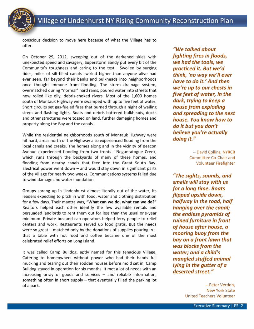
conscious decision to move here because of what the Village has to offer. On October 29, 2012, sweeping out of the darkened skies with unexpected speed and savagery, Superstorm Sandy put every bit of the Community’s toughness and caring to the test. Swollen by surging tides, miles of silt-filled canals swirled higher than anyone alive had ever seen, far beyond their banks and bulkheads into neighborhoods once thought immune from flooding. The storm drainage system, overmatched during “normal” hard rains, poured water into streets that now roiled like oily, debris-choked rivers. Most of the 1,600 homes south of Montauk Highway were swamped with up to five feet of water. Short circuits set gas-fueled fires that burned through a night of wailing sirens and flashing lights. Boats and debris battered bulkheads, docks and other structures were tossed on land, further damaging homes and property along the Bay and the canals. While the residential neighborhoods south of Montauk Highway were hit hard, areas north of the Highway also experienced flooding from the local canals and creeks. The homes along and in the vicinity of Beacon Avenue experienced flooding from two fronts - Neguntatogue Creek, which runs through the backyards of many of these homes, and flooding from nearby canals that feed into the Great South Bay. Electrical power went down – and would stay down in significant parts of the Village for nearly two weeks. Communications systems failed due to wind damage and water inundation. Groups sprang up in Lindenhurst almost literally out of the water, its leaders expecting to pitch in with food, water and clothing distribution for a few days. Their mantra was, “What can we do, what can we do?” Realtors helped each other identify the few available rentals and persuaded landlords to rent them out for less than the usual one-year minimum. Private bus and cab operators helped ferry people to relief centers and work. Restaurants served up food gratis. But the needs were so great – matched only by the donations of supplies pouring in – that a table with hot food and coffee became one of the most celebrated relief efforts on Long Island. It was called Camp Bulldog, aptly named for this tenacious Village. Catering to homeowners without power who had their hands full mucking and tearing out their sodden houses before mold set in, Camp Bulldog stayed in operation for six months. It met a lot of needs with an increasing array of goods and services – and reliable information, something often in short supply – that eventually filled the parking lot of a park.
“We talked about fighting fires in floods, we had the tools, we practiced it. But we’d think, ‘no way we’ll ever have to do it.’ And then we’re up to our chests in five feet of water, in the dark, trying to keep a house from exploding and spreading to the next house. You know how to do it but you don’t believe you’re actually doing it.”
-- David Collins, NYRCR Committee Co-Chair and
Volunteer Firefighter
“The sights, sounds, and smells will stay with us for a long time. Boats flipped upside down, halfway in the road, half hanging over the canal; the endless pyramids of ruined furniture in front of house after house, a mooring buoy from the bay on a front lawn that was blocks from the water; and a child’s mangled stuffed animal lying in the gutter of a deserted street.”
-- Peter Verdon, New York State
United Teachers Volunteer
Executive Summary | ES- 3
Lindenhurst NY Rising Community Reconstruction Plan Village of Lindenhurst NY Rising Community Reconstruction Plan
“They provided fellowship, a place for people to be close to each other and share their experiences. Camp Bulldog saved us in so many ways.”
-- Mary Ellen Cunningham, NYRCR Committee Member
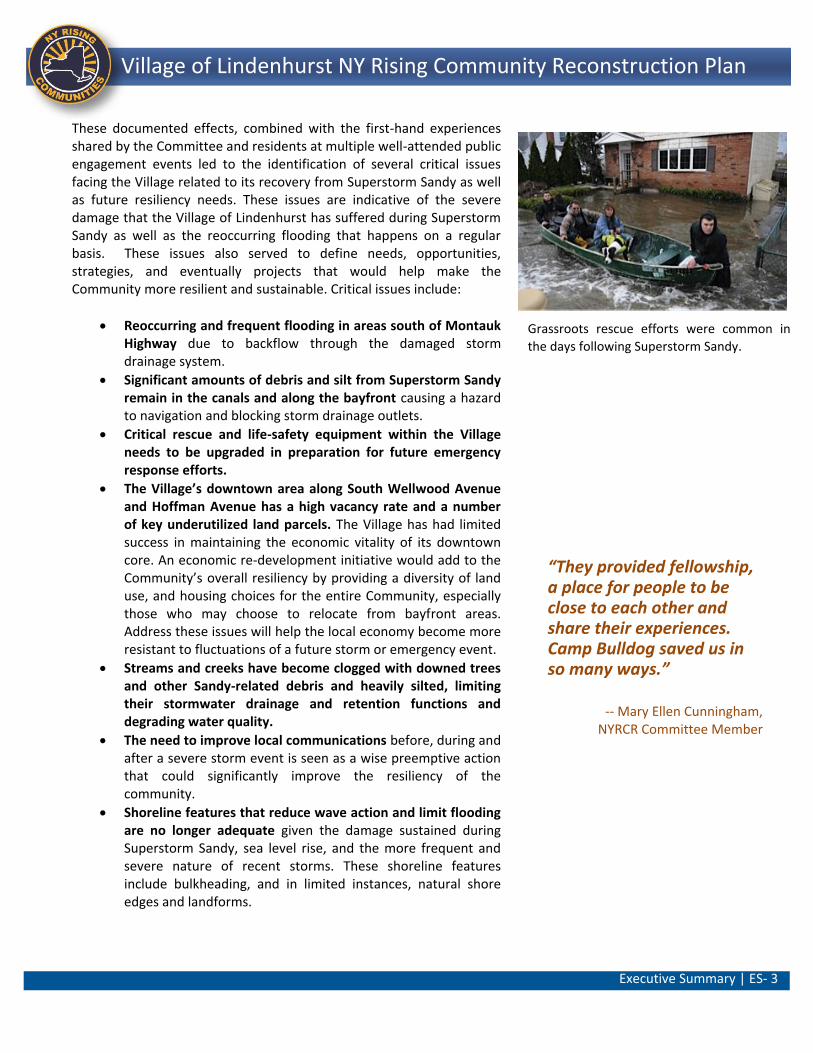
These documented effects, combined with the first-hand experiences shared by the Committee and residents at multiple well-attended public engagement events led to the identification of several critical issues facing the Village related to its recovery from Superstorm Sandy as well as future resiliency needs. These issues are indicative of the severe damage that the Village of Lindenhurst has suffered during Superstorm Sandy as well as the reoccurring flooding that happens on a regular basis. These issues also served to define needs, opportunities, strategies, and eventually projects that would help make the Community more resilient and sustainable. Critical issues include:
Reoccurring and frequent flooding in areas south of Montauk Highway due to backflow through the damaged storm drainage system.
Significant amounts of debris and silt from Superstorm Sandy remain in the canals and along the bayfront causing a hazard to navigation and blocking storm drainage outlets.
Critical rescue and life-safety equipment within the Village needs to be upgraded in preparation for future emergency response efforts.
The Village’s downtown area along South Wellwood Avenue and Hoffman Avenue has a high vacancy rate and a number of key underutilized land parcels. The Village has had limited success in maintaining the economic vitality of its downtown core. An economic re-development initiative would add to the Community’s overall resiliency by providing a diversity of land use, and housing choices for the entire Community, especially those who may choose to relocate from bayfront areas. Address these issues will help the local economy become more resistant to fluctuations of a future storm or emergency event.
Streams and creeks have become clogged with downed trees and other Sandy-related debris and heavily silted, limiting their stormwater drainage and retention functions and degrading water quality.
The need to improve local communications before, during and after a severe storm event is seen as a wise preemptive action that could significantly improve the resiliency of the community.
Shoreline features that reduce wave action and limit flooding are no longer adequate given the damage sustained during Superstorm Sandy, sea level rise, and the more frequent and severe nature of recent storms. These shoreline features include bulkheading, and in limited instances, natural shore edges and landforms.
Grassroots rescue efforts were common in
the days following Superstorm Sandy.
Executive Summary | ES- 4
Lindenhurst NY Rising Community Reconstruction Plan Village of Lindenhurst NY Rising Community Reconstruction Plan
Numerous properties south of Montauk Highway remain vacant as a result of Superstorm Sandy, fragmenting neighborhoods and causing blight on the Community.
NYRCR Program: A Community-Driven Process
The Village’s goal is “building back better.” The Committee took on the responsibility of developing a plan that laid the groundwork for planning and building a more resilient future. In many ways, this plan is an extension of the grassroots volunteerism at Camp Bulldog and throughout the Village in the days immediately after the storm. During many Committee and subcommittee meetings as well as Public Engagement Events, Committee members and the public drew on their own experiences and on input from their neighbors to identify projects and policies. Based on this feedback and input the Committee began the process of formulating a future vision of a resilient Village The Committee spent significant time and effort in developing a vision for their community’s resilient future. This vision was based on establishing a series of goals that could act as targets or waypoints for the community on its journey towards resiliency. This final vision was informed by public input from community members. The Community Vision Statement represents a consensus assessment of the direction this Community wishes to move towards. All strategies and projects identified were measured against the Community’s Vision Statement to ensure that recommended actions would not detract from the community achieving its desired goals.
Public Engagement Process In keeping with Governor Cuomo’s emphasis on bottom-up planning, members of the Community were involved in each step of the NYRCR Program. The NYRCR Committee was composed of residents who could speak directly from experience of the character of the community, its needs, and strengths in good times and bad. Eleven Committee meetings have been held as of March 15, 2014. All Committee meetings were open to the public, with meeting dates and times posted on the NYRCR website (www.stormrecovery.ny.gov/nyrcr). Comment forms were available at Committee meetings and public engagement events and on the State’s website to provide an opportunity for the public to contribute their feedback, which were then passed along to the Committee. The Community at-large was invited to take part in the NYRCR Program through a variety of methods. Their feedback was reviewed by the
VISION STATEMENT
The Village of Lindenhurst is a close-knit
and caring community of hard-working
neighbors and families who seek to
protect their homes, schools, businesses,
parks and waterfront resources from
storms, flooding and other natural and
man-made disasters. We are a coastal
community and seek to improve public
access to the waterfront while utilizing
built and natural features to reduce
flooding. We seek to encourage economic
development opportunities at the
waterfront as well as in our downtown.
We will actively support and pursue
improvements and policies that address
our immediate recovery needs as well as
long-term needs that lessen storm damage
and improve our resiliency over time. We
are strong survivors and our community
will endure, prosper and be safer for all!
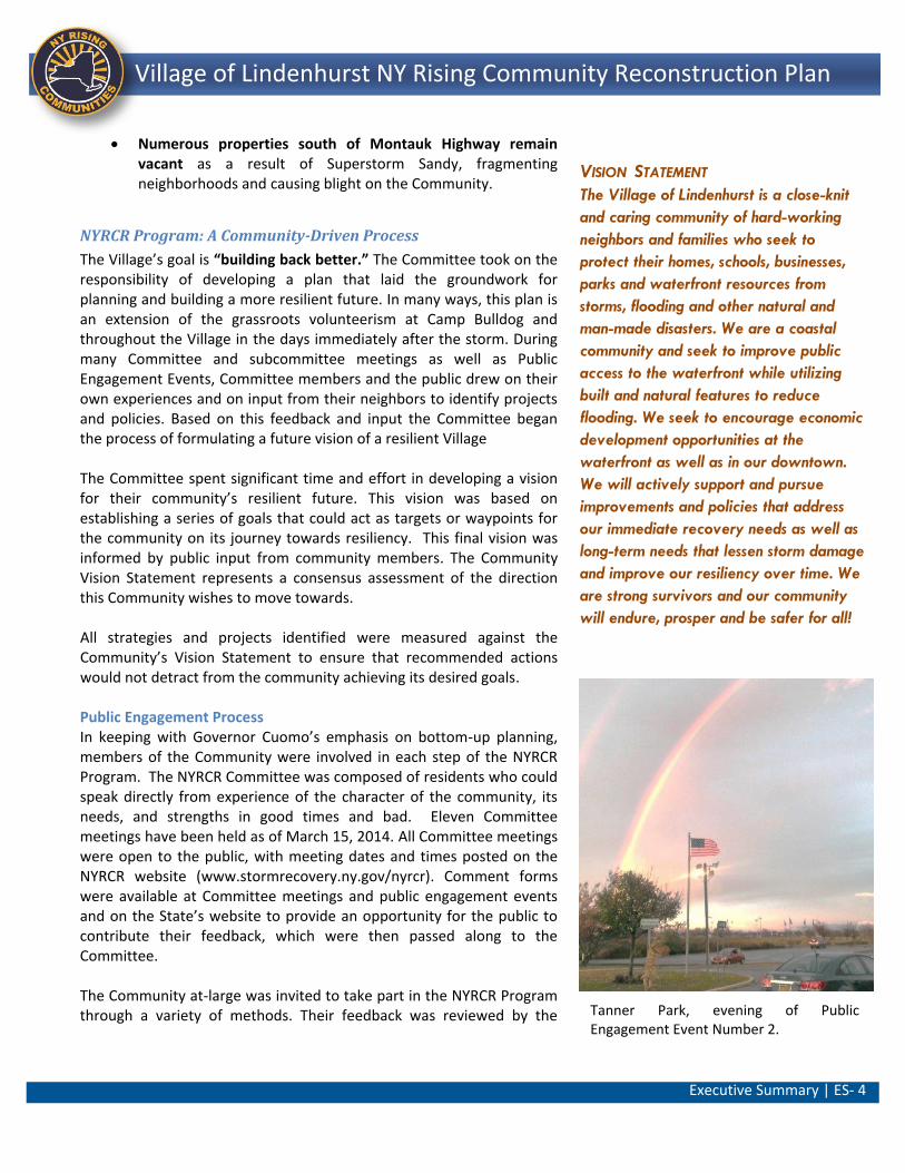
Tanner Park, evening of Public Engagement Event Number 2.
Executive Summary | ES- 5
Lindenhurst NY Rising Community Reconstruction Plan Village of Lindenhurst NY Rising Community Reconstruction Plan
Committee and incorporated into the decision-making process that informed the development of this Plan. Three well-attended, open-house style events were held during the development of the plan and a fourth will present this final document. Across the eight NYRCR Communities in Suffolk County, thousands of participants attended Committee meetings and Public Engagement events. Additionally, the public was encouraged to complete a web-based survey to gauge public opinion on the Proposed Projects in conjunction with Public Engagement Event 3. Special efforts were taken to reach out to younger members of the community. They were invited to participate in a web-based “Next Generation” survey to gather feedback on Proposed Projects that would likely affect their futures in the Community.
NYRCR Final Plan: A Blueprint for Resiliency
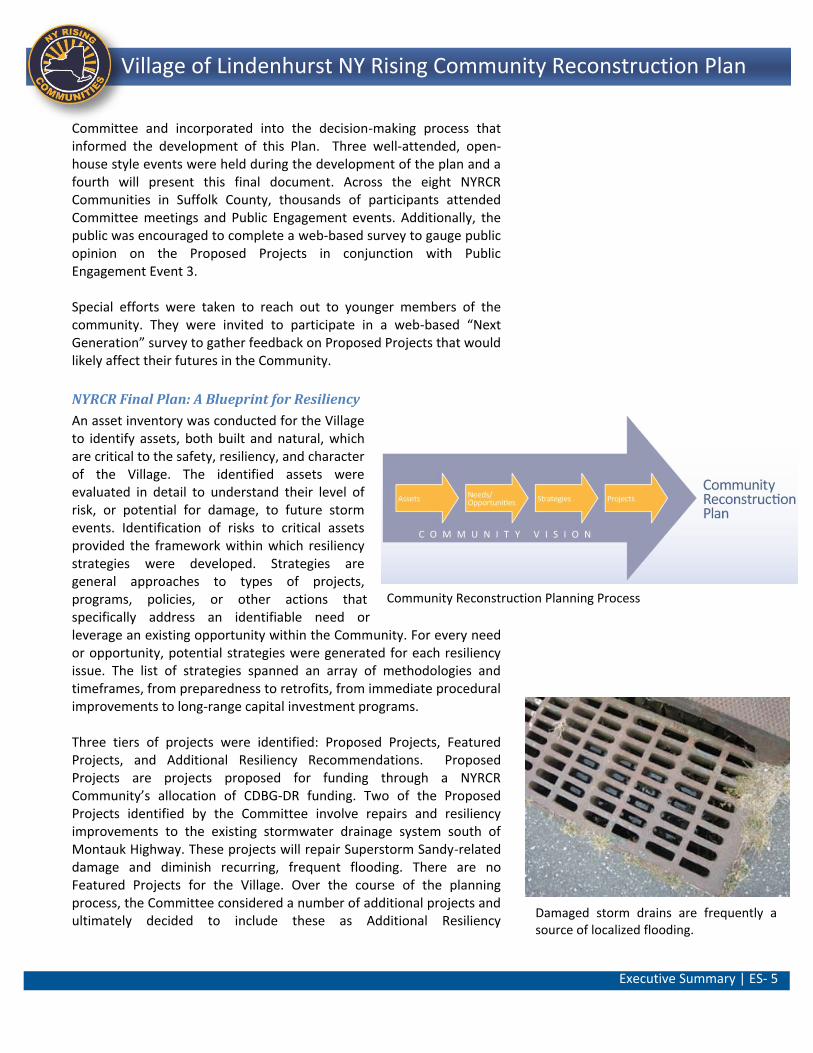
An asset inventory was conducted for the Village to identify assets, both built and natural, which are critical to the safety, resiliency, and character of the Village. The identified assets were evaluated in detail to understand their level of risk, or potential for damage, to future storm events. Identification of risks to critical assets provided the framework within which resiliency strategies were developed. Strategies are general approaches to types of projects, programs, policies, or other actions that specifically address an identifiable need or leverage an existing opportunity within the Community. For every need or opportunity, potential strategies were generated for each resiliency issue. The list of strategies spanned an array of methodologies and timeframes, from preparedness to retrofits, from immediate procedural improvements to long-range capital investment programs. Three tiers of projects were identified: Proposed Projects, Featured Projects, and Additional Resiliency Recommendations. Proposed Projects are projects proposed for funding through a NYRCR Community’s allocation of CDBG-DR funding. Two of the Proposed Projects identified by the Committee involve repairs and resiliency improvements to the existing stormwater drainage system south of Montauk Highway. These projects will repair Superstorm Sandy-related damage and diminish recurring, frequent flooding. There are no Featured Projects for the Village. Over the course of the planning process, the Committee considered a number of additional projects and ultimately decided to include these as Additional Resiliency
Damaged storm drains are frequently a source of localized flooding.
Community Reconstruction Planning Process
Executive Summary | ES- 6
Lindenhurst NY Rising Community Reconstruction Plan Village of Lindenhurst NY Rising Community Reconstruction Plan
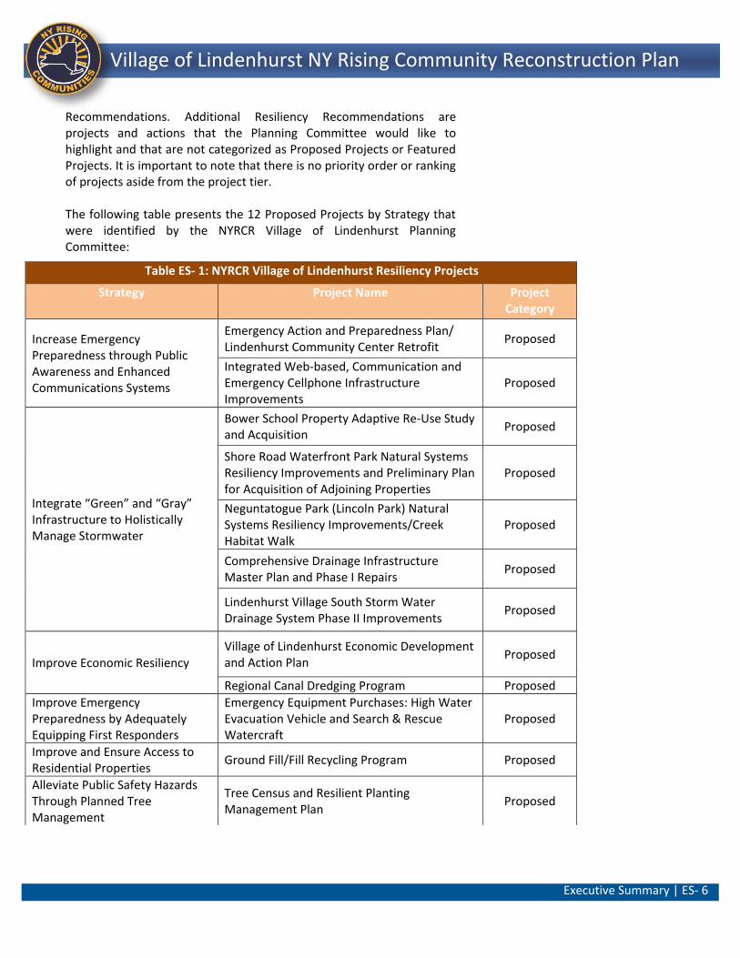
Recommendations. Additional Resiliency Recommendations are projects and actions that the Planning Committee would like to highlight and that are not categorized as Proposed Projects or Featured Projects. It is important to note that there is no priority order or ranking of projects aside from the project tier. The following table presents the 12 Proposed Projects by Strategy that were identified by the NYRCR Village of Lindenhurst Planning Committee:
Table ES- 1: NYRCR Village of Lindenhurst Resiliency Projects
Strategy Project Name Project Category
Increase Emergency Preparedness through Public Awareness and Enhanced Communications Systems
Emergency Action and Preparedness Plan/ Lindenhurst Community Center Retrofit
Proposed
Integrated Web-based, Communication and Emergency Cellphone Infrastructure Improvements
Proposed
Integrate “Green” and “Gray” Infrastructure to Holistically Manage Stormwater
Bower School Property Adaptive Re-Use Study and Acquisition
Proposed
Shore Road Waterfront Park Natural Systems Resiliency Improvements and Preliminary Plan for Acquisition of Adjoining Properties
Proposed
Neguntatogue Park (Lincoln Park) Natural Systems Resiliency Improvements/Creek Habitat Walk
Proposed
Comprehensive Drainage Infrastructure Master Plan and Phase I Repairs
Proposed
Lindenhurst Village South Storm Water Drainage System Phase II Improvements
Proposed
Improve Economic Resiliency Village of Lindenhurst Economic Development and Action Plan
Proposed
Regional Canal Dredging Program Proposed
Improve Emergency Preparedness by Adequately Equipping First Responders
Emergency Equipment Purchases: High Water Evacuation Vehicle and Search & Rescue Watercraft
Proposed
Improve and Ensure Access to Residential Properties
Ground Fill/Fill Recycling Program Proposed
Alleviate Public Safety Hazards Through Planned Tree Management
Tree Census and Resilient Planting Management Plan
Proposed
Section I: Community Overview | 1 ||
Lindenhurst NY Rising Community Reconstruction Plan Village of Lindenhurst NY Rising Community Reconstruction Plan
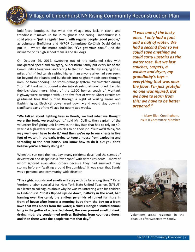
View from the Village’s aged 1970s era High-Water Rescue Vehicle as it forges one of the many flooded roadways.
Section I: Community Overview
The Village of Lindenhurst (the Village) is located along the South
Shore of Suffolk County, Long Island, New York. The Village,
which lies within the Town of Babylon, is bounded by Copiague
to the west and West Babylon to the east. North Lindenhurst lies
to the north with North Amityville to the northwest. The Village
fronts the Great South Bay and features an extensive waterfront
and canal system. As a result of its proximity to the water, the
Village is characterized by single family residences and water-
dependent uses exemplified by a concentration of marina and
marine industry support services, especially south of Montauk
Highway. The Village’s homes, businesses, and infrastructure
suffered significant damage as a result of Superstorm Sandy.
As part of the ongoing recovery from Superstorm Sandy, the
Village of Lindenhurst’s NY Rising Community Reconstruction
Program (NYRCR) Committee (Committee) took on the
responsibility of developing a plan that laid the groundwork for
the Village’s resilient future. The composition of the Committee
included a cross-section of the Village population including
municipal representatives, local residents, and members of local
businesses and community organizations. The Village of
Lindenhurst’s NYRCR Committee Co-Chairs were selected by the
State in consultation with the Village. With the entire Village
involved, and with the help of New York State, the Committee
has produced a pragmatic recovery and resiliency plan.
The Local Perspective
The Village of Lindenhurst is a neat and tidy community. The residents and businesses here take pride in what they and their neighbors have worked so hard to create. Many of the residents have grown up in this Village and have chosen to remain here. Others have made the conscious decision to move here because of what the Village has to offer. That said, it is fair to say that most of the bungalows and capes along the Village’s canals do not show up in magazines for the rich and famous. The Village’s homey downtown does not have blocks of glitzy
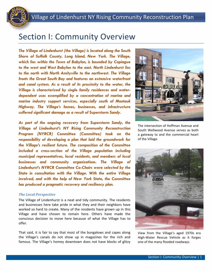
The intersection of Hoffman Avenue and South Wellwood Avenue serves as both a gateway to and the commercial heart of the Village.
Section I: Community Overview | 2 ||
Lindenhurst NY Rising Community Reconstruction Plan Village of Lindenhurst NY Rising Community Reconstruction Plan
bold-faced boutiques. But what the Village may lack in cache and trendiness it makes up for in toughness and caring. Lindenhurst is a solid place – “just a regular town, with regular people, good people,” as volunteer firefighter and NYRCR Committee Co-Chair David Collins put it -- where the motto could be, “I’ve got your back.” And the nickname of its high school team is The Bulldogs. On October 29, 2012, sweeping out of the darkened skies with unexpected speed and savagery, Superstorm Sandy put every bit of the Community’s toughness and caring to the test. Swollen by surging tides, miles of silt-filled canals swirled higher than anyone alive had ever seen, far beyond their banks and bulkheads into neighborhoods once thought immune from flooding. The storm drainage system, overmatched during “normal” hard rains, poured water into streets that now roiled like oily, debris-choked rivers. Most of the 1,600 homes south of Montauk Highway were swamped with up to five feet of water. Short circuits set gas-fueled fires that burned through a night of wailing sirens and flashing lights. Electrical power went down – and would stay down in significant parts of the Village for nearly two weeks. “We talked about fighting fires in floods, we had what we thought were the tools, we practiced it,” said Mr. Collins, then captain of the volunteer firefighting unit known as the Bay Rats that had to rely on 40-year-old high-water rescue vehicles to do their job. “But we’d think, ‘no way we’ll ever have to do it.’ And then we’re up to our chests in five feet of water, in the dark, trying to keep a house from exploding and spreading to the next house. You know how to do it but you don’t believe you’re actually doing it.”
When the sun rose the next day, many residents described the scenes of devastation and despair as a “war zone” with dazed residents – many of whom ignored evacuation orders because they had survived many storms before – “walking around like zombies.” It was clear that Sandy was a personal and community-wide disaster. “The sights, sounds and smells will stay with us for a long time,” Peter Verdon, a labor specialist for New York State United Teachers (NYSUT) in a letter to colleagues about why he was volunteering with his children in Lindenhurst. “Boats flipped upside down, halfway in the road, half hanging over the canal; the endless pyramids of ruined furniture in front of house after house; a mooring buoy from the bay on a front lawn that was blocks from the water; a child’s mangled stuffed animal lying in the gutter of a deserted street; the ever present smell of dank, drying mud; the condemned notices fluttering from countless doors; and then there were the people we met that day.”
“I was one of the lucky ones. I only had a foot and a half of water. We had a second floor so we could save anything we could carry upstairs as the water rose. But we lost couches, carpets, a washer and dryer, my grandbaby’s toys – everything that was near the floor. I’m just grateful no one was injured. But we have to learn from this; we have to be better prepared.”
-- Mary Ellen Cunningham, NYRCR Committee Member
Volunteers assist residents in the clean-up after Superstorm Sandy.
Section I: Community Overview | 3 ||
Lindenhurst NY Rising Community Reconstruction Plan Village of Lindenhurst NY Rising Community Reconstruction Plan
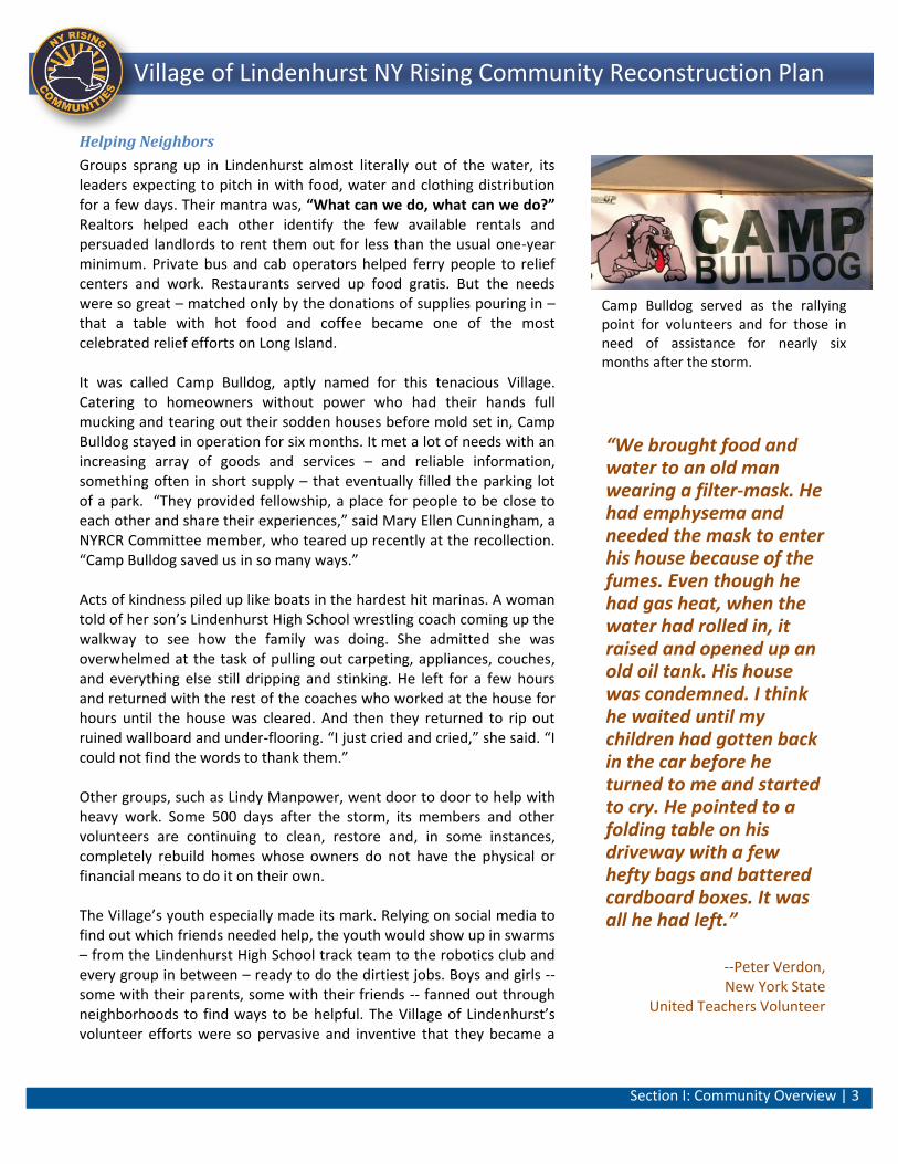
Helping Neighbors
Groups sprang up in Lindenhurst almost literally out of the water, its leaders expecting to pitch in with food, water and clothing distribution for a few days. Their mantra was, “What can we do, what can we do?” Realtors helped each other identify the few available rentals and persuaded landlords to rent them out for less than the usual one-year minimum. Private bus and cab operators helped ferry people to relief centers and work. Restaurants served up food gratis. But the needs were so great – matched only by the donations of supplies pouring in – that a table with hot food and coffee became one of the most celebrated relief efforts on Long Island. It was called Camp Bulldog, aptly named for this tenacious Village. Catering to homeowners without power who had their hands full mucking and tearing out their sodden houses before mold set in, Camp Bulldog stayed in operation for six months. It met a lot of needs with an increasing array of goods and services – and reliable information, something often in short supply – that eventually filled the parking lot of a park. “They provided fellowship, a place for people to be close to each other and share their experiences,” said Mary Ellen Cunningham, a NYRCR Committee member, who teared up recently at the recollection. “Camp Bulldog saved us in so many ways.” Acts of kindness piled up like boats in the hardest hit marinas. A woman told of her son’s Lindenhurst High School wrestling coach coming up the walkway to see how the family was doing. She admitted she was overwhelmed at the task of pulling out carpeting, appliances, couches, and everything else still dripping and stinking. He left for a few hours and returned with the rest of the coaches who worked at the house for hours until the house was cleared. And then they returned to rip out ruined wallboard and under-flooring. “I just cried and cried,” she said. “I could not find the words to thank them.” Other groups, such as Lindy Manpower, went door to door to help with heavy work. Some 500 days after the storm, its members and other volunteers are continuing to clean, restore and, in some instances, completely rebuild homes whose owners do not have the physical or financial means to do it on their own. The Village’s youth especially made its mark. Relying on social media to find out which friends needed help, the youth would show up in swarms – from the Lindenhurst High School track team to the robotics club and every group in between – ready to do the dirtiest jobs. Boys and girls --some with their parents, some with their friends -- fanned out through neighborhoods to find ways to be helpful. The Village of Lindenhurst’s volunteer efforts were so pervasive and inventive that they became a
“We brought food and water to an old man wearing a filter-mask. He had emphysema and needed the mask to enter his house because of the fumes. Even though he had gas heat, when the water had rolled in, it raised and opened up an old oil tank. His house was condemned. I think he waited until my children had gotten back in the car before he turned to me and started to cry. He pointed to a folding table on his driveway with a few hefty bags and battered cardboard boxes. It was all he had left.”
--Peter Verdon, New York State
United Teachers Volunteer
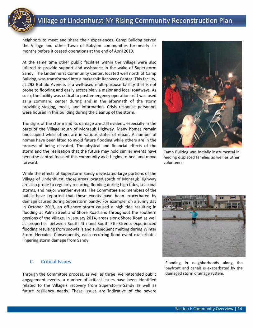
Camp Bulldog served as the rallying point for volunteers and for those in need of assistance for nearly six months after the storm.
Section I: Community Overview | 4 ||
Lindenhurst NY Rising Community Reconstruction Plan Village of Lindenhurst NY Rising Community Reconstruction Plan
magnet for the media and for people literally around the world. A group from Taiwan donated tens of thousands of dollars. Firefighters from North Carolina showed up to help a New York City police officer who had worked around-the-clock for three days, only to come home and find his house in ruins. In addition to Newsday, the regional paper that was a Pulitzer runner-up for Sandy-related work, the Washington Post, Huffington Post and CBS television reported from the Village. A Resilient Future
The assistance and attention was encouraging and gratifying, but the Committee and the Community know it is not enough just to feel good about themselves and their neighbors and to take pride in the people still committed to the work of recovery. The focus now is to learn from the experience, especially from what did not go right with the Village’s infrastructure, emergency equipment, communication systems, and evacuation procedures. The Village also needs to understand how decisions about where residents live, and how they treat Community assets, can make all the difference in future recovery and resiliency planning efforts. “We have to look at preparation and mitigation in a different light and with more urgency,” said Shawn Cullinane, the Lindenhurst Village Clerk/Treasurer and a member of the NYRCR Committee. “We need to come up with bigger and bolder ways to protect ourselves.” As a member of a national organization of village officials, Mr. Cullinane said he heard stories from colleagues who faced earthquakes, wildfires, drought, and floods. “We’ve never dealt with stuff like that,” he said. “Now we are part of the club and we have to be ready for it.” The Village’s goal is “building back better.” The Committee took on the responsibility of developing a plan that laid the groundwork for planning and building a more resilient future. In many ways, this plan is an extension of the grassroots volunteerism at Camp Bulldog and throughout the Village in the days immediately after the storm. During many Committee and subcommittee meetings as well as Public Engagement Events, Committee members and the public drew on their own experiences and on input from their neighbors to identify projects and policies. Based on this feedback and input the Committee began the process of formulating a future vision of a resilient Village. The Village must repair the damage caused by Superstorm Sandy but at the same time do this in a manner that can resist future inundations and other disasters. With the entire Village involved, and with the help of New York State, the Committee has produced a sound and realistic plan for recovery and resiliency. Perhaps more importantly for the long haul, it also offered a
“We spent a lot of time and effort putting together a list of projects but we did it with a lot of input from the community. These are the ones we want and need. This was a consensus.”
-- Alex Keller,
NYRCR Committee Co-Chair
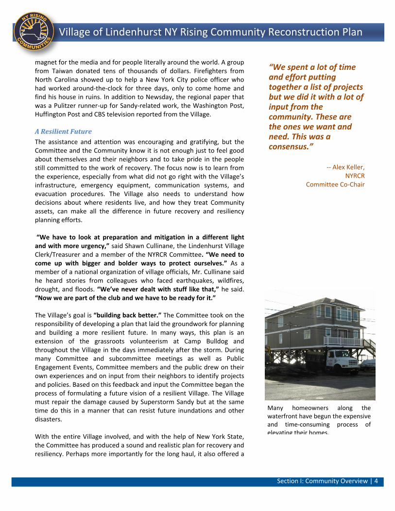
Many homeowners along the waterfront have begun the expensive and time-consuming process of elevating their homes.
Section I: Community Overview | 5 ||
Lindenhurst NY Rising Community Reconstruction Plan Village of Lindenhurst NY Rising Community Reconstruction Plan
planning forum that recognized and respected the experiences, expertise and preferences, that empowered people and promoted constructive dialogue. Historic Context
Until the 1860s, the area that is now called Lindenhurst was primarily an agricultural community. The completion of a single-track to Babylon in 1867 by the South Side Rail Road (now the Long Island Rail Road [LIRR]) brought increased access and commercial development and a business district matured in the vicinity of the train station developing into what is now Lindenhurst. This pattern of development is similar to other business districts in Suffolk County that initially expanded around a harbor or station. Originally named “Breslau” after the Silesian town from where Lindenhurst’s original settlers emigrated, the City of Breslau was formally dedicated on June 6, 1870.1 Prior to the turn of the 20th Century, business and factories came to the Village, providing many local residents with employment. This growth facilitated the formation of a fire department, the Breslau Engine Company in 1877 and later the incorporation of the Village of Lindenhurst in 1923. Lindenhurst continued to grow after World War II and became a bedroom community to New York City as a result of its access to both major roadways and the LIRR. These characteristics of the Village were attractive to both residents wanting to live in a suburban community but also to those requiring access to points east including New York City. Present Day
Lindenhurst is the fourth-largest Village in New York State with a total population of 27,253 residents and approximately 8,638 households as identified by U.S. Census 2010 data. The population density of the Village is approximately 7,248 persons per square mile. Single-family residences are the predominant housing type within the Village. However, of the 6,665 housing units within the Village, approximately 15% were classified as multi-unit structures. Approximately 86% of the housing stock within Lindenhurst was owner-occupied as of the 2010 Census. The median owner-occupied house value was approximately $392,000 within the Village. More than 37% of the households in the Village have children under the age of 18 living with them, while approximately 25% of the population was over 55 years old. Approximately 8% of households have someone living alone who was more than 65 years of age.
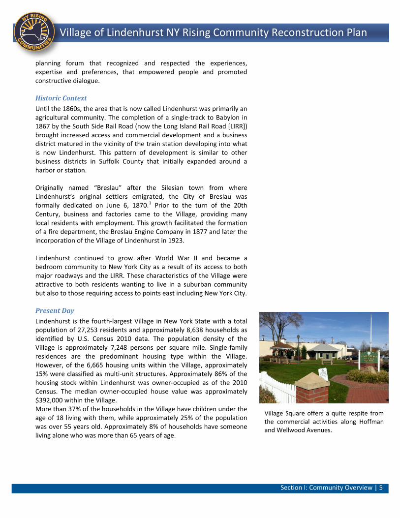
Village Square offers a quite respite from the commercial activities along Hoffman and Wellwood Avenues.
Section I: Community Overview | 6 ||
Lindenhurst NY Rising Community Reconstruction Plan Village of Lindenhurst NY Rising Community Reconstruction Plan
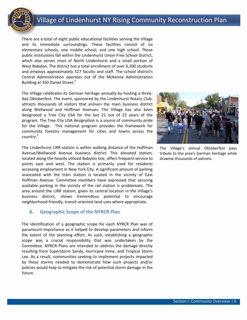
There are a total of eight public educational facilities serving the Village and its immediate surroundings. These facilities consist of six elementary schools, one middle school, and one high school. These public institutions fall within the Lindenhurst Union Free School District, which also serves most of North Lindenhurst and a small portion of West Babylon. The district has a total enrollment of over 6,200 students and employs approximately 527 faculty and staff. The school district’s Central Administration operates out of the McKenna Administration Building at 350 Daniel Street.2 The Village celebrates its German heritage annually by hosting a three-day Oktoberfest. The event, sponsored by the Lindenhurst Rotary Club, attracts thousands of visitors that enliven the main business district along Wellwood and Hoffman Avenues. The Village has also been designated a Tree City USA for the last 21 out of 22 years of the program. The Tree City USA designation is a source of community pride for the Village. This national program provides the framework for community forestry management for cities and towns across the country.3 The Lindenhurst LIRR station is within walking distance of the Hoffman Avenue/Wellwood Avenue business district. This elevated station, located along the heavily utilized Babylon line, offers frequent service to points east and west. The station is primarily used for residents accessing employment in New York City. A significant amount of parking associated with the train station is located in the vicinity of East Hoffman Avenue. Committee members have expressed that securing available parking in the vicinity of the rail station is problematic. The area around the LIRR station, given its central location in the Village’s business district, shows tremendous potential to encourage neighborhood-friendly, transit-oriented land uses where appropriate.
A. Geographic Scope of the NYRCR Plan
The identification of a geographic scope for each NYRCR Plan was of paramount importance as it helped to develop parameters and inform the extent of the planning effort. As such, establishing a geographic scope was a crucial responsibility that was undertaken by the Committee. NYRCR Plans are intended to address the damage directly resulting from Superstorm Sandy, Hurricane Irene, and Tropical Storm Lee. As a result, communities seeking to implement projects impacted by those storms needed to demonstrate how such projects and/or policies would help to mitigate the risk of potential storm damage in the future.
The Village’s annual Oktoberfest pays tribute to the area’s German heritage while drawing thousands of patrons.
Section I: Community Overview | 7 ||
Lindenhurst NY Rising Community Reconstruction Plan Village of Lindenhurst NY Rising Community Reconstruction Plan
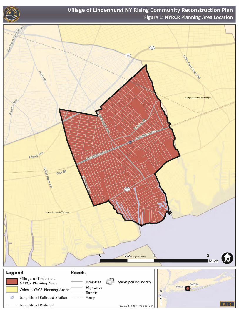
Community assets most likely to be at risk due to future weather events were typically located in extreme, high, and moderate risk areas of the Community. The geographic scope of the NYRCR Planning Area included areas where assets are most at risk; where future construction or reconstruction of existing development should be encouraged or discouraged; or where key investment to improve the local economy can be instituted. The identification of more resilient areas for future development can later be reinforced in municipal comprehensive plans as well as other local regulatory requirements. The Village of Lindenhurst’s NYRCR Planning Area was derived based on feedback from the Committee and the public by utilizing the methodology outlined above. Data from a variety of different sources was evaluated in determining the extent of the Village’s NYRCR Planning Area. Source data included hazard assessment area information provided by the State and Federal Emergency Management Agency (FEMA) flood hazard boundaries, as well as inundation and elevation data. The Committee also indicated that the Village’s geographic scope should be inclusive of locally identified assets such as the Hoffman and Wellwood Avenue corridors, the Bower School property, and the waterfront area. The Village’s geographic scope for the NYRCR planning process corresponds to the Village’s incorporated boundaries. Even though the northern areas of the Village did not sustain as much direct damage as a result of Superstorm Sandy, the Committee felt that the inter-relationship between discreet assets across the Village was sufficient justification to utilize the broader Village boundary as the Planning Area. The Village of Lindenhurst’s NYRCR Community is largely inclusive of the area between Copiague to the west, North Amityville to the northwest, North Lindenhurst to the north, West Babylon to the east and the waterfront to the south. More specifically, the NYRCR Community is generally bounded by a portion of Sunrise Highway as well as 43rd Street, North Wellwood Avenue and Frank Street to the north, Strong Street to the west and loosely follows Santapogue Creek to the east. In the vicinity of Montauk Highway and Park Avenue, the NYRCR Community extends westward before shifting to encompass the land and canals between Roosevelt Avenue and South 9th Street to the east. The NYRCR Community extends south to the shoreline fronting the Great South Bay. Figure 1 below illustrates the Geographic Scope of the NYRCR Community Lindenhurst Planning Area.
“The NY Rising Committee did a good job of keeping on track. It did everything possible to reach out to the community to involve people in the process.”
-- Shawn Cullinane, Village of Lindenhurst
Clerk/Treasurer
Section I: Community Overview | 8 ||
Lindenhurst NY Rising Community Reconstruction Plan Village of Lindenhurst NY Rising Community Reconstruction Plan
Figure 1: Community Area Location Map
Section I: Community Overview | 9 ||
Lindenhurst NY Rising Community Reconstruction Plan Village of Lindenhurst NY Rising Community Reconstruction Plan
One challenge that was noted throughout the Village’s public engagement process was the placement of the Venetian Shores community within a NYRCR Planning Area. This community shares a zip code with the Village of Lindenhurst and is within the Lindenhurst Union Free School District. At the same time this community receives much of its services from the Town of Babylon and is also integrally linked with the adjoining communities of West Babylon and the Village of Babylon. The eventual choice was made to incorporate Venetian Shores into the neighboring Village of Babylon/West Babylon NYRCR Planning Area. Best efforts were made to work across the respective NYRCR Planning Area boundaries to address Venetian Shores physical and cultural geography, as well as their specific concerns and risks. One example of this is that two of the Public Engagement Events were jointly held between NYRCR Communities within the Town of Babylon in order to allow for discussion of both regional issues and issues pertinent to the adjacent Planning Areas. Public Engagement Event 2 included three of the four NYRCR Communities within the Town of Babylon while public Engagement Event 3 included all four NYRCR Communities.4
Demographic Overview Understanding the characteristics of the people who live and work in the Village of Lindenhurst was crucial in assessing their resiliency needs and developing strategies and projects that respond to those needs. The following information helped to focus the planning efforts of the Committee. Geographic Area and Data
With the exception of data on ethnicity and race, all demographic data noted below was taken from the US Census Bureau’s American Factfinder at the Census Designated Place (CDP) level, and reflects data from the 2005-2009 American Community Survey (ACS).5 Demographic data relating to ethnicity and race were derived from the 2010 Census in order to provide the most recent data available in those categories.6
Village of Lindenhurst General Demographics
The age of the population in the Village of Lindenhurst NYRCR Community showed a typical suburban distribution among the Census age groups, with about 30% of the population between 35 and 54 years old, 45% under 35 years old, and 25% over 55 years old. The community is 92% White, with 2% African American, 2% Asian, and the remainder classified as 3% other and 2% two or more races.7 The residents reported that the majority (81%) of the Village either spoke English as the only language at home or rated their English
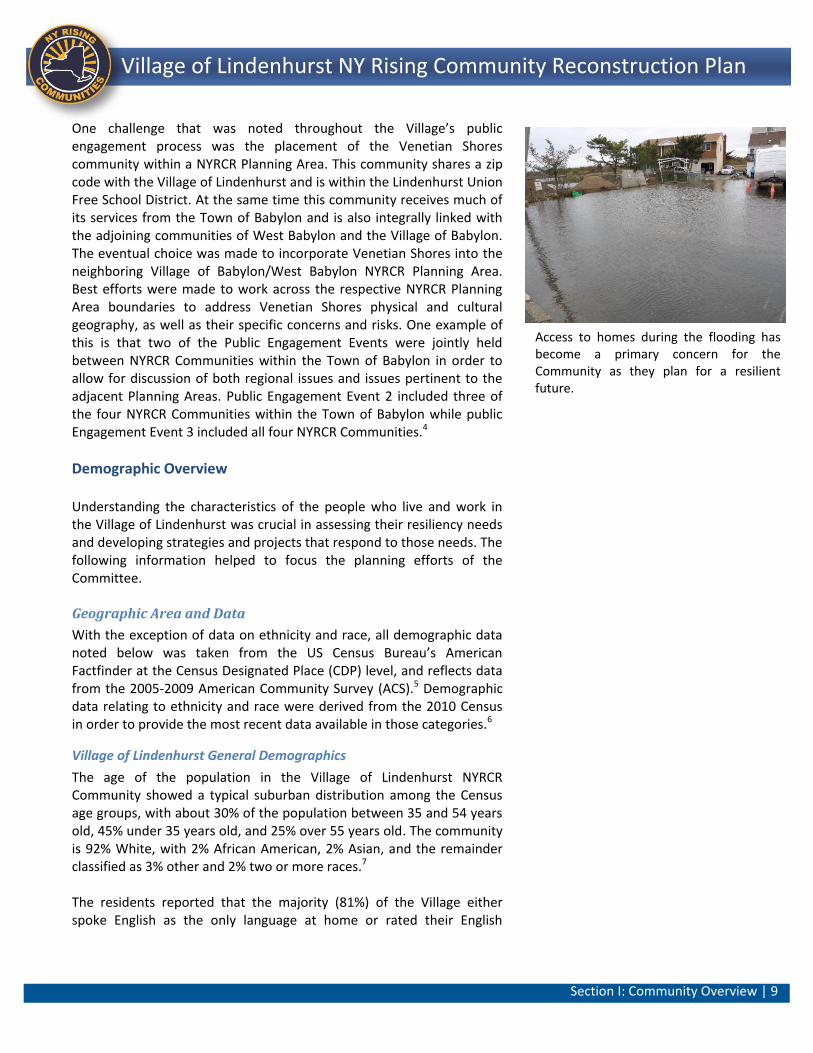
Access to homes during the flooding has become a primary concern for the Community as they plan for a resilient future.
Section I: Community Overview | 10 ||
Lindenhurst NY Rising Community Reconstruction Plan Village of Lindenhurst NY Rising Community Reconstruction Plan
proficiency as “very good;” though 8% of the community rated their English proficiency as “less than well.”8 This data was important for the identification of needs and opportunities as the non-English speaking population represented a community of concern that may not have easy access to important life safety information. Income and Poverty
The Village includes a diverse range of individual wage earnings. More than half earn less than $35,000, while more than 15% earn $75,000 or more. Although a large percentage, 18%, earns less than $10,000, a smaller percentage, 7%, is under 150% of the poverty level, indicating that the population reporting individual income under $10,000 is primarily composed of retirees and individuals in similar circumstances, not individuals or families who represent an economically disadvantaged population. Employment and Journey to Work
Understanding the general character of the Village’s workforce helped to identify needs, opportunities, and projects to maintain, restore, and enhance the economic vitality of the Village. About 60% of the residents in the Village work within Suffolk County, and nearly all of the residents work somewhere within New York State. About 86% of workers drove alone to work or carpool. The next largest means of travel to work was by rail, but the percentage of rail commuters as a portion of all commuters is 7%. The percentage of zero-car households was less than 2%, with 47% having three or more vehicles. While workers residing in the community supported a diverse array of industries, educational services, construction and retail trade compose approximately 43% of all industries represented.9
Housing
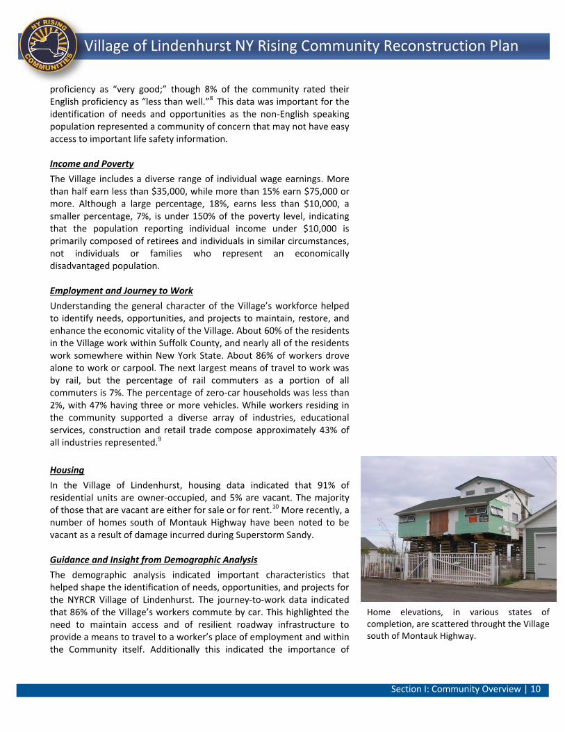
In the Village of Lindenhurst, housing data indicated that 91% of residential units are owner-occupied, and 5% are vacant. The majority of those that are vacant are either for sale or for rent.10 More recently, a number of homes south of Montauk Highway have been noted to be vacant as a result of damage incurred during Superstorm Sandy. Guidance and Insight from Demographic Analysis
The demographic analysis indicated important characteristics that helped shape the identification of needs, opportunities, and projects for the NYRCR Village of Lindenhurst. The journey-to-work data indicated that 86% of the Village’s workers commute by car. This highlighted the need to maintain access and of resilient roadway infrastructure to provide a means to travel to a worker’s place of employment and within the Community itself. Additionally this indicated the importance of
Home elevations, in various states of completion, are scattered throught the Village south of Montauk Highway.
Section I: Community Overview | 11 ||
Lindenhurst NY Rising Community Reconstruction Plan Village of Lindenhurst NY Rising Community Reconstruction Plan
assuring that residents’ vehicles can be safely preserved during times of storm and inundation. At the same time, the opportunity to encourage improvements to the pedestrian, bicycle, and transit networks, to offer an alternative to driving, was also noted. Lastly, housing type and occupancy indicated that the resiliency of the housing stock was of vital importance. There are very few (10%) renter-occupied units in the Village, indicating relatively low residential turnover and few vacancies. The vacancy assumption was further supported by the occupancy statistics. This indicated that in the event of a catastrophic event, the homes affected would be permanent residences and the affected homeowners and their families had few options for relocation within their community. The Census data therefore strongly suggest that programs and incentives to protect and preserve the existing housing supply, to provide for potential increases in the diversity of house types outside of the Severe and High risk areas, and to provide for the temporary housing of dislocated residents, should be recognized in the NYRCR Village of Lindenhurst Plan. These Census findings were incorporated into the dialogue with Village residents and reflected in the work of the Committee as they identified specific projects to help the Village become a more resilient and sustainable future.
B. Description of Storm Damage
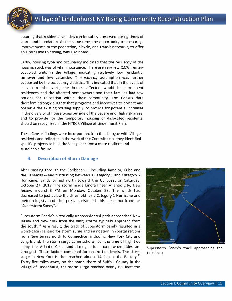
After passing through the Caribbean -- including Jamaica, Cuba and the Bahamas -- and fluctuating between a Category 1 and Category 2 Hurricane, Sandy turned north toward the US coast on Saturday, October 27, 2012. The storm made landfall near Atlantic City, New Jersey, around 8 PM on Monday, October 29. The winds had decreased to just below the threshold for a Category 1 Hurricane and meteorologists and the press christened this near hurricane as “Superstorm Sandy”.11 Superstorm Sandy’s historically unprecedented path approached New Jersey and New York from the east; storms typically approach from the south.12 As a result, the track of Superstorm Sandy resulted in a worst-case scenario for storm surge and inundation in coastal regions from New Jersey north to Connecticut including New York City and Long Island. The storm surge came ashore near the time of high tide along the Atlantic Coast and during a full moon when tides are strongest. These factors combined for record tide levels. The storm surge in New York Harbor reached almost 14 feet at the Battery.13 Thirty-five miles away, on the south shore of Suffolk County in the Village of Lindenhurst, the storm surge reached nearly 6.5 feet; this
Superstorm Sandy’s track approaching the East Coast.
Section I: Community Overview | 12 ||
Lindenhurst NY Rising Community Reconstruction Plan Village of Lindenhurst NY Rising Community Reconstruction Plan
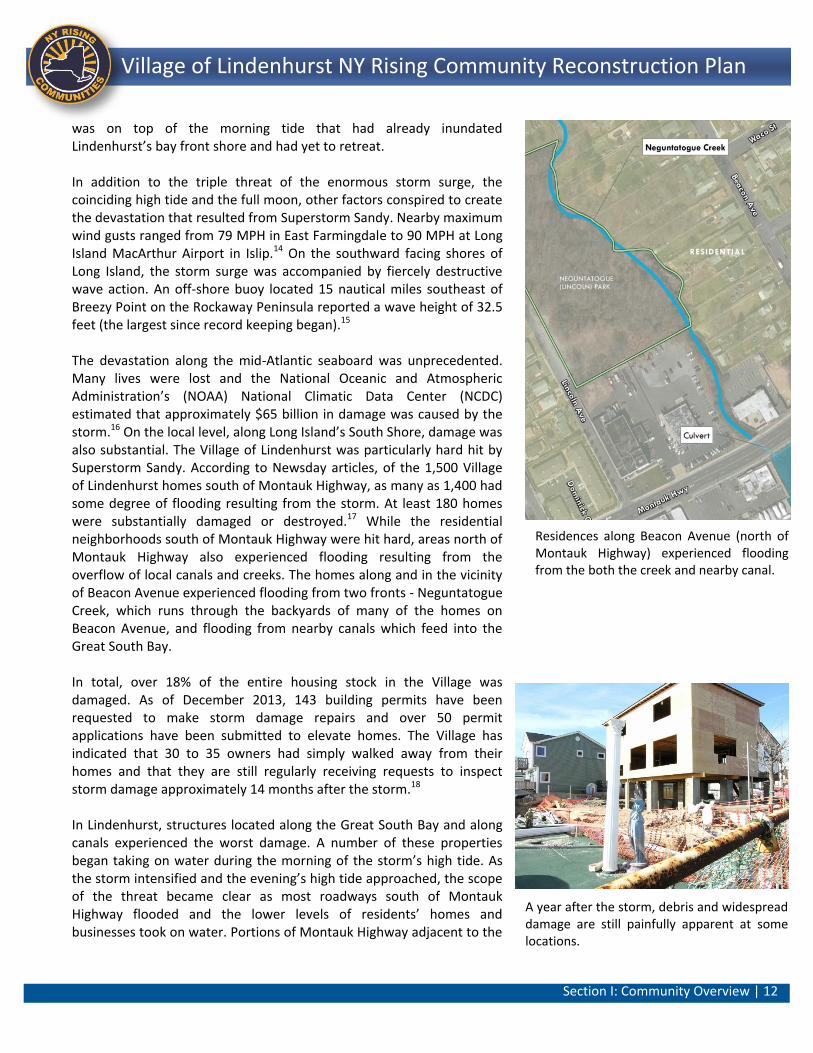
was on top of the morning tide that had already inundated Lindenhurst’s bay front shore and had yet to retreat. In addition to the triple threat of the enormous storm surge, the coinciding high tide and the full moon, other factors conspired to create the devastation that resulted from Superstorm Sandy. Nearby maximum wind gusts ranged from 79 MPH in East Farmingdale to 90 MPH at Long Island MacArthur Airport in Islip.14 On the southward facing shores of Long Island, the storm surge was accompanied by fiercely destructive wave action. An off-shore buoy located 15 nautical miles southeast of Breezy Point on the Rockaway Peninsula reported a wave height of 32.5 feet (the largest since record keeping began).15 The devastation along the mid-Atlantic seaboard was unprecedented. Many lives were lost and the National Oceanic and Atmospheric Administration’s (NOAA) National Climatic Data Center (NCDC) estimated that approximately $65 billion in damage was caused by the storm.16 On the local level, along Long Island’s South Shore, damage was also substantial. The Village of Lindenhurst was particularly hard hit by Superstorm Sandy. According to Newsday articles, of the 1,500 Village of Lindenhurst homes south of Montauk Highway, as many as 1,400 had some degree of flooding resulting from the storm. At least 180 homes were substantially damaged or destroyed.17 While the residential neighborhoods south of Montauk Highway were hit hard, areas north of Montauk Highway also experienced flooding resulting from the overflow of local canals and creeks. The homes along and in the vicinity of Beacon Avenue experienced flooding from two fronts - Neguntatogue Creek, which runs through the backyards of many of the homes on Beacon Avenue, and flooding from nearby canals which feed into the Great South Bay. In total, over 18% of the entire housing stock in the Village was damaged. As of December 2013, 143 building permits have been requested to make storm damage repairs and over 50 permit applications have been submitted to elevate homes. The Village has indicated that 30 to 35 owners had simply walked away from their homes and that they are still regularly receiving requests to inspect storm damage approximately 14 months after the storm.18 In Lindenhurst, structures located along the Great South Bay and along canals experienced the worst damage. A number of these properties began taking on water during the morning of the storm’s high tide. As the storm intensified and the evening’s high tide approached, the scope of the threat became clear as most roadways south of Montauk Highway flooded and the lower levels of residents’ homes and businesses took on water. Portions of Montauk Highway adjacent to the
A year after the storm, debris and widespread damage are still painfully apparent at some locations.
Residences along Beacon Avenue (north of Montauk Highway) experienced flooding from the both the creek and nearby canal.
Section I: Community Overview | 13 ||
Lindenhurst NY Rising Community Reconstruction Plan Village of Lindenhurst NY Rising Community Reconstruction Plan
northern most extensions of the canals became flooded, cutting off access to Good Samaritan Hospital Medical Center, the region’s main hospital to the east. Boats and debris from storm battered bulkheads, docks and other structures were tossed on land, further damaging homes and property along the Bay and the canals. Electricity and communications systems failed due to the water inundation and wind damage.
In the morning of October 30, when the storm had dissipated, residents began to survey the damage. Flooding made immediate recovery efforts more difficult. Committee members and other members of the public noted that damage of this magnitude had not been seen before in the Village. As noted above, 180 homes were substantially damaged or destroyed. Others had severe damage to the lower levels. Cars, boats, sheds, compromised oil tanks, and all manner of debris were scattered from where they had originally began the evening before. The Village, its emergency service providers, the residents and local businesses mobilized quickly. Immediate efforts were focused on reaching those stranded in their homes, especially seniors, children and the disabled. Next it became imperative to clear roads for access by emergency service providers, utility workmen, and heavy machinery to begin the clean-up. The Village’s vintage and repurposed 1970s high water rescue vehicle was pressed into service, as was the dive team’s donated rescue watercraft. Unfortunately these vehicles were insufficient to meet the overwhelming needs for the immediate rescue of the elderly, disabled, and others who were stranded in their homes as well as damage survey efforts. As the days progressed, it became clear that a long-term, sustained effort would be necessary. Electricity was restored south of Montauk Highway after approximately two weeks, although many residents were unable to restore service until their homes had received repairs and inspections. Initially, as a result of the displacement of Village families, the school district needed to bus hundreds of children from as far away as Queens and Riverhead. As late as June 2013 (7 months after Superstorm Sandy), the district was still responsible for the long-distance transportation of children from 49 families, a total cost of approximately $500,000.19 As previously mentioned, in order to assist and support their community, a number of residents and local organizations established Camp Bulldog at Shore Road Park. This facility served those affected by the storm by providing a central location for the distribution of donated food, clothes, services, and other needed items. Camp Bulldog also served as a central place for the dissemination of information concerning the storm damage, recovery efforts, and as a place for
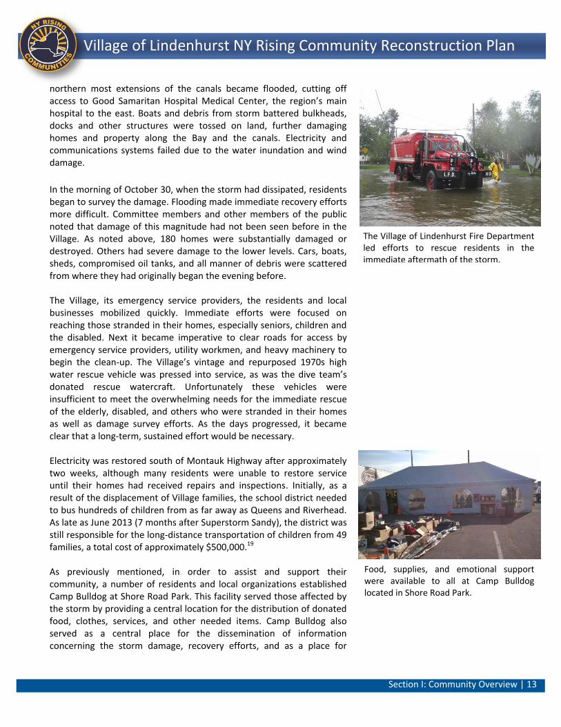
The Village of Lindenhurst Fire Department led efforts to rescue residents in the immediate aftermath of the storm.
Food, supplies, and emotional support were available to all at Camp Bulldog located in Shore Road Park.
Section I: Community Overview | 14 ||
Lindenhurst NY Rising Community Reconstruction Plan Village of Lindenhurst NY Rising Community Reconstruction Plan
neighbors to meet and share their experiences. Camp Bulldog served the Village and other Town of Babylon communities for nearly six months before it ceased operations at the end of April 2013. At the same time other public facilities within the Village were also utilized to provide support and assistance in the wake of Superstorm Sandy. The Lindenhurst Community Center, located well north of Camp Bulldog, was transformed into a makeshift Recovery Center. This facility, at 293 Buffalo Avenue, is a well-used multi-purpose facility that is not prone to flooding and easily accessible via major and local roadways. As such, the facility was critical to post-emergency operation as it was used as a command center during and in the aftermath of the storm providing staging, meals, and information. Crisis response personnel were housed in this building during the cleanup of the storm. The signs of the storm and its damage are still evident, especially in the parts of the Village south of Montauk Highway. Many homes remain unoccupied while others are in various states of repair. A number of homes have been lifted to avoid future flooding while others are in the process of being elevated. The physical and financial effects of the storm and the realization that the future may hold similar events have been the central focus of this community as it begins to heal and move forward. While the effects of Superstorm Sandy devastated large portions of the Village of Lindenhurst, those areas located south of Montauk Highway are also prone to regularly recurring flooding during high tides, seasonal storms, and major weather events. The Committee and members of the public have reported that these events have been exacerbated by damage caused during Superstorm Sandy. For example, on a sunny day in October 2013, an off-shore storm caused a high tide resulting in flooding at Palm Street and Shore Road and throughout the southern portions of the Village. In January 2014, areas along Shore Road as well as properties between South 4th and South 5th Streets experienced flooding resulting from snowfalls and subsequent melting during Winter Storm Hercules. Consequently, each recurring flood event exacerbates lingering storm damage from Sandy.
C. Critical Issues
Through the Committee process, as well as three well-attended public engagement events, a number of critical issues have been identified related to the Village’s recovery from Superstorm Sandy as well as future resiliency needs. These issues are indicative of the severe
Camp Bulldog was initially instrumental in feeding displaced families as well as other volunteers.
Flooding in neighborhoods along the bayfront and canals is exacerbated by the damaged storm drainage system.

Section I: Community Overview | 15 ||
Lindenhurst NY Rising Community Reconstruction Plan Village of Lindenhurst NY Rising Community Reconstruction Plan
damage that the Village of Lindenhurst has suffered during Superstorm Sandy as well as the reoccurring flooding that happens on a regular basis. These issues also served as the basis for efforts to eventually define needs, opportunities, strategies and eventually projects that would help resolve these issues and make the Village a more resilient and sustainable community. Critical issues include:
The reoccurring and frequent flooding in areas south of Montauk Highway are due in many instances to backflow through the storm drainage system. Superstorm Sandy severely damaged the Village’s storm water drainage system. Stormwater from average rain fall, high tides and nor’easters often cause roadways and private property to become temporarily flooded as water backs up through the storm drainage network of outlets, pipes and inlets. Access through the streets becomes limited, residents are often trapped in their homes as their cars and the lower levels of their houses take on water. This has occurred a number of times since Superstorm Sandy.
Significant amounts of debris and silt from Superstorm Sandy remain in the canals and along the bayfront causing a hazard to navigation and blocking storm drainage outlets. These hazards have impacted navigation and have resulted in further localized flooding due to blocked and damage storm drain outlets along the canals.
Critical equipment within the Village needs to be upgraded in preparation for future emergency response efforts. In response to lessons learned during Superstorm Sandy, it has become clear that existing emergency rescue equipment is insufficient to protect life and property in the event of another major storm.
The Village’s downtown area along South Wellwood Avenue and Hoffman Avenue has a high vacancy rate and a number of key underutilized land parcels. The downtown is in need of an economic re-development initiative that would add to the community’s overall resiliency by providing a diversity of land uses and housing choices for the entire community, especially those who may choose to relocate from the bayfront areas.
Streams and creeks have become clogged with downed trees and other Sandy-related debris and heavily silted, limiting their stormwater drainage and retention functions and degrading water quality. The ability to restore these features and enhance their natural ability to retain storm water and
Since Superstorm Sandy, localized flooding has become a constant occurrence.
Section I: Community Overview | 16 ||
Lindenhurst NY Rising Community Reconstruction Plan Village of Lindenhurst NY Rising Community Reconstruction Plan
improve water quality during rain events will help reduce flooding.
The need to improve local communications before, during and after a severe storm event is seen as a wise preemptive action that could significantly improve the resiliency of the community.
Shoreline features that reduce wave action and limit flooding are no longer adequate given the damage sustained during Superstorm Sandy, sea level rise, and the more frequent and severe nature of recent storms. These shoreline features include bulkheading, and in limited instances, natural shore edges and landforms.
Numerous properties south of Montauk Highway remain vacant, as a result of Superstorm Sandy. This has fragmented neighborhoods and caused blight on the community.
Section I: Community Overview | 17 ||
Lindenhurst NY Rising Community Reconstruction Plan Village of Lindenhurst NY Rising Community Reconstruction Plan
D. Community Vision
The Village of Lindenhurst’s NYRCR Planning Committee spent significant time and effort in developing a vision for their community’s resilient future. This vision was based on establishing a series of goals that could act as targets or waypoints for the community on its journey towards resiliency. This vision itself was actively offered for public input and revision. The Goals and Vision Statement represent a consensus assessment of the direction this Community wishes to move towards: Based on this Vision Statement, a series of goals for the Village of Lindenhurst were identified by the Committee: Short-Term Goals:
To minimize recurring flooding related to the inadequate storm drainage system.
To review and enact flood abatement preventative measures.
To improve emergency response delivery for the police, fire, DPW and municipal government.
To define and procure equipment and supplies to performs tasks necessary prior to, during and after a storm.
To work with utilities to alleviate dangerous public safety conditions and minimize electrical/utility outages resulting from fallen trees.
To reduce inundation, standing water and mosquito infestation that often results post-storm and rainfall events.
To provide better information to the public prior to emergencies about the risk and evacuation information.
To enhance resiliency of existing Village facilities situated outside flood zones (i.e., local community center) for use as a “Recovery Center”.
Medium-Term Goals:
To strengthen the downtown business district to help improve the resiliency of the Village’s local economy.
To plan for the adaptive and/or resilient re-use of abandoned or underutilized properties.
To plan for new and improved existing strategies that will eliminate the potential for loss of life.
To minimize damage caused by future natural disasters.
To improve currently insufficient emergency communication systems.
To protect, maintain and enhance natural ecosystems.
VISION STATEMENT
The Village of Lindenhurst is a close-knit
and caring community of hard-working
neighbors and families who seek to
protect their homes, schools, businesses,
parks and waterfront resources from
storms, flooding and other natural and
man-made disasters. We are a coastal
community and seek to improve public
access to the waterfront while utilizing
built and natural features to reduce
flooding. We seek to encourage
economic development opportunities at
the waterfront as well as in our
downtown. We will actively support and
pursue improvements and policies that
address our immediate recovery needs
as well as long-term needs that lessen
storm damage and improve our
resiliency over time. We are strong
survivors and our community will
endure, prosper and be safer for all!
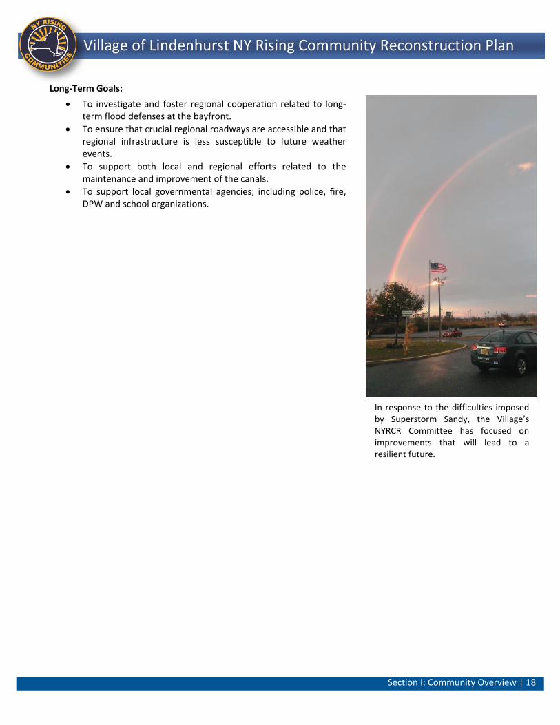
Section I: Community Overview | 18 ||
Lindenhurst NY Rising Community Reconstruction Plan Village of Lindenhurst NY Rising Community Reconstruction Plan
Long-Term Goals:
To investigate and foster regional cooperation related to long-term flood defenses at the bayfront.
To ensure that crucial regional roadways are accessible and that regional infrastructure is less susceptible to future weather events.
To support both local and regional efforts related to the maintenance and improvement of the canals.
To support local governmental agencies; including police, fire, DPW and school organizations.
In response to the difficulties imposed by Superstorm Sandy, the Village’s NYRCR Committee has focused on improvements that will lead to a resilient future.
Section I: Community Overview | 19 ||
Lindenhurst NY Rising Community Reconstruction Plan Village of Lindenhurst NY Rising Community Reconstruction Plan
E. Relationship to Regional Plans
In order to better understand the planning environment and the work done to date within the Village of Lindenhurst, it was paramount to understand the context and interrelated issues that occur locally and regionally. Review of Relevant Existing Plans and Studies
The following plans were identified and reviewed as part of the planning effort related to the Village’s NYRCR Conceptual Plan. The reviewed plans, described below, formed the initial basis for an overall understanding of the existing conditions as well as the desired future conditions within the Village. Local Plans and Studies
Village of Lindenhurst: Downtown Business District Analysis, Suffolk County Department of Planning, April 2000. This study, conducted by the Suffolk County Department of Planning at the request of the Village, assessed the development patterns and status of commercial development along the Wellwood Avenue and Hoffman Avenue corridors. One of the goals of the study was to improve the economic base of the Village by creating jobs and expanding the tax base. Another goal was to protect the viability of existing businesses in the downtown core. Recommendations included: redevelopment of the commercial district; streetscape improvements; the construction of mixed-use high density housing along Wellwood and Hoffman Avenues; improving municipal parking lots, and restoring Neguntatogue Creek. This study informs and reinforces the Committee’s economic resiliency initiatives.
Draft Local Waterfront Revitalization Program (LWRP), Village of Lindenhurst, January 2011. The LWRP was prepared in cooperation with the New York State Department of State (NYS DOS), pursuant to the provisions of the New York State Waterfront Revitalization of Coastal Areas and Inland Waterways Act and the New York State Coastal Management Program. Under the LWRP, the Village proposed a rezoning of waterfront areas, a harbor management law, and other laws that would prohibit illicit discharges into the water. These changes were intended to encourage the development of the maritime economy and water-related uses along the Village’s waterfront.
The Village’s January 2011 LWRP was perhaps the single most specific and up to date current plan that was reviewed. This plan
Section I: Community Overview | 20 ||
Lindenhurst NY Rising Community Reconstruction Plan Village of Lindenhurst NY Rising Community Reconstruction Plan
and its recommendations provided a basis for further consideration and identification of strategies and projects intended to increase the resiliency within the Village. The LWRP was helpful in regard to its inventory of existing conditions as well as its identification of potential projects within the locality.
A Plan for the Future of the Town of Babylon, Draft Comprehensive
Plan, Town of Babylon Comprehensive Plan Committee, March 1998. This Comprehensive Plan for the Town of Babylon presents five central themes which are: preserving the Town’s suburban character; responding to the changing population; improving the quality of life in economically distressed areas; job and economic development and the preservation of natural resources. This initiative proposes town regulations, such as building code ordinances intended to preserve Babylon’s suburban character. While Villages within the Town, such as Lindenhurst, have Zoning and Planning Boards to manage certain discretionary approvals and zoning requests, the Town’s Comprehensive Plan helps to inform their local codes and ordinances. This plan provided context for the Committee as it deliberated on issues ranging from resilient zoning and policy initiatives to potential economic development plans and quality of life improvements.
Town of Babylon Complete Streets Policy, Town of Babylon, July 14, 2010. This policy examined the relationship between road, bicycle and pedestrian networks. Recommended strategies included multi-modal transit options, limiting greenhouse gas emissions and ensuring safety for all modes of transportation. The Village embodies a number of Complete Street aspects in that it has a pedestrian friendly downtown core centered on its LIRR station. The Committee expressed interest in incorporating the features of Complete Street policies into their future resiliency planning efforts.
County Plans and Studies
Suffolk County Comprehensive Plan 2035, Suffolk County Planning
Commission, August 2011. This report was issued as the first volume of a series that will cover all aspects of the Suffolk County environment, economy, sustainability and resource protection. Volume I began the process by presenting updated information on demographics and socio-economic information, development trends, as well as a summary of prior regional and local plans. The Village of Lindenhurst is potentially affected by the recommendations of the plan as it involves County roads, drainage, parks and wastewater treatment—all issues of importance to the Committee.
Section I: Community Overview | 21 ||
Lindenhurst NY Rising Community Reconstruction Plan Village of Lindenhurst NY Rising Community Reconstruction Plan
Suffolk County Comprehensive Water Resources Management
Plan: Executive Summary, County of Suffolk, January 2014. In this report, Suffolk County Executive Steve Bellone identifies nitrogen pollution of ground and surface waters as the region’s greatest threat to public health and safety. Highlighting the fact that 70% of the County (or 350,000 homes) is unsewered, the report launches an effort to identify and prioritize parcels of land most critical to water quality management; these parcels will be targeted for sewer connections and septic system upgrades. The report states: “Water is the single most significant resource for which Suffolk County bears responsibility. As the impact of Superstorm Sandy underscored, more than at any time in our history, we are obliged to come to terms, in every sense, with the water that surrounds us.”
Suffolk County Transfer of Development Rights (TDR) Study: An Inventory of Existing TDR Programs, NY-CT Sustainable Communities Consortium, March 2013. Developed through a 2011 U.S. Housing and Urban Development Sustainable Communities Regional Planning Grant, this report documents and describes all TDR plans, programs, policies and ordinances in Suffolk County. TDR has been used to protect Long Island’s aquifer-based drinking water by preserving thousands of acres in the Long island Pine Barrens. TDR can be an important too, for storm resiliency by helping to shift development from high-risk shoreline areas to low-risk inland areas appropriate for higher density, such as Transit-Oriented Developments along Long island’s rail corridor.
Land Available for Development and Population Analysis Western Suffolk County, Suffolk County Department of Planning, October 2009. This study, by the Suffolk County Department of Planning, was completed as a component of the County’s Comprehensive Water Resources Management Plan. The intent of the study was to determine the potential for population growth and demand for ground water. The study indicated that 37 acres of vacant land were available for development in Lindenhurst. Of this acreage, 29 acres were identified as residential with 5 acres commercial and 3 acres of industrial.
Comprehensive Master List Update 2012: Proposed Open Space Acquisitions, Suffolk County, NY, Suffolk County Department of Planning, December 2012. This report, prepared by the Suffolk County Department of Planning, provides information on demographic, socioeconomic and development trends for both Suffolk County and, in some cases, for Nassau County as well. The report is updated regularly with the most recent update occurring in
Section I: Community Overview | 22 ||
Lindenhurst NY Rising Community Reconstruction Plan Village of Lindenhurst NY Rising Community Reconstruction Plan
August 2013. This report finds a slight growth in jobs in the bi-county area (+ 19,400, 1.54% compared to June 2012). Of note is the finding that the number of businesses increased 1.7% in the five years between 2006 and 2011. There were no open space acquisitions proposed within the Village.
Managing Stormwater – Natural Vegetation and Green Methodologies, Suffolk County, February 2011. This guidebook on stormwater management was prepared by Suffolk County to inform municipalities about the benefits, processes, and best practices for stormwater management and green infrastructure management. Topics include policies to protect groundwater such as overlay districts, subdivision regulations, site plan review process, and penalties for the inappropriate use of fertilizers. The Village, as a bayfront community that experiences recurring flooding, is heavily invested in examining effective stormwater management practices. Early on, the Committee and the public discussed the potential for incorporating these concepts as part of their resiliency efforts.
Suffolk County Multi-Jurisdictional Multi-Hazard Mitigation Plan, Suffolk County, October 2008. In 2008, Suffolk County developed a Mitigation Plan with participation from the Town of Babylon. Implementation of mitigation strategies is the responsibility of local governments and regional partners. The plan was approved by the New York State Office of Emergency Management and FEMA. The plan covers strategies to reduce the impact of future disasters and hazards including: resource management, planning process intended to reduce long-term impacts to health and property loss, and developing in a more sustainable and resilient manner. While the Village of Lindenhurst did not participate in this planning effort; the Village does, however, utilize this plan in their emergency and disaster planning efforts.
Shopping Center and Downtowns, Suffolk County, Suffolk County Department of Planning, New York, May 2006. This report, published in 2006, noted that the Village of Lindenhurst had 140 storefronts with a vacancy rate of 6.4%. By comparison the vacancy rate for the Town of Babylon was approximately 5.0%. The higher rate of vacancies within the Village is a significant matter of concern to the Committee and the public. The Committee expressed an interest in the initial planning stages of this effort to address the overall economic resiliency of the Village. Areas of focus for the Committee included the high rate of vacancies, alternative parking strategies and potential appropriate redevelopment of underutilized property.
Section I: Community Overview | 23 ||
Lindenhurst NY Rising Community Reconstruction Plan Village of Lindenhurst NY Rising Community Reconstruction Plan
Regional Plans and Studies
Long Island’s Dynamic South Shore: A Primer on the Forces and
Trends Shaping Our Coast, New York Sea Grant, 2007. This study provides a scientific overview about coastal processes and erosion on Long Island’s South Shore. Historical shoreline positions, major shoreline trends and technical issues associated with erosion and erosion management are also discussed in this primer. The shoreline is impacted by four factors as noted in the primer: the amount of wave action striking the coast; the supply of sand available for building the shoreline; short and long-term changes in sea level; and human activities in the coastal zone that alter or disrupt movement of sand or natural processes. A significant issue on the South Shore occurs during major storms and winter nor’easters where elevated water levels and big waves erode large volumes of sand from the shore and attack the bluffs behind the shoreline. These storms move material along the shore to adjacent areas or too far out into the ocean for it to be brought back to the beach by gentler waves during calmer conditions. As a result, this sand is permanently lost to the shoreline. This type of event occurred at the southern end of Shore Road Park during Superstorm Sandy.
Long Island South Shore Estuary Reserve Comprehensive Management Plan (SSER CMP) NYS DOS, April 2001. The South Shore Estuary Reserve (SSER) stretches 70 miles from the western border of Nassau County to the center of Suffolk County encompassing all the Bays (Hempstead, South Oyster, Great South, Moriches, and Shinnecock) between Fire and Jones Islands and mainland Long Island. The SSER CMP takes a holistic approach towards managing the South Shore Estuary for both human and environmental needs. It makes recommendations to improve and maintain the SSER’s water quality, to protect and restore living resources, to expand public use, and to sustain and improve related economies. The Village as a bay-front community is inextricably tied to the estuary, both economically and environmentally.
Fire Island Inlet to Montauk Point New York Reformation Study, Draft Formulation Study, U.S. Army Corps of Engineers (USACE), May 2009. The purpose of the study is to identify, evaluate and recommend long-term solutions for hurricane and storm damage reduction for homes and businesses within the floodplain along the ocean and bay shoreline from Fire Island Inlet to Montauk Point. In some locations, the study area extends northward to Sunrise Highway. The completed study is expected in the near future. Upon
Section I: Community Overview | 24 ||
Lindenhurst NY Rising Community Reconstruction Plan Village of Lindenhurst NY Rising Community Reconstruction Plan
approval, funding will become available to complete projects recommended by the study. It is expected that this will include increasing the height and width of the primary dune on the ocean side of Fire Island in selected, vulnerable locations. There are also components of the plan that could affect the South Shore and could potentially involve the Village of Lindenhurst. Possible projects that are being considered include raising houses and roads in certain highly vulnerable locations.
Places to Grow: An Analysis of the Potential for Transit-Accessible Housing and Jobs in Long Island’s Downtowns and Station Areas, Regional Plan Association/Long Island Index, January 2010. This report identifies 8,300 acres of undeveloped land in and around over 150 downtowns and transit stations on Long island. This information is important for storm resiliency because it emphasizes sustainable development and Smart Growth in inland areas, away from high-risk shoreline areas.
Cleaner, Greener Long Island Sustainability Plan, Long island Regional Sustainability Consortium, May 2013. Created through Governor Cuomo’s Cleaner, Greener NY Program, the plan sets forth a regional, community-based vision for future sustainability on Long Island based on economic prosperity, social responsibility and environmental health. A Regional Sustainability Consortium – composed of technical experts and local stakeholders – developed strategies and recommendations in five main focus areas – Economic Development and Workforce Housing; Energy; Transportation; Land Use and Livable Communities; Waste Management; Water Management; and Governance and Implementation. Created through Governor Cuomo’s Cleaner, Greener NY Program, the plan sets forth a regional, community-based vision for future sustainability on Long Island based on economic prosperity, social responsibility and environmental health. A Regional Sustainability Consortium – composed of technical experts and local stakeholders – developed strategies and recommendations in five main focus areas – Economic Development and Workforce Housing; Energy; Transportation; Land Use and Livable Communities; Waste Management; Water Management; and Governance and Implementation.
Long Island 2035: A Regional Comprehensive Sustainability Plan Long Island Regional Planning Council, December 2010. The plan noted the inability of Long Island to sustain itself fiscally, environmentally and socially based on current governance methods and policies. The plan put forward that fundamental change would be necessary to alter the course of the future by noting the

Section I: Community Overview | 25 ||
Lindenhurst NY Rising Community Reconstruction Plan Village of Lindenhurst NY Rising Community Reconstruction Plan
following, “Despite these challenges, Long Island has a tremendous opportunity to redefine what it means to live in a sustainable 21st century suburban community, recognizing it is possible for Long Island to be affordable and prosperous, bringing a return to economic growth and strength. Our ability to act today –and leave behind the status quo -will have a tremendous impact on the future of the region.” The aftermath of the Superstorm Sandy highlighted the critical importance of the FINS, the Army Corps of Engineers (USACE), FEMA and other Federal agencies working with various State agencies, two towns, two incorporated Villages and 17 communities to coordinate reconstruction and rebuilding. The effort is leading to a call for a more sustainable relationship between these entities, such as a recurrent Fire Island Planning Forum.
Long Island’s Future Economy: Long Island Regional Economic
Development Council (LIREDC), 2011 (2012, 2013 Progress Report). This plan was initiated by New York State as a means of reviving the regional economy. The plan contains six major strategies that cover a broad spectrum of economic and quality of life issues. The Executive Summary of the Plan describes the strategies as follows (language from document): o Create a cohesive education and workforce training strategy
through partnerships among a range of stakeholders – business, trade groups, labor, government agencies, educational institutions, parents and students – with the goal of ensuring that workers from all of Long Island’s communities are prepared to take advantage of new job opportunities in key economic growth sectors.
o Develop innovation and industry clusters in transformative locations across the region including downtowns, brownfields and university, research and medical centers by integrating the smart-growth principles of transit-oriented development and vibrant community life.
o Enhance and develop multi-faceted, interdisciplinary facilities aimed at incubating and accelerating the commercialization of innovative products generated at the region’s premier research institutions, by linking scientists, engineers, health and medical professionals to entrepreneurs and small businesses.
o Reinvigorate Long Island’s manufacturing sector through continued transformation from traditional defense and aerospace work to advanced technology products, creating
Section I: Community Overview | 26 ||
Lindenhurst NY Rising Community Reconstruction Plan Village of Lindenhurst NY Rising Community Reconstruction Plan
skilled, high-value jobs and a network of nimble companies that can develop synergistic partnerships with companies in other regions of the State.
o Produce a new generation of sustainable, good-paying jobs in the legacy sectors of agriculture, aquaculture, fisheries and tourism by expanding export opportunities, infrastructure, recreation facilities, research partnerships and workforce training.
o Rebuild and expand infrastructure to improve job access, revitalize downtowns and transit hubs, speed trade, and attract and retain dynamic regional businesses and highly skilled workforce.
The LIREDC progress report detailed the year-long effort to organize, coordinate and focus local, State and private resources. The Progress Report addressed challenges of stressed infrastructure, loss of young workers and the economic disparities between communities across the region. This update also outlines how local government, private businesses and major research clusters on Long Island are expected to bring forward to facilitate job creation across Long Island.20
The Village has identified a need to revitalize its downtown and to encourage an innovative, sustainable economy consistent with the study’s recommendation. In addition, the Committee has proposed projects that address the rebuilding and expansion of infrastructure to protect the environment, strengthen the economy and improve the overall resiliency of the Village of Lindenhurst.
Connect Long Island: A Regional Transportation and Development Plan, Town of Babylon, October, 2011. This is a plan for regional economic development and quality-of-life, focusing on strategic, sustainable public infrastructure investments along Long Island’s transit corridor. The plan scope is three-fold: promote Transit-Oriented Development (TOD); improve transit connections between these TOD destinations; and create greater connectivity between transit and job hubs, including North-South transit service. These goals are important for regional storm resiliency as they will provide greater housing and economic development opportunities along the rail corridor, away from the high-risk flood areas along the shore. And demographics on Long Island indicate a growing need for housing in “Smart Growth” communities – that is, compact, mixed-use downtown centers within close proximity to public transit.
Section I: Community Overview | 27 ||
Lindenhurst NY Rising Community Reconstruction Plan Village of Lindenhurst NY Rising Community Reconstruction Plan
Potential Regional Issues and Concerns
Long Island spans over 118 miles from New York Harbor to Montauk Point and has a maximum width of approximately 23 miles between the Long Island Sound to the north and the Atlantic Ocean to the south. Long Island, the 11th largest island in the nation, has a land area of over 1,400 square miles and is larger than the state of Rhode Island. Due to its island geography, many of the communities and counties within the Island share similar challenges as well as opportunities relative to the natural environment, physical infrastructure, and other built systems. Potential Island-wide issues are expanded upon below. Natural Environment: Long Island has 1,180 miles of shoreline fronting the Atlantic Ocean, Sound, and a number of lakes, bays, inlets and canals. Approximately one-fifth of Long Island’s land is protected from development by Federal, State, County, or municipal entities. About half of this land represents over 800 public parks on Long Island ranging from small community playgrounds to larger parks like Fire Island National Seashore and Bethpage State Park.21 Developable Land Supply: Almost two-thirds of Long Island’s land surface is developed with buildings, pavement and other manmade structures. This condition in combination with the large amount of protected/preserved land, results in a limited supply of available vacant land to accommodate new housing or economic development activities. Water Quality: Long Island’s aquifers receive their fresh water from precipitation that percolates into the ground and is recharged into the groundwater system. The greatest threat to the quality of this water is development (residential/commercial/industrial) in sensitive areas that would add pollutants and impede the absorption of precipitation. Other threats to water quality include non-point source pollution and storm water runoff, which are County-wide concerns. Non-point sources typically include fertilizer and pesticides, oil and other automobile fluid, as well as animal and pet waste. This type of pollution has the potential to seep into ground water and impact surface waters such as the Great South Bay. While the Great South Bay is a surface water body, it is also a significant habitat comprised of features such as barrier beaches and islands, wetlands as well as marsh islands. Utilities: Electricity and the susceptibility of the power grid are both national and regional issues of concern. The Long Island Regional Economic Development Council (LIREDC) strategic economic development plan update has similarly stressed the importance of addressing utility vulnerabilities, which currently exist across the Island.
Section I: Community Overview | 28 ||
Lindenhurst NY Rising Community Reconstruction Plan Village of Lindenhurst NY Rising Community Reconstruction Plan
Climate Change: As a coastal area, Long Island is susceptible to rising sea levels, especially as it relates to storm surges. Flooding generated by major weather events, 100-year storms, or just a heavy downpour, causing damage to residences and property, have been occurring with greater frequency. According to a joint Columbia University and City University of New York study, the sea level is anticipated to increase by 4 to 12 centimeters in the New York region by the 2020s and by 30 to 56 centimeters by 2080.22 Other issues that are pertinent on a regional level include those related to public health and economic equity. These include projects designed to improve the quality of life for the Island’s impoverished, underinsured or at-risk populations. Emergency preparedness projects are also important to improve the overall safety of the Island’s population. These include: maintaining evacuation route access; improving the communication capability for a multi-jurisdictional response during emergency events.
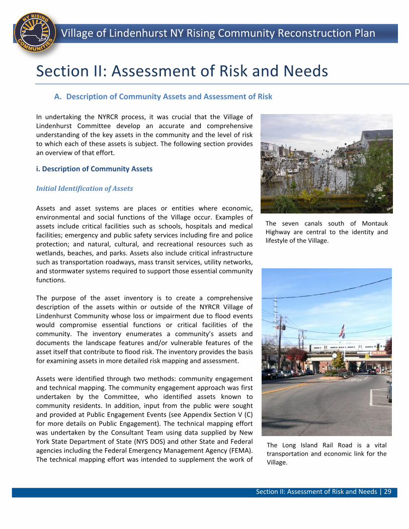
Section II: Assessment of Risk and Needs | 29
Lindenhurst NY Rising Community Reconstruction Plan Village of Lindenhurst NY Rising Community Reconstruction Plan
Section II: Assessment of Risk and Needs
A. Description of Community Assets and Assessment of Risk
In undertaking the NYRCR process, it was crucial that the Village of Lindenhurst Committee develop an accurate and comprehensive understanding of the key assets in the community and the level of risk to which each of these assets is subject. The following section provides an overview of that effort.
i. Description of Community Assets
Initial Identification of Assets
Assets and asset systems are places or entities where economic, environmental and social functions of the Village occur. Examples of assets include critical facilities such as schools, hospitals and medical facilities; emergency and public safety services including fire and police protection; and natural, cultural, and recreational resources such as wetlands, beaches, and parks. Assets also include critical infrastructure such as transportation roadways, mass transit services, utility networks, and stormwater systems required to support those essential community functions. The purpose of the asset inventory is to create a comprehensive description of the assets within or outside of the NYRCR Village of Lindenhurst Community whose loss or impairment due to flood events would compromise essential functions or critical facilities of the community. The inventory enumerates a community’s assets and documents the landscape features and/or vulnerable features of the asset itself that contribute to flood risk. The inventory provides the basis for examining assets in more detailed risk mapping and assessment. Assets were identified through two methods: community engagement and technical mapping. The community engagement approach was first undertaken by the Committee, who identified assets known to community residents. In addition, input from the public were sought and provided at Public Engagement Events (see Appendix Section V (C) for more details on Public Engagement). The technical mapping effort was undertaken by the Consultant Team using data supplied by New York State Department of State (NYS DOS) and other State and Federal agencies including the Federal Emergency Management Agency (FEMA). The technical mapping effort was intended to supplement the work of
The seven canals south of Montauk Highway are central to the identity and lifestyle of the Village.
The Long Island Rail Road is a vital transportation and economic link for the Village.
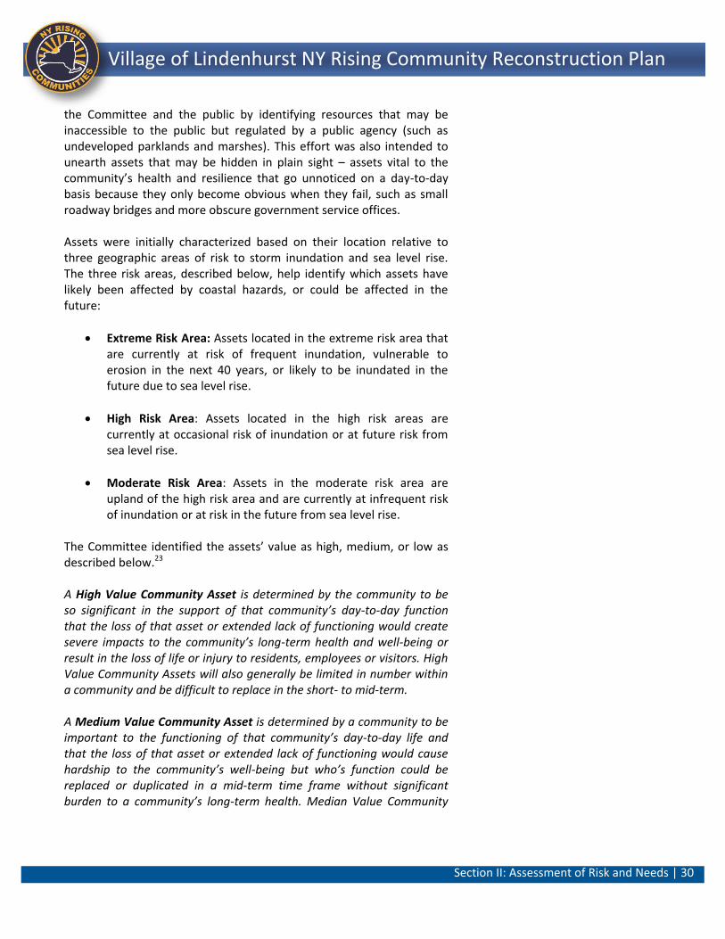
Section II: Assessment of Risk and Needs | 30
Lindenhurst NY Rising Community Reconstruction Plan Village of Lindenhurst NY Rising Community Reconstruction Plan
the Committee and the public by identifying resources that may be inaccessible to the public but regulated by a public agency (such as undeveloped parklands and marshes). This effort was also intended to unearth assets that may be hidden in plain sight – assets vital to the community’s health and resilience that go unnoticed on a day-to-day basis because they only become obvious when they fail, such as small roadway bridges and more obscure government service offices. Assets were initially characterized based on their location relative to three geographic areas of risk to storm inundation and sea level rise. The three risk areas, described below, help identify which assets have likely been affected by coastal hazards, or could be affected in the future:
Extreme Risk Area: Assets located in the extreme risk area that are currently at risk of frequent inundation, vulnerable to erosion in the next 40 years, or likely to be inundated in the future due to sea level rise.
High Risk Area: Assets located in the high risk areas are currently at occasional risk of inundation or at future risk from sea level rise.
Moderate Risk Area: Assets in the moderate risk area are upland of the high risk area and are currently at infrequent risk of inundation or at risk in the future from sea level rise.
The Committee identified the assets’ value as high, medium, or low as described below.23 A High Value Community Asset is determined by the community to be so significant in the support of that community’s day-to-day function that the loss of that asset or extended lack of functioning would create severe impacts to the community’s long-term health and well-being or result in the loss of life or injury to residents, employees or visitors. High Value Community Assets will also generally be limited in number within a community and be difficult to replace in the short- to mid-term. A Medium Value Community Asset is determined by a community to be important to the functioning of that community’s day-to-day life and that the loss of that asset or extended lack of functioning would cause hardship to the community’s well-being but who’s function could be replaced or duplicated in a mid-term time frame without significant burden to a community’s long-term health. Median Value Community
Section II: Assessment of Risk and Needs | 31
Lindenhurst NY Rising Community Reconstruction Plan Village of Lindenhurst NY Rising Community Reconstruction Plan
Assets are generally more frequent in occurrence in a community than a High Value Asset. A Low Value Community Asset is determined by a community to play a role in the functioning of a community’s day-to-day life but whose loss could be managed and overcome within a community without substantial impact to that community’s functioning. These assets are generally more frequent in a community than a High or Medium Value Community Asset and can be restarted, replaced or temporarily duplicated in a short-term time frame with limited burden to a community’s long-term health. The assets identified through the technical mapping effort were combined with the community identified asset data and the community identification, resulting in a complete picture of not only the physical assets themselves but their value as perceived by the community. The community assets and their corresponding risk areas, identified by the Committee and community at large, are presented in the following tables. The complete asset inventory is found in Section V: Additional Materials. The complete inventory provides more detail on each identified asset, such as its classification as a critical or non-critical facility, whether the asset serves a vulnerable population, and the relative value, or importance, of the asset to the community. As part of the inventory, the Consultant Team also noted contributing landscape attributes and physical features of the asset or surrounding the asset that influences the severity of storm impacts. For example, assets that are located near shorelines absent of wide beaches, healthy dunes, and protective vegetation are at increased risk of flooding. Specific features of the asset that are at risk (e.g., mechanical equipment below flooding elevation) are also recorded in the inventory. Figure 2 shows Risk Area and Inundation.
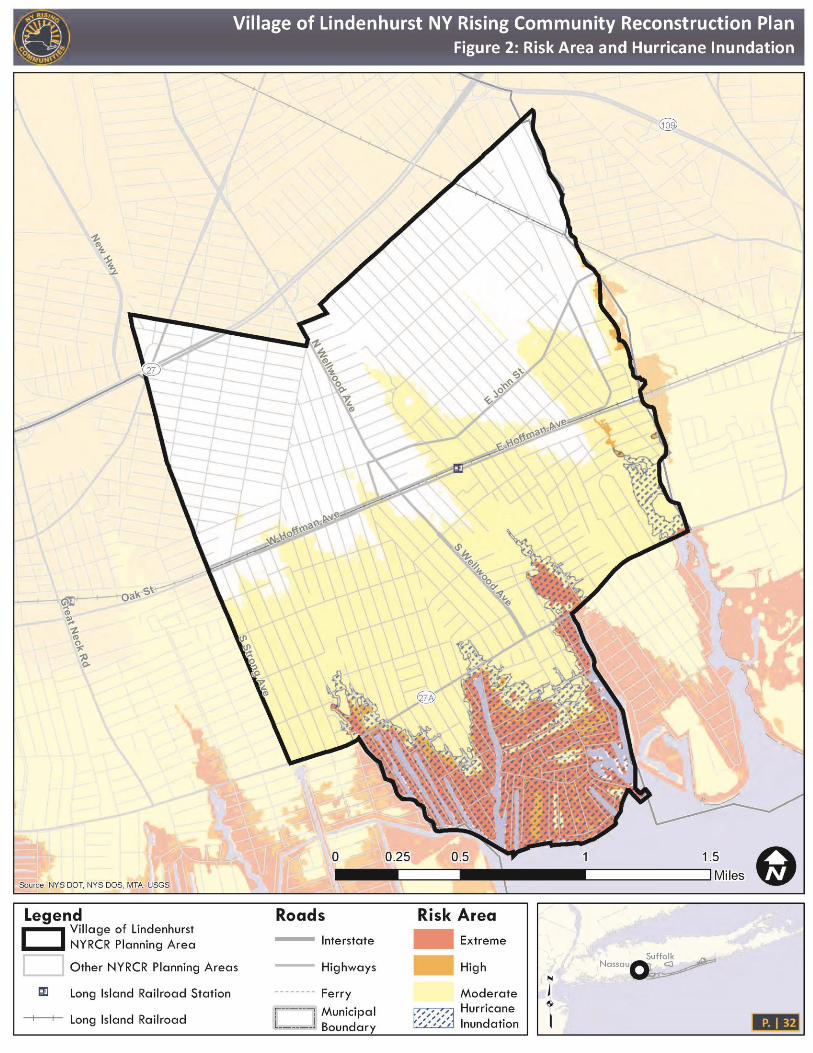
Section II: Assessment of Risk and Needs | 32
Lindenhurst NY Rising Community Reconstruction Plan Village of Lindenhurst NY Rising Community Reconstruction Plan
Figure 2: Risk Areas and Superstorm Sandy Inundation
Section II: Assessment of Risk and Needs | 33
Lindenhurst NY Rising Community Reconstruction Plan Village of Lindenhurst NY Rising Community Reconstruction Plan
Description of Assets An overview of NYRCR Village of Lindenhurst assets is provided below. Over 200 assets were originally catalogued based on this initial level of review. This inventory highlighted community assets that, if impaired as a result of hazard events, would compromise the essential social, economic, or environmental functions of the community. The asset classifications, including facilities and/or specific places as well as systems (storm sewer, electric, etc.), are as follows:24
o Cultural, Natural, and Recreational Resources: The benefits of natural infrastructure have been increasingly recognized among hazard planners. Coastal ecosystems can help reduce wave attenuation, deflection, erosion reduction, and also provide stormwater retention. Many of these natural systems offer co-benefits: wetlands help to cleanse urban stormwater of contaminants before it enters local waterways, improving overall water quality; shoreline green space provides wildlife habitats as well as recreation and improved quality of life for residents. Some natural systems also require less maintenance and operations costs. The Village, as a bayfront community, is explicitly interested in not only maintaining but also improving upon their natural resources including Neguntatogue Creek and Park and its shorefront/landward edge at Shore Road Park.
o Health and Social Services (Life Safety and Administration/ Education): The ability to restore and improve health and social service networks to promote the resilience, health and independence and well-being of the entire Village is the core recovery capability for this asset class. These functions are especially important to vulnerable populations that may require access to medical and social services. Many residents illustrated these asset class qualities at a grassroots level when they pulled together post storm to create make-shift recovery centers. One of these locations, Camp Bulldog, was established in Shore Road Park. In a practical sense, the camp became a place to go for a warm meal, to check on neighbors or obtain information about recovery resources. Symbolically and figuratively, this location was at the center of the Village’s resiliency and recovery efforts.
o Infrastructure Systems (Transportation and Utilities): The roadway and rail networks, gas mains and the power grid are central to the Village as they provide the ability to travel within and between communities, access employment, and communicate. The ability to restore these functions in a timely

Section II: Assessment of Risk and Needs | 34
Lindenhurst NY Rising Community Reconstruction Plan Village of Lindenhurst NY Rising Community Reconstruction Plan
manner after a storm and better protect these systems in future hazards is important in terms of supporting a viable, more resilient community. Investments in infrastructure can be effective both in rebuilding capabilities lost during a storm and in providing economic development from job creation. Early on in the NYRCR planning process, the Committee indicated that travel conditions, utility outages and the ability to communicate effectively hindered the cleanup and rebuilding process post-Superstorm Sandy.
o Housing: Housing solutions are important in that they effectively support the needs of the Village as well as vulnerable populations, and contribute to its sustainability and resiliency. Housing is critical since local economies cannot recover from devastating disasters without adequate housing. It is challenging because many years’ worth of housing repair, rehabilitation, reconstruction and new construction often need to occur at an accelerated pace as a result of a disaster. These conditions create design, construction, labor, materials, logistics, inspection and financing problems. Many of these issues were experienced south of Montauk Highway, which is a predominantly residential area of the Village that sustained heavy damage from Superstorm Sandy.
o Economic: The assets within this category are important to the Village in that they help to sustain and/or rebuild businesses and employment and also develop economic opportunities that result in sustainable and economic resilient communities. The Village has a traditional downtown commercial district along Wellwood and Hoffman Avenues as well as a marine oriented economy that is typified by marinas, boat sales and repair facilities, and dining establishments along its waterfront. The businesses within these areas are assets to the Village and maintaining their economic vitality will ensure the future ability of these businesses to remain within the community.
Natural and Cultural Resources Natural and Cultural Resources include natural habitats, wetlands and marshes, recreation facilities, parks, open spaces, agricultural areas, religious establishments, libraries, museums, historic landmarks and performing arts venues. The South Shore of Long Island has historically been, and continues to be, a natural and recreational resource. Intact and ecologically stable natural resources are a vital component to the resiliency of coastal
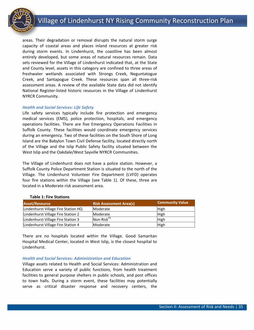
Section II: Assessment of Risk and Needs | 35
Lindenhurst NY Rising Community Reconstruction Plan Village of Lindenhurst NY Rising Community Reconstruction Plan
areas. Their degradation or removal disrupts the natural storm surge capacity of coastal areas and places inland resources at greater risk during storm events. In Lindenhurst, the coastline has been almost entirely developed, but some areas of natural resources remain. Data sets reviewed for the Village of Lindenhurst indicated that, at the State and County level, assets in this category are confined to three areas of freshwater wetlands associated with Strongs Creek, Neguntatogue Creek, and Santapogue Creek. These resources span all three-risk assessment areas. A review of the available State data did not identify National Register-listed historic resources in the Village of Lindenhurst NYRCR Community. Health and Social Services: Life Safety Life safety services typically include fire protection and emergency medical services (EMS), police protection, hospitals, and emergency operations facilities. There are five Emergency Operations Facilities in Suffolk County. These facilities would coordinate emergency services during an emergency. Two of these facilities on the South Shore of Long Island are the Babylon Town Civil Defense facility, located directly north of the Village and the Islip Public Safety facility situated between the West Islip and the Oakdale/West Sayville NYRCR Communities. The Village of Lindenhurst does not have a police station. However, a Suffolk County Police Department Station is situated to the north of the Village. The Lindenhurst Volunteer Fire Department (LVFD) operates four fire stations within the Village (see Table 1). Of these, three are located in a Moderate risk assessment area.
Table 1: Fire Stations
Asset/Resource Risk Assessment Area(s) Community Value
Lindenhurst Village Fire Station HQ Moderate High
Lindenhurst Village Fire Station 2 Moderate High
Lindenhurst Village Fire Station 3 Non-Risk25 High
Lindenhurst Village Fire Station 4 Moderate High
There are no hospitals located within the Village. Good Samaritan Hospital Medical Center, located in West Islip, is the closest hospital to Lindenhurst. Health and Social Services: Administration and Education Village assets related to Health and Social Services: Administration and Education serve a variety of public functions, from health treatment facilities to general purpose shelters in public schools, and post offices to town halls. During a storm event, these facilities may potentially serve as critical disaster response and recovery centers, the
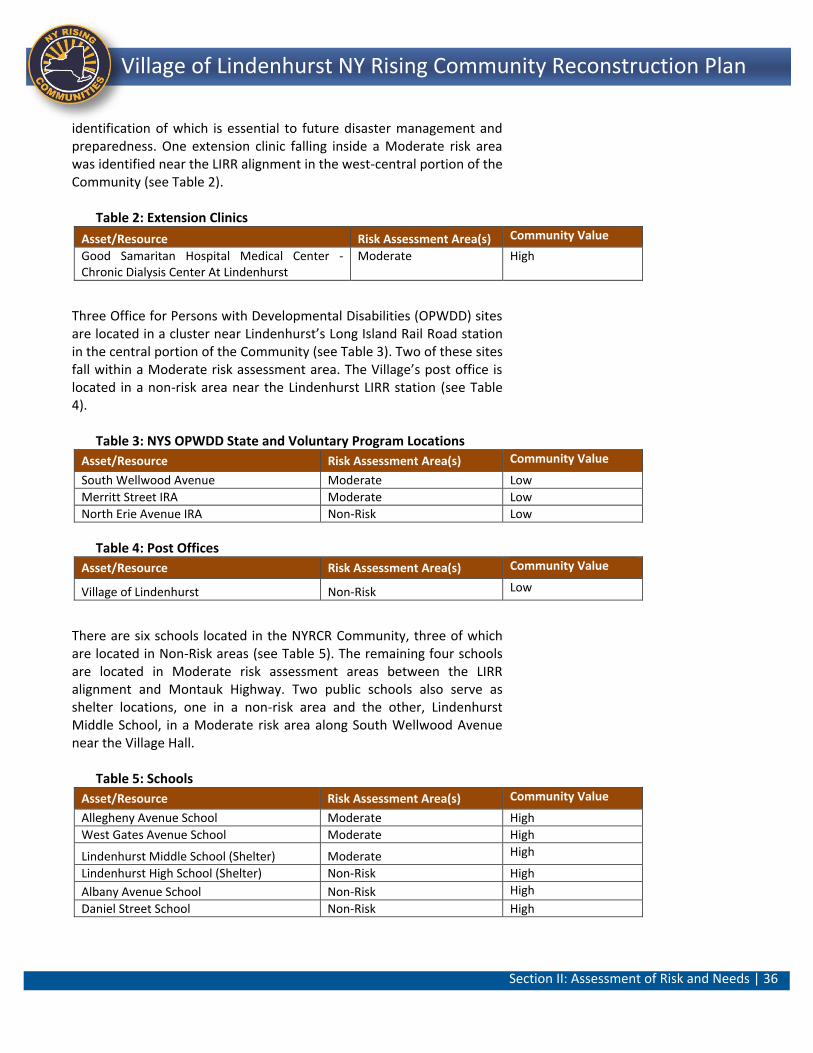
Section II: Assessment of Risk and Needs | 36
Lindenhurst NY Rising Community Reconstruction Plan Village of Lindenhurst NY Rising Community Reconstruction Plan
identification of which is essential to future disaster management and preparedness. One extension clinic falling inside a Moderate risk area was identified near the LIRR alignment in the west-central portion of the Community (see Table 2).
Table 2: Extension Clinics
Asset/Resource Risk Assessment Area(s) Community Value
Good Samaritan Hospital Medical Center - Chronic Dialysis Center At Lindenhurst
Moderate High
Three Office for Persons with Developmental Disabilities (OPWDD) sites are located in a cluster near Lindenhurst’s Long Island Rail Road station in the central portion of the Community (see Table 3). Two of these sites fall within a Moderate risk assessment area. The Village’s post office is located in a non-risk area near the Lindenhurst LIRR station (see Table 4).
Table 3: NYS OPWDD State and Voluntary Program Locations
Asset/Resource Risk Assessment Area(s) Community Value
South Wellwood Avenue Moderate Low
Merritt Street IRA Moderate Low
North Erie Avenue IRA Non-Risk Low
Table 4: Post Offices
Asset/Resource Risk Assessment Area(s) Community Value
Village of Lindenhurst Non-Risk Low
There are six schools located in the NYRCR Community, three of which are located in Non-Risk areas (see Table 5). The remaining four schools are located in Moderate risk assessment areas between the LIRR alignment and Montauk Highway. Two public schools also serve as shelter locations, one in a non-risk area and the other, Lindenhurst Middle School, in a Moderate risk area along South Wellwood Avenue near the Village Hall.
Table 5: Schools
Asset/Resource Risk Assessment Area(s) Community Value
Allegheny Avenue School Moderate High
West Gates Avenue School Moderate High
Lindenhurst Middle School (Shelter) Moderate High
Lindenhurst High School (Shelter) Non-Risk High
Albany Avenue School Non-Risk High
Daniel Street School Non-Risk High
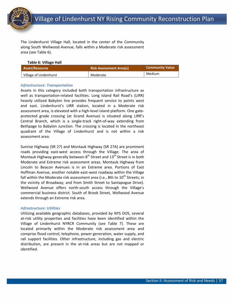
Section II: Assessment of Risk and Needs | 37
Lindenhurst NY Rising Community Reconstruction Plan Village of Lindenhurst NY Rising Community Reconstruction Plan
The Lindenhurst Village Hall, located in the center of the Community along South Wellwood Avenue, falls within a Moderate risk assessment area (see Table 6).
Table 6: Village Hall
Asset/Resource Risk Assessment Area(s) Community Value
Village of Lindenhurst Moderate Medium
Infrastructure: Transportation Assets in this category included both transportation infrastructure as well as transportation-related facilities. Long Island Rail Road’s (LIRR) heavily utilized Babylon line provides frequent service to points west and east. Lindenhurst’s LIRR station, located in a Moderate risk assessment area, is elevated with a high-level island platform. One gate-protected grade crossing (at Grand Avenue) is situated along LIRR’s Central Branch, which is a single-track right-of-way extending from Bethpage to Babylon Junction. The crossing is located in the northeast quadrant of the Village of Lindenhurst and is not within a risk assessment area. Sunrise Highway (SR 27) and Montauk Highway (SR 27A) are prominent roads providing east-west access through the Village. The area of Montauk Highway generally between 8th Street and 13th Street is in both Moderate and Extreme risk assessment areas. Montauk Highway from Lincoln to Beacon Avenues is in an Extreme area. Portions of East Hoffman Avenue, another notable east-west roadway within the Village fall within the Moderate risk assessment area (i.e., 8th to 10th Streets; in the vicinity of Broadway; and from Smith Street to Santapogue Drive). Wellwood Avenue offers north-south access through the Village’s commercial business district. South of Brook Street, Wellwood Avenue extends through an Extreme risk area. Infrastructure: Utilities Utilizing available geographic databases, provided by NYS DOS, several at-risk utility properties and facilities have been identified within the Village of Lindenhurst NYRCR Community (see Table 7). These are located primarily within the Moderate risk assessment area and comprise flood control, telephone, power generation, water supply, and rail support facilities. Other infrastructure, including gas and electric distribution, are present in the at-risk areas but are not mapped or identified.
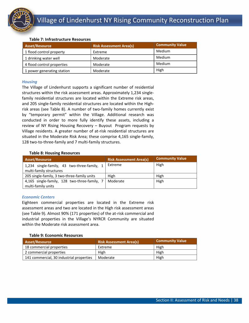
Section II: Assessment of Risk and Needs | 38
Lindenhurst NY Rising Community Reconstruction Plan Village of Lindenhurst NY Rising Community Reconstruction Plan
Table 7: Infrastructure Resources
Asset/Resource Risk Assessment Area(s) Community Value
1 flood control property Extreme Medium
1 drinking water well Moderate Medium
4 flood control properties Moderate Medium
1 power generating station Moderate High
Housing The Village of Lindenhurst supports a significant number of residential structures within the risk assessment areas. Approximately 1,234 single-family residential structures are located within the Extreme risk areas, and 205 single-family residential structures are located within the High-risk areas (see Table 8). A number of two-family homes currently exist by “temporary permit” within the Village. Additional research was conducted in order to more fully identify these assets, including a review of NY Rising Housing Recovery – Buyout Program requests by Village residents. A greater number of at-risk residential structures are situated in the Moderate Risk Area; these comprise 4,165 single-family, 128 two-to-three-family and 7 multi-family structures.
Table 8: Housing Resources
Asset/Resource Risk Assessment Area(s) Community Value
1,234 single-family, 43 two-three-family, 1 multi-family structures
Extreme High
205 single-family, 3 two-three-family units High High
4,165 single-family, 128 two-three-family, 7 multi-family units
Moderate High
Economic Centers Eighteen commercial properties are located in the Extreme risk assessment areas and two are located in the High risk assessment areas (see Table 9). Almost 90% (171 properties) of the at-risk commercial and industrial properties in the Village’s NYRCR Community are situated within the Moderate risk assessment area.
Table 9: Economic Resources
Asset/Resource Risk Assessment Area(s) Community Value
18 commercial properties Extreme High
2 commercial properties High High
141 commercial, 30 industrial properties Moderate High
Section II: Assessment of Risk and Needs | 39
Lindenhurst NY Rising Community Reconstruction Plan Village of Lindenhurst NY Rising Community Reconstruction Plan
ii. Assessment of Risk to Assets and Systems
Risk is the chance that an asset will be damaged or destroyed. Assessing the risk to identified community assets and systems through a risk assessment process helped the Committee identify assets at the greatest flood risk, understand measures that would protect those assets, and develop projects that can be put in place to protect assets at risk. The three factors that contribute to the measure of overall risk for each asset are:
o Hazard: The likelihood and magnitude of future storm events. Examples of the most common hazard risks include coastal flooding, flooding in a 100-year floodplain, sea level rise, or hurricanes. Typically, an asset located in an Extreme risk area experiences hazards with greater frequency and intensity that assets in a High or Moderate risk area.
o Exposure: The moderating effect of topographic and shoreline features. If assets are more exposed (e.g., situated on low-lying floodplains, directly exposed to a probable storm surge, or otherwise unprotected), they are more likely to suffer storm effects than similar assets located at a higher elevation or on a rocky shoreline protected by dunes. Similarly, landscape features and vegetation are more important for an asset proximate to a flood source than an asset further inland.
o Vulnerability: The level of impairment or consequences that assets may experience from a storm event. The ability of an asset to resist damage from a storm is a measure of vulnerability. If an asset recovers quickly with limited interruption in service it has low vulnerability. An asset with extended service loss or permanently reduced capacity would be considered to be significantly vulnerable.
The NYRCR Committee in cooperation with the State used a standardized Risk Assessment Tool to assess and quantify the risk to assets identified by the Community. The asset inventory provided a baseline to identify the most critical assets in the Village to be advanced through the Risk Assessment Tool for further analysis. The assets selected from the inventory for input into the Risk Assessment Tool include:
Assets situated in Extreme and High Risk areas Critical Assets (FEMA-critical) in Moderate Risk Zones
Section II: Assessment of Risk and Needs | 40
Lindenhurst NY Rising Community Reconstruction Plan Village of Lindenhurst NY Rising Community Reconstruction Plan
Locally-significant community identified (High Community Value) in Moderate Risk Zones
Assets with High Community Value in Non Risk Areas Assets providing critical life safety services
In addition, similar assets were grouped as a single asset to the maximum extent possible because these assets would likely experience the same effects from storm events and have similar risk scores. For example, residential neighborhoods with similar construction were combined by risk area. For each asset input into the Risk Assessment Tool, the three factors that contribute to risk were scored and multiplied to produce a final risk score. The formula to calculate risk is:
Hazard x Exposure x Vulnerability = Risk26
Village of Lindenhurst Risk Assessment Results The complete Asset Inventory Worksheet and corresponding Risk Assessment Tool data for the Village of Lindenhurst are provided in Section V. Generally, but in not all instances, risk dissipates the further upland an asset is from the water. The inventory catalogued approximately 60 assets that were carried through for analysis in the Risk Assessment Tool.27 These assets ranged from residential areas within Moderate, High, and Extreme Risk areas south of Montauk Highway to commercial clusters along Hoffman and Wellwood Avenues. Natural resource systems such as Neguntatogue Park and Creek and Santapogue and Strongs Creeks were also inventoried. Other asset categories included transportation facilities, EMS resources and commercial/economic uses. Community-identified high value resources such as the Village’s seven canals and the Lindenhurst Community Center were also included for analysis. Risk score classifications ranged from Residual at the Lindenhurst Community Center and Lindenhurst High School to High Risk at Neguntatogue Creek and the Moose Lodge. The area south of Montauk Highway is predominantly comprised of residential properties, many of which back on to canals. This area is subject to persistent, recurring flooding during both major storms and typical seasonal weather and high tides. Throughout the course of the planning process, the susceptibility of this area was raised by Village residents at the Public Engagement Events and by members of the Committee at their working sessions. In October 2013, southern portions of the Village experienced flooding from a high tide exacerbated by an off-shore storm. Most recently, there was flooding
Section II: Assessment of Risk and Needs | 41
Lindenhurst NY Rising Community Reconstruction Plan Village of Lindenhurst NY Rising Community Reconstruction Plan
throughout this area in January 2014 as a result of winter snowfalls and subsequent melting in the vicinity of 8th Street, 4th and 5th Streets and Shore Road. More than a year after Superstorm Sandy this neighborhood is still recovering with homes in various states of construction (including elevating). Other properties are for sale, abandoned or in disrepair, all of which was evident during field reconnaissance. As a result, the risk to residential properties and adequately addressing the needs of those residing south of Montauk Highway was of great concern to the NYRCR Planning Committee. This anecdotal evidence has been validated through the Risk Assessment analysis as resources situated south of Montauk Highway with adjacencies to the canals and those towards the Great South Bay generally scored in the Severe Risk range with some High Risk assets interspersed. One notable exception was the Bower School property that was one of the few properties south of Montauk Highway that did not flood during Superstorm Sandy. This property is a high point in the area and had a Moderate Risk score. The Village Marina, residences in the Extreme risk areas, Shore Road Park and the Canals were all classified in as Severe Risk. Assets that received the highest risk scores included the Village Marina and residential neighborhoods in Extreme risk areas and the Canals. The risk assessments helped inform, focus and provide context for the needs and opportunities identified by the Lindenhurst NYRCR Planning Committee, as discussed below. The Risk Assessment Table provides an identification number (ID#) for each asset shown on the Risk Map (see Table 10). The identification number on the table corresponds to the ID number shown on the map. The table is also color coded by risk level and an overview follows. Assets are placed into the following risk categories, based upon their risk scores.
Severe Risk assets (shown in red in the table and map) are those that are in a dangerous situation or location.
High Risk assets (shown in orange) indicate conditions that could lead to significant negative outcomes from a storm.
Moderate Risk assets (in yellow) pose moderate to serious consequences. These assets, however, may be at a lower priority compared to High or Severe Risk assets because Moderate Risk assets have relatively low exposure or vulnerability.
Residual Risk assets (green) occur when both vulnerability and exposure are relatively low. (Flood waters and storm damage
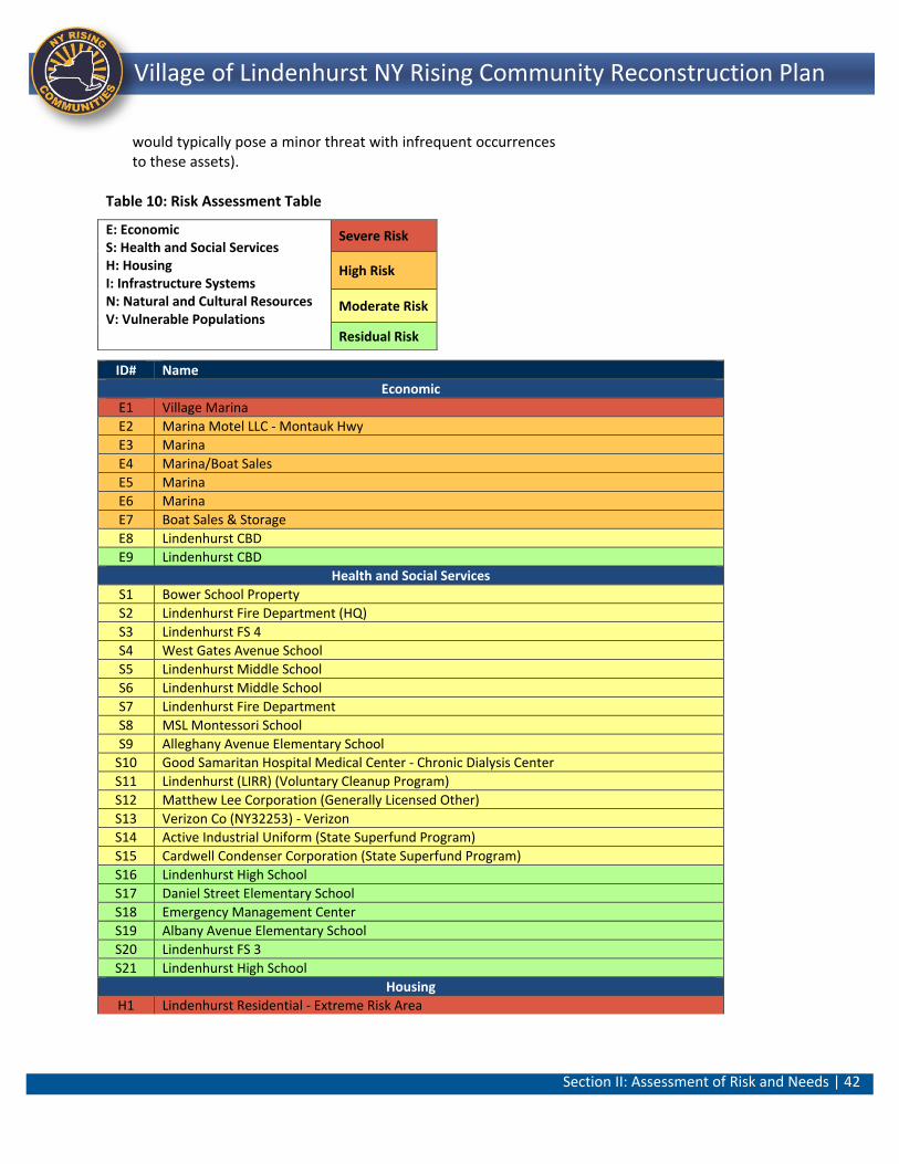
Section II: Assessment of Risk and Needs | 42
Lindenhurst NY Rising Community Reconstruction Plan Village of Lindenhurst NY Rising Community Reconstruction Plan
would typically pose a minor threat with infrequent occurrences to these assets).
Table 10: Risk Assessment Table
ID# Name
Economic
E1 Village Marina
E2 Marina Motel LLC - Montauk Hwy
E3 Marina
E4 Marina/Boat Sales
E5 Marina
E6 Marina
E7 Boat Sales & Storage
E8 Lindenhurst CBD
E9 Lindenhurst CBD
Health and Social Services
S1 Bower School Property
S2 Lindenhurst Fire Department (HQ)
S3 Lindenhurst FS 4
S4 West Gates Avenue School
S5 Lindenhurst Middle School
S6 Lindenhurst Middle School
S7 Lindenhurst Fire Department
S8 MSL Montessori School
S9 Alleghany Avenue Elementary School
S10 Good Samaritan Hospital Medical Center - Chronic Dialysis Center
S11 Lindenhurst (LIRR) (Voluntary Cleanup Program)
S12 Matthew Lee Corporation (Generally Licensed Other)
S13 Verizon Co (NY32253) - Verizon
S14 Active Industrial Uniform (State Superfund Program)
S15 Cardwell Condenser Corporation (State Superfund Program)
S16 Lindenhurst High School
S17 Daniel Street Elementary School
S18 Emergency Management Center
S19 Albany Avenue Elementary School
S20 Lindenhurst FS 3
S21 Lindenhurst High School
Housing
H1 Lindenhurst Residential - Extreme Risk Area
E: Economic S: Health and Social Services H: Housing I: Infrastructure Systems N: Natural and Cultural Resources V: Vulnerable Populations
Severe Risk
High Risk
Moderate Risk
Residual Risk
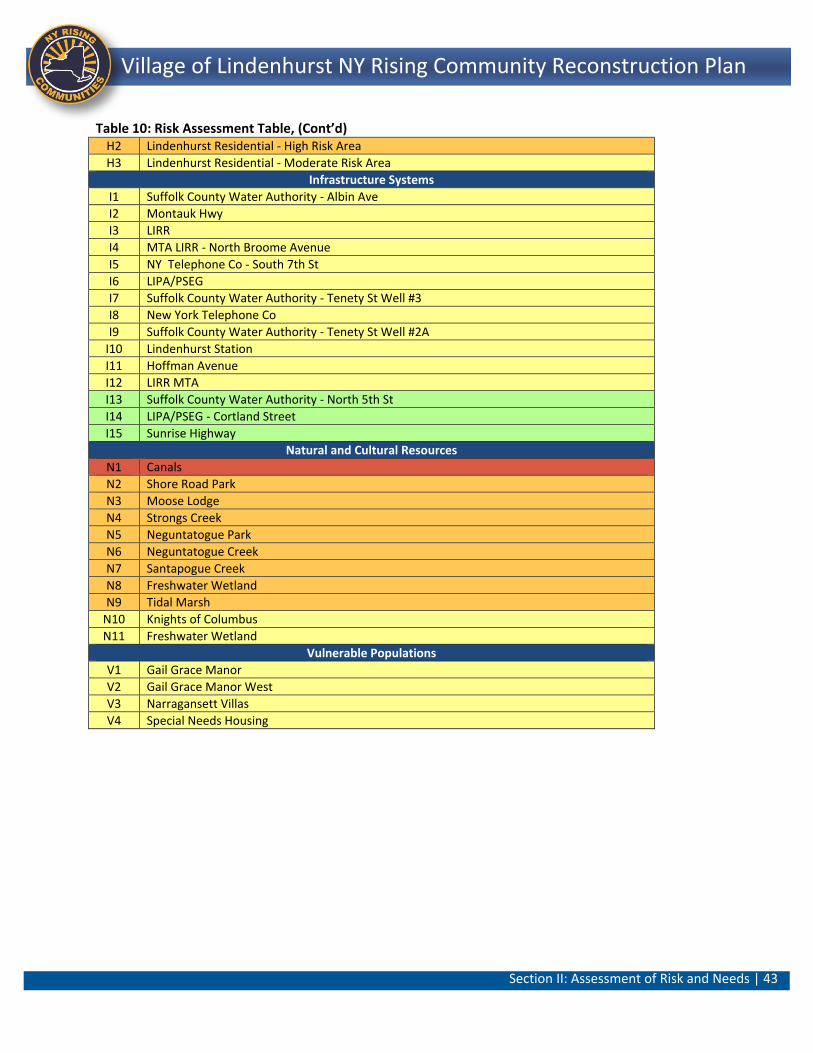
Section II: Assessment of Risk and Needs | 43
Lindenhurst NY Rising Community Reconstruction Plan Village of Lindenhurst NY Rising Community Reconstruction Plan
Table 10: Risk Assessment Table, (Cont’d)
H2 Lindenhurst Residential - High Risk Area
H3 Lindenhurst Residential - Moderate Risk Area
Infrastructure Systems
I1 Suffolk County Water Authority - Albin Ave
I2 Montauk Hwy
I3 LIRR
I4 MTA LIRR - North Broome Avenue
I5 NY Telephone Co - South 7th St
I6 LIPA/PSEG
I7 Suffolk County Water Authority - Tenety St Well #3
I8 New York Telephone Co
I9 Suffolk County Water Authority - Tenety St Well #2A
I10 Lindenhurst Station
I11 Hoffman Avenue
I12 LIRR MTA
I13 Suffolk County Water Authority - North 5th St
I14 LIPA/PSEG - Cortland Street
I15 Sunrise Highway
Natural and Cultural Resources
N1 Canals
N2 Shore Road Park
N3 Moose Lodge
N4 Strongs Creek
N5 Neguntatogue Park
N6 Neguntatogue Creek
N7 Santapogue Creek
N8 Freshwater Wetland
N9 Tidal Marsh
N10 Knights of Columbus
N11 Freshwater Wetland
Vulnerable Populations
V1 Gail Grace Manor
V2 Gail Grace Manor West
V3 Narragansett Villas
V4 Special Needs Housing
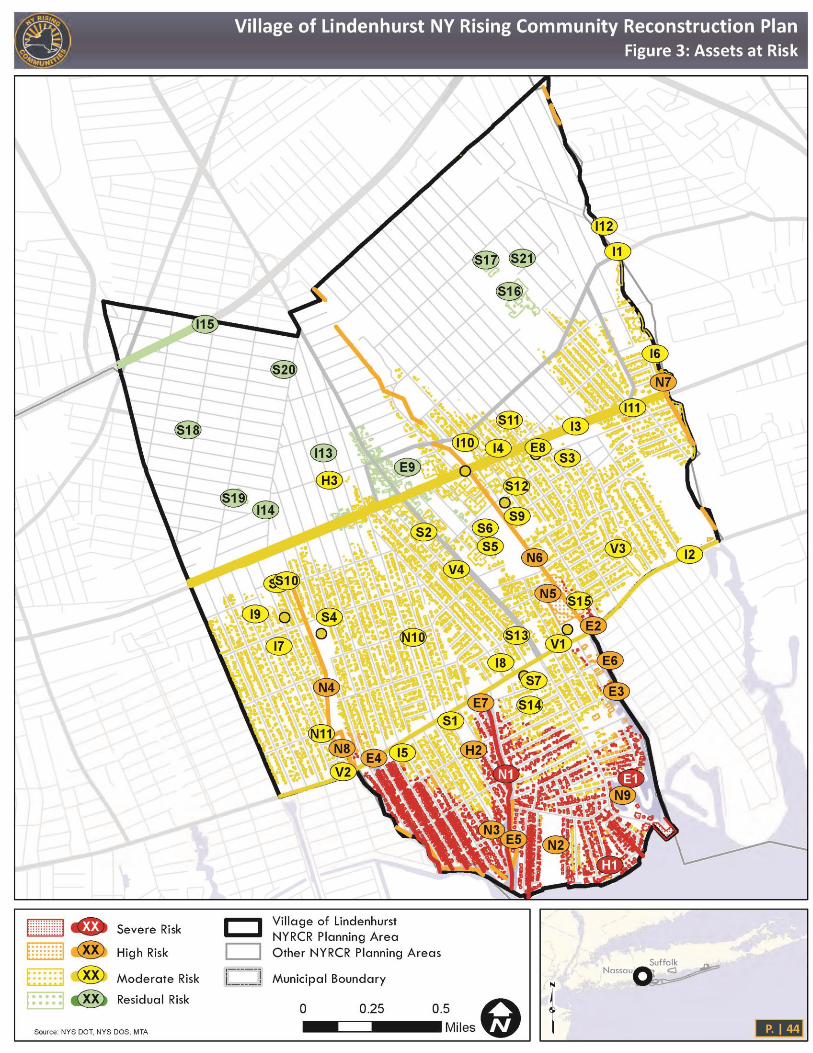
Section II: Assessment of Risk and Needs | 44
Lindenhurst NY Rising Community Reconstruction Plan Village of Lindenhurst NY Rising Community Reconstruction Plan
Figure 3: Assets at Risk Map
Section II: Assessment of Risk and Needs | 45
Lindenhurst NY Rising Community Reconstruction Plan Village of Lindenhurst NY Rising Community Reconstruction Plan
B. Assessment of Needs and Opportunities
The Village of Lindenhurst NYRCR Planning Committee initially identified needs and opportunities based on the Village’s reconstruction and economic growth goals, existing plans and studies, and the community’s overall vision for its future. The term “need” is used here to illustrate infrastructure and services that were damaged or rendered inoperable by Superstorm Sandy as well as methods and operations that failed to work during the storm event or experienced insufficient capacity to respond effectively. During a disaster, many things can go wrong, such as communications breakdowns, equipment failure, infrastructure damage and more. Thinking through what took place during the storm event, as well as what was damaged, provided the Committee with insights as to the inherent resiliency of those structures, procedures, and operations. This assessment process led to a frank discussion of community needs and includes recognition of changing climate patterns and the economic and practical necessity of factoring resiliency and adaptive capacity into recovery actions. Opportunities are based on the idea that additional resiliency benefits, whether economic, environmental, social or cultural, may be achieved through the integration of new methods, procedures and materials into the normal course of rebuilding. The post-disaster environment also presents opportunities to rebuild in ways that create a community that is stronger and more resilient to future storms. Resilient communities tend to have redundant infrastructure and communication systems, diverse and flexible adaptation strategies, and collaborative public and private partnerships. Throughout this Plan, you will see projects and strategies categorized by their Recovery Support Functions (or RSF). FEMA uses these RSFs to identify, coordinate and ultimately deliver assistance to the Community from several different funding sources available in the recovery effort – e.g., Federal, State, private, philanthropic, and not-for-profit. The “Economic Development” RSF, for example, will help bring together all the possible sources of assistance to achieve business resiliency through the projects identified by the Community (discussed further in Section IV: Implementation - Project Profiles.)
Section II: Assessment of Risk and Needs | 46
Lindenhurst NY Rising Community Reconstruction Plan Village of Lindenhurst NY Rising Community Reconstruction Plan
The six RSFs are:
Community Planning and Capacity Building. The community’s ability to both implement storm recovery activities and plan to mitigate the effects of future storms.
Economic Development. Returning economic and business activities to a state of health and developing new economic opportunities that result in a stronger, more resilient community.
Health and Social Services. Restoring and potentially expanding public health programs, health care facilities and essential social services, especially for vulnerable populations.
Housing. Assessing local housing conditions and associated risk levels during the re-building process.
Infrastructure. Investing in infrastructure to re-build capacities lost during storms and reducing future risks to critical assets.
Natural and Cultural Resources. The rehabilitation, management and protection of the natural and cultural resources that define the community’s physical and human character.
The following is a discussion of the needs and opportunities identified by the Committee and Community at large within each RSF. Community Planning and Capacity Building The Village of Lindenhurst would benefit from increased knowledge related to risk mitigation and management, disaster preparedness and recovery resources. As Superstorm Sandy approached, many residents failed to evacuate, not recognizing that the storm was as serious a threat to life and safety as it was. In the aftermath of the storm, few residents knew where or how to access critical response and recovery resources. As a result, the Village realized the need to improve preparedness and communication through high and low-tech mechanisms and the need for more locally resilient recovery resources. Additionally, the Village has experienced recurring property damage (public and private) as a result of repetitive flooding. Programs and initiatives helping to address these issues on a Village-wide level are greatly needed. Economic Development The Village has a downtown commercial core near its Long Island Rail Road station as well as a maritime economy oriented around the waterfront. The Village feels that the potential of these two resources is often overlooked for investment by business owners and private development. The Village has a long-term vision for a quaint,
Section II: Assessment of Risk and Needs | 47
Lindenhurst NY Rising Community Reconstruction Plan Village of Lindenhurst NY Rising Community Reconstruction Plan
welcoming, and walkable commercial district and thriving waterfront that are distinct to the Village of Lindenhurst. The Village would benefit from a strategic infusion of public investment dollars into the revitalization of its downtown commercial district to create a catalyst for attracting jobs, consumers, and a variety of new local businesses. A plan for improvement in the Village’s economic core would greatly benefit the overall economic resiliency of the Community, allowing it to better withstand and recover from major disasters like Superstorm Sandy. Health and Social Services The Village of Lindenhurst would benefit greatly from improvements to life safety services/fire protection. Currently, the fire protection equipment that the Lindenhurst Volunteer Fire Department is utilizing is antiquated and functionally obsolete. The Department’s high water rescue vehicle was in high demand and is inadequate to meet the needs of the Fire Department for rescuing shut-ins, the disabled, seniors and children during and in the aftermath of the storm. Increased emergency service capacity and efficient response times are critical needs of the community. Housing The need for more resilient housing construction was a major and ongoing theme throughout the recovery planning process. Approximately 1,473 homes in the Village of Lindenhurst were damaged as a result of Superstorm Sandy. Of these homes, 93% (1,381) sustained heavy or strong damage.28 Approximately 97% or 1,427 of the damaged homes had experienced flooding, primarily in the range of one to four feet of water in the home.29 The housing stock within the Village, especially south of Montauk Highway is characterized by a mix of building eras. While some homes are elevated, or are “new” construction that in theory is more resilient, many residences south of Montauk Highway are single-story bungalow style structures. These homes, many of which were built in the 1950s, were improved over time but not constructed to accommodate modern flood and wind loads. Consequently, this stock could benefit from some degree of modernization to be more resilient to floods and windstorms. There is a need, therefore, to encourage the elevation of homes in high-risk areas to eliminate inundation from minor repetitive flood events, as well as to encourage additional hardening measures for the existing housing stock, such as tree maintenance/pruning, and ground filling to minimize damage from less common but catastrophic flooding and wind events.
Section II: Assessment of Risk and Needs | 48
Lindenhurst NY Rising Community Reconstruction Plan Village of Lindenhurst NY Rising Community Reconstruction Plan
While the housing discussion has focused on flood mitigation and measures to reduce personal property damage, a number of community members have indicated that there is a lack of affordability and diversity to accommodate young people and seniors. In fact, over the series of Public Engagement Events held for the NYRCR Plan, many residents approaching retirement age echoed that while they loved living in the Village they would be forced to move out once they retire because of high housing costs. As a result, more affordable options as well as suitable locations for those who wish to relocate within the Village from extreme or high-risk areas are needed. Appropriate locations would include sites that are proximate to transportation, retail shopping and office centers. Infrastructure There were a number of infrastructure topics that were expressed among the Committee and Village residents during and after Superstorm Sandy. The strongest themes related to: flooding; restoration of power, gas service and downed mobile communications; access; and power outages. Specifically, below Montauk Highway, there is a need to address frequent, recurring flooding that comes over bulkheads and backs up through the drainage system. This recurring condition inundates local roadways, yards and residences. Several community members have described losing cars to routine flooding (particularly in the vicinity of South 4th Street) and parents communicated that they had to walk their children up the street away from the bay because school buses were reluctant to risk in-street flooding. Residential neighborhoods north of Montauk Highway surrounding Neguntatogue Park and creek, near Lincoln and Beacon Avenues also experience flooding from the creek and similar drainage issues. The Village is realistic about the difficulties of preventing flooding similar to the magnitude resulting from Superstorm Sandy; however, they want to find solutions to flooding that occurs from common seasonal storms, nor’easters, or a strong high tide. Additional critical infrastructure issues that were highlighted by Superstorm Sandy included the need for resiliency in the power system, cellular and Internet services, and the sanitary sewer system. Natural and Cultural Resources The Village of Lindenhurst has expressed support for all regional efforts to strengthen and rehabilitate the Great South Bay’s ecology and natural protective landscape of dunes, beaches and marshes. The Village’s residents also recognize the need to improve and protect the natural resources within their boundaries, including enhancements to the creek systems (i.e., Neguntatogue Creek), and the Shore Road Park bayfront. The reduction of pollutants that run off of the Village’s streets
Section II: Assessment of Risk and Needs | 49
Lindenhurst NY Rising Community Reconstruction Plan Village of Lindenhurst NY Rising Community Reconstruction Plan
and lawns and contaminate the local waters and the Great South Bay, at large, are also a major concern. Village residents have expressed the need for safe pedestrian/public access to the waterfront, specifically at Shore Road Park. The preservation of open space and retention of permeable surfaces is of importance to the Community. The Community also expressed a desire for the creation of recreational resources to supplement recreational open space that was rendered unusable as a result of Superstorm Sandy. Table 11 lists the Needs and Opportunities in each of the six RSF categories and that were identified through the planning process.30
Table 11: Needs and Opportunities
Community Planning and Capacity Building
Need: Mitigate extensive and repetitive damage to residential, commercial, and community structures. Opportunity: Revise/update building and other codes, plans, and policies to increase long term resiliency and economic stability and enforce on an ongoing basis.
Need: Increase public awareness and knowledge of Risk and Disaster Management and review and update disaster recovery plans. Opportunity: Increase resiliency of public facilities.
Need: Prevent personal injury and damage to property as well as impacts to emergency access and power from falling trees. Opportunity: Improve ability of homeowners and local businesses to maintain power during and after storm events.
Economic Development
Need: Maintain and grow local tax base, create jobs and provide for the resiliency of the economy. Opportunity: Strengthen local Village economy.
Need: Strengthen the overall economic resiliency of the community. Opportunity: Promote downtown district as well as the maritime presence of the Village of Lindenhurst.
Health and Social Services
Need: Improve outreach and assistance to special needs populations before, during, and after emergency events. Opportunity: Increase access to public safety services.
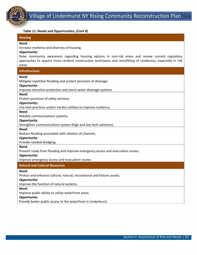
Section II: Assessment of Risk and Needs | 50
Lindenhurst NY Rising Community Reconstruction Plan Village of Lindenhurst NY Rising Community Reconstruction Plan
Table 11: Needs and Opportunities, (Cont’d)
Housing
Need: Increase resiliency and diversity of housing. Opportunity: Raise community awareness regarding housing options in non-risk areas and review current regulatory approaches to require more resilient construction techniques and retrofitting of residences, especially in risk areas.
Infrastructure
Need: Mitigate repetitive flooding and protect provision of drainage. Opportunity: Improve shoreline protection and storm water drainage systems.
Need: Protect provision of utility services. Opportunity: Use best practices and/or harden utilities to improve resiliency.
Need: Reliable communications systems. Opportunity: Strengthen communications system (high and low tech solutions).
Need: Reduce flooding associated with siltation of channels. Opportunity: Provide needed dredging.
Need: Prevent roads from flooding and improve emergency access and evacuation routes. Opportunity: Improve emergency access and evacuation routes.
Natural and Cultural Resources
Need: Protect and enhance cultural, natural, recreational and historic assets. Opportunity: Improve the function of natural systems.
Need: Improve public ability to utilize waterfront areas. Opportunity: Provide better public access to the waterfront in Lindenhurst.
Section III: Reconstruction and Resiliency Strategies | 51
Lindenhurst NY Rising Community Reconstruction Plan Village of Lindenhurst NY Rising Community Reconstruction Plan
Section III: Reconstruction and Resiliency Strategies
The process of identifying the community’s post-storm needs and opportunities informed the Committee’s development of strategies to resolve these needs and realize opportunities. In turn, the strategies helped conceptualize and design projects to specifically address these needs and opportunities. Strategies can be types of projects, programs, policies, or other actions that specifically address an identifiable need. Typically, there can be multiple strategies to address a given need. For example, communities are most successful when they blend traditional stabilization and repair actions with a holistic, long-range, forward-looking view of recovery and economic development. This section presents the strategies developed by the NYRCR Village of Lindenhurst Planning Committee for how best to use community assets, capitalize on opportunities, and resolve critical issues. For every need or opportunity, potential strategies were generated for each resiliency issue. The list of strategies spans an array of methodologies and timeframes, from preparedness to retrofits, from immediate procedural improvements to long-range capital investments programs. Strategies also include conservation of natural protective features, regulatory changes and building code updates, structural defenses, resilient retrofits, market measures, land use planning and education and outreach in an effort to employ multiple, complementary actions rather than relying on a single means of protection. Careful consideration was given to what is at risk, what resources are available, and the capacity to implement various management measures. As general resiliency strategies evolved into specific projects and actions several factors were considered to begin prioritizing the most effective and feasible strategies, and thus identify the best use of Sandy recovery funds. These considerations included how each strategy relates to Superstorm Sandy’s impacts on the Village of Lindenhurst; to what extent each strategy would reduce current and projected risk; whether it contributed to protection of vulnerable populations; feasibility of a successful implementation; compliance with existing regulations; upfront and long-term maintenance costs; direct and indirect benefits; and public perception.
Section III: Reconstruction and Resiliency Strategies | 52
Lindenhurst NY Rising Community Reconstruction Plan Village of Lindenhurst NY Rising Community Reconstruction Plan
A. Reconstruction and Resiliency Strategies
The Committee developed reconstruction and resiliency strategies that were derived from assets identified as being at risk relative to the Community’s needs (discussed in the previous section). Each strategy was designed to take into account the following considerations:
Whether it reduced the level of risk and met an identified community need;
Whether it helped (or improved the resiliency of) vulnerable populations; and,
Whether it could be implemented through discrete programs and/or projects.
The following pages explain the strategies developed by the NYRCR Planning Committee. Strategy: Increase Emergency Preparedness Through Public Awareness and Enhanced Communications Systems
The lack of both an organized emergency response plan and a nearby evacuation center were deterrents for evacuation in the Village of Lindenhurst. As a result, there is a need to develop a strategy to increase public awareness about emergency preparedness and to establish a response and recovery command center in the community outside of the flood zone. This strategy addresses resiliency issues related to Community Planning and Capacity Building. It tackles the needs to enhance emergency preparedness/management and increase public awareness and knowledge of risk management and hazard mitigation. Risks to residents and businesses in the Moderate, High and Extreme Risk Areas can be mitigated through improved communications and emergency preparedness planning. The retrofitting of the Community Center would provide a single location for command and control of evacuation and recovery functions for all residents including vulnerable populations during and after a storm or emergency event. The strategy is relevant to all Village residents who are at risk or in need of assistance during and after a storm event. Vulnerable populations, many of whom live in at-risk locations south of Montauk Highway, would benefit through the provision of this facility. The Proposed Project for an Emergency Action and Preparedness Plan/Lindenhurst Community Center Retrofit was developed to implement this strategy. Many Village residents indicated that there was confusion and conflicting information related to storm preparedness in the days leading up to Superstorm Sandy. Similarly, immediately after the storm,
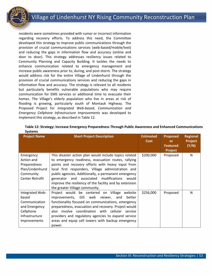
Section III: Reconstruction and Resiliency Strategies | 53
Lindenhurst NY Rising Community Reconstruction Plan Village of Lindenhurst NY Rising Community Reconstruction Plan
residents were sometimes provided with rumor or incorrect information regarding recovery efforts. To address this need, the Committee developed this strategy to improve public communications through the provision of crucial communications services (web-based/mobile/text) and reducing the gaps in information flow and accuracy (online and door to door). This strategy addresses resiliency issues related to Community Planning and Capacity Building. It tackles the needs to enhance communication related to emergency management and increase public awareness prior to, during, and post-storm. The strategy would address risk for the entire Village of Lindenhurst through the provision of crucial communications services and reducing the gaps in information flow and accuracy. The strategy is relevant to all residents but particularly benefits vulnerable populations who may require communication for EMS services or additional time to evacuate their homes. The Village’s elderly population who live in areas at risk of flooding is growing, particularly south of Montauk Highway. The Proposed Project for Integrated Web-based, Communication and Emergency Cellphone Infrastructure Improvements was developed to implement this strategy, as described in Table 12.
Table 12: Strategy: Increase Emergency Preparedness Through Public Awareness and Enhanced Communications Systems
Project Name Short Project Description Estimated Cost
Proposed or
Featured Project
Regional Project (Y/N)
Emergency Action and Preparedness Plan/Lindenhurst Community Center Retrofit
This disaster action plan would include topics related to emergency readiness, evacuation routes, rallying points and recovery efforts with heavy input from local first responders, Village administration and public agencies. Additionally, a permanent emergency generator and associated modifications would improve the resiliency of the facility and by extension the greater Village community.
$200,000 Proposed N
Integrated Web-based Communication and Emergency Cellphone Infrastructure Improvements
Project would be centered on Village website improvements, GIS web viewer, and better functionality focused on communications, emergency preparedness, evacuation and recovery. Project would also involve coordination with cellular service providers and regulatory agencies to expand service areas and equip cell towers with backup emergency power.
$256,000 Proposed N
Section III: Reconstruction and Resiliency Strategies | 54
Lindenhurst NY Rising Community Reconstruction Plan Village of Lindenhurst NY Rising Community Reconstruction Plan
Strategy: Integrate “Green” and “Gray” Infrastructure to Holistically Manage Stormwater During Superstorm Sandy, significant flooding occurred not only along the Village’s vulnerable coastal areas, but also in neighborhoods north of Montauk Highway surrounding Neguntatogue Park. Superstorm Sandy caused significant damage to the storm sewer system and the surrounding residences, especially south of Montauk Highway. In addition to flooding from the Great South Bay, the storm surge came up through the storm drainage system and flooded streets and homes. This strategy would use a combination of green and gray infrastructure to manage stormwater in the Village. Typically, water infrastructure may be considered “green” or “gray”. Gray infrastructure typically refers to traditional practices for stormwater management and wastewater treatment, such as pipes and sewers. Green infrastructure refers to sustaintable pollution reducing practices that also provide other ecosystem services such as reduced greenhouse gas emissions or increased flood control. Examples of green infrastructure include the use of porous materials, planted buffers, and rain gardens.31
This strategy addresses the need to preserve natural permeable ground cover for stormwater and water quality management. It provides an opportunity to preserve what little undeveloped land is left in Lindenhurst and put it to its highest and best use. This strategy would increase safety along the bay front and creeks and protect assets adjacent to the creeks and bayshore through improvements to stream corridors and undeveloped areas that act as natural storm water infrastructure to store runoff and reduce and protect against flooding. This strategy addresses resiliency issues related to the Infrastructure RSF. This strategy would also provide a new passive recreational resource to supplement open space that was damaged by Superstorm Sandy. This strategy also meets the need to mitigate repetitive flooding and optimize storm water management. This strategy would address risk for residents of the Village by creating a long-term, cohesive plan to address frequent, recurring flooding in the Village. Projects within this strategy are medium to high cost and would initially involve work to address immediate needs followed by a long-term approach to repairs, upgrades, and maintenance. This strategy is relevant to vulnerable populations of the Village, especially south of Montauk highway, since the current flooding damages property, restricts access, and impairs the safety of the elderly and disabled, as described in Table 13.
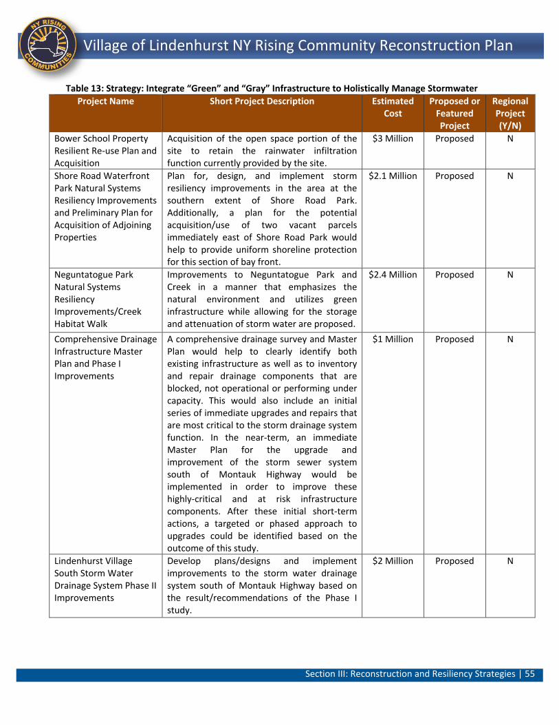
Section III: Reconstruction and Resiliency Strategies | 55
Lindenhurst NY Rising Community Reconstruction Plan Village of Lindenhurst NY Rising Community Reconstruction Plan
Table 13: Strategy: Integrate “Green” and “Gray” Infrastructure to Holistically Manage Stormwater
Project Name Short Project Description Estimated Cost
Proposed or Featured Project
Regional Project (Y/N)
Bower School Property Resilient Re-use Plan and Acquisition
Acquisition of the open space portion of the site to retain the rainwater infiltration function currently provided by the site.
$3 Million Proposed N
Shore Road Waterfront Park Natural Systems Resiliency Improvements and Preliminary Plan for Acquisition of Adjoining Properties
Plan for, design, and implement storm resiliency improvements in the area at the southern extent of Shore Road Park. Additionally, a plan for the potential acquisition/use of two vacant parcels immediately east of Shore Road Park would help to provide uniform shoreline protection for this section of bay front.
$2.1 Million Proposed N
Neguntatogue Park Natural Systems Resiliency Improvements/Creek Habitat Walk
Improvements to Neguntatogue Park and Creek in a manner that emphasizes the natural environment and utilizes green infrastructure while allowing for the storage and attenuation of storm water are proposed.
$2.4 Million Proposed N
Comprehensive Drainage Infrastructure Master Plan and Phase I Improvements
A comprehensive drainage survey and Master Plan would help to clearly identify both existing infrastructure as well as to inventory and repair drainage components that are blocked, not operational or performing under capacity. This would also include an initial series of immediate upgrades and repairs that are most critical to the storm drainage system function. In the near-term, an immediate Master Plan for the upgrade and improvement of the storm sewer system south of Montauk Highway would be implemented in order to improve these highly-critical and at risk infrastructure components. After these initial short-term actions, a targeted or phased approach to upgrades could be identified based on the outcome of this study.
$1 Million Proposed N
Lindenhurst Village South Storm Water Drainage System Phase II Improvements
Develop plans/designs and implement improvements to the storm water drainage system south of Montauk Highway based on the result/recommendations of the Phase I study.
$2 Million Proposed N
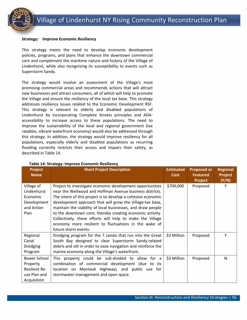
Section III: Reconstruction and Resiliency Strategies | 56
Lindenhurst NY Rising Community Reconstruction Plan Village of Lindenhurst NY Rising Community Reconstruction Plan
Strategy: Improve Economic Resiliency This strategy meets the need to develop economic development policies, programs, and plans that enhance the downtown commercial core and complement the maritime nature and history of the Village of Lindenhurst, while also recognizing its susceptibility to events such as Superstorm Sandy. The strategy would involve an assessment of the Village's most promising commercial areas and recommends actions that will attract new businesses and attract consumers, all of which will help to promote the Village and ensure the resiliency of the local tax base. This strategy addresses resiliency issues related to the Economic Development RSF. This strategy is relevant to elderly and disabled populations of Lindenhurst by incorporating Complete Streets principles and ADA-accessibility to increase access to these populations. The need to improve the sustainability of the local and regional government (tax ratables, vibrant waterfront economy) would also be addressed through this strategy. In addition, the strategy would improve resiliency for all populations, especially elderly and disabled populations as recurring flooding currently restricts their access and impairs their safety, as described in Table 14.
Table 14: Strategy: Improve Economic Resiliency
Project Name
Short Project Description Estimated Cost
Proposed or Featured Project
Regional Project (Y/N)
Village of Lindenhurst Economic Development and Action Plan
Project to investigate economic development opportunities near the Wellwood and Hoffman Avenue business districts. The intent of this project is to develop a cohesive economic development approach that will grow the Village-tax base, maintain the viability of local businesses, and draw people to the downtown core; thereby creating economic activity. Collectively, these efforts will help to make the Village economy more resilient to fluctuations in the wake of future storm events.
$700,000 Proposed Y
Regional Canal Dredging Program
Dredging program for the 7 canals that run into the Great South Bay designed to clear Superstorm Sandy-related debris and silt in order to ease navigation and reinforce the marine economy along the Village’s waterfront.
$3 Million Proposed Y
Bower School Property Resilient Re-use Plan and Acquisition
This property could be sub-divided to allow for a combination of commercial development (due to its location on Montauk Highway), and public use for stormwater management and open space.
$3 Million Proposed N
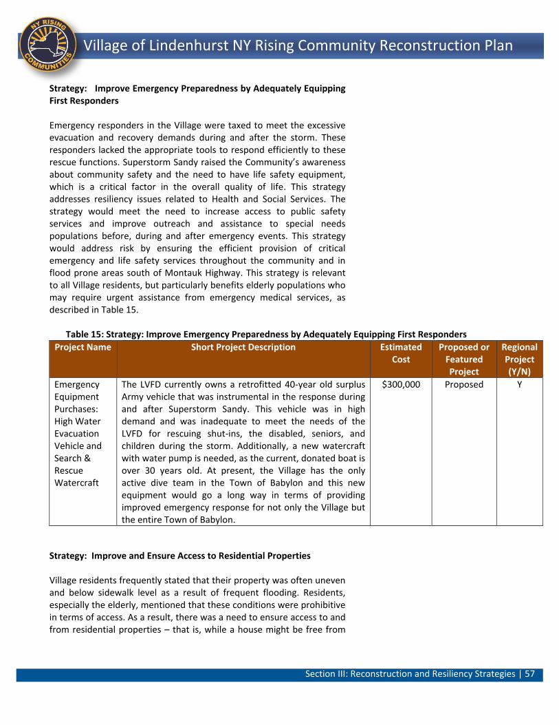
Section III: Reconstruction and Resiliency Strategies | 57
Lindenhurst NY Rising Community Reconstruction Plan Village of Lindenhurst NY Rising Community Reconstruction Plan
Strategy: Improve Emergency Preparedness by Adequately Equipping First Responders Emergency responders in the Village were taxed to meet the excessive evacuation and recovery demands during and after the storm. These responders lacked the appropriate tools to respond efficiently to these rescue functions. Superstorm Sandy raised the Community’s awareness about community safety and the need to have life safety equipment, which is a critical factor in the overall quality of life. This strategy addresses resiliency issues related to Health and Social Services. The strategy would meet the need to increase access to public safety services and improve outreach and assistance to special needs populations before, during and after emergency events. This strategy would address risk by ensuring the efficient provision of critical emergency and life safety services throughout the community and in flood prone areas south of Montauk Highway. This strategy is relevant to all Village residents, but particularly benefits elderly populations who may require urgent assistance from emergency medical services, as described in Table 15.
Table 15: Strategy: Improve Emergency Preparedness by Adequately Equipping First Responders
Project Name Short Project Description Estimated Cost
Proposed or Featured Project
Regional Project (Y/N)
Emergency Equipment Purchases: High Water Evacuation Vehicle and Search & Rescue Watercraft
The LVFD currently owns a retrofitted 40-year old surplus Army vehicle that was instrumental in the response during and after Superstorm Sandy. This vehicle was in high demand and was inadequate to meet the needs of the LVFD for rescuing shut-ins, the disabled, seniors, and children during the storm. Additionally, a new watercraft with water pump is needed, as the current, donated boat is over 30 years old. At present, the Village has the only active dive team in the Town of Babylon and this new equipment would go a long way in terms of providing improved emergency response for not only the Village but the entire Town of Babylon.
$300,000 Proposed Y
Strategy: Improve and Ensure Access to Residential Properties Village residents frequently stated that their property was often uneven and below sidewalk level as a result of frequent flooding. Residents, especially the elderly, mentioned that these conditions were prohibitive in terms of access. As a result, there was a need to ensure access to and from residential properties – that is, while a house might be free from
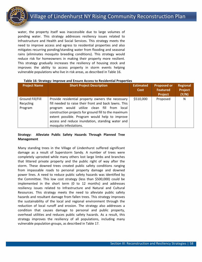
Section III: Reconstruction and Resiliency Strategies | 58
Lindenhurst NY Rising Community Reconstruction Plan Village of Lindenhurst NY Rising Community Reconstruction Plan
water, the property itself was inaccessible due to large volumes of ponding water. This strategy addresses resiliency issues related to Infrastructure and Health and Social Services. This strategy meets the need to improve access and egress to residential properties and also mitigates recurring ponding/standing water from flooding and seasonal rains (eliminates mosquito breeding conditions). This strategy would reduce risk for homeowners in making their property more resilient. This strategy gradually increases the resiliency of housing stock and improves the ability to access property in storm events helping vulnerable populations who live in risk areas, as described in Table 16.
Table 16: Strategy: Improve and Ensure Access to Residential Properties
Project Name Short Project Description Estimated Cost
Proposed or Featured Project
Regional Project (Y/N)
Ground Fill/Fill Recycling Program
Provide residential property owners the necessary fill needed to raise their front and back lawns. This program would utilize clean fill from local construction projects for ground fill to the maximum extent possible. Program would help to improve access and reduce inundation, standing water and mosquito infestations.
$510,000 Proposed N
Strategy: Alleviate Public Safety Hazards Through Planned Tree Management Many standing trees in the Village of Lindenhurst suffered significant damage as a result of Superstorm Sandy. A number of trees were completely uprooted while many others lost large limbs and branches that littered private property and the public right of way after the storm. These downed trees created public safety conditions ranging from impassable roads to personal property damage and downed power lines. A need to reduce public safety hazards was identified by the Committee. This low cost strategy (less than $500,000) could be implemented in the short term (0 to 12 months) and addresses resiliency issues related to Infrastructure and Natural and Cultural Resources. This strategy meets the need to alleviate public safety hazards and resultant damage from fallen trees. This strategy improves the sustainability of the local and regional environment through the reduction of local runoff and erosion. The strategy also addresses a condition that causes damage to personal and public property, overhead utilities and reduces public safety hazards. As a result, this strategy improves the resiliency of all populations, including many vulnerable population groups, as described in Table 17.
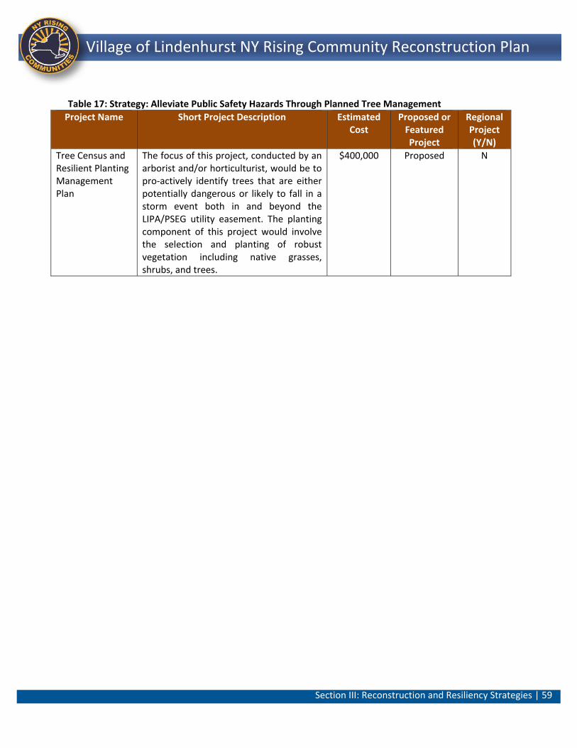
Section III: Reconstruction and Resiliency Strategies | 59
Lindenhurst NY Rising Community Reconstruction Plan Village of Lindenhurst NY Rising Community Reconstruction Plan
Table 17: Strategy: Alleviate Public Safety Hazards Through Planned Tree Management
Project Name Short Project Description Estimated Cost
Proposed or Featured Project
Regional Project (Y/N)
Tree Census and Resilient Planting Management Plan
The focus of this project, conducted by an arborist and/or horticulturist, would be to pro-actively identify trees that are either potentially dangerous or likely to fall in a storm event both in and beyond the LIPA/PSEG utility easement. The planting component of this project would involve the selection and planting of robust vegetation including native grasses, shrubs, and trees.
$400,000 Proposed N

Section IV: Implementation – Project Profiles | 60
Lindenhurst NY Rising Community Reconstruction Plan Village of Lindenhurst NY Rising Community Reconstruction Plan
Section IV: Implementation - Project Profiles
Introduction
This section provides a complete Project Profile for each Proposed Project identified by the NYRCR Village of Lindenhurst Planning Committee (Committee) and the community (Village). The NYRCR Program has allocated to the Community up to $6.1 million. The funding is provided through the U.S. Department of Housing and Urban Development (HUD) Community Development Block Grant – Disaster Recovery (CDBG-DR) program. While developing projects and actions for inclusion in the NYRCR Plan, Planning Committees took into account cost estimates, cost-benefit analyses, the effectiveness of each project in reducing risk to populations and critical assets, feasibility, and community support. Planning Committees also considered the potential likelihood that a project or action would be eligible for CDBG-DR funding. The projects and actions set forth in the NYRCR Plan are divided into three categories. The order in which the projects and actions are listed in the NYRCR Plan does not necessarily indicate the Community’s prioritization of these projects and actions. Proposed Projects are projects proposed for funding through the Community’s allocation of CDBG-DR funding. Featured Projects are projects and actions that the Planning Committee has identified as important resiliency recommendations and has analyzed in depth, but has not proposed for funding through the NYRCR Program. There are no Featured Projects for the Village. Additional Resiliency Recommendations (see Section V) are projects and actions that the Planning Committee would like to highlight and that are not categorized as Proposed Projects or Featured Projects. The total cost of Proposed Projects in the NYRCR Plan exceeds the NYRCR Community’s CDBG-DR allocation to allow for flexibility if some Proposed Projects cannot be implemented due to environmental review, HUD eligibility, technical feasibility, or other factors. Implementation of the projects and actions found in the NYRCR Plan are subject to applicable Federal, State, and local laws and regulations, including the Americans with Disabilities Act (ADA). Inclusion of a project or action in the NYRCR Plan does not guarantee that a particular project or action will be eligible for CDBG‐DR funding or that it will be implemented.
Section IV: Implementation – Project Profiles | 61
Lindenhurst NY Rising Community Reconstruction Plan Village of Lindenhurst NY Rising Community Reconstruction Plan
In addition to providing a detailed description of each project, the profiles include information on two important elements used by the Committee to evaluate the value of each project – a Cost-Benefit Analysis and a Risk Reduction Analysis. Before proceeding to the projects themselves, it is important to understand these two analytical elements of the Project Profiles.
Cost Benefit Analysis
A cost-benefit analysis (CBA) is a tool used to calculate and compare the benefits and costs associated with a project. The CBA provides decision-makers with a framework for comparing different projects (i.e., anticipated cost of implementation against total expected benefits), and determining whether the benefits of a particular project outweigh the costs. More specifically, the value of the CBA is two-fold: (1) to inform the selection of projects for implementation; and (2) to support applications for funding. Because the NYRCR Program is a community-driven process, the CBA has focused on identifying project costs and benefits that easily relate to the communities that the NYRCR Planning Committees represent. Community and Committee input -- informed by a true understanding of local conditions, needs and community values -- plays a crucial role in the selection of projects that are implemented. With this in mind, the CBA has used a mix of both quantitative and qualitative factors in its analysis. The costs and benefits used to evaluate projects through the CBA are explained further below.
Project Costs
Project Profiles include a description of anticipated costs, including soft costs, contingency costs and the hard “costs” associated with implementation (labor and materials). Soft costs refer to costs associated with design, procurement, permitting or any other “up-front” costs associated with project implementation (up to 25% of construction costs). Contingency costs refer to additional costs that have been factored into a project (up to 25% of construction costs) due to the conceptual nature of the projects and the potential for cost escalations due to unknowns. The CBA cannot, however, project costs or benefits with complete certainty; rather, it provides the community with a practical understanding of the potential estimated costs of project implementation and the potential benefits accrued to the community with the particular project in place.
Section IV: Implementation – Project Profiles | 62
Lindenhurst NY Rising Community Reconstruction Plan Village of Lindenhurst NY Rising Community Reconstruction Plan
The cost of implementing a project is just one aspect of the justification for funding these Proposed Projects. Conversely, another important variable is the future costs of not implementing these projects -- which have the potential to negatively impact the long-term viability of both the Village and its neighboring South Shore communities. While these costs are more difficult to quantify, they are no less important to our analysis, and are therefore addressed qualitatively. These costs include:
Extensive, repetitive damage to personal property (vehicles, residences) and public infrastructure resulting from frequent recurring flooding and future storm events
Economic loss to residents and to local and regional employers as a result of the inability to work
Hindrance in the provision of life safety and emergency services resulting in repeated inability to access areas of the community
Project Benefits
The types of benefits considered in the CBA include:
o Risk Reduction: The extent to which a project reduces the risk of damage to a community asset from a future storm event (discussed further below under “Risk Reduction Analysis”). 32
o Economic Resiliency: The project’s potential to help minimize economic costs and reduce the time it takes for the local economy to rebound from a storm event. Economic data included, where applicable, an estimate of permanent jobs secured/added; relationship to, and/or furtherance of, Regional Economic Development Plan goals; potential for additional economic activity; and the net effect on local municipal expenditures.33
o Health, Social and Public Safety Services: Qualitative information was provided on the overall population benefits of improved access to health and social service facilities and public safety services; type and size of socially vulnerable population secured;34 and degree to which essential health and social service facilities are able to provide services to a community during a future storm or weather event as a result of the project.
o Environmental Protection: Benefits include the protection of crucial environmental assets or high-priority habitat, threatened and endangered species, migration or habitat connectivity; any clean-up resulting from the action; creation of open space or a new recreational asset.
Section IV: Implementation – Project Profiles | 63
Lindenhurst NY Rising Community Reconstruction Plan Village of Lindenhurst NY Rising Community Reconstruction Plan
Risk Reduction Analysis
A Risk Reduction Analysis estimates the extent to which Proposed and Featured Projects will reduce storm damage (environmental, social and economic) and flooding risk to specific community assets when the project is in place. (The extent to which a project reduced such risk is also considered as a benefit in the Cost Benefit Analysis -- see “Project Benefits” above.) Risk “reduction” is different from the risk “assessment” in the previous section in a very important way – risk assessment looks at storm and flood risks to community assets before the project is implemented; risk reduction looks at the reduced risk after the project is in place. For the risk reduction analysis, projects were evaluated under a 3-foot rise in sea level scenario for their potential to reduce an asset’s level of exposure and/or vulnerability to future storms. This helps communities and decision-makers understand the potential environmental, social and economic outcomes associated with implementing a project.
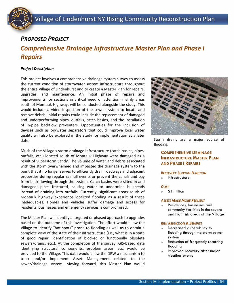
Section IV: Implementation – Project Profiles | 64
Lindenhurst NY Rising Community Reconstruction Plan Village of Lindenhurst NY Rising Community Reconstruction Plan
COMPREHENSIVE DRAINAGE
INFRASTRUCTURE MASTER PLAN
AND PHASE I REPAIRS
RECOVERY SUPPORT FUNCTION o Infrastructure
COST o $1 million
ASSETS MADE MORE RESILIENT o Residences, businesses and
community facilities in the severe and high risk areas of the Village
RISK REDUCTION & BENEFITS o Decreased vulnerability to
flooding through the storm sewer system
o Reduction of frequently recurring flooding
o Improved recovery after major weather events
PROPOSED PROJECT
Comprehensive Drainage Infrastructure Master Plan and Phase I Repairs
Project Description This project involves a comprehensive drainage system survey to assess the current condition of stormwater system infrastructure throughout the entire Village of Lindenhurst and to create a Master Plan for repairs, upgrades, and maintenance. An initial phase of repairs and improvements for sections in critical need of attention, mainly areas south of Montauk Highway, will be conducted alongside the study. This would include a video inspection of the sewer system to locate and remove debris. Initial repairs could include the replacement of damaged and underperforming pipes, outfalls, catch basins, and the installation of in-pipe backflow preventers. Opportunities for the inclusion of devices such as oil/water separators that could improve local water quality will also be explored in the study for implementation at a later date. Much of the Village’s storm drainage infrastructure (catch basins, pipes, outfalls, etc.) located south of Montauk Highway were damaged as a result of Superstorm Sandy. The volume of water and debris associated with the storm overwhelmed and impacted the drainage system to the point that it no longer serves to efficiently drain roadways and adjacent properties during regular rainfall events or prevent the canals and bay from back-flowing through the system. Catch basins were silted in and damaged; pipes fractured, causing water to undermine bulkheads instead of draining into outfalls. Currently, significant areas south of Montauk highway experience localized flooding as a result of these inadequacies. Homes and vehicles suffer damage and access for residents, businesses and emergency services is compromised. The Master Plan will identify a targeted or phased approach to upgrades based on the outcome of this investigation. The effort would allow the Village to identify “hot spots” prone to flooding as well as to obtain a complete view of the state of their infrastructure (i.e., what is in a state of good repair, identification of blocked or functionally obsolete sewers/drains, etc.). At the completion of the survey, GIS-based data identifying structural components, problem areas, etc. would be provided to the Village. This data would allow the DPW a mechanism to track and/or implement Asset Management related to the sewer/drainage system. Moving forward, this Master Plan would
Storm drains are a major source of flooding.
Section IV: Implementation – Project Profiles | 65
Lindenhurst NY Rising Community Reconstruction Plan Village of Lindenhurst NY Rising Community Reconstruction Plan
function as the basis for future drainage infrastructure improvements. While the project would not eliminate all flood risks, it would reduce risk, especially for moderate level storm events; extreme storm events would still present flood risks as was evidenced with Superstorm Sandy. Estimated Project Costs The implementation of this project has been estimated to cost $1 million in total, which includes $200,000 for the development of the Storm Drainage System Master Plan; $575,000 for efforts related to debris removal, and initial repairs related to damage caused by Superstorm Sandy; $115,000 in soft costs; and, $110,000 in contingency costs. The estimated operation and maintenance cost associated with these improvements is approximately $25,000 per year. Assuming an average useful life of 30 years for these improvements, a conceptual life cycle cost of $1.75 million has been estimated. Project Benefits Risk Reduction and Resiliency This Proposed Project would not stop flooding in another major natural disaster or storm event similar to Superstorm Sandy; however, the Village would be more resilient with this project in place as it would generally reduce the vulnerability of assets in the severe and high risk areas of the Village from the recurring seasonal flooding that occurs through the storm drainage system and would enable the affected assets to recover more rapidly after a major weather event (i.e., severe high tides, nor’easters, 100-year storm or combinations of these events). Economic Benefits The implementation of this project could potentially create temporary jobs for a minimum of one year. Based on industry standards an estimated 10 Full Time Equivalent (FTE) jobs would be created during that period.35 Permanent stormwater protection maintenance jobs that existed prior to and after Superstorm Sandy would be retained. In addition, permanent jobs associated with the local marine economy would also be maintained as drainage improvements would reduce the likelihood of waterfront businesses relocating or temporarily closing due to recurring flooding. This project would also help reduce risk to these local waterfront assets; helping to make the Village’s local economy more resilient on the whole. The resiliency improvements associated with this project would reduce storm-related emergency and recovery costs for local businesses. Other benefits include a reduction in days lost at work due to storm damage and costs associated with repair or replacement of flooded vehicles.
Section IV: Implementation – Project Profiles | 66
Lindenhurst NY Rising Community Reconstruction Plan Village of Lindenhurst NY Rising Community Reconstruction Plan
Environmental Protection Enhancements and capacity improvements to the Village’s storm water drainage system could be critically important to the ecological health of the Great South Bay. The incorporation of oil/water separators, and other improvements that reduce the conveyance of sediments and floatables, would result in improved water quality. County-wide water quality concerns include non-point source pollution and storm water runoff which have the potential to seep into ground water and impact surface water bodies such as the Great South Bay. This Proposed Project would be consistent with the County’s stormwater management practices as outlined in Managing Stormwater – Natural Vegetation and Green Methodologies. This project would also comply with Suffolk County’s Comprehensive Water Resources Management Plan which prioritizes the evaluation of additional sewers and other structural measures in an effort to help protect groundwater resources and address potential future development.36 Health and Social Benefits Accessibility to this area during times of flooding would be improved along roadways for residents as well as emergency personnel. As a result, the project would reduce the vulnerability of all residents south of Montauk Highway to being stranded or nor being able to reach a critical facility. The occurrence of standing water and the high water level in catch basins would reduce potential reducing mosquito breeding areas. The flooding created from the current situation creates unsanitary conditions for both the natural and built environment that would be improved with the storm sewer improvement project elements. Cost Benefit Analysis This Proposed Project for the Village has been analyzed in terms of costs and benefits. The total project cost of approximately $1 million is an investment that will yield high returns while reducing government and private expenditures as a result of future storms. Other benefits include decreased risk/vulnerability to flooding through the storm water system; economic benefit to maintaining residential property values; environmental benefits from reducing the back flow of storm sewer water into residential streets and private property. Health and social benefits from maintaining clear access to medical facilities during emergency events and for emergency responders would also be a benefit resulting from this project. This analysis demonstrates that the benefits of this project outweigh the costs making the project justifiable and appropriate.
Section IV: Implementation – Project Profiles | 67
Lindenhurst NY Rising Community Reconstruction Plan Village of Lindenhurst NY Rising Community Reconstruction Plan
Risk Reduction Analysis The Risk Reduction Process was used to evaluate the level of risk reduction that could be achieved through the implementation of Phase I of the Comprehensive Drainage Infrastructure Master Plan. This project would reduce risk to Village assets, especially those in the areas south of Montauk Highway by reducing their vulnerability to flooding and flood related damage from the storm drain system. It would also increase the resiliency of the assets by decreasing their time out of service. Using the Risk Assessment Tool and the Risk Reduction Analysis it was determined that assets located along the Villages canals as well as shore road park, that initially scored in the severe risk range, would see a reduction to the high risk range. Residences that initially scored in the high risk range would see a reduction to the moderate range. General Timeframe for Implementation It is estimated that, from the time implementation begins, this Project has potential for immediate implementation (0 to 12 months). The initial Master Plan Study and specifications for initial repairs could be undertaken and completed in approximately four months while the implementation of the debris removal and repairs could be implemented in approximately eight months. Regulatory Requirements Related to Project Regulatory review of this project would likely include State or County entities depending on status of ownership in roadways where infrastructure is located. A Coastal Zone Management (CZM) consistency review (New York State Department of State) would be required in areas of the Village that lie within the State’s Coastal Zone boundary. Additionally, review and coordination as well as the necessary environmental permitting would be required with the New York State Department of Environmental Conservation (NYS DEC) in areas proximate to wetlands and the waterfront. Additional coordination and review with appropriate utilities such as LIPA/PSEG/National Grid and others, would also be necessary. No real property or other significant constraints have been identified to date Jurisdiction Village of Lindenhurst

Section IV: Implementation – Project Profiles | 68
Lindenhurst NY Rising Community Reconstruction Plan Village of Lindenhurst NY Rising Community Reconstruction Plan
LINDENHURST VILLAGE SOUTH
STORM WATER DRAINAGE
SYSTEM PHASE II IMPROVEMENTS
RECOVERY SUPPORT FUNCTION o Infrastructure
COST o $2 million
ASSETS MADE MORE RESILIENT o Residences, businesses and
community facilities located in the area south of Montauk Highway
RISK REDUCTION & BENEFITS o Decreased vulnerability to
flooding through the storm sewer system
o Reduction of frequently recurring flooding
o Improved recovery after major weather events
PROPOSED PROJECT
Lindenhurst Village South Storm Water Drainage System Phase II Improvements Project Description This project involves the design, development, and implementation of improvements to the storm water drainage system south of Montauk Highway based on the results and recommendations of the previous project (Comprehensive Drainage Infrastructure Master Plan and Phase I Repairs). This area of the Village experiences frequent and recurring flooding resulting from damage inflicted during Superstorm Sandy resulting in poor drainage and the back flow of water during storm events, high tides, and rainfall events. This project would restore, and repair the Village’s stormwater drainage infrastructure south of Montauk Highway. The project has a high-level of feasibility, as these improvements are standard and implemented on a regular basis in communities across Long Island and other areas. Potential challenges are limited in scope. Improvements relate to repairing damage resulting from Superstorm Sandy and generally returning the system to a state of good repair. Improvements include new drain pipe installation, new oil/water separators, Superstorm Sandy related debris removal, expanding the capacity of storm water drainage system facilities, relocating or improving outfalls and the installation of backflow preventers.
While the project would not eliminate all flood risks, it would reduce risk, especially for moderate level storm events. Extreme storm events would still present flood risks as was evidenced with Superstorm Sandy. Estimated Project Costs The implementation of this project has been estimated to cost approximately $2.0 million in total includes $340,000 for the installation of new enlarged storm drainage pipe; $540,000 for the installation of new catch basins, and $350,000 for the installation of new check valves. The total cost also includes approximately $230,000 in soft costs and $540,000 in contingencies. The estimated operation and maintenance cost associated with these improvements is approximately $60,000 per year. Assuming an average useful life of 30 years for these improvements, a conceptual life cycle cost of $3.8 million has been estimated.
Localized flooding due to damaged storm dains has become a constant occurrence.
Section IV: Implementation – Project Profiles | 69
Lindenhurst NY Rising Community Reconstruction Plan Village of Lindenhurst NY Rising Community Reconstruction Plan
Project Benefits Risk Reduction and Resiliency This project would assist in achieving direct risk reduction for many of the households located in extreme and high risk areas within the Village. During Superstorm Sandy and other emergency events, these neighborhoods were at an elevated risk because the existing storm sewer system permitted storm surge water to inundate streets and flood adjacent residences, businesses and community facilities in these neighborhoods. Village assets would be better able to resist damage from hazards and experience less time out of service after a storm with the project in place. In all likelihood, this Proposed Project would not stop flooding in another major natural disaster or storm event similar to Superstorm Sandy; however, the Village would be more resilient with this project in place as it would generally reduce the vulnerability of residences, businesses and community facilities in the severe and high risk areas of the Village due to flooding that occurs through the storm drainage system. As a result, this project would reduce frequently-recurring seasonal flooding and would enable the frequently flooded portions of the Village to recover more rapidly after a major weather event (i.e., severe high tides, nor’easters, 100-year storm or combinations of these events). Backflow valves will also protect the storm sewer system itself preventing damage to pipes and catch basins caused by debris washed in during storm events. Economic Benefits Design and construction of this project would create temporary construction jobs for a minimum of one year. An estimated 25 FTE jobs would be created during that period.35 Permanent stormwater protection maintenance jobs that existed prior to and after Superstorm Sandy would be retained with these improvements. Permanent jobs associated with the local marine economy would also be maintained as the proposed drainage improvements would reduce the likelihood of waterfront businesses relocating or temporarily closing due to recurring flooding. This project would also help reduce risk to these local waterfront assets, helping to make the Village’s local economy more resilient on the whole. The resiliency improvements associated with this project would reduce storm-related emergency and recovery costs for local businesses. This project would also benefit those who are employed in businesses south of Montauk Highway as well as residents living in this area. Benefits include a reduction in days lost at work due to storm damage.
Section IV: Implementation – Project Profiles | 70
Lindenhurst NY Rising Community Reconstruction Plan Village of Lindenhurst NY Rising Community Reconstruction Plan
This project would address the Long Island Regional Economic Development Council (LIREDC) goal, Investments in Rebuilding LI “Smartly”, which includes a strategy related to this project: “Rebuild and expand infrastructure to improve job access, revitalize downtowns and transit hubs, speed trade, and attract and retain dynamic regional businesses and highly skilled workers.”37 Additionally, this project would alleviate flood damage repairs that residents in high and extreme risk areas would otherwise have to repeatedly undertake without the project in place. This project would also help to make real estate south of Montauk Highway more desirable and less flood-prone, thereby stabilizing tax ratables within the community. Environmental Benefits Enhancements and capacity improvements to the Village’s storm water drainage system would be critically important to the ecological health of the Great South Bay. Repairing and expanding the storm water drainage system capacity and facilities, relocating or improving outfalls, and the installation of backflow preventers and oil/water separators could reduce the conveyance of oils, sediments and floatables resulting in improved water quality. County-wide water quality concerns include non-point source pollution and storm water runoff which have the potential to seep into ground water and impact surface water bodies such as the Great South Bay. This Proposed Project would be consistent with the County’s stormwater management practices as outlined in Managing Stormwater – Natural Vegetation and Green Methodologies. This project would also comply with Suffolk County’s Comprehensive Water Resources Management Plan which prioritizes the evaluation of additional sewers and other structural measures in an effort to help protect groundwater resources and address potential future development.38 Health and Social Benefits Accessibility to this area during times of flooding would be improved along roadways including access by the fire department, police, emergency medical services and utility repair crews who have been previously hampered by flooding. As a result, the project would reduce the vulnerability of all residents south of Montauk Highway including vulnerable populations such as the elderly and individuals with disabilities. The occurrence of standing water and the high water level in catch basins would be reduced or ameliorated potential reducing mosquito breeding areas. The flooding created from the current situation creates unsanitary conditions for both the natural and built
Section IV: Implementation – Project Profiles | 71
Lindenhurst NY Rising Community Reconstruction Plan Village of Lindenhurst NY Rising Community Reconstruction Plan
environment that would be improved with the storm sewer improvement project elements. Cost Benefit Analysis The Proposed Project for the Village has been analyzed in terms of costs and benefits. The overall project cost of approximately $2.0 million includes improvements that would build on the Phase I Master Plan. However, these costs are dependent on a number of factors including the findings of the Phase I project as well as scope, complexity and phasing. For example, based on preliminary estimates for drainage pipe installation costs per linear foot vary by pipe diameter. As such, a new pipe cost of $85 per linear foot (LF) was used based on the installation of an approximately 18-inch pipe size. Catch basins were estimated at approximately $15,000 per location. The Planning Consultant Team also assumed the installation of approximately 70 check valves at $5,000 each.
At a cost of slightly over $2 million, the project will have a number of benefits including decreased vulnerability and risk to flooding through the storm sewer; economic benefits related to maintaining home values and reduced property damage; environmental benefits from reducing the back flow of storm sewer water into residential streets and private property. Social and health benefits will likely be derived from maintaining clear access to medical facilities during emergency events and for first responders. This project represents the Village’s efforts to adapt to a future reality in which flood events become more frequent and severe. These improvements would minimize public and private property damage in risk areas. At an estimated cost of $2 million, this project is a pragmatic and cost-effective request. Public benefits for the Village as a whole include risk reduction, economic development, environmental benefits and public health. The analysis demonstrates that the benefits outweigh the costs making the project justifiable and appropriate.
Risk Reduction Analysis More specifically, it is anticipated that the risk to the Village’s canals would be reduced from the Severe category to the High classification. Similarly, the risk scores of marinas would remain in the High Risk classification but would be reduced to the lower end of the High Risk range. The risk to Shore Road Park would also be reduced to a High Risk. Risk for residences, including those backing onto the canals, in the Severe Risk areas would be reduced to the low end of the Severe Risk. High Risk Areas would be reduced to the Moderate classification with the project in place
Section IV: Implementation – Project Profiles | 72
Lindenhurst NY Rising Community Reconstruction Plan Village of Lindenhurst NY Rising Community Reconstruction Plan
General Timeframe for Implementation It is estimated that this Project has potential for immediate implementation (0 to 12 months) after the completion of the Master Plan Drainage Survey described in the Proposed Project, Comprehensive Drainage Infrastructure Master Plan and Phase I Repairs (p. 64).
Regulatory Requirements Related to Project Regulatory review of this project would likely include State or County entities depending on status of ownership in roadways where infrastructure is located. A Coastal Zone Management (CZM) consistency review (New York State Department of State) would be required in areas of the Village that lie within the State’s Coastal Zone boundary. Additionally, review and coordination as well as the necessary environmental permitting would be required with New York State Department of Environmental Conservation (NYS DEC) in areas proximate to wetlands and the waterfront. Additional coordination and review with appropriate utilities such as LIPA/PSEG/National Grid and others would also be necessary. No real property or other significant constraints have been identified to date for this project that enjoys public support. Jurisdiction Village of Lindenhurst
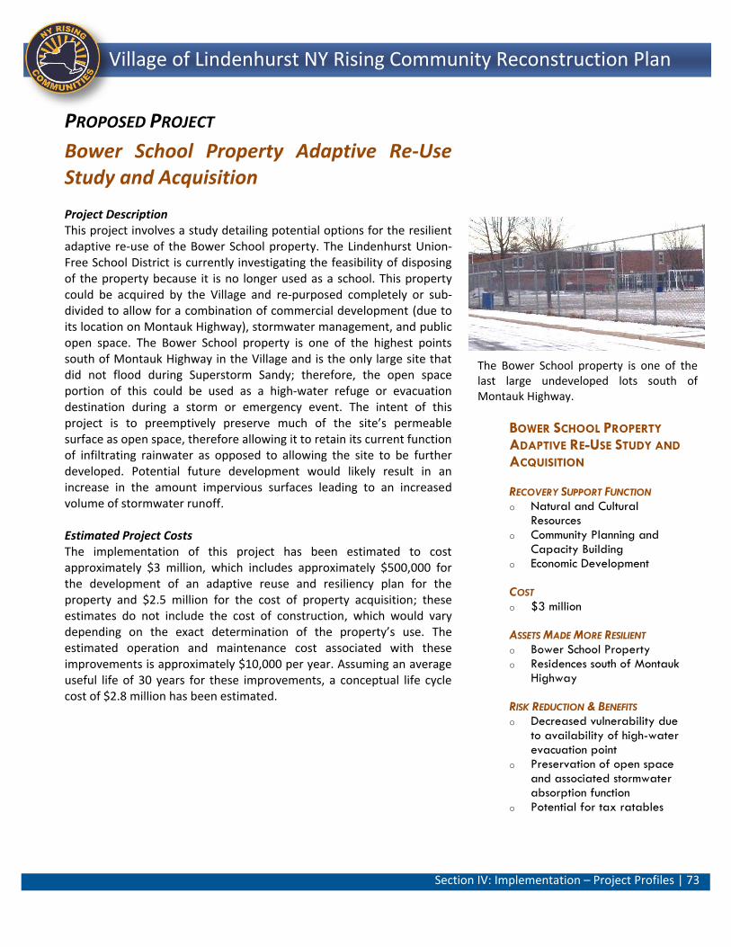
Section IV: Implementation – Project Profiles | 73
Lindenhurst NY Rising Community Reconstruction Plan Village of Lindenhurst NY Rising Community Reconstruction Plan
BOWER SCHOOL PROPERTY
ADAPTIVE RE-USE STUDY AND
ACQUISITION
RECOVERY SUPPORT FUNCTION o Natural and Cultural
Resources o Community Planning and
Capacity Building o Economic Development
COST o $3 million
ASSETS MADE MORE RESILIENT o Bower School Property o Residences south of Montauk
Highway
RISK REDUCTION & BENEFITS o Decreased vulnerability due
to availability of high-water evacuation point
o Preservation of open space and associated stormwater absorption function
o Potential for tax ratables
PROPOSED PROJECT
Bower School Property Adaptive Re-Use Study and Acquisition Project Description This project involves a study detailing potential options for the resilient adaptive re-use of the Bower School property. The Lindenhurst Union-Free School District is currently investigating the feasibility of disposing of the property because it is no longer used as a school. This property could be acquired by the Village and re-purposed completely or sub-divided to allow for a combination of commercial development (due to its location on Montauk Highway), stormwater management, and public open space. The Bower School property is one of the highest points south of Montauk Highway in the Village and is the only large site that did not flood during Superstorm Sandy; therefore, the open space portion of this could be used as a high-water refuge or evacuation destination during a storm or emergency event. The intent of this project is to preemptively preserve much of the site’s permeable surface as open space, therefore allowing it to retain its current function of infiltrating rainwater as opposed to allowing the site to be further developed. Potential future development would likely result in an increase in the amount impervious surfaces leading to an increased volume of stormwater runoff. Estimated Project Costs The implementation of this project has been estimated to cost approximately $3 million, which includes approximately $500,000 for the development of an adaptive reuse and resiliency plan for the property and $2.5 million for the cost of property acquisition; these estimates do not include the cost of construction, which would vary depending on the exact determination of the property’s use. The estimated operation and maintenance cost associated with these improvements is approximately $10,000 per year. Assuming an average useful life of 30 years for these improvements, a conceptual life cycle cost of $2.8 million has been estimated.
The Bower School property is one of the last large undeveloped lots south of Montauk Highway.
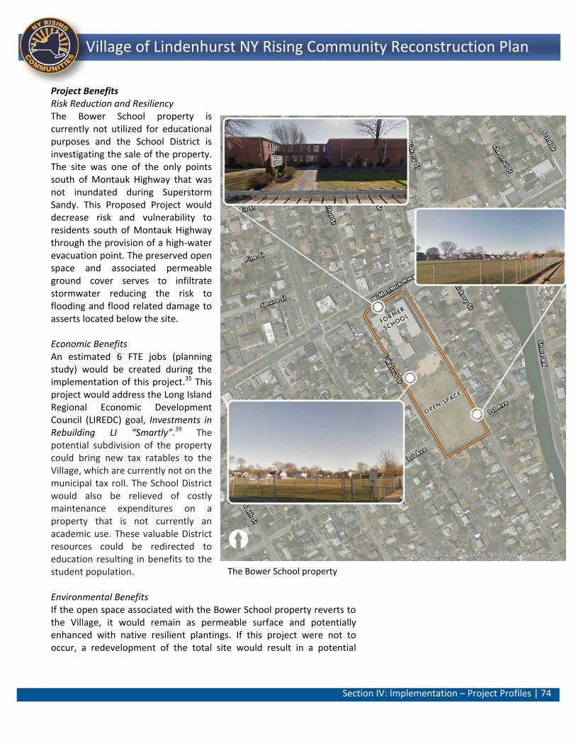
Section IV: Implementation – Project Profiles | 74
Lindenhurst NY Rising Community Reconstruction Plan Village of Lindenhurst NY Rising Community Reconstruction Plan
Project Benefits Risk Reduction and Resiliency The Bower School property is currently not utilized for educational purposes and the School District is investigating the sale of the property. The site was one of the only points south of Montauk Highway that was not inundated during Superstorm Sandy. This Proposed Project would decrease risk and vulnerability to residents south of Montauk Highway through the provision of a high-water evacuation point. The preserved open space and associated permeable ground cover serves to infiltrate stormwater reducing the risk to flooding and flood related damage to asserts located below the site. Economic Benefits An estimated 6 FTE jobs (planning study) would be created during the implementation of this project.35 This project would address the Long Island Regional Economic Development Council (LIREDC) goal, Investments in Rebuilding LI “Smartly”.39 The potential subdivision of the property could bring new tax ratables to the Village, which are currently not on the municipal tax roll. The School District would also be relieved of costly maintenance expenditures on a property that is not currently an academic use. These valuable District resources could be redirected to education resulting in benefits to the student population. Environmental Benefits If the open space associated with the Bower School property reverts to the Village, it would remain as permeable surface and potentially enhanced with native resilient plantings. If this project were not to occur, a redevelopment of the total site would result in a potential
The Bower School property
Section IV: Implementation – Project Profiles | 75
Lindenhurst NY Rising Community Reconstruction Plan Village of Lindenhurst NY Rising Community Reconstruction Plan
increase in hard surfacing which would cause a resultant increase in runoff. Health and Social Benefits The community heavily uses the open space associated with the property. This open space could remain as undeveloped property which benefits the community both recreationally and more importantly as a rallying point/refuge during storm events as this property is the only high-point located south of Montauk Highway that did not flood as a result of Superstorm Sandy. Cost Benefit Analysis This approximately $3 million project presents an excellent opportunity to invest in this 5-acre property and, by extension, the entire Village of Lindenhurst. Co-benefits of this project would include potential commercial development (economic) on the built portion of the property that would bring much-needed tax ratables. The Village would maintain the existing open space (recreational use), thereby preserving the site’s permeable surface to allow storm water runoff and to also serve as a potential refuge area during other large storms (environmental benefits and resiliency). This project would provide a blueprint for a targeted investment that would utilize this property in the most efficient manner. The potential benefits of this project outweigh the medium cost of implementation. Risk Reduction Analysis This Proposed Project would decrease risk and vulnerability to residents south of Montauk Highway through the provision of a high-water evacuation point. Residences in the High Risk Areas and Moderate Risk Areas would be reduced to the Moderate classification in the post intervention condition. General Timeframe for Implementation It is estimated that, from the time implementation begins, this Project has potential for long-term implementation (36 months). This assumes approximately 6 months for the development of the reuse plan including extensive public input and consultation; Approximately 12 months for the disposition of the property by the School Board; and approximately 18 months for the acquisition of the property by the Village and any action by the Village Board of Trustees and the Planning Board. Regulatory Requirements Related to Project This project is feasible; however, a number of issues exist relative to the acquisition of the property. Coordination between the community,
Section IV: Implementation – Project Profiles | 76
Lindenhurst NY Rising Community Reconstruction Plan Village of Lindenhurst NY Rising Community Reconstruction Plan
Board of Education (ownership of property) and Village Board (holds zoning authority over property) would be required as well. The Village Board, which holds zoning authority over the property, has indicated that they do not want to see future potential residential development on this particular parcel. Jurisdiction Village of Lindenhurst and Lindenhurst Union Free School District
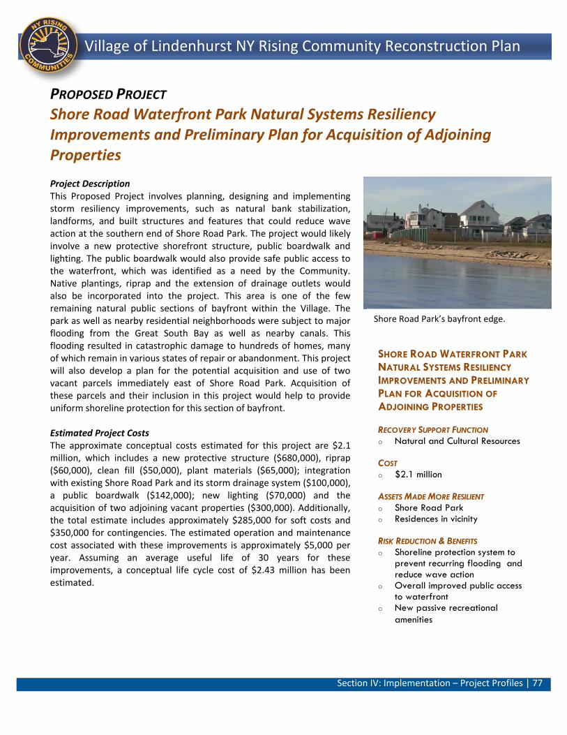
Section IV: Implementation – Project Profiles | 77
Lindenhurst NY Rising Community Reconstruction Plan Village of Lindenhurst NY Rising Community Reconstruction Plan
SHORE ROAD WATERFRONT PARK
NATURAL SYSTEMS RESILIENCY
IMPROVEMENTS AND PRELIMINARY
PLAN FOR ACQUISITION OF
ADJOINING PROPERTIES
RECOVERY SUPPORT FUNCTION o Natural and Cultural Resources
COST o $2.1 million
ASSETS MADE MORE RESILIENT o Shore Road Park o Residences in vicinity
RISK REDUCTION & BENEFITS o Shoreline protection system to
prevent recurring flooding and reduce wave action
o Overall improved public access to waterfront
o New passive recreational
amenities
PROPOSED PROJECT Shore Road Waterfront Park Natural Systems Resiliency Improvements and Preliminary Plan for Acquisition of Adjoining Properties
Project Description This Proposed Project involves planning, designing and implementing storm resiliency improvements, such as natural bank stabilization, landforms, and built structures and features that could reduce wave action at the southern end of Shore Road Park. The project would likely involve a new protective shorefront structure, public boardwalk and lighting. The public boardwalk would also provide safe public access to the waterfront, which was identified as a need by the Community. Native plantings, riprap and the extension of drainage outlets would also be incorporated into the project. This area is one of the few remaining natural public sections of bayfront within the Village. The park as well as nearby residential neighborhoods were subject to major flooding from the Great South Bay as well as nearby canals. This flooding resulted in catastrophic damage to hundreds of homes, many of which remain in various states of repair or abandonment. This project will also develop a plan for the potential acquisition and use of two vacant parcels immediately east of Shore Road Park. Acquisition of these parcels and their inclusion in this project would help to provide uniform shoreline protection for this section of bayfront. Estimated Project Costs The approximate conceptual costs estimated for this project are $2.1 million, which includes a new protective structure ($680,000), riprap ($60,000), clean fill ($50,000), plant materials ($65,000); integration with existing Shore Road Park and its storm drainage system ($100,000), a public boardwalk ($142,000); new lighting ($70,000) and the acquisition of two adjoining vacant properties ($300,000). Additionally, the total estimate includes approximately $285,000 for soft costs and $350,000 for contingencies. The estimated operation and maintenance cost associated with these improvements is approximately $5,000 per year. Assuming an average useful life of 30 years for these improvements, a conceptual life cycle cost of $2.43 million has been estimated.
Shore Road Park’s bayfront edge.
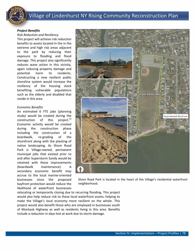
Section IV: Implementation – Project Profiles | 78
Lindenhurst NY Rising Community Reconstruction Plan Village of Lindenhurst NY Rising Community Reconstruction Plan
Project Benefits Risk Reduction and Resiliency This project will achieve risk reduction benefits to assets located in the in the extreme and high risk areas adjacent to the park by reducing their exposure to flooding and flood damage. This project also significantly reduces wave action in this vicinity, again reducing property damage and potential harm to residents. Constructing a new resilient public shoreline system would increase the resiliency of the housing stock benefiting vulnerable populations such as the elderly and disabled that reside in this area. Economic Benefits An estimated 6 FTE jobs (planning study) would be created during the construction of this project.35 Economic activity would be created during the construction phase including the construction of a boardwalk, re-grading of the shorefront along with the planting of native landscaping. As Shore Road Park is Village-owned, permanent municipal jobs that existed prior to and after Superstorm Sandy would be retained with these improvements (boardwalk maintenance). A secondary economic benefit may accrue to the local marine-oriented businesses since the proposed bayfront protection would reduce the likelihood of waterfront businesses relocating or temporarily closing due to recurring flooding. This project would also help reduce risk to these local waterfront assets; helping to make the Village’s local economy more resilient on the whole. This project would also benefit those who are employed in businesses south of Montauk Highway as well as residents living in this area. Benefits include a reduction in days lost at work due to storm damage.
Shore Road Park is located in the heart of the Village’s residential waterfront neighborhood.
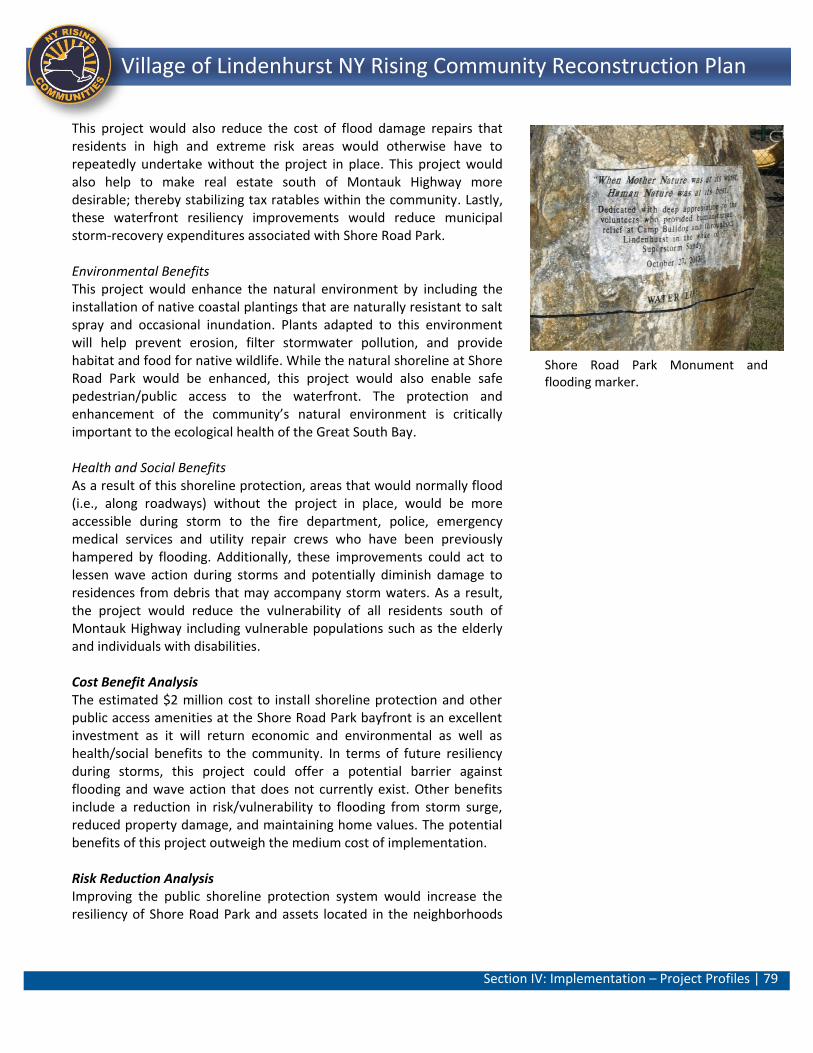
Section IV: Implementation – Project Profiles | 79
Lindenhurst NY Rising Community Reconstruction Plan Village of Lindenhurst NY Rising Community Reconstruction Plan
This project would also reduce the cost of flood damage repairs that residents in high and extreme risk areas would otherwise have to repeatedly undertake without the project in place. This project would also help to make real estate south of Montauk Highway more desirable; thereby stabilizing tax ratables within the community. Lastly, these waterfront resiliency improvements would reduce municipal storm-recovery expenditures associated with Shore Road Park. Environmental Benefits This project would enhance the natural environment by including the installation of native coastal plantings that are naturally resistant to salt spray and occasional inundation. Plants adapted to this environment will help prevent erosion, filter stormwater pollution, and provide habitat and food for native wildlife. While the natural shoreline at Shore Road Park would be enhanced, this project would also enable safe pedestrian/public access to the waterfront. The protection and enhancement of the community’s natural environment is critically important to the ecological health of the Great South Bay. Health and Social Benefits As a result of this shoreline protection, areas that would normally flood (i.e., along roadways) without the project in place, would be more accessible during storm to the fire department, police, emergency medical services and utility repair crews who have been previously hampered by flooding. Additionally, these improvements could act to lessen wave action during storms and potentially diminish damage to residences from debris that may accompany storm waters. As a result, the project would reduce the vulnerability of all residents south of Montauk Highway including vulnerable populations such as the elderly and individuals with disabilities. Cost Benefit Analysis The estimated $2 million cost to install shoreline protection and other public access amenities at the Shore Road Park bayfront is an excellent investment as it will return economic and environmental as well as health/social benefits to the community. In terms of future resiliency during storms, this project could offer a potential barrier against flooding and wave action that does not currently exist. Other benefits include a reduction in risk/vulnerability to flooding from storm surge, reduced property damage, and maintaining home values. The potential benefits of this project outweigh the medium cost of implementation.
Risk Reduction Analysis Improving the public shoreline protection system would increase the resiliency of Shore Road Park and assets located in the neighborhoods
Shore Road Park Monument and flooding marker.
Section IV: Implementation – Project Profiles | 80
Lindenhurst NY Rising Community Reconstruction Plan Village of Lindenhurst NY Rising Community Reconstruction Plan
south of Montauk Highway. As such, the project reduces the risk score for assets in these areas by reducing the exposure to flooding and flood-related impacts. Additionally, the existing bioswales that bound Shore Road Park would function more efficiently with the project in place. These changes bring the risk score of residential assets down from a Severe classification in the baseline condition to a High range where shoreline protection would be improved. The Village’s canals would improve from a Severe risk to a High post intervention. Given these changes in criteria and an improvement in vulnerability rating (from 5 to 3), Shore Road Park would be significantly protected with a score of 18 (Moderate category) with the project in place. General Timeframe for Implementation It is estimated that, from the time implementation begins, this Project has potential for long-term implementation (36 months). This assumes approximately 6 months for the development of design documents; approximately 18 months for environmental permitting and property acquisition; and, 12 months for construction. Regulatory Requirements Related to Project Potential challenges are moderate in scope; however, this project would likely require close coordination between the Village, the New York State Department of Environmental Conservation (NYS DEC), New York State Department of State (NYS DOS) and possibly the U.S. Army Corps of Engineers (USACE). A NYS DOS Coastal Zone Management (CZM) consistency review would be required in areas of the Village that lie within the State’s Coastal Zone boundary. Additionally, review and coordination as well as the necessary extensive environmental permitting would be required with NYS DEC in areas proximate to wetlands and the waterfront. Jurisdiction Village of Lindenhurst (Village-owned)
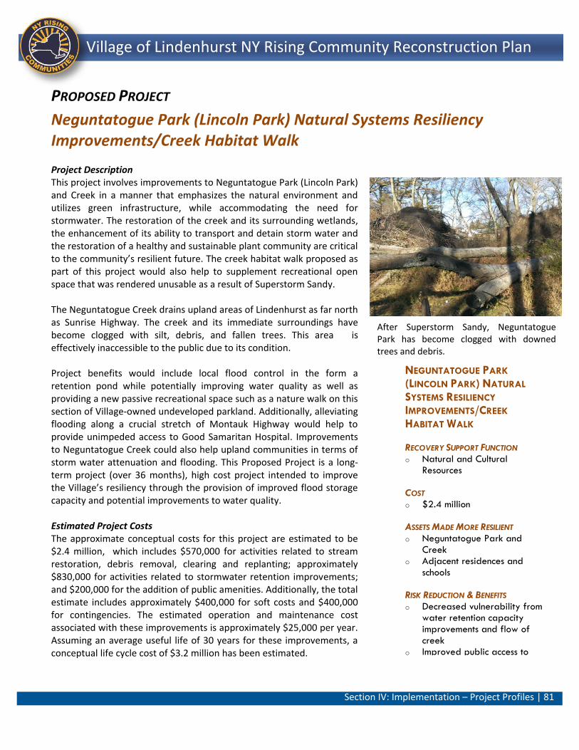
Section IV: Implementation – Project Profiles | 81
Lindenhurst NY Rising Community Reconstruction Plan Village of Lindenhurst NY Rising Community Reconstruction Plan
NEGUNTATOGUE PARK
(LINCOLN PARK) NATURAL
SYSTEMS RESILIENCY
IMPROVEMENTS/CREEK
HABITAT WALK
RECOVERY SUPPORT FUNCTION o Natural and Cultural
Resources
COST o $2.4 million
ASSETS MADE MORE RESILIENT o Neguntatogue Park and
Creek o Adjacent residences and
schools
RISK REDUCTION & BENEFITS o Decreased vulnerability from
water retention capacity improvements and flow of creek
o Improved public access to passive recreational amenity
PROPOSED PROJECT
Neguntatogue Park (Lincoln Park) Natural Systems Resiliency Improvements/Creek Habitat Walk
Project Description This project involves improvements to Neguntatogue Park (Lincoln Park) and Creek in a manner that emphasizes the natural environment and utilizes green infrastructure, while accommodating the need for stormwater. The restoration of the creek and its surrounding wetlands, the enhancement of its ability to transport and detain storm water and the restoration of a healthy and sustainable plant community are critical to the community’s resilient future. The creek habitat walk proposed as part of this project would also help to supplement recreational open space that was rendered unusable as a result of Superstorm Sandy. The Neguntatogue Creek drains upland areas of Lindenhurst as far north as Sunrise Highway. The creek and its immediate surroundings have become clogged with silt, debris, and fallen trees. This area is effectively inaccessible to the public due to its condition. Project benefits would include local flood control in the form a retention pond while potentially improving water quality as well as providing a new passive recreational space such as a nature walk on this section of Village-owned undeveloped parkland. Additionally, alleviating flooding along a crucial stretch of Montauk Highway would help to provide unimpeded access to Good Samaritan Hospital. Improvements to Neguntatogue Creek could also help upland communities in terms of storm water attenuation and flooding. This Proposed Project is a long-term project (over 36 months), high cost project intended to improve the Village’s resiliency through the provision of improved flood storage capacity and potential improvements to water quality. Estimated Project Costs The approximate conceptual costs for this project are estimated to be $2.4 million, which includes $570,000 for activities related to stream restoration, debris removal, clearing and replanting; approximately $830,000 for activities related to stormwater retention improvements; and $200,000 for the addition of public amenities. Additionally, the total estimate includes approximately $400,000 for soft costs and $400,000 for contingencies. The estimated operation and maintenance cost associated with these improvements is approximately $25,000 per year. Assuming an average useful life of 30 years for these improvements, a conceptual life cycle cost of $3.2 million has been estimated.
After Superstorm Sandy, Neguntatogue Park has become clogged with downed trees and debris.
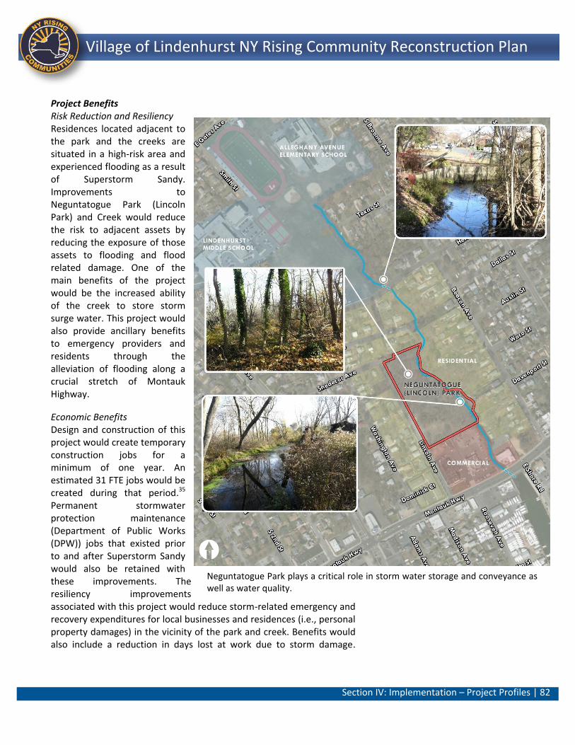
Section IV: Implementation – Project Profiles | 82
Lindenhurst NY Rising Community Reconstruction Plan Village of Lindenhurst NY Rising Community Reconstruction Plan
Project Benefits Risk Reduction and Resiliency Residences located adjacent to the park and the creeks are situated in a high-risk area and experienced flooding as a result of Superstorm Sandy. Improvements to Neguntatogue Park (Lincoln Park) and Creek would reduce the risk to adjacent assets by reducing the exposure of those assets to flooding and flood related damage. One of the main benefits of the project would be the increased ability of the creek to store storm surge water. This project would also provide ancillary benefits to emergency providers and residents through the alleviation of flooding along a crucial stretch of Montauk Highway.
Economic Benefits Design and construction of this project would create temporary construction jobs for a minimum of one year. An estimated 31 FTE jobs would be created during that period.35 Permanent stormwater protection maintenance (Department of Public Works (DPW)) jobs that existed prior to and after Superstorm Sandy would also be retained with these improvements. The resiliency improvements associated with this project would reduce storm-related emergency and recovery expenditures for local businesses and residences (i.e., personal property damages) in the vicinity of the park and creek. Benefits would also include a reduction in days lost at work due to storm damage.
Neguntatogue Park plays a critical role in storm water storage and conveyance as well as water quality.
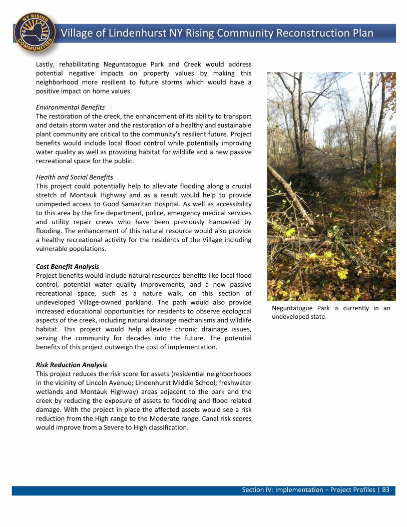
Section IV: Implementation – Project Profiles | 83
Lindenhurst NY Rising Community Reconstruction Plan Village of Lindenhurst NY Rising Community Reconstruction Plan
Lastly, rehabilitating Neguntatogue Park and Creek would address potential negative impacts on property values by making this neighborhood more resilient to future storms which would have a positive impact on home values.
Environmental Benefits The restoration of the creek, the enhancement of its ability to transport and detain storm water and the restoration of a healthy and sustainable plant community are critical to the community’s resilient future. Project benefits would include local flood control while potentially improving water quality as well as providing habitat for wildlife and a new passive recreational space for the public.
Health and Social Benefits This project could potentially help to alleviate flooding along a crucial stretch of Montauk Highway and as a result would help to provide unimpeded access to Good Samaritan Hospital. As well as accessibility to this area by the fire department, police, emergency medical services and utility repair crews who have been previously hampered by flooding. The enhancement of this natural resource would also provide a healthy recreational activity for the residents of the Village including vulnerable populations. Cost Benefit Analysis Project benefits would include natural resources benefits like local flood control, potential water quality improvements, and a new passive recreational space, such as a nature walk, on this section of undeveloped Village-owned parkland. The path would also provide increased educational opportunities for residents to observe ecological aspects of the creek, including natural drainage mechanisms and wildlife habitat. This project would help alleviate chronic drainage issues, serving the community for decades into the future. The potential benefits of this project outweigh the cost of implementation. Risk Reduction Analysis This project reduces the risk score for assets (residential neighborhoods in the vicinity of Lincoln Avenue; Lindenhurst Middle School; freshwater wetlands and Montauk Highway) areas adjacent to the park and the creek by reducing the exposure of assets to flooding and flood related damage. With the project in place the affected assets would see a risk reduction from the High range to the Moderate range. Canal risk scores would improve from a Severe to High classification.
Neguntatogue Park is currently in an undeveloped state.
Section IV: Implementation – Project Profiles | 84
Lindenhurst NY Rising Community Reconstruction Plan Village of Lindenhurst NY Rising Community Reconstruction Plan
General Timeframe for Implementation It is estimated that, from the time implementation begins, this Project has potential for long-term implementation (36 months). This assumes approximately 6 months for the development of design documents; approximately 18 months for environmental permitting and property acquisition; and, 12 months for construction. Regulatory Requirements Related to Project The Neguntatogue Park property is Village-owned and as a result private property acquisition is not anticipated as a project constraint. Community outreach and involvement of adjoining residential owners, especially in the vicinity of Lincoln Avenue, should be undertaken as the project progresses during the planning and design stages. Review, coordination and permitting would be required with the New York State Department of Environmental Conservation (NYS DEC) in areas proximate to wetlands and the waterfront. This project may also involve the U.S. Army Corps of Engineers (USACE) and Coastal Zone Management (CZM) consistency concurrence (New York State Department of State).
Jurisdiction Village of Lindenhurst (Village-owned)
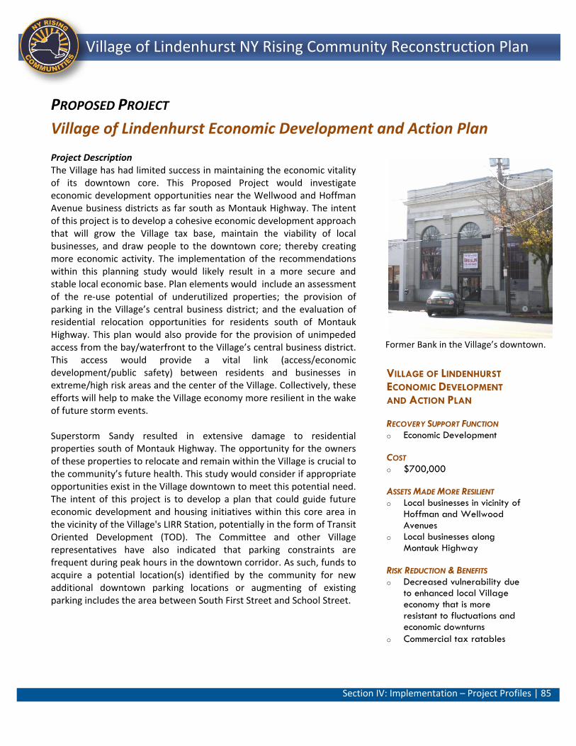
Section IV: Implementation – Project Profiles | 85
Lindenhurst NY Rising Community Reconstruction Plan Village of Lindenhurst NY Rising Community Reconstruction Plan
VILLAGE OF LINDENHURST
ECONOMIC DEVELOPMENT
AND ACTION PLAN
RECOVERY SUPPORT FUNCTION o Economic Development
COST o $700,000
ASSETS MADE MORE RESILIENT o Local businesses in vicinity of
Hoffman and Wellwood Avenues
o Local businesses along Montauk Highway
RISK REDUCTION & BENEFITS o Decreased vulnerability due
to enhanced local Village economy that is more resistant to fluctuations and economic downturns
o Commercial tax ratables
PROPOSED PROJECT
Village of Lindenhurst Economic Development and Action Plan Project Description The Village has had limited success in maintaining the economic vitality of its downtown core. This Proposed Project would investigate economic development opportunities near the Wellwood and Hoffman Avenue business districts as far south as Montauk Highway. The intent of this project is to develop a cohesive economic development approach that will grow the Village tax base, maintain the viability of local businesses, and draw people to the downtown core; thereby creating more economic activity. The implementation of the recommendations within this planning study would likely result in a more secure and stable local economic base. Plan elements would include an assessment of the re-use potential of underutilized properties; the provision of parking in the Village’s central business district; and the evaluation of residential relocation opportunities for residents south of Montauk Highway. This plan would also provide for the provision of unimpeded access from the bay/waterfront to the Village’s central business district. This access would provide a vital link (access/economic development/public safety) between residents and businesses in extreme/high risk areas and the center of the Village. Collectively, these efforts will help to make the Village economy more resilient in the wake of future storm events. Superstorm Sandy resulted in extensive damage to residential properties south of Montauk Highway. The opportunity for the owners of these properties to relocate and remain within the Village is crucial to the community’s future health. This study would consider if appropriate opportunities exist in the Village downtown to meet this potential need. The intent of this project is to develop a plan that could guide future economic development and housing initiatives within this core area in the vicinity of the Village's LIRR Station, potentially in the form of Transit Oriented Development (TOD). The Committee and other Village representatives have also indicated that parking constraints are frequent during peak hours in the downtown corridor. As such, funds to acquire a potential location(s) identified by the community for new additional downtown parking locations or augmenting of existing parking includes the area between South First Street and School Street.
Former Bank in the Village’s downtown.
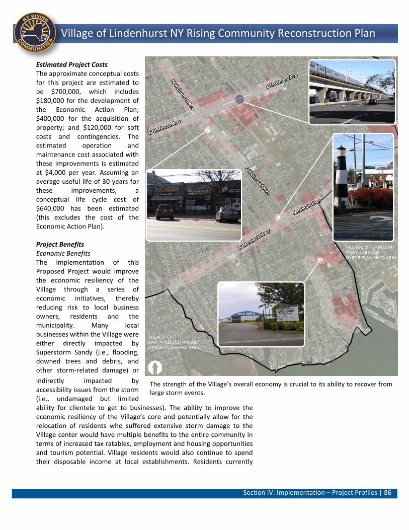
Section IV: Implementation – Project Profiles | 86
Lindenhurst NY Rising Community Reconstruction Plan Village of Lindenhurst NY Rising Community Reconstruction Plan
Estimated Project Costs The approximate conceptual costs for this project are estimated to be $700,000, which includes $180,000 for the development of the Economic Action Plan; $400,000 for the acquisition of property; and $120,000 for soft costs and contingencies. The estimated operation and maintenance cost associated with these improvements is estimated at $4,000 per year. Assuming an average useful life of 30 years for these improvements, a conceptual life cycle cost of $640,000 has been estimated (this excludes the cost of the Economic Action Plan). Project Benefits Economic Benefits The implementation of this Proposed Project would improve the economic resiliency of the Village through a series of economic initiatives, thereby reducing risk to local business owners, residents and the municipality. Many local businesses within the Village were either directly impacted by Superstorm Sandy (i.e., flooding, downed trees and debris, and other storm-related damage) or
indirectly impacted by accessibility issues from the storm (i.e., undamaged but limited ability for clientele to get to businesses). The ability to improve the economic resiliency of the Village’s core and potentially allow for the relocation of residents who suffered extensive storm damage to the Village center would have multiple benefits to the entire community in terms of increased tax ratables, employment and housing opportunities and tourism potential. Village residents would also continue to spend their disposable income at local establishments. Residents currently
The strength of the Village’s overall economy is crucial to its ability to recover from large storm events.
Section IV: Implementation – Project Profiles | 87
Lindenhurst NY Rising Community Reconstruction Plan Village of Lindenhurst NY Rising Community Reconstruction Plan
located in extreme and high risk areas may benefit from a reduction in risk as relocation opportunities may be created for new housing options in non/moderate risk zones. The creation of this economic development and action plan will create an estimated 2 FTEs.35 The local commercial convenience uses and the remainder of the Village’s employment base that existed prior to and after Superstorm Sandy would be more stable with this initiative in place. This project coincides with the Long Island Regional Economic Development Council (LIREDC) goals of Investments in Rebuilding LI “Smartly” and Investments in Our Workforce.40 Health and Social Benefits With the creation of the Economic Development and Action Plan, the Village will create the roadmap that will allow the local economy to become more resistant to fluctuations as a result of a storm or emergency event. A dynamic and thriving Village center would benefit the entire community including vulnerable populations as residents and visitors alike would have increased options to open and/or patronize new businesses. Cost Benefit Analysis Village residents have expressed a desire to have their downtown area reinvigorated, particularly after the damaging effects of Superstorm Sandy to both local and neighboring downtown areas. Lindenhurst’s core commercial district along Wellwood and Hoffman Avenues is partially located just outside of the moderate risk assessment area (other areas of these corridors are moderate risk), and therefore presents an excellent opportunity to invest in existing downtown areas but without a significant concern for future flood hazards. However, the community needs a blueprint for targeted investments that will bring interest to the Village’s downtown in the most efficient manner. A $700,000 investment in a downtown revitalization plan will accomplish this and provide the foundation for future downtown improvements. The potential benefits of this project are considered to outweigh the medium cost of implementation. Risk Reduction Analysis This project would reduce the risk of post-disaster disruptions to business operations, loss of tax revenue, and economic downturns. Collectively, these efforts will help to make the Village economy more resilient to fluctuations in the wake of future storm events. Residents who may have relocated to the Village core from areas closer to the waterfront will experience less risk due to flooding.
Section IV: Implementation – Project Profiles | 88
Lindenhurst NY Rising Community Reconstruction Plan Village of Lindenhurst NY Rising Community Reconstruction Plan
General Timeframe for Implementation This Proposed Project could be undertaken in two stages: it is estimated that, from the time implementation begins, the first stage of the project has potential for near-term implementation (0 to 12 months); once the first stage is completed, the second stage can begin, from which point the implementation of the recommendations from the study including the potential acquisition of property which would require a longer-term time frame (in excess of 2 years). Regulatory Requirements Related to Project The implementation of the recommendations of the plan would require approval by the Village of Lindenhurst Board of Trustees as well as possible actions by the Planning Board and or the Zoning Board. Jurisdiction Village of Lindenhurst
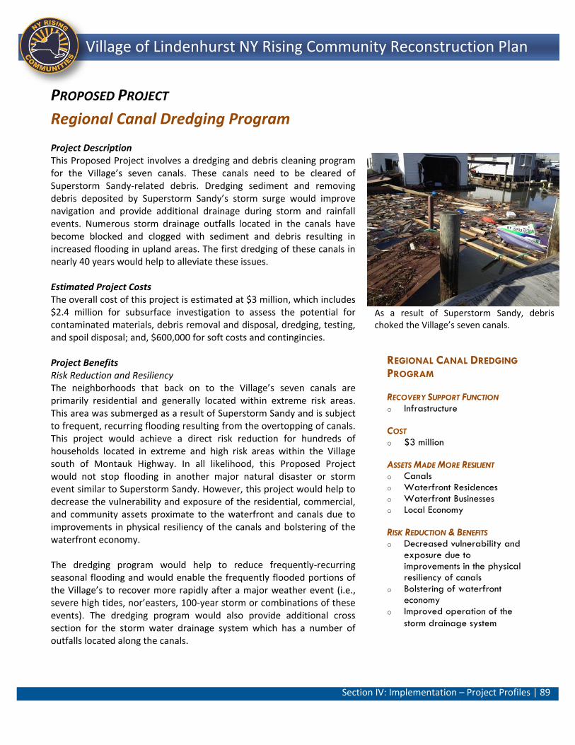
Section IV: Implementation – Project Profiles | 89
Lindenhurst NY Rising Community Reconstruction Plan Village of Lindenhurst NY Rising Community Reconstruction Plan
REGIONAL CANAL DREDGING
PROGRAM
RECOVERY SUPPORT FUNCTION o Infrastructure
COST o $3 million
ASSETS MADE MORE RESILIENT o Canals o Waterfront Residences o Waterfront Businesses o Local Economy
RISK REDUCTION & BENEFITS o Decreased vulnerability and
exposure due to improvements in the physical resiliency of canals
o Bolstering of waterfront economy
o Improved operation of the
storm drainage system
PROPOSED PROJECT
Regional Canal Dredging Program Project Description This Proposed Project involves a dredging and debris cleaning program for the Village’s seven canals. These canals need to be cleared of Superstorm Sandy-related debris. Dredging sediment and removing debris deposited by Superstorm Sandy’s storm surge would improve navigation and provide additional drainage during storm and rainfall events. Numerous storm drainage outfalls located in the canals have become blocked and clogged with sediment and debris resulting in increased flooding in upland areas. The first dredging of these canals in nearly 40 years would help to alleviate these issues. Estimated Project Costs The overall cost of this project is estimated at $3 million, which includes $2.4 million for subsurface investigation to assess the potential for contaminated materials, debris removal and disposal, dredging, testing, and spoil disposal; and, $600,000 for soft costs and contingincies. Project Benefits Risk Reduction and Resiliency The neighborhoods that back on to the Village’s seven canals are primarily residential and generally located within extreme risk areas. This area was submerged as a result of Superstorm Sandy and is subject to frequent, recurring flooding resulting from the overtopping of canals. This project would achieve a direct risk reduction for hundreds of households located in extreme and high risk areas within the Village south of Montauk Highway. In all likelihood, this Proposed Project would not stop flooding in another major natural disaster or storm event similar to Superstorm Sandy. However, this project would help to decrease the vulnerability and exposure of the residential, commercial, and community assets proximate to the waterfront and canals due to improvements in physical resiliency of the canals and bolstering of the waterfront economy. The dredging program would help to reduce frequently-recurring seasonal flooding and would enable the frequently flooded portions of the Village’s to recover more rapidly after a major weather event (i.e., severe high tides, nor’easters, 100-year storm or combinations of these events). The dredging program would also provide additional cross section for the storm water drainage system which has a number of outfalls located along the canals.
As a result of Superstorm Sandy, debris choked the Village’s seven canals.
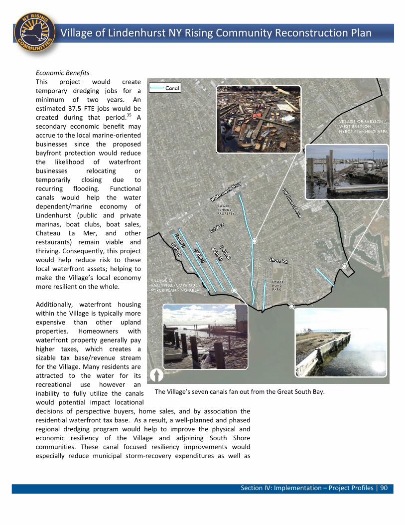
Section IV: Implementation – Project Profiles | 90
Lindenhurst NY Rising Community Reconstruction Plan Village of Lindenhurst NY Rising Community Reconstruction Plan
Economic Benefits This project would create temporary dredging jobs for a minimum of two years. An estimated 37.5 FTE jobs would be created during that period.35 A secondary economic benefit may accrue to the local marine-oriented businesses since the proposed bayfront protection would reduce the likelihood of waterfront businesses relocating or temporarily closing due to recurring flooding. Functional canals would help the water dependent/marine economy of Lindenhurst (public and private marinas, boat clubs, boat sales, Chateau La Mer, and other restaurants) remain viable and thriving. Consequently, this project would help reduce risk to these local waterfront assets; helping to make the Village’s local economy more resilient on the whole. Additionally, waterfront housing within the Village is typically more expensive than other upland properties. Homeowners with waterfront property generally pay higher taxes, which creates a sizable tax base/revenue stream for the Village. Many residents are attracted to the water for its recreational use however an inability to fully utilize the canals would potential impact locational decisions of perspective buyers, home sales, and by association the residential waterfront tax base. As a result, a well-planned and phased regional dredging program would help to improve the physical and economic resiliency of the Village and adjoining South Shore communities. These canal focused resiliency improvements would especially reduce municipal storm-recovery expenditures as well as
The Village’s seven canals fan out from the Great South Bay.
Section IV: Implementation – Project Profiles | 91
Lindenhurst NY Rising Community Reconstruction Plan Village of Lindenhurst NY Rising Community Reconstruction Plan
personal property damage for homeowners from flooding events. This project would address the Long Island Regional Economic Development Council (LIREDC) goal: Investments in Rebuilding LI “Smartly”.41 Health and Social Benefits As a result of this project, areas that would normally flood (i.e., along roadways) without the project in place, would be more accessible during storm events access by the fire department, police, emergency medical services and utility repair crews who have been previously hampered by flooding. As a result, the project would reduce the vulnerability of all residents south of Montauk Highway including vulnerable populations such as the elderly and individuals with disabilities. Cost Benefit Analysis The canals are a critical element in the Village’s drainage infrastructure. The dredging of the Village’s canals of Superstorm Sandy-related debris would have numerous direct benefits (reduced flooding of adjacent neighborhood and community assets) and co-benefits (stabilizing waterfront property values/tax ratables, and navigation and recreation for the community) that lead to this project being a good investment. Risk Reduction Analysis A well-planned and phased regional dredging program would help to improve the physical and economic resiliency of the Village and adjoining South Shore communities. This project will increase the resiliency of neighborhoods and roads that are adjacent to the canals. The project reduces risk for assets in the Severe and High classifications, especially those located south of Montauk Highway by reducing exposure to flooding and flood-related impacts. General Timeframe for Implementation It is estimated that, from the time implementation begins, this Project has potential for long-term implementation (36 months). Regulatory Requirements Related to Project Dredging is generally a difficult and complex issue due to a number of reasons (testing of dredge spoils, disposal, limited availability of rigs, compressed season, limited improvement in flood control, regulatory requirements, etc.). Suffolk County currently maintains a dredging plan and program. However, coordination would need to be initiated with the New York State Department of Environmental Conservation (NYS DEC) and the U.S. Army Corps of Engineers (USACE). A New York State Department of State (NYS DOS) Coastal Zone Management (CZM) consistency review would be required as the canals lie within the State’s
Section IV: Implementation – Project Profiles | 92
Lindenhurst NY Rising Community Reconstruction Plan Village of Lindenhurst NY Rising Community Reconstruction Plan
Coastal Zone boundary. Given that the majority of South Shore communities are faced with similar dredging/waterfront economy issues as well as the constraints noted above, this project has special regional significance Jurisdiction Village of Lindenhurst, Suffolk County, NYS DEC, USACE.
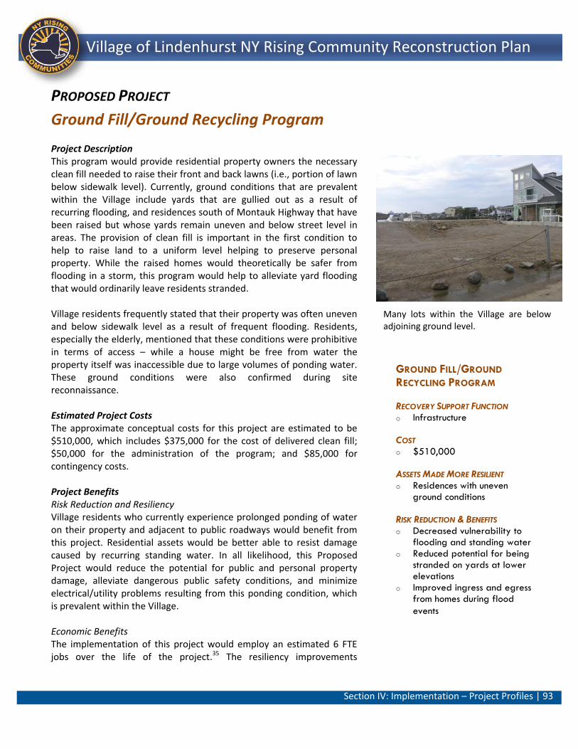
Section IV: Implementation – Project Profiles | 93
Lindenhurst NY Rising Community Reconstruction Plan Village of Lindenhurst NY Rising Community Reconstruction Plan
GROUND FILL/GROUND
RECYCLING PROGRAM
RECOVERY SUPPORT FUNCTION o Infrastructure
COST o $510,000
ASSETS MADE MORE RESILIENT o Residences with uneven
ground conditions
RISK REDUCTION & BENEFITS o Decreased vulnerability to
flooding and standing water o Reduced potential for being
stranded on yards at lower elevations
o Improved ingress and egress from homes during flood
events
PROPOSED PROJECT
Ground Fill/Ground Recycling Program Project Description This program would provide residential property owners the necessary clean fill needed to raise their front and back lawns (i.e., portion of lawn below sidewalk level). Currently, ground conditions that are prevalent within the Village include yards that are gullied out as a result of recurring flooding, and residences south of Montauk Highway that have been raised but whose yards remain uneven and below street level in areas. The provision of clean fill is important in the first condition to help to raise land to a uniform level helping to preserve personal property. While the raised homes would theoretically be safer from flooding in a storm, this program would help to alleviate yard flooding that would ordinarily leave residents stranded. Village residents frequently stated that their property was often uneven and below sidewalk level as a result of frequent flooding. Residents, especially the elderly, mentioned that these conditions were prohibitive in terms of access – while a house might be free from water the property itself was inaccessible due to large volumes of ponding water. These ground conditions were also confirmed during site reconnaissance. Estimated Project Costs The approximate conceptual costs for this project are estimated to be $510,000, which includes $375,000 for the cost of delivered clean fill; $50,000 for the administration of the program; and $85,000 for contingency costs. Project Benefits Risk Reduction and Resiliency Village residents who currently experience prolonged ponding of water on their property and adjacent to public roadways would benefit from this project. Residential assets would be better able to resist damage caused by recurring standing water. In all likelihood, this Proposed Project would reduce the potential for public and personal property damage, alleviate dangerous public safety conditions, and minimize electrical/utility problems resulting from this ponding condition, which is prevalent within the Village. Economic Benefits The implementation of this project would employ an estimated 6 FTE jobs over the life of the project.35 The resiliency improvements
Many lots within the Village are below adjoining ground level.
Section IV: Implementation – Project Profiles | 94
Lindenhurst NY Rising Community Reconstruction Plan Village of Lindenhurst NY Rising Community Reconstruction Plan
associated with this project would reduce storm-related emergency and recovery costs for local businesses. This project would also benefit those who are employed in local businesses as well as residents living in this area. Benefits include a reduction in days lost at work due to ingress/egress and access issues at homes caused by standing water. Health and Social Benefits Accessibility to and from residential homes in the Village, which may have had depressions on their property that collected water and blocked access and egress, would be improved. Access to homes by the fire department, police, emergency medical services and utility repair crews who have been previously hampered by standing water would be improved. This resiliency project would also reduce the severity of the ponding of stagnant water thereby potentially reducing mosquito breeding conditions. Cost Benefit Analysis This project is a low-cost mechanism to provide homeowners with multiple benefits including: the means to mitigate against future personal property loss (economic) and would reduce municipal clean up expenditures. This project would also have health and safety benefits as it would reduce access limitations as a result of standing water and also alleviate dangerous public safety conditions. The benefits of this project are anticipated to outweigh the cost. Risk Reduction Analysis This near-term, cost-effective, Proposed Project would help to reduce risk/vulnerability to residences. The project would improve access to and from homes as well as limit inundation, standing water and mosquito infestation. General Timeframe for Implementation It is estimated that, from the time implementation begins, this Project has potential for long-term implementation (36 months). Regulatory Requirements Related to Project This project is highly feasible and enjoys municipal support. Challenges are limited in scope; including the provision of clean fill and the appropriate environmental coordination and permitting with New York State Department of Envrionmental Conservation (NYS DEC) necessary to place clean fill proximate to waterbodies such as the canals and the bayfront. Jurisdiction Village of Lindenhurst
Section IV: Implementation – Project Profiles | 95
Lindenhurst NY Rising Community Reconstruction Plan Village of Lindenhurst NY Rising Community Reconstruction Plan
INTEGRATED WEB-BASED, COMMUNICATION &
EMERGENCY CELLPHONE
INFRASTRUCTURE
IMPROVEMENTS
RECOVERY SUPPORT FUNCTION o Community Planning and
Capacity Building
COST o $256,000
ASSETS MADE MORE RESILIENT o Entire Village of Lindenhurst
RISK REDUCTION & BENEFITS o Decreased community
vulnerability through more efficient and coordinated response
PROPOSED PROJECT
Integrated Web-based, Communication & Emergency Cellphone Infrastructure Improvements Project Description This project would involve the investigation of electronic and “off-grid” communication improvements, such as radio, text messaging, solar powered/generator based communications equipment. One aspect to this project involves Village website improvements and better functionality focused on communications, emergency preparedness, evacuation and recovery. The improved Village website would function as a single-source repository for storm/emergency preparedness, public safety/notifications and other information. A GIS web-based viewer could provide improved and/or real-time mapping (evacuation routes; obstructed or flooded streets, etc.) and should also be investigated as part of this project. In addition, a “Project Updates” would be incorporated into the Village’s improved website. This page would post status updates of NYRCR Projects in their various phases of completion. The goal of this project is to create a mechanism to effectively link local government, emergency management entities, and community organizations. Such a mechanism was lacking during Superstorm Sandy. Mobile communication was the critical mode of communication during Superstorm Sandy and the current cellular infrastructure was not sufficient to maintain service throughout the storm. As such, this project would also involve coordination with cellular service providers and regulatory agencies to expand service areas and equip cell towers with emergency backup power. The intent of this project is to develop a communications and information system in order to decrease community vulnerability through a coordinated response. This project would look to build upon the Village’s existing website. Estimated Project Costs The approximate conceptual costs for this project are estimated to be $256,000, which includes $38,000 in soft and contingency costs. Project Benefits Risk Reduction and Resiliency All Village residents, local businesses and visitors to the locality would benefit from this project as the community including vulnerable populations would be better informed as to emergency safety protocol and emergency or incoming storm conditions.
Village of Lindenhurst Insignia
Section IV: Implementation – Project Profiles | 96
Lindenhurst NY Rising Community Reconstruction Plan Village of Lindenhurst NY Rising Community Reconstruction Plan
Economic Benefits The implementation of this project would create an estimated 2 FTE jobs for work related to the website/cellphone infrastructure improvements.35 Permanent municipal webmaster jobs which existed prior to and after Superstorm Sandy would be retained with these improvements. Health and Social Benefits This project would provide a mechanism to more effectively link local government, emergency management entities and the public. Residents and vulnerable populations such as the elderly and disabled would benefit, as they would be better informed as to evacuation and preparedness measures. Cost Benefit Analysis The Village of Lindenhurst recognizes inefficiencies in communications relative to emergency management procedures in the lead up and aftermath of Superstorm Sandy. As such, the Village is seeking the most innovative and cost-effective methods for handling future storms/emergency events. This Proposed Project would provide actions to improve and streamline emergency communications helping to make the Village more resilient in advance of a storm and during post-storm recovery activities. The benefits of this project are anticipated to outweigh the cost. Risk Reduction Analysis Overall, the project would enhance the efficiency and coordination of response and recovery activities by the Village and other governmental entities, thereby improving the resiliency of the Village pre- and post-storm. General Timeframe for Implementation It is estimated that, from the time implementation begins, this Project has potential for immediate implementation (0 to 12 months). Regulatory Requirements Related to Project This project is feasible as potential challenges are limited in scope. However, coordination with cellular service providers and appropriate regulatory agencies to expand service areas and make cellular infrastructure more resilient would be needed. Jurisdiction Village of Lindenhurst
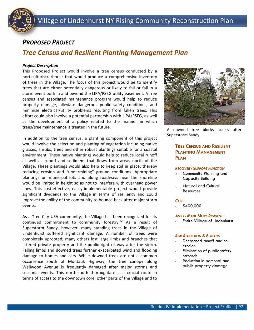
Section IV: Implementation – Project Profiles | 97
Lindenhurst NY Rising Community Reconstruction Plan Village of Lindenhurst NY Rising Community Reconstruction Plan
TREE CENSUS AND RESILIENT
PLANTING MANAGEMENT
PLAN
RECOVERY SUPPORT FUNCTION o Community Planning and
Capacity Building
o Natural and Cultural Resources
COST o $400,000
ASSETS MADE MORE RESILIENT o Entire Village of Lindenhurst
RISK REDUCTION & BENEFITS o Decreased runoff and soil
erosion o Elimination of public safety
hazards o Reduction in personal and
public property damage
PROPOSED PROJECT
Tree Census and Resilient Planting Management Plan Project Description This Proposed Project would involve a tree census conducted by a horticulturist/arborist that would produce a comprehensive inventory of trees in the Village. The focus of this project would be to identify trees that are either potentially dangerous or likely to fail or fall in a storm event both in and beyond the LIPA/PSEG utility easement. A tree census and associated maintenance program would help to reduce property damage, alleviate dangerous public safety conditions, and minimize electrical/utility problems resulting from fallen trees. This effort could also involve a potential partnership with LIPA/PSEG, as well as the development of a policy related to the manner in which trees/tree maintenance is treated in the future. In addition to the tree census, a planting component of this project would involve the selection and planting of vegetation including native grasses, shrubs, trees and other robust plantings suitable for a coastal environment. These native plantings would help to reduce local runoff as well as runoff and sediment that flows from areas north of the Village. These plantings would also help to keep soil in place, thereby reducing erosion and “undermining” ground conditions. Appropriate plantings on municipal lots and along roadways near the shoreline would be limited in height so as not to interfere with overhead power lines. This cost-effective, easily-implementable project would provide significant dividends to the Village in terms of resiliency and could improve the ability of the community to bounce-back after major storm events. As a Tree City USA community, the Village has been recognized for its continued commitment to community forestry.42 As a result of Superstorm Sandy, however, many standing trees in the Village of Lindenhurst suffered significant damage. A number of trees were completely uprooted; many others lost large limbs and branches that littered private property and the public right of way after the storm. Falling limbs and downed trees further exacerbated wind and flooding damage to homes and cars. While downed trees are not a common occurrence south of Montauk Highway; the tree canopy along Wellwood Avenue is frequently damaged after major storms and seasonal events. This north-south thoroughfare is a crucial route in terms of access to the downtown core, other parts of the Village and to
A downed tree blocks access after Superstorm Sandy.
Section IV: Implementation – Project Profiles | 98
Lindenhurst NY Rising Community Reconstruction Plan Village of Lindenhurst NY Rising Community Reconstruction Plan
neighboring municipalities. Consequently, a safe route along Wellwood Avenue clear of downed trees is important in terms of transportation, provision of emergency services and to local businesses Estimated Project Costs The approximate conceptual costs for this project are estimated to be $400,000, which includes approximately $155,000 related to the development of the tree census; $180,000 related to the cost of tree trimming and new resilient plantings; and, approximately $65,000 for soft costs and contingincies. Project Benefits Risk Reduction and Resiliency Village assets would be better able to resist damage from falling tree hazards and experience less time out of service after a storm with the project in place. In all likelihood, this Proposed Project would reduce the potential for public and personal property damage, alleviate dangerous public safety conditions, and minimize electrical/utility problems resulting from fallen trees. All Village residents, local businesses and visitors to the locality would benefit from this project. Economic Benefits The implementation of this project would employ an arborist for the census portion of the project. An estimated 5 FTE jobs would be created during that period from the preparation of the arbor census.35 The resiliency improvements associated with this project would reduce storm-related emergency and recovery costs for local businesses. This project would also benefit those who are employed in local businesses as well as residents living in this area. Benefits include a reduction in days lost at work due to tree damage and/or access issues due to fallen trees. Utility providers may realize a cost savings as a result of this project due to the potential for reduced emergency clean-up expenditures post storm. As such, co-benefits would likely accrue to utilities responsible for overhead transmission lines as well as life safety and DPW personnel in terms of their ability to access and respond to storm clean up and emergency situations. Environmental Benefits The planting component of this project would involve the selection and planting of vegetation including native grasses, shrubs, trees and other robust plantings suitable for a coastal environment. These native plantings would help to reduce stormwater runoff and help to keep soil in place; thereby reducing erosion and “undermining” ground conditions. Appropriate plantings near utilities would be limited in
Section IV: Implementation – Project Profiles | 99
Lindenhurst NY Rising Community Reconstruction Plan Village of Lindenhurst NY Rising Community Reconstruction Plan
height. Wildlife habitat will also be created with the addition of native vegetation. Health and Social Benefits Accessibility to areas of the Village during times of weather-related conditions would be improved along sidewalks/roadways including access by the fire department, police, emergency medical services and utility repair crews who have been previously hampered by downed trees. As a result, the project would reduce the vulnerability of all residents on a Village-wide level including vulnerable populations such as the elderly and individuals with disabilities. Cost Benefit Analysis At a cost of approximately $400,000, the project would help to fortify and improve the resiliency of the Village, especially residential housing, vehicles, utilities and other personal and public property. The planting component of the project would stabilize permeable surfaces thereby providing ancillary support in terms of flood reduction. The benefits of this project are anticipated to outweigh the cost making the project justifiable and appropriate. Risk Reduction Analysis Improvements in risk score of identified assets were attributed to an improved vulnerability rating that was carried across all assets in the landscape attribute related to the absence of protective vegetation. This cost-effective, easily-implementable project would provide significant dividends to the Village-wide assets in terms of their resiliency. General Timeframe for Implementation It is estimated that, from the time implementation begins, this Project has potential for immediate implementation (0 to 12 months). Regulatory Requirements Related to Project This project has a high-level of technical feasibility, as potential challenges are limited. Regulatory review of this project is not anticipated; however it is possible that a Coastal Zone Management (CZM) consistency review (New York State Department of State) would be required in areas of the Village that lie within the State’s Coastal Zone boundary. Coordination with LIPA/PSEG would be necessary where trees and utility alignments are coterminous. No real property or other significant constraints have been identified to date for this project which enjoys public support. Jurisdiction Village of Lindenhurst
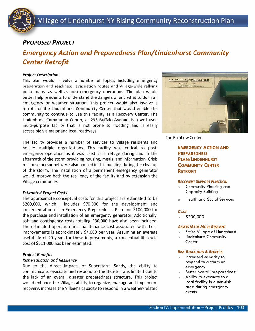
Section IV: Implementation – Project Profiles | 100
Lindenhurst NY Rising Community Reconstruction Plan Village of Lindenhurst NY Rising Community Reconstruction Plan
EMERGENCY ACTION AND
PREPAREDNESS
PLAN/LINDENHURST
COMMUNITY CENTER
RETROFIT
RECOVERY SUPPORT FUNCTION o Community Planning and
Capacity Building
o Health and Social Services
COST o $200,000
ASSETS MADE MORE RESILIENT o Entire Village of Lindenhurst o Lindenhurst Community
Center
RISK REDUCTION & BENEFITS o Increased capacity to
respond to a storm or emergency
o Better overall preparedness o Ability to evacuate to a
local facility in a non-risk area during emergency events
PROPOSED PROJECT
Emergency Action and Preparedness Plan/Lindenhurst Community Center Retrofit Project Description This plan would involve a number of topics, including emergency preparation and readiness, evacuation routes and Village-wide rallying point maps, as well as post-emergency operations. The plan would better help residents to understand the dangers of and what to do in an emergency or weather situation. This project would also involve a retrofit of the Lindenhurst Community Center that would enable the community to continue to use this facility as a Recovery Center. The Lindenhurst Community Center, at 293 Buffalo Avenue, is a well-used multi-purpose facility that is not prone to flooding and is easily accessible via major and local roadways. The facility provides a number of services to Village residents and houses multiple organizations. This facility was critical to post-emergency operation as it was used as a refuge during and in the aftermath of the storm providing housing, meals, and information. Crisis response personnel were also housed in this building during the cleanup of the storm. The installation of a permanent emergency generator would improve both the resiliency of the facility and by extension the Village community. Estimated Project Costs The approximate conceptual costs for this project are estimated to be $200,000, which includes $70,000 for the development and implementation of an Emergency Preparedness Plan and $100,000 for the purchase and installation of an emergency generator. Additionally, soft and contingency costs totaling $30,000 have also been included. The estimated operation and maintenance cost associated with these improvements is approximately $4,000 per year. Assuming an average useful life of 20 years for these improvements, a conceptual life cycle cost of $211,000 has been estimated. Project Benefits Risk Reduction and Resiliency Due to the direct impacts of Superstorm Sandy, the ability to communicate, evacuate and respond to the disaster was limited due to the lack of an overall disaster preparedness structure. This project would enhance the Villages ability to organize, manage and implement recovery, increase the Village’s capacity to respond in a weather-related
The Rainbow Center
Section IV: Implementation – Project Profiles | 101
Lindenhurst NY Rising Community Reconstruction Plan Village of Lindenhurst NY Rising Community Reconstruction Plan
and/or emergency situation, and provide a safe, centrally-located evacuation facility outside of the risk areas for Village residents. The project would also help better inform Village residents as to the dangers of weather events, proper procedures to prepare for a storm event, and appropriate post-storm recovery. The project would also provide local direct public benefits for the Village in that other beneficiaries of this project would be local life safety personnel. Potential beneficiaries include all Village residents, as they would be more willing to evacuate their homes if a shelter is near-by. The hardening of a local facility within the Village where residents can access basic necessities, including electricity, heat, and communications capabilities, as well as other response resources, would greatly reduce residents’ stress and trauma during a major disaster. The facility may also prevent potential life-threatening situations that ensued post-Superstorm Sandy, such as exposure to freezing temperatures that put many at risk for hypothermia. This project would have a positive benefit to the safety of the entire community in terms of overall preparedness for emergency events and during future storms by providing a cohesive plan as well as providing a safe, centrally-located facility with electricity for shelter, particularly for vulnerable populations that may be reluctant to evacuate to facilities that are further away from the community. Economic Benefits The installation of a permanent generator at the Lindenhurst Community Center would secure a limited amount of temporary work for existing local tradespersons. Approximately 1 FTE jobs would be created during the installation period.35 The implementation of this project, especially the retrofit of the Lindenhurst Community Center would generally enhance the local economy in that a resilient Community Center would reduce costs for Village residents to travel to more distant evacuation centers during emergency events. This project would also reduce future storm-related storm-recovery and associated emergency expenditures by reducing the number of residents who would remain in their home during a storm/flood condition and then require evacuation. Health and Social Benefits The installation of a permanent emergency generator would improve both the resiliency of the Community Center facility and by extension the Village community, especially vulnerable populations that may be reluctant or unable to evacuate to facilities that are outside of the Village. This project relates to overall resiliency and economic security that would accrue to the Village since life safety services would be better able to respond more efficiently to emergency situations and
Section IV: Implementation – Project Profiles | 102
Lindenhurst NY Rising Community Reconstruction Plan Village of Lindenhurst NY Rising Community Reconstruction Plan
perhaps lessen human loss and injury. Additionally, residents and business owners would be more aware of what to do in a weather-related event and in its immediate aftermath. As a result, the project would better help the Village to recover after a weather event. Cost Benefit Analysis At a cost of $200,000, this Proposed Project would have numerous benefits including the increased resilience of the Village, decreased risk of injury to citizens and first responders, and the ability to evacuate vulnerable populations that may be reluctant to go to facilities further away. The procurement of a permanent generator to outfit a facility outside of the flood risk areas has the potential to serve the Community for future severe disaster events. Similarly, an emergency preparedness plan would help the Village implement recovery actions by the Village’s Emergency response team. The benefits of this project are anticipated to outweigh the cost making the project justifiable and appropriate. Risk Reduction Analysis In general, the implementation of this project would improve the resiliency of the entire Village through the installation of a permanent generator to be used during emergency events at the Community Center. As such, this Proposed Project would holistically improve the Village’s capacity building and ability to recover more rapidly after a major weather event. This project would have a positive benefit to the safety of the community in terms of overall preparedness for emergency events and during future storms by providing a cohesive plan as well as providing a safe, centrally-located facility with electricity for shelter, particularly for vulnerable populations that may be reluctant to evacuate to facilities that are further away from the community. General Timeframe for Implementation It is estimated that, from the time implementation begins, this Project has potential for immediate implementation (0 to 12 months). Regulatory Requirements Related to Project This project is highly feasible and potential challenges are limited. Aside from the installation of a permanent generator (i.e., pad-mounted above base flood elevation), no significant construction would be involved in this project. Regulatory review of this project is not anticipated. No real property or other significant constraints have been identified to date for this project which enjoys public support. Jurisdiction Village of Lindenhurst
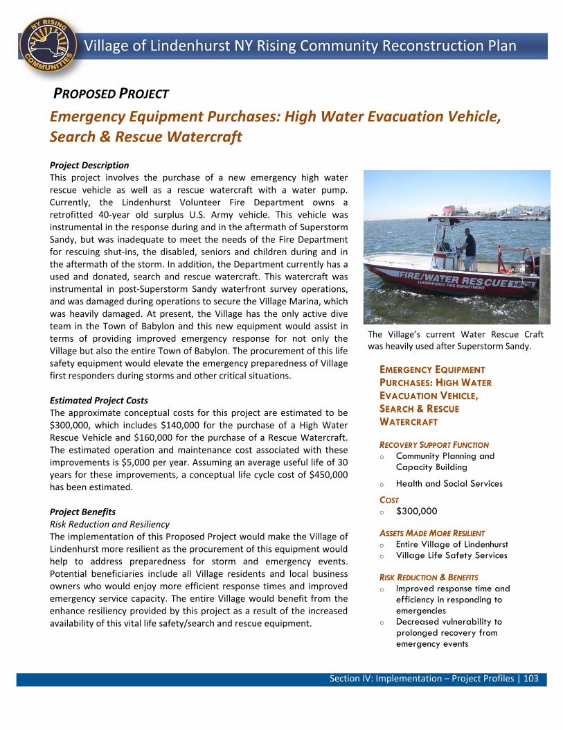
Section IV: Implementation – Project Profiles | 103
Lindenhurst NY Rising Community Reconstruction Plan Village of Lindenhurst NY Rising Community Reconstruction Plan
EMERGENCY EQUIPMENT
PURCHASES: HIGH WATER
EVACUATION VEHICLE, SEARCH & RESCUE
WATERCRAFT
RECOVERY SUPPORT FUNCTION o Community Planning and
Capacity Building
o Health and Social Services
COST o $300,000
ASSETS MADE MORE RESILIENT o Entire Village of Lindenhurst o Village Life Safety Services
RISK REDUCTION & BENEFITS o Improved response time and
efficiency in responding to emergencies
o Decreased vulnerability to prolonged recovery from emergency events
PROPOSED PROJECT
Emergency Equipment Purchases: High Water Evacuation Vehicle, Search & Rescue Watercraft
Project Description This project involves the purchase of a new emergency high water rescue vehicle as well as a rescue watercraft with a water pump. Currently, the Lindenhurst Volunteer Fire Department owns a retrofitted 40-year old surplus U.S. Army vehicle. This vehicle was instrumental in the response during and in the aftermath of Superstorm Sandy, but was inadequate to meet the needs of the Fire Department for rescuing shut-ins, the disabled, seniors and children during and in the aftermath of the storm. In addition, the Department currently has a used and donated, search and rescue watercraft. This watercraft was instrumental in post-Superstorm Sandy waterfront survey operations, and was damaged during operations to secure the Village Marina, which was heavily damaged. At present, the Village has the only active dive team in the Town of Babylon and this new equipment would assist in terms of providing improved emergency response for not only the Village but also the entire Town of Babylon. The procurement of this life safety equipment would elevate the emergency preparedness of Village first responders during storms and other critical situations. Estimated Project Costs The approximate conceptual costs for this project are estimated to be $300,000, which includes $140,000 for the purchase of a High Water Rescue Vehicle and $160,000 for the purchase of a Rescue Watercraft. The estimated operation and maintenance cost associated with these improvements is $5,000 per year. Assuming an average useful life of 30 years for these improvements, a conceptual life cycle cost of $450,000 has been estimated. Project Benefits Risk Reduction and Resiliency The implementation of this Proposed Project would make the Village of Lindenhurst more resilient as the procurement of this equipment would help to address preparedness for storm and emergency events. Potential beneficiaries include all Village residents and local business owners who would enjoy more efficient response times and improved emergency service capacity. The entire Village would benefit from the enhance resiliency provided by this project as a result of the increased availability of this vital life safety/search and rescue equipment.
The Village’s current Water Rescue Craft was heavily used after Superstorm Sandy.
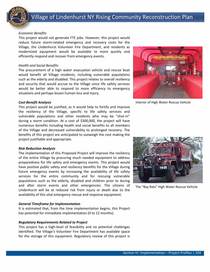
Section IV: Implementation – Project Profiles | 104
Lindenhurst NY Rising Community Reconstruction Plan Village of Lindenhurst NY Rising Community Reconstruction Plan
Economic Benefits This project would not generate FTE jobs. However, this project would reduce future storm-related emergency and recovery costs for the Village, the Lindenhurst Volunteer Fire Department, and residents as modernized equipment would be available to more quickly and efficiently respond and recover from emergency events. Health and Social Benefits The procurement of a high water evacuation vehicle and rescue boat would benefit all Village residents, including vulnerable populations such as the elderly and disabled. This project relates to overall resiliency and security that would accrue to the Village since life safety services would be better able to respond to more efficiency to emergency situations and perhaps lessen human loss and injury. Cost Benefit Analysis This project would be justified, as it would help to fortify and improve the resiliency of the Village, specific to life safety services and vulnerable populations and other residents who may be “shut-in” during a storm condition. At a cost of $300,000, the project will have numerous benefits including health and social benefits to all members of the Village and decreased vulnerability to prolonged recovery. The benefits of this project are anticipated to outweigh the cost making the project justifiable and appropriate. Risk Reduction Analysis The implementation of this Proposed Project will improve the resiliency of the entire Village by procuring much needed equipment to address preparedness for life safety and emergency events. This project would have positive public safety and resiliency benefits for the Village during future emergency events by increasing the availability of life safety services for the entire community and for rescuing vulnerable populations such as the elderly, disabled and children prior to during and after storm events and other emergencies. The citizens of Lindenhurst will be at reduced risk from injury or death due to the availability of this vital emergency rescue and response equipment. General Timeframe for Implementation It is estimated that, from the time implementation begins, this Project has potential for immediate implementation (0 to 12 months). Regulatory Requirements Related to Project This project has a high-level of feasibility and no potential challenges identified. The Village’s Volunteer Fire Department has available space for the storage of this equipment. Regulatory review of this project is
Interior of High Water Rescue Vehicle
The “Bay Rats” High Water Rescue Vehicle
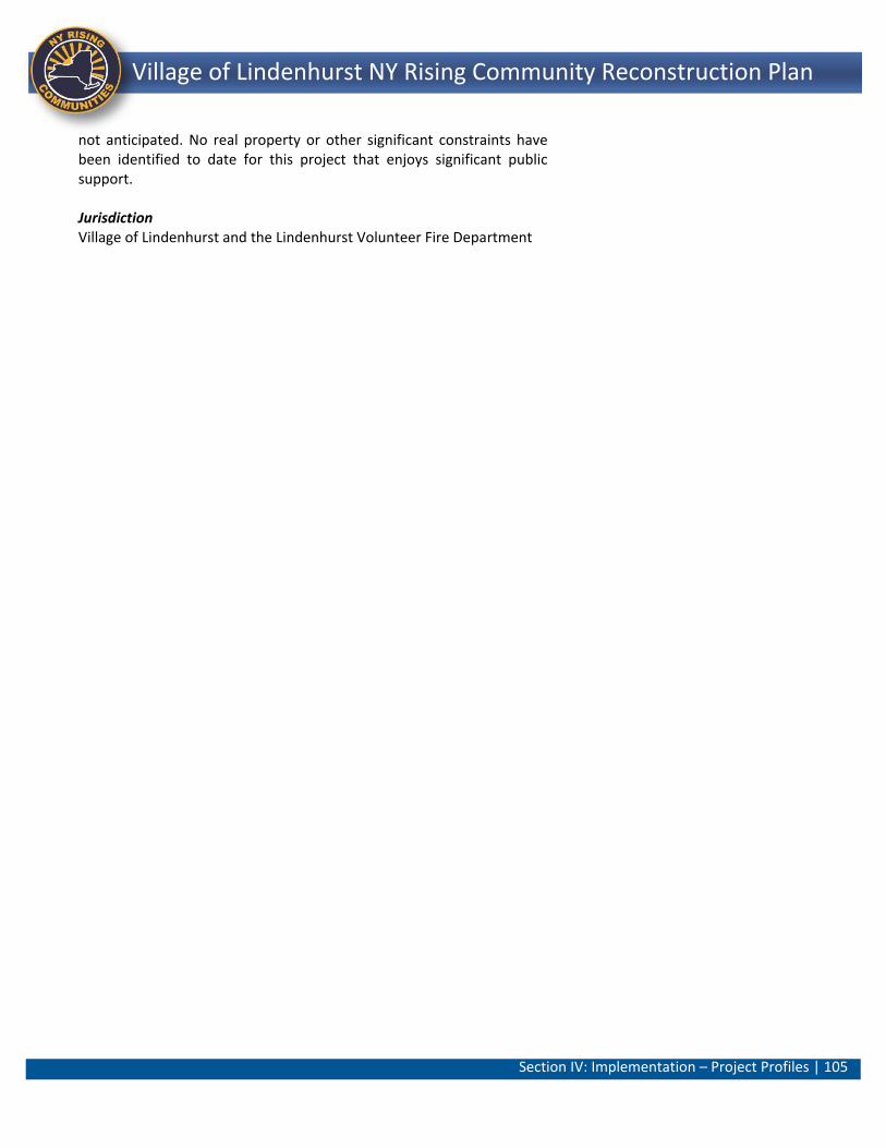
Section IV: Implementation – Project Profiles | 105
Lindenhurst NY Rising Community Reconstruction Plan Village of Lindenhurst NY Rising Community Reconstruction Plan
not anticipated. No real property or other significant constraints have been identified to date for this project that enjoys significant public support. Jurisdiction Village of Lindenhurst and the Lindenhurst Volunteer Fire Department
Section V: Additional Materials| 106
Lindenhurst NY Rising Community Reconstruction Plan Village of Lindenhurst NY Rising Community Reconstruction Plan
Section V: Additional Materials
A. Additional Resiliency Recommendations
Presented in the Table 18 below are Additional Resiliency Recommendations that were identified during the planning process in addition to the Proposed Project recommended by the Committee.
Table 18: Additional Resiliency Recommendations
Strategy Project Name Short Description Estimated Cost
Regional (Y/N)
Improve Storm Drainage System
Maintenance Purchase: DPW Storm Drainage Vehicle
A storm drainage vacuum vehicle is much needed as existing Village DPW equipment is well-used and approaching the end of its functional life-span. As other neighboring Committees have has similar maintenance vehicle requests, the Village will explore the opportunity for a shared vehicle via intermunicipal agreement. This acquisition would help to complement the storm sewer system that would be improved under the Comprehensive Drainage Infrastructure Master Plan and Phase I Repairs.
$420,000 Y
Improve Storm Surge Capacity and Mitigate Flooding
Assemble Underutilized Properties and Improve Natural Systems to Increase Public Open Space and Improve Storm Resiliency
This potential project contemplates developing a plan and designs for the identification, acquisition, management, maintenance and reuse of abandoned, underutilized and bought-out properties south of Montauk Highway. This complex project would identify potential opportunities for the assemblage of these properties into larger parcels with a focus on their sustainable development and natural ecosystems.
$1,000,000 N
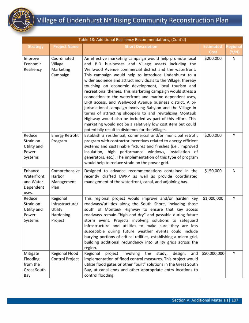
Section V: Additional Materials| 107
Lindenhurst NY Rising Community Reconstruction Plan Village of Lindenhurst NY Rising Community Reconstruction Plan
Table 18: Additional Resiliency Recommendations, (Cont’d)
Strategy Project Name Short Description Estimated Cost
Regional (Y/N)
Improve Economic Resiliency
Coordinated Village Marketing Campaign
An effective marketing campaign would help promote local and BID businesses and Village assets including the Wellwood Avenue commercial district and the waterfront. This campaign would help to introduce Lindenhurst to a wider audience and attract individuals to the Village; thereby touching on economic development, local tourism and recreational themes. This marketing campaign would stress a connection to the waterfront and marine dependent uses, LIRR access, and Wellwood Avenue business district. A bi-jurisdictional campaign involving Babylon and the Village in terms of attracting shoppers to and revitalizing Montauk Highway would also be included as part of this effort. This marketing would not be a relatively low cost item but could potentially result in dividends for the Village.
$200,000 N
Reduce Strain on Utility and Power Systems
Energy Retrofit Program
Establish a residential, commercial and/or municipal retrofit program with contractor incentives related to energy efficient systems and sustainable fixtures and finishes (i.e., improved insulation, high performance windows, installation of generators, etc.). The implementation of this type of program would help to reduce strain on the power grid.
$200,000 Y
Enhance Waterfront and Water-Dependent uses.
Comprehensive Harbor Management Plan
Designed to advance recommendations contained in the recently drafted LWRP as well as provide coordinated management of the waterfront, canal, and adjoining bay.
$150,000 N
Reduce Strain on Utility and Power Systems
Regional Infrastructure/Utility Hardening Project
This regional project would improve and/or harden key roadways/utilities along the South Shore, including those south of Montauk Highway to ensure that key access roadways remain “high and dry” and passable during future storm event. Projects involving solutions to safeguard infrastructure and utilities to make sure they are less susceptible during future weather events could include burying portions of critical utilities, establishing a micro grid, building additional redundancy into utility grids across the region.
$1,000,000 Y
Mitigate Flooding from the Great South Bay
Regional Flood Control Project
Regional project involving the study, design, and implementation of flood control measures. This project would utilize flood gates or other “built” solutions in the Great South Bay, at canal ends and other appropriate entry locations to control flooding.
$50,000,000 Y
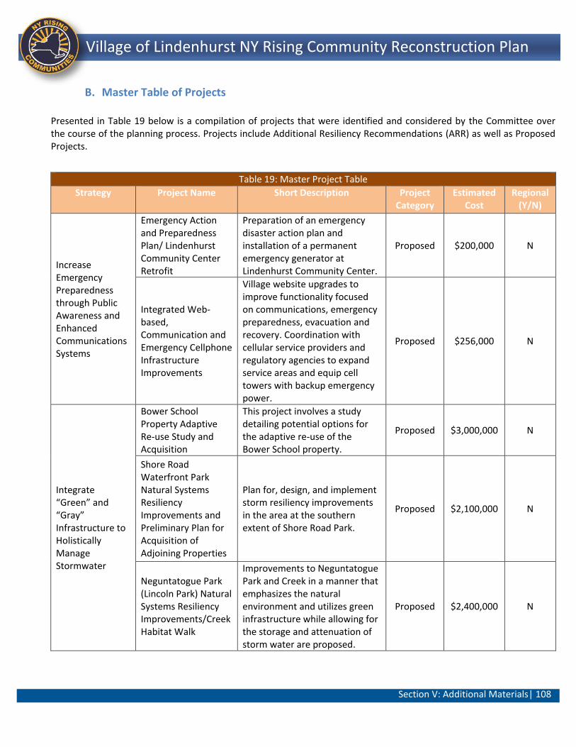
Section V: Additional Materials| 108
Lindenhurst NY Rising Community Reconstruction Plan Village of Lindenhurst NY Rising Community Reconstruction Plan
B. Master Table of Projects
Presented in Table 19 below is a compilation of projects that were identified and considered by the Committee over the course of the planning process. Projects include Additional Resiliency Recommendations (ARR) as well as Proposed Projects.
Table 19: Master Project Table
Strategy Project Name Short Description Project Category
Estimated Cost
Regional (Y/N)
Increase Emergency Preparedness through Public Awareness and Enhanced Communications Systems
Emergency Action and Preparedness Plan/ Lindenhurst Community Center Retrofit
Preparation of an emergency disaster action plan and installation of a permanent emergency generator at Lindenhurst Community Center.
Proposed $200,000 N
Integrated Web-based, Communication and Emergency Cellphone Infrastructure Improvements
Village website upgrades to improve functionality focused on communications, emergency preparedness, evacuation and recovery. Coordination with cellular service providers and regulatory agencies to expand service areas and equip cell towers with backup emergency power.
Proposed $256,000 N
Integrate “Green” and “Gray” Infrastructure to Holistically Manage Stormwater
Bower School Property Adaptive Re-use Study and Acquisition
This project involves a study detailing potential options for the adaptive re-use of the Bower School property.
Proposed $3,000,000 N
Shore Road Waterfront Park Natural Systems Resiliency Improvements and Preliminary Plan for Acquisition of Adjoining Properties
Plan for, design, and implement storm resiliency improvements in the area at the southern extent of Shore Road Park.
Proposed $2,100,000 N
Neguntatogue Park (Lincoln Park) Natural Systems Resiliency Improvements/Creek Habitat Walk
Improvements to Neguntatogue Park and Creek in a manner that emphasizes the natural environment and utilizes green infrastructure while allowing for the storage and attenuation of storm water are proposed.
Proposed $2,400,000 N
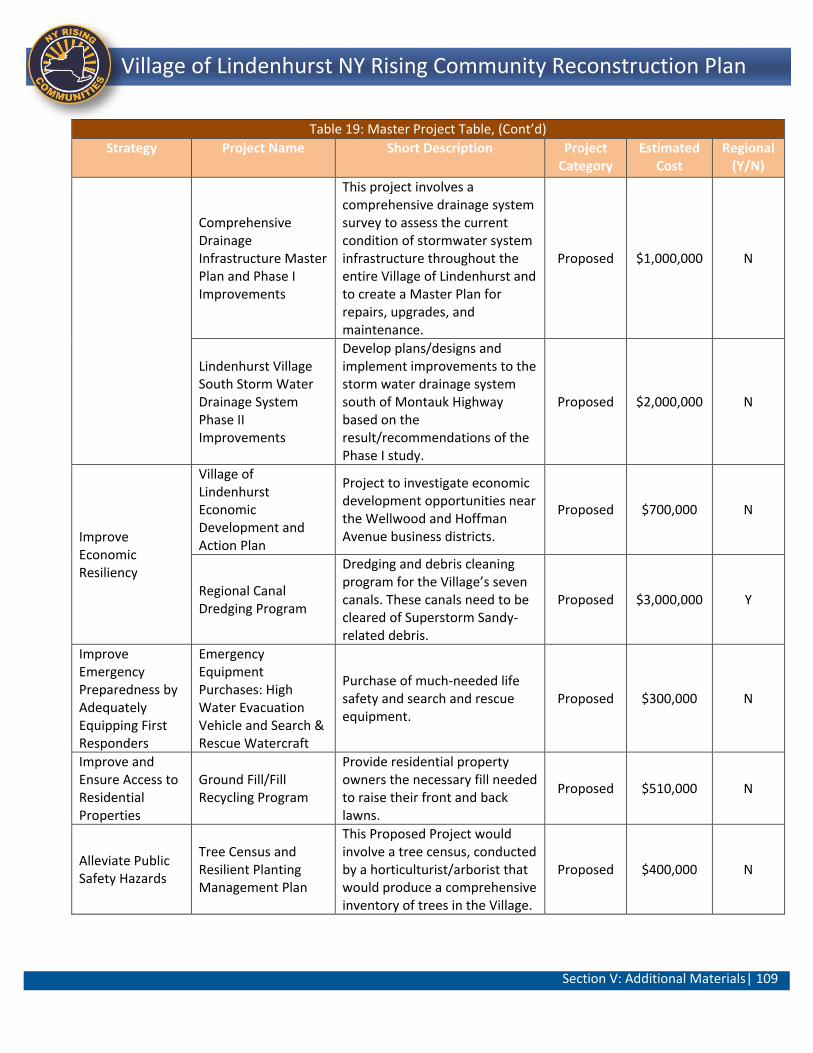
Section V: Additional Materials| 109
Lindenhurst NY Rising Community Reconstruction Plan Village of Lindenhurst NY Rising Community Reconstruction Plan
Table 19: Master Project Table, (Cont’d)
Strategy Project Name Short Description Project Category
Estimated Cost
Regional (Y/N)
Comprehensive Drainage Infrastructure Master Plan and Phase I Improvements
This project involves a comprehensive drainage system survey to assess the current condition of stormwater system infrastructure throughout the entire Village of Lindenhurst and to create a Master Plan for repairs, upgrades, and maintenance.
Proposed $1,000,000 N
Lindenhurst Village South Storm Water Drainage System Phase II Improvements
Develop plans/designs and implement improvements to the storm water drainage system south of Montauk Highway based on the result/recommendations of the Phase I study.
Proposed $2,000,000 N
Improve Economic Resiliency
Village of Lindenhurst Economic Development and Action Plan
Project to investigate economic development opportunities near the Wellwood and Hoffman Avenue business districts.
Proposed $700,000 N
Regional Canal Dredging Program
Dredging and debris cleaning program for the Village’s seven canals. These canals need to be cleared of Superstorm Sandy-related debris.
Proposed $3,000,000 Y
Improve Emergency Preparedness by Adequately Equipping First Responders
Emergency Equipment Purchases: High Water Evacuation Vehicle and Search & Rescue Watercraft
Purchase of much-needed life safety and search and rescue equipment.
Proposed $300,000 N
Improve and Ensure Access to Residential Properties
Ground Fill/Fill Recycling Program
Provide residential property owners the necessary fill needed to raise their front and back lawns.
Proposed $510,000 N
Alleviate Public Safety Hazards
Tree Census and Resilient Planting Management Plan
This Proposed Project would involve a tree census, conducted by a horticulturist/arborist that would produce a comprehensive inventory of trees in the Village.
Proposed $400,000 N
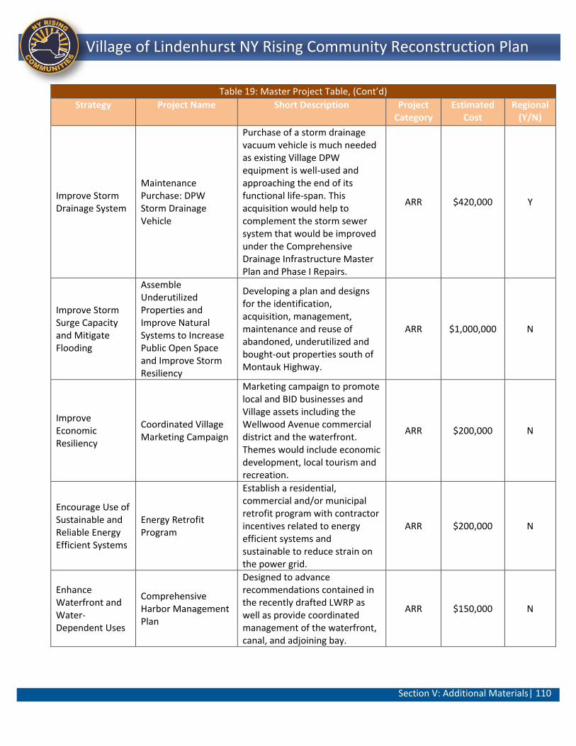
Section V: Additional Materials| 110
Lindenhurst NY Rising Community Reconstruction Plan Village of Lindenhurst NY Rising Community Reconstruction Plan
Table 19: Master Project Table, (Cont’d)
Strategy Project Name Short Description Project Category
Estimated Cost
Regional (Y/N)
Improve Storm Drainage System
Maintenance Purchase: DPW Storm Drainage Vehicle
Purchase of a storm drainage vacuum vehicle is much needed as existing Village DPW equipment is well-used and approaching the end of its functional life-span. This acquisition would help to complement the storm sewer system that would be improved under the Comprehensive Drainage Infrastructure Master Plan and Phase I Repairs.
ARR $420,000 Y
Improve Storm Surge Capacity and Mitigate Flooding
Assemble Underutilized Properties and Improve Natural Systems to Increase Public Open Space and Improve Storm Resiliency
Developing a plan and designs for the identification, acquisition, management, maintenance and reuse of abandoned, underutilized and bought-out properties south of Montauk Highway.
ARR $1,000,000 N
Improve Economic Resiliency
Coordinated Village Marketing Campaign
Marketing campaign to promote local and BID businesses and Village assets including the Wellwood Avenue commercial district and the waterfront. Themes would include economic development, local tourism and recreation.
ARR $200,000 N
Encourage Use of Sustainable and Reliable Energy Efficient Systems
Energy Retrofit Program
Establish a residential, commercial and/or municipal retrofit program with contractor incentives related to energy efficient systems and sustainable to reduce strain on the power grid.
ARR $200,000 N
Enhance Waterfront and Water-Dependent Uses
Comprehensive Harbor Management Plan
Designed to advance recommendations contained in the recently drafted LWRP as well as provide coordinated management of the waterfront, canal, and adjoining bay.
ARR $150,000 N
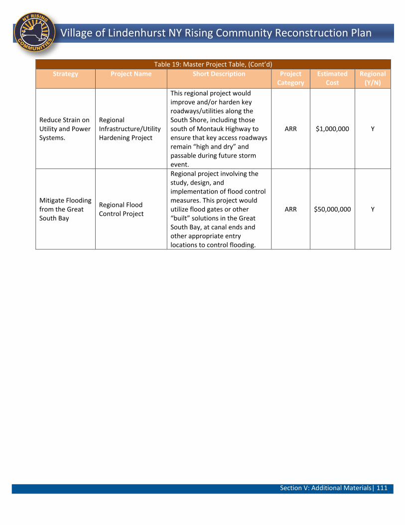
Section V: Additional Materials| 111
Lindenhurst NY Rising Community Reconstruction Plan Village of Lindenhurst NY Rising Community Reconstruction Plan
Table 19: Master Project Table, (Cont’d)
Strategy Project Name Short Description Project Category
Estimated Cost
Regional (Y/N)
Reduce Strain on Utility and Power Systems.
Regional Infrastructure/Utility Hardening Project
This regional project would improve and/or harden key roadways/utilities along the South Shore, including those south of Montauk Highway to ensure that key access roadways remain “high and dry” and passable during future storm event.
ARR $1,000,000 Y
Mitigate Flooding from the Great South Bay
Regional Flood Control Project
Regional project involving the study, design, and implementation of flood control measures. This project would utilize flood gates or other “built” solutions in the Great South Bay, at canal ends and other appropriate entry locations to control flooding.
ARR $50,000,000 Y
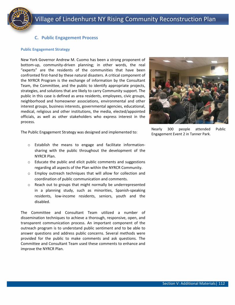
Section V: Additional Materials| 112
Lindenhurst NY Rising Community Reconstruction Plan Village of Lindenhurst NY Rising Community Reconstruction Plan
C. Public Engagement Process
Public Engagement Strategy New York Governor Andrew M. Cuomo has been a strong proponent of bottom-up, community-driven planning; in other words, the real “experts” are the residents of the communities that have been confronted first-hand by these natural disasters. A critical component of the NYRCR Program is the exchange of information by the Consultant Team, the Committee, and the public to identify appropriate projects, strategies, and solutions that are likely to carry Community support. The public in this case is defined as area residents, employees, civic groups, neighborhood and homeowner associations, environmental and other interest groups, business interests, governmental agencies, educational, medical, religious and other institutions, the media, elected/appointed officials, as well as other stakeholders who express interest in the process. The Public Engagement Strategy was designed and implemented to:
o Establish the means to engage and facilitate information-
sharing with the public throughout the development of the
NYRCR Plan.
o Educate the public and elicit public comments and suggestions
regarding all aspects of the Plan within the NYRCR Community.
o Employ outreach techniques that will allow for collection and
coordination of public communication and comments.
o Reach out to groups that might normally be underrepresented
in a planning study, such as minorities, Spanish-speaking
residents, low-income residents, seniors, youth and the
disabled.
The Committee and Consultant Team utilized a number of dissemination techniques to achieve a thorough, responsive, open, and transparent communication process. An important component of the outreach program is to understand public sentiment and to be able to answer questions and address public concerns. Several methods were provided for the public to make comments and ask questions. The Committee and Consultant Team used these comments to enhance and improve the NYRCR Plan.
Nearly 300 people attended Public Engagement Event 2 in Tanner Park.
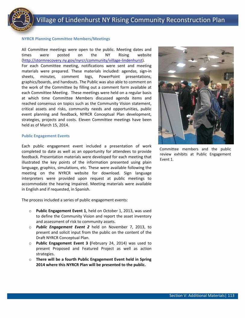
Section V: Additional Materials| 113
Lindenhurst NY Rising Community Reconstruction Plan Village of Lindenhurst NY Rising Community Reconstruction Plan
NYRCR Planning Committee Members/Meetings All Committee meetings were open to the public. Meeting dates and times were posted on the NY Rising website (http://stormrecovery.ny.gov/nyrcr/community/village-lindenhurst). For each Committee meeting, notifications were sent and meeting materials were prepared. These materials included: agendas, sign-in sheets, minutes, comment logs, PowerPoint presentations, graphics/boards, and handouts. The Public was also able to comment on the work of the Committee by filling out a comment form available at each Committee Meeting. These meetings were held on a regular basis at which time Committee Members discussed agenda items and reached consensus on topics such as the Community Vision statement, critical assets and risks, community needs and opportunities, public event planning and feedback, NYRCR Conceptual Plan development, strategies, projects and costs. Eleven Committee meetings have been held as of March 15, 2014. Public Engagement Events
Each public engagement event included a presentation of work completed to date as well as an opportunity for attendees to provide feedback. Presentation materials were developed for each meeting that illustrated the key points of the information presented using plain language, graphics, simulations, etc. These were available following the meeting on the NYRCR website for download. Sign language interpreters were provided upon request at public meetings to accommodate the hearing impaired. Meeting materials were available in English and if requested, in Spanish. The process included a series of public engagement events:
o Public Engagement Event 1, held on October 1, 2013, was used
to define the Community Vision and report the asset inventory and assessment of risk to community assets.
o Public Engagement Event 2 held on November 7, 2013, to present and solicit input from the public on the content of the Draft NYRCR Conceptual Plan.
o Public Engagement Event 3 (February 24, 2014) was used to present Proposed and Featured Project as well as action strategies.
o There will be a fourth Public Engagement Event held in Spring 2014 where this NYRCR Plan will be presented to the public.
Committee members and the public review exhibits at Public Engagement Event 1.
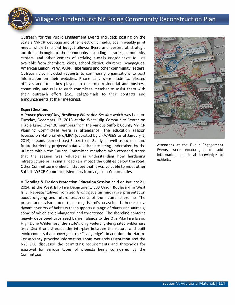
Section V: Additional Materials| 114
Lindenhurst NY Rising Community Reconstruction Plan Village of Lindenhurst NY Rising Community Reconstruction Plan
Outreach for the Public Engagement Events included: posting on the State’s NYRCR webpage and other electronic media; ads in weekly print media when time and budget allows; flyers and posters at strategic locations throughout the community including libraries, community centers, and other centers of activity; e-mails and/or texts to lists available from chambers, civics, school district, churches, synagogues, American Legion, VFW, AARP, Hibernians and other community leaders. Outreach also included requests to community organizations to post information on their websites. Phone calls were made to: elected officials and other key players in the local residential and business community and calls to each committee member to assist them with their outreach effort (e.g., calls/e-mails to their contacts and announcements at their meetings). Expert Sessions A Power (Electric/Gas) Resiliency Education Session which was held on Tuesday, December 17, 2013 at the West Islip Community Center on Higbie Lane. Over 30 members from the various Suffolk County NYRCR Planning Committees were in attendance. The education session focused on National Grid/LIPA (operated by LIPA/PSEG as of January 1, 2014) lessons learned post-Superstorm Sandy as well as current and future hardening projects/initiatives that are being undertaken by the utilities within the County. Committee members who attended stated that the session was valuable in understanding how hardening infrastructure or raising a road can impact the utilities below the road. Other Committee members indicated that it was valuable to meet other Suffolk NYRCR Committee Members from adjacent Communities. A Flooding & Erosion Protection Education Session held on January 21, 2014, at the West Islip Fire Department, 309 Union Boulevard in West Islip. Representatives from Sea Grant gave an innovative presentation about ongoing and future treatments of the natural shoreline. The presentation also noted that Long Island’s coastline is home to a dynamic variety of habitats that supports a range of plants and animals, some of which are endangered and threatened. The shoreline contains heavily developed urbanized barrier islands to the Otis Pike Fire Island High Dune Wilderness, the State’s only Federally-designated wilderness area. Sea Grant stressed the interplay between the natural and built environments that converge at the “living edge”. In addition, the Nature Conservancy provided information about wetlands restoration and the NYS DEC discussed the permitting requirements and thresholds for approval for various types of projects being considered by the Committees.
Attendees at the Public Engagement Events were encouraged to add information and local knowledge to exhibits.
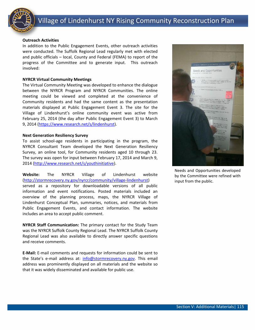
Section V: Additional Materials| 115
Lindenhurst NY Rising Community Reconstruction Plan Village of Lindenhurst NY Rising Community Reconstruction Plan
Outreach Activities In addition to the Public Engagement Events, other outreach activities were conducted. The Suffolk Regional Lead regularly met with elected and public officials – local, County and Federal (FEMA) to report of the progress of the Committee and to generate input. This outreach involved: NYRCR Virtual Community Meetings The Virtual Community Meeting was developed to enhance the dialogue between the NYRCR Program and NYRCR Communities. The online meeting could be viewed and completed at the convenience of Community residents and had the same content as the presentation materials displayed at Public Engagement Event 3. The site for the Village of Lindenhurst’s online community event was active from February 25, 2014 (the day after Public Engagement Event 3) to March 9, 2014 (https://www.research.net/s/lindenhurst). Next Generation Resiliency Survey To assist school-age residents in participating in the program, the NYRCR Consultant Team developed the Next Generation Resiliency Survey, an online tool, for Community residents aged 10 through 23. The survey was open for input between February 17, 2014 and March 9, 2014 (http://www.research.net/s/youthinitiative). Website: The NYRCR Village of Lindenhurst website (http://stormrecovery.ny.gov/nyrcr/community/village-lindenhurst) served as a repository for downloadable versions of all public information and event notifications. Posted materials included an overview of the planning process, maps, the NYRCR Village of Lindenhurst Conceptual Plan, summaries, notices, and materials from Public Engagement Events, and contact information. The website includes an area to accept public comment. NYRCR Staff Communication: The primary contact for the Study Team was the NYRCR Suffolk County Regional Lead. The NYRCR Suffolk County Regional Lead was also available to directly answer specific questions and receive comments. E-Mail: E-mail comments and requests for information could be sent to the State’s e-mail address at: [email protected]. This email address was prominently displayed on all materials and the website so that it was widely disseminated and available for public use.
Needs and Opportunities developed by the Committee were refined with input from the public.

Section V: Additional Materials| 116
Lindenhurst NY Rising Community Reconstruction Plan Village of Lindenhurst NY Rising Community Reconstruction Plan
D. Community Asset Inventory
Presented on the following pages is an inventory of assets in the Village of Lindenhurst Community. Included in the risk assessment spreadsheet for each asset is the asset name, risk area, asset class, critical facility designation, community value, landscape attributes and risk assessment scores. The approach to using the Risk Assessment Tool is provided below:
Using the Risk Assessment Tool The dual purpose of the Risk Assessment Tool was: (1) to provide risk information as a means to identify and prioritize management measures; and (2) to provide a standardized risk assessment process for the NYRCR Program.
The assets catalogued in the NYRCR Conceptual Plan included preliminary data such as community, asset name and type, asset category, as well as risk area and asset class. This task included a review of GIS datasets, aerial imagery, and community/Committee input. Most of the risk assessment tool fields were populated using appropriate data from the consolidated database. Two important aspects to the tool are how to accurately determine the exposure and vulnerability scores.
Exposure Score The exposure score was automatically populated in the Risk Assessment Tool based on landscape attribute information. Grouped assets based on similar exposure were given the same exposure score. Data that informed the exposure score included a review of Coastal Erosion Hazard Area (CeHa) maps, aerial imagery, and site reconnaissance as well as a reliance on local knowledge and input from the Project Manager and/or Committee.
Vulnerability Score The vulnerability score of each asset will be determined using the State guidance (based on Table 3: Vulnerability Based on Impact on Service or Function of Community Assets contained in Guidance for Community Reconstruction Zone Plans) as well as local background knowledge. Vulnerability generally pertains to length of time that a resource is out of service or a reduction in service capacity.43
Risk Score Range After populating Risk Assessment Tool with attribute information (basic data/hazard area/exposure/vulnerability, etc.) a Risk Score was automatically generated. The Risk Score relied on past experience as a predictor of future risk and included some subjective analysis. For a 100 year event the Risk Score ranges from Residual (less than 6) to Severe (54 or greater).
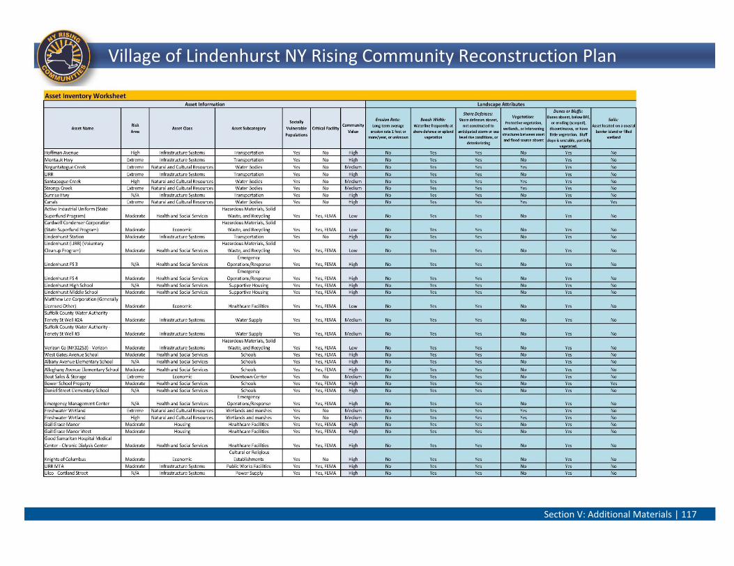
Section V: Additional Materials | 117
Village of Lindenhurst NY Rising Community Reconstruction Plan
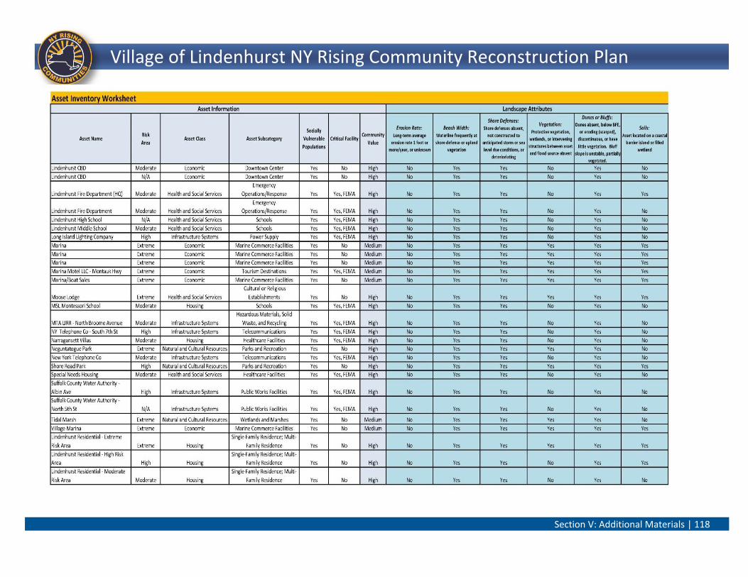
Section V: Additional Materials | 118
Village of Lindenhurst NY Rising Community Reconstruction Plan
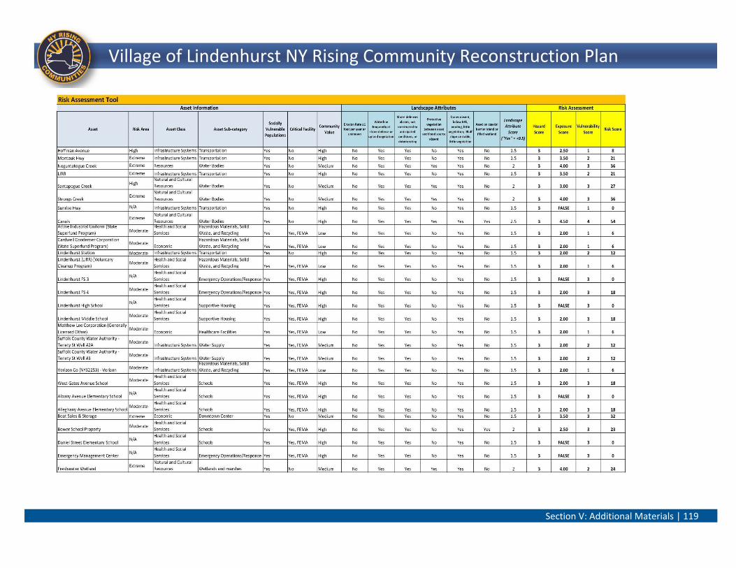
Section V: Additional Materials | 119
Village of Lindenhurst NY Rising Community Reconstruction Plan
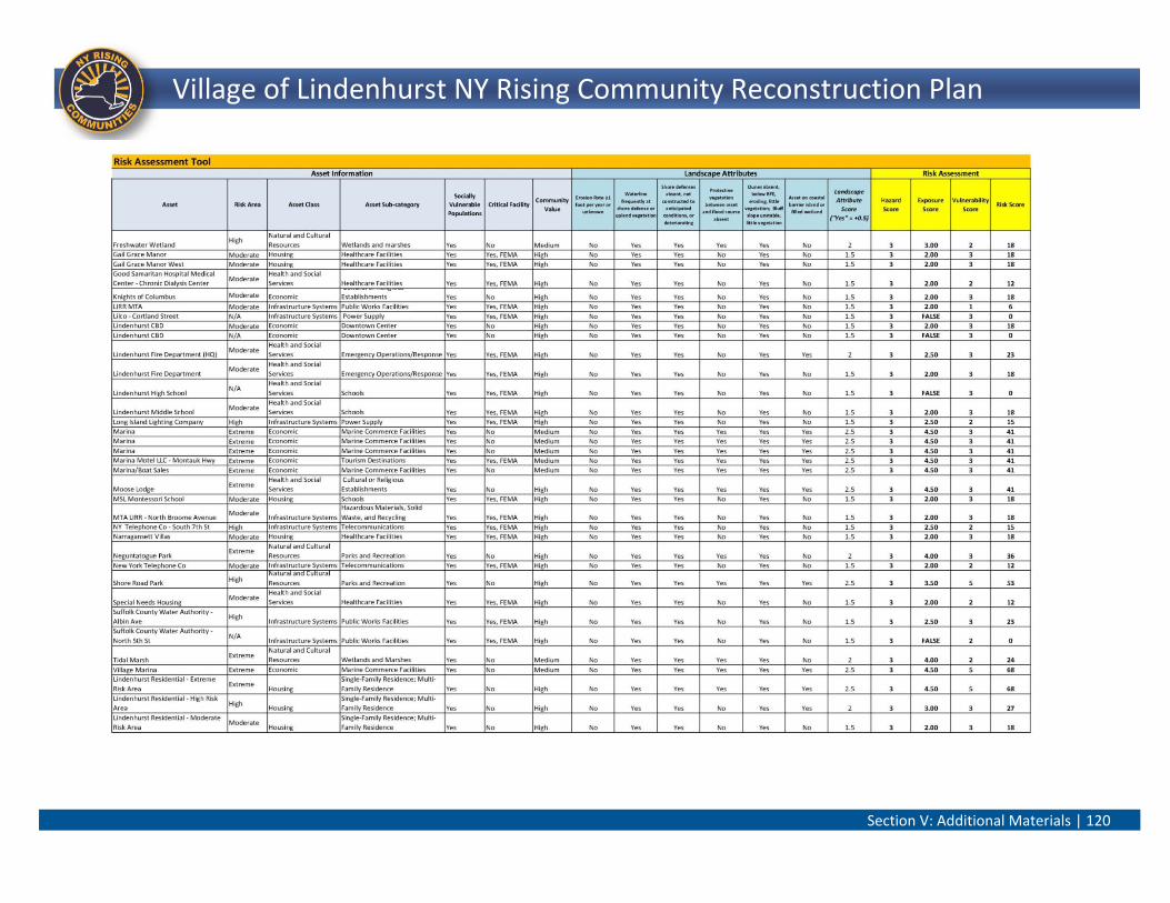
Section V: Additional Materials | 120
Village of Lindenhurst NY Rising Community Reconstruction Plan
Section V: Additional Materials| 121
Village of Lindenhurst NY Rising Community Reconstruction Plan
E. Glossary
Acronyms
AARP - American Association of Retired Persons
ADA - Americans with Disabilities Act
CBA - Cost-benefit analysis
CDBG-DR - Community Development Block Grant – Disaster Recovery
CDP - Census Designated Place
CeHa - Coastal Erosion Hazard Area
CZM - Coastal Zone Management
EMS - Emergency Medical Services
FEMA - Federal Emergency Management Agency
FTA - Federal Transit Administration
FTE - Full-time equivalent
GIS - Geographic Information Systems
HUD - U.S. Department of Housing and Urban Development
LIRR - Long Island Rail Road
NOAA - National Oceanic and Atmospheric Administration
NYRCR - NY Rising Community Reconstruction
NYS DEC - New York State Department of Environmental Conservation
NYS DOS - New York State Department of State
NYS DOT - New York State Department of Transportation
OPWDD - Office for People with Developmental Disabilities
USACE - U.S. Army Corps of Engineers
VFW - Veterans of Foreign Wars
Section V: Additional Materials| 122
Village of Lindenhurst NY Rising Community Reconstruction Plan
Terms
Asset - Places or entities where economic, environmental and social functions of the community occur.
Asset Inventory - Completing an inventory of the community’s social, economic, and natural resource assets
that have been, or will be, affected by coastal or riverine hazards.
Community Vision - The overall goal of the community throughout the NYRCR planning process.
Conceptual Plan - A snapshot of the current thoughts of the community and planning committee. The plans
will evolve as communities analyze the risk to their assets, their needs and opportunities, the potential costs
and benefits of projects and actions, and their priorities.
Exposure - Local landscape characteristics that tend to increase or decrease storm effects.
Geographic scope - The Community identified by the community and State guidelines where assets are most
at risk; where future construction or reconstruction of existing development should be encouraged or
discourage; or where key investment to improve the local economy can be instituted.
Hazard - The likelihood and magnitude of anticipated hazard events.
Hazus - Hazus is a geographic information system-based natural hazard loss estimation software package
developed and freely distributed by FEMA.
Implementation Schedule - Preparing an implementation schedule of the actions needed to implement the
strategies.
Need - Infrastructure and services that were damaged or rendered inoperable by Superstorm Sandy as well
as methods and operations that failed to work during the storm event or experienced insufficient capacity to
respond effectively.
Needs and Opportunities Assessment - Determining needs and opportunities to improve local economic
growth and enhance resilience to future storms.
Opportunity - Additional resiliency benefits, whether economic, environmental, social or cultural, that may
be achieved through the integration of new methods, procedures and materials into the normal course of
rebuilding.
Public Engagement - Offering opportunities for public input and involvement at key milestones in the
planning process.
Resilience - The ability of a system to absorb impacts while retaining the same basic structure and ways of
functioning, the capacity for self-organization, and the capacity to adapt.
Risk - The degree to which a system is susceptible to, or unable to cope with, adverse effects of climate
change, including climate variability and extremes.
Section V: Additional Materials| 123
Village of Lindenhurst NY Rising Community Reconstruction Plan
Risk Area - Geographic areas at risk from coastal hazards according to differences in the exposure of the
landscape.
Risk Assessment - Assessing risk to key community assets based on the three factors contributing to risk:
hazard, exposure, and vulnerability.
Risk Assessment Tool - Evaluation of risk based on the formula: Hazard x Exposure x Vulnerability
Risk Score - The result of the risk assessment tool evaluation
Strategy - A specific way or ways to address the needs and realize opportunities presented by the
committee.
Strategies for Investment and Action - Developing strategies and the projects and actions needed to
implement the strategies; identifying potential costs and benefits of chosen projects and actions, as well as
potential funding sources.
Transit Oriented Development - A mixed-use residential and commercial area designed to maximize access
to public transport, and often incorporates features to encourage transit ridership.
Vulnerability - The capacity of an asset to return to service after an event.
Section V: Additional Materials| 124
Village of Lindenhurst NY Rising Community Reconstruction Plan
F. End Notes
Photos Credits: Photos contained in this document were taken by Jacobs or provided by NYRCR Committee Members or others with permission. 1 The City of Breslau was located in Lower Silesia, Germany until the end of World War II. Following the Allied victory in 1945, this territory was transferred to Poland (now called the City of Wroclaw) under the Potsdam Agreement. 2 Lindenhurst Public Schools. Our Schools. http://www.lindenhurstschools.org/our_schools/ 3 Arbor Day Foundation. Tree City USA. http://www.arborday.org/programs/treeCityUSA/about.cfm In order to qualify as a Tree City USA community, a town or city must meet four standards established by The Arbor Day Foundation and the National Association of State Foresters. These standards include: (1) a tree board or department; (2) a tree care ordinance; (3) a community forestry program with an annual budget of at least $2 per capita; and (4) an arbor day observance and proclamation. 4 Public Engagement Event 2 included three NYRCR Communities within the Town of Babylon (Village of Lindenhurst, Village of Amityville/Copiague, and the Village of Babylon/West Babylon. Public Engagement Event 3 included the Communities identified for Public Engagement Event 2 as well as the West Gilgo to Captree NYRCR Community (all four NYRCR Communities withtin the Town). 5 ACS estimates (2005-2009) were utilized for the Community as this represented the most recent data available for the level of detail/inquiry needed to provide a demographic overview of the Village of Lindenhurst. 6 The CDP level was selected because the availability and detail of current Census data varied by geographic location and level of analysis (CDP, Census Tract, Census Block, etc.). The CDP level provided a uniform level of data detail and reporting period. It is acknowledged that the CDP data may include some areas that are not contained within the identified NYRCR Community; however, across all CDPs in Suffolk County, the differences between the Census CDP boundaries and the NYRCR Community definitions are not large. Additionally, the Census data was intended to provide an overview of the composition and general habits of the NYRCR Communities. It is unlikely that areas included in the CDP but excluded from the NYRCR Community would result in a substantial effect on the overview-level interpretation of the data or affect the identification of needs and opportunities or projects under the NYRCR Program. 7 The U.S. Census Bureau defines “Other” to include all other responses not included in the “Hispanic or Latino,” “White,” “Black or African American,” “American Indian or Alaska Native,” “Asian,” and “Native Hawaiian or Other Pacific Islander” ethnic origin or race categories. Respondents reporting entries such as “multiracial,” “mixed,” or “interracial” in response to the ethnic origin or race question are included in this category. U.S. Census Bureau. Glossary http://www.census.gov/glossary/#term_OtherEthnicOriginorRace 8 U.S. Census Bureau. American Community Survey estimates (2005-2009) 9 U.S. Census Bureau. American Community Survey estimates (2005-2009) 10 U.S. Census Bureau. American Community Survey estimates (2005-2009) 11 Factual information incorporated into this section of the report has been gathered through a review of the NOAA website for the days leading to and directly after Superstorm Sandy, as well as a review of pertinent Newsday and local Patch articles. 12 U.S. Department of Commerce, NOAA, National Weather Service. Hurricane/Post-Tropical Cyclone Sandy, October 22-29, 2013. May 2013. p.1. 13 U.S. Department of Commerce, NOAA, National Weather Service. Hurricane/Post-Tropical Cyclone Sandy, October 22-29, 2013. Figure 18: National Ocean Service tide table with storm surge values included. May 2013. p.36. 14 National Weather Service. Hurricane Sandy – October 29, 2012 Winds. http://www.weather.gov/okx/HurricaneSandy#Winds 15 Climate Central. 32-Foot-Plus Waves From Hurricane Sandy Topple Records. November 14, 2012. http://www.climatecentral.org/news/32-foot-wave-from-hurricane-sandy-topples-records-noaa-finds-15241 16 NOAA National Cilmatic Data Center. Billion-Dollar Weather/Climate Disasters. 2012 All Disasters. http://www.ncdc.noaa.gov/billions/events 17 Newsday. After Sandy, Lindenhurst looks at long-term plans. May 12, 2013. http://www.newsday.com/long-island/towns/after-sandy-lindenhurst-looks-at-long-term-plans-1.5249089 18 Community Development Corporation of Long Island, Inc. Housing Needs and Opportunities Assessment and Housing Strategies: Village of Lindenhurst Suffolk County, New York Draft. January 2014. p. 5. http://www.fema.gov/national-flood-insurance-program/definitions
Section V: Additional Materials| 125
Village of Lindenhurst NY Rising Community Reconstruction Plan
19 Based on conversation provided by MaryEllen Cunningham, Vice President, School Board . 20 Regional Economic Development Councils. Building a New New York Region by Region. http://regionalcouncils.ny.gov/sites/default/files/documents/2013/Guidebook3_draft_6-3-13_345pm.pdf 21 Long Island Regional Planning Council. Long Island 2035 Visioning Initiative Final Report. December 2009. p. 19. 22 Ibid. p.21. 23 The Extreme, High, and Moderate risk areas incorporate future sea level rise by adding 3 feet of elevation to the Mean High Water shoreline, NOAA National Weather Service shallow coastal flood advisory thresholds, and the 100-year floodplain, respectively. 24 FEMA. Recovery Support Functions: Leading Coordinating Agencies and Key Aspects. http://www.fema.gov/recovery-support-functions 25 Assets not in the extreme, high, and moderate risk assessment areas are noted as Non-Risk. 26 The maximum risk score is 75 as the hazard score is 3 for a 100-year storm; the exposure score ranges up to 5 and the vulnerability score ranges up to 5. 27 The Village of Lindenhurst’s approximately 60 assets that were carried through the risk assessment process were refined, consolidated and/or eliminated based on the initial review of over 200 assets. 28 The U.S. Department of Housing and Urban Development (HUD), Office of Policy Development and Research, Analysis of Communities Impacted by Hurricane Sandy (January 29, 2013, Draft). 29 The U.S. Department of Housing and Urban Development (HUD), Office of Policy Development and Research, Analysis of Communities Impacted by Hurricane Sandy. Table 3: Summary of Damage in New York State by Places and Community Districts for New York City.(January 29, 2013, Draft) p. 10. 30 NYRCR Guidance Document. 2013. http://stormrecovery.ny.gov/sites/default/files/documents/Guidance_for_Community_Reconstruction_Plans.pdf 31 United States Environmental Potection Agency. Green and Gray Infrastructure Research. http://www.epa.gov/nrmrl/wswrd/wq/stormwater/green.html#green 32 New York Rising Community Reconstruction Program. NYRCR Program Guidance to Firms, Project Evaluation, December 30, 2013. p.3. 33 These costs could relate to reduced emergency and recovery expenditures in the future less implementation costs for the life of the project. 34 Socially vulnerable population may be derived from the following criteria: poverty/low income, immigrant status, education level, institutionalization, renter-occupied household status, single senior-citizen household status. 35 The FTE figures are general estimates. The number of FTEs is a function of total project cost to be expended. All job estimates assume labor at 50% of total project costs, divided by $40,000 per FTE job. The income figures, provided by the U.S. Bureau of Labor Statistics, for Full Time Equivalent jobs are used for all project profiles. U.S Bureau of Labor Statistics. Occupational Employment Statistics, May 2012 Metropolitan and Nonmetropolitan Area Occupational Employment and Wage Estimates Nassau-Suffolk, NY Metropolitan Division http://www.bls.gov/oes/current/oes_35004.htm#47-0000. This source for Full Time Equivalent jobs is used for all project profiles. 36 Suffolk County. Comprehensive Water Resources Management Plan. Task 2.4 Early Action Recommendations. 2010. 37 Long Island Regional Economic Development Council. Strong Island: The Strategic Economic Development Plan for Nassau and Suffolk Counties. 2013 Update. p. 31 38 Suffolk County. Comprehensive Water Resources Management Plan. Task 2.4 Early Action Recommendations. 2010. 39 Long Island Regional Economic Development Council. Strong Island: The Strategic Economic Development Plan for Nassau and Suffolk Counties. 2013 Update. p. 31. 40 Long Island Regional Economic Development Council. Strong Island: The Strategic Economic Development Plan for Nassau and Suffolk Counties. 2013 Update. pp. 31, 42. 41 Long Island Regional Economic Development Council. Strong Island: The Strategic Economic Development Plan for Nassau and Suffolk Counties. 2013 Update. p. 31. 42 Arbor Day Foundation. Tree City USA. http://www.arborday.org/programs/treeCityUSA/about.cfm In order to qualify as a Tree City USA community, a town or city must meet four standards established by The Arbor Day Foundation and the National Association of State Foresters. These standards include: (1) a tree board or department; (2) a tree care ordinance; (3) a community forestry program with an annual budget of at least $2 per capita; and (4) an Arbor Day observance and proclamation. 43 Vulnerability criteria was classified based on State guidance as follows:
Insignificant (1): limited interruption in service/short-term reduction in service
Section V: Additional Materials| 126
Village of Lindenhurst NY Rising Community Reconstruction Plan
Minor (2): service loss for up to 1 week/longer-term reduction in service
Moderate (3): service loss of more than 1 week up to 1 month
Significant (4): service loss for more than 1 month/permanent reduction in capacity
Major (5): permanent loss of service/asset

NY Rising Community Reconstruction Programwww.stormrecovery.ny.gov/nyrcr