Embed Size (px)
Citation preview
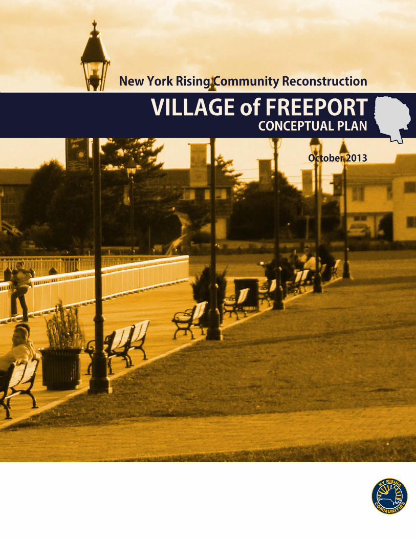
CONCEPTUAL PLANVILLAGE of FREEPORT
October 2013
New York Rising Community Reconstruction

This document was developed by the Freeport Planning Committee as part of the NY Rising Community Reconstruction (NYRCR) Program within the Governor’s Office of Storm Recovery. The NYRCR Program is supported by NYS Homes and Community Renewal, NYS Department of State, and NYS Department of Transportation.
Freeport NYRCR Planning Committee
Dewey Smalls, Freeport, Co-Chair Rob Weltner, Freeport, Co-ChairKen Bellafiore, Committee MemberRich Cantwell, Committee MemberAnthony Fiore, Committee MemberRobert Fisenne, Freeport Department of Public WorksCharles Hirshberg, Committee MemberEllen Kelly, Committee MemberCynthia Krieg, Committee MemberAnthony Miller, Committee Member Jim Ruocco, Committee MemberJonathan Smith, Freeport Department of BuildingsChris Squeri, Committee MemberFrank White, Committee Member
New York StateLaura Munafo, Nassau County Region Lead, NYS Homes and Community RenewalNancy Rucks, State Planner, NYS Department of StateTerra Sturn, State Planner, NYS Department of State
ConsultantsOve Arup & Partners P.C.Sasaki AssociatesUrbanomicsCAS GroupFine Arts and Sciences
Acknowledgements

Introduction 1
Introduction
About the Program
Setting the Scene
Community Background 9
Overview
Geographic Scope
Storm Impacts
County Impacts
Local Impacts
Existing Plans and Studies
Regional Plans and Studies
Local Plans and Studies
Looking to the Future 23
Community Vision
Community Assessment
Community Assets
Evaluation of Risks
Risk Areas
Needs and Opportunities
Key Projects and Strategies
Strategies
Projects
Actions
Cost-Benefit Analysis
Public Engagement 59
Next Steps 63
Appendices 67
Contents


Introduction
2 New York Rising Community Reconstruction
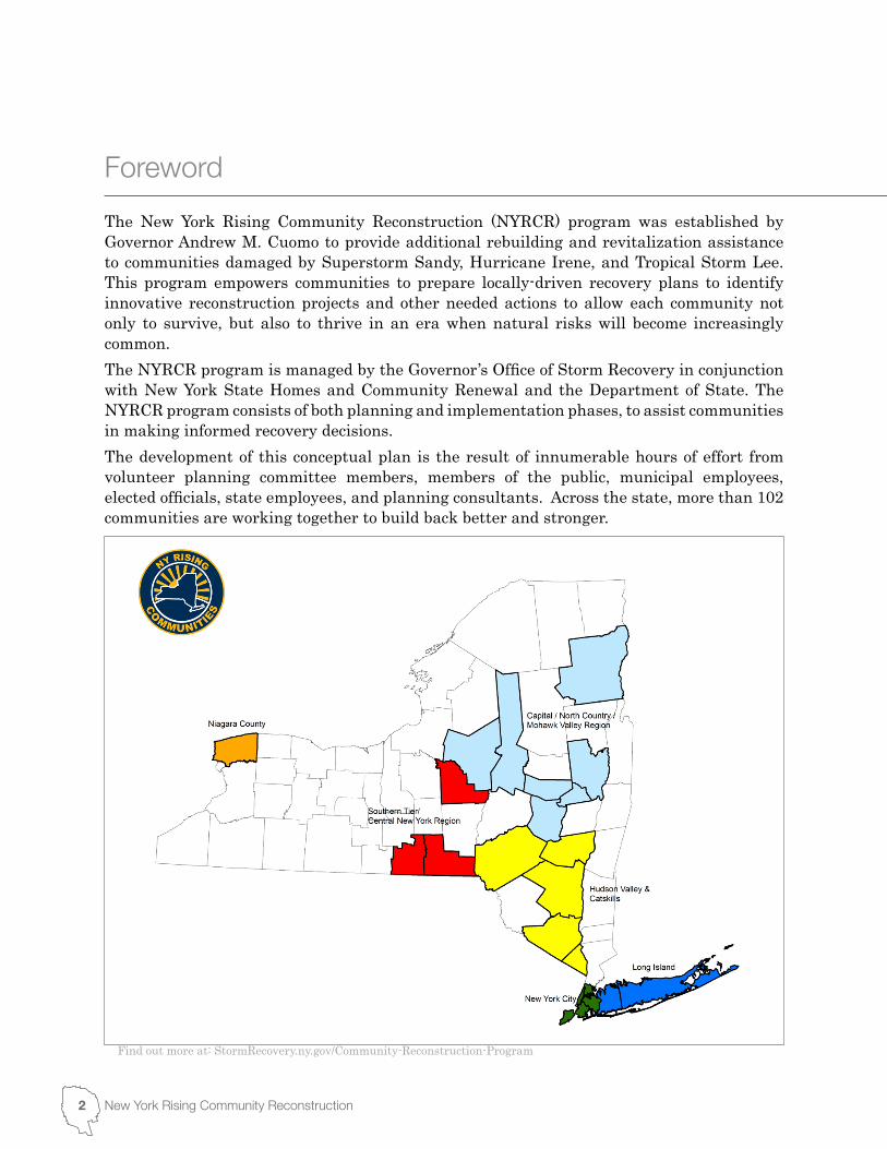
The New York Rising Community Reconstruction (NYRCR) program was established by Governor Andrew M. Cuomo to provide additional rebuilding and revitalization assistance to communities damaged by Superstorm Sandy, Hurricane Irene, and Tropical Storm Lee. This program empowers communities to prepare locally-driven recovery plans to identify innovative reconstruction projects and other needed actions to allow each community not only to survive, but also to thrive in an era when natural risks will become increasingly common.The NYRCR program is managed by the Governor’s Office of Storm Recovery in conjunction with New York State Homes and Community Renewal and the Department of State. The NYRCR program consists of both planning and implementation phases, to assist communities in making informed recovery decisions. The development of this conceptual plan is the result of innumerable hours of effort from volunteer planning committee members, members of the public, municipal employees, elected officials, state employees, and planning consultants. Across the state, more than 102 communities are working together to build back better and stronger.
Foreword
Find out more at: StormRecovery.ny.gov/Community-Reconstruction-Program
3NYRCR Freeport Conceptual PlanOctober 2013
This conceptual plan is a snapshot of the current thoughts of the community and planning committee. The plans will evolve as communities analyze the risk to their assets, their needs and opportunities, the potential costs and benefits of projects and actions, and their priorities. As projects are more fully defined, the potential impact on neighboring municipalities or the region as a whole may lead to further modifications.In the months ahead, communities will develop ways to implement additional strategies for economic revitalization, human services, housing, infrastructure, natural and cultural resources, and the community’s capacity to implement changes.Implementation of the proposed projects and actions found in this conceptual plan is subject to applicable federal, state, and local laws and regulations. Inclusion of a project or action in this conceptual plan does not guarantee that a particular project or action will be eligible for Community Development Block Grant – Disaster Recovery (CDBG-DR) funding. Proposed projects or actions may be eligible for other state or federal funding, or could be accomplished with municipal, nonprofit or private investment. Each NYRCR Community will continue to engage the public as they develop a final plan for community reconstruction. Events will be held to receive feedback on the conceptual plan, to provide an understanding of risk to assets, and to gather additional ideas for strategies, projects and actions.
4 New York Rising Community Reconstruction
On October 29, the New York Tri-State region was devastated by Hurricane Sandy, the most destructive storm of the 2012 Atlantic Ocean hurricane season. The south shore of Long Island suffered massive storm surge damage, power outages, sewer line overflows, and utility and transportation disruption. Flooding from Hurricane Sandy exceeded many of the Federal Emergency Management Agency’s (FEMA) 100-year flood zones – in Freeport the flood zone was exceeded by 250 feet.1 Freeport’s historic center – and the heart of the local economy – the Nautical Mile, was devastated and flooding was experienced throughout the Village. Flood levels were well beyond what anyone has experienced or expected. Though the initial public response was well-informed and recovery efforts were well-managed, no one was prepared for the extent of the storm’s impact. Directly or indirectly, the lives and well-being of virtually everyone in the region were, and continue to be, affected by the storm’s aftermath.While the entirety of the region was largely unprepared for the severity of the storm, Freeport community members were generally well informed and prepared. Freeport was able to bounce back quickly. The Police, Fire, Public Works and Electric Departments are a few areas where Freeport exceled in response and recovery. Local residents and organizations, such as Operation Splash, were also involved in the response, recovery and cleanup efforts.However, as we mark the one-year anniversary of this devastating storm, we turn our attention to the future and to what must be done to transform this disaster into an opportunity to not only restore what was lost, but to help achieve our collective vision for the future of the Village of Freeport. In light of our changing climate, and with the understanding that extreme storms and unpredictable weather are becoming the new normal, returning to the status quo is no longer a sufficient response. We must consider long-term recovery for the Village, south shore, and the greater community. We must rebuild to be resilient. Our goal in creating this Plan is to position Freeport to rebuild a safer, more resilient, sustainable community that reduces its vulnerability and exposure to risks in order to achieve a better future for its current and future residents.Governor Andrew M. Cuomo instructed the State to partner with local communities to capture this unique window of opportunity by creating the New York Rising Community Reconstruction (NYRCR) Program. A NYRCR Planning Committee comprised of community residents and stakeholders have been working closely with a Consultant Team and State agencies to develop the material included in this NYRCR Conceptual Plan. In addition, a series of public information meetings are being held to gather public feedback. This NYRCR Conceptual Plan identifies needs and opportunities, as well as the community’s goals for recovery and resiliency, and connects those to an initial set of strategies and projects.
1Village of Freeport, All Hazard Mitigation Plan, 2013. Pg 34
Introduction
5NYRCR Freeport Conceptual PlanOctober 2013
NYRCR Planning CommitteeAs a part of this process, a Freeport Planning Committee was established to work with appropriate municipal, non-profit and consultant supporters to identify a vision, goals, objectives and a plan for the Village of Freeport. This committee advises on all aspects of the project and will help shape the overall direction of the plan and the actions that flow from it.
NYRCR Public ProcessThe public will be engaged at regular intervals throughout the process to provide further guidance and insight into making Freeport a more resilient community. The Planning Committee helps to guide the public workshops and meetings.
NYRCR Conceptual PlanThe NYRCR Conceptual Plan is a preliminary step in the entire NYRCR planning process. It outlines a vision for the recovery of the Village and a preliminary set of ideas about how to establish a legacy of positive change in the Village of Freeport. It is the start of a conversation of how to make Freeport a better place to live, work and play, now and in the decades to come. With the release of this plan, it is expected that further input will be garnered throughout the remainder of the planning and public engagement process. This content will be contained in the Final Plan, which is expected to be completed in March 2014. From that point forward, NYRCR Freeport Plan should serve as a practical tool for government agencies, the private sector partners, not-for-profits, and the community as a whole to maximize the implementation of the proposed recovery and resiliency initiatives.The NYRCR Conceptual Plan is divided into four sections:1. Community Background: This section includes information on the NYRCR Freeport
community, the geographic scope of the NYRCR Freeport Plan, and the impacts of Hurricanes Sandy and Irene. In addition, existing plans and studies are reviewed as potential sources for local and regional strategies that would support NYRCR Freeport’s reconstruction efforts.
2. Looking to the Future: Here we move from examining the past to considering the future. It includes NYRCR Freeport’s vision and goals for recovery and resiliency as developed by the residents and stakeholders of this community; asset inventory and flood risk maps; and needs and opportunities identified.
3. Public Engagement: This section of the report describes the ways in which the public has and can continue to participate in the planning process.
4. Next Steps: Finally, the next steps section describes how we will work together to review and refine this NYRCR Freeport Conceptual Plan.
6 New York Rising Community Reconstruction
Setting the Scene
South shore residents value their proximity to water and the natural beauty of the region. The close relationship between human settlements and the natural environment on Long Island offers many quality-of-life benefits to residents and visitors but it also poses risks. The beautiful tree canopies which cool and clean the air pose risks to elevated power lines during wind events. Canals, rivers and waterfronts offer access to beautiful natural landscapes but leave many properties exposed to tidal and storm surges. Low density, sprawling developments and extensive paved surfaces push more water into already overloaded drainage systems, rivers and bays. Striking a better balance between proximity to nature and protection and safety is necessary to ensure that Long Island communities build back better and stronger.
The Intergovernmental Panel on Climate Change’s Fifth Assessment Report, 2013, states “warming of the climate system is unequivocal, and since the 1950s, many of the observed changes are unprecedented over decades to millennia. The atmosphere and ocean have warmed, the amounts of snow and ice have diminished, sea level has risen, and the concentrations of greenhouse gases have increased.”2 These changes affect the types of weather systems, the seasonal distribution of precipitation, and the overall energy balance in the atmosphere differently at a regional level. This means that an area which has been designed around certain patterns of weather must now adapt to different events that come at greater frequency and with stronger intensity than before.
Long Islanders understand that natural disasters and unpredictable weather events are not going away. As Governor Cuomo put it days after Hurricane Sandy struck, “extreme weather is the new normal.”3 In other words, events like Sandy, Lee, Irene, and perhaps risks that have never been experienced locally, are likely to occur with greater frequency and intensity than they have in the past on Long Island. Thus, we need to change how things are planned, designed, built and implemented to respect this reality.Building on this, Freeport must turn its mind to the tremendous opportunity presented by the Governor, through the New York Rising program, to set a legacy of resilience.
Resilience for Long IslandFor Long Island to continue to be a place for people to call home, and for it to restore its economic and social strength, resiliency must be adopted as an underpinning goal. Resilient planning, design and building on Long Island should create a higher degree of protection for existing communities while allowing for growth that is more balanced with the protection of the natural features that make Long Island so attractive. It also sends a message across the Island – and the region – that Long Island can continue to be an attractive place to live, work and play. Resilient design entails a set of strategies in designs, buildings, and institutional structures that lessen the impact of severe events and speed the recovery when those events happen. Importantly, we should not lose sight of the potential impacts of designing for resilience as often times these approaches yield opportunities for co-benefits, which can enhance the viability of Long Island’s environment, economy and society.
2IPCC. Approved Summary for Policymakers, 2013.3http://www.nydailynews.com/opinion/lead-climate-change-article-1.1202221


1Community Background
10 New York Rising Community Reconstruction
The Village of Freeport is located within the Town of Hempstead and Nassau County on Long Island. As a part of the greater New York City metropolitan area, it is approximately 22 miles east of Midtown Manhattan, and 7 miles east of the Nassau-Queens border. The Village occupies 4.6 square miles along the southern edge of Nassau County, and has its own municipal electric and water utilities, police force, and fire department.Freeport has one of the highest residential population densities on Long Island, at 9,531 people per square mile, more than double the average density of Nassau County. Based on the 2010 Census, the population of Freeport was 42,860, making it the second largest village in New York State. Diversity is also comparatively high, with African American and Hispanic or Latino groups each accounting for approximately one-third of the total population.4 Single family homes represent 62% of Freeport’s housing stock, lower than the 77% county average. Its downtown area is characterized by a high presence of multi-family and rental housing, and is predominantly low-income with more than 10% of households below the poverty line.Sunrise Highway (New York State Route 27) and Merrick Road (New York State Route 27A) are the two major east-west thoroughfares serving the Freeport area. The eastern edge of the Village is bordered by the Meadowbrook State Parkway, which intersects the Sunrise Highway and provides access to northern Nassau County, and to the south, the Long Beach and Jones Beach barrier islands. North Main Street is the major north-south route through the Village, providing access to the Sunrise Highway and Freeport’s rail station.The Freeport community is served by the Long Island Rail Road’s (LIRR) Babylon line, which runs from Pennsylvania Station in Manhattan to the Village of Babylon in Suffolk County. Freeport Station averages 5,365 passenger trips daily, and nearly 30% of the Village’s residents live within a half-mile of the station. Eight Nassau Inter-County Express (NICE) bus routes also serve the Village, with the N40 and N41 lines providing critical north-south transit access for residents.Freeport’s southern edge is penetrated by a number of canals, which provide access through Middle Bay’s salt marshes and the Jones and East Rockaway inlets to the Atlantic Ocean. The Nautical Mile, a commercial and recreational waterfront strip west of Woodcleft Canal, is a popular regional summer destination for boating, dining, and nightlife. The Nautical Mile features a variety of restaurants and bars, retail stores and food markets. Many, if not all, of these stores and restaurants depend on their waterfront location for success, particularly places like the Fiore Brothers Fish Market, which burned down in the immediate aftermath of Sandy and sustained $3.5 million in property losses.5 The Village’s 4-acre Sea Breeze waterfront park, located at the foot of the Nautical Mile, includes a boat dock for transients, boat slips for hire and a public building with rest facilities.
4Community Profiles, US Census 5Village of Freeport, All Hazard Mitigation Plan, 2013. Pg 34
Overview
11 NYRCR Freeport Conceptual PlanOctober 2013
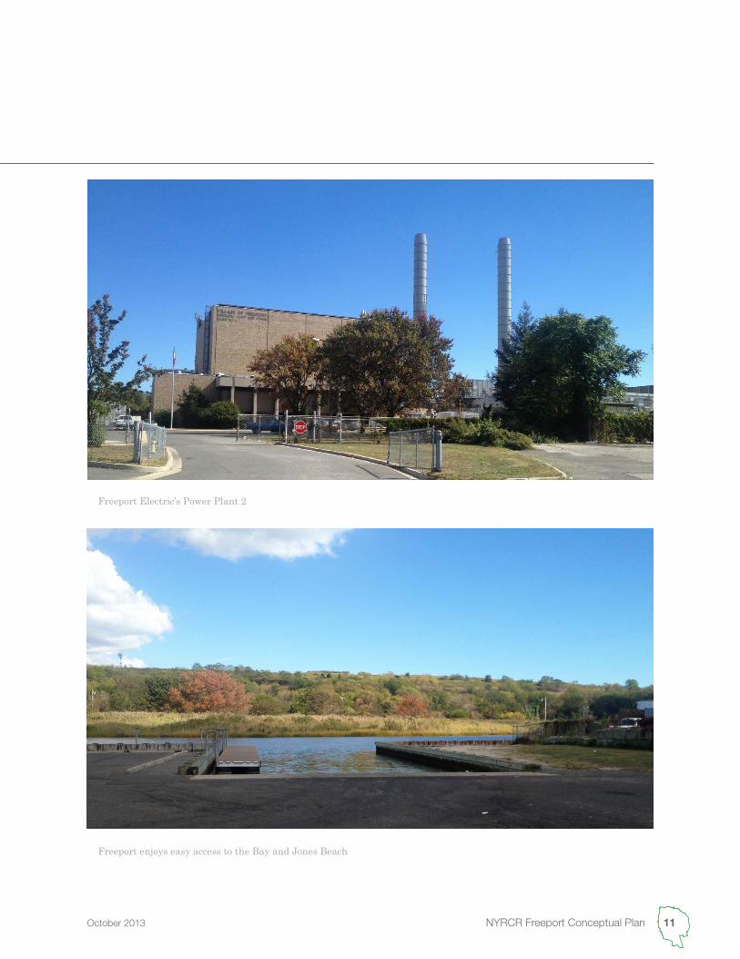
Freeport enjoys easy access to the Bay and Jones Beach
Freeport Electric’s Power Plant 2
12 New York Rising Community Reconstruction
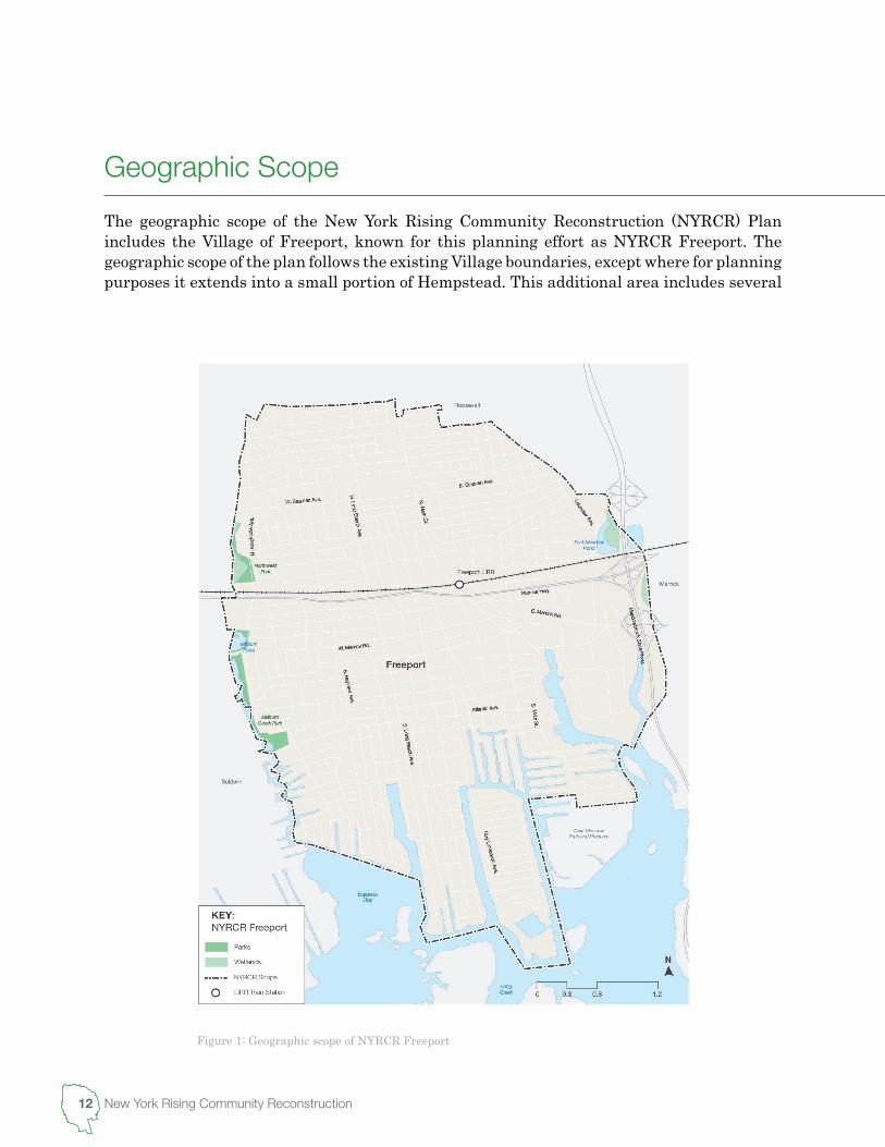
Figure 1: Geographic scope of NYRCR Freeport
The geographic scope of the New York Rising Community Reconstruction (NYRCR) Plan includes the Village of Freeport, known for this planning effort as NYRCR Freeport. The geographic scope of the plan follows the existing Village boundaries, except where for planning purposes it extends into a small portion of Hempstead. This additional area includes several
Geographic Scope

13 NYRCR Freeport Conceptual PlanOctober 2013
private landholdings and Nassau County’s Cow Meadow Park and Preserve. The area receives electric, water and some emergency services from the Village of Freeport and those services will considered in the NYRCR Plan. As shown in Figure 1, the geographic scope of the NYRCR Freeport area extends north from the Middle Bay to Babylon Turnpike and southern border of the unincorporated area of Roosevelt. The area is generally bounded on the east by the Meadowbrook State Parkway, and the Cow Meadow Park and Preserve. The eastern boundary begins to the south at Baldwin Bay and extends north along Millburn Creek, intersecting the Sunrise Highway and the Long Island Railroad’s Babylon line.While the NYRCR Planning Committee discussed limiting the scope of the project to the areas most vulnerable to future storms and coastal flooding, the Committee decided that the entire Village should be considered collectively due to the uncertainty of scale and breadth of future events.
Open space in Freeport
14 New York Rising Community Reconstruction
County ImpactsLike many other areas in the greater New York City metropolitan region, Nassau County’s residents and businesses were severely damaged by Hurricane Sandy. Nassau County suffered unprecedented damage to homes and businesses, public facilities, infrastructure, and environmental assets. The storm flooded, damaged or destroyed 74,736 structures, with 30,036 suffering damages of more than 50% of their value and 117 damaged beyond repair. This includes 44 power substations and facilities, 26 schools, 31 sanitary sewage pump stations, 100 traffic signals, more than 1,000 County drainage outfalls, 28 fire stations, three police stations and one medical facility.Many community members throughout Nassau County lost homes and property, and a large number of these residents are still displaced. The County’s small businesses suffered major losses, which were often exacerbated as damaged roads and buildings prolonged reopening after the initial impacts of the storm and rebuilding materials and contractors were in short supply. Although employees were able to receive unemployment insurance, many of the owners did not qualify for the benefit. Without sufficient capital to finance repairs, and unable to afford additional loans, these business were left with no option but closure.The County’s wastewater infrastructure systems failed. The Bay Park Waste Water Treatment Plant, which services 40% of Nassau County, including Freeport, was inundated with 12 feet of water during Hurricane Sandy’s storm surge. Despite days of emergency preparation, water from the storm surge quickly filled the engines of the plant’s main pumping station, forcing Bay Park off-line. Sewage began to back up and overflow into low-lying streets and homes throughout Hempstead’s Western Bay, flooding communities with untreated wastewater. The facility remained off-line for more than 50 hours before service was restored, ultimately flooding channels and waterways with approximately 200 million gallons of raw sewage.6 Electrical shortages caused by saltwater flooding set fire to 32 homes within Nassau County, and resulted in fatalities from carbon monoxide poisoning and electrocution. Flooding and wind damage created a significant amount of debris, including damaged bulkheads, pilings and other marine structures, unmoored boats, and building fragments carried by the storm surge. Over 90% of the approximately 3.3 million cubic yards of debris was structural detritus, with downed trees accounting for 172,980 cubic yards of the total amount.The Federal Emergency Management Agency (FEMA) received approximately 1,175 requests for public assistance for public projects in Nassau County, with 258 small (less than $67,500) and 434 large (more than $67,500) projects deemed eligible for assistance. FEMA reported that 113,901 residents in both Nassau and Suffolk counties have applied for disaster relief assistance following Hurricane Sandy. Of the 95,534 homes that experienced flooding in these counties, only 43,106 had federal flood insurance policies.
6http://www.nytimes.com/2012/11/30/nyregion/sewage-flows-after-hurricane-sandy-exposing-flaws-in-system.html?smid=pl-share
Storm Impacts
15 NYRCR Freeport Conceptual PlanOctober 2013
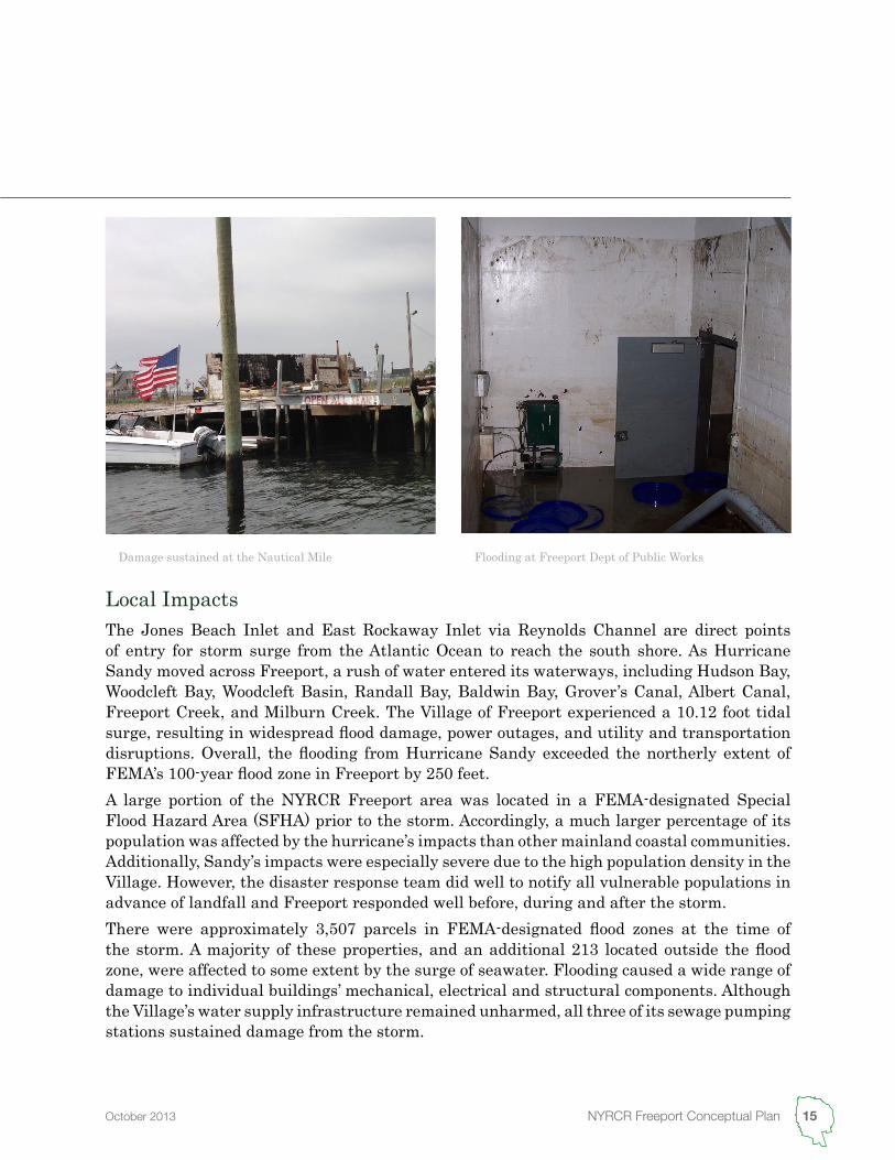
Local ImpactsThe Jones Beach Inlet and East Rockaway Inlet via Reynolds Channel are direct points of entry for storm surge from the Atlantic Ocean to reach the south shore. As Hurricane Sandy moved across Freeport, a rush of water entered its waterways, including Hudson Bay, Woodcleft Bay, Woodcleft Basin, Randall Bay, Baldwin Bay, Grover’s Canal, Albert Canal, Freeport Creek, and Milburn Creek. The Village of Freeport experienced a 10.12 foot tidal surge, resulting in widespread flood damage, power outages, and utility and transportation disruptions. Overall, the flooding from Hurricane Sandy exceeded the northerly extent of FEMA’s 100-year flood zone in Freeport by 250 feet.A large portion of the NYRCR Freeport area was located in a FEMA-designated Special Flood Hazard Area (SFHA) prior to the storm. Accordingly, a much larger percentage of its population was affected by the hurricane’s impacts than other mainland coastal communities. Additionally, Sandy’s impacts were especially severe due to the high population density in the Village. However, the disaster response team did well to notify all vulnerable populations in advance of landfall and Freeport responded well before, during and after the storm.There were approximately 3,507 parcels in FEMA-designated flood zones at the time of the storm. A majority of these properties, and an additional 213 located outside the flood zone, were affected to some extent by the surge of seawater. Flooding caused a wide range of damage to individual buildings’ mechanical, electrical and structural components. Although the Village’s water supply infrastructure remained unharmed, all three of its sewage pumping stations sustained damage from the storm.
Damage sustained at the Nautical Mile Flooding at Freeport Dept of Public Works
16 New York Rising Community Reconstruction
More than $70 million in individual claims were submitted for damages sustained from Sandy, and more than 100 homes were “red tagged” as being unsafe for habitation. More than 200 additional properties were deemed substantially damaged by the flooding. A year following the storm, approximately half of the red-tagged structures have been repaired, and the Village expects that a majority, if not all of such residences will be safe to inhabit within one to two years.The Village incurred approximately $4.5 million in Hurricane Sandy related damage expenditures, of which $3.3 million are attributable to the Village’s General Fund and almost $1.2 million to its Electric Fund. Approximately $2.0 million was expended for debris removal, of which $575,000 was for non-capital equipment and materials, $820,000 for Village labor overtime costs and $1.1 million for contractual costs. In total, an estimated 13,347 tons of debris was removed.More than $207,000 was expended by Village of Freeport Housing Authority to make critical repairs to the Moxie Rigby, South Main and 100 North Main Street properties. As many of the buildings’ power and heating systems that were repaired were compromised in previous storms, the Housing Authority is seeking assistance to elevate and relocate equipment to prevent future damage. The Authority, working with engineers, have provided a pre-engineering estimate of $342,000 to address these repairs.Three commercial properties on the Village’s Nautical Mile experienced significant damage and remain closed for construction. One of these businesses, Fiore Brothers Fish Market, sustained $3.5 million in property damages, as their building burned down in the immediate aftermath of the Storm.The Leo F. Giblyn Elementary School, located along South Ocean Avenue in a SFHA, had to temporarily relocate their 564 students to neighboring schools in the district due to storm surge damage. The students were displaced for six weeks as repairs were made, before returning to school on December 10, 2012.
17 NYRCR Freeport Conceptual PlanOctober 2013
The changing social, environmental and economic landscape of the south shore of Long Island has created a need for short-, mid- and long-term planning goals to address the impacted region’s future. Several groups have independently undertaken research and analysis of existing problems and concerns, and have developed recommendations based on their findings. The NYRCR Freeport Planning Committee and Consultant Team has reviewed this work and identified a set of key themes that outline common issues and opportunities within the south shore region.
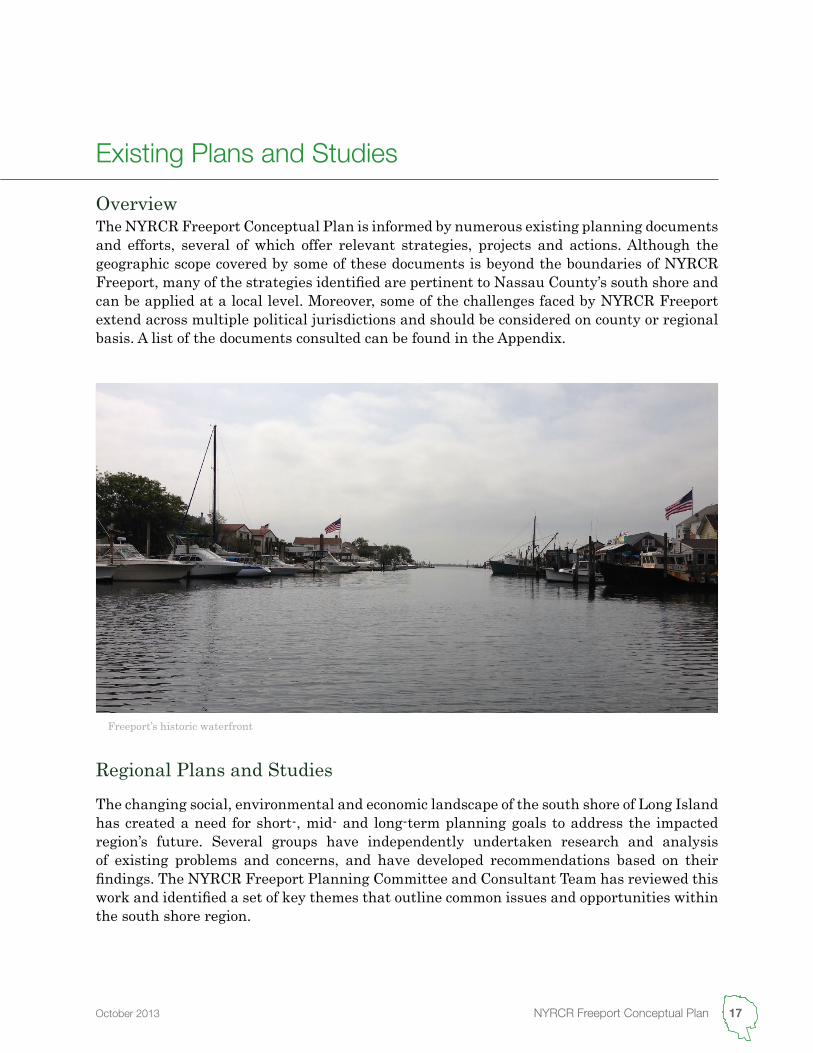
The NYRCR Freeport Conceptual Plan is informed by numerous existing planning documents and efforts, several of which offer relevant strategies, projects and actions. Although the geographic scope covered by some of these documents is beyond the boundaries of NYRCR Freeport, many of the strategies identified are pertinent to Nassau County’s south shore and can be applied at a local level. Moreover, some of the challenges faced by NYRCR Freeport extend across multiple political jurisdictions and should be considered on county or regional basis. A list of the documents consulted can be found in the Appendix.
Overview
Freeport’s historic waterfront
Existing Plans and Studies
Regional Plans and Studies
18 New York Rising Community Reconstruction
Infrastructure InvestmentLong Island’s aging infrastructure is struggling to accommodate previous population growth and changing demographics while adapting to the increasing threat of storm events and sea level rise. Roadway infrastructure, bulkheads, and utilities – power and gas lines – have been particularly affected by flooding and storm damage. Additionally, the transportation network no longer best serves Long Island’s present-day commuting patterns and should be re-evaluated to better accommodate trips that are not bound for New York City. Infrastructure investment has consistently been identified as critical to Long Island’s regional growth and economic viability.
Water ResourcesGroundwater contamination from pollution and saltwater intrusion is an issue in Nassau County, where potable water is supplied solely by aquifers. Real estate development to facilitate and attract population growth, combined with sea level rise, threatens the future drinking water and consumptive water resources – those removed from the system without out a return, such as manufacturing and food preparation – on Long Island. The need for flood management, water conservation, and environmental protection is a recurring theme in many of the documents studied.
EnergyElectricity rates for Long Island residents are among the highest in the nation, and much of its energy supply depends on off-island resources. Many of the documents reviewed favored investment in energy efficiency and conservation, renewable energy sources, and distributed energy generation strategies to increase energy independence and reduce ratepayer costs. However, as an incorporated village, Freeport generates, purchases and distributes its own energy through Freeport Electric. This makes Freeport’s energy supply more affordable, reliable and diverse than other areas of Long Island.
HousingNassau County is dominated by single family housing, with a majority of units more than 50 years old. Before Hurricane Sandy, escalating home prices and property tax levels limited the stock of housing available for the young and aging population, low-income residents, and those displaced by previous storms. Many plans have recommended an increase in smaller, affordable housing and rental unit developments. However, following the impacts of Hurricane Sandy it is uncertain if home prices will remain at their current level.
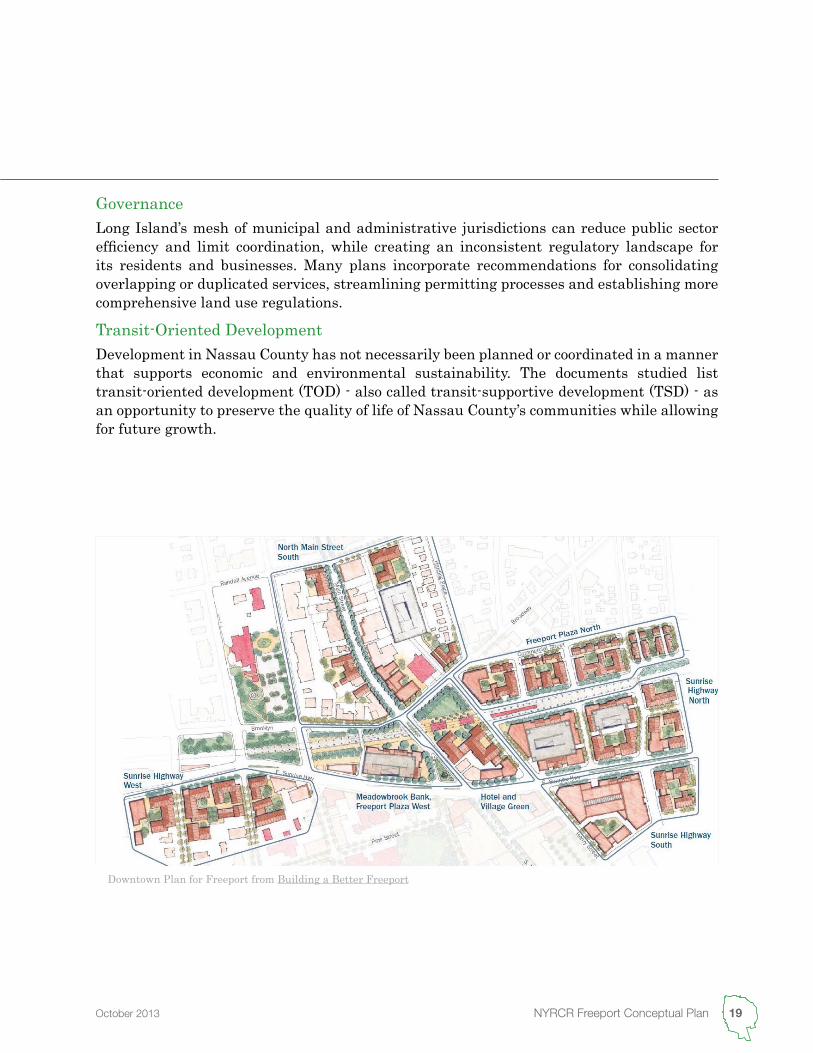
Downtown Plan for Freeport from Building a Better Freeport
19 NYRCR Freeport Conceptual PlanOctober 2013
GovernanceLong Island’s mesh of municipal and administrative jurisdictions can reduce public sector efficiency and limit coordination, while creating an inconsistent regulatory landscape for its residents and businesses. Many plans incorporate recommendations for consolidating overlapping or duplicated services, streamlining permitting processes and establishing more comprehensive land use regulations.
Transit-Oriented DevelopmentDevelopment in Nassau County has not necessarily been planned or coordinated in a manner that supports economic and environmental sustainability. The documents studied list transit-oriented development (TOD) - also called transit-supportive development (TSD) - as an opportunity to preserve the quality of life of Nassau County’s communities while allowing for future growth.
20 New York Rising Community Reconstruction
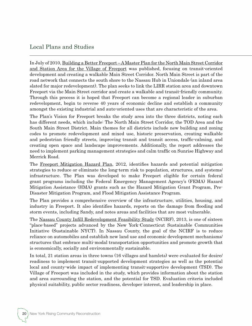
In July of 2010, Building a Better Freeport – A Master Plan for the North Main Street Corridor and Station Area for the Village of Freeport was published, focusing on transit-oriented development and creating a walkable Main Street Corridor. North Main Street is part of the road network that connects the south shore to the Nassau Hub in Uniondale (an inland area slated for major redevelopment). The plan seeks to link the LIRR station area and downtown Freeport via the Main Street corridor and create a walkable and transit-friendly community. Through this process it is hoped that Freeport can become a regional leader in suburban redevelopment, begin to reverse 40 years of economic decline and establish a community amongst the existing industrial and auto-oriented uses that are characteristic of the area.The Plan’s Vision for Freeport breaks the study area into the three districts, noting each has different needs, which include: The North Main Street Corridor, the TOD Area and the South Main Street District. Main themes for all districts include new building and zoning codes to promote redevelopment and mixed use, historic preservation, creating walkable and pedestrian friendly streets, improving transit and transit access, traffic-calming, and creating open space and landscape improvements. Additionally, the report addresses the need to implement parking management strategies and calm traffic on Sunrise Highway and Merrick Road.The Freeport Mitigation Hazard Plan, 2012, identifies hazards and potential mitigation strategies to reduce or eliminate the long-term risk to population, structures, and systems/infrastructure. The Plan was developed to make Freeport eligible for certain federal grant programs including the Federal Emergency Management Agency’s (FEMA) Hazard Mitigation Assistance (HMA) grants such as the Hazard Mitigation Grant Program, Pre-Disaster Mitigation Program, and Flood Mitigation Assistance Program.The Plan provides a comprehensive overview of the infrastructure, utilities, housing, and industry in Freeport. It also identifies hazards, reports on the damage from flooding and storm events, including Sandy, and notes areas and facilities that are most vulnerable.The Nassau County Infill Redevelopment Feasibility Study (NCIRF), 2013, is one of sixteen “place-based” projects advanced by the New York-Connecticut Sustainable Communities Initiative (Sustainable NYCT). In Nassau County, the goal of the NCIRF is to reduce reliance on automobiles and establish new land use and economic development mechanisms/structures that embrace multi-modal transportation opportunities and promote growth that is economically, socially and environmentally sustainable. In total, 21 station areas in three towns (16 villages and hamlets) were evaluated for desire/readiness to implement transit-supported development strategies as well as the potential local and county-wide impact of implementing transit-supportive development (TSD). The Village of Freeport was included in the study, which provides information about the station and area surrounding the station, and the potential for TSD. Evaluation criteria included physical suitability, public sector readiness, developer interest, and leadership in place.
Local Plans and Studies
21 NYRCR Freeport Conceptual PlanOctober 2013
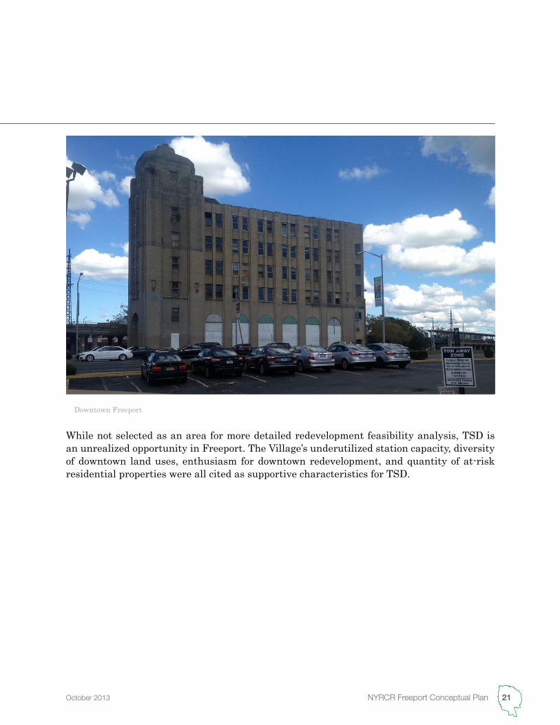
While not selected as an area for more detailed redevelopment feasibility analysis, TSD is an unrealized opportunity in Freeport. The Village’s underutilized station capacity, diversity of downtown land uses, enthusiasm for downtown redevelopment, and quantity of at-risk residential properties were all cited as supportive characteristics for TSD.
Downtown Freeport


2Looking to the Future
24 New York Rising Community Reconstruction
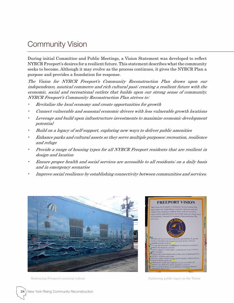
During initial Committee and Public Meetings, a Vision Statement was developed to reflect NYRCR Freeport’s desires for a resilient future. This statement describes what the community seeks to become. Although it may evolve as the process continues, it gives the NYRCR Plan a purpose and provides a foundation for response.The Vision for NYRCR Freeport’s Community Reconstruction Plan draws upon our independence, nautical commerce and rich cultural past; creating a resilient future with the economic, social and recreational outlets that builds upon our strong sense of community. NYRCR Freeport’s Community Reconstruction Plan strives to:• Revitalize the local economy and create opportunities for growth• Connect vulnerable and seasonal economic drivers with less vulnerable growth locations• Leverage and build upon infrastructure investments to maximize economic development
potential• Build on a legacy of self-support, exploring new ways to deliver public amenities• Enhance parks and cultural assets so they serve multiple purposes; recreation, resilience
and refuge• Provide a range of housing types for all NYRCR Freeport residents that are resilient in
design and location• Ensure proper health and social services are accessible to all residents; on a daily basis
and in emergency scenarios• Improve social resilience by establishing connectivity between communities and services.
Embracing Freeport’s nautical culture Gathering public input on the Vision
Community Vision
25NYRCR Freeport Conceptual PlanOctober 2013
The NYRCR Freeport Plan will reflect an assessment of risks facing regional and community assets, and the needs and opportunities presented by community members. The NYRCR Program has developed a standardized methodology consisting of six main steps for the asset inventory and risk assessment process. This allows for teams supporting each community to share a common understanding of how to categorize assets and evaluate risk, and to ensure that the results of each participating community are comparable.The six steps are:1. Collect preliminary data 2. Conduct supplemental data collection 3. Identify and address data gaps4. Conduct asset inventory, classification and attributes5. Utilize the Initial Risk Assessment Tool Implementation for coastal areas, which includes
review by the community planning team6. Identify management options review and other community scenarios.In addition to the asset inventory and risk assessment process, the NYRCR Freeport Planning Committee and Consultant Team will identify needs and opportunities within the community of NYRCR Freeport. The needs and opportunities presented in the NYRCR Freeport Conceptual Plan incorporate existing studies relating to previous storm impacts with public feedback and an analysis of key economic drivers within the community. A majority of needs relate to the repair or replacement of assets damaged by previous storms, and the economic losses attributed to damage and recovery. Other considerations, such as existing projects occurring prior to storm damage and opportunities for increasing the resilience of existing assets, will also be addressed.
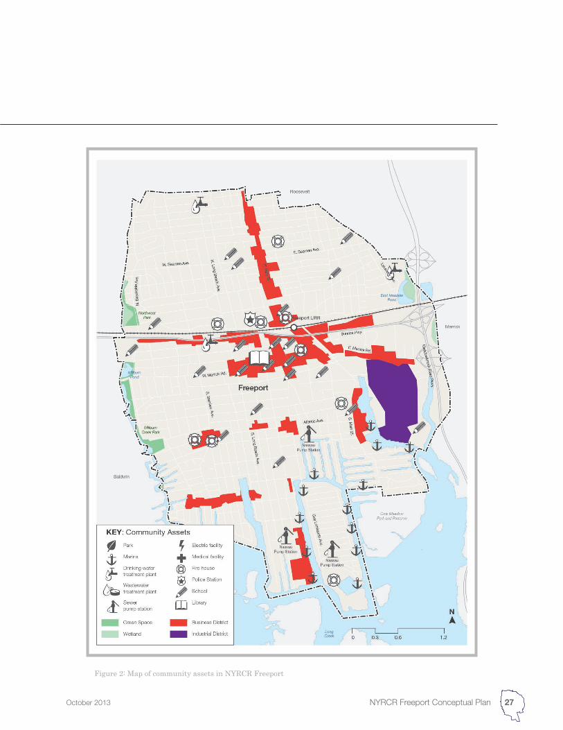
NYRCR Freeport has a variety of community assets including residential and commercial districts, schools and hospitals, infrastructure, parks and ecological areas that were greatly impacted by Hurricane Sandy and which face future exposure. Many of these assets are highly valued and treasured by community members, and stakeholders have expressed particular interest in protecting them.The NYRCR Freeport Planning Committee and Consultant Team is cataloguing NYRCR Freeport’s assets by collecting information and data from State, County and local sources across six asset classes, described below. Throughout the public engagement process, the NYRCR Freeport Planning Committee and Consultant Team will continue to add to this initial list based on feedback from the community and will identify the assets that are most critical to protect.
Community Assessment
Community Assets
26 New York Rising Community Reconstruction
EconomicEconomic asset types include commercial and industrial buildings, downtown centers and commercial corridors, and seasonal or tourist destinations.
Heath and Social ServicesHeath and social service assets include schools and day cares, health and elder care facilities, government and administrative services, media and communications, and critical services such as police and fire.
HousingHousing assets include single-family and multi-family dwellings, group or senior housing and public housing. Similar building types in close proximity may be identified as a single asset, such as a particular residential neighborhood.
Infrastructure SystemsInfrastructure systems include public transit, such as the LIRR, transit ways, transportation hubs, energy sources and fuel stations, water, stormwater, wastewater, and solid waste and recycling networks.
Natural and Cultural ResourcesNatural assets include habitats, wetlands and marshes, as well as parks and open spaces. Cultural assets include religious establishments, libraries and museums, historic landmarks and arts venues.
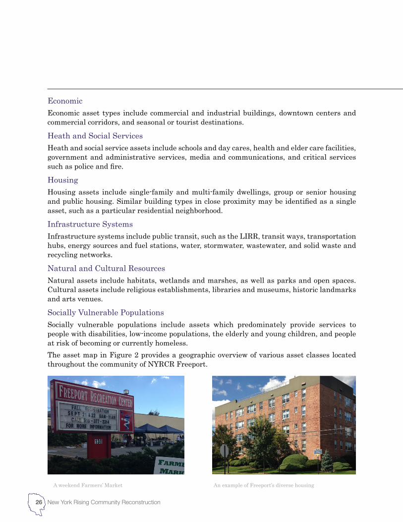
Socially Vulnerable PopulationsSocially vulnerable populations include assets which predominately provide services to people with disabilities, low-income populations, the elderly and young children, and people at risk of becoming or currently homeless.The asset map in Figure 2 provides a geographic overview of various asset classes located throughout the community of NYRCR Freeport.
A weekend Farmers’ Market An example of Freeport’s diverse housing
27NYRCR Freeport Conceptual PlanOctober 2013
Figure 2: Map of community assets in NYRCR Freeport
7Guidance for New York Rising Community Reconstruction Plans: A Planning Toolkit for CR Planning Committees
28 New York Rising Community Reconstruction
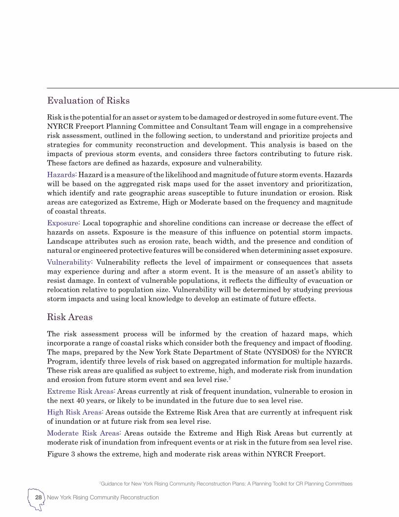
Risk is the potential for an asset or system to be damaged or destroyed in some future event. The NYRCR Freeport Planning Committee and Consultant Team will engage in a comprehensive risk assessment, outlined in the following section, to understand and prioritize projects and strategies for community reconstruction and development. This analysis is based on the impacts of previous storm events, and considers three factors contributing to future risk. These factors are defined as hazards, exposure and vulnerability.Hazards: Hazard is a measure of the likelihood and magnitude of future storm events. Hazards will be based on the aggregated risk maps used for the asset inventory and prioritization, which identify and rate geographic areas susceptible to future inundation or erosion. Risk areas are categorized as Extreme, High or Moderate based on the frequency and magnitude of coastal threats.Exposure: Local topographic and shoreline conditions can increase or decrease the effect of hazards on assets. Exposure is the measure of this influence on potential storm impacts. Landscape attributes such as erosion rate, beach width, and the presence and condition of natural or engineered protective features will be considered when determining asset exposure.Vulnerability: Vulnerability reflects the level of impairment or consequences that assets may experience during and after a storm event. It is the measure of an asset’s ability to resist damage. In context of vulnerable populations, it reflects the difficulty of evacuation or relocation relative to population size. Vulnerability will be determined by studying previous storm impacts and using local knowledge to develop an estimate of future effects.
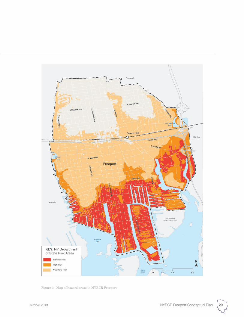
The risk assessment process will be informed by the creation of hazard maps, which incorporate a range of coastal risks which consider both the frequency and impact of flooding. The maps, prepared by the New York State Department of State (NYSDOS) for the NYRCR Program, identify three levels of risk based on aggregated information for multiple hazards. These risk areas are qualified as subject to extreme, high, and moderate risk from inundation and erosion from future storm event and sea level rise.7 Extreme Risk Areas: Areas currently at risk of frequent inundation, vulnerable to erosion in the next 40 years, or likely to be inundated in the future due to sea level rise.High Risk Areas: Areas outside the Extreme Risk Area that are currently at infrequent risk of inundation or at future risk from sea level rise.Moderate Risk Areas: Areas outside the Extreme and High Risk Areas but currently at moderate risk of inundation from infrequent events or at risk in the future from sea level rise.Figure 3 shows the extreme, high and moderate risk areas within NYRCR Freeport.
Evaluation of Risks
Risk Areas
29NYRCR Freeport Conceptual PlanOctober 2013
Figure 3: Map of hazard areas in NYRCR Freeport
30 New York Rising Community Reconstruction
New York Depart of State Risk Assessment Area Mapping Methodology8 To help understand the geographic distribution of coastal risk, the NYSDOS prepared coastal risk assessment areas with assistance from the National Oceanic and Atmospheric Administration Coastal Services Center (NOAA-CSC) and the Federal Emergency Management Agency (FEMA). The following process was used to develop a geographic assessment of extreme, high, and moderate risk areas for Nassau County.
Map risk assessment areas: Data was collected from sources accurate enough to differentiate geographic areas according to likelihood of flooding, erosion, waves and storm surge. To the extent allowed by source data, places where flood water can extend upstream are reflected in the mapping. Data sources include, but are not limited to:
• High Resolution Topography: The best available topography data for all areas was used. This allowed for topographic mapping of elevation differences that could affect flooding potential. Topographic data for inundation analysis had an average vertical error of 9 centimeters.
• 2009 FEMA Flood Insurance Rate Maps: Commonly referred to as 100-year flood zones, A and V zones on floodplain maps are areas with a 1% annual risk of flooding based on the most recent FEMA analysis. The boundaries of these zones are identified on Flood Insurance Rate Maps (FIRMs). The FIRMs also identify zones X and B, which are subject to a “500-year flood,” or 100-year flood with a depth less than 1 foot, or with a contributing drainage area less than 1 square mile, and areas protected by levees from the base flood. For this Risk Assessment, zones X and B are relatively low-risk areas subject to future storm surge inundation with sea level rise, in which case a higher standard for flood protection may be appropriate.
• SLOSH Storm Inundation Zones (NY3 Basin): The Sea, Lake, and Overland Surges from Hurricanes (SLOSH) model from the National Hurricane Center estimates hurricane storm surge. Because category 3 hurricanes (Saffir-Simpson scale) have occurred numerous times in New York, the SLOSH category 3 inundation zone was used to identify the geographic extent of coastal inundation risk.
• Sea Level Rise: To account for future sea level rise, a 0-3 feet above Mean Higher High Water (MHHW) shoreline (using the NOAA VDatum for MHHW surface) that shows both possible and more likely areas impacted by sea level rise based
8NYS Department of State, Risk Assessment Area Mapping – Datasets and Methodology http://stormrecovery.ny.gov/sites/default/files/documents/Risk_Assessment_Area_Mapping.pdf
31NYRCR Freeport Conceptual PlanOctober 2013
on mapping confidence. Future sea level rise was also accounted for by adding 3 feet of elevation to the NOAA Weather Service coastal flood advisory and adding 3 feet of elevation to the inland extent of the 100-year flood zone.
• Shallow coastal flooding: NOAA National Weather Service (NWS) shallow coastal flood advisory thresholds were used. An analysis of the number of events and duration of coastal flooding over the past 3 years, and the consequence of 0.5 and 1 meter of sea level rise was carried out.
• Susceptible Natural Shoreline Features: Areas subject to shoreline erosion are at risk of chronic impacts as well as increased storm impacts.
Compile mapping and classify geographic areas: Compile mapping into a summary, and classify geographic areas according to differences in vulnerability. Mapped areas were overlaid, and combined vulnerabilities were used to separate geographic areas into three classes:
• Extreme Risk Areas: Areas currently at risk of frequent inundation, vulnerable to erosion in the next 40 years, or likely to be inundated in the future due to sea level rise. This includes FEMA V flood zones, areas subject to Shallow Coastal Flooding per NOAA NWS’s advisory threshold, areas prone to erosion or natural features susceptible to erosion, and areas subject to future sea level rise.
• High Risk Areas: Areas outside the Extreme Risk Area that are currently at infrequent risk of inundation or at future risk from sea level rise. These include areas bounded by the 1% annual flood risk zone (FEMA V and A zones), and areas subject to future sea level rise.
• Moderate Risk Areas: Areas outside the Extreme and High Risk Areas but currently at moderate risk of inundation from infrequent events or at risk in the future from sea level rise are Moderate Risk Areas. These include areas bounded by the 0.2% annual risk (500 year) flood zone, where available, and areas bounded by the SLOSH category 3 hurricane inundation zone.
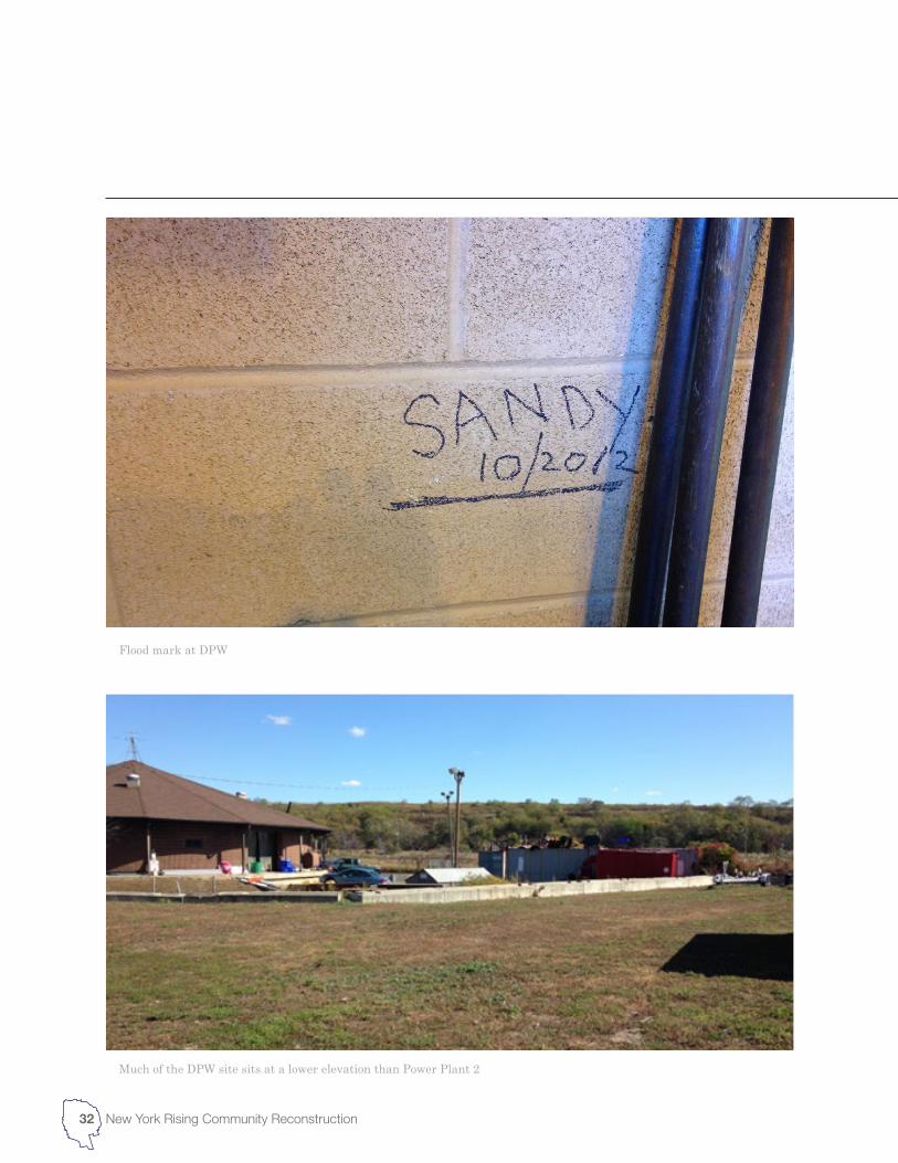
Flood mark at DPW
Much of the DPW site sits at a lower elevation than Power Plant 2
32 New York Rising Community Reconstruction
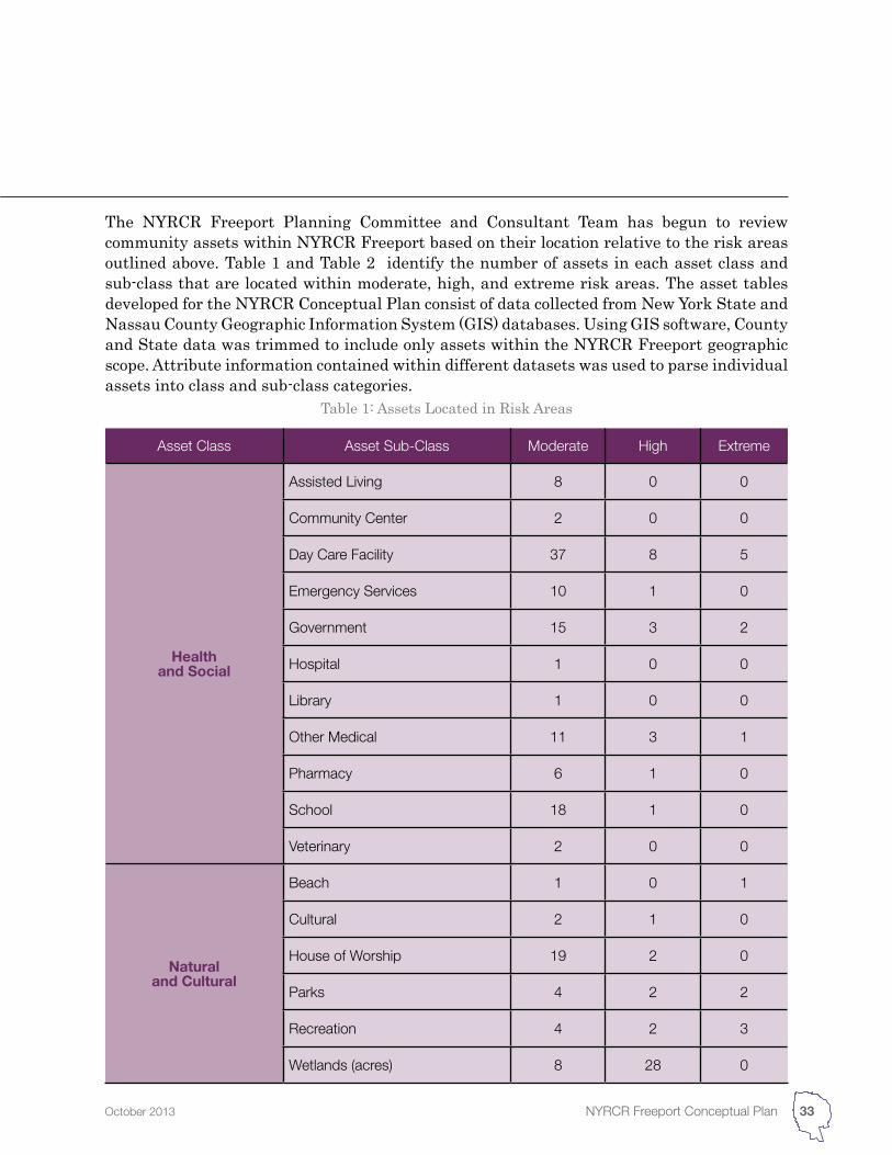
Table 1: Assets Located in Risk Areas
Asset Class Asset Sub-Class Moderate High Extreme
Health and Social
Assisted Living 8 0 0
Community Center 2 0 0
Day Care Facility 37 8 5
Emergency Services 10 1 0
Government 15 3 2
Hospital 1 0 0
Library 1 0 0
Other Medical 11 3 1
Pharmacy 6 1 0
School 18 1 0
Veterinary 2 0 0
Natural and Cultural
Beach 1 0 1
Cultural 2 1 0
House of Worship 19 2 0
Parks 4 2 2
Recreation 4 2 3
Wetlands (acres) 8 28 0
33NYRCR Freeport Conceptual PlanOctober 2013
The NYRCR Freeport Planning Committee and Consultant Team has begun to review community assets within NYRCR Freeport based on their location relative to the risk areas outlined above. Table 1 and Table 2 identify the number of assets in each asset class and sub-class that are located within moderate, high, and extreme risk areas. The asset tables developed for the NYRCR Conceptual Plan consist of data collected from New York State and Nassau County Geographic Information System (GIS) databases. Using GIS software, County and State data was trimmed to include only assets within the NYRCR Freeport geographic scope. Attribute information contained within different datasets was used to parse individual assets into class and sub-class categories.
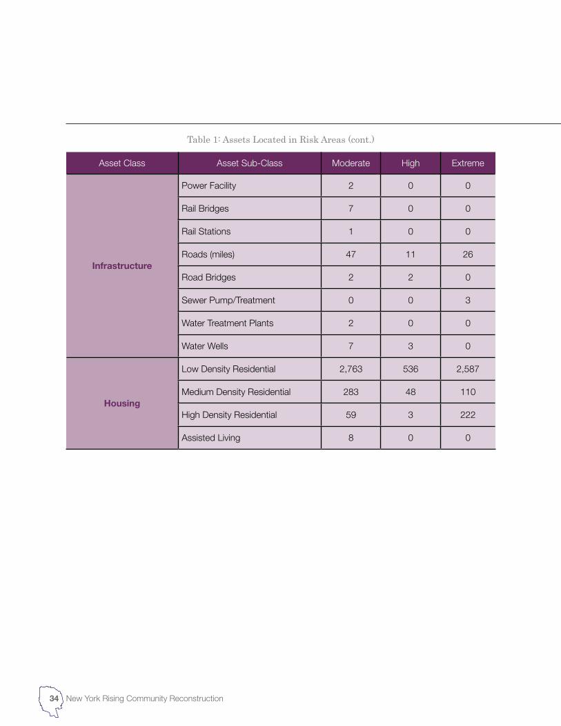
Asset Class Asset Sub-Class Moderate High Extreme
Infrastructure
Power Facility 2 0 0
Rail Bridges 7 0 0
Rail Stations 1 0 0
Roads (miles) 47 11 26
Road Bridges 2 2 0
Sewer Pump/Treatment 0 0 3
Water Treatment Plants 2 0 0
Water Wells 7 3 0
Housing
Low Density Residential 2,763 536 2,587
Medium Density Residential 283 48 110
High Density Residential 59 3 222
Assisted Living 8 0 0
Table 1: Assets Located in Risk Areas (cont.)
34 New York Rising Community Reconstruction
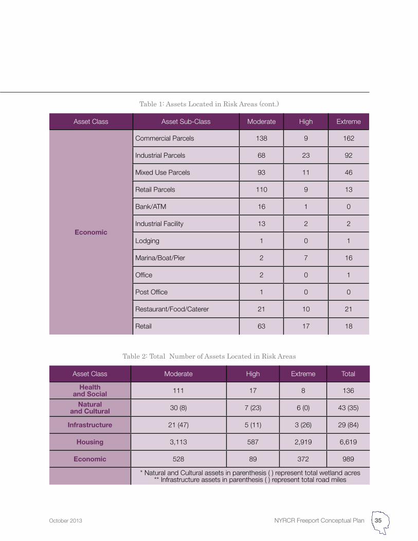
Table 2: Total Number of Assets Located in Risk Areas
Asset Class Moderate High Extreme Total
Health and Social 111 17 8 136
Natural and Cultural 30 (8) 7 (23) 6 (0) 43 (35)
Infrastructure 21 (47) 5 (11) 3 (26) 29 (84)
Housing 3,113 587 2,919 6,619
Economic 528 89 372 989
* Natural and Cultural assets in parenthesis ( ) represent total wetland acres** Infrastructure assets in parenthesis ( ) represent total road miles
Asset Class Asset Sub-Class Moderate High Extreme
Economic
Commercial Parcels 138 9 162
Industrial Parcels 68 23 92
Mixed Use Parcels 93 11 46
Retail Parcels 110 9 13
Bank/ATM 16 1 0
Industrial Facility 13 2 2
Lodging 1 0 1
Marina/Boat/Pier 2 7 16
Office 2 0 1
Post Office 1 0 0
Restaurant/Food/Caterer 21 10 21
Retail 63 17 18
Table 1: Assets Located in Risk Areas (cont.)
35NYRCR Freeport Conceptual PlanOctober 2013
36 New York Rising Community Reconstruction
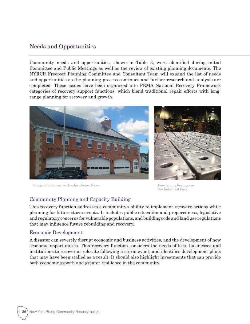
Community Planning and Capacity BuildingThis recovery function addresses a community’s ability to implement recovery actions while planning for future storm events. It includes public education and preparedness, legislative and regulatory concerns for vulnerable populations, and building code and land use regulations that may influence future rebuilding and recovery.
Economic DevelopmentA disaster can severely disrupt economic and business activities, and the development of new economic opportunities. This recovery function considers the needs of local businesses and institutions to recover or relocate following a storm event, and identifies development plans that may have been stalled as a result. It should also highlight investments that can provide both economic growth and greater resilience in the community.
Community needs and opportunities, shown in Table 3, were identified during initial Committee and Public Meetings as well as the review of existing planning documents. The NYRCR Freeport Planning Committee and Consultant Team will expand the list of needs and opportunities as the planning process continues and further research and analysis are completed. These issues have been organized into FEMA National Recovery Framework categories of recovery support functions, which blend traditional repair efforts with long-range planning for recovery and growth.
Freeport Firehouse with solar photovoltaics Functioning business in the Industrial Park
Needs and Opportunities
37NYRCR Freeport Conceptual PlanOctober 2013
Health and Social ServicesThis recovery function considers the strategies and management measures needed to ensure that health care facilities and essential social services are accessible at an appropriate level. These measures are specifically important to protecting the health and wellbeing of socially vulnerable populations. Long-term effects are also relevant, such as post-disaster health impacts on residents and recovery workers.
HousingThe housing recovery support function establishes needs and opportunities relative to community housing goals, prioritizing damaged and at-risk areas. The type and location of housing should consider current and expected demand, the availability of rental and non-rental units, and the range of housing available relative to community income levels. The effects of previous events on building code requirements can also significantly impact housing-related needs.
InfrastructureInfrastructure needs and opportunities include a number of essential services, from flood control measures to wastewater treatment facilities. These issues should closely align with the community assets identified by the asset inventory, and recovery efforts should focus on opportunities to rebuild in a way that decreases vulnerability to future impacts.
Natural and Cultural ResourcesThis recovery function addresses damage to natural and cultural resources, and the actions that should be taken to preserve, rehabilitate or restore these assets or services to their initial state. Natural systems have been shown to mitigate storm impacts, and offer significant environmental and commercial benefits such as stormwater management and recreational opportunities.
Table 3: Community needs and opportunities identified by NYRCR Freeport
Recovery Function Community Needs and Opportunities
Community Planning and Capacity Building
N – improved communication between Town and Village Authorities and relief organizations during emergency scenarios
O – build regional partnerships between response organizations
Economic Development
N – less vulnerable, year-round economic generators
N – support and incentives for small-medium industrial businesses
O – refresh regulatory framework and develop design guidelines for resilient and business-friendly precincts
O – protect and redevelop the Industrial Park
O – redesign the Nautical Mile
O – create a resiliency learning center
O – create opportunities for builders of flood mitigation materials and systems to locate in the Village
Health and Social Services
O – create “no-fail emergency centers” that are accessible during flooding and storm events to allow community to charge phones, distribute important information and provide a safe haven for vulnerable populations
Housing
N – a range of housing types that are attractive to all income levels and family types
N – clear and consistent design guidelines /requirements for rebuilding more resilient housing
N – reduce the proportion of housing in extreme and high risk areas
O – increase apartment, condominium and co-operative housing options through downtown and LIRR station area revitalization
O – maintain and expand affordable housing options
O – educate residents in extreme risk areas on the potential safety and financial risks of rebuilding
38 New York Rising Community Reconstruction
Recovery Function Community Needs and Opportunities
Infrastructure
N – decrease the vulnerability of Power Plant 2 and Freeport’s energy supply
N – a more resilient and accessible location for Department of Public Works and rescue equipment
N – improved upstream stormwater management
O – create an energy center around Power Plant 1 and allow for black start of PP 1 and 2
O – create network to support microgrid technology
O – expand open space areas in low-income areas (addressing upstream stormwater issues)
O – develop/enhance natural storm buffer systems and living coast lines
O – investigate new locations for Department of Public Works
Natural and Cultural Resources
N – clean up and protection of contaminated sites
N – protection of ecological systems and services from climate change and development
N – mitigation and adaptation measures which balance human and ecosystem protection
O – develop process for acquisition of severely damaged properties for flood mitigation, stormwater retention and wildlife habitat
O – use cost/benefit analysis phase of NYRCR to clearly demonstrate the environmental impacts of each storm protection measure
O – raise awareness of the co-benefits of ecological preservation, for example, the role the marshes and barrier beaches play in storm protection and the role inland parks and preserves play in mitigating runoff and pollution
O – leverage cultural institutions (schools, libraries, learning centers) as emergency information and meeting centers, as well as climate change education and awareness centers
Table 3: Community needs and opportunities identified by NYRCR Freeport (cont.)
39NYRCR Freeport Conceptual PlanOctober 2013
Table 4: Strategies to achieve rebuilding, resilience, and economic growth
Recovery Function Community Strategies
Community Planning and Capacity Building
Improve local emergency action planning efforts to incorporate lessons learned from Hurricane Sandy.
Create a stockpile of portable generators that can be readily deployed throughout the community.
Create a single source of information for all emergency management and assistance programs.
Revise zoning regulations to accommodate resilient rebuilding.
Increase duration of backup power sources for cellular towers.
Encourage transit-oriented development around train stations and downtown centers.
Economic
Encourage developers, contractors, and homeowners to incorporate energy efficiency measures in new buildings or renovations.
Improve downtown areas by encouraging development and improving public spaces.
Provide a greater variety of housing options around downtown centers and transit hubs.
Health and Social Services
Ensure that critical facilities, including emergency shelters, are equipped with generators capable of providing power during and after major storm events.
Ensure that emergency shelters are accessible and able to accommodate the needs of community members.
Provide safe parking areas for residents in evacuation zones to store personal vehicles during major storm events.
40 New York Rising Community Reconstruction
The strategies included in the NYRCR Conceptual Plan were developed to achieve rebuilding goals, increase resilience and promote economic growth within the community of NYRCR Freeport. At this stage of the planning process, many of the strategies currently outlined are a product of preliminary feedback and analysis, and focus more heavily on regional issues. After completion of the assessment and public outreach phase, the NYRCR Freeport Planning Committee and Consultant Team will have the information necessary to develop a comprehensive set of strategies that better reflect the needs and opportunities of NYRCR Freeport.
The strategies outlined in this section have been organized by the FEMA’s National Recovery Framework’s six recovery support functions, which include both traditional repair efforts and long-term planning goals. To the extent possible, they consider the risk faced by critical and non-critical community assets, the availability of funding and the potential synergies with other planned or ongoing initiatives.
Key Strategies and Projects
Strategies
Recovery Function Community Strategies
Housing
Develop a housing plan to accommodate the region’s diversifying population and the next generation of its residents.
Provide homeowners with support for purchasing and installing personal generators for emergency use.
Provide support and assistance for residents interested in moving out of extreme-risk areas.
Create a comprehensive housing resource for displaced residents.
Infrastructure
Protect major streets and roads against storm impacts to facilitate evacuation and emergency services during and after major events.
Reduce the duration and frequency of power outages by protecting electrical distribution infrastructure, including overhead lines and substations from storm damage.
Support the use of small-scale renewable energy generation to provide power for homes and businesses.
Support decentralization and diversification of power generation and supply and the development of self-sufficient areas.
Protect wastewater infrastructure from storm damage and ensure that power outages do not impact system operation.
Install check valves on sewers to prevent backup and flooding.
Prevent damaged fuel tanks from contaminating flood water.
Modernize the energy distribution network with smart technologies.
Invest in utility-scale renewable energy generation.
Natural and Cultural
Resources
Establish a coordinated plan to protect and maintain the region’s natural water resources, including green infrastructure for stormwater management.
Establish and support regional development guidelines that preserve open spaces and protect the natural environment.
Protect inlets and shorelines to minimize the impact of storm surge.
Expand and increase access to public waterfront areas.
Table 4: Strategies to achieve rebuilding, resilience, and economic growth (cont.)
41NYRCR Freeport Conceptual PlanOctober 2013
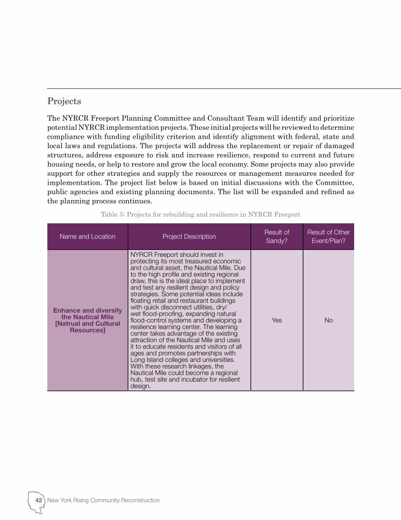
Name and Location Project DescriptionResult of Sandy?
Result of Other Event/Plan?
Enhance and diversify the Nautical Mile
[Natrual and Cultural Resources]
NYRCR Freeport should invest in protecting its most treasured economic and cultural asset, the Nautical Mile. Due to the high profile and existing regional draw, this is the ideal place to implement and test any resilient design and policy strategies. Some potential ideas include floating retail and restaurant buildings with quick disconnect utilities, dry/wet flood-proofing, expanding natural flood-control systems and developing a resilience learning center. The learning center takes advantage of the existing attraction of the Nautical Mile and uses it to educate residents and visitors of all ages and promotes partnerships with Long Island colleges and universities. With these research linkages, the Nautical Mile could become a regional hub, test site and incubator for resilient design.
Yes No
Table 5: Projects for rebuilding and resilience in NYRCR Freeport
42 New York Rising Community Reconstruction
The NYRCR Freeport Planning Committee and Consultant Team will identify and prioritize potential NYRCR implementation projects. These initial projects will be reviewed to determine compliance with funding eligibility criterion and identify alignment with federal, state and local laws and regulations. The projects will address the replacement or repair of damaged structures, address exposure to risk and increase resilience, respond to current and future housing needs, or help to restore and grow the local economy. Some projects may also provide support for other strategies and supply the resources or management measures needed for implementation. The project list below is based on initial discussions with the Committee, public agencies and existing planning documents. The list will be expanded and refined as the planning process continues.
Projects
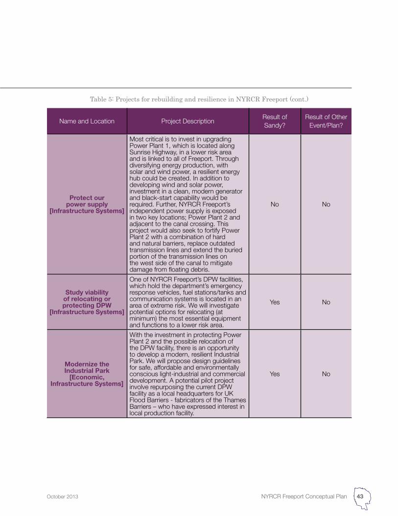
Name and Location Project DescriptionResult of Sandy?
Result of Other Event/Plan?
Protect our power supply
[Infrastructure Systems]
Most critical is to invest in upgrading Power Plant 1, which is located along Sunrise Highway, in a lower risk area and is linked to all of Freeport. Through diversifying energy production, with solar and wind power, a resilient energy hub could be created. In addition to developing wind and solar power, investment in a clean, modern generator and black-start capability would be required. Further, NYRCR Freeport’s independent power supply is exposed in two key locations; Power Plant 2 and adjacent to the canal crossing. This project would also seek to fortify Power Plant 2 with a combination of hard and natural barriers, replace outdated transmission lines and extend the buried portion of the transmission lines on the west side of the canal to mitigate damage from floating debris.
No No
Study viability of relocating or protecting DPW
[Infrastructure Systems]
One of NYRCR Freeport’s DPW facilities, which hold the department’s emergency response vehicles, fuel stations/tanks and communication systems is located in an area of extreme risk. We will investigate potential options for relocating (at minimum) the most essential equipment and functions to a lower risk area.
Yes No
Modernize the Industrial Park
[Economic, Infrastructure Systems]
With the investment in protecting Power Plant 2 and the possible relocation of the DPW facility, there is an opportunity to develop a modern, resilient Industrial Park. We will propose design guidelines for safe, affordable and environmentally conscious light-industrial and commercial development. A potential pilot project involve repurposing the current DPW facility as a local headquarters for UK Flood Barriers - fabricators of the Thames Barriers – who have expressed interest in local production facility.
Yes No
Table 5: Projects for rebuilding and resilience in NYRCR Freeport (cont.)
43NYRCR Freeport Conceptual PlanOctober 2013
Name and Location Project DescriptionResult of Sandy?
Result of Other Event/Plan?
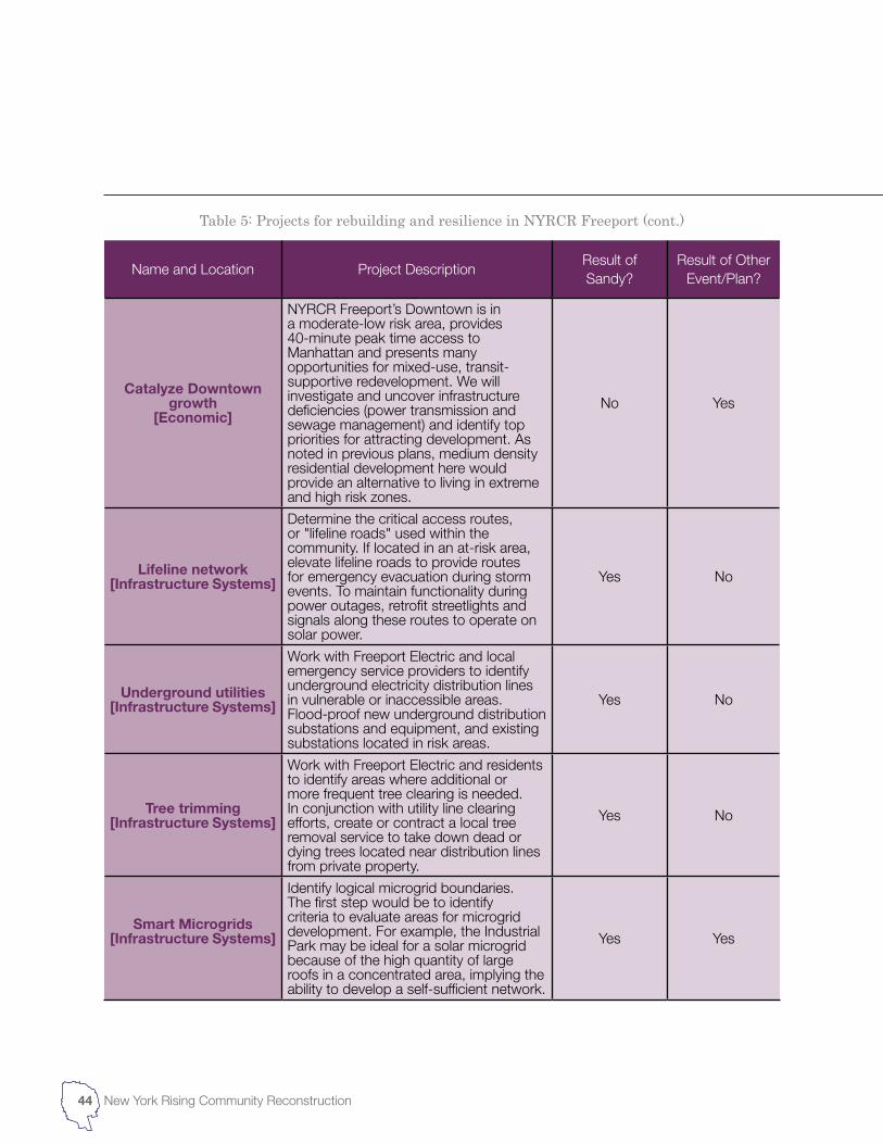
Catalyze Downtown growth
[Economic]
NYRCR Freeport’s Downtown is in a moderate-low risk area, provides 40-minute peak time access to Manhattan and presents many opportunities for mixed-use, transit-supportive redevelopment. We will investigate and uncover infrastructure deficiencies (power transmission and sewage management) and identify top priorities for attracting development. As noted in previous plans, medium density residential development here would provide an alternative to living in extreme and high risk zones.
No Yes
Lifeline network[Infrastructure Systems]
Determine the critical access routes, or "lifeline roads" used within the community. If located in an at-risk area, elevate lifeline roads to provide routes for emergency evacuation during storm events. To maintain functionality during power outages, retrofit streetlights and signals along these routes to operate on solar power.
Yes No
Underground utilities[Infrastructure Systems]
Work with Freeport Electric and local emergency service providers to identify underground electricity distribution lines in vulnerable or inaccessible areas. Flood-proof new underground distribution substations and equipment, and existing substations located in risk areas.
Yes No
Tree trimming[Infrastructure Systems]
Work with Freeport Electric and residents to identify areas where additional or more frequent tree clearing is needed. In conjunction with utility line clearing efforts, create or contract a local tree removal service to take down dead or dying trees located near distribution lines from private property.
Yes No
Smart Microgrids[Infrastructure Systems]
Identify logical microgrid boundaries. The first step would be to identify criteria to evaluate areas for microgrid development. For example, the Industrial Park may be ideal for a solar microgrid because of the high quantity of large roofs in a concentrated area, implying the ability to develop a self-sufficient network.
Yes Yes
Table 5: Projects for rebuilding and resilience in NYRCR Freeport (cont.)
44 New York Rising Community Reconstruction
Name and Location Project DescriptionResult of Sandy?
Result of Other Event/Plan?
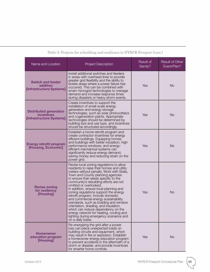
Switch and feeder addition
[Infrastructure Systems]
Install additional switches and feeders in areas with overhead lines to provide greater grid flexibility and the ability to isolate areas where a power failure has occurred. This can be combined with smart microgrid technologies to manage demand and increase response times during disasters or heavy storm events.
Yes No
Distributed generation incentives
[Infrastructure Systems]
Create incentives to support the installation of small-scale energy generation and energy storage technologies, such as solar photovoltaics and cogeneration plants. Appropriate technologies should be determined by building size and use type, and incentives should be structured accordingly.
Yes No
Energy retrofit program[Housing, Economic]
Establish a home retrofit program and create contractor incentives for energy efficient buildings. Equipping homes and buildings with better insulation, high performance windows, and energy-efficient mechanical systems can significantly reduce energy demand, saving money and reducing strain on the power grid.
Yes No
Revise zoning for resiliency
[Housing]
Revise local zoning regulations to allow residents to raise their homes and utility meters without penalty. Work with State, Town and County planning agencies to ensure that needs specific to the community’s rebuilding efforts are not omitted or overlooked.In addition, ensure local planning and zoning regulations support the energy retrofit program. Include domestic and commercial energy sustainability standards, such as building and window orientation, shading, and insulation, which can reduce dependency on the energy network for heating, cooling and lighting during emergency scenarios and on a daily basis.
Yes No
Homeowner education program
[Housing]
Re-energizing the grid after a power loss can place unexpected loads on building circuits and equipment, which may result in fire or explosion. Establish a homeowner energy education program to prevent accidents in the aftermath of a storm or disaster, and provide incentives for smarter home controls.
Yes No
Table 5: Projects for rebuilding and resilience in NYRCR Freeport (cont.)
45NYRCR Freeport Conceptual PlanOctober 2013
Name and Location Project DescriptionResult of Sandy?
Result of Other Event/Plan?
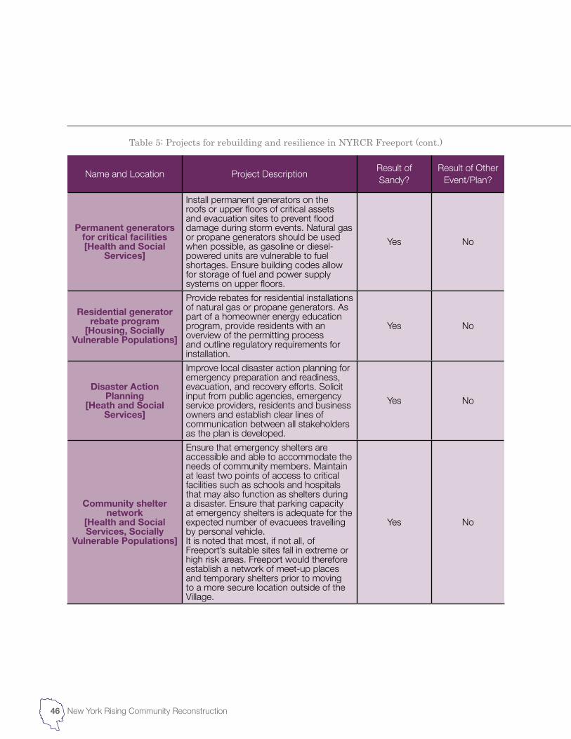
Permanent generators for critical facilities[Health and Social
Services]
Install permanent generators on the roofs or upper floors of critical assets and evacuation sites to prevent flood damage during storm events. Natural gas or propane generators should be used when possible, as gasoline or diesel-powered units are vulnerable to fuel shortages. Ensure building codes allow for storage of fuel and power supply systems on upper floors.
Yes No
Residential generator rebate program
[Housing, Socially Vulnerable Populations]
Provide rebates for residential installations of natural gas or propane generators. As part of a homeowner energy education program, provide residents with an overview of the permitting process and outline regulatory requirements for installation.
Yes No
Disaster Action Planning
[Heath and Social Services]
Improve local disaster action planning for emergency preparation and readiness, evacuation, and recovery efforts. Solicit input from public agencies, emergency service providers, residents and business owners and establish clear lines of communication between all stakeholders as the plan is developed.
Yes No
Community shelter network
[Health and Social Services, Socially
Vulnerable Populations]
Ensure that emergency shelters are accessible and able to accommodate the needs of community members. Maintain at least two points of access to critical facilities such as schools and hospitals that may also function as shelters during a disaster. Ensure that parking capacity at emergency shelters is adequate for the expected number of evacuees travelling by personal vehicle.It is noted that most, if not all, of Freeport’s suitable sites fall in extreme or high risk areas. Freeport would therefore establish a network of meet-up places and temporary shelters prior to moving to a more secure location outside of the Village.
Yes No
Table 5: Projects for rebuilding and resilience in NYRCR Freeport (cont.)
46 New York Rising Community Reconstruction
Name and Location Project DescriptionResult of Sandy?
Result of Other Event/Plan?
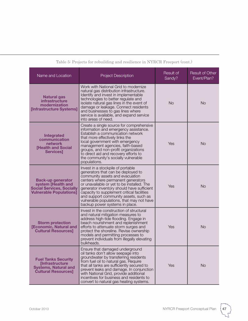
Natural gas infrastructure modernization
[Infrastructure Systems]
Work with National Grid to modernize natural gas distribution infrastructure. Identify and invest in implementable technologies to better regulate and isolate natural gas lines in the event of damage or leakage. Connect residents and businesses to gas lines where service is available, and expand service into areas of need.
No No
Integrated communication
network[Health and Social
Services]
Create a single source for comprehensive information and emergency assistance. Establish a communication network that more effectively links the local government with emergency management agencies, faith-based groups, and non-profit organizations to direct aid and recovery efforts to the community's socially vulnerable populations.
Yes No
Back-up generator system [Health and
Social Services, Socially Vulnerable Populations]
Invest in a stockpile of portable generators that can be deployed to community assets and evacuation centers where permanent generators or unavailable or yet to be installed. The generator inventory should have sufficient capacity to supplement critical facilities and support community assets, such as vulnerable populations, that may not have backup power systems in place.
Yes No
Storm protection[Economic, Natural and
Cultural Resources]
Invest in the construction of structural and natural mitigation measures to address high-tide flooding. Engage in beach nourishment and replenishment efforts to attenuate storm surges and protect the shoreline. Revise ownership models and permitting processes to prevent individuals from illegally elevating bulkheads.
Yes No
Fuel Tanks Security[Infrastructure
Systems, Natural and Cultural Resources]
Ensure that damaged underground oil tanks don’t allow seepage into groundwater by transferring residents from fuel oil to natural gas. Require that all tanks are sufficiently secured to prevent leaks and damage. In conjunction with National Grid, provide additional incentives for business and residents to convert to natural gas heating systems.
Yes No
Table 5: Projects for rebuilding and resilience in NYRCR Freeport (cont.)
47NYRCR Freeport Conceptual PlanOctober 2013
Name and Location Project DescriptionResult of Sandy?
Result of Other Event/Plan?
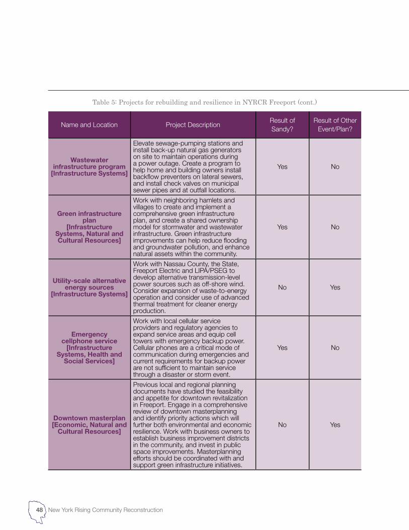
Wastewater infrastructure program
[Infrastructure Systems]
Elevate sewage-pumping stations and install back-up natural gas generators on site to maintain operations during a power outage. Create a program to help home and building owners install backflow preventers on lateral sewers, and install check valves on municipal sewer pipes and at outfall locations.
Yes No
Green infrastructure plan
[Infrastructure Systems, Natural and Cultural Resources]
Work with neighboring hamlets and villages to create and implement a comprehensive green infrastructure plan, and create a shared ownership model for stormwater and wastewater infrastructure. Green infrastructure improvements can help reduce flooding and groundwater pollution, and enhance natural assets within the community.
Yes No
Utility-scale alternative energy sources
[Infrastructure Systems]
Work with Nassau County, the State, Freeport Electric and LIPA/PSEG to develop alternative transmission-level power sources such as off-shore wind. Consider expansion of waste-to-energy operation and consider use of advanced thermal treatment for cleaner energy production.
No Yes
Emergency cellphone service
[Infrastructure Systems, Health and
Social Services]
Work with local cellular service providers and regulatory agencies to expand service areas and equip cell towers with emergency backup power. Cellular phones are a critical mode of communication during emergencies and current requirements for backup power are not sufficient to maintain service through a disaster or storm event.
Yes No
Downtown masterplan[Economic, Natural and
Cultural Resources]
Previous local and regional planning documents have studied the feasibility and appetite for downtown revitalization in Freeport. Engage in a comprehensive review of downtown masterplanning and identify priority actions which will further both environmental and economic resilience. Work with business owners to establish business improvement districts in the community, and invest in public space improvements. Masterplanning efforts should be coordinated with and support green infrastructure initiatives.
No Yes
Table 5: Projects for rebuilding and resilience in NYRCR Freeport (cont.)
48 New York Rising Community Reconstruction
Name and Location Project DescriptionResult of Sandy?
Result of Other Event/Plan?
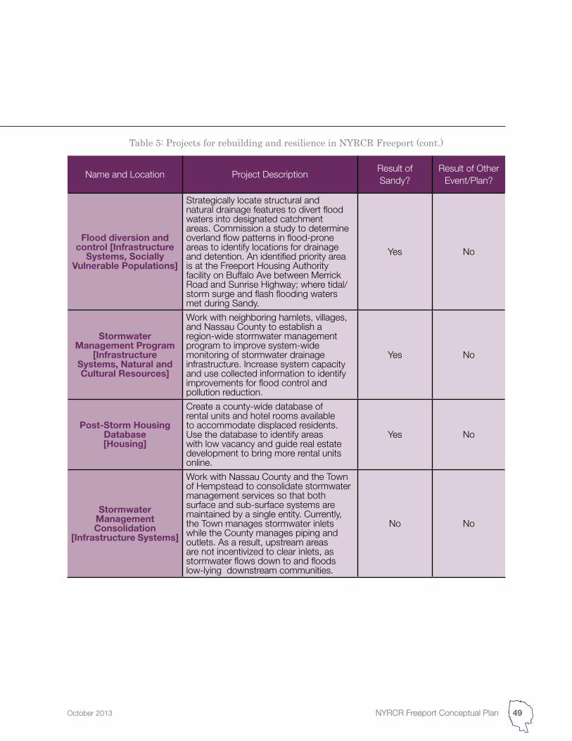
Flood diversion and control [Infrastructure
Systems, Socially Vulnerable Populations]
Strategically locate structural and natural drainage features to divert flood waters into designated catchment areas. Commission a study to determine overland flow patterns in flood-prone areas to identify locations for drainage and detention. An identified priority area is at the Freeport Housing Authority facility on Buffalo Ave between Merrick Road and Sunrise Highway; where tidal/storm surge and flash flooding waters met during Sandy.
Yes No
Stormwater Management Program
[Infrastructure Systems, Natural and Cultural Resources]
Work with neighboring hamlets, villages, and Nassau County to establish a region-wide stormwater management program to improve system-wide monitoring of stormwater drainage infrastructure. Increase system capacity and use collected information to identify improvements for flood control and pollution reduction.
Yes No
Post-Storm Housing Database[Housing]
Create a county-wide database of rental units and hotel rooms available to accommodate displaced residents. Use the database to identify areas with low vacancy and guide real estate development to bring more rental units online.
Yes No
Stormwater Management Consolidation
[Infrastructure Systems]
Work with Nassau County and the Town of Hempstead to consolidate stormwater management services so that both surface and sub-surface systems are maintained by a single entity. Currently, the Town manages stormwater inlets while the County manages piping and outlets. As a result, upstream areas are not incentivized to clear inlets, as stormwater flows down to and floods low-lying downstream communities.
No No
Table 5: Projects for rebuilding and resilience in NYRCR Freeport (cont.)
49NYRCR Freeport Conceptual PlanOctober 2013
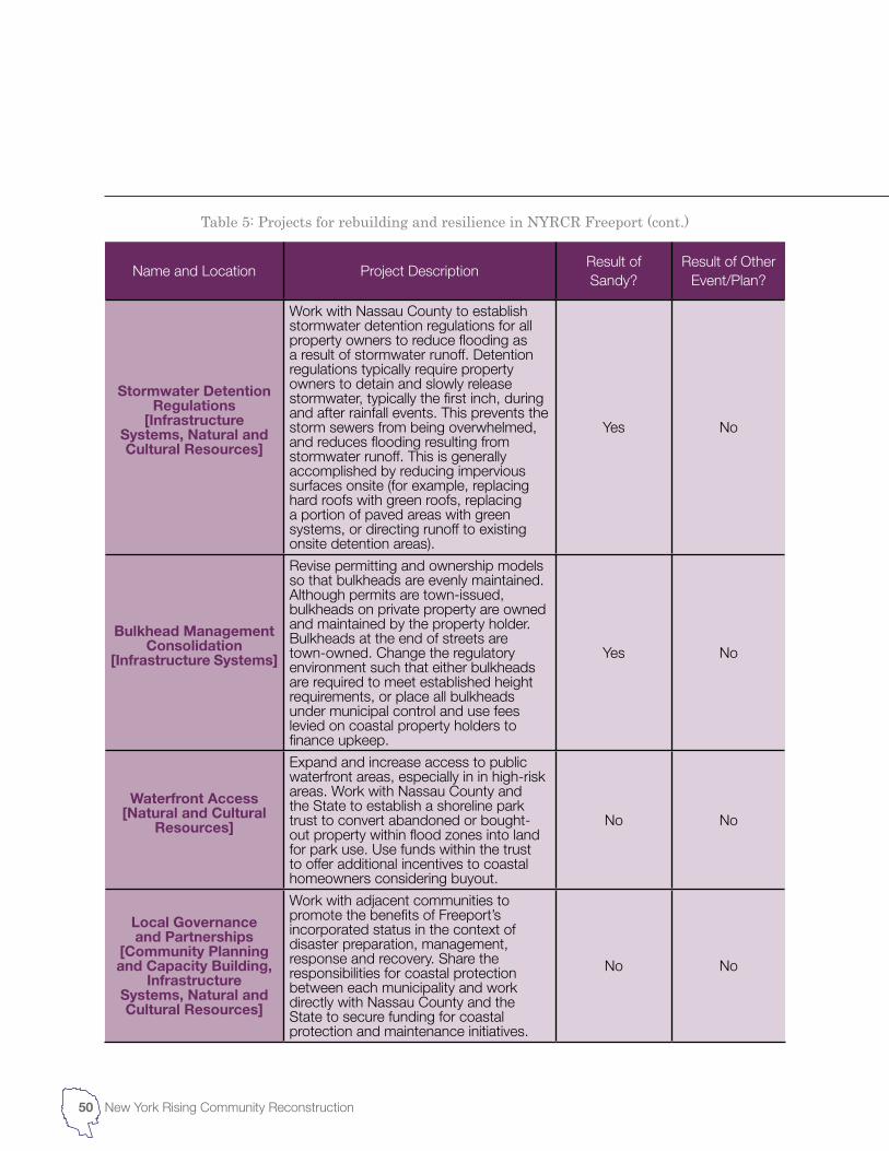
Name and Location Project DescriptionResult of Sandy?
Result of Other Event/Plan?
Stormwater Detention Regulations
[Infrastructure Systems, Natural and Cultural Resources]
Work with Nassau County to establish stormwater detention regulations for all property owners to reduce flooding as a result of stormwater runoff. Detention regulations typically require property owners to detain and slowly release stormwater, typically the first inch, during and after rainfall events. This prevents the storm sewers from being overwhelmed, and reduces flooding resulting from stormwater runoff. This is generally accomplished by reducing impervious surfaces onsite (for example, replacing hard roofs with green roofs, replacing a portion of paved areas with green systems, or directing runoff to existing onsite detention areas).
Yes No
Bulkhead Management Consolidation
[Infrastructure Systems]
Revise permitting and ownership models so that bulkheads are evenly maintained. Although permits are town-issued, bulkheads on private property are owned and maintained by the property holder. Bulkheads at the end of streets are town-owned. Change the regulatory environment such that either bulkheads are required to meet established height requirements, or place all bulkheads under municipal control and use fees levied on coastal property holders to finance upkeep.
Yes No
Waterfront Access[Natural and Cultural
Resources]
Expand and increase access to public waterfront areas, especially in in high-risk areas. Work with Nassau County and the State to establish a shoreline park trust to convert abandoned or bought-out property within flood zones into land for park use. Use funds within the trust to offer additional incentives to coastal homeowners considering buyout.
No No
Local Governance and Partnerships
[Community Planning and Capacity Building,
Infrastructure Systems, Natural and Cultural Resources]
Work with adjacent communities to promote the benefits of Freeport’s incorporated status in the context of disaster preparation, management, response and recovery. Share the responsibilities for coastal protection between each municipality and work directly with Nassau County and the State to secure funding for coastal protection and maintenance initiatives.
No No
Table 5: Projects for rebuilding and resilience in NYRCR Freeport (cont.)
50 New York Rising Community Reconstruction
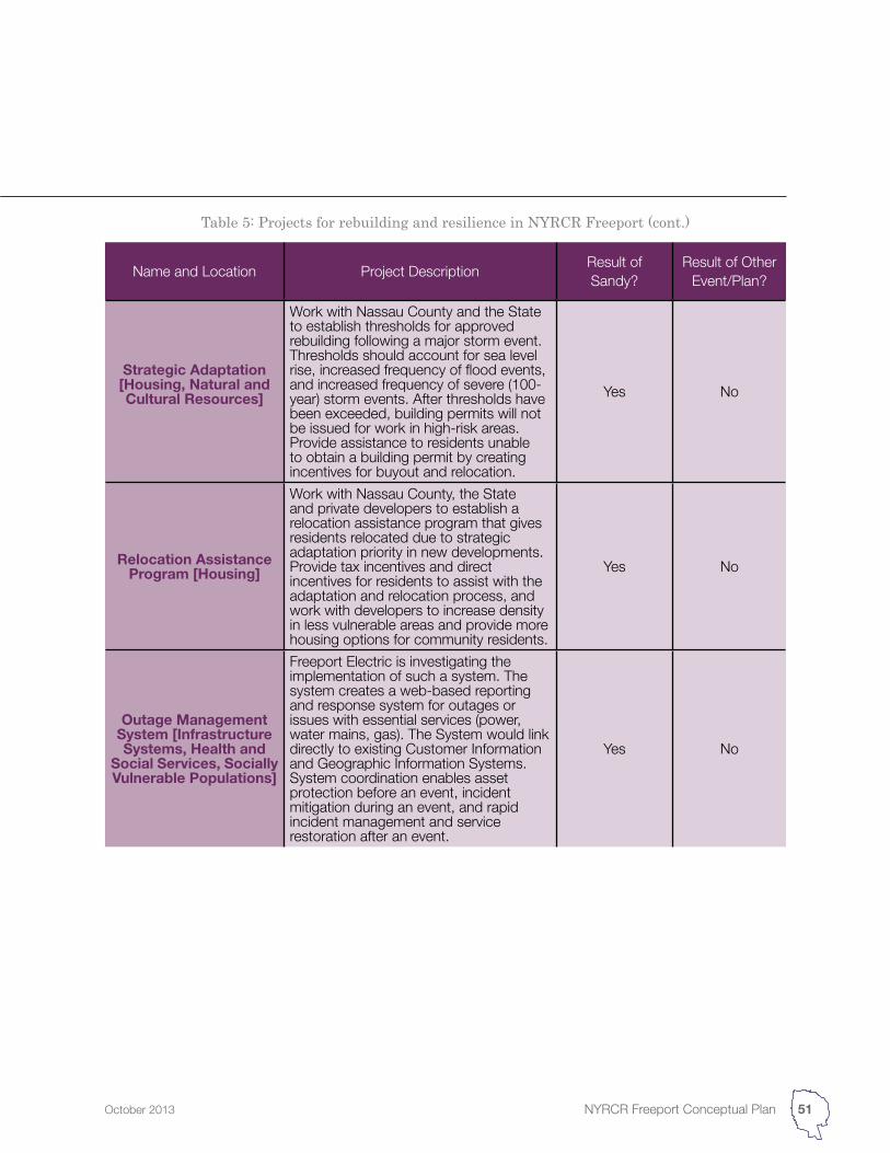
Name and Location Project DescriptionResult of Sandy?
Result of Other Event/Plan?
Strategic Adaptation[Housing, Natural and Cultural Resources]
Work with Nassau County and the State to establish thresholds for approved rebuilding following a major storm event. Thresholds should account for sea level rise, increased frequency of flood events, and increased frequency of severe (100-year) storm events. After thresholds have been exceeded, building permits will not be issued for work in high-risk areas. Provide assistance to residents unable to obtain a building permit by creating incentives for buyout and relocation.
Yes No
Relocation Assistance Program [Housing]
Work with Nassau County, the State and private developers to establish a relocation assistance program that gives residents relocated due to strategic adaptation priority in new developments. Provide tax incentives and direct incentives for residents to assist with the adaptation and relocation process, and work with developers to increase density in less vulnerable areas and provide more housing options for community residents.
Yes No
Outage Management System [Infrastructure Systems, Health and
Social Services, Socially Vulnerable Populations]
Freeport Electric is investigating the implementation of such a system. The system creates a web-based reporting and response system for outages or issues with essential services (power, water mains, gas). The System would link directly to existing Customer Information and Geographic Information Systems. System coordination enables asset protection before an event, incident mitigation during an event, and rapid incident management and service restoration after an event.
Yes No
Table 5: Projects for rebuilding and resilience in NYRCR Freeport (cont.)
51NYRCR Freeport Conceptual PlanOctober 2013
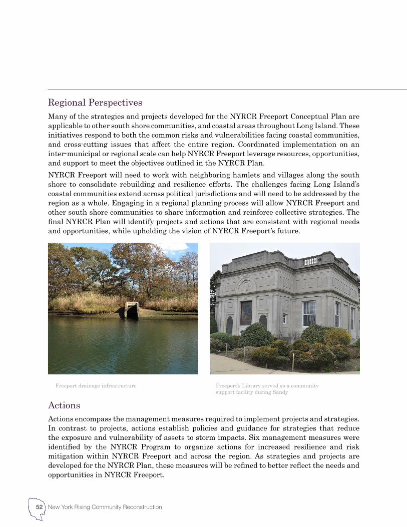
Freeport drainage infrastructure Freeport’s Library served as a community support facility during Sandy
52 New York Rising Community Reconstruction
Actions encompass the management measures required to implement projects and strategies. In contrast to projects, actions establish policies and guidance for strategies that reduce the exposure and vulnerability of assets to storm impacts. Six management measures were identified by the NYRCR Program to organize actions for increased resilience and risk mitigation within NYRCR Freeport and across the region. As strategies and projects are developed for the NYRCR Plan, these measures will be refined to better reflect the needs and opportunities in NYRCR Freeport.
Actions
Many of the strategies and projects developed for the NYRCR Freeport Conceptual Plan are applicable to other south shore communities, and coastal areas throughout Long Island. These initiatives respond to both the common risks and vulnerabilities facing coastal communities, and cross-cutting issues that affect the entire region. Coordinated implementation on an inter-municipal or regional scale can help NYRCR Freeport leverage resources, opportunities, and support to meet the objectives outlined in the NYRCR Plan.NYRCR Freeport will need to work with neighboring hamlets and villages along the south shore to consolidate rebuilding and resilience efforts. The challenges facing Long Island’s coastal communities extend across political jurisdictions and will need to be addressed by the region as a whole. Engaging in a regional planning process will allow NYRCR Freeport and other south shore communities to share information and reinforce collective strategies. The final NYRCR Plan will identify projects and actions that are consistent with regional needs and opportunities, while upholding the vision of NYRCR Freeport’s future.
Regional Perspectives
53NYRCR Freeport Conceptual PlanOctober 2013
Conserve, Restore, and Enhance Natural Protective FeaturesThese management actions use the natural landscape to promote safety and livability while reducing costs. Approaches include natural flood storage capacity, wetland conservation, and transfer of development rights.
Resilient ConstructionThese actions ensure that proper construction techniques are required to provide an adequate level of safety for structure and occupants. This includes new construction and resilient retrofitting, which may be necessary where existing development in risk areas cannot be relocated or adapted.
Structural DefensesStructural defenses are natural or engineered constructions designed to resist storm impacts. They may act as a permanent safety measure or as temporary protection as a project or strategy is deployed.
Land Use Planning and RegulationThese actions can reduce storm impacts through incorporating resilience and sustainability measures into planning regulations. Land use management can increase resilience and enhance community value while protecting natural resources and lowering costs.
Market-Based MethodsMarket-based actions reduce vulnerability by incorporating the cost of risk into land and land use costs. This is achieved by establishing prices, taxes and fees that account for the economic effect of storm impacts. As a result, owners and developers can evaluate the value of a location based on the cost of future use.
Increased Awareness and InformationActions to increase information availability allow better decision making in the rebuilding and resilience-making process. This includes education and outreach programs that provide information and create engagement within the public and private sectors.
54 New York Rising Community Reconstruction
While the NYRCR Freeport Planning Committee and Consultant Team are working with the public to identify and prioritize key strategies for NYRCR Freeport, implementation of these strategies ultimately rest with the appropriate agencies, organizations or actors who are authorized to administer federal funds and able to build the necessary programs or projects.It may be beneficial to reflect on the opportunities and challenges presented by current governmental and service delivery models. There may be better ways to manage and implement necessary improvements within each community, at the inter-municipal or regional level. Numerous studies and reports, along with commentary from NYRCR Planning Committee members, suggest that governance reform and consolidation is long overdue and necessary on Long Island. The recovery process offers an opportunity to step back, reflect, and align government services and bodies to the needs of south shore communities.To successfully implement the projects and strategies outlined in the NYRCR Conceptual Plan, NYRCR Freeport will need to coordinate with the Town of Hempstead, Nassau County, and the State to meet collective recovery and resiliency goals. For major projects, the number of overlapping governmental jurisdictions and service areas within NYRCR Freeport can make the implementation process difficult in some cases. Projects and strategies that affect shared services will require support from other communities within the service territory, and willingness on behalf of the service provider to participate.Water-related projects such as the repair of bulkheads or other waterway structures will require approval from State, County and Village governments, and may need to undergo a comprehensive environmental review. The New York State Department of Environmental Conservation (NYSDEC) issues permits for projects that are in, or have an impact on wetlands and waterways. Most waterfront projects require a joint permit application to be filed with the NYSDEC and the U.S. Army Corps of Engineers (USACE). While this joint application streamlines the submission process, each agency processes the permit application separately, and the application must satisfy the separate concerns and requirements of both before being approved.Coastal projects must also obtain a Coastal Consistency Certification from the NYSDOS before a permit is issued by a State or Federal agency. The goal of this certification is to ensure that the proposed action will not detract from the policies set out in the State’s Coastal Zone Management Act (CZMA). The CZMA also allows municipalities to create local coastal plans, termed Local Waterfront Revitalization Plans (LWRP) by the State. Additionally, the New York State Office of General Services must be consulted for any projects extending into or on State-owned lands. As most of the navigable bodies of water in New York are State-owned, a grant, easement or license from the Office of General Services will be required.The Nassau County Department of Public Works is responsible for the design, construction, repair and maintenance of all streets and bridges under County jurisdiction. Roads and parking fields within NYRCR Freeport are maintained by the Village of Freeport Highway Department. The Departments regulate road improvement, opening and restoration projects,
Implementation Structure
55NYRCR Freeport Conceptual PlanOctober 2013
and issues permits for work performed within a Village right of way. Additionally, the Freeport Highway Department is responsible for the cleaning and maintenance of catch basins and storm water drains located on or along Village sidewalks and roadways. The Highway Department is also responsible for clearing flood debris from roadways and parking fields, constructing barricades and closing streets in response to hurricanes and flooding.The Nassau County Department of Public Works is also responsible for managing the design and construction of County parks and grounds, drains and drainage structures, sewers, and water infrastructure. The Nassau County Sewer and Stormwater Authority is responsible for the operation of Nassau County’s two sewage treatment plants, the Bay Park Sewage Treatment Plant and the Cedar Creek Water Pollution Control Plant, both of which were damaged and suffered outages during Hurricane Sandy. A number of other independent treatment facilities also operate within the County. The Village of Freeport municipal sewer collects sewage generated in NYRCR Freeport, and pumps it into County facilities for treatment. NYRCR Freeport’s stormwater management system is primarily the responsibility of the Village of Freeport and Nassau County. Stormwater in Nassau County is not collected by the sewer system and treated before discharge. Instead, it is collected in groundwater recharge basins or directed to stormwater outfalls located along the south shore. The inter-municipal Nassau County Storm Water Management Program (NCSWMP) was established by the County, in conjunction with the NYSDEC, to provide a framework for municipalities to implement measures to manage stormwater runoff.In NYRCR Freeport, energy services are provided by Freeport Electric. Energy infrastructure assets, such as distribution lines and transformers, are owned by Freeport Electric and operated and managed internally. Natural gas service is provided by National Grid, who owns and operates the distribution system. In addition to support from energy providers, State approval will be needed to implement major projects or programs.The NYRCR Freeport Conceptual plan is the first step in the rebuilding process. As the NYRCR Freeport Planning Committee and Consultant Team moves through the planning and project development process, project implementation will be an important focus. The NYRCR Freeport Planning Committee and Consultant Team will develop a responsibility matrix to guide the implementation of individual strategies and projects. This matrix will identify the agency or agencies responsible for permitting and approval, length of time and level of effort required for implementation.It is possible that government management and services may need to change or evolve in order to respond to the realities presented by Hurricane Sandy and the recovery process. If governmental reform is needed to facilitate implementation of the NYRCR Freeport Plan, the NYRCR Freeport Planning Committee and Consultant Team will note how the government can evolve to respond to these new realities.
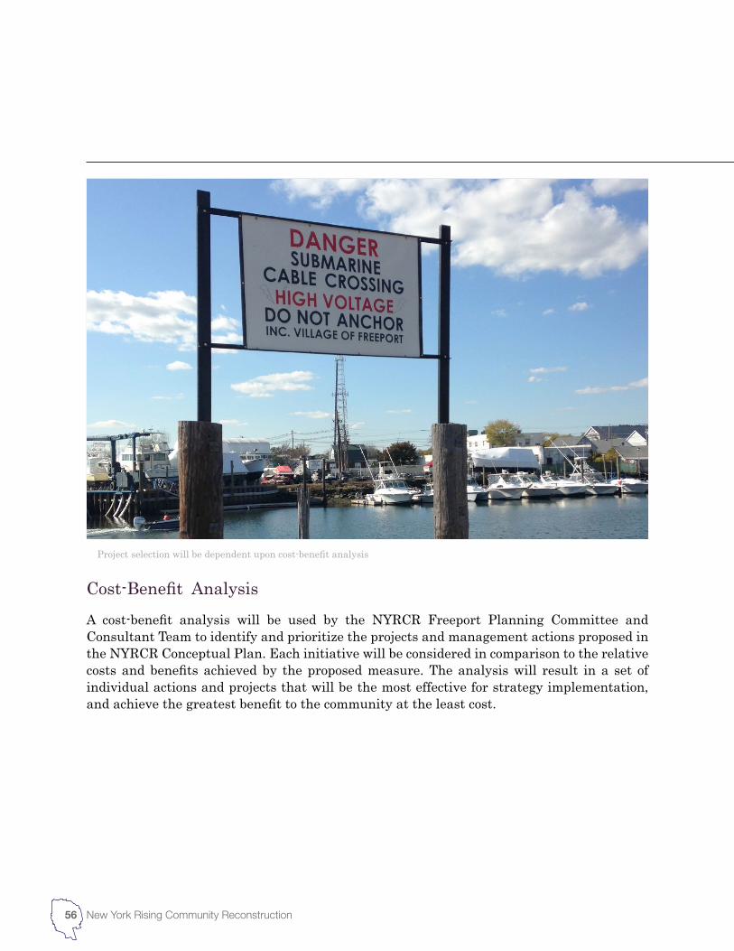
56 New York Rising Community Reconstruction
A cost-benefit analysis will be used by the NYRCR Freeport Planning Committee and Consultant Team to identify and prioritize the projects and management actions proposed in the NYRCR Conceptual Plan. Each initiative will be considered in comparison to the relative costs and benefits achieved by the proposed measure. The analysis will result in a set of individual actions and projects that will be the most effective for strategy implementation, and achieve the greatest benefit to the community at the least cost.
Project selection will be dependent upon cost-benefit analysis
Cost-Benefit Analysis


3Public Engagement
60 New York Rising Community Reconstruction
The strategies outlined in the NYRCR Plan ultimately will impact the quality of life for those who live and work in the community of NYRCR Freeport. As such, input from residents, business owners, and community leaders has been an important component of the planning process. The NYRCR Freeport Planning Committee and Consultant Team has worked to provide multiple opportunities for public participation and community engagement. These opportunities include the creation of an integrated planning committee, a series of public meetings, and online outreach.
The Planning CommitteeCommunity representatives serving on the NYRCR Freeport Planning Committee work with the NYRCR Consultant Team to develop material for the NYRCR Freeport Plan and manage the planning process. Representatives have had a major role in defining the geographic scope and vision for the community, and were critical to the community asset inventory. As the NYRCR Freeport Plan progresses they will help develop key strategies, projects, and actions for future implementation.
Public Information MeetingsResidents of NYRCR Freeport and other stakeholders will participate in a series of four public meetings, now underway, to review the work of the NYRCR Planning Committee and contribute to the ongoing planning process. The first public meeting was held in mid-October of 2013. It introduced the NYRCR Plan concept to the community and provided an opportunity to review the community vision developed by the NYRCR Planning Committee. Participants worked to establish a community vision, identified community needs and opportunities, and suggested potential recovery and resiliency projects.The public meetings provide an opportunity for broad public involvement, and underpin the needs, opportunities and strategies developed in the NYRCR Plan. To facilitate the work of the NYRCR Freeport Planning Committee and Consultant Team, these four public sessions are scheduled at critical points in the planning process. A combination of open house stations, presentations, and small working groups will be employed to share information with and gather feedback from participants.
Public Engagement
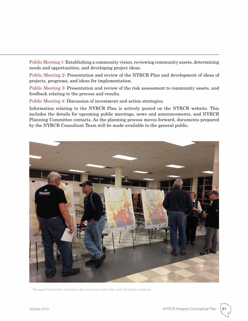
61NYRCR Freeport Conceptual PlanOctober 2013
Public Meeting 1: Establishing a community vision, reviewing community assets, determining needs and opportunities, and developing project ideas.Public Meeting 2: Presentation and review of the NYRCR Plan and development of ideas of projects, programs, and ideas for implementation.Public Meeting 3: Presentation and review of the risk assessment to community assets, and feedback relating to the process and results.Public Meeting 4: Discussion of investment and action strategies.Information relating to the NYRCR Plan is actively posted on the NYRCR website. This includes the details for upcoming public meetings, news and announcements, and NYRCR Planning Committee contacts. As the planning process moves forward, documents prepared by the NYRCR Consultant Team will be made available to the general public.
Freeport Committee members discuss assets and risks with Freeport residents


4Next Steps
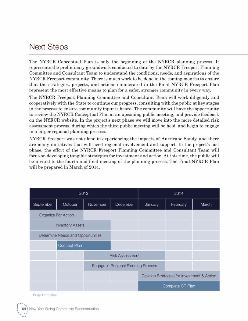
2013 2014
September October November December January February March
Organize For Action
Inventory Assets
Determine Needs and Opportunities
Concept Plan
Risk Assessment
Engage in Regional Planning Process
Develop Strategies for Investment & Action
Complete CR Plan
64 New York Rising Community Reconstruction
The NYRCR Conceptual Plan is only the beginning of the NYRCR planning process. It represents the preliminary groundwork conducted to date by the NYRCR Freeport Planning Committee and Consultant Team to understand the conditions, needs, and aspirations of the NYRCR Freeport community. There is much work to be done in the coming months to ensure that the strategies, projects, and actions enumerated in the Final NYRCR Freeport Plan represent the most effective means to plan for a safer, stronger community in every way.The NYRCR Freeport Planning Committee and Consultant Team will work diligently and cooperatively with the State to continue our progress, consulting with the public at key stages in the process to ensure community input is heard. The community will have the opportunity to review the NYRCR Conceptual Plan at an upcoming public meeting, and provide feedback on the NYRCR website. In the project’s next phase we will move into the more detailed risk assessment process, during which the third public meeting will be held, and begin to engage in a larger regional planning process. NYRCR Freeport was not alone in experiencing the impacts of Hurricane Sandy, and there are many initiatives that will need regional involvement and support. In the project’s last phase, the effort of the NYRCR Freeport Planning Committee and Consultant Team will focus on developing tangible strategies for investment and action. At this time, the public will be invited to the fourth and final meeting of the planning process. The Final NYRCR Plan will be prepared in March of 2014.
Project timeline
Next Steps
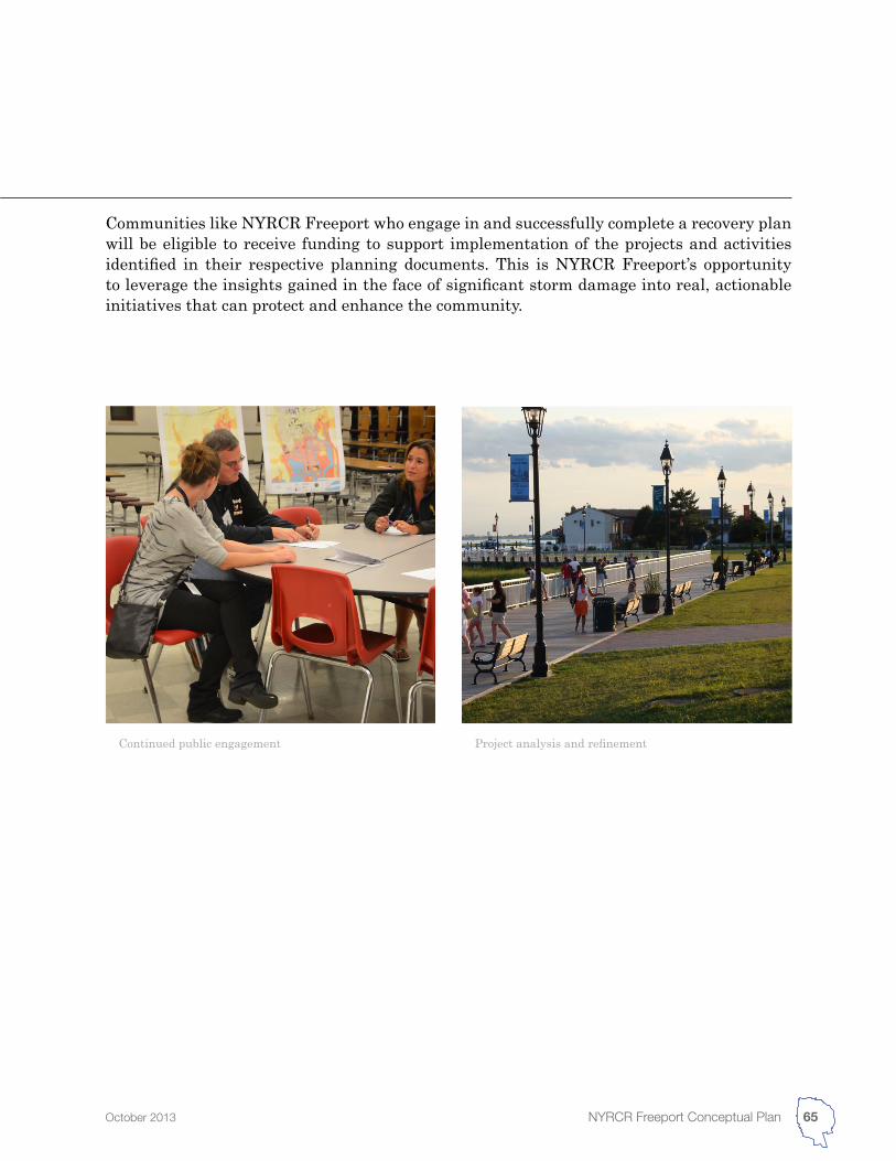
65NYRCR Freeport Conceptual PlanOctober 2013
Communities like NYRCR Freeport who engage in and successfully complete a recovery plan will be eligible to receive funding to support implementation of the projects and activities identified in their respective planning documents. This is NYRCR Freeport’s opportunity to leverage the insights gained in the face of significant storm damage into real, actionable initiatives that can protect and enhance the community.
Continued public engagement Project analysis and refinement


Appendices
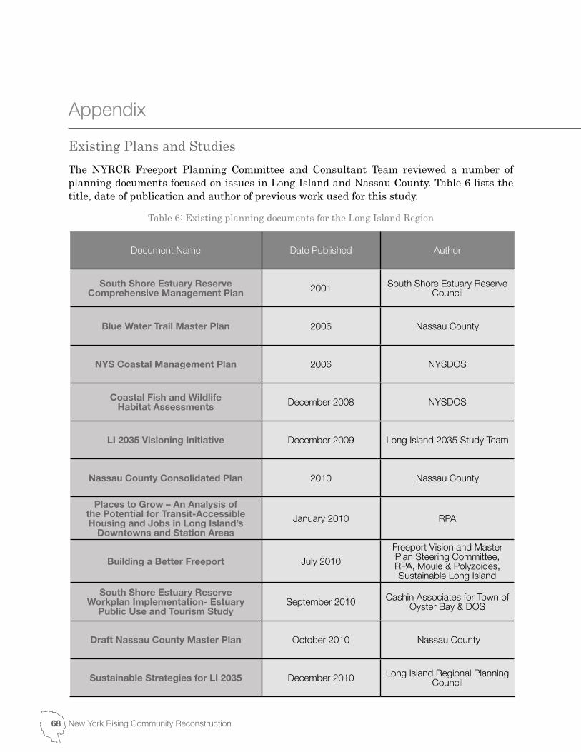
Table 6: Existing planning documents for the Long Island Region
Document Name Date Published Author
South Shore Estuary Reserve Comprehensive Management Plan 2001 South Shore Estuary Reserve
Council
Blue Water Trail Master Plan 2006 Nassau County
NYS Coastal Management Plan 2006 NYSDOS
Coastal Fish and Wildlife Habitat Assessments December 2008 NYSDOS
LI 2035 Visioning Initiative December 2009 Long Island 2035 Study Team
Nassau County Consolidated Plan 2010 Nassau County
Places to Grow – An Analysis of the Potential for Transit-Accessible Housing and Jobs in Long Island’s
Downtowns and Station Areas
January 2010 RPA
Building a Better Freeport July 2010
Freeport Vision and Master Plan Steering Committee, RPA, Moule & Polyzoides, Sustainable Long Island
South Shore Estuary Reserve Workplan Implementation- Estuary
Public Use and Tourism StudySeptember 2010 Cashin Associates for Town of
Oyster Bay & DOS
Draft Nassau County Master Plan October 2010 Nassau County
Sustainable Strategies for LI 2035 December 2010 Long Island Regional Planning Council
68 New York Rising Community Reconstruction
The NYRCR Freeport Planning Committee and Consultant Team reviewed a number of planning documents focused on issues in Long Island and Nassau County. Table 6 lists the title, date of publication and author of previous work used for this study.
Appendix
Existing Plans and Studies
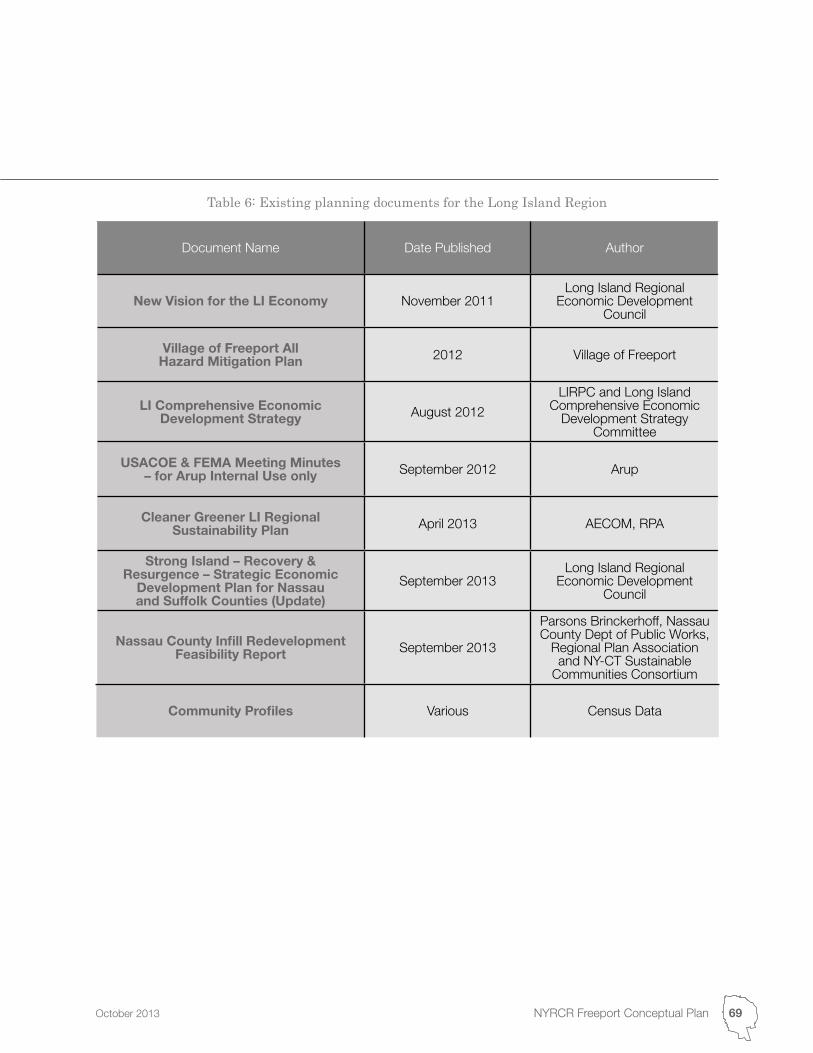
Document Name Date Published Author
New Vision for the LI Economy November 2011Long Island Regional
Economic Development Council
Village of Freeport All Hazard Mitigation Plan 2012 Village of Freeport
LI Comprehensive Economic Development Strategy August 2012
LIRPC and Long Island Comprehensive Economic
Development Strategy Committee
USACOE & FEMA Meeting Minutes – for Arup Internal Use only September 2012 Arup
Cleaner Greener LI Regional Sustainability Plan April 2013 AECOM, RPA
Strong Island – Recovery & Resurgence – Strategic Economic
Development Plan for Nassau and Suffolk Counties (Update)
September 2013Long Island Regional
Economic Development Council
Nassau County Infill Redevelopment Feasibility Report September 2013
Parsons Brinckerhoff, Nassau County Dept of Public Works,
Regional Plan Association and NY-CT Sustainable
Communities Consortium
Community Profiles Various Census Data
Table 6: Existing planning documents for the Long Island Region
69NYRCR Freeport Conceptual PlanOctober 2013

![FREEPORT LNG TERMINAL · 2020. 5. 20. · FREEPORT LNG TERMINAL FREEPORT MARINE OPERATIONS MANUAL [04/15/20]2 FREEPORT LNG CONTACT INFORMATION TERMINAL OFFICES Freeport LNG Terminal](https://img.pdfslide.us/doc/110x75/606c9d1603f05e3bdb64da66/freeport-lng-terminal-2020-5-20-freeport-lng-terminal-freeport-marine-operations.jpg)