Embed Size (px)
Citation preview
All documentation, software, and data related to this project are proprietary and copyrighted. Use is governed by the contract requirements as defined in the Michigan Department of Transportation contract 2007-0371. Unauthorized use of this documentation is a violation of law except as provided for in said contract.
Copyright © 2007 Mixon/Hill of Michigan, Inc. All rights reserved.
VII Data Use Analysis and Processing
CONCEPT OF OPERATIONS
August 2007
FINAL v1.02
Prepared By:
Mixon/Hill of Michigan, Inc.
12980 Metcalf Avenue, Suite 470
Overland Park, Kansas 66213
(913) 239-8400
Michigan Department of Transportation VII Data Use Analysis and Processing
Concept of Operations
06022-kz201cop0102
Page i
Copyright © 2007 Mixon/Hill of Michigan, Inc.
All rights reserved.
Abstract
The Michigan Department of Transportation (MDOT) Vehicle Infrastructure Integration
(VII) Data Use Analysis and Processing (DUAP) Concept of Operations (ConOps)
documents the opportunities and benefits to MDOT of acquiring and using VII data in the
management and operations of Michigan’s transportation systems. The ConOps provides
a link between MDOT’s VII Strategic and Business Plan and the development of systems
to implement that plan. The ConOps describes the existing systems relevant to
transportation operations data; establishes the case for change; describes the capabilities
and features of the proposed system; and discusses scenarios illustrating future system
operation. The document will be used by MDOT to facilitate communications on VII and
transportation operations with its stakeholders and partners and as a basis for generating
more detailed user needs and expectations for VII data, use, and processing.
Table of Contents
1 SCOPE ....................................................................................................................... 1
1.1 Identification ....................................................................................................................................... 1
1.2 Background ......................................................................................................................................... 1
1.3 Document Overview ............................................................................................................................ 2
1.4 Referenced Documents ....................................................................................................................... 3
2 THE CURRENT SYSTEMS AND SITUATION................................................... 4
2.1 Background, Objectives, and Scope .................................................................................................. 4
2.2 Operational Policies and Constraints for Data ................................................................................. 4
2.3 Description of the Current Situation ................................................................................................. 5 2.3.1 Processes and Activities .............................................................................................................. 5
2.3.1.1 Plan .................................................................................................................................... 5 2.3.1.2 Design ................................................................................................................................ 6 2.3.1.3 Construct ............................................................................................................................ 6 2.3.1.4 Maintain ............................................................................................................................. 6 2.3.1.5 Operate ............................................................................................................................... 7 2.3.1.6 Measure .............................................................................................................................. 7
2.3.2 Existing Systems and Interfaces .................................................................................................. 7 2.3.2.1 Operations Centers ............................................................................................................. 8 2.3.2.2 Asset Management Systems .............................................................................................. 9 2.3.2.3 Other MDOT Tools ..........................................................................................................13 2.3.2.4 Michigan Center for Geographic Information Framework ...............................................13 2.3.2.5 Southeast Michigan Snow and Ice Management ..............................................................14 2.3.2.6 Pending MDOT Projects ...................................................................................................14 2.3.2.7 Public Transit Providers ....................................................................................................15 2.3.2.8 Traffic.com .......................................................................................................................15
Michigan Department of Transportation VII Data Use Analysis and Processing
Concept of Operations
06022-kz201cop0102
Page ii
Copyright © 2007 Mixon/Hill of Michigan, Inc.
All rights reserved.
2.4 Stakeholders .......................................................................................................................................15
2.5 Support Environment ........................................................................................................................17
3 THE CASE FOR AND NATURE OF CHANGES .............................................. 18
3.1 Case for Changes................................................................................................................................18 3.1.1 Improving Safety ........................................................................................................................18 3.1.2 Improving Traffic Management .................................................................................................19 3.1.3 Improving Asset Management ...................................................................................................20
3.2 Description of Opportunities and Desired Changes ........................................................................21 3.2.1 Obtaining VII Probe Data ...........................................................................................................21 3.2.2 Obtaining Probe Data from Non-VII Sources ............................................................................24 3.2.3 Integrating Operational Data into MDOT Systems ....................................................................25
3.3 Priorities among Changes .................................................................................................................25
3.4 Changes Considered But Not Included ............................................................................................26
3.5 Assumptions and Constraints ...........................................................................................................26
4 CONCEPTS FOR THE PROPOSED SYSTEM .................................................. 28
4.1 Background, Objectives, and Scope .................................................................................................28
4.2 Stakeholders .......................................................................................................................................28
4.3 Description of the Proposed System .................................................................................................29 4.3.1 Input Services .............................................................................................................................30 4.3.2 Dynamic Data Services ..............................................................................................................31 4.3.3 Persistent Data Services .............................................................................................................31 4.3.4 Computational Services ..............................................................................................................31 4.3.5 Output Services ..........................................................................................................................32 4.3.6 Presentation Services ..................................................................................................................32 4.3.7 Administrative Services..............................................................................................................32
4.4 Operational Policies and Constraints ...............................................................................................33
4.5 Modes of Operation ...........................................................................................................................33
4.6 Support Environment ........................................................................................................................34 4.6.1 Communications .........................................................................................................................34 4.6.2 Power and Environmental Control .............................................................................................35 4.6.3 Hardware ....................................................................................................................................35 4.6.4 Software .....................................................................................................................................36
5 OPERATIONAL SCENARIOS ............................................................................ 37
5.1 Traffic Incident ..................................................................................................................................37
5.2 Weather Response ..............................................................................................................................39
Michigan Department of Transportation VII Data Use Analysis and Processing
Concept of Operations
06022-kz201cop0102
Page iii
Copyright © 2007 Mixon/Hill of Michigan, Inc.
All rights reserved.
5.3 Special Event Planning and Execution .............................................................................................42
5.4 Maintenance Planning .......................................................................................................................44
5.5 Asset Management and Planning .....................................................................................................46
6 SUMMARY OF IMPACTS ................................................................................... 48
6.1 Operational Impacts ..........................................................................................................................48
6.2 Impacts during Development ............................................................................................................49
7 ANALYSIS OF THE PROPOSED SYSTEM ...................................................... 51
7.1 Summary of Improvements ...............................................................................................................51
7.2 Limitations ..........................................................................................................................................52
APPENDIX A - DEFINITIONS, ACRONYMS, AND ABBREVIATIONS ........... 53
APPENDIX B - REFERENCED DOCUMENTS ...................................................... 57
Table of Figures
FIGURE 1 – DUAP DATA FLOWS ............................................................................................................. 2 FIGURE 2 – MDOT PROCESSES ................................................................................................................ 5 FIGURE 3 – MDOT BUSINESS PROCESSES WITH SUPPORTING SYSTEMS AND TOOLS ............. 8 FIGURE 4 – DUAP SYSTEM SERVICES ..................................................................................................30 FIGURE 5 – MODES OF OPERATION ......................................................................................................34 FIGURE 6 – INCIDENT SCENARIO ..........................................................................................................38 FIGURE 7 – WEATHER RESPONSE SCENARIO ....................................................................................40 FIGURE 8 – SPECIAL EVENT SCENARIO ...............................................................................................43 FIGURE 9 – MAINTENANCE SCENARIO ................................................................................................45
Table of Tables
TABLE 1 – VII POC REQUIRED PROBE DATA ELEMENTS ................................................................22 TABLE 2 – VII POC OPTIONAL PROBE DATA ELEMENTS.................................................................23
Revision History
Revision Issue Date Status Authority Comments
01.00 5/25/2007 Draft Initial working draft
01.01 6/22/2007 Draft Draft for comment
01.02 8/23/2007 Final Incorporates resolution of
comments

Michigan Department of Transportation VII Data Use Analysis and Processing
Concept of Operations
06022-kz201cop0102
Page iv
Copyright © 2007 Mixon/Hill of Michigan, Inc.
All rights reserved.
Electronic File
Saved As: 06022-kz201cop0102_DUAP_ConOps_Final
Michigan Department of Transportation VII Data Use Analysis and Processing
Concept of Operations
06022-kz201cop0102
Page 1
Copyright © 2007 Mixon/Hill of Michigan, Inc.
All rights reserved.
1 SCOPE
1.1 Identification
This document describes the Concept of Operations (ConOps) for the Michigan
Department of Transportation’s (MDOT’s) Vehicle Infrastructure Integration
(VII) Data Use Analysis and Processing (DUAP) project. The ConOps document
describes the current state, establishes the case for change, and describes the
proposed system in terms of its features and operations.
1.2 Background
Advances in information and communications technology over recent decades
have created the potential for vehicles themselves to become active participants in
the management and operations of the transportation infrastructure. Whereas
traditional roadway infrastructure and traffic controls are independent of the
controls within a vehicle, VII initiatives are aggressively pursuing opportunities
for the sensors and controls on vehicles and the roadway to work together.
Federal, state, and local agencies and private commercial stakeholders are
working together to evaluate and promote the VII opportunities. To this end, the
U.S. Department of Transportation (USDOT), MDOT, other state and local
agencies, the Vehicle Infrastructure Integration Consortium (VIIC), and industry
associations have established a network of common interests and a process of
mutual investment and support intended to develop and realize the potential of
VII. The efforts of these participants over the last several years have resulted in a
common vision and plan; opportunities for public information and involvement;
and the beginnings of a technical (and economic) framework.
MDOT is leading the way among state agencies and has produced a ―Vehicle-
Infrastructure Integration Strategic and Business Plan‖ (Ref. 13) that lays out the
vision and action plan for VII development in Michigan. The plan describes the
institutional relationships, outreach, and technical developments that will be
needed to develop and deploy VII. The DUAP project brings together much of the
technical development called for in the plan.
The specific purpose of the DUAP project is to support MDOT and its partners in
evaluating uses and benefits of VII-related data in transportation agency
management and operations. As such, the project complements parallel efforts of
MDOT, USDOT, VIIC, and others to design and deploy the VII network1, vehicle
equipment, and initial applications. The DUAP project builds on that foundational
work to investigate how the availability of data from VII-equipped vehicles
throughout the road network may impact the ways transportation agencies do
business. The project will focus specifically on data uses and benefits in
responding to safety concerns, managing traffic, and managing MDOT’s
1 Throughout the ConOps, the term ―VII network‖ should be understood to refer to a VII network based on
the USDOT’s VII National System Requirements.
Michigan Department of Transportation VII Data Use Analysis and Processing
Concept of Operations
06022-kz201cop0102
Page 2
Copyright © 2007 Mixon/Hill of Michigan, Inc.
All rights reserved.
transportation assets. The work will also support the other VII activities,
technology development for MDOT, and economic growth for the state.
The key tasks within the DUAP project are:
to identify uses for the VII data;
to develop algorithms to use and process the VII data;
to develop prototype applications and data management software; and
to evaluate how well the data and the algorithms function in a department
of transportation.
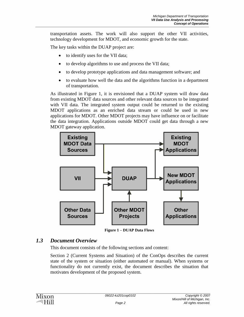
As illustrated in Figure 1, it is envisioned that a DUAP system will draw data
from existing MDOT data sources and other relevant data sources to be integrated
with VII data. The integrated system output could be returned to the existing
MDOT applications as an enriched data stream or could be used in new
applications for MDOT. Other MDOT projects may have influence on or facilitate
the data integration. Applications outside MDOT could get data through a new
MDOT gateway application.
Figure 1 – DUAP Data Flows
1.3 Document Overview
This document consists of the following sections and content:
Section 2 (Current Systems and Situation) of the ConOps describes the current
state of the system or situation (either automated or manual). When systems or
functionality do not currently exist, the document describes the situation that
motivates development of the proposed system.
Michigan Department of Transportation VII Data Use Analysis and Processing
Concept of Operations
06022-kz201cop0102
Page 3
Copyright © 2007 Mixon/Hill of Michigan, Inc.
All rights reserved.
Section 3 (Case for and Nature of Changes) describes the rationale, justification
for, and nature of the proposed changes. This section identifies the shortcomings,
if any, of the existing situation and the opportunities and benefits of change.
Section 4 (Concepts for the Proposed System) describes the proposed system that
results from the desired changes. This is, necessarily, a high-level description,
indicating the operational features of the system when fully deployed. This
represents a long-term vision, and the initial deployment may not include all of
the features or components described therein.
Section 5 (Operational Scenarios) of the ConOps contains operational scenarios
for the system. A scenario is a step-by-step description of how the proposed
system might operate and interact with its users and its external interfaces under a
given set of circumstances. The scenarios tie together all parts of the proposed
system, the users, and other entities by describing how they interact in a particular
context.
Section 6 (Summary of Impacts) of the document describes the operational
impacts of the proposed system on the users, the developers, and the support and
maintenance organizations. This section may also identify temporary impacts of
the transition from the old system(s) to the new system.
Section 7 (Analysis of the Proposed System) discusses the benefits, limitations,
advantages, disadvantages, alternatives, and trade-offs considered for the
proposed system. In the context of this document, alternatives are operational
alternatives and not design alternatives (which would be considered in a Systems
Engineering Analysis, if appropriate).
Appendix A (Definitions, Acronyms, and Abbreviations) provides definitions for
the terms, acronyms, and abbreviations used throughout the document.
Appendix B provides an extensive list of references for the document.
1.4 Referenced Documents
Full citations for the documents referenced in this ConOps can be found in
Appendix B, which also includes documents that have not explicitly been
referenced, but contain additional information relevant to the project.
Michigan Department of Transportation VII Data Use Analysis and Processing
Concept of Operations
06022-kz201cop0102
Page 4
Copyright © 2007 Mixon/Hill of Michigan, Inc.
All rights reserved.
2 THE CURRENT SYSTEMS AND SITUATION This section describes the current state of data use, analysis, and processing in
MDOT transportation management and operations.
2.1 Background, Objectives, and Scope
The mission of MDOT is to provide the highest-quality integrated transportation
services for the economic benefit of, and improved quality of life throughout, the
State of Michigan (Ref. 15). MDOT strives to be aware of what its customers and
stakeholders want and need from Michigan transportation systems. It does that by
providing leadership and support for all aspects of a comprehensive integrated
transportation system that is:
Efficient,
Effective,
Safe,
Socially and environmentally responsible,
Responsive to current and future needs, and
Supportive of economic growth.
MDOT further recognizes that these ends are best achieved in partnership with
other stakeholders who desire the development and operation of an innovative and
integrated transportation system. To that end, MDOT has developed an extensive
network of working and data-sharing relationships with other Michigan state
agencies and departments; regional, county, and local transportation and planning
agencies; emergency services; and private providers of transportation services and
information.
MDOT and its partners work together in achieving its objectives through a diverse
set of processes and systems. The potential applications of VII-originated data are
so broad that almost any of these existing processes or systems might be affected.
As such, the scope of review of the current state intends to include all major
information systems related to transportation management and operations.
2.2 Operational Policies and Constraints for Data
In the current operating environment, policies around the acquisition and use of
data from the transportation network are focused on security, ownership, and
redistribution. While it is an inherent part of MDOT’s mission to provide the
public with timely and accurate information on the state of the transportation
network, there are limitations on the content and manner of distribution. As
described in Section 2.5, the Michigan Department of Information Technology
(MDIT) maintains policies and procedures for the management of data and
applications that apply to all MDOT systems. MDOT and its partner
transportation agencies also have various contracts for transportation information
services that include provisions on the use and redistribution of information
obtained through those services.
Michigan Department of Transportation VII Data Use Analysis and Processing
Concept of Operations
06022-kz201cop0102
Page 5
Copyright © 2007 Mixon/Hill of Michigan, Inc.
All rights reserved.
The use, analysis, processing, and redistribution of transportation system
information are also constrained by technological and financial resources. While
most of MDOT’s operations are assisted by some data automation, there are
varying degrees of systems integration within and between transportation
agencies. This may be due in part to institutional constraints and technology
limitations, but is likely aggravated by competing demands for funds.
2.3 Description of the Current Situation
2.3.1 Processes and Activities
Given the breadth of potential applications of VII data, it is important to review
the scope of transportation agency activities where greater data availability might
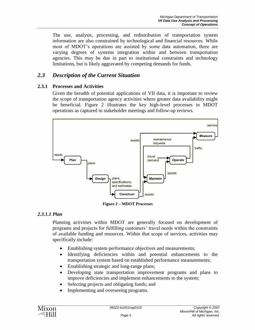
be beneficial. Figure 2 illustrates the key high-level processes in MDOT
operations as captured in stakeholder meetings and follow-up reviews.
Figure 2 – MDOT Processes
2.3.1.1 Plan
Planning activities within MDOT are generally focused on development of
programs and projects for fulfilling customers’ travel needs within the constraints
of available funding and resources. Within that scope of services, activities may
specifically include:
Establishing system performance objectives and measurements;
Identifying deficiencies within and potential enhancements to the
transportation system based on established performance measurements;
Establishing strategic and long-range plans;
Developing state transportation improvement programs and plans to
improve deficiencies and implement enhancements to the system;
Selecting projects and obligating funds; and
Implementing and overseeing programs.
Michigan Department of Transportation VII Data Use Analysis and Processing
Concept of Operations
06022-kz201cop0102
Page 6
Copyright © 2007 Mixon/Hill of Michigan, Inc.
All rights reserved.
2.3.1.2 Design
Design activities within MDOT are focused on steps necessary to design
transportation projects that have been established by the planning process.
Activities may include:
Acquiring aerial mapping photography and producing topographic maps to
be used for design/construction documents of transportation projects;
Accumulating survey data for the use of Project Development, Road and
Bridge Design Units, and the Real Estate Support Area; Providing engineering data regarding utilities, drainage, and roadside
development to be used for design documents of transportation projects;
Developing and organizing project study procedures and overseeing multi-
discipline project investigations to obtain engineering, planning, and
environmental data for analysis;
Preparing construction plans and related contract documents for the
construction/reconstruction of state highways, bridges, and related
structures; Assuring plans and proposals are prepared in conformance with Federal
Highway Administration (FHWA), American Association of State
Highway and Transportation Officials (AASHTO), and MDOT design
procedures, principle standards, and specifications; Coordinating and implementing automated engineering systems and
standards; and
Administering the federal and state aid programs for local agencies.
2.3.1.3 Construct
Construction activities at MDOT are primarily those necessary to build projects
that have been planned and designed by MDOT or its consultants. Activities
include:
Developing and distributing construction specifications; Developing and distributing field consultation standards and performing
associated training; and Overseeing construction projects.
2.3.1.4 Maintain
Maintenance activities at MDOT ensure that the departmental resources are
properly utilized after the projects have been constructed. Activities include:
Developing and implementing the Capital Preventative Maintenance
Program;
Allocating and dispatching departmental resources to resolve problems
identified along the transportation assets;
Managing materials;
Preserving infrastructure;
Michigan Department of Transportation VII Data Use Analysis and Processing
Concept of Operations
06022-kz201cop0102
Page 7
Copyright © 2007 Mixon/Hill of Michigan, Inc.
All rights reserved.
Performing winter maintenance;
Inspecting bridges and bridge supports; and
Maintaining, updating, and reporting from the bridge structure inventory
database.
2.3.1.5 Operate
Operations activities make sure that MDOT's assets are being properly utilized.
Activities may include the following:
Controlling access to transportation systems;
Directing flow within the transportation systems;
Assuring traffic safety;
Identifying and removing obstacles on the systems’ right-of-way;
Optimizing the efficiency of traffic flow on signalized arterials; and
Providing traveler information.
2.3.1.6 Measure
Although MDOT currently has over 100 performance measures, the Department
has selected a core set of fourteen measures (Ref. 7) that are used in a crosscutting
or matrix fashion, meaning that rather than being tied to one specific goal area
like Safety or Mobility, individual measures are viewed as indicators of progress
toward all goal areas. Activities related to data that might be enhanced in the
DUAP project include:
Evaluating roadway pavement conditions such as ride quality, crack
severity, and rutting;
Evaluating bridge conditions throughout the state;
Acquiring traffic and incident data for assessing system-wide safety
performance; and
Measuring highway congestion and assessing capacity for additional
traffic growth.
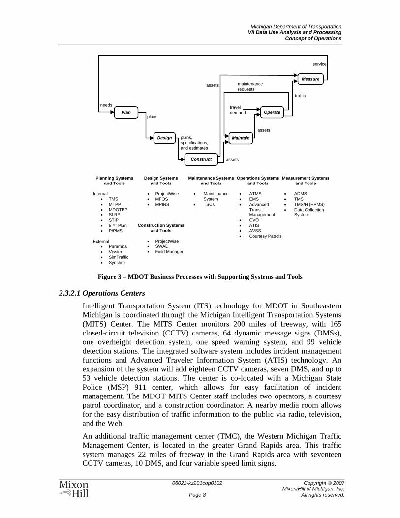
2.3.2 Existing Systems and Interfaces
There are many existing MDOT and partner agency systems and interfaces using
data gathered by staff and contractors, roadway sensors, signal systems, and on-
board sensors. Many of these data sources will be supplemented or replaced by
VII-derived data. Some of these systems are illustrated in relation to MDOT
business processes in
Figure 3. This section describes the existing systems and interfaces as a basis for
understanding and anticipating the potential for VII enhancements to MDOT data
flows.
Michigan Department of Transportation VII Data Use Analysis and Processing
Concept of Operations
06022-kz201cop0102
Page 8
Copyright © 2007 Mixon/Hill of Michigan, Inc.
All rights reserved.
Design Maintain
Measure
service
plans,
specifications,
and estimates
plans
needs
Construct
Planning Systems
and Tools
Internal
TMS
MTPP
MDOTBP
SLRP
STIP
5 Yr Plan
P/PMS
External
Paramics
Vissim
SimTraffic
Synchro
Operate
assets
traffic
assets
travel
demand
maintenance
requestsassets
Maintenance Systems
and Tools
Maintenance
System
TSCs
Operations Systems
and Tools
ATMS
EMS
Advanced
Transit
Management
CVO
ATIS
AVSS
Courtesy Patrols
Measurement Systems
and Tools
ADMS
TMS
TMS/H (HPMS)
Data Collection
System
Plan
Design Systems
and Tools
ProjectWise
MFOS
MPINS
Construction Systems
and Tools
ProjectWise
SWAD
Field Manager
Figure 3 – MDOT Business Processes with Supporting Systems and Tools
2.3.2.1 Operations Centers
Intelligent Transportation System (ITS) technology for MDOT in Southeastern
Michigan is coordinated through the Michigan Intelligent Transportation Systems
(MITS) Center. The MITS Center monitors 200 miles of freeway, with 165
closed-circuit television (CCTV) cameras, 64 dynamic message signs (DMSs),
one overheight detection system, one speed warning system, and 99 vehicle
detection stations. The integrated software system includes incident management
functions and Advanced Traveler Information System (ATIS) technology. An
expansion of the system will add eighteen CCTV cameras, seven DMS, and up to
53 vehicle detection stations. The center is co-located with a Michigan State
Police (MSP) 911 center, which allows for easy facilitation of incident
management. The MDOT MITS Center staff includes two operators, a courtesy
patrol coordinator, and a construction coordinator. A nearby media room allows
for the easy distribution of traffic information to the public via radio, television,
and the Web.
An additional traffic management center (TMC), the Western Michigan Traffic
Management Center, is located in the greater Grand Rapids area. This traffic
system manages 22 miles of freeway in the Grand Rapids area with seventeen
CCTV cameras, 10 DMS, and four variable speed limit signs.
Michigan Department of Transportation VII Data Use Analysis and Processing
Concept of Operations
06022-kz201cop0102
Page 9
Copyright © 2007 Mixon/Hill of Michigan, Inc.
All rights reserved.
In addition to the MDOT centers, some counties have their own traffic operation
centers (TOCs). The Road Commission for Oakland County (RCOC) has a TOC
connected to the MITS Center through a center-to-center link to facilitate area-
wide management of traffic across jurisdictions. A coordinated traffic signal
system, called FAST-TRAC (Faster and Safer Travel through Routing and
Advanced Controls), has been implemented to control congestion on county
arterials. System computers monitor traffic flow and adjust traffic signal timing to
balance flow throughout the system. The FAST-TRAC system archives detailed
data from the signalized intersections for future analysis.
RCOC also has a road weather information system (RWIS) that provides weather
data as recorded at the location of their three environmental sensor stations (ESS).
The ESS observe the following information:
Air temperature;
Amount and type of precipitation;
Visibility;
Dewpoint;
Pavement surface temperature and condition; and
Wind speed and direction.
The Road Commission of Macomb County (RCMC) TOC has access to
approximately 175 signalized intersections within the county. The staff is able to
view traffic signal areas in real time to better anticipate and mitigate traffic
congestion and to allow the adjustment of signal timing to aid in redirecting
traffic. In addition, the staff is able to detect, analyze, and repair signal
malfunctions in a timely manner. There are plans to expand the system to include
more vehicle detection stations and to automate signal systems to adjust to
changes in traffic patterns.
2.3.2.2 Asset Management Systems
MDOT uses the Transportation Management System (TMS) to manage assets.
The system is composed of six components or subsystems:
Bridge Management System;
Pavement Management System;
Congestion Management System;
Public Transportation Management System;
Intermodal Management System;
Safety Management System; and
Traffic Monitoring System.
These subsystems share a common database, a common set of decision support
tools and functionality, and the use of a robust and consistent user interface.
Bridge Management System
The Bridge Management System (BMS) is an important part of MDOT’s overall
asset management process. The BMS includes an Oracle database that stores
Michigan Department of Transportation VII Data Use Analysis and Processing
Concept of Operations
06022-kz201cop0102
Page 10
Copyright © 2007 Mixon/Hill of Michigan, Inc.
All rights reserved.
transportation asset inventory for bridges and culverts throughout the state. The
database structure is compatible with the AASHTO Pontis bridge management
system. The BMS is the decision-support tool responsible for managing the
inspection, analysis, and maintenance of the numerous components that make up
a bridge.
The Michigan Bridge Reporting System (MBRS) is a Web-based software
application built into the Bridge Operations Web site. It is a portal for viewing
bridge data and is used to allow non-MDOT entities, including local agencies and
consultants, to obtain bridge inspection data in meaningful reports.
The Michigan Bridge Inspection System (MBIS) is a Web-based software
application built into the Bridge Operations Web site. MBIS was developed to
help MDOT maintain the many bridges and culverts throughout the state, to
comply with federal inspection requirements through the National Bridge
Inspection Standards (NBIS), and to gather data useful for other divisions within
MDOT. MBIS helps to improve communication between local agencies and
MDOT and to streamline the process of collecting and distributing data pertaining
to bridge safety and project development. MDOT and local agencies are required
to perform bridge inspections, the results of which are compiled by MDOT and
submitted to the FHWA. Bridge inspectors are the direct customers for the MBIS
system. Indirect customers include MDOT staff involved in the design,
development, and construction of bridges and culverts.
The Fabrication, Inspection, and Construction System (FICS) is the inspection
reporting Web-based system that collects quality assurance inspection reports for
bridges and ancillary highway products during the fabrication and erection
process. The reports are archived in a database for material acceptance and
historical retrievals for project payment and documentation. FICS also ties reports
to inspector's time sheets and invoices for Web-based payment purposes.
The Bridge Condition Forecasting System (BCFS) is a bridge-network condition
forecasting tool used to develop preservation policies. The BCFS-generated
estimate is based on the National Bridge Inventory (NBI) condition ratings, bridge
deterioration rate, project cost, expected inflation, and repair strategies.
Pavement Management System
The Pavement Management System (PMS) is used to perform a variety of
engineering and planning functions. These include forecasting future network
pavement conditions and costs associated with implementing various pavement
repair strategies. Two different types of evaluation systems are used. Annually a
survey is made of the entire state system by a subjective, visual means. Every two
years, a detailed inspection of the pavement condition is made by using specially
equipped vehicles to take measurements and record data. The Pavement
Preservation Program (PPM) uses the information provided by the PMS to assist
staff in determining the appropriate ―fix‖ for a stretch of pavement.
Michigan Department of Transportation VII Data Use Analysis and Processing
Concept of Operations
06022-kz201cop0102
Page 11
Copyright © 2007 Mixon/Hill of Michigan, Inc.
All rights reserved.
Congestion Management System
The Congestion Management System (CMS) provides access to current system
level conditions and identification of current and future congested roadways. It
also incorporates travel demand forecasting capabilities for 14 urban and
numerous rural areas throughout Michigan to assess transportation system
performance and to identify areas with unacceptable performance.
Within the CMS, users can identify specific locations where congestion occurs or
is expected to occur. The supporting database incorporates historic traffic data and
future traffic forecasts from both the statewide and urban area models. The CMS
also provides access to historic and forecasted socioeconomic data from the U.S.
Census. Socioeconomic data are stored at both the traffic analysis zone and
county levels.
The CMS provides summary statistics and performance measures for user-
selected routes by geographical area or by any of several road classification
systems. Many performance measures and indicators are available and can be
used to measure progress toward meeting the goals and objectives of the State
Long-Range Plan (SLRP) and long range plans of regional and metropolitan
planning agencies.
Public Transportation Management System
The Public Transportation Management System (PTMS) provides access to data
regarding public transportation ridership, finance, vehicles, and performance.
PTMS includes a comprehensive list of about 100 Michigan transit agencies, with
specific information such as the names of contact people, mail and e-mail
addresses, phone numbers, and services provided. PTMS also includes a statewide
vehicle inventory used for forecasting needs and a financial database used for
both budgeting and obtaining state funds. The Annual Application module
contains capital items requested by transit agencies (during their yearly
application process) as well as their operating request (budget). The Vehicle
Inventory module contains pertinent data about the vehicles owned by an agency.
The Equipment and Facility Inventory modules are not currently in use, but they
will contain related data about any agency’s equipment valued at over $5,000 and
any facilities it owns or leases. The Operating Assistance Report module contains
budgeted, quarterly, annual (reconciled), and audited financial data as reported by
the transit agencies. Reporting of this data is required for agencies to receive state
and federal funds.
Intermodal Management System
The Intermodal Management System is a data management and information
analysis tool, used to access facts necessary to support decisions involving
passenger and freight access to and movement by air, marine, non-motorized, or
rail transport. It is designed to support the day-to-day functions of modal
specialists, while providing user access to data on intermodal assets.
Within this system, a transportation asset is considered to be any facility,
segment, property, or service on which MDOT or its government partners expend
funds or to which access is provided. Assets are divided into three groups:
Michigan Department of Transportation VII Data Use Analysis and Processing
Concept of Operations
06022-kz201cop0102
Page 12
Copyright © 2007 Mixon/Hill of Michigan, Inc.
All rights reserved.
Facilities: sites specifically intended to provide for the transfer of people
and/or goods from one segment of the transportation system to another.
Segments: the modal connections by which people and/or goods are
moved between intermodal facilities and other points.
Services: scheduled movements of groups of people over the
transportation system between facilities.
Safety Management System
The Safety Management System (SMS) is the decision support tool responsible
for analyzing vehicular crashes and the roads on which they occur. The SMS pulls
data about traffic incidents from the Traffic Crash Reporting System (TCRS). The
SMS provides identification, analysis, and implementation of engineering
improvements at locations with a high number of crashes.
Traffic Monitoring System for Highways
The Traffic Monitoring System for Highways (TMS/H) is MDOT’s program for
traffic information. TMS/H meets the FHWA requirements identified in the
Traffic Monitoring Guide and the Highway Performance Monitoring System
(HPMS) for collecting and reporting traffic information to the FHWA.
MDOT’s TMS/H covers traffic data collection, processing, storage, and reporting
of traffic information on the state trunkline system. The TMS/H includes data
from both short term (typically 48 hour) recorders and permanent traffic
recorders.
Short term information includes:
Traffic volume counts broken into 15 minute and hourly traffic volumes
and
Hourly volumes for each of 13 vehicle type classifications.
Permanent Traffic Recorder (PTR) information includes:
Continuous traffic volumes of all vehicles;
Continuous hourly volumes for each of 13 vehicle type classifications;
Continuous hourly volumes by 15 bins of speed groupings;
Continuous data collection for truck information such as axle weights and
spacing; and
Station location data identifying the location of the traffic data.
There are approximately 135 PTRs that collect traffic volumes and approximately
40 that collect vehicle classification and truck weight data. Typically, more than
3500 short term volume and classification studies are conducted each year.
The data are stored in an Oracle database. Internal applications allow the database
to be updated and maintained, and external applications provide user access to the
database. Volume and classification data are retained for ten years, and three
years of truck weight data are actively available to the user. Older data are
archived ―off-system‖.
Michigan Department of Transportation VII Data Use Analysis and Processing
Concept of Operations
06022-kz201cop0102
Page 13
Copyright © 2007 Mixon/Hill of Michigan, Inc.
All rights reserved.
2.3.2.3 Other MDOT Tools
MDOT uses a variety of planning tools. These include:
Michigan Transportation Policy Plan;
MDOT 2006 Strategic Plan;
MDOT VII Strategic & Business Plan;
State Long-Range Plan;
State Transportation Improvement Program (STIP);
Five-Year Road & Bridge Program; and
Program/Project Management System.
Traffic simulation tools used by MDOT to model various traffic scenarios
include:
Paramics;
Vissim;
SimTraffic; and
Synchro.
During design and construction, two different tools are used by MDOT to keep
projects on track. The first is TRANSPORT, which consists of four parts:
Proposal and Estimates System;
Letting and Award System;
Construction Administration System; and
Decision Support System.
The second tool is Field Manager, which is a construction field office system.
MDOT also has access in some locations to the MSP’s computer-aided dispatch
(CAD) system. Local governmental entities have a 911 system and then transfer
calls as necessary to the MSP.
MDOT and its transportation agency partners provide information for the traveler
on various Web sites. The traveler is able to find information on incidents such as
road construction and lane closures.
2.3.2.4 Michigan Center for Geographic Information Framework
The Michigan Center for Geographic Information (CGI) provides leadership,
technical expertise, and policy for the acquisition, development, use,
dissemination, promotion, and sharing of geographic information in the state of
Michigan.
The Michigan Geographic Framework (MGF) is a digital base map for use by
state government. It includes the ability for partner agencies to assist with updates
based on data from their business applications. The availability of a common
digital state map allows for improved communication and coordination between
various transportation agencies.
Michigan Department of Transportation VII Data Use Analysis and Processing
Concept of Operations
06022-kz201cop0102
Page 14
Copyright © 2007 Mixon/Hill of Michigan, Inc.
All rights reserved.
2.3.2.5 Southeast Michigan Snow and Ice Management
The Southeast Michigan Snow and Ice Management (SEMSIM) project joins the
RCOC, RCMC, Wayne County Department of Public Services, the City of
Detroit, and Suburban Mobility Authority for Regional Transportation (SMART)
in a partnership. The SEMSIM project has equipped snow plows/salt trucks from
all four jurisdictions with:
Satellite-based global positioning system (GPS) vehicle tracking devices;
Air and pavement temperature sensors;
Plow sensors;
Salt spreader sensors;
In-vehicle dashboard computer displays;
A 900 MHz radio system; and
Customized computer software.
2.3.2.6 Pending MDOT Projects
There are several MDOT projects either in-progress or pending. These projects
will have data that could be integrated with DUAP. These projects include:
Advanced Traffic Management System (ATMS) Software Design –
Depending on the region where the ATMS software is implemented, the
ATMS software may include the following features:
Signal coordination at rail crossing
Network surveillance
DMS
Satellite TMC
Real-time traffic counts
RWIS
Local parking system management
Regional parking management system
Drawbridge management system
Animal crossing detection
Roadway closure management system
®ATIS)
TMCs
MITS Center upgrade
West Michigan upgrade
Superior and Traverse City North Regions (in planning stages)
Statewide (in planning stage)
RWIS deployment
Superior Region (limited evaluation deployment)
Grand/North Region (planning)
Michigan Department of Transportation VII Data Use Analysis and Processing
Concept of Operations
06022-kz201cop0102
Page 15
Copyright © 2007 Mixon/Hill of Michigan, Inc.
All rights reserved.
Clarus – MDOT is participating in the Clarus Initiative which is to
provide broader weather information support for surface transportation
system operators through the design, demonstration, and deployment of a
national surface transportation weather data collection and management
system that complements NOAA’s Meteorological Assimilation Data
Ingest System (MADIS).
2.3.2.7 Public Transit Providers
There are about 100 urbanized and non-urbanized public transit agencies
registered within the state of Michigan. These agencies provide services to the
specific geographic region which they serve. Each individual agency is
responsible for planning, operating, and maintaining the equipment and property
owned by the agency.
2.3.2.8 Traffic.com
Traffic.com, a subsidiary of NAVTEQ Corp., acquires, aggregates, processes, and
redistributes traffic data in dozens of metropolitan areas around the United States.
As a commercial traffic information service provider, Traffic.com subscribes to
publicly available data provided by transportation agencies, monitors law
enforcement and emergency service activity, and deploys its own detectors in
priority corridors not otherwise instrumented by a transportation agency. Basic
traffic information, including selected travel times, is available to the public from
Traffic.com. More detailed data are available via a Traffic.com subscription
service.
2.4 Stakeholders
Stakeholders for the existing situation include all those who provide, create, or
use the data and systems described in Section 2.3.2. Stakeholders in this case are
predominantly MDOT staff but also include those who work with MDOT or who
exchange data with MDOT.
MDOT operators have the objective of minimizing the impact of planned and
unplanned events on the normal flow of traffic. In order to meet this objective,
operators perform the following tasks:
Review major incidents and events that impact travel;
Assess potential impact on travelers;
Determine response actions needed; and
Monitor incident or event for status changes.
MDOT maintenance personnel maintain the roadways and bridges within their
particular jurisdiction. They provide snow removal and pavement treatment in the
winter, perform routine reactive maintenance, and clean up and repair roadway as
needed in response to incidents.
MDOT asset managers and planners analyze the data and information collected
about the assets in their area to determine the annual programs and projects. Their
Michigan Department of Transportation VII Data Use Analysis and Processing
Concept of Operations
06022-kz201cop0102
Page 16
Copyright © 2007 Mixon/Hill of Michigan, Inc.
All rights reserved.
goal is a cost-effective use of resources within the agency. Planning and pavement
and bridge management personnel are included in this group of stakeholders.
MDOT executives, such as the MDOT Director, MDOT Executive Bureau, and
State Transportation Commission provide oversight and make final decisions on
investments in Michigan’s transportation infrastructure. Information from existing
systems is used to guide and support the decisions made by the executives.
MDOT system administrators are part of the MDIT. Their goal is to have all
collected data available for use by the other stakeholders. MDIT Enterprise IT
policies, standards, and procedures are documented to assure consistency,
efficiency, and effectiveness in the delivery of information technology services
that support the business functions of the state.
Local and regional transportation agencies (including transit agencies) interact
with existing MDOT systems where their areas of operation interface with
MDOT. Stakeholders within these agencies may include executives, managers,
operators, maintainers, and system administrators. Other DOTs are stakeholders
in the existing data where there is cooperation across state or provincial
boundaries.
MDOT’s Asset Management Council brings together state and local
transportation agencies from across Michigan to invest more efficiently in
Michigan’s roads and bridges. The Council provides coordination and
collaboration in asset management policies, programs, and practices among the
member agencies.
The USDOT is focused on the safety, mobility, and economic impact of the
nation’s transportation systems. USDOT works with each state to gather quality
data that are used for national statistical reporting. Often these data have an
impact upon the prioritization of state projects.
International highway and transportation agencies and authorities share MDOT’s
interests in the development and deployment of VII technologies. As such, they
are actively monitoring VII developments in Michigan, the US, and the rest of the
world, and will continue to be stakeholders throughout the development of the
DUAP program.
Travelers are all the people who use the roadways, whether driving or riding in
private or commercial vehicles. They obtain their trip information from various
sources and use it to prepare for their daily commute or for an extended trip. The
trip information may be used by the traveler for determining possible delays along
desired route(s) or choosing an alternative route or mode of transportation.
Commercial fleets are those transportation vehicles which are used by business
for economic purposes. These fleets obtain route information from the existing
data in order to select the most economical route.
Commercial information service providers (ISPs) and other media outlets use data
from the existing traveler information systems to redistribute information to their
Michigan Department of Transportation VII Data Use Analysis and Processing
Concept of Operations
06022-kz201cop0102
Page 17
Copyright © 2007 Mixon/Hill of Michigan, Inc.
All rights reserved.
audiences. This information may be provided as part of a newscast (free) or as a
subscription service.
Universities and the research community assist MDOT and other transportation
agencies in both acquiring and analyzing traffic, environmental, and asset data.
Emergency Services are staffed with trained personnel who respond to emergency
incidents or major disasters both on and off the roadway system. Their primary
goal is to provide appropriate services—for example, medical, law enforcement,
or hazardous materials—while protecting the public and services personnel from
further injury or loss during the response. The data from the roadway system will
assist them initially in getting to the incident location. After Emergency Services
personnel are on-site, the data can be used to help evaluate the impact of the
incident on the current traffic and help determine if additional resources are
needed.
Other Michigan state and local agencies may use existing transportation systems
data for planning and operational needs specific to their agency. The Michigan
Economic Development Corporation (MEDC), for example, provides assistance
to small and large companies in Michigan seeking to grow in a very competitive
and challenging global economy. Efficient transportation systems and data are
essential to those companies’ operations and can catalyze further opportunities for
growth.
2.5 Support Environment
Support for MDOT systems and data is provided by MDIT, whose goal is to
achieve a unified and more cost-effective approach for managing information
technology among all the Executive Branch agencies while delivering innovative
business solutions with their partners.
MDIT Enterprise IT policies, standards, and procedures (Ref. 18) are established
and implemented to assure consistency, efficiency, and effectiveness in the
delivery of IT services that support the business functions of the State. Generally,
MDIT prefers adherence to widely available technology standards, software tools,
and frameworks that have open-software interfaces and broad industry support,
and hardware that historically is of outstanding build quality and high reliability.
Specific products having been identified as Enterprise IT standards for the State
are reviewed, at a minimum, every two years. Currently, standard products have
been defined for the desktop environment, Web tools, database software and
tools, servers, network devices, and network monitoring tools.
Michigan Department of Transportation VII Data Use Analysis and Processing
Concept of Operations
06022-kz201cop0102
Page 18
Copyright © 2007 Mixon/Hill of Michigan, Inc.
All rights reserved.
3 THE CASE FOR AND NATURE OF CHANGES This section describes the shortcomings of the existing situation and opportunities
for improvement of the current situation that motivate development of a new
system.
3.1 Case for Changes
MDOT’s VII Strategic and Business Plan (Ref. 13) provides a broad view of the
opportunities and agency’s intentions for development of VII leadership,
partnerships, and technologies. Starting from MDOT’s mission and vision
statements, the plan lays out a vision and identifies needs, goals, measures, and
activities for VII in Michigan. The resulting strategy includes three high-level VII
use cases: safety, traffic management, and asset management. These use cases
provide the context for DUAP and for building the more detailed case for change.
3.1.1 Improving Safety
The opportunity to make travel safer is a key motivator in the development and
implementation of VII systems. Reductions in injuries, deaths, and property
damage associated with crashes are tangible objectives shared by all stakeholders
in VII and DUAP. Safety improvements also provide benefits in traffic
management by reducing the number and severity of incidents that may cause
travel delays and in transportation system asset management by reducing
maintenance and repair costs on damaged assets.
Safety improvement needs are found on both the vehicle and infrastructure sides
of the VII opportunity. In-vehicle systems have never had access to information
about the location of other vehicles or downstream roadway conditions.
Transportation agency systems have generally not had access to detailed real-time
information on vehicle locations or roadway conditions. While substantial effort
is being made in other VII initiatives to build in-vehicle systems to enhance
safety, the need for MDOT in DUAP is to gather more information about travel
conditions from the vehicles so that it can be used to provide more specific
information to travelers.
Safety-related traveler information is currently provided through traffic control
devices outside the vehicle and supplemented with broadcast traveler information.
In the case of traffic control devices, the information is generally static—for
example, fixed warning signs for Slippery When Wet or Bridge Ices Before Road.
Although the warning is generally relevant to that location, it may not indicate the
actual road conditions at the time a traveler sees it. Broadcast traveler
information—whether on highway advisory radio, commercial media, or the
Internet—is generally descriptive of conditions over a wider geographical area,
but may be more specific to the time at which it is broadcast. Even the most
specific traveler information, such as traffic broadcasts in urban areas, provides
only guidance on routes or highway segments, and generally only as it relates to
particular incidents.
Michigan Department of Transportation VII Data Use Analysis and Processing
Concept of Operations
06022-kz201cop0102
Page 19
Copyright © 2007 Mixon/Hill of Michigan, Inc.
All rights reserved.
VII-related needs for improving safety on Michigan roadways are therefore
focused on:
Collecting road condition information more frequently;
Collecting road condition information at finer resolutions;
Having access to vehicle locations; and
Providing targeted in-vehicle messaging of local road conditions.
Data coming from VII-equipped vehicles could be used to generate warnings of
hazardous traffic and road weather conditions. The data could be combined in real
time with location-specific information to provide warnings that supplement
existing traffic control devices such as curve and work zone speed warnings,
school zones, low overheads, and wrong way signs.
3.1.2 Improving Traffic Management
The most direct benefits to MDOT from VII may be in improving the agency’s
ability to manage traffic. Congestion and traffic delays cost money and time and
create frustration for Michigan travelers. Improvements in traffic efficiency also
improve traffic safety by reducing the likelihood of secondary collisions and
make more productive use of the existing transportation assets.
Currently, traffic management data are gathered primarily from video cameras
and vehicle detections stations. The 222 miles of freeway currently monitored
represent a small percentage of the more than 9700 miles of major highways
within the state. Although system deployment has been prioritized to monitor the
areas with the worst congestion, many unmonitored areas experience recurring
and incident related congestion. There is therefore a need for additional data
within the existing infrastructure in order to fill gaps in the existing roadway
surveillance. The use of VII data would allow additional information to be
gathered from roadways currently being monitored and would also allow more
roadways to be monitored without requiring the installation of additional fixed
monitoring equipment. Data from VII sources can be combined with data from
the existing surveillance devices to provide a seamless view of traffic conditions.
Both the traveling public and commercial traveler information service providers
have expressed a desire for more comprehensive information about incidents,
congestion, and delays on state roadways. MDOT’s ability to meet this desire has
been limited not only by the scarcity of data, but also by options for redistributing
the data. Existing capabilities provide traveler information on current conditions
through broadcast media and Web sites, and, to a lesser extent, on changeable or
dynamic message signs (CMS/DMS).
The need for better traffic management information is therefore focused on:
Collecting traffic data throughout the entire roadway network;
Collecting traffic data at finer resolutions;
Collecting traffic data in near real time;
Creating more accurate traveler information based on this wealth of data;
and
Michigan Department of Transportation VII Data Use Analysis and Processing
Concept of Operations
06022-kz201cop0102
Page 20
Copyright © 2007 Mixon/Hill of Michigan, Inc.
All rights reserved.
Redistributing the data with as little time delay as possible.
These data can be used in conjunction with existing monitoring capabilities to
provide a broad real-time view of conditions across the state. VII greatly extends
MDOT’s ability to gather traffic data, which creates opportunity for enhancing
traffic management through advanced arterial traffic signal and ramp metering
controls. VII capabilities for routing messages directly to vehicles would enable
traveler information to be presented within the vehicles, informing and allowing
drivers to select alternative routes.
3.1.3 Improving Asset Management
Asset management processes involve the full range of MDOT activities from
planning to traffic management, throughout the full life cycle of MDOT’s
transportation assets. As such, asset management data needs are closely coupled
to improving the cost-effectiveness of MDOT’s infrastructure investment. The
SLRP, STIP, and Call for Projects all depend on having the best possible
information on pavement and bridge conditions and on reliable forecasts of traffic
volumes across the statewide system. Unfortunately, current asset data collection
methods are relatively expensive, time consuming, and may provide only
intermittent (annual or biennial) snapshots of the state of most of the assets.
Historic traffic data are used in traffic simulations and forecasts for planning.
Granularity of the data varies widely across the state, correlating largely with
traffic volumes. In urban areas with permanent vehicle detection stations (for
example, in those areas of the Detroit metro monitored by the MITS Center),
archived traffic data may be available at 30 second intervals on two-mile
segments. Selected locations around the state have permanent counting stations
for monitoring volumes. Some segments may only be counted once every two
years. There is also significant interest in gathering information on traffic volumes
by vehicle class and weight. It is generally believed that heavy vehicles are
responsible for the majority of pavement and bridge ―wear and tear,‖ but the state
currently has no means of obtaining data specifically for those heavy vehicles.
Collection of pavement and bridge condition information is more consistent
across the state, but is performed only on an annual cycle. Programmed
inspections are performed during summer months by specially-equipped
maintenance vehicles driving over every lane-mile of state roadway. While this
inspection frequency is generally adequate for annual planning and the Call for
Projects, it provides too few data points to reliably detect variation from expected
trends in surface deterioration. Potholes or cracks requiring immediate repair may
be identified by Transportation Service Center (TSC) staff during the course of
routine operations or might even be called in by observant and helpful drivers.
The need for better asset management data from VII is therefore focused on:
Collecting traffic data consistently throughout the entire roadway network;
Collecting traffic data at finer resolutions;
Collecting traffic data throughout the year;
Collecting data on vehicle class within the traffic data;
Michigan Department of Transportation VII Data Use Analysis and Processing
Concept of Operations
06022-kz201cop0102
Page 21
Copyright © 2007 Mixon/Hill of Michigan, Inc.
All rights reserved.
Collecting asset condition throughout the year; and
Reducing the cost of collecting asset condition data.
Obtaining these data through VII could significantly reduce the cost and extend
the reach of data collection for planning and asset management processes within
MDOT. For example, more complete and consistent historical traffic information
would improve transportation simulation and forecasting in support of planning.
More continuous monitoring of pavement and bridge condition data might be able
to automate identification of potholes and cracks, and could enable faster spotting
of trends in pavement deterioration. Correlations of pavement conditions with
traffic data and vehicle classes could facilitate studies of prevention and
mitigation of surface damage from heavy vehicles.
3.2 Description of Opportunities and Desired Changes
As stated in the Introduction, the purpose of the DUAP project is to support
MDOT and its partners in evaluating uses and benefits of VII-related data in
transportation agency management and operations. Within this purpose,
opportunities are available not only within VII data available from formalized
government-funded programs, but also from similar public and commercial
vehicle probe data networks. Applications of the data will include not only the
existing MDOT systems that may benefit from having access to more data, but
also better integration between systems, even between agencies.
3.2.1 Obtaining VII Probe Data
The USDOT/VIIC’s VII Proof-of-Concept (POC) Development Test
Environment (DTE) will make use of a set of initial applications that obtain and
use data from VII-equipped vehicles to evaluate VII operational concepts. The
DTE will become operational in the Detroit metro area during the fourth quarter
of 2007, with operations to be extended into 2008 to support ongoing evaluations
and MDOT’s DUAP project. POC results will become part of the basis for
deciding whether it is technically feasible, economically viable, and socially
acceptable to recommend the deployment of a nationwide communication system
on the road infrastructure and in all vehicles sold in the U.S.
Tables 1 and 2 below list and describe the probe data elements to be made
available from the VII POC, as detailed in the following documents:
SAE J2735 Dedicated Short Range Communications (DSRC) Message Set
Dictionary – Dec. 2006, (VIIC Doc. No. APP190-01), Reference 16,
contains the initial specification for data generated during the VII POC.
POC Additions and Exceptions to APP190-01 (VIIC Doc. Number:
APP190-02), Reference 29, contains modifications to data specifications
noted in Reference 16.
Software Requirements Document (SRS) for the POC Vehicle Probe Data
Generation Application (VIIC Doc. Number APP220-01), Reference 30,
indicates the data elements that will be supported by the Probe Data
Generation Vehicle Application for POC. The sizes and units for the
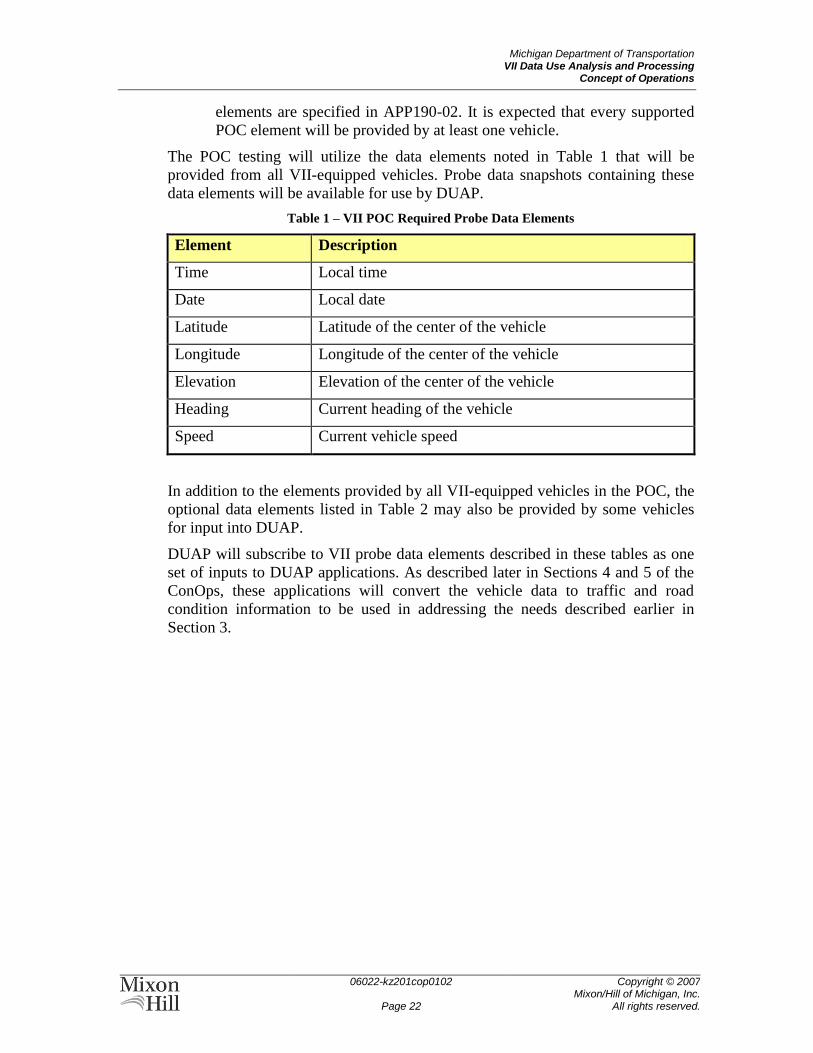
Michigan Department of Transportation VII Data Use Analysis and Processing
Concept of Operations
06022-kz201cop0102
Page 22
Copyright © 2007 Mixon/Hill of Michigan, Inc.
All rights reserved.
elements are specified in APP190-02. It is expected that every supported
POC element will be provided by at least one vehicle.
The POC testing will utilize the data elements noted in Table 1 that will be
provided from all VII-equipped vehicles. Probe data snapshots containing these
data elements will be available for use by DUAP.
Table 1 – VII POC Required Probe Data Elements
Element Description
Time Local time
Date Local date
Latitude Latitude of the center of the vehicle
Longitude Longitude of the center of the vehicle
Elevation Elevation of the center of the vehicle
Heading Current heading of the vehicle
Speed Current vehicle speed
In addition to the elements provided by all VII-equipped vehicles in the POC, the
optional data elements listed in Table 2 may also be provided by some vehicles
for input into DUAP.
DUAP will subscribe to VII probe data elements described in these tables as one
set of inputs to DUAP applications. As described later in Sections 4 and 5 of the
ConOps, these applications will convert the vehicle data to traffic and road
condition information to be used in addressing the needs described earlier in
Section 3.
Michigan Department of Transportation VII Data Use Analysis and Processing
Concept of Operations
06022-kz201cop0102
Page 23
Copyright © 2007 Mixon/Hill of Michigan, Inc.
All rights reserved.
Table 2 – VII POC Optional Probe Data Elements
Element Description
Air Temperature Ambient air temperature
Wiper Status Indication of wiper status. Settings could be: not
equipped, off, intermittent, low, high or automatic.
Vehicle Exterior
Lights
Status of exterior lights. Settings could be: parking lights,
headlights (low and high beam, automatic light control),
fog lights, daytime running lights, turn signals (right /
left), and hazard signals.
Rain Sensor
Rain/snow intensity. The value of the Rain Sensor data
element ranges from 0-7, with 0 indicating "No
Rain/Snow", 1 indicating "Light Mist", and 7 indicating
"Heavy Downpour".
Sun Sensor
Level of sunlight. The value of the Sun Sensor data
element ranges from 0-7, with 0 indicating "Complete
Darkness", 1 indicating "Minimal Sun Light", and 7
indicating "Maximum Sun Light".
Traction Control
Indication of whether one or more of the vehicle's drive
wheels was slipping during an acceleration. Values could
indicate no traction control system, or whether the
system is off, on or engaged.
Stability Control
Indication of whether the vehicle’s stability control
system is activated because of the vehicle being too far
off-axis during a turn. Values could indicate no stability
control, or whether the system is off or active.
Anti-Lock Brakes
Indication of whether the vehicles anti-lock brake system
is activated due to an extreme braking condition or a
slippery roadway condition. Values could be not
equipped, off, on or engaged.
Vertical
Acceleration Vehicle’s vertical G acceleration per second.
Brake Applied
Wheel braking status. Values could indicate whether all
brakes are off, which wheel brakes are applied, or
whether all brakes are applied.
Steering Wheel
Angle
Angle relative to straight that the steering wheel is
turned.
Steering Wheel
Angle Rate of
Change
Rate of change of the steering wheel angle.
Michigan Department of Transportation VII Data Use Analysis and Processing
Concept of Operations
06022-kz201cop0102
Page 24
Copyright © 2007 Mixon/Hill of Michigan, Inc.
All rights reserved.
Element Description
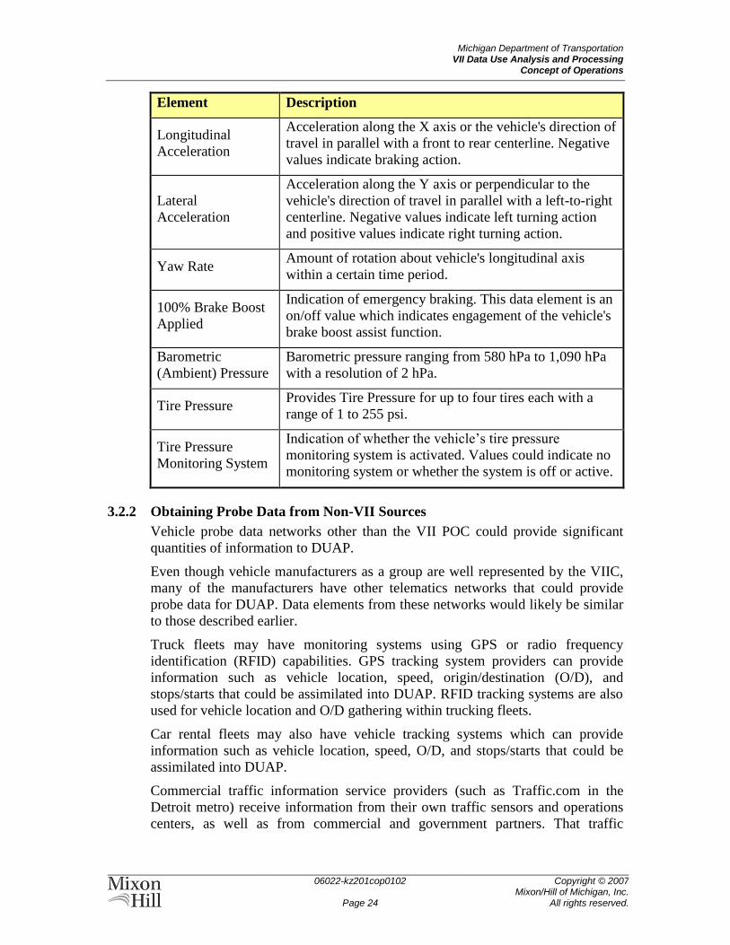
Longitudinal
Acceleration
Acceleration along the X axis or the vehicle's direction of
travel in parallel with a front to rear centerline. Negative
values indicate braking action.
Lateral
Acceleration
Acceleration along the Y axis or perpendicular to the
vehicle's direction of travel in parallel with a left-to-right
centerline. Negative values indicate left turning action
and positive values indicate right turning action.
Yaw Rate Amount of rotation about vehicle's longitudinal axis
within a certain time period.
100% Brake Boost
Applied
Indication of emergency braking. This data element is an
on/off value which indicates engagement of the vehicle's
brake boost assist function.
Barometric
(Ambient) Pressure
Barometric pressure ranging from 580 hPa to 1,090 hPa
with a resolution of 2 hPa.
Tire Pressure Provides Tire Pressure for up to four tires each with a
range of 1 to 255 psi.
Tire Pressure
Monitoring System
Indication of whether the vehicle’s tire pressure
monitoring system is activated. Values could indicate no
monitoring system or whether the system is off or active.
3.2.2 Obtaining Probe Data from Non-VII Sources
Vehicle probe data networks other than the VII POC could provide significant
quantities of information to DUAP.
Even though vehicle manufacturers as a group are well represented by the VIIC,
many of the manufacturers have other telematics networks that could provide
probe data for DUAP. Data elements from these networks would likely be similar
to those described earlier.
Truck fleets may have monitoring systems using GPS or radio frequency
identification (RFID) capabilities. GPS tracking system providers can provide
information such as vehicle location, speed, origin/destination (O/D), and
stops/starts that could be assimilated into DUAP. RFID tracking systems are also
used for vehicle location and O/D gathering within trucking fleets.
Car rental fleets may also have vehicle tracking systems which can provide
information such as vehicle location, speed, O/D, and stops/starts that could be
assimilated into DUAP.
Commercial traffic information service providers (such as Traffic.com in the
Detroit metro) receive information from their own traffic sensors and operations
centers, as well as from commercial and government partners. That traffic
Michigan Department of Transportation VII Data Use Analysis and Processing
Concept of Operations
06022-kz201cop0102
Page 25
Copyright © 2007 Mixon/Hill of Michigan, Inc.
All rights reserved.
information could be subscribed to, processed, and assimilated into DUAP to
supplement other data streams.
3.2.3 Integrating Operational Data into MDOT Systems
While much information is available within MDOT and its partners’ systems, the
data are not always shared between organizations. DUAP will be designed to
allow data to be shared between the different MDOT groups and partners. As
more data becomes available and the data reliability increases, additional
applications can be developed that will allow additional data sharing and two-way
data flows between systems with DUAP acting as a data broker.
For example, DUAP will gather traffic information on road segment speed,
volume, and occupancy from a variety of systems. These data will be integrated
with traffic information derived from VII vehicle probe data to create a single
integrated view of traffic conditions. The integrated data could be published
directly to the ATMS in a TOC and also be available to real-time traffic
forecasting applications. Similarly, data could be published from public transit
agencies as input to DUAP, where the transit fleet information could be passed on
to the MDOT ATMS.
Road and lane closure data from MDOT and other transportation agency
construction and maintenance databases could be acquired by DUAP and
integrated with other event data. The integrated event data set could be shared
with the MDOT ATMS, ISPs, and the traveling public and be used in traffic data
validation or demand forecasts.
3.3 Priorities among Changes
Determining priorities among potential system changes should begin by
considering the impacts that DUAP might have on the needs discussed in section
3.1. Decisions on implementation of changes would then be based on those
priorities and on the programmatic, institutional, and financial needs and
constraints discussed in the MDOT VII Strategic and Business Plan.
Implementation viability and risks may also be factors in setting priorities.
The highest priorities among the changes would be those related to safety and
mobility. Preventing accidents and allowing free flow of traffic on the highways
is of utmost importance. For example, secondary incidents can be prevented if
incident management response time is decreased through use of VII and DUAP.
Safety due to weather issues is also a high priority. Having additional weather
data available to the organizations responsible for salting, sanding, and plowing
can allow those groups to respond more quickly to problem areas and prevent
additional accidents. Likewise, the traveling public will be able to make safer
choices while driving in inclement weather if VII and DUAP can provide more
specific and accurate information on road conditions.
Asset monitoring, particularly monitoring of pavement conditions, is a significant
priority for MDOT operations but may be a less immediate priority for the public.
By having additional data on pavement conditions, problem areas can be quickly
Michigan Department of Transportation VII Data Use Analysis and Processing
Concept of Operations
06022-kz201cop0102
Page 26
Copyright © 2007 Mixon/Hill of Michigan, Inc.
All rights reserved.
assessed and addressed to prevent future degradation of facilities, but this will
generally not be a safety issue. Similarly, having information on traffic flow along
the highways, especially the number of heavy vehicles, would enable traffic
utilization studies to determine if modifications might need to be made, such as
having specific truck lanes or high occupancy vehicle lanes.
3.4 Changes Considered But Not Included
Proprietary telematics systems were considered but not explicitly included as
sources of data in this document. While integration with independent telematics
systems may occur in the future, the necessary institutional agreements and
intellectual property agreements are generally beyond the scope of this project.
CAD systems operated by emergency management services or agencies could be
significant sources of traffic and operations data. The CAD systems within
Michigan represent a potential external integration point, but the number of
systems, proprietary interfaces, and institutional agreements required to include
CAD systems in this project made it impractical to include CAD integration in
this deployment.
3.5 Assumptions and Constraints
Data latency is the time delay experienced when data are sent from one point to
another. Latency enters into the data collection process in several ways:
The time required for vehicle systems to collect and store vehicle data;
The delay between the data collection and the data transmission from the
vehicle to DUAP;
The time required for DUAP pre-processing of data;
The time required for the DUAP system to process the data and publish it
to other systems; and
The time between the DUAP processing and the transmission to the end
systems.
While the VII data may be more timely and complete than data currently being
processed, participants must recognize that VII data is near real-time data. Each
system using DUAP data must be capable of evaluating the data based on the
source and date/time stamps to determine the suitability of each data element for
the intended purpose.
Data quality may also be an issue. Vehicle sensors may be in various states of
calibration and may even function in degraded modes. Each application using the
VII and DUAP data will need to have the capability of assessing the quality of
data and making appropriate use of any available data quality flags.
Finally, the amount of data coming into DUAP from VII is highly dependent on
the amount of data collected by each vehicle, the number of VII-equipped
vehicles, and the means of data collection from the vehicles. While these factors
can be controlled during the evaluation phase of this project, only the means of
data collection will be within the control of agencies during the full production

Michigan Department of Transportation VII Data Use Analysis and Processing
Concept of Operations
06022-kz201cop0102
Page 27
Copyright © 2007 Mixon/Hill of Michigan, Inc.
All rights reserved.
roll-out of the system. As such, reliance on VII data to address transportation
agency management and operations challenges should be tempered by the
uncertainties of how quickly data may become available from the vehicles.
Michigan Department of Transportation VII Data Use Analysis and Processing
Concept of Operations
06022-kz201cop0102
Page 28
Copyright © 2007 Mixon/Hill of Michigan, Inc.
All rights reserved.
4 CONCEPTS FOR THE PROPOSED SYSTEM This section describes concepts for the proposed system that respond to needs
identified in Section 3. Concepts are described as operational features and are not
intended to specify or imply particular designs or implementations.
4.1 Background, Objectives, and Scope
The current state of processes and systems available to MDOT as described in
Section 2 contains significant opportunities to improve safety, mobility, and
efficient use of the state’s transportation system. Expectations for delivery of
transportation services continue to grow2, while resources for service delivery are
externally constrained. Transportation agencies are expected to satisfy greater
demand for services for less cost, all the while making a net positive contribution
to the state’s broader economic development.
These demands are illustrated in the case for change described in Section 3. The
traveling public wants more real-time information about traffic and road
conditions. MDOT wants more information about its assets and how they are used
by the traveling public. Everyone wants to travel in complete safety. While travel
demand is increasing, funding levels have not kept sufficient pace to allow
meeting that demand with new pavement or bridges alone. New technologies will
have to fill that capacity gap, and the integration of those new capabilities with
existing applications will bridge the remainder.
To that end, a strategy is put forth in MDOT’s Vehicle Infrastructure Integration
Strategic and Business Plan (Ref. 13) that focuses on partnering, developing, and
deploying a VII infrastructure and testbeds; increasing safety and mobility;
improving asset management; developing outreach programs to better expose
others to VII in Michigan; justifying the need for VII; and determining creative
investment funding venues for VII activities.
Within this context, the DUAP project will investigate and evaluate the utility of
VII data and its integration with other transportation agency sources in enhancing
safety, increasing mobility, and improving asset management. Tasks within
DUAP will identify uses for the VII data, develop algorithms to use and process
the VII data, develop prototype applications and data management software, and
evaluate the utility of the processed data for MDOT and its partners. Data
processing will require acquisition from a variety of sources, standardization and
integration, storage, synthesis for particular applications, and dissemination.
4.2 Stakeholders
Stakeholders in DUAP-enhanced transportation system operations are almost
entirely the same as those involved in the current state of operations. The intent of
adding new data sources is to provide a more complete dataset upon which the
2 AASHTO reports, for example, that ―Interstate highway travel demand measured through vehicle miles
traveled (VMT) will increase from 690 billion in 2002 to 1.3 trillion by 2026.‖ (Ref. 1, page 20)
Michigan Department of Transportation VII Data Use Analysis and Processing
Concept of Operations
06022-kz201cop0102
Page 29
Copyright © 2007 Mixon/Hill of Michigan, Inc.
All rights reserved.
transportation agencies can base operational decisions, but there are not
necessarily any new users of VII data within the agencies. The providers of VII
data are, however, new stakeholders in transportation operations.
The automobile manufacturers (or original equipment manufacturers, OEMs) and
their suppliers become stakeholders in DUAP because VII data become available
to transportation agencies only if those OEMs provide equipment and
communication systems in their vehicles for transmitting the data to the VII
network. Many of the OEMs are members of the VIIC, which is developing the
on-board equipment (OBE) and assisting the USDOT in development of
applications for VII infrastructure and data. OEMs are in many cases also
developing independent telematics networks from which transportation agencies
might be able to obtain data similar to that provided through the USDOT/VIIC
efforts.
Automotive industry research groups and associations become stakeholders in
DUAP through their support of the MEDC and the automotive manufacturers.
The Center for Automotive Research (CAR) and Connected Vehicle Trade
Association (CVTA), for example, provide perspective and research on industry
trends, policies, and methodologies. In particular, the Connected Vehicle Proving
Center (CVPC) under development by CAR and CVTA will test and evaluate
connected vehicle systems by integrating connected vehicles, smart roadway
infrastructure, and communication technologies to showcase the potential of VII
and related vehicle-communications initiatives.
The VII network (and any similar independent telematics networks) will also
introduce a network operating entity as a stakeholder to DUAP and transportation
system operations. Once the VII field infrastructure is in place, a network
operating entity will be needed to operate, monitor, and maintain the flow of VII
data and the infrastructure enabling it. The operating entity’s responsibilities in
this capacity are similar to those of a transportation agency relative to the
transportation network. The operating entity’s telecommunications service
providers would be indirect stakeholders in DUAP.
4.3 Description of the Proposed System
When describing a system, there are many ways to represent what the system will
do and how it will be implemented. Each representation has its own strengths and
limitations, but all are intended to create understanding of the system’s
boundaries, components, and interactions. Each representation has its own set of
basic units and interactions. One or more of these representations taken together
describe the system architecture.
Systems similar to the DUAP system are frequently and effectively represented as
sets of interacting services. Each service has one or more interfaces by which the
services interact. This representation is a very natural way of approaching a
potentially complex system with a basic repeatable model.
A representation based on services and interfaces inherently leads to a flexible,
scalable, and maintainable design. With well-defined interfaces, it is possible to

Michigan Department of Transportation VII Data Use Analysis and Processing
Concept of Operations
06022-kz201cop0102
Page 30
Copyright © 2007 Mixon/Hill of Michigan, Inc.
All rights reserved.
improve the functions of the system by adding services that conform to the
interfaces, but provide new operations. Services do not unnecessarily constrain
the physical and computational hardware to which they might be deployed. It is
possible to scale the system by adding hardware to support the processing needs
of new services as they are developed and deployed. Maintainability can be
preserved by being able to update both hardware and software components while
the system is running.
A DUAP system based on a service-oriented architecture will then be flexible,
scalable, and maintainable. It will be capable of handling large amounts of
continuously streaming data. It will support current and future MDOT missions
and goals.
Figure 4 is a simple (but abstract) representation of the DUAP system as a set of
services. As shown in the figure, the basic services provided by DUAP are input,
dynamic data, computational, persistent data, output, presentation, and
administrative. These basic services are common to all information systems, but
will have specific implementations for DUAP to assure that it meets the needs
described earlier in the ConOps.
Figure 4 – DUAP System Services
4.3.1 Input Services
Input services provide the ability for DUAP to interact with any other system that
might have data needed by DUAP. As described in Section 3, these other systems
could include the VII POC, other probe data services, other transportation agency
traffic management systems, commercial traffic information service providers,
and weather service providers. A specific DUAP input service would be needed
for each source of data.
Michigan Department of Transportation VII Data Use Analysis and Processing
Concept of Operations
06022-kz201cop0102
Page 31
Copyright © 2007 Mixon/Hill of Michigan, Inc.
All rights reserved.
The VII POC input services, for example, will use the X-031 Probe Data Service
interface as described by the VII Network User to Service Delivery Node
Subsystem document. DUAP data input services will send a subscription request
to the Probe Data Service, to be fulfilled within the VII network. As infrastructure
data are collected from the vehicles by the network, the network feeds the data
continuously to the subscribed DUAP services.
Input services will also receive speed, volume, and occupancy data from ATIS
throughout the state. The MITS Center ATMS, for example, will have its own
input service for collecting speed, volume, and occupancy, and may also obtain
event descriptions and messages posted on CMS/DMS.
4.3.2 Dynamic Data Services
The Dynamic Data Services are the active memory of DUAP. Data obtained by
the Input Services are stored here for use by other DUAP components. Following
a pattern similar to the input services, the Dynamic Data Services (and other
services within the DUAP system) register with the Input Services to receive
copies (subscriptions) of the data for their use. The Dynamic Data Services then
provide a buffering service within the DUAP system to increase the data
longevity so that other more complex services will have an opportunity to process
the data completely. As input data are buffered, they are immediately made
available to other services.
4.3.3 Persistent Data Services
The Persistent Data Services are the long-term memory of DUAP. While
buffering services like the Dynamic Data Services are intended to store data that
are readily accessible and saved for a relatively short duration, longer-term
storage will be fulfilled by Persistent Data Services. Archive services, for
example, will receive vehicle data from buffering services just like other services
in the DUAP system. Buffering services provide fast access to the most recent
vehicle data, while archive services will organize and provide long-term storage
for vehicle information to support future data analysis and management needs.
4.3.4 Computational Services
The purpose of the DUAP system’s Computational Services is to apply logical
algorithms to incoming vehicle and traffic observations in order to transform
those observations into data that are directly applicable to transportation
management and operations processes. Computational services will operate on the
dynamic and persistent data to perform analysis functions that derive new and
useful information about what is occurring within the public infrastructure.
Derived information can then be operated upon by still other computational
services for further analysis.
Many computational services are possible. A list of immediately useful
algorithms follows:
Incident Detection and Location
Michigan Department of Transportation VII Data Use Analysis and Processing
Concept of Operations
06022-kz201cop0102
Page 32
Copyright © 2007 Mixon/Hill of Michigan, Inc.
All rights reserved.
Queue Length
Travel Time
Segment Aggregation
Weather Condition
Road/Bridge Condition
Pothole Locator
Data Quality Checking
4.3.5 Output Services
Output Services subscribe to data within DUAP Dynamic and Persistent Data
Services and structure and format it for use by other services within and external
to the DUAP system. For example, SAE J2354 XML-formatted data can be
produced as data output to other systems that provide traveler information and
enhance public safety.
Data output services also format analyzed data for use by presentation services.
An example of this relationship between data output and presentation services is
sending information messages to a VII participating vehicle. This interaction
could be achieved by preparing data according to the X-032 interface—described
by VII National System Specification—to an Advisory Message Distribution
Service.
4.3.6 Presentation Services
Presentation Services support human interpretation of DUAP data. Due to the
inherent flexibility in modular service implementation, presentation services—and
the data output services that support those presentation services—can be added to
the system as needed.
For example, a traveler information presentation service might be expected to
provide information on incidents and travel times through a Web page. Other
computational services—incident detection travel time calculation, and incident
status monitoring, for example—would generate the data, and an output service
would package the data. A presentation service, however, would create the user
interface. Similarly, presentation services for maintenance support systems could
be deployed to generate pavement segment maintenance priority lists, immediate
maintenance alerts, and estimated segment roadway life expectancy from data
created by other computational services.
4.3.7 Administrative Services
Administrative Services exist within the DUAP system to configure other
services. Essentially, administrative services fulfill the role of ―meta-services.‖
These services will be used to organize the sequence of execution for any of the
other services, to view logging information, and to change the operating modes of
the system.
Michigan Department of Transportation VII Data Use Analysis and Processing
Concept of Operations
06022-kz201cop0102
Page 33
Copyright © 2007 Mixon/Hill of Michigan, Inc.
All rights reserved.
4.4 Operational Policies and Constraints
Operational policies will need to be established to protect the privacy and data
ownership of the data originators. While the USDOT VII program is addressing
policy issues for the VII network itself, MDOT will be faced with many of the
same issues as it seeks to integrate VII data into its operations.
For example, while VII probe data are ―anonymized‖ to the extent that
information is not associated directly with a particular vehicle or driver, there are
inherent limitations to that anonymity. In the simplest such case, the VII-
originated record of a vehicle’s behavior could be uniquely correlated to a
particular vehicle if it were the only such vehicle on a roadway at a particular time
and corroborated by other observations. While this may not be a significant policy
issue during system development and testing or after every vehicle on the road is
VII-enabled, it could become an issue in the transition—when some but not all
vehicles are so equipped and are therefore more easily identifiable.
The question of ownership of comingled data may become an issue for DUAP-
based information. MDOT and its partner transportation agencies currently
subscribe to selected traffic, vehicle location, and weather information services
that would be blended into the DUAP data streams. While the bulk of data will be
from the VII network, other sources present opportunities for data expansion and
validation that might be necessary for DUAP to succeed. Limitations on the use or
redistribution of data from these third-party sources could hamper the usefulness
of DUAP and will need to be considered in agreements for those services.
4.5 Modes of Operation
Modes of operation are a way of defining and expressing sets of conditions under
which a system is expected to operate. From a system user’s perspective, the
modes define what can (or can’t) happen while the system is in that mode. From a
system developer’s perspective, modes prescribe what the system should (or
should not) do while the system is in that mode. In an automobile, for example,
the mode is driver-selected by the ignition switch, which then constrains what
vehicle subsystems are enabled or disabled. The modes of operation for the
DUAP software system are:
Start – Start is the mode that tells the administrative services to start the
dependent processes sequentially as defined. A system in this mode will
either transition to Normal mode or to Shutdown mode.
Normal – Normal is the desired mode for the system. In this mode, the
system is ready to receive and process data as designed. From this mode,
the system can either go into Abnormal mode, Diagnostic/Repair mode, or
Shutdown mode.
Abnormal – In this mode, the system is still functioning but is also
experiencing a problem. From this mode, the system can either go into
Diagnostic/Repair mode or Shutdown mode.
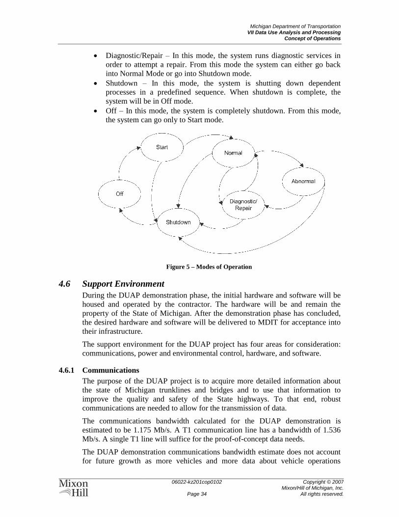
Michigan Department of Transportation VII Data Use Analysis and Processing
Concept of Operations
06022-kz201cop0102
Page 34
Copyright © 2007 Mixon/Hill of Michigan, Inc.
All rights reserved.
Diagnostic/Repair – In this mode, the system runs diagnostic services in
order to attempt a repair. From this mode the system can either go back
into Normal Mode or go into Shutdown mode.
Shutdown – In this mode, the system is shutting down dependent
processes in a predefined sequence. When shutdown is complete, the
system will be in Off mode.
Off – In this mode, the system is completely shutdown. From this mode,
the system can go only to Start mode.
Figure 5 – Modes of Operation
4.6 Support Environment
During the DUAP demonstration phase, the initial hardware and software will be
housed and operated by the contractor. The hardware will be and remain the
property of the State of Michigan. After the demonstration phase has concluded,
the desired hardware and software will be delivered to MDIT for acceptance into
their infrastructure.
The support environment for the DUAP project has four areas for consideration:
communications, power and environmental control, hardware, and software.
4.6.1 Communications
The purpose of the DUAP project is to acquire more detailed information about
the state of Michigan trunklines and bridges and to use that information to
improve the quality and safety of the State highways. To that end, robust
communications are needed to allow for the transmission of data.
The communications bandwidth calculated for the DUAP demonstration is
estimated to be 1.175 Mb/s. A T1 communication line has a bandwidth of 1.536
Mb/s. A single T1 line will suffice for the proof-of-concept data needs.
The DUAP demonstration communications bandwidth estimate does not account
for future growth as more vehicles and more data about vehicle operations
Michigan Department of Transportation VII Data Use Analysis and Processing
Concept of Operations
06022-kz201cop0102
Page 35
Copyright © 2007 Mixon/Hill of Michigan, Inc.
All rights reserved.
becomes available. Should it become necessary during the DUAP demonstration,
the proposed solution is to purchase additional T1 lines up to a maximum of eight.
At that point, it is more economical to purchase a single DS3 line (equivalent to
28 T1 lines). It is unlikely that the data volume will reach that high level during
the demonstration. MDIT will be able to make its own assessment of
communication needs based on its existing infrastructure and the additional
demands placed on it through the deployment of the DUAP system.
The communications needs just discussed are from the perspective of the wide
area network (WAN) segment of the DUAP system connected to the VII network.
Local area networks (LANs) are connected to the WAN using switches and
routers. The LAN for the DUAP project will be connected using Gigabit Ethernet
switches and routers. Gigabit Ethernet equipment is widely available and cost
effective. Through the use of modular networking equipment, it is possible to
upgrade to higher communication bandwidth by replacing computer network
interface cards and switches as it becomes necessary and economical to do so.
4.6.2 Power and Environmental Control
The computer hardware will be housed in a restricted access, environmentally
controlled room. The servers will be mounted in standard (42U, 19-inch) racks.
Uninterruptible power supplies (UPS) will provide conditioned and continuous
power for the system and will be mounted near the servers.
UPS will be able to sustain the DUAP system for 20 minutes in the event of total
power failure. This level of UPS is sufficient for the DUAP proof-of-concept as
95% of all power interruptions in a metropolitan area last less than two minutes.
Power interruptions lasting more than 20 minutes will result in temporary loss of
access to the DUAP demonstration system. Access to the DUAP system will be
automatically restored when main power is restored.
4.6.3 Hardware
The equipment and software for this project will meet the MDIT guidelines
provided at the start of the project. Any exceptions will be documented and
approved by MDIT before implementation.
Computing hardware will consist of Sun Microsystems X4200 servers or
equivalent models. Each server will contain a minimum of two dual-core
processors, equating to at least four processors per machine. Memory will be
maximized according to server purpose and software needs. Up to 16 gigabytes
(GB) of random access memory can be installed for each server. Storage will
consist of high-speed, 73 GB serial-attached SCSI disk drives. Up to four disk
drives per server can be installed.
Sun servers have a feature called Integrated Lights-Out Management (ILOM).
Essentially there is a small computer built into the server that monitors the server
health. With ILOM, it is possible to securely and remotely monitor, shut down,
and restart the DUAP system when necessary.
Michigan Department of Transportation VII Data Use Analysis and Processing
Concept of Operations
06022-kz201cop0102
Page 36
Copyright © 2007 Mixon/Hill of Michigan, Inc.
All rights reserved.
4.6.4 Software
The software for this project will meet MDIT standards provided at the start of
this project. Any exceptions will be documented and approved by MDIT before
implementation. MDIT will be consulted throughout this project to ensure
compliance with these standards.
MDIT is skilled in the use of Java technologies. Building on a Java software
foundation has the advantage of being operating system agnostic. It is possible to
install Microsoft, Sun, or other open source operating systems on the suggested
server hardware. MDIT is currently running the Solaris operating system and the
DUAP software will follow that lead.
Java and its related software frameworks and technologies will be used to develop
the applications. Java Database Connectivity (JDBC) enables generic access to
differing vendor databases. The selected relational database will be Oracle 10G,
and database information requests will be handled through standard Structured
Query Language (SQL) commands.
MDOT and MDIT may have existing algorithms and software modules that can
be leveraged for the DUAP project. Software modules will be interfaced to the
system using the Java Native Interface (JNI) where possible. Algorithms and non-
interfaced software modules can be implemented using JAVA and will then be
directly usable by the DUAP project.
Configuring the DUAP system as a set of services has an advantage in flexibility.
It will be possible to re-organize service deployments across the available
computing hardware. Fewer very demanding computational services can be
installed on one set of servers while less demanding services can be installed on
another set of servers. Processing load will be distributed more evenly across the
available computing resources, minimizing information bottlenecks.
Michigan Department of Transportation VII Data Use Analysis and Processing
Concept of Operations
06022-kz201cop0102
Page 37
Copyright © 2007 Mixon/Hill of Michigan, Inc.
All rights reserved.
5 OPERATIONAL SCENARIOS A scenario is a step-by-step description of how the proposed system should
operate and interact with its users and its external interfaces under a given set of
circumstances. The following scenarios will allow readers to walk through
activities and gain an understanding of how the various parts of the proposed
system function and interact. The scenarios will tie together the system, the users,
and other entities by describing how they interact.
Scenarios are not limited to addressing specific needs (Section 3.1), but discuss
the future system in the larger context of potential future operations. In addition,
the specific parameters to be provided by VII in any particular scenario are
representative of the DOT’s interests, but may not be in the immediate scope of
VII implementation plans. Similarly, the scenarios are not specific about the
networks through which data from VII-equipped vehicles are obtained by DUAP
applications. Future VII networks could use a variety of technologies,
implemented in phases beyond the existing VII POC program.
5.1 Traffic Incident
A crash occurs during typical rush hour congestion with clear weather conditions
on the southbound segment of I-275/I-96 just north of 10 Mile where it reduces
down to four lanes. For the purposes of the scenario, it is assumed that the
segment is not being monitored by video surveillance but does have traffic
sensors that are monitored at the MITS Center. Detector stations are located about
0.5 mile upstream and 1.5 miles downstream of the event location. Vehicle 1 is hit
in the left rear end by Vehicle 2, and the impact activates the airbags in Vehicle 2.
The accident blocks the left two lanes of the roadway.
Numerous vehicles behind the accident apply brakes, and the Antilock Brake
Systems (ABS) are activated in some vehicles. The vehicles reduce speed to avoid
disabled Vehicles 1 and 2. Vehicles attempt to merge from the left lanes into the
right two lanes, resulting in turn signal activations, changes in steering wheel
angle, wheel angle, heading, and further reduction in speed. On-board equipment
acquires a mix of periodic snapshots (views of all data available at any particular
time) and vehicle event data (snapshots taken based on a vehicle systems event
such as ABS actuation). Data received from the vehicles includes:
Location
Speed
Heading
Longitudinal Acceleration
ABS
Wheel Angle
Meanwhile, numerous vehicle drivers call 911, whereby a general description of
the event and its location are picked up by local emergency services. An incident
notification is received in the MITS Center CAD system approximately 60
seconds after the incident is first called in. The traffic queue behind the crash
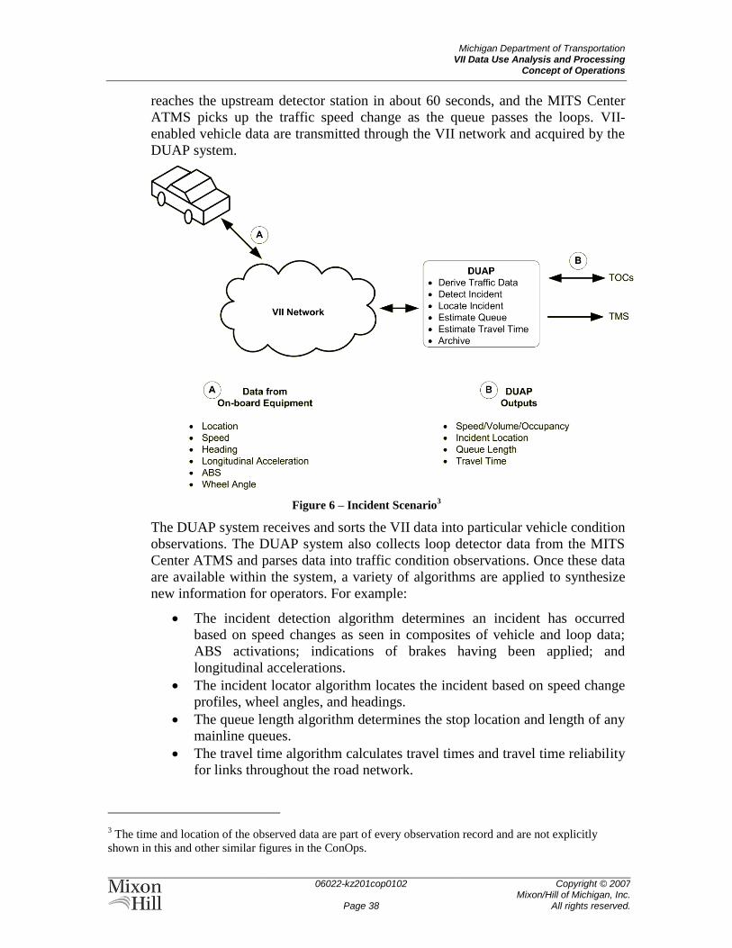
Michigan Department of Transportation VII Data Use Analysis and Processing
Concept of Operations
06022-kz201cop0102
Page 38
Copyright © 2007 Mixon/Hill of Michigan, Inc.
All rights reserved.
reaches the upstream detector station in about 60 seconds, and the MITS Center
ATMS picks up the traffic speed change as the queue passes the loops. VII-
enabled vehicle data are transmitted through the VII network and acquired by the
DUAP system.
Figure 6 – Incident Scenario3
The DUAP system receives and sorts the VII data into particular vehicle condition
observations. The DUAP system also collects loop detector data from the MITS
Center ATMS and parses data into traffic condition observations. Once these data
are available within the system, a variety of algorithms are applied to synthesize
new information for operators. For example:
The incident detection algorithm determines an incident has occurred
based on speed changes as seen in composites of vehicle and loop data;
ABS activations; indications of brakes having been applied; and
longitudinal accelerations.
The incident locator algorithm locates the incident based on speed change
profiles, wheel angles, and headings.
The queue length algorithm determines the stop location and length of any
mainline queues.
The travel time algorithm calculates travel times and travel time reliability
for links throughout the road network.
3 The time and location of the observed data are part of every observation record and are not explicitly
shown in this and other similar figures in the ConOps.
Michigan Department of Transportation VII Data Use Analysis and Processing
Concept of Operations
06022-kz201cop0102
Page 39
Copyright © 2007 Mixon/Hill of Michigan, Inc.
All rights reserved.
The DUAP system creates outputs to notify and provide incident data to
interacting applications through the publication of SAE J2354 center-to-center
(C2C) traveler information messages.
Information is picked up from the DUAP system by the MITS ATMS (and any
other subscribing transportation agency center systems), which then presents data
to operators.
Information is also picked up from the DUAP system by VII traveler information
services, which then structure and forward messages in appropriate formats to the
VII network for broadcast to affected vehicles. Messages from the DUAP system
may include link speeds, travel times, and event descriptions. Some VII messages
may contain value-added elements such as recommended routing to minimize
travel time of affected travelers.
Finally, data and outgoing messages are logged by the DUAP system archiving
services. This preserves both the data for replaying events or for future analysis
and the record of system activities for system monitoring and operations.
The DUAP system data supplements, but does not replace, existing MITS Center
operator interfaces (e.g., maps, alerts, event reports). Operators relate and confirm
the incident with information received from the native ATMS interfaces and
emergency services dispatch. Operators then create messages for display on signs
along the affected corridor, and the ATMS publishes a new update of those
messages. Operators may dispatch Courtesy Patrol and maintenance vehicles as
needed to support clearance and restoration of traffic flow.
The DUAP system then collects the MITS ATMS CMS/DMS messages for
republication in the SAE J2354 format back to other users such as VII.
The event is resolved as emergency services clear the incident from active traffic
lanes. The incident is ―closed‖ from a traffic perspective when performance
conditions are restored to pre-incident levels, which could be determined or
verified by a DUAP algorithm. The incident is documented in MSP Form UD-10,
which is incorporated into MDOT TMS and can be correlated with the DUAP
system data archive.
5.2 Weather Response
An unexpected early spring storm has brought a mix of rain, sleet, and snow over
southeast Michigan. The ground is still largely frozen from winter, and air
temperatures are hovering just above freezing. Conditions worsen through the
day, and forecasts are now predicting the most intense precipitation to occur
during the evening rush hour. Pretreatment options are limited because of the rain;
any chemicals applied would be wasted. Forecasts are not clear on what form the
precipitation will take—rain, sleet, or snow—in any particular location.
Conditions are particularly problematic on road segments near any of the larger
lakes. Lake effect snows could intensify quickly. Operationally, MDOT and the
county maintenance crews will have to depend on near real-time data routed
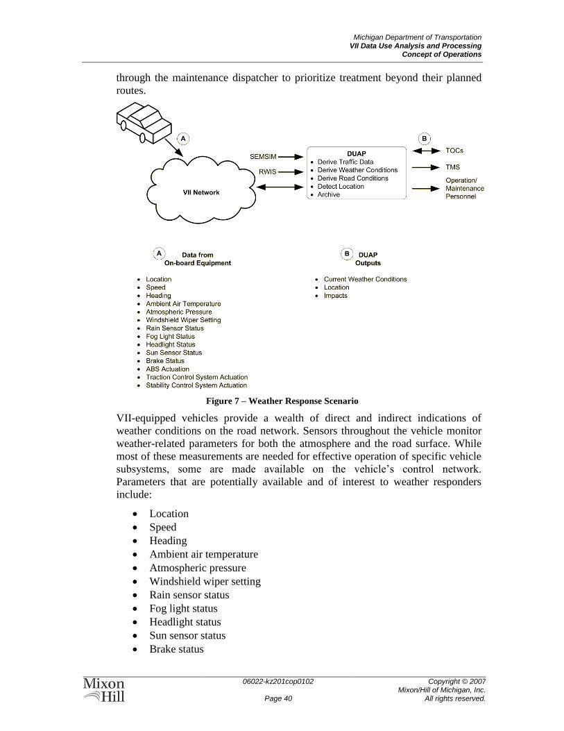
Michigan Department of Transportation VII Data Use Analysis and Processing
Concept of Operations
06022-kz201cop0102
Page 40
Copyright © 2007 Mixon/Hill of Michigan, Inc.
All rights reserved.
through the maintenance dispatcher to prioritize treatment beyond their planned
routes.
Figure 7 – Weather Response Scenario
VII-equipped vehicles provide a wealth of direct and indirect indications of
weather conditions on the road network. Sensors throughout the vehicle monitor
weather-related parameters for both the atmosphere and the road surface. While
most of these measurements are needed for effective operation of specific vehicle
subsystems, some are made available on the vehicle’s control network.
Parameters that are potentially available and of interest to weather responders
include:
Location
Speed
Heading
Ambient air temperature
Atmospheric pressure
Windshield wiper setting
Rain sensor status
Fog light status
Headlight status
Sun sensor status
Brake status
Michigan Department of Transportation VII Data Use Analysis and Processing
Concept of Operations
06022-kz201cop0102
Page 41
Copyright © 2007 Mixon/Hill of Michigan, Inc.
All rights reserved.
ABS actuation
Traction control system actuation
Stability control system actuation
These observations are collected on the vehicle for publishing through the VII
network to subscribing weather analysis services. For example:
The DUAP system subscribes specifically to weather data with immediate
operational impact. This subscription reduces the latency of data
transmission and analysis, and allows DUAP to anticipate significant
changes in weather conditions and in forecasts.
FHWA’s Weather Data Translator (WDT) subscribes to the VII data so
that it can be correlated with supplemental data sets to synthesize pseudo-
observations along road segments. The output is consistent with the
Clarus system. Clarus then checks the quality of the data with in situ
observations to present a unified view of the observation field for mapping
and analysis.
Enhanced local weather response systems can subscribe to VII data to
supplement their existing detection. A bridge-deicing system, for example,
could use not just measurements of road surface temperature and
conductivity from its own instruments, but could monitor vehicle response
to determine appropriate deicing strategies.
SEMSIM-equipped maintenance vehicles throughout the area are out on the roads
monitoring conditions specifically in order to improve safety and mobility of the
traveling public. Data on road conditions and atmospheric observations are
collected in real-time and sent immediately to the SEMSIM servers. The trucks
also send information on any treatment and plowing operations they may be
executing. These data are sent with the vehicle location and observation time to
the automatic vehicle location (AVL) system servers, from which they are taken
for presentation in the SEMSIM user interfaces and for incorporation in DUAP
applications.
Fixed ESS are deployed at specific locations throughout the region to address
local weather-dependent concerns such as bridge icing, low visibility due to fog
or intense precipitation, and flooding. Other ESS are deployed regionally to
provide characteristic surface conditions and to supplement atmospheric
observations from the National Oceanic & Atmospheric Administration (NOAA),
the Michigan Department of Natural Resources (DNR), and other agencies
concerned with more generalized observations and forecasting. Observations are
collected by the RWIS servers from the ESS, and are subsequently collected from
those servers by the DUAP system, the Clarus system, and other NOAA and
commercial meteorological interests.
The DUAP system aggregates all the weather observations from these disparate
sources to create a consistent set of observation fields. The system can then
Michigan Department of Transportation VII Data Use Analysis and Processing
Concept of Operations
06022-kz201cop0102
Page 42
Copyright © 2007 Mixon/Hill of Michigan, Inc.
All rights reserved.
integrate the weather observations with corresponding traffic observations to
correlate weather impacts and identify weather-response priorities. For example4:
Air temperature change and relative humidity (from ESS), headlights, and
vehicle speed changes (braking) might be used to indicate fog
development; and
Headlight state, windshield wiper settings, and vehicle speed changes
could be used to indicate the presence of precipitation.
Once these direct and correlated observations are available, watch points and
thresholds on key weather condition measures can be set to notify traffic
operations and maintenance personnel. Weather information messages may be
created for posting on CMS/DMS and publication to traveler information outlets.
Further correlation of weather and traffic conditions could generate real-time risk
maps to support dispatch of traffic control, Emergency Management Services
(EMS), and/or courtesy patrols to the highest priority locations.
Based on these correlations, the DUAP system will send notices to subscribers via
email, pager, or instant messaging (IM) whenever particular watch parameters
exceed their notification thresholds.
Among automated system interfaces, the MITS ATMS and other traffic
management systems could be provided with weather and road condition reports
to overlay on network maps. SEMSIM could get additional data for faster and
more granular updates on specific road segment conditions and combine those
with a maintenance decision support system (MDSS) to dynamically update and
optimize treatment plans. RCOC’s FAST-TRAC system could get notice of the
need for extended signal phases to facilitate mobility on snow routes.
In response to these notifications, the MITS Center would be enabled to provide
information on specific weather hazards (e.g., icing, flooding) just as it provides
information on other traffic events. SEMSIM could improve deployment of
vehicles to prioritized maintenance needs; change treatment and plowing routes
dynamically; monitor segments that are temporarily inaccessible or not otherwise
able to be monitored; and allow for more accurate treatment analysis and
deployment, thereby reducing costs. RCOC could use FAST-TRAC to create true
emergency snow routes, rerouting traffic either to predetermined high-priority
roadways, or dynamically adjusting timing to store and buffer or redistribute
flows based on real-time roadway conditions.
5.3 Special Event Planning and Execution
The National Baby Food Festival (http://www.babyfoodfest.com) in Fremont,
Michigan (population 4500) has in past years presented only a minor challenge
for traffic planning and management. The town is reached primarily by highway
4 The National Center for Atmospheric Research (NCAR) has performed a preliminary analysis of possible
correlations that go beyond the direct vehicle/VII-provided observations and would provide significant
meteorological value.
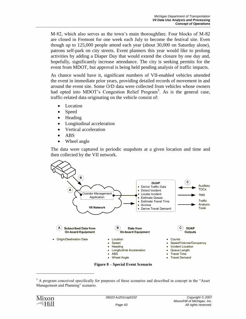
Michigan Department of Transportation VII Data Use Analysis and Processing
Concept of Operations
06022-kz201cop0102
Page 43
Copyright © 2007 Mixon/Hill of Michigan, Inc.
All rights reserved.
M-82, which also serves as the town’s main thoroughfare. Four blocks of M-82
are closed in Fremont for one week each July to become the festival site. Even
though up to 125,000 people attend each year (about 30,000 on Saturday alone),
patrons self-park on city streets. Event planners this year would like to prolong
activities by adding a Diaper Day that would extend the closure by one day and,
hopefully, significantly increase attendance. The city is seeking permits for the
event from MDOT, but approval is being held pending analysis of traffic impacts.
As chance would have it, significant numbers of VII-enabled vehicles attended
the event in immediate prior years, providing detailed records of movement in and
around the event site. Some O/D data were collected from vehicles whose owners
had opted into MDOT’s Congestion Relief Program5. As is the general case,
traffic-related data originating on the vehicle consist of:
Location
Speed
Heading
Longitudinal acceleration
Vertical acceleration
ABS
Wheel angle
The data were captured in periodic snapshots at a given location and time and
then collected by the VII network.
Figure 8 – Special Event Scenario
5 A program conceived specifically for purposes of these scenarios and described in concept in the ―Asset
Management and Planning‖ scenario.
Michigan Department of Transportation VII Data Use Analysis and Processing
Concept of Operations
06022-kz201cop0102
Page 44
Copyright © 2007 Mixon/Hill of Michigan, Inc.
All rights reserved.
Data from last year’s event were collected by DUAP and processed into traffic
management parameters. As in other scenarios utilizing traffic data for operations
monitoring and congestion planning, the DUAP system converted vehicle
movement data into more traditional measures of speed, volume, and occupancy
on given segments and synthesizes turning movements and any trip data not
provided directly by the VII network. Data were archived within DUAP and
converted to TMS/H-compliant forms for export.
Availability of data from the VII network in the prior year facilitated the use of
MDOT’s mobile Auxiliary TOC, which received event data through DUAP. This
combination of resources enabled MDOT and event managers to provide real-
time traffic information and travel times on CMS on approaches into and in town
during the event. The CMS could also be used during the event to advise
attendees of parking locations and availability.
In this year’s event planning study, O/D, demand, turning movement, and parking
data from last year’s event are fed into simulation models with the proposed event
changes to determine the impact of increased demand. Output from the simulation
can be used to make modifications to last year’s event traffic management plan to
accommodate the increased demand. Deployment of the Auxiliary TOC in
conjunction with increasing proportions of VII-enabled vehicles can then be used
to verify the simulation forecasts and collect data for subsequent years.
5.4 Maintenance Planning
A section of highway consisting of an interchange, ramps, and overpass is seeing
exceptionally high degradation rates. The pavement has visible rutting and
cracking, and potholes have developed on joints. The bridge/pavement interface is
developing significant gaps and potholes/ledges on the approach side. The
interchange and arterial were expanded three years ago, and there is significant
new industrial development in the area.
The increased traffic in the area is providing more VII data as well as increased
pavement wear. VII-equipped vehicles are experiencing significant vertical and
longitudinal accelerations from potholes, cracks, and gaps, and a noticeable
increase in rapid wheel angle changes due to swerves and lane changes to avoid
the surface defects and obstacles. Data collected in these vehicles include:
Location
Speed
Heading
Longitudinal acceleration
Vertical acceleration
ABS
Wheel angle
DUAP receives this information from the VII network as it does any other set of
vehicle observations, and the observations are available for use with other VII
data for correlation with traffic, incident, and weather data. There are, however,
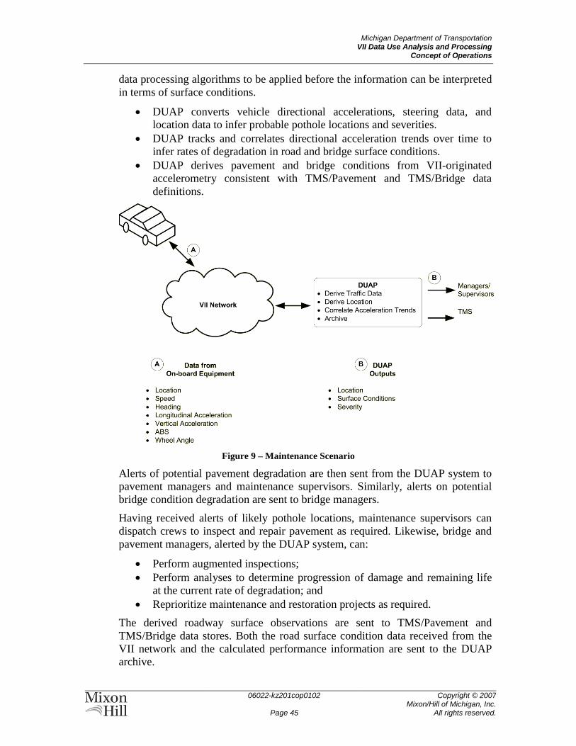
Michigan Department of Transportation VII Data Use Analysis and Processing
Concept of Operations
06022-kz201cop0102
Page 45
Copyright © 2007 Mixon/Hill of Michigan, Inc.
All rights reserved.
data processing algorithms to be applied before the information can be interpreted
in terms of surface conditions.
DUAP converts vehicle directional accelerations, steering data, and
location data to infer probable pothole locations and severities.
DUAP tracks and correlates directional acceleration trends over time to
infer rates of degradation in road and bridge surface conditions.
DUAP derives pavement and bridge conditions from VII-originated
accelerometry consistent with TMS/Pavement and TMS/Bridge data
definitions.
Figure 9 – Maintenance Scenario
Alerts of potential pavement degradation are then sent from the DUAP system to
pavement managers and maintenance supervisors. Similarly, alerts on potential
bridge condition degradation are sent to bridge managers.
Having received alerts of likely pothole locations, maintenance supervisors can
dispatch crews to inspect and repair pavement as required. Likewise, bridge and
pavement managers, alerted by the DUAP system, can:
Perform augmented inspections;
Perform analyses to determine progression of damage and remaining life
at the current rate of degradation; and
Reprioritize maintenance and restoration projects as required.
The derived roadway surface observations are sent to TMS/Pavement and
TMS/Bridge data stores. Both the road surface condition data received from the
VII network and the calculated performance information are sent to the DUAP
archive.

Michigan Department of Transportation VII Data Use Analysis and Processing
Concept of Operations
06022-kz201cop0102
Page 46
Copyright © 2007 Mixon/Hill of Michigan, Inc.
All rights reserved.
If thresholds for alerts were not exceeded, degradation would be confirmed in
regular (biennial) bridge and pavement surveys.
In this case, the accelerated loss of roadway surface integrity is determined to be
due to the increased number of heavy vehicles used in adjacent development. The
availability of more pavement condition information in a more timely manner
provides an increasingly objective basis for project prioritization and allows the
Call for Projects, Five-Year Road and Bridge Program, SLRP, and STIP to be
updated. Restoration and interchange improvements are accelerated beyond the
original SLRP, thus bringing the highway back into compliance with its
performance benchmarks for mobility and safety.
5.5 Asset Management and Planning
Increasing traffic demands within Michigan generally cause increasing congestion
and decreasing mobility. This results in safety issues and negative economic
impacts due to the amount of time spent in traffic queues. As part of a Congestion
Relief Program, MDOT studies various locations to assess and implement a
solution. The congested corridor consists of a section of highway, including
interchange and ramps, together with the major arterial feeding the interchange
and its nearby intersections.
VII-equipped vehicles moving through the corridor provide data which includes:
Location
Speed
Heading
Longitudinal acceleration
ABS
Wheel angle
By VII design, data are provided as sequences of periodic location/speed/heading
snapshots without reference to the particular vehicle generating the data. This
scheme is intended to protect the anonymity of the drivers and vehicles by
limiting the ability to identify individuals by their travel patterns. Drivers and
vehicles opting into the MDOT Congestion Relief Program, however, can remove
the restrictions toward anonymity and provide continuous trip data, from origin to
destination, throughout the range of the VII network.
Data acquired on VII-equipped vehicles are sent through normal VII network
operations and received by the DUAP system. These data are then combined with
other data from fixed monitoring devices and correlated with asset, incident, and
weather data.
DUAP correlates location, speed, heading, and brake activity for multiple
vehicles to infer and synthesize volume and occupancy along segments
being observed. The individual vehicle speed data can be compressed into
characteristic pseudo-observations for each lane and segment.
DUAP converts the time-dependent location data into trip/segment
profiles detailing lane changes and turning movements.
Michigan Department of Transportation VII Data Use Analysis and Processing
Concept of Operations
06022-kz201cop0102
Page 47
Copyright © 2007 Mixon/Hill of Michigan, Inc.
All rights reserved.
While the DUAP system performs data transformations to provide a base of
traffic information, there are a variety of tools already in existence for analyzing
and forecasting traffic conditions. To that end, traffic data (speed, volume, and
occupancy) synthesized from VII data are provided by DUAP to TMS/H to take
advantage of existing analytical processes. Similarly, the segment trip profiles and
O/D pairs provided through VII are stored for use in travel demand models.
Traffic data received from the VII network and the derived observations are also
sent to the DUAP archive for later reuse.
Having synthesized a consistently detailed view of traffic throughout the corridor,
the enriched traffic data are brought into existing analysis tools to evaluate
sources and potential remediation of increased congestion. For example, the
availability of trip/segment data provides details on turning movements to fine-
tune models and signal plans along arterials. Similarly, greater availability of O/D
pairs enables more complete analysis of corridor demand, intermodal solutions,
and potential new developments in the region.
The traffic analyses in this case might determine that the congestion in question is
a consequence of increased demand from new development, temporary detours
associated with construction, and no provision for alternative vehicular or
intermodal capacity. Ongoing monitoring of the corridor using the capabilities
provided by VII and DUAP would validate or refine that analysis. Some potential
countermeasures—modifying signal timing plans on arterials or adding high-
occupancy vehicle (HOV) lanes, for example—could be facilitated and measured
using the same VII and DUAP capabilities.
Michigan Department of Transportation VII Data Use Analysis and Processing
Concept of Operations
06022-kz201cop0102
Page 48
Copyright © 2007 Mixon/Hill of Michigan, Inc.
All rights reserved.
6 SUMMARY OF IMPACTS This section describes the operational impacts of the proposed system on the
users, the developers, and the support and maintenance organizations. It also
describes the temporary impacts on users, buyers, developers, and the support and
maintenance organizations while the new system is being developed, installed, or
used for training.
6.1 Operational Impacts
DUAP impacts on the management and operations of MDOT systems are best
understood in terms of its data flows. VII and DUAP affect the collection of data
about the transportation system, how those data are processed within MDOT, and
the dissemination of data to MDOT’s customers. The DUAP data flows contain
more data types of a greater variety and are received more frequently than any
current MDOT data streams.
Data collection is both more efficient and more effective with VII and DUAP.
MDOT is able with DUAP to extend its data gathering capabilities beyond its
own resources and those of its partnered transportations agencies. Data used for
other purposes on vehicles that are using the transportation system are repurposed
with VII to support management and operation of that system. Much of the data
collection needed by MDOT is automated, allowing reduction of MDOT
resources to gather those data. Data are gathered in near real time wherever and
whenever vehicles are using the infrastructure—not just where and when specially
instrumented devices are installed or dispatched. The resource cost savings with
VII data availability are large in both infrastructure and personnel.
The availability of VII data for MDOT management and operations extends the
capabilities of existing systems and enables new applications. More data gathered
in near real time enables systems to respond dynamically to changing conditions
throughout the transportation network. While traffic management systems like the
MITS Center have paved the way for system monitoring, reactive response, and
dynamic traveler information, DUAP provides the capability to be proactive in
system management and operations. Many lower level functions can be
automated, and decision support rests on a larger foundation of more diverse
information.
The potential for enhancing existing systems does not necessarily mean, however,
that existing operating procedures will be forced to change. Enhancements could
work through the existing user interfaces to extend the geographical and
operational reach of the management and operations centers. Automation of the
information exchange would minimize any incremental workload to operators,
and it would also allow for quicker responses to events.
The price for the increased DUAP data flow is paid largely in data management
and control. VII provides order-of-magnitude increases in the amount of data to
be received, stored, managed, and retrieved. Data management challenges—
identifying and maintaining the data relationships, maintaining the security and
Michigan Department of Transportation VII Data Use Analysis and Processing
Concept of Operations
06022-kz201cop0102
Page 49
Copyright © 2007 Mixon/Hill of Michigan, Inc.
All rights reserved.
integrity of the data stores, for example—increase exponentially because of the
complexity and quantity of the data. New skills and many of the human resources
released from data collection will be needed in data management.
Similarly, implementing VII and DUAP systems will require administrative effort
to build and maintain the interfaces between these and other systems already in
existence. Changes affecting the data published from any system—new or
existing—on the network would need to be evaluated for their impact on other
systems and operations.
DUAP will also impact the means and content of MDOT’s information
distribution to stakeholders including the traveling public, other transportation
agencies, contractors, and commercial ISPs. New messaging capabilities could be
used for both public traveler information and for enhancing MDOT business
processes.
For example, VII and DUAP are capable of sending data back to the vehicles in
order to provide additional information to the drivers. The information to be sent
to the driver might originate with MDOT, but could pass first to a third-party
provider to supplement the content or provide formatting for the in-vehicle
context. These capabilities create significant new operational opportunities and
challenges in tailoring communications to local real-time conditions while
remaining consistent with existing means of communication and control—like
fixed signage, dynamic message signs, and commercial radio traffic broadcasts—
and emerging telematics services.
Similarly, DUAP-enhanced information distribution could be used to facilitate
communication between MDOT and its own contractors and service providers.
Work zones, for example, become much ―smarter‖ when real-time traffic and
road weather conditions are made available to the maintenance and construction
crews. Reactive maintenance dispatch can be expedited or automated with alerts
based on VII-originated pavement condition data.
6.2 Impacts during Development
As noted in the discussion of operational impacts, development and deployment
of the VII and DUAP systems will require some agency technical, administrative,
and financial resources beyond those provided by the development team.
Establishing effective standards and procedures for information exchange
will need a team of technical representatives from affected agencies and
supporting system vendors.
Making existing system modifications to publish and ingest the DUAP
data streams may require agency technical and financial support beyond
that needed for DUAP development.
Integration of DUAP development with other MDOT projects (for
example, the MITS Center ATMS upgrade) may require additional
analysis and testing on both the project and DUAP sides of the interface.
Michigan Department of Transportation VII Data Use Analysis and Processing
Concept of Operations
06022-kz201cop0102
Page 50
Copyright © 2007 Mixon/Hill of Michigan, Inc.
All rights reserved.
Because DUAP-generated data are intended to supplement existing data wherever
possible, impact on existing systems is expected to be minimal during the
development process. Testing will need to be performed in order to confirm that
DUAP data are in the correct format for integration into the existing databases.
Plans need to be developed and implemented, however, to allow for increases in
the database storage, retrieval, and archival capabilities in those systems.
Michigan Department of Transportation VII Data Use Analysis and Processing
Concept of Operations
06022-kz201cop0102
Page 51
Copyright © 2007 Mixon/Hill of Michigan, Inc.
All rights reserved.
7 ANALYSIS OF THE PROPOSED SYSTEM This section provides an analysis of the benefits, limitations, advantages,
disadvantages, and alternatives and trade-offs considered for the proposed system.
7.1 Summary of Improvements
DUAP allows participating agencies to extend the reach of their existing
management and operations systems.
The following are some of the examples of benefits from DUAP applications.
DUAP system data supplement existing TMC/TOC data.
Accident occurrence and location can be detected through the incident
detection and incident locator algorithms.
Mainline queues can be determined from the queue length algorithm.
Road network link travel times can be determined from the travel time
algorithm.
Other applications can be notified of incidents through the C2C traveler
information messages.
VII traveler information, such as trip routing, can be obtained from DUAP
and sent back to vehicles.
The DUAP system combines meteorological data from many disparate
sources to create a consistent set of observation fields and identify
weather-response priorities.
DUAP can send notices to subscribers whenever particular meteorological
watch parameters exceed their notification thresholds.
The weather benefits include:
o Roads get cleared faster;
o More accurate traveler information is provided;
o Weather-related accident risks are reduced;
o Weather-related mobility impacts are lessened; and
o Treatment material costs are reduced.
Surface conditions can be inferred from data generated from DUAP:
o Pothole locations and severities;
o Road and Bridge surface degradation; and
o Additional pseudo-observations for bridge and pavement
conditions can be generated.
Surface condition information inferred from DUAP data can be used to
request augmented inspections, and to reprioritize maintenance and
restoration projects.
DUAP can generate trip/segment profiles detailing lane changes and
turning movements.
Traffic data such as speed, volume, and occupancy can be provided by
DUAP to TMS/H to supplement existing data processes.
Segment trip profiles and O/D pairs can be used in more-detailed travel
demand models.
Data and outgoing messages are logged by DUAP archiving services.
Michigan Department of Transportation VII Data Use Analysis and Processing
Concept of Operations
06022-kz201cop0102
Page 52
Copyright © 2007 Mixon/Hill of Michigan, Inc.
All rights reserved.
7.2 Limitations
Although the DUAP concept provides significant flexibility in terms of the data to
be exchanged by participating agencies, those advantages are the source of some
limitations in its deployment and operations.
The data feeds to DUAP will initially be limited by the relative scarcity of VII-
equipped vehicles and infrastructure. Over time, however, the trickle of data will
become a flood. Both extremes create unique sets of problems, and it is dangerous
to try to scale results from one extreme to the other. For example, obtaining
reliable traffic information from a small number of vehicles may require
algorithms that become incorrect or unnecessary as volumes of VII data increase.
It may also be possible to have too much data—to the extent that it may become
necessary to sample, aggregate, or average data from VII. While the system
concepts described in Section 4 accommodate an evolution of services, DUAP
system measures will have to be monitored for those slow changes in
performance.
Because of the volume of data, plans need to be implemented to allow for
increases in the data storage, retrieval, and archival capabilities of systems that
may be receiving data from DUAP—TMS, for example. If no increase in capacity
or capability is implemented, the DUAP concept may not work because the
additional data generated by DUAP could conceivably overwhelm the
downstream databases.
The ability to add new input and output interfaces to DUAP makes it somewhat
sensitive to changes in data and messaging standards. The ease with which new
interfaces are added ensures that DUAP will accumulate many such interfaces.
Each interface, however, may be subject to changes coming from the interfacing
system. It may be necessary to modify DUAP as those systems change over time,
creating configuration control and maintenance costs outside the direct control of
MDOT.
The collection of more data of such diverse types creates user demand for more
(and more) reports and analysis of the data. While this should generally be seen as
a tremendous opportunity, the ongoing cost of supporting specialized reports and
analysis tools tends to be much larger than the initial cost of development.
Procedures for requesting, implementing, maintaining, and decommissioning
specialized analyses and reports will need to be created.
Michigan Department of Transportation VII Data Use Analysis and Processing
Concept of Operations
06022-kz201cop0102
Page 53
Copyright © 2007 Mixon/Hill of Michigan, Inc.
All rights reserved.
APPENDIX A - DEFINITIONS, ACRONYMS, AND
ABBREVIATIONS The following table provides the definitions of all terms, acronyms, and
abbreviations required to properly interpret this Concept of Operations.
Term Definition
AASHTO American Association of State Highway and Transportation
Officials
ABS Antilock Brake System
ADMS Archived Data Management System
ATIS Advanced Traveler Information System
ATMS Advanced Traffic Management System
AVL Automatic Vehicle Location
AVSS Advanced Vehicle Safety System
BCFS Bridge Condition Forecasting System
BMS Bridge Management System
C2C Center to Center
CAD Computer Aided Dispatch
CAR Center for Automotive Research
CCTV Closed-Circuit Television
CGI Center for Geographic Information
Clarus The Clarus (which is Latin for "clear") System is an
integrated surface transportation weather observing,
forecasting and data management system.
CMS Changeable Message Sign; or Congestion Management
System
ConOps Concept of Operations
CVO Commercial Vehicle Operations
CVPC Connected Vehicular Proving Center
CVTA Connected Vehicle Trade Association
DMS Dynamic Message Signs
DNR Department of Natural Resources
DSRC Dedicated Short Range Communications
DTE Development Test Environment
Michigan Department of Transportation VII Data Use Analysis and Processing
Concept of Operations
06022-kz201cop0102
Page 54
Copyright © 2007 Mixon/Hill of Michigan, Inc.
All rights reserved.
DUAP Data Use Analysis and Processing
EMS Emergency Management Services
ESS Environmental Sensor Station
FAST-TRAC Faster And Safer Travel Through Routing and Advanced
Controls
FHWA Federal Highway Administration
FICS Fabrication Inspection and Construction System
G A unit of force that is equal to the force exerted by gravity
on a body at rest
GB Gigabyte(s)
GPS Global Positioning System
HOV High Occupancy Vehicle
hPa Hectopascal – one hundred Pascals (equal to one millibar)
HPMS Highway Performance Monitoring System
ILOM Integrated Lights-Out Management
IM Instant Messaging
ISP Information Service Provider
IT Information Technology
ITS Intelligent Transportation Systems
JNI Java Native Interface
LAN Local Area Network
MADIS Meteorological Assimilation Data Ingest System
Mb/s Megabit per second
MBIS Michigan Bridge Inspection System
MBRS Michigan Bridge Reporting System
MDIT Michigan Department of Information Technology
MDOT Michigan Department of Transportation
MDOTBP Michigan Department of Transportation Business Plan
MDSS Maintenance Decision Support System
MEDC Michigan Economic Development Corporation
MFOS MDOT Financial Obligation System
MGF Michigan Geographic Format
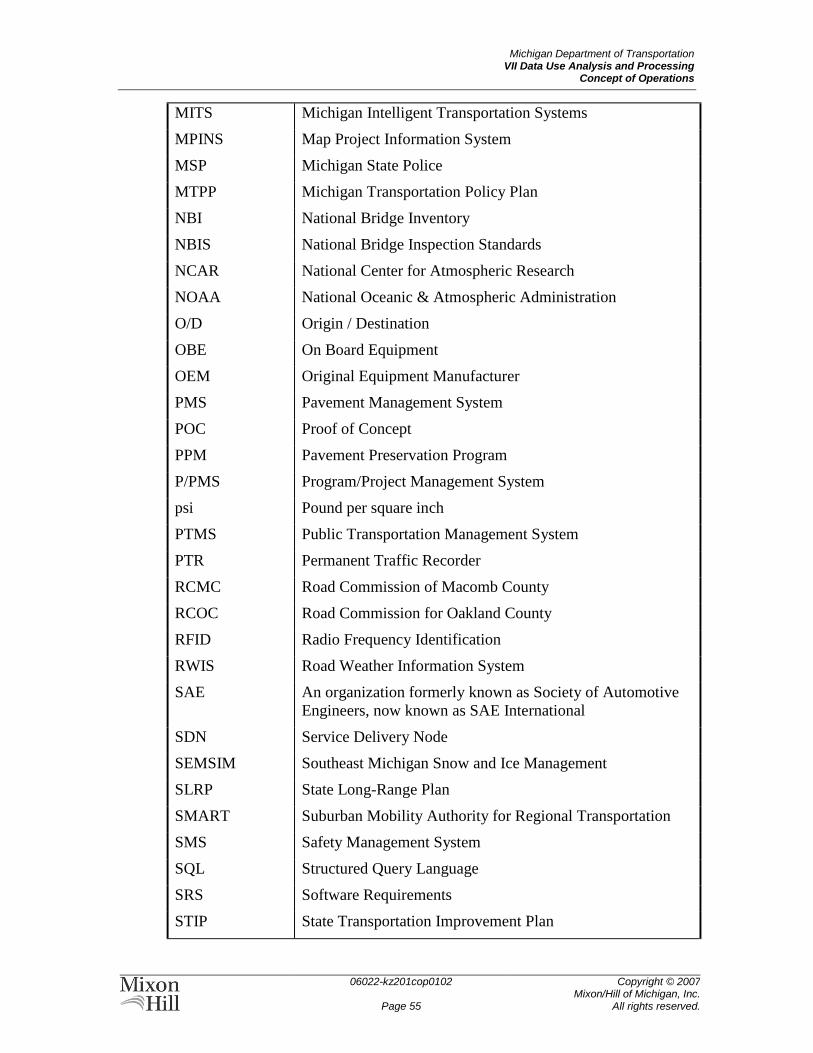
Michigan Department of Transportation VII Data Use Analysis and Processing
Concept of Operations
06022-kz201cop0102
Page 55
Copyright © 2007 Mixon/Hill of Michigan, Inc.
All rights reserved.
MITS Michigan Intelligent Transportation Systems
MPINS Map Project Information System
MSP Michigan State Police
MTPP Michigan Transportation Policy Plan
NBI National Bridge Inventory
NBIS National Bridge Inspection Standards
NCAR National Center for Atmospheric Research
NOAA National Oceanic & Atmospheric Administration
O/D Origin / Destination
OBE On Board Equipment
OEM Original Equipment Manufacturer
PMS Pavement Management System
POC Proof of Concept
PPM Pavement Preservation Program
P/PMS Program/Project Management System
psi Pound per square inch
PTMS Public Transportation Management System
PTR Permanent Traffic Recorder
RCMC Road Commission of Macomb County
RCOC Road Commission for Oakland County
RFID Radio Frequency Identification
RWIS Road Weather Information System
SAE An organization formerly known as Society of Automotive
Engineers, now known as SAE International
SDN Service Delivery Node
SEMSIM Southeast Michigan Snow and Ice Management
SLRP State Long-Range Plan
SMART Suburban Mobility Authority for Regional Transportation
SMS Safety Management System
SQL Structured Query Language
SRS Software Requirements
STIP State Transportation Improvement Plan
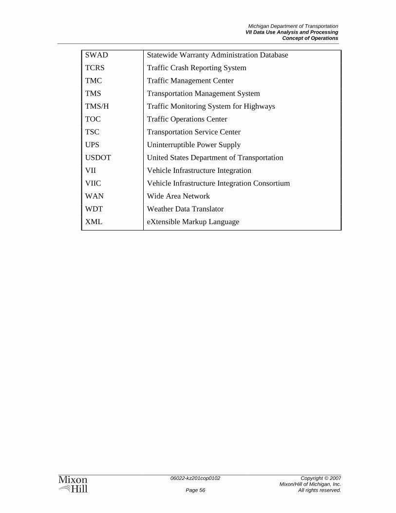
Michigan Department of Transportation VII Data Use Analysis and Processing
Concept of Operations
06022-kz201cop0102
Page 56
Copyright © 2007 Mixon/Hill of Michigan, Inc.
All rights reserved.
SWAD Statewide Warranty Administration Database
TCRS Traffic Crash Reporting System
TMC Traffic Management Center
TMS Transportation Management System
TMS/H Traffic Monitoring System for Highways
TOC Traffic Operations Center
TSC Transportation Service Center
UPS Uninterruptible Power Supply
USDOT United States Department of Transportation
VII Vehicle Infrastructure Integration
VIIC Vehicle Infrastructure Integration Consortium
WAN Wide Area Network
WDT Weather Data Translator
XML eXtensible Markup Language
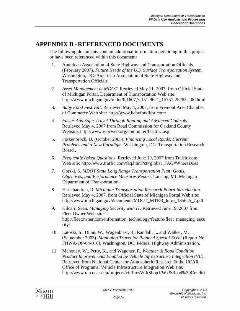
Michigan Department of Transportation VII Data Use Analysis and Processing
Concept of Operations
06022-kz201cop0102
Page 57
Copyright © 2007 Mixon/Hill of Michigan, Inc.
All rights reserved.
APPENDIX B - REFERENCED DOCUMENTS The following documents contain additional information pertaining to this project
or have been referenced within this document:
1. American Association of State Highway and Transportation Officials.
(February 2007). Future Needs of the U.S. Surface Transportation System.
Washington, DC: American Association of State Highway and
Transportation Officials.
2. Asset Management at MDOT. Retrieved May 11, 2007, from Official State
of Michigan Portal, Department of Transportation Web site:
http://www.michigan.gov/mdot/0,1607,7-151-9621_15757-25283--,00.html
3. Baby Food Festival!. Retrieved May 4, 2007, from Fremont Area Chamber
of Commerce Web site: http://www.babyfoodfest.com/
4. Faster And Safer Travel Through Routing and Advanced Controls.
Retrieved May 4, 2007 from Road Commission for Oakland County
Website: http://www.rcocweb.org/commuter/fasttrac.asp
5. Forkenbrock, D. (October 2005). Financing Local Roads: Current
Problems and a New Paradigm. Washington, DC: Transportation Research
Board.,
6. Frequently Asked Questions. Retrieved June 19, 2007 from Traffic.com
Web site: http://www.traffic.com/faq.html?ct=global_FAQ#WhereDoes
7. Gorski, S. MDOT State Long Range Transportation Plan; Goals,
Objectives, and Performance Measures Report. Lansing, MI: Michigan
Department of Transportation.
8. Harichandran, R. Michigan Transportation Research Board Introduction.
Retrieved May 4, 2007, from Official State of Michigan Portal Web site:
http://www.michigan.gov/documents/MDOT_MTRB_Intro_135645_7.pdf
9. Kilcarr, Sean. Managing Security with IT. Retrieved June 19, 2007 from
Fleet Owner Web site:
http://fleetowner.com/information_technology/feature/fleet_managing_secu
rity/
10. Latoski, S., Dunn, W., Wagenblast, B., Randall, J., and Walker, M.
(September 2003). Managing Travel for Planned Special Event (Report No.
FHWA-OP-04-010). Washington, DC: Federal Highway Administration.
11. Mahoney, W., Petty, K., and Wagoner, R. Weather & Road Condition
Product Improvements Enabled by Vehicle Infrastructure Integration (VII).
Retrieved from National Center for Atmospheric Research & the UCAR
Office of Programs, Vehicle Infrastructure Integration Web site:
http://www.rap.ucar.edu/projects/vii/PresWrkShop1/Wx&Road%20Conditi
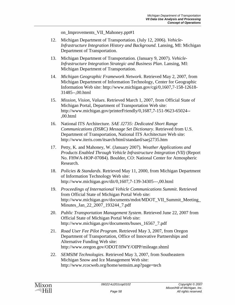
Michigan Department of Transportation VII Data Use Analysis and Processing
Concept of Operations
06022-kz201cop0102
Page 58
Copyright © 2007 Mixon/Hill of Michigan, Inc.
All rights reserved.
on_Improvements_VII_Mahoney.ppt#1
12. Michigan Department of Transportation. (July 12, 2006). Vehicle-
Infrastructure Integration History and Background. Lansing, MI: Michigan
Department of Transportation.
13. Michigan Department of Transportation. (January 9, 2007). Vehicle-
Infrastructure Integration Strategic and Business Plan. Lansing, MI:
Michigan Department of Transportation.
14. Michigan Geographic Framework Network. Retrieved May 2, 2007, from
Michigan Department of Information Technology, Center for Geographic
Information Web site: http://www.michigan.gov/cgi/0,1607,7-158-12618-
31485--,00.html
15. Mission, Vision, Values. Retrieved March 1, 2007, from Official State of
Michigan Portal, Department of Transportation Web site:
http://www.michigan.gov/printerFriendly/0,1687,7-151-9623-65024--
,00.html
16. National ITS Architecture. SAE J2735: Dedicated Short Range
Communications (DSRC) Message Set Dictionary. Retrieved from U.S.
Department of Transportation, National ITS Architecture Web site:
http://www.iteris.com/itsarch/html/standard/saej2735.htm
17. Petty, K. and Mahoney, W. (January 2007). Weather Applications and
Products Enabled Through Vehicle Infrastructure Integration (VII) (Report
No. FHWA-HOP-07084). Boulder, CO: National Center for Atmospheric
Research.
18. Policies & Standards. Retrieved May 11, 2000, from Michigan Department
of Information Technology Web site:
http://www.michigan.gov/dit/0,1607,7-139-34305---,00.html
19. Proceedings of International Vehicle Communications Summit. Retrieved
from Official State of Michigan Portal Web site:
http://www.michigan.gov/documents/mdot/MDOT_VII_Summit_Meeting_
Minutes_Jan_22_2007_193244_7.pdf
20. Public Transportation Management System. Retrieved June 22, 2007 from
Official State of Michigan Portal Web site:
http://www.michigan.gov/documents/buses_16567_7.pdf
21. Road User Fee Pilot Program. Retrieved May 3, 2007, from Oregon
Department of Transportation, Office of Innovative Partnerships and
Alternative Funding Web site:
http://www.oregon.gov/ODOT/HWY/OIPP/mileage.shtml
22. SEMSIM Technologies. Retrieved May 3, 2007, from Southeastern
Michigan Snow and Ice Management Web site:
http://www.rcocweb.org/home/semsim.asp?page=tech
Michigan Department of Transportation VII Data Use Analysis and Processing
Concept of Operations
06022-kz201cop0102
Page 59
Copyright © 2007 Mixon/Hill of Michigan, Inc.
All rights reserved.
23. Society of Automotive Engineers. (January 30, 2007). SAE J2735
Dedicated Short Range Communications (DSRC) Message Set Dictionary –
Dec. 2006 (VIIC Document No. APP190-01). Society of Automotive
Engineers.
24. South East Michigan Council of Governments. (August 2006). MDOT
Freeway Courtesy Patrol in Southeast Michigan: 2005 Evaluation Report.
Detroit, Michigan: South East Michigan Council of Governments.
25. State of Michigan Project Management Methodology Orientation.
Retrieved May 3, 2007, from Official State of Michigan Portal Web site:
http://www.michigan.gov/documents/PMM_For_SOM_Vendors_v4_12733
8_7.ppt#1
26. Systems Engineering Methodology Version 1.0. Retrieved May 3, 2007,
from Official State of Michigan Portal Web site:
http://www.michigan.gov/documents/suite/SEM_Version_1.0_April_2007_
191710_7.pdf
27. Transportation Asset Management Case Studies: Data Integration: The
Michigan Experience. Retrieved from Federal Highway Administration
Web site: http://www.fhwa.dot.gov/infrastructure/asstmgmt/dimi.pdf
28. Vehicle Infrastructure Integration VII Architecture and Functional
Requirements, Version 1. Retrieved April 12, 2005 from National Center for
Atmospheric Research & the UCAR Office of Programs, Vehicle
Infrastructure Integration Web site:
http://www.rap.ucar.edu/projects/vii/docs/VIIArchandFuncRequirements.pdf
29. VII Consortium. (March 13, 2007) POC Additions and Exceptions to
APP190-01 (Doc No.: APP190-02). VII Consortium.
30. VII Consortium. (March 20, 2007). Software Requirements Document (SRS)
for the POC Vehicle Probe Data Generation Application (Document No.
APP220-01). VII Consortium.
31. VII Data Characteristics Task: Data Needs Assessment. Retrieved from
National Center for Atmospheric Research & the UCAR Office of
Programs, Vehicle Infrastructure Integration Web site:
http://www.rap.ucar.edu/projects/vii/PresWrkShop2/VII%20DC%20Overvi
ew%20(Wunderlich%20for%20Boulder).ppt
32. Wunderlich, Karl. VII Data Characteristics for Traffic Management: Task
Overview and Update. Retrieved June 21,2006 from National Center for
Atmospheric Research & the UCAR Office of Programs, Vehicle
Infrastructure Integration Web site:
http://www.rap.ucar.edu/projects/vii/PresWrkShop2/VII%20DC%20Overvi
ew%20(Wunderlich%20for%20Boulder).ppt


![Ece Vii Image Processing [06ec756] Solution](https://img.pdfslide.us/doc/110x75/552bbb4a5503464c158b45a9/ece-vii-image-processing-06ec756-solution.jpg)