Embed Size (px)
Citation preview
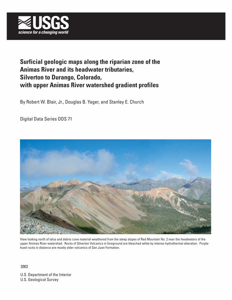
Surficial geologic maps along the riparian zone of the Animas River and its headwater tributaries, Silverton to Durango, Colorado, with upper Animas River watershed gradient profiles
By Robert W. Blair, Jr., Douglas B. Yager, and Stanley E. Church
Digital Data Series DDS 71
2002
U.S. Department of the InteriorU.S. Geological Survey
View looking north of talus and debris cone material weathered from the steep slopes of Red Mountain No. 2 near the headwaters of the upper Animas River watershed. Rocks of Silverton Volcanics in foreground are bleached white by intense hydrothermal alteration. Purple-hued rocks in distance are mostly older volcanics of San Juan Formation.
i
CONTENTS
Introduction ..................................................................................................................................... 1Surficial deposits and the geochemical baseline .................................................................................. 1Surficial geologic maps ...................................................................................................................... 3Gradient profile map .......................................................................................................................... 3Acknowledgments ............................................................................................................................ 3References ....................................................................................................................................... 4
FIGURES
1. Index map of Animas River watershed and surficial geology maps (plates 1–10) .............................. 22. Photograph of Mineral Creek terrace, and geochemical profile3. Photograph of Cement Creek terrace, and geochemical profile4. Photograph of Upper Animas River silt, and geochemical profile5. Photograph of pre-1890 fluvial deposits, upper Animas River, and geochemical profile6. Photograph of fluvial mill tailings, upper Animas River, and geochemical profile7. Photograph of overbank deposits along the Animas River at Elk Park, and geochemical profile8. Geochemical profile of oxbow deposits along the Animas River near Durango, Colorado
PLATES
1–11. Maps showing:
1. Surficial geology along Mineral and Cement Creeks in the Ironton quadrangle, AnimasRiver watershed, San Juan County, Colorado
2. Surficial geology along the Animas River in the Handies Peak quadrangle, Animas Riverwatershed, San Juan County, Colorado
3. Surficial geology along the Middle and South Forks of Mineral Creek in the Ophirquadrangle, Animas River watershed, San Juan County, Colorado
4. Surficial geology along the Middle and South Forks of Mineral Creek, Mineral and Ce-ment Creeks, and the Animas River in the Silverton quadrangle, Animas River water-shed, San Juan County, Colorado
5. Surficial geology along the Animas River and Cunningham Creek in the Howardsvillequadrangle, Animas River watershed, San Juan County, Colorado
6. Surficial geology along the Animas River in the Snowdon Peak quadrangle, Animas Riverwatershed, La Plata and San Juan Counties, Colorado
7. Surficial geology along the Animas River in the Electra Lake quadrangle, Animas Riverwatershed, La Plata County, Colorado
8. Surficial geology along the Animas River in the Mountain View Crest quadrangle, AnimasRiver watershed, La Plata County, Colorado
9. Surficial geology along the Animas River in the Hermosa quadrangle, Animas River wa-tershed, La Plata County, Colorado
10. Surficial geology along the Animas River in the Durango East quadrangle, Animas Riverwatershed, La Plata County, Colorado
11. Gradient determinations for the Animas River and its major headwater tributaries, AnimasRiver watershed, La Plata, and San Juan Counties, Colorado
1
INTRODUCTION
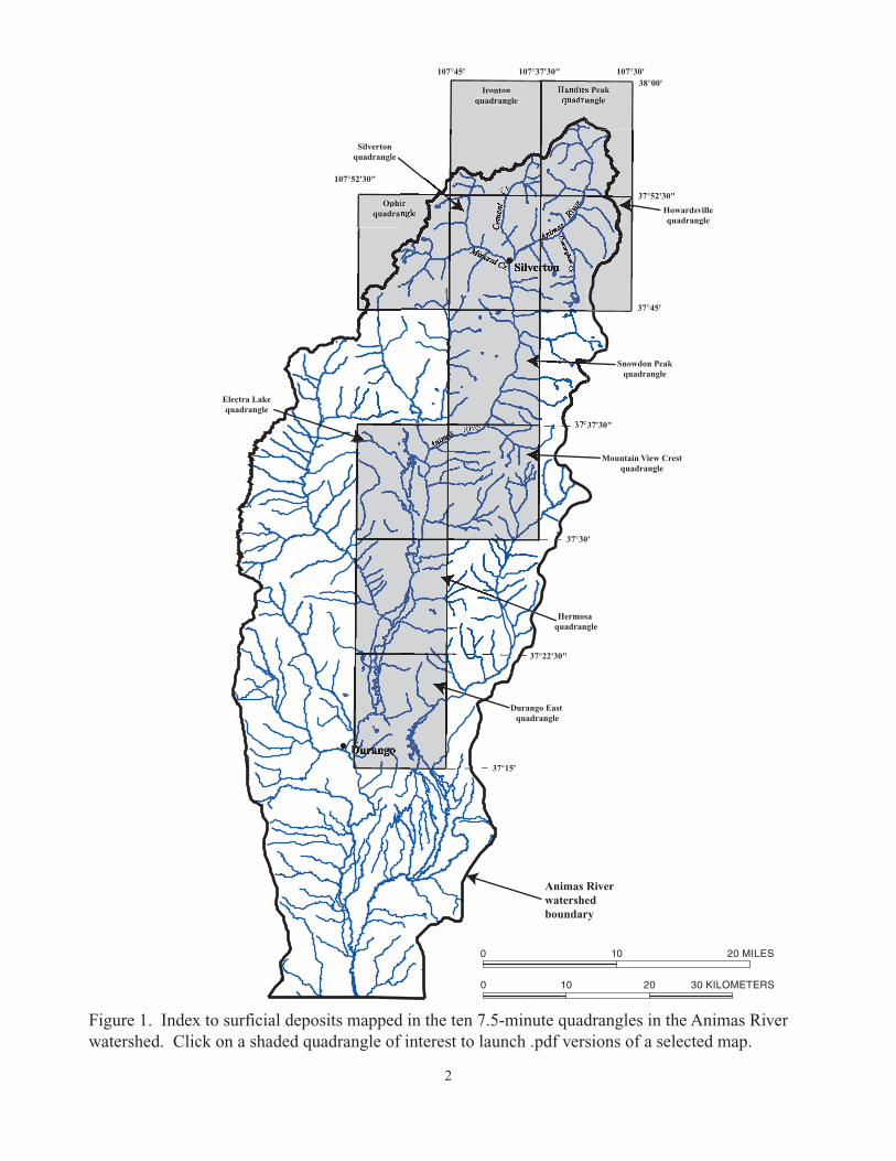
The Animas River originates in the SanJuan Mountains north of the historic miningtown of Silverton, Colo. The accompanying 10surficial geologic strip maps show the distribu-tion of surficial deposits along the riparian zoneof the Animas River and its upper headwatertributaries approximately 400 ft (130 m) abovethe valley floor (fig.1). These deposits havebeen mapped in the larger tributaries of the Ani-mas River in its headwaters north of Silvertonand along the Animas River south to Durango,Colo. The Animas River watershed is the site ofan interdisciplinary, multi-agency study designedto effectively characterize lands impacted by his-torical mining activities and to aid land managersin making restoration decisions (Buxton andothers, 1997; U.S. Geological Survey, 2000).
Today, stream waters in Mineral and Ce-ment Creeks are acidic and range in pH from 3.5at base flow to 7 at high flow. In contrast, theAnimas River above Silverton ranges in pH from6 to 7.5 (Mast and others, 2000). Evidence ofacidic drainage is readily apparent in streamreaches and tributaries in the watershed aboveSilverton. Red, yellow, and white precipitatesfrom waters draining hydrothermally altered ar-eas are strong visual indications of acidic, metal-rich waters in tributary basins of the AnimasRiver watershed. Physical and chemical weath-ering of altered and mineralized rock undisturbedby mining activity contributes high concentra-tions of major and trace elements that exceedaverage crustal abundances in streambed sedi-ments (Church and others, 2000). After themining of mineral deposits and milling of poly-metallic vein materials in the study area, trans-port and deposition of mine and mill wastes intostreams and floodplains concentrated metalabundances in sediments (Nash, 2000a, b;Church and others, 2000).
One of the fundamental questions to beaddressed in watersheds affected by historicalmining is: “What was the water quality in thewatershed prior to mining?” In addressing thisquestion, geologists must find field evidence thatindicates what the water chemistry was prior tomining. We have approached this question bymapping and determining the chemistry of fluvialdeposits such as stream terraces that are olderthan the initiation of mining activity, which be-gan in 1871.
Prior to mining, acidic waters transportedtrace and major elements from mineralized areasand deposited these elements in stream terracesand other surficial deposits. Surficial geologicmapping may be used with other data sets, such
as alteration assemblage maps, to infer possiblesources of acid rock drainage. Surficial depositsin the Animas River watershed are often derivedfrom the downslope transport of weathered,hydrothermally altered and mineralized rock.Surficial deposits that contain pyrite are porousand permeable pathways for groundwater andare sources for acidic drainage (Yager and oth-ers, 2000). Conversely, when minerals such aschlorite or calcite are present, the surficial de-posits have the ability to neutralize acidic waters(Desborough and Yager, 2000).
SURFICIAL DEPOSITS AND THEGEOCHEMICAL BASELINE
The determination of the pre-mining geo-chemical baseline is a key component in under-standing the effect that historical mining hashad on the riparian habitat in the watershed.Geochemical analyses of samples collected fromthe pre-1860 surficial deposits (Church and oth-ers, 2000) provide a measure of the pre-mininggeochemical baseline. We have included severalexamples of the types of deposits used to de-termine the pre-mining geochemical baseline instreambed sediments preserved in terrace de-posits. Click the following links (figs. 2–8,indicated in blue) for examples of surficialdeposits and their corresponding geochem-ical profiles.
Figure 2. Mineral Creek terraceFigure 3. Cement Creek terraceFigure 4. Upper Animas River siltFigure 5. Pre-1890 fluvial deposits, upper
Animas RiverFigure 6. Fluvial mill tailings, upper Animas RiverFigure 7. Overbank deposits along the Animas
River at Elk ParkFigure 8. Oxbow deposits along the Animas
River near Durango
Several surficial deposit types are useful inthe characterization of the pre-mining geochem-ical baseline. These deposits include:
(1) Pre-1860 valley deposits: These depositsare located on the slightly concave surface ofnarrow, approximately 100-m-wide valleyfloors of smaller tributaries, where there areno distinct fluvial terraces or alluvial fans.The valley sediment consists of unconsoli-dated sand and gravel with a silty matrix, andoccasionally larger stones often derived fromvalley sides. Deposits are derived from acomplex of fluvial and colluvial processes andinclude slope wash from valley sides and over-bank deposits from periodic floods.
Durango East quadrangle
Animas Riverwatershedboundary
Electra Lakequadrangle
s Peakangle
38°00' 107°30' 107°45'
107°52'30"
37°52'30"
37°45'
107°37'30"
37°37'30"
37°30'
37°22'30"
37°15'
Hermosa quadrangle
Irontonquadrangle
Mountain View Crestquadrangle
Silvertonquadrangle
Ophiquadra
Snowdon Peakquadrangle
Howardsvillequadrangle
0 10 20 30 KILOMETERS
0 10 20 MILES
Figure 1. Index to surficial deposits mapped in the ten 7.5-minute quadrangles in the Animas River watershed. Click on a shaded quadrangle of interest to launch .pdf versions of a selected map.
2
3
(2) Terrace deposits: Terraces are relativelyflat, narrow surfaces elevated above andcommonly parallel to the active stream chan-nel. The fluvial sediment in terraces repre-sents old floodplain deposits and consists ofunconsolidated, poorly sorted, rounded sandand gravel mixed with silt. Gravels are oftenimbricated. In the upper Animas River, boul-ders as much as 0.5 m in diameter are notuncommon. Terrace sediment is depositedduring spring and storm discharge events as-sociated with overbank flow. Since deposi-tion, water infiltration and weathering of de-tritus have contributed to soil and peat devel-opment, particularly on terraces higher thanseveral meters above the existing channel.(3) Oxbow deposits: These deposits are rem-nants of the once active river channel andthey are preserved as curved, shallow de-pressions in the floodplain. They are found ingently dipping to flat, meandering river flood-plains such as in the lower Animas River Val-ley north of Durango and they are associatedwith cutoff meander channels (oxbow lakes).Oxbow deposits consist of unconsolidatedsilty sand often mixed with peat near theirupper surface. Discontinuous lenses of gravelare common at depth. These abandonedchannels range in age from pre-1860 to post-1860. Older oxbow deposits eventually fillwith silt to become dry swales on the activefloodplain.
SURFICIAL GEOLOGIC MAPS
We have mapped surficial deposits alongparts of ten 1:24,000-scale topographic quad-rangles from Silverton to Durango. Each sur-ficial deposit map may be viewed in .pdfformat by clicking the map of interest infigure 1. On several of the maps, we have de-veloped interactive links to photographs thatrepresent surficial deposits throughout the Ani-mas River watershed. This allows the user totake a “virtual tour” of the watershed. Cameraicons on the maps (in blue) identify the photo-graph sites. The lens of the camera icon is ori-ented in the direction in which the photographwas taken. Photographs of surficial depositsthat were mapped are included as .pdf format filesand are stored in the Photos subfolder on thisCD-ROM, which may be viewed and printed withthe Adobe Acrobat viewer.
GRADIENT PROFILE MAP
Gradient profiles are useful when interpret-ing the types of fluvial deposits (mining and non-
mining related) that form within a watershed. Inthe case of the upper Animas River watershed,higher gradient stream reaches, which haveabundant boulder and cobble bed sediment loadscontribute to turbulent flow. A turbulent flowregime is capable of keeping sediment in suspen-sion longer when compared to laminar flow;however, the circuitous route water moleculesmust take limits the velocity of turbulent flow.Where stream gradient dramatically decreases,such as occurs along the valley floors at thebase of steep gradient reaches, the velocity candecrease resulting in sedimentation. These hy-drologic processes related to gradient are keyfactors in establishing healthy stream habitatsfrom the alpine zones, with frequently highergradients, to lower elevation habitats wherepools and meandering reaches with gravel barsdevelop that are suitable fish spawning areas.
We have included a map that indicates thechange in stream gradient along the main tribu-taries in the upper Animas River watershed.Gradients along the Animas River south of theSnowdon Peak quadrangle near Durango, Colo.,are generally lower than gradients observed inthe upper part of the watershed, and thus werenot determined because the resolution of thedata used for these calculations (10-m digital ele-vation models) may not be sufficient to resolvesubtle changes in elevation along these shal-lower gradient reaches. Click here to openthe .pdf format gradient map. Specific gradi-ent profiles for a stream reach are viewed byclicking a stream segment on the map. Thesegradient profiles can be used as an analysis toolto help evaluate the fluvial geomorphologic pro-cesses influencing sediment transport and depo-sition that have occurred in the upper AnimasRiver watershed prior to and after mining. Onespecific example of how we might use this infor-mation is to try to understand the relationshipbetween gradient, sediment transport, and de-position of processed mineral deposits from thehigh-gradient reaches of the upper Animas Riverabove Eureka townsite to the lower gradientbraided stream reach of the Animas River nearHowardsville.
ACKNOWLEDGMENTS
This work was supported by the U.S.Geological Survey Abandoned Mine Lands Pro-gram. Robert Waltermire (USGS) provided valu-able assistance in producing the ARC INFO cov-erages used for the gradient determinations.Reviews by Constance Nutt, StephenPersonius, and Alex Donatich (all with USGS)significantly improved this digital product.
4
REFERENCES
Barrett, J.K., and Pearl, R.H., 1976, Hydrogeo-logical data of thermal springs and wells inColorado: Colorado Geological SurveyDepartment of Natural Resources Infor-mation Series No. 6, p. 80–109.
Buxton, H.T., Nimick, D.A., von Guerard, Paul,Church, S.E., Frazier, A.G., Gray, J.R.,Lipin, B.R., Marsh, S.P., Woodward, D.F.,Kimball, B.A., Finger, S.E., Ischinger, L.S.,Fordham, J.C., Power, M.S., Bunck,C.M., and Jones, J.W., 1997, A science-based watershed strategy to support ef-fective remediation of abandoned minelands: Proceedings Fourth InternationalConference on Acid Rock Drainage(ICARD) May 30–June 6, 1997, Vancou-ver, British Columbia, Canada, p. 1869–1880.
Carrara, P.E., Mode, W.N, Rubin, M., andRobinson, S.W., 1984, Deglaciation andpostglacial timberline in the San JuanMountains, Colorado: Quaternary Re-search, v. 21, p. 42–55.
Carroll, C.J., Gillam, M.L., Ruf, J.C., Loseke,T.D. and Kirkham, R.M., 1999, Geologicmap of the Durango East quadrangle, LaPlata County, Colorado: Colorado Geo-logical Survey Open-File Report 99–6, 45p.
Church, S.E., Fey, D.L., and Blair, Robert,2000, Pre-mining bed sediment geochemi-cal baseline in the Animas River Water-shed, southwestern, Colorado, in Pro-ceedings Fifth International Conferenceon Acid Rock Drainage (ICARD) 2000,Denver, Colo., v. 1: Littleton, Colo., So-ciety for Mining, Metallurgy, and Explo-ration, Inc., p. 499–512.
Desborough, G.A., and Yager, D.B., 2000,Acid-neutralizing potential of igneousbedrocks in the Animas river headwaters,San Juan County, Colorado: U.S. Geo-logical Survey Open-File Report 00–165,14 p.
Fey, D.L., Church, S.E., and Unruh, D.M.,2000, Geochemical and lead isotopic datafrom sediment cores, fluvial tailings, ironbogs, and pre-mining terrace deposits,Animas River watershed, Colorado, 1995–1999: U.S. Geological Survey Open-FileReport 00–245, 91 p.
Gillam, M.L., 1998, Late Cenozoic geology andsoils of the Lower Animas River Valley,Colorado and New Mexico: Boulder,Colo., University of Colorado Ph.D. dis-sertation, 477 p., 3 pls., 65 figs.
Lipman, P.W., 1976, Geologic map of the LakeCity caldera area, western San JuanMountains, southwestern Colorado: U.S.Geological Survey Miscellaneous Investi-gations Series Map I–962, scale 1:48,000.
Lipman, P.W., Steven, T.A., Luedke, R.G., andBurbank, W.S., 1973, Revised volcanichistory of the San Juan, Uncompahgre,Silverton, and Lake City calderas in thewestern San Juan Mountains, Colorado:Journal of Research of the GeologicalSurvey, v. 1, no. 6, p. 627–642.
Maher, L.J., 1972, Nomograms for computing0.95 confidence limits of pollen data: Re-view of Paleobotany and Palynology, v.13, p. 85–93.
Mast, M.A., Evans, J.B., Leib, K.J., and Wright,W.G., 2000, Hydrologic and water-qualitydata at selected sites in the upper AnimasRiver watershed, southwestern Colorado,1997–1999: U.S. Geological SurveyOpen-File Report 00–53, 65 p.
Nash, J.T., 2000a, Geochemical investigationsand interim recommendations for priorityabandoned mine sites, U.S.D.A. ForestService lands, Mineral Creek watershed,San Juan County, Colorado: U.S. Geo-logical Survey Open-File Report 99–170,31 p.
——2000b, Geochemical investigations and in-terim recommendations for priority aban-doned mine sites, BLM lands, upper Ani-mas River watershed, San Juan County,Colorado: U.S. Geological Survey Open-File Report 99–323, 38 p.
Sloan, R.E., and Skowronski, C.A., 1975, TheRainbow Route, an illustrated history ofthe Silverton Railroad, the Northern Sil-verton Railroad, and the Silverton, Glad-stone, & Northerly Railroad: Denver,Colo., Sundance Publications Limited, 416p.
Sprat, H.G., Jr., Stanton, M.R,. Koch, J.C.,Hallett, I.E., Wells, R.B., and Cohn, C.A.,1999, Influences of natural versus anthro-pogenic sources of acid rock drainage inthe Animas River basin of Colorado: Geo-logical Society of America Abstracts withPrograms, v. 31, no. 7, p. 253–254.
Steven, T.A., Lipman, P.W., Hail, W.J. Jr.,Barker, F., and Luedke, R.G., 1974, com-pilers, Geologic map of the Durango quad-rangle, southwestern Colorado: U.S.Geological Survey Miscellaneous Investi-gation Series Map I–764, scale 1:250,000.
U.S. Geological Survey, 2000, Interim report onthe scientific investigations in the AnimasRiver watershed, Colorado, to facilitate

5
remediation decisions by the U.S. Bureauof Land Management and the U.S. ForestService, March 29, 2000 meeting, Den-ver, Colo.: U.S. Geological Survey Open-File Report 00–245, 34 p.
Vincent, K.R., Church, S.E., and Fey, D.L.,1999, Geomorphological context of met-als-laden sediments in the Animas riverflood plain, Colorado, in Morganwalp,D.W., and Buxton, H.T., eds., Contami-nation from hardrock mining: U.S. Geo-logical Survey Toxic Substances Hydrol-ogy Program—Proceedings of the Tech-nical Meeting, Charleston, South Car-olina, March 8–12, 1999, v. 1, p. 99–105.
Yager, D.B., and Bove, D.J., 2002, Generalizedgeologic map of part of the upper AnimasRiver watershed and vicinity, Silverton,Colorado: U.S. Geological Survey Miscel-laneous Field Studies Map MF–2377, scale1:48,000.
Yager, D.B., Mast, M.A., Verplanck , P.L., Bove,D.J., Wright, W.G., and Hageman, P.L.,2000, Natural versus mining-related waterquality degradation to tributaries drainingMount Moly, Silverton, Colorado, Pro-ceedings Fifth International Conferenceon Acid Rock Drainage (ICARD) 2000,Denver, Colo., v. 1: Littleton, Colo., So-ciety for Mining, Metallurgy, and Explo-ration, Inc., p. 535–547