Embed Size (px)
Citation preview
Victorian ePlan Protocol Version 1.10
January 2019

Photo credit
The photo in the front sheet has been downloaded from the following link and edited:
https://pixabay.com/en/blogging-blogger-office-business-336376/
© The State of Victoria Department of Environment, Land, Water and Planning 2019
This work is licensed under a Creative Commons Attribution 4.0 International licence. You are free to re-use the work under that licence, on the condition that you credit the State of Victoria as author. The licence does not apply to any images, photographs or branding, including the Victorian Coat of Arms, the Victorian Government logo and the
Department of Environment, Land, Water and Planning (DELWP) logo. To view a copy of this licence, visit http://creativecommons.org/licenses/by/4.0/
Disclaimer
This publication may be of assistance to you but the State of Victoria and its employees do not guarantee that the publication is without flaw of any kind or is wholly appropriate for your particular purposes and therefore disclaims all liability for any error, loss or other consequence which may arise from you relying on any information in this publication.
Accessibility
If you would like to receive this publication in an alternative format, please telephone the
DELWP Customer Service Centre on 136186, email [email protected],
or via the National Relay Service on 133 677 www.relayservice.com.au. This document is
also available on the internet at www.delwp.vic.gov.au.

Victorian ePlan Protocol
Version 1.10
i
Victorian ePlan Protocol Version 1.10
January 2019
ii Victorian ePlan Protocol
Version 1.10
Contents
1 General ............................................................................................................... 1
1.1 XML Prolog ..................................................................................................................................... 1
1.2 LandXML ......................................................................................................................................... 1
1.3 Units and Metric ............................................................................................................................. 2
1.4 CoordinateSystem ......................................................................................................................... 2
1.5 Application ..................................................................................................................................... 2
1.6 Author ............................................................................................................................................. 2
1.7 FeatureDictionary .......................................................................................................................... 3
1.8 Amendment .................................................................................................................................... 3
2 Administrative Information ............................................................................... 4
2.1 Survey ............................................................................................................................................. 4
2.2 SurveyHeader ................................................................................................................................ 4
2.3 HeadOfPower ................................................................................................................................. 5
2.4 PurposeOfSurvey .......................................................................................................................... 5
2.5 Personnel ....................................................................................................................................... 5
2.6 AdministrativeArea ........................................................................................................................ 5
2.7 Annotation ...................................................................................................................................... 5
2.8 AdministrativeDate ........................................................................................................................ 6
3 Spatial Components .......................................................................................... 7
3.1 Parcels ............................................................................................................................................ 7
3.2 Parcel .............................................................................................................................................. 7
3.3 Parcel Linkage (AllocationsParcelsType in Victorian Schema) ............................................... 8
3.4 Title ................................................................................................................................................. 8
3.5 LocationAddress ........................................................................................................................... 8
3.6 ComplexName ................................................................................................................................ 9
3.7 RoadName ...................................................................................................................................... 9
3.8 AdministrativeArea ........................................................................................................................ 9
3.9 AddressPoint ............................................................................................................................... 10
3.10 PlanFeatures ................................................................................................................................ 10
3.11 PlanFeature .................................................................................................................................. 10
3.12 CgPoints ....................................................................................................................................... 10
3.13 CgPoint ......................................................................................................................................... 11
3.14 CoordGeom .................................................................................................................................. 11
3.15 Line ............................................................................................................................................... 11
3.16 Curve ............................................................................................................................................. 12
3.17 IrregularLine ................................................................................................................................. 12
Victorian ePlan Protocol
Version 1.10
iii
3.18 Start ............................................................................................................................................... 12
3.19 End ................................................................................................................................................ 13
3.20 PntList2D ...................................................................................................................................... 13
3.21 Center ........................................................................................................................................... 13
3.22 ObservationGroup ....................................................................................................................... 13
3.23 ReducedObservation .................................................................................................................. 13
3.24 ReducedArcObservation ............................................................................................................ 14
3.25 RedHorizontalPosition ................................................................................................................ 15
3.26 RedVerticalObservation .............................................................................................................. 16
3.27 Monuments................................................................................................................................... 16
3.28 Monument ..................................................................................................................................... 16
3.29 FieldNote ...................................................................................................................................... 17
3.30 InstrumentSetup .......................................................................................................................... 17
3.31 InstrumentPoint ........................................................................................................................... 17

Victorian ePlan Protocol
Version 1.10
1
This document outlines the mapping of the Victorian ePlan Protocol to LandXML. Each heading represents an
element in the schema.
This document is intended for ePlan Software Developers.
Legend
Type Column Required Column
Simple LandXML types: string, double, date, ID, IDRef
vic enum = Victorian Enumerations Schema, lxml enum = LandXML
Enumerations, vic ref = Victorian Reference Data List
R = Required, CR = Conditionally
Required, O = Optional
1 General
1.1 XML Prolog
<?xml version="1.0" encoding="utf-8"?>
1.2 LandXML
Child Elements Cardinality
Units 1
CoordinateSystem 1
Application 1
Amendment 0 - *
CgPoints 0 - *
Parcels 1
PlanFeatures 0 - *
Survey 1
Monuments 0 - 1
FeatureDictionary 1
Attribute Type Required Description
Date string R Date this version of the EPLAN was created. ISO 8601 format.
eg 2018-06-30
time string R Time this version of the EPLAN was created. ISO 8601 format.
eg 13:56:48
version double R [Land Use Victoria (LUV) Use Only] Version number of this
EPLAN, based on the Victorian protocol schema (.xsd) version.
This can be derived from the Victorian protocol schema file name.
eg 1.10
xmlns string R Required if using namespaces. XML namespace, set to: http://www.landxml.org/schema/LandXML-1.2
xmlns:xsi string R XML schema instance, set to: http://www.w3.org/2001/XMLSchema-instance
2 Victorian ePlan Protocol
Version 1.10
Attribute Type Required Description
xsi:schemaLocation string R LandXML Schema Location for validation, set to: http://www.landxml.org/schema/LandXML-1.2
http://www.landxml.org/schema/LandXML-
1.2/LandXML-1.2.xsd
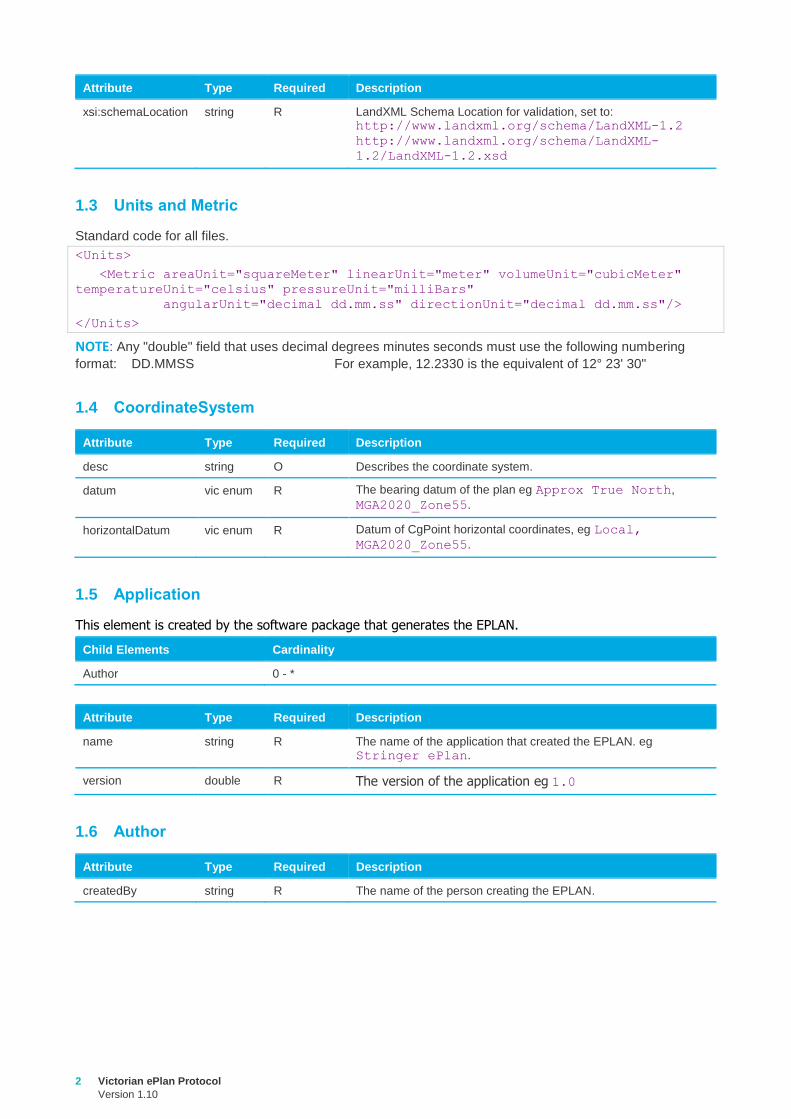
1.3 Units and Metric
Standard code for all files.
<Units>
<Metric areaUnit="squareMeter" linearUnit="meter" volumeUnit="cubicMeter"
temperatureUnit="celsius" pressureUnit="milliBars"
angularUnit="decimal dd.mm.ss" directionUnit="decimal dd.mm.ss"/>
</Units>
NOTE: Any "double" field that uses decimal degrees minutes seconds must use the following numbering
format: DD.MMSS For example, 12.2330 is the equivalent of 12° 23' 30"
1.4 CoordinateSystem
Attribute Type Required Description
desc string O Describes the coordinate system.
datum vic enum R The bearing datum of the plan eg Approx True North,
MGA2020_Zone55.
horizontalDatum vic enum R Datum of CgPoint horizontal coordinates, eg Local,
MGA2020_Zone55.
1.5 Application
This element is created by the software package that generates the EPLAN.
Child Elements Cardinality
Author 0 - *
Attribute Type Required Description
name string R The name of the application that created the EPLAN. eg Stringer ePlan.
version double R The version of the application eg 1.0
1.6 Author
Attribute Type Required Description
createdBy string R The name of the person creating the EPLAN.
Victorian ePlan Protocol
Version 1.10
3
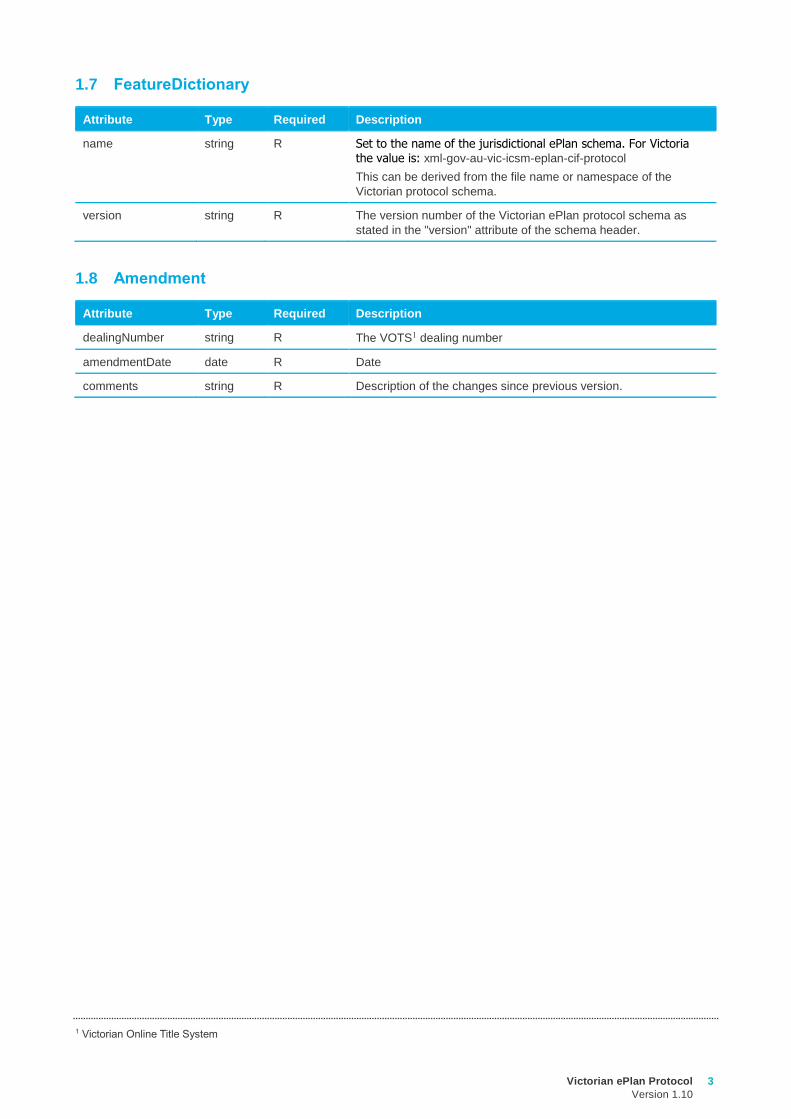
1.7 FeatureDictionary
Attribute Type Required Description
name string R Set to the name of the jurisdictional ePlan schema. For Victoria the value is: xml-gov-au-vic-icsm-eplan-cif-protocol
This can be derived from the file name or namespace of the
Victorian protocol schema.
version string R The version number of the Victorian ePlan protocol schema as
stated in the "version" attribute of the schema header.
1.8 Amendment
Attribute Type Required Description
dealingNumber string R The VOTS1 dealing number
amendmentDate date R Date
comments string R Description of the changes since previous version.
1 Victorian Online Title System
4 Victorian ePlan Protocol
Version 1.10
2 Administrative Information
2.1 Survey
Child Elements Cardinality
SurveyHeader 1
ObservationGroup 1
InstrumentSetup 1 - *
2.2 SurveyHeader
Child Elements Cardinality
HeadOfPower 1 - *
PurposeOfSurvey 1 - *
Personnel 0 - *
AdministrativeArea 1 - *
Annotation 0 - *
FieldNote 0 - *
AdministrativeDate 0 - *
Attribute Type Required Description
name string R The plan number with check digit eg PS123456X, PS123456X/S1.
jurisdiction vic enum R "Victoria".
surveyorFirm string R The name of the surveying firm. All text from the surveyors stamp
goes here, formatted in the following way:
{Trading Name}

{Company Name}

{Office Address}

{Mailing Address}

{Phone}

{Fax}

{ABN}

{Website URL}
Each field can contain any characters including spaces. 

is the XML code for new line.
surveyorReference string R A space for the surveying firms internal reference ID and version
number, eg 123-Ver01. Note: ‘Ver’ is case sensitive.
surveyFormat vic enum O See VIC enumerations schema.
type lxml
enum
R Maps to Survey/Non-Survey notation in the notations panel.
Computed = Non-Survey; Surveyed = Survey; Compiled =
Partial Survey.
Victorian ePlan Protocol
Version 1.10
5
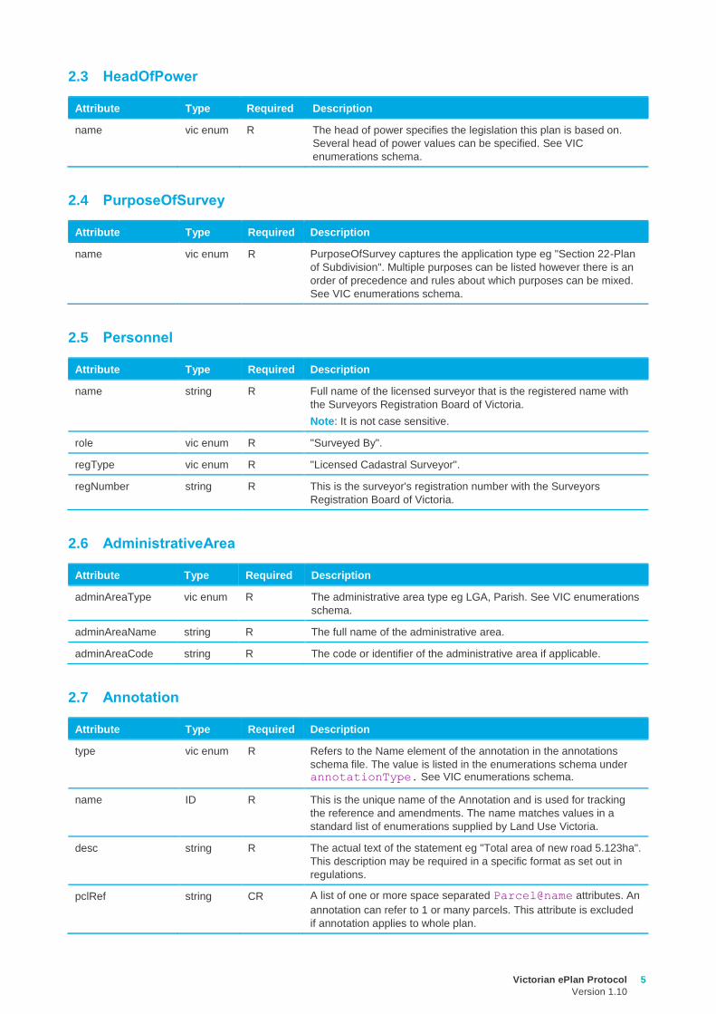
2.3 HeadOfPower
Attribute Type Required Description
name vic enum R The head of power specifies the legislation this plan is based on.
Several head of power values can be specified. See VIC
enumerations schema.
2.4 PurposeOfSurvey
Attribute Type Required Description
name vic enum R PurposeOfSurvey captures the application type eg "Section 22-Plan
of Subdivision". Multiple purposes can be listed however there is an
order of precedence and rules about which purposes can be mixed.
See VIC enumerations schema.
2.5 Personnel
Attribute Type Required Description
name string R Full name of the licensed surveyor that is the registered name with
the Surveyors Registration Board of Victoria.
Note: It is not case sensitive.
role vic enum R "Surveyed By".
regType vic enum R "Licensed Cadastral Surveyor".
regNumber string R This is the surveyor's registration number with the Surveyors
Registration Board of Victoria.
2.6 AdministrativeArea
Attribute Type Required Description
adminAreaType vic enum R The administrative area type eg LGA, Parish. See VIC enumerations
schema.
adminAreaName string R The full name of the administrative area.
adminAreaCode string R The code or identifier of the administrative area if applicable.
2.7 Annotation
Attribute Type Required Description
type vic enum R Refers to the Name element of the annotation in the annotations
schema file. The value is listed in the enumerations schema under annotationType. See VIC enumerations schema.
name ID R This is the unique name of the Annotation and is used for tracking
the reference and amendments. The name matches values in a
standard list of enumerations supplied by Land Use Victoria.
desc string R The actual text of the statement eg "Total area of new road 5.123ha".
This description may be required in a specific format as set out in
regulations.
pclRef string CR A list of one or more space separated Parcel@name attributes. An
annotation can refer to 1 or many parcels. This attribute is excluded
if annotation applies to whole plan.
6 Victorian ePlan Protocol
Version 1.10
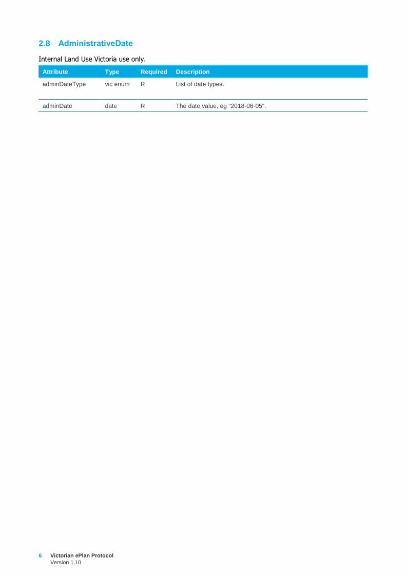
2.8 AdministrativeDate
Internal Land Use Victoria use only.
Attribute Type Required Description
adminDateType vic enum R List of date types.
adminDate date R The date value, eg "2018-06-05".
Victorian ePlan Protocol
Version 1.10
7
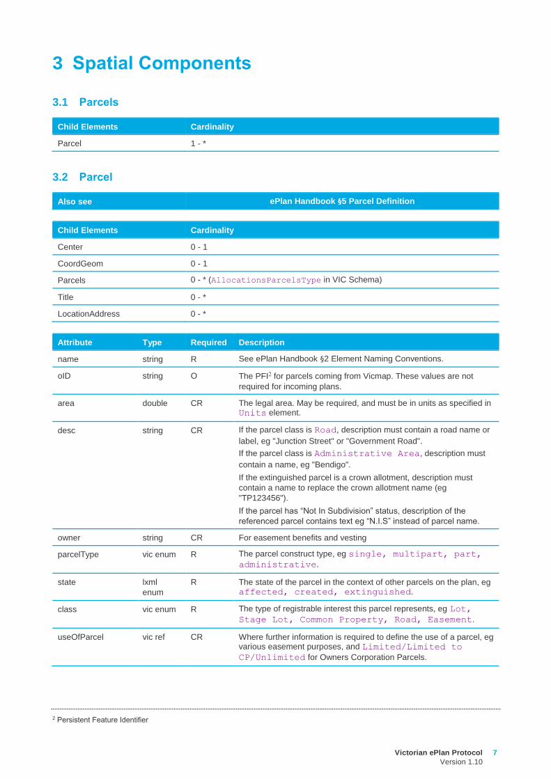
3 Spatial Components
3.1 Parcels
Child Elements Cardinality
Parcel 1 - *
3.2 Parcel
Also see ePlan Handbook §5 Parcel Definition
Child Elements Cardinality
Center 0 - 1
CoordGeom 0 - 1
Parcels 0 - * (AllocationsParcelsType in VIC Schema)
Title 0 - *
LocationAddress 0 - *
Attribute Type Required Description
name string R See ePlan Handbook §2 Element Naming Conventions.
oID string O The PFI2 for parcels coming from Vicmap. These values are not
required for incoming plans.
area double CR The legal area. May be required, and must be in units as specified in Units element.
desc string CR If the parcel class is Road, description must contain a road name or
label, eg "Junction Street" or "Government Road".
If the parcel class is Administrative Area, description must
contain a name, eg "Bendigo".
If the extinguished parcel is a crown allotment, description must
contain a name to replace the crown allotment name (eg
"TP123456").
If the parcel has “Not In Subdivision” status, description of the
referenced parcel contains text eg “N.I.S” instead of parcel name.
owner string CR For easement benefits and vesting
parcelType vic enum R The parcel construct type, eg single, multipart, part,
administrative.
state lxml
enum
R The state of the parcel in the context of other parcels on the plan, eg affected, created, extinguished.
class vic enum R The type of registrable interest this parcel represents, eg Lot,
Stage Lot, Common Property, Road, Easement.
useOfParcel vic ref CR Where further information is required to define the use of a parcel, eg various easement purposes, and Limited/Limited to
CP/Unlimited for Owners Corporation Parcels.
2 Persistent Feature Identifier
8 Victorian ePlan Protocol
Version 1.10
Attribute Type Required Description
parcelFormat vic ref CR The type of boundaries the parcel is described by, eg Geometry,
Standard, 2D Building. Geometry is only used for spatial
easements.
3.3 Parcel Linkage (AllocationsParcelsType in Victorian Schema)
A parcel linkage is a parcel nested inside another parcel. These elements have different required attributes.
Also see ePlan Handbook §5 Parcel Definition
Attribute Type Required Description
name string R See ePlan Handbook §2 Element Naming Conventions.
pclRef string R Reference used to link Parcel elements.
lotEntitlements string CR The lot entitlement for Owners Corporation, Body Corporate or
scheme land entity.
liabilityApportionment string CR The liability for Owners Corporation, Body Corporate or scheme
land entity.
3.4 Title
Attribute Type Required Description
name string R The reference of the legal document or parcel.
titleType vic enum R Types of titles. see VIC enumerations schema.
3.5 LocationAddress
Child Elements Cardinality
ComplexName 0 - *
RoadName 1 - *
AdministrativeArea 1 - *
AddressPoint 0 - *
Attribute Type Required Description
addressType vic enum R The type of the address. A parcel could have many addresses as it
could have several frontages and be used for different purposes. For
example it may have a primary address and several aliases.
VicMap Address Field: ADDRESS_CLASS
flatType vic ref O The type of the flat, eg, unit, townhouse, etc
VicMap Address Field: BLG_UNIT_TYPE
flatNumber string O The number of the flat
VicMap Address Field: BLG_UNIT_PREFIX_1, BLG_UNIT_ID_1,
BLG_UNIT_SUFFIX_1, BLG_UNIT_PREFIX_2, BLG_UNIT_ID_2,
BLG_UNIT_SUFFIX_2
Note: If more than one number is supplied, values are concatenated
and separated by a space.
Victorian ePlan Protocol
Version 1.10
9
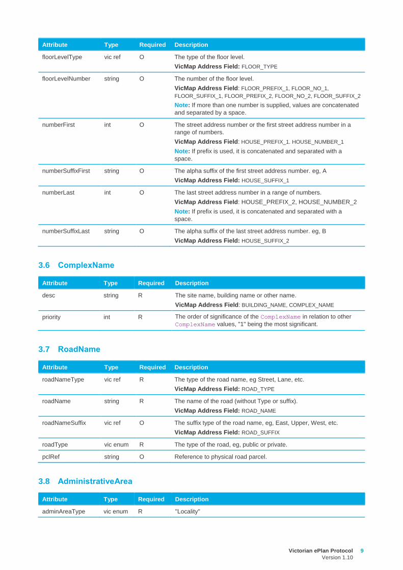
Attribute Type Required Description
floorLevelType vic ref O The type of the floor level.
VicMap Address Field: FLOOR_TYPE
floorLevelNumber string O The number of the floor level.
VicMap Address Field: FLOOR_PREFIX_1, FLOOR_NO_1,
FLOOR_SUFFIX_1, FLOOR_PREFIX_2, FLOOR_NO_2, FLOOR_SUFFIX_2
Note: If more than one number is supplied, values are concatenated
and separated by a space.
numberFirst int O The street address number or the first street address number in a
range of numbers.
VicMap Address Field: HOUSE_PREFIX_1. HOUSE_NUMBER_1
Note: If prefix is used, it is concatenated and separated with a
space.
numberSuffixFirst string O The alpha suffix of the first street address number. eg, A
VicMap Address Field: HOUSE_SUFFIX_1
numberLast int O The last street address number in a range of numbers.
VicMap Address Field: HOUSE_PREFIX_2, HOUSE_NUMBER_2
Note: If prefix is used, it is concatenated and separated with a
space.
numberSuffixLast string O The alpha suffix of the last street address number. eg, B
VicMap Address Field: HOUSE_SUFFIX_2
3.6 ComplexName
Attribute Type Required Description
desc string R The site name, building name or other name.
VicMap Address Field: BUILDING_NAME, COMPLEX_NAME
priority int R The order of significance of the ComplexName in relation to other
ComplexName values, "1" being the most significant.
3.7 RoadName
Attribute Type Required Description
roadNameType vic ref R The type of the road name, eg Street, Lane, etc.
VicMap Address Field: ROAD_TYPE
roadName string R The name of the road (without Type or suffix).
VicMap Address Field: ROAD_NAME
roadNameSuffix vic ref O The suffix type of the road name, eg, East, Upper, West, etc.
VicMap Address Field: ROAD_SUFFIX
roadType vic enum R The type of the road, eg, public or private.
pclRef string O Reference to physical road parcel.
3.8 AdministrativeArea
Attribute Type Required Description
adminAreaType vic enum R "Locality"
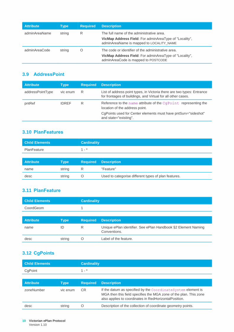
10 Victorian ePlan Protocol
Version 1.10
Attribute Type Required Description
adminAreaName string R The full name of the administrative area.
VicMap Address Field: For adminAreaType of "Locality",
adminAreaName is mapped to LOCALITY_NAME
adminAreaCode string O The code or identifier of the administrative area.
VicMap Address Field: For adminAreaType of "Locality",
adminAreaCode is mapped to POSTCODE
3.9 AddressPoint
Attribute Type Required Description
addressPointType vic enum R List of address point types, in Victoria there are two types: Entrance
for frontages of buildings, and Virtual for all other cases.
pntRef IDREF R Reference to the name attribute of the CgPoint representing the
location of the address point.
CgPoints used for Center elements must have pntSurv="sideshot"
and state="existing".
3.10 PlanFeatures
Child Elements Cardinality
PlanFeature 1 - *
Attribute Type Required Description
name string R "Feature"
desc string O Used to categorise different types of plan features.
3.11 PlanFeature
Child Elements Cardinality
CoordGeom 1
Attribute Type Required Description
name ID R Unique ePlan identifier. See ePlan Handbook §2 Element Naming
Conventions.
desc string O Label of the feature.
3.12 CgPoints
Child Elements Cardinality
CgPoint 1 - *
Attribute Type Required Description
zoneNumber vic enum CR If the datum as specified by the CoordinateSystem element is
MGA then this field specifies the MGA zone of the plan. This zone
also applies to coordinates in RedHorizontalPosition.
desc string O Description of the collection of coordinate geometry points.
Victorian ePlan Protocol
Version 1.10
11
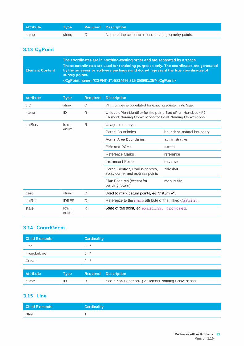
Attribute Type Required Description
name string O Name of the collection of coordinate geometry points.
3.13 CgPoint
Element Content
The coordinates are in northing-easting order and are separated by a space.
These coordinates are used for rendering purposes only. The coordinates are generated
by the surveyor or software packages and do not represent the true coordinates of
survey points.
<CgPoint name="CGPNT-1">5814496.815 350991.357</CgPoint>
Attribute Type Required Description
oID string O PFI number is populated for existing points in VicMap.
name ID R Unique ePlan identifier for the point. See ePlan Handbook §2
Element Naming Conventions for Point Naming Conventions.
pntSurv lxml
enum
R Usage summary:
Parcel Boundaries boundary, natural boundary
Admin Area Boundaries administrative
PMs and PCMs control
Reference Marks reference
Instrument Points traverse
Parcel Centres, Radius centres,
splay corner and address points
sideshot
Plan Features (except for
building return)
monument
desc string O Used to mark datum points, eg "Datum A".
pntRef IDREF O Reference to the name attribute of the linked CgPoint.
state lxml
enum
R State of the point, eg existing, proposed.
3.14 CoordGeom
Child Elements Cardinality
Line 0 - *
IrregularLine 0 - *
Curve 0 - *
Attribute Type Required Description
name ID R See ePlan Handbook §2 Element Naming Conventions.
3.15 Line
Child Elements Cardinality
Start 1
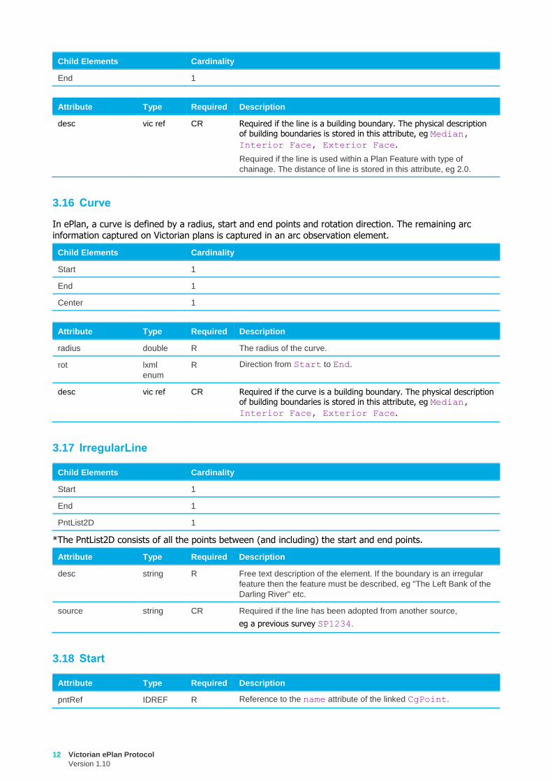
12 Victorian ePlan Protocol
Version 1.10
Child Elements Cardinality
End 1
Attribute Type Required Description
desc vic ref CR
Required if the line is a building boundary. The physical description of building boundaries is stored in this attribute, eg Median,
Interior Face, Exterior Face.
Required if the line is used within a Plan Feature with type of
chainage. The distance of line is stored in this attribute, eg 2.0.
3.16 Curve
In ePlan, a curve is defined by a radius, start and end points and rotation direction. The remaining arc
information captured on Victorian plans is captured in an arc observation element.
Child Elements Cardinality
Start 1
End 1
Center 1
Attribute Type Required Description
radius double R The radius of the curve.
rot lxml
enum
R Direction from Start to End.
desc vic ref CR Required if the curve is a building boundary. The physical description of building boundaries is stored in this attribute, eg Median,
Interior Face, Exterior Face.
3.17 IrregularLine
Child Elements Cardinality
Start 1
End 1
PntList2D 1
*The PntList2D consists of all the points between (and including) the start and end points.
Attribute Type Required Description
desc string R Free text description of the element. If the boundary is an irregular
feature then the feature must be described, eg "The Left Bank of the
Darling River" etc.
source string CR Required if the line has been adopted from another source,
eg a previous survey SP1234.
3.18 Start
Attribute Type Required Description
pntRef IDREF R Reference to the name attribute of the linked CgPoint.
Victorian ePlan Protocol
Version 1.10
13
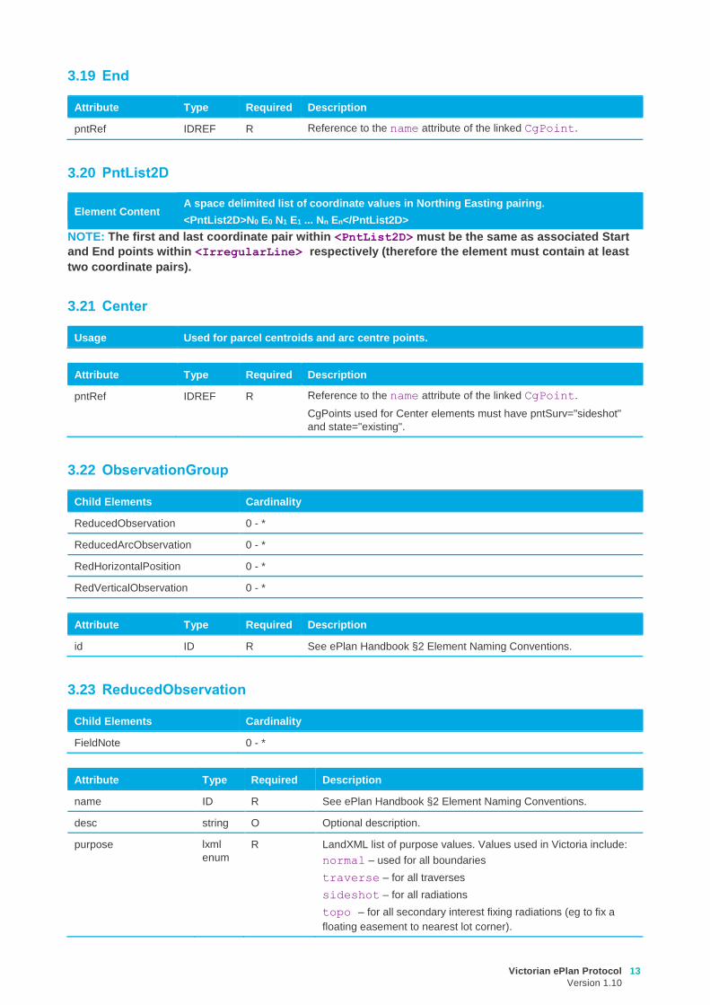
3.19 End
Attribute Type Required Description
pntRef IDREF R Reference to the name attribute of the linked CgPoint.
3.20 PntList2D
Element Content A space delimited list of coordinate values in Northing Easting pairing.
<PntList2D>N0 E0 N1 E1 ... Nn En</PntList2D>
NOTE: The first and last coordinate pair within <PntList2D> must be the same as associated Start
and End points within <IrregularLine> respectively (therefore the element must contain at least
two coordinate pairs).
3.21 Center
Usage Used for parcel centroids and arc centre points.
Attribute Type Required Description
pntRef IDREF R Reference to the name attribute of the linked CgPoint.
CgPoints used for Center elements must have pntSurv="sideshot"
and state="existing".
3.22 ObservationGroup
Child Elements Cardinality
ReducedObservation 0 - *
ReducedArcObservation 0 - *
RedHorizontalPosition 0 - *
RedVerticalObservation 0 - *
Attribute Type Required Description
id ID R See ePlan Handbook §2 Element Naming Conventions.
3.23 ReducedObservation
Child Elements Cardinality
FieldNote 0 - *
Attribute Type Required Description
name ID R See ePlan Handbook §2 Element Naming Conventions.
desc string O Optional description.
purpose lxml
enum
R LandXML list of purpose values. Values used in Victoria include:
normal – used for all boundaries
traverse – for all traverses
sideshot – for all radiations
topo – for all secondary interest fixing radiations (eg to fix a
floating easement to nearest lot corner).
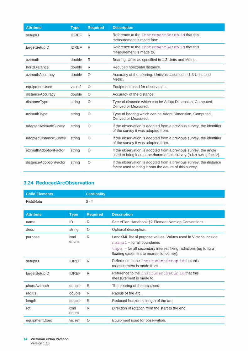
14 Victorian ePlan Protocol
Version 1.10
Attribute Type Required Description
setupID IDREF R Reference to the InstrumentSetup id that this
measurement is made from.
targetSetupID IDREF R Reference to the InstrumentSetup id that this
measurement is made to.
azimuth double R Bearing. Units as specified in 1.3 Units and Metric.
horizDistance double R Reduced horizontal distance.
azimuthAccuracy double O Accuracy of the bearing. Units as specified in 1.3 Units and
Metric.
equipmentUsed vic ref O Equipment used for observation.
distanceAccuracy double O Accuracy of the distance.
distanceType string O Type of distance which can be Adopt Dimension, Computed,
Derived or Measured.
azimuthType string O Type of bearing which can be Adopt Dimension, Computed,
Derived or Measured.
adoptedAzimuthSurvey string O If the observation is adopted from a previous survey, the identifier
of the survey it was adopted from.
adoptedDistanceSurvey string O If the observation is adopted from a previous survey, the identifier
of the survey it was adopted from.
azimuthAdoptionFactor string O If the observation is adopted from a previous survey, the angle
used to bring it onto the datum of this survey (a.k.a swing factor).
distanceAdoptionFactor string O If the observation is adopted from a previous survey, the distance
factor used to bring it onto the datum of this survey.
3.24 ReducedArcObservation
Child Elements Cardinality
FieldNote 0 - *
Attribute Type Required Description
name ID R See ePlan Handbook §2 Element Naming Conventions.
desc string O Optional description.
purpose lxml
enum
R LandXML list of purpose values. Values used in Victoria include:
normal – for all boundaries
topo – for all secondary interest fixing radiations (eg to fix a
floating easement to nearest lot corner).
setupID IDREF R Reference to the InstrumentSetup id that this
measurement is made from.
targetSetupID IDREF R Reference to the InstrumentSetup id that this
measurement is made to.
chordAzimuth double R The bearing of the arc chord.
radius double R Radius of the arc.
length double R Reduced horizontal length of the arc.
rot lxml
enum
R Direction of rotation from the start to the end.
equipmentUsed vic ref O Equipment used for observation.
Victorian ePlan Protocol
Version 1.10
15
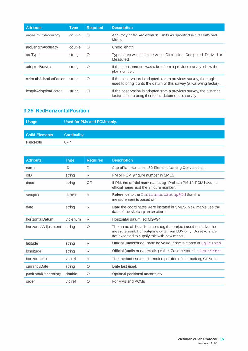
Attribute Type Required Description
arcAzimuthAccuracy double O Accuracy of the arc azimuth. Units as specified in 1.3 Units and
Metric.
arcLengthAccuracy double O Chord length
arcType string O Type of arc which can be Adopt Dimension, Computed, Derived or
Measured.
adoptedSurvey string O If the measurement was taken from a previous survey, show the
plan number.
azimuthAdoptionFactor string O If the observation is adopted from a previous survey, the angle
used to bring it onto the datum of this survey (a.k.a swing factor).
lengthAdoptionFactor string O If the observation is adopted from a previous survey, the distance
factor used to bring it onto the datum of this survey.
3.25 RedHorizontalPosition
Usage Used for PMs and PCMs only.
Child Elements Cardinality
FieldNote 0 - *
Attribute Type Required Description
name ID R See ePlan Handbook §2 Element Naming Conventions.
oID string R PM or PCM 9 figure number in SMES.
desc string CR If PM, the official mark name, eg "Prahran PM 1". PCM have no
official name, just the 9 figure number.
setupID IDREF R Reference to the InstrumentSetup@Id that this
measurement is based off.
date string R Date the coordinates were instated in SMES. New marks use the
date of the sketch plan creation.
horizontalDatum vic enum R Horizontal datum, eg MGA94.
horizontalAdjustment string O The name of the adjustment (eg the project) used to derive the
measurement. For outgoing data from LUV only. Surveyors are
not expected to supply this with new marks.
latitude string R Official (undistorted) northing value. Zone is stored in CgPoints.
longitude string R Official (undistorted) easting value. Zone is stored in CgPoints.
horizontalFix vic ref R The method used to determine position of the mark eg GPSnet.
currencyDate string O Date last used.
positionalUncertainty double O Optional positional uncertainty.
order vic ref O For PMs and PCMs.
16 Victorian ePlan Protocol
Version 1.10
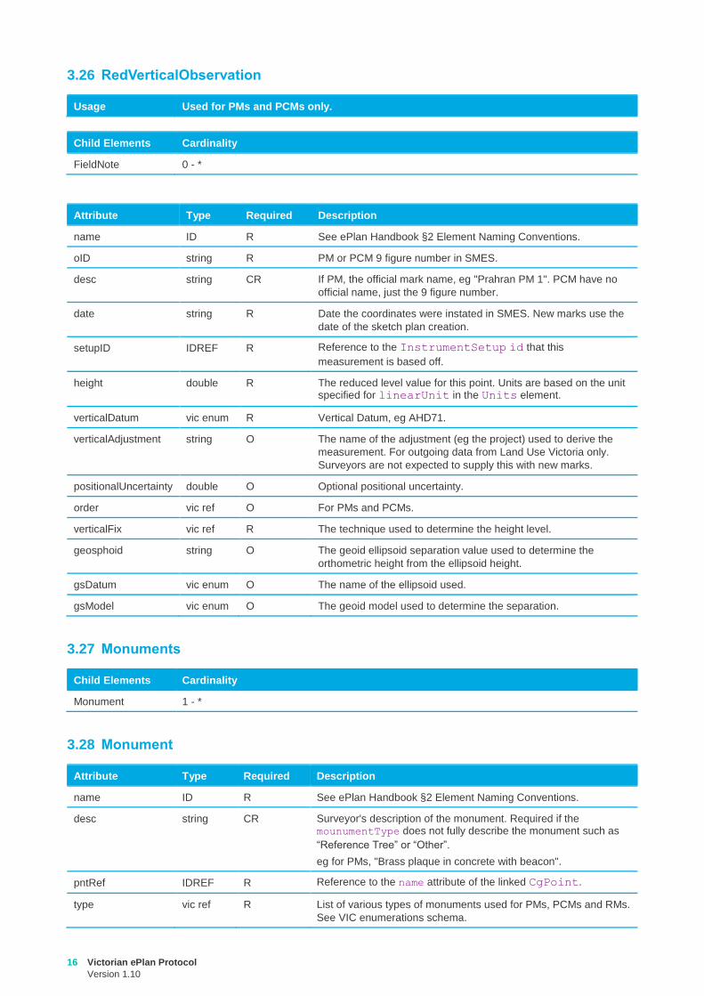
3.26 RedVerticalObservation
Usage Used for PMs and PCMs only.
Child Elements Cardinality
FieldNote 0 - *
Attribute Type Required Description
name ID R See ePlan Handbook §2 Element Naming Conventions.
oID string R PM or PCM 9 figure number in SMES.
desc string CR If PM, the official mark name, eg "Prahran PM 1". PCM have no
official name, just the 9 figure number.
date string R Date the coordinates were instated in SMES. New marks use the
date of the sketch plan creation.
setupID IDREF R Reference to the InstrumentSetup id that this
measurement is based off.
height double R The reduced level value for this point. Units are based on the unit specified for linearUnit in the Units element.
verticalDatum vic enum R Vertical Datum, eg AHD71.
verticalAdjustment string O The name of the adjustment (eg the project) used to derive the
measurement. For outgoing data from Land Use Victoria only.
Surveyors are not expected to supply this with new marks.
positionalUncertainty double O Optional positional uncertainty.
order vic ref O For PMs and PCMs.
verticalFix vic ref R The technique used to determine the height level.
geosphoid string O The geoid ellipsoid separation value used to determine the
orthometric height from the ellipsoid height.
gsDatum vic enum O The name of the ellipsoid used.
gsModel vic enum O The geoid model used to determine the separation.
3.27 Monuments
Child Elements Cardinality
Monument 1 - *
3.28 Monument
Attribute Type Required Description
name ID R See ePlan Handbook §2 Element Naming Conventions.
desc string CR Surveyor's description of the monument. Required if the mounumentType does not fully describe the monument such as
“Reference Tree” or “Other”.
eg for PMs, "Brass plaque in concrete with beacon".
pntRef IDREF R Reference to the name attribute of the linked CgPoint.
type vic ref R List of various types of monuments used for PMs, PCMs and RMs.
See VIC enumerations schema.
Victorian ePlan Protocol
Version 1.10
17
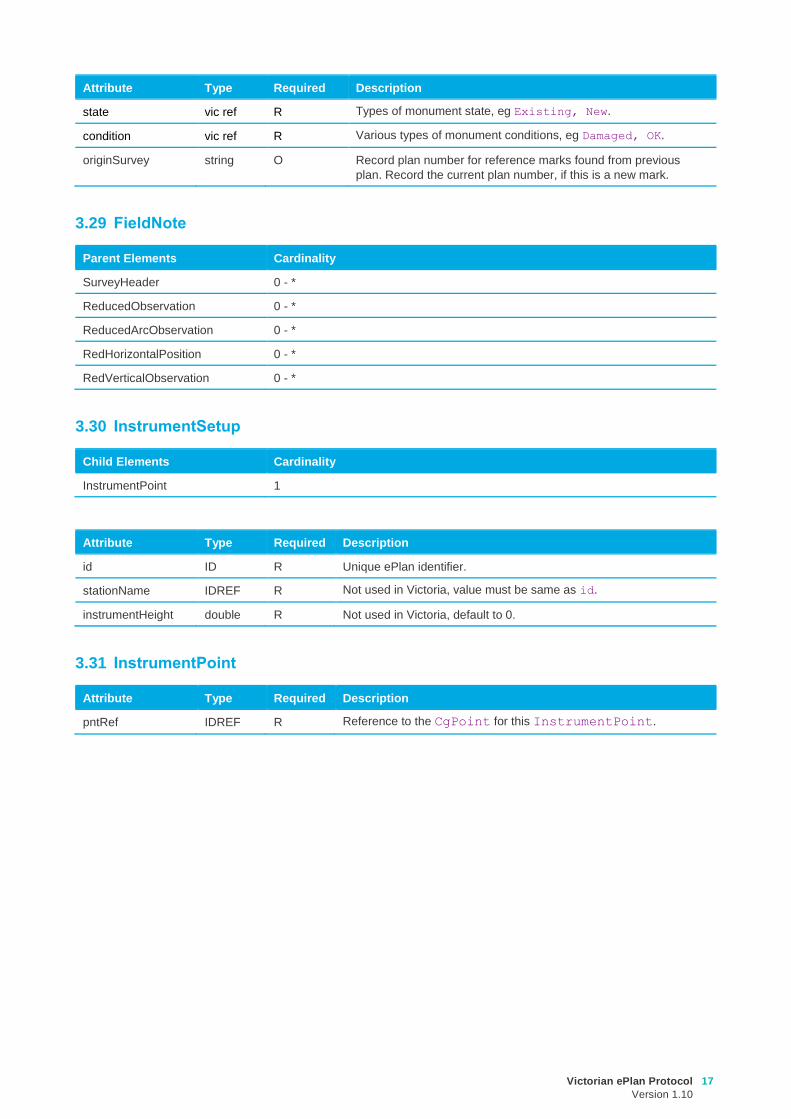
Attribute Type Required Description
state vic ref R Types of monument state, eg Existing, New.
condition vic ref R Various types of monument conditions, eg Damaged, OK.
originSurvey string O Record plan number for reference marks found from previous
plan. Record the current plan number, if this is a new mark.
3.29 FieldNote
Parent Elements Cardinality
SurveyHeader 0 - *
ReducedObservation 0 - *
ReducedArcObservation 0 - *
RedHorizontalPosition 0 - *
RedVerticalObservation 0 - *
3.30 InstrumentSetup
Child Elements Cardinality
InstrumentPoint 1
Attribute Type Required Description
id ID R Unique ePlan identifier.
stationName IDREF R Not used in Victoria, value must be same as id.
instrumentHeight double R Not used in Victoria, default to 0.
3.31 InstrumentPoint
Attribute Type Required Description
pntRef IDREF R Reference to the CgPoint for this InstrumentPoint.