Embed Size (px)
Citation preview

VI ISSUES EFFECTING THE MASTERPLAN
SANT A TERESA COUNTY PARK FINAL MASTER PLAN REPORT
VI ISSUES AFFECTING THE MASTER PLAN
Three categories of issues are addressed with in this chapter The first is compatibility broken into two subsections One the compatibility of various permanent or temporal uses taking into account the capacity (either visual or physical) of the environment and two the compatibility of and between the various types of uses occurring concurrently in a particular zone of the Park Two additional issues are security and operation of the Park
A RECREATIONAL USE AND COMPATIBILITY
I EquestriansBikers
Questions were raised at the first public meeting regarding the compatibility of novice equestrian and mountain bike users on the trails in Santa Teresa Park The questions revolved around the reaction of horses and their inexperienced riders to the sudden appearance of bicyclists on the trail There were also complaints regarding the newly designated bicycle area and trails near Bernal Hill It was argued that the trails designated specifically for bikes were too short and not worth the effort to travel to the site for their use Issues regarding sharedsegregated trails use prompted the planning team to survey seven public agencies in the Bay Area regarding their policies in this matter While some agencies had no firm policies regarding multi-use trails (combining pedestrian equestrian and bicycle use or other restrictions such as speed limits or posted restrictions others have well developed policies There appears to be little inter-agency coordination as yet regarding these issues This is imminently critical if the multi-use concept of the Bay Area Ridge Trail is to be realized The BARTrail is intended to provide segregated alignments where physical characteristics permit however if the terrain is limiting and the potential for segregation of trails is limited multi-use trails are to be provided (at least until a segregated alignment is secured)
Considerable input was generated by bicycling groups This ranged from specific proposals for trail use and categorization of Santa Teresa Park trails (letters and maps from Don Axtell) including a number of form letters supporting extensive multi-use trails These materials are reproduced in the appendix section of the report Other related issues include potential or perceived conflicts between the various trail user groups on steep and narrow trails with obstructed views and inadequate sight distances
2 GolfersHikers
Informal use by hikers of the Los Alamitos Canal as a trail (especially in the vicinity of the pond) has the potential for conflicts including disturbance of golf play and the subjection of hikers to the hazard of flying golf balls
3 White Oak Picnic Area
A popular neighborhood picnicking facility the White Oak area was closed to public use with the expansion of the golf course A relatively large restroom (which had been constructed by the Park Department) was abandoned The area was replaced theoretically with the construction of the Pueblo Picnic Area however the environmental quality of the Pueblo area has never matched that of the White Oak area which was adjacent to a pond and natural springs and sheltered by mature oak trees Two other reasons for the closure of this facility were swimming and night parties Although swimming was never permitted one drowning has occured The lack of staffing for a full time
CHAPTER VI
- 42 shy
0 z
gtltZMUlTI-USE TRAIIS 1-lt0 -(f)
Z (f)~COIWA RISON ~ JI-lt ~ ~ 01 gt- lt I-ltQI-ltlt( U~ ~
~ Z -JQ ~ OU c J ~J VIlaquo r4~ ~ I-ltJ~ 0 Z~r4 I-lt~ J(f)~~ U~r4 I-lt~ lt SO( Q z U~Q lt~ ZO~ r4lt ~ ~ ~ ~~ J 1-lt1-lt p gt ~ JI-lt)gtlt Z ~QI-lt~ Z~ ~ 2 lt QQ jQltltr4 Slt ) jQ jQ 1-lt1-lt ltVI VIltoct JgtTRAIL AUTIIORITY Zoo ~amprl ) oop jLI jLI 200 20 20 p
MULTI-USE TUAIL Y N Y Y Y N Y Y Y Y
WIDTHGHADE 4 3 3 1 3 3 3
ENVW HESTRICTlONS Y Y Y 2 2 2 2 N Y 2
POSTED SImiddotEED LIMITS
5-15 MPH 4 Y
10 MlllI Y 4
5-15 MPH
5-15 MPH Y
10 111gt11
DIKE PATH MIN WIDTIl 4 4 3 1 4 3 3 4
1middot05TED AUEA UESTIUCTIONS Y Y Y Y Y 3 Y 3 Y Y
1 UIKES ALLOWED ON FmESEHVICE ROADS ONLY Y = YES
2 NO RECENT TUAIL CONSTRUCTION N = NO
3 CURRENTLY NO STANDARDS
4 STANDARDS CUnUENTLY UEING DEVELOlllm
TINshyNe)
SANTA TERESA COUNTY PARK FINAL MASTER PLAN REPORT
lifeguard necessitated the facilitys closing The facility was closed also to prevent night parties frequently held at the site
4 Archery RangeHikers
The use of the Los Alamitoas Canal levee has the potential for hazards to pedestrians and bicyclists where it abuts the archery range Generally the lease area presents a safety hazard with the current official and unofficial use The lower archery range is sited in a linear fashion with target ranges backing up to the Canal with shooting taking place in the direction of these actively used unofficial trails (See also Chapter VI (Inventory and Analysis) Section 3 (Utilities and Easements)
The area roughly plusmn 12 acres in size is not used intensively and constitutes a large percent of relatively level land within current park boundaries The Park contains relatively few large flat potential active use areas of this size
5 Grazing FencesHikers
There have been reports of damage to fences adjacent to ranch lands presumably by Park users Damage can be caused by Park users as they cut through or climb over fences The Parks Department has responded to these concerns and made repairs Also fences have been affected by fires whether started inside or outside the Park Older fences (acquired with property) consisting of wood posts are particularly susceptible to fire damage New parks fences are typically metal stakes with barbed wire
6 HikersBackyard SecurityLos Alamitos Canal
The neighbors of Santa Teresa Park are no different than the neighbors of parks throughout the Bay Area Those who have parcels which back up to park land and are not visible from the nearest public street (and therefore from police vehicles) are very concerned about the possibility of formal or informal trails along their back yard fences Concerns were expressed that present and anticipated use of the Los Alamitos Canal as a trail would generate break-ins vandalism and other illegal activities A 1983 report on the future role of the Coyote-Alamitos canal refers to potential liabilities for Santa Clara Valley Water District due presumably to its current unused and unsupervised status
7 Hazardous UtilitiesHikers
Several power lines particularly in the vicinity of the Ohlone Trail and Pond Area (providing power to such facilities as the KSJO radio station or the Wright Ranch) have been constructed without consideration of access to park users In one case the low point of the arc comes within four feet of the ground near the Ohlone Trail and therefore within easy reach of park visitors
8 Santa Teresa Park Road UsagePark Users
During informal discussions with the public at the workshops several individuals expressed concern over the heavy traffic levels generated by the Santa Teresa Park Road and the occasional driver who fails to recognize the stop signs at trail crossings (See also Section A 5 Traffic and Circulation Chapter VIII) Traffic levels on the Santa Teresa Park Road do not exceed normal uses of suburban residential and park area roads according to the planning team traffic consultant Gay Pang Original intent of the road was a general access road and was built to County standards including bike lanes and shoulders according to IBM It adequately handles the current flow Such use problems therefore are
CHAPTER VI
- 43 shy
SANTA TERESA COUNTY PARK FINAL MASTER PLAN REPORT
perceived and are seen to be encroaching on a desired level of visual and acoustical quietude which park users expect (See also Security below) However vehicles commonly exceed posted speeds and fail to observe stop signs at pedestrian and equestrian crossings thereby posing a safety hazard
9 Pond Hazard
The existing pond (which is used as a water holding pond for golf course irrigation) is unsupervised and unfenced It was used prior to 1983 as a fishing facility but was closed after amiddot drowning incident The ponds generally attractive surroundings and relatively easy access along the Los Alamitos Canal levee make it a continued hazard or at least an attractive nuisance
10 Water Tank on Coyote Peak
The proposal for a 212000 gallon water tank atop the highest peak in the Park generated concern In addition to the potential for visual impacts and the appropriateness of such a utilitarian structure on a landmark of potential interpretive value there was concern over the precedent of using a public park to accomodate a private development This was in apparent reference to other potential hillside and ridgetop development sites near the Park along Santa Teresa ridge One neighbor suggested that the emphasis should be on removing rather than adding more utilities Financial compensation was not included in the Conditions for Approval of the conceptual plan as approved by the Board of Supervisors The conditions did include provision for horse watering troughs and two fire hydrants along the waterline
CHAPTER VI
- 44 shy
SANTA TERESA COUNTY PARK FINAL MASTER PLAN REPORT
B ENVIRONMENT AL RECREATIONAL USE COMPATIBILITIES
The next set of issues concerns park uses and the physical or visual capacities of the park environment
1 Slope FailurePhysical Facilities
While it appears that as yet there have been no failures endangering recent improvements such as roads or trails it is clear from geologic studies that many of the steeper slopes of the Park are in delicate equilibrium and could easily fail should a grading for trails roads or other facilities be carried out in an improper fashion (See also Chapter VI INVENTORY AND ANALYSIS)
2 Fire
Natural or man caused fires pose a continuing problem for park managers in several plant community types (eg Chapparal) Periodic fire is a natural and healthy occurrence Fires of moderate heat are beneficial for regeneration of some types of seeds Catastrophic fire fueled by litter built up over years due to fire suppression can however destroy such seeds when fire does occur Yet because of adjacent and on-site improvements park staff and local fire departments are required to suppress all fires This has lead to a dangerous build up of fire fuel (downed wood debris high grass and thatch etc) particularly in the Ohlone Trail area and slopes above the golf course This is particularly important during drought cycles
3 Off-leash DogsWildlife
There has been mention at public meetings of a desire for unrestricted dog access to the Park or a dog exercise area Unrestricted use could result in harassment of cattle and adjacent cattle ranching operations and has the potential of endangering endemic or indigenous wildlife Currently park policy allows dogs on leashes in picnic areas only A plan to designate a trails system for pet use was voted down by the Parks and Recreation Commission in 1989 According to Park staff women joggers running alone like to be accompanied by leashed dogs for safety
4 Rare and Endangered Animal and Plant Communities
Because of land form in combination with geology and serpentine soils substantial areas of sensitive riparian corridors and native grasslands (which are in themselves of value) support wildlife which is either rare andor endangered or about to be listed as such A potential issue is whether or not recreational uses can be introduced without disturbing or destroying such resources
5 UtilitiesVisual Environment
The most obvious utility easement within the Park is the large PGampE high voltage electrical transmission towers and lines In many cases these were in place before the assemblage of parcels making up the Park Some power systems (involving wooden poles) were added afterward (power to the Muriel Wright Residential Center to KSJO etc) Any future lines whether or not for public agencies or utilities or private concerns should meet the goals of the Park Master Plan
A similar issue has arisen with respect to a proposal made some time ago (1981) to place a water tank at the top of Coyote Peak for private use The proposed
CHAPTER VI
- 4S shy
SANTA TERESA COUNTY PARK FINAL MASTER PLAN REPORT
tank would be supplied by water from Great Oaks district with a connection at the golf course pumped 950 up to Coyote Peak with the water line ascending the steep slopes above the golf course to a large tank at the top of Coyote Peak The Board of Supervisors approved the proposed concept of a 62000 gallon tank and water line in 1982 for 40 residential connections Since that time the adjacent 28 lot subdivision has become active and will require a 212000 gallon water tank The developer and their engineers have submitted plans for the Parks Department approval Water from the tank would be available for fire suppression and horse watering troughs according to the concept The value of this trade-off cannot be determined until the Parks additional water needs are determined at the completion of the Draft Master Plan No financial compensation for the easement is included
Such uses should in any case adhere to the physical and visual criteria established in the Master Plan for park uses and facilities
A more basic question outside of the purview of this study is whether public lands should be used at all for the provision of services to private development in part due to the precedent setting implications
CHAPTER VI
- 46 shy
SANTA TERESA COUNTY PARK FINAL MASTER PLAN REPORT
C SECURITY
Staffing
Santa Teresa Park has operated for years with a part time staff which operates from Calero Reservoir Park and must share its operational and maintenance time with Almaden Quicksilver and Calero Parks The construction of the modern Santa Teresa Park Road made unauthorized night time access to the Park by off-road vehicles and others quite easy Because IBM workers need outer access at the IBM Bernal entrance at night when the Park is closed there is no way to gate the entrance off at Bernal Road A construction program to line vulnerable curb reaches with 36 plus boulders has been started and appears to be successful in limiting some of the unauthorized access to offshyroad areas Off-road vehicular tracks in the Pueblo area have been replanted and stabilized Other unauthorized uses however remain a problem even though vandalism has abated lately according to Park field staff
An interesting perspective on the lack of staff was provided by seventh grade students at the nearby Bernal Intermediate School Many of them mentioned the need for a full time ranger Prior to Proposition 13 Santa Teresa Park had two separate units sharing the same offices and maintenance yards at the Golf Course One unit operated and maintained the Golf Course while the other was dedicated to operation and maintenance of the Park Staff dedicated specifically to Santa Teresa Park included a Supervising Ranger Rangemaster (for rifle range which is now an archery range) two full time rangers two full time maintenance crew and various seasonal employees (a total of 6+) As a result of Proposition 13 staffing was cut and park units were consolidated with Santa Teresas merging with the Calero unit The Golf Course including the Santa Teresa maintenance yard and offices were leased out to a concessionaire and all Santa Teresa Park operation and maintenance facilities were moved to Calero Permanent staffing dedicated to Santa Teresa has not been replaced as of yet Currently the Calero unit is responsible for Calero Park and Reservoir AlmadenQuicksilver and Santa Teresa totaling 7531 acres The permanent staff consists of one Regional Park Manager one Senior Ranger four rangers and four maintenance workers or slightly over 3 per park assuming equal distribution Most of the units time is dedicated to operational and maintenance of Calero Reservoir
CHAPTER VI
- 47 shy
SANTA TERESA COUNTY PARK FINAL MASTER PLAN REPORT
D OPERATIONS
1 Scheduling
In contrast to the apparent low intensity of usage over past years (only limited statistics for Santa Teresa Park have been kept since 1980) the nature of use is changing such that conflicts are arising Events or park use involving large groups or reservations of a park or portions of a park require special use permits issued by the County Parks Department These permits are issued on a first come first serve basis for a fee based on a standard fee plus the events impact on normal revenue generation An example of a recent scheduling conflict occurred on the weekend of July 28-29 1990 when an arranged specially permitted mountain bike event precluded an unscheduled equestrian tour by a local commercial equestrian business Substantially increased biker use has been implied by statements of biker groups An estimated increase in population in nearby Almaden Valley of some 6000 persons and regional trail connections in process add to this pressure Scheduling methods andor staff commitment may need adjustments to respond to these changes
2 Maintenance
The focus is on maintenance of the Pueblo area picnic facilities and meadow removal of trash and maintenance of restrooms In several areas trails need clearing or regrading and installation of drainage devices The level of disrepair may have been made worse because of the lack of overall trail use controls and signage which encourage unauthorized use of non-designated trails andor trails which are subject to erosion Accessories such as signs benches and hitching posts are limited and receive limited attention The recent and anticipated increase in use along with the implementation of any master plan recommendations will substantially increase maintenance needs
3 Irrigation
Even though the irrigation is connected to the Muriel Wright Residential Center water system for the Pueblo turf area it has been used little in the past few years because of the drought the impact on Muriel Wright Residential Center water needs and maintenance cutbacks This in turn has resulted in a dramatic reduction in use of the area according to Park staff especially during the hot dry summer and fall months
CHAPTER VI
- 48 shy
Vll SYNTHESIS OPPORTUNITIES AND CONSTRAINTS
SANTA TERESA COUNTY PARK FINAL MASTER PLAN REPORT
VILSYNTHESIS OPPORTUNITIES AND CONSTRAINTS
A INTEREST GROUPS AND USE PROJECTIONS
1 Information Sources
Prior to and during the preparation of this report two public meetings and three task force meetings were held with attendance ranging from 17 to 35 persons These workshops have been the source of a great deal of the information regarding recreation interests for Santa Teresa Park In addition County staff mailed 255 survey questionnaires to Task Force members interested park users bicycle shops equestrian organizations archery shops and local schools in April and May of this year In addition the surveys and flyers for all public workshops were posted at the Almaden and Santa Teresa Libraries and at the Southside Community Center A number of communications including seven form letters were received from individuals interested in multi shyuse trails and shared equestrianmountain bicycle use Finally extensive discussions in the field with the Parks field and administrative staff provided a good deal of information
The following summary lists the activities considered and their apparent popularity A tabulated form of the survey is included in the appendix While a survey of plusmn30 respondents must be considered of limited accuracy the general range of uses seem to be supported by the informal discussions at workshops It appears that the respondents reflect a cross section of interest with relative accuracy
The comments which accompanied the check list forms indicate a strong interest in restoration of a grassy shade area particularly in connection with picnicking use Mountain bicycling equestrian and other shared use trail enthusiasts vigorously argued for more multi-use trails and longer trails for bicycle use By far the greatest interest was in an activity not normally associated with County facilities a swimming complex Some of the respondents were members of Mr Mike Boullands seventh grade class at Bernal Intermediate SchooL Other activities which were not included in the survey list but which appeared to be of some interest to special groups included soccer fields a cross country running course for high schools a historical museum and a dog run area or dogs on trails policy
It is significant that the wide range of uses derived are highly contrasting and in some cases potentially conflicting in nature For example for someone making quiet passive uses of historic trails interpretive facilities and nature areas intense physically active uses such as cross country running mountain biking field play areas etc could be seen as disruptive Another type of contrast can be seen in the passive uses which are typically sited in rustic open space settings compared to those which are usually associated with more urban use areas such as a swimming pool complex
2 Interest Group Goals
Three groups clearly distinguished themselves the mountain biking group equestrians and environmentalists Only the mountain bike groups submitted specific map suggestions for trail uses while other groups and individuals relied essentially on resource data gathered by this study and referred to sites within the Park where their interests might be met
3 Use Projections
CHAPTER VII
- 49 shy
SANTA TERESA COUNTY PARK FINAL MASTER PLAN REPORT
The survey data limited as it was to some 30 individuals is inadequate in providing Quantitative use projections While the Park is a unique entity serving a County wide system it is clear that the greatest pressure comes from individuals living closest to the Park This may be less so in the case of golfers and midday hikers and joggers who are employed at the IBM facility
The greatest source of users for the Park it can be assumed comes from the urbanized Santa Clara Valley floor directly north of the Park The population within a two mile radius from the north side of the Park (at the Bernal Road entrance) is estimated to be approximately 15000 to 16000 individuals (l500 times 45 units per gross acre equals 6750 units times 23 individuals per unit equals 15525) Conversely to the south City plans suggest a potential future population of about 6000 in the 10werAImaden Valley Urban Reserve area in addition to existing populations With the completion of a regional trail system in the future additional users will be passing through the Park and perhaps stopping (as opposed to destination users)
CHAPTER VII
- SO shy
SANTA TERESA COUNTY PARK FINAL MASTER PLAN REPORT
USER SURVEY SUMMARY - Most Desired Uses
(Listed from highest to lower vote tallies All items received 1990 survey)
Total Votes 1 Family picnic area 2 HikingJogging 3 Informal play meadow 4 Native shade trees 5 Equestrian trail riding 6 Historical miningranch trail
Nature trails and areas 7 Group picnic 8 Kite flying area 9 Mountain biking 10 Formal turf field play 11 Joice Ranch use 12 RunningX country events 13 Archery 14 Dog run areadogs allowed on trails 15 Shade structure 16 Horse rentals 17 Fishing pond 18 Pony rides 19 Day camp 20 Swimming Pool
For and Against totals were the same for both items
Split-Vote Items (no plurality - 15 votes or fewer each)
Court play Equestrian pack trips Riding lessons Amphitheateropen air performances Special day use programs Historic re-enactments Arboretum Rental for partiesevents Scavenger hunts Riding corral Weddings and ceremonies
a plurality in the April-May
30 27 26 26 23 21 21 19 17 17 17 15 15 15 14 14 13 10 10 10 8
CHAPTER VII
- 51 - FIG 23
SANT A TERESA COUNTY PARK FINAL MASTER PLAN REPORT
An assumption that current use levels reflect this population pattern would assist somewhat in making future use projections The problem with this assumption is it cannot be backed up by attendance figures (none have been kept for Santa Teresa Park since 1980) Also the current very limited facilities plus the virtual elimination of such important items as irrigation for the Pueblo area and the displacement of the White Oak picnic area probably imply a lower level of interest by the adjacent population than would be the case were these facilities fully developed and their recreational and interpretational characteristics well known to the public One can only assume that improved conditions in the Park would generate a much higher level of use for the Park from the existing population base and that the demand for such uses can be expected to nearly double by the time the lower Almaden Valley and adjacent foothill areas are built out Figures for permits and individuals for the Pueblo picnic area are available for the following years
1985 23 permits 1306 individuals
1986 22 permits 1190 individuals
1987 23 permits 1435 individuals
1988 14 permits 850 individuals
Prior to 1980 records show a peak in use of the Pueblo area of 109537 individuals (1973) to a low of 37920 (1980)
CHAPTER VII
- 52 shy
SANT A TERESA COUNTY PARK FINAL MASTER PLAN REPORT
B RESOURCE SENSITIVITIES
The physical and visual resources and their characteristics have been summarized in three maps Overall Sensitivity Zones Shelter Zones and Views and Site Character The Overall Sensitivity Zones Map summarizes all of the physical and historicprehistoric resources In addition it reflects in essence a stacking of conditions leading to greater sensitivity where more valuable or delicate resources occur and conversely less sensitivity where there are fewer such resources By contrast the definition of shelter zones and the values attached thereto are based on site observations and topographic and cross sectional analysis
1 Physical Sensitivities Composite Map
Five categories are shown on this map
a Very High Sensitivity The highest sensitivity zones include such factors as landslide potential high soil erosion hazard sensitive riparian vegetation andor streams the Checkerspot Butterfly habitat and prehistoric burial grounds in various combinations The highest concentration of these is in the zone roughly centered on the Rossetto Ranch extending eastward into the Wilets property and to a lesser degree westward toward the IBM ARC gate North of the crest of the Park the highest sensitivity zones occur in a much patchier fashion roughly covariant with the steep canyons above the golf course the Buck Norred Ranch and above the Joice Ranch and Santa Teresa Springs Smaller areas in a more scattered pattern appear on the mid-slope on the Hunter Ranch to the east of the study area
b High Sensitivity High sensitivity zones combine butterfly habitat with erosion hazard and riparian zones but also in some cases landslide areas in the vicinity of oak forest and erosive soils The largest zones of this category occur on the north facing slopes of the Wilets or Big Oak Valley the north facing slope above the Pueblo area and to a lesser degree above the golf course A very strong concentration occurs on the slopes surrounding the Rossetto Ranch and just at the westerly boundary of the existing park partially on the Hunter Ranch property Patchy areas occur at the western edge of the Hunter Ranch and again at mid-slope This also occurs above the Buck Norred Ranch and to a lesser degree on the south facing slopes of the WHets property
c Moderate Sensitivity This category may include endangered butterfly habitat covariant with oaks or with riparian habitat and with high erosion hazard zones andor oak forests Another combination in this category is the endangered butterfly habitat with high erosion hazard and oak forest areas Most of the sloping areas of the Park which exhibit moderately high and high sensitivities fall in this category with large areas all along the northern slope of the Santa Teresa Hills (the Hunter and the Joice Ranches) the slopes above Buck Norred and above the golf course Another large patch occurs on the rocky ridgetop some of which is owned by the Lagatutta family and then again on the ridgetop of the Wilets property
d Low Sensitivity This category includes the riparian habitat without any other sensitivity factors high soil erosion zones in connection with a landslide zone or an erosion zone in connection with an oak forest condition Somewhat more limited in size there are patches of this category found at the base of the north facing Hunter property slopes
CHAPTER VII
- S3 shy
SANT A TERESA COUNTY PARK FINAL MASTER PLAN REPORT
a few upslope of the Buck Norred Ranch areas near the Muriel Wright Residential Center and along the edge of the Wilets property with a few remaining patches around the Rossetto Ranch
e Very Low Sensitivity The lowest category includes slopes under 30 that are free of any of the foregoing constraints (landslides riparian high erosion hazard etc) which are either grasslands or oak woodlands
2 Shelter Zones
One of the most important qualities for regional park use is a sense of seclusion or shelter This is of course reflective of a basic human need to have some sense of control over the immediate environment no matter how minimal or primitive the environmental factors involved are Shelter zones picked by the planning team are frequently covariant with prehistoric habitation or use areas such as grinding holes or burial grounds Five zones were identified in the study Taken as a whole they occur in essentially contiguous zones I) in the valleys surrounding and downstream of the Rossetto Ranch 2) all along the high ridge of the Hunter Property 3) in a few isolated patches at the base of the slopes above the golf course and 4) again at the far eastern edge of the property which is currently used as the archery range Each of these zones is made up of one or more of the following categories of shelter These are illustrated in the accompanying crOSS sectional diagram
A The strongest combination of environmental factors involves mature oak forests grasslands and relatively small valleys flanked by slopes of 15 or greater The width of the valleys is generally less than 500 feet A variation on this type (illustrated by Section A) is where a cluster of riparian vegetation parallels a young stream or gully providing narrower shelter zones along creek banks
B These can occur at the north facing side of a relatively narrow valley where the oak trees have clustered in response to greater ground moisture (as is the case in Big Oak Valley) or off to the side of a ridgetop which occurs on the Hunter Ranch west of Bernal Hill
C This occurs on convex land forms or basically ridgetops where the sense of protection is somewhat less but is provided by mature oaks unobscured with chaparral or other shrub vegetation The largest concentration of this zone is along the main ridge mostly on the Hunter property A small and rather unique patch is created by a group of Pygmy Oaks overlooking the Rossetto Ranch
D The land form which gives the least sense of protection is that of an open valley which lacks mature oaks but is either small enough in terms of the width of the valley floor or is flanked by steep enough slopes to have a general sense of enclosure
3 View and Site Character
This map has been described in Chapter VI Section B-1 The map reflects five constituent elements as follows
Regional ridgelines Visually prominent slopes Regional mountain peak or hilltop
CHAPTER VII
- 54 shy
SANTA TERESA COUNTY PARK FINAL MASTER PLAN REPORT
Ridgeline views (linear in character) Vista points (localized) Secluded zone
The last of these (secluded zone) is one from which no direct or significant urbanization (including the IBM Almaden facility)is visible
Each of these zones is sensitive in a different way Tree removal grading or construction of structures on the steep hillsides ridge tops or peaks would be easily seen from surrounding urbanized neighborhoods which would therefore be in conflict with County goals The greatest problem with any physical alteration of ridge lines mountain peaks or hilltops is that any additional structures will be seen in silhouette and thus become highly visible
Disturbances here could include grading for roads development of trails or utilities a removal of oak forest or riparian or chaparral vegetation and of course grading for and construction of any major structures
The introduction of man made structures to the secluded zone could be problematic This study recommends that this area be treated with special concern because it will in a short period become one of a few areas relatively
close to urbanization where residents from either the adjacent Santa Clara or Almaden Valleys can escape from the urban scene
CHAPTER VII
- 33 shy
SANTA TERESA COUNTY PARK FINAL MASTER PLAN REPORT
C PLANNING AND DESIGN
I Environmental
A Sensitive Environment The constraint implications of the environmental opportunities and constraints listed in Chapter VI can be summarized as reflecting a visual physical and biological environment which is relatively sensitive and in some situations highly delicate This appears to be so on ridgetops that are seen by surrounding residents or by contrast in narrow sometimes secluded valleys In areas that are not burdened with constraints such as landslides high erosion hazard sensitive habitats for endangered butterflies or aquatic breeding grounds and the like there may be visually secluded zones that present visual environments perfect for historic and prehistoric interpretation
Because of these sensitivities some of which have extremely limited carrying capacities recreation uses should logically be located and designed to respond to these highly varied sensitivities For example highly active uses inVOlving large numbers of people in vehicles should in general be located off the steep slopes and away from secluded zones at the center of the Park The alternative is to locate these areas at the periphery of the Park where they can be reached directly from adjacent arterial or neighborhood roads andor regional trails The parking capacity of these areas varies highly and some parking will be difficult Nevertheless several different opportunities are described in a subsequent chapter of this report
An example of the need to respond to environmental senSItIVIty is the Joice Ranch According to Slope Stability maps prepared by Earth Technology the ranch house is located either on or at the base of an existing landslide Even though the structure has stood since the latter part of the 19th century environmental changes such as tectonic movement may have occurred and are likely to occur in the future Additional more detailed study by geologists andor structural engineers should be considered as a part of the plans provided by the interested groups These should establish in a precise sense the relative safety of the buildings By implication as well any improvements which might disturb existing ground levels or surface or subsurface water conditions should be carefully studied In some cases extensive excavation or filling can trigger landslide movement In a similar vein the impacts of livestock or grazing particularly on the steep hillside areas behind the house should be considered because of the potential for increasing erosion on soil types that are highly fragile
Similarly trail type uses should be determined based on physical requirements for the use considered where new trails are called for such trails should be located and designed to respond to the highly varied and in some cases limited capacity of the natural landscape Soil erodability as shown on the accompanying map (Figure 27) is the most important constraint
In highly sensitive environments such as Santa Teresa Park it is important to identify the potential for various uses to impact the environment adversely The following Physical and Visual Impacts Summary Chart (Figure 26) is a generalized ranking applied to those uses that have been mentioned as appropriate or desirable for the Park It illustrates relative differences only Well designed facilities which are closely adapted to environmental constraints can in some cases mitigate adverse impacts
At the same time it is clear both from the opinions surveys and from discussions with the task force and the public that by and large the uses which
CHAPTER VII
- 56 shy
SANT A TERESA COUNTY PARK FINAL MASTER PLAN REPORT
the public now associates with the Park are generally those favored to remain with a limited number of exceptions noted (eg a turfed soccer field dog run shade structure and a swimming facility) The remaining potential uses of interest generally appear to be those which could be accommodated without major biological or visual disturbance It is clear the public does not support uses that would require major buildings or structures nor does it want to see massive upgrading of trails by the inclusion of pavej or divided sections There appears to be a corollary interest in preserving the existing look of the Park by avoiding the addition of major utilities beyond those which already exist
CHAPTER VII
- 57 shy
FINAL MASTER PLAN REPORT
PHYSICAL AND VISUAL IMP ACTS SUMMARY CHART
In highly sensitive environments such as Santa Teresa Park it is important to identify the potential for the construction of various facilities which may impact the environment adversely The following is a generalized ranking applied to those uses which have been mentioned as appropriate or desirable for the Park It illustrates relative differences only Well designed facilities which are closely adapted to environmental constraints can in many cases mitigate adverse impacts
PHYSICAL ALTERATION OR IMPACT LEVEL
HIGH Major utility systems (major underground lines) Parking lots Court type play area Multi-use trail (8 wide) Maintenance road (8 wide) Unleashed dogs on trails Shade structure Equestrian facilities (corral etc) Fishing pond Day camp facilities Amphitheater Archery Dog run area (fenced) Equestrian trails (8 wide) Arboretum Restroom facilities Group picnic facilities Informal play meadow Mountain biking trail (4 wide) Family picnic areas Historical trail (use) (2 wide) Runningjogging trail (use) (2 wide) Nature trails and areas (15 wide)
LOW Hiking trails (15 wide)
VISUAL ALTERATION OR IMPACT LEVEL
HIGH Major utility systems (power lines water tanks) Court play area Formal turf field play Shade structure Equestrian facilities Fishing pond Amphitheater Restroom facilities Combined Eqstrnbike trails Native trees
LOW Historical trail
CHAPTER VII FIG 28 - 58 shy
SANTA TERESA COUNTY PARK FINAL MASTER PLAN REPORT
The reinstatement of irrigation to recreate an informal play meadow at the Pueblo area could have both beneficial and negative impacts on adjacent wetlands and drainages depending on how it is handled As discussed in the paragraph below there is also relatively strong interest in making the most of resources such as the existing Joice Ranch but are as yet undeveloped
2 Visual and Cultural Opportunities
The inference can be drawn from discussions at the public workshops and task force meetings that the public would support preservation and even the highlighting of the unique ecological cultural and visual characteristics of the Park This includes the open space character of the Park as seen from and in contrast to the urbanized valley floor to the north In the extension of these existing land forms such as the two valleys the sky line of peaks and ridges should receive special protection from all forms of development which add or alter these elements
General knowledge of workshop participants in regards to the history of the site and in some cases of its prehistoric characteristics revealed an interest in seeing this resource developed further This could best be done through a comprehensive natural and cultural history program This interest also implies that protection andor restoration of these valued resources should be a high priority For example historic buildings if not in conflict with site character or with historic building codes should be restored
In addition to the interest expressed for an historic and prehistoric resources interpretation program there is a strong interest in a developed natural history interpretive program There are many natural resources in the Park (described in subsequent chapters) which could become an integral part of such an interpretive program
Historic Landscape Concept The wealth of dispersed significant historic and prehistoric sites is such that the concept of an historic landscape might apply While this is a concept which has been applied primarily in national and state historic parks the richness of Santa Teresa Park resources may make it an appropriate opportunity This could be applied as an overlay policy zone similar to that used in land use planning covering the critical historic and prehistoric resources zones of the Park if not the entire park Three primary eras could be involved
Native American Spanish Rancho American Ranching and Mining (up to the mid-twentieth century)
3 Revenue Generation Implications
Santa Teresa Park clearly is a study in contrasts when it comes to revenue generation On the one hand the golf course is a major generator of income which goes not to Santa Teresa Park but to the County Park general fund The rest of the Park contains little that generates significant funds As noted in Chapter VI aside from golf courses water recreational uses are the most lucrative in the Park system By contrast Santa Teresa Park is a relatively arid landscape with only one pond near the golf course driving range Uses which hold moderate promise for revenue generation exist at three or four sites at the perimeter of the existing property There should be a considerable market for large group gatherings making use of combined indooroutdoor socializing and picnic facilities In addition to social groups and clubs there is demand
CHAPTER VII
- 59 shy
SANTA TERESA COUNTY PARK FINAL MASTER PLAN REPORT
from corporate group facilities for hosting groups of up to 500 people The Norred Ranch the Rossetto Ranch and the area identified as the East Meadow (currently used by the archery groups) all have the potential to accommodate this sort of use
Because of the existing combination of parking restroom facilities stables dance pavilion picnic tables and barbecue units the Norred Ranch offers great theoretical potential It should be noted the Parks own analysis of the buildings on the Ranch suggests very few if any of them can be saved The Rossetto Ranch is only slightly less attractive but only because a considerable amount of work would be required to meet its potential for the same sort of function Finally the archery area for a variety of reasons explained in the next chapter has the potential to serve such uses possibly conducted in connection with the golf course facility
In conclusion without these facilities the revenue generating potentials of the rest of the Park are limited These would improve somewhat with the improvement of the Pueblo area as this would certainly encourage or generate more group activity and specially permitted events
4 Utilities and Support Facilities
As noted above the combination of site limitations and the nature of demand does not suggest a massive increase in water or power requirements in the Pueblo Improvements to restroom facilities and septic fields would certainly be logical if there is an increase in use by large groups Even if areas such as Rossetto and Norred were to be acquired andor developed for various uses (described elsewhere) they are at the perimeter of the Park and close to existing utilities and other infrastructure This tends to minimize the capital costs for such improvements (The water and sewage capacities at the Rossetto Ranch however need further study)
5 Access and Security
a Through-road As previously discussed (Chapter V Section E) the Bernal Road extension (aka Santa Teresa Park Road provides a physical connection from north to south (Harry Road) and is available in cases of emergency IBM allows unrestricted passage to County Park Rangers
Adding a publicly accessible north-south through road meeting modern traffic and safety standards has been considered Such would only become a possibility if and when the Rossetto Ranch is purchased There are arguments why this idea should not be pursued First it would bring levels of activity to the center of the Park which would conflict with the goals of the 2020 report and the County General Plan A through-road would introduce a level of activity which would at least conflict with if not destroy the core of the Park as an isolated open space retreat from the adjacent urban areas It would also in all likelihood heavily impact the rich pre-historic resources in the ranch houseswimming pool area
Other major constraints to this concept include the physical difficulties of getting a road along Fortini Creek (a sensitive wildlife habitat corridor pinched by landslide formations on both sides) This traffic would impact both Bernal Road and the Fortini San Vicente Road accesses
CHAPTER VII
- 60 shy
1
-TO No~ -
-1 FUeetv fW~~~
SKETCH PLAN A ~rt
~ C cptf GCU~e7
PF ~ ~ ~ LD- ~ITcfi ~~
-1 bullbull bull bull~ ~ ~f01~-rP-J ~ middot~==middot~l VirIO PI(fi ~ l bull~ bullbull y ~ ~- To NcW K y lt1l ~H eM t7u-=D-I 4
EXISTING W~T~q CONDITIONS
CONSUL T ANTS FOR DRAFT MASTER PLAN PROJECT bull TITO TRI I ASSOCITES bull u cu COUNTy
u l aICItpoundA flO OC-TLDSCPE ARCHITECTURe SANTA TERESA PARKzbullbull GAADlIIf OAlY Ul20 ONTGOERY ~ 0 01 OATQS CAlIIOa
SN FRANCISCO C so~O 401 UI
TEl 15-gB aa 11 PROPOSED FiG MODiFICATION 29 BERNAL GATEWAY
SANTA TERESA COUNTY PARK FINAL MASTER PLAN REPORT
b Bernal Entrance An important opportunity does exist to reconfigure the entrance road (south of its intersection with Heaton Moor Road) in a way which could help solve the ParkIBM off hours security problem The switch-back (700 feet southeast of the intersection of Heaton Moor and Bernal Roads) could be turned into a T intersection with several benefits One benefit would be to force downhill vehicles (which generally speed around this corner) to come to a full stop A t400 foot straight section upslope of the switch-back could he modified with speed bumps or warning lights and signs The T intersection would then allow the possibility of a road connection in a southeasterly direction could take place along a modified Los Alamitos Canal levee as shown in the cross section (Figure 29) The modification to the levee could also accommodate trail uses Similarly a T section and arterial stop and levee modification could allow a road connection northwesterly to the Buck Norred Ranch
This reconfirmation would create two sites for a control gate and guard kiosk One location (Sketch Plan B) close to the intersection of Heaton Moor and Bernal would provide good sight control north easterly along Bernal and southeasterly along the Santa Teresa Park Road (up to the proposed T intersection) It would however need to be manned or opened if there were night events at Norred Ranch and access to the Ranch were along the Los Alamitos Canal levee The second (Sketch Plan A) could be at the T intersection This could allow for closure of the Park at night but operable with electronic devices for those authorized vehicles traveling to the Muriel Wright Residential Center or the IBM facility IBM does not staff its kiosk at night but if it were willing to do so and the gates were not carded at the proposed kiosk this might solve the current security problem (the inability to control use of the Park after dark) IBM has stated that nighttime staffing is not acceptable As noted in Section VIII A (following) a smaller control kiosk (similar to the Calero Reservoir Boat Launch kiosk) could also be built at the Rossetto Ranch or south entrance off Fortini Road should the Rossetto properties be included in the Park
East Meadow TheT configuration is also an important part of two alternative access routes to the East Meadow (currently the archery area) These are
(1) A road along the Alamitos Canal levee (modified) to a point 200-300 feet east of 8th tee of the golf course The route would then descend off the canal berm (which drops into a syphon at that point) and skirt the northerly edge of the existing pond After that it would be aligned along the southern edge of the driving range where taller fences might be required as a protection from flying golf balls A few hundred feet further east the road would have to leave the canal alignment and skirt along the south side of another tee and terminate at what is now the Bowmans parking area The total distance however is substantial 6500 feet or 12 miles
(2) A second possibility of providing vehicular access to the East Meadow area is directly off the intersection to Santa Teresa Boulevard and the Los Alamitos Canal where again the reconfigured canal although outside the current park boundary could provide reasonable access along a low speed driveway type of road The distance from Santa Teresa Boulevard to the Park boundary is approximately 3500 feet (07 miles)
CHAPTER VII
- 61 shy
SANTA TERESA COUNTY PARK FINAL MASTER PLAN REPORT
The major limitation of the two prior alternatives is likely to be the cost The distance from the proposed T intersection and East Meadow parking lot would be approximately one mile The advantage of these two routes is that they would impact the adjacent neighborhoods minimally
Two other opportunities for accessing East Meadow include
(3) Continued use of the Bayliss A venue access off A venida Espana which has a direct connection to Santa Teresa Boulevard and provides access at the current gate to the archery center
(4) A route through the golf course There is a possibility of extending a road from the most easterly end of the existing paved parking lot It would continue along a southerly service road and then follow the existing Los Alamitos Canal alignment
These different access possibilities relate to three possible recreational use variations for the East Meadow area in general which are described in the Recommendations Section Their feasibility depends to some extent on the relationship between the uses proposed and golf use
The westerly alternative could impact golf play in some areas depending on its exact configuration Of the two alternatives the existing entrance would require at most refurbishing and an upgrading of new pavement whereas the extension from the existing golf course parking lot would require a new road bed and paving for a distance of approximately 2500 feet
6 Operations and Maintenance Opportunities
a A clear implication can be drawn from the discussions regarding such uses as soccer biking equestrian access in that there could be conflicts between uses depending on two factors the number of people involved and the characteristics of the use imposed on the landscape The flatter more usable areas of Santa Teresa Park are relatively limited compared to the population base which is close at hand particularly on the north side In addition to this recreation use characteristics are constantly changing as evidenced by the increasingly significant demand for mountain biking trails The implications of this are that there should be where possible the physical or temporal separation of uses where there are potentials for conflict The temporal separation of course means that some uses that require permit and approval by park administration can be scheduled to avoid conflict
b Maintenance The most important implication of maintenance demand is the clear need for a full service corporation yard somewhere in the Park Approximately 15 to 20 acres (more than is feasible at the Muriel Wright Residential Center) would be needed In addition because of the natural grouping of physical and visual conditions a zone approach to management should be developed This is also appropriate should staffing increases become possible In this event it will become easier to coordinate scheduled uses with the location and number of management zones which the Park staff would be able to handle at any given time The zone approach would also assist in establishing appropriate maintenance policies Since the zones would reflect generally consistent topographic conditions and other related environmental
CHAPTER VII
- 62 shy
)~ll 1 ~ 1 poundJpound)~ V U 11 1 I r fJl
FINAL MASTER PLAN REPORT
limitations maintenance projections and staff allocations could be based on careful evaluation of the potential physical impacts of various anticipated uses on each zone
c Staffing Opportunities The implications of the general conditions of the landscape and of park improvements as they stand now are that current staffing levels are inadequate to meet even the most minimal management and maintenance needs of the Park The various levels of development obviously entail a commitment on the part of staff relative to the needs implied by such development in terms of both improvement maintenance and management of natural resources Conceptually speaking there are three levels of staff which can be related to either qualitative or quantitative conditions or increases for the Park
(I) Existing Level Existing levels of staffing are clearly inadequate to deal not only with primary management needs of patrolling but secondary needs such as erosion control reforestation protection of rare and endangered habitats resource management mechanical fire fuel reduction etc In fact it might be argued that existing maintenance needs in the Park are enough in excess of staff capacities that some facilities should be abandoned or removed For example maintenance needs for some ad-hoc trails in the Ohlone and Hidden Springs areas are substantial Some of these trails it could be argued should be closed until such time as there is adequate staff augmentation
(2) Level Two Assignment of at least one full time ranger would have two effects One would be to assist in or reduce the cost of special patrols in basic maintenance and policing Secondly the very presence of a full time ranger would have a beneficial psychological impact on park users of all ages Also some combination of contrasting concepts for the Park equestrianbiker use will require monitoring in order to assess the optimum design for such uses in the future Such efforts would be greatly enhanced by the assignment of a full time ranger
(3) Level Three Level three involves substantial increases in staff These would have to be directly related to characteristics of improved facilities and increased use Different combinations of uses and areas imply different staff skills especially with respect to interpretational versus or in tandem with recreational uses Santa Teresa is a more centralized location for the staff unit relative to Calero and AQ Parks
CHAPTER VII
- 63 shy
SANT A TERESA COUNTY PARK FINAL MASTER PLAN REPORT
VI ISSUES AFFECTING THE MASTER PLAN
Three categories of issues are addressed with in this chapter The first is compatibility broken into two subsections One the compatibility of various permanent or temporal uses taking into account the capacity (either visual or physical) of the environment and two the compatibility of and between the various types of uses occurring concurrently in a particular zone of the Park Two additional issues are security and operation of the Park
A RECREATIONAL USE AND COMPATIBILITY
I EquestriansBikers
Questions were raised at the first public meeting regarding the compatibility of novice equestrian and mountain bike users on the trails in Santa Teresa Park The questions revolved around the reaction of horses and their inexperienced riders to the sudden appearance of bicyclists on the trail There were also complaints regarding the newly designated bicycle area and trails near Bernal Hill It was argued that the trails designated specifically for bikes were too short and not worth the effort to travel to the site for their use Issues regarding sharedsegregated trails use prompted the planning team to survey seven public agencies in the Bay Area regarding their policies in this matter While some agencies had no firm policies regarding multi-use trails (combining pedestrian equestrian and bicycle use or other restrictions such as speed limits or posted restrictions others have well developed policies There appears to be little inter-agency coordination as yet regarding these issues This is imminently critical if the multi-use concept of the Bay Area Ridge Trail is to be realized The BARTrail is intended to provide segregated alignments where physical characteristics permit however if the terrain is limiting and the potential for segregation of trails is limited multi-use trails are to be provided (at least until a segregated alignment is secured)
Considerable input was generated by bicycling groups This ranged from specific proposals for trail use and categorization of Santa Teresa Park trails (letters and maps from Don Axtell) including a number of form letters supporting extensive multi-use trails These materials are reproduced in the appendix section of the report Other related issues include potential or perceived conflicts between the various trail user groups on steep and narrow trails with obstructed views and inadequate sight distances
2 GolfersHikers
Informal use by hikers of the Los Alamitos Canal as a trail (especially in the vicinity of the pond) has the potential for conflicts including disturbance of golf play and the subjection of hikers to the hazard of flying golf balls
3 White Oak Picnic Area
A popular neighborhood picnicking facility the White Oak area was closed to public use with the expansion of the golf course A relatively large restroom (which had been constructed by the Park Department) was abandoned The area was replaced theoretically with the construction of the Pueblo Picnic Area however the environmental quality of the Pueblo area has never matched that of the White Oak area which was adjacent to a pond and natural springs and sheltered by mature oak trees Two other reasons for the closure of this facility were swimming and night parties Although swimming was never permitted one drowning has occured The lack of staffing for a full time
CHAPTER VI
- 42 shy
0 z
gtltZMUlTI-USE TRAIIS 1-lt0 -(f)
Z (f)~COIWA RISON ~ JI-lt ~ ~ 01 gt- lt I-ltQI-ltlt( U~ ~
~ Z -JQ ~ OU c J ~J VIlaquo r4~ ~ I-ltJ~ 0 Z~r4 I-lt~ J(f)~~ U~r4 I-lt~ lt SO( Q z U~Q lt~ ZO~ r4lt ~ ~ ~ ~~ J 1-lt1-lt p gt ~ JI-lt)gtlt Z ~QI-lt~ Z~ ~ 2 lt QQ jQltltr4 Slt ) jQ jQ 1-lt1-lt ltVI VIltoct JgtTRAIL AUTIIORITY Zoo ~amprl ) oop jLI jLI 200 20 20 p
MULTI-USE TUAIL Y N Y Y Y N Y Y Y Y
WIDTHGHADE 4 3 3 1 3 3 3
ENVW HESTRICTlONS Y Y Y 2 2 2 2 N Y 2
POSTED SImiddotEED LIMITS
5-15 MPH 4 Y
10 MlllI Y 4
5-15 MPH
5-15 MPH Y
10 111gt11
DIKE PATH MIN WIDTIl 4 4 3 1 4 3 3 4
1middot05TED AUEA UESTIUCTIONS Y Y Y Y Y 3 Y 3 Y Y
1 UIKES ALLOWED ON FmESEHVICE ROADS ONLY Y = YES
2 NO RECENT TUAIL CONSTRUCTION N = NO
3 CURRENTLY NO STANDARDS
4 STANDARDS CUnUENTLY UEING DEVELOlllm
TINshyNe)
SANTA TERESA COUNTY PARK FINAL MASTER PLAN REPORT
lifeguard necessitated the facilitys closing The facility was closed also to prevent night parties frequently held at the site
4 Archery RangeHikers
The use of the Los Alamitoas Canal levee has the potential for hazards to pedestrians and bicyclists where it abuts the archery range Generally the lease area presents a safety hazard with the current official and unofficial use The lower archery range is sited in a linear fashion with target ranges backing up to the Canal with shooting taking place in the direction of these actively used unofficial trails (See also Chapter VI (Inventory and Analysis) Section 3 (Utilities and Easements)
The area roughly plusmn 12 acres in size is not used intensively and constitutes a large percent of relatively level land within current park boundaries The Park contains relatively few large flat potential active use areas of this size
5 Grazing FencesHikers
There have been reports of damage to fences adjacent to ranch lands presumably by Park users Damage can be caused by Park users as they cut through or climb over fences The Parks Department has responded to these concerns and made repairs Also fences have been affected by fires whether started inside or outside the Park Older fences (acquired with property) consisting of wood posts are particularly susceptible to fire damage New parks fences are typically metal stakes with barbed wire
6 HikersBackyard SecurityLos Alamitos Canal
The neighbors of Santa Teresa Park are no different than the neighbors of parks throughout the Bay Area Those who have parcels which back up to park land and are not visible from the nearest public street (and therefore from police vehicles) are very concerned about the possibility of formal or informal trails along their back yard fences Concerns were expressed that present and anticipated use of the Los Alamitos Canal as a trail would generate break-ins vandalism and other illegal activities A 1983 report on the future role of the Coyote-Alamitos canal refers to potential liabilities for Santa Clara Valley Water District due presumably to its current unused and unsupervised status
7 Hazardous UtilitiesHikers
Several power lines particularly in the vicinity of the Ohlone Trail and Pond Area (providing power to such facilities as the KSJO radio station or the Wright Ranch) have been constructed without consideration of access to park users In one case the low point of the arc comes within four feet of the ground near the Ohlone Trail and therefore within easy reach of park visitors
8 Santa Teresa Park Road UsagePark Users
During informal discussions with the public at the workshops several individuals expressed concern over the heavy traffic levels generated by the Santa Teresa Park Road and the occasional driver who fails to recognize the stop signs at trail crossings (See also Section A 5 Traffic and Circulation Chapter VIII) Traffic levels on the Santa Teresa Park Road do not exceed normal uses of suburban residential and park area roads according to the planning team traffic consultant Gay Pang Original intent of the road was a general access road and was built to County standards including bike lanes and shoulders according to IBM It adequately handles the current flow Such use problems therefore are
CHAPTER VI
- 43 shy
SANTA TERESA COUNTY PARK FINAL MASTER PLAN REPORT
perceived and are seen to be encroaching on a desired level of visual and acoustical quietude which park users expect (See also Security below) However vehicles commonly exceed posted speeds and fail to observe stop signs at pedestrian and equestrian crossings thereby posing a safety hazard
9 Pond Hazard
The existing pond (which is used as a water holding pond for golf course irrigation) is unsupervised and unfenced It was used prior to 1983 as a fishing facility but was closed after amiddot drowning incident The ponds generally attractive surroundings and relatively easy access along the Los Alamitos Canal levee make it a continued hazard or at least an attractive nuisance
10 Water Tank on Coyote Peak
The proposal for a 212000 gallon water tank atop the highest peak in the Park generated concern In addition to the potential for visual impacts and the appropriateness of such a utilitarian structure on a landmark of potential interpretive value there was concern over the precedent of using a public park to accomodate a private development This was in apparent reference to other potential hillside and ridgetop development sites near the Park along Santa Teresa ridge One neighbor suggested that the emphasis should be on removing rather than adding more utilities Financial compensation was not included in the Conditions for Approval of the conceptual plan as approved by the Board of Supervisors The conditions did include provision for horse watering troughs and two fire hydrants along the waterline
CHAPTER VI
- 44 shy
SANTA TERESA COUNTY PARK FINAL MASTER PLAN REPORT
B ENVIRONMENT AL RECREATIONAL USE COMPATIBILITIES
The next set of issues concerns park uses and the physical or visual capacities of the park environment
1 Slope FailurePhysical Facilities
While it appears that as yet there have been no failures endangering recent improvements such as roads or trails it is clear from geologic studies that many of the steeper slopes of the Park are in delicate equilibrium and could easily fail should a grading for trails roads or other facilities be carried out in an improper fashion (See also Chapter VI INVENTORY AND ANALYSIS)
2 Fire
Natural or man caused fires pose a continuing problem for park managers in several plant community types (eg Chapparal) Periodic fire is a natural and healthy occurrence Fires of moderate heat are beneficial for regeneration of some types of seeds Catastrophic fire fueled by litter built up over years due to fire suppression can however destroy such seeds when fire does occur Yet because of adjacent and on-site improvements park staff and local fire departments are required to suppress all fires This has lead to a dangerous build up of fire fuel (downed wood debris high grass and thatch etc) particularly in the Ohlone Trail area and slopes above the golf course This is particularly important during drought cycles
3 Off-leash DogsWildlife
There has been mention at public meetings of a desire for unrestricted dog access to the Park or a dog exercise area Unrestricted use could result in harassment of cattle and adjacent cattle ranching operations and has the potential of endangering endemic or indigenous wildlife Currently park policy allows dogs on leashes in picnic areas only A plan to designate a trails system for pet use was voted down by the Parks and Recreation Commission in 1989 According to Park staff women joggers running alone like to be accompanied by leashed dogs for safety
4 Rare and Endangered Animal and Plant Communities
Because of land form in combination with geology and serpentine soils substantial areas of sensitive riparian corridors and native grasslands (which are in themselves of value) support wildlife which is either rare andor endangered or about to be listed as such A potential issue is whether or not recreational uses can be introduced without disturbing or destroying such resources
5 UtilitiesVisual Environment
The most obvious utility easement within the Park is the large PGampE high voltage electrical transmission towers and lines In many cases these were in place before the assemblage of parcels making up the Park Some power systems (involving wooden poles) were added afterward (power to the Muriel Wright Residential Center to KSJO etc) Any future lines whether or not for public agencies or utilities or private concerns should meet the goals of the Park Master Plan
A similar issue has arisen with respect to a proposal made some time ago (1981) to place a water tank at the top of Coyote Peak for private use The proposed
CHAPTER VI
- 4S shy
SANTA TERESA COUNTY PARK FINAL MASTER PLAN REPORT
tank would be supplied by water from Great Oaks district with a connection at the golf course pumped 950 up to Coyote Peak with the water line ascending the steep slopes above the golf course to a large tank at the top of Coyote Peak The Board of Supervisors approved the proposed concept of a 62000 gallon tank and water line in 1982 for 40 residential connections Since that time the adjacent 28 lot subdivision has become active and will require a 212000 gallon water tank The developer and their engineers have submitted plans for the Parks Department approval Water from the tank would be available for fire suppression and horse watering troughs according to the concept The value of this trade-off cannot be determined until the Parks additional water needs are determined at the completion of the Draft Master Plan No financial compensation for the easement is included
Such uses should in any case adhere to the physical and visual criteria established in the Master Plan for park uses and facilities
A more basic question outside of the purview of this study is whether public lands should be used at all for the provision of services to private development in part due to the precedent setting implications
CHAPTER VI
- 46 shy
SANTA TERESA COUNTY PARK FINAL MASTER PLAN REPORT
C SECURITY
Staffing
Santa Teresa Park has operated for years with a part time staff which operates from Calero Reservoir Park and must share its operational and maintenance time with Almaden Quicksilver and Calero Parks The construction of the modern Santa Teresa Park Road made unauthorized night time access to the Park by off-road vehicles and others quite easy Because IBM workers need outer access at the IBM Bernal entrance at night when the Park is closed there is no way to gate the entrance off at Bernal Road A construction program to line vulnerable curb reaches with 36 plus boulders has been started and appears to be successful in limiting some of the unauthorized access to offshyroad areas Off-road vehicular tracks in the Pueblo area have been replanted and stabilized Other unauthorized uses however remain a problem even though vandalism has abated lately according to Park field staff
An interesting perspective on the lack of staff was provided by seventh grade students at the nearby Bernal Intermediate School Many of them mentioned the need for a full time ranger Prior to Proposition 13 Santa Teresa Park had two separate units sharing the same offices and maintenance yards at the Golf Course One unit operated and maintained the Golf Course while the other was dedicated to operation and maintenance of the Park Staff dedicated specifically to Santa Teresa Park included a Supervising Ranger Rangemaster (for rifle range which is now an archery range) two full time rangers two full time maintenance crew and various seasonal employees (a total of 6+) As a result of Proposition 13 staffing was cut and park units were consolidated with Santa Teresas merging with the Calero unit The Golf Course including the Santa Teresa maintenance yard and offices were leased out to a concessionaire and all Santa Teresa Park operation and maintenance facilities were moved to Calero Permanent staffing dedicated to Santa Teresa has not been replaced as of yet Currently the Calero unit is responsible for Calero Park and Reservoir AlmadenQuicksilver and Santa Teresa totaling 7531 acres The permanent staff consists of one Regional Park Manager one Senior Ranger four rangers and four maintenance workers or slightly over 3 per park assuming equal distribution Most of the units time is dedicated to operational and maintenance of Calero Reservoir
CHAPTER VI
- 47 shy
SANTA TERESA COUNTY PARK FINAL MASTER PLAN REPORT
D OPERATIONS
1 Scheduling
In contrast to the apparent low intensity of usage over past years (only limited statistics for Santa Teresa Park have been kept since 1980) the nature of use is changing such that conflicts are arising Events or park use involving large groups or reservations of a park or portions of a park require special use permits issued by the County Parks Department These permits are issued on a first come first serve basis for a fee based on a standard fee plus the events impact on normal revenue generation An example of a recent scheduling conflict occurred on the weekend of July 28-29 1990 when an arranged specially permitted mountain bike event precluded an unscheduled equestrian tour by a local commercial equestrian business Substantially increased biker use has been implied by statements of biker groups An estimated increase in population in nearby Almaden Valley of some 6000 persons and regional trail connections in process add to this pressure Scheduling methods andor staff commitment may need adjustments to respond to these changes
2 Maintenance
The focus is on maintenance of the Pueblo area picnic facilities and meadow removal of trash and maintenance of restrooms In several areas trails need clearing or regrading and installation of drainage devices The level of disrepair may have been made worse because of the lack of overall trail use controls and signage which encourage unauthorized use of non-designated trails andor trails which are subject to erosion Accessories such as signs benches and hitching posts are limited and receive limited attention The recent and anticipated increase in use along with the implementation of any master plan recommendations will substantially increase maintenance needs
3 Irrigation
Even though the irrigation is connected to the Muriel Wright Residential Center water system for the Pueblo turf area it has been used little in the past few years because of the drought the impact on Muriel Wright Residential Center water needs and maintenance cutbacks This in turn has resulted in a dramatic reduction in use of the area according to Park staff especially during the hot dry summer and fall months
CHAPTER VI
- 48 shy
Vll SYNTHESIS OPPORTUNITIES AND CONSTRAINTS
SANTA TERESA COUNTY PARK FINAL MASTER PLAN REPORT
VILSYNTHESIS OPPORTUNITIES AND CONSTRAINTS
A INTEREST GROUPS AND USE PROJECTIONS
1 Information Sources
Prior to and during the preparation of this report two public meetings and three task force meetings were held with attendance ranging from 17 to 35 persons These workshops have been the source of a great deal of the information regarding recreation interests for Santa Teresa Park In addition County staff mailed 255 survey questionnaires to Task Force members interested park users bicycle shops equestrian organizations archery shops and local schools in April and May of this year In addition the surveys and flyers for all public workshops were posted at the Almaden and Santa Teresa Libraries and at the Southside Community Center A number of communications including seven form letters were received from individuals interested in multi shyuse trails and shared equestrianmountain bicycle use Finally extensive discussions in the field with the Parks field and administrative staff provided a good deal of information
The following summary lists the activities considered and their apparent popularity A tabulated form of the survey is included in the appendix While a survey of plusmn30 respondents must be considered of limited accuracy the general range of uses seem to be supported by the informal discussions at workshops It appears that the respondents reflect a cross section of interest with relative accuracy
The comments which accompanied the check list forms indicate a strong interest in restoration of a grassy shade area particularly in connection with picnicking use Mountain bicycling equestrian and other shared use trail enthusiasts vigorously argued for more multi-use trails and longer trails for bicycle use By far the greatest interest was in an activity not normally associated with County facilities a swimming complex Some of the respondents were members of Mr Mike Boullands seventh grade class at Bernal Intermediate SchooL Other activities which were not included in the survey list but which appeared to be of some interest to special groups included soccer fields a cross country running course for high schools a historical museum and a dog run area or dogs on trails policy
It is significant that the wide range of uses derived are highly contrasting and in some cases potentially conflicting in nature For example for someone making quiet passive uses of historic trails interpretive facilities and nature areas intense physically active uses such as cross country running mountain biking field play areas etc could be seen as disruptive Another type of contrast can be seen in the passive uses which are typically sited in rustic open space settings compared to those which are usually associated with more urban use areas such as a swimming pool complex
2 Interest Group Goals
Three groups clearly distinguished themselves the mountain biking group equestrians and environmentalists Only the mountain bike groups submitted specific map suggestions for trail uses while other groups and individuals relied essentially on resource data gathered by this study and referred to sites within the Park where their interests might be met
3 Use Projections
CHAPTER VII
- 49 shy
SANTA TERESA COUNTY PARK FINAL MASTER PLAN REPORT
The survey data limited as it was to some 30 individuals is inadequate in providing Quantitative use projections While the Park is a unique entity serving a County wide system it is clear that the greatest pressure comes from individuals living closest to the Park This may be less so in the case of golfers and midday hikers and joggers who are employed at the IBM facility
The greatest source of users for the Park it can be assumed comes from the urbanized Santa Clara Valley floor directly north of the Park The population within a two mile radius from the north side of the Park (at the Bernal Road entrance) is estimated to be approximately 15000 to 16000 individuals (l500 times 45 units per gross acre equals 6750 units times 23 individuals per unit equals 15525) Conversely to the south City plans suggest a potential future population of about 6000 in the 10werAImaden Valley Urban Reserve area in addition to existing populations With the completion of a regional trail system in the future additional users will be passing through the Park and perhaps stopping (as opposed to destination users)
CHAPTER VII
- SO shy
SANTA TERESA COUNTY PARK FINAL MASTER PLAN REPORT
USER SURVEY SUMMARY - Most Desired Uses
(Listed from highest to lower vote tallies All items received 1990 survey)
Total Votes 1 Family picnic area 2 HikingJogging 3 Informal play meadow 4 Native shade trees 5 Equestrian trail riding 6 Historical miningranch trail
Nature trails and areas 7 Group picnic 8 Kite flying area 9 Mountain biking 10 Formal turf field play 11 Joice Ranch use 12 RunningX country events 13 Archery 14 Dog run areadogs allowed on trails 15 Shade structure 16 Horse rentals 17 Fishing pond 18 Pony rides 19 Day camp 20 Swimming Pool
For and Against totals were the same for both items
Split-Vote Items (no plurality - 15 votes or fewer each)
Court play Equestrian pack trips Riding lessons Amphitheateropen air performances Special day use programs Historic re-enactments Arboretum Rental for partiesevents Scavenger hunts Riding corral Weddings and ceremonies
a plurality in the April-May
30 27 26 26 23 21 21 19 17 17 17 15 15 15 14 14 13 10 10 10 8
CHAPTER VII
- 51 - FIG 23
SANT A TERESA COUNTY PARK FINAL MASTER PLAN REPORT
An assumption that current use levels reflect this population pattern would assist somewhat in making future use projections The problem with this assumption is it cannot be backed up by attendance figures (none have been kept for Santa Teresa Park since 1980) Also the current very limited facilities plus the virtual elimination of such important items as irrigation for the Pueblo area and the displacement of the White Oak picnic area probably imply a lower level of interest by the adjacent population than would be the case were these facilities fully developed and their recreational and interpretational characteristics well known to the public One can only assume that improved conditions in the Park would generate a much higher level of use for the Park from the existing population base and that the demand for such uses can be expected to nearly double by the time the lower Almaden Valley and adjacent foothill areas are built out Figures for permits and individuals for the Pueblo picnic area are available for the following years
1985 23 permits 1306 individuals
1986 22 permits 1190 individuals
1987 23 permits 1435 individuals
1988 14 permits 850 individuals
Prior to 1980 records show a peak in use of the Pueblo area of 109537 individuals (1973) to a low of 37920 (1980)
CHAPTER VII
- 52 shy
SANT A TERESA COUNTY PARK FINAL MASTER PLAN REPORT
B RESOURCE SENSITIVITIES
The physical and visual resources and their characteristics have been summarized in three maps Overall Sensitivity Zones Shelter Zones and Views and Site Character The Overall Sensitivity Zones Map summarizes all of the physical and historicprehistoric resources In addition it reflects in essence a stacking of conditions leading to greater sensitivity where more valuable or delicate resources occur and conversely less sensitivity where there are fewer such resources By contrast the definition of shelter zones and the values attached thereto are based on site observations and topographic and cross sectional analysis
1 Physical Sensitivities Composite Map
Five categories are shown on this map
a Very High Sensitivity The highest sensitivity zones include such factors as landslide potential high soil erosion hazard sensitive riparian vegetation andor streams the Checkerspot Butterfly habitat and prehistoric burial grounds in various combinations The highest concentration of these is in the zone roughly centered on the Rossetto Ranch extending eastward into the Wilets property and to a lesser degree westward toward the IBM ARC gate North of the crest of the Park the highest sensitivity zones occur in a much patchier fashion roughly covariant with the steep canyons above the golf course the Buck Norred Ranch and above the Joice Ranch and Santa Teresa Springs Smaller areas in a more scattered pattern appear on the mid-slope on the Hunter Ranch to the east of the study area
b High Sensitivity High sensitivity zones combine butterfly habitat with erosion hazard and riparian zones but also in some cases landslide areas in the vicinity of oak forest and erosive soils The largest zones of this category occur on the north facing slopes of the Wilets or Big Oak Valley the north facing slope above the Pueblo area and to a lesser degree above the golf course A very strong concentration occurs on the slopes surrounding the Rossetto Ranch and just at the westerly boundary of the existing park partially on the Hunter Ranch property Patchy areas occur at the western edge of the Hunter Ranch and again at mid-slope This also occurs above the Buck Norred Ranch and to a lesser degree on the south facing slopes of the WHets property
c Moderate Sensitivity This category may include endangered butterfly habitat covariant with oaks or with riparian habitat and with high erosion hazard zones andor oak forests Another combination in this category is the endangered butterfly habitat with high erosion hazard and oak forest areas Most of the sloping areas of the Park which exhibit moderately high and high sensitivities fall in this category with large areas all along the northern slope of the Santa Teresa Hills (the Hunter and the Joice Ranches) the slopes above Buck Norred and above the golf course Another large patch occurs on the rocky ridgetop some of which is owned by the Lagatutta family and then again on the ridgetop of the Wilets property
d Low Sensitivity This category includes the riparian habitat without any other sensitivity factors high soil erosion zones in connection with a landslide zone or an erosion zone in connection with an oak forest condition Somewhat more limited in size there are patches of this category found at the base of the north facing Hunter property slopes
CHAPTER VII
- S3 shy
SANT A TERESA COUNTY PARK FINAL MASTER PLAN REPORT
a few upslope of the Buck Norred Ranch areas near the Muriel Wright Residential Center and along the edge of the Wilets property with a few remaining patches around the Rossetto Ranch
e Very Low Sensitivity The lowest category includes slopes under 30 that are free of any of the foregoing constraints (landslides riparian high erosion hazard etc) which are either grasslands or oak woodlands
2 Shelter Zones
One of the most important qualities for regional park use is a sense of seclusion or shelter This is of course reflective of a basic human need to have some sense of control over the immediate environment no matter how minimal or primitive the environmental factors involved are Shelter zones picked by the planning team are frequently covariant with prehistoric habitation or use areas such as grinding holes or burial grounds Five zones were identified in the study Taken as a whole they occur in essentially contiguous zones I) in the valleys surrounding and downstream of the Rossetto Ranch 2) all along the high ridge of the Hunter Property 3) in a few isolated patches at the base of the slopes above the golf course and 4) again at the far eastern edge of the property which is currently used as the archery range Each of these zones is made up of one or more of the following categories of shelter These are illustrated in the accompanying crOSS sectional diagram
A The strongest combination of environmental factors involves mature oak forests grasslands and relatively small valleys flanked by slopes of 15 or greater The width of the valleys is generally less than 500 feet A variation on this type (illustrated by Section A) is where a cluster of riparian vegetation parallels a young stream or gully providing narrower shelter zones along creek banks
B These can occur at the north facing side of a relatively narrow valley where the oak trees have clustered in response to greater ground moisture (as is the case in Big Oak Valley) or off to the side of a ridgetop which occurs on the Hunter Ranch west of Bernal Hill
C This occurs on convex land forms or basically ridgetops where the sense of protection is somewhat less but is provided by mature oaks unobscured with chaparral or other shrub vegetation The largest concentration of this zone is along the main ridge mostly on the Hunter property A small and rather unique patch is created by a group of Pygmy Oaks overlooking the Rossetto Ranch
D The land form which gives the least sense of protection is that of an open valley which lacks mature oaks but is either small enough in terms of the width of the valley floor or is flanked by steep enough slopes to have a general sense of enclosure
3 View and Site Character
This map has been described in Chapter VI Section B-1 The map reflects five constituent elements as follows
Regional ridgelines Visually prominent slopes Regional mountain peak or hilltop
CHAPTER VII
- 54 shy
SANTA TERESA COUNTY PARK FINAL MASTER PLAN REPORT
Ridgeline views (linear in character) Vista points (localized) Secluded zone
The last of these (secluded zone) is one from which no direct or significant urbanization (including the IBM Almaden facility)is visible
Each of these zones is sensitive in a different way Tree removal grading or construction of structures on the steep hillsides ridge tops or peaks would be easily seen from surrounding urbanized neighborhoods which would therefore be in conflict with County goals The greatest problem with any physical alteration of ridge lines mountain peaks or hilltops is that any additional structures will be seen in silhouette and thus become highly visible
Disturbances here could include grading for roads development of trails or utilities a removal of oak forest or riparian or chaparral vegetation and of course grading for and construction of any major structures
The introduction of man made structures to the secluded zone could be problematic This study recommends that this area be treated with special concern because it will in a short period become one of a few areas relatively
close to urbanization where residents from either the adjacent Santa Clara or Almaden Valleys can escape from the urban scene
CHAPTER VII
- 33 shy
SANTA TERESA COUNTY PARK FINAL MASTER PLAN REPORT
C PLANNING AND DESIGN
I Environmental
A Sensitive Environment The constraint implications of the environmental opportunities and constraints listed in Chapter VI can be summarized as reflecting a visual physical and biological environment which is relatively sensitive and in some situations highly delicate This appears to be so on ridgetops that are seen by surrounding residents or by contrast in narrow sometimes secluded valleys In areas that are not burdened with constraints such as landslides high erosion hazard sensitive habitats for endangered butterflies or aquatic breeding grounds and the like there may be visually secluded zones that present visual environments perfect for historic and prehistoric interpretation
Because of these sensitivities some of which have extremely limited carrying capacities recreation uses should logically be located and designed to respond to these highly varied sensitivities For example highly active uses inVOlving large numbers of people in vehicles should in general be located off the steep slopes and away from secluded zones at the center of the Park The alternative is to locate these areas at the periphery of the Park where they can be reached directly from adjacent arterial or neighborhood roads andor regional trails The parking capacity of these areas varies highly and some parking will be difficult Nevertheless several different opportunities are described in a subsequent chapter of this report
An example of the need to respond to environmental senSItIVIty is the Joice Ranch According to Slope Stability maps prepared by Earth Technology the ranch house is located either on or at the base of an existing landslide Even though the structure has stood since the latter part of the 19th century environmental changes such as tectonic movement may have occurred and are likely to occur in the future Additional more detailed study by geologists andor structural engineers should be considered as a part of the plans provided by the interested groups These should establish in a precise sense the relative safety of the buildings By implication as well any improvements which might disturb existing ground levels or surface or subsurface water conditions should be carefully studied In some cases extensive excavation or filling can trigger landslide movement In a similar vein the impacts of livestock or grazing particularly on the steep hillside areas behind the house should be considered because of the potential for increasing erosion on soil types that are highly fragile
Similarly trail type uses should be determined based on physical requirements for the use considered where new trails are called for such trails should be located and designed to respond to the highly varied and in some cases limited capacity of the natural landscape Soil erodability as shown on the accompanying map (Figure 27) is the most important constraint
In highly sensitive environments such as Santa Teresa Park it is important to identify the potential for various uses to impact the environment adversely The following Physical and Visual Impacts Summary Chart (Figure 26) is a generalized ranking applied to those uses that have been mentioned as appropriate or desirable for the Park It illustrates relative differences only Well designed facilities which are closely adapted to environmental constraints can in some cases mitigate adverse impacts
At the same time it is clear both from the opinions surveys and from discussions with the task force and the public that by and large the uses which
CHAPTER VII
- 56 shy
SANT A TERESA COUNTY PARK FINAL MASTER PLAN REPORT
the public now associates with the Park are generally those favored to remain with a limited number of exceptions noted (eg a turfed soccer field dog run shade structure and a swimming facility) The remaining potential uses of interest generally appear to be those which could be accommodated without major biological or visual disturbance It is clear the public does not support uses that would require major buildings or structures nor does it want to see massive upgrading of trails by the inclusion of pavej or divided sections There appears to be a corollary interest in preserving the existing look of the Park by avoiding the addition of major utilities beyond those which already exist
CHAPTER VII
- 57 shy
FINAL MASTER PLAN REPORT
PHYSICAL AND VISUAL IMP ACTS SUMMARY CHART
In highly sensitive environments such as Santa Teresa Park it is important to identify the potential for the construction of various facilities which may impact the environment adversely The following is a generalized ranking applied to those uses which have been mentioned as appropriate or desirable for the Park It illustrates relative differences only Well designed facilities which are closely adapted to environmental constraints can in many cases mitigate adverse impacts
PHYSICAL ALTERATION OR IMPACT LEVEL
HIGH Major utility systems (major underground lines) Parking lots Court type play area Multi-use trail (8 wide) Maintenance road (8 wide) Unleashed dogs on trails Shade structure Equestrian facilities (corral etc) Fishing pond Day camp facilities Amphitheater Archery Dog run area (fenced) Equestrian trails (8 wide) Arboretum Restroom facilities Group picnic facilities Informal play meadow Mountain biking trail (4 wide) Family picnic areas Historical trail (use) (2 wide) Runningjogging trail (use) (2 wide) Nature trails and areas (15 wide)
LOW Hiking trails (15 wide)
VISUAL ALTERATION OR IMPACT LEVEL
HIGH Major utility systems (power lines water tanks) Court play area Formal turf field play Shade structure Equestrian facilities Fishing pond Amphitheater Restroom facilities Combined Eqstrnbike trails Native trees
LOW Historical trail
CHAPTER VII FIG 28 - 58 shy
SANTA TERESA COUNTY PARK FINAL MASTER PLAN REPORT
The reinstatement of irrigation to recreate an informal play meadow at the Pueblo area could have both beneficial and negative impacts on adjacent wetlands and drainages depending on how it is handled As discussed in the paragraph below there is also relatively strong interest in making the most of resources such as the existing Joice Ranch but are as yet undeveloped
2 Visual and Cultural Opportunities
The inference can be drawn from discussions at the public workshops and task force meetings that the public would support preservation and even the highlighting of the unique ecological cultural and visual characteristics of the Park This includes the open space character of the Park as seen from and in contrast to the urbanized valley floor to the north In the extension of these existing land forms such as the two valleys the sky line of peaks and ridges should receive special protection from all forms of development which add or alter these elements
General knowledge of workshop participants in regards to the history of the site and in some cases of its prehistoric characteristics revealed an interest in seeing this resource developed further This could best be done through a comprehensive natural and cultural history program This interest also implies that protection andor restoration of these valued resources should be a high priority For example historic buildings if not in conflict with site character or with historic building codes should be restored
In addition to the interest expressed for an historic and prehistoric resources interpretation program there is a strong interest in a developed natural history interpretive program There are many natural resources in the Park (described in subsequent chapters) which could become an integral part of such an interpretive program
Historic Landscape Concept The wealth of dispersed significant historic and prehistoric sites is such that the concept of an historic landscape might apply While this is a concept which has been applied primarily in national and state historic parks the richness of Santa Teresa Park resources may make it an appropriate opportunity This could be applied as an overlay policy zone similar to that used in land use planning covering the critical historic and prehistoric resources zones of the Park if not the entire park Three primary eras could be involved
Native American Spanish Rancho American Ranching and Mining (up to the mid-twentieth century)
3 Revenue Generation Implications
Santa Teresa Park clearly is a study in contrasts when it comes to revenue generation On the one hand the golf course is a major generator of income which goes not to Santa Teresa Park but to the County Park general fund The rest of the Park contains little that generates significant funds As noted in Chapter VI aside from golf courses water recreational uses are the most lucrative in the Park system By contrast Santa Teresa Park is a relatively arid landscape with only one pond near the golf course driving range Uses which hold moderate promise for revenue generation exist at three or four sites at the perimeter of the existing property There should be a considerable market for large group gatherings making use of combined indooroutdoor socializing and picnic facilities In addition to social groups and clubs there is demand
CHAPTER VII
- 59 shy
SANTA TERESA COUNTY PARK FINAL MASTER PLAN REPORT
from corporate group facilities for hosting groups of up to 500 people The Norred Ranch the Rossetto Ranch and the area identified as the East Meadow (currently used by the archery groups) all have the potential to accommodate this sort of use
Because of the existing combination of parking restroom facilities stables dance pavilion picnic tables and barbecue units the Norred Ranch offers great theoretical potential It should be noted the Parks own analysis of the buildings on the Ranch suggests very few if any of them can be saved The Rossetto Ranch is only slightly less attractive but only because a considerable amount of work would be required to meet its potential for the same sort of function Finally the archery area for a variety of reasons explained in the next chapter has the potential to serve such uses possibly conducted in connection with the golf course facility
In conclusion without these facilities the revenue generating potentials of the rest of the Park are limited These would improve somewhat with the improvement of the Pueblo area as this would certainly encourage or generate more group activity and specially permitted events
4 Utilities and Support Facilities
As noted above the combination of site limitations and the nature of demand does not suggest a massive increase in water or power requirements in the Pueblo Improvements to restroom facilities and septic fields would certainly be logical if there is an increase in use by large groups Even if areas such as Rossetto and Norred were to be acquired andor developed for various uses (described elsewhere) they are at the perimeter of the Park and close to existing utilities and other infrastructure This tends to minimize the capital costs for such improvements (The water and sewage capacities at the Rossetto Ranch however need further study)
5 Access and Security
a Through-road As previously discussed (Chapter V Section E) the Bernal Road extension (aka Santa Teresa Park Road provides a physical connection from north to south (Harry Road) and is available in cases of emergency IBM allows unrestricted passage to County Park Rangers
Adding a publicly accessible north-south through road meeting modern traffic and safety standards has been considered Such would only become a possibility if and when the Rossetto Ranch is purchased There are arguments why this idea should not be pursued First it would bring levels of activity to the center of the Park which would conflict with the goals of the 2020 report and the County General Plan A through-road would introduce a level of activity which would at least conflict with if not destroy the core of the Park as an isolated open space retreat from the adjacent urban areas It would also in all likelihood heavily impact the rich pre-historic resources in the ranch houseswimming pool area
Other major constraints to this concept include the physical difficulties of getting a road along Fortini Creek (a sensitive wildlife habitat corridor pinched by landslide formations on both sides) This traffic would impact both Bernal Road and the Fortini San Vicente Road accesses
CHAPTER VII
- 60 shy
1
-TO No~ -
-1 FUeetv fW~~~
SKETCH PLAN A ~rt
~ C cptf GCU~e7
PF ~ ~ ~ LD- ~ITcfi ~~
-1 bullbull bull bull~ ~ ~f01~-rP-J ~ middot~==middot~l VirIO PI(fi ~ l bull~ bullbull y ~ ~- To NcW K y lt1l ~H eM t7u-=D-I 4
EXISTING W~T~q CONDITIONS
CONSUL T ANTS FOR DRAFT MASTER PLAN PROJECT bull TITO TRI I ASSOCITES bull u cu COUNTy
u l aICItpoundA flO OC-TLDSCPE ARCHITECTURe SANTA TERESA PARKzbullbull GAADlIIf OAlY Ul20 ONTGOERY ~ 0 01 OATQS CAlIIOa
SN FRANCISCO C so~O 401 UI
TEl 15-gB aa 11 PROPOSED FiG MODiFICATION 29 BERNAL GATEWAY
SANTA TERESA COUNTY PARK FINAL MASTER PLAN REPORT
b Bernal Entrance An important opportunity does exist to reconfigure the entrance road (south of its intersection with Heaton Moor Road) in a way which could help solve the ParkIBM off hours security problem The switch-back (700 feet southeast of the intersection of Heaton Moor and Bernal Roads) could be turned into a T intersection with several benefits One benefit would be to force downhill vehicles (which generally speed around this corner) to come to a full stop A t400 foot straight section upslope of the switch-back could he modified with speed bumps or warning lights and signs The T intersection would then allow the possibility of a road connection in a southeasterly direction could take place along a modified Los Alamitos Canal levee as shown in the cross section (Figure 29) The modification to the levee could also accommodate trail uses Similarly a T section and arterial stop and levee modification could allow a road connection northwesterly to the Buck Norred Ranch
This reconfirmation would create two sites for a control gate and guard kiosk One location (Sketch Plan B) close to the intersection of Heaton Moor and Bernal would provide good sight control north easterly along Bernal and southeasterly along the Santa Teresa Park Road (up to the proposed T intersection) It would however need to be manned or opened if there were night events at Norred Ranch and access to the Ranch were along the Los Alamitos Canal levee The second (Sketch Plan A) could be at the T intersection This could allow for closure of the Park at night but operable with electronic devices for those authorized vehicles traveling to the Muriel Wright Residential Center or the IBM facility IBM does not staff its kiosk at night but if it were willing to do so and the gates were not carded at the proposed kiosk this might solve the current security problem (the inability to control use of the Park after dark) IBM has stated that nighttime staffing is not acceptable As noted in Section VIII A (following) a smaller control kiosk (similar to the Calero Reservoir Boat Launch kiosk) could also be built at the Rossetto Ranch or south entrance off Fortini Road should the Rossetto properties be included in the Park
East Meadow TheT configuration is also an important part of two alternative access routes to the East Meadow (currently the archery area) These are
(1) A road along the Alamitos Canal levee (modified) to a point 200-300 feet east of 8th tee of the golf course The route would then descend off the canal berm (which drops into a syphon at that point) and skirt the northerly edge of the existing pond After that it would be aligned along the southern edge of the driving range where taller fences might be required as a protection from flying golf balls A few hundred feet further east the road would have to leave the canal alignment and skirt along the south side of another tee and terminate at what is now the Bowmans parking area The total distance however is substantial 6500 feet or 12 miles
(2) A second possibility of providing vehicular access to the East Meadow area is directly off the intersection to Santa Teresa Boulevard and the Los Alamitos Canal where again the reconfigured canal although outside the current park boundary could provide reasonable access along a low speed driveway type of road The distance from Santa Teresa Boulevard to the Park boundary is approximately 3500 feet (07 miles)
CHAPTER VII
- 61 shy
SANTA TERESA COUNTY PARK FINAL MASTER PLAN REPORT
The major limitation of the two prior alternatives is likely to be the cost The distance from the proposed T intersection and East Meadow parking lot would be approximately one mile The advantage of these two routes is that they would impact the adjacent neighborhoods minimally
Two other opportunities for accessing East Meadow include
(3) Continued use of the Bayliss A venue access off A venida Espana which has a direct connection to Santa Teresa Boulevard and provides access at the current gate to the archery center
(4) A route through the golf course There is a possibility of extending a road from the most easterly end of the existing paved parking lot It would continue along a southerly service road and then follow the existing Los Alamitos Canal alignment
These different access possibilities relate to three possible recreational use variations for the East Meadow area in general which are described in the Recommendations Section Their feasibility depends to some extent on the relationship between the uses proposed and golf use
The westerly alternative could impact golf play in some areas depending on its exact configuration Of the two alternatives the existing entrance would require at most refurbishing and an upgrading of new pavement whereas the extension from the existing golf course parking lot would require a new road bed and paving for a distance of approximately 2500 feet
6 Operations and Maintenance Opportunities
a A clear implication can be drawn from the discussions regarding such uses as soccer biking equestrian access in that there could be conflicts between uses depending on two factors the number of people involved and the characteristics of the use imposed on the landscape The flatter more usable areas of Santa Teresa Park are relatively limited compared to the population base which is close at hand particularly on the north side In addition to this recreation use characteristics are constantly changing as evidenced by the increasingly significant demand for mountain biking trails The implications of this are that there should be where possible the physical or temporal separation of uses where there are potentials for conflict The temporal separation of course means that some uses that require permit and approval by park administration can be scheduled to avoid conflict
b Maintenance The most important implication of maintenance demand is the clear need for a full service corporation yard somewhere in the Park Approximately 15 to 20 acres (more than is feasible at the Muriel Wright Residential Center) would be needed In addition because of the natural grouping of physical and visual conditions a zone approach to management should be developed This is also appropriate should staffing increases become possible In this event it will become easier to coordinate scheduled uses with the location and number of management zones which the Park staff would be able to handle at any given time The zone approach would also assist in establishing appropriate maintenance policies Since the zones would reflect generally consistent topographic conditions and other related environmental
CHAPTER VII
- 62 shy
)~ll 1 ~ 1 poundJpound)~ V U 11 1 I r fJl
FINAL MASTER PLAN REPORT
limitations maintenance projections and staff allocations could be based on careful evaluation of the potential physical impacts of various anticipated uses on each zone
c Staffing Opportunities The implications of the general conditions of the landscape and of park improvements as they stand now are that current staffing levels are inadequate to meet even the most minimal management and maintenance needs of the Park The various levels of development obviously entail a commitment on the part of staff relative to the needs implied by such development in terms of both improvement maintenance and management of natural resources Conceptually speaking there are three levels of staff which can be related to either qualitative or quantitative conditions or increases for the Park
(I) Existing Level Existing levels of staffing are clearly inadequate to deal not only with primary management needs of patrolling but secondary needs such as erosion control reforestation protection of rare and endangered habitats resource management mechanical fire fuel reduction etc In fact it might be argued that existing maintenance needs in the Park are enough in excess of staff capacities that some facilities should be abandoned or removed For example maintenance needs for some ad-hoc trails in the Ohlone and Hidden Springs areas are substantial Some of these trails it could be argued should be closed until such time as there is adequate staff augmentation
(2) Level Two Assignment of at least one full time ranger would have two effects One would be to assist in or reduce the cost of special patrols in basic maintenance and policing Secondly the very presence of a full time ranger would have a beneficial psychological impact on park users of all ages Also some combination of contrasting concepts for the Park equestrianbiker use will require monitoring in order to assess the optimum design for such uses in the future Such efforts would be greatly enhanced by the assignment of a full time ranger
(3) Level Three Level three involves substantial increases in staff These would have to be directly related to characteristics of improved facilities and increased use Different combinations of uses and areas imply different staff skills especially with respect to interpretational versus or in tandem with recreational uses Santa Teresa is a more centralized location for the staff unit relative to Calero and AQ Parks
CHAPTER VII
- 63 shy
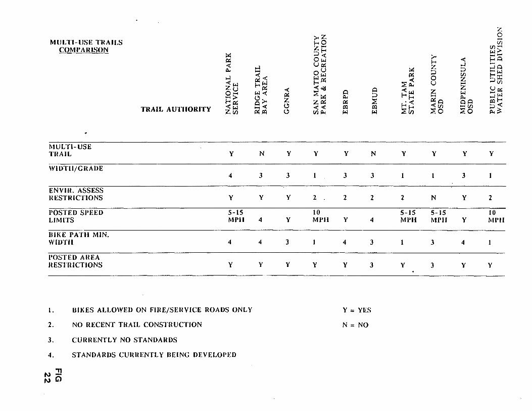
SANTA TERESA COUNTY PARK FINAL MASTER PLAN REPORT
D OPERATIONS
1 Scheduling
In contrast to the apparent low intensity of usage over past years (only limited statistics for Santa Teresa Park have been kept since 1980) the nature of use is changing such that conflicts are arising Events or park use involving large groups or reservations of a park or portions of a park require special use permits issued by the County Parks Department These permits are issued on a first come first serve basis for a fee based on a standard fee plus the events impact on normal revenue generation An example of a recent scheduling conflict occurred on the weekend of July 28-29 1990 when an arranged specially permitted mountain bike event precluded an unscheduled equestrian tour by a local commercial equestrian business Substantially increased biker use has been implied by statements of biker groups An estimated increase in population in nearby Almaden Valley of some 6000 persons and regional trail connections in process add to this pressure Scheduling methods andor staff commitment may need adjustments to respond to these changes
2 Maintenance
The focus is on maintenance of the Pueblo area picnic facilities and meadow removal of trash and maintenance of restrooms In several areas trails need clearing or regrading and installation of drainage devices The level of disrepair may have been made worse because of the lack of overall trail use controls and signage which encourage unauthorized use of non-designated trails andor trails which are subject to erosion Accessories such as signs benches and hitching posts are limited and receive limited attention The recent and anticipated increase in use along with the implementation of any master plan recommendations will substantially increase maintenance needs
3 Irrigation
Even though the irrigation is connected to the Muriel Wright Residential Center water system for the Pueblo turf area it has been used little in the past few years because of the drought the impact on Muriel Wright Residential Center water needs and maintenance cutbacks This in turn has resulted in a dramatic reduction in use of the area according to Park staff especially during the hot dry summer and fall months
CHAPTER VI
- 48 shy
Vll SYNTHESIS OPPORTUNITIES AND CONSTRAINTS
SANTA TERESA COUNTY PARK FINAL MASTER PLAN REPORT
VILSYNTHESIS OPPORTUNITIES AND CONSTRAINTS
A INTEREST GROUPS AND USE PROJECTIONS
1 Information Sources
Prior to and during the preparation of this report two public meetings and three task force meetings were held with attendance ranging from 17 to 35 persons These workshops have been the source of a great deal of the information regarding recreation interests for Santa Teresa Park In addition County staff mailed 255 survey questionnaires to Task Force members interested park users bicycle shops equestrian organizations archery shops and local schools in April and May of this year In addition the surveys and flyers for all public workshops were posted at the Almaden and Santa Teresa Libraries and at the Southside Community Center A number of communications including seven form letters were received from individuals interested in multi shyuse trails and shared equestrianmountain bicycle use Finally extensive discussions in the field with the Parks field and administrative staff provided a good deal of information
The following summary lists the activities considered and their apparent popularity A tabulated form of the survey is included in the appendix While a survey of plusmn30 respondents must be considered of limited accuracy the general range of uses seem to be supported by the informal discussions at workshops It appears that the respondents reflect a cross section of interest with relative accuracy
The comments which accompanied the check list forms indicate a strong interest in restoration of a grassy shade area particularly in connection with picnicking use Mountain bicycling equestrian and other shared use trail enthusiasts vigorously argued for more multi-use trails and longer trails for bicycle use By far the greatest interest was in an activity not normally associated with County facilities a swimming complex Some of the respondents were members of Mr Mike Boullands seventh grade class at Bernal Intermediate SchooL Other activities which were not included in the survey list but which appeared to be of some interest to special groups included soccer fields a cross country running course for high schools a historical museum and a dog run area or dogs on trails policy
It is significant that the wide range of uses derived are highly contrasting and in some cases potentially conflicting in nature For example for someone making quiet passive uses of historic trails interpretive facilities and nature areas intense physically active uses such as cross country running mountain biking field play areas etc could be seen as disruptive Another type of contrast can be seen in the passive uses which are typically sited in rustic open space settings compared to those which are usually associated with more urban use areas such as a swimming pool complex
2 Interest Group Goals
Three groups clearly distinguished themselves the mountain biking group equestrians and environmentalists Only the mountain bike groups submitted specific map suggestions for trail uses while other groups and individuals relied essentially on resource data gathered by this study and referred to sites within the Park where their interests might be met
3 Use Projections
CHAPTER VII
- 49 shy
SANTA TERESA COUNTY PARK FINAL MASTER PLAN REPORT
The survey data limited as it was to some 30 individuals is inadequate in providing Quantitative use projections While the Park is a unique entity serving a County wide system it is clear that the greatest pressure comes from individuals living closest to the Park This may be less so in the case of golfers and midday hikers and joggers who are employed at the IBM facility
The greatest source of users for the Park it can be assumed comes from the urbanized Santa Clara Valley floor directly north of the Park The population within a two mile radius from the north side of the Park (at the Bernal Road entrance) is estimated to be approximately 15000 to 16000 individuals (l500 times 45 units per gross acre equals 6750 units times 23 individuals per unit equals 15525) Conversely to the south City plans suggest a potential future population of about 6000 in the 10werAImaden Valley Urban Reserve area in addition to existing populations With the completion of a regional trail system in the future additional users will be passing through the Park and perhaps stopping (as opposed to destination users)
CHAPTER VII
- SO shy
SANTA TERESA COUNTY PARK FINAL MASTER PLAN REPORT
USER SURVEY SUMMARY - Most Desired Uses
(Listed from highest to lower vote tallies All items received 1990 survey)
Total Votes 1 Family picnic area 2 HikingJogging 3 Informal play meadow 4 Native shade trees 5 Equestrian trail riding 6 Historical miningranch trail
Nature trails and areas 7 Group picnic 8 Kite flying area 9 Mountain biking 10 Formal turf field play 11 Joice Ranch use 12 RunningX country events 13 Archery 14 Dog run areadogs allowed on trails 15 Shade structure 16 Horse rentals 17 Fishing pond 18 Pony rides 19 Day camp 20 Swimming Pool
For and Against totals were the same for both items
Split-Vote Items (no plurality - 15 votes or fewer each)
Court play Equestrian pack trips Riding lessons Amphitheateropen air performances Special day use programs Historic re-enactments Arboretum Rental for partiesevents Scavenger hunts Riding corral Weddings and ceremonies
a plurality in the April-May
30 27 26 26 23 21 21 19 17 17 17 15 15 15 14 14 13 10 10 10 8
CHAPTER VII
- 51 - FIG 23
SANT A TERESA COUNTY PARK FINAL MASTER PLAN REPORT
An assumption that current use levels reflect this population pattern would assist somewhat in making future use projections The problem with this assumption is it cannot be backed up by attendance figures (none have been kept for Santa Teresa Park since 1980) Also the current very limited facilities plus the virtual elimination of such important items as irrigation for the Pueblo area and the displacement of the White Oak picnic area probably imply a lower level of interest by the adjacent population than would be the case were these facilities fully developed and their recreational and interpretational characteristics well known to the public One can only assume that improved conditions in the Park would generate a much higher level of use for the Park from the existing population base and that the demand for such uses can be expected to nearly double by the time the lower Almaden Valley and adjacent foothill areas are built out Figures for permits and individuals for the Pueblo picnic area are available for the following years
1985 23 permits 1306 individuals
1986 22 permits 1190 individuals
1987 23 permits 1435 individuals
1988 14 permits 850 individuals
Prior to 1980 records show a peak in use of the Pueblo area of 109537 individuals (1973) to a low of 37920 (1980)
CHAPTER VII
- 52 shy
SANT A TERESA COUNTY PARK FINAL MASTER PLAN REPORT
B RESOURCE SENSITIVITIES
The physical and visual resources and their characteristics have been summarized in three maps Overall Sensitivity Zones Shelter Zones and Views and Site Character The Overall Sensitivity Zones Map summarizes all of the physical and historicprehistoric resources In addition it reflects in essence a stacking of conditions leading to greater sensitivity where more valuable or delicate resources occur and conversely less sensitivity where there are fewer such resources By contrast the definition of shelter zones and the values attached thereto are based on site observations and topographic and cross sectional analysis
1 Physical Sensitivities Composite Map
Five categories are shown on this map
a Very High Sensitivity The highest sensitivity zones include such factors as landslide potential high soil erosion hazard sensitive riparian vegetation andor streams the Checkerspot Butterfly habitat and prehistoric burial grounds in various combinations The highest concentration of these is in the zone roughly centered on the Rossetto Ranch extending eastward into the Wilets property and to a lesser degree westward toward the IBM ARC gate North of the crest of the Park the highest sensitivity zones occur in a much patchier fashion roughly covariant with the steep canyons above the golf course the Buck Norred Ranch and above the Joice Ranch and Santa Teresa Springs Smaller areas in a more scattered pattern appear on the mid-slope on the Hunter Ranch to the east of the study area
b High Sensitivity High sensitivity zones combine butterfly habitat with erosion hazard and riparian zones but also in some cases landslide areas in the vicinity of oak forest and erosive soils The largest zones of this category occur on the north facing slopes of the Wilets or Big Oak Valley the north facing slope above the Pueblo area and to a lesser degree above the golf course A very strong concentration occurs on the slopes surrounding the Rossetto Ranch and just at the westerly boundary of the existing park partially on the Hunter Ranch property Patchy areas occur at the western edge of the Hunter Ranch and again at mid-slope This also occurs above the Buck Norred Ranch and to a lesser degree on the south facing slopes of the WHets property
c Moderate Sensitivity This category may include endangered butterfly habitat covariant with oaks or with riparian habitat and with high erosion hazard zones andor oak forests Another combination in this category is the endangered butterfly habitat with high erosion hazard and oak forest areas Most of the sloping areas of the Park which exhibit moderately high and high sensitivities fall in this category with large areas all along the northern slope of the Santa Teresa Hills (the Hunter and the Joice Ranches) the slopes above Buck Norred and above the golf course Another large patch occurs on the rocky ridgetop some of which is owned by the Lagatutta family and then again on the ridgetop of the Wilets property
d Low Sensitivity This category includes the riparian habitat without any other sensitivity factors high soil erosion zones in connection with a landslide zone or an erosion zone in connection with an oak forest condition Somewhat more limited in size there are patches of this category found at the base of the north facing Hunter property slopes
CHAPTER VII
- S3 shy
SANT A TERESA COUNTY PARK FINAL MASTER PLAN REPORT
a few upslope of the Buck Norred Ranch areas near the Muriel Wright Residential Center and along the edge of the Wilets property with a few remaining patches around the Rossetto Ranch
e Very Low Sensitivity The lowest category includes slopes under 30 that are free of any of the foregoing constraints (landslides riparian high erosion hazard etc) which are either grasslands or oak woodlands
2 Shelter Zones
One of the most important qualities for regional park use is a sense of seclusion or shelter This is of course reflective of a basic human need to have some sense of control over the immediate environment no matter how minimal or primitive the environmental factors involved are Shelter zones picked by the planning team are frequently covariant with prehistoric habitation or use areas such as grinding holes or burial grounds Five zones were identified in the study Taken as a whole they occur in essentially contiguous zones I) in the valleys surrounding and downstream of the Rossetto Ranch 2) all along the high ridge of the Hunter Property 3) in a few isolated patches at the base of the slopes above the golf course and 4) again at the far eastern edge of the property which is currently used as the archery range Each of these zones is made up of one or more of the following categories of shelter These are illustrated in the accompanying crOSS sectional diagram
A The strongest combination of environmental factors involves mature oak forests grasslands and relatively small valleys flanked by slopes of 15 or greater The width of the valleys is generally less than 500 feet A variation on this type (illustrated by Section A) is where a cluster of riparian vegetation parallels a young stream or gully providing narrower shelter zones along creek banks
B These can occur at the north facing side of a relatively narrow valley where the oak trees have clustered in response to greater ground moisture (as is the case in Big Oak Valley) or off to the side of a ridgetop which occurs on the Hunter Ranch west of Bernal Hill
C This occurs on convex land forms or basically ridgetops where the sense of protection is somewhat less but is provided by mature oaks unobscured with chaparral or other shrub vegetation The largest concentration of this zone is along the main ridge mostly on the Hunter property A small and rather unique patch is created by a group of Pygmy Oaks overlooking the Rossetto Ranch
D The land form which gives the least sense of protection is that of an open valley which lacks mature oaks but is either small enough in terms of the width of the valley floor or is flanked by steep enough slopes to have a general sense of enclosure
3 View and Site Character
This map has been described in Chapter VI Section B-1 The map reflects five constituent elements as follows
Regional ridgelines Visually prominent slopes Regional mountain peak or hilltop
CHAPTER VII
- 54 shy
SANTA TERESA COUNTY PARK FINAL MASTER PLAN REPORT
Ridgeline views (linear in character) Vista points (localized) Secluded zone
The last of these (secluded zone) is one from which no direct or significant urbanization (including the IBM Almaden facility)is visible
Each of these zones is sensitive in a different way Tree removal grading or construction of structures on the steep hillsides ridge tops or peaks would be easily seen from surrounding urbanized neighborhoods which would therefore be in conflict with County goals The greatest problem with any physical alteration of ridge lines mountain peaks or hilltops is that any additional structures will be seen in silhouette and thus become highly visible
Disturbances here could include grading for roads development of trails or utilities a removal of oak forest or riparian or chaparral vegetation and of course grading for and construction of any major structures
The introduction of man made structures to the secluded zone could be problematic This study recommends that this area be treated with special concern because it will in a short period become one of a few areas relatively
close to urbanization where residents from either the adjacent Santa Clara or Almaden Valleys can escape from the urban scene
CHAPTER VII
- 33 shy
SANTA TERESA COUNTY PARK FINAL MASTER PLAN REPORT
C PLANNING AND DESIGN
I Environmental
A Sensitive Environment The constraint implications of the environmental opportunities and constraints listed in Chapter VI can be summarized as reflecting a visual physical and biological environment which is relatively sensitive and in some situations highly delicate This appears to be so on ridgetops that are seen by surrounding residents or by contrast in narrow sometimes secluded valleys In areas that are not burdened with constraints such as landslides high erosion hazard sensitive habitats for endangered butterflies or aquatic breeding grounds and the like there may be visually secluded zones that present visual environments perfect for historic and prehistoric interpretation
Because of these sensitivities some of which have extremely limited carrying capacities recreation uses should logically be located and designed to respond to these highly varied sensitivities For example highly active uses inVOlving large numbers of people in vehicles should in general be located off the steep slopes and away from secluded zones at the center of the Park The alternative is to locate these areas at the periphery of the Park where they can be reached directly from adjacent arterial or neighborhood roads andor regional trails The parking capacity of these areas varies highly and some parking will be difficult Nevertheless several different opportunities are described in a subsequent chapter of this report
An example of the need to respond to environmental senSItIVIty is the Joice Ranch According to Slope Stability maps prepared by Earth Technology the ranch house is located either on or at the base of an existing landslide Even though the structure has stood since the latter part of the 19th century environmental changes such as tectonic movement may have occurred and are likely to occur in the future Additional more detailed study by geologists andor structural engineers should be considered as a part of the plans provided by the interested groups These should establish in a precise sense the relative safety of the buildings By implication as well any improvements which might disturb existing ground levels or surface or subsurface water conditions should be carefully studied In some cases extensive excavation or filling can trigger landslide movement In a similar vein the impacts of livestock or grazing particularly on the steep hillside areas behind the house should be considered because of the potential for increasing erosion on soil types that are highly fragile
Similarly trail type uses should be determined based on physical requirements for the use considered where new trails are called for such trails should be located and designed to respond to the highly varied and in some cases limited capacity of the natural landscape Soil erodability as shown on the accompanying map (Figure 27) is the most important constraint
In highly sensitive environments such as Santa Teresa Park it is important to identify the potential for various uses to impact the environment adversely The following Physical and Visual Impacts Summary Chart (Figure 26) is a generalized ranking applied to those uses that have been mentioned as appropriate or desirable for the Park It illustrates relative differences only Well designed facilities which are closely adapted to environmental constraints can in some cases mitigate adverse impacts
At the same time it is clear both from the opinions surveys and from discussions with the task force and the public that by and large the uses which
CHAPTER VII
- 56 shy
SANT A TERESA COUNTY PARK FINAL MASTER PLAN REPORT
the public now associates with the Park are generally those favored to remain with a limited number of exceptions noted (eg a turfed soccer field dog run shade structure and a swimming facility) The remaining potential uses of interest generally appear to be those which could be accommodated without major biological or visual disturbance It is clear the public does not support uses that would require major buildings or structures nor does it want to see massive upgrading of trails by the inclusion of pavej or divided sections There appears to be a corollary interest in preserving the existing look of the Park by avoiding the addition of major utilities beyond those which already exist
CHAPTER VII
- 57 shy
FINAL MASTER PLAN REPORT
PHYSICAL AND VISUAL IMP ACTS SUMMARY CHART
In highly sensitive environments such as Santa Teresa Park it is important to identify the potential for the construction of various facilities which may impact the environment adversely The following is a generalized ranking applied to those uses which have been mentioned as appropriate or desirable for the Park It illustrates relative differences only Well designed facilities which are closely adapted to environmental constraints can in many cases mitigate adverse impacts
PHYSICAL ALTERATION OR IMPACT LEVEL
HIGH Major utility systems (major underground lines) Parking lots Court type play area Multi-use trail (8 wide) Maintenance road (8 wide) Unleashed dogs on trails Shade structure Equestrian facilities (corral etc) Fishing pond Day camp facilities Amphitheater Archery Dog run area (fenced) Equestrian trails (8 wide) Arboretum Restroom facilities Group picnic facilities Informal play meadow Mountain biking trail (4 wide) Family picnic areas Historical trail (use) (2 wide) Runningjogging trail (use) (2 wide) Nature trails and areas (15 wide)
LOW Hiking trails (15 wide)
VISUAL ALTERATION OR IMPACT LEVEL
HIGH Major utility systems (power lines water tanks) Court play area Formal turf field play Shade structure Equestrian facilities Fishing pond Amphitheater Restroom facilities Combined Eqstrnbike trails Native trees
LOW Historical trail
CHAPTER VII FIG 28 - 58 shy
SANTA TERESA COUNTY PARK FINAL MASTER PLAN REPORT
The reinstatement of irrigation to recreate an informal play meadow at the Pueblo area could have both beneficial and negative impacts on adjacent wetlands and drainages depending on how it is handled As discussed in the paragraph below there is also relatively strong interest in making the most of resources such as the existing Joice Ranch but are as yet undeveloped
2 Visual and Cultural Opportunities
The inference can be drawn from discussions at the public workshops and task force meetings that the public would support preservation and even the highlighting of the unique ecological cultural and visual characteristics of the Park This includes the open space character of the Park as seen from and in contrast to the urbanized valley floor to the north In the extension of these existing land forms such as the two valleys the sky line of peaks and ridges should receive special protection from all forms of development which add or alter these elements
General knowledge of workshop participants in regards to the history of the site and in some cases of its prehistoric characteristics revealed an interest in seeing this resource developed further This could best be done through a comprehensive natural and cultural history program This interest also implies that protection andor restoration of these valued resources should be a high priority For example historic buildings if not in conflict with site character or with historic building codes should be restored
In addition to the interest expressed for an historic and prehistoric resources interpretation program there is a strong interest in a developed natural history interpretive program There are many natural resources in the Park (described in subsequent chapters) which could become an integral part of such an interpretive program
Historic Landscape Concept The wealth of dispersed significant historic and prehistoric sites is such that the concept of an historic landscape might apply While this is a concept which has been applied primarily in national and state historic parks the richness of Santa Teresa Park resources may make it an appropriate opportunity This could be applied as an overlay policy zone similar to that used in land use planning covering the critical historic and prehistoric resources zones of the Park if not the entire park Three primary eras could be involved
Native American Spanish Rancho American Ranching and Mining (up to the mid-twentieth century)
3 Revenue Generation Implications
Santa Teresa Park clearly is a study in contrasts when it comes to revenue generation On the one hand the golf course is a major generator of income which goes not to Santa Teresa Park but to the County Park general fund The rest of the Park contains little that generates significant funds As noted in Chapter VI aside from golf courses water recreational uses are the most lucrative in the Park system By contrast Santa Teresa Park is a relatively arid landscape with only one pond near the golf course driving range Uses which hold moderate promise for revenue generation exist at three or four sites at the perimeter of the existing property There should be a considerable market for large group gatherings making use of combined indooroutdoor socializing and picnic facilities In addition to social groups and clubs there is demand
CHAPTER VII
- 59 shy
SANTA TERESA COUNTY PARK FINAL MASTER PLAN REPORT
from corporate group facilities for hosting groups of up to 500 people The Norred Ranch the Rossetto Ranch and the area identified as the East Meadow (currently used by the archery groups) all have the potential to accommodate this sort of use
Because of the existing combination of parking restroom facilities stables dance pavilion picnic tables and barbecue units the Norred Ranch offers great theoretical potential It should be noted the Parks own analysis of the buildings on the Ranch suggests very few if any of them can be saved The Rossetto Ranch is only slightly less attractive but only because a considerable amount of work would be required to meet its potential for the same sort of function Finally the archery area for a variety of reasons explained in the next chapter has the potential to serve such uses possibly conducted in connection with the golf course facility
In conclusion without these facilities the revenue generating potentials of the rest of the Park are limited These would improve somewhat with the improvement of the Pueblo area as this would certainly encourage or generate more group activity and specially permitted events
4 Utilities and Support Facilities
As noted above the combination of site limitations and the nature of demand does not suggest a massive increase in water or power requirements in the Pueblo Improvements to restroom facilities and septic fields would certainly be logical if there is an increase in use by large groups Even if areas such as Rossetto and Norred were to be acquired andor developed for various uses (described elsewhere) they are at the perimeter of the Park and close to existing utilities and other infrastructure This tends to minimize the capital costs for such improvements (The water and sewage capacities at the Rossetto Ranch however need further study)
5 Access and Security
a Through-road As previously discussed (Chapter V Section E) the Bernal Road extension (aka Santa Teresa Park Road provides a physical connection from north to south (Harry Road) and is available in cases of emergency IBM allows unrestricted passage to County Park Rangers
Adding a publicly accessible north-south through road meeting modern traffic and safety standards has been considered Such would only become a possibility if and when the Rossetto Ranch is purchased There are arguments why this idea should not be pursued First it would bring levels of activity to the center of the Park which would conflict with the goals of the 2020 report and the County General Plan A through-road would introduce a level of activity which would at least conflict with if not destroy the core of the Park as an isolated open space retreat from the adjacent urban areas It would also in all likelihood heavily impact the rich pre-historic resources in the ranch houseswimming pool area
Other major constraints to this concept include the physical difficulties of getting a road along Fortini Creek (a sensitive wildlife habitat corridor pinched by landslide formations on both sides) This traffic would impact both Bernal Road and the Fortini San Vicente Road accesses
CHAPTER VII
- 60 shy
1
-TO No~ -
-1 FUeetv fW~~~
SKETCH PLAN A ~rt
~ C cptf GCU~e7
PF ~ ~ ~ LD- ~ITcfi ~~
-1 bullbull bull bull~ ~ ~f01~-rP-J ~ middot~==middot~l VirIO PI(fi ~ l bull~ bullbull y ~ ~- To NcW K y lt1l ~H eM t7u-=D-I 4
EXISTING W~T~q CONDITIONS
CONSUL T ANTS FOR DRAFT MASTER PLAN PROJECT bull TITO TRI I ASSOCITES bull u cu COUNTy
u l aICItpoundA flO OC-TLDSCPE ARCHITECTURe SANTA TERESA PARKzbullbull GAADlIIf OAlY Ul20 ONTGOERY ~ 0 01 OATQS CAlIIOa
SN FRANCISCO C so~O 401 UI
TEl 15-gB aa 11 PROPOSED FiG MODiFICATION 29 BERNAL GATEWAY
SANTA TERESA COUNTY PARK FINAL MASTER PLAN REPORT
b Bernal Entrance An important opportunity does exist to reconfigure the entrance road (south of its intersection with Heaton Moor Road) in a way which could help solve the ParkIBM off hours security problem The switch-back (700 feet southeast of the intersection of Heaton Moor and Bernal Roads) could be turned into a T intersection with several benefits One benefit would be to force downhill vehicles (which generally speed around this corner) to come to a full stop A t400 foot straight section upslope of the switch-back could he modified with speed bumps or warning lights and signs The T intersection would then allow the possibility of a road connection in a southeasterly direction could take place along a modified Los Alamitos Canal levee as shown in the cross section (Figure 29) The modification to the levee could also accommodate trail uses Similarly a T section and arterial stop and levee modification could allow a road connection northwesterly to the Buck Norred Ranch
This reconfirmation would create two sites for a control gate and guard kiosk One location (Sketch Plan B) close to the intersection of Heaton Moor and Bernal would provide good sight control north easterly along Bernal and southeasterly along the Santa Teresa Park Road (up to the proposed T intersection) It would however need to be manned or opened if there were night events at Norred Ranch and access to the Ranch were along the Los Alamitos Canal levee The second (Sketch Plan A) could be at the T intersection This could allow for closure of the Park at night but operable with electronic devices for those authorized vehicles traveling to the Muriel Wright Residential Center or the IBM facility IBM does not staff its kiosk at night but if it were willing to do so and the gates were not carded at the proposed kiosk this might solve the current security problem (the inability to control use of the Park after dark) IBM has stated that nighttime staffing is not acceptable As noted in Section VIII A (following) a smaller control kiosk (similar to the Calero Reservoir Boat Launch kiosk) could also be built at the Rossetto Ranch or south entrance off Fortini Road should the Rossetto properties be included in the Park
East Meadow TheT configuration is also an important part of two alternative access routes to the East Meadow (currently the archery area) These are
(1) A road along the Alamitos Canal levee (modified) to a point 200-300 feet east of 8th tee of the golf course The route would then descend off the canal berm (which drops into a syphon at that point) and skirt the northerly edge of the existing pond After that it would be aligned along the southern edge of the driving range where taller fences might be required as a protection from flying golf balls A few hundred feet further east the road would have to leave the canal alignment and skirt along the south side of another tee and terminate at what is now the Bowmans parking area The total distance however is substantial 6500 feet or 12 miles
(2) A second possibility of providing vehicular access to the East Meadow area is directly off the intersection to Santa Teresa Boulevard and the Los Alamitos Canal where again the reconfigured canal although outside the current park boundary could provide reasonable access along a low speed driveway type of road The distance from Santa Teresa Boulevard to the Park boundary is approximately 3500 feet (07 miles)
CHAPTER VII
- 61 shy
SANTA TERESA COUNTY PARK FINAL MASTER PLAN REPORT
The major limitation of the two prior alternatives is likely to be the cost The distance from the proposed T intersection and East Meadow parking lot would be approximately one mile The advantage of these two routes is that they would impact the adjacent neighborhoods minimally
Two other opportunities for accessing East Meadow include
(3) Continued use of the Bayliss A venue access off A venida Espana which has a direct connection to Santa Teresa Boulevard and provides access at the current gate to the archery center
(4) A route through the golf course There is a possibility of extending a road from the most easterly end of the existing paved parking lot It would continue along a southerly service road and then follow the existing Los Alamitos Canal alignment
These different access possibilities relate to three possible recreational use variations for the East Meadow area in general which are described in the Recommendations Section Their feasibility depends to some extent on the relationship between the uses proposed and golf use
The westerly alternative could impact golf play in some areas depending on its exact configuration Of the two alternatives the existing entrance would require at most refurbishing and an upgrading of new pavement whereas the extension from the existing golf course parking lot would require a new road bed and paving for a distance of approximately 2500 feet
6 Operations and Maintenance Opportunities
a A clear implication can be drawn from the discussions regarding such uses as soccer biking equestrian access in that there could be conflicts between uses depending on two factors the number of people involved and the characteristics of the use imposed on the landscape The flatter more usable areas of Santa Teresa Park are relatively limited compared to the population base which is close at hand particularly on the north side In addition to this recreation use characteristics are constantly changing as evidenced by the increasingly significant demand for mountain biking trails The implications of this are that there should be where possible the physical or temporal separation of uses where there are potentials for conflict The temporal separation of course means that some uses that require permit and approval by park administration can be scheduled to avoid conflict
b Maintenance The most important implication of maintenance demand is the clear need for a full service corporation yard somewhere in the Park Approximately 15 to 20 acres (more than is feasible at the Muriel Wright Residential Center) would be needed In addition because of the natural grouping of physical and visual conditions a zone approach to management should be developed This is also appropriate should staffing increases become possible In this event it will become easier to coordinate scheduled uses with the location and number of management zones which the Park staff would be able to handle at any given time The zone approach would also assist in establishing appropriate maintenance policies Since the zones would reflect generally consistent topographic conditions and other related environmental
CHAPTER VII
- 62 shy
)~ll 1 ~ 1 poundJpound)~ V U 11 1 I r fJl
FINAL MASTER PLAN REPORT
limitations maintenance projections and staff allocations could be based on careful evaluation of the potential physical impacts of various anticipated uses on each zone
c Staffing Opportunities The implications of the general conditions of the landscape and of park improvements as they stand now are that current staffing levels are inadequate to meet even the most minimal management and maintenance needs of the Park The various levels of development obviously entail a commitment on the part of staff relative to the needs implied by such development in terms of both improvement maintenance and management of natural resources Conceptually speaking there are three levels of staff which can be related to either qualitative or quantitative conditions or increases for the Park
(I) Existing Level Existing levels of staffing are clearly inadequate to deal not only with primary management needs of patrolling but secondary needs such as erosion control reforestation protection of rare and endangered habitats resource management mechanical fire fuel reduction etc In fact it might be argued that existing maintenance needs in the Park are enough in excess of staff capacities that some facilities should be abandoned or removed For example maintenance needs for some ad-hoc trails in the Ohlone and Hidden Springs areas are substantial Some of these trails it could be argued should be closed until such time as there is adequate staff augmentation
(2) Level Two Assignment of at least one full time ranger would have two effects One would be to assist in or reduce the cost of special patrols in basic maintenance and policing Secondly the very presence of a full time ranger would have a beneficial psychological impact on park users of all ages Also some combination of contrasting concepts for the Park equestrianbiker use will require monitoring in order to assess the optimum design for such uses in the future Such efforts would be greatly enhanced by the assignment of a full time ranger
(3) Level Three Level three involves substantial increases in staff These would have to be directly related to characteristics of improved facilities and increased use Different combinations of uses and areas imply different staff skills especially with respect to interpretational versus or in tandem with recreational uses Santa Teresa is a more centralized location for the staff unit relative to Calero and AQ Parks
CHAPTER VII
- 63 shy
SANTA TERESA COUNTY PARK FINAL MASTER PLAN REPORT
The survey data limited as it was to some 30 individuals is inadequate in providing Quantitative use projections While the Park is a unique entity serving a County wide system it is clear that the greatest pressure comes from individuals living closest to the Park This may be less so in the case of golfers and midday hikers and joggers who are employed at the IBM facility
The greatest source of users for the Park it can be assumed comes from the urbanized Santa Clara Valley floor directly north of the Park The population within a two mile radius from the north side of the Park (at the Bernal Road entrance) is estimated to be approximately 15000 to 16000 individuals (l500 times 45 units per gross acre equals 6750 units times 23 individuals per unit equals 15525) Conversely to the south City plans suggest a potential future population of about 6000 in the 10werAImaden Valley Urban Reserve area in addition to existing populations With the completion of a regional trail system in the future additional users will be passing through the Park and perhaps stopping (as opposed to destination users)
CHAPTER VII
- SO shy
SANTA TERESA COUNTY PARK FINAL MASTER PLAN REPORT
USER SURVEY SUMMARY - Most Desired Uses
(Listed from highest to lower vote tallies All items received 1990 survey)
Total Votes 1 Family picnic area 2 HikingJogging 3 Informal play meadow 4 Native shade trees 5 Equestrian trail riding 6 Historical miningranch trail
Nature trails and areas 7 Group picnic 8 Kite flying area 9 Mountain biking 10 Formal turf field play 11 Joice Ranch use 12 RunningX country events 13 Archery 14 Dog run areadogs allowed on trails 15 Shade structure 16 Horse rentals 17 Fishing pond 18 Pony rides 19 Day camp 20 Swimming Pool
For and Against totals were the same for both items
Split-Vote Items (no plurality - 15 votes or fewer each)
Court play Equestrian pack trips Riding lessons Amphitheateropen air performances Special day use programs Historic re-enactments Arboretum Rental for partiesevents Scavenger hunts Riding corral Weddings and ceremonies
a plurality in the April-May
30 27 26 26 23 21 21 19 17 17 17 15 15 15 14 14 13 10 10 10 8
CHAPTER VII
- 51 - FIG 23
SANT A TERESA COUNTY PARK FINAL MASTER PLAN REPORT
An assumption that current use levels reflect this population pattern would assist somewhat in making future use projections The problem with this assumption is it cannot be backed up by attendance figures (none have been kept for Santa Teresa Park since 1980) Also the current very limited facilities plus the virtual elimination of such important items as irrigation for the Pueblo area and the displacement of the White Oak picnic area probably imply a lower level of interest by the adjacent population than would be the case were these facilities fully developed and their recreational and interpretational characteristics well known to the public One can only assume that improved conditions in the Park would generate a much higher level of use for the Park from the existing population base and that the demand for such uses can be expected to nearly double by the time the lower Almaden Valley and adjacent foothill areas are built out Figures for permits and individuals for the Pueblo picnic area are available for the following years
1985 23 permits 1306 individuals
1986 22 permits 1190 individuals
1987 23 permits 1435 individuals
1988 14 permits 850 individuals
Prior to 1980 records show a peak in use of the Pueblo area of 109537 individuals (1973) to a low of 37920 (1980)
CHAPTER VII
- 52 shy
SANT A TERESA COUNTY PARK FINAL MASTER PLAN REPORT
B RESOURCE SENSITIVITIES
The physical and visual resources and their characteristics have been summarized in three maps Overall Sensitivity Zones Shelter Zones and Views and Site Character The Overall Sensitivity Zones Map summarizes all of the physical and historicprehistoric resources In addition it reflects in essence a stacking of conditions leading to greater sensitivity where more valuable or delicate resources occur and conversely less sensitivity where there are fewer such resources By contrast the definition of shelter zones and the values attached thereto are based on site observations and topographic and cross sectional analysis
1 Physical Sensitivities Composite Map
Five categories are shown on this map
a Very High Sensitivity The highest sensitivity zones include such factors as landslide potential high soil erosion hazard sensitive riparian vegetation andor streams the Checkerspot Butterfly habitat and prehistoric burial grounds in various combinations The highest concentration of these is in the zone roughly centered on the Rossetto Ranch extending eastward into the Wilets property and to a lesser degree westward toward the IBM ARC gate North of the crest of the Park the highest sensitivity zones occur in a much patchier fashion roughly covariant with the steep canyons above the golf course the Buck Norred Ranch and above the Joice Ranch and Santa Teresa Springs Smaller areas in a more scattered pattern appear on the mid-slope on the Hunter Ranch to the east of the study area
b High Sensitivity High sensitivity zones combine butterfly habitat with erosion hazard and riparian zones but also in some cases landslide areas in the vicinity of oak forest and erosive soils The largest zones of this category occur on the north facing slopes of the Wilets or Big Oak Valley the north facing slope above the Pueblo area and to a lesser degree above the golf course A very strong concentration occurs on the slopes surrounding the Rossetto Ranch and just at the westerly boundary of the existing park partially on the Hunter Ranch property Patchy areas occur at the western edge of the Hunter Ranch and again at mid-slope This also occurs above the Buck Norred Ranch and to a lesser degree on the south facing slopes of the WHets property
c Moderate Sensitivity This category may include endangered butterfly habitat covariant with oaks or with riparian habitat and with high erosion hazard zones andor oak forests Another combination in this category is the endangered butterfly habitat with high erosion hazard and oak forest areas Most of the sloping areas of the Park which exhibit moderately high and high sensitivities fall in this category with large areas all along the northern slope of the Santa Teresa Hills (the Hunter and the Joice Ranches) the slopes above Buck Norred and above the golf course Another large patch occurs on the rocky ridgetop some of which is owned by the Lagatutta family and then again on the ridgetop of the Wilets property
d Low Sensitivity This category includes the riparian habitat without any other sensitivity factors high soil erosion zones in connection with a landslide zone or an erosion zone in connection with an oak forest condition Somewhat more limited in size there are patches of this category found at the base of the north facing Hunter property slopes
CHAPTER VII
- S3 shy
SANT A TERESA COUNTY PARK FINAL MASTER PLAN REPORT
a few upslope of the Buck Norred Ranch areas near the Muriel Wright Residential Center and along the edge of the Wilets property with a few remaining patches around the Rossetto Ranch
e Very Low Sensitivity The lowest category includes slopes under 30 that are free of any of the foregoing constraints (landslides riparian high erosion hazard etc) which are either grasslands or oak woodlands
2 Shelter Zones
One of the most important qualities for regional park use is a sense of seclusion or shelter This is of course reflective of a basic human need to have some sense of control over the immediate environment no matter how minimal or primitive the environmental factors involved are Shelter zones picked by the planning team are frequently covariant with prehistoric habitation or use areas such as grinding holes or burial grounds Five zones were identified in the study Taken as a whole they occur in essentially contiguous zones I) in the valleys surrounding and downstream of the Rossetto Ranch 2) all along the high ridge of the Hunter Property 3) in a few isolated patches at the base of the slopes above the golf course and 4) again at the far eastern edge of the property which is currently used as the archery range Each of these zones is made up of one or more of the following categories of shelter These are illustrated in the accompanying crOSS sectional diagram
A The strongest combination of environmental factors involves mature oak forests grasslands and relatively small valleys flanked by slopes of 15 or greater The width of the valleys is generally less than 500 feet A variation on this type (illustrated by Section A) is where a cluster of riparian vegetation parallels a young stream or gully providing narrower shelter zones along creek banks
B These can occur at the north facing side of a relatively narrow valley where the oak trees have clustered in response to greater ground moisture (as is the case in Big Oak Valley) or off to the side of a ridgetop which occurs on the Hunter Ranch west of Bernal Hill
C This occurs on convex land forms or basically ridgetops where the sense of protection is somewhat less but is provided by mature oaks unobscured with chaparral or other shrub vegetation The largest concentration of this zone is along the main ridge mostly on the Hunter property A small and rather unique patch is created by a group of Pygmy Oaks overlooking the Rossetto Ranch
D The land form which gives the least sense of protection is that of an open valley which lacks mature oaks but is either small enough in terms of the width of the valley floor or is flanked by steep enough slopes to have a general sense of enclosure
3 View and Site Character
This map has been described in Chapter VI Section B-1 The map reflects five constituent elements as follows
Regional ridgelines Visually prominent slopes Regional mountain peak or hilltop
CHAPTER VII
- 54 shy
SANTA TERESA COUNTY PARK FINAL MASTER PLAN REPORT
Ridgeline views (linear in character) Vista points (localized) Secluded zone
The last of these (secluded zone) is one from which no direct or significant urbanization (including the IBM Almaden facility)is visible
Each of these zones is sensitive in a different way Tree removal grading or construction of structures on the steep hillsides ridge tops or peaks would be easily seen from surrounding urbanized neighborhoods which would therefore be in conflict with County goals The greatest problem with any physical alteration of ridge lines mountain peaks or hilltops is that any additional structures will be seen in silhouette and thus become highly visible
Disturbances here could include grading for roads development of trails or utilities a removal of oak forest or riparian or chaparral vegetation and of course grading for and construction of any major structures
The introduction of man made structures to the secluded zone could be problematic This study recommends that this area be treated with special concern because it will in a short period become one of a few areas relatively
close to urbanization where residents from either the adjacent Santa Clara or Almaden Valleys can escape from the urban scene
CHAPTER VII
- 33 shy
SANTA TERESA COUNTY PARK FINAL MASTER PLAN REPORT
C PLANNING AND DESIGN
I Environmental
A Sensitive Environment The constraint implications of the environmental opportunities and constraints listed in Chapter VI can be summarized as reflecting a visual physical and biological environment which is relatively sensitive and in some situations highly delicate This appears to be so on ridgetops that are seen by surrounding residents or by contrast in narrow sometimes secluded valleys In areas that are not burdened with constraints such as landslides high erosion hazard sensitive habitats for endangered butterflies or aquatic breeding grounds and the like there may be visually secluded zones that present visual environments perfect for historic and prehistoric interpretation
Because of these sensitivities some of which have extremely limited carrying capacities recreation uses should logically be located and designed to respond to these highly varied sensitivities For example highly active uses inVOlving large numbers of people in vehicles should in general be located off the steep slopes and away from secluded zones at the center of the Park The alternative is to locate these areas at the periphery of the Park where they can be reached directly from adjacent arterial or neighborhood roads andor regional trails The parking capacity of these areas varies highly and some parking will be difficult Nevertheless several different opportunities are described in a subsequent chapter of this report
An example of the need to respond to environmental senSItIVIty is the Joice Ranch According to Slope Stability maps prepared by Earth Technology the ranch house is located either on or at the base of an existing landslide Even though the structure has stood since the latter part of the 19th century environmental changes such as tectonic movement may have occurred and are likely to occur in the future Additional more detailed study by geologists andor structural engineers should be considered as a part of the plans provided by the interested groups These should establish in a precise sense the relative safety of the buildings By implication as well any improvements which might disturb existing ground levels or surface or subsurface water conditions should be carefully studied In some cases extensive excavation or filling can trigger landslide movement In a similar vein the impacts of livestock or grazing particularly on the steep hillside areas behind the house should be considered because of the potential for increasing erosion on soil types that are highly fragile
Similarly trail type uses should be determined based on physical requirements for the use considered where new trails are called for such trails should be located and designed to respond to the highly varied and in some cases limited capacity of the natural landscape Soil erodability as shown on the accompanying map (Figure 27) is the most important constraint
In highly sensitive environments such as Santa Teresa Park it is important to identify the potential for various uses to impact the environment adversely The following Physical and Visual Impacts Summary Chart (Figure 26) is a generalized ranking applied to those uses that have been mentioned as appropriate or desirable for the Park It illustrates relative differences only Well designed facilities which are closely adapted to environmental constraints can in some cases mitigate adverse impacts
At the same time it is clear both from the opinions surveys and from discussions with the task force and the public that by and large the uses which
CHAPTER VII
- 56 shy
SANT A TERESA COUNTY PARK FINAL MASTER PLAN REPORT
the public now associates with the Park are generally those favored to remain with a limited number of exceptions noted (eg a turfed soccer field dog run shade structure and a swimming facility) The remaining potential uses of interest generally appear to be those which could be accommodated without major biological or visual disturbance It is clear the public does not support uses that would require major buildings or structures nor does it want to see massive upgrading of trails by the inclusion of pavej or divided sections There appears to be a corollary interest in preserving the existing look of the Park by avoiding the addition of major utilities beyond those which already exist
CHAPTER VII
- 57 shy
FINAL MASTER PLAN REPORT
PHYSICAL AND VISUAL IMP ACTS SUMMARY CHART
In highly sensitive environments such as Santa Teresa Park it is important to identify the potential for the construction of various facilities which may impact the environment adversely The following is a generalized ranking applied to those uses which have been mentioned as appropriate or desirable for the Park It illustrates relative differences only Well designed facilities which are closely adapted to environmental constraints can in many cases mitigate adverse impacts
PHYSICAL ALTERATION OR IMPACT LEVEL
HIGH Major utility systems (major underground lines) Parking lots Court type play area Multi-use trail (8 wide) Maintenance road (8 wide) Unleashed dogs on trails Shade structure Equestrian facilities (corral etc) Fishing pond Day camp facilities Amphitheater Archery Dog run area (fenced) Equestrian trails (8 wide) Arboretum Restroom facilities Group picnic facilities Informal play meadow Mountain biking trail (4 wide) Family picnic areas Historical trail (use) (2 wide) Runningjogging trail (use) (2 wide) Nature trails and areas (15 wide)
LOW Hiking trails (15 wide)
VISUAL ALTERATION OR IMPACT LEVEL
HIGH Major utility systems (power lines water tanks) Court play area Formal turf field play Shade structure Equestrian facilities Fishing pond Amphitheater Restroom facilities Combined Eqstrnbike trails Native trees
LOW Historical trail
CHAPTER VII FIG 28 - 58 shy
SANTA TERESA COUNTY PARK FINAL MASTER PLAN REPORT
The reinstatement of irrigation to recreate an informal play meadow at the Pueblo area could have both beneficial and negative impacts on adjacent wetlands and drainages depending on how it is handled As discussed in the paragraph below there is also relatively strong interest in making the most of resources such as the existing Joice Ranch but are as yet undeveloped
2 Visual and Cultural Opportunities
The inference can be drawn from discussions at the public workshops and task force meetings that the public would support preservation and even the highlighting of the unique ecological cultural and visual characteristics of the Park This includes the open space character of the Park as seen from and in contrast to the urbanized valley floor to the north In the extension of these existing land forms such as the two valleys the sky line of peaks and ridges should receive special protection from all forms of development which add or alter these elements
General knowledge of workshop participants in regards to the history of the site and in some cases of its prehistoric characteristics revealed an interest in seeing this resource developed further This could best be done through a comprehensive natural and cultural history program This interest also implies that protection andor restoration of these valued resources should be a high priority For example historic buildings if not in conflict with site character or with historic building codes should be restored
In addition to the interest expressed for an historic and prehistoric resources interpretation program there is a strong interest in a developed natural history interpretive program There are many natural resources in the Park (described in subsequent chapters) which could become an integral part of such an interpretive program
Historic Landscape Concept The wealth of dispersed significant historic and prehistoric sites is such that the concept of an historic landscape might apply While this is a concept which has been applied primarily in national and state historic parks the richness of Santa Teresa Park resources may make it an appropriate opportunity This could be applied as an overlay policy zone similar to that used in land use planning covering the critical historic and prehistoric resources zones of the Park if not the entire park Three primary eras could be involved
Native American Spanish Rancho American Ranching and Mining (up to the mid-twentieth century)
3 Revenue Generation Implications
Santa Teresa Park clearly is a study in contrasts when it comes to revenue generation On the one hand the golf course is a major generator of income which goes not to Santa Teresa Park but to the County Park general fund The rest of the Park contains little that generates significant funds As noted in Chapter VI aside from golf courses water recreational uses are the most lucrative in the Park system By contrast Santa Teresa Park is a relatively arid landscape with only one pond near the golf course driving range Uses which hold moderate promise for revenue generation exist at three or four sites at the perimeter of the existing property There should be a considerable market for large group gatherings making use of combined indooroutdoor socializing and picnic facilities In addition to social groups and clubs there is demand
CHAPTER VII
- 59 shy
SANTA TERESA COUNTY PARK FINAL MASTER PLAN REPORT
from corporate group facilities for hosting groups of up to 500 people The Norred Ranch the Rossetto Ranch and the area identified as the East Meadow (currently used by the archery groups) all have the potential to accommodate this sort of use
Because of the existing combination of parking restroom facilities stables dance pavilion picnic tables and barbecue units the Norred Ranch offers great theoretical potential It should be noted the Parks own analysis of the buildings on the Ranch suggests very few if any of them can be saved The Rossetto Ranch is only slightly less attractive but only because a considerable amount of work would be required to meet its potential for the same sort of function Finally the archery area for a variety of reasons explained in the next chapter has the potential to serve such uses possibly conducted in connection with the golf course facility
In conclusion without these facilities the revenue generating potentials of the rest of the Park are limited These would improve somewhat with the improvement of the Pueblo area as this would certainly encourage or generate more group activity and specially permitted events
4 Utilities and Support Facilities
As noted above the combination of site limitations and the nature of demand does not suggest a massive increase in water or power requirements in the Pueblo Improvements to restroom facilities and septic fields would certainly be logical if there is an increase in use by large groups Even if areas such as Rossetto and Norred were to be acquired andor developed for various uses (described elsewhere) they are at the perimeter of the Park and close to existing utilities and other infrastructure This tends to minimize the capital costs for such improvements (The water and sewage capacities at the Rossetto Ranch however need further study)
5 Access and Security
a Through-road As previously discussed (Chapter V Section E) the Bernal Road extension (aka Santa Teresa Park Road provides a physical connection from north to south (Harry Road) and is available in cases of emergency IBM allows unrestricted passage to County Park Rangers
Adding a publicly accessible north-south through road meeting modern traffic and safety standards has been considered Such would only become a possibility if and when the Rossetto Ranch is purchased There are arguments why this idea should not be pursued First it would bring levels of activity to the center of the Park which would conflict with the goals of the 2020 report and the County General Plan A through-road would introduce a level of activity which would at least conflict with if not destroy the core of the Park as an isolated open space retreat from the adjacent urban areas It would also in all likelihood heavily impact the rich pre-historic resources in the ranch houseswimming pool area
Other major constraints to this concept include the physical difficulties of getting a road along Fortini Creek (a sensitive wildlife habitat corridor pinched by landslide formations on both sides) This traffic would impact both Bernal Road and the Fortini San Vicente Road accesses
CHAPTER VII
- 60 shy
1
-TO No~ -
-1 FUeetv fW~~~
SKETCH PLAN A ~rt
~ C cptf GCU~e7
PF ~ ~ ~ LD- ~ITcfi ~~
-1 bullbull bull bull~ ~ ~f01~-rP-J ~ middot~==middot~l VirIO PI(fi ~ l bull~ bullbull y ~ ~- To NcW K y lt1l ~H eM t7u-=D-I 4
EXISTING W~T~q CONDITIONS
CONSUL T ANTS FOR DRAFT MASTER PLAN PROJECT bull TITO TRI I ASSOCITES bull u cu COUNTy
u l aICItpoundA flO OC-TLDSCPE ARCHITECTURe SANTA TERESA PARKzbullbull GAADlIIf OAlY Ul20 ONTGOERY ~ 0 01 OATQS CAlIIOa
SN FRANCISCO C so~O 401 UI
TEl 15-gB aa 11 PROPOSED FiG MODiFICATION 29 BERNAL GATEWAY
SANTA TERESA COUNTY PARK FINAL MASTER PLAN REPORT
b Bernal Entrance An important opportunity does exist to reconfigure the entrance road (south of its intersection with Heaton Moor Road) in a way which could help solve the ParkIBM off hours security problem The switch-back (700 feet southeast of the intersection of Heaton Moor and Bernal Roads) could be turned into a T intersection with several benefits One benefit would be to force downhill vehicles (which generally speed around this corner) to come to a full stop A t400 foot straight section upslope of the switch-back could he modified with speed bumps or warning lights and signs The T intersection would then allow the possibility of a road connection in a southeasterly direction could take place along a modified Los Alamitos Canal levee as shown in the cross section (Figure 29) The modification to the levee could also accommodate trail uses Similarly a T section and arterial stop and levee modification could allow a road connection northwesterly to the Buck Norred Ranch
This reconfirmation would create two sites for a control gate and guard kiosk One location (Sketch Plan B) close to the intersection of Heaton Moor and Bernal would provide good sight control north easterly along Bernal and southeasterly along the Santa Teresa Park Road (up to the proposed T intersection) It would however need to be manned or opened if there were night events at Norred Ranch and access to the Ranch were along the Los Alamitos Canal levee The second (Sketch Plan A) could be at the T intersection This could allow for closure of the Park at night but operable with electronic devices for those authorized vehicles traveling to the Muriel Wright Residential Center or the IBM facility IBM does not staff its kiosk at night but if it were willing to do so and the gates were not carded at the proposed kiosk this might solve the current security problem (the inability to control use of the Park after dark) IBM has stated that nighttime staffing is not acceptable As noted in Section VIII A (following) a smaller control kiosk (similar to the Calero Reservoir Boat Launch kiosk) could also be built at the Rossetto Ranch or south entrance off Fortini Road should the Rossetto properties be included in the Park
East Meadow TheT configuration is also an important part of two alternative access routes to the East Meadow (currently the archery area) These are
(1) A road along the Alamitos Canal levee (modified) to a point 200-300 feet east of 8th tee of the golf course The route would then descend off the canal berm (which drops into a syphon at that point) and skirt the northerly edge of the existing pond After that it would be aligned along the southern edge of the driving range where taller fences might be required as a protection from flying golf balls A few hundred feet further east the road would have to leave the canal alignment and skirt along the south side of another tee and terminate at what is now the Bowmans parking area The total distance however is substantial 6500 feet or 12 miles
(2) A second possibility of providing vehicular access to the East Meadow area is directly off the intersection to Santa Teresa Boulevard and the Los Alamitos Canal where again the reconfigured canal although outside the current park boundary could provide reasonable access along a low speed driveway type of road The distance from Santa Teresa Boulevard to the Park boundary is approximately 3500 feet (07 miles)
CHAPTER VII
- 61 shy
SANTA TERESA COUNTY PARK FINAL MASTER PLAN REPORT
The major limitation of the two prior alternatives is likely to be the cost The distance from the proposed T intersection and East Meadow parking lot would be approximately one mile The advantage of these two routes is that they would impact the adjacent neighborhoods minimally
Two other opportunities for accessing East Meadow include
(3) Continued use of the Bayliss A venue access off A venida Espana which has a direct connection to Santa Teresa Boulevard and provides access at the current gate to the archery center
(4) A route through the golf course There is a possibility of extending a road from the most easterly end of the existing paved parking lot It would continue along a southerly service road and then follow the existing Los Alamitos Canal alignment
These different access possibilities relate to three possible recreational use variations for the East Meadow area in general which are described in the Recommendations Section Their feasibility depends to some extent on the relationship between the uses proposed and golf use
The westerly alternative could impact golf play in some areas depending on its exact configuration Of the two alternatives the existing entrance would require at most refurbishing and an upgrading of new pavement whereas the extension from the existing golf course parking lot would require a new road bed and paving for a distance of approximately 2500 feet
6 Operations and Maintenance Opportunities
a A clear implication can be drawn from the discussions regarding such uses as soccer biking equestrian access in that there could be conflicts between uses depending on two factors the number of people involved and the characteristics of the use imposed on the landscape The flatter more usable areas of Santa Teresa Park are relatively limited compared to the population base which is close at hand particularly on the north side In addition to this recreation use characteristics are constantly changing as evidenced by the increasingly significant demand for mountain biking trails The implications of this are that there should be where possible the physical or temporal separation of uses where there are potentials for conflict The temporal separation of course means that some uses that require permit and approval by park administration can be scheduled to avoid conflict
b Maintenance The most important implication of maintenance demand is the clear need for a full service corporation yard somewhere in the Park Approximately 15 to 20 acres (more than is feasible at the Muriel Wright Residential Center) would be needed In addition because of the natural grouping of physical and visual conditions a zone approach to management should be developed This is also appropriate should staffing increases become possible In this event it will become easier to coordinate scheduled uses with the location and number of management zones which the Park staff would be able to handle at any given time The zone approach would also assist in establishing appropriate maintenance policies Since the zones would reflect generally consistent topographic conditions and other related environmental
CHAPTER VII
- 62 shy
)~ll 1 ~ 1 poundJpound)~ V U 11 1 I r fJl
FINAL MASTER PLAN REPORT
limitations maintenance projections and staff allocations could be based on careful evaluation of the potential physical impacts of various anticipated uses on each zone
c Staffing Opportunities The implications of the general conditions of the landscape and of park improvements as they stand now are that current staffing levels are inadequate to meet even the most minimal management and maintenance needs of the Park The various levels of development obviously entail a commitment on the part of staff relative to the needs implied by such development in terms of both improvement maintenance and management of natural resources Conceptually speaking there are three levels of staff which can be related to either qualitative or quantitative conditions or increases for the Park
(I) Existing Level Existing levels of staffing are clearly inadequate to deal not only with primary management needs of patrolling but secondary needs such as erosion control reforestation protection of rare and endangered habitats resource management mechanical fire fuel reduction etc In fact it might be argued that existing maintenance needs in the Park are enough in excess of staff capacities that some facilities should be abandoned or removed For example maintenance needs for some ad-hoc trails in the Ohlone and Hidden Springs areas are substantial Some of these trails it could be argued should be closed until such time as there is adequate staff augmentation
(2) Level Two Assignment of at least one full time ranger would have two effects One would be to assist in or reduce the cost of special patrols in basic maintenance and policing Secondly the very presence of a full time ranger would have a beneficial psychological impact on park users of all ages Also some combination of contrasting concepts for the Park equestrianbiker use will require monitoring in order to assess the optimum design for such uses in the future Such efforts would be greatly enhanced by the assignment of a full time ranger
(3) Level Three Level three involves substantial increases in staff These would have to be directly related to characteristics of improved facilities and increased use Different combinations of uses and areas imply different staff skills especially with respect to interpretational versus or in tandem with recreational uses Santa Teresa is a more centralized location for the staff unit relative to Calero and AQ Parks
CHAPTER VII
- 63 shy
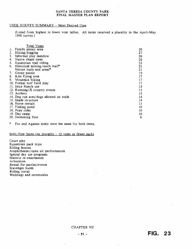
SANTA TERESA COUNTY PARK FINAL MASTER PLAN REPORT
USER SURVEY SUMMARY - Most Desired Uses
(Listed from highest to lower vote tallies All items received 1990 survey)
Total Votes 1 Family picnic area 2 HikingJogging 3 Informal play meadow 4 Native shade trees 5 Equestrian trail riding 6 Historical miningranch trail
Nature trails and areas 7 Group picnic 8 Kite flying area 9 Mountain biking 10 Formal turf field play 11 Joice Ranch use 12 RunningX country events 13 Archery 14 Dog run areadogs allowed on trails 15 Shade structure 16 Horse rentals 17 Fishing pond 18 Pony rides 19 Day camp 20 Swimming Pool
For and Against totals were the same for both items
Split-Vote Items (no plurality - 15 votes or fewer each)
Court play Equestrian pack trips Riding lessons Amphitheateropen air performances Special day use programs Historic re-enactments Arboretum Rental for partiesevents Scavenger hunts Riding corral Weddings and ceremonies
a plurality in the April-May
30 27 26 26 23 21 21 19 17 17 17 15 15 15 14 14 13 10 10 10 8
CHAPTER VII
- 51 - FIG 23
SANT A TERESA COUNTY PARK FINAL MASTER PLAN REPORT
An assumption that current use levels reflect this population pattern would assist somewhat in making future use projections The problem with this assumption is it cannot be backed up by attendance figures (none have been kept for Santa Teresa Park since 1980) Also the current very limited facilities plus the virtual elimination of such important items as irrigation for the Pueblo area and the displacement of the White Oak picnic area probably imply a lower level of interest by the adjacent population than would be the case were these facilities fully developed and their recreational and interpretational characteristics well known to the public One can only assume that improved conditions in the Park would generate a much higher level of use for the Park from the existing population base and that the demand for such uses can be expected to nearly double by the time the lower Almaden Valley and adjacent foothill areas are built out Figures for permits and individuals for the Pueblo picnic area are available for the following years
1985 23 permits 1306 individuals
1986 22 permits 1190 individuals
1987 23 permits 1435 individuals
1988 14 permits 850 individuals
Prior to 1980 records show a peak in use of the Pueblo area of 109537 individuals (1973) to a low of 37920 (1980)
CHAPTER VII
- 52 shy
SANT A TERESA COUNTY PARK FINAL MASTER PLAN REPORT
B RESOURCE SENSITIVITIES
The physical and visual resources and their characteristics have been summarized in three maps Overall Sensitivity Zones Shelter Zones and Views and Site Character The Overall Sensitivity Zones Map summarizes all of the physical and historicprehistoric resources In addition it reflects in essence a stacking of conditions leading to greater sensitivity where more valuable or delicate resources occur and conversely less sensitivity where there are fewer such resources By contrast the definition of shelter zones and the values attached thereto are based on site observations and topographic and cross sectional analysis
1 Physical Sensitivities Composite Map
Five categories are shown on this map
a Very High Sensitivity The highest sensitivity zones include such factors as landslide potential high soil erosion hazard sensitive riparian vegetation andor streams the Checkerspot Butterfly habitat and prehistoric burial grounds in various combinations The highest concentration of these is in the zone roughly centered on the Rossetto Ranch extending eastward into the Wilets property and to a lesser degree westward toward the IBM ARC gate North of the crest of the Park the highest sensitivity zones occur in a much patchier fashion roughly covariant with the steep canyons above the golf course the Buck Norred Ranch and above the Joice Ranch and Santa Teresa Springs Smaller areas in a more scattered pattern appear on the mid-slope on the Hunter Ranch to the east of the study area
b High Sensitivity High sensitivity zones combine butterfly habitat with erosion hazard and riparian zones but also in some cases landslide areas in the vicinity of oak forest and erosive soils The largest zones of this category occur on the north facing slopes of the Wilets or Big Oak Valley the north facing slope above the Pueblo area and to a lesser degree above the golf course A very strong concentration occurs on the slopes surrounding the Rossetto Ranch and just at the westerly boundary of the existing park partially on the Hunter Ranch property Patchy areas occur at the western edge of the Hunter Ranch and again at mid-slope This also occurs above the Buck Norred Ranch and to a lesser degree on the south facing slopes of the WHets property
c Moderate Sensitivity This category may include endangered butterfly habitat covariant with oaks or with riparian habitat and with high erosion hazard zones andor oak forests Another combination in this category is the endangered butterfly habitat with high erosion hazard and oak forest areas Most of the sloping areas of the Park which exhibit moderately high and high sensitivities fall in this category with large areas all along the northern slope of the Santa Teresa Hills (the Hunter and the Joice Ranches) the slopes above Buck Norred and above the golf course Another large patch occurs on the rocky ridgetop some of which is owned by the Lagatutta family and then again on the ridgetop of the Wilets property
d Low Sensitivity This category includes the riparian habitat without any other sensitivity factors high soil erosion zones in connection with a landslide zone or an erosion zone in connection with an oak forest condition Somewhat more limited in size there are patches of this category found at the base of the north facing Hunter property slopes
CHAPTER VII
- S3 shy
SANT A TERESA COUNTY PARK FINAL MASTER PLAN REPORT
a few upslope of the Buck Norred Ranch areas near the Muriel Wright Residential Center and along the edge of the Wilets property with a few remaining patches around the Rossetto Ranch
e Very Low Sensitivity The lowest category includes slopes under 30 that are free of any of the foregoing constraints (landslides riparian high erosion hazard etc) which are either grasslands or oak woodlands
2 Shelter Zones
One of the most important qualities for regional park use is a sense of seclusion or shelter This is of course reflective of a basic human need to have some sense of control over the immediate environment no matter how minimal or primitive the environmental factors involved are Shelter zones picked by the planning team are frequently covariant with prehistoric habitation or use areas such as grinding holes or burial grounds Five zones were identified in the study Taken as a whole they occur in essentially contiguous zones I) in the valleys surrounding and downstream of the Rossetto Ranch 2) all along the high ridge of the Hunter Property 3) in a few isolated patches at the base of the slopes above the golf course and 4) again at the far eastern edge of the property which is currently used as the archery range Each of these zones is made up of one or more of the following categories of shelter These are illustrated in the accompanying crOSS sectional diagram
A The strongest combination of environmental factors involves mature oak forests grasslands and relatively small valleys flanked by slopes of 15 or greater The width of the valleys is generally less than 500 feet A variation on this type (illustrated by Section A) is where a cluster of riparian vegetation parallels a young stream or gully providing narrower shelter zones along creek banks
B These can occur at the north facing side of a relatively narrow valley where the oak trees have clustered in response to greater ground moisture (as is the case in Big Oak Valley) or off to the side of a ridgetop which occurs on the Hunter Ranch west of Bernal Hill
C This occurs on convex land forms or basically ridgetops where the sense of protection is somewhat less but is provided by mature oaks unobscured with chaparral or other shrub vegetation The largest concentration of this zone is along the main ridge mostly on the Hunter property A small and rather unique patch is created by a group of Pygmy Oaks overlooking the Rossetto Ranch
D The land form which gives the least sense of protection is that of an open valley which lacks mature oaks but is either small enough in terms of the width of the valley floor or is flanked by steep enough slopes to have a general sense of enclosure
3 View and Site Character
This map has been described in Chapter VI Section B-1 The map reflects five constituent elements as follows
Regional ridgelines Visually prominent slopes Regional mountain peak or hilltop
CHAPTER VII
- 54 shy
SANTA TERESA COUNTY PARK FINAL MASTER PLAN REPORT
Ridgeline views (linear in character) Vista points (localized) Secluded zone
The last of these (secluded zone) is one from which no direct or significant urbanization (including the IBM Almaden facility)is visible
Each of these zones is sensitive in a different way Tree removal grading or construction of structures on the steep hillsides ridge tops or peaks would be easily seen from surrounding urbanized neighborhoods which would therefore be in conflict with County goals The greatest problem with any physical alteration of ridge lines mountain peaks or hilltops is that any additional structures will be seen in silhouette and thus become highly visible
Disturbances here could include grading for roads development of trails or utilities a removal of oak forest or riparian or chaparral vegetation and of course grading for and construction of any major structures
The introduction of man made structures to the secluded zone could be problematic This study recommends that this area be treated with special concern because it will in a short period become one of a few areas relatively
close to urbanization where residents from either the adjacent Santa Clara or Almaden Valleys can escape from the urban scene
CHAPTER VII
- 33 shy
SANTA TERESA COUNTY PARK FINAL MASTER PLAN REPORT
C PLANNING AND DESIGN
I Environmental
A Sensitive Environment The constraint implications of the environmental opportunities and constraints listed in Chapter VI can be summarized as reflecting a visual physical and biological environment which is relatively sensitive and in some situations highly delicate This appears to be so on ridgetops that are seen by surrounding residents or by contrast in narrow sometimes secluded valleys In areas that are not burdened with constraints such as landslides high erosion hazard sensitive habitats for endangered butterflies or aquatic breeding grounds and the like there may be visually secluded zones that present visual environments perfect for historic and prehistoric interpretation
Because of these sensitivities some of which have extremely limited carrying capacities recreation uses should logically be located and designed to respond to these highly varied sensitivities For example highly active uses inVOlving large numbers of people in vehicles should in general be located off the steep slopes and away from secluded zones at the center of the Park The alternative is to locate these areas at the periphery of the Park where they can be reached directly from adjacent arterial or neighborhood roads andor regional trails The parking capacity of these areas varies highly and some parking will be difficult Nevertheless several different opportunities are described in a subsequent chapter of this report
An example of the need to respond to environmental senSItIVIty is the Joice Ranch According to Slope Stability maps prepared by Earth Technology the ranch house is located either on or at the base of an existing landslide Even though the structure has stood since the latter part of the 19th century environmental changes such as tectonic movement may have occurred and are likely to occur in the future Additional more detailed study by geologists andor structural engineers should be considered as a part of the plans provided by the interested groups These should establish in a precise sense the relative safety of the buildings By implication as well any improvements which might disturb existing ground levels or surface or subsurface water conditions should be carefully studied In some cases extensive excavation or filling can trigger landslide movement In a similar vein the impacts of livestock or grazing particularly on the steep hillside areas behind the house should be considered because of the potential for increasing erosion on soil types that are highly fragile
Similarly trail type uses should be determined based on physical requirements for the use considered where new trails are called for such trails should be located and designed to respond to the highly varied and in some cases limited capacity of the natural landscape Soil erodability as shown on the accompanying map (Figure 27) is the most important constraint
In highly sensitive environments such as Santa Teresa Park it is important to identify the potential for various uses to impact the environment adversely The following Physical and Visual Impacts Summary Chart (Figure 26) is a generalized ranking applied to those uses that have been mentioned as appropriate or desirable for the Park It illustrates relative differences only Well designed facilities which are closely adapted to environmental constraints can in some cases mitigate adverse impacts
At the same time it is clear both from the opinions surveys and from discussions with the task force and the public that by and large the uses which
CHAPTER VII
- 56 shy
SANT A TERESA COUNTY PARK FINAL MASTER PLAN REPORT
the public now associates with the Park are generally those favored to remain with a limited number of exceptions noted (eg a turfed soccer field dog run shade structure and a swimming facility) The remaining potential uses of interest generally appear to be those which could be accommodated without major biological or visual disturbance It is clear the public does not support uses that would require major buildings or structures nor does it want to see massive upgrading of trails by the inclusion of pavej or divided sections There appears to be a corollary interest in preserving the existing look of the Park by avoiding the addition of major utilities beyond those which already exist
CHAPTER VII
- 57 shy
FINAL MASTER PLAN REPORT
PHYSICAL AND VISUAL IMP ACTS SUMMARY CHART
In highly sensitive environments such as Santa Teresa Park it is important to identify the potential for the construction of various facilities which may impact the environment adversely The following is a generalized ranking applied to those uses which have been mentioned as appropriate or desirable for the Park It illustrates relative differences only Well designed facilities which are closely adapted to environmental constraints can in many cases mitigate adverse impacts
PHYSICAL ALTERATION OR IMPACT LEVEL
HIGH Major utility systems (major underground lines) Parking lots Court type play area Multi-use trail (8 wide) Maintenance road (8 wide) Unleashed dogs on trails Shade structure Equestrian facilities (corral etc) Fishing pond Day camp facilities Amphitheater Archery Dog run area (fenced) Equestrian trails (8 wide) Arboretum Restroom facilities Group picnic facilities Informal play meadow Mountain biking trail (4 wide) Family picnic areas Historical trail (use) (2 wide) Runningjogging trail (use) (2 wide) Nature trails and areas (15 wide)
LOW Hiking trails (15 wide)
VISUAL ALTERATION OR IMPACT LEVEL
HIGH Major utility systems (power lines water tanks) Court play area Formal turf field play Shade structure Equestrian facilities Fishing pond Amphitheater Restroom facilities Combined Eqstrnbike trails Native trees
LOW Historical trail
CHAPTER VII FIG 28 - 58 shy
SANTA TERESA COUNTY PARK FINAL MASTER PLAN REPORT
The reinstatement of irrigation to recreate an informal play meadow at the Pueblo area could have both beneficial and negative impacts on adjacent wetlands and drainages depending on how it is handled As discussed in the paragraph below there is also relatively strong interest in making the most of resources such as the existing Joice Ranch but are as yet undeveloped
2 Visual and Cultural Opportunities
The inference can be drawn from discussions at the public workshops and task force meetings that the public would support preservation and even the highlighting of the unique ecological cultural and visual characteristics of the Park This includes the open space character of the Park as seen from and in contrast to the urbanized valley floor to the north In the extension of these existing land forms such as the two valleys the sky line of peaks and ridges should receive special protection from all forms of development which add or alter these elements
General knowledge of workshop participants in regards to the history of the site and in some cases of its prehistoric characteristics revealed an interest in seeing this resource developed further This could best be done through a comprehensive natural and cultural history program This interest also implies that protection andor restoration of these valued resources should be a high priority For example historic buildings if not in conflict with site character or with historic building codes should be restored
In addition to the interest expressed for an historic and prehistoric resources interpretation program there is a strong interest in a developed natural history interpretive program There are many natural resources in the Park (described in subsequent chapters) which could become an integral part of such an interpretive program
Historic Landscape Concept The wealth of dispersed significant historic and prehistoric sites is such that the concept of an historic landscape might apply While this is a concept which has been applied primarily in national and state historic parks the richness of Santa Teresa Park resources may make it an appropriate opportunity This could be applied as an overlay policy zone similar to that used in land use planning covering the critical historic and prehistoric resources zones of the Park if not the entire park Three primary eras could be involved
Native American Spanish Rancho American Ranching and Mining (up to the mid-twentieth century)
3 Revenue Generation Implications
Santa Teresa Park clearly is a study in contrasts when it comes to revenue generation On the one hand the golf course is a major generator of income which goes not to Santa Teresa Park but to the County Park general fund The rest of the Park contains little that generates significant funds As noted in Chapter VI aside from golf courses water recreational uses are the most lucrative in the Park system By contrast Santa Teresa Park is a relatively arid landscape with only one pond near the golf course driving range Uses which hold moderate promise for revenue generation exist at three or four sites at the perimeter of the existing property There should be a considerable market for large group gatherings making use of combined indooroutdoor socializing and picnic facilities In addition to social groups and clubs there is demand
CHAPTER VII
- 59 shy
SANTA TERESA COUNTY PARK FINAL MASTER PLAN REPORT
from corporate group facilities for hosting groups of up to 500 people The Norred Ranch the Rossetto Ranch and the area identified as the East Meadow (currently used by the archery groups) all have the potential to accommodate this sort of use
Because of the existing combination of parking restroom facilities stables dance pavilion picnic tables and barbecue units the Norred Ranch offers great theoretical potential It should be noted the Parks own analysis of the buildings on the Ranch suggests very few if any of them can be saved The Rossetto Ranch is only slightly less attractive but only because a considerable amount of work would be required to meet its potential for the same sort of function Finally the archery area for a variety of reasons explained in the next chapter has the potential to serve such uses possibly conducted in connection with the golf course facility
In conclusion without these facilities the revenue generating potentials of the rest of the Park are limited These would improve somewhat with the improvement of the Pueblo area as this would certainly encourage or generate more group activity and specially permitted events
4 Utilities and Support Facilities
As noted above the combination of site limitations and the nature of demand does not suggest a massive increase in water or power requirements in the Pueblo Improvements to restroom facilities and septic fields would certainly be logical if there is an increase in use by large groups Even if areas such as Rossetto and Norred were to be acquired andor developed for various uses (described elsewhere) they are at the perimeter of the Park and close to existing utilities and other infrastructure This tends to minimize the capital costs for such improvements (The water and sewage capacities at the Rossetto Ranch however need further study)
5 Access and Security
a Through-road As previously discussed (Chapter V Section E) the Bernal Road extension (aka Santa Teresa Park Road provides a physical connection from north to south (Harry Road) and is available in cases of emergency IBM allows unrestricted passage to County Park Rangers
Adding a publicly accessible north-south through road meeting modern traffic and safety standards has been considered Such would only become a possibility if and when the Rossetto Ranch is purchased There are arguments why this idea should not be pursued First it would bring levels of activity to the center of the Park which would conflict with the goals of the 2020 report and the County General Plan A through-road would introduce a level of activity which would at least conflict with if not destroy the core of the Park as an isolated open space retreat from the adjacent urban areas It would also in all likelihood heavily impact the rich pre-historic resources in the ranch houseswimming pool area
Other major constraints to this concept include the physical difficulties of getting a road along Fortini Creek (a sensitive wildlife habitat corridor pinched by landslide formations on both sides) This traffic would impact both Bernal Road and the Fortini San Vicente Road accesses
CHAPTER VII
- 60 shy
1
-TO No~ -
-1 FUeetv fW~~~
SKETCH PLAN A ~rt
~ C cptf GCU~e7
PF ~ ~ ~ LD- ~ITcfi ~~
-1 bullbull bull bull~ ~ ~f01~-rP-J ~ middot~==middot~l VirIO PI(fi ~ l bull~ bullbull y ~ ~- To NcW K y lt1l ~H eM t7u-=D-I 4
EXISTING W~T~q CONDITIONS
CONSUL T ANTS FOR DRAFT MASTER PLAN PROJECT bull TITO TRI I ASSOCITES bull u cu COUNTy
u l aICItpoundA flO OC-TLDSCPE ARCHITECTURe SANTA TERESA PARKzbullbull GAADlIIf OAlY Ul20 ONTGOERY ~ 0 01 OATQS CAlIIOa
SN FRANCISCO C so~O 401 UI
TEl 15-gB aa 11 PROPOSED FiG MODiFICATION 29 BERNAL GATEWAY
SANTA TERESA COUNTY PARK FINAL MASTER PLAN REPORT
b Bernal Entrance An important opportunity does exist to reconfigure the entrance road (south of its intersection with Heaton Moor Road) in a way which could help solve the ParkIBM off hours security problem The switch-back (700 feet southeast of the intersection of Heaton Moor and Bernal Roads) could be turned into a T intersection with several benefits One benefit would be to force downhill vehicles (which generally speed around this corner) to come to a full stop A t400 foot straight section upslope of the switch-back could he modified with speed bumps or warning lights and signs The T intersection would then allow the possibility of a road connection in a southeasterly direction could take place along a modified Los Alamitos Canal levee as shown in the cross section (Figure 29) The modification to the levee could also accommodate trail uses Similarly a T section and arterial stop and levee modification could allow a road connection northwesterly to the Buck Norred Ranch
This reconfirmation would create two sites for a control gate and guard kiosk One location (Sketch Plan B) close to the intersection of Heaton Moor and Bernal would provide good sight control north easterly along Bernal and southeasterly along the Santa Teresa Park Road (up to the proposed T intersection) It would however need to be manned or opened if there were night events at Norred Ranch and access to the Ranch were along the Los Alamitos Canal levee The second (Sketch Plan A) could be at the T intersection This could allow for closure of the Park at night but operable with electronic devices for those authorized vehicles traveling to the Muriel Wright Residential Center or the IBM facility IBM does not staff its kiosk at night but if it were willing to do so and the gates were not carded at the proposed kiosk this might solve the current security problem (the inability to control use of the Park after dark) IBM has stated that nighttime staffing is not acceptable As noted in Section VIII A (following) a smaller control kiosk (similar to the Calero Reservoir Boat Launch kiosk) could also be built at the Rossetto Ranch or south entrance off Fortini Road should the Rossetto properties be included in the Park
East Meadow TheT configuration is also an important part of two alternative access routes to the East Meadow (currently the archery area) These are
(1) A road along the Alamitos Canal levee (modified) to a point 200-300 feet east of 8th tee of the golf course The route would then descend off the canal berm (which drops into a syphon at that point) and skirt the northerly edge of the existing pond After that it would be aligned along the southern edge of the driving range where taller fences might be required as a protection from flying golf balls A few hundred feet further east the road would have to leave the canal alignment and skirt along the south side of another tee and terminate at what is now the Bowmans parking area The total distance however is substantial 6500 feet or 12 miles
(2) A second possibility of providing vehicular access to the East Meadow area is directly off the intersection to Santa Teresa Boulevard and the Los Alamitos Canal where again the reconfigured canal although outside the current park boundary could provide reasonable access along a low speed driveway type of road The distance from Santa Teresa Boulevard to the Park boundary is approximately 3500 feet (07 miles)
CHAPTER VII
- 61 shy
SANTA TERESA COUNTY PARK FINAL MASTER PLAN REPORT
The major limitation of the two prior alternatives is likely to be the cost The distance from the proposed T intersection and East Meadow parking lot would be approximately one mile The advantage of these two routes is that they would impact the adjacent neighborhoods minimally
Two other opportunities for accessing East Meadow include
(3) Continued use of the Bayliss A venue access off A venida Espana which has a direct connection to Santa Teresa Boulevard and provides access at the current gate to the archery center
(4) A route through the golf course There is a possibility of extending a road from the most easterly end of the existing paved parking lot It would continue along a southerly service road and then follow the existing Los Alamitos Canal alignment
These different access possibilities relate to three possible recreational use variations for the East Meadow area in general which are described in the Recommendations Section Their feasibility depends to some extent on the relationship between the uses proposed and golf use
The westerly alternative could impact golf play in some areas depending on its exact configuration Of the two alternatives the existing entrance would require at most refurbishing and an upgrading of new pavement whereas the extension from the existing golf course parking lot would require a new road bed and paving for a distance of approximately 2500 feet
6 Operations and Maintenance Opportunities
a A clear implication can be drawn from the discussions regarding such uses as soccer biking equestrian access in that there could be conflicts between uses depending on two factors the number of people involved and the characteristics of the use imposed on the landscape The flatter more usable areas of Santa Teresa Park are relatively limited compared to the population base which is close at hand particularly on the north side In addition to this recreation use characteristics are constantly changing as evidenced by the increasingly significant demand for mountain biking trails The implications of this are that there should be where possible the physical or temporal separation of uses where there are potentials for conflict The temporal separation of course means that some uses that require permit and approval by park administration can be scheduled to avoid conflict
b Maintenance The most important implication of maintenance demand is the clear need for a full service corporation yard somewhere in the Park Approximately 15 to 20 acres (more than is feasible at the Muriel Wright Residential Center) would be needed In addition because of the natural grouping of physical and visual conditions a zone approach to management should be developed This is also appropriate should staffing increases become possible In this event it will become easier to coordinate scheduled uses with the location and number of management zones which the Park staff would be able to handle at any given time The zone approach would also assist in establishing appropriate maintenance policies Since the zones would reflect generally consistent topographic conditions and other related environmental
CHAPTER VII
- 62 shy
)~ll 1 ~ 1 poundJpound)~ V U 11 1 I r fJl
FINAL MASTER PLAN REPORT
limitations maintenance projections and staff allocations could be based on careful evaluation of the potential physical impacts of various anticipated uses on each zone
c Staffing Opportunities The implications of the general conditions of the landscape and of park improvements as they stand now are that current staffing levels are inadequate to meet even the most minimal management and maintenance needs of the Park The various levels of development obviously entail a commitment on the part of staff relative to the needs implied by such development in terms of both improvement maintenance and management of natural resources Conceptually speaking there are three levels of staff which can be related to either qualitative or quantitative conditions or increases for the Park
(I) Existing Level Existing levels of staffing are clearly inadequate to deal not only with primary management needs of patrolling but secondary needs such as erosion control reforestation protection of rare and endangered habitats resource management mechanical fire fuel reduction etc In fact it might be argued that existing maintenance needs in the Park are enough in excess of staff capacities that some facilities should be abandoned or removed For example maintenance needs for some ad-hoc trails in the Ohlone and Hidden Springs areas are substantial Some of these trails it could be argued should be closed until such time as there is adequate staff augmentation
(2) Level Two Assignment of at least one full time ranger would have two effects One would be to assist in or reduce the cost of special patrols in basic maintenance and policing Secondly the very presence of a full time ranger would have a beneficial psychological impact on park users of all ages Also some combination of contrasting concepts for the Park equestrianbiker use will require monitoring in order to assess the optimum design for such uses in the future Such efforts would be greatly enhanced by the assignment of a full time ranger
(3) Level Three Level three involves substantial increases in staff These would have to be directly related to characteristics of improved facilities and increased use Different combinations of uses and areas imply different staff skills especially with respect to interpretational versus or in tandem with recreational uses Santa Teresa is a more centralized location for the staff unit relative to Calero and AQ Parks
CHAPTER VII
- 63 shy
SANT A TERESA COUNTY PARK FINAL MASTER PLAN REPORT
a few upslope of the Buck Norred Ranch areas near the Muriel Wright Residential Center and along the edge of the Wilets property with a few remaining patches around the Rossetto Ranch
e Very Low Sensitivity The lowest category includes slopes under 30 that are free of any of the foregoing constraints (landslides riparian high erosion hazard etc) which are either grasslands or oak woodlands
2 Shelter Zones
One of the most important qualities for regional park use is a sense of seclusion or shelter This is of course reflective of a basic human need to have some sense of control over the immediate environment no matter how minimal or primitive the environmental factors involved are Shelter zones picked by the planning team are frequently covariant with prehistoric habitation or use areas such as grinding holes or burial grounds Five zones were identified in the study Taken as a whole they occur in essentially contiguous zones I) in the valleys surrounding and downstream of the Rossetto Ranch 2) all along the high ridge of the Hunter Property 3) in a few isolated patches at the base of the slopes above the golf course and 4) again at the far eastern edge of the property which is currently used as the archery range Each of these zones is made up of one or more of the following categories of shelter These are illustrated in the accompanying crOSS sectional diagram
A The strongest combination of environmental factors involves mature oak forests grasslands and relatively small valleys flanked by slopes of 15 or greater The width of the valleys is generally less than 500 feet A variation on this type (illustrated by Section A) is where a cluster of riparian vegetation parallels a young stream or gully providing narrower shelter zones along creek banks
B These can occur at the north facing side of a relatively narrow valley where the oak trees have clustered in response to greater ground moisture (as is the case in Big Oak Valley) or off to the side of a ridgetop which occurs on the Hunter Ranch west of Bernal Hill
C This occurs on convex land forms or basically ridgetops where the sense of protection is somewhat less but is provided by mature oaks unobscured with chaparral or other shrub vegetation The largest concentration of this zone is along the main ridge mostly on the Hunter property A small and rather unique patch is created by a group of Pygmy Oaks overlooking the Rossetto Ranch
D The land form which gives the least sense of protection is that of an open valley which lacks mature oaks but is either small enough in terms of the width of the valley floor or is flanked by steep enough slopes to have a general sense of enclosure
3 View and Site Character
This map has been described in Chapter VI Section B-1 The map reflects five constituent elements as follows
Regional ridgelines Visually prominent slopes Regional mountain peak or hilltop
CHAPTER VII
- 54 shy
SANTA TERESA COUNTY PARK FINAL MASTER PLAN REPORT
Ridgeline views (linear in character) Vista points (localized) Secluded zone
The last of these (secluded zone) is one from which no direct or significant urbanization (including the IBM Almaden facility)is visible
Each of these zones is sensitive in a different way Tree removal grading or construction of structures on the steep hillsides ridge tops or peaks would be easily seen from surrounding urbanized neighborhoods which would therefore be in conflict with County goals The greatest problem with any physical alteration of ridge lines mountain peaks or hilltops is that any additional structures will be seen in silhouette and thus become highly visible
Disturbances here could include grading for roads development of trails or utilities a removal of oak forest or riparian or chaparral vegetation and of course grading for and construction of any major structures
The introduction of man made structures to the secluded zone could be problematic This study recommends that this area be treated with special concern because it will in a short period become one of a few areas relatively
close to urbanization where residents from either the adjacent Santa Clara or Almaden Valleys can escape from the urban scene
CHAPTER VII
- 33 shy
SANTA TERESA COUNTY PARK FINAL MASTER PLAN REPORT
C PLANNING AND DESIGN
I Environmental
A Sensitive Environment The constraint implications of the environmental opportunities and constraints listed in Chapter VI can be summarized as reflecting a visual physical and biological environment which is relatively sensitive and in some situations highly delicate This appears to be so on ridgetops that are seen by surrounding residents or by contrast in narrow sometimes secluded valleys In areas that are not burdened with constraints such as landslides high erosion hazard sensitive habitats for endangered butterflies or aquatic breeding grounds and the like there may be visually secluded zones that present visual environments perfect for historic and prehistoric interpretation
Because of these sensitivities some of which have extremely limited carrying capacities recreation uses should logically be located and designed to respond to these highly varied sensitivities For example highly active uses inVOlving large numbers of people in vehicles should in general be located off the steep slopes and away from secluded zones at the center of the Park The alternative is to locate these areas at the periphery of the Park where they can be reached directly from adjacent arterial or neighborhood roads andor regional trails The parking capacity of these areas varies highly and some parking will be difficult Nevertheless several different opportunities are described in a subsequent chapter of this report
An example of the need to respond to environmental senSItIVIty is the Joice Ranch According to Slope Stability maps prepared by Earth Technology the ranch house is located either on or at the base of an existing landslide Even though the structure has stood since the latter part of the 19th century environmental changes such as tectonic movement may have occurred and are likely to occur in the future Additional more detailed study by geologists andor structural engineers should be considered as a part of the plans provided by the interested groups These should establish in a precise sense the relative safety of the buildings By implication as well any improvements which might disturb existing ground levels or surface or subsurface water conditions should be carefully studied In some cases extensive excavation or filling can trigger landslide movement In a similar vein the impacts of livestock or grazing particularly on the steep hillside areas behind the house should be considered because of the potential for increasing erosion on soil types that are highly fragile
Similarly trail type uses should be determined based on physical requirements for the use considered where new trails are called for such trails should be located and designed to respond to the highly varied and in some cases limited capacity of the natural landscape Soil erodability as shown on the accompanying map (Figure 27) is the most important constraint
In highly sensitive environments such as Santa Teresa Park it is important to identify the potential for various uses to impact the environment adversely The following Physical and Visual Impacts Summary Chart (Figure 26) is a generalized ranking applied to those uses that have been mentioned as appropriate or desirable for the Park It illustrates relative differences only Well designed facilities which are closely adapted to environmental constraints can in some cases mitigate adverse impacts
At the same time it is clear both from the opinions surveys and from discussions with the task force and the public that by and large the uses which
CHAPTER VII
- 56 shy
SANT A TERESA COUNTY PARK FINAL MASTER PLAN REPORT
the public now associates with the Park are generally those favored to remain with a limited number of exceptions noted (eg a turfed soccer field dog run shade structure and a swimming facility) The remaining potential uses of interest generally appear to be those which could be accommodated without major biological or visual disturbance It is clear the public does not support uses that would require major buildings or structures nor does it want to see massive upgrading of trails by the inclusion of pavej or divided sections There appears to be a corollary interest in preserving the existing look of the Park by avoiding the addition of major utilities beyond those which already exist
CHAPTER VII
- 57 shy
FINAL MASTER PLAN REPORT
PHYSICAL AND VISUAL IMP ACTS SUMMARY CHART
In highly sensitive environments such as Santa Teresa Park it is important to identify the potential for the construction of various facilities which may impact the environment adversely The following is a generalized ranking applied to those uses which have been mentioned as appropriate or desirable for the Park It illustrates relative differences only Well designed facilities which are closely adapted to environmental constraints can in many cases mitigate adverse impacts
PHYSICAL ALTERATION OR IMPACT LEVEL
HIGH Major utility systems (major underground lines) Parking lots Court type play area Multi-use trail (8 wide) Maintenance road (8 wide) Unleashed dogs on trails Shade structure Equestrian facilities (corral etc) Fishing pond Day camp facilities Amphitheater Archery Dog run area (fenced) Equestrian trails (8 wide) Arboretum Restroom facilities Group picnic facilities Informal play meadow Mountain biking trail (4 wide) Family picnic areas Historical trail (use) (2 wide) Runningjogging trail (use) (2 wide) Nature trails and areas (15 wide)
LOW Hiking trails (15 wide)
VISUAL ALTERATION OR IMPACT LEVEL
HIGH Major utility systems (power lines water tanks) Court play area Formal turf field play Shade structure Equestrian facilities Fishing pond Amphitheater Restroom facilities Combined Eqstrnbike trails Native trees
LOW Historical trail
CHAPTER VII FIG 28 - 58 shy
SANTA TERESA COUNTY PARK FINAL MASTER PLAN REPORT
The reinstatement of irrigation to recreate an informal play meadow at the Pueblo area could have both beneficial and negative impacts on adjacent wetlands and drainages depending on how it is handled As discussed in the paragraph below there is also relatively strong interest in making the most of resources such as the existing Joice Ranch but are as yet undeveloped
2 Visual and Cultural Opportunities
The inference can be drawn from discussions at the public workshops and task force meetings that the public would support preservation and even the highlighting of the unique ecological cultural and visual characteristics of the Park This includes the open space character of the Park as seen from and in contrast to the urbanized valley floor to the north In the extension of these existing land forms such as the two valleys the sky line of peaks and ridges should receive special protection from all forms of development which add or alter these elements
General knowledge of workshop participants in regards to the history of the site and in some cases of its prehistoric characteristics revealed an interest in seeing this resource developed further This could best be done through a comprehensive natural and cultural history program This interest also implies that protection andor restoration of these valued resources should be a high priority For example historic buildings if not in conflict with site character or with historic building codes should be restored
In addition to the interest expressed for an historic and prehistoric resources interpretation program there is a strong interest in a developed natural history interpretive program There are many natural resources in the Park (described in subsequent chapters) which could become an integral part of such an interpretive program
Historic Landscape Concept The wealth of dispersed significant historic and prehistoric sites is such that the concept of an historic landscape might apply While this is a concept which has been applied primarily in national and state historic parks the richness of Santa Teresa Park resources may make it an appropriate opportunity This could be applied as an overlay policy zone similar to that used in land use planning covering the critical historic and prehistoric resources zones of the Park if not the entire park Three primary eras could be involved
Native American Spanish Rancho American Ranching and Mining (up to the mid-twentieth century)
3 Revenue Generation Implications
Santa Teresa Park clearly is a study in contrasts when it comes to revenue generation On the one hand the golf course is a major generator of income which goes not to Santa Teresa Park but to the County Park general fund The rest of the Park contains little that generates significant funds As noted in Chapter VI aside from golf courses water recreational uses are the most lucrative in the Park system By contrast Santa Teresa Park is a relatively arid landscape with only one pond near the golf course driving range Uses which hold moderate promise for revenue generation exist at three or four sites at the perimeter of the existing property There should be a considerable market for large group gatherings making use of combined indooroutdoor socializing and picnic facilities In addition to social groups and clubs there is demand
CHAPTER VII
- 59 shy
SANTA TERESA COUNTY PARK FINAL MASTER PLAN REPORT
from corporate group facilities for hosting groups of up to 500 people The Norred Ranch the Rossetto Ranch and the area identified as the East Meadow (currently used by the archery groups) all have the potential to accommodate this sort of use
Because of the existing combination of parking restroom facilities stables dance pavilion picnic tables and barbecue units the Norred Ranch offers great theoretical potential It should be noted the Parks own analysis of the buildings on the Ranch suggests very few if any of them can be saved The Rossetto Ranch is only slightly less attractive but only because a considerable amount of work would be required to meet its potential for the same sort of function Finally the archery area for a variety of reasons explained in the next chapter has the potential to serve such uses possibly conducted in connection with the golf course facility
In conclusion without these facilities the revenue generating potentials of the rest of the Park are limited These would improve somewhat with the improvement of the Pueblo area as this would certainly encourage or generate more group activity and specially permitted events
4 Utilities and Support Facilities
As noted above the combination of site limitations and the nature of demand does not suggest a massive increase in water or power requirements in the Pueblo Improvements to restroom facilities and septic fields would certainly be logical if there is an increase in use by large groups Even if areas such as Rossetto and Norred were to be acquired andor developed for various uses (described elsewhere) they are at the perimeter of the Park and close to existing utilities and other infrastructure This tends to minimize the capital costs for such improvements (The water and sewage capacities at the Rossetto Ranch however need further study)
5 Access and Security
a Through-road As previously discussed (Chapter V Section E) the Bernal Road extension (aka Santa Teresa Park Road provides a physical connection from north to south (Harry Road) and is available in cases of emergency IBM allows unrestricted passage to County Park Rangers
Adding a publicly accessible north-south through road meeting modern traffic and safety standards has been considered Such would only become a possibility if and when the Rossetto Ranch is purchased There are arguments why this idea should not be pursued First it would bring levels of activity to the center of the Park which would conflict with the goals of the 2020 report and the County General Plan A through-road would introduce a level of activity which would at least conflict with if not destroy the core of the Park as an isolated open space retreat from the adjacent urban areas It would also in all likelihood heavily impact the rich pre-historic resources in the ranch houseswimming pool area
Other major constraints to this concept include the physical difficulties of getting a road along Fortini Creek (a sensitive wildlife habitat corridor pinched by landslide formations on both sides) This traffic would impact both Bernal Road and the Fortini San Vicente Road accesses
CHAPTER VII
- 60 shy
1
-TO No~ -
-1 FUeetv fW~~~
SKETCH PLAN A ~rt
~ C cptf GCU~e7
PF ~ ~ ~ LD- ~ITcfi ~~
-1 bullbull bull bull~ ~ ~f01~-rP-J ~ middot~==middot~l VirIO PI(fi ~ l bull~ bullbull y ~ ~- To NcW K y lt1l ~H eM t7u-=D-I 4
EXISTING W~T~q CONDITIONS
CONSUL T ANTS FOR DRAFT MASTER PLAN PROJECT bull TITO TRI I ASSOCITES bull u cu COUNTy
u l aICItpoundA flO OC-TLDSCPE ARCHITECTURe SANTA TERESA PARKzbullbull GAADlIIf OAlY Ul20 ONTGOERY ~ 0 01 OATQS CAlIIOa
SN FRANCISCO C so~O 401 UI
TEl 15-gB aa 11 PROPOSED FiG MODiFICATION 29 BERNAL GATEWAY
SANTA TERESA COUNTY PARK FINAL MASTER PLAN REPORT
b Bernal Entrance An important opportunity does exist to reconfigure the entrance road (south of its intersection with Heaton Moor Road) in a way which could help solve the ParkIBM off hours security problem The switch-back (700 feet southeast of the intersection of Heaton Moor and Bernal Roads) could be turned into a T intersection with several benefits One benefit would be to force downhill vehicles (which generally speed around this corner) to come to a full stop A t400 foot straight section upslope of the switch-back could he modified with speed bumps or warning lights and signs The T intersection would then allow the possibility of a road connection in a southeasterly direction could take place along a modified Los Alamitos Canal levee as shown in the cross section (Figure 29) The modification to the levee could also accommodate trail uses Similarly a T section and arterial stop and levee modification could allow a road connection northwesterly to the Buck Norred Ranch
This reconfirmation would create two sites for a control gate and guard kiosk One location (Sketch Plan B) close to the intersection of Heaton Moor and Bernal would provide good sight control north easterly along Bernal and southeasterly along the Santa Teresa Park Road (up to the proposed T intersection) It would however need to be manned or opened if there were night events at Norred Ranch and access to the Ranch were along the Los Alamitos Canal levee The second (Sketch Plan A) could be at the T intersection This could allow for closure of the Park at night but operable with electronic devices for those authorized vehicles traveling to the Muriel Wright Residential Center or the IBM facility IBM does not staff its kiosk at night but if it were willing to do so and the gates were not carded at the proposed kiosk this might solve the current security problem (the inability to control use of the Park after dark) IBM has stated that nighttime staffing is not acceptable As noted in Section VIII A (following) a smaller control kiosk (similar to the Calero Reservoir Boat Launch kiosk) could also be built at the Rossetto Ranch or south entrance off Fortini Road should the Rossetto properties be included in the Park
East Meadow TheT configuration is also an important part of two alternative access routes to the East Meadow (currently the archery area) These are
(1) A road along the Alamitos Canal levee (modified) to a point 200-300 feet east of 8th tee of the golf course The route would then descend off the canal berm (which drops into a syphon at that point) and skirt the northerly edge of the existing pond After that it would be aligned along the southern edge of the driving range where taller fences might be required as a protection from flying golf balls A few hundred feet further east the road would have to leave the canal alignment and skirt along the south side of another tee and terminate at what is now the Bowmans parking area The total distance however is substantial 6500 feet or 12 miles
(2) A second possibility of providing vehicular access to the East Meadow area is directly off the intersection to Santa Teresa Boulevard and the Los Alamitos Canal where again the reconfigured canal although outside the current park boundary could provide reasonable access along a low speed driveway type of road The distance from Santa Teresa Boulevard to the Park boundary is approximately 3500 feet (07 miles)
CHAPTER VII
- 61 shy
SANTA TERESA COUNTY PARK FINAL MASTER PLAN REPORT
The major limitation of the two prior alternatives is likely to be the cost The distance from the proposed T intersection and East Meadow parking lot would be approximately one mile The advantage of these two routes is that they would impact the adjacent neighborhoods minimally
Two other opportunities for accessing East Meadow include
(3) Continued use of the Bayliss A venue access off A venida Espana which has a direct connection to Santa Teresa Boulevard and provides access at the current gate to the archery center
(4) A route through the golf course There is a possibility of extending a road from the most easterly end of the existing paved parking lot It would continue along a southerly service road and then follow the existing Los Alamitos Canal alignment
These different access possibilities relate to three possible recreational use variations for the East Meadow area in general which are described in the Recommendations Section Their feasibility depends to some extent on the relationship between the uses proposed and golf use
The westerly alternative could impact golf play in some areas depending on its exact configuration Of the two alternatives the existing entrance would require at most refurbishing and an upgrading of new pavement whereas the extension from the existing golf course parking lot would require a new road bed and paving for a distance of approximately 2500 feet
6 Operations and Maintenance Opportunities
a A clear implication can be drawn from the discussions regarding such uses as soccer biking equestrian access in that there could be conflicts between uses depending on two factors the number of people involved and the characteristics of the use imposed on the landscape The flatter more usable areas of Santa Teresa Park are relatively limited compared to the population base which is close at hand particularly on the north side In addition to this recreation use characteristics are constantly changing as evidenced by the increasingly significant demand for mountain biking trails The implications of this are that there should be where possible the physical or temporal separation of uses where there are potentials for conflict The temporal separation of course means that some uses that require permit and approval by park administration can be scheduled to avoid conflict
b Maintenance The most important implication of maintenance demand is the clear need for a full service corporation yard somewhere in the Park Approximately 15 to 20 acres (more than is feasible at the Muriel Wright Residential Center) would be needed In addition because of the natural grouping of physical and visual conditions a zone approach to management should be developed This is also appropriate should staffing increases become possible In this event it will become easier to coordinate scheduled uses with the location and number of management zones which the Park staff would be able to handle at any given time The zone approach would also assist in establishing appropriate maintenance policies Since the zones would reflect generally consistent topographic conditions and other related environmental
CHAPTER VII
- 62 shy
)~ll 1 ~ 1 poundJpound)~ V U 11 1 I r fJl
FINAL MASTER PLAN REPORT
limitations maintenance projections and staff allocations could be based on careful evaluation of the potential physical impacts of various anticipated uses on each zone
c Staffing Opportunities The implications of the general conditions of the landscape and of park improvements as they stand now are that current staffing levels are inadequate to meet even the most minimal management and maintenance needs of the Park The various levels of development obviously entail a commitment on the part of staff relative to the needs implied by such development in terms of both improvement maintenance and management of natural resources Conceptually speaking there are three levels of staff which can be related to either qualitative or quantitative conditions or increases for the Park
(I) Existing Level Existing levels of staffing are clearly inadequate to deal not only with primary management needs of patrolling but secondary needs such as erosion control reforestation protection of rare and endangered habitats resource management mechanical fire fuel reduction etc In fact it might be argued that existing maintenance needs in the Park are enough in excess of staff capacities that some facilities should be abandoned or removed For example maintenance needs for some ad-hoc trails in the Ohlone and Hidden Springs areas are substantial Some of these trails it could be argued should be closed until such time as there is adequate staff augmentation
(2) Level Two Assignment of at least one full time ranger would have two effects One would be to assist in or reduce the cost of special patrols in basic maintenance and policing Secondly the very presence of a full time ranger would have a beneficial psychological impact on park users of all ages Also some combination of contrasting concepts for the Park equestrianbiker use will require monitoring in order to assess the optimum design for such uses in the future Such efforts would be greatly enhanced by the assignment of a full time ranger
(3) Level Three Level three involves substantial increases in staff These would have to be directly related to characteristics of improved facilities and increased use Different combinations of uses and areas imply different staff skills especially with respect to interpretational versus or in tandem with recreational uses Santa Teresa is a more centralized location for the staff unit relative to Calero and AQ Parks
CHAPTER VII
- 63 shy
SANTA TERESA COUNTY PARK FINAL MASTER PLAN REPORT
C PLANNING AND DESIGN
I Environmental
A Sensitive Environment The constraint implications of the environmental opportunities and constraints listed in Chapter VI can be summarized as reflecting a visual physical and biological environment which is relatively sensitive and in some situations highly delicate This appears to be so on ridgetops that are seen by surrounding residents or by contrast in narrow sometimes secluded valleys In areas that are not burdened with constraints such as landslides high erosion hazard sensitive habitats for endangered butterflies or aquatic breeding grounds and the like there may be visually secluded zones that present visual environments perfect for historic and prehistoric interpretation
Because of these sensitivities some of which have extremely limited carrying capacities recreation uses should logically be located and designed to respond to these highly varied sensitivities For example highly active uses inVOlving large numbers of people in vehicles should in general be located off the steep slopes and away from secluded zones at the center of the Park The alternative is to locate these areas at the periphery of the Park where they can be reached directly from adjacent arterial or neighborhood roads andor regional trails The parking capacity of these areas varies highly and some parking will be difficult Nevertheless several different opportunities are described in a subsequent chapter of this report
An example of the need to respond to environmental senSItIVIty is the Joice Ranch According to Slope Stability maps prepared by Earth Technology the ranch house is located either on or at the base of an existing landslide Even though the structure has stood since the latter part of the 19th century environmental changes such as tectonic movement may have occurred and are likely to occur in the future Additional more detailed study by geologists andor structural engineers should be considered as a part of the plans provided by the interested groups These should establish in a precise sense the relative safety of the buildings By implication as well any improvements which might disturb existing ground levels or surface or subsurface water conditions should be carefully studied In some cases extensive excavation or filling can trigger landslide movement In a similar vein the impacts of livestock or grazing particularly on the steep hillside areas behind the house should be considered because of the potential for increasing erosion on soil types that are highly fragile
Similarly trail type uses should be determined based on physical requirements for the use considered where new trails are called for such trails should be located and designed to respond to the highly varied and in some cases limited capacity of the natural landscape Soil erodability as shown on the accompanying map (Figure 27) is the most important constraint
In highly sensitive environments such as Santa Teresa Park it is important to identify the potential for various uses to impact the environment adversely The following Physical and Visual Impacts Summary Chart (Figure 26) is a generalized ranking applied to those uses that have been mentioned as appropriate or desirable for the Park It illustrates relative differences only Well designed facilities which are closely adapted to environmental constraints can in some cases mitigate adverse impacts
At the same time it is clear both from the opinions surveys and from discussions with the task force and the public that by and large the uses which
CHAPTER VII
- 56 shy
SANT A TERESA COUNTY PARK FINAL MASTER PLAN REPORT
the public now associates with the Park are generally those favored to remain with a limited number of exceptions noted (eg a turfed soccer field dog run shade structure and a swimming facility) The remaining potential uses of interest generally appear to be those which could be accommodated without major biological or visual disturbance It is clear the public does not support uses that would require major buildings or structures nor does it want to see massive upgrading of trails by the inclusion of pavej or divided sections There appears to be a corollary interest in preserving the existing look of the Park by avoiding the addition of major utilities beyond those which already exist
CHAPTER VII
- 57 shy
FINAL MASTER PLAN REPORT
PHYSICAL AND VISUAL IMP ACTS SUMMARY CHART
In highly sensitive environments such as Santa Teresa Park it is important to identify the potential for the construction of various facilities which may impact the environment adversely The following is a generalized ranking applied to those uses which have been mentioned as appropriate or desirable for the Park It illustrates relative differences only Well designed facilities which are closely adapted to environmental constraints can in many cases mitigate adverse impacts
PHYSICAL ALTERATION OR IMPACT LEVEL
HIGH Major utility systems (major underground lines) Parking lots Court type play area Multi-use trail (8 wide) Maintenance road (8 wide) Unleashed dogs on trails Shade structure Equestrian facilities (corral etc) Fishing pond Day camp facilities Amphitheater Archery Dog run area (fenced) Equestrian trails (8 wide) Arboretum Restroom facilities Group picnic facilities Informal play meadow Mountain biking trail (4 wide) Family picnic areas Historical trail (use) (2 wide) Runningjogging trail (use) (2 wide) Nature trails and areas (15 wide)
LOW Hiking trails (15 wide)
VISUAL ALTERATION OR IMPACT LEVEL
HIGH Major utility systems (power lines water tanks) Court play area Formal turf field play Shade structure Equestrian facilities Fishing pond Amphitheater Restroom facilities Combined Eqstrnbike trails Native trees
LOW Historical trail
CHAPTER VII FIG 28 - 58 shy
SANTA TERESA COUNTY PARK FINAL MASTER PLAN REPORT
The reinstatement of irrigation to recreate an informal play meadow at the Pueblo area could have both beneficial and negative impacts on adjacent wetlands and drainages depending on how it is handled As discussed in the paragraph below there is also relatively strong interest in making the most of resources such as the existing Joice Ranch but are as yet undeveloped
2 Visual and Cultural Opportunities
The inference can be drawn from discussions at the public workshops and task force meetings that the public would support preservation and even the highlighting of the unique ecological cultural and visual characteristics of the Park This includes the open space character of the Park as seen from and in contrast to the urbanized valley floor to the north In the extension of these existing land forms such as the two valleys the sky line of peaks and ridges should receive special protection from all forms of development which add or alter these elements
General knowledge of workshop participants in regards to the history of the site and in some cases of its prehistoric characteristics revealed an interest in seeing this resource developed further This could best be done through a comprehensive natural and cultural history program This interest also implies that protection andor restoration of these valued resources should be a high priority For example historic buildings if not in conflict with site character or with historic building codes should be restored
In addition to the interest expressed for an historic and prehistoric resources interpretation program there is a strong interest in a developed natural history interpretive program There are many natural resources in the Park (described in subsequent chapters) which could become an integral part of such an interpretive program
Historic Landscape Concept The wealth of dispersed significant historic and prehistoric sites is such that the concept of an historic landscape might apply While this is a concept which has been applied primarily in national and state historic parks the richness of Santa Teresa Park resources may make it an appropriate opportunity This could be applied as an overlay policy zone similar to that used in land use planning covering the critical historic and prehistoric resources zones of the Park if not the entire park Three primary eras could be involved
Native American Spanish Rancho American Ranching and Mining (up to the mid-twentieth century)
3 Revenue Generation Implications
Santa Teresa Park clearly is a study in contrasts when it comes to revenue generation On the one hand the golf course is a major generator of income which goes not to Santa Teresa Park but to the County Park general fund The rest of the Park contains little that generates significant funds As noted in Chapter VI aside from golf courses water recreational uses are the most lucrative in the Park system By contrast Santa Teresa Park is a relatively arid landscape with only one pond near the golf course driving range Uses which hold moderate promise for revenue generation exist at three or four sites at the perimeter of the existing property There should be a considerable market for large group gatherings making use of combined indooroutdoor socializing and picnic facilities In addition to social groups and clubs there is demand
CHAPTER VII
- 59 shy
SANTA TERESA COUNTY PARK FINAL MASTER PLAN REPORT
from corporate group facilities for hosting groups of up to 500 people The Norred Ranch the Rossetto Ranch and the area identified as the East Meadow (currently used by the archery groups) all have the potential to accommodate this sort of use
Because of the existing combination of parking restroom facilities stables dance pavilion picnic tables and barbecue units the Norred Ranch offers great theoretical potential It should be noted the Parks own analysis of the buildings on the Ranch suggests very few if any of them can be saved The Rossetto Ranch is only slightly less attractive but only because a considerable amount of work would be required to meet its potential for the same sort of function Finally the archery area for a variety of reasons explained in the next chapter has the potential to serve such uses possibly conducted in connection with the golf course facility
In conclusion without these facilities the revenue generating potentials of the rest of the Park are limited These would improve somewhat with the improvement of the Pueblo area as this would certainly encourage or generate more group activity and specially permitted events
4 Utilities and Support Facilities
As noted above the combination of site limitations and the nature of demand does not suggest a massive increase in water or power requirements in the Pueblo Improvements to restroom facilities and septic fields would certainly be logical if there is an increase in use by large groups Even if areas such as Rossetto and Norred were to be acquired andor developed for various uses (described elsewhere) they are at the perimeter of the Park and close to existing utilities and other infrastructure This tends to minimize the capital costs for such improvements (The water and sewage capacities at the Rossetto Ranch however need further study)
5 Access and Security
a Through-road As previously discussed (Chapter V Section E) the Bernal Road extension (aka Santa Teresa Park Road provides a physical connection from north to south (Harry Road) and is available in cases of emergency IBM allows unrestricted passage to County Park Rangers
Adding a publicly accessible north-south through road meeting modern traffic and safety standards has been considered Such would only become a possibility if and when the Rossetto Ranch is purchased There are arguments why this idea should not be pursued First it would bring levels of activity to the center of the Park which would conflict with the goals of the 2020 report and the County General Plan A through-road would introduce a level of activity which would at least conflict with if not destroy the core of the Park as an isolated open space retreat from the adjacent urban areas It would also in all likelihood heavily impact the rich pre-historic resources in the ranch houseswimming pool area
Other major constraints to this concept include the physical difficulties of getting a road along Fortini Creek (a sensitive wildlife habitat corridor pinched by landslide formations on both sides) This traffic would impact both Bernal Road and the Fortini San Vicente Road accesses
CHAPTER VII
- 60 shy
1
-TO No~ -
-1 FUeetv fW~~~
SKETCH PLAN A ~rt
~ C cptf GCU~e7
PF ~ ~ ~ LD- ~ITcfi ~~
-1 bullbull bull bull~ ~ ~f01~-rP-J ~ middot~==middot~l VirIO PI(fi ~ l bull~ bullbull y ~ ~- To NcW K y lt1l ~H eM t7u-=D-I 4
EXISTING W~T~q CONDITIONS
CONSUL T ANTS FOR DRAFT MASTER PLAN PROJECT bull TITO TRI I ASSOCITES bull u cu COUNTy
u l aICItpoundA flO OC-TLDSCPE ARCHITECTURe SANTA TERESA PARKzbullbull GAADlIIf OAlY Ul20 ONTGOERY ~ 0 01 OATQS CAlIIOa
SN FRANCISCO C so~O 401 UI
TEl 15-gB aa 11 PROPOSED FiG MODiFICATION 29 BERNAL GATEWAY
SANTA TERESA COUNTY PARK FINAL MASTER PLAN REPORT
b Bernal Entrance An important opportunity does exist to reconfigure the entrance road (south of its intersection with Heaton Moor Road) in a way which could help solve the ParkIBM off hours security problem The switch-back (700 feet southeast of the intersection of Heaton Moor and Bernal Roads) could be turned into a T intersection with several benefits One benefit would be to force downhill vehicles (which generally speed around this corner) to come to a full stop A t400 foot straight section upslope of the switch-back could he modified with speed bumps or warning lights and signs The T intersection would then allow the possibility of a road connection in a southeasterly direction could take place along a modified Los Alamitos Canal levee as shown in the cross section (Figure 29) The modification to the levee could also accommodate trail uses Similarly a T section and arterial stop and levee modification could allow a road connection northwesterly to the Buck Norred Ranch
This reconfirmation would create two sites for a control gate and guard kiosk One location (Sketch Plan B) close to the intersection of Heaton Moor and Bernal would provide good sight control north easterly along Bernal and southeasterly along the Santa Teresa Park Road (up to the proposed T intersection) It would however need to be manned or opened if there were night events at Norred Ranch and access to the Ranch were along the Los Alamitos Canal levee The second (Sketch Plan A) could be at the T intersection This could allow for closure of the Park at night but operable with electronic devices for those authorized vehicles traveling to the Muriel Wright Residential Center or the IBM facility IBM does not staff its kiosk at night but if it were willing to do so and the gates were not carded at the proposed kiosk this might solve the current security problem (the inability to control use of the Park after dark) IBM has stated that nighttime staffing is not acceptable As noted in Section VIII A (following) a smaller control kiosk (similar to the Calero Reservoir Boat Launch kiosk) could also be built at the Rossetto Ranch or south entrance off Fortini Road should the Rossetto properties be included in the Park
East Meadow TheT configuration is also an important part of two alternative access routes to the East Meadow (currently the archery area) These are
(1) A road along the Alamitos Canal levee (modified) to a point 200-300 feet east of 8th tee of the golf course The route would then descend off the canal berm (which drops into a syphon at that point) and skirt the northerly edge of the existing pond After that it would be aligned along the southern edge of the driving range where taller fences might be required as a protection from flying golf balls A few hundred feet further east the road would have to leave the canal alignment and skirt along the south side of another tee and terminate at what is now the Bowmans parking area The total distance however is substantial 6500 feet or 12 miles
(2) A second possibility of providing vehicular access to the East Meadow area is directly off the intersection to Santa Teresa Boulevard and the Los Alamitos Canal where again the reconfigured canal although outside the current park boundary could provide reasonable access along a low speed driveway type of road The distance from Santa Teresa Boulevard to the Park boundary is approximately 3500 feet (07 miles)
CHAPTER VII
- 61 shy
SANTA TERESA COUNTY PARK FINAL MASTER PLAN REPORT
The major limitation of the two prior alternatives is likely to be the cost The distance from the proposed T intersection and East Meadow parking lot would be approximately one mile The advantage of these two routes is that they would impact the adjacent neighborhoods minimally
Two other opportunities for accessing East Meadow include
(3) Continued use of the Bayliss A venue access off A venida Espana which has a direct connection to Santa Teresa Boulevard and provides access at the current gate to the archery center
(4) A route through the golf course There is a possibility of extending a road from the most easterly end of the existing paved parking lot It would continue along a southerly service road and then follow the existing Los Alamitos Canal alignment
These different access possibilities relate to three possible recreational use variations for the East Meadow area in general which are described in the Recommendations Section Their feasibility depends to some extent on the relationship between the uses proposed and golf use
The westerly alternative could impact golf play in some areas depending on its exact configuration Of the two alternatives the existing entrance would require at most refurbishing and an upgrading of new pavement whereas the extension from the existing golf course parking lot would require a new road bed and paving for a distance of approximately 2500 feet
6 Operations and Maintenance Opportunities
a A clear implication can be drawn from the discussions regarding such uses as soccer biking equestrian access in that there could be conflicts between uses depending on two factors the number of people involved and the characteristics of the use imposed on the landscape The flatter more usable areas of Santa Teresa Park are relatively limited compared to the population base which is close at hand particularly on the north side In addition to this recreation use characteristics are constantly changing as evidenced by the increasingly significant demand for mountain biking trails The implications of this are that there should be where possible the physical or temporal separation of uses where there are potentials for conflict The temporal separation of course means that some uses that require permit and approval by park administration can be scheduled to avoid conflict
b Maintenance The most important implication of maintenance demand is the clear need for a full service corporation yard somewhere in the Park Approximately 15 to 20 acres (more than is feasible at the Muriel Wright Residential Center) would be needed In addition because of the natural grouping of physical and visual conditions a zone approach to management should be developed This is also appropriate should staffing increases become possible In this event it will become easier to coordinate scheduled uses with the location and number of management zones which the Park staff would be able to handle at any given time The zone approach would also assist in establishing appropriate maintenance policies Since the zones would reflect generally consistent topographic conditions and other related environmental
CHAPTER VII
- 62 shy
)~ll 1 ~ 1 poundJpound)~ V U 11 1 I r fJl
FINAL MASTER PLAN REPORT
limitations maintenance projections and staff allocations could be based on careful evaluation of the potential physical impacts of various anticipated uses on each zone
c Staffing Opportunities The implications of the general conditions of the landscape and of park improvements as they stand now are that current staffing levels are inadequate to meet even the most minimal management and maintenance needs of the Park The various levels of development obviously entail a commitment on the part of staff relative to the needs implied by such development in terms of both improvement maintenance and management of natural resources Conceptually speaking there are three levels of staff which can be related to either qualitative or quantitative conditions or increases for the Park
(I) Existing Level Existing levels of staffing are clearly inadequate to deal not only with primary management needs of patrolling but secondary needs such as erosion control reforestation protection of rare and endangered habitats resource management mechanical fire fuel reduction etc In fact it might be argued that existing maintenance needs in the Park are enough in excess of staff capacities that some facilities should be abandoned or removed For example maintenance needs for some ad-hoc trails in the Ohlone and Hidden Springs areas are substantial Some of these trails it could be argued should be closed until such time as there is adequate staff augmentation
(2) Level Two Assignment of at least one full time ranger would have two effects One would be to assist in or reduce the cost of special patrols in basic maintenance and policing Secondly the very presence of a full time ranger would have a beneficial psychological impact on park users of all ages Also some combination of contrasting concepts for the Park equestrianbiker use will require monitoring in order to assess the optimum design for such uses in the future Such efforts would be greatly enhanced by the assignment of a full time ranger
(3) Level Three Level three involves substantial increases in staff These would have to be directly related to characteristics of improved facilities and increased use Different combinations of uses and areas imply different staff skills especially with respect to interpretational versus or in tandem with recreational uses Santa Teresa is a more centralized location for the staff unit relative to Calero and AQ Parks
CHAPTER VII
- 63 shy
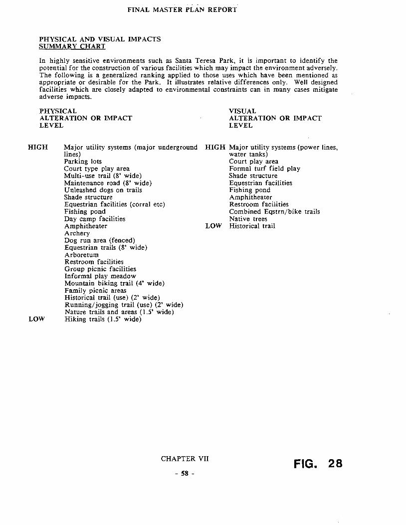
FINAL MASTER PLAN REPORT
PHYSICAL AND VISUAL IMP ACTS SUMMARY CHART
In highly sensitive environments such as Santa Teresa Park it is important to identify the potential for the construction of various facilities which may impact the environment adversely The following is a generalized ranking applied to those uses which have been mentioned as appropriate or desirable for the Park It illustrates relative differences only Well designed facilities which are closely adapted to environmental constraints can in many cases mitigate adverse impacts
PHYSICAL ALTERATION OR IMPACT LEVEL
HIGH Major utility systems (major underground lines) Parking lots Court type play area Multi-use trail (8 wide) Maintenance road (8 wide) Unleashed dogs on trails Shade structure Equestrian facilities (corral etc) Fishing pond Day camp facilities Amphitheater Archery Dog run area (fenced) Equestrian trails (8 wide) Arboretum Restroom facilities Group picnic facilities Informal play meadow Mountain biking trail (4 wide) Family picnic areas Historical trail (use) (2 wide) Runningjogging trail (use) (2 wide) Nature trails and areas (15 wide)
LOW Hiking trails (15 wide)
VISUAL ALTERATION OR IMPACT LEVEL
HIGH Major utility systems (power lines water tanks) Court play area Formal turf field play Shade structure Equestrian facilities Fishing pond Amphitheater Restroom facilities Combined Eqstrnbike trails Native trees
LOW Historical trail
CHAPTER VII FIG 28 - 58 shy
SANTA TERESA COUNTY PARK FINAL MASTER PLAN REPORT
The reinstatement of irrigation to recreate an informal play meadow at the Pueblo area could have both beneficial and negative impacts on adjacent wetlands and drainages depending on how it is handled As discussed in the paragraph below there is also relatively strong interest in making the most of resources such as the existing Joice Ranch but are as yet undeveloped
2 Visual and Cultural Opportunities
The inference can be drawn from discussions at the public workshops and task force meetings that the public would support preservation and even the highlighting of the unique ecological cultural and visual characteristics of the Park This includes the open space character of the Park as seen from and in contrast to the urbanized valley floor to the north In the extension of these existing land forms such as the two valleys the sky line of peaks and ridges should receive special protection from all forms of development which add or alter these elements
General knowledge of workshop participants in regards to the history of the site and in some cases of its prehistoric characteristics revealed an interest in seeing this resource developed further This could best be done through a comprehensive natural and cultural history program This interest also implies that protection andor restoration of these valued resources should be a high priority For example historic buildings if not in conflict with site character or with historic building codes should be restored
In addition to the interest expressed for an historic and prehistoric resources interpretation program there is a strong interest in a developed natural history interpretive program There are many natural resources in the Park (described in subsequent chapters) which could become an integral part of such an interpretive program
Historic Landscape Concept The wealth of dispersed significant historic and prehistoric sites is such that the concept of an historic landscape might apply While this is a concept which has been applied primarily in national and state historic parks the richness of Santa Teresa Park resources may make it an appropriate opportunity This could be applied as an overlay policy zone similar to that used in land use planning covering the critical historic and prehistoric resources zones of the Park if not the entire park Three primary eras could be involved
Native American Spanish Rancho American Ranching and Mining (up to the mid-twentieth century)
3 Revenue Generation Implications
Santa Teresa Park clearly is a study in contrasts when it comes to revenue generation On the one hand the golf course is a major generator of income which goes not to Santa Teresa Park but to the County Park general fund The rest of the Park contains little that generates significant funds As noted in Chapter VI aside from golf courses water recreational uses are the most lucrative in the Park system By contrast Santa Teresa Park is a relatively arid landscape with only one pond near the golf course driving range Uses which hold moderate promise for revenue generation exist at three or four sites at the perimeter of the existing property There should be a considerable market for large group gatherings making use of combined indooroutdoor socializing and picnic facilities In addition to social groups and clubs there is demand
CHAPTER VII
- 59 shy
SANTA TERESA COUNTY PARK FINAL MASTER PLAN REPORT
from corporate group facilities for hosting groups of up to 500 people The Norred Ranch the Rossetto Ranch and the area identified as the East Meadow (currently used by the archery groups) all have the potential to accommodate this sort of use
Because of the existing combination of parking restroom facilities stables dance pavilion picnic tables and barbecue units the Norred Ranch offers great theoretical potential It should be noted the Parks own analysis of the buildings on the Ranch suggests very few if any of them can be saved The Rossetto Ranch is only slightly less attractive but only because a considerable amount of work would be required to meet its potential for the same sort of function Finally the archery area for a variety of reasons explained in the next chapter has the potential to serve such uses possibly conducted in connection with the golf course facility
In conclusion without these facilities the revenue generating potentials of the rest of the Park are limited These would improve somewhat with the improvement of the Pueblo area as this would certainly encourage or generate more group activity and specially permitted events
4 Utilities and Support Facilities
As noted above the combination of site limitations and the nature of demand does not suggest a massive increase in water or power requirements in the Pueblo Improvements to restroom facilities and septic fields would certainly be logical if there is an increase in use by large groups Even if areas such as Rossetto and Norred were to be acquired andor developed for various uses (described elsewhere) they are at the perimeter of the Park and close to existing utilities and other infrastructure This tends to minimize the capital costs for such improvements (The water and sewage capacities at the Rossetto Ranch however need further study)
5 Access and Security
a Through-road As previously discussed (Chapter V Section E) the Bernal Road extension (aka Santa Teresa Park Road provides a physical connection from north to south (Harry Road) and is available in cases of emergency IBM allows unrestricted passage to County Park Rangers
Adding a publicly accessible north-south through road meeting modern traffic and safety standards has been considered Such would only become a possibility if and when the Rossetto Ranch is purchased There are arguments why this idea should not be pursued First it would bring levels of activity to the center of the Park which would conflict with the goals of the 2020 report and the County General Plan A through-road would introduce a level of activity which would at least conflict with if not destroy the core of the Park as an isolated open space retreat from the adjacent urban areas It would also in all likelihood heavily impact the rich pre-historic resources in the ranch houseswimming pool area
Other major constraints to this concept include the physical difficulties of getting a road along Fortini Creek (a sensitive wildlife habitat corridor pinched by landslide formations on both sides) This traffic would impact both Bernal Road and the Fortini San Vicente Road accesses
CHAPTER VII
- 60 shy
1
-TO No~ -
-1 FUeetv fW~~~
SKETCH PLAN A ~rt
~ C cptf GCU~e7
PF ~ ~ ~ LD- ~ITcfi ~~
-1 bullbull bull bull~ ~ ~f01~-rP-J ~ middot~==middot~l VirIO PI(fi ~ l bull~ bullbull y ~ ~- To NcW K y lt1l ~H eM t7u-=D-I 4
EXISTING W~T~q CONDITIONS
CONSUL T ANTS FOR DRAFT MASTER PLAN PROJECT bull TITO TRI I ASSOCITES bull u cu COUNTy
u l aICItpoundA flO OC-TLDSCPE ARCHITECTURe SANTA TERESA PARKzbullbull GAADlIIf OAlY Ul20 ONTGOERY ~ 0 01 OATQS CAlIIOa
SN FRANCISCO C so~O 401 UI
TEl 15-gB aa 11 PROPOSED FiG MODiFICATION 29 BERNAL GATEWAY
SANTA TERESA COUNTY PARK FINAL MASTER PLAN REPORT
b Bernal Entrance An important opportunity does exist to reconfigure the entrance road (south of its intersection with Heaton Moor Road) in a way which could help solve the ParkIBM off hours security problem The switch-back (700 feet southeast of the intersection of Heaton Moor and Bernal Roads) could be turned into a T intersection with several benefits One benefit would be to force downhill vehicles (which generally speed around this corner) to come to a full stop A t400 foot straight section upslope of the switch-back could he modified with speed bumps or warning lights and signs The T intersection would then allow the possibility of a road connection in a southeasterly direction could take place along a modified Los Alamitos Canal levee as shown in the cross section (Figure 29) The modification to the levee could also accommodate trail uses Similarly a T section and arterial stop and levee modification could allow a road connection northwesterly to the Buck Norred Ranch
This reconfirmation would create two sites for a control gate and guard kiosk One location (Sketch Plan B) close to the intersection of Heaton Moor and Bernal would provide good sight control north easterly along Bernal and southeasterly along the Santa Teresa Park Road (up to the proposed T intersection) It would however need to be manned or opened if there were night events at Norred Ranch and access to the Ranch were along the Los Alamitos Canal levee The second (Sketch Plan A) could be at the T intersection This could allow for closure of the Park at night but operable with electronic devices for those authorized vehicles traveling to the Muriel Wright Residential Center or the IBM facility IBM does not staff its kiosk at night but if it were willing to do so and the gates were not carded at the proposed kiosk this might solve the current security problem (the inability to control use of the Park after dark) IBM has stated that nighttime staffing is not acceptable As noted in Section VIII A (following) a smaller control kiosk (similar to the Calero Reservoir Boat Launch kiosk) could also be built at the Rossetto Ranch or south entrance off Fortini Road should the Rossetto properties be included in the Park
East Meadow TheT configuration is also an important part of two alternative access routes to the East Meadow (currently the archery area) These are
(1) A road along the Alamitos Canal levee (modified) to a point 200-300 feet east of 8th tee of the golf course The route would then descend off the canal berm (which drops into a syphon at that point) and skirt the northerly edge of the existing pond After that it would be aligned along the southern edge of the driving range where taller fences might be required as a protection from flying golf balls A few hundred feet further east the road would have to leave the canal alignment and skirt along the south side of another tee and terminate at what is now the Bowmans parking area The total distance however is substantial 6500 feet or 12 miles
(2) A second possibility of providing vehicular access to the East Meadow area is directly off the intersection to Santa Teresa Boulevard and the Los Alamitos Canal where again the reconfigured canal although outside the current park boundary could provide reasonable access along a low speed driveway type of road The distance from Santa Teresa Boulevard to the Park boundary is approximately 3500 feet (07 miles)
CHAPTER VII
- 61 shy
SANTA TERESA COUNTY PARK FINAL MASTER PLAN REPORT
The major limitation of the two prior alternatives is likely to be the cost The distance from the proposed T intersection and East Meadow parking lot would be approximately one mile The advantage of these two routes is that they would impact the adjacent neighborhoods minimally
Two other opportunities for accessing East Meadow include
(3) Continued use of the Bayliss A venue access off A venida Espana which has a direct connection to Santa Teresa Boulevard and provides access at the current gate to the archery center
(4) A route through the golf course There is a possibility of extending a road from the most easterly end of the existing paved parking lot It would continue along a southerly service road and then follow the existing Los Alamitos Canal alignment
These different access possibilities relate to three possible recreational use variations for the East Meadow area in general which are described in the Recommendations Section Their feasibility depends to some extent on the relationship between the uses proposed and golf use
The westerly alternative could impact golf play in some areas depending on its exact configuration Of the two alternatives the existing entrance would require at most refurbishing and an upgrading of new pavement whereas the extension from the existing golf course parking lot would require a new road bed and paving for a distance of approximately 2500 feet
6 Operations and Maintenance Opportunities
a A clear implication can be drawn from the discussions regarding such uses as soccer biking equestrian access in that there could be conflicts between uses depending on two factors the number of people involved and the characteristics of the use imposed on the landscape The flatter more usable areas of Santa Teresa Park are relatively limited compared to the population base which is close at hand particularly on the north side In addition to this recreation use characteristics are constantly changing as evidenced by the increasingly significant demand for mountain biking trails The implications of this are that there should be where possible the physical or temporal separation of uses where there are potentials for conflict The temporal separation of course means that some uses that require permit and approval by park administration can be scheduled to avoid conflict
b Maintenance The most important implication of maintenance demand is the clear need for a full service corporation yard somewhere in the Park Approximately 15 to 20 acres (more than is feasible at the Muriel Wright Residential Center) would be needed In addition because of the natural grouping of physical and visual conditions a zone approach to management should be developed This is also appropriate should staffing increases become possible In this event it will become easier to coordinate scheduled uses with the location and number of management zones which the Park staff would be able to handle at any given time The zone approach would also assist in establishing appropriate maintenance policies Since the zones would reflect generally consistent topographic conditions and other related environmental
CHAPTER VII
- 62 shy
)~ll 1 ~ 1 poundJpound)~ V U 11 1 I r fJl
FINAL MASTER PLAN REPORT
limitations maintenance projections and staff allocations could be based on careful evaluation of the potential physical impacts of various anticipated uses on each zone
c Staffing Opportunities The implications of the general conditions of the landscape and of park improvements as they stand now are that current staffing levels are inadequate to meet even the most minimal management and maintenance needs of the Park The various levels of development obviously entail a commitment on the part of staff relative to the needs implied by such development in terms of both improvement maintenance and management of natural resources Conceptually speaking there are three levels of staff which can be related to either qualitative or quantitative conditions or increases for the Park
(I) Existing Level Existing levels of staffing are clearly inadequate to deal not only with primary management needs of patrolling but secondary needs such as erosion control reforestation protection of rare and endangered habitats resource management mechanical fire fuel reduction etc In fact it might be argued that existing maintenance needs in the Park are enough in excess of staff capacities that some facilities should be abandoned or removed For example maintenance needs for some ad-hoc trails in the Ohlone and Hidden Springs areas are substantial Some of these trails it could be argued should be closed until such time as there is adequate staff augmentation
(2) Level Two Assignment of at least one full time ranger would have two effects One would be to assist in or reduce the cost of special patrols in basic maintenance and policing Secondly the very presence of a full time ranger would have a beneficial psychological impact on park users of all ages Also some combination of contrasting concepts for the Park equestrianbiker use will require monitoring in order to assess the optimum design for such uses in the future Such efforts would be greatly enhanced by the assignment of a full time ranger
(3) Level Three Level three involves substantial increases in staff These would have to be directly related to characteristics of improved facilities and increased use Different combinations of uses and areas imply different staff skills especially with respect to interpretational versus or in tandem with recreational uses Santa Teresa is a more centralized location for the staff unit relative to Calero and AQ Parks
CHAPTER VII
- 63 shy
SANTA TERESA COUNTY PARK FINAL MASTER PLAN REPORT
from corporate group facilities for hosting groups of up to 500 people The Norred Ranch the Rossetto Ranch and the area identified as the East Meadow (currently used by the archery groups) all have the potential to accommodate this sort of use
Because of the existing combination of parking restroom facilities stables dance pavilion picnic tables and barbecue units the Norred Ranch offers great theoretical potential It should be noted the Parks own analysis of the buildings on the Ranch suggests very few if any of them can be saved The Rossetto Ranch is only slightly less attractive but only because a considerable amount of work would be required to meet its potential for the same sort of function Finally the archery area for a variety of reasons explained in the next chapter has the potential to serve such uses possibly conducted in connection with the golf course facility
In conclusion without these facilities the revenue generating potentials of the rest of the Park are limited These would improve somewhat with the improvement of the Pueblo area as this would certainly encourage or generate more group activity and specially permitted events
4 Utilities and Support Facilities
As noted above the combination of site limitations and the nature of demand does not suggest a massive increase in water or power requirements in the Pueblo Improvements to restroom facilities and septic fields would certainly be logical if there is an increase in use by large groups Even if areas such as Rossetto and Norred were to be acquired andor developed for various uses (described elsewhere) they are at the perimeter of the Park and close to existing utilities and other infrastructure This tends to minimize the capital costs for such improvements (The water and sewage capacities at the Rossetto Ranch however need further study)
5 Access and Security
a Through-road As previously discussed (Chapter V Section E) the Bernal Road extension (aka Santa Teresa Park Road provides a physical connection from north to south (Harry Road) and is available in cases of emergency IBM allows unrestricted passage to County Park Rangers
Adding a publicly accessible north-south through road meeting modern traffic and safety standards has been considered Such would only become a possibility if and when the Rossetto Ranch is purchased There are arguments why this idea should not be pursued First it would bring levels of activity to the center of the Park which would conflict with the goals of the 2020 report and the County General Plan A through-road would introduce a level of activity which would at least conflict with if not destroy the core of the Park as an isolated open space retreat from the adjacent urban areas It would also in all likelihood heavily impact the rich pre-historic resources in the ranch houseswimming pool area
Other major constraints to this concept include the physical difficulties of getting a road along Fortini Creek (a sensitive wildlife habitat corridor pinched by landslide formations on both sides) This traffic would impact both Bernal Road and the Fortini San Vicente Road accesses
CHAPTER VII
- 60 shy
1
-TO No~ -
-1 FUeetv fW~~~
SKETCH PLAN A ~rt
~ C cptf GCU~e7
PF ~ ~ ~ LD- ~ITcfi ~~
-1 bullbull bull bull~ ~ ~f01~-rP-J ~ middot~==middot~l VirIO PI(fi ~ l bull~ bullbull y ~ ~- To NcW K y lt1l ~H eM t7u-=D-I 4
EXISTING W~T~q CONDITIONS
CONSUL T ANTS FOR DRAFT MASTER PLAN PROJECT bull TITO TRI I ASSOCITES bull u cu COUNTy
u l aICItpoundA flO OC-TLDSCPE ARCHITECTURe SANTA TERESA PARKzbullbull GAADlIIf OAlY Ul20 ONTGOERY ~ 0 01 OATQS CAlIIOa
SN FRANCISCO C so~O 401 UI
TEl 15-gB aa 11 PROPOSED FiG MODiFICATION 29 BERNAL GATEWAY
SANTA TERESA COUNTY PARK FINAL MASTER PLAN REPORT
b Bernal Entrance An important opportunity does exist to reconfigure the entrance road (south of its intersection with Heaton Moor Road) in a way which could help solve the ParkIBM off hours security problem The switch-back (700 feet southeast of the intersection of Heaton Moor and Bernal Roads) could be turned into a T intersection with several benefits One benefit would be to force downhill vehicles (which generally speed around this corner) to come to a full stop A t400 foot straight section upslope of the switch-back could he modified with speed bumps or warning lights and signs The T intersection would then allow the possibility of a road connection in a southeasterly direction could take place along a modified Los Alamitos Canal levee as shown in the cross section (Figure 29) The modification to the levee could also accommodate trail uses Similarly a T section and arterial stop and levee modification could allow a road connection northwesterly to the Buck Norred Ranch
This reconfirmation would create two sites for a control gate and guard kiosk One location (Sketch Plan B) close to the intersection of Heaton Moor and Bernal would provide good sight control north easterly along Bernal and southeasterly along the Santa Teresa Park Road (up to the proposed T intersection) It would however need to be manned or opened if there were night events at Norred Ranch and access to the Ranch were along the Los Alamitos Canal levee The second (Sketch Plan A) could be at the T intersection This could allow for closure of the Park at night but operable with electronic devices for those authorized vehicles traveling to the Muriel Wright Residential Center or the IBM facility IBM does not staff its kiosk at night but if it were willing to do so and the gates were not carded at the proposed kiosk this might solve the current security problem (the inability to control use of the Park after dark) IBM has stated that nighttime staffing is not acceptable As noted in Section VIII A (following) a smaller control kiosk (similar to the Calero Reservoir Boat Launch kiosk) could also be built at the Rossetto Ranch or south entrance off Fortini Road should the Rossetto properties be included in the Park
East Meadow TheT configuration is also an important part of two alternative access routes to the East Meadow (currently the archery area) These are
(1) A road along the Alamitos Canal levee (modified) to a point 200-300 feet east of 8th tee of the golf course The route would then descend off the canal berm (which drops into a syphon at that point) and skirt the northerly edge of the existing pond After that it would be aligned along the southern edge of the driving range where taller fences might be required as a protection from flying golf balls A few hundred feet further east the road would have to leave the canal alignment and skirt along the south side of another tee and terminate at what is now the Bowmans parking area The total distance however is substantial 6500 feet or 12 miles
(2) A second possibility of providing vehicular access to the East Meadow area is directly off the intersection to Santa Teresa Boulevard and the Los Alamitos Canal where again the reconfigured canal although outside the current park boundary could provide reasonable access along a low speed driveway type of road The distance from Santa Teresa Boulevard to the Park boundary is approximately 3500 feet (07 miles)
CHAPTER VII
- 61 shy
SANTA TERESA COUNTY PARK FINAL MASTER PLAN REPORT
The major limitation of the two prior alternatives is likely to be the cost The distance from the proposed T intersection and East Meadow parking lot would be approximately one mile The advantage of these two routes is that they would impact the adjacent neighborhoods minimally
Two other opportunities for accessing East Meadow include
(3) Continued use of the Bayliss A venue access off A venida Espana which has a direct connection to Santa Teresa Boulevard and provides access at the current gate to the archery center
(4) A route through the golf course There is a possibility of extending a road from the most easterly end of the existing paved parking lot It would continue along a southerly service road and then follow the existing Los Alamitos Canal alignment
These different access possibilities relate to three possible recreational use variations for the East Meadow area in general which are described in the Recommendations Section Their feasibility depends to some extent on the relationship between the uses proposed and golf use
The westerly alternative could impact golf play in some areas depending on its exact configuration Of the two alternatives the existing entrance would require at most refurbishing and an upgrading of new pavement whereas the extension from the existing golf course parking lot would require a new road bed and paving for a distance of approximately 2500 feet
6 Operations and Maintenance Opportunities
a A clear implication can be drawn from the discussions regarding such uses as soccer biking equestrian access in that there could be conflicts between uses depending on two factors the number of people involved and the characteristics of the use imposed on the landscape The flatter more usable areas of Santa Teresa Park are relatively limited compared to the population base which is close at hand particularly on the north side In addition to this recreation use characteristics are constantly changing as evidenced by the increasingly significant demand for mountain biking trails The implications of this are that there should be where possible the physical or temporal separation of uses where there are potentials for conflict The temporal separation of course means that some uses that require permit and approval by park administration can be scheduled to avoid conflict
b Maintenance The most important implication of maintenance demand is the clear need for a full service corporation yard somewhere in the Park Approximately 15 to 20 acres (more than is feasible at the Muriel Wright Residential Center) would be needed In addition because of the natural grouping of physical and visual conditions a zone approach to management should be developed This is also appropriate should staffing increases become possible In this event it will become easier to coordinate scheduled uses with the location and number of management zones which the Park staff would be able to handle at any given time The zone approach would also assist in establishing appropriate maintenance policies Since the zones would reflect generally consistent topographic conditions and other related environmental
CHAPTER VII
- 62 shy
)~ll 1 ~ 1 poundJpound)~ V U 11 1 I r fJl
FINAL MASTER PLAN REPORT
limitations maintenance projections and staff allocations could be based on careful evaluation of the potential physical impacts of various anticipated uses on each zone
c Staffing Opportunities The implications of the general conditions of the landscape and of park improvements as they stand now are that current staffing levels are inadequate to meet even the most minimal management and maintenance needs of the Park The various levels of development obviously entail a commitment on the part of staff relative to the needs implied by such development in terms of both improvement maintenance and management of natural resources Conceptually speaking there are three levels of staff which can be related to either qualitative or quantitative conditions or increases for the Park
(I) Existing Level Existing levels of staffing are clearly inadequate to deal not only with primary management needs of patrolling but secondary needs such as erosion control reforestation protection of rare and endangered habitats resource management mechanical fire fuel reduction etc In fact it might be argued that existing maintenance needs in the Park are enough in excess of staff capacities that some facilities should be abandoned or removed For example maintenance needs for some ad-hoc trails in the Ohlone and Hidden Springs areas are substantial Some of these trails it could be argued should be closed until such time as there is adequate staff augmentation
(2) Level Two Assignment of at least one full time ranger would have two effects One would be to assist in or reduce the cost of special patrols in basic maintenance and policing Secondly the very presence of a full time ranger would have a beneficial psychological impact on park users of all ages Also some combination of contrasting concepts for the Park equestrianbiker use will require monitoring in order to assess the optimum design for such uses in the future Such efforts would be greatly enhanced by the assignment of a full time ranger
(3) Level Three Level three involves substantial increases in staff These would have to be directly related to characteristics of improved facilities and increased use Different combinations of uses and areas imply different staff skills especially with respect to interpretational versus or in tandem with recreational uses Santa Teresa is a more centralized location for the staff unit relative to Calero and AQ Parks
CHAPTER VII
- 63 shy
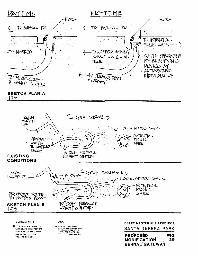
SANTA TERESA COUNTY PARK FINAL MASTER PLAN REPORT
The major limitation of the two prior alternatives is likely to be the cost The distance from the proposed T intersection and East Meadow parking lot would be approximately one mile The advantage of these two routes is that they would impact the adjacent neighborhoods minimally
Two other opportunities for accessing East Meadow include
(3) Continued use of the Bayliss A venue access off A venida Espana which has a direct connection to Santa Teresa Boulevard and provides access at the current gate to the archery center
(4) A route through the golf course There is a possibility of extending a road from the most easterly end of the existing paved parking lot It would continue along a southerly service road and then follow the existing Los Alamitos Canal alignment
These different access possibilities relate to three possible recreational use variations for the East Meadow area in general which are described in the Recommendations Section Their feasibility depends to some extent on the relationship between the uses proposed and golf use
The westerly alternative could impact golf play in some areas depending on its exact configuration Of the two alternatives the existing entrance would require at most refurbishing and an upgrading of new pavement whereas the extension from the existing golf course parking lot would require a new road bed and paving for a distance of approximately 2500 feet
6 Operations and Maintenance Opportunities
a A clear implication can be drawn from the discussions regarding such uses as soccer biking equestrian access in that there could be conflicts between uses depending on two factors the number of people involved and the characteristics of the use imposed on the landscape The flatter more usable areas of Santa Teresa Park are relatively limited compared to the population base which is close at hand particularly on the north side In addition to this recreation use characteristics are constantly changing as evidenced by the increasingly significant demand for mountain biking trails The implications of this are that there should be where possible the physical or temporal separation of uses where there are potentials for conflict The temporal separation of course means that some uses that require permit and approval by park administration can be scheduled to avoid conflict
b Maintenance The most important implication of maintenance demand is the clear need for a full service corporation yard somewhere in the Park Approximately 15 to 20 acres (more than is feasible at the Muriel Wright Residential Center) would be needed In addition because of the natural grouping of physical and visual conditions a zone approach to management should be developed This is also appropriate should staffing increases become possible In this event it will become easier to coordinate scheduled uses with the location and number of management zones which the Park staff would be able to handle at any given time The zone approach would also assist in establishing appropriate maintenance policies Since the zones would reflect generally consistent topographic conditions and other related environmental
CHAPTER VII
- 62 shy
)~ll 1 ~ 1 poundJpound)~ V U 11 1 I r fJl
FINAL MASTER PLAN REPORT
limitations maintenance projections and staff allocations could be based on careful evaluation of the potential physical impacts of various anticipated uses on each zone
c Staffing Opportunities The implications of the general conditions of the landscape and of park improvements as they stand now are that current staffing levels are inadequate to meet even the most minimal management and maintenance needs of the Park The various levels of development obviously entail a commitment on the part of staff relative to the needs implied by such development in terms of both improvement maintenance and management of natural resources Conceptually speaking there are three levels of staff which can be related to either qualitative or quantitative conditions or increases for the Park
(I) Existing Level Existing levels of staffing are clearly inadequate to deal not only with primary management needs of patrolling but secondary needs such as erosion control reforestation protection of rare and endangered habitats resource management mechanical fire fuel reduction etc In fact it might be argued that existing maintenance needs in the Park are enough in excess of staff capacities that some facilities should be abandoned or removed For example maintenance needs for some ad-hoc trails in the Ohlone and Hidden Springs areas are substantial Some of these trails it could be argued should be closed until such time as there is adequate staff augmentation
(2) Level Two Assignment of at least one full time ranger would have two effects One would be to assist in or reduce the cost of special patrols in basic maintenance and policing Secondly the very presence of a full time ranger would have a beneficial psychological impact on park users of all ages Also some combination of contrasting concepts for the Park equestrianbiker use will require monitoring in order to assess the optimum design for such uses in the future Such efforts would be greatly enhanced by the assignment of a full time ranger
(3) Level Three Level three involves substantial increases in staff These would have to be directly related to characteristics of improved facilities and increased use Different combinations of uses and areas imply different staff skills especially with respect to interpretational versus or in tandem with recreational uses Santa Teresa is a more centralized location for the staff unit relative to Calero and AQ Parks
CHAPTER VII
- 63 shy