2
ENQUIRIES: Tel: (021) 866 1560 Cell: 082 467 0405 RESERVATIONS: Tel: (021) 483 0190 www.capenature.co.za from lower in the valley and can change rapidly, becoming dangerous. Vegetation The natural vegetation of the Jonkershoek area is mainly mountain fynbos. More than 1 100 plant species are known to occur, of which a number are rare and/or endemic to the area. Distinctive species are Protea repens, P. neriifolia, mountain cypress, as well as various ericas and restios. Several relic forest communities occur in narrow, moist kloofs where they are relatively sheltered from fire. Dense riparian vegetation grows along the banks of the Eerste River. Oak trees, although not indigenous, have been allowed to remain in Assegaaibosch because of their special histori- cal value. Large pine plantations are a dis- tinctive feature of the valley and occur on property neighbouring the Nature Reserves. The Reserves’ man- agement programmes include control of hakea and other invasive alien plants that threaten the fynbos. Animals Mammals include leopard, honey badger, baboon, klip- springer, mongoose and numerous smaller animals like mice, shrews and rats. Most of these are shy, however, and seldom seen. Large raptors such as black eagle, the occa- sional fish eagle and spotted eagle owl occur, while king- fishers and typical fynbos birds (sugarbird, orangebreasted sunbird and protea seed-eater) are more abundant. On warm days rock agama lizards can be seen basking in the sun. Berg adder, puff adder, boomslang and Cape cobra are fairly common and hikers should be alert. Activities The Assegaaibosch Nature Reserve has two hiking routes: a short 3km walk and a longer 5,5km trail. Parking, picnic and braai areas, and toilet facilities are available. The Jonkershoek Nature Reserve has a circular drive of ±10km, leading around the valley floor. Four hiking trails of varying difficulty and length lead off the circular drive and up the mountain slopes. 1. Swartboskloof–Sosyskloof: This easy scenic route ascends along the western slopes of Swartboskloof for about 2 km, passing through a patch of beautiful indigenous forest. It then traverses along a contour to Sosyskloof before winding back to the start. 5.3 km; 2 hours; circular, or 6.9 km; 2.5 hours; circular, if longer route to lookout is taken. 2. Swartboskloof Route: Ascends the steep Swartboskloof, gaining over 900 m in altitude over the first 4.5 km, but the panoramic views are ample reward. The route then traverses fairly level terrain to the top of Kurktrekkernek where there is a steep 2.5 km descent to the Waterfall Route. 18 km; 6 hours; circular. 3. Panorama Circuit: From the bridge on the hairpin bend of the Circular Drive, there is a steep climb to a contour path just below Third Ridge and Banghoek peaks. Following the contour path, you reach Bergriviernek, from where there are amazing views of Assegaaiboskloof. The path then winds across the Dwarsberg Plateau, with its marshy areas and streams surrounded by disas, to Kurktrekkernek. There is a short detour here, to the summit of Guardian Peak (1,227 m), with stunning views of the Cape Peninsula, from Table Mountain to Cape Point, Robben Island, False Bay, Cape Hangklip and the peaks of the Hottentots Holland range. From Kurktrekker the path descends past Second and First waterfalls to the starting point. 17 km; 6 hours; circular. 4. Tweede Waterval: An easy ramble along the Eerste River past Eerste Waterval (First Waterfall), followed by a steep climb along a gorge to the foot of Tweede Waterval (Second Waterfall). The dangerous ascent to this waterfall is closed. 6.4 km; 2 hours; out-and-return. NATURE RESERVE onkershoek Nature Reserve, which includes the smaller Assegaaibosch Nature Reserve, lies near the town of Stellenbosch in the south- western Cape. The Reserve comprises the imposing Jonkershoek mountains and portions of the upper Jonkershoek valley.The Jonkershoek mountains, with their high peaks and deep kloofs, form part of the larger Boland mountain range (part of the greater Hottentots Holland Nature Reserve). The Eerste, Berg, Lourens and Riviersonderend rivers all have their sources high in these mountains, although only the Eerste River actually flows through the Jonkershoek valley. The lower reaches of the valley are a well-known wine-producing area. Jonkershoek Nature Reserve is 11 000ha in extent and functions as a mountain catchment area, providing water for Stellenbosch and surrounds. Its rugged terrain is ideal for hiking. Assegaaibosch, at 204ha, is much smaller and suitable for shorter walks and picnics. Visitors can explore one or both reserves on a single occasion as they are in easy reach of each other. Both Reserves are approximately 9km from Stellenbosch via the Jonkershoek valley road. Climate The climate of the Jonkershoek area is fairly typical of the south-western Cape. Summers are warm to very hot and strong south-easterly winds prevail, creating a serious fire hazard. The winters are cold, often with gale-force north-westerly winds. The mountainous topography has a significant effect on the rainfall, which is of the highest in South Africa. Snow is not unusual on the higher peaks during the winter months. Hikers should note that at higher altitudes the weather conditions may be quite different CapeNature 5/2017 Historical buildings The Assegaaibosch farmstead was built circa 1792 but it is uncertain who the original owner of the house was. Wouter Eduard Wium owned the house from 1806 until 1844 and he planted the huge old oak trees in 1817. The farm changed hands several times over the years, becoming neglected, until the Cape Provincial Administration pur- chased it in 1960. It has since been renovated, is now a national monument and used as a guest house. In 1893 the Colonial Government rented a portion of the estate adjacent to Assegaaibosch for the establishment of a trout hatchery. The sturdy, stone hatching house was con- structed by John Scott and is now a national monument. Today CapeNature utilises the property as a conservation station. This is a World Heritage Site NATURE RESERVE www.capenature.co.za DISCLAIMER OF LIABILITY All persons entering this conservation area and using its facilities, do so entirely at their own risk. The Western Cape Nature Conservation Board and/or its employees and/ or agents and/or its successors in title shall not be liable for any damage, loss, theft, injury, accident or death suffered by any person, howsoever caused. Right of Admission Reserved.

Vegetation - CapeNature · riparian vegetation grows along the banks of the Eerste River. Oak trees, although not indigenous, ... In 1893 the Colonial Government rented a portion

Embed Size (px)

Citation preview

ENQUIRIES:Tel: (021) 866 1560Cell: 082 467 0405

RESERVATIONS:Tel: (021) 483 0190

www.capenature.co.za

from lower in the valley and can change rapidly, becoming dangerous.

Vegetat i onThe natural vegetation of the Jonkershoek area is mainly mountain fynbos. More than 1 100 plant species are known to occur, of which a number are rare and/or endemic to the area. Distinctive species are Protea repens, P. neriifolia, mountain cypress, as well as various ericas and restios. Several relic forest communities occur in narrow, moist kloofs where they are relatively sheltered from fire. Dense riparian vegetation grows along the banks of the Eerste River. Oak trees, although not indigenous, have been allowed to remain in Assegaaibosch because of their special histori-cal value. Large pine plantations are a dis-tinctive feature of the valley and occur on property neighbouring the Nature Reserves. The Reserves’ man-agement programmes include control of hakea and other invasive alien plants that threaten the fynbos.

Anima l sMammals include leopard, honey badger, baboon, klip-springer, mongoose and numerous smaller animals like mice, shrews and rats. Most of these are shy, however, and seldom seen. Large raptors such as black eagle, the occa-sional fish eagle and spotted eagle owl occur, while king-fishers and typical fynbos birds (sugarbird, orangebreasted sunbird and protea seed-eater) are more abundant. On warm days rock agama lizards can be seen basking in the sun. Berg adder, puff adder, boomslang and Cape cobra are fairly common and hikers should be alert.

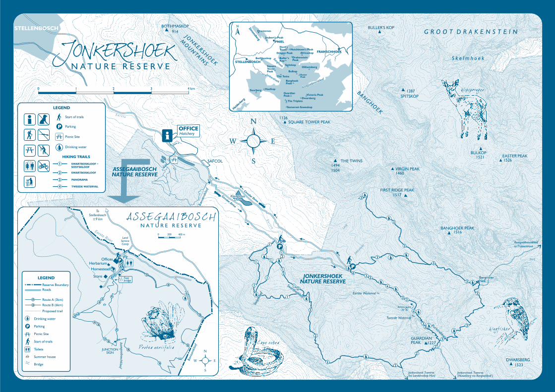
Activ i t ie s The Assegaaibosch Nature Reserve has two hiking routes: a short 3km walk and a longer 5,5km trail. Parking, picnic and braai areas, and toilet facilities are available.

The Jonkershoek Nature Reserve has a circular drive of ±10km, leading around the valley floor. Four hiking trails of varying difficulty and length lead off the circular drive and up the mountain slopes.

1. Swartboskloof–Sosyskloof: This easy scenic route ascends along the western slopes of Swartboskloof for about 2 km, passing through a patch of beautiful indigenous forest. It then traverses along a contour to Sosyskloof before winding back to the start. 5.3 km; 2 hours; circular, or 6.9 km; 2.5 hours; circular, if longer route to lookout is taken.

2. Swartboskloof Route: Ascends the steep Swartboskloof, gaining over 900 m in altitude over the first 4.5 km, but the panoramic views are ample reward. The route then traverses fairly level terrain to the top of Kurktrekkernek where there is a steep 2.5 km descent to the Waterfall Route. 18 km; 6 hours; circular.

3. Panorama Circuit: From the bridge on the hairpin bend of the Circular Drive, there is a steep climb to a contour path just below Third Ridge and Banghoek peaks. Following the contour path, you reach Bergriviernek, from where there are amazing views of Assegaaiboskloof. The path then winds across the Dwarsberg Plateau, with its marshy areas and streams surrounded by disas, to Kurktrekkernek. There is a short detour here, to the summit of Guardian Peak (1,227 m), with stunning views of the Cape Peninsula, from Table Mountain to Cape Point, Robben Island, False Bay, Cape Hangklip and the peaks of the Hottentots Holland range. From Kurktrekker the path descends past Second and First waterfalls to the starting point. 17 km; 6 hours; circular.

4. Tweede Waterval: An easy ramble along the Eerste River past Eerste Waterval (First Waterfall), followed by a steep climb along a gorge to the foot of Tweede Waterval (Second Waterfall). The dangerous ascent to this waterfall is closed. 6.4 km; 2 hours; out-and-return.

NA

TU

RE

RE

SER

VE

onkershoek Nature Reserve, which includes the smaller Assegaaibosch Nature Reserve, lies near the town of Stellenbosch in the south-western Cape. The Reserve comprises the

imposing Jonkershoek mountains and portions of the upper Jonkershoek valley. The Jonkershoek mountains, with their high peaks and deep kloofs, form part of the larger Boland mountain range (part of the greater Hottentots Holland Nature Reserve). The Eerste, Berg, Lourens and Riviersonderend rivers all have their sources high in these mountains, although only the Eerste River actually flows through the Jonkershoek valley. The lower reaches of the valley are a well-known wine-producing area.

Jonkershoek Nature Reserve is 11 000ha in extent and functions as a mountain catchment area, providing water for Stellenbosch and surrounds. Its rugged terrain is ideal for hiking. Assegaaibosch, at 204ha, is much smaller and suitable for shorter walks and picnics. Visitors can explore one or both reserves on a single occasion as they are in easy reach of each other. Both Reserves are approximately 9km from Stellenbosch via the Jonkershoek valley road.

ClimateThe climate of the Jonkershoek area is fairly typical of the south-western Cape. Summers are warm to very hot and strong south-easterly winds prevail, creating a serious fire hazard. The winters are cold, often with gale-force north-westerly winds. The mountainous topography has a significant effect on the rainfall, which is of the highest

in South Africa. Snow is not unusual on the higher peaks during the winter months.

Hikers should note that at higher altitudes the weather conditions may be quite different

Cap

eNat

ure

5/20

17

Histor ica l bui ld ing sThe Assegaaibosch farmstead was built circa 1792 but it is uncertain who the original owner of the house was. Wouter Eduard Wium owned the house from 1806 until 1844 and he planted the huge old oak trees in 1817. The farm changed hands several times over the years, becoming neglected, until the Cape Provincial Administration pur-chased it in 1960. It has since been renovated, is now a national monument and used as a guest house.

In 1893 the Colonial Government rented a portion of the estate adjacent to Assegaaibosch for the establishment of a trout hatchery. The sturdy, stone hatching house was con-structed by John Scott and is now a national monument. Today CapeNature utilises the property as a conservation station.

This is a World Heritage SiteNATURE RESERVE

www.capenature.co.za

DISCLAIMER OFLIABILITY

All persons entering this conservation area and using its facilities, do so entirely

at their own risk. The Western Cape Nature Conservation Board and/or its employees and/

or agents and/or its successors in title shall not be liable for any damage, loss, theft, injury,

accident or death suffered by any person, howsoever caused.

Right of Admission Reserved.