Embed Size (px)
Citation preview
VASCULAR FLORA AND VEGETATION OF RIMARIKI AND ASSOCIATED ISLANDS, MIMIWHANGATA, NORTH-EAST
NEW ZEALAND
by E.K. Cameron Department of Botany, University of Auckland, Private Bag, Auckland
S U M M A R Y
Although highly modified in the past, Rimariki is steadily progressing back to native forest cover via an unusual shrubland association. The two very small islands of Motuwharariki and Otawhanga contain less disturbed forest than the far larger Rimariki Island.
The flora of 13 islands, islets and stacks is presented, totalling 215 taxa of which 60% are native. Accompanying the vegetation descriptions are a vegetation map of Rimariki and an annotated species list. The status of potential weeds is also discussed.
INTRODUCTION
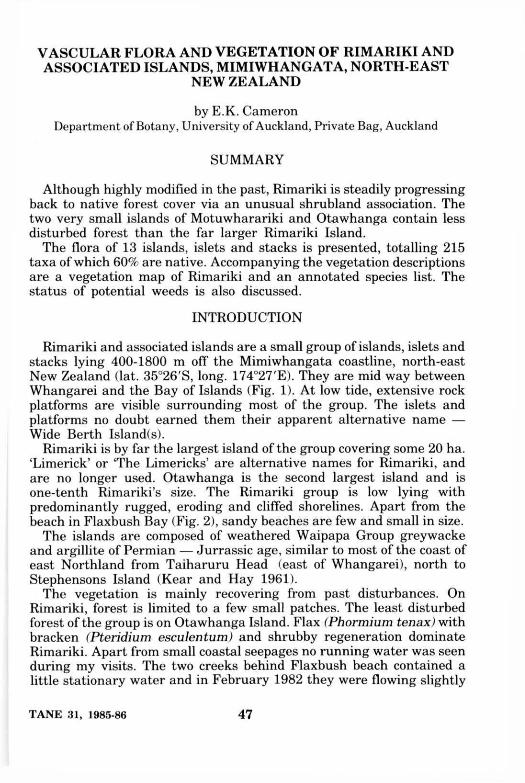
Rimariki and associated islands are a small group of islands, islets and stacks lying 400-1800 m off the Mimiwhangata coastline, north-east New Zealand (lat. 35°26'S, long. 174°27'E). They are mid way between Whangarei and the Bay of Islands (Fig. 1). At low tide, extensive rock platforms are visible surrounding most of the group. The islets and platforms no doubt earned them their apparent alternative name — Wide Berth Island(s).
Rimariki is by far the largest island of the group covering some 20 ha. 'Limerick' or The Limericks' are alternative names for Rimariki, and are no longer used. Otawhanga is the second largest island and is one-tenth Rimariki's size. The Rimariki group is low lying with predominantly rugged, eroding and cliffed shorelines. Apart from the beach in Flaxbush Bay (Fig. 2), sandy beaches are few and small in size.
The islands are composed of weathered Waipapa Group greywacke and argillite of Permian — Jurrassic age, similar to most of the coast of east Northland from Taiharuru Head (east of Whangarei), north to Stephensons Island (Kear and Hay 1961).
The vegetation is mainly recovering from past disturbances. On Rimariki, forest is limited to a few small patches. The least disturbed forest of the group is on Otawhanga Island. Flax (Phormium tenax) with bracken (Pteridium esculentum) and shrubby regeneration dominate Rimariki. Apart from small coastal seepages no running water was seen during my visits. The two creeks behind Flaxbush beach contained a little stationary water and in February 1982 they were flowing slightly
TANE 31, 1985-86 47
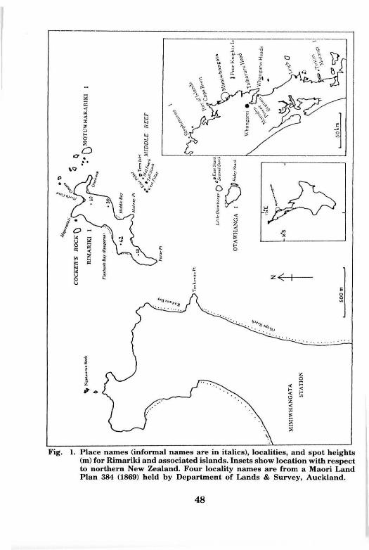
Fig. 1. Place names (informal names are in italics), localities, and spot heights (m) for Rimariki and associated islands. Insets show location with respect to northern New Zealand. Four locality names are from a Maori Land Plan 384 (1869) held by Department of Lands & Survey, Auckland.
48
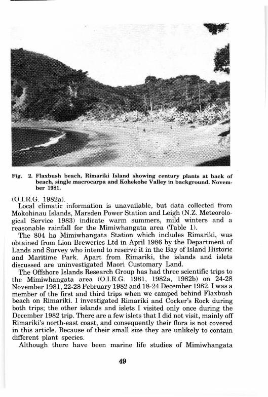
Fig. 2. Flaxbush beach, Rimariki Island showing century plants at back of beach, single macrocarpa and Kohekohe Valley in background. November 1981.
(O.I.R.G. 1982a). Local climatic information is unavailable, but data collected from
Mokohinau Islands, Marsden Power Station and Leigh (N.Z. Meteorological Service 1983) indicate warm summers, mild winters and a reasonable rainfall for the Mimiwhangata area (Table 1).
The 804 ha Mimiwhangata Station which includes Rimariki, was obtained from Lion Breweries Ltd in April 1986 by the Department of Lands and Survey who intend to reserve it in the Bay of Island Historic and Maritime Park. Apart from Rimariki, the islands and islets discussed are uninvestigated Maori Customary Land.
The Offshore Islands Research Group has had three scientific trips to the Mimiwhangata area (O.I.R.G. 1981, 1982a, 1982b) on 24-28 November 1981, 22-28 February 1982 and 18-24 December 1982.1 was a member of the first and third trips when we camped behind Flaxbush beach on Rimariki. I investigated Rimariki and Cocker's Rock during both trips; the other islands and islets I visited only once during the December 1982 trip. There are a few islets that I did not visit, mainly off Rimariki's north-east coast, and consequently their flora is not covered in this article. Because of their small size they are unlikely to contain different plant species.
Although there have been marine life studies of Mimiwhangata
49
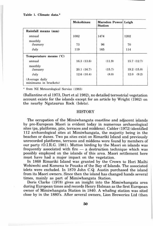
Table 1. Climate data.*
Mokohinau Marsden Power Station
Leigh
Rainfall means (mm) annual 1082 1474 1202 monthly
J aunary 73 96 70 July 119 165 114
Temperature means (°C) annual 16.3 (13.6) (11.9) 15.7 (12.7) monthly
January 20.1 (16.7) (15.7) 19.2 (15.8) July 12.6 (10.4) (8.0) 12.0 (9.2)
(Average daily minimums in brackets)
* from NZ Meteorological Service (1983)
(Ballantine et al 1973, Dart et al 1982), no detailed terrestrial vegetation account exists for the islands except for an article by Wright (1982) on the nearby Ngataurua Rock (Islets).
HISTORY
The occupation of the Mimiwhangata coastline and adjacent islands by pre-European Maori is evident today in numerous archaeological sites (pa, platforms, pits, terraces and middens). Calder (1972) identified 112 archaeological sites at Mimiwhangata, the majority being in the beaches or dunes. Two pa sites exist on Rimariki Island and previously unrecorded platforms, terraces and middens were found by members of our party (O.I.R.G. 1981). Mutton birding by the Maori on islands was frequently associated with fire — a destruction technique which was possibly employed on the islands of this area. Maori settlement here must have had a major impact on the vegetation.
In 1868 Rimariki Island was granted by the Crown to Hori Maihi Wehiwehi and Komena te Pouaka of the Bay of Islands. The associated islets were excluded. In 1870 John C.Q. Austin purchased the island from its Maori owners. Since then the island has changed hands several times, mainly as part of Mimiwhangata Station.
Doris Clarke (1978) gives an insight into the Mimiwhangata area during European times and records Henry Holman as the first European owner of Mimiwhangata Station in 1840. A whaling station was sited close by in the 1880's. After several owners, Lion Breweries Ltd (then
50
NZ Breweries Ltd) in 1962 purchased the property, including Rimariki and in 1975 established a Trust to manage and preserve the area. A Marine Park Environmental Impact Report was produced for Mimiwhangata in 1982 (Dart et al 1982) and the Park gazetted on 1 January 1984.
Clarke (1978), while on a picnic at Rimariki in 1917 recorded moving the 20 sheep from the island because of fear that the grass would be sparse after two months grazing. She also mentions that areas of the island can now be burnt and planted " . . . with grass seed ready for another mob of sheep next season". From Flaxbush beach she records ". . . stunted scrub and fern . . . (with). . . flax bushes dotted about, while just above the high water mark was a row of giant succulents". The only structure on the island mentioned was a small yard for holding sheep.
The earliest aerial photographs of the area were taken in 1950 (series 551, photos 101-103). They show the island much as it is today apart from the less vegetated coastal cliffs. Also visible are the few forest areas, scattered shrubby regeneration (flax clumps?) and the single macrocarpa (Cupressus macrocarpa) (Fig. 2).
V E G E T A T I O N
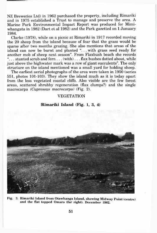
Rimariki Island (Fig. 1, 3, 4)
Fig. 3. Rimariki Island from Otawhanga Island, showing Midway Point (centre) and the flat topped Omaro (far right). December 1982.
51
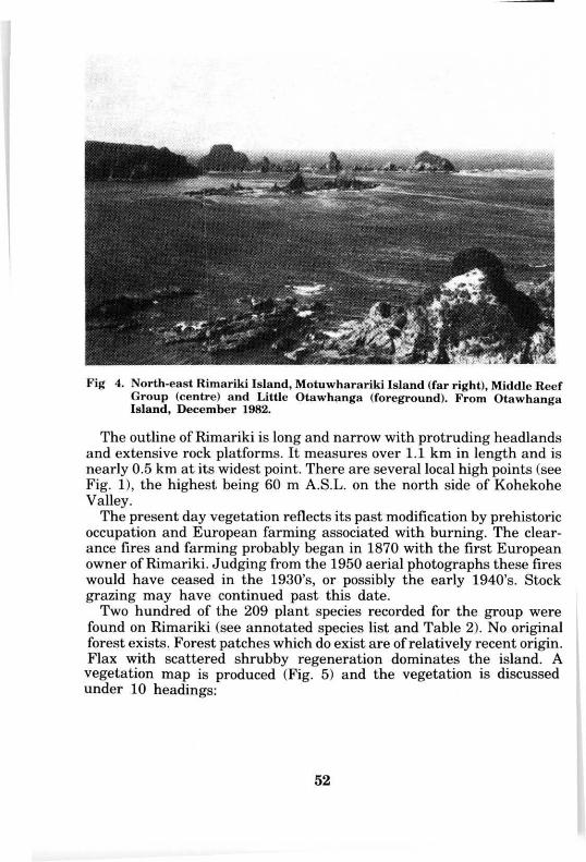
Fig 4. North-east Rimariki Island, Motuwharariki Island (far right), Middle Reef Group (centre) and Little Otawhanga (foreground). From Otawhanga Island, December 1982.
The outline of Rimariki is long and narrow with protruding headlands and extensive rock platforms. It measures over 1.1 km in length and is nearly 0.5 km at its widest point. There are several local high points (see Fig. 1), the highest being 60 m A.S.L. on the north side of Kohekohe Valley.
The present day vegetation reflects its past modification by prehistoric occupation and European farming associated with burning. The clearance fires and farming probably began in 1870 with the first European owner of Rimariki. Judging from the 1950 aerial photographs these fires would have ceased in the 1930's, or possibly the early 1940's. Stock grazing may have continued past this date.
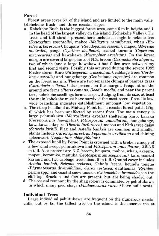
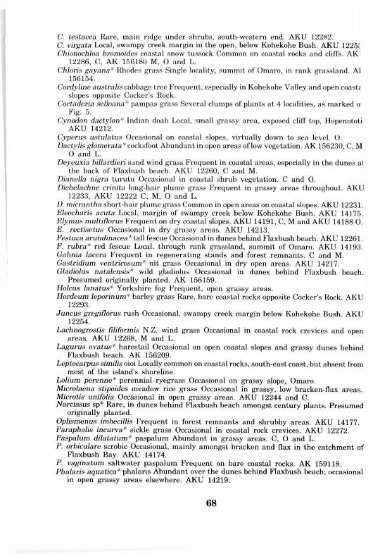
Two hundred of the 209 plant species recorded for the group were found on Rimariki (see annotated species list and Table 2). No original forest exists. Forest patches which do exist are of relatively recent origin. Flax with scattered shrubby regeneration dominates the island. A vegetation map is produced (Fig. 5) and the vegetation is discussed under 10 headings:
52
Table 2. Classification of Rimariki and associated islands floras.
R i m a r i k i Is land
C o c k e r ' s R o c k
M o t u w h a r a r i k i Is land
O t a w h a n g a Is land
Litt le O t a w a h a n g a
C o m m o n to a l l
5 i s lands T O T A L S
Native ferns 17 5 4 6 1 - 18
Native d i c o t y l e d o n s 59 28 23 30 14 10 65
Nat ive m o n o c o t y l e d o n s 42 17 14 14 7 5 42
A d v e n t i v e 2 g y m n o s p e r m s 1 - - - - 1
A d v e n t i v e 2 d i c o t y l e d o n s 48 21 11 14 10 6 50
A d v e n t i v e 2 m o n o c o t y l e d o n s 33 10 6 7 8 1 33
A d v e n t i v e 2 sub total 82 31 17 21 18 7 84
Native sub total 118 50 41 50 22 15 125
T O T A L S 200 81 58 71 40 22 209
t:t Nat ive 59.0 61.7 70.7 70.4 55.0 68.2 59.8
1 H y b r i d s e x c l u d e d 2 Includes a few l ikely p lanted species o n R i m a r i k i Island
V E G E T A T I O N T Y P E S
1
X X
forest
s h r u b l a n d
flax-scrubland
c e n t u r y p lants
b r a c k e n
g r a s s l a n d
p o h u t u k a w a
p a m p a s grass
R I M A R I K I I S L A N D
Cockers Rock^j^
Fig. 5. Vegetation map, Rimariki Island (informal place names are in italics).
53
Forest Forest areas cover 6% of the island and are limited to the main valley;
(Kohekohe Bush) and three coastal slopes. a. Kohekohe Bush is the biggest forest area, some 6 m in height and i
in the head of the largest valley on the island (Kohekohe Valley). Thi trees and tall shrubs present here include a single kohekohe tree (Dysoxylum spectabile), mahoe (Melicytus ramiflorus), whau (Entelea arborescens), houpara (Pseudopanax lessonii), mapou (Myrsine australis), ponga (Cyathea dealbata), coastal karamu (Coprosma macrocarpa) and kawakawa (Macropiper excelsum). On the forest margin are several large plants of N.Z. broom (Carmichaelia aligera), two of which (and a large kawakawa) had fallen over between my first and second visits. Possibly this occurred during the severe 1982 Easter storm. Karo (Pittosporum crassifolium), cabbage trees (Cordyline australis) and hangehange (Geniostoma rupestre) are common on the forest margin. There are two separate clumps of pampas grass (Cortaderia selloana) also present on the margin. Frequent on the ground are ferns (Pteris comans, Doodia media) and near the parent tree, kohekohe seedlings form a carpet. Judging from its size, at least the main kohekohe must have survived the most recent fires. Its low, wide branching indicates establishment amongst low vegetation.
b. The steep headland at Midway Point has a coastal forest patch (Fig. 6) which has been unaffected by recent fires. The main canopy is large pohutukawa (Metrosideros excelsa) sheltering karo, karaka (Corynocarpus laevigatus), Pittosporum umbellatum, hangehange, kawakawa, akepiro (Olearia furfuracea), mapou and Kirks tree daisy (Senecio kirkii). Flax and Astelia banksii are common and smaller plants include Carex spinirostris, Peperomia urvilleana and shining spleenwort (Asplenium oblongifolium).
c. The exposed knoll by Porae Point is crowned with a broken canopy of a few wind swept pohutukawa and Pittosporum umbellatum, 2.5-3.5 m tall. Also present are N.Z. broom, houpara, mahoe, whau, akepiro, mapou, koromiko, manuka (Leptospermum scoparium), karo, coastal karamu and two cabbage trees about 5 m tall. Ground cover includes Astelia banksii, Scirpus nodosus, Gahnia lacera, hound's tongue (Phymatosorus diversifolius), Carex testacea, danthonias (Rytidosperma spp.) and coastal snow tussock (Chionochloa bromoides) on the cliff top. Bracken and flax are present, but are being shaded out.
d. The coastal remnant by the shag colony is dominated by pohutukawa in which many pied shags (Phalacrocorax varius) have built nests.
Individual Trees Large individual pohutukawa are frequent on the numerous coastal
cliffs, but by far the tallest tree on the island is the macrocarpa at
54
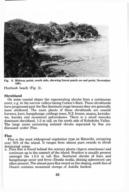
Fig. 6. Midway point, south side, showing forest patch on end point. November 1981.
Flaxbush beach (Fig. 2).
Shrubland On some coastal slopes the regenerating shrubs form a continuous
cover, e.g. in the narrow valleys facing Cocker's Rock. These shrublands have progressed past the flax dominant stage because they are generally more sheltered. The main plants of these shrublands are coastal karamu, karo, hangehange, cabbage trees, N.Z. broom, mapou, Kawakawa, karaka and occasional pohutukawa. There is a small manuka dominant shrubland, 1-3 m tall, on the north side of Kohekohe Valley. The large areas containing isolated shrubs separated by flax are discussed under Flax.
Flax Flax is the most widespread vegetation type on Rimariki, occupying
over 70% of the island. It ranges from almost pure swards to shrub dominated areas. a. Pure flax is found behind the century plants (Agave americana) and
continues up to the summit of the island. Bracken is usually present amongst the 1.5-2 m tall flax. Scattered shrubs of karo and hangehange occur and ferns (Doodia media, shining spleenwort) are often present. The almost pure flax sward on the sloping, south face of Omaro contains occasional clumps of Astelia banksii.
55
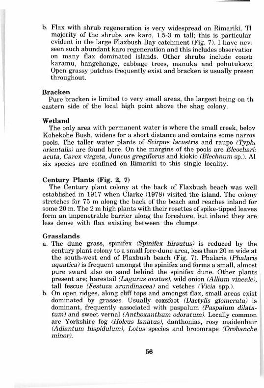
b. Flax with shrub regeneration is very widespread on Rimariki. Tl majority of the shrubs are karo, 1.5-3 m tall; this is particular evident in the large Flaxbush Bay catchment (Fig. 7). I have never seen such abundant karo regeneration and this includes observation on many flax dominated islands. Other shrubs include coastal karamu, hangehange, cabbage trees, manuka and pohutukawa Open grassy patches frequently exist and bracken is usually present throughout.
Bracken Pure bracken is limited to very small areas, the largest being on th
eastern side of the local high point above the shag colony.
Wetland The only area with permanent water is where the small creek, below
Kohekohe Bush, widens for a short distance and contains some narrow pools. The taller water plants of Scirpus lacustris and raupo (Typhi orientalis) are found here. On the margins of the pools are Eleocharis acuta, Carex virgata, Juncus gregiflorus and kiokio (Blechnum sp.). A l six species are confined on Rimariki to this single locality.
Century Plants (Fig. 2, 7) The Century plant colony at the back of Flaxbush beach was well
established in 1917 when Clarke (1978) visited the island. The colony stretches for 75 m along the back of the beach and reaches inland for some 20 m. The 2 m high plants with their rosettes of spike-tipped leaves form an impenetrable barrier along the foreshore, but inland they are less dense with flax existing between the clumps.
Grasslands a. The dune grass, spinifex (Spinifex hirsutus) is reduced by the
century plant colony to a small fore-dune area, less than 20 m wide at the south-west end of Flaxbush beach (Fig. 7). Phalaris (Phalaris aquatica) is frequent amongst the spinifex and forms a small, almost pure sward also on sand behind the spinifex dune. Other plants present are; harestail (Lagurus ovatus), wild onion (Allium vineale), tall fescue (Festuca arundinacea) and vetches (Vicia spp.).
b. On open ridges, along cliff tops and amongst flax, small areas exist dominated by grasses. Usually coxsfoot (Dactylis glomerata) is dominant, frequently associated with paspalum (Paspalum dilatatum) and sweet vernal (Anthoxanthum odoratum). Locally common are Yorkshire fog (Holcus lanatus), danthonias, rosy maidenhair (Adiantum hispidulum), Lotus species and broomrape (Orobanche minor).
56
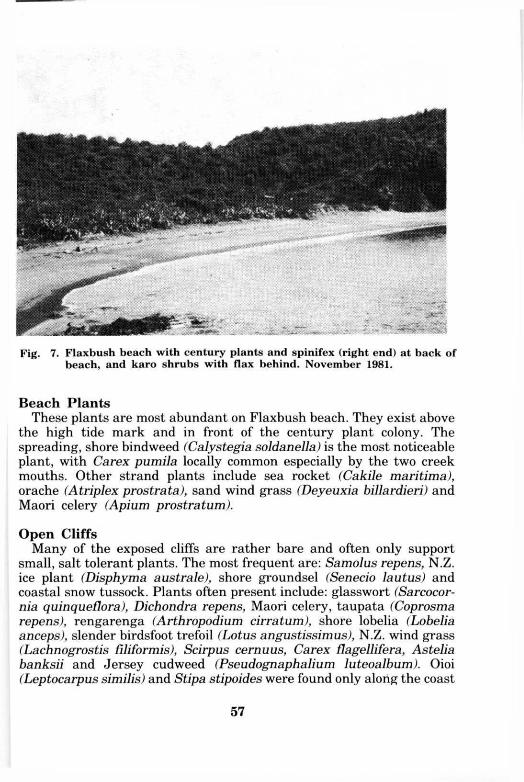
Fig. 7. Flaxbush beach with century plants and spinifex (right end) at back of beach, and karo shrubs with flax behind. November 1981.
Beach Plants These plants are most abundant on Flaxbush beach. They exist above
the high tide mark and in front of the century plant colony. The spreading, shore bindweed (Calystegia soldanella) is the most noticeable plant, with Carex pumila locally common especially by the two creek mouths. Other strand plants include sea rocket (Cakile maritima), orache (Atriplex prostrata), sand wind grass (Deyeuxia billardieri) and Maori celery (Apium prostration).
Open Cliffs Many of the exposed cliffs are rather bare and often only support
small, salt tolerant plants. The most frequent are: Samolus repens, N.Z. ice plant (Disphyma australe), shore groundsel (Senecio lautus) and coastal snow tussock. Plants often present include: glass wort (Sarcocornia quinqueflora), Dichondra repens, Maori celery, taupata (Coprosma repens), rengarenga (Arthropodium cirratum), shore lobelia (Lobelia anceps), slender birdsfoot trefoil (Lotus angustissimus), N.Z. wind grass (Lachnogrostis filiformis), Scirpus cernuus, Carex flagellifera, Astelia banksii and Jersey cudweed (Pseudognaphalium luteoalbum). Oioi (Leptocarpus similis) and Stipa stipoides were found only along the coast
57
from Porae to Midway Point. The prostrate Strathmore weed (Pimelea prostrata) is locally common. Many of these plants also occur in other open areas on the island, e.g. cliff tops and narrow ridges.
In the small fresh-water, coastal seepages over rocks, Scirpus cernuus was usually abundant. Chickweed (Stellaria media) and pearlwort (Sagina procumbens) often occurred and in one seepage the tiny plants of Lilaeopsis and Triglochin were common.
Cocker's Rock (Fig. 1, 8)
A small island of about 0.3 ha, and some 20 m A.S.L. It is encircled by a wide rock platform separated by a channel, 'Cocker's Gut' from Rimariki Island. Eighty-one species were recorded for Cocker's Rock during two visits (see annotated species list and Table 2).
The island is well vegetated, though bare ground is present next to and under pohutukawa on the north-east side and on an old slip face of the west side. The 1950 aerial photographs show the west side as being less vegetated than present day. Cocker's is dominated by pohutukawa 3-5 m tall. Frequent other larger plants include; karo, houpara, mapou, flax and coastal snow tussock. The two plants recorded here and not on Rimariki were both weeds — Cotula australis and purple cudweed (Gnaphalium coarctatum).
Motuwharariki Island (Fig. 1, 4)
A small, sloping islet of about 0.5 ha, over 20 m A.S.L., steeply cliffed on its eastern side and almost joined to north-eastern Rimariki by an extended rock platform. Although I was ashore only briefly I recorded 51 species (see annotated species list and Table 2) and an additional seven species were found by A . E . Wright during his November 1981 visit.
The open vegetation of the lower slopes were coastal snow tussock, taupata, flax, karo and Astelia banksii. The upper slope supported a low forest, 3-5 m tall, comprising mahoe, karaka, coastal karamu, karo and the occasional tawapou (Planchonella costata) and pohutukawa. Large-leaved milk tree (Streblus sp.) was represented by two trees and several smaller plants — a few as exposed shrubs on the western slope. Carmichaelia williamsii found here as a single plant, was not recorded elsewhere in the group and the only other locality for tawapou was Otawhanga Island.
Middle Reef Group (Fig. 1, 4)
A small group of islets with wide rock platforms but separated by
58
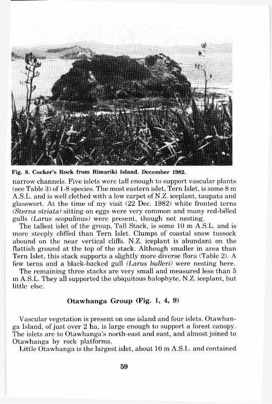
Fig. 8. Cocker's Rock from Rimariki Island. December 1982. narrow channels. Five islets were tall enough to support vascular plants (see Table 3) of 1-8 species. The most eastern islet, Tern Islet, is some 8 m A.S.L. and is well clothed with a low carpet of N.Z. iceplant, taupata and glasswort. At the time of my visit (22 Dec. 1982) white fronted terns (Sterna striata) sitting on eggs were very common and many red-billed gulls (Larus scopulinus) were present, though not nesting.
The tallest islet of the group, Tall Stack, is some 10 m A.S.L. and is more steeply cliffed than Tern Islet. Clumps of coastal snow tussock abound on the near vertical cliffs. N.Z. iceplant is abundant on the flattish ground at the top of the stack. Although smaller in area than Tern Islet, this stack supports a slightly more diverse flora (Table 2). A few terns and a black-backed gull (Larus bulleri) were nesting here.
The remaining three stacks are very small and measured less than 5 m A.S.L. They all supported the ubiquitous halophyte, N.Z. iceplant, but little else.
Otawhanga Group (Fig. 1, 4, 9)
Vascular vegetation is present on one island and four islets. Otawhanga Island, of just over 2 ha, is large enough to support a forest canopy. The islets are to Otawhanga's north-east and east, and almost joined to Otawhanga by rock platforms.
Little Otawhanga is the largest islet, about 10 m A.S.L. and contained
59
Table 3. Flora of islets.*
Island Group Middle Reef Otawhanga
Islet Tern Mid Tall East West East Second Holey Islet Stack Stack Pillar Pillar Stack Stack Stack
Dicots
Coprosma repens X X X X
Dichondra repens X
Disphyma australis X X X X X X X
Einadia triandra X
Pittosporum crassifolium X X
Polycarpon tetraphyllum X
Samolus repens X X
Sarcocornia quinqueflora X X X X X
Senecio lautus X X X X X X X
Sonchus oleracous X
Monocots
Chionochloa bromoides X X X
Paspalum vaginatum X
Rytidosperma sp. X
Scirpus nodosus X
TOTALS 6 3 8 2 1 7 2 8
F o r is let l o c a t i o n see F i g . 1
40 species (see annotated species list and Table 2). It is crowned with a knob of pohutukawa. Numerous shrubs of karo, houpara and taupata; clumps of flax, coastal snow tussock and bare earth dominate the steep sides. As well as the salt resistant herbs; Asplenium flaccidum ssp. haurakiense is frequent. Six species recorded here were not seen on the adjacent, far larger Otawhanga Island. They were possibly overlooked on Otawhanga Island as they are small annuals.
The other three islet floras are presented in Table 3. These small stacks less than 8 m A.S.L. support little (e.g. taupata or occasional karo), or no woody species. Shore groundsel is the only plant present on all three stacks. The salt resistant herbs of N.Z. ice plant, Samolus repens and glass wort were present in two of the stacks.
Otawhanga Island rises some 35 m A.S.L. and 71 species were recorded during a single brief visit (see annotated species list and Table 2). It is surrounded on three sides by steep, open cliffs. The south-
60
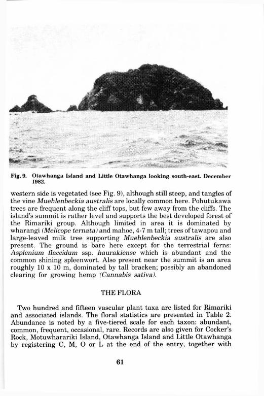
Fig. 9. Otawhanga Island and Little Otawhanga looking south-east. December 1982.
western side is vegetated (see Fig. 9), although still steep, and tangles of the vine Muehlenbeckia australis are locally common here. Pohutukawa trees are frequent along the cliff tops, but few away from the cliffs. The island's summit is rather level and supports the best developed forest of the Rimariki group. Although limited in area it is dominated by wharangi (Melicope ternata) and mahoe, 4-7 m tall; trees of tawapou and large-leaved milk tree supporting Muehlenbeckia australis are also present. The ground is bare here except for the terrestrial ferns: Asplenium flaccidum ssp. haurakiense which is abundant and the common shining spleenwort. Also present near the summit is an area roughly 10 x 10 m, dominated by tall bracken; possibly an abandoned clearing for growing hemp (Cannabis sativa).
T H E FLORA
Two hundred and fifteen vascular plant taxa are listed for Rimariki and associated islands. The floral statistics are presented in Table 2. Abundance is noted by a five-tiered scale for each taxon: abundant, common, frequent, occasional, rare. Records are also given for Cocker's Rock, Motuwharariki Island, Otawhanga Island and Little Otawhanga by registering C, M , O or L at the end of the entry, together with
61
herbarium sheet numbers, where voucher specimens exist. If not otherwise stated comments and herbarium vouchers refer only to Rimariki Island. Most of the vouchers lodged at A K were collected by A . E . Wright and the A K U specimens by E.K.C. Herbarium abbreviations follow Holmgren et al (1981). A n asterisk (*) denotes adventive or planted species.
Nomenclature of the ferns follows Brownsey et al (1985) and the angiosperms generally follow Allan (1961), Moore & Edgar (1970), Healey & Edgar (1980), Healy (1984), and Cheeseman (1925). Most of the adventive dicotyledons are also listed in a series of 'Checklists' in the N.Z. Journal of Botany, beginning in 1978. Nomenclature changes relating to native plants are reviewed by Edgar (1971) and Edgar and Connor (1978, 1983), many of these are followed.
Ferns
Adiantum cunninghamii maidenhair Occasional amongst tall grass, bracken, manuka and forest remnants.
A. hispidilum rosy maidenhair Abundant throughout. A K U 12232. Asplenium flaccidum ssp. haurakiense Common on coastal rocks. A K U 12284, M , A K U
14242 O and L. A. flaccidum ssp. haurakiense x A. oblongifolium Single terrestrial plant amongst bracken
and flax. Two plants in summit forest, Otawhanga Island. A K U 14199 and A K U 14182 0.
A. oblongifolium shining spleenwort Frequent amongst bracken, flax and in forest remnants. C, M and O.
Blechnum filiforme Rare, ground form only, Kohekohe Bush. B. sp. (B. capense sensu Allan, 1961) kiokio Creek margin in the open, below Kohekohe
Bush. A K 159079-80. Cheilanthes distans woolly cloak fern Otawhanga Island where it was occasional on dry,
open coastal slopes. O. C. sieberi cloak fern Local, common on grassy cliffs, south-west Flaxbush Bay. A K U 12229. Cyathea dealbata ponga Occasional, mainly in forest pockets, especially in Kohekohe
Bush. C. medullaris mamuka As for C. dealbata. Dicksonia squarrosa wheki Single trunkless plant, amongst bracken and shrubs, coastal
slope west of the island's summit. A K U 14195. Doodia media ssp. australis Frequent throughout, abundant through flax north of
Kohekohe Valley. C. Phymatosorus diversifolius hound's tongue Frequent, terrestrial and occasionally epiphy
tic especially in forest and shrubby areas. A K 159224, C, M and O. Pteridium esculentum bracken Abundant throughout. A K 159174, C, M and O. Pteris comans Occasional in forest remnants, common in Kohekohe Bush. A K 159136. P. macilenta Two plants in tall shrubland opposite Cocker's Rock. A K U 14208. P. tremula Occasional in forest remnants and in the open. A K 159137. Pyrrosia serpens Locally common on coastal rocks and tree (especially pohutukawa)
branches. C and O.
62
Gymnosperms
Cupressus macrocarpa* macrocarpa Single tree, c. 20 m tall, east end of Flaxbush beach. Cones present, no seedlings observed. A small tree skeleton lying near ridge between Flaxbush and Middle Bays appears to have been a macrocarpa as well. It is not evident in the 1950 aerial photograph and presumably it has been dead for a long time. Both must have been planted.
Dicotyledons Albizia lopantha* brush wattle Only seedlings present, at a single locality behind century
plant colony. A K 159110-16. Anagallis arvensis* scarlet pimpernel Common amongst coastal rocks and on banks. C, M ,
O and L. Apium prostratum ssp. prostratum Maori celery Common amongst coastal rocks, screes
and back of beaches. A K 159166, M and O. Atriplex prostrata orache Local, back of beaches. A K U 14197. Avicennia marina var. resinfera manawa Single plant c. 30cm tall in 1981, back of North
Cove, absent in 1982. Abundant precociously germinated seedlings on Flaxbush beach after a northerly storm.
Brachyglottis repanda rangiora Rare, upper forest margin in Kohekohe Valley. Brassica juncea* Indian mustard Local, coastal cliffs by shag colony and south side of
Flaxbush Bay. A K U 12292. Cakile maritima* sea rocket Local, back of several beaches. A K U 14221. Calystegia sepium greater bindweed Occasional through bracken and flax. C. soldanella shore bindweed Locally abundant, as at the back of Flaxbush beach. A K U
12246. C. tuguriorum Observed only at south end of Flaxbush Bay beach above spinifex dunes.
Sterile, glabrous (unusual for this species), spreading plant. A K U 14220. Cannabis sativa* hemp Three planted seedlings behind Flaxbush beach amongst flax,
December 1982. Carmichaelia aligera N.Z. broom Occasional on coastal slopes and common as large bushy
plants, up to 5 m tall, on Kohekohe Bush margin. A K U 14176 and C. C. williamsii A single 3.5 m tall plant, 8-10 cm diameter at base, in summit bush on
Motuwharariki Island. In November 1981 A . E . Wright found the upper two-thirds brown but alive, the lower third green and about 2 m wide. In December 1982 the upper two-thirds was dead. A K 156182 M .
Centaurium erythraea* centaury Frequent on coastal slopes and screes, some flowering plants only 7.5 cm tall. A K U 12294, C, M and L.
Cerastium glomeratum* annual mouse-ear chickweed Occasional amongst coastal rocks. C.
Cirsium vulgare* Scotch thistle Occasional, open areas. M and O. Clematis paniculata puawhananga Frequent in forest remnants. Conyza albida* (C. floribunda sensu Healy 1984) broad-leaved fleabane Common
throughout in open areas. C, M , O and L. Coprosma grandifolia kanono Single record from a bushy point between Onekura and
Middle Bay. C. macrocarpa coastal karamu Abundant throughout. A K U 15259, C, M and O. C. macrocarpa x C. propinqua Occasional, a series of forms in shrubby area opposite
Cocker's Rock. A K U 15258. C. macrocarpa x C. robusta As for the above hybrid. C. repens taupata Common on coastal rocks. C, M , O and L. C. robusta karamu Occasional, lower part of Kohekohe Valley and opposite Cocker's Rock. Coriaria arborea tutu Occasional, mainly in Kohekohe Valley and upper margin of forest
63
remnant opposite Cocker's Rock. C. Corynocarpus laevigatus karaka Frequent in forest and shrubland areas. A K U 12255, C,
M and O. Cotula australis* Rare, only depauperate plants on Cocker's Rock, coastal slope. A K U
12221 C. Crassula sieberiana Frequent on bare coastal rocks. A K 156152 and C. Crepis capillaris* hawksbeard Common in open areas. C and M . Dichondra repens Frequent on grassy coastal slopes and in forest remnants. C, M , O and L. Disphyma australe N.Z. ice plant Abundant on coastal rocks. C, M , O and L. Drosera peltata ssp. auriculata sundew Single locality, open mossy area surrounded by
manuka and flax, north side Kohekohe Valley. Dysoxylum spectabile kohekohe Rare, only in Kohekohe Bush. Single large spreading tree
c. 6 m tall, 80 cm dbh (diameter at breast height), November 1981. The ground beneath carpeted with kohekohe seedlings and some saplings also present. A K 159083.
Einadia triandra Local, coastal rocks near south end of island. O and L. Entelea arborescens whau Frequent in forest remnants. Eupatorium adenophorum* Mexican devil Abundant above and below the Kohekohe
Bush, absent elsewhere. A K 159082. Euphorbia peplus* milkweed Single plant, coastal rock, west of Flaxbush Bay. A K U
14229. Ficus carica* edible fig A few plants growing amongst century plant colony behind
Flaxbush beach. Probably originating from a single planting. Galium aparine* cleavers Local, through bracken and flax in Kohekohe Valley. Geniostoma rupestre var. crassum hangehange Common amongst flax and in shrubby cliff
associations. A K U 14203, C and M . Geranium solanderi "coarse hairs"* (see Gardner 1984) Common in grassy areas. A K U
12230 and C. Gnaphalium audax ssp. audax creeping cudweed Occasional, coastal rock and open cliffs.
A K U 12271, C, A K 156178 M and O. G. coarctatum* (G. spicatum sensu Healy 1984) purple cudweed Cocker's Rock only. A K U
12226 C. G. gymocephalum creeping cudweed Not observed on Rimariki, but seen on exposed
coastal slopes of two other islands. A K U 14214 C and A K U 14187 O. G. simplicicaule* Single plant, grassy area opposite Cocker's Rock. A K U 14226. Haloragis erecta shrubby haloragis Frequent on open coastal slopes and amongst bracken
and flax. A K 159167. Hebe stricta var. stricta koromiko Frequent on open coastal slopes and in shrubby areas.
A K U 12263 and C. H. sp. "m" Habitat as for H. stricta. This unnamed species differs from H. stricta by its
shorter, more oblong-shaped leaves and larger seed capsules. (Determination by A.P. Druce, 1986). Eagle (1982) p. 344 records this species only for the Whangarei Heads area; apart from Rimariki it also occurs at Cape Brett ( A K U 13780). A K 156144.
Hibiscus trionum* Single plant c. 50 cm tall, open grassy area, north-facing slope west of Flaxbush Bay.
Hypochaeris radicata* catsear Common throughout in open areas. C, M , O and L. Lepidium pseudo-tasmanicum* Rare, several plants at base of coastal scree, west of
Flaxbush Bay. Locally common by avian burrows on Cocker's Rock. A K U 12223 C. Leptospermum scoparium manuka Frequent, especially along cliff-tops and ridges. C. Leucopogon fasciculatus mingimingi Common on fairly open coastal slopes and occasional
amongst bracken. C, M , O and L. L. fraseri patotara Locally abundant along the tops of bare coastal cliffs. Lilaeopsis sp. In Fresh-water seepage along cracks in coastal rock, opposite Cocker's Rock.
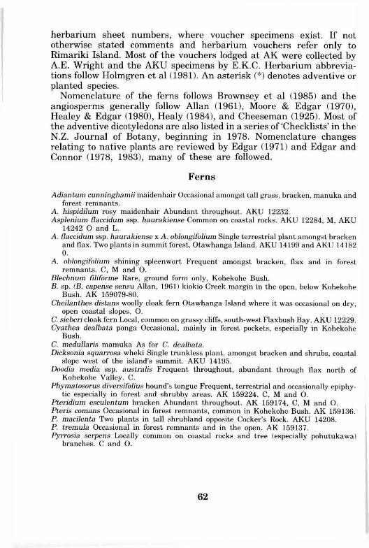
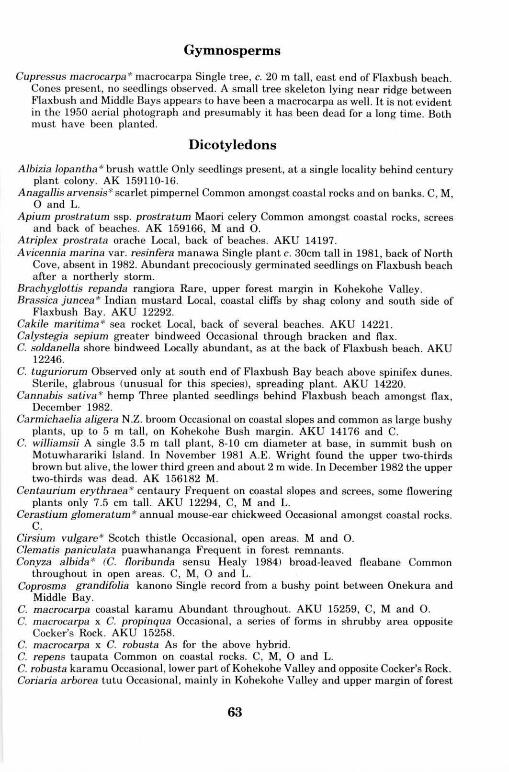
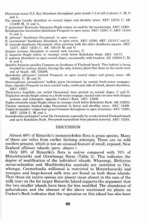
Ovoid green fruit c. 1.5 mm long, ribs faint. A K U 14243. Linum monogynum Occasional on coastal rock faces (see Fig. 10). A K U 12273.
64
Fig. 10. Linum monogynum, coastal slope, Rimariki Island. November 1981.
L. trigynum* yellow flax Occasional in dry grassy areas. A K U 14216. Lobelia anceps shore lobelia Common on coastal rocks, especially by fresh-water seepages.
A K 156599 and C. Lotus angustissimus* slender birdsfoot trefoil Abundant, coastal rock faces and open
areas. A K U 12290 and C. L. pedunculatus* lotus Common in grassy, bracken and flax vegetation. A K U 12252. L. suaveolens* hairy birdsfoot trefoil As for L. angustissimus but not as common. A K U
12235, A K U 12227 C and O. Lycium ferocissimum* boxthorn Represented by only 4 bushes: 1 on Otawhanga Island
and 3 on Little Otawhanga. A l l were cut down in December 1982. O and L. Macropiper excelsum var. excelsum kawakawa Common in forest remnants, some up to 5
m tall. A K U 12237, M and O. Medicago lupulina* black medick Occasional, open grassy areas. A K 156185 and O. M. polymorpha* bur medick Common, open, coastal areas. A K U 12245. Melicope ternata wharangi Represented only on Otawhanga Island where it is abundant
as trees near the summit, up to 7 m tall with 35 cm dbh. O. Melicytus novae-zelandiae ssp. novae-zelandiae Otawhanga Island where it was occasional
near summit. O. M. novae-zelandiae x M. ramiflorus A single plant on Motuwharariki Island (Determina
tion by R.O. Gardner, 1986). A K 156177 M . M. ramiflorus ssp. ramiflorus mahoe Frequent in forest remnants, usually less than 4 m
tall. Abundant on the summit of Otawhanga Island. A K U 12247, M and O. Metrosideros excelsa pohutukawa Abundant large trees on cliff faces and high points.
Occasional regeneration amongst flax. C, M , O and L. Muehlenbeckia australis Confined to Otawhanga Island where it was locally abundant
climbing over the taller vegetation. A K U 14179 0. M. complexa wire vine Abundant as tangles on the coastal margin of vegetation and also
present inland amongst bracken and flax. C, M , O and L. Myoporum laetum var. decumbens ngaio Single low spreading plant with wide glossy
65
leaves (up to 12.5 x 6.0 cm), back of small rocky beach amongst decaying seaweed in fresh-water seepage, south of Midway Point in 1981, absent in 1982. A K U 12238.
Myrsine australis mapou Common in forest remnants and occasional in shrubby areas. C and O.
Olearia furfuracea akepiro Coastal slopes which escaped the most recent burning. Orobanche minor* broomrape Abundant in open grassy areas. C, M and L. Oxalis exilis Occasional in forest remnants and coastal slopes. A K U 12250. O. rubens (O. stricta sensu Allan 1961) Common in open areas. A K U 12264 C, M and O. Parentucellia viscosa* tarweed Local on open coastal cliffs. A K 156101. Parietaria debilis Rare, only observed in coastal forest remnant by shag colony. Common
on summit of Otawhanga Island by avian burrows. A K U 14181 0. Peperomia urvilleana Common on shaded rocks. C, O and L. Physalis peruviana* cape gooseberry Rare, below Kohekohe Bush. A K 159134. Phytolacca octandra* inkweed Rare, in coastal forest remnant, Midway Point. Occasional
on Otawhanga Island. C and O. Pimelea prostrata Strathmore weed Common in open coastal areas. C, M , O and L. Pittosporum crassifolium karo Abundant throughout mainly as 1.5-2.5 m high regenerat
ing shrubs growing through flax. C, M , O and L. P. umbellatum Frequent throughout, usually as a small round-headed tree. A K U 12266
and M . Planchonella costata tawapou Present in Motuwharariki Island's bush. Frequent as small
trees (up to 7 m tall) in summit forest on Otawhanga Island. A K 156175 M and A K U 14185 0.
Plantago major* broad-leaved plantain Rare, several plants at back of rocky beach in fresh-water seepage, south of Midway Point. A K U 12241.
Polycarpon tetraphyllum* allseed Common in open areas throughout. A K 156200, C, M , O and L.
Pomaderris phylicifolia var. ericifolia whatitiri Rare, present on grassy ridge between Flaxbush and Middle Bays. A K U 12255.
Pseudognaphalium luteoalbum Jersey cudweed Common, coastal rocks and open cliffs. C and O.
Pseudopanax lessonii houpara Frequent, mainly on coastal slopes. C, A K U 14180 O and L. Rumex brownii* hooked dock Frequent on grassy coastal slopes and amongst bracken and
flax. A K U 14178. R. conglomeratus* clustered dock Occasional behind century plants and by mouth of
Kohekohe Valley creek. A K 159165. R. crispus* curled dock Local, several plants with the Plantago. A K U 12240. Sagina apetala* annual pearlwort Occasional, coastal rock crevices. A K U 14211 and C. S. procumbens* pearlwort Occasional on coastal rock by fresh-water seepages. Samolus repens Abundant on bare coastal rocks. C, M , O and L. Sarcocornia quinqueflora ssp. quinqueflora glasswort Frequent on bare coastal rocks in
splash zone. M , O and L. Scleranthus biflorus Single clump, exposed cliff top, Hopenototi. A K U 14210. Senecio diaschides* fireweed Rare, open coastal site. A K 156105. S. hispidulus fireweed Occasional in open areas. A K U 12276 and A K U 12220 C. S. kirkii var. kirkii Kirks tree daisy Six shrubs on shaded bank, margin of forest remnant,
Midway Point. A K U 14202. S. lautus ssp. lautus shore groundsel Common on coastal rocks. A K U 12259, C, M , O and
L. Silene gallica* catchfly Occasional on exposed bare ground. C, O and L. Solanum americanum small-flowered nightshade Frequent on open coastal slopes. C and
O. S. nigrum* black nightshade Occasional on Rimariki and Otawhanga Islands. O. Sonchus oleraceus* sowthistle Common in open areas. C, M , O and L.
66

Sophora microphylla kowhai No plants observed. Seeds were common along the tide line of Flaxbush beach, about one quarter (12/50) germinated when scarified and potted up (January 1983).
Stellaria media* chickweed Occasional on coastal rocks with fresh-water seepages. A K U 12239.
Streblus sp. (Paratrophis banksii) large-leaved milk tree Single seedling (<1 m tall) under pohutukawa on ridge facing Omaro. Frequent in summit forest on Otawhanga Island « 5 m tall and 25 cm dbh). A K 156409, A K U 14225 M and A K U 14183 0.
Trichocereus l pachianus* cactus Single plant less than 50 cm tall, behind century plants, Flaxbush beach. Presumed planted. Cut off at ground level in 1981. A K 161273.
Trifolium dubium* suckling clover Common amongst low vegetation on coastal cliffs. A K U 12228, C, M , O and L.
T. glomeratum* clustered clover Occasional in grassy areas in Flaxbush Bay catchment. A K U 12288 and O.
Verbena bonariensis* purple top Frequent in open areas. A K 156143. Vicia sativa* vetch Abundant on grassy dunes and in other open areas. A K U 12267 and C. V. tetrasperma* four-seeded vetch As for V. sativa, frequently growing together. A K U
14201, C and M . Wahlenbergia marginata harebell Occasional in open coastal sites. C.
Monocotyledons
Agave americana* century plant Abundant large plants along the foreshore of Flaxbush beach (Fig. 2, 7). It is slowly spreading vegetatively via rhizomes along and behind the beach. Several tall inflorescences were present and some plants may have established from seed or bulblet, though no individuals were more than 10 m away from the main colony. Presumed to have spread from an original planting. A K U 14228.
Agrostis capillaris* browntop Local, rank grassy areas by Omaro. A K U 12287. A. gigantea* redtop Rare, amongst low bracken and flax, north end of Flaxbush beach.
A K U 14198. Aira caryophyllea* silvery hair grass Frequent in bare, exposed areas. A K U 12278, C, O
and L. A. praecox* early hair grass Local, only found close to Rimariki, on a separate stack
opposite Cocker's Rock. A K 156213. Allium vineale* wild onion Occasional amongst spinifix and phalaris at south-west end of
Flaxbush beach. A K U 12243. Anthoxanthum odoratum* sweet vernal Frequent, coastal grassy faces. C, O and L. Arthropodium cirratum rengarenga Common on coastal cliffs. C, M and O. Astelia banksii Common on coastal cliffs and amongst flax. C, M and O. Avena barbata* slender oat Frequent in grassy areas. A K U 12217 C, A K 173488 M and L. Briza minor* shivery grass As for Avena, though usually amongst shorter vegetation. C, M
and L. Bromus hordeaceus* soft brome Frequent, as for Briza. C and M . B. wildenowii* prairie grass Occasional on coastal cliffs, south-east side of island. A K U
12258, O and L. Carex breviculmis Frequent on bare coastal slopes and occasionally amongst bracken.
A K U 14189 and A K U 14186 O. C. dissita Occasional in bracken and shrubby areas. A K U 14207 and A K U 14223 M . C. flagellifera Frequent on coastal cliffs, virtually down to sea level. A K U 12262, A K U
14215 C and A K U 14224 M . C. inversa Frequent in grassy areas. A K U 14171. C. pumila Occasional colonies along upper Flaxbush beach. A K U 12251. C. spinirostris Occasional in forest remnants, south-east coast. A K U 12270.
67
C. testacea Rare, main ridge under shrubs, south-western end. A K U 12282. C. virgata Local, swampy creek margin in the open, below Kohekohe Bush. A K U 1225J Chionochloa bromoides coastal snow tussock Common on coastal rocks and cliffs. A K
12286, C, A K 156180 M , O and L. Chloris gay ana* Rhodes grass Single locality, summit of Omaro, in rank grassland. A l
156154. Cordyline australis cabbage tree Frequent, especially in Kohekohe Valley and open coasts
slopes opposite Cocker's Rock. Cortaderia selloana* pampas grass Several clumps of plants at 4 localities, as marked oi
Fig. 5. Cynodon dactylon* Indian doab Local, small grassy area, exposed cliff top, Hopenototi
A K U 14212. Cyperus ustulatus Occasional on coastal slopes, virtually down to sea level. O. Dactylis glomerata* cocksfoot Abundant in open areas of low vegetation. A K 156230, C, M
O and L. Deyeuxia billardieri sand wind grass Frequent in coastal areas, especially in the dunes al
the back of Flaxbush beach. A K U 12260, C and M . Dianella nigra turutu Occasional in coastal shrub vegetation. C and O. Dichelachne crinita long-hair plume grass Frequent in grassy areas throughout. A K U
12233, A K U 12222 C, M , O and L. D. micrantha short-hair plume grass Common in open areas on coastal slopes. A K U 12231. Eleocharis acuta Local, margin of swampy creek below Kohekohe Bush. A K U 14175. Elymus multiflorus Frequent on dry coastal slopes. A K U 14191, C, M and A K U 14188 O. E. rectisetus Occasional in dry grassy areas. A K U 14213. Festuca arundinacea* tall fescue Occasional in dunes behind Flaxbush beach. A K U 12261. F. rubra* red fescue Local, through rank grassland, summit of Omaro. A K U 14193. Gahnia lacera Frequent in regenerating stands and forest remnants. C and M . Gastridium ventricosum* nit grass Occasional in dry open areas. A K U 14217. Gladiolus natalensis* wild gladiolus Occasional in dunes behind Flaxbush beach.
Presumed originally planted. A K 156159. Holcus lanatus* Yorkshire fog Frequent, open grassy areas. Hordeum leporinum* barley grass Rare, bare coastal rocks opposite Cocker's Rock. A K U
12293. Juncus gregiflorus rush Occasional, swampy creek margin below Kohekohe Bush. A K U
12254. Lachnogrostis filiformis N.Z. wind grass Occasional in coastal rock crevices and open
areas. A K U 12268, M and L. Lagurus ovatus* harestail Occasional on open coastal slopes and grassy dunes behind
Flaxbush beach. A K 156209. Leptocarpus similis oioi Locally common on coastal rocks, south-east coast, but absent from
most of the island's shoreline. Lolium perenne* perennial ryegrass Occasional on grassy slope, Omaro. Microlaena stipoides meadow rice grass Occasional in grassy, low bracken-flax areas. Microtis unifolia Occasional in open grassy areas. A K U 12244 and C. Narcissus sp* Rare, in dunes behind Flaxbush beach amongst century plants. Presumed
originally planted. Oplismenus imbecillis Frequent in forest remnants and shrubby areas. A K U 14177. Parapholis incurva* sickle grass Occasional in coastal rock crevices. A K U 12272. Paspalum dilatatum* paspalum Abundant in grassy areas. C, O and L. P. orbiculare scrobic Occasional, mainly amongst bracken and flax in the catchment of
Flaxbush Bay. A K U 14174. P. vaginatum saltwater paspalum Frequent on bare coastal rocks. A K 159118. Phalaris aquatica* phalaris Abundant over the dunes behind Flaxbush beach; occasional
in open grassy areas elsewhere. A K U 14219.
68
Phormium tenax N.Z. flax Abundant throughout; pure stands 1-3 m tall in places. C, M , O and L.
Poa anceps Locally abundant on coastal slopes and shrubby areas. A K U 12279, C, A K 173489 M , O and L.
P. pratenisis* Kentucky bluegrass Single colony on sand by the macrocarpa. A K U 12265. Rytidosperma biannulare danthonia Frequent in open areas. A K U 12281, C, A K U 14184
O and L. R. pilosum* danthonia Occasional, in open areas. R. racemosum* danthonia Abundant, in open areas. A K U 12280, A K U 12219 C and O. R. unarede danthonia Occasional, often growing with the other danthonia species. A K U
12277, A K U 12225 C, A K 156176 M and O. Scirpus cernuus Abundant in coastal rock crevices. C. S. lacustris Single colony in swampy creek below Kohekohe Bush. A K U 14173. S. nodosus Abundant on open coastal slopes, occasionally with bracken. A K 156204 C, M ,
O and L. Spinifex hirsutus spinifex Common on foredunes of Flaxbush beach. This habitat is being
invaded by century plants, leaving the only century plant-free dune at the south-west end of beach. A K 156208.
Sporobolus africanus* ratstail Frequent on open coastal slopes and grassy areas. A K 156202, C, M and O.
Stenotaphrum secundatum* buffalo grass Occasional, by coastal fresh-water seepages. Stipa stipoides Frequent on bare coastal rocks, south-east side of island, absent elsewhere.
A K U 12257. Thelymitra longifolia sun orchid Occasional, bare ground on coastal slopes. C and O. Triglochin striata Single colony in a fresh-water seepage, coastal rock crevices with Scirpus
cernuus and Lilaeopsis; opposite Cocker's Rock. A K U 14206. Typha orientalis raupo Single colony in swampy creek below Kohekohe Bush. A K 159223. Uncinia uncinata hooked sedge Occasional in forest and shrubby areas. A K U 14209. Vulpia bromoides* vulpia hair grass Common throughout in open situations. A K U 12291,
A K U 12224 C, M and L. Zantedeschia aethiopica * arum lily Occasional, especially by creeks behind Flaxbush beach
and up to Kohekohe Bush. Presumed naturalised from planted material. A K U 12242.
DISCUSSION
Almost 60% of Rimariki's monocotyledon flora is grass species. Many of these are relics from earlier farming attempts. There are no wild conifers present, which is not an unusual feature of small, exposed, New Zealand offshore islands (pers. observ.).
Only 59% of Rimariki's flora is native compared with 70% of Motuwharariki and Otawhanga floras (Table 2). This indicates the degree of modification of the individual islands. Wharangi, Melicytus novae-zelandiae and Muehlenbeckia australis are restricted to Otawhanga; Carmichaelia williamsii is restricted to Motuwharariki and tawapou and large-leaved milk tree are found on both these islands. That these six native species are absent (near absent in the case of the milk tree) on the far larger Rimariki Island supports the argument that the two smaller islands have been far less modified. The abundance of pohutukawa and the absence of the above mentioned six plants on Cocker's Rock indicates that the vegetation on this island has also been
69
modified, probably up until earlier this century. There are a number of plant species on Rimariki that have been
planted in earlier times and have since persisted or naturalised. These include; macrocarpa, edible fig (Ficus carica), century plant, wild gladiolus (Gladiolus natalensis), Narcissus and arum lily (Zantedeschia aethipica). They are all present behind Flaxbush beach. The century plants were well established in 1917 (Clarke 1978) and the macrocarpa was tall in 1950, indicating that they, and possibly the other four species were introduced to the island a long time ago. Perhaps they were introduced by someone living on the island last century, but I have found no record of this. Hemp and the cactus (Trichocereus) are recent plantings.
WEEDS
My definition of a bad weed is an introduced plant that may dominate the vegetation for a long time and in so doing prohibit regeneration of native species.
Pampas grass is potentially a bad weed present on Rimariki and is capable of growing several metres tall and several metres wide. It was sprayed with a systemic herbicide (amitrole) by R.E. Beever at three of the four Rimariki localities in December 1982 (see Fig. 5 for their location). The plants recovered from the single spraying, and the Mimiwhangata ranger sprayed them again in recent years. Continued regeneration of the island's vegetation will eliminate many establishment sites, leaving the coastal cliffs as the major potential site for this light demanding weed. Because the seeds are wind dispersed, Mimiwhangata Station should also be cleared of pampas grass and recently the mainland plants adjacent to Rimariki were sprayed.
The other major weed on the island is the large fleshy succulent, century plant, growing along the foredune of the Flaxbush beach (Fig. 2, 7). Although its inland spread will be retarded by regeneration of taller species, its removal is desirable because: it is slowly continuing to spread; it dominates the beach landscape; its sharp leaf tips are dangerous and it is unlikely to be replaced by regenerating vegetation. Several chemical controls were tried on some of the plants by R.E. Beever in December 1982 (see O.I.R.G. 1982b), but after a year the plants were virtually back to normal. Physical removal and spraying of the few large clumps and numerous small ones was carried out on plants which had extended past the two creek beds in 1982. Removal of the plants from these two areas has been continued to contain the colony to between the creeks.
In 1982 there was still brush wattle (Albizia lophantha) seed in the soil where the single tree was cut down in February 1981. Over 600 seedlings were removed during 1981-82 and more have been removed in
70
recent years as they appear. If allowed to establish, brush wattle would develop into a small tree and could quite rapidly dominate the more open areas. In the short term this may not appear desirable, but in the long-term it would be replaced at most sites by taller growing, longer lived native species. The advantages of brush wattle would be to add nitrogen to the soil and provide shelter; thereby speeding up the progression to forest. It would also provide nectar for birds in the winter. On Tiritiri Matangi Island in the Hauraki Gulf, the vegetation is at a relatively similar stage to Rimariki and brush wattle has failed to spread from a single valley where it was recorded by Esler (1978) over eleven years ago.
The only other potentially bad weed is the spiny, woody shrub, boxthorn (Lycium ferocissimum) which is a noxious plant (Healy 1984) growing to c. 3 m tall. Four plants were cut down on the Otawhanga group in 1982. The occasional monitoring of the open coastal cliffs would be worthwhile to make sure this plant does not re-establish.
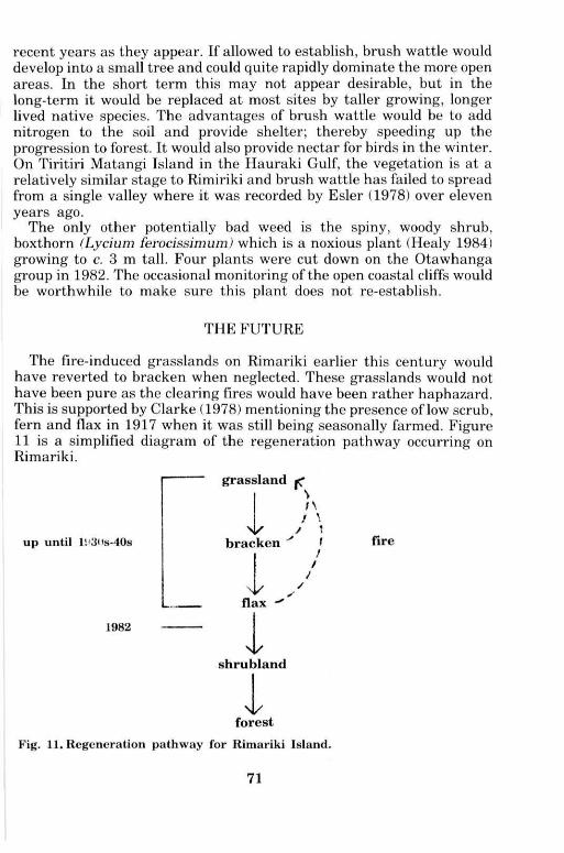
THE F U T U R E
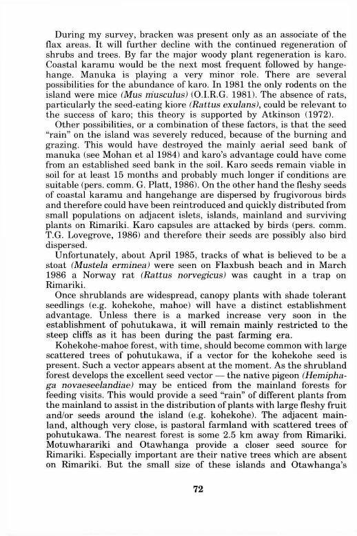
The fire-induced grasslands on Rimariki earlier this century would have reverted to bracken when neglected. These grasslands would not have been pure as the clearing fires would have been rather haphazard. This is supported by Clarke (1978) mentioning the presence of low scrub, fern and flax in 1917 when it was still being seasonally farmed. Figure 11 is a simplified diagram of the regeneration pathway occurring on Rimariki.
up until l!>3<>s-40s
grassland \ n
/ \ V / \
bracken v f
flax
1982
shrubland
fire
Fig. 11. Regeneration pathway for Rimariki Island.
71
During my survey, bracken was present only as an associate of the flax areas. It will further decline with the continued regeneration of shrubs and trees. By far the major woody plant regeneration is karo. Coastal karamu would be the next most frequent followed by hangehange. Manuka is playing a very minor role. There are several possibilities for the abundance of karo. In 1981 the only rodents on the island were mice (Mus musculus) (O.I.R.G. 1981). The absence of rats, particularly the seed-eating kiore (Rattus exulans), could be relevant to the success of karo; this theory is supported by Atkinson (1972).
Other possibilities, or a combination of these factors, is that the seed "rain" on the island was severely reduced, because of the burning and grazing. This would have destroyed the mainly aerial seed bank of manuka (see Mohan et al 1984) and karo's advantage could have come from an established seed bank in the soil. Karo seeds remain viable in soil for at least 15 months and probably much longer if conditions are suitable (pers. comm. G. Piatt, 1986). On the other hand the fleshy seeds of coastal karamu and hangehange are dispersed by frugivorous birds and therefore could have been reintroduced and quickly distributed from small populations on adjacent islets, islands, mainland and surviving plants on Rimariki. Karo capsules are attacked by birds (pers. comm. T.G. Lovegrove, 1986) and therefore their seeds are possibly also bird dispersed.
Unfortunately, about April 1985, tracks of what is believed to be a stoat (Mustela erminea) were seen on Flaxbush beach and in March 1986 a Norway rat (Rattus norvegicus) was caught in a trap on Rimariki.
Once shrublands are widespread, canopy plants with shade tolerant seedlings (e.g. kohekohe, mahoe) will have a distinct establishment advantage. Unless there is a marked increase very soon in the establishment of pohutukawa, it will remain mainly restricted to the steep cliffs as it has been during the past farming era.
Kohekohe-mahoe forest, with time, should become common with large scattered trees of pohutukawa, if a vector for the kohekohe seed is present. Such a vector appears absent at the moment. As the shrubland forest develops the excellent seed vector — the native pigeon (Hemiphaga novaeseelandiae) may be enticed from the mainland forests for feeding visits. This would provide a seed "rain" of different plants from the mainland to assist in the distribution of plants with large fleshy fruit and/or seeds around the island (e.g. kohekohe). The adjacent mainland, although very close, is pastoral farmland with scattered trees of pohutukawa. The nearest forest is some 2.5 km away from Rimariki. Motuwharariki and Otawhanga provide a closer seed source for Rimariki. Especially important are their native trees which are absent on Rimariki. But the small size of these islands and Otawhanga's
72
relative remoteness will make the establishment process of these plants very slow. The plants with bird-dispersed seed should show a marked advantage over other plant species.
The flora of the nearby Ngataurua Rock (see Wright 1982) will provide no new species to the Rimariki group save Poa annua (AK 156290) which was possibly overlooked on Rimariki anyway. Note — Avena fatua recorded by Wright for the Ngataurua Rock should be A. barbata.
Flocks of mynas (Acridotheres tristis) numbering up to 58 birds, were seen flying to and from Rimariki. Possibly these birds are vectors for some plant species. No tui (Prosthemadera novaeseelandiae) were seen on the island during our visits even though the flax was flowering.
Rimariki is regenerating well towards native forest. The developing karo-dominant shrubland of Flaxbush Bay catchment is most unusual. Monitoring and removal of potentially bad weeds is the only vegetation management required. This will prove less of a problem as the island's vegetation grows taller and the gaps are filled. Future monitoring of vegetation changes and the arrival of new species will be scientifically interesting.
A C K N O W L E D G E M E N T S
I thank Lion Breweries Ltd, Mimiwhangata Farm Park Charitable Trust, Hauraki Gulf Maritime Park Board, Whangaruru, Mokau & Whananaki Maori Committees for permission for the research to take place. Also acknowledged is the assistance of other O.I.R.G. members in locating plants, especially A . E . Wright and R.E. Beever for several records unseen by me; R.V. Grace and the Department of Lands and Survey for information about the area; R.V. Grace for transport to and from the islets and islands, and for information on the current situation on Rimariki; R.O. Gardner and C.N. Taylor for comments on the draft manuscript; R. Arthur and R.I. Matthews for typing it.
R E F E R E N C E S
Allan, H .H. 1961: Flora of New Zealand. Vol. I. Government Printer, Wellington. 1085p. Atkinson, I.A.E. 1972: Vegetation and flora of Sail Rock, Hen and Chickens Islands. New
Zealand Journal of Botany 10: 545-558. Ballantine, W.J., Grace, R.V. & Doak, W.T. 1973: Mimiwhangata Marine Report. Turbott
& Halstead, for N.Z. Breweries Ltd. 98 p. Brownsey, P.J . , Given, D.R. & Lovis, J .D. 1985: A revised classification of New Zealand
pteridophytes with a synonymic checklist of species. New Zealand Journal of Botany 23 (3): 431-489.
Calder, A. 1972: Mimiwhangata Archaeological Report. Turbott & Halstead for N.Z. Breweries Ltd. 23 p.
Cheeseman, T.F. 1925: Manual of the New Zealand flora, ed. 2. Wellington, Government Printer. 1163 p.
Clarke, D. 1978: Mimiwhangata Station. F. Keene Publishers, Whangarei. 109 p. Dart, J . ; Drey, B. & Grace, R.1982: Mimiwhangata Marine Park Environmental Impact
Report. For Hauraki Gulf Maritime Park Board. 143 p. Eagle, A. 1982: Eagles trees and shrubs of New Zealand. 2nd series. Auckland, Collins. 382
P-Edgar, E. 1971: Nomina nova plantarum Novae-Zelandiae 1960-1969. Gymnospermae,
73
Angiospermae. New Zealand Journal of Botany 16: 322-330. Edgar, E. & Connor, H.E. 1978: Nomina nova II, 1970-1976. New Zealand Journal ,
Botany 16: 103-118. Edgar, E. & Connor, H.E. 1983: Nomina nova III, 1977-1983. New Zealand Journal i
Botany 21: 421-441. Esler, A . E . 1978: Botanical features of Tiritiri Island, Hauraki Gulf, New Zealand. Ne\
Zealand Journal of Botany 16(2):207-226. Gardner, R.O. 1984: Geranium solanderi and allies in New Zealand. New Zealand Journal
of Botany 22: 127-134. Healy, A . J . 1984: Standard common names for weeds in New Zealand, ed. 2. New Zealand
Weed and Pest Control Society, Hastings. 207 p. Healy, A . J . & Edgar, E. 1980: Flora of New Zealand. Vol. III. Wellington, Government
Printer. 354 p. Holmgren, P.K.; Keuken, W. & Schofield, E.K. 1981: Index Herbariorum. Regnum
vegetabile 106: 1-452. Kear, D. & Hay, R.F. 1961: Sheet 1, North Cape (1st ed.). Geological map of New Zealand.
1:250,000. Department of Scientific and Industrial Research. Mohan, E; Mitchell, N . & Lovell, P. 1984: Environmental factors controlling germination of
Leptospermum scoparium (manuka). New Zealand Journal of Botany 22 (1): 95-101. Moore, L.B. & Edgar, E. 1970: Flora of New Zealand. Vol. II. Wellington, Government
Printer. 354 p. New Zealand Meteorological Service 1983: Summaries of Climatological Observation to
1980. New Zealand Meteorological Service Miscellaneous Publication 177: 1-172. Offshore Islands Research Group 1981: Preliminary report on scientific camp to Rimariki
Island, Mimiwhangata, November 1981. Unpublished. 3 p. Offshore Islands Research Group 1982a: Preliminary report on second scientific camp to
the Mimiwhangata area, February 1982. Unpublished. 5 p. Offshore Islands Research Group 1982b: Preliminary report on third scientific camp to the
Mimiwhangata area, December 1982. Unpublished. 10 p. Wright, A . E . 1982: Ngataurua Islets, Mimiwhangata. Auckland Botanical Society
Newsletter 37 (1): 8-10.
74