Embed Size (px)
Citation preview
3. VARIABILITY OF AMERICAN MONSOON SYSTEMS(VAMOS) (G3)3.1 SCIENTIFIC RATIONALE
The word monsoon is derived from an Arabian word referring to season: it was the term used bysailors to describe the seasonal reversal of the winds over the Arabian Sea. It is now applied to lowlatitude regions that experience pronounced changes in the low-level circulation and precipitationregimes that result from the seasonal cycle of heating associated with the reversal of thetemperature gradient between continents and oceans.
3.1.1 The American monsoon systems
The Asian-Australian and American monsoon systems are the two dominant monsoon systems ofthe world. Viewed in a global context, these two systems constitute major components of thelow-latitude atmospheric heating field and the seasonally-varying, zonally-averaged HadleyCirculation. During most of the year, the dominant feature of the low-latitude Hadley Circulationis a single direct cell which links the two hemispheres (descending motion in the winterhemisphere; ascending motion in the summer hemisphere). Similarly, the regional monsoonalcomponents of the Hadley Circulation link the winter monsoon circulation of one hemisphere withits summer monsoon counterpart.
The configurations (size, shape and location) of the land masses and surrounding ocean featuresinvolved in the Asian-Australian and American monsoon systems have important differences:
The distribution of land and ocean in the Asian-Australian sector is largely north-southoriented, with land (ocean) primarily to the north and ocean (land) primarily to the south inAsia and vice versa in Australia. Over the Americas, the orientation of the land masses isprimarily north-south, with oceans to the east and west.The major mountain complex of southern Asia has an east-west orientation, while the majorwestern continental mountain ranges over the Americas extend north and south for the entirelength of both continents.The continents of the Americas are more similar in size than Asia and Australia, but exhibitdifferent asymmetries. Most of the land mass of South America is at low latitudes, and infact extends into the northern hemisphere, while North America resides in the middle andhigh latitudes.The Intertropical Convergence Zone (ITCZ) in the Asian-west Pacific sector executes apronounced inter-hemispheric seasonal migration, while its counterpart in the eastern Pacificand eastern Atlantic executes a much smaller seasonal migration and remains north of theEquator (except for a weak secondary ITCZ that sometimes develops west of south Americaduring the height of the warm season). Associated with this asymmetry is the great contrastbetween the relatively warm waters of the North Atlantic and Pacific and the colder watersof the South Atlantic and Pacific.
Turning to the individual continental scale features, the definition of a monsoon region has centredon the requirement of a reversal in the low-level flow and the steadiness of this flow (Fein andStephens, 1987). One can also describe a three dimensional, continental scale "monsooncirculation system", which includes both an upward branch associated with the region of enhanced
Variability of the American Monsoon Systems (G3) http://www.clivar.org/sites/default/files/imported/organization...
1 von 38 06.10.14 19:20

precipitation (e.g. the Indian "monsoon") and a downward branch associated with regions ofsuppressed precipitation (e.g. the compensating subsidence over the arid regions of the MiddleEast). The monsoon system perspective provides a useful framework for describing, understandingand modelling the annual cycle and interannual variability of the low and middle latitudecontinental precipitation and associated temperature regimes.
Fig. 3.1 shows the Northern Hemisphere wet season (June-July-August) and Southern Hemispherewet season (December-January-February) rainfall. The continental monsoons and the oceanicITCZs are clearly seen in this figure. During the Northern Hemisphere wet season, the northernbranch of the Pacific ITCZ extends across much of the basin and merges with the continentalmonsoons of Mexico, central America and northern South America. In the Atlantic the ITCZ is atits most northern position and also merges with the monsoon over northern South America.During the Southern Hemisphere wet season, the ITCZ in both oceans weakens and the monsoonover Amazonia dominates and merges with the South Atlantic Convergence Zone (SACZ). In thiscontext, the rainfall climatology of the low and middle latitude continental regions of theAmericas is dominated by the eastern Pacific and western Atlantic ITCZs and the seasonalcontinental monsoons.
3.1.1.1 The monsoon system in the Northern Hemisphere
Climatologists and meteorologists have long referred to a "southwest monsoon" over Arizona andNew Mexico, which begins in early July (Carleton, 1985, 1986, 1987; Adang and Gall, 1989;Hales, 1974). It is now apparent that this southwest monsoon is simply the northernmost portion ofa more extensive region of heavy precipitation that first develops over southern Mexico and thenspreads northward along the western slopes of the Sierra Madre Occidental (see Fig. 3.2).
The development phase of the North American monsoon system (May-June) is characterised by adecrease in synoptic-scale transient activity over northern Mexico and the U.S., as the mid-latitudestorm track weakens and migrates poleward. Heavy rainfall starts over southern Mexico andquickly spreads northward along the western slopes of the Sierra Madre Occidental into Arizonaand New Mexico by early July. Early in the mature phase (July-August), a "monsoon high"becomes established in the upper-troposphere near the U.S.-Mexican border. This feature isanalogous to the Tibetan High over Asia (Tang and Reiter, 1984; Carleton et al., 1990). The regionof enhanced upper tropospheric divergence in the vicinity and to the south of the uppertroposphere high coincides with enhanced upper tropospheric easterlies or weaker westerlies andenhanced Mexican monsoon rainfall. In contrast, the flow is more convergent and rainfalldiminishes in the increasingly anticyclonic westerly flow to the north and east of the monsoonhigh. There is some indication of increased divergence and precipitation in the vicinity of the"induced" trough over the eastern U.S. The decay phase of the system (September-October) isgenerally the reverse of the development phase, but proceeds at a slower pace. The ridge over thewestern U.S. weakens, as the monsoon high and Mexican monsoon precipitation retreat southwardinto the deep tropics.
The North American monsoon system, therefore, affects much of Mexico and the U.S. (Douglas etal., 1993). Major drought episodes in the midwestern U.S. are associated with what may bebroadly characterised as an amplification of the upper tropospheric monsoon ridge. Associatedchanges in the lower troposphere include a weakening of the western end of the "Bermuda High"and the low-level jet over the Great Plains, which in turn is associated with a weakened inflow ofmoisture to the central U.S (McCorcle, 1988; Higgins et al., 1997a). A more or less reverse series
Variability of the American Monsoon Systems (G3) http://www.clivar.org/sites/default/files/imported/organization...
2 von 38 06.10.14 19:20

of anomalies tends to develop during wet periods over the Midwest. Recent empirical studiesprovide evidence of a negative correlation between precipitation over the southwest U.S. monsoonregion and over the northwestern U.S.-Mississippi Basin (Higgins et al., 1997b; Higgins et al.,1998a). The teleconnection may be one that develops over a time span of just a few days, with thearrival of a strong monsoon linked to atmospheric descent and drying over the Great Plains as aresponse to outflow from the monsoon (Higgins et al.,1998b). The primary mode of precipitationin July shows strong correlation with a mid-latitude circulation type termed the Pacific TransitionPattern. This suggests that mid-latitude circulation anomalies may play a part in the developmentof the monsoon system in Mexico.
Variability of the American Monsoon Systems (G3) http://www.clivar.org/sites/default/files/imported/organization...
3 von 38 06.10.14 19:20
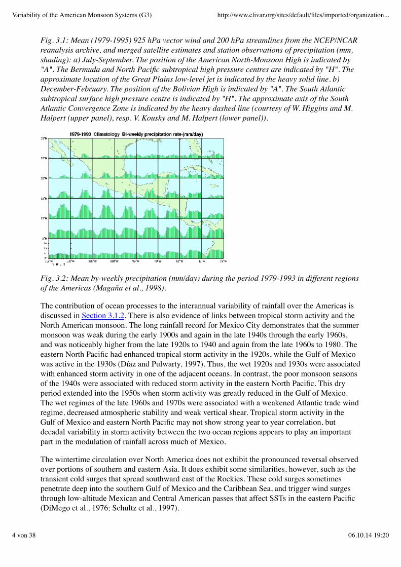
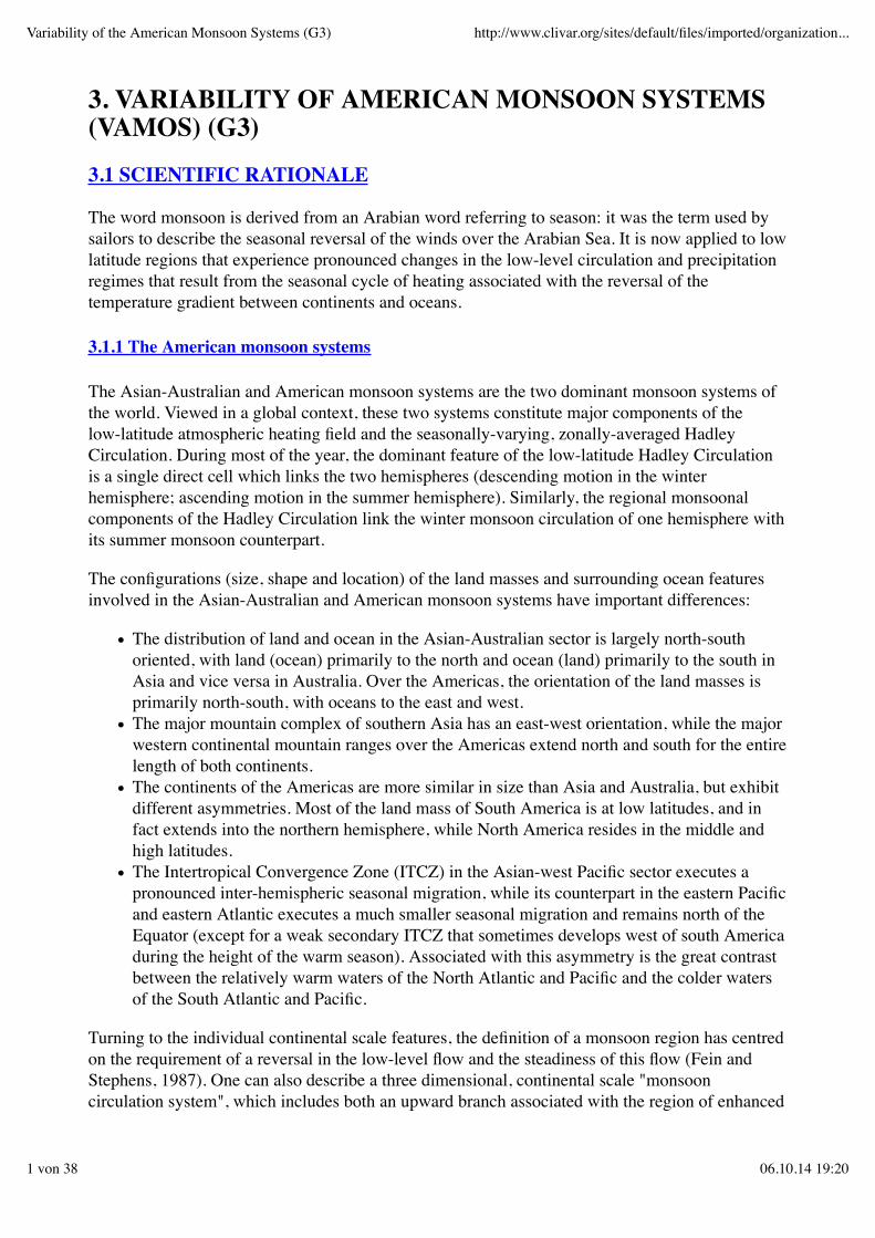
Fig. 3.1: Mean (1979-1995) 925 hPa vector wind and 200 hPa streamlines from the NCEP/NCARreanalysis archive, and merged satellite estimates and station observations of precipitation (mm,shading): a) July-September. The position of the American North-Monsoon High is indicated by"A". The Bermuda and North Pacific subtropical high pressure centres are indicated by "H". Theapproximate location of the Great Plains low-level jet is indicated by the heavy solid line. b)December-February. The position of the Bolivian High is indicated by "A". The South Atlanticsubtropical surface high pressure centre is indicated by "H". The approximate axis of the SouthAtlantic Convergence Zone is indicated by the heavy dashed line (courtesy of W. Higgins and M.Halpert (upper panel), resp. V. Kousky and M. Halpert (lower panel)).
Fig. 3.2: Mean by-weekly precipitation (mm/day) during the period 1979-1993 in different regionsof the Americas (Magaña et al., 1998).
The contribution of ocean processes to the interannual variability of rainfall over the Americas isdiscussed in Section 3.1.2. There is also evidence of links between tropical storm activity and theNorth American monsoon. The long rainfall record for Mexico City demonstrates that the summermonsoon was weak during the early 1900s and again in the late 1940s through the early 1960s,and was noticeably higher from the late 1920s to 1940 and again from the late 1960s to 1980. Theeastern North Pacific had enhanced tropical storm activity in the 1920s, while the Gulf of Mexicowas active in the 1930s (Díaz and Pulwarty, 1997). Thus, the wet 1920s and 1930s were associatedwith enhanced storm activity in one of the adjacent oceans. In contrast, the poor monsoon seasonsof the 1940s were associated with reduced storm activity in the eastern North Pacific. This dryperiod extended into the 1950s when storm activity was greatly reduced in the Gulf of Mexico.The wet regimes of the late 1960s and 1970s were associated with a weakened Atlantic trade windregime, decreased atmospheric stability and weak vertical shear. Tropical storm activity in theGulf of Mexico and eastern North Pacific may not show strong year to year correlation, butdecadal variability in storm activity between the two ocean regions appears to play an importantpart in the modulation of rainfall across much of Mexico.
The wintertime circulation over North America does not exhibit the pronounced reversal observedover portions of southern and eastern Asia. It does exhibit some similarities, however, such as thetransient cold surges that spread southward east of the Rockies. These cold surges sometimespenetrate deep into the southern Gulf of Mexico and the Caribbean Sea, and trigger wind surgesthrough low-altitude Mexican and Central American passes that affect SSTs in the eastern Pacific(DiMego et al., 1976; Schultz et al., 1997).
Variability of the American Monsoon Systems (G3) http://www.clivar.org/sites/default/files/imported/organization...
4 von 38 06.10.14 19:20
3.1.1.2 The monsoon system in the Southern Hemisphere
The characterisation of the seasonal cycle in the southern hemisphere as monsoonal in nature ismore problematical. There is a seasonal shift in the inflow on the eastern side of the continent,which includes a distinct seasonal reversal in the cross equatorial flow, but the wind shifts aregenerally far from a complete reversal in the flow. Nevertheless, the elevated terrain of the Andesand the latent heating during the warm season give rise to an upper troposphere anticyclone ("theBolivian High") that seems to be analogous to the Tibetan High. Furthermore, there is a markedseasonal cycle in the precipitation regime and associated continental-scale vertical motion fieldover the continent (Tanajura, 1996; Kousky and Ropelewski, 1997).
The development of the monsoon system in the southern hemisphere during the austral spring ischaracterised by a rapid southward shift of the region of intense convection from northwesternSouth America to the highland region of the central Andes (South American altiplano) and to thesouthern Amazon basin (Schwerdtfeger, 1976). In contrast to its counterpart in the northernhemisphere, transient synoptic systems at higher latitudes play an important role in modulating thesouthward shift in convection. Cold fronts that enter northern Argentina and southern Brazil arefrequently accompanied by enhanced deep convection over the western and southern Amazonia(Kousky and Ferreira, 1981; Kousky, 1985) and by increased southward moisture flux from lowerlatitudes. It has been suggested that this moisture flux is enhanced by a strong low-level jet east ofthe Andes (Virji, 1981, 1982; Stensrud, 1996). The low-level jet over South America is not aswell-documented as its counterpart over the Great Plains of North America. As the austral springprogresses, precipitation increases over the Brazilian altiplano and southeast Brazil, as the SACZdevelops (Kousky, 1988). The Bolivian High becomes established near 15oS, 65oW, as themonsoon system achieves mature phase characteristics. Intraseasonal and interannual rainfallvariability in the region of the South American altiplano is closely linked to changes in intensityand position of this high pressure system. To the east of the Bolivian High and off the east coast ofBrazil there is an upper-level cold trough, where rainfall is very low (Kousky and Ropelewski,1997). The decay phase of the monsoon begins in late summer as convection shifts graduallynorthward toward the equator. During April and May, the low-level southward flow of moisturefrom the western Amazonia weakens, as more frequent incursions of drier and cooler air from themid-latitudes begin to occur over the interior of subtropical South America.
Diagnostic studies of the diabatic heat source over the South American continent reveal apredominant role of the surface sensible heating in warming up the mid-troposphere over thecentral Andes during the pre-monsoon period. After the monsoon onset, strong latent heat release,accompanying deep convection over the subtropical highlands and the southern portion of theAmazon basin, maintains the thermal structure of the troposphere. The heating is largest in themature phase, while the warm air spans the widest subtropical domain from the eastern southPacific to the western south Atlantic.
Analysis of persistent wet and dry conditions over tropical and subtropical eastern South Americaduring the austral summer reveals a dipole pattern of rainfall anomalies, with one centre oversoutheastern Brazil in the vicinity of the SACZ and another centre over southern Brazil, Uruguayand northeastern Argentina (Casarin and Kousky, 1986; Nogues-Paegle and Mo, 1996). Thisseesaw pattern, which reflects changes in the position and intensity of the SACZ on intraseasonaland interannual time scales, appears to be a regional component of a larger scale system. Thesouthward extension and strengthening of the SACZ is associated with enhanced convection overthe central and eastern tropical Pacific and dry conditions over the western Pacific and the
Variability of the American Monsoon Systems (G3) http://www.clivar.org/sites/default/files/imported/organization...
5 von 38 06.10.14 19:20
maritime continent. Convection is simultaneously suppressed in the region of the SPCZ, over theGulf of Mexico, and in the ITCZ over the north Atlantic (Grimm and Silva Dias, 1995a, b). In theopposite phase, there is a strong influx of moisture from the tropics into central Argentina andsouthern Brazil.
The contribution of ocean processes to the interannual variability of rainfall over the Americas isdiscussed in the following subsection. There is also evidence that inter-hemisphericteleconnections contribute to that variability. The North Atlantic Oscillation (NAO) is an exampleof such connections: blocking conditions over the North Atlantic are normally associated withnegative rainfall anomalies over the eastern Amazonia and northeast Brazil (Namias, 1972).
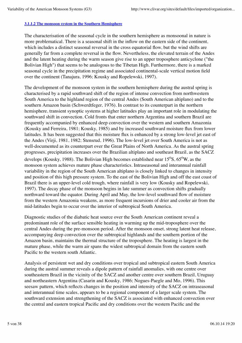
Fig. 3.3: Two features of a typical cold surge over South America during the Southern Hemispherewinter:
a) equatorward penetration of cold air at the surface (contour interval 5K),
b) decrease in specific humidity at 850hPa (contour interval 0.2 x 10⁻²g kg-1)
(courtesy of C. Vera).
Large-scale features, such as the ITCZ and SACZ, are frequently composed of organisedmesoscale systems that are important in understanding the local climate and in weatherforecasting. Some of these mesoscale systems are strongly tied to the local surface characteristicsand are strongly modulated by the diurnal cycle. Satellite studies reveal the complexity of thediurnal variation of convection over the South American monsoon region (Kousky, 1980). Thereare clear indications of precipitation maxima associated with the inland penetration (sometimes upto several hundred kilometres) of convective activity initiated by the sea breeze along coastalsections of tropical South America. The large rivers and flooded areas in the equatorial region alsoprovide the necessary forcing for the establishment of local circulation systems that can be clearlyidentified in satellite data and precipitation observations. The development and intensity ofmesoscale convective systems, such as mesoscale convective complexes, squall lines and diurnalconvection are strongly modulated by transient synoptic systems. At times, this scale interactionleads to excessive rainfall and flooding.
Variability of the American Monsoon Systems (G3) http://www.clivar.org/sites/default/files/imported/organization...
6 von 38 06.10.14 19:20
During the austral winter, precipitation is larger over northwestern South America north of theequator. The upper level subtropical jet stream is strongest at this time and is displacedequatorward over South America in agreement with the descending branch of a Hadley-typecirculation over that area. Frontal systems move fast above regions of low specific humidity andhigh loss of heat by radiation, and are not associated with strong convective activity, but introducecold surges, known as "friagens", in central and north Brazil (Fig. 3.3) (Parmenter, 1976; Hamiltonand Tarifa, 1978; Fortune and Kousky, 1983; Marengo et al., 1997).
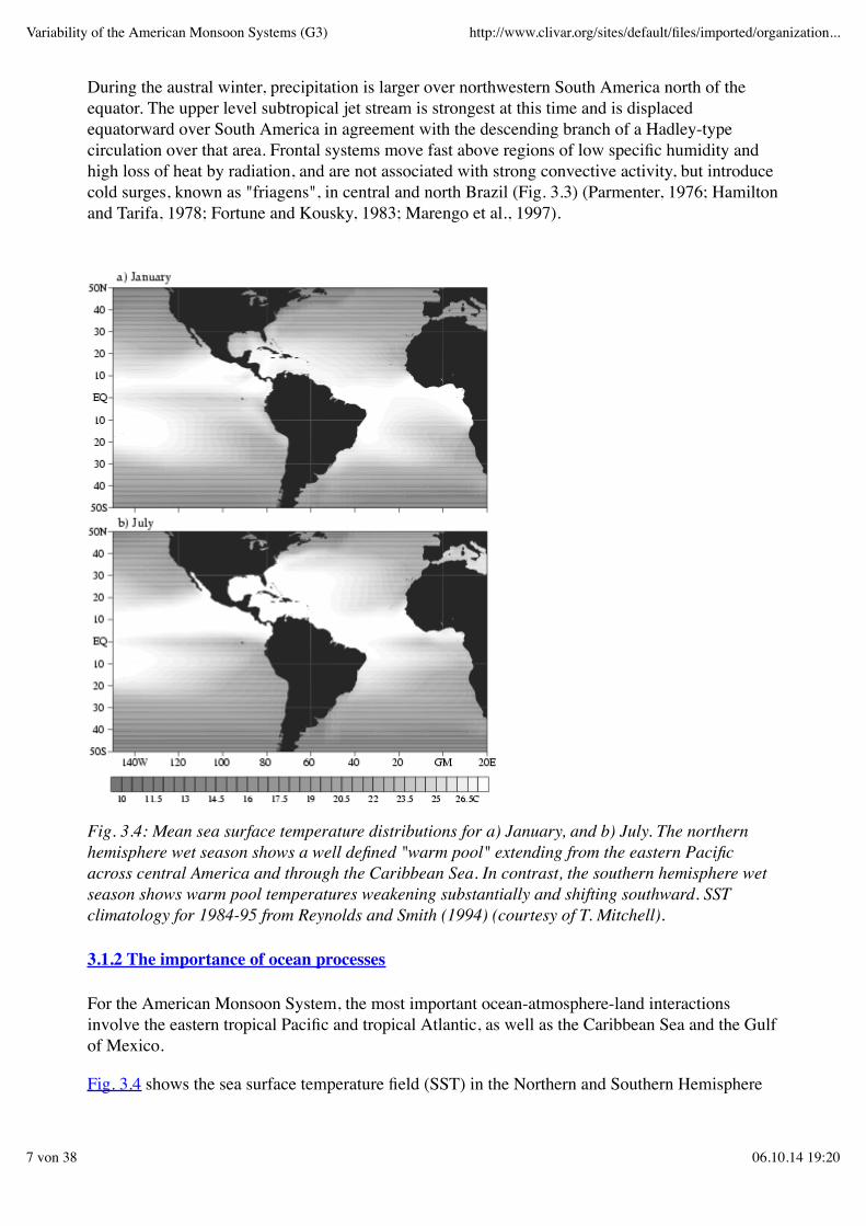
Fig. 3.4: Mean sea surface temperature distributions for a) January, and b) July. The northernhemisphere wet season shows a well defined "warm pool" extending from the eastern Pacificacross central America and through the Caribbean Sea. In contrast, the southern hemisphere wetseason shows warm pool temperatures weakening substantially and shifting southward. SSTclimatology for 1984-95 from Reynolds and Smith (1994) (courtesy of T. Mitchell).
3.1.2 The importance of ocean processes
For the American Monsoon System, the most important ocean-atmosphere-land interactionsinvolve the eastern tropical Pacific and tropical Atlantic, as well as the Caribbean Sea and the Gulfof Mexico.
Fig. 3.4 shows the sea surface temperature field (SST) in the Northern and Southern Hemisphere
Variability of the American Monsoon Systems (G3) http://www.clivar.org/sites/default/files/imported/organization...
7 von 38 06.10.14 19:20
wet seasons, respectively. During the northern hemisphere wet season there is a well defined"warm pool" that extends from the eastern Pacific across central America and through theCaribbean Sea. For the most part, the oceanic rainfall is coincident with the warmest SST, and thelarge-scale continental precipitation can be viewed as an extension of the ITCZs over thecontinents. In contrast, during the southern hemisphere wet season the warm pool temperaturesweaken substantially and shift southward. Moreover, the direct connection between the continentalprecipitation and the oceanic ITCZs fades.
The eastern equatorial Pacific and Atlantic Oceans are characterised by cold tongue/ITCZcomplexes with marked hemispheric asymmetry and strong seasonality. Southeasterly tradewindsdrive equatorial and coastal upwelling, leading to cooler surface waters along and to the south ofthe equator. In contrast, north of the equator in the eastern Pacific and Atlantic, surfacetemperatures are warmer in the vicinity of the ITCZ. At comparable latitudes in the SouthernHemisphere, large-scale subsidence over cool surface waters leads to the formation of low levelstratus decks and minimal precipitation (Mitchell and Wallace, 1992). The reasons for these inter-hemispheric asymmetries are not fully understood at present (Li and Philander, 1996; Philander etal., 1996).
The hemispheric asymmetries in the eastern Pacific and Atlantic Oceans are most marked near thecoasts. In the eastern Pacific, for example, the coolest surface waters are found in the coastalupwelling regime off the west coast of South America, where the climate is of the "humid desert"type. North of the equator, on the other hand, the warmest waters in the ITCZ region are locatedoff the west coast of Central America. This eastern Pacific "warm pool" develops in a region ofconvergent wind driven ocean currents, and is marked by extreme rainfall over both the ocean andneighbouring land mass. The intensity of these features decreases from east to west in and over theocean, as upstream continental influences wane and as the trade winds become more zonallyoriented. In the tropical Atlantic there is a deep warm pool along the coast of South America, withextensions into the Caribbean Sea and Gulf of Mexico. This warm pool, and the correspondingwarm pool in the northeastern equatorial Pacific separated by the relatively narrow continentalland mass of Central America, are noteworthy in that so little is known about the processes thatcontribute to their maintenance.
The wind driven oceanic circulation in the eastern equatorial Pacific and Atlantic is important indetermining the patterns of SST variability (Wallace et al., 1989). Major zonal flows of theequatorial current system include the westward flowing North and South Equatorial Currents,between which flows the eastward North Equatorial Countercurrent north of the equator in thevicinity of the ITCZ. A meridional ridge/trough system in surface topography and thermoclinedepth delimits the latitudinal boundaries of these currents. The Equatorial Undercurrent flowseastward below the surface along the equator, providing a source for upwelled water from thethermocline. Superimposed on these zonal flows is a meridional circulation involving polewardEkman divergence and upwelling near the equator, meridional convergence and downwelling athigher latitudes, and geostrophic inflow towards the equator from higher latitudes at thermoclinedepth.
Surface winds in the South Atlantic force a gyre-scale interior ocean circulation, which is closedalong the western boundary by the strong, southward-flowing Brazil Current. The southwesterntropical Atlantic is also characterised by the SACZ (Casarin and Kousky, 1986; Kousky 1988;Kodama, 1992), which is in some ways analogous to the South Pacific Convergence Zone (SPCZ)in the southwestern Pacific. The SACZ is not as well documented and explored in terms ofoceanographic consequences as its Pacific counterpart. It is unclear, for example, whether the
Variability of the American Monsoon Systems (G3) http://www.clivar.org/sites/default/files/imported/organization...
8 von 38 06.10.14 19:20
SACZ is associated with a South Equatorial Countercurrent in the south Atlantic to the sameextent to which the SPCZ is associated with a similar current in the south Pacific.
The seasonally varying climate of the Americas is governed in part by pronounced seasonalvariations in the surrounding tropical oceans. In boreal summer, for example, coastal andequatorial upwelling circulations intensify in response to intensified southeasterly trade winds, andthe cold tongues of the equatorial eastern Pacific and Atlantic intensify and expand poleward. TheITCZ, and the warm surface waters underlying it, are displaced northward. The northern branch ofthe South Equatorial Current and the North Equatorial Countercurrent intensify in both theAtlantic and Pacific. Associated with these zonal current variations are changes in thermoclinetopography and meridional mass fluxes, which result in an increased heat flux from the Northernto Southern Hemisphere.
Boreal summer monsoon circulations also develop in the atmosphere with onshore flow ofmoisture laden air in Central America and in the southwest U.S. Convergence of this moisture fluxover land leads to convection and marked increases in continental precipitation. In northeast Brazilon the other hand, boreal spring is the wet season, corresponding to the time when the equatorialoceans are warmest, and the ITCZ in the western Atlantic is at its southernmost position south ofthe equator. In the southwestern Atlantic, the SACZ is best developed in austral summer, whereasin austral winter, migratory cyclones and associated cold fronts coming from the Pacific affect thisregion.
The intensity of the American monsoon systems is significantly modulated on intraseasonal,interannual and decadal time scales. The impacts of El Niño-Southern Oscillation (ENSO)phenomenon in the tropical Pacific are global, with specific regional imprints on precipitationpatterns over the Americas (Ropelewski and Halpert, 1987, 1989; Aceituno, 1988, 1989;Pisciottano et al., 1994). There is evidence that the monsoon in Mexico is modulated by ENSO(Cavazos and Hastenrath, 1990). Specifically, a wet equatorial central Pacific (warm ENSO) isassociated with dryness along the Pacific coast of southern and western Mexico (Magaña andQuintanar, 1997). Several studies suggest that in late-spring/early-summer ENSO establishes ateleconnection pattern with an anomalous trough over North America, and the jet stream andstorm track displaced southward of their average locations. (e.g., Kalnay et. al., 1990; Trenberthand Branstator, 1992; Trenberth and Guillemot, 1996; Bell and Janowiak, 1995; Janowiak, 1988).This results in increased frequency of storms and higher precipitation. Conversely, anomalouslycold SSTs in the central equatorial Pacific are associated with a decreased frequency of storms andlower precipitation over North America. The modulation of monsoonal rainfall over SouthAmerica SST variations in the tropical Atlantic is suggested by other studies (Namias, 1972;Hastenrath and Heller, 1977; Enfield, 1996). Through atmospheric teleconnections, ENSO eventsalso affect the winds and therefore the oceanographic conditions in the Atlantic basin (Enfield andMayer, 1997). In particular, the equatorial Atlantic is often characterised by unusually warm SSTsin the year following major ENSO warm events in the Pacific. Ocean-atmosphere interactionsinternal to the Atlantic are also an important source of interannual climate variability in that basin,in addition to that generated externally via teleconnections to the Pacific (Philander, 1986; Zebiak,1993; Carton and Huang, 1994; Latif and Barnett, 1995).
Notable decadal time scale oceanic variations have also been reported in the Atlantic (Deser andBlackmon, 1993; Kushnir, 1994; Mehta and Delworth, 1995; Chang et al., 1997). Those variationsinclude the so-called Atlantic dipole, which is characterised by inter-hemispheric variations inSST, surface winds and surface heat fluxes. The dipole influences the latitudinal position of theITCZ and associated rainfall fields, and therefore has significant socio-economic impacts on
Variability of the American Monsoon Systems (G3) http://www.clivar.org/sites/default/files/imported/organization...
9 von 38 06.10.14 19:20
countries bordering the region. The dipole also exhibits fluctuations on shorter seasonal andinterannual time scales, which are important to describe and understand for the purposes ofpredicting short-term climate variability (Weiner and Soares, 1997). Decadal time scale variationshave also been recently documented in the tropical Pacific (Trenberth and Hurrell, 1994; Graham,1994; Deser et al., 1996). These low frequency variations manifest themselves in terms of SSTswith a spatial structure different from that associated with ENSO. Whether these variationsrepresent a decadal modulation of the ENSO cycle, or arise from ocean-atmosphere interactionsdistinct from those associated with ENSO, is unknown at the present time. It is also unknown towhat extent these decadal fluctuations are linked to decadal fluctuations in the North Pacific,and/or to anthropogenic climate change.
In addition to these long-term climate fluctuations, significant intraseasonal variations occur in thetropical Atlantic and Pacific which affect the detailed evolution of the seasonal cycle. Common toboth basins are tropical instability waves with periods of about one month and horizontal scales ofseveral hundred kilometres (Philander et al., 1985). These waves are important in regulatingtemperatures and large-scale current variations in the equatorial cold tongue regions throughhorizontal turbulent transports of heat and momentum. In the western Atlantic, ocean eddies areprominent in the strong western boundary current regime of the coast of South America, wherethey affect ocean circulation and heat transports. In the Pacific, intraseasonal (60-90 day)equatorial Kelvin waves forced by surface winds associated with the atmospheric Madden andJulian Oscillation (MJO) are a very pronounced mode of variability (Madden and Julian, 1994).Intraseasonal variations in SST, thermocline depth and ocean currents result from the passage ofthese waves along the equator, and poleward along the coasts of North, Central and SouthAmerica. Enhancements of MJO and Kelvin wave energy at intraseasonal frequencies are,moreover, implicated in the development of ENSO warm events.
3.1.3 The importance of orography and land surface processes
Over the continents, the orography and coastal geometry have a profound role in modulating thecontinental monsoon circulations. For example, during the wet season in Mexico the rainfall alongthe western slopes of the Sierra Madre Occidental can exceed 65 cm, whereas less than 200 kmdirectly to the west the wet season rainfall is over 40 cm less. This mesoscale structure isinfluenced by the complex surface characteristics from the gulf of California in the west to theMexican highlands in the east. Over South America, the narrow Andes mountains stronglyinfluence the character of the monsoon circulation. During the Southern Hemisphere wet seasonthe western slopes of the Andes mountains are arid, but the eastern slopes exhibit a relative rainfallmaximum. The surface characteristics of the Amazon basin also influence the local monsoonrainfall maxima at the southern edge of the basin and at the mouth of the Amazon River.
Land surface processes are particularly relevant to the American monsoonal circulations. Earlywarm season conditions, which are most likely related to global circulation, can provide the landsurface with either an excess or a deficit of moisture relative to the long-term mean value. Thehypothesis is that this anomaly influences subsequent moisture conditions, either locally orregionally, as larger-scale atmospheric circulation becomes less important and local convection(and perhaps moisture recycling) becomes dominant in the summer season (e.g. Rind, 1982;Mintz, 1984; Delworth and Manabe, 1989). Preliminary coupled terrestrial hydrologic-atmospheric modelling studies (Koster and Suarez, 1995) tend to support this hypothesis.
Dynamical processes controlled by the regional water and energy balance can influence water
Variability of the American Monsoon Systems (G3) http://www.clivar.org/sites/default/files/imported/organization...
10 von 38 06.10.14 19:20
vapour flow and, in this way, contribute to the occurrence of extreme events. Land-surfaceprocesses also have substantial influence on elevated mixed layers, and on associated lids onatmospheric instability that act to determine the distribution of the regional precipitation in timeand space (Benjamin and Carlson, 1986; Clark and Arritt, 1995). There is compelling evidencethat meteorological prediction is sensitive to terrestrial hydrologic-atmospheric couplingprocesses, which argues for research aimed to identify the coupling processes that are mostimportant for improved prediction, and the level of complexity that is worthwhile to include insub-models describing those processes.
3.2 VAMOS: PROGRAMME DEFINITION
GOALS, one of the main streams of CLIVAR, deals with climate variability and predictability onseasonal-to-interannual time scales building upon the accomplishments and observing system ofTOGA. GOALS, acting in collaboration with GEWEX, seeks to develop skilful prediction ofglobal climate variability on seasonal-to-interannual time scales through exploitation of linkageswith predictable variability of tropical heat sources and sinks associated with SST and othersurface anomalies, or that predictability that may be inherent in the extratropical system. Theoverall strategy is to focus on the monsoon systems in order to capitalise on the known major heatsources that contribute to shape the global atmospheric circulation. The largest annually varyingtropical heat source is associated with the switch from the Australian summer monsoon centred inJanuary, to the Asian summer monsoon centred in July. The second largest monsoon occurs overthe Americas as the large atmospheric heat source, associated with rainfall over the Amazon basinthat peaks in January, migrates to the Northern Hemisphere in the northern summer. Twodistinctive characteristics of the American monsoon system differ from the Asian-Australianmonsoon system.
First, tropical SST anomalies are particularly influential on climate variability in the Americansector. Hence, a study of the American monsoons will address the predictability of tropical SST toa greater extent than the other GOALS components. Second, complex orography and coastalgeometry imprint a mesoscale signature upon the American monsoon systems that is strongenough to qualitatively influence its planetary-scale structure and behaviour. Hence, a studyfocused on American monsoons will emphasise multi-scale studies ranging from the planetary tothe regional.
Because many countries are affected by these monsoons systems, it is advantageous to co-ordinateresearch programmes that address the outstanding scientific issues. Therefore CLIVAR hasestablished two panels dealing with the different aspects of the Asian-Australian and the Americanmonsoons: Asian-Australian Monsoon Panel and Variability of the American Monsoon Systems(VAMOS) Panel.
VAMOS is a component of CLIVAR GOALS with three major objectives:
to describe, understand, and model the mean and seasonal aspects of the American monsoonsystems,
1.
to investigate their predictability and to make predictions to a feasible extent, and2. to prepare products in view of meeting societal needs.3.
VAMOS will focus on rainfall and the probability of occurrence of significant weather events suchas tropical storms and temperature extremes. The term "monsoon system" encompasses not only
Variability of the American Monsoon Systems (G3) http://www.clivar.org/sites/default/files/imported/organization...
11 von 38 06.10.14 19:20
the summer monsoon rainfall in the tropical Americas, but also the perturbations in the planetary,synoptic and mesoscale flow patterns that occur in association with it, including those in the winterhemisphere. The region of interest covers both the tropical and the extratropical Americas andsurrounding oceans. Like the other regional components of CLIVAR, VAMOS will also foster thedevelopment of the observing, modelling and data management capabilities required for climateprediction.
A number of regional and national research projects, such as the Pan-American Climate Study(PACS), the GEWEX Continental Scale International Project (GCIP), the Large Scale Biosphere-Atmosphere Experiment in Amazonia (LBA), and the Pilot Research Moored Array in theTropical Atlantic (PIRATA) contribute to VAMOS. The Inter-American Institute for GlobalChange Research (IAI) provides important linkages to the societal impact of climate researchwithin the Americas. Finally, the International Research Institute for Climate Prediction (IRI)provides a framework for VAMOS to carry out climate predictions and the assessment ofpredictability of the American monsoon systems. More detailed descriptions about the linkages tothese programmes is provided in Section 3.8.
3.3 MODELLING AND PREDICTION
3.3.1 Atmospheric general circulation models (AGCMs)
Inference of causal relationships based on empirical evidence is often difficult because theanomalous surface wind field associated with the rainfall anomalies can induce SST anomalies ofits own, and anomalous boundary conditions in a number of different regions are often interrelatedby way of planetary-scale atmospheric teleconnections. In view of the complexity of theseprocesses, AGCMs play key roles in establishing hypotheses on the atmospheric response toboundary forcing. Nevertheless, present AGCM simulations forced with climatological meanboundary conditions exhibit systematic biases in regions of the Americas and adjacent oceans. Themodels generally underestimate the wind stress in the equatorial belt, and the coverage of oceanicstratus clouds. These clouds play an important role in the energy balance of the PBL and the oceanmixed layer and are associated with the equatorial asymmetry of SST in the tropical Atlantic andeastern Pacific (Ma et al., 1996). Such well-defined biases highlight basic deficiencies in theatmospheric models that need to be corrected in order to pave the way for the development ofrealistic coupled models.
VAMOS will encourage studies with AGCMs aimed at a better understanding of atmosphericsensitivity to anomalous boundary forcing. Results of several published AGCM studies suggestthat tropical SST anomalies can influence warm season rainfall over the Americas (Moura andShukla, 1981; Mechoso and Lyons, 1988; Mechoso et al., 1990; Díaz et al., 1998). AGCMexperiments can explore the mechanisms by which monsoon rainfall anomalies over northeastBrazil are positively correlated with SST anomalies over the tropical South Atlantic andnegatively correlated with SST anomalies over the tropical North Atlantic. Additional experimentsmay examine the hypothesis that SST anomalies associated with El Niño are capable of inducingrainfall anomalies over northeast Brazil and other regions of the Americas, independently of theanomalies in the Atlantic. Such experiments are needed to understand, and ultimately to predict,the way in which the slowly evolving planetary-scale atmospheric response to boundary forcingmodulates the more intermittent, higher frequency synoptic and subsynoptic phenomena that areresponsible for the individual episodes of heavy rainfall and significant weather.
Variability of the American Monsoon Systems (G3) http://www.clivar.org/sites/default/files/imported/organization...
12 von 38 06.10.14 19:20
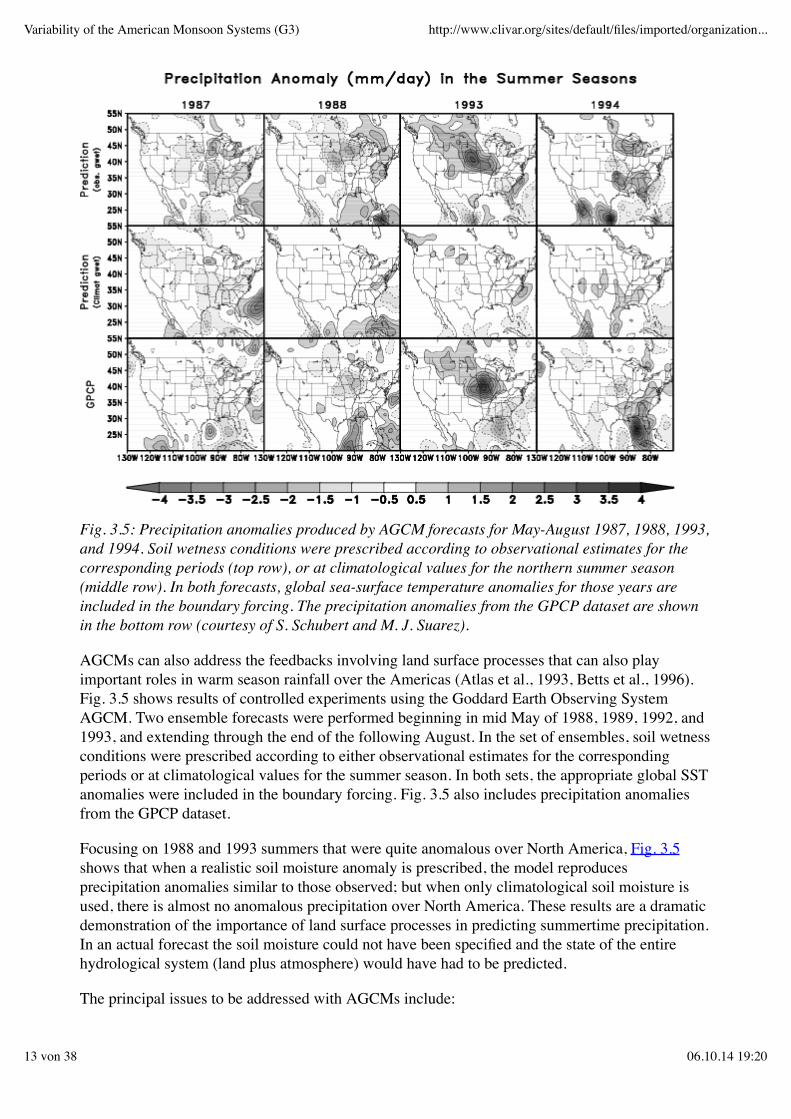
Fig. 3.5: Precipitation anomalies produced by AGCM forecasts for May-August 1987, 1988, 1993,and 1994. Soil wetness conditions were prescribed according to observational estimates for thecorresponding periods (top row), or at climatological values for the northern summer season(middle row). In both forecasts, global sea-surface temperature anomalies for those years areincluded in the boundary forcing. The precipitation anomalies from the GPCP dataset are shownin the bottom row (courtesy of S. Schubert and M. J. Suarez).
AGCMs can also address the feedbacks involving land surface processes that can also playimportant roles in warm season rainfall over the Americas (Atlas et al., 1993, Betts et al., 1996).Fig. 3.5 shows results of controlled experiments using the Goddard Earth Observing SystemAGCM. Two ensemble forecasts were performed beginning in mid May of 1988, 1989, 1992, and1993, and extending through the end of the following August. In the set of ensembles, soil wetnessconditions were prescribed according to either observational estimates for the correspondingperiods or at climatological values for the summer season. In both sets, the appropriate global SSTanomalies were included in the boundary forcing. Fig. 3.5 also includes precipitation anomaliesfrom the GPCP dataset.
Focusing on 1988 and 1993 summers that were quite anomalous over North America, Fig. 3.5shows that when a realistic soil moisture anomaly is prescribed, the model reproducesprecipitation anomalies similar to those observed; but when only climatological soil moisture isused, there is almost no anomalous precipitation over North America. These results are a dramaticdemonstration of the importance of land surface processes in predicting summertime precipitation.In an actual forecast the soil moisture could not have been specified and the state of the entirehydrological system (land plus atmosphere) would have had to be predicted.
The principal issues to be addressed with AGCMs include:
Variability of the American Monsoon Systems (G3) http://www.clivar.org/sites/default/files/imported/organization...
13 von 38 06.10.14 19:20
Are simulations by AGCMs realistically sensitive to slowly varying boundary forcing?What is the atmospheric response to SST anomalies in the Caribbean Sea and the Gulf ofMexico?In which way does the slowly evolving planetary-scale atmospheric response to boundaryforcing modulate the more intermittent, higher-frequency synoptic and subsynopticphenomena that are responsible for episodes of heavy rainfall and significant weather (e.g.flare-ups in the ITCZ and SACZ, migrating frontal systems, Atlantic and Caribbeanhurricanes, and higher latitude blocking events associated with cold air outbreaks)?How can the simulations of the intensity of ITCZ rainfall and the diversity of convectiveheating profiles in the tropics be improved?How can the simulations of regional differences in the diurnal cycle of precipitation beimproved?What vertical resolution is required for simulation of the different stratiform cloud regimes?Can AGCMs provide appropriate boundary (lateral) conditions to embedded mesoscalemodels?
3.3.2 Oceanic general circulation models (OGCMs)
OGCMs will address a number of important questions concerning the processes that contribute toSST variability in the tropical Pacific and Atlantic. The mechanisms that control the annual marchof SST in the monsoon regime of the eastern tropical Pacific appear to be fundamentally differentfrom those in the trade wind regime of the central Pacific, upon which much of the prior OGCMdevelopment effort has been focused. The lack of correspondence between fluctuations in SST andthermocline depth in the annual cycle of the eastern Pacific Ocean attests to the importance ofother processes such as insolation and other surface fluxes, upwelling, horizontal advection andvertical mixing in the heat balance (Philander et al., 1987).
There are unresolved questions on the source of water upwelled in the equatorial cold tongue, thedepth from which it originates, and the meridional extent of the upwelling cell. Also, it isunknown whether the upwelling water can be traced back to the surface in extratropical regions, ashas been suggested in recent studies (Deser et al., 1996; Gu and Philander, 1997). As in theatmosphere, an issue that remains unresolved is the rectification of high-frequency forcing andinternal instabilities into the low-frequency variability. Since mixing is an irreversible process, thenet effect of high-frequency signals on the annual cycle might be quite different than would bededuced from low frequency averages alone. There also appears to be important smaller-scaleregional variability that escapes the resolution of basin-scale OGCMs, but that may be significantfor understanding the heat, mass, and momentum budgets over the eastern tropical Pacific. Theregion up to a few hundred kilometres of the Central American coast is generally very warm butcan cool rapidly in response to winter northerlies blowing through gaps in the American cordillera.
The principal issues to be addressed with OGCMs include:
What are, and how to model, the processes that contribute to the maintenance of the oceanicmixed layer in the presence of equatorial upwelling?What is the source of water upwelled in the equatorial cold tongue, the depth at which itoriginates, and the meridional extent of the upwelling cell?What is the relative importance of dynamical and thermodynamical processes associatedwith the seasonal variations of the meridional wind stress in the eastern tropical Pacific andAtlantic?
Variability of the American Monsoon Systems (G3) http://www.clivar.org/sites/default/files/imported/organization...
14 von 38 06.10.14 19:20
What mechanisms control the seasonal cycle of SST in the monsoon regime of the easterntropical Pacific and in the trade wind regime of the central Pacific?What role do tropical instability waves in and north of the cold tongue play in the transportof heat and momentum in the upper ocean?What is the role of small-scale regional variability in the heat, mass, and momentum budgetsof coastal regions?
3.3.3 Coupled atmosphere-ocean-land GCMs (coupled GCMs)
Many of the challenges confronted in modelling the atmosphere, ocean and land surface arefurther heightened in a coupled context, as the interactions among the components can lead tostrong internal feedbacks (Webster and Chou, 1980). A relevant case in point is the simulation ofthe coupled annual cycle in the eastern Pacific (Ma et al., 1994). The strong meridional gradients,and strong equatorially asymmetric character of the annual cycle evolution clearly involvescoupling between land, atmosphere and ocean, and has proven a very difficult challenge forcoupled models. At this time, many models are unable to simulate the evolution realistically,perhaps the most common errors being associated with the appearance of overlay warm waters andatmospheric convection to the south of the equator during the austral summer season (Mechoso etal., 1995). Such errors clearly impact the circulation over the Americas, and in particular, thesimulation of the American monsoon systems. VAMOS will encourage studies that furtherelucidate the boundary layer, convective cloud interaction, and dynamical processes giving rise toseasonal-to-interannual variability in the American sector. It is only through improvedunderstanding that better parameterisations and model simulations will be possible.
These issues to be addressed with coupled GCMs include:
What mechanisms determine the variability of ENSO?Why do the simulated cold tongues in the equatorial Pacific and Atlantic Oceans tend to beso strong and persistent, to extend so far west, and to separate from continental coasts to theeast?What are the atmospheric, oceanic, and coupled atmosphere-ocean processes that contributeto the existence of the persistent stratus clouds in the eastern Pacific and Atlantic Ocean?Why is it that coupled GCM simulations tend to show relatively warm water extending toofar east in the subtropical southern Pacific and Atlantic Oceans?How strong are the connections between the variability of the coupled atmosphere-oceansystem in the Pacific and Atlantic Oceans?What would be the impact on the precipitation forecasts over the Americas of extendingoperational forecasts of the coupled atmosphere-ocean system for the Pacific to include theAtlantic Ocean?
3.3.4 Mesoscale atmospheric models
The richly textured distribution of rainfall over the continents and oceanic convergence zonespresents a challenge and an opportunity for regional analyses and predictions. Along the coastsand over the mountainous terrain of the Americas, the coarse-resolution rainfall simulated byGCMs cannot be compared directly with station data. GCM simulations are particularly poor inthe summer, when mesoscale convective systems play a dominant role in organizing theprecipitation (Horel et al., 1989; Rao et al., 1996).
Variability of the American Monsoon Systems (G3) http://www.clivar.org/sites/default/files/imported/organization...
15 von 38 06.10.14 19:20
VAMOS will focus attention on mesoscale processes that affect the distribution ofcontinental-scale precipitation and its variability on seasonal-to- interannual time scales.Mesoscale processes have long been considered to have both deterministic and probabilisticcomponents. Characteristics of the underlying surface on the mesoscale help to control thedevelopment and organisation of mesoscale circulations (Figueroa et al., 1995). Mesoscaleresolution of such factors as the slope of the terrain, land-sea temperature contrasts, or variationsin soil moisture and vegetation will be necessary in order to understand better the Americanmonsoon systems. On the other hand, mesoscale instabilities (e.g. tropical storms or mesoscaleconvective systems) contribute a significant fraction of the total seasonal precipitation in manyareas of the Americas, and their occurrence (or absence) can lead to large year-to-year variationsin precipitation. Thus, VAMOS will evaluate the aggregate effect of such mesoscale instabilitieson the climate of the American monsoon systems.
Mesoscale models are expected to contribute to VAMOS in several ways, including the analysisand simulation of the mesoscale aspects of the mean state and spatial and temporal variations ofthe American monsoon systems. There is a need to evaluate specific physical processes that affectimportant components of the American monsoon systems. For example, cool season surgesthrough the mountain gaps of Central America are known to rapidly lower the sea surfacetemperature downwind of the gaps and modify regional oceanic currents. In addition, thelow-level jet to the east of the Andes Mountains contributes to the meridional moisture transportfrom the Amazon Basin into the subtropical regions of South America and modulates convectiveoutbreaks in those regions. There is also a need to perform sensitivity and predictabilityexperiments in which a model with mesoscale resolution is nested within an AGCM or coupledatmosphere-ocean GCM. The nesting strategy employed may be one-way (i.e. the mesoscalestructures in the interior domain do not affect the GCM solution in the outer domain) or two-way(i.e. the mesoscale structures in the interior domain may affect the global solution).
The mesoscale modelling strategies will most likely evolve over the duration of the VAMOSprogramme. To effectively employ mesoscale models, a number of fundamental model designissues must be addressed. These issues focus on how to improve mesoscale models for climateanalysis and prediction and include:
How do mesoscale physical processes, such as convection, differ as a function of latitudeand how do these differences affect model parameterisations?What is the sensitivity of the mesoscale simulations to the details of the underlying surface:e.g. sea surface temperature gradients or terrain? How important is the specification of soilmoisture to the initialisation of mesoscale simulations as a function of soil type andseasonally evolving vegetation?How well can the seasonally varying climate be simulated as a function of horizontal andvertical resolution?How dependent are mesoscale simulations on specific physical parameterisations, such assurface exchange, and how do these dependencies differ for the various components of theAmerican monsoon systems?What is required to develop an integrated approach to air/land/sea interactions on themesoscale?What are the most appropriate nesting strategies and what are the sensitivities to the nestingmethodology?To what extent does the skill of the GCM or coupled GCM in which a mesoscale model isembedded control the skill of regional predictions?
Variability of the American Monsoon Systems (G3) http://www.clivar.org/sites/default/files/imported/organization...
16 von 38 06.10.14 19:20
3.3.5 Predictability
The quality of deterministic atmospheric forecasts depends heavily on the quality of the initialdata. The initial data cannot be created with absolute accuracy because of errors in observationaldata, lack of coverage and problems with representativeness. Forecasts starting from two slightlydifferent initial data which are equally likely to represent the true atmospheric state, will deviatefrom each other after a few days. On average such forecast pairs deviate from each other asrandomly chosen atmospheric states after 10 to 15 days. From that one can deduct thatdeterministic forecasts of the weather beyond 12 days are presently hardly possible.
There is also an interest in forecasts of the mean (weekly, monthly, or seasonally averaged) state ofthe atmosphere but then with a longer lead time. Experiments have been shown that the boundaryforcing (SSTs, snow, soil moisture) become important for such forecasts. There are areas,especially in the tropics, which show a high sensitivity of e.g. mean precipitation to the phase ofENSO. An atmospheric model could be used to predict atmospheric mean states for such areas, ifthe oceanic temperatures could be forecasted. The latter has successfully been achieved withstatistical models but for larger lead times (more than 6 months) only forecasts with coupledocean-atmosphere models have the chance of success. The forecast of the 1997-98 strong El Niñowith a lead time of one year is an example of the potential skill of such forecasts with coupledmodels especially for the Americas. Comparisons between forecasts by different schemes maycontribute to enhance progress in coupled modelling
Simulations-predictability issues arise in the context of regional scale models. At the present time,very little work has been done regarding sensitivity of mesoscale models to initial and boundaryconditions. These studies are a necessary prerequisite to the prediction of regional scale climateover the Americas.
3.3.6 Prediction
At present, ENSO SST predictions are being done routinely with an array of coupled dynamicalmodels, as well as statistical-dynamical and purely statistical models (Cane et al., 1986; Barnett etal., 1993; Penland and Magorian, 1993; Balmaseda et al., 1994; Ji et al., 1996). Nonetheless,dynamical climate prediction is in its infancy. For example, many systems do not utilise much ofthe observational information available, and are thus obviously limited. Almost none of theclimate assimilation systems acknowledge atmosphere-ocean coupling, even though a coupledsystem is more natural and undoubtedly optimal for coupled models. Forecasting methodologiessuch as ensemble averaging, model output statistics (MOS) corrections and probability forecastingare only now beginning to be considered. And of course, aspects of climate other than ENSOremain by and large unexplored. Yet the achievements to date provide optimism for furtherimprovements in climate forecasting and forecast products that will be of direct relevance toVAMOS. Given the proximity to the tropical Pacific, the gains made in ENSO prediction willundoubtedly benefit climate prediction over the Americas.
Another set of issues that are crucial to prediction of precipitation (and other variables) over theVAMOS region concerns the initialisation of land surface conditions. At this time, it is not knownwhat the observational requirements are for regional climate prediction. Certainly improvementsin present land surface models will be needed, especially at the regional scale. Progress in therepresentation of land-atmosphere interactions over the last two decades has been sufficient tomotivate several operational modelling centres (e.g. the National Center for Environmental
Variability of the American Monsoon Systems (G3) http://www.clivar.org/sites/default/files/imported/organization...
17 von 38 06.10.14 19:20
Prediction, the European Centre for Medium Range Forecasting and the Japanese MeteorologicalCentre) to implement and benefit from modern-era, multi-layer soil-vegetation- atmospheretransfer schemes. Planetary, continental and regional atmospheric circulation patterns in suchassimilation systems are constrained near truth by the assimilation of atmospheric observations.Nonetheless, the implementation of improved representation of terrestrial hydrologic-atmosphericinteractions has undoubtedly improved the quality of the precipitation and low-level temperatureanalysis products provided by data assimilation systems. The sharp topography of the VAMOSregion poses a particular challenge to prediction. At present, it is not known at what scaledynamical model predictions may become useful for the region. It will be necessary to evaluatecontinuously the state-of-the-art dynamical predictions against mixed statistical-dynamical (oreven purely statistical) predictions. It would not be surprising if, at the regional scale, the latteractually prove superior in the short-term, given the complexities involved.
Methodological research akin to that for large-scale predictions is also necessary in the mesoscaledomain for the Americas. Such research is essential to meet the objectives of VAMOS, and will bestrongly encouraged by the programme.
3.4 SPECIAL OBSERVING NEEDS
3.4.1 Enhanced monitoring in the eastern tropical Pacific region
VAMOS will encourage the development of enhanced monitoring systems that will provide theobservational basis for improvement of operational coupled ocean-atmosphere analysis andprediction systems for the eastern Pacific region, as well as for the tropical Atlantic. Monitoring isunderstood as continuous atmospheric and oceanic observations during a multi-year period.
Although the TAO array has improved the definition of the surface meteorological conditions andupper ocean thermal structure over the equatorial Pacific, the region to the east of the Line Islands(160oW) remains among the most serious data gaps in the global observing system. Operationalatmospheric analyses and forecasts of midtropospheric winds cannot be verified for lack of in situobservations, and even some aspects of the climatology are not very well established. A moreaccurate and detailed description of the annual march of the upper ocean temperature and salinitystructure is needed off the west coast of the Americas. The TAO array covers only the equatorialzone, leaving seriously undersampled regions in the warm pool off the central American coast andthe vast stratus decks to the south of the equatorial zone in the southeastern Pacific (see Fig. 3.6).Until these observational system gaps are filled through a combination of in situ and space-basedobservations, it is unlikely that the annual variation of the ITCZ-cold tongue complex can beanalysed and forecast with the accuracy required for skilful predictions of seasonal-to-interannualvariability of the American monsoon.
Concerning the eastern Pacific, several approaches are being considered to enhance monitoring ofmeteorological and oceanic conditions. For the atmosphere, the augmentation of the continentaland island-based rawinsonde network, the use of ship-based soundings of opportunity, andsounding systems operated from manned and/or unmanned aircraft are promising. Extension of theTAO array along 95oW from about 12oS under the stratus deck, across the cold tongue, theequatorial front and into the warm pool to around 12oN could provide valuable "synoptic"information on upper ocean temperature and salinity structure, as well as data to validate and
Variability of the American Monsoon Systems (G3) http://www.clivar.org/sites/default/files/imported/organization...
18 von 38 06.10.14 19:20
constrain model-based analyses of the upper ocean heat and freshwater budgets in the ITCZ-coldtongue complex. Other approaches are being considered by the PIRATA programme for thetropical Atlantic.
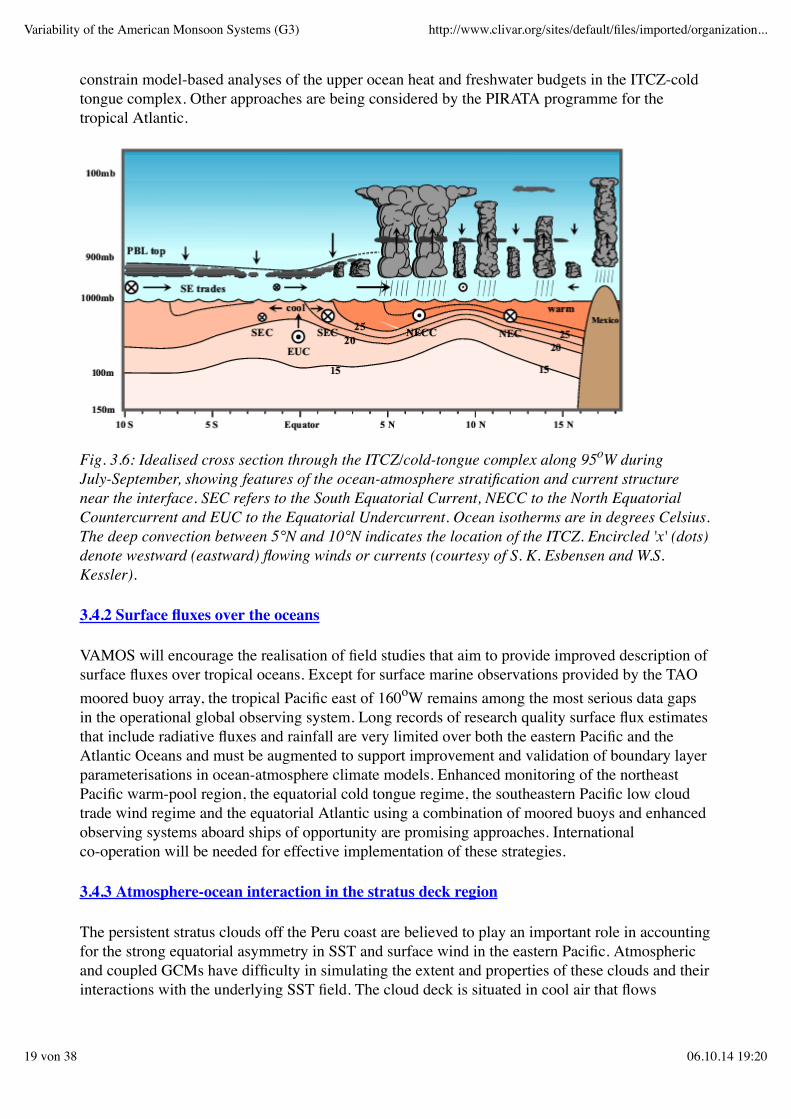
Fig. 3.6: Idealised cross section through the ITCZ/cold-tongue complex along 95oW duringJuly-September, showing features of the ocean-atmosphere stratification and current structurenear the interface. SEC refers to the South Equatorial Current, NECC to the North EquatorialCountercurrent and EUC to the Equatorial Undercurrent. Ocean isotherms are in degrees Celsius.The deep convection between 5°N and 10°N indicates the location of the ITCZ. Encircled 'x' (dots)denote westward (eastward) flowing winds or currents (courtesy of S. K. Esbensen and W.S.Kessler).
3.4.2 Surface fluxes over the oceans
VAMOS will encourage the realisation of field studies that aim to provide improved description ofsurface fluxes over tropical oceans. Except for surface marine observations provided by the TAOmoored buoy array, the tropical Pacific east of 160oW remains among the most serious data gapsin the operational global observing system. Long records of research quality surface flux estimatesthat include radiative fluxes and rainfall are very limited over both the eastern Pacific and theAtlantic Oceans and must be augmented to support improvement and validation of boundary layerparameterisations in ocean-atmosphere climate models. Enhanced monitoring of the northeastPacific warm-pool region, the equatorial cold tongue regime, the southeastern Pacific low cloudtrade wind regime and the equatorial Atlantic using a combination of moored buoys and enhancedobserving systems aboard ships of opportunity are promising approaches. Internationalco-operation will be needed for effective implementation of these strategies.
3.4.3 Atmosphere-ocean interaction in the stratus deck region
The persistent stratus clouds off the Peru coast are believed to play an important role in accountingfor the strong equatorial asymmetry in SST and surface wind in the eastern Pacific. Atmosphericand coupled GCMs have difficulty in simulating the extent and properties of these clouds and theirinteractions with the underlying SST field. The cloud deck is situated in cool air that flows
Variability of the American Monsoon Systems (G3) http://www.clivar.org/sites/default/files/imported/organization...
19 von 38 06.10.14 19:20

equatorward around the east side of the subtropical anticyclone, and which maintains theatmospheric planetary boundary layer (PBL) in an unstable state as it encounters increasinglywarmer waters. VAMOS will encourage projects that address the existence and variability of thesecloud decks, and the way in which their presence affects the insolation and downward flux ofinfrared radiation at the air-sea interface. There is need to investigate the microstructure of thecloud deck and its variations with time, as well as its height, thickness, radiative properties andposition relative the vertical structure of the PBL. It is also of interest to determine how deep intothe ocean the influence of the cloud deck extends, and the evolution of the PBL structure as onefollows air trajectories northwestward from the stratus deck into the relatively cloud-freeequatorial cold tongue region. In addition, it is important to assess whether the temporal variationsin the extent of the cloud deck are related to variations in the strength of the low-level flow aroundthe subtropical anticyclone and/or to the subsidence aloft.
3.4.4 High resolution sea surface temperature
Higher spatial and temporal resolution SST data are required to study regional relationshipsbetween ocean boundary and American monsoon systems. The spatial resolution must besufficient to resolve SST gradients in regions such as the Gulf of California. A 1o long. by 1o lat.COADS monthly SST data set is currently available for the period 1960 to 1993. VAMOS willrequire updates of these data through the life of the programme and, where the data are adequate,weekly analyses on this spatial scale. Specific requirements for higher spatial resolution weeklySST data will be developed to support studies utilizing nested regional numerical models. VAMOSanticipates these mesoscale modelling studies will require SST on spatial scales near 0.5o long. by0.5o lat. for limited sub-domains of the VAMOS region. These higher resolution data will berequired for time periods coinciding with model experiments.
3.4.5 Soil moisture
Over land areas, soil moisture is thought to play a role somewhat analogous to that of SST overthe oceans (Delworth and Manabe, 1989; Koster and Suarez, 1995, 1996). VAMOS requiresestimates of soil moisture in order to investigate these relationships, and will encourage work bythe GEWEX programme aimed at providing the necessary observational estimates of soil moistureor some proxy for soil wetness. In principle, monthly, gridded, soil moisture would provide anuntold wealth of insight into seasonal precipitation mechanisms over the Americas. Selectednumerical and/or field studies require higher spatial and temporal resolution soil moisture data,e.g. weekly on 0.5o long. by 0.5o lat. analyses.
However, recognizing that gridded soil moisture estimates on these scales may not be attainable inthe near future, some VAMOS requirements may be met through utilisation of a network of in situsoil moisture measurements. These requirements may be partially met over portions of NorthAmerica by the soil moisture measurements taken as part of GCIP. VAMOS encourages similarobservational programmes for Central and South America. In South America, VAMOS will lookto the LBA programme to provide some of these data.
3.4.6 Precipitation
A major focus of VAMOS is understanding and prediction of seasonal precipitation. However,
Variability of the American Monsoon Systems (G3) http://www.clivar.org/sites/default/files/imported/organization...
20 von 38 06.10.14 19:20
climate-scale phenomena do not generally respect the traditional calendar month boundaries. Thisis especially true for many aspects of the American monsoon systems including onsets, breaks andmonsoon withdrawals. Thus, at a minimum, VAMOS requires the development of daily rainfalldata sets over the Americas. This will require the integration of data from a variety of independentsources.
Recent numerical modelling experiments have highlighted the importance of properly capturingthe diurnal cycle of evaporation and precipitation. The ability to correctly replicate the observeddiurnal cycle is important in the context of climate model simulations. High quality hourlyprecipitation measurements are required for a better understanding, modelling and prediction ofseasonal precipitation. The corresponding datasets are necessary both to validate regionalnumerical models that are run in a climate setting, and to provide a fuller understanding of the roleof climate-scale variability in modulating the diurnal cycle of rainfall.
3.4.7 Vertical structure of the atmosphere
A more complete understanding of the evolution and variability of the American monsoon systemsrequires a full description of the atmospheric circulation associated with the events. While themajor large-scale circulation features may be described using one of the GCM-based reanalyses(e.g. the NCEP/NCAR 40 year reanalysis), the study of regional features requires additionalobservations. For example, the global analyses are consistent with the notion that the flow isnortherly along the eastern side of the Andes during the southern summer (Virji, 1981, 1982). Theanalyses also suggest the existence of a southward-flowing low-level jet from the Amazon basininto Argentina embedded in the large-scale northerly flow (Sugahara, et al., 1994: Stensrud, 1996).It is generally believed that the spatial structure and temporal variability of this jet are similar tothat of its well-documented counterpart over the Great Plains of North America. These features arevery important for convective developments. Mesoscale convective systems travelling eastwardand forming over northern Argentina and southern Bolivia have been associated with a low-levelwarm and moist flow from the Amazon region (Guedes and Silva Días, 1985; Silva Días, 1989).
Studies have shown that approximately 30% of the southern summer days have a low-level jet eastof the Andes at approximately 60oW, 20oS with an average speed of 13 ms-1 at about 1,500 mabove sea level. In fact, the Andes seem to play a key role in the existence of this feature (Ganduand Geisler, 1992; Figueroa et al., 1995). The low-level jet appears to have marked diurnaloscillations in association with buoyancy oscillations above the elevated and heated Andes. Thediurnal evolution of convective weather shows that summer showers tend to occur at night overmost of Central Argentina (Paegle et al., 1982). The destabilising effects in the PBL of dynamicalmechanisms, therefore, appear to be more important than the stabilizing effects ofthermodynamical mechanisms during night-time. A marked diurnal cycle in the low-level floweast of the Andes has been simulated (Nicolini et al., 1987). In addition, the regions mostfavourable for the formation of convective systems are strongly correlated with those where thediurnal cycle has largest amplitudes (Machado and Guedes, 1996).
The available observational datasets are insufficient for study of the southern low-level jet in viewof the subsynoptic scales involved and the sparseness of the South American observing system.Further data are needed to address several specific issues that require further clarification:
What is the structure of the low-level jet east of the Andes?What are the mechanisms at work for its existence?
Variability of the American Monsoon Systems (G3) http://www.clivar.org/sites/default/files/imported/organization...
21 von 38 06.10.14 19:20
What are the relationships between the jet and the mesoscale convection that contributesignificantly to the total seasonal precipitation in southeastern South America?What is the relationship between the variability of the jet and that of the SACZ?What is the contribution of the moisture advected by the jet to the regional atmospherichydrologic cycle?
Numerical models have difficulty with the extremely sharp topographic features of the Andes.Understanding the South American monsoon system requires more complete descriptions of thewind fields and atmospheric moisture transports and how they are influenced by these topographicfeatures. Enhanced observations are required for the PBL and free atmosphere over the SouthernPacific, the west coast of South America, the Altiplano region, the lee of the Andes and across thecontinent into the SACZ. Enhanced observational periods with frequent soundings are necessaryfor model development and validation, as well as for empirical studies.
3.5 FIELD STUDIES
3.5.1 Atmospheric PBL structure above the cold tongue
Several field studies are required to assess whether it is possible to reconcile the observed verticalprofile of wind speed and direction with existing models of PBL structure. The outcome willprovide insights into how the models might be improved.
A field programme is under way funded by PACS to collect soundings in the PBL above the coldtongue region in the southerly regime in the far eastern Pacific. Another project is building a morecomprehensive background climatology of the PBL structure over the cold tongue in the easternequatorial Pacific to ascertain the degree to which the PBL reflects the local distribution of SST.Except for a few isolated field observations made during the Eastern Pacific Ocean ClimateStudies (EPOCS), the vertical profile of the wind and thermodynamic variables in the southerlysurface wind regime in the far eastern Pacific is virtually undocumented.
3.5.2 Structure and intensity of ITCZ rainfall
A PACS shipboard field study was carried out in summer of 1997 to test whether the hypothesisthat the eastern Pacific clouds produce more rain than the western Pacific clouds but are not asdeep is correct. It has generally been assumed that lower cloud-top temperatures are indicative ofgreater rainfall amounts. This ship-based study also examined the nature of the low-toppedprecipitating clouds over the eastern Pacific.
3.5.3 Air-sea fluxes in the cold tongue-ITCZ complex
A PACS field project aims to provide accurate measurements of the heat, momentum and freshwater fluxes in the eastern tropical Pacific. Of special interest is the relation of the verticalstructure of the upper ocean and sea surface temperature to the local air-sea fluxes, andparticularly, the role of the precipitation in governing SST. In this regard, two surface mooringswill be set, one in the ITCZ (10oN, 125oW) and the other in the centre of the oceanic cold tongue(equator, 125oW). Both moorings will make surface meteorological measurements, including windvelocity, air temperature, SST, incoming short-wave and long-wave radiation, relative humidity,
Variability of the American Monsoon Systems (G3) http://www.clivar.org/sites/default/files/imported/organization...
22 von 38 06.10.14 19:20
barometric pressure, and precipitation. They will also make oceanic observations includingtemperature, salinity and horizontal velocity in the upper 200 m.
3.5.4 Vertical current profiles in the equatorial cold tongue
A PACS field investigation will deploy a surface mooring at 125oW with a high vertical resolution(1 m) acoustic Doppler current profiler and several temperature and temperature/salinity recordersto sample both the velocity and density structure from a 2 m depth through the mixed layer and theupper portion of the thermocline. It is recognised that measurements at a single location will notbe sufficient to resolve the modelling issues concerning the structure and dynamics of equatorialupwelling. In order to effectively address those issues in a field study, it will be necessary todeploy an array of moorings suitable for estimating the vertical profile of divergence and therelevant advection terms in the various budgets.
3.5.5 Tropical Rainfall Measuring Mission (TRMM)
In 1997 NASA/NASDA TRMM satellite was launched to map tropical precipitation. The easternPacific ITCZ presents a particular problem in this regard because of the sparsity of island-basedstations in that region. The shipborne radar and precipitation measurements obtained over thetropical eastern Pacific Ocean provide valuable validation data for TRMM.
3.6 DIAGNOSTICS AND EMPIRICAL STUDIES
3.6.1 Diagnostic studies
The synoptic climatology of rainfall and significant weather events over the Americas is still inneed of further elaboration, particularly for the warm season. There are indications of inverserelationships between monsoonal rainfall and rainfall in adjacent regions that warrant furtherexploration. There remain outstanding questions concerning the mechanisms of the annual marchin the cold tongue/ITCZ complexes and the stratus decks that could be addressed in diagnosticstudies based on existing data sets.
VAMOS will encourage the realisation of statistical studies documenting relationships betweenanomalous boundary forcing and climate anomalies over the Americas, and diagnostic studieselucidating the physical and dynamical mechanisms through which these linkages occur. In thiscontext, anomalous boundary forcing includes both SST and land surface processes, and climateanomalies refer not only to mean temperature and rainfall, but also to the frequency of droughts,floods and severe thunderstorm outbreaks. There is also need for descriptive and diagnostic studiesof the tropical and extratropical storm tracks, ocean mixed layer, atmospheric PBL structure, andinterfacial fluxes in the ITCZ-cold tongue complexes, based on existing marine surfaceobservations and satellite data.
3.6.2 Empirical studies
It is becoming increasingly apparent that the ENSO phenomenon is subject to variability ondecadal-to-century time scales. The warm polarity has become more prevalent since themid-1970's and particularly since 1990 and the quasi biennial periodicity that characterised much
Variability of the American Monsoon Systems (G3) http://www.clivar.org/sites/default/files/imported/organization...
23 von 38 06.10.14 19:20
of the previous 20 years has not been in evidence. Empirical studies are needed to clarify whetherthese long-term changes should be viewed as deterministic fluctuations in the coupled climatesystem, or whether they are merely a reflection of sampling variability associated with the ENSOcycle. VAMOS will encourage work on the processes that determine the evolution of the moresubtle SST anomalies in the tropical Atlantic, and their impact on the atmospheric circulation.
Empirical studies that define and elucidate the fundamental characteristics of the regionaldistribution of continental precipitation are also needed. Terrain features over the Americas giverise to a number of distinctive local features in the synoptic climatology such as low-level jets withmoist, poleward flow to the east of the Rockies and Andes, episodic "gap winds" across centralAmerica and strong diurnal variations in rainfall patterns.
3.7 DATA SET DEVELOPMENT
The VAMOS Data Management will be based, as far as possible, on the principle of free and openaccess to data. Data access will be achieved through existing data centres, research institutions anduniversities to the fullest extent possible rather than through the establishment of one centraliseddata centre. To the extent possible, data management links will be established through a WorldWide Web Home Page for VAMOS. The project will require assistance from the participants toco-ordinate a variety of data management activities. Specific tasks include further identification ofexisting VAMOS-related data, procedures for accessing them, and co-ordination of VAMOS-specific data needs for field studies.
3.7.1 Existing sources of data
An initial review of data sets of interest to VAMOS investigators reveal that some data are alreadyavailable through existing institutions and distribution mechanisms. Some of these are listed inTable I (Section 3.10).
3.7.2 Historic data sets / data archaeology
While VAMOS will be able to take advantage of a number of existing data centre activities as wellas the data sets discussed above, the programme will require a number of specific data sets. Thesewill be more specifically defined in response to the detailed VAMOS science and implementationplans.
VAMOS will provide an opportunity to merge a number of data sets from several different datasources to provide a coherent description of the American monsoon systems to support diagnosticand empirical studies, model validation studies and prediction activities.
The development of historical daily precipitation and temperature data sets will be a key activity.The development of VAMOS daily precipitation and temperature data sets will build on currentactivities in PACS, GCIP, LBA, IAI and other regional and national activities.
A unique VAMOS data requirement arises from interest in the Intra-American Seas (IAS). Thepossible role of the IAS on regional precipitation will be one of the VAMOS research foci. Thiswill require special efforts for improved historic SST, wind, and subsurface data in the Caribbeanand Gulf of Mexico.
Variability of the American Monsoon Systems (G3) http://www.clivar.org/sites/default/files/imported/organization...
24 von 38 06.10.14 19:20
VAMOS will strongly encourage recovery of precipitation and surface temperature time series thatare currently stowed away on non-digital formats in various non-conventional archives. This isespecially applicable to data from South America where long term time series of good quality(sometimes going back to the turn of the century) exist in national records or private holdings inpaper form. Examples are national and state agencies involved in the management of waterresources and landowners. There is an urgent need to develop funding opportunities to rescue thisvaluable resource which might otherwise be lost due to the frailty of the records.
The private sector has recently engaged in active measurements efforts in some South Americacountries. As an example, one company has sold 800 automatic stations in Argentina only in thelast 5 years. This figure should be compared with less of 100 sites currently available in the GTS.Policies need to be developed to access this important resource and make it available to thescience community. A concern is the fact that many of the national weather services do notencourage the open exchange of data. This pressing issue, that threatens the integrity of keyscientific data, needs to be addressed at the highest possible administrative levels.
3.7.3 The VAMOS data base
VAMOS will require development of a data base which will serve the needs of the diagnostics,empirical studies, modelling and prediction communities in VAMOS. The requirement to link withseveral data centres, research institutions and regional projects strongly suggests the developmentof a distributed data base structure linked through a VAMOS Home Page. While these links willnot be able to service all of the VAMOS data needs, they will provide an efficient mechanism forproviding information about data and for effecting data exchange. Distributed data bases haveproven an effective means of servicing data needs without the requirement of a single large andcostly data centre.
The distributed data base concept will allow VAMOS to interact efficiently with the InterAmerican Institute for Global Change Research (IAI), as well as with other regional centres suchas CPTEC and regional projects such as GCIP and LBA.
3.8 LINKAGES
VAMOS will closely interact and co-operate with a number of national and regional projects aswell as with other components of CLIVAR.
3.8.1 Within CLIVAR
Naturally, VAMOS has strong interactions with the other core projects of CLIVAR GOALS: G1(ENSO: Extending and Improving the Predictions), G2 (Variability of the Asian-AustralianMonsoon System) and G4 (African Climate Variability). Although VAMOS will focus mostly onseasonal-to-interannual climate variations, decadal climate variability might modulate and affectshort-term climate variations of the American monsoons. Therefore, a co-ordination with researchprojects under the CLIVAR foci D2 (Tropical Atlantic Variability) and D4 (Pacific and IndianOcean Decadal Climate Variability) is highly recommended.
3.8.2 Within WCRP
Variability of the American Monsoon Systems (G3) http://www.clivar.org/sites/default/files/imported/organization...
25 von 38 06.10.14 19:20
3.8.2.1 Global Energy and Water Cycle Experiment (GEWEX)
GEWEX emphasises the impact of weather systems on ground hydrology. Mesoscale modelling ofcontinental precipitation in a climate context is an important element of the programme. TheGEWEX Continental-scale International Programme (GCIP) focuses on North American rainfalland Large Scale Biosphere-Atmosphere Experiment in Amazonia (LBA) on rainfall in theAmazon basin. A particularly important issue for GCIP is that the surface energy balance is knownto affect the low-level jet over the great plains. Such coupling has been demonstrated by numericalmodelling. This low-level jet is, in turn, a major factor in the regional moisture transport andmoisture flux divergence in the Mississippi River region (Rasmusson, 1967).
(i) GEWEX Continental Scale International Project (GCIP)
The GEWEX Continental Scale International Project (GCIP) is a U.S.-led initiative being carriedout in the Mississippi River Basin under the auspices of the WCRP's GEWEX programme. GCIP'smission is to demonstrate an ability to predict changes in water resources on seasonal, annual andinterannual time scales within the framework of a global climate prediction system. GCIP hasstructured its programme around five objectives: 1) to determine and explain the annual,interannual and spatial variability of water and energy cycles in the Mississippi River Basin, 2) todevelop and evaluate coupled hydrologic-atmospheric models at resolutions appropriate tolarge-scale continental basins, 3) to develop and evaluate atmospheric, land and coupled dataassimilation schemes that incorporate both remote and in-situ observations, 4) to provide access toGCIP in-situ, remote sensing and model data sets for use in GCIP and as benchmarks for modelevaluation, and 5) to improve the utility of hydrologic predictions for water resources managementup to seasonal and interannual time scales.
The second phase of GCIP is currently being planned based on needs to expand the geographicalarea for process studies to include the western U.S. A GCIP/PACS ad-hoc working group isdeveloping a scientific prospectus focusing on the seasonal-to-interannual variability of warmseason rainfall, surface air temperature, and the hydrologic cycle over North America. Theseimprovements are needed to obtain more accurate water budget estimates and better informationfor model validation for both GCIP and VAMOS.
(ii) Large Scale Biosphere-Atmosphere Experiment in Amazonia (LBA)
LBA is an international research programme aimed at creating the new knowledge needed tounderstand the climatological, ecological, biogeochemical, and hydrological functioning ofAmazonia, the impact of land use change on these functions, and the interactions betweenAmazonia and the Earth system. LBA is centred around two key questions that will be addressedthrough multi-disciplinary research, which will integrate studies in the physical, chemical,biological and human sciences: How does Amazonia currently function as a regional entity?, andhow will changes in land use and climate affect the biological, chemical and physical functions ofAmazonia, including the sustainability of development in the region and the influence ofAmazonia on global climate?
In LBA, emphasis is given to observations and analysis which will increase the knowledge basefor Amazonia in six general areas: physical climate, carbon storage and exchange,biogeochemistry, atmospheric chemistry, hydrology, and land use and land cover. The programmewill help provide the basis for sustainable land use in Amazonia, using data and analysis to definethe present state of the system and its response to observed perturbations, complemented by
Variability of the American Monsoon Systems (G3) http://www.clivar.org/sites/default/files/imported/organization...
26 von 38 06.10.14 19:20
modelling to provide insight into possible changes in the future.
Meteorological and hydrological studies in the physical climate component will be conducted fornested spatial scales, from plots to the entire Amazonia, with emphasis on the understanding of thespatial and temporal variations of energy and water fluxes. Variations of climate and the responsesof the Amazonian system to these variations, will be determined on daily to seasonal time scales.The data fields generated by a numerical weather prediction model will be stored and used in afour-dimensional data assimilation scheme as a primary tool to process the observational datasets.
VAMOS will contribute to co-ordinate the efforts of LBA and GCIP to encompass the largesthydrological basins in the Americas. This co-ordination will facilitate the unification ofapproaches across national boundaries. It will also facilitate the elaboration of the relative roles ofsoil moisture over land, and SSTs over oceans in determining precipitation and temperaturepatterns over a wide range of climate zones.
3.8.3 With other programmes
3.8.3.1 Pan-American Climate Study (PACS)
PACS is a U.S. project under the GOALS programme. Within the overall framework of CLIVAR,PACS can contribute to extend the scope and to improve the skill of operational seasonal-to-interannual climate prediction over the Americas, with emphasis on monsoons and extratropicalsummer rainfall and the coupling between them.
The scientific objectives of PACS are to promote a better understanding and more realisticsimulation of (1) the boundary forcing of seasonal to interannual climate variations over theAmericas, (2) the evolution of tropical SST anomalies in the tropical Pacific and Atlantic, (3) theseasonally varying mean climate over the Americas and adjacent ocean regions, (4) thetime-dependent structure of the ITCZ/cold tongue complexes over the Atlantic and eastern Pacific,and (5) the relevant land surface processes over the Americas, including the effects of mesoscaleorography and coastal geometry.
PACS sponsors dataset development, empirical studies, modelling and field activities. Datasetdevelopment is a decentralised effort designed to make global and American satellite and groundbased datasets more accessible to the research community. Empirical studies, both statistical anddiagnostic, address all five of the above objectives. Modelling includes atmospheric generalcirculation model (AGCM) simulations of the atmospheric response to boundary forcing, oceanicgeneral circulation model (OGCM) simulations of the tropical oceans, coupled atmosphere-oceangeneral circulation model (coupled GCM) simulations focusing on the cold tongue-ITCZcomplexes and the associated stratus decks and their interaction with the American monsoonsystems, and simulation of the mesoscale structure of monsoon rainfall in a climate context. Fieldactivities (exploratory measurements, enhanced monitoring, and process studies) contribute to thescientific objectives by providing improved datasets for initializing and verifying modelsimulations of the boundary forcing of rainfall anomalies over the Americas and the evolution ofthe tropical SST field, and promoting a better understanding and more realistic simulation of thestructure of the ITCZ/cold tongue complex. PACS's field studies will focus on different regions ofthe American climate system in sequence. During the initial phase PACS will focus onatmosphere-ocean interaction in the tropical eastern Pacific, in association with the ENSO cycleand the climatological-mean annual march. During the second half of PACS the emphasis will
Variability of the American Monsoon Systems (G3) http://www.clivar.org/sites/default/files/imported/organization...
27 von 38 06.10.14 19:20
gradually shift to the tropical Atlantic Ocean.
3.8.3.2 Pilot Research Moored Array in the Tropical Atlantic (PIRATA)
PIRATA is designed as the Atlantic counterpart of the TAO array in the tropical Pacific. In a threeyear (1997-2000) pilot project PIRATA aims to provide time-series data of surface fluxes, surfacetemperature and salinity, and upper ocean heat and salt content to examine processes by which theocean and atmosphere interact in key regions of the tropical Atlantic. The field phase of PIRATAstarted with the deployment of two moorings in 1997. Deployment of up to 12 moorings isenvisioned as part of a multinational effort involving Brazil, France, and the United States (seefigure 6.6, page 203).
PIRATA is also being co-ordinated with the WOCE/ACCE programme scheduled for 1997-98,which will also be taking observations in the tropical Atlantic. VAMOS will provide PIRATAresearchers with opportunities for enhanced co-operation with those working in the tropical Pacificunder the sponsorship of PACS. It will facilitate the exchange of information with GCIP and LBAresearchers on the information required from the tropical Atlantic for a better understanding of themoisture flux to the American monsoon systems.
3.8.3.3 Inter American Institute for Global Change Research (IAI)
In recognition of the importance of a regional approach to the study of global change, elevencountries of the Americas signed an agreement establishing the Inter American Institute for GlobalChange Research on May 13th, 1992, at Montevideo, Uruguay: Argentina, Bolivia, Brazil, Chile,Costa Rica, Dominican Republic, Mexico, Panama, Peru, United States, and Uruguay.
The IAI focuses on the 1) increased understanding of global change related phenomena and thesocietal implications of such phenomena, 2) increased overall scientific capacity of the region, 3)enhanced regional relationships, establishment of new institutional arrangements, and 4)promotion of the open exchange of scientific data and information generated by the Institute'sresearch programmes, implementation of IAI Training and Education Programs.
The following research themes have been identified as initial priorities of the IAI: 1) tropicalecosystems and biogeochemical cycles, 2) impact of climate change on biodiversity, 3) ENSO andinterannual climate variability, 4) ocean/atmosphere/land interactions in the inter tropicalAmericas, 5) comparative studies of oceanic, coastal and estuarine processes in the temperatezones, and 6) comparative studies of temperate terrestrial ecosystems and high latitude processes.
Although they are primarily concerned with the science of climate assessment and prediction onseasonal-to-interannual time scales, the regional programmes organised under theCLIVAR/GOALS contribute to a broader range of human endeavours. The participation of IAI isof special importance to VAMOS in view of the Institute's major thrust on the societal impacts ofclimate variability over the Americas. VAMOS will provide IAI researchers with opportunities forenhanced co-operation with other science programmes focusing on the American climate system,particularly with the large and regional scale modelling efforts developed in PACS and GCIP. Itwill also provide enhanced co-ordination of field activities in the American sector.
3.8.3.4 International Research Institute (IRI)
Variability of the American Monsoon Systems (G3) http://www.clivar.org/sites/default/files/imported/organization...
28 von 38 06.10.14 19:20
The International Research Institute for seasonal to interannual climate predictions was launchedin 1996 by NOAA, and is developing toward a multi-national organisation focused on seasonal-to-interannual climate prediction, and the application of climate predictions to the benefit ofsocieties. The goals of the IRI are 1) to continually develop dynamically and thermodynamicallyconsistent coupled models of the global atmosphere, ocean, and land, 2) to serve as a basis forimproved climate prediction, 3) to systematically explore the predictability of climate anomalieson time scales up to a few years, 4) to receive, analyse, and archive global atmospheric andoceanic data to improve the scope and accuracy of the forecasts, 5) to systematically produceuseful climate forecasts on time scales of several months to several years on global space scales,and 6) to shape and augment these forecasts by incorporating additional physical, agricultural,economic and other appropriate data, to the explicit social and economic benefit of nationalsocieties.
Toward these goals, the IRI, acting in collaboration with both the climate and applications researchcommunities, and the WMO network of meteorological and hydrologic centres, will fosteractivities in model and forecast system development, experimental forecasting, applicationsresearch, climate monitoring and dissemination, and targeted training. In addition, the IRI willestablish selected regional applications pilot projects in which prototypical end-to-end systems aredeveloped, evaluated, and refined, with continuing and active dialogue between climateresearchers, technical experts, social scientists, and decision makers. The IRI programme ofdevelopment and research will lead to improvements in ENSO-related predictions (and eventuallymore general climate predictions).
VAMOS will contribute to the efforts of IRI on assessing the predictability inherent in the tropicalSST field and its impacts upon regional climate with the research programmes in PACS. It willalso facilitate the focusing of the field and monitoring programmes in PACS and PIRATA, as wellas GCIP and LBA, on the observational datasets that are more urgently needed for predictionimprovements.
In terms of applications and human dimensions, the implementation VAMOS will consist of twostages. The first stage is the establishment of partnerships between physical scientists and socialscientists. The second stage is the design and realisation of end-to-end problems. The IRI andVAMOS will need extensive climate and applications data base development for the Americas andadjacent oceanic regions. All programmes will benefit from co-ordinating the acquisition,technical support and distribution activities associated with this data base.
3.9 REFERENCES
Aceituno, P., 1988: On the functioning of the Southern Oscillation in the South American sector.Part I: Surface climate. Mon. Wea. Rev., 116, 505-524.
Aceituno, P., 1989: On the functioning of the Southern Oscillation in the South American sector.Part II: Upper-air circulation. J. Climate, 2, 341-355.
Adang, T.C. and R.L. Gall, 1989: Structure and dynamics of the Arizona monsoon boundary. Mon.Wea. Rev., 117, 1423-1438.
Atlas, R., N. Wolfson, and J. Terry, 1993: The effect of SST and soil moisture anomalies on GLAmodel simulations of the 1988 summer drought. J. Climate, 6, 2034-2048.
Variability of the American Monsoon Systems (G3) http://www.clivar.org/sites/default/files/imported/organization...
29 von 38 06.10.14 19:20
Balmaseda, M., D.L.T. Anderson, and M.K. Davey, 1994: ENSO prediction using a dynamicalocean model coupled to statistical atmospheres. Tellus, 46A, 497-511.
Barnett, T.P., M. Latif, N. Graham, M. Flügel, S. Pazan, and W. White, 1993: ENSO andENSO-related predictability: Part I: Prediction of equatorial Pacific sea surface temperatures witha hybrid coupled ocean-atmosphere model. J. Climate, 6, 1545-1566.
Bell, G.D. and J.E. Janowiak, 1995: Atmospheric circulation associated with the Midwest floodsof 1993. Bull. Amer. Meteor. Soc., 76, 681-695.
Benjamin, S.G. and T N. Carlson, 1986: Some effects of surface heating and topography in theregional severe storm environment. Part I: three-dimensional simulations. Mon. Wea. Rev., 114,307-329.
Betts, A.K., J.H. Ball, A.C. M. Beljaars, M.J. Miller, and P. Viterbo, 1996: The land-surface-atmosphere interaction: A review based on observational and global modelling perspectives. J.Geophys. Res., 101, 7209-7225.
Cane, M.A., S.E. Zebiak, and S.C. Dolan, 1986: Experimental forecasts of El Niño. Nature, 321,827-832.
Carleton, A.M., 1985: Synoptic and satellite aspects of the southwestern U.S. summer monsoon.Int. J. Climatology, 5, 389-402.
Carleton, A.M., 1986: Synoptic-dynamic character of bursts and breaks in the south-west U.S.summer precipitation singularity. Int. J. Climatology, 6, 605-623.
Carleton, A. M., 1987: Summer circulation climate of the American southwest, 1945-84. Annalsof the Association of American Geographers, 77, 619-634.
Carleton, A.M., D.A. Carpenter, and P.J. Webster, 1990: Mechanisms of interannual variability ofthe southwest United States summer rainfall maximum. J. Climate, 3, 999-1015.
Carton, J.A. and B.-H. Huang, 1994: Warm events in the Tropical Atlantic. J. Phys. Oceanogr., 24,888-903.
Casarin, D.P. and V.E. Kousky, 1986: Precipitation anomalies in southern Brazil and relatedchanges in the atmospheric circulation (In Portuguese). Revista Brazileira de Meteorologia, 1,217-231.
Cavazos, T. and S. Hastenrath, 1990: Convection and rainfall over Mexico and their modulationby the Southern Oscillation. Int. J. Climatology, 10, 377-386.
Chang, P., L. Ji and H. Li, 1997: A decadal climate variation in the tropical Atlantic ocean fromthermodynamic air-sea interactions. Nature, 385, 516-518.
Clark, C.A. and R. W. Arritt, 1995: Numerical simulations of the effect of soil moisture andvegetation cover on the development of deep convection. J. Applied. Meteor., 34, 2029-2045.
Delworth, T.L. and S. Manabe, 1989: The influence of soil wetness on near-surface atmosphericvariability. J. Climate, 2, 1447-1462.
Variability of the American Monsoon Systems (G3) http://www.clivar.org/sites/default/files/imported/organization...
30 von 38 06.10.14 19:20
Deser, C. and M.L. Blackmon, 1993: Surface climate variations over the north Atlantic Oceanduring winter: 1900-1989. J. Climate, 6, 1743-1754.
Deser, C., M. Alexander, and M.S. Timlin, 1996: Upper-ocean thermal variations in the NorthPacific during 1970-1991. J. Climate, 9, 1840-1855.
Díaz, H.F. and R.S. Pulwarty, 1997: Decadal climate variability, Atlantic hurricanes, and societalimpacts: An overview. Hurricanes, Eds.: H. F. Díaz and R. S. Pulwarty. Springer, 292 pp.
Díaz, A.F., C.D. Studzinksi, and C.R. Mechoso, 1998: Relationships between precipitationanomalies in Uruguay and southern Brazil and sea surface temperature in the Pacific and AtlanticOceans. J. Climate, 11, 251-271.
DiMego, G.F., L.F. Bosart, and G.W. Enderson, 1976: An examination of the frequency and meanconditions surrounding frontal incursions into the Gulf of Mexico and Caribbean Sea. Mon. Wea.Rev., 104, 709-718.
Douglas, M. W., R.A. Maddox, K.W. Howard, and S. Reyes, 1993: The Mexican monsoon. J.Climate, 6, 1665-1677.
Enfield, D. B., 1996: Relationships of inter-American rainfall to tropical Atlantic and Pacific SSTvariability. Geophys. Res. Lett., 23, 3305-3308.
Enfield, D.B. and D.A. Mayer, 1997: Tropical Atlantic sea surface temperature variability and itsrelation to El Niño-Southern Oscillation. J. Geophys. Res., 102, 929-945.
Fein, J.S. and P. Stephens, 1987: Monsoons. John Wiley and Sons, New York, 384 pp.
Figueroa, S.N., P. Satyamurty, and P.L. Silva-Dias, 1995: Simulations of the summer circulationover the South American region with an eta-co-ordinate model. J. Atmos. Sci., 52, 1573-1584.
Fortune, M.A. and V.E. Kousky, 1983: Two severe freezes in Brazil: Precursors and synopticevolution. Mon. Wea. Rev., 111, 181-196.
Gandu, A.W. and Geisler, J.E., 1992: A primitive equation model study of the effect of topographyon the summer circulation over tropical South America. J. Atmos, Sci., 48, 1822-1836.
Graham, N.E., 1994: Decadal-scale climate variability in the tropical and North Pacific during the1970s and 1980s: Observations and model results. Climate Dyn., 6, 135-162.
Grimm, A.M. and P.L. Silva-Dias, 1995a: Use of barotropic models in the study of theextratropical response to tropical heat sources. J. Meteor. Soc. Japan., 73, 765-779.
Grimm, A.M. and P.L. Silva-Dias, 1995b: Analysis of tropical-extratropical interactions withinfluence functions of a barotropic model. J. Atmos. Sci., 52, 3538-3555.
Gu, D. and S.G.H. Philander, 1997: Interdecadal climate fluctuations that depend on exchangesbetween the tropics and extratropics. Science, 275, 805-807.
Guedes, R.L. and M.A.F. Silva Dias, 1985: The observed synoptic scale structure in the presenceof mesoscale convective complexes over South America. 2nd Meeting of the Brazil-USACo-operative Program on the Role of Convection in the Amazon Region, São Jose dos Campos,
Variability of the American Monsoon Systems (G3) http://www.clivar.org/sites/default/files/imported/organization...
31 von 38 06.10.14 19:20
Brazil, 5-7 August 1985.
Hales, J.E., 1974: Southwestern United States monsoon source - Gulf of Mexico or Pacific Ocean?J. Applied Meteor., 13, 331-342.
Hamilton, M.G. and J.R. Tarifa, 1978: Synoptic aspects of a polar outbreak leading to frost intropical Brazil, July 1972. Mon. Wea. Rev., 106, 1545-1556.
Hastenrath, S. and L. Heller, 1977: Dynamics of climatic hazards in Northeast Brazil. Quart. J.Roy. Meteor. Soc., 103, 77-92.
Higgins, R. W., Y. Yao, J. E. Janowiak, and K. C. Mo, 1997a: Influence of the Great Plainslow-level jet on summertime precipitation and moisture transport over the central United States. J.Climate, 10, 481-507.
Higgins, R. W., Y. Yao, and X. Wang, 1997b: Influence of the North American monsoon system onthe United States summer precipitation regime. J. Climate, 10, 2600-2622.
Higgins, R. W., K. C. Mo, and Y. Yao, 1998a: Interannual variability of the United States summerprecipitation regime with emphasis on the southwestern monsoon. J. Climate, 11, in press.
Higgins, R. W., Y. Chen, and A. Douglas, 1998b: Interannual variability of the North Americanwarm season precipitation regime. J. Climate, accepted.
Horel, J.D., A.N. Hahmann, and J.E. Geisler, 1989: An investigation of the annual cycle of theconvective activity over the tropical Americas. J. Climate, 2, 1388-1403.
Janowiak, J.E., 1988: The global climate for March-May 1988: The end of the 1986-1987 Pacificwarm episode and the onset of widespread drought in the United States. J. Climate, 1, 1019-1040.
Kalnay, E., M. Kanamitsu, and W.E. Baker, 1990: Global numerical weather prediction at theNational Meteorological Center. Bull. Amer. Meteor. Soc., 71, 1410-1428.
Ji, M., A. Leetmaa, and V.E. Kousky, 1996: Coupled model predictions of ENSO during the1980's and the 1990's at the National Center for Environmental Prediction. J. Climate, 9,3105-3120.
Kodama, Y.-M., 1992: Large-scale common features of subtropical precipitation zones (the Baisefrontal zone, the SPCZ, and the SACZ. Part I: Characteristics of subtropical frontal zones. J.Meteor. Soc. Japan, 70, 813-836.
Koster, R.D. and M.J. Suarez, 1995: Relative contributions of land and ocean processes toprecipitation variability. J Geophys. Res., 100, 13,775-13, 790.
Koster, R.D.and M.J. Suarez, 1996: The influence of land surface moisture retention onprecipitation statistics. J. Climate, 9, 2551-2567.
Kousky, V.E., 1980: Diurnal rainfall variation in northeast Brazil. Mon. Wea. Rev., 108, 488-498.
Kousky, V.E. and N.J. Ferreira, 1981: Interdiurnal surface pressure variations in Brazil: Theirspatial distributions, origins and effects. Mon. Wea. Rev., 109, 1999-2008.
Variability of the American Monsoon Systems (G3) http://www.clivar.org/sites/default/files/imported/organization...
32 von 38 06.10.14 19:20
Kousky, V.E., 1985: Atmospheric circulation changes associated with rainfall anomalies overtropical Brazil. Mon. Wea. Rev., 113, 1951-1957.
Kousky, V.E., 1988: Pentad outgoing long wave radiation climatology for the South Americasector. Revistia Brasileira de Meteorologia, 3, 217-231.
Kousky, V.E. and C.F. Ropelewski, 1997: The tropospheric seasonally varying mean climate overthe western hemisphere (1979-1995). NCEP/Climate Prediction Center ATLAS, No. 3,Washington, 135 pp.
Kushnir, Y., 1994: Interdecadal variations in North Atlantic sea surface temperature and associatedatmospheric conditions. J. Climate, 7, 141-157.
Latif, M. and T.P. Barnett, 1995: Interactions of the tropical oceans. J. Climate, 8, 952-964.
Li, T. and S.G.H. Philander, 1996: On the annual cycle of the eastern equatorial Pacific. J. Climate,9, 2986-2998.
Ma, C.-C., C.R. Mechoso, A. Arakawa, and J.D. Farrara, 1994: Sensitivity of tropical climate in acoupled ocean-atmosphere general circulation model. J. Climate, 7, 1883-1896.
Ma, C.-C., C.R. Mechoso, A.W. Robertson, and A. Arakawa, 1996: Peruvian stratus clouds andthe tropical Pacific circulation - a coupled ocean-atmosphere GCM study. J. Climate, 9,1635-1645.
Machado, L.A.T. and R.L. Guedes, 1996: Formacao e propagacao de sistemas convectivos naAmerica do Sul. Anais do IX Cong. Bras. Meteorol., Campos do Jordao (SP), 6-13 Nov. 1996,1279-1283.
Madden, R.A. and P.R. Julian, 1994: Observations of the 40-50 day tropical oscillation: A review.Mon. Wea. Rev., 122, 814-837.
Magaña, V. and A. Quintanar, 1997: On the use of a general circulation model to study regionalclimate. In: Numerical Simulations in the Environmental and Earth Sciences. Proceedings of the2nd. UNAM-CRAY Supercomputing Conference. Eds.: F. Garcia Garcia, Gerardo Cisneros,Agustin Fernandez, and Roman Alvarez. Cambridge University Press, 283 pp.
Magaña, V., J. Amadov, and S. Medina, 1998: The mid-summer drought over Mexico and CentralAmerica. J. Climate, accepted.
Marengo, J., A. Cornejo, P. Satyamurty, C. Nobre, and W. Sea, 1997: Cold waves in the SouthAmerican continent: The strong event of June 1994. Mon. Wea. Rev., 125, 2759-2786.
McCorcle, M.D., 1988: simulation of surface moisture effects on the great plains low-level jet.Mon. Wea. Rev., 116, 1705-1720.
Mechoso, C.R. and S.L. Lyons, 1988: On the atmospheric response to SST anomalies associatedwith the Atlantic warm event during 1984. J. Climate., 1, 422-428.
Mechoso, C.R., S.W. Lyons, and J.A. Spahr, 1990: The impact of sea surface temperatureanomalies on the rainfall over northeast Brazil. J. Climate, 3, 812-826.
Variability of the American Monsoon Systems (G3) http://www.clivar.org/sites/default/files/imported/organization...
33 von 38 06.10.14 19:20
Mechoso, C.R., A.W. Robertson, N. Barth, M.K. Davey, P. Delecluse, P.R. Gent, S. Ineson, B.Kirtman, M. Latif, H. Le Treut, T. Nagai, J.D. Neelin, S.G.H. Philander, J. Polcher, P.S. Schopf, T.Stockdale, M.J. Suarez, L. Terray, O. Thual, and J.J. Tribbia, 1995: The seasonal cycle over theTropical Pacific in General Circulation Models. Mon. Wea. Rev., 123, 2825-2838.
Mehta, V.M. and T. Delworth, 1995: Decadal variability of the tropical Atlantic Ocean sea surfacetemperature in shipboard measurements and in a global ocean-atmosphere model. J. Climate, 2,172-190.
Mintz, Y., 1984: The sensitivity of numerically simulated climates to land-surface boundaryconditions In: The Global Climate, Ed.: J. Houghton, Cambridge University Press, Cambridge,UK, 79-105.
Mitchell, T.P. and J.M. Wallace, 1992: On the annual cycle in equatorial convection and seasurface temperature. J. Climate, 5, 1140-1152.
Moura, A.D. and J. Shukla, 1981: On the dynamics of droughts in Northeast Brazil: Observations,theory and numerical experiments with a general circulation model. J. Atmos. Sci., 38, 2653-2675.
Namias, J., 1972: Influence of Northern Hemisphere general circulation on drought in northeastBrazil. Tellus, 24, 336-342.
Nicolini, M., J. Paegle, and M.L. Altinger, 1987: Numerical simulation of convection andboundary layer convergence. Preprint 11 deg. Interamerican Congress of Meteorology, BuenosAires, Argentina, 8.5.1-8.5.7.
Nogues-Paegle, J. and K.C. Mo, 1997: Alternating wet and dry conditions over South Americaduring summer. Mon. Wea. Rev., 125, 279-291.
Paegle, J., C. Ereno, and E. Collini, 1982: Diurnal oscillations of convective weather andboundary layer flows in South America. Anais 2 Congreso Brasileiro de Meteorologia.
Parmenter, F.C., 1976: A Southern Hemisphere cold front passage at the equator. Bull. Amer.Meteor. Soc., 57, 1435-1440.
Penland, C. and T. Magorian, 1993: Prediction of Niño-3 sea-surface temperatures using linearinverse-modelling. J. Climate, 6, 1067-1076.
Philander, S.G.H., D. Halpern, D. Hansen, R. Legeckis, L. Miller, C. Paul, R. Watts, R. Weisberg,and M. Wimbush, 1985: Long waves in the equatorial Pacific. Transactions of the AmericanGeophysical Union, 66, 154.
Philander, S.G.H., 1986: Unusual conditions in the tropical Atlantic Ocean in 1984. Nature, 322,236-238.
Philander, S.G.H., W.J. Hurlin, and A.D. Seigel, 1987: Simulation of the seasonal cycle of thetropical Pacific Ocean. J. Phys. Oceanogr., 17, 1986-2002.
Philander, S.G.H., D. Gu, D. Halpern, G. Lambert, N.-C. Lau, T. Li, and R.C. Pacanowski, 1996:Why the ITCZ is mostly north of the equator. J. Climate, 9, 2958-2972.
Variability of the American Monsoon Systems (G3) http://www.clivar.org/sites/default/files/imported/organization...
34 von 38 06.10.14 19:20
Pisciottano, G., A. Díaz, G. Cazes, and C.R. Mechoso, 1994: El Niño-Southern Oscillation impacton rainfall in Uruguay. J. Climate, 7, 1286-1302.
Rao, V.B., I.F.A. Cavalcanti, and K. Hada, 1996: Annual variations of rainfall over Brazil andwater vapour characteristics over South America. J. Geophys. Res., 101, 26539-26551.
Rasmusson, E.M., 1967: Atmospheric water vapour transport and the water balance of NorthAmerica. Part I: Characteristics of the water vapour flux field. Mon. Wea. Rev., 95, 403-425.
Rind, D., 1982: The influence of ground moisture conditions in North America on summer climateas modelled in the GISS GCM. Mon. Wea. Rev., 110, 1487-1494, 1982.
Ropelewski, C.F. and M.S. Halpert, 1987: Global and regional scale precipitation patternsassociated with the El Niño Southern Oscillation. Mon. Wea. Rev., 113, 1606-1626.
Ropelewski, C.F. and M.S. Halpert, 1989: Precipitation patterns associated with high index phaseof the Southern Oscillation. J. Climate, 2, 260-284.
Schultz, D.M., W.E. Brachen, L.F. Bosart, G.J. Hakim, M.A. Bedrick, M.J. Dickinson, and K.R.Tyle, 1997: The 1993 superstorm cold surge: Frontal structure, gap flow and tropical impact. Mon.Wea. Rev., 125, 5-39.
Schwerdtfeger, W. 1976: High thunderstorm frequency over the subtropical Andes during thesummer; cause and effects. Climate of Central and South America, World Survey of Climatology,Vol. 12, W. Schwerdtfeger and H.E. Landsberg, Eds., Elsevier, 192-195.
Silva Dias, M.A.F., 1989: Mesoscale meteorology - South American phenomena. In: Mesoscaleforecasting and its applications - WMO-No. 712, Geneva, pp. 21-47.
Stensrud, D., 1996: Importance of low-level jets to climate: A review. J. Climate, 9, 1698-1711.
Sugahara, S., R.P. Rocha, and M.L Rodrigues, 1994: Atmospheric conditions associated with theSouth America low level jet (in Portuguese). Proceedings of the VIII Congresso Brasileiro deMeteorologia, 2, 573-577.
Tanajura, C.A.S., 1996: Modelling and analysis of the South American summer climate. Ph.D.Thesis, University of Maryland, 164 pp.
Tang, M. and E.R. Reiter, 1984: Plateau monsoons of the Northern Hemisphere: A comparisonbetween North America and Tibet. Mon. Wea. Rev., 112, 617-637.
Trenberth, K.E. and G.W. Branstator, 1992: Issues in establishing causes of the 1988 drought overNorth America. J. Climate, 5, 159-172.
Trenberth, K.E. and J.W. Hurrell, 1994: Decadal atmosphere-ocean variations in the Pacific.Climate Dyn., 9, 303-319.
Trenberth, K.E. and C.J. Guillemot, 1996: Physical processes involved in the 1988 drought and1993 floods in North America. J. Climate, 9, 1288-1298.
Virji, H., 1981: A preliminary study of summertime tropospheric circulation patterns over SouthAmerica estimated from winds. Mon. Wea. Rev., 109, 599-610.
Variability of the American Monsoon Systems (G3) http://www.clivar.org/sites/default/files/imported/organization...
35 von 38 06.10.14 19:20
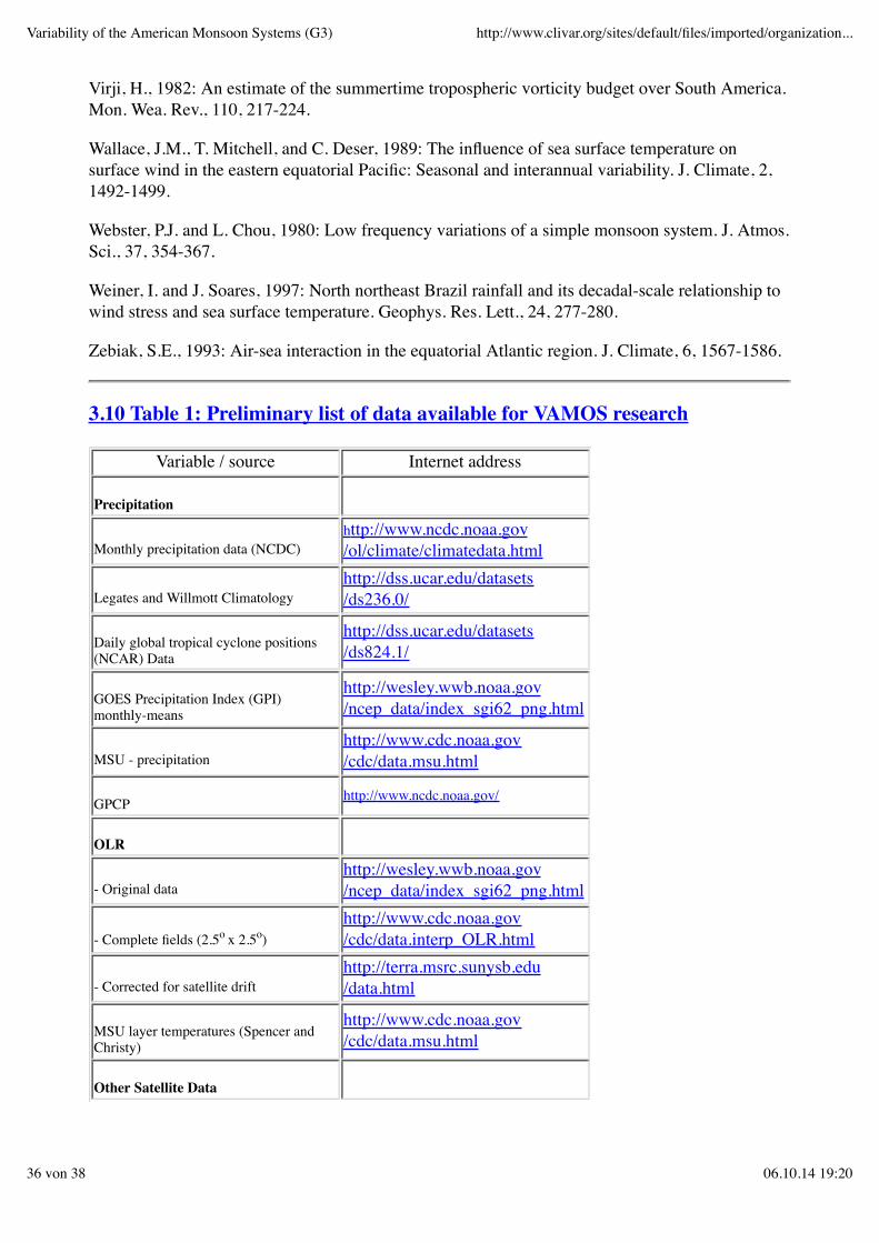
Virji, H., 1982: An estimate of the summertime tropospheric vorticity budget over South America.Mon. Wea. Rev., 110, 217-224.
Wallace, J.M., T. Mitchell, and C. Deser, 1989: The influence of sea surface temperature onsurface wind in the eastern equatorial Pacific: Seasonal and interannual variability. J. Climate, 2,1492-1499.
Webster, P.J. and L. Chou, 1980: Low frequency variations of a simple monsoon system. J. Atmos.Sci., 37, 354-367.
Weiner, I. and J. Soares, 1997: North northeast Brazil rainfall and its decadal-scale relationship towind stress and sea surface temperature. Geophys. Res. Lett., 24, 277-280.
Zebiak, S.E., 1993: Air-sea interaction in the equatorial Atlantic region. J. Climate, 6, 1567-1586.
3.10 Table 1: Preliminary list of data available for VAMOS research
Variable / source Internet address
Precipitation
Monthly precipitation data (NCDC)http://www.ncdc.noaa.gov/ol/climate/climatedata.html
Legates and Willmott Climatologyhttp://dss.ucar.edu/datasets/ds236.0/
Daily global tropical cyclone positions(NCAR) Data
http://dss.ucar.edu/datasets/ds824.1/
GOES Precipitation Index (GPI)monthly-means
http://wesley.wwb.noaa.gov/ncep_data/index_sgi62_png.html
MSU - precipitationhttp://www.cdc.noaa.gov/cdc/data.msu.html
GPCP http://www.ncdc.noaa.gov/
OLR
- Original datahttp://wesley.wwb.noaa.gov/ncep_data/index_sgi62_png.html
- Complete fields (2.5o x 2.5o)http://www.cdc.noaa.gov/cdc/data.interp_OLR.html
- Corrected for satellite drifthttp://terra.msrc.sunysb.edu/data.html
MSU layer temperatures (Spencer andChristy)
http://www.cdc.noaa.gov/cdc/data.msu.html
Other Satellite Data
Variability of the American Monsoon Systems (G3) http://www.clivar.org/sites/default/files/imported/organization...
36 von 38 06.10.14 19:20
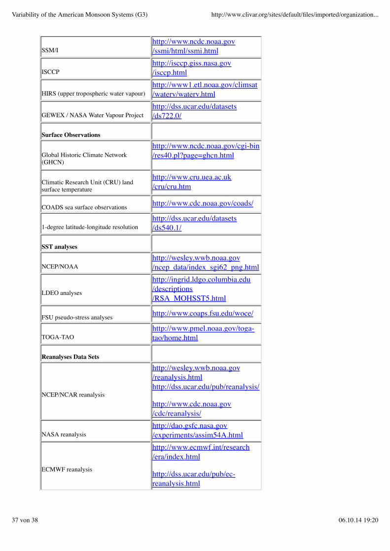
SSM/Ihttp://www.ncdc.noaa.gov/ssmi/html/ssmi.html
ISCCPhttp://isccp.giss.nasa.gov/isccp.html
HIRS (upper tropospheric water vapour)http://www1.etl.noaa.gov/climsat/waterv/waterv.html
GEWEX / NASA Water Vapour Projecthttp://dss.ucar.edu/datasets/ds722.0/
Surface Observations
Global Historic Climate Network(GHCN)
http://www.ncdc.noaa.gov/cgi-bin/res40.pl?page=ghcn.html
Climatic Research Unit (CRU) landsurface temperature
http://www.cru.uea.ac.uk/cru/cru.htm
COADS sea surface observations http://www.cdc.noaa.gov/coads/
1-degree latitude-longitude resolutionhttp://dss.ucar.edu/datasets/ds540.1/
SST analyses
NCEP/NOAAhttp://wesley.wwb.noaa.gov/ncep_data/index_sgi62_png.html
LDEO analyses
http://ingrid.ldgo.columbia.edu/descriptions/RSA_MOHSST5.html
FSU pseudo-stress analyses http://www.coaps.fsu.edu/woce/
TOGA-TAOhttp://www.pmel.noaa.gov/toga-tao/home.html
Reanalyses Data Sets
NCEP/NCAR reanalysis
http://wesley.wwb.noaa.gov/reanalysis.htmlhttp://dss.ucar.edu/pub/reanalysis/
http://www.cdc.noaa.gov/cdc/reanalysis/
NASA reanalysishttp://dao.gsfc.nasa.gov/experiments/assim54A.html
ECMWF reanalysis
http://www.ecmwf.int/research/era/index.html
http://dss.ucar.edu/pub/ec-reanalysis.html
Variability of the American Monsoon Systems (G3) http://www.clivar.org/sites/default/files/imported/organization...
37 von 38 06.10.14 19:20
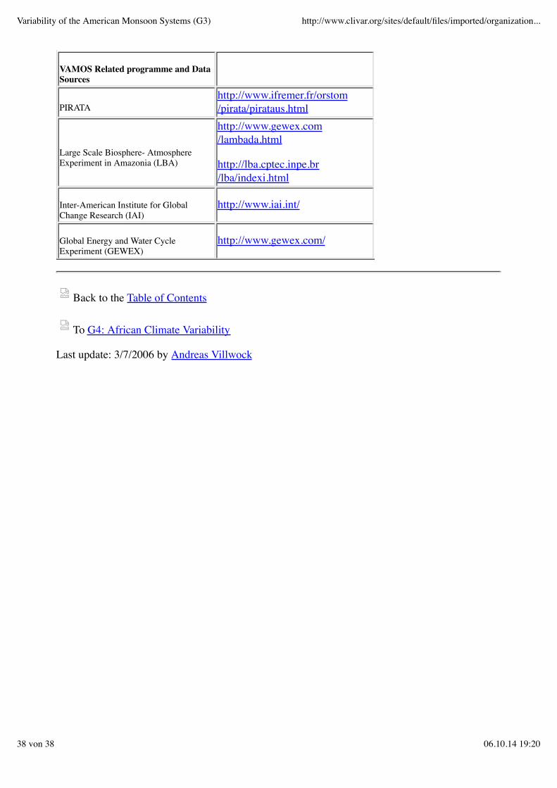
VAMOS Related programme and DataSources
PIRATAhttp://www.ifremer.fr/orstom/pirata/pirataus.html
Large Scale Biosphere- AtmosphereExperiment in Amazonia (LBA)
http://www.gewex.com/lambada.html
http://lba.cptec.inpe.br/lba/indexi.html
Inter-American Institute for GlobalChange Research (IAI)
http://www.iai.int/
Global Energy and Water CycleExperiment (GEWEX)
http://www.gewex.com/
Back to the Table of Contents
To G4: African Climate Variability
Last update: 3/7/2006 by Andreas Villwock
Variability of the American Monsoon Systems (G3) http://www.clivar.org/sites/default/files/imported/organization...
38 von 38 06.10.14 19:20