Embed Size (px)
Citation preview
Validation of Water Erosion Prediction Project (WEPP) Model for Low-Volume Forest ~ o a d s
W.J. Elliot, R.B. Foltz, and C.H. Luce, USDA Forest Service, Moscow, Idaho
Erosion rers of tecendy p d e d nongravel el@ r~ads were measumd under rainfall simulation on five different soils. The erosion rsres o b m d on 24 forest road erosion plow were compared with values predicted by tke Water Ekosicm Prediction Project w P ) Model, Version 93.1. Hydraulic d r n t i v i t y and soil d i i t y e a l a e s were pre- dicted from methods heloped for -land and WOP land soils.* was found &%ton four ofthe five SQ&, rnnoff values were closely pfediaed and hr the p~&d em- &on w not s@cantlp &rent Ercrm the observed em- sion when wing rangeland methe& for pdtcthg soil eradibili. It was aka found that interrill emion mtw wwc underpded using tangelad methods far pred'Q ing soil erodibiity, bus slightly o ~ e r p r W when using cropland interrill erodibitity pr~diotion methods. Rill ero- sion rates for road wheel ruts were elosely predicted from rangeland rill erodibiliy J w k .
T here is an increased awareness of theimportance of maintaining the global eosptem with all i hiologie ditremity. The USDA Forest S d a
manages Luge areas of the nation's foresdands and h an cod^ to apply the best t e c h n d ~ avaflable in itsmanagmeat piocew+ One of the ateas of concern in the forest eamystern is the amount of sed- bent eroded from forest mads inre gPgteFways that serve as spawning and rearing habitats bor fish and as h a b ' i for aquatic macromvembaEes.
The $uthon have been participating in the develop- ment of the Water Erodon Predicrion Pmjecc [WEPP], a maior interagwq r e ~ ~ c h and model devdopmens uroiect. The &or b t of the WEPP pmja has been * , m predict soil &don for agxi~ulhuai and rprrp&nd co~diriions. Fucther research L being c o n d u d to apply the WEPP d e l m forest roads and harvest arm.
The purpose of this study was to d&znnine the suifa- biIity of the WEFP model for forest road w~ditions and to contribute to the lida at ion of the WEPP hillslope model by coqasiag runoff and erosion eslimates pnr dnced by the m&l with observed data from rainfall simulation s ~ d i e s eamied out on forest roads.
The objectives of %hk paper are to fa) give an me- view of rhe W P erosion prediction achnolagy and &s applicatim m predksing forest road erosion and (b) de- tedne the suitabii of esdmating the eradibiliy of nonpvel road surfaces from eropknd and r a n e d research resalts
Din rwds commcted to afecss forestlands are majwr and persiowt sources of ~ e - t to he&^-

st-. &id ((1) i d a d &t fa a ,ma& Wa&igxon sueam M tvi& a tbdd d ~ i n Clf 2.5 u2, ap- prbprkte for s k y b cab[@ Iogg'in& sps- sediinenc W v a l h roid surfacre erosion a~i,unted for he- men 13 and 18 pnertear .of cbe tool. sedrraenr in die sh-em. kdiment fsom coBdS .caraalbttsed b- 34 .& Q p e r m rrf & =aent lm -2 mra in dim- e m Har r& : h ~ ~ s t r a w I g t raad :sediment pew .& can a do&b JOB a -;P
=&,,&?nt bu*t afld a ii- *- of be ,$& .fg,&t ;n p d c *
G* the potlntid bt s?%fimnt psodiucral, f*t madshmebecnt6eiocus o f a g e a t d e a l s f m e h t o esdmatc raws of soil Ew frok road swfzces and to ,determine tht ~ t c o n t r o 1 me&&. b.someaf h e ,ear Iiest quaMimtive r-ch H&vw (Z) & :and Trimhie (4 maswed erosion &om c r o ~ d o n a l lotffering. ~Cr@~*.@dnaI b k m ~ data cail h gtW- t i ~ h l e b r i s c bbrh cmijpacrion dw to ad& and oi,ion conuibutc to the 10- More raFnrt qum- titstivc w.rk hap concentrated ton mcasdng dima ant in.traps (fl or su8pdcd sedheatconrenaatio~~g from am &ios asld~ealm (5) aader nataral r&W mn- &&&. O&r iecentwo& m d shdati@
-emoff and er@&ofi &a.h (G-,@. &ae of .@ mt gwt&&$e cork whsd
6 , U hes been wed to e b ~ i r i d model building. &&an IP) mmrnctcd an t;~~omnrial dewl maitel of sedima~ produ&n .ow time ~ o ~ g Rdd and Dume [Sj .built an q u i d model relaring .h&, mad ,wgmmt length, and toad gradimc EO sad- 'hem $roduaion
ne -@tist & using rainfall ,-rim ksed qed ~&roth.eg$&i&xl and prc+x@-W mode& of rdwosioa. Burroughs mil King (I@) w d m i d l sbuh ibn an wyhg degree8 of mitigatien* suCh as s t r a w d & to ,,&&p empirical t&&p be- ~~ eppticarionrion Egre and e&cdvm&. wad (&? d *u to i&,&y ~"metec-valtfes &,*.& &35m 4 u1). b. & m e ,* & fob gte a
si- .*@ af.se&'qt in fom. Trp .* *G
has b e little ammpt ro p r e e fhe amount o f ,.&-
m e ~ t from a given section af LO J to aid in evaluatiag tile imparts af r d on uglad StEeamS..
Mmm6 ~o~lhm $i~ghtion modkiin$ makes I aatrabk mp- fributiad, t~ hydrologic ~eqeash and praCc&.~2~:). &id- search InvoIviag data couccdon h m low--. fdd *dies is a h w & g and m e & -tiye rn mRd& e m ,&&
6~ FJj h+&& of .--[ & co,&&*.
Sdien&'cs :we developin$ phpicallr bwed erbsicm pt$dI~dod. models ftn wmpureqs rhat aw the ~ssr to model :the iildi~idual prwce$%S &t lead to mil ero- GQU, irtdudinf r a w intensity and distribution, infilf~atirn and run&, d s d detachnaeut, .&am- pa, md deposidion. Early modeling, in the IBfOs, wirh p.hP~i~dly based models required mainfrae eapyret ,~apab&& & *ut dafa sm. The a e q r e & d afa&&&ty cf &hep 4 pee& m- p~$lS& Smedfs UOW m a k ~ . ~ ~ C h ti!Chn~l0~ a~&b]L to I@ na.turii m w c e inanago@. Pk&caUy h a d m*Uw. be swessfrtlt~applicd to ma* more-- &tiom r$an statkiical d e I s as k g as the faeto&. a f k t k g the processes can be iden&d and char*- n&ed (131,.
19&, the As- *& &p&&
(m) the s*g Go-.&& %& (S@) & c p operatipn with the B w u of taad Mana@tat .and the Forest $mike l a u d e d a c w p ~ f i v f : M c h . d o r t hewn ;ts the Erosion Predietioa Projm. The& ged wststo:dc*re10p a urn-friendly &pially hd.em- siom pidimon modcl that muid a p s e on a posrabk amp- & auld & 4 by s%s 6.rher &u
. . . . ; t ~ an .aid p,&r&n gild -7
vatibn pl& fer :aoplaad, and bms& Mer five years of Wd, Iabramry, and andrnptu re- ,@& the first ~~aple@l rewad don ofthe WZPP -papaw rele%d B Augast 19119 . a d the first fieid v d n in 1991. It is eqededthatthe mmQdelwillbegiu rcaivkg apid~*~pread we bp St3 in the .he 19!i!OS and dl k c h e trorswn prcdiedon d e l rifondmh kit0 the WNiy (14).
Tht PPEPP model & based on fnndapenulIs of Wuati~n, surface runog, plant growth, reSi'due decomporjtion, hydraulics, tillage .iriemg&enf soil .consh))ida~on, and .e~osMsl .mdmias ($a. Table 1 s e the impmtant Input pmmetws for the mit11, Thhr model cmhines pttp&dly baad er-ogiea and hy&lw:.mo,&wi& a && be w- armr to e s h p &I logs and depasltim and rhus fad- & & . * ~ O P : Q f ~ ~ p s ~ * t a ~ . .
?% ~ .ad er&a The WBPP rnchlagy includes a hihlegw pr&
verJion, a watershed version, a d a grid versicJn (1:6). TBe &Mope version wBm and where
add +&&on an a &koPe, tltting inra .rmw m e m e n % p~~ and dimate. It h dB% *&&,&the p-.*i* @osiod
~ r e d i c t & s a h n o f ~ ~ a M p % e . ~ . .The &I m9p dm be d in Ehe s i & w t ~ m ~ d e . (1s). The wamshed v&n w&incs:a &E ofhill- slopesarrdEhannelelemmtstodescrIbea.dwater- s6ed The gdd vezsion, now under developmmt, will eombk I @,j .f Wpes & a .&€ can 4 .sl"@.jil m"f&e.&.
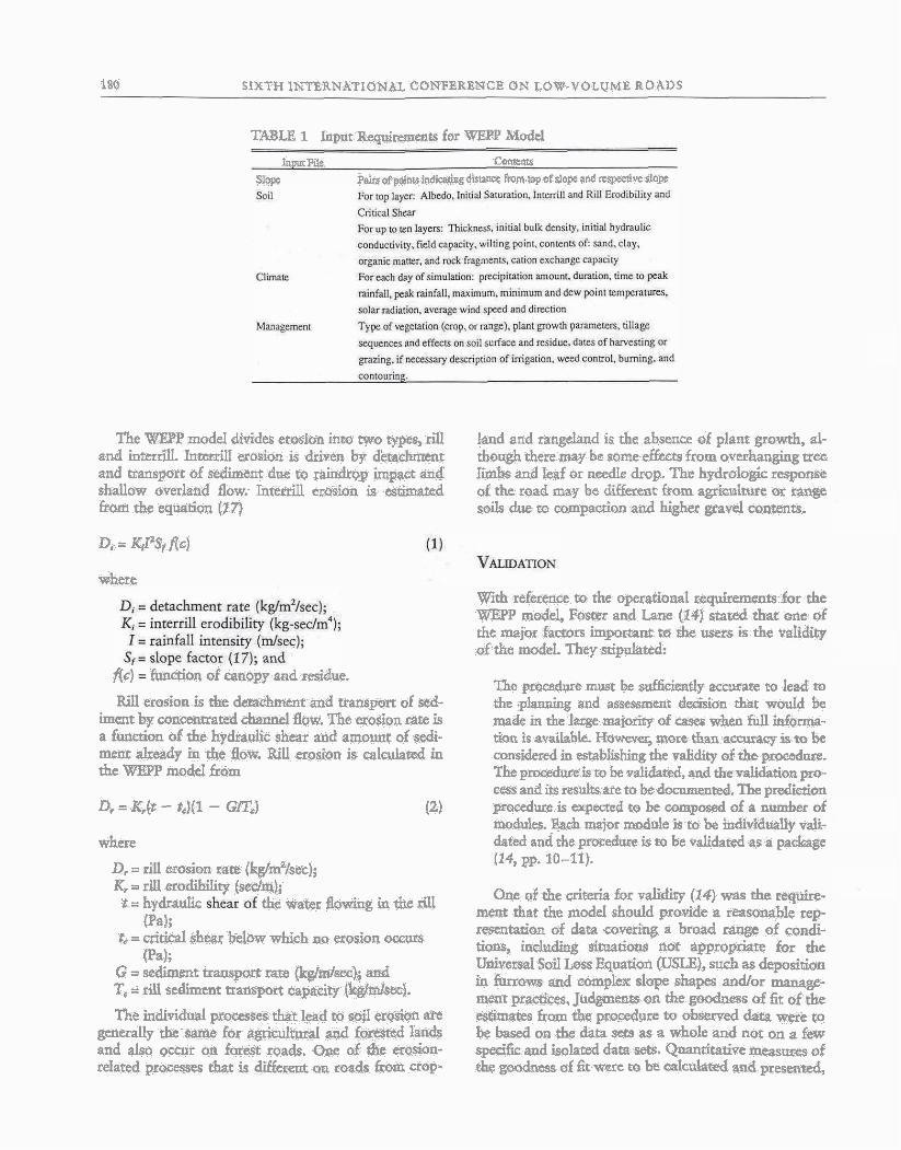
180 SIXTH INTZRNATIONAL CONTiBRENCE ON LOW-VOLUME ROADS
TABLE 1 Input Reqirements for W P Model
Input P* Come=
=ppc l$*s ~f sob,@ *idi&gdism(1~t Ron topof slw and r6swtive 516pc
The WEPP model divides erosion into two ypes,dl l a d and rangJand is the absence of plant grawth, al- a d interrill. Inretrill erosion is driven by detadunmt tho& there may be some effeas from overhanging tree and transport of &m due to raindrop impact and limbsand leaf or needle drop. The hydrologic response shallow overland flow. h t e d erosion is m t e d of rhe mad may k clifferent from agricuIture or t a n s from the eqwtition (17) soils due to compacdon and higher grad confents.
Di = KPS, flc)
where W i reference ro the operational rqnhments for the WEPP model, F6st~ and Lane (14) s t a d that one OF the majw faaon impoaant to the users is the validity of rhe model. Thep stipulated:
fit) fn&~n of canopy and residue. The pmcedwe rust be std6ciend.y accurate to lead m
Rill erosloa is the dem&nr and rransport of std- thE .planning and assmrnent &&ion dmt wouId be imcnt by c01lmmami ckannel flow. The erosion rate is made in the large majoriw of cases whcn fill Manna- a function 6f tke hydratalk shear and amona of scdi- ucion is available. Hawevq mare than accwwy is to be mem already in the flaw. Rill erosion is calculatd in censidered in establishing the validity of the pmcedw. the Wl?.lT modeI from The ~roeeduteisu, be validated and the validation mo-
D* = &(t - tJ(l - Gm*)
where
cespand~red~sretok&ted.~hepredi& (2) procedure is expacted to be composed of a rider of
&es. &ah major module is to be indiddually vali- dated and &e procedure is to be validated as a package (14, pp. 10-11).
. - D. = rill erosion rare (kg/mlsec); % = rill erodibitity (sedrqj; One of the criteria for validirp (14) was the require- '= hpdraa &' water flowing & * dl ment that rhe mode1 should provide a reasonable rep
(Pa); L = critical shear below which a~ erosion omw
mantation of data coverkg a broad range of candi-
[Pa); tiow* kidding situatiom not appropriare for rhe
G = sediment trw rate (kglm/seo); aud Unived $03 h s &nation WSLE), such as deposition
T. = rill sedimut a n s p a t mpaciy (kghid. in fanom and complex slope shapea and/or manage- mean praaices, Judgments on the goodness of fit of the
The individual p r m that lead to sail erosion ate alimates fram rhe pzocedure to obserped data m e to generally the same for 5gr idrmal4 f o x e d lands be based on the data sets as a whole and not on a few and also o a r on fore@ roads. Qqe d cbe erosion- spedfk and ieolated data sets. Quantitatim inewures of relared pswesses that is di@xea w mads &om crop tLw goodness of fit wore to be &dated aad presented,
,-.---.- - - ELLIOT El AL. 181
but a quantitarive lwel of accuracy figure was not spec- ified because of the great variation in the experimental data that would be used in validation. Ho- the resulrs were to be at least as good with respect to ob- served data and known relarimships as those predicted by the USE.
Road Erosion Data CoUection
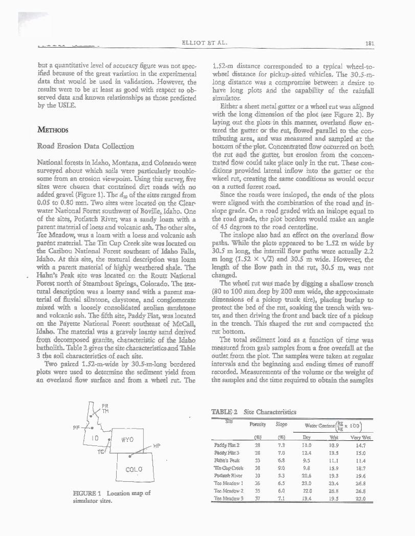
National forests in Idaho$ Montapa, and Calorado wece surveyed about which soils were paaiculady (rouble- some from an erosion viewpoint. Using this s w q , &ve sites were chosen rhat contained dirt roads with no added p v d ( F i e 1). The d, of the sites ranged from 0.05 m 0.80 mm. Two sires were located on the Clear- warn National Forat southwest of Bode, Idaho. One of the sites, Potlatch Riveg was u sandy loam wirh a patent marerial of Ioess and voIcanicasB The other size, Tee Meadow, was a loans with a loess and volcanic ash p-t material. The Ti Cup Creek site was located on the Caribou Nat ied Forest sourheas of Idaho Falls, Idaho. At this site, the remural description was loam with a parent marerial of &ghly weathered shale. The
. W s Peak site was locared on the Boutt NatEonal Forest north of Steamboat Springs, Colorado. The twr- tural desaiption was a loamy sand with a p m ma- terial of flufluvial siltatone, claysrone, and congiommate m i d with a laosely consolidated aeolian s a n b n e and polcantc ash. The fifth site, Paddy Flat, was lmcated on the Peiyeene Natioml Forest 6outlnxs of M a Idaho. Tbe material was a gravely loamy sand derived h m decomposed granite, ka~teEist ic of the Idaho batholith. Table 2 gives the s i t e c h a m m i d a d Table 3 the sail characterkria of each site.
W o paired 1.52-m-wide by 30.5-m-laag bordered plots were used to det-e rhe sediment yield from an overland flow sudaee and from a w h l rnt. The
1.52-m distance corresponded to a typical wheel-to- wheel distanee for pickup-sized vehicles. The 30.5-m- long distance was a compmnke bemeen a desire m have 10% plots and the Gapability of the e a i n k t l 8ilDliht0r.
Eithera shwt meral gum or a wheel rut m s aligned with the Ion8 dimension of rhe plot (see Figure 2). By laying out the plots in this manner, o~erland flow a- wed the gutter or the rut, flawed pmallel to the con- tribudag arm arid was measured and sampled a t rhe b e o m of the pbt. Concentrated flaw o m e d on both the tur and the gutter, but erosion from the concen- trqbd flow c6dd cake place only in the rar. These con- ditions provided lateral i dow into the gutter or the wheel rut, seating the same c o n d i as would occur on a nmed forest r o d
k e the roads were insloped, the e d of the plots were aligned with the combination of the road and in- slope pde. On a road graded with an inslope equal to the road grade, the plot borders would make an angk of 45 degrees to the roed centerline.
The &pe also had an effect on the overland flow paths, While the phts appeared to be 1.52 m wide by 30.5 m hng, the i n t d flow paths wese actually 2.2 m long (1.52 X '82) and 30.5 m wide. HowePer, the latgth of the flow path in the Nr, 30.5 m, was not changed.
The wheel rut avas made hy dig& a shallow m c h (80 to 100 mm deep by 200 ma widc, the approximate dbwnskions of a picknp mtck tire), pkdng burlap to pmect the bed of the mi, sozking the wench with wa- rer, and then drb@ the front and back t ire of a pickup inthe~each.Thisshapedrhemtandcompactedthe rut bornom.
The total sediment load as a function af time was measwed from grab samples fram a free OWIM as the ondet from the plot. The samples were taken at regulax intervals and the beg&& and endig rimes of muff recorded. Meamitemems of the volume or the FPeight of the sampEes and the time squired to obtain the samples
P F b T L [ ' *
TABLE2 STtecharaa2terisii~s
mps W ~ ~ ~ ( ~ ~ I O O )
mt 6% w Wa vaywa PaddyFlat2 28 7.3 11.0 10.9 14.7
TC . PPddyFlat3 28 71) 1 2 4 13.3 15.0 ~ h n ' s P & 33 66 9.5 11.1 11.4
CoLo TinOugCmk 38 9-0 9.8 15.9 18.7 PMImltRivcr 33 5.3 20.6 19.3 19.6 TceWaw 1 )6 6.5 23.0 23.4 26.8
FIGURE 1 Locanontaap of T w W w 2 35 6.0 22.0 u5.8 26.8
simulator Sites. Te~Msadowl 37 7.1 19.4 19.5 22.0
182 SIXTH INTERNATIONAL CONFERENCE ON LOW-VOLUME ROADS
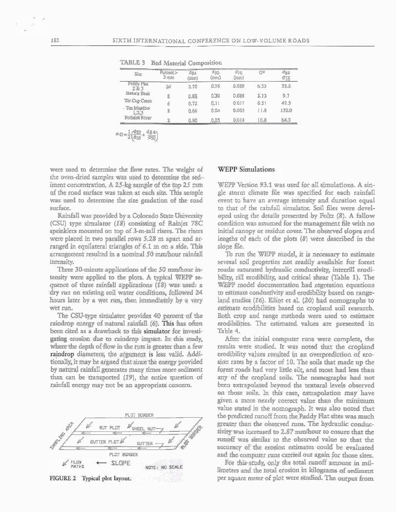
TABLE 3 Bed M a t 4 Compositioo
Sa BerCrnH~ W 6% dl6 Ce $4 2 . m ~ (ma1 h> Onrri) a
"%P 24 2.7Q 0.76 8.W &5& 33.8 B U ~ ' ~ W 8 0.82 030 0.085 3.13 9.7 ?-OG9w 6 0.72 0.11 0.Q17 6 51 42 % .Tem#adaw
1.23 OJ$~ 0.04 kl.005 11.8 L%O PO^^ egg 0.0s ~1.014 la., rira
a~=-lf%!2+~a3 z el6 rn
were used to determine the deoP tares. ih..weight d the oven-dried samp~es was used tq der- rf ie s~d-. iment conoeWation. A U-kgsatnple of the -2.5 ~D@I of the road sutface was d e n at each sitt. This sample was used to 'deteriuim the siae .gmdation of the riad surface.
Rainfall was provided by a Co10rado &re U&se&y (CSU) type simulatoz (IP) coasltting of Rainjet 78% apdclers mouueed on cop of 3-m-tall risers. The risers were pIacsd ia two parallel mras S.28 m apart and ar- ranged in eqoilaferal aian&s of 6.1 m on a side. This wangemeat resulted m a nominal $0 mmm0,ur rainfall inteasiity.
' T h e 30-minure applicatiens of the 50 d o . m in- tend~ were appM to the plots, A @tcd WB?P se- quence of three d & U applieatiens (18) ws~: 4: a
run on &*g soil water mnditims, f&d M hours latu by a vet then imniately bp a v m W e I'M.
The W q p e skdatar p~ouides 4D percent qf the raindrop entrga d nahlral~9in'Sl [i),. b, o h heen c-&, as a c t . g ~ f ~ .= :,& for dd-
a d o n .d& to ; ~ & p @m, I1 this smdy, whae&deprhof&m&&.mis@eater&a:kw
d b ~ i the -t less && Ad& &alltittnqb.r aigued &atshc&e eJgQ,yp~~aSded by .natural r & M l gtnerates many times more sediment than can be h m p d (tP):, the eat& ,guestian of rabdall en= my not be an appropriard wxem
PLOT BORDER y7m/ 3 sp
PLDT B m E R 8
BltEPP Vasion 93.1 was used for all simularions. A sin- gle storm dim& file mas sp&ed for each rainfall event to have an aTerage intensity and duration equal m that of the rainfall simulator. Sail files were devd- oped using rhe detaiis preaenred by Foltz (8). A. fallow candiuon was assumed for the enagement fie wir l~ no initial canopy or residue wvar. The observed slopes and lengths of each of the plots (81 were described in the slope file.
To nm the WEPP model, it Is necessary to estimate seveml soil properties not mdily a d a b l e For forest roads sawred hy$raulic conducdvityJ in& erodi- biky, dl erodibilirp, and cri&cal shear (Bbk 1). The WEPP model donunentatibn had regression equations m estimate condncriviy and ero&bilitp based on range- land studies (16). Elliot et aL (20) had nomograph to e s h t e erodibdities h e d an cropland sail research. Both map and ran@ methods were used to estimate mdibibies. The estimated yalues are presented in TahL 4.
After the %&a1 computer runs were wmplete, the t e s h wate studied. It was noted b t the cropland edibility values resulted in an overpredidon af cro- sion raw a £actof of 10. The soits thar made up the forest roads had very little silt, and most Id Iess &an any of of wopland soils. The nanographs had nor been ucnapolated beyond the t d levels observed on -those soils. In &is ease, extrapolation map have given a more rrearlr correct value than tlxe minimum value seam4 in the nomograph. It was also noted that fhgpredhed~naff fromthe~addy Flarsitesrpasmuch greater than the o h m d rams. The hpdranlic mnduc- tiviFpwas irrcres+ed~2$7d(w1t0ertsurethar&e RUXQEE was h i t a r to the o b ~ e d value so that the m a q df the etosion estimates eodd be nraluated and the c~mpufer runs carded out. again for those sires.
For Fos smds only the totatal runoff amounc in mil- heten and the total erosion k~ kilograms of sediment per square meter of plot were shrdied The output from

El 1 107 ET AL. 183
TABLE 4 Estimated Soil Erodibil'q Properties Using Rangeland and Cropland Methods
the WEPP pmgram provides coqsiderable dqail about the disrriburion of erosion or deposition along a hill- slope, a muoff hfdrograpb, average erosion, sediment yields, and sediment size didudon . The WJPP outpat fib also contains the amount of inwill erodon.im k& c p m per square meter. ?;his predicted fate should be comparable to rhe erosion observed from the plots %-ith the meeal gutter lining the wheel rut because there was uo deposition obarved in the b e L Fume &dies comidering the sesedimeM size dis@ibde and nmoff hydrographs may provide additional insight into the ap- propriateness of OWSPrP for orodeling h t read msion PI-
Runoff
The 0bsez-d and predicted nmoff ram are pr-d in Table 5. A stetistical andpis of these data showed rhat thw were differences in moff between sires (P s .001), w&ch would be -red with difkmt soil con- ditium. There m e differem in EUIL& bwem owrs (P < .001), with the wet aad v q wa runs generally having greater nm& amounts. Gene&& rhe WEPP modei pr,di.cd these differences. Thw wme SriU sm- risdcally significmt d i f f ~ i e m bettaeea. abserved and predickd edoirates (P < .001) in spire of the manual adiustment made to the saturated hydraulic conductiv- iry for the Paddy Hat shes. The differences were s e L b greater than 10 percent and, gemdy, the prdicced amoff was greater than the obsenred muf f , s So hy- draulic condnniviy may have been un&&ted. Be-
muse of the low hydra* condunivities of most roads compared to the rainfall snd she unifonniry of simu- lated raidail, large diEe'cmce8 d d not be expected. Under conditions of lower rai&ll am~ltnts~ or higher conductiviriq greater discrepancies in mnoff prediction ma9 be expected. The hydraulic condudvicy of the Paddy Flat site was much peaw than the o k site+ and greaw &an the prediction quadam h a t e d The materialat h d d y Fht i s d e c ~ m ~ e d garire, with a much higher sand con=.
There was a si+cant interaden between the de- rwninatian method (observed or predicted) ad s h (P a .001), mwing d m on some sites., =off was over- ptedicred, whereas on other dtes. it was +- There was alsa a dgniiicaut inreradon betlsaen sites and nurs CP e .001), m w that not all sites had gmm mnoffa from the wet or very wet tuns. These interadons cran be nored in rhe moffvalues presented in Table 5, fw cxauiple, rhe Tee Meadow 3 site, arhare the site was wet for the initial event (Table 2).
The resuls of the predicted and observed e r d n rates are pre~ehted in Table 5 for the plots with m. when wing &e ria and h t e d erodibMes as predicted by cropland methods, rhe predicted erosion rate was a p prextnateiy 10 times Ebe & s e n d s&ent yield. TlGs would mgesr that masagem hoping to estimate road erosion rates ushg any type of a&ulturaI rnedrod should be exmemely cau&us to ensure that aIl of the differences b e e n the forest conditions and the agri* colt91 conditions are carefuIly c ~ ~ l ~ h d .
- 184 SIXTH INTERNATIONAL CONFERBNCE OW LOW-VOLUME ROADS
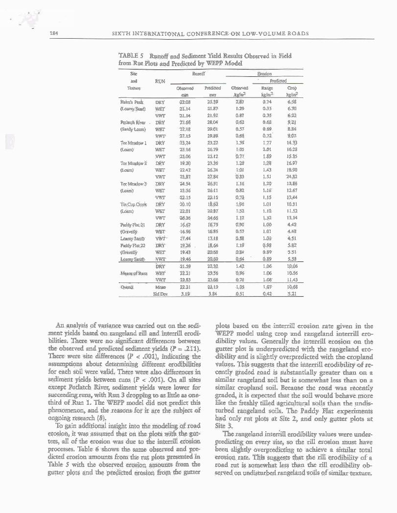
TABLE 5 RMoff and Sediment %Id R~ELIIIU Observed in FieEd from Rut Plots and Rediaed by WEPP Model
Ron& Emoion ead RUN P n a d d
TcaMe m e d RLdiW ed h p CIOp m m wm2 wmz w 3
Knhk P&& Y 25118 23.39 a%? P.94 6.98 [Lauay Saw4 WET 31.14 3161 1.29 0.35 6.30
W 21.111 25.92 0.87 0.35 6.22 w t h r c h ~ i ~ ~ r DRY 27.64 zg04 a62 0.68 9.21 (sindy ~oam) w 29.18 m i 0.57 o 69 aw
WfT 27.15 29.89 0.68 0.72 9.m TeeMcadw1 DRY a1 23.27 139 1.77 14.33 (LOPIRI wsr =.!a 16.79 13s Z.OI 16.28
W 3fa6 25.12 0.77 1.89 15.35 TmMasdavZ DRY 1.9.20 23.36 1.28 1.28 16.97 ( k w HtEl' 23.42 26.3 1.01 1.43 18.90
W 29.87 27.W 0.83 1.11 24,82 TecMtdm3 QRY 24.54 1651 1.16 1.20 1286 (IMm) RST 23.36 26.11 O.%Z 1-13 12.67
W 2215 22.15 U.73 1.15 1244 r i -~ l rek DRI 20.10 ~8.62 1.98 1.01 10.31 @ma 1LO1 20.87 1.S 1.1'2 1l.B
YWT 56-38 2465 1.12 1.32 13.54 Wdy flat 21 DRY 1667 t6.73 0.W 1.m 4.42 * d Y W6T la% 1085 051 1.a 4.43 ~e~ysanm w- 17.44 1 ~ 1 8 03s 1.~3 651 WdyT)atYZ DRY t9.26 L%U 1.S 0.W 5.62 (ow* WFT 1943 m.58 0.84 0.89 5 51 L o s m y W WVr 19.46 Ta6P 0.S 0.89 5 . S
EBW ai.s9 2232 1.42 1.06 m.ob M m m o l ~ WEP B.21 23.56 O.% 1.06 10.56
VWP 25.83 2 3 8 6 8 0.78 1.08 11.43 ovaall MCP 22.21 23.19 1.05 1.07 10.8%
WDut 3.1% 1s 0.51 0.42 521
An apalysh of variance was d e d out on the sedi- mest f el& basad on angeland rill and interrill erodi- bilitb. Them were no sipihnt di&~nces h e n the observed a d predicted sediment yields (P = 211). k e were site &eaces (P < .001), i nk * the assumptioas about detetmining different erodibiies for each sbil were valid. There were also &ences in = h t yields between ~ o s (P < .Q01). Qn all sires except Pohtch R i m +ent yields wcre lower for succeeding runs, with Bun 3 dropping to as lide ras one- third of Run 1. The 'OttBPP model rdid not predict rhis phenomenon, and the reasons for it are the &ect of ongoing reseglrh (8).
To gain additional insight into rhe hemodcling of road erosion, it was assumed that on che pi& wit$ them- tern, all of the erosion was due to the inteniil d u n promm. Table 6 shows the same observed snd pre- dkmd erosion amumzs from the rut pI& p r d in Table 5 with the observod masion ar9iow.m hom the gum plots and the pmlicted eradim &om the gum
plots based on the beerriti erosion rate given in the WEPP mod4 tKing crop and rangehnd intenill ero- dibility values. Generally the interrill erosion on the gutter plot is underprediid with the rangeland ero- dib* and is slightly averpredicted with the cropland vdues. This suggests that the interrill erodibility of r e m d y graded road is substantially greater than on a similar raageland mil but is somewhat less rhan on a sirnilat cropland soil. Became the read was recently graded, it is e x p d that the soil would behave more like the freshty rued agidltural soils than the nndis- ambed rangeland soils. The Paddy ]Fiat e n t s had only rut plots at Site 2, and only gutter plots at Site 3.
The rangeland i n r d eroditdiy values were unk- prdmiq on every sire, so the riil erosion must have been slightly o~erprediicring ta achieve a similar total wosion rate. suggests that the rill erodib* of a road rut is somewhat Less than the rill erodibiiity ob- saved on undisturbed rangelandsoih of similar texture.

ELLIOT ET AL.
TABLE 6 Zsthdon of Total d I n t d Eaosion Wares
Rut plc(mh = ~ ~ m ~ u o s r n = I ~ I Only SfTkand RUN Ri l l+ lmain
7 obwd mroQ Wm2 d !dm* Rlng Cmp
HP DRY PglO U.731) 0386 rM)lS 0.137 H F W ~ ~ r n OM 8397 MIS am ~ Y W T as70 OSY Q.W ow 0.417 PRW om 0.617 o'asa 0.136 0.816 PR W 0368 0.680 0.218 0.16% 0 822 PR YWF 0.676 0117 &284 0,180 0.SZ llill DRY 1.W 1.761 0553 0.135 0.749 'IMIW l .W L W 0.747 0.165 0.916 IXIYWF 0.771 1.m 0.614 8144 0.803 m a m y 1.?a 1232 w76 0.120 0.m TMlWET 1.012 1.428 0.568 0 140 Q 677 ~ M ~ D R Y 1 . 1 s 1.w ' 0.m 0.160 a.774 T M P W 0.817 1.178 8.476 0,147 6.7 U a 3 w 0.7~0 1.1~2 0.469 0.1% a.6~ E D B Y 1.9@ 1.807 0.83 0.089 0,486 TCW 1.5~ 1.1n I.I@ 0.097 0.~11 EWT 1.120 1.311 I.Ei3 0.324 0.68 Pnl DRY 1.187 OW 6 * YE21 WET 0.839 [.MI7 * q q
PFLI V W I 0.637 Lo25 = * * PP2aBRY 0.m 0,%?6 t t * PF%WET Of72 041 * li I
E'FxZy 0.585 0.885 w PF31 DRY t e 0.354 0.036 0401 FF3l WET I* 0.2% 0.039 0.4% PF31Wn a I 8231 OD39 0.436 ~ ~ 3 2 DRY . . 0367 5 n ~ a401 =WET I . b.28a 0.038 0.436 PPZ1W a257 0~x38 0,436
&BANS 1.042 laP3 03188 0 091, 0367 St% (m6 0,417 0260 0.059 0.235
* Paddy R s l q w l m m hsd only rutplog ar r b Z d addy ~ p l ~ a r 3. Rut a w b r m arak arodmdify vrlw wrly*
From an &I smdy ro compare the prediaed and m 4 muoff and erosidn from foxst roads wing the WEPP W o p e mdeI, the fo11owing w~cLusim were reached.
1, WJZP input Bes can be developed for forest roads.
2. With rhe raiddl inrensite much greater tban hy- draulic conducrivirlesd the use of the prediction eqm rions in the WrESP man4 and the WEFT model pre- b d ntwff within 10 percent of the observed total volume on four out of five hve On the powly pre- dicted soil, the observed hydraulii wndusrivi~ was greater than pedined by &e quatiom and was also &pi&&y $ream than generally observed on &ye- surface roads,
3. The hted erosion of a recently graded, non- gravel forest roads is sgpiiicantly grearer ib would bc %nperred fmn~ undisaubed mqqebad soh, but g e n d y not as grmt from a aopland sail of similar texture.
4. The rill erosion from a wheel rut is somewhat less thaa the dl erosion of an undisnubed rangeland soil of similar t ame , and considerably less (10 percent) than wodd he prediaed with mopland erodibility values. This s u b t i a l differace shows the potentid hazard of & agri&e erosion te&nolo%y on forest roads. S. Following a grading disturbanq soil erosion
from brat roads reduas wirh successive stom, but rhe WEPP program does not model fer dris process.
From this initial studs it appears that the WEPp model may piovide msonableestimam of m o d and erosion from forest rot&, but hvther study is necessaq
LESCE ON LOW-VOLUME ROADS
to determine road erodibiIity parameters, and rmsonc for dedincs in uo&n rates with succssi~e storm Ad- ditional work with more detailed fiskd dam and he wa- ter6hed version of WlPP is ~l~~essary rn My evaluate run& and sediment load rates from complw rod ptim,
The aurbors would like to e c k c i ~ w b the ashtpgee of Trey Xlanroe, *&ate d e n t in a g r i c t a l d m g h h g at the Unipusiy of Idaho, fer rhe p e p - ration of I as, wnaing of the =models, and assisimcc with the sthqumt s&cal analpea, The IWC& wm sqpoed by the USDA Forest Sexvice ~ o ~ - tain h& Stadon, Moscow, Idaho.
1. &id, L M. Wimmt Pm$uca'm fiom GlsuahLrlQcsd FwsJt Roads, &asiff, Wrnbj*nn PRI-UW- 8108. F i k k R& Mtute, Univdty of Ww&- ton, hnl.el l%L
2 Ikwq M. D. Watet and T i &a-t. JOWI ofsoil W w c#$e?wa Val. 7,195& pp. 75-7%.
3. WdtLmm, S;., and G R w. Skid-ad Erosion 'h 2+ Redaced Jmnalof Soil Wcfta Voi, 17, NO. 3,19S& pp" 122-134.
4 &gahan,W. P. andE J. Kid& Em of &a&
seenh Papa INT-123. USDAPonst Smke, lncemmn- lain bearah Station, Ogden, Utah, 1972.
5. &id, L M. ma T. Dunnc. Sediment ~~n b n Fwst Road Srrrbcts W m Ratowtap Rcseanh, VoL 20, No. f 1, I%, pp. 1733-1761.
6. Wud, Tm J. A b d y of RmogandEmsk Prc~cssts Us- i f f g L a v g e m r d 8 d W a B M . W R R I B e p o r t Na. 215. New t&&o W h Resourn Researcb Insti- sutq Ids CRlres, 1986.
7. War, l J., ,R. B. Poh, C. K LW, and 1? R bbi- &aid A T d 6x bimh Diimbed Fomt Site Sodi- snwt Prodwion. Ptwc., kt& Cpda~Mock-Wiitc pi, Forwk Ecclogy. c m d ' ~ ~ m t Spg~vIm, De- pcmat of Nawd Rrsaune kimces, Wjlabgton Sratr Unhie~s&, P&mPofhnan, 1993.
8. Foltz, B. B. Sedfmmt P ~ c w e s in Wheel Ruu on U w - f w d Purest loads. PLD. d i s ~ t i w . URivcr~~ a1 Idaho, Moscow, 1993.
9. Me&;m, Wb WIE. Emsion Qtcn Thne on S m I y Dis- wbed Grunitic Sdk: A Moasl Rescad Paw INT-156. USDA Form Service, Intamowntain Research Stadw, QCn, Utub, 1974. c-
10. Burroqhs, E R, JL, and J. G. I(ing. i tehdon of Sofl h i o m on For& Raeds: W. Ttds. Rqp. ENT-564. USDA Porest SEMiez, Inmouneain h c h Sradon, Ogdm, Utah, 1989.
11. S i o n ~ , D. &, R. K Li, and and J. Ward k p k Pmu- dutd Wod fit &timaw On-&& 9oII ~1&. Be- pon CW76-77DEBWTJWJ8. Calondo Snrc Uni- vaity* Fon e O b I 1977.
12. Fure'ua, V. A, and R. E. Sdh. The Limitrd Pkysicll Ba- sis of Phpically Bawd kly&o!q& MOMS. In Modeling @icrtE~rrmf~ POT&, d rrnQq4krad Kydvhgy, fio~., 19-88 Intmdkd ~ y n c p ~ & ~ , Chicagv, 111. St Jaseph, Mi&, 1988, pp. 10-18.
13. Fosc~, G. IL, and L. D. Xdeges. Mathematical SimUtaCn of Uplsnd Jkosion by FundmenaL Bmsion Mechar&. Proc., Sdjtmt-YCId Rwk5hop. USDA Sediment Lab, O d d , 197Z.
14. Posnt G. k. a d L 1. Lane. moilem. User W r e - me& USI)~ Wstn &cion kc& Ptofcct @PI. NSERL REnort No. 1. UgDA-M.5, NadoIM]. hid Erosion Rwascb &hontory, Purdue University, West LaEayette, Id, 1987.
15. N&g, M. A, G. R Fostec, L. J. Lane, and 5.6. Fi- wr. A Proass-Based Soit Erosim Modd for USDA-W8w Erodton Prediction Projrot Tcehndogy. Tkist~& of the ASAE, VoL 32, Ne. 5,1989, pp. 1587-1S3.
16. Lane, L, J., and M, A. Nearin& ads. Ws.D;A-W& Ero- don Pre&ction Projsut HilMope Pro& bdodel DQM- menhation. NBiU Wepoet Na. 2. USDA-ARS, Natiotlsl Si &&on Aesearrh Laboratory, Purdiie Unimity, West Lafaycno, hd., 19$9.
17. Liebcsow, A.M., W. J. E&t, J.M L a b s and K. D. #old. herrill Erodibiii~: Colloction and Ansly& of Dam Psom Cropland Soils. Tr- of the MAE? VoL 96, NO. 6,1990, pp. 1882-1888.
18. M. I% H o h d Da&u and Te&g of8 i&i.faIl Sy6r.m c]eff 69-70 m 21. Cotoredo State Univcrsty Erpul- m a t Station, Fort COG, 1969,
19. hb,O.O,D.D. P-XJ, Ellior,aadRK Eames. Soil am' Wnw Commaa'm Engitwhg, 4th d. John Wiiq asrd Sans, Nna Yd, 1993.
20. Elliot, E! J. M. La&cn, ,and G, B Bsw. Sei1 Emdk bSty Nmpaphs fol. dhe WEPP Model, Paper No. 93Z046, MAE, St Jbeeph, Mi&, 1993.
CONFERENCE PROCEEDINGS 6
Sixth International Conference on
Low-Volume Roads


![Preferential petroleum migration pathways and prediction of ......holes (%)]/2. In the Eastern PRM Basin, the modeling results give an MPI 1 (prediction of discoveries) of 97% (37](https://img.pdfslide.us/doc/110x75/610bfd7c29cbaf0b431ba9d3/preferential-petroleum-migration-pathways-and-prediction-of-holes-2.jpg)