Embed Size (px)
Citation preview
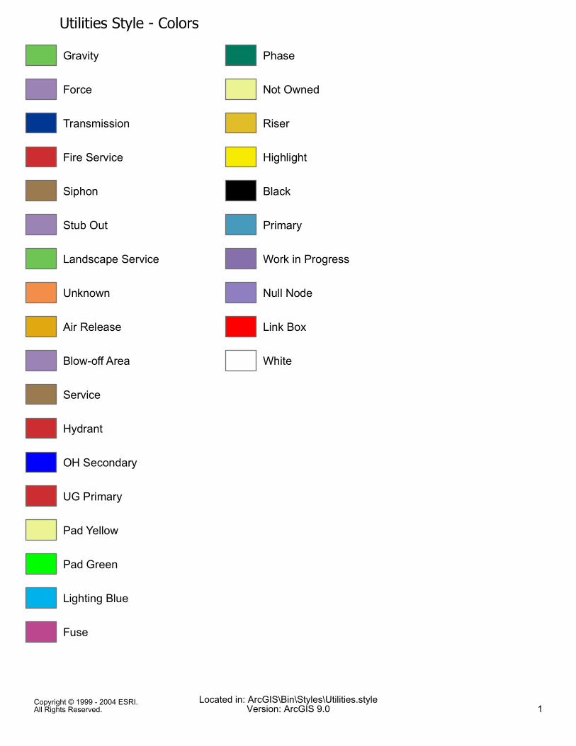
Utilities Style - ColorsGravity
Force
Transmission
Fire Service
Siphon
Stub Out
Landscape Service
Unknown
Air Release
Blow-off Area
Service
Hydrant
OH Secondary
UG Primary
Pad Yellow
Pad Green
Lighting Blue
Fuse
Phase
Not Owned
Riser
Highlight
Black
Primary
Work in Progress
Null Node
Link Box
White
Copyright © 1999 - 2004 ESRI.All Rights Reserved.
Located in: ArcGIS\Bin\Styles\Utilities.styleVersion: ArcGIS 9.0 1
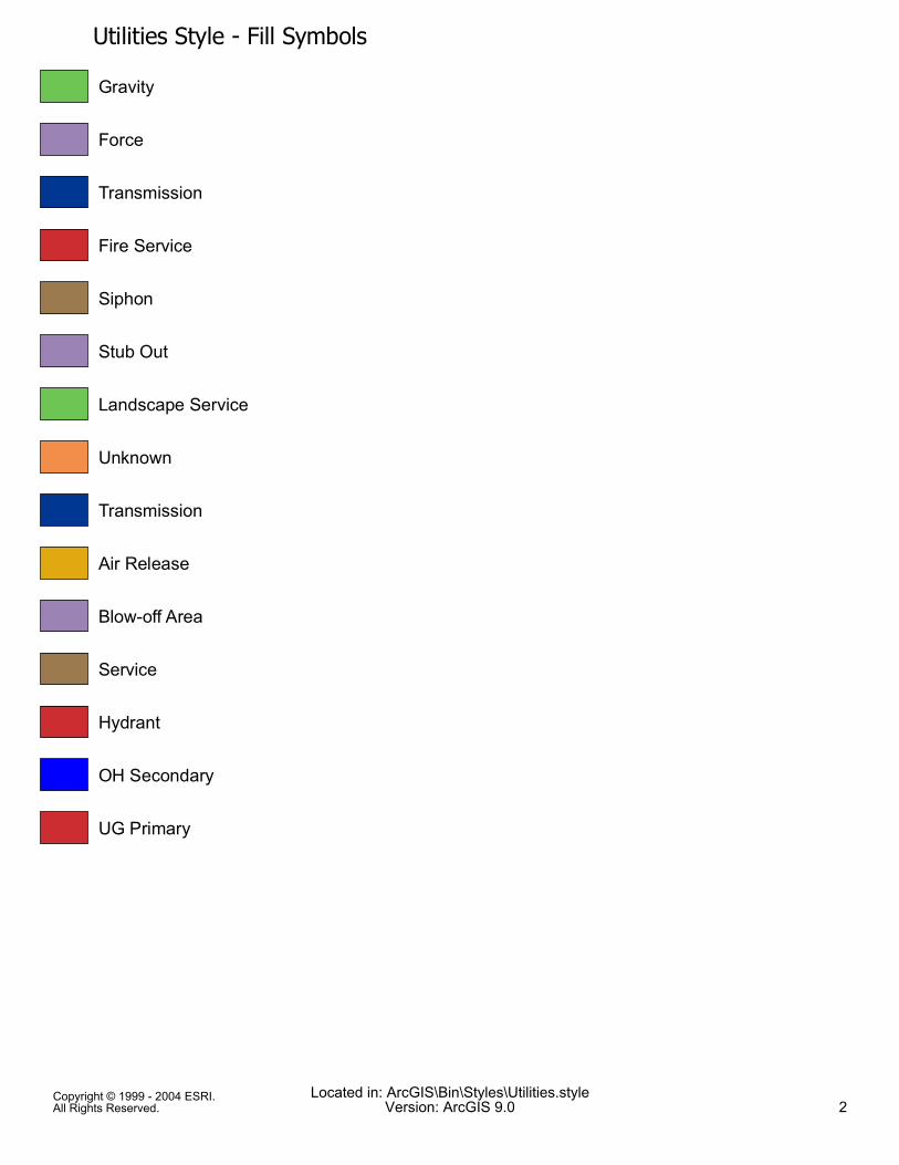
Utilities Style - Fill SymbolsGravity
Force
Transmission
Fire Service
Siphon
Stub Out
Landscape Service
Unknown
Transmission
Air Release
Blow-off Area
Service
Hydrant
OH Secondary
UG Primary
Copyright © 1999 - 2004 ESRI.All Rights Reserved.
Located in: ArcGIS\Bin\Styles\Utilities.styleVersion: ArcGIS 9.0 2
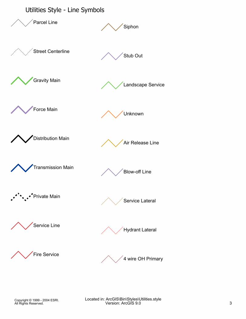
Utilities Style - Line SymbolsParcel Line
Street Centerline
Gravity Main
Force Main
Distribution Main
Transmission Main
Private Main
Service Line
Fire Service
Siphon
Stub Out
Landscape Service
Unknown
Air Release Line
Blow-off Line
Service Lateral
Hydrant Lateral
4 wire OH Primary
Copyright © 1999 - 2004 ESRI.All Rights Reserved.
Located in: ArcGIS\Bin\Styles\Utilities.styleVersion: ArcGIS 9.0 3
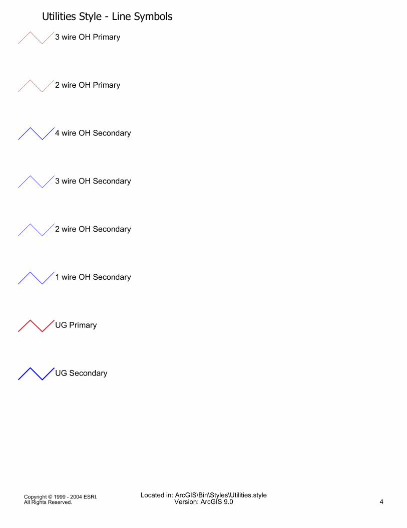
Utilities Style - Line Symbols3 wire OH Primary
2 wire OH Primary
4 wire OH Secondary
3 wire OH Secondary
2 wire OH Secondary
1 wire OH Secondary
UG Primary
UG Secondary
Copyright © 1999 - 2004 ESRI.All Rights Reserved.
Located in: ArcGIS\Bin\Styles\Utilities.styleVersion: ArcGIS 9.0 4
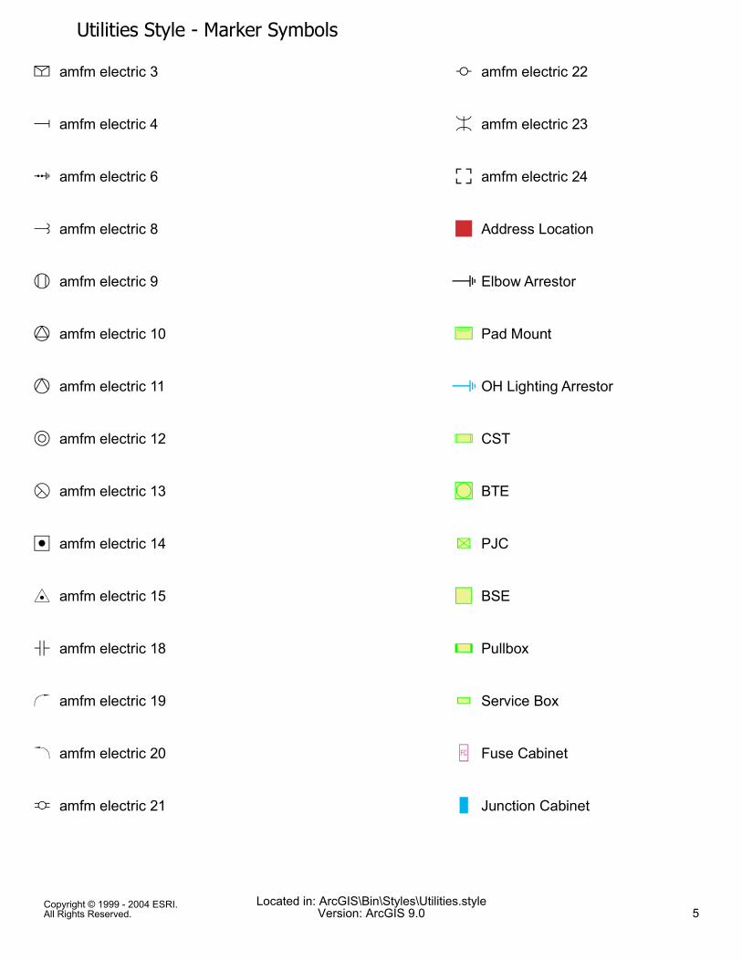
Utilities Style - Marker Symbolsm amfm electric 3
n amfm electric 4
p amfm electric 6
r amfm electric 8
s amfm electric 9
t amfm electric 10
u amfm electric 11
v amfm electric 12
w amfm electric 13
x amfm electric 14
y amfm electric 15
| amfm electric 18
} amfm electric 19
¡ amfm electric 20
¢ amfm electric 21
£ amfm electric 22
¤ amfm electric 23
¥ amfm electric 24
! Address Location
" Elbow Arrestor
åô Pad Mount
" OH Lighting Arrestor
çï CST
!ð BTE
õ̂ PJC
!% BSE
çñ Pullbox
Ýò Service Box
ÎV Fuse Cabinet
ß Junction Cabinet
Copyright © 1999 - 2004 ESRI.All Rights Reserved.
Located in: ArcGIS\Bin\Styles\Utilities.styleVersion: ArcGIS 9.0 5
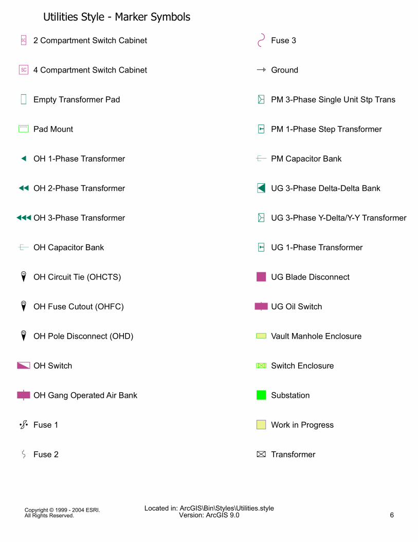
Utilities Style - Marker SymbolsÎT 2 Compartment Switch Cabinet
!U 4 Compartment Switch Cabinet
ߧ Empty Transformer Pad
ô Pad Mount
q OH 1-Phase Transformer
n OH 2-Phase Transformer
p OH 3-Phase Transformer
& OH Capacitor Bank
Ù OH Circuit Tie (OHCTS)
Ú OH Fuse Cutout (OHFC)
Ü OH Pole Disconnect (OHD)
ÛÒ OH Switch
Û̄ OH Gang Operated Air Bank
k Fuse 1
z Fuse 2
+ Fuse 3
o Ground
y PM 3-Phase Single Unit Stp Trans
âx PM 1-Phase Step Transformer
& PM Capacitor Bank
Íw UG 3-Phase Delta-Delta Bank
ãy UG 3-Phase Y-Delta/Y-Y Transformer
âx UG 1-Phase Transformer
! UG Blade Disconnect
Û̄ UG Oil Switch
XY Vault Manhole Enclosure
_ö Switch Enclosure
! Substation
!% Work in Progress
l Transformer
Copyright © 1999 - 2004 ESRI.All Rights Reserved.
Located in: ArcGIS\Bin\Styles\Utilities.styleVersion: ArcGIS 9.0 6
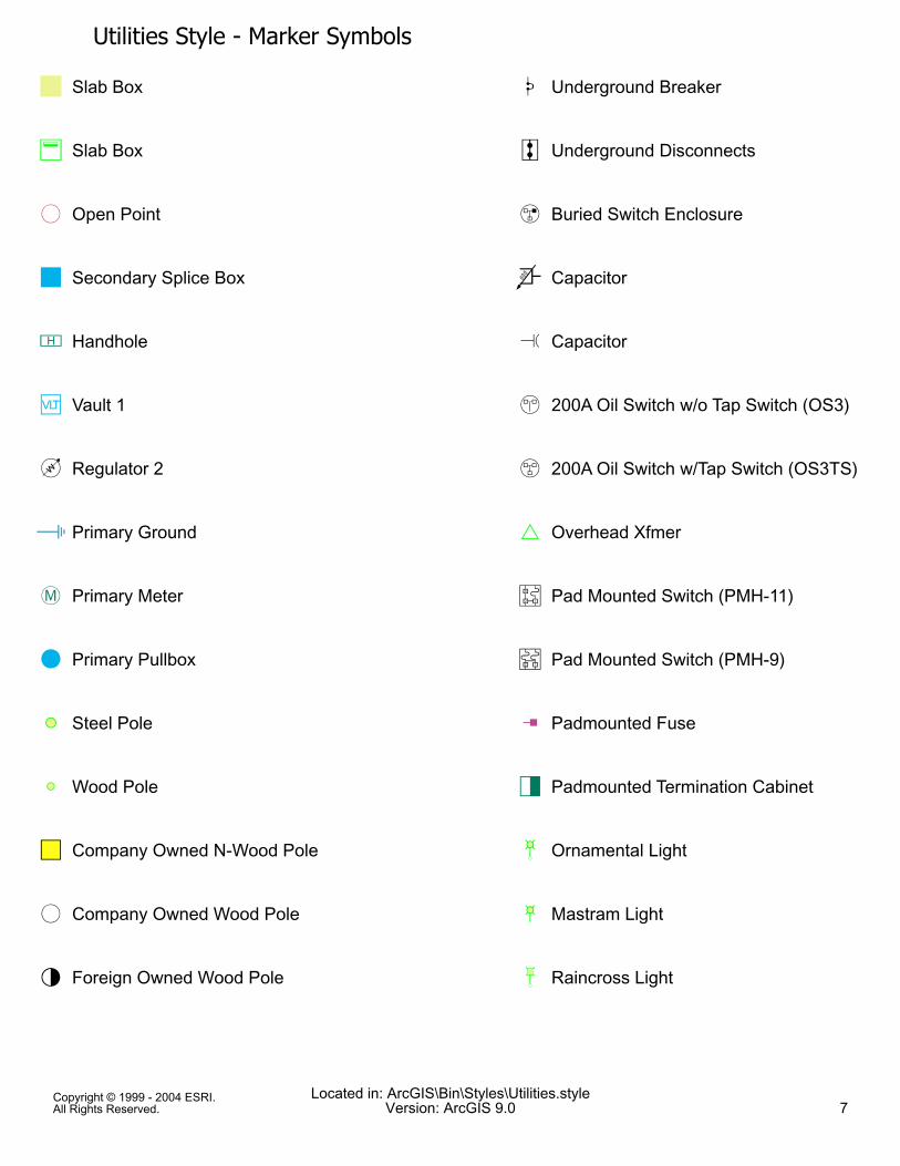
Utilities Style - Marker Symbols] Slab Box
ó Slab Box
è/ Open Point
! Secondary Splice Box
i Handhole
!j Vault 1
àk Regulator 2
" Primary Ground
dR Primary Meter
d Primary Pullbox
6( Steel Pole
:9 Wood Pole
!% Company Owned N-Wood Pole
d/ Company Owned Wood Pole
d2 Foreign Owned Wood Pole
Ø Underground Breaker
Ï Underground Disconnects
Þ Buried Switch Enclosure
@ Capacitor
q Capacitor
ë 200A Oil Switch w/o Tap Switch (OS3)
á 200A Oil Switch w/Tap Switch (OS3TS)
. Overhead Xfmer
Ð Pad Mounted Switch (PMH-11)
Ñ Pad Mounted Switch (PMH-9)
\ Padmounted Fuse
!e Padmounted Termination Cabinet
øì Ornamental Light
øî Mastram Light
úí Raincross Light
Copyright © 1999 - 2004 ESRI.All Rights Reserved.
Located in: ArcGIS\Bin\Styles\Utilities.styleVersion: ArcGIS 9.0 7
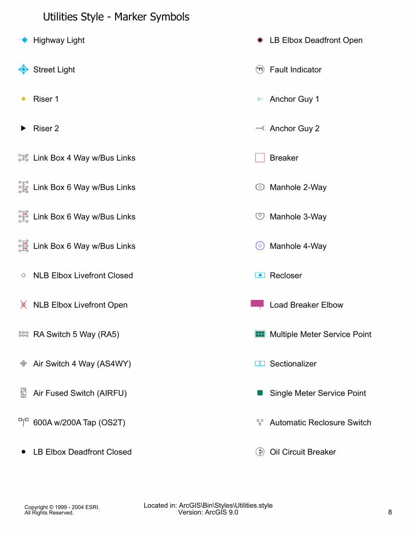
Utilities Style - Marker SymbolsM Highway Light
O Street Light
: Riser 1
B Riser 2
½³ Link Box 4 Way w/Bus Links
ÇÉ Link Box 6 Way w/Bus Links
ÇÈ Link Box 6 Way w/Bus Links
ÇÊ Link Box 6 Way w/Bus Links
9 NLB Elbox Livefront Closed
97 NLB Elbox Livefront Open
Ë RA Switch 5 Way (RA5)
Ô Air Switch 4 Way (AS4WY)
o Air Fused Switch (AIRFU)
< 600A w/200A Tap (OS2T)
: LB Elbox Deadfront Closed
(: LB Elbox Deadfront Open
) Fault Indicator
L Anchor Guy 1
{ Anchor Guy 2
!% Breaker
Õ̀ Manhole 2-Way
Öa Manhole 3-Way
×b Manhole 4-Way
4 Recloser
Û̄ Load Breaker Elbow
êQ Multiple Meter Service Point
C Sectionalizer
! Single Meter Service Point
Ó Automatic Reclosure Switch
Ì Oil Circuit Breaker
Copyright © 1999 - 2004 ESRI.All Rights Reserved.
Located in: ArcGIS\Bin\Styles\Utilities.styleVersion: ArcGIS 9.0 8
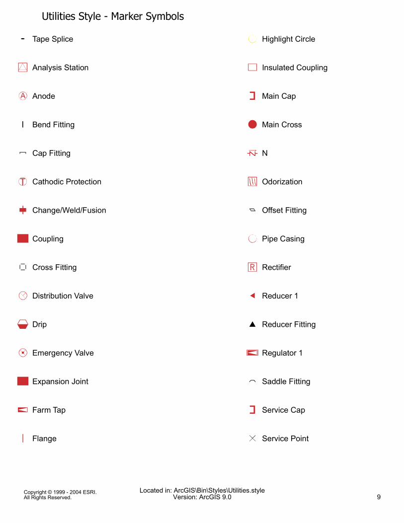
Utilities Style - Marker SymbolsTape Splice
Analysis Station
Anode
Bend Fitting
Cap Fitting
Cathodic Protection
Change/Weld/Fusion
Coupling
Cross Fitting
Distribution Valve
Drip
Emergency Valve
Expansion Joint
Farm Tap
Flange
Highlight Circle
Insulated Coupling
Main Cap
Main Cross
N
Odorization
Offset Fitting
Pipe Casing
Rectifier
Reducer 1
Reducer Fitting
Regulator 1
Saddle Fitting
Service Cap
Service Point
Copyright © 1999 - 2004 ESRI.All Rights Reserved.
Located in: ArcGIS\Bin\Styles\Utilities.styleVersion: ArcGIS 9.0 9
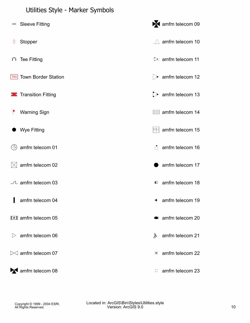
Utilities Style - Marker Symbols$ Sleeve Fitting
µ Stopper
" Tee Fitting
éÀ Town Border Station
¶ Transition Fitting
¼ Warning Sign
# Wye Fitting
! amfm telecom 01
" amfm telecom 02
$ amfm telecom 03
% amfm telecom 04
& amfm telecom 05
0 amfm telecom 06
1 amfm telecom 07
4 amfm telecom 08
5 amfm telecom 09
? amfm telecom 10
@ amfm telecom 11
A amfm telecom 12
B amfm telecom 13
D amfm telecom 14
G amfm telecom 15
F amfm telecom 16
E amfm telecom 17
` amfm telecom 18
a amfm telecom 19
b amfm telecom 20
c amfm telecom 21
[ amfm telecom 22
\ amfm telecom 23
Copyright © 1999 - 2004 ESRI.All Rights Reserved.
Located in: ArcGIS\Bin\Styles\Utilities.styleVersion: ArcGIS 9.0 10
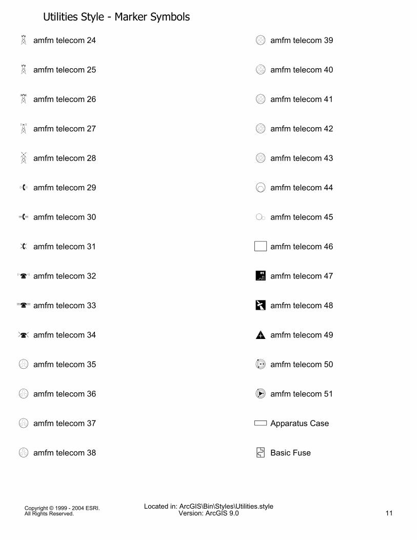
Utilities Style - Marker SymbolsV amfm telecom 24
W amfm telecom 25
X amfm telecom 26
Y amfm telecom 27
Z amfm telecom 28
] amfm telecom 29
^ amfm telecom 30
_ amfm telecom 31
C amfm telecom 32
H amfm telecom 33
I amfm telecom 34
J amfm telecom 35
K amfm telecom 36
L amfm telecom 37
M amfm telecom 38
N amfm telecom 39
O amfm telecom 40
P amfm telecom 41
Q amfm telecom 42
R amfm telecom 43
S amfm telecom 44
T amfm telecom 45
* amfm telecom 46
d amfm telecom 47
e amfm telecom 48
h amfm telecom 49
f amfm telecom 50
g amfm telecom 51
( Apparatus Case
g Basic Fuse
Copyright © 1999 - 2004 ESRI.All Rights Reserved.
Located in: ArcGIS\Bin\Styles\Utilities.styleVersion: ArcGIS 9.0 11
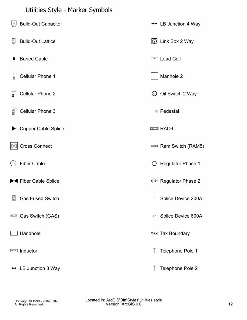
Utilities Style - Marker Symbols: Build-Out Capacitor
9 Build-Out Lattice
, Buried Cable
i Cellular Phone 1
j Cellular Phone 2
k Cellular Phone 3
2 Copper Cable Splice
; Cross Connect
> Fiber Cable
3 Fiber Cable Splice
o Gas Fused Switch
u Gas Switch (GAS)
) Handhole
8 Inductor
{ LB Junction 3 Way
| LB Junction 4 Way
E Link Box 2 Way
7 Load Coil
+ Manhole 2
m Oil Switch 2 Way
/ Pedestal
t RAC6
s Ram Switch (RAM5)
f Regulator Phase 1
r Regulator Phase 2
} Splice Device 200A
9 Splice Device 600A
- Tax Boundary
6 Telephone Pole 1
< Telephone Pole 2
Copyright © 1999 - 2004 ESRI.All Rights Reserved.
Located in: ArcGIS\Bin\Styles\Utilities.styleVersion: ArcGIS 9.0 12
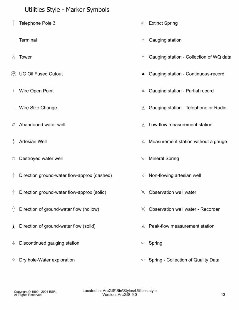
Utilities Style - Marker Symbols= Telephone Pole 3
. Terminal
# Tower
h UG Oil Fused Cutout
N Wire Open Point
' Wire Size Change
Y Abandoned water well
; Artesian Well
» Destroyed water well
® Direction ground-water flow-approx (dashed)
¯ Direction ground-water flow-approx (solid)
¬ Direction of ground-water flow (hollow)
Direction of ground-water flow (solid)
¦ Discontinued gauging station
ª Dry hole-Water exploration
B Extinct Spring
¥ Gauging station
¢ Gauging station - Collection of WQ data
£ Gauging station - Continuous-record
¤ Gauging station - Partial record
{ Gauging station - Telephone or Radio
¡ Low-flow measurement station
¥ Measurement station without a gauge
I Mineral Spring
Æ Non-flowing artesian well
= Observation well water
> Observation well water - Recorder
| Peak-flow measurement station
A Spring
F Spring - Collection of Quality Data
Copyright © 1999 - 2004 ESRI.All Rights Reserved.
Located in: ArcGIS\Bin\Styles\Utilities.styleVersion: ArcGIS 9.0 13
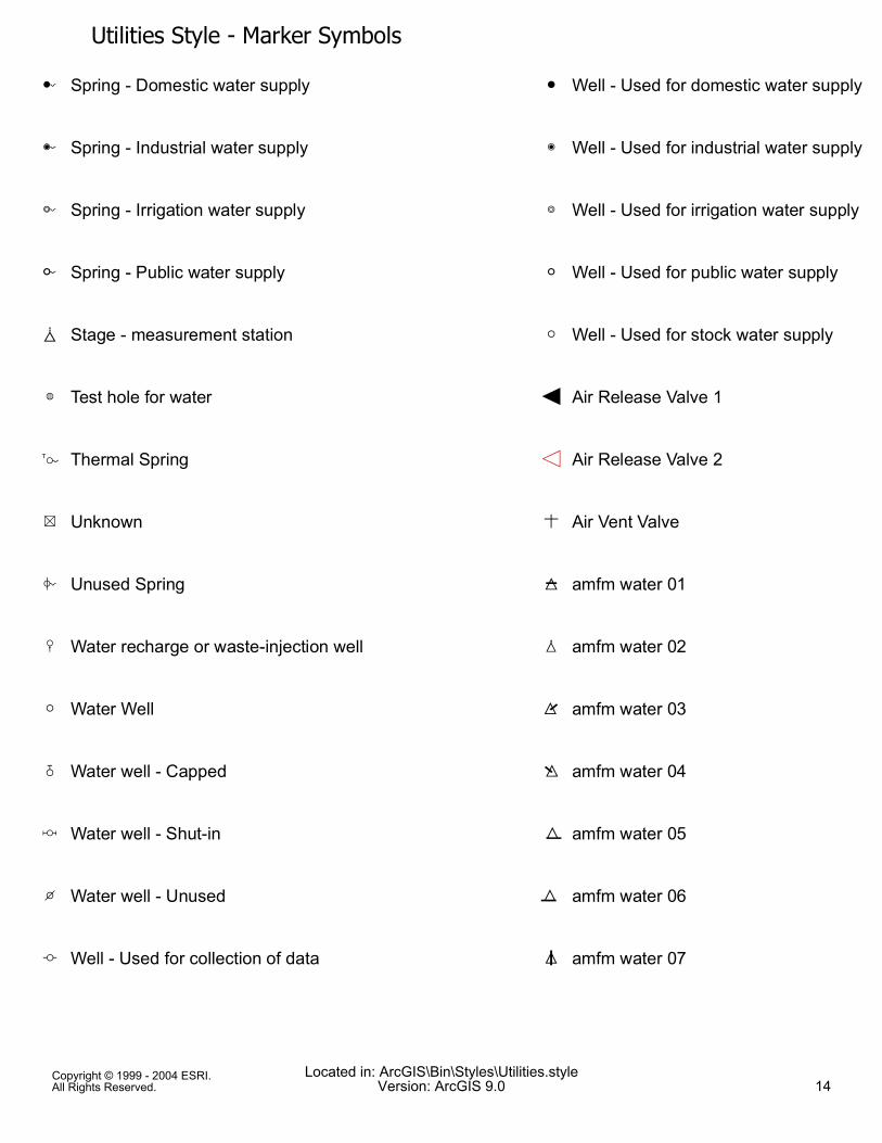
Utilities Style - Marker SymbolsE Spring - Domestic water supply
H Spring - Industrial water supply
G Spring - Irrigation water supply
D Spring - Public water supply
} Stage - measurement station
É Test hole for water
J Thermal Spring
Ý Unknown
C Unused Spring
< Water recharge or waste-injection well
" Water Well
@ Water well - Capped
? Water well - Shut-in
y Water well - Unused
Ê Well - Used for collection of data
' Well - Used for domestic water supply
w Well - Used for industrial water supply
v Well - Used for irrigation water supply
x Well - Used for public water supply
" Well - Used for stock water supply
Æ Air Release Valve 1
Ç Air Release Valve 2
+ Air Vent Valve
¼ amfm water 01
½ amfm water 02
¾ amfm water 03
¿ amfm water 04
À amfm water 05
Á amfm water 06
 amfm water 07
Copyright © 1999 - 2004 ESRI.All Rights Reserved.
Located in: ArcGIS\Bin\Styles\Utilities.styleVersion: ArcGIS 9.0 14
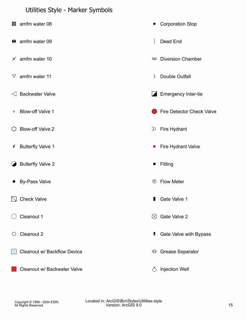
Utilities Style - Marker SymbolsR amfm water 08
N amfm water 09
O amfm water 10
Q amfm water 11
ÆÈ Backwater Valve
, Blow-off Valve 1
ÊË Blow-off Valve 2
- Butterfly Valve 1
&É Butterfly Valve 2
S By-Pass Valve
ÍÏ Check Valve
&, Cleanout 1
P Cleanout 2
ÍÐ Cleanout w/ Backflow Device
Í Cleanout w/ Backwater Valve
& Corporation Stop
á Dead End
C Diversion Chamber
A Double Outfall
ÍÒ Emergency Inter-tie
&, Fire Detector Check Valve
Ñ Fire Hydrant
S Fire Hydrant Valve
Í Fitting
E Flow Meter
. Gate Valve 1
&. Gate Valve 2
/ Gate Valve with Bypass
F Grease Separator
G Injection Well
Copyright © 1999 - 2004 ESRI.All Rights Reserved.
Located in: ArcGIS\Bin\Styles\Utilities.styleVersion: ArcGIS 9.0 15
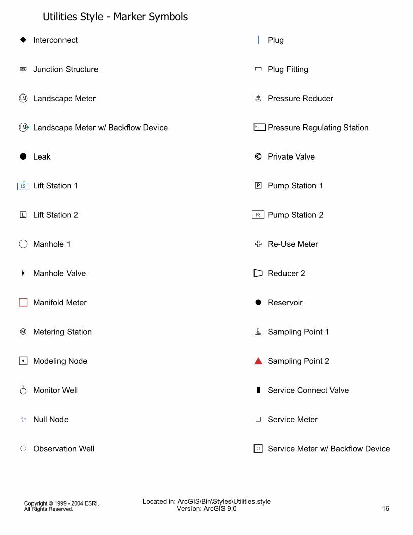
Utilities Style - Marker SymbolsH Interconnect
D Junction Structure
Ó Landscape Meter
ÓÕ Landscape Meter w/ Backflow Device
I Leak
ä Lift Station 1
J Lift Station 2
&, Manhole 1
1 Manhole Valve
ÍÎ Manifold Meter
4 Metering Station
ÍÖ Modeling Node
L Monitor Well
× Null Node
&, Observation Well
á Plug
* Plug Fitting
M Pressure Reducer
Ù Pressure Regulating Station
3 Private Valve
5 Pump Station 1
Ú Pump Station 2
6 Re-Use Meter
Û Reducer 2
& Reservoir
7 Sampling Point 1
àÞ Sampling Point 2
2 Service Connect Valve
Ü Service Meter
ÍÐ Service Meter w/ Backflow Device
Copyright © 1999 - 2004 ESRI.All Rights Reserved.
Located in: ArcGIS\Bin\Styles\Utilities.styleVersion: ArcGIS 9.0 16
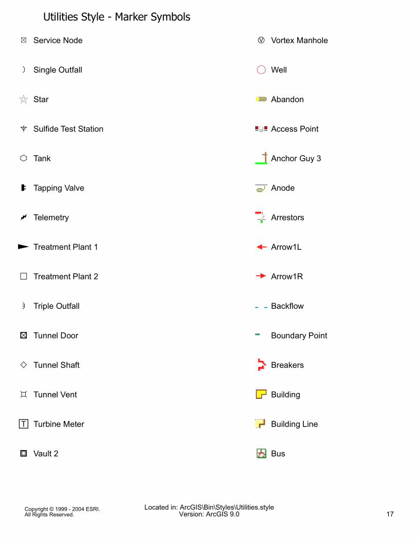
Utilities Style - Marker SymbolsÝ Service Node
@ Single Outfall
è Star
8 Sulfide Test Station
9 Tank
0 Tapping Valve
: Telemetry
Ø Treatment Plant 1
; Treatment Plant 2
B Triple Outfall
< Tunnel Door
> Tunnel Shaft
= Tunnel Vent
L Turbine Meter
? Vault 2
K Vortex Manhole
&, Well
Abandon
Access Point
Anchor Guy 3
Anode
Arrestors
Arrow1L
Arrow1R
Backflow
Boundary Point
Breakers
Building
Building Line
Bus
Copyright © 1999 - 2004 ESRI.All Rights Reserved.
Located in: ArcGIS\Bin\Styles\Utilities.styleVersion: ArcGIS 9.0 17
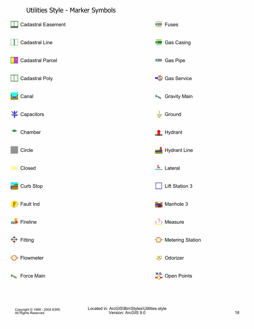
Utilities Style - Marker SymbolsCadastral Easement
Cadastral Line
Cadastral Parcel
Cadastral Poly
Canal
Capacitors
Chamber
Circle
Closed
Curb Stop
Fault Ind
Fireline
Fitting
Flowmeter
Force Main
Fuses
Gas Casing
Gas Pipe
Gas Service
Gravity Main
Ground
Hydrant
Hydrant Line
Lateral
Lift Station 3
Manhole 3
Measure
Metering Station
Odorizer
Open Points
Copyright © 1999 - 2004 ESRI.All Rights Reserved.
Located in: ArcGIS\Bin\Styles\Utilities.styleVersion: ArcGIS 9.0 18
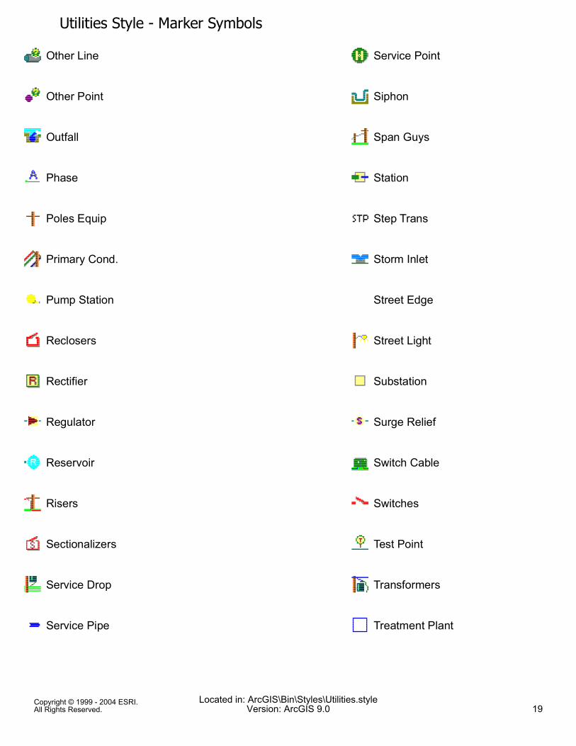
Utilities Style - Marker SymbolsOther Line
Other Point
Outfall
Phase
Poles Equip
Primary Cond.
Pump Station
Reclosers
Rectifier
Regulator
Reservoir
Risers
Sectionalizers
Service Drop
Service Pipe
Service Point
Siphon
Span Guys
Station
Step Trans
Storm Inlet
Street Edge
Street Light
Substation
Surge Relief
Switch Cable
Switches
Test Point
Transformers
Treatment Plant
Copyright © 1999 - 2004 ESRI.All Rights Reserved.
Located in: ArcGIS\Bin\Styles\Utilities.styleVersion: ArcGIS 9.0 19
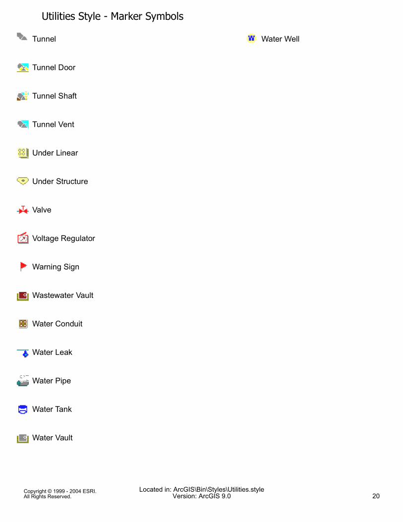
Utilities Style - Marker SymbolsTunnel
Tunnel Door
Tunnel Shaft
Tunnel Vent
Under Linear
Under Structure
Valve
Voltage Regulator
Warning Sign
Wastewater Vault
Water Conduit
Water Leak
Water Pipe
Water Tank
Water Vault
Water Well
Copyright © 1999 - 2004 ESRI.All Rights Reserved.
Located in: ArcGIS\Bin\Styles\Utilities.styleVersion: ArcGIS 9.0 20
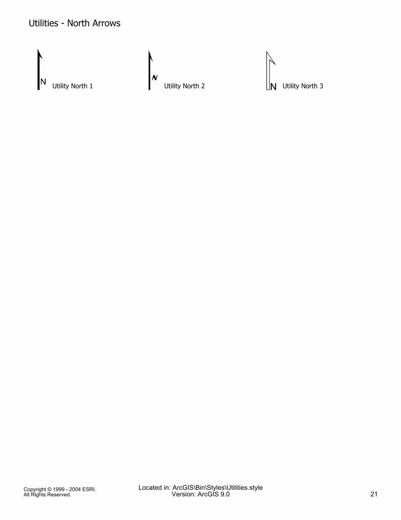
# Utility North 1
Utilities - North Arrows
% Utility North 2 & Utility North 3
Copyright © 1999 - 2004 ESRI.All Rights Reserved.
Located in: ArcGIS\Bin\Styles\Utilities.styleVersion: ArcGIS 9.0 21