Embed Size (px)
Citation preview
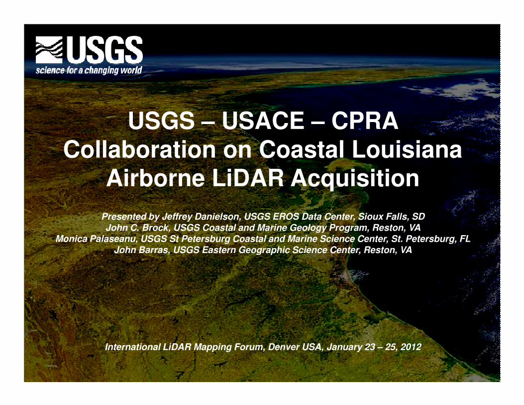
USGS – USACE – CPRA Collaboration on Coastal Louisiana
Airborne LiDAR Acquisition
Presented by Jeffrey Danielson, USGS EROS Data Center, Sioux Falls, SDJohn C. Brock, USGS Coastal and Marine Geology Program, Reston, VA
Monica Palaseanu, USGS St Petersburg Coastal and Marine Science Center, St. Petersburg, FLJohn Barras, USGS Eastern Geographic Science Center, Reston, VA
International LiDAR Mapping Forum, Denver USA, January 23 – 25, 2012
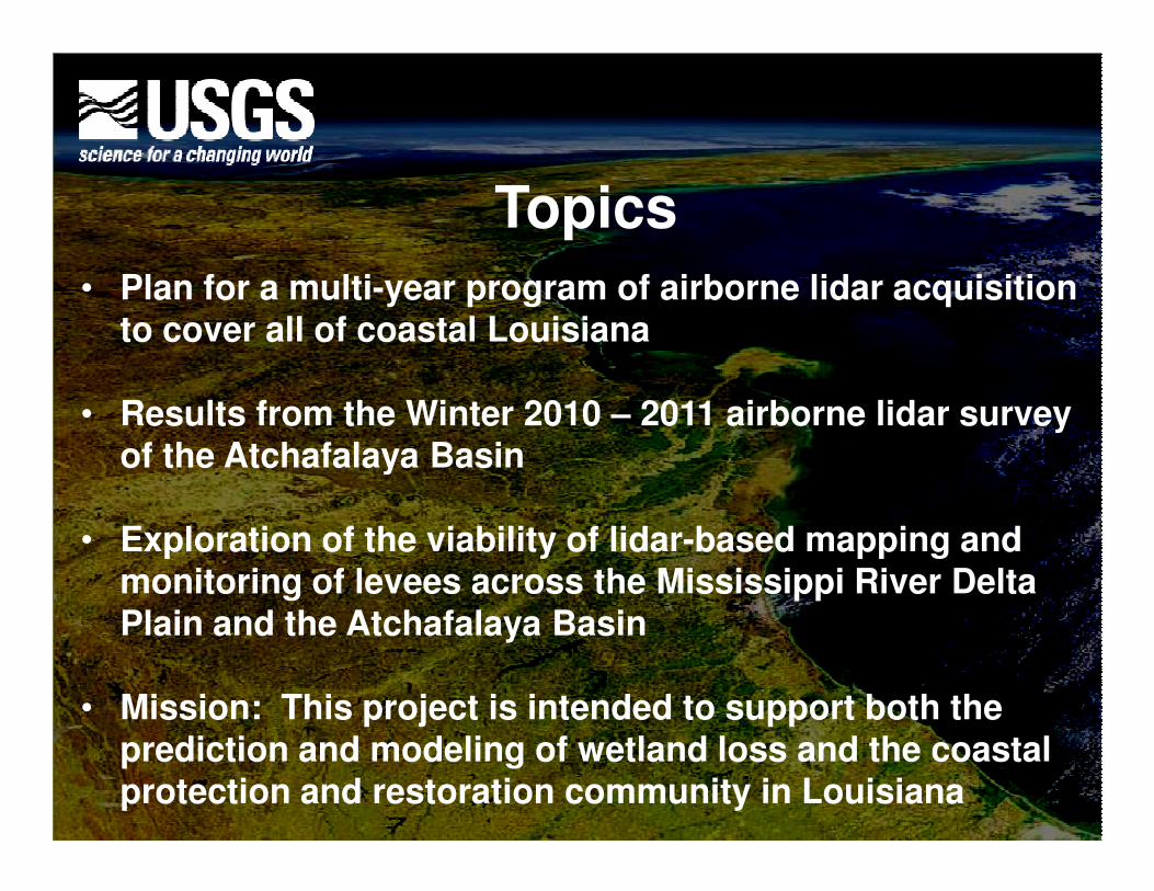
Topics
• Plan for a multi-year program of airborne lidar acquisition to cover all of coastal Louisiana
• Results from the Winter 2010 – 2011 airborne lidar survey of the Atchafalaya Basinof the Atchafalaya Basin
• Exploration of the viability of lidar-based mapping and monitoring of levees across the Mississippi River Delta Plain and the Atchafalaya Basin
• Mission: This project is intended to support both the prediction and modeling of wetland loss and the coastal protection and restoration community in Louisiana
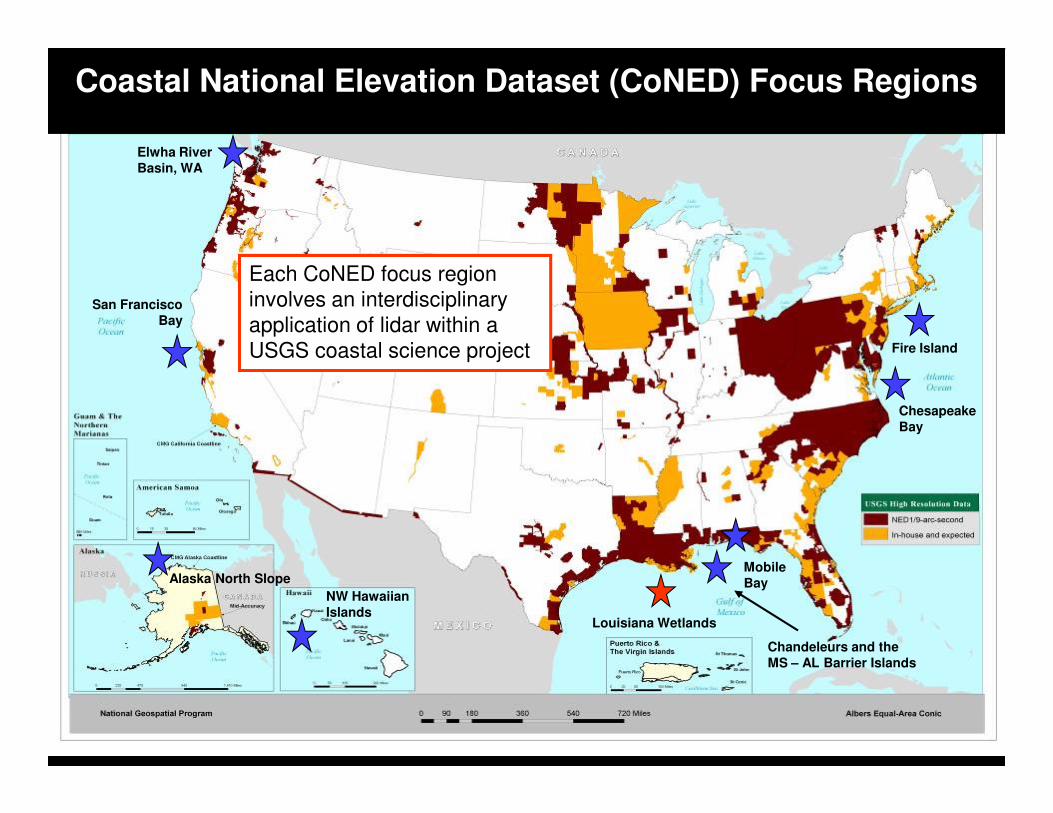
Elwha River
Basin, WA
Chesapeake
San Francisco
Bay
Each CoNED focus region
involves an interdisciplinary
application of lidar within a
USGS coastal science project
Coastal National Elevation Dataset (CoNED) Focus Regions
Fire Island
Alaska North Slope
Louisiana Wetlands
Mobile
Bay
Chesapeake
Bay
Chandeleurs and the
MS – AL Barrier Islands
NW Hawaiian
Islands
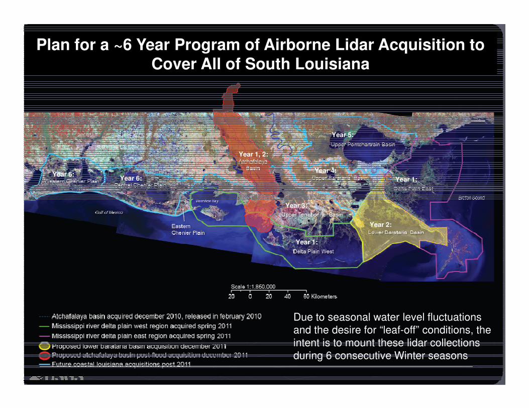
Plan for a ~6 Year Program of Airborne Lidar Acquisition to Cover All of South Louisiana
Year 3:
Year 4:
Year 5:
Year 6:Year 6:
Year 1, 2:
Year 1:
Year 3:
Year 2:
Year 1:
Due to seasonal water level fluctuations
and the desire for “leaf-off” conditions, the
intent is to mount these lidar collections
during 6 consecutive Winter seasons
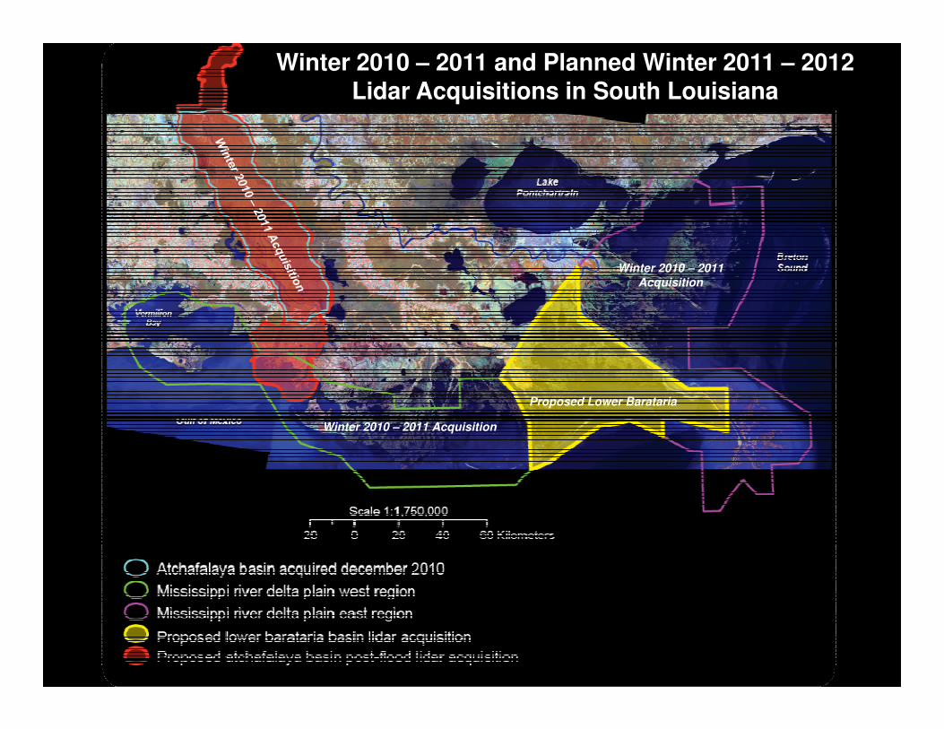
Winter 2010 – 2011 and Planned Winter 2011 – 2012 Lidar Acquisitions in South Louisiana
Winter 2010 – 2011
Acquisition
Winter 2010 – 2011 Acquisition
Proposed Lower Barataria
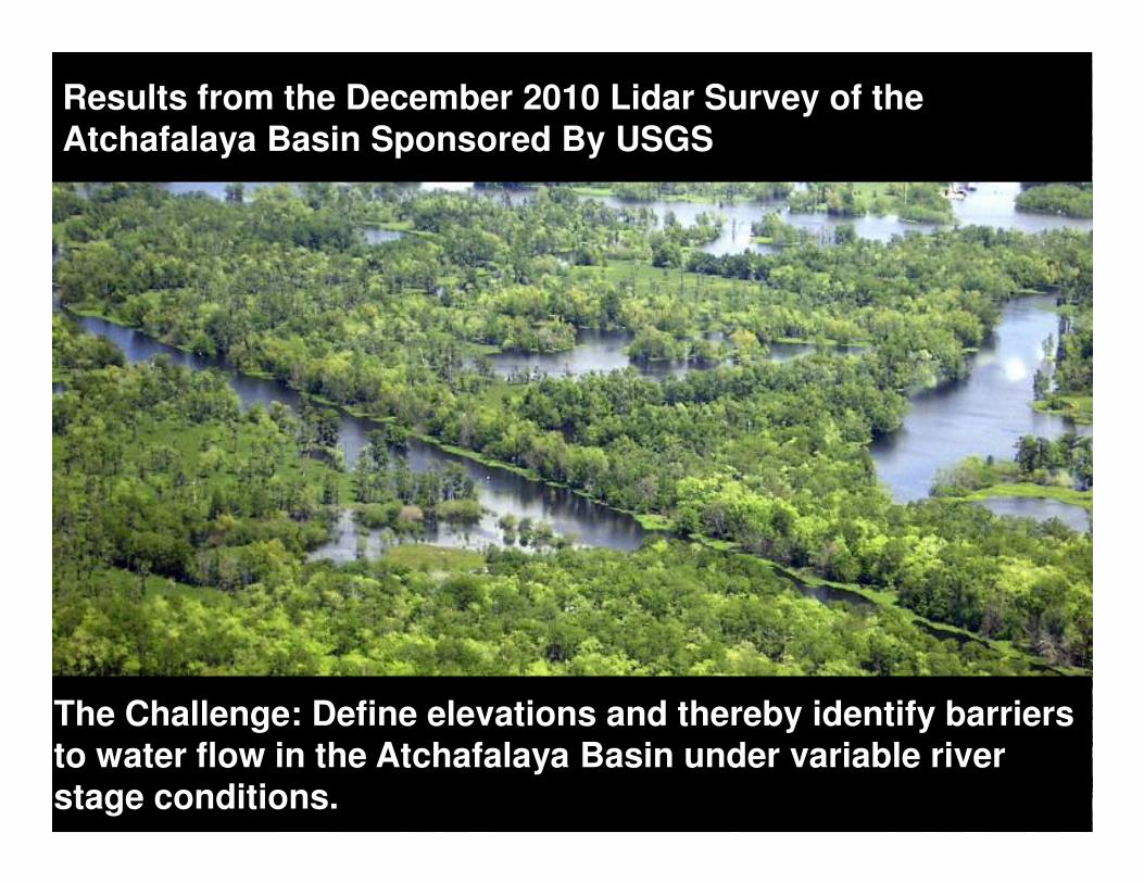
Results from the December 2010 Lidar Survey of the Atchafalaya Basin Sponsored By USGS
The Challenge: Define elevations and thereby identify barriers to water flow in the Atchafalaya Basin under variable river stage conditions.
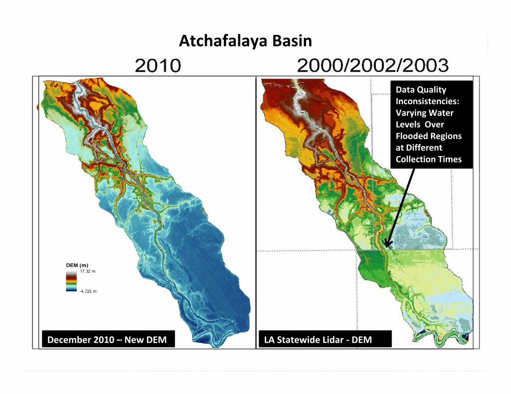
Atchafalaya Basin
Data Quality
Inconsistencies:
Varying Water
Levels Over
Flooded Regions
at Different
Collection Times
BUILDING STRONG®
December 2010 – New DEM LA Statewide Lidar - DEM
Y, U
TM
(m)
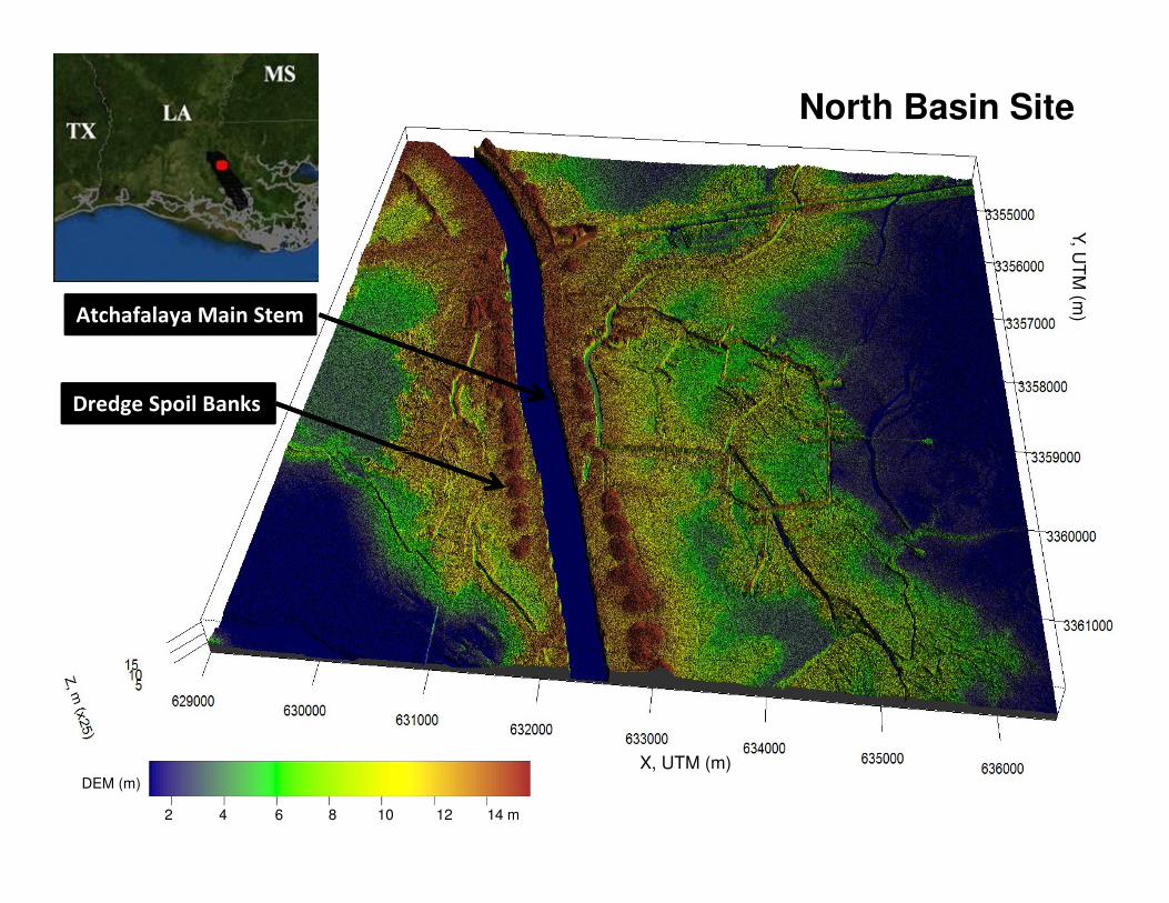
North Basin Site
Dredge Spoil Banks
Atchafalaya Main Stem
2 4 6 8 10 12 14 m
DEM (m)
X, UTM (m)
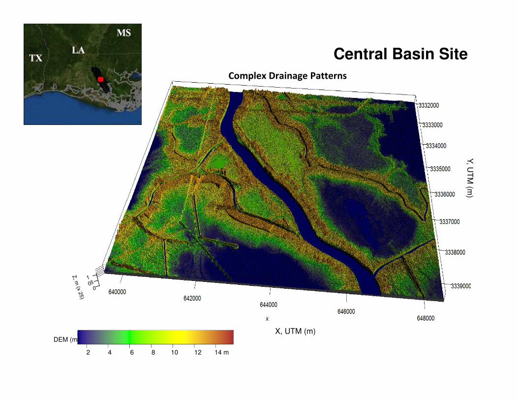
Central Basin SiteY, U
TM
(m)
Complex Drainage Patterns
2 4 6 8 10 12 14 m
DEM (m)
X, UTM (m)
Y, U
TM
(m)
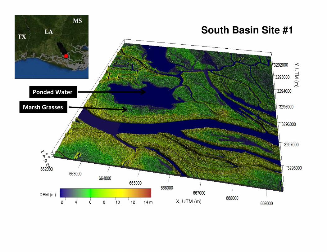
South Basin Site #1
Ponded Water
Marsh Grasses
2 4 6 8 10 12 14 m
DEM (m)
X, UTM (m)
Y, U
TM
(m)
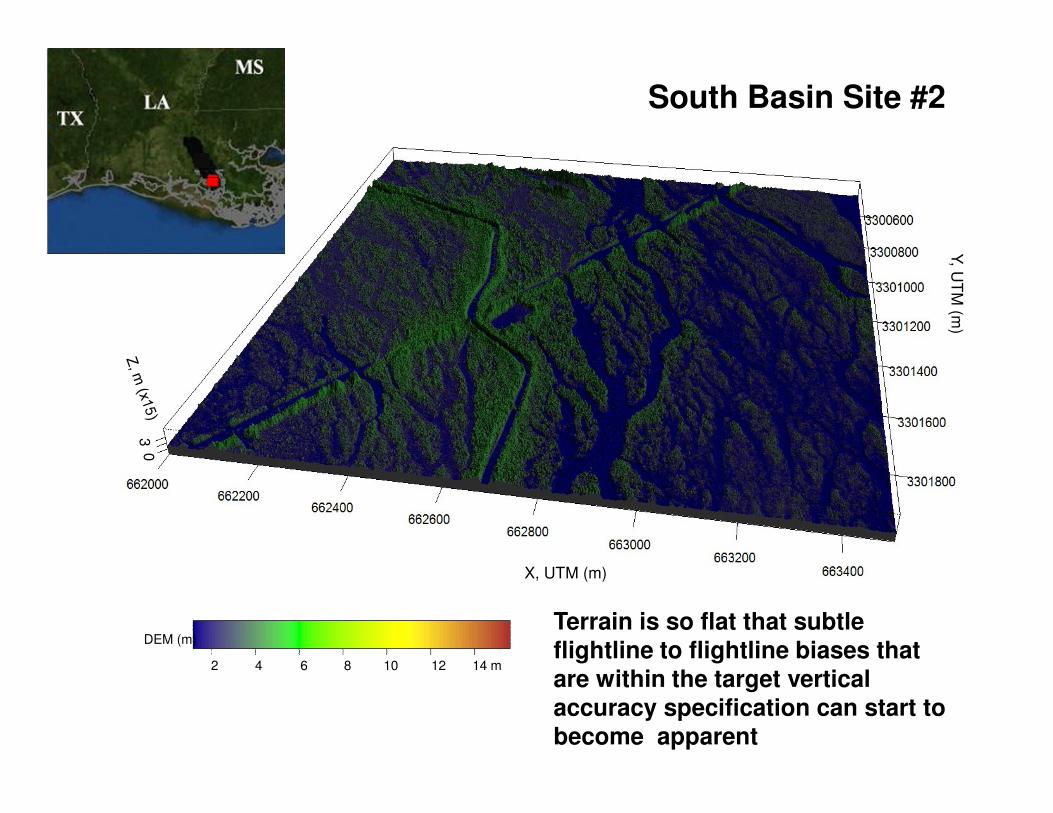
South Basin Site #2
2 4 6 8 10 12 14 m
DEM (m)
03
X, UTM (m)
Terrain is so flat that subtle flightline to flightline biases that are within the target vertical accuracy specification can start to become apparent
Coastal Louisiana Lidar-Based Levee Mapping and Monitoring
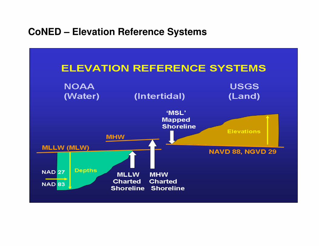
CoNED – Elevation Reference Systems
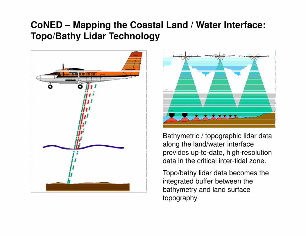
Coastal Louisiana Lidar-Based Levee Mapping and MonitoringCoNED – Mapping the Coastal Land / Water Interface: Topo/Bathy Lidar Technology
Bathymetric / topographic lidar data
along the land/water interface
provides up-to-date, high-resolution
data in the critical inter-tidal zone.
Topo/bathy lidar data becomes the
integrated buffer between the
bathymetry and land surface
topography
Coastal Louisiana Lidar-Based Levee Mapping and Monitoring
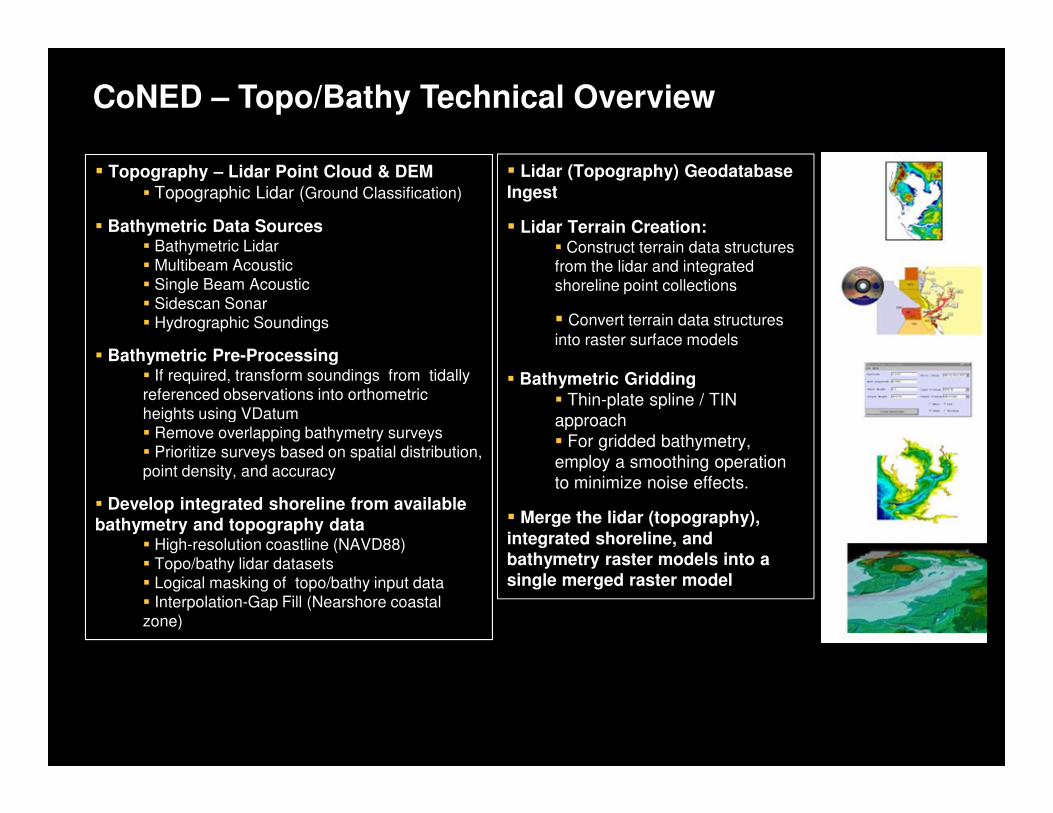
CoNED – Topo/Bathy Technical Overview
� Topography – Lidar Point Cloud & DEM
� Topographic Lidar (Ground Classification)
� Bathymetric Data Sources� Bathymetric Lidar
� Multibeam Acoustic
� Single Beam Acoustic
� Sidescan Sonar
� Hydrographic Soundings
� Bathymetric Pre-Processing� If required, transform soundings from tidally
referenced observations into orthometric
heights using VDatum
� Lidar (Topography) Geodatabase
Ingest
� Lidar Terrain Creation: � Construct terrain data structures
from the lidar and integrated
shoreline point collections
� Convert terrain data structures
into raster surface models
� Bathymetric Gridding� Thin-plate spline / TIN
heights using VDatum
� Remove overlapping bathymetry surveys
� Prioritize surveys based on spatial distribution,
point density, and accuracy
� Develop integrated shoreline from available bathymetry and topography data
� High-resolution coastline (NAVD88)
� Topo/bathy lidar datasets
� Logical masking of topo/bathy input data
� Interpolation-Gap Fill (Nearshore coastal
zone)
� Thin-plate spline / TIN
approach
� For gridded bathymetry,
employ a smoothing operation
to minimize noise effects.
� Merge the lidar (topography),
integrated shoreline, and bathymetry raster models into a single merged raster model
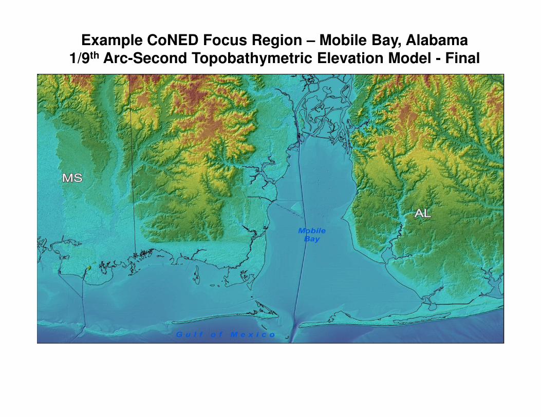
Example CoNED Focus Region – Mobile Bay, Alabama1/9th Arc-Second Topobathymetric Elevation Model - Final
Coastal Louisiana Lidar-Based Levee Mapping and Monitoring
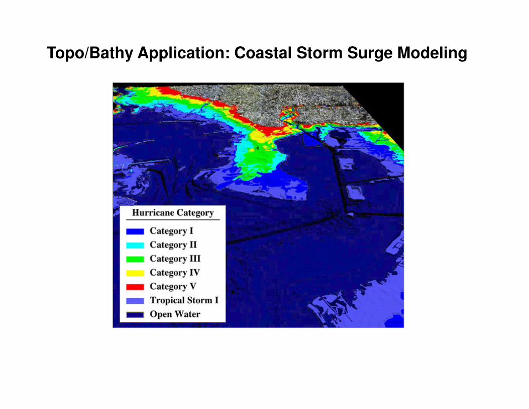
Topo/Bathy Application: Coastal Storm Surge Modeling
Coastal Louisiana Lidar-Based Levee Mapping and Monitoring
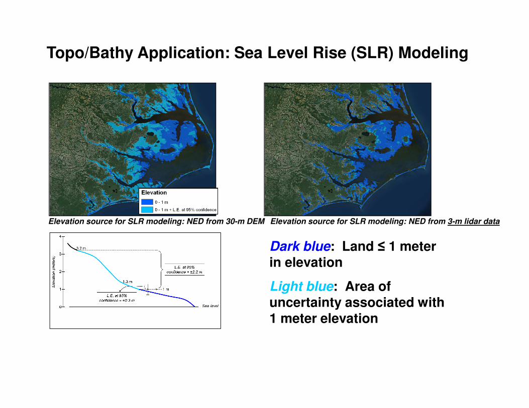
Topo/Bathy Application: Sea Level Rise (SLR) Modeling
Elevation source for SLR modeling: NED from 30-m DEM Elevation source for SLR modeling: NED from 3-m lidar data
Dark blue: Land ≤ 1 meter in elevation
Light blue: Area of uncertainty associated with 1 meter elevation
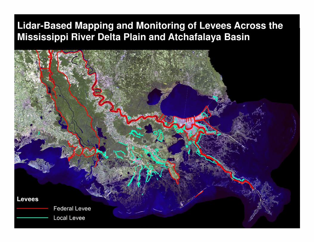
Coastal Louisiana Lidar-Based Levee Mapping and MonitoringLidar-Based Mapping and Monitoring of Levees Across the Mississippi River Delta Plain and Atchafalaya Basin

Lidar-Based Mapping and Monitoring of Levees Across the Mississippi River Delta Plain – Lafourche Parish
Study Area Around New Orleans
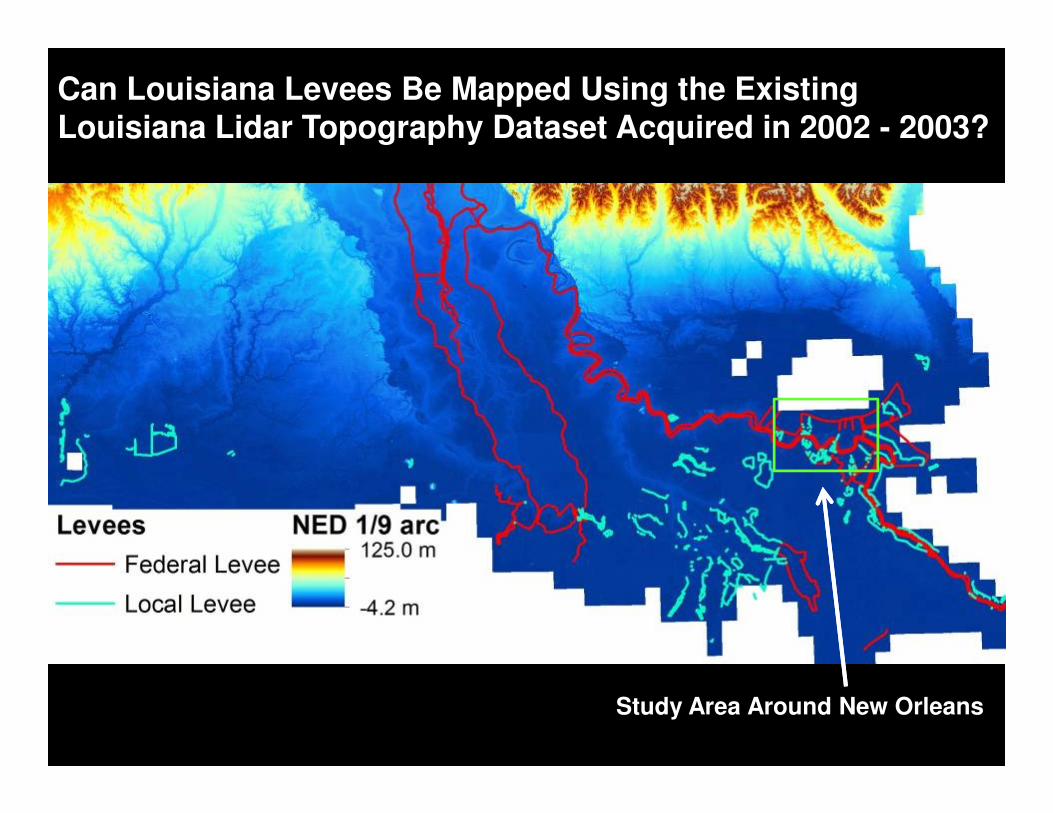
Can Louisiana Levees Be Mapped Using the Existing Louisiana Lidar Topography Dataset Acquired in 2002 - 2003?
Study Area Around New Orleans
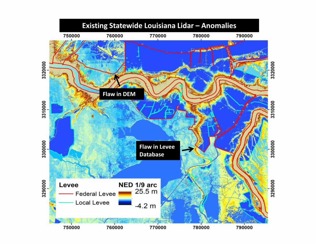
Flaw in DEM
Existing Statewide Louisiana Lidar – Anomalies
Flaw in Levee
Database
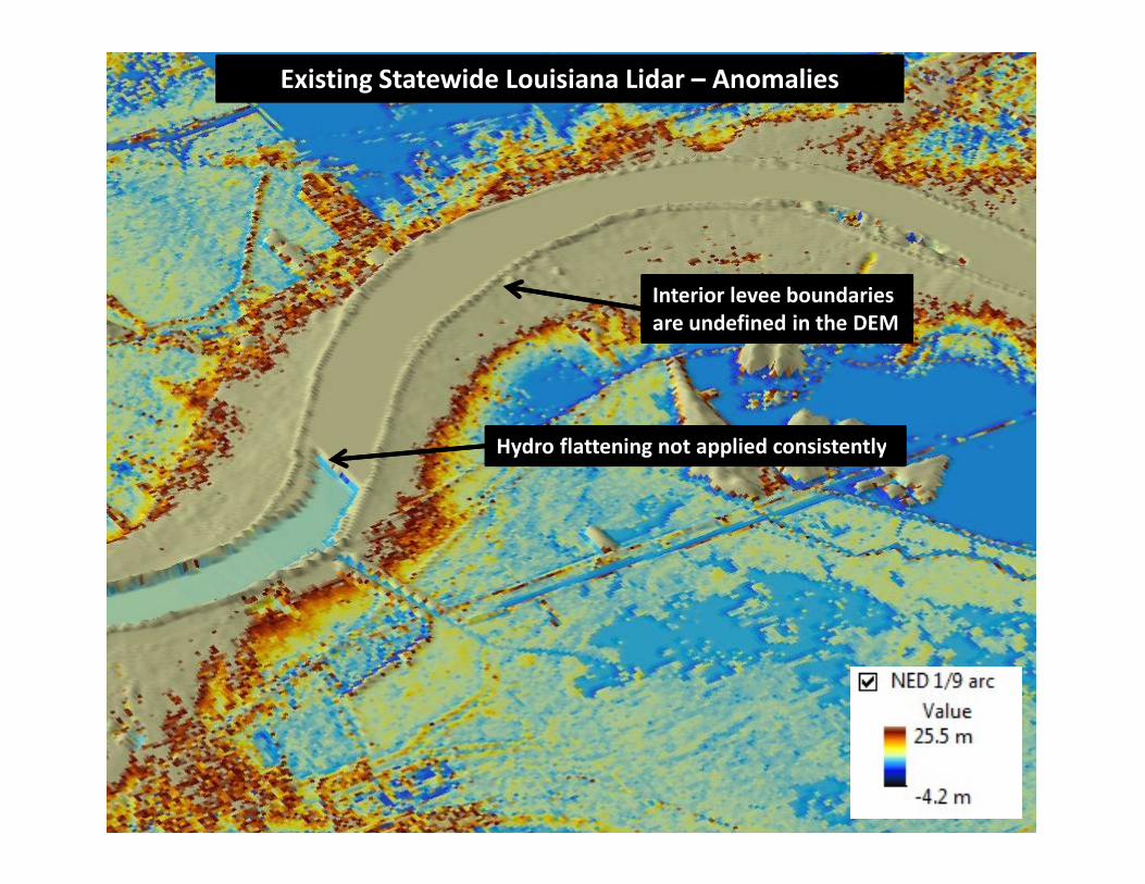
Interior levee boundaries
are undefined in the DEM
Hydro flattening not applied consistently
Existing Statewide Louisiana Lidar – Anomalies
Hydro flattening not applied consistently
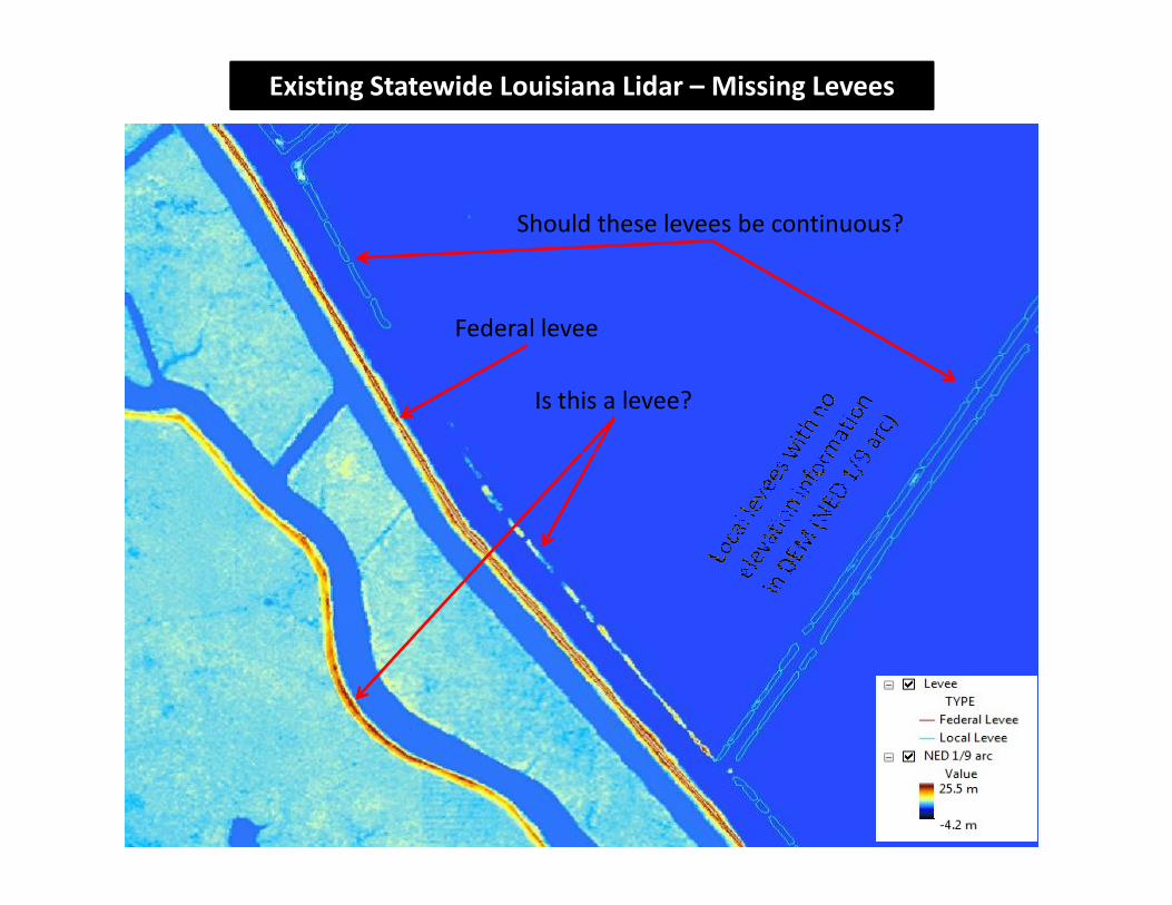
Is this a levee?
Federal levee
Should these levees be continuous?
Existing Statewide Louisiana Lidar – Missing Levees
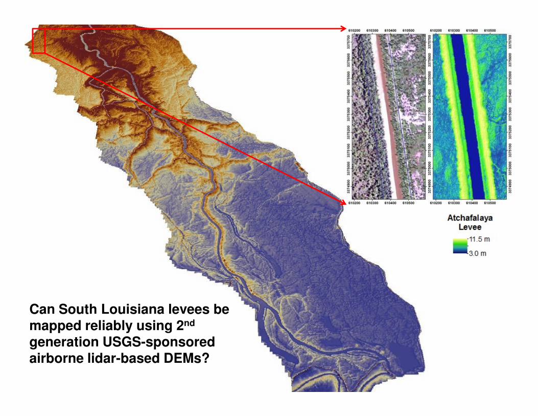
Can South Louisiana levees be mapped reliably using 2nd
generation USGS-sponsored airborne lidar-based DEMs?
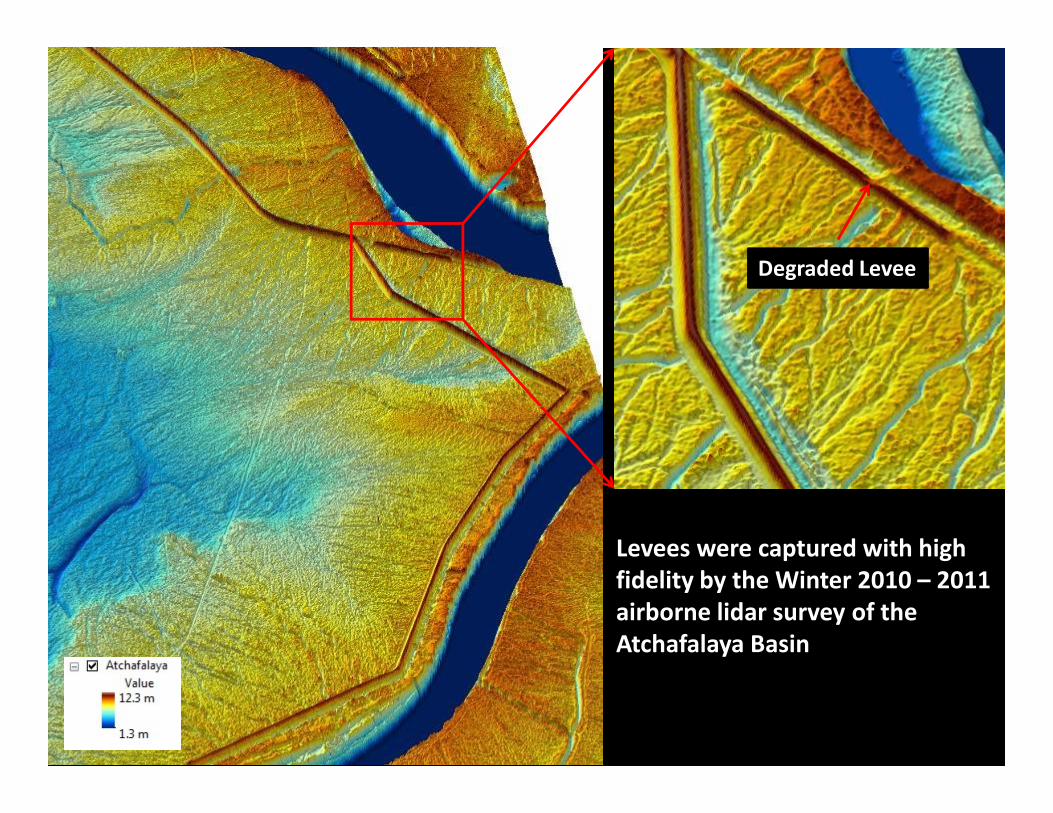
Degraded Levee
Levees were captured with high
fidelity by the Winter 2010 – 2011
airborne lidar survey of the
Atchafalaya Basin
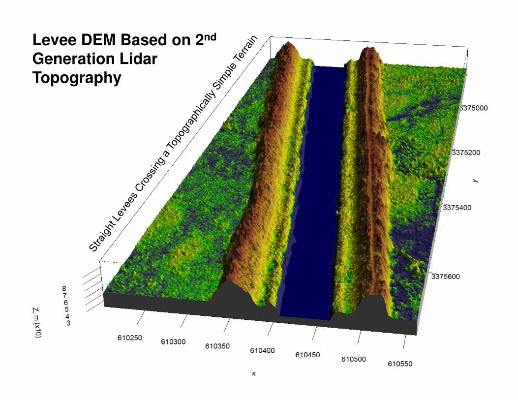
Levee DEM Based on 2nd
Generation Lidar Topography
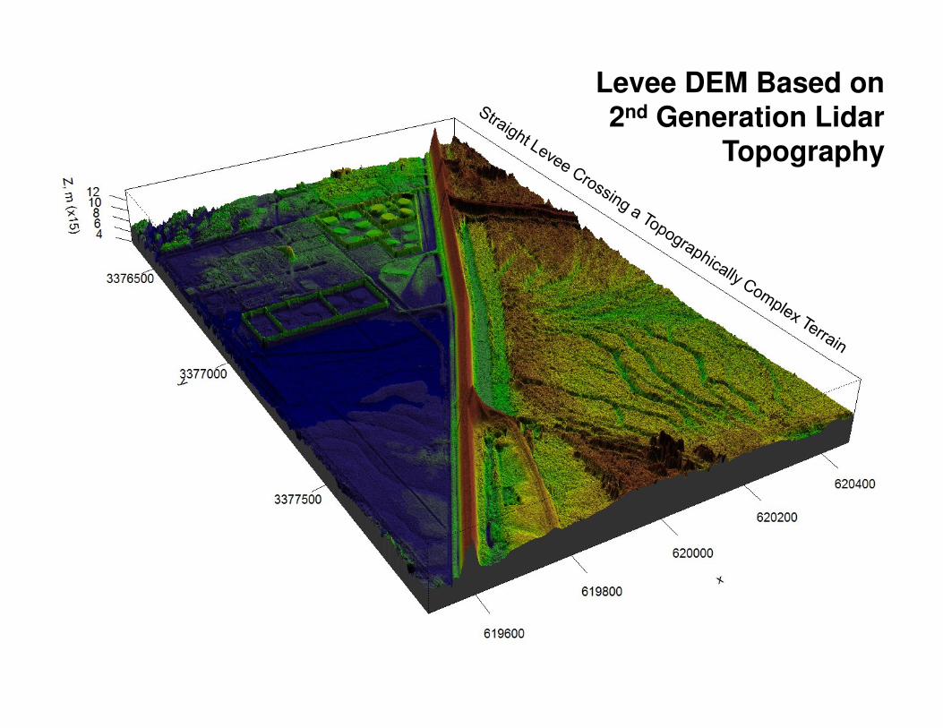
Levee DEM Based on 2nd Generation Lidar
Topography
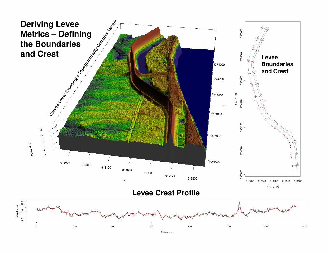
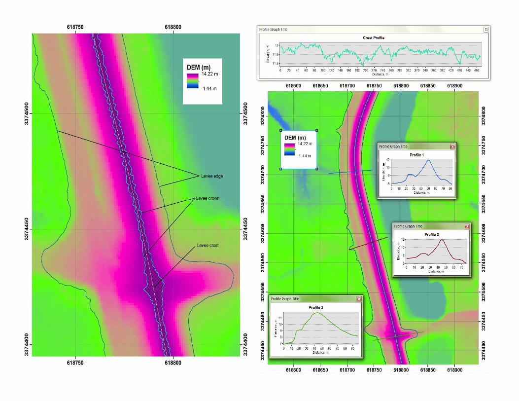
Deriving Levee Metrics – Defining the Boundariesand Crest Levee
Boundariesand Crest
Levee Crest Profile
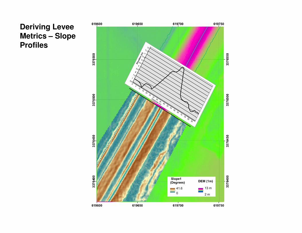
Deriving Levee Metrics – Slope Profiles
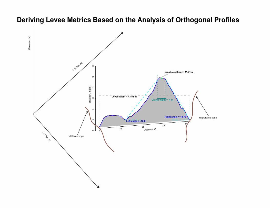
Deriving Levee Metrics Based on the Analysis of Orthogonal Profiles
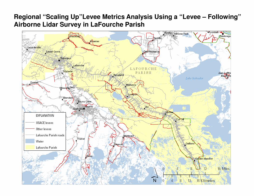
Regional “Scaling Up”Levee Metrics Analysis Using a “Levee – Following” Airborne Lidar Survey in LaFourche Parish
Summary
• A USGS – sponsored partnership to create a multi-year program of airborne lidar acquisitions to cover all of coastal Louisiana has been established
• The successful pre-Summer 2011 flood Winter 2010 – 2011 • The successful pre-Summer 2011 flood Winter 2010 – 2011 airborne lidar survey of the Atchafalaya Basin will be repeated with expanded coverage in Winter 2011 - 2012
• Pilot analysis of 2nd generation lidar surveys during Winter 2010 – 2011 has led to an initiative to map and monitor of levees across the Mississippi River Delta Plain and Atchafalaya Basin using targeted “levee – following” airborne lidar collections
Acknowledgements
USGS Coastal and Marine Geology Program, Reston, VA
USGS National Geospatial Program, Reston, VA
USGS National Wetlands Research Center, Lafayette, LA
Louisiana Coastal Protection and Restoration Authority, Baton Rouge, LA
US Army Corps of Engineers, New Orleans District, New Orleans, LA