Embed Size (px)
Citation preview
User Manual of the NWCPY tool for
the NWC/GEO
Code: NWC/CDOP3/GEO/AEMET/SW/UM/NWCPY
Issue: 1.1 Date: 11 Feb 2018
File: NWC-CDOP3-GEO-AEMET-SW-SUM-NWCPY_v1.1
Page: 1/19
User Manual of the NWCPY tool for the
NWC/GEO
NWC/CDOP3/GEO/AEMET/SW/UM/NWCPY, Issue 1, Rev. 1
11 Feb 2018
Applicable to NWCPY v1.1
for SAFNWC/GEO version 2016
Prepared by GMV Aerospace and Defence S.A.U

User Manual of the NWCPY tool for
the NWC/GEO
Code: NWC/CDOP3/GEO/AEMET/SW/UM/NWCPY
Issue: 1.1 Date: 11 Feb 2018
File: NWC-CDOP3-GEO-AEMET-SW-SUM-NWCPY_v1.1
Page: 2/19
REPORT SIGNATURE TABLE
Function Name Signature Date
Prepared by GMV
(as AEMET SW engineering
assistant)
Dic 2017 - Feb 2018
Reviewed by Xavier Calbet
NWCSAF GEO Manager
Endorsed by
Authorised by
User Manual of the NWCPY tool for
the NWC/GEO
Code: NWC/CDOP3/GEO/AEMET/SW/UM/NWCPY
Issue: 1.1 Date: 11 Feb 2018
File: NWC-CDOP3-GEO-AEMET-SW-SUM-NWCPY_v1.1
Page: 3/19
DOCUMENT CHANGE RECORD
Version Date Pages Changes
1.0 2 Oct 2017 16 First version, applicable to NWCPY v1.0
1.1 11 Feb 2018 19 Second version, applicable to NWCPY v1.1
Pressure interval differentiation and trajectories included in
HRW product
ASII product added
Image format changed from PNG to GIF
User Manual of the NWCPY tool for
the NWC/GEO
Code: NWC/CDOP3/GEO/AEMET/SW/UM/NWCPY
Issue: 1.1 Date: 11 Feb 2018
File: NWC-CDOP3-GEO-AEMET-SW-SUM-NWCPY_v1.1
Page: 4/19
Table of Contents
1 INTRODUCTION ............................................................................................................................................. 5
1.1 PURPOSE ......................................................................................................................................................... 5 1.2 REFERENCES ................................................................................................................................................... 5
1.2.1 Applicable documents ........................................................................................................................... 5 1.2.2 Reference documents............................................................................................................................. 5
2 FUNCTIONAL DESCRIPTION ...................................................................................................................... 6
3 INSTALLATION OF NWCPY ........................................................................................................................ 7
3.1 ENVIRONMENT ................................................................................................................................................ 7 3.2 PREVIOUS CONDITIONS AND LICENSES ............................................................................................................. 7
3.2.1 NWC/GEO ............................................................................................................................................. 7 3.2.2 python.................................................................................................................................................... 7 3.2.3 GEO-L1SD ............................................................................................................................................ 8
3.3 INSTALLATION OF THE NWCPY PACKAGE ...................................................................................................... 8
4 OPERATION OF NWCPY TOOL .................................................................................................................. 9
4.1 COMMAND LINE INTERFACE ............................................................................................................................ 9 4.2 OUTPUT NAMING CRITERIA ........................................................................................................................... 10 4.3 EXAMPLES ..................................................................................................................................................... 12
4.3.1 NWC/GEO Image-like product (CT) ................................................................................................... 12 4.3.2 GEO-L1SD Satellite Data ................................................................................................................... 13 4.3.3 NWC/GEO Image-like product (iSHAI) .............................................................................................. 14 4.3.4 NWC/GEO HRW product (winds) ....................................................................................................... 15
4.3.4.1 Considering pressure level ........................................................................................................................... 15 4.3.4.2 Considering wind speed ............................................................................................................................... 16
4.3.5 NWC/GEO HRW product (trajectories) .............................................................................................. 17 4.3.6 NWC/GEO ASII product ..................................................................................................................... 18 4.3.7 NWC/GEO RDT-CW product .............................................................................................................. 19
List of Tables and Figures
TABLE 1: LIST OF APPLICABLE DOCUMENTS .................................................................................................................. 5 TABLE 2: LIST OF REFERENCED DOCUMENTS ................................................................................................................ 6 TABLE 3: MINIMUM CONFIGURATION ............................................................................................................................. 7 TABLE 4: PYTHON PACKAGES REQUIRED BY NWCPY ................................................................................................... 8
FIGURE 1: GRAPHICAL REPRESENTATION OF A NWC/GEO CT PRODUCT .................................................................... 12 FIGURE 2: GRAPHICAL REPRESENTATION OF A NWC/GEO-L1-SD PRODUCT .............................................................. 13 FIGURE 3: GRAPHICAL REPRESENTATION OF A NWC/GEO-ISHAI PRODUCT (K-INDEX PARAMETER) ......................... 14 FIGURE 4: GRAPHICAL REPRESENTATION OF A NWC/GEO-HRW PRODUCT IN TERMS OF PRESSURE LEVEL ................ 15 FIGURE 5: GRAPHICAL REPRESENTATION OF A NWC/GEO-HRW PRODUCT IN TERMS OF WIND SPEED........................ 16 FIGURE 6: GRAPHICAL REPRESENTATION OF NWC/GEO-HRW TRAJECTORIES CONSIDERING 4 MSG SLOTS .............. 17 FIGURE 7: GRAPHICAL REPRESENTATION OF A NWC/GEO-ASII PRODUCT ................................................................. 18 FIGURE 8: GRAPHICAL REPRESENTATION OF A NWC/GEO-RDT-CW PRODUCT ......................................................... 19
User Manual of the NWCPY tool for
the NWC/GEO
Code: NWC/CDOP3/GEO/AEMET/SW/UM/NWCPY
Issue: 1.1 Date: 11 Feb 2018
File: NWC-CDOP3-GEO-AEMET-SW-SUM-NWCPY_v1.1
Page: 5/19
1 INTRODUCTION
1.1 PURPOSE
In the frame of the NWC SAF project, an easy-to-use tool (NWCPY) has been developed in charge
of reading NWC/GEO output products in netCDF1 format and generating a graphical representation
of a certain variable in a GIF file. The tool read the required information to generate the plot from
the NWC/GEO netCDF fields, as for example the colour palette, the valid range of the data, the
meaning of the values, …
The present document details the functionality of the NWCPY tool, and the procedure to install and
operate it.
1.2 REFERENCES
1.2.1 Applicable documents
The following documents, of the exact issue shown, form part of this document to the extent
specified herein. Applicable documents are those referenced in the Contract or approved by the
Approval Authority. They are referenced in this document in the form [AD.X].
For dated references, subsequent amendments to, or revisions of, any of these publications do not
apply. For undated references, the current edition of the document referred applies.
Current documentation can be found at the NWC SAF Helpdesk web: http://www.nwcsaf.org
Ref Title Code Vers Date
[AD.1] Proposal for the Third Continuous
Development and Operations Phase
(CDOP3) March 2017 – February 2022
NWC SAF: CDOP-3 proposal
1.0 11/04/16
[AD.2] Data Output Format of the NWC/GEO NWC/CDOP/GEO/AEMET/SW/DOF 1.2.1 15/06/17
[AD.3] User Manual of the GEO-L1SD tool NWC/CDOP3/GEO/AEMET/SW/UM/L1SD 1.0 25/05/17
[AD.4] User Manual for the Wind product
processors of the NWC/GEO: Science
Part
NWC/CDOP2/GEO/AEMET/SCI/UM/Wind 1.0 15/10/16
Table 1: List of Applicable Documents
1.2.2 Reference documents
The reference documents contain useful information related to the subject of the project. These
reference documents complement the applicable ones, and can be looked up to enhance the
information included in this document if it is desired. They are referenced in this document in the
form [RD.X].
1 The only exception is the NWC/GEO ASII, which is generated in BUFR format and shall be read in that format.
The NWC/GEO HRW product is available in netCDF format, just setting OUTPUT_FORMAT = NET in the HRW
model configuration file.
User Manual of the NWCPY tool for
the NWC/GEO
Code: NWC/CDOP3/GEO/AEMET/SW/UM/NWCPY
Issue: 1.1 Date: 11 Feb 2018
File: NWC-CDOP3-GEO-AEMET-SW-SUM-NWCPY_v1.1
Page: 6/19
For dated references, subsequent amendments to, or revisions of, any of these publications do not
apply. For undated references, the current edition of the document referred applies.
Current documentation can be found at the NWC SAF Helpdesk web: http://www.nwcsaf.org
Ref Title Code Vers Date
[RD.1] The Nowcasting SAF Glossary NWC/CDOP2/SAF/AEMET/MGT/GLO
Table 2: List of Referenced Documents
2 FUNCTIONAL DESCRIPTION
The NWCPY tool implements the following high-level requirements:
Id Description
010 The NWCPY application shall generate a graphical representation of NWC/GEO
products in GIF format
020 The NWCPY application shall be developed as a tool apart from the NWC/GEO, so
that a user could run it without installing the NWC SAF software
030 The application shall allow the reading of all PGE product files in native netCDF
format (including EXIM products) and ASII product in BUFR format (See [AD.2])
040 The application shall also allow the reading of Satellite Data products in netCDF as
generated by the NWC/GEO extra tool GEO-L1SD (See [AD.3])
050 Given a netCDF product file, the application shall read the data corresponding to a
certain variable, including its attributes and colour palette. In case of HRW product
file, the application shall also read trajectory data (See [AD.4])
060 Given a BUFR ASII file, the application shall read the latitude, longitude and variable
name contained in each message
070 The plotting shall follow the native geostationary projection, using the gdal parameters
included in the netCDF file. In case of HRW and ASII products, gdal parameters are
taken from the corresponding L1SD netCDF file
080 Output image shall be provided in gif format, with the dimensions (width x height)
specified by the user as an input parameter
090 No data pixels in iSHAI representation shall be filled using the data of the IR_band
variable included in the iSHAI product (See [AD.2])
100 No data pixels in CI product images shall be filled with brightness temperatures data
read from the GEO-L1SD IR_120_BT satellite data product for the same slot and
region
110 Appropriate GEO-L1SD IR_120_BT satellite data product shall be used as background
image for the representation of HRW, ASII and RDT-CW data
User Manual of the NWCPY tool for
the NWC/GEO
Code: NWC/CDOP3/GEO/AEMET/SW/UM/NWCPY
Issue: 1.1 Date: 11 Feb 2018
File: NWC-CDOP3-GEO-AEMET-SW-SUM-NWCPY_v1.1
Page: 7/19
120 The image generated in gif format will follow the same nomenclature than the netCDF
input file, only adding the parameter being displayed and changing the extension (.gif)
3 INSTALLATION OF NWCPY
3.1 ENVIRONMENT
This section describes HW/SW prerequisites needed to install and execute the NWCPY tool.
NWCPY tool has been tested in a Linux/RHEL6.4 64 bits environment. Correct execution in other
environments cannot be currently guaranteed.
Intel/Linux
O.S RHEL release 6.4
Santiago
CPU 4x
Intel(R) Core(TM) i5-4590
CPU @ 3.30GHz
Arch x86_64
Memory(1) 8 GB
Disk 500 GB
Shell bash; ksh
Compilers GCC compilers 4.4.7;
gcc; g++; gfortran
gzip gzip 1.3.12
Python 2.7.10
Table 3: Minimum configuration
3.2 PREVIOUS CONDITIONS AND LICENSES
3.2.1 NWC/GEO
The NWCPY has been designed and developed to be self-dependant. Therefore, the NWC/GEO
package is not required to execute this tool.
3.2.2 python
The NWCPY has been developed in python; python 2 is required to execute the NWCPY tools.
In addition, the following python packages are required, and must be properly installed in the
platform:
User Manual of the NWCPY tool for
the NWC/GEO
Code: NWC/CDOP3/GEO/AEMET/SW/UM/NWCPY
Issue: 1.1 Date: 11 Feb 2018
File: NWC-CDOP3-GEO-AEMET-SW-SUM-NWCPY_v1.1
Page: 8/19
Table 4: Python packages required by NWCPY
datetime Basic date and time types h5py Pythonic interface to the HDF5 binary data
format matplotlib Python 2D plotting library mpl_toolkits Matplotlib Toolkits (collections of application-
specific functions that extend matplotlib) netCDF4 Python interface to the netCDF C library. numpy Package for scientific computing with Python os Miscellaneous operating system interfaces pybufrkit Python toolkit for WMO BUFR messages re Regular expression operations subprocess Subprocess management sys System-specific parameters and functions
3.2.3 GEO-L1SD
NWCPY requires GEO-L1SD satellite data products as background data for some products.
Therefore, the user must assure the availability of GEO-L1SD products if required (CI, HRW, ASII
and RDT representation).
The GEO-L1SD application is available to NWCSAF registered users in the NWCSAF Helpdesk,
clicking in Software->Extra Tools. This page allows downloading both the GEO-L1SD software and
the User Manual.
3.3 INSTALLATION OF THE NWCPY PACKAGE
The NWCPY package is provided in a tar.gz file:
NWC-CDOP3-GEO-AEMET-SW-CODE-NWCPY_v1.1.tgz
It is important to note that the NWCPY tool does not require NWC/GEO application to be installed
in the system. It can be executed in any machine that met the requirements from Section 3.2. To
install the NWCPY package:
1. Locate in the desired directory and decompress the tgz distribution:
% cd <target_directory> % tar xvf <source>/NWC-CDOP3-GEO-AEMET-SW-CODE-NWCPY_v1.1.tgz
The following files will be created:
User Manual of the NWCPY tool for
the NWC/GEO
Code: NWC/CDOP3/GEO/AEMET/SW/UM/NWCPY
Issue: 1.1 Date: 11 Feb 2018
File: NWC-CDOP3-GEO-AEMET-SW-SUM-NWCPY_v1.1
Page: 9/19
<target_directory> Decompression directory
NWCPY NWCPY module
logoNWCSAF.png Logo of the project
nwcpy_asii.py Source code for the NWCPY tool, ASII product
nwcpy_hrw.py Source code for the NWCPY tool, HRW product
nwcpy_hrw_traj.py Source code for the NWCPY tool, HRW trajectories
nwcpy.py Source code for the NWCPY tool, image-like products
nwcpy_rdt.py Source code for the NWCPY tool, RDT product
2. Define in the command line the environment variable NWCPY_PATH as the path to
logoNWCSAF.png. Add this line to your .profile:
export NWCPY_PATH=<source>/NWCPY
No other steps are required.
4 OPERATION OF NWCPY TOOL
4.1 COMMAND LINE INTERFACE
Once the NWCPY tool is installed on the system, the command line interface is the following:
For image-like products (CMA, CT, CTTH, …): python nwcpy.py <path/file.nc> <variable1> <width> <height> For HRW winds: python nwcpy_hrw.py <path/file.nc> <width> <height> <type> [<pressure_interval>] For HRW trajectories4: python nwcpy_hrw_traj.py <path/file.nc> <width> <height> <n_slots> [<pressure_interval>] For ASII product: python nwcpy_asii.py <path/file.bufr> <width> <height> For RDT product: python nwcpy_rdt.py <path/file.nc> <width> <height>
where
4 nwcpy_hrw_traj.py source code for trajectories generates the temporary file trajectories.txt on each execution,
and removes it once the trajectory variables are properly stored. The user shall check there is no file named
trajectories.txt in the working directory, otherwise it will be overwritten.
User Manual of the NWCPY tool for
the NWC/GEO
Code: NWC/CDOP3/GEO/AEMET/SW/UM/NWCPY
Issue: 1.1 Date: 11 Feb 2018
File: NWC-CDOP3-GEO-AEMET-SW-SUM-NWCPY_v1.1
Page: 10/19
<path/file.nc> (<path/file.bufr>) is the complete path to the product file in netCDF
(BUFR) format.
<variable1> is the name of the variable contained in the netCDF for image-like products.
<width> <height> are the dimensions of the output gif image. Set to “0 0” to generate the
output file at default size (1100x800).
<type> is the variable to be labelled in the HRW product: “p” (pressure) or “ws” (wind
speed)
<n_slots> is the number of satellite slots to be used to plot trajectories (>=2)
[<pressure_interval>] is an optional parameter to plot winds and trajectories only for
certain pressure levels. Allowed values are 0 (only background), 1 (100-400 hPa), 2 (400-600
hPa), 3 (600-800 hPa), 4 (800-1000 hPa). If no pressure_interval is set, winds and
trajectories are plotted for ALL pressure levels.
NWCPY commands can be executed from any directory, properly indicating the path to the
netCDF/BUFR files. The output gif images are stored in the working directory.
4.2 OUTPUT NAMING CRITERIA
The images generated by the NWCPY tool are stored in the working directory and follow the next
naming criteria:
For image-like products (CMA, CT, CTTH, …):
<file>.<variable1>.gif
For HRW winds:
<file>.<type>_<pressure_interval_label>.gif
For HRW trajectories:
<file>.traj_<pressure_interval_label>_<n_slots>slots.gif
For ASII product:
<file>.asii.gif
For RDT product:
<file>.rdt.gif
where <pressure_interval_label> is the label associated to <pressure_interval>: 0-
“background”, 1-“100-400hPa”, 2-“400-600hPa”, 3-“600-800hPa”, 4-“800-1000hPa” and none-
“all”.
IMPORTANT NOTE: HRW winds/trajectories image includes IR background (GEO-L1SD
IR_120_BT) only in the following cases:
<pressure_interval> = 0
User Manual of the NWCPY tool for
the NWC/GEO
Code: NWC/CDOP3/GEO/AEMET/SW/UM/NWCPY
Issue: 1.1 Date: 11 Feb 2018
File: NWC-CDOP3-GEO-AEMET-SW-SUM-NWCPY_v1.1
Page: 11/19
<pressure_interval> = “”
Otherwise GEO-L1SD satellite data product is used to read gdal projection parameters necessary to
navigate wind vectors/trajectories, but these are displayed over a transparent background.
User Manual of the NWCPY tool for
the NWC/GEO
Code: NWC/CDOP3/GEO/AEMET/SW/UM/NWCPY
Issue: 1.1 Date: 11 Feb 2018
File: NWC-CDOP3-GEO-AEMET-SW-SUM-NWCPY_v1.1
Page: 12/19
4.3 EXAMPLES
4.3.1 NWC/GEO Image-like product (CT)
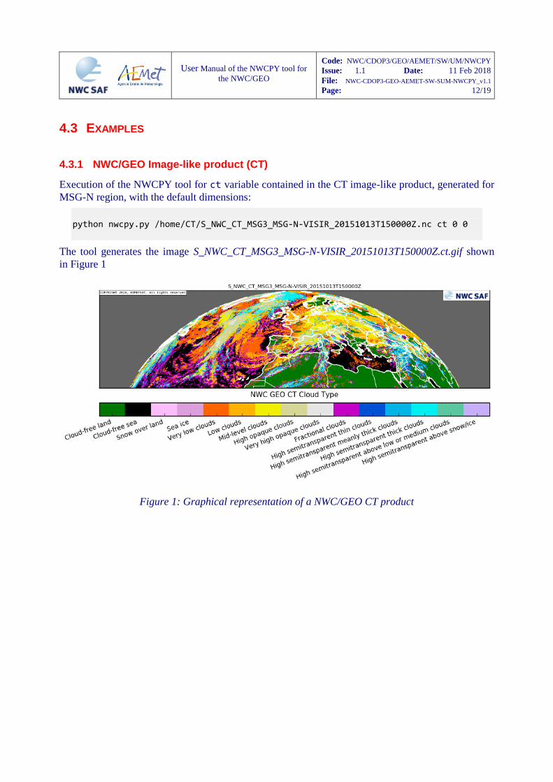
Execution of the NWCPY tool for ct variable contained in the CT image-like product, generated for
MSG-N region, with the default dimensions:
python nwcpy.py /home/CT/S_NWC_CT_MSG3_MSG-N-VISIR_20151013T150000Z.nc ct 0 0
The tool generates the image S_NWC_CT_MSG3_MSG-N-VISIR_20151013T150000Z.ct.gif shown
in Figure 1
Figure 1: Graphical representation of a NWC/GEO CT product
User Manual of the NWCPY tool for
the NWC/GEO
Code: NWC/CDOP3/GEO/AEMET/SW/UM/NWCPY
Issue: 1.1 Date: 11 Feb 2018
File: NWC-CDOP3-GEO-AEMET-SW-SUM-NWCPY_v1.1
Page: 13/19
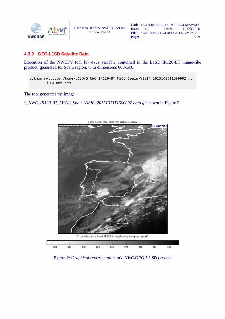
4.3.2 GEO-L1SD Satellite Data
Execution of the NWCPY tool for data variable contained in the L1SD IR120-BT image-like
product, generated for Spain region, with dimensions 600x600:
python nwcpy.py /home/L1SD/S_NWC_IR120-BT_MSG3_Spain-VISIR_20151013T150000Z.nc
data 600 600
The tool generates the image
S_NWC_IR120-BT_MSG3_Spain-VISIR_20151013T150000Z.data.gif shown in Figure 2
Figure 2: Graphical representation of a NWC/GEO-L1-SD product
User Manual of the NWCPY tool for
the NWC/GEO
Code: NWC/CDOP3/GEO/AEMET/SW/UM/NWCPY
Issue: 1.1 Date: 11 Feb 2018
File: NWC-CDOP3-GEO-AEMET-SW-SUM-NWCPY_v1.1
Page: 14/19
4.3.3 NWC/GEO Image-like product (iSHAI)
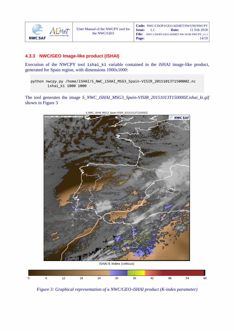
Execution of the NWCPY tool ishai_ki variable contained in the iSHAI image-like product,
generated for Spain region, with dimensions 1000x1000:
python nwcpy.py /home/iSHAI/S_NWC_iSHAI_MSG3_Spain-VISIR_20151013T150000Z.nc
ishai_ki 1000 1000
The tool generates the image S_NWC_iSHAI_MSG3_Spain-VISIR_20151013T150000Z.ishai_ki.gif
shown in Figure 3
Figure 3: Graphical representation of a NWC/GEO-iSHAI product (K-index parameter)
User Manual of the NWCPY tool for
the NWC/GEO
Code: NWC/CDOP3/GEO/AEMET/SW/UM/NWCPY
Issue: 1.1 Date: 11 Feb 2018
File: NWC-CDOP3-GEO-AEMET-SW-SUM-NWCPY_v1.1
Page: 15/19
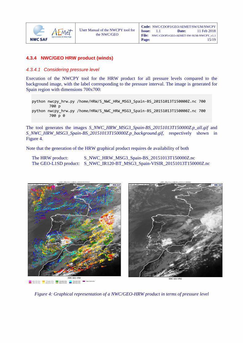
4.3.4 NWC/GEO HRW product (winds)
4.3.4.1 Considering pressure level
Execution of the NWCPY tool for the HRW product for all pressure levels compared to the
background image, with the label corresponding to the pressure interval. The image is generated for
Spain region with dimensions 700x700:
python nwcpy_hrw.py /home/HRW/S_NWC_HRW_MSG3_Spain-BS_20151013T150000Z.nc 700
700 p python nwcpy_hrw.py /home/HRW/S_NWC_HRW_MSG3_Spain-BS_20151013T150000Z.nc 700
700 p 0
The tool generates the images S_NWC_HRW_MSG3_Spain-BS_20151013T150000Z.p_all.gif and
S_NWC_HRW_MSG3_Spain-BS_20151013T150000Z.p_background.gif, respectively shown in
Figure 4.
Note that the generation of the HRW graphical product requires de availability of both
The HRW product: S_NWC_HRW_MSG3_Spain-BS_20151013T150000Z.nc
The GEO-L1SD product: S_NWC_IR120-BT_MSG3_Spain-VISIR_20151013T150000Z.nc
Figure 4: Graphical representation of a NWC/GEO-HRW product in terms of pressure level
User Manual of the NWCPY tool for
the NWC/GEO
Code: NWC/CDOP3/GEO/AEMET/SW/UM/NWCPY
Issue: 1.1 Date: 11 Feb 2018
File: NWC-CDOP3-GEO-AEMET-SW-SUM-NWCPY_v1.1
Page: 16/19
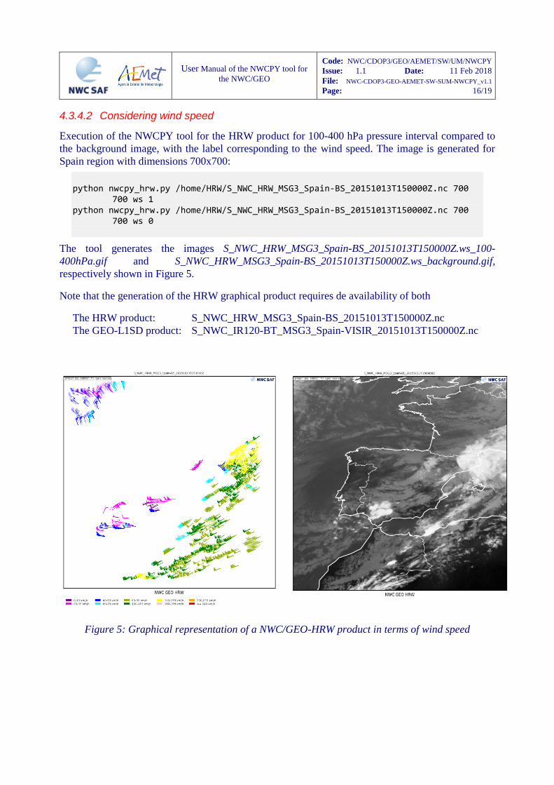
4.3.4.2 Considering wind speed
Execution of the NWCPY tool for the HRW product for 100-400 hPa pressure interval compared to
the background image, with the label corresponding to the wind speed. The image is generated for
Spain region with dimensions 700x700:
python nwcpy_hrw.py /home/HRW/S_NWC_HRW_MSG3_Spain-BS_20151013T150000Z.nc 700
700 ws 1 python nwcpy_hrw.py /home/HRW/S_NWC_HRW_MSG3_Spain-BS_20151013T150000Z.nc 700
700 ws 0
The tool generates the images S_NWC_HRW_MSG3_Spain-BS_20151013T150000Z.ws_100-
400hPa.gif and S_NWC_HRW_MSG3_Spain-BS_20151013T150000Z.ws_background.gif,
respectively shown in Figure 5.
Note that the generation of the HRW graphical product requires de availability of both
The HRW product: S_NWC_HRW_MSG3_Spain-BS_20151013T150000Z.nc
The GEO-L1SD product: S_NWC_IR120-BT_MSG3_Spain-VISIR_20151013T150000Z.nc
Figure 5: Graphical representation of a NWC/GEO-HRW product in terms of wind speed
User Manual of the NWCPY tool for
the NWC/GEO
Code: NWC/CDOP3/GEO/AEMET/SW/UM/NWCPY
Issue: 1.1 Date: 11 Feb 2018
File: NWC-CDOP3-GEO-AEMET-SW-SUM-NWCPY_v1.1
Page: 17/19
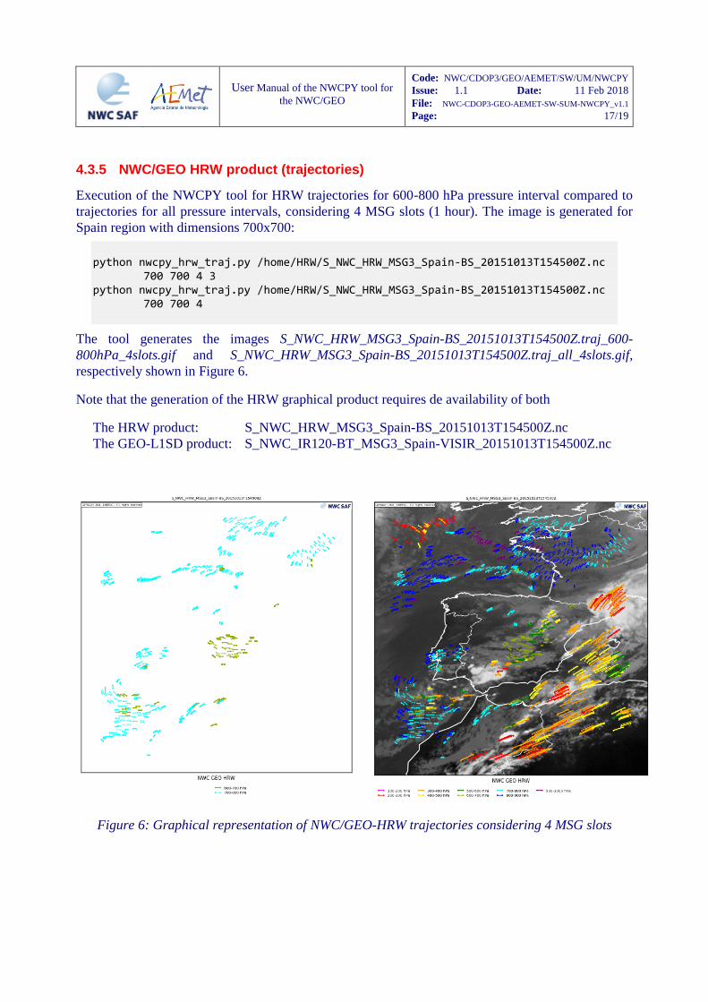
4.3.5 NWC/GEO HRW product (trajectories)
Execution of the NWCPY tool for HRW trajectories for 600-800 hPa pressure interval compared to
trajectories for all pressure intervals, considering 4 MSG slots (1 hour). The image is generated for
Spain region with dimensions 700x700:
python nwcpy_hrw_traj.py /home/HRW/S_NWC_HRW_MSG3_Spain-BS_20151013T154500Z.nc
700 700 4 3 python nwcpy_hrw_traj.py /home/HRW/S_NWC_HRW_MSG3_Spain-BS_20151013T154500Z.nc
700 700 4
The tool generates the images S_NWC_HRW_MSG3_Spain-BS_20151013T154500Z.traj_600-
800hPa_4slots.gif and S_NWC_HRW_MSG3_Spain-BS_20151013T154500Z.traj_all_4slots.gif,
respectively shown in Figure 6.
Note that the generation of the HRW graphical product requires de availability of both
The HRW product: S_NWC_HRW_MSG3_Spain-BS_20151013T154500Z.nc
The GEO-L1SD product: S_NWC_IR120-BT_MSG3_Spain-VISIR_20151013T154500Z.nc
Figure 6: Graphical representation of NWC/GEO-HRW trajectories considering 4 MSG slots
User Manual of the NWCPY tool for
the NWC/GEO
Code: NWC/CDOP3/GEO/AEMET/SW/UM/NWCPY
Issue: 1.1 Date: 11 Feb 2018
File: NWC-CDOP3-GEO-AEMET-SW-SUM-NWCPY_v1.1
Page: 18/19
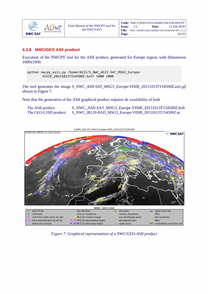
4.3.6 NWC/GEO ASII product
Execution of the NWCPY tool for the ASII product, generated for Europe region, with dimensions
1000x1000:
python nwcpy_asii.py /home/ASII/S_NWC_ASII-SAT_MSG3_Europe-
VISIR_20151013T154500Z.bufr 1000 1000
The tool generates the image S_NWC_ASII-SAT_MSG3_Europe-VISIR_20151013T154500Z.asii.gif
shown in Figure 7.
Note that the generation of the ASII graphical product requires de availability of both
The ASII product: S_NWC_ASII-SAT_MSG3_Europe-VISIR_20151013T154500Z.bufr The GEO-L1SD product: S_NWC_IR120-RAD_MSG3_Europe-VISIR_20151013T154500Z.nc
Figure 7: Graphical representation of a NWC/GEO-ASII product
User Manual of the NWCPY tool for
the NWC/GEO
Code: NWC/CDOP3/GEO/AEMET/SW/UM/NWCPY
Issue: 1.1 Date: 11 Feb 2018
File: NWC-CDOP3-GEO-AEMET-SW-SUM-NWCPY_v1.1
Page: 19/19
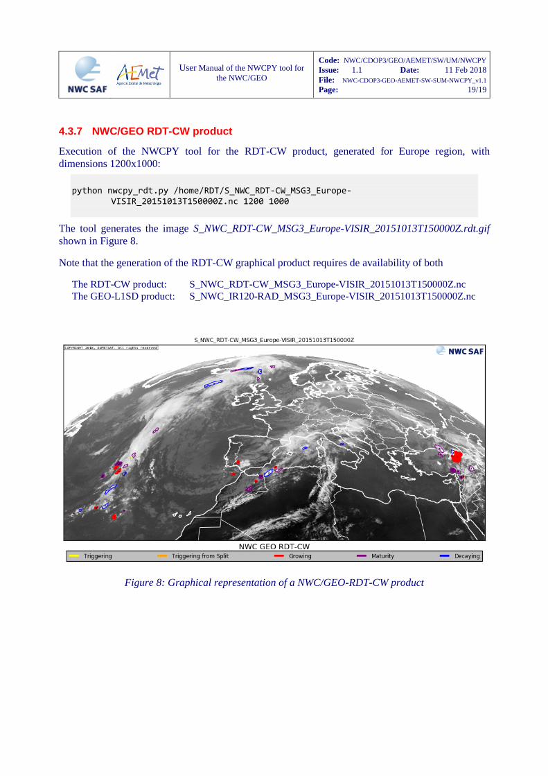
4.3.7 NWC/GEO RDT-CW product
Execution of the NWCPY tool for the RDT-CW product, generated for Europe region, with
dimensions 1200x1000:
python nwcpy_rdt.py /home/RDT/S_NWC_RDT-CW_MSG3_Europe-
VISIR_20151013T150000Z.nc 1200 1000
The tool generates the image S_NWC_RDT-CW_MSG3_Europe-VISIR_20151013T150000Z.rdt.gif
shown in Figure 8.
Note that the generation of the RDT-CW graphical product requires de availability of both
The RDT-CW product: S_NWC_RDT-CW_MSG3_Europe-VISIR_20151013T150000Z.nc
The GEO-L1SD product: S_NWC_IR120-RAD_MSG3_Europe-VISIR_20151013T150000Z.nc
Figure 8: Graphical representation of a NWC/GEO-RDT-CW product


![NetCDF-4 Performance Report - The HDF Group · NetCDF-4 Performance Report Choonghwan Lee ... Introduction NetCDF-4 [1] ... netcdf4 large netcdf3 large netcdf4 small](https://img.pdfslide.us/doc/110x75/5b509b227f8b9a5a6f8ed256/netcdf-4-performance-report-the-hdf-group-netcdf-4-performance-report-choonghwan.jpg)