Embed Size (px)
Citation preview
Applied Radiation and Isotopes 69 (2011) 463–474
Contents lists available at ScienceDirect
Applied Radiation and Isotopes
0969-80
doi:10.1
n Corr
E-m
journal homepage: www.elsevier.com/locate/apradiso
Usefulness of systematic in situ gamma-ray surveys in the radiometriccharacterization of natural systems with poorly contrasting geological features(examples from NE of Portugal)
Pedro Duarte a,b, Antonio Mateus b, Isabel Paiva a,n, Rom~ao Trindade a, Pedro Santos a,b
a Instituto Tecnologico e Nuclear, Unidade de Protecc- ~ao e Seguranc-a Radiologica, Estrada Nacional no10, Apartado 21, 2686-953 Sacavem, Portugalb Departamento de Geologia e CeGUL, Faculdade de Ciencias da Universidade de Lisboa, Campo Grande, Edifıcio C6, 1749-016 Lisboa, Portugal
a r t i c l e i n f o
Article history:
Received 29 July 2010
Received in revised form
10 September 2010
Accepted 4 October 2010
Keywords:
In situ gamma-ray surveys
Radiometric mapping
(Serpentinised) peridotites
Schist sequences
43/$ - see front matter & 2010 Elsevier Ltd. A
016/j.apradiso.2010.10.002
esponding author. Tel.: +351 219946318; fax
ail address: [email protected] (I. Paiva).
a b s t r a c t
This paper focuses on the starting point of various studies that are being carried out in two possible
locations being considered to host a hypothetical site for a repository for low and intermediate level
radioactive waste (LILW) produced in Portugal in compliance with international requirements on the
long-term safety of this kind of repository. Previous studies concerning the geology of the much larger
geographical areas where these locations are included were fundamental in the choice of these locations
and for the design of the survey strategy. One of the fundamental assessment studies during the site-
selection is the overall radiological characterization of the locations and its relation to the geology. This
paper pretends to show the adequability of using a fast and reasonably inexpensive survey technique such
as in situ gamma-ray portable detectors, to access the radiometric response of the systems in study by
providing the radiometric mapping of the areas. The existence of adequate radiometric maps represents a
critical pre-requisite to constrain both the number and spatial distribution of samples to be collected for
further analysis, sustaining as well the subsequent extrapolation of results needed to fully characterise
the surveyed system. Both areas were surveyed using portable gamma-ray spectrometers with NaI(Tl)
detectors. In situ gamma-ray measurements have clearly shown not only the poorly contrasting geological
features, but also their differences representing: (i) a deformed/metamorphosed ophiolite complex and
(ii) a monotonous meta-sedimentary sequence. The radiometric maps obtained have show heterogene-
ities that reflect mostly changes in rock-forming mineral assemblages, even in the presence of small
variations of gamma radiation. These maps support objective criteria about the number/distribution of
samples to be collected for subsequent comprehensive studies and reinforce the valuable contribution of
in situ gamma spectrometry to assess, in radiological terms, the prevalent geological features.
& 2010 Elsevier Ltd. All rights reserved.
1. Introduction
Gamma radiation measurements are commonly performed, butthe approaches selected may vary significantly according to theintended objectives, such as gamma radiation mapping (Clouvas et al.,2004), characterization of high-background radiation areas (Mohantyet al., 2004), monitoring of environmental contamination (Tyler,2004), evaluation of nuclear accident impacts (Bikit et al., 2006),mineral prospecting (Asfahani et al., 2009) or earthquake prediction(Tsvetkova et al., 2001). In operational terms, the surveys can be doneby air-borne (Asfahani et al., 2009), car-borne (Aage et al., 2006) orwalking (Paridaens, 2006), with a considerable number of set-uppossibilities whose selection weigh many different variables (e.g. areato be surveyed, specific goals to be achieved, data-resolution desired,
ll rights reserved.
: +351 219941995.
available detectors and logistical and financial support). In manystudies, however, the answer of several key-questions resides incomprehensive analysis of individual samples, therefore demandingimproved care in planning a representative sampling program.
The influence of intrinsic compositional and structural featuresdisplayed by different geological systems on gamma radiationmeasurements is reported in many studies (e.g. Tzortzis et al.,2003; Malczewski et al., 2004; Yamada et al., 2008; Baykara andDogru, 2009). Nevertheless, in what applies specifically to(serpentinised) peridotite-bearing complexes (expected to becharacterized by low radionuclide concentrations), the dataavailable in the literature is not so extensive, with the noteworthyworks of Chiozzi et al. (2002) and Tzortzis et al. (2003) aiming atparticular targets located in Europe. Thus, complementary data setsare essential for improving the analysis framework in those geologicalsystems, contributing also to understanding the cause and effectrelationships that help explain the variability of radiometricbackground often displayed by (serpentinised) peridotite rocks.
P. Duarte et al. / Applied Radiation and Isotopes 69 (2011) 463–474464
The present paper represents the starting point of a work-planintended to characterize the naturally occurring detailed distribu-tion and abundance of radionuclides at sites that may potentiallyserve as a near-surface repository for low and intermediate levelradioactive waste (Trindade et al., 2004; Duarte et al., 2006). Itaddresses the challenges raised above by studying two geologicaldistinct areas located in northern Portugal. At each site, thevariability in composition and structure of the rocks is relativelylow, resulting in difficulty in defining specific lithologies or rockunits that may have a specific radiogenic signature. Because of thislow contrast between the geological features present, a surfacescintillation survey was proposed as a means to further definethe characteristics of the rocks and soils. A fast and reasonablyinexpensive survey was designed and tested using a portableNaI(Tl) 300 �300 (Target system electronic gmbh) gamma-raydetector and a measurement-grid adapted to the field conditionswithout compromising the complete scan of both areas. In order tobetter constrain results in the (serpentinised) peridotite-dominantarea, transitions into contiguous geological neighbourhoods(comprising distinctly different geological formations) were alsosurveyed. This procedure was not necessary for the other areabecause it extends throughout the same geological formation(monotonous schist sequence).
2. Main characteristics of the areas surveyed
The two selected areas are sited in Tras-os-Montes (NE Portugal;Fig. 1): the northernmost one (Morais), located between coordinates6151030.100W–41128015.200N and 6144034.100W–41132019.600N, extendsfor about 55 km2; the other one (nearby the Torre de Moncorvovillage), occupies ca. 1 km2 and is placed between coordinates6155034.900W–4118040.800N and 6154028.300W–4119028.600N. Theprevailing geomorphic feature of Morais corresponds to a hillwith moderate to low slopes and a maximum elevation of 770 mabove sea level, controlling a centrifuge hydrographical pattern;the average annual rainfall is 642 mm and the major land-useconsists of non-irrigated annual crops, shrubs, bushes and corktrees. The Torre de Moncorvo area is a plateau between 609 and623 m above sea level, surrounded by severe slopes (E50%); theaverage annual rainfall is 731 mm and the land-use mainly consists ofshrubs, bushes and olive groves. The size of the second area is quitesmall when compared to the former one and the reason for that istwofold: (i) strong homogenous lithological background and rathersimple structure, facilitating the choice of a geologically representativearea and (ii) numerous deep-set streams, preventing the preservationof large-sized plateaus.
The area of Morais covers most of the outcropping (serpenti-nised) peridotites included in an un-rooted portion of a Variscanophiolite complex, the latter also comprising variably deformedflaser-gabbros and amphibolites (e.g. Dallmeyer et al., 1991;Ribeiro et al., 1990, 2007; Pereira et al., 1999). This ophiolitecomplex is tectonically in contact with mica-schists and ortho-gneisses belonging to another allochthonous unit (representing apoly-metamorphic continental sequence), and the entire suite isaffected by various fault zones subjected to recurrent re-activation(e.g. Ribeiro et al., 1990, 2007; Pereira et al., 1999). The recentgeological evolution of the area (Miocene to Pliocene), is mostlyrecorded by conglomeratic deposits with different matrices ofvariable thickness that are particularly well-preserved to the northof the surveyed area (e.g. Pereira, 1997; Ribeiro et al., 1990, 2007;Pereira et al., 1999). At the second area (nearby Torre de Moncorvo),the geological background corresponds to a relatively monotonouslitho-stratigraphic unit composed of slates and black-schists withmeta-siltstone intercalations that have evolved to a siliceous schistsequence (occasionally C-rich). In both areas, the soil thickness is
quite variable (from a few centimetres up to 0.50 m), enabling thepreservation of many rock-cropping exposures, particularly atMorais; this favourable feature for geological mapping allowsdistinguishing a relatively continuous band of foliated(serpentinised) peridotites adjoining the main outer thrust faultzones. According to the geological features displayed by both areas,contrasting gamma radiation backgrounds are expected due tosignificant differences in type and abundance of rock-formingminerals able to incorporate chemical elements that arepotentially responsible for the natural radioactivity emitted(such as K, U and Th). Indeed, the meta-sediments at Torre deMoncorvo, as well as the mica-schists and ortho-gneisses at Moraiscontain significant amounts of K-rich phases, namely micas that inthe latter two rock types come together with K-feldspars besidesaccessory apatite and zircon. The mineralogical contrast withgabbros and peridotites belonging to the ophiolite suite atMorais is evident, irrespectively of the retrograding featuresexperienced by them (see below).
3. Material and methods
3.1. In situ gamma-ray measurements
The surveys were carried out by using portable NaI(Tl) 300 �300
detector, from Target systemelectronic gmbh, coupled with amultichannel analyzer (MCA) and a palmtop. In some surveypoints, a 500 �500 detector was also used. The detectors are periodi-cally calibrated at The Metrology Laboratory of Ionizing Radiation(LMRI/ITN), a Primary Laboratory of National Primary System and,during field measurements, the energy calibration and gain stabi-lization were performed daily, with a 137Cs sealed source. In situ
calibration of the gamma-ray detectors was carried out outside thearea of interest. The detector was positioned 1 m above the groundand, at each sampling point, ten values in ‘‘count rate’’ mode (Units:cps) were recorded after detector stabilization. The geographiccoordinates (WGS84 system) of the sampling points, with ca. 4 m ofuncertainty, were gathered with a portable GPS. Measurementswere completed along several linear profiles (transects) withdistinct lengths and composed of regularly spaced (ca. 50 m)sampling points, further complemented (whenever possible, dueto dense vegetation covering) with scattered stations betweenadjacent transects for extrapolation improvements for unmea-sured (inaccessible) areas during the subsequent production ofradiometric maps (Fig. 2).
In the Morais area, measurements were carried out in 863sampling points during five non-consecutive days of June–July2007 without rainfall and an average atmospheric temperature ofabout 20 1C. Two consecutive days of November 2007 were enoughto carry out the measurements in 117 sampling points at the areanearby Torre de Moncorvo under somewhat-different field condi-tions: no rainfall and 6 1C of daily average atmospheric tempera-ture during the first day; and 40 mm of precipitation and 8 1C ofdaily average atmospheric temperature throughout thesecond day.
3.2. Radiometric maps
In order to characterise the spatial variability of the naturalgamma radiation (local background) all over the two surveyedareas, predictive maps were constructed using GIS software (ESRIsArcMapTM 9.2 with their Geostatistical Analyst tool). The spatialanalysis (interpolation) of raw data was performed with ordinarykriging, and adjustments to the exponential model proved to be themost adequate, revealing the lowest average standard error for alldata sets. A maximum of five and a minimum of two measurement
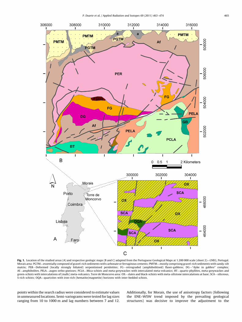
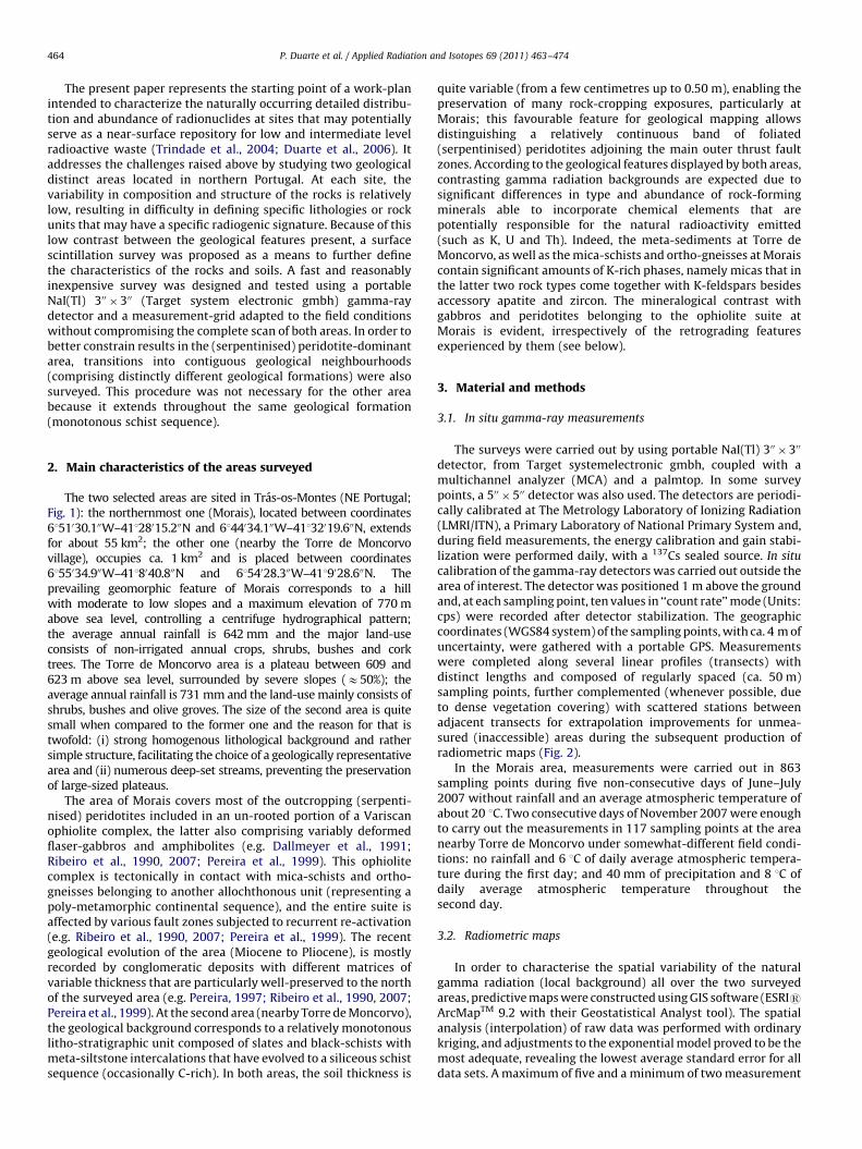
Fig. 1. Location of the studied areas (A) and respective geologic maps (B and C) adapted from the Portuguese Geological Maps at 1.200 000 scale (sheet 2)—LNEG, Portugal.
Morais area: PGTM—essentially composed of gravel-rich sediments with carbonate or ferruginous cements; PMTM—mostly comprising gravel-rich sediments with sandy-silt
matrix; PER—Deformed (locally strongly foliated) serpentinised peridotites; FG—retrograded (amphibolitised) flaser-gabbros; DG—‘‘dyke in gabbro’’ complex;
Af—amphibolites. PELA—augen ortho-gneisses; PCLA—Mica-schists and meta-greywackes with intercalated meta-volcanics; BT—quartz-phyllites, meta-greywackes and
green-schists with intercalations of (mafic) meta-volcanics. Torre de Moncorvo area: OX—slates and black-schists with meta-siltstone intercalations at base; SCA—siliceous,
S-rich schists; OQA—quartzites with iron-rich (hematite/magnetite) horizons with inter-bedded schists.
P. Duarte et al. / Applied Radiation and Isotopes 69 (2011) 463–474 465
points within the search radius were considered to estimate valuesin unmeasured locations. Semi-variograms were tested for lag sizesranging from 10 to 1000 m and lag numbers between 7 and 12.
Additionally, for Morais, the use of anisotropy factors (followingthe ENE–WSW trend imposed by the prevailing geologicalstructures) was decisive to improve the adjustment to the
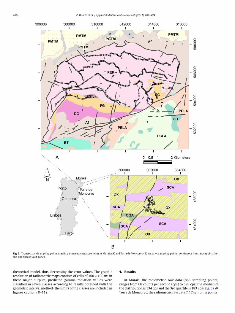
Fig. 2. Transects and sampling points used in gamma-ray measurements at Morais (A) and Torre de Moncorvo (B) areas. +: sampling points; continuous lines: traces of strike-
slip and thrust fault zones.
P. Duarte et al. / Applied Radiation and Isotopes 69 (2011) 463–474466
theoretical model, thus, decreasing the error values. The graphicresolution of radiometric maps consists of cells of 100�100 m; inthese major outputs, predicted gamma radiation values wereclassified in seven classes according to results obtained with thegeometric interval method (the limits of the classes are included infigures captions 8–11).
4. Results
At Morais, the radiometric raw data (863 sampling points)ranges from 60 counts per second (cps) to 598 cps; the median ofthe distribution is 134 cps and the 3rd quartile is 183 cps (Fig. 3). AtTorre de Moncorvo, the radiometric raw data (117 sampling points)
Fig. 3. Distribution of the gamma radiation measurements obtained in Morais and Torre de Moncorvo areas.
Fig. 4. Distribution of the coefficient of variability of gamma measurements obtained in Morais and Torre de Moncorvo areas.
P. Duarte et al. / Applied Radiation and Isotopes 69 (2011) 463–474 467
varies between 669 and 1020 cps; the median of the distribution is752 cps and the 3rd quartile is 792 cps (Fig. 3). For each samplingpoint, the representative cps value represents the median of the tenregistered measurements displaying a positive linear correlation of0.99 with the average value.
The homogeneity and confidence level of the measurementsperformed at each site could be appreciated through the coefficientof variability (CV) displayed by their respective distributions(Fig. 4). Indeed, CV values are systematically higher for Morais,which is consistent with the recorded differences on gammaradiation intensity; for this area, three quarters of the measuredsites show CV values below 10.8%, while for Torre de Moncorvo thesame percentage corresponds to a coefficient of variability below1.9%. No correlation was observed between gamma radiationvalues and CV (e.g. lower radiation values corresponding tohigher coefficient of variability) in both areas, and the normaldistribution (Kolmogorov–Sminrnov test with a¼0.05) only fitsthe Torre de Moncorvo gamma-ray data set.
Data analysis per profile at Morais (Fig. 5) shows differentgamma radiation average values, ranging from 89 cps (transect 11,
the shortest, comprising 25 sampling points) to 193 cps (transect10, including 36 sampling points), as well as dissimilar degrees ofheterogeneity; transect 3 displays the lowest coefficient ofvariability (15%), while the first one exhibits the highest (36%).Low to moderate fluctuations of gamma radiation in consecutivesampling points are obtained for 70% of the sampling points ifdeviations below 720% (CPSX/CPSX�1) of the measured value aretaken as the numerical limit to qualify those variations. Abruptchanges (higher than 740%) in gamma radiation valuescharacterise only 7.5% (n¼52) of the sampling points (Fig. 5).Possible reasons that may cause the abrupt variations found inthe gamma radiation data led to the results summarised in Table 1.The larger part (36%), if combined reasons are considered,corresponds to situations where coefficients of variability of theten measurements performed are above 10.8% (3rd quartile of thecoefficient of variability), thus suggesting minor confidence ofthe readings; 29% coincides with sudden changes in the geologicalbackground, such as fault zones with variable kinematics andlithological contacts; and 16% match nearby water-streams. Theremaining situations, totalizing 35% of the detected abrupt
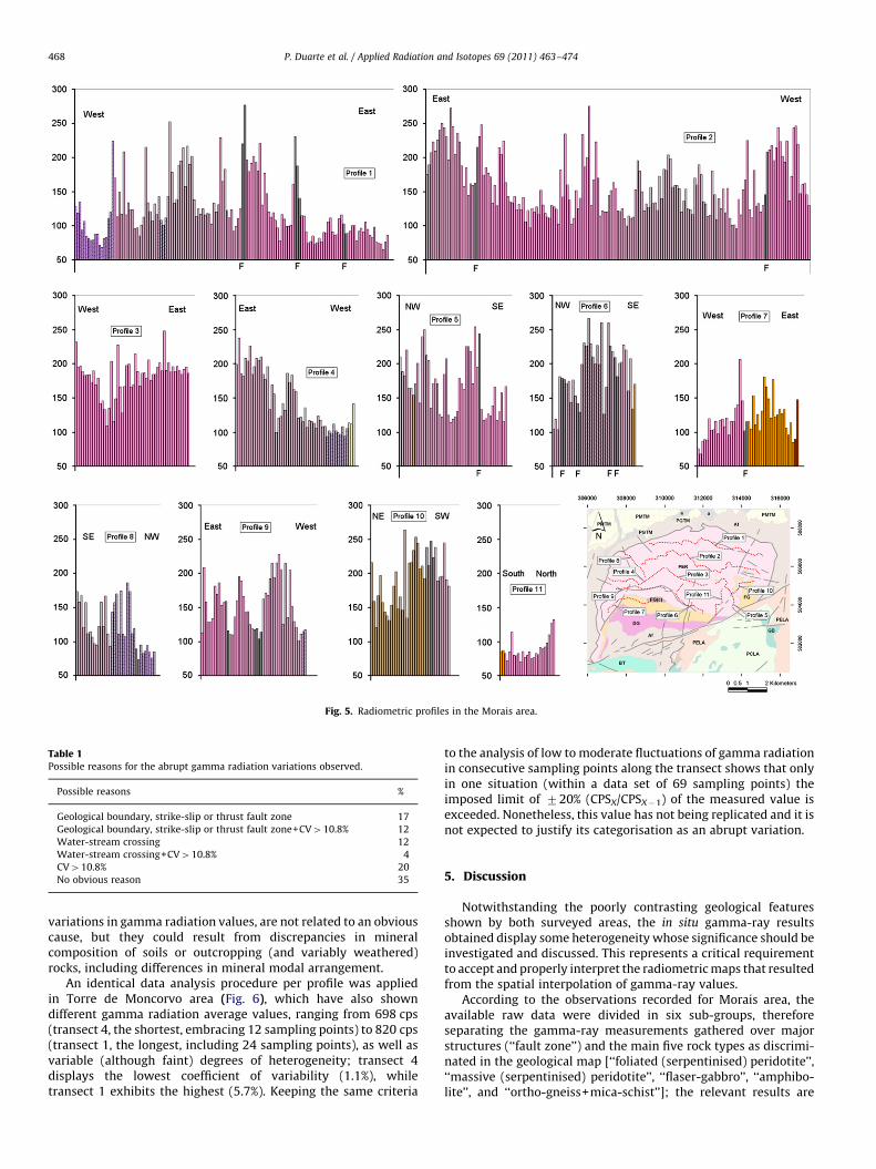
Fig. 5. Radiometric profiles in the Morais area.
Table 1Possible reasons for the abrupt gamma radiation variations observed.
Possible reasons %
Geological boundary, strike-slip or thrust fault zone 17
Geological boundary, strike-slip or thrust fault zone+CV410.8% 12
Water-stream crossing 12
Water-stream crossing+CV410.8% 4
CV410.8% 20
No obvious reason 35
P. Duarte et al. / Applied Radiation and Isotopes 69 (2011) 463–474468
variations in gamma radiation values, are not related to an obviouscause, but they could result from discrepancies in mineralcomposition of soils or outcropping (and variably weathered)rocks, including differences in mineral modal arrangement.
An identical data analysis procedure per profile was appliedin Torre de Moncorvo area (Fig. 6), which have also showndifferent gamma radiation average values, ranging from 698 cps(transect 4, the shortest, embracing 12 sampling points) to 820 cps(transect 1, the longest, including 24 sampling points), as well asvariable (although faint) degrees of heterogeneity; transect 4displays the lowest coefficient of variability (1.1%), whiletransect 1 exhibits the highest (5.7%). Keeping the same criteria
to the analysis of low to moderate fluctuations of gamma radiationin consecutive sampling points along the transect shows that onlyin one situation (within a data set of 69 sampling points) theimposed limit of 720% (CPSX/CPSX�1) of the measured value isexceeded. Nonetheless, this value has not being replicated and it isnot expected to justify its categorisation as an abrupt variation.
5. Discussion
Notwithstanding the poorly contrasting geological featuresshown by both surveyed areas, the in situ gamma-ray resultsobtained display some heterogeneity whose significance should beinvestigated and discussed. This represents a critical requirementto accept and properly interpret the radiometric maps that resultedfrom the spatial interpolation of gamma-ray values.
According to the observations recorded for Morais area, theavailable raw data were divided in six sub-groups, thereforeseparating the gamma-ray measurements gathered over majorstructures (‘‘fault zone’’) and the main five rock types as discrimi-nated in the geological map [‘‘foliated (serpentinised) peridotite’’,‘‘massive (serpentinised) peridotite’’, ‘‘flaser-gabbro’’, ‘‘amphibo-lite’’, and ‘‘ortho-gneiss+mica-schist’’]; the relevant results are
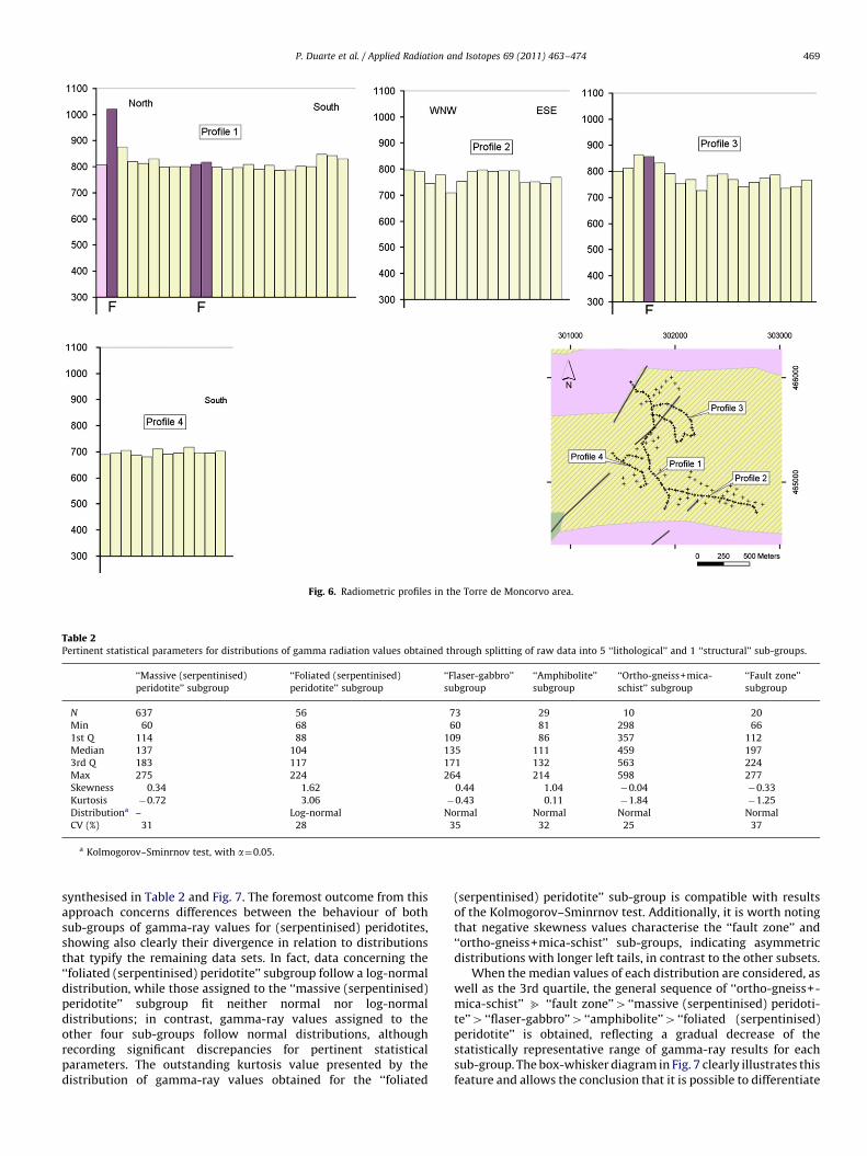
Fig. 6. Radiometric profiles in the Torre de Moncorvo area.
Table 2Pertinent statistical parameters for distributions of gamma radiation values obtained through splitting of raw data into 5 ‘‘lithological’’ and 1 ‘‘structural’’ sub-groups.
‘‘Massive (serpentinised)
peridotite’’ subgroup
‘‘Foliated (serpentinised)
peridotite’’ subgroup
‘‘Flaser-gabbro’’
subgroup
‘‘Amphibolite’’
subgroup
‘‘Ortho-gneiss+mica-
schist’’ subgroup
‘‘Fault zone’’
subgroup
N 637 56 73 29 10 20
Min 60 68 60 81 298 66
1st Q 114 88 109 86 357 112
Median 137 104 135 111 459 197
3rd Q 183 117 171 132 563 224
Max 275 224 264 214 598 277
Skewness 0.34 1.62 0.44 1.04 �0.04 �0.33
Kurtosis �0.72 3.06 �0.43 0.11 �1.84 �1.25
Distributiona – Log-normal Normal Normal Normal Normal
CV (%) 31 28 35 32 25 37
a Kolmogorov–Sminrnov test, with a¼0.05.
P. Duarte et al. / Applied Radiation and Isotopes 69 (2011) 463–474 469
synthesised in Table 2 and Fig. 7. The foremost outcome from thisapproach concerns differences between the behaviour of bothsub-groups of gamma-ray values for (serpentinised) peridotites,showing also clearly their divergence in relation to distributionsthat typify the remaining data sets. In fact, data concerning the‘‘foliated (serpentinised) peridotite’’ subgroup follow a log-normaldistribution, while those assigned to the ‘‘massive (serpentinised)peridotite’’ subgroup fit neither normal nor log-normaldistributions; in contrast, gamma-ray values assigned to theother four sub-groups follow normal distributions, althoughrecording significant discrepancies for pertinent statisticalparameters. The outstanding kurtosis value presented by thedistribution of gamma-ray values obtained for the ‘‘foliated
(serpentinised) peridotite’’ sub-group is compatible with resultsof the Kolmogorov–Sminrnov test. Additionally, it is worth notingthat negative skewness values characterise the ‘‘fault zone’’ and‘‘ortho-gneiss+mica-schist’’ sub-groups, indicating asymmetricdistributions with longer left tails, in contrast to the other subsets.
When the median values of each distribution are considered, aswell as the 3rd quartile, the general sequence of ‘‘ortho-gneiss+-mica-schist’’ b ‘‘fault zone’’4 ‘‘massive (serpentinised) peridoti-te’’4 ‘‘flaser-gabbro’’4 ‘‘amphibolite’’4 ‘‘foliated (serpentinised)peridotite’’ is obtained, reflecting a gradual decrease of thestatistically representative range of gamma-ray results for eachsub-group. The box-whisker diagram in Fig. 7 clearly illustrates thisfeature and allows the conclusion that it is possible to differentiate
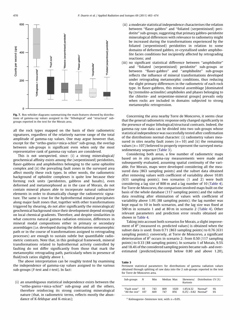
Fig. 7. Box-whisker diagrams summarising the main features showed by distribu-
tions of gamma-ray values assigned to the ‘‘lithological’’ and ‘‘structural’’ sub-
groups reported in the text for the Morais area.
Table 3Pertinent statistical parameters for distributions of gamma radiation values
obtained through splitting of raw data into the 2 sub-groups reported in the text
P. Duarte et al. / Applied Radiation and Isotopes 69 (2011) 463–474470
all the rock types mapped on the basis of their radiometricsignatures, regardless of the relatively narrow range of the totalamplitude of gamma-ray values. One may argue however that,except for the ‘‘ortho-gneiss+mica-schist’’ sub-group, the overlapbetween sub-groups is significant even when only the mostrepresentative rank of gamma-ray values are considered.
This is not unexpected, since: (i) a strong mineralogical/geochemical affinity exists among the (serpentinised) peridotites,flaser-gabbros and amphibolites belonging to the same ophiolitecomplex and (ii) the prevailing fault zones in the surveyed areaaffect mostly these rock types. In other words, the radiometricbackground of ophiolite complexes is quite low because theirforming rock units (peridotites, gabbros and basalts), evendeformed and metamorphosed as in the case of Morais, do notcontain mineral phases able to incorporate natural radioactiveelements in order to dramatically change the radiometric signa-ture. The same is true for the hydrothermal mineral precipitatesalong major fault zones that, together with other transformationstriggered by shearing, do not alter significantly the mineralogical/geochemical background since their development depend stronglyon local chemical gradients. Therefore, and despite similarities inwhat concerns natural gamma radiation emission, differences inmineral modal compositions either in primary or secondaryassemblages (i.e. developed during the deformation-metamorphicpath or in the course of transformations assigned to retrogradingprocesses) are enough to sustain subtle but quantifiable radio-metric contrasts. Note that, in this geological framework, mineraltransformations related to hydrothermal activity controlled byfaulting do not differ significantly from those that mark themetamorphic retrograding path, particularly when in presence offluid/rock ratios slightly above 1.
The above interpretation can be roughly tested by examiningthe independence of gamma-ray values assigned to the varioussub-groups (F-test and t-test). In fact:
for Torre de Moncorvo area.
Sub-groups N Min Median Max Skewness/Kurtosis
Distribution CV (%)
(i)‘‘Fault zone’’ 10 743 809 1020 1.85/4.32 Normala 9%‘‘All the rest’’ 107 669 747 856 0.25/�0.82 Normala 6%
a Kolmogorov–Sminrnov test, with a¼0.05.
an unambiguous statistical independence exists between the‘‘ortho-gneiss+mica-schist’’ sub-group and all the others,therefore reinforcing its strong contrasting mineralogicalnature (that, in radiometric terms, reflects mostly the abun-dance of K-feldspar and K-micas);
(ii)
a moderate statistical independence characterises the relationbetween ‘‘flaser-gabbro’’ and ‘‘foliated (serpentinised) peri-dotite’’ sub-groups, suggesting that primary gabbro-peridotitemineralogical differences with relevance to radiometry mightbe increased during the transformations experienced by thefoliated (serpentinised) peridotites in relation to somedomains of deformed gabbro, re-crystallised under amphibo-lite facies conditions but incipiently affected by retrogradingreactions; and(iii)
no significant statistical difference between ‘‘amphibolite’’and ‘‘foliated (serpentinised) peridotite’’ sub-groups orbetween ‘‘flaser-gabbro’’ and ‘‘amphibolite’’ sub-groupsreflects the influence of mineral transformations developedunder retrograding metamorphic conditions, thus reducingthe slight primary differences in the radiometric of each rocktype. In flaser-gabbros, this mineral assemblage [dominatedby (tremolite-actinolite) amphiboles and phases belonging tothe chlorite- and serpentine-mineral groups] prevails onlywhen rocks are included in domains subjected to strongmetamorphic retrogression.Concerning the area nearby Torre de Moncorvo, it seems clearthat the general radiometric response only changed significantly inthe presence of major lithological/structural contrasts. Indeed, thegamma-ray raw data can be divided into two sub-groups whosestatistical independence was successfully tested after confirmationof the distributions normal character: (i) radiometry values mea-sured in sites nearby fault zones (n¼10) and (ii) the remainingvalues (n¼107) believed to properly represent the surveyed meta-sedimentary sequence (Table 3).
Considering both areas, a few number of radiometric mapsbased on in situ gamma-ray measurements were made andsubsequently evaluated, assuming spatial continuity of the vari-able. For Morais, maps were developed considering all the mea-sured data (863 sampling points) and the subset data obtainedafter removing values with coefficient of variability above 10.8%(631 sampling points); two scenarios (1 and 2) were builtconsidering a lag size of 800 m and a lag number of 10 (Table 4).For Torre de Moncorvo, the comparison involved maps built on thebasis of the whole database (117 sampling points) and the subsetdata resulting after elimination of values with coefficient ofvariability above 1.9% (88 sampling points); the lag number waskept equal to 10 in both scenarios, and the lag size was fixed at500 m in scenario 1 and at 80 m in scenario 2 (Table 4). Otherrelevant parameters and prediction error results obtained areshown in Table 4.
Taking into account both scenarios for Morais, a slight improve-ment of R2 (measured vs. predicted values) is obtained when thesubset data is used: from 0.71 (863 sampling points) to 0.76 (631sampling points); conversely, at Torre de Moncorvo, a significantdeterioration of R2 occurs in scenario 2: from 0.50 (117 samplingpoints) to 0.33 (88 sampling points). In scenario 1 of Morais, 9.5%and 18.4% of the considered sampling points became sub- and over-estimated (predicted/measured below 0.80 and above 1.20),
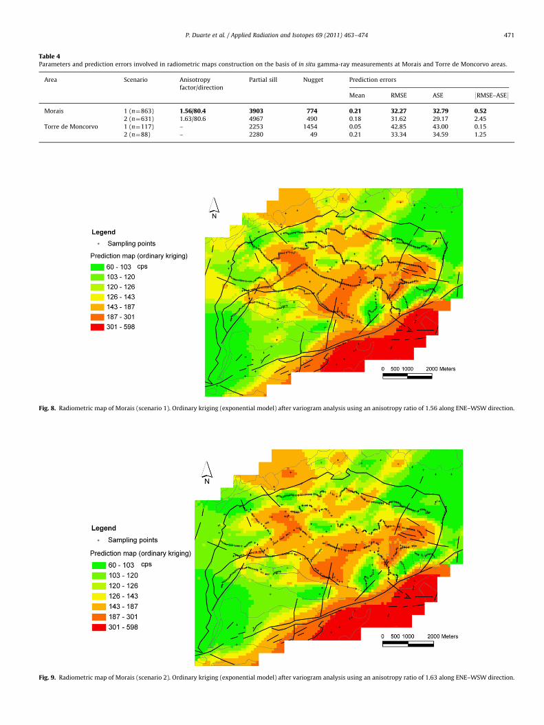
Table 4Parameters and prediction errors involved in radiometric maps construction on the basis of in situ gamma-ray measurements at Morais and Torre de Moncorvo areas.
Area Scenario Anisotropy
factor/direction
Partial sill Nugget Prediction errors
Mean RMSE ASE 9RMSE–ASE9
Morais 1 (n¼863) 1.56/80.4 3903 774 0.21 32.27 32.79 0.522 (n¼631) 1.63/80.6 4967 490 0.18 31.62 29.17 2.45
Torre de Moncorvo 1 (n¼117) – 2253 1454 0.05 42.85 43.00 0.15
2 (n¼88) – 2280 49 0.21 33.34 34.59 1.25
Fig. 8. Radiometric map of Morais (scenario 1). Ordinary kriging (exponential model) after variogram analysis using an anisotropy ratio of 1.56 along ENE–WSW direction.
Fig. 9. Radiometric map of Morais (scenario 2). Ordinary kriging (exponential model) after variogram analysis using an anisotropy ratio of 1.63 along ENE–WSW direction.
P. Duarte et al. / Applied Radiation and Isotopes 69 (2011) 463–474 471
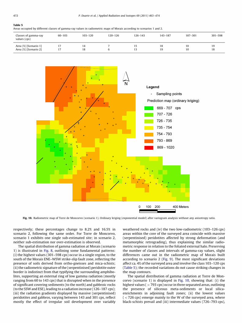
Table 5Areas occupied by different classes of gamma-ray values in radiometric maps of Morais according to scenarios 1 and 2.
Classes of gamma-ray
values (cps)
60–103 103–120 120–126 126–143 143–187 187–301 301–598
Area (%) [Scenario 1] 17 14 7 15 18 10 19
Area (%) [Scenario 2] 17 18 6 13 19 10 18
Fig. 10. Radiometric map of Torre de Moncorvo (scenario 1). Ordinary kriging (exponential model) after variogram analysis without any anisotropy ratio.
P. Duarte et al. / Applied Radiation and Isotopes 69 (2011) 463–474472
respectively; these percentages change to 8.2% and 16.5% inscenario 2, following the same order. For Torre de Moncorvo,scenario 1 exhibits one single sub-estimated site; in scenario 2,neither sub-estimation nor over-estimation is observed.
The spatial distribution of gamma radiation at Morais (scenario1) is illustrated in Fig. 8, outlining some fundamental patterns:(i) the highest values (301–598 cps) occur in a single region, to thesouth of the Morais ENE–WSW strike-slip fault zone, reflecting thepresence of soils derived from ortho-gneisses and mica-schists;(ii) the radiometric signature of the (serpentinised) peridotite outerborder is indistinct from that typifying the surrounding amphibo-lites, supporting an external ring of low gamma radiation (mostlyranging from 60 to 143 cps) that is disrupted when in the presenceof significant covering sediments (to the north) and gabbroic rocks(to the SSW and ESE), leading to a radiation increase (126–187 cps);(iii) the radiation gradients displayed by massive (serpentinised)peridotites and gabbros, varying between 143 and 301 cps, reflectmostly the effect of irregular soil development over variably
weathered rocks and (iv) the two low-radiometric (103–126 cps)areas within the core of the surveyed area coincide with massive(serpentinised) peridotites affected by strong deformation (andmetamorphic retrograding), thus explaining the similar radio-metric response in relation to the foliated external halo. Preservingthe number of classes and intervals of gamma-ray values, slightdifferences came out in the radiometric map of Morais builtaccording to scenario 2 (Fig. 9). The most significant deviationsaffect ca. 4% of the surveyed area and involve the class 103–120 cps(Table 5); the recorded variations do not cause striking changes inthe map contours.
The spatial distribution of gamma radiation at Torre de Mon-corvo (scenario 1) is displayed in Fig. 10, showing that: (i) thehighest values (4793 cps) occur in three separated areas, outliningthe presence of siliceous meta-sediments or local silica-enrichments in adjoining fault zones; (ii) the lowest values(o726 cps) emerge mainly to the W of the surveyed area, whereblack-schists prevail and (iii) intermediate values (726–793 cps),
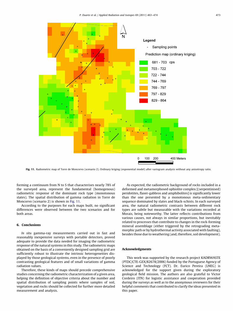
Fig. 11. Radiometric map of Torre de Moncorvo (scenario 2). Ordinary kriging (exponential model) after variogram analysis without any anisotropy ratio.
P. Duarte et al. / Applied Radiation and Isotopes 69 (2011) 463–474 473
forming a continuum from N to S that characterises nearly 78% ofthe surveyed area, represent the fundamental (homogenous)radiometric response of the dominant rock type (monotonousslates). The spatial distribution of gamma radiation in Torre deMoncorvo (scenario 2) is shown in Fig. 11.
According to the purposes for each maps built, no significantdifferences were observed between the two scenarios and forboth areas.
6. Conclusions
In situ gamma-ray measurements carried out in fast andreasonably inexpensive surveys with portable detectors, provedadequate to provide the data needed for imaging the radiometricresponse of the natural systems in this study. The radiometric mapsobtained on the basis of a conveniently designed sampling grid aresufficiently robust to illustrate the intrinsic heterogeneities dis-played by those geological systems, even in the presence of poorlycontrasting geological features and of small variations of gammaradiation values.
Therefore, these kinds of maps should precede comprehensivestudies concerning the radiometric characterization of a given area,helping the definition of objective criteria about the number andspatial distribution of sampling points where samples of soil,vegetation and rocks should be collected for further more detailedmeasurement and analysis.
As expected, the radiometric background of rocks included in adeformed and metamorphosed ophiolite complex [(serpentinised)peridotites, flaser-gabbros and amphibolites] is significantly lowerthan the one presented by a monotonous meta-sedimentarysequence dominated by slates and black-schists. In each surveyedarea, the natural radiometric contrasts between different rocktypes are subtle but measurable with the variations recorded atMorais, being noteworthy. The latter reflects contributions fromvarious causes, not always in similar proportions, but inevitablyrelated to processes that contribute to changes in the rock-formingmineral assemblage (either triggered by the retrograding meta-morphic path or by hydrothermal activity associated with faulting),besides those due to weathering (and, therefore, soil development).
Acknowledgments
This work was supported by the research project KADRWASTE(PTDC/CTE-GEX/82678/2006) funded by the Portuguese Agency ofScience and Technology (FCT). Dr. Eurico Pereira (LNEG) isacknowledged for the support given during the exploratorygeological field mission. The authors are also grateful to VictorCordeiro (ITN) for logistic assistance and cooperation providedduring the surveys as well as to the anonymous reviewers for theirhelpful comments that contributed to clarify the ideas presented inthis paper.
P. Duarte et al. / Applied Radiation and Isotopes 69 (2011) 463–474474
References
Aage, H.K., Korsbech, U., Bargholz, K., Hovgaard, J., 2006. Carborne gamma-rayspectrometry. Calibration and applications. Appl. Radiat. Isot 64, 948–956.
Asfahani, J., Al-Hent, R., Aissa, M., 2009. Uranium statistical and geologicalevaluation of airborne spectrometric data in theAl-Awabed region and itssurroundings (Area-3) Northern Palmyrides, Syria. Appl. Radiat. Isot. 67,654–663.
Baykara, O., Dogru, M., 2009. Determination of terrestrial gamma, 238U, 232Th and40K in soil along fracture zones. Radiat. Meas. 44, 116–121.
Bikit, I., Slivka, J., Veskovic, M., Varga, E., Zikic-Todorovic, N., MrXa, D., Forkapic, S.,2006. Measurement of Danube sediment radioactivity in Serbia and Montene-gro using gamma ray spectrometry. Radiat. Meas. 41, 477–481.
Chiozzi, P., Pasquale, V., Verdoya, M., 2002. Naturally occurring radioactivity at theAlps–Apennines transition. Radiat. Meas. 35, 147–154.
Clouvas, A., Xanthos, S., Antonopoulos-Domis, M., 2004. Radiological maps ofoutdoor and indoor gamma dose rates in Greek urban areas obtained byin situ gamma spectrometry. Radiat. Prot. Dosim. 112 (2), 267–275.
Dallmeyer, R.D., Ribeiro, A., Marques, F., 1991. Polyphase Variscan emplacement ofexotic terranes (Morais and Braganc-a Massifs) onto Iberian successions:evidence from 40Ar/39Ar mineral ages. Lithos 27, 133–144.
Duarte, P., Paiva, I., Trindade, R., Mateus, A., 2006. Suitable areas for a long-termradioactive waste storage facility in Portugal. In: Proceedings of the SecondEuropean IRPA Congress on Radiation Protection, Paris.
Mohanty, A.K., Sengupta, D., Das, S.K., Vijayan, V., Saha, S.K., 2004. Natural radio-activity in the newly discovered high background radiation area on the easterncoast of Orissa, India. Radiat. Meas. 38, 153–165.
Malczewski, D., Teper, L., Dorda, J., 2004. Assessment of natural and anthropogenicradioactivity levels in rocks and soils in the environs of Swieradow Zdrojin
Sudetes, Poland, by in situ gamma-ray spectrometry. J. Environ. Radioact. 73,233–245.
Paridaens, J., 2006. Development of a low cost, GPS-based upgrade to a standardhandheld gamma detector for mapping environmental radioactive contamina-tion. Appl. Radiat. Isot. 64, 264–271.
Pereira, D.M.I., 1997. Sedimentologia e estratigrafia do Cenozoico de Tras-os-MontesOriental (NE Portugal). Ph.D. Thesis, University of Minho.
Pereira, E., Ribeiro, A., Castro, P.F. 1999. Carta Geologica de Portugal �a escala 1:50000.Notıcia explicativa da Folha 7 – D (Macedo de Cavaleiros). Serv. Geol. Portugal,Lisboa, Portugal.
Ribeiro, A., Munha, J., Dias, R., Mateus, A., Pereira, E., Ribeiro, L., Fonseca, P., Araujo, A.,Oliveira, T., Rom~ao, J., Chamine, H., Coke, C., Pedro, J., 2007. Geodynamicevolution of SW Europe Variscides. Tectonics 26 TC6009.
Ribeiro, A., Pereira, E., Dias, R., 1990. Structure in the NW of the Iberia Peninsula(Allochthonous sequences). In: Dallmeyer, R.D., Martinez Garcia, E. (Eds.), Pre-Mesozoic Geology of Iberia. Springer Verlag, pp. 220–236.
Trindade, R., Paiva, I., Portugal, L., 2004. Radioactive waste management in Portugal.In: Proceedings of the International Symposium on Disposal of Low ActivityRadioactive Waste, IAEA, Cordoba, Spain, pp. 119–123.
Yamada, J., Oka, M., Shimo, M., Minami, K., Minatos, S., Sugino, M., Hosoda, M.,Fukushi, M., 2008. The effect of geological and geographical features onenvironmental radiation. AIP Conf. Proc. 1034 (1), 498–502.
Tsvetkova, T., Monninb, M., Nevinskya, I., Perelygin, V., 2001. Research on variationof radon and gamma-background as a prediction of earthquakes in the Caucasus.Radiat. Meas. 33, 1–5.
Tyler, A.N., 2004. High accuracy in situ radiometric mapping. J. Environ. Radioact. 72,195–202.
Tzortzis, M., Tsertos, H., Christofides, S., Christodoulides, G., 2003. Gamma-raymeasurements of naturally occurring radioactive samples from Cyprus char-acteristic geological rocks. Radiat. Meas. 37, 221–229.