Embed Size (px)
Citation preview

Use of Remote Sensing Imagery Use of Remote Sensing Imagery
for GeoTraceability in for GeoTraceability in
AgricultureAgriculture
WALLOON REGION
STEREO & VEGETATION WorkshopSTEREO & VEGETATION Workshop
6 May 2004 6 May 2004 -- BrusselsBrussels
Biometry, Data management and Agrometeorology Unit
[email protected] – [email protected]@cra.wallonie.be - [email protected]
CENTRE WALLON DE RECHERCHES AGRONOMIQUES

SSTTC STEREO & VEGETATION Workshop SSTTC STEREO & VEGETATION Workshop -- 6 may 2004 6 may 2004 -- BrusselsBrussels
PresentationPresentation
�� Traceability conceptTraceability concept(Basic concepts and approach)(Basic concepts and approach)
�� Traceability ContextTraceability Context
�� Legislation (EULegislation (EU--CAP, National…)CAP, National…)
�� IACS/LPISIACS/LPIS
�� GeoTraceability conceptGeoTraceability concept
�� Opportunities/Potentialities of RSOpportunities/Potentialities of RS

SSTTC STEREO & VEGETATION Workshop SSTTC STEREO & VEGETATION Workshop -- 6 may 2004 6 may 2004 -- BrusselsBrussels
TraceabilityTraceability conceptconcept
�� Traceability in agricultureTraceability in agriculture::Ability to document, trace and follow a food or feed product Ability to document, trace and follow a food or feed product through all stages of its life, from its creation (production) uthrough all stages of its life, from its creation (production) up p to its consumption (distribution).to its consumption (distribution).
�� Tracing:Tracing:Determining the « history » throughout the Determining the « history » throughout the agriagri--food chain.food chain.
Field TableProduction
Supply – Transport – Stock management
Transformation Distribution
UpstreamUpstream TraceabilityTraceability DownstreamDownstream TraceabilityTraceability ConsumersProducers
GeoTraceAgri Service Societies

SSTTC STEREO & VEGETATION Workshop SSTTC STEREO & VEGETATION Workshop -- 6 may 2004 6 may 2004 -- BrusselsBrussels
GeoTraceability conceptGeoTraceability concept
LegislationLegislation ConsumersConsumers
TRACEABILITYTRACEABILITY
FoodFood --chainchain FarmersFarmers
Meet society'sMeet society'srequirementsrequirements
(Healthy, Safety & Quality insurance
Environmental protection…)
CAP CAP EU/Nat. standardsEU/Nat. standards(1rts & 2nd pillars…)
Minimise risksMinimise risks(Healthy, Safety…)
Food & Products claim Food & Products claim (labels, certifications…)
Help farmersHelp farmers(Farm management…)

SSTTC STEREO & VEGETATION Workshop SSTTC STEREO & VEGETATION Workshop -- 6 may 2004 6 may 2004 -- BrusselsBrussels
Traceability context: CAP Traceability context: CAP orientationsorientations
�� Actual CAPActual CAP
�� Management and control of agricultural area based subsidiesManagement and control of agricultural area based subsidies
�� IACS conceptIACS concept
�� CAP ReformCAP Reform
�� Market orientation (consumer driven)Market orientation (consumer driven)
�� Quality initiative & Food SafetyQuality initiative & Food Safety
�� Environment protectionEnvironment protection
�� Rural developmentRural development
�� LPIS conceptLPIS concept
Traceability scheme
SSTTC STEREO & VEGETATION Workshop SSTTC STEREO & VEGETATION Workshop -- 6 may 2004 6 may 2004 -- BrusselsBrussels
Traceability context: Traceability context: LPISLPIS
�� Main purpose of the LPIS are to provideMain purpose of the LPIS are to provide�� An unique parcel identification numberAn unique parcel identification number
�� A geographic locationA geographic location
�� An area for any agricultural parcelAn area for any agricultural parcel
�� In 2000: In 2000: RegReg 1593/00 make compulsory digital 1593/00 make compulsory digital LPIS and GISLPIS and GIS�� Digital mapsDigital maps
�� OrthophotosOrthophotos
�� Jan 2005: LPIS/GIS fully implementedJan 2005: LPIS/GIS fully implemented
In practice, the LPIS provides a reference system a t the parcel level,allowing the identification and the cross checks of
all the parcels declared in a given campaign.

SSTTC STEREO & VEGETATION Workshop SSTTC STEREO & VEGETATION Workshop -- 6 may 2004 6 may 2004 -- BrusselsBrussels
GeoTraceability conceptGeoTraceability concept
GeoTraceability because:GeoTraceability because:
�� Traceability at the parcel level (IACS/LPIS).Traceability at the parcel level (IACS/LPIS).
Recording and monitoring all the field operations.Recording and monitoring all the field operations.
�� Traceability entails the measurements of both, Traceability entails the measurements of both,
the environmental and climatic conditions the environmental and climatic conditions
occurring naturally, that may affect the food occurring naturally, that may affect the food
safety (risk, standards…).safety (risk, standards…).

SSTTC STEREO & VEGETATION Workshop SSTTC STEREO & VEGETATION Workshop -- 6 may 2004 6 may 2004 -- BrusselsBrussels
Potentialities of RemotePotentialities of Remote--SensingSensing
EventEvent⇒⇒Temporal RS potentialitiesTemporal RS potentialities
(Multi(Multi --temporal)temporal)
EnvironmentEnvironment⇒⇒Spatial RS potentialitiesSpatial RS potentialities
(Multi(Multi --scale)scale)
Climate
Soil
Event
Decade
Season
Multi-Seasonal
Parcel
Region
Crops
CharacteristicsCharacteristics⇒⇒Spectral RS potentialitiesSpectral RS potentialities
(Multi(Multi --spectral)spectral)

SSTTC STEREO & VEGETATION Workshop SSTTC STEREO & VEGETATION Workshop -- 6 may 2004 6 may 2004 -- BrusselsBrussels
�� EO capacities have already been used intensively for EO capacities have already been used intensively for
monitoring agriculture (MARSmonitoring agriculture (MARS--EU, BEU, B--CGMS, CGMS,
SAGRIWATEL…)SAGRIWATEL…)
�� To calculate GeoTo calculate Geo--indicators that complement the LPIS indicators that complement the LPIS
�� Fixed time intervalFixed time interval
�� Fixed Fixed periodesperiodes / dates/ dates
�� Covering large territoriesCovering large territories
�� For parcels and farm surroundings For parcels and farm surroundings
Potentialities of RemotePotentialities of Remote--SensingSensing

SSTTC STEREO & VEGETATION Workshop SSTTC STEREO & VEGETATION Workshop -- 6 may 2004 6 may 2004 -- BrusselsBrussels
GeoTraceability conceptGeoTraceability concept
LegislationLegislation ConsumersConsumers
TRACEABILITYTRACEABILITY
FoodFood --chainchain FarmersFarmers
Meet society'sMeet society'srequirementsrequirements
(Healthy, Safety & Quality insurance
Environmental protection…)
CAP CAP EU/Nat. standardsEU/Nat. standards(1rts & 2nd pillars…)
Minimise risksMinimise risks(Healthy, Safety…)
Food claim Food claim (labels, certifications…)
Help farmersHelp farmers(Farm management…)

SSTTC STEREO & VEGETATION Workshop SSTTC STEREO & VEGETATION Workshop -- 6 may 2004 6 may 2004 -- BrusselsBrussels
Opportunities of RemoteOpportunities of Remote--SensingSensing (cont.)(cont.)
�� Control of declarations in the traceability process:Control of declarations in the traceability process:
�� Reduce Reduce in situin situ control process control process
�� Contribute to crossContribute to cross--checkschecks
IKONOS IKONOS –– 06/11/200306/11/2003
�� Check of agricultural landCheck of agricultural land--use declarationuse declaration
�� Check of parcel acreage declarationCheck of parcel acreage declaration
Overlay IACS with geo-corrected SPOT-XS or IKONOS images

SSTTC STEREO & VEGETATION Workshop SSTTC STEREO & VEGETATION Workshop -- 6 may 2004 6 may 2004 -- BrusselsBrussels
Opportunities of RemoteOpportunities of Remote--SensingSensing (cont.)(cont.)
�� Control of declarations in the traceability process:Control of declarations in the traceability process:
�� Reduce Reduce in situin situ control process control process
�� Contribute to crossContribute to cross--checkschecks
IKONOS IKONOS –– 06/11/200306/11/2003
�� Check of agricultural landCheck of agricultural land--use declaration.use declaration.
�� Check of parcel acreage declarationCheck of parcel acreage declaration
�� Control specific EU/Nat. standards for:Control specific EU/Nat. standards for:-- certifications, labels…certifications, labels…
Buffer zones

SSTTC STEREO & VEGETATION Workshop SSTTC STEREO & VEGETATION Workshop -- 6 may 2004 6 may 2004 -- BrusselsBrussels
Just pastured
Not yet pastured
Opportunities of RemoteOpportunities of Remote--SensingSensing (cont.)(cont.)
Hyperspectral Hyperspectral –– 06/200306/2003
�� Check of agricultural landCheck of agricultural land--use declaration.use declaration.
�� Check of parcel acreage declarationCheck of parcel acreage declaration
�� Control specific EU/Nat. standards for:Control specific EU/Nat. standards for:- certifications, labels…certifications, labels…-- environnemental protection (environnemental protection ( AEMsAEMs ))
One IACS parcel butOne IACS parcel butLower part = Lower part = normal practicenormal practiceUpper part = Upper part = late cutting (AEM)late cutting (AEM)
�� Reduce Reduce in situin situ control process control process
�� Contribute to crossContribute to cross--checkschecks
�� Control of declarations in the traceability process:Control of declarations in the traceability process:

SSTTC STEREO & VEGETATION Workshop SSTTC STEREO & VEGETATION Workshop -- 6 may 2004 6 may 2004 -- BrusselsBrussels
Opportunities of RemoteOpportunities of Remote--SensingSensing (cont.)(cont.)
�� Historical information for GeoTraceability process:Historical information for GeoTraceability process:
�� New declared parcelNew declared parcel
�� New EU/Nat. legislation/standardsNew EU/Nat. legislation/standards
�� No declarative information available,No declarative information available,so if new information is needed we canso if new information is needed we canexpect to find it in archive imagery.expect to find it in archive imagery.
�� LandLand--Cover / LandCover / Land--Use change Use change e.g. Forest e.g. Forest ↔↔ CropsCrops
Begin April
End May
Begin September
Mid July 2000
SPOT time seriesSPOT time series

SSTTC STEREO & VEGETATION Workshop SSTTC STEREO & VEGETATION Workshop -- 6 may 2004 6 may 2004 -- BrusselsBrussels
Opportunities of RemoteOpportunities of Remote--SensingSensing (cont.)(cont.)
�� GeoTraceability for food & products promotion :GeoTraceability for food & products promotion :
�� Characterisation of the environment of the parcel Characterisation of the environment of the parcel
�� Surrounding parcels Surrounding parcels
SPOT XS SPOT XS –– 05/30/199705/30/1997
�� Characterisation of parcels environment Characterisation of parcels environment as part of the certificationas part of the certification
�� Spatial analysis and diagnosis of theSpatial analysis and diagnosis of theparcel according to surrounding parcelsparcel according to surrounding parcels
Proximity indicators
Generic indicators
SSTTC STEREO & VEGETATION Workshop SSTTC STEREO & VEGETATION Workshop -- 6 may 2004 6 may 2004 -- BrusselsBrussels
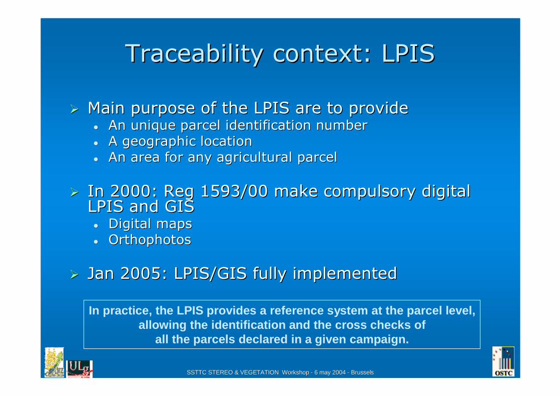
Opportunities of Opportunities of RemoteRemote--Sensing Sensing (cont(cont.).)
�� AgriAgri--Environmental Measures Environmental Measures
�� FarmFarm--managementmanagement
�� Indicators related to agricultural andIndicators related to agricultural andagriagri--environementalenvironemental practices during practices during the season:the season:
-- fertilisation,fertilisation,
Agri-environmental indicators
�� GeoTraceability for food & products promotion :GeoTraceability for food & products promotion :
CASICASI--SWIR SWIR spectroradiometersspectroradiometers
SSTTC STEREO & VEGETATION Workshop SSTTC STEREO & VEGETATION Workshop -- 6 may 2004 6 may 2004 -- BrusselsBrussels
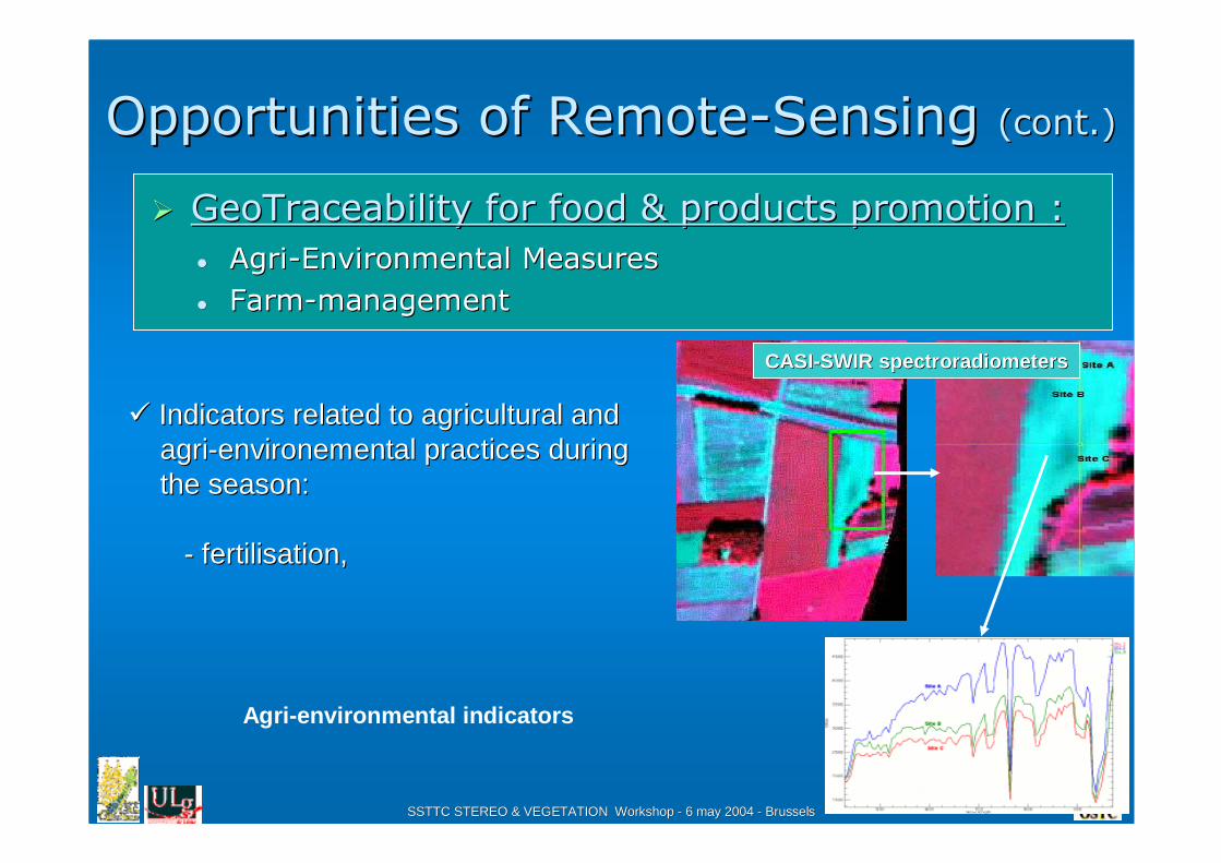
Opportunities of RemoteOpportunities of Remote--SensingSensing (cont.)(cont.)
�� AgriAgri--Environmental Measures Environmental Measures
�� FarmFarm--managementmanagement
�� Indicators related to agricultural andIndicators related to agricultural andagriagri--environementalenvironemental practices during practices during the season:the season:
-- fertilisation,fertilisation,-- length of the growing period, length of the growing period, -- biomass and yieldbiomass and yield-- ……
SPOTSPOT--XS, 30 May 1997 XS, 30 May 1997
Agri-environmental indicators
SPOTSPOT--XS, 6 August 1997XS, 6 August 1997
�� GeoTraceability for food & products promotion :GeoTraceability for food & products promotion :
SSTTC STEREO & VEGETATION Workshop SSTTC STEREO & VEGETATION Workshop -- 6 may 2004 6 may 2004 -- BrusselsBrussels
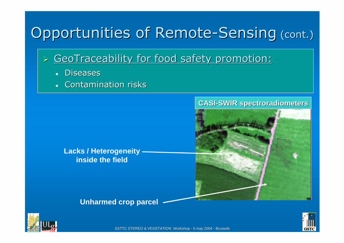
Opportunities of RemoteOpportunities of Remote--SensingSensing (cont.)(cont.)
�� DiseasesDiseases
�� Contamination risksContamination risks
CASICASI--SWIR SWIR spectroradiometersspectroradiometers
�� GeoTraceability for food safety promotion:GeoTraceability for food safety promotion:
Lacks / Heterogeneityinside the field
Unharmed crop parcel

SSTTC STEREO & VEGETATION Workshop SSTTC STEREO & VEGETATION Workshop -- 6 may 2004 6 may 2004 -- BrusselsBrussels
Opportunities of RemoteOpportunities of Remote--SensingSensing (cont.)(cont.)
�� GeoTraceability for food quality promotion:GeoTraceability for food quality promotion:
0.00
0.10
0.20
0.30
0.40
0.50
0.60
0.70
400 600 800 1000 1200 1400 1600 1800 2000 2200 2400 2600
Wavelength (nm)
CASI Sensor SASI Sensor
400 450 500 550 600 650 700 750 800 850 900 950 1000 1050 1100 1150 1200 1250 1300 1350 1400 1450 15001550 1600 1650 1700 1750 1800 1850 1900 1950 2000 2050 2100 2150 2200 2250 2300 2350 2400Dry matterProteinCellulose Sugar
VEM VEVI DVE OEB
HeightBiomassWet matter
Reflectances
Ref
lect
ance
Bare soilJust harvested grassland
Not harvested

SSTTC STEREO & VEGETATION Workshop SSTTC STEREO & VEGETATION Workshop -- 6 may 2004 6 may 2004 -- BrusselsBrussels
To To summarizesummarize
The support of remote sensing in The support of remote sensing in geotraceabilitygeotraceability can be can be summarised as follow:summarised as follow:
• To complement and reinforce the diagnosis at parcel & farm level.
• To better focus field inspections related to traceability
• To better support the update process of LPIS
• To complement the analysis of the impact of agricultural production on the surrounding of the parcel & farm

SSTTC STEREO & VEGETATION Workshop SSTTC STEREO & VEGETATION Workshop -- 6 may 2004 6 may 2004 -- BrusselsBrussels
ConclusionConclusion
-- IACS/LPIS = reference database system for traceabilityIACS/LPIS = reference database system for traceability
-- Provides exhaustive information on parcels for all agricultural Provides exhaustive information on parcels for all agricultural parcels in Europe.parcels in Europe.
-- Gives information on the parcel practicesGives information on the parcel practices
-- RemoteRemote--Sensing is a complementary toolSensing is a complementary tool
-- Capture non declarative and periodic information.Capture non declarative and periodic information.
-- On large territories.On large territories.
-- Give information on practices carried out on surrounding parcelsGive information on practices carried out on surrounding parcels..
-- To provide and to facilitate the calculation of complementary To provide and to facilitate the calculation of complementary GeoTraceability indicators.GeoTraceability indicators.
- GeoTraceAgri project (FP5-IST)CRA-W (Belgique), FUL-ULg (Belgique), CDER Informatique (France),
CCI Gers (France), CIRAD (France), U-Laval (Canada)
- GTIS-CAP (FP6-SSP)CRA-W (Belgique), FUL-ULg (Belgique), CIGEST (Belgique), SPOT
(France), CCI Gers (France), ACTA (France),CDER Informatique (France)