Embed Size (px)
Citation preview
THE USE OF SATELLITE RADAR REMOTE SENSING IMAGERY IN THE DETECTION OF ARCHAEOLOGICAL SITES IN THE CENTRAL
MESOPOTAMIAN PLAIN OF IRAQ
Benjamin F. Richason III Department of Geography St Cloud State University
St Cloud, MN 56301 [email protected]
ABSTRACT The landscape of the southern portion of the Central Mesopotamian Plain is a unique maze of ancient settlement sites and canals. Various ground survey studies, such as Robert Adams’s Heartland of Cities, have inventoried and mapped a number of these settlement concentrations. Because of the size of the region and problems with accessibility a variety of sensor systems including Landsat, SPOT, ASTER, and Corona have been successively employed in refining and adding to these earlier ground surveys. Of particular benefit has been the use of radar imagery. Radar imagery provides a distinctive perspective of the earth’s surface with its microwave illumination. This type of imagery was helpful in the detection of linear features such as canals, irrigated agriculture, dunes and levees, and ancient drainage ways in central Iraq. This was especially true in using Radarsat imagery in combination with SPOT and Landsat imagery in a study of an area around the ancient site of Nippur and Lake Dalmaj. To aid in this investigation extensive GIS databases were created from a variety of field studies. These databases were used in conjunction with the imagery to isolate different age groupings of sites and canals and map their location and extent.
INTRODUCTION
The human history of the area north of the Persian Gulf is fundamentally intertwined with the two great rivers that drain it. The Mesopotamian Plain of central Iraq formed as the result of the alluvial deposition of the Tigris and Euphrates rivers at the end of the Pleistocene (Buringh, 1960). Throughout their history these rivers have shifted their courses, especially the Euphrates, to the positions they occupy today. Evidence of these shifts
Figure 1. (A) The Nippur site showing the ziggurat and the Chicago Expedition House. (Courtesy of John Sanders, Oriental Institute) (B) A trace of an ancient canal
near Nippur. (Courtesy of Tony Wilkinson, University of Edinburgh) can be seen on the present-day plain in the form of ancient drainage ways and meander scars. In addition, over the millennia a number of urban societies have occupied this plain, leaving their imprint on it in the form of ancient
Pecora 16 “Global Priorities in Land Remote Sensing” October 23-27, 2005 * Sioux Falls, South Dakota
canal systems, tells (mound sites), and other occupation sites (Figure 1). What exists today is a complex mix of physical and cultural patterns. The archaeological landscape that is superimposed on top of the river alluvium is, in itself, a multi-layered combination of settlement locations and intersecting canals.
As the rivers have repositioned themselves over time, so too did the concentrations of urban sites and canal systems which were heavily dependent on access to the water. Modern archaeological studies of these landscapes in the central portion of the Mesopotamian Plain began in the 1950’s with the work of Jacobson and Adams. One of the most extensive was Adams’s Heartland of Cities that covered about a third of the central alluvial plain of southern Mesopotamia (Adams, 1972). He surveyed hundreds of kilometers on foot and by vehicle, inventorying and dating hundreds of sites and tracing the positions of numerous canal systems. The study was somewhat constrained because he limited the boundaries of the survey by not going into heavily cultivated areas. In areas that were not readily accessible, Adams supplemented his ground survey with what aerial photography was available. Additional small auxiliary surveys were done by other researchers to fill in more specific settlement patterns (Gibson, 1972; Wilkinson, 1990).
REMOTE SENSING APPLICATIONS
Satellite remote sensing imagery and techniques have only recently been employed in the study of archaeological landscapes in the region. An example would be the work done by a research team from the University of Ghent (Gasche and Cole et al., 1998). In researching an area around Sippur in the late 1980’s the team re-evaluated ancient water courses and levees. More recent studies have utilized Aster imagery and Corona photography to investigate sites and drainage ways around Abu Salabikh (Hritz, 2005).
While the use of VIS/IR sensors for archaeological studies in the alluvial plain of Mesopotamia is well documented, the use of another type of sensor, radar, is not. To study the utility of satellite radar remote sensing for these types of investigations a study was undertaken to see what the potential was for such a sensor system in the analysis of ancient drainage ways, tracing canals patterns, identifying the structure of mound sites, and the detection of possible new sites. Study Area
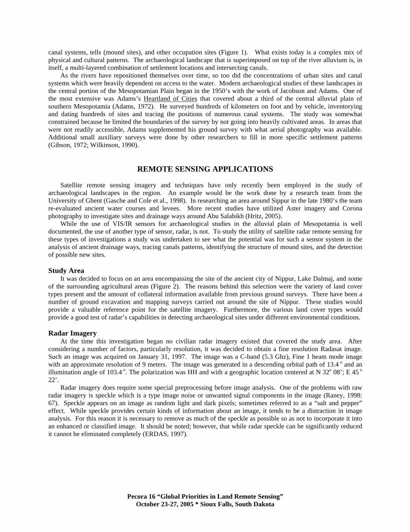
It was decided to focus on an area encompassing the site of the ancient city of Nippur, Lake Dalmaj, and some of the surrounding agricultural areas (Figure 2). The reasons behind this selection were the variety of land cover types present and the amount of collateral information available from previous ground surveys. There have been a number of ground excavation and mapping surveys carried out around the site of Nippur. These studies would provide a valuable reference point for the satellite imagery. Furthermore, the various land cover types would provide a good test of radar’s capabilities in detecting archaeological sites under different environmental conditions.
Radar Imagery
At the time this investigation began no civilian radar imagery existed that covered the study area. After considering a number of factors, particularly resolution, it was decided to obtain a fine resolution Radasat image. Such an image was acquired on January 31, 1997. The image was a C-band (5.3 Ghz), Fine 1 beam mode image with an approximate resolution of 9 meters. The image was generated in a descending orbital path of 13.4 o and an illumination angle of 103.4 o. The polarization was HH and with a geographic location centered at N 32o 08’; E 45 o 22’.
Radar imagery does require some special preprocessing before image analysis. One of the problems with raw radar imagery is speckle which is a type image noise or unwanted signal components in the image (Raney, 1998: 67). Speckle appears on an image as random light and dark pixels; sometimes referred to as a “salt and pepper” effect. While speckle provides certain kinds of information about an image, it tends to be a distraction in image analysis. For this reason it is necessary to remove as much of the speckle as possible so as not to incorporate it into an enhanced or classified image. It should be noted; however, that while radar speckle can be significantly reduced it cannot be eliminated completely (ERDAS, 1997).
Pecora 16 “Global Priorities in Land Remote Sensing” October 23-27, 2005 * Sioux Falls, South Dakota
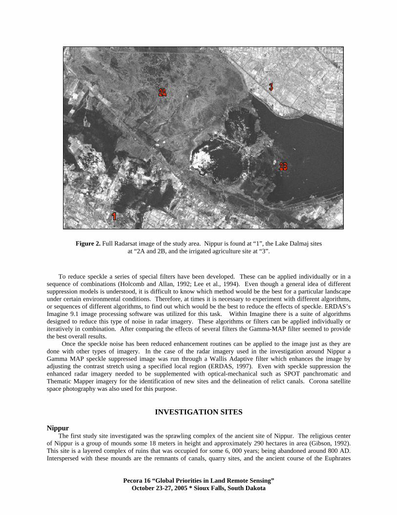
Figure 2. Full Radarsat image of the study area. Nippur is found at “1”, the Lake Dalmaj sites at “2A and 2B, and the irrigated agriculture site at “3”.
To reduce speckle a series of special filters have been developed. These can be applied individually or in a sequence of combinations (Holcomb and Allan, 1992; Lee et al., 1994). Even though a general idea of different suppression models is understood, it is difficult to know which method would be the best for a particular landscape under certain environmental conditions. Therefore, at times it is necessary to experiment with different algorithms, or sequences of different algorithms, to find out which would be the best to reduce the effects of speckle. ERDAS’s Imagine 9.1 image processing software was utilized for this task. Within Imagine there is a suite of algorithms designed to reduce this type of noise in radar imagery. These algorithms or filters can be applied individually or iteratively in combination. After comparing the effects of several filters the Gamma-MAP filter seemed to provide the best overall results.
Once the speckle noise has been reduced enhancement routines can be applied to the image just as they are done with other types of imagery. In the case of the radar imagery used in the investigation around Nippur a Gamma MAP speckle suppressed image was run through a Wallis Adaptive filter which enhances the image by adjusting the contrast stretch using a specified local region (ERDAS, 1997). Even with speckle suppression the enhanced radar imagery needed to be supplemented with optical-mechanical such as SPOT panchromatic and Thematic Mapper imagery for the identification of new sites and the delineation of relict canals. Corona satellite space photography was also used for this purpose.
INVESTIGATION SITES Nippur
The first study site investigated was the sprawling complex of the ancient site of Nippur. The religious center of Nippur is a group of mounds some 18 meters in height and approximately 290 hectares in area (Gibson, 1992). This site is a layered complex of ruins that was occupied for some 6, 000 years; being abandoned around 800 AD. Interspersed with these mounds are the remnants of canals, quarry sites, and the ancient course of the Euphrates
Pecora 16 “Global Priorities in Land Remote Sensing” October 23-27, 2005 * Sioux Falls, South Dakota
River. Nippur is an excellent example of a tell or mound site that denotes a number of different occupation phases over thousands of years. Other such tells exist over this region of Mesopotamia, but Nippur is one of the best preserved. (Gibson, 1992). A Corona photograph is presented in (Figure 3) as reference (Kennedy, 1998).
Figure 3. Corona photograph of the Nippur site. The ziggurat can be seen at “1”, the north wall at “2”, the Shatt an-Nil at “3”, and
the Expedition House at “4”.
That portion of the Radarsat image that covered the excavated site of Nippur was studied in conjunction with a
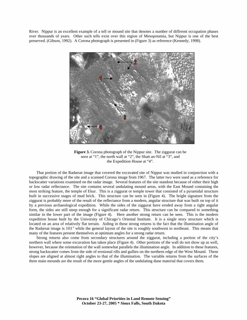
topographic drawing of the site and a scanned Corona image from 1967. The latter two were used as a reference for backscatter variations examined on the radar image. Several features of the site standout because of either their high or low radar reflectance. The site contains several undulating mound areas, with the East Mound containing the most striking feature, the temple of Ekur. This is a ziggurat or temple tower that consisted of a pyramidal structure built in successive stages of mud brick. This structure can be seen in (Figure 4). The bright signature from the ziggurat is probably more of the result of the reflectance from a modern, angular structure that was built on top of it by a previous archaeological expedition. While the sides of the ziggurat have eroded away from a right angular form, the sides are still steep enough for a significant radar return. This structure can be compared to something similar in the lower part of the image (Figure 4). Here another strong return can be seen. This is the modern expedition house built by the University of Chicago’s Oriental Institute. It is a single story structure which is located on an area of relatively flat terrain. Aiding in these strong returns is the fact that the illumination angle of the Radarsat image is 103 o while the general layout of the site is roughly southwest to northeast. This means that many of the features present themselves at optimum angles for a strong radar return.
Strong returns also come from secondary structures around the ziggurat, including a portion of the city’s northern wall where some excavation has taken place (Figure 4). Other portions of the wall do not show up as well, however, because the orientation of the wall somewhat parallels the illumination angle. In addition to these features, strong backscatter comes from the side of erosional rills and gullies on the northern edge of the West Mound. These slopes are aligned at almost right angles to that of the illumination. The variable returns from the surfaces of the three main mounds are the result of the more gentle angles of the undulating dune material that covers them.
Pecora 16 “Global Priorities in Land Remote Sensing” October 23-27, 2005 * Sioux Falls, South Dakota
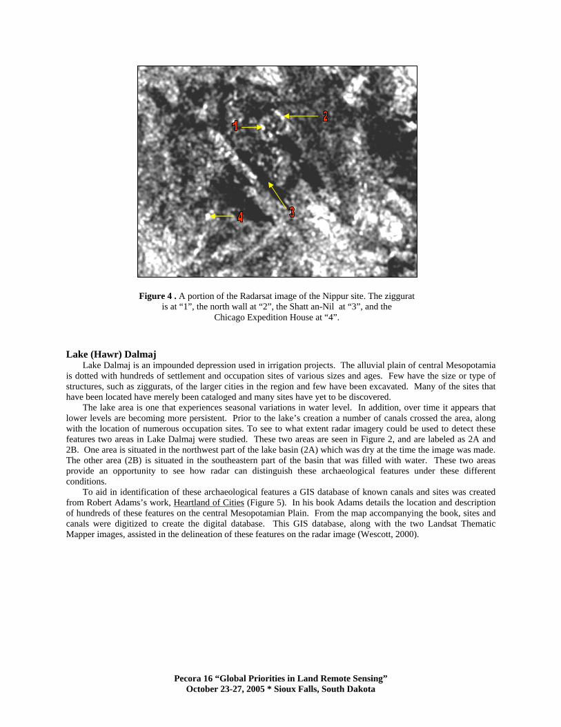
Figure 4 . A portion of the Radarsat image of the Nippur site. The ziggurat is at “1”, the north wall at “2”, the Shatt an-Nil at “3”, and the
Chicago Expedition House at “4”.
Lake (Hawr) Dalmaj
Lake Dalmaj is an impounded depression used in irrigation projects. The alluvial plain of central Mesopotamia is dotted with hundreds of settlement and occupation sites of various sizes and ages. Few have the size or type of structures, such as ziggurats, of the larger cities in the region and few have been excavated. Many of the sites that have been located have merely been cataloged and many sites have yet to be discovered.
The lake area is one that experiences seasonal variations in water level. In addition, over time it appears that lower levels are becoming more persistent. Prior to the lake’s creation a number of canals crossed the area, along with the location of numerous occupation sites. To see to what extent radar imagery could be used to detect these features two areas in Lake Dalmaj were studied. These two areas are seen in Figure 2, and are labeled as 2A and 2B. One area is situated in the northwest part of the lake basin (2A) which was dry at the time the image was made. The other area (2B) is situated in the southeastern part of the basin that was filled with water. These two areas provide an opportunity to see how radar can distinguish these archaeological features under these different conditions.
To aid in identification of these archaeological features a GIS database of known canals and sites was created from Robert Adams’s work, Heartland of Cities (Figure 5). In his book Adams details the location and description of hundreds of these features on the central Mesopotamian Plain. From the map accompanying the book, sites and canals were digitized to create the digital database. This GIS database, along with the two Landsat Thematic Mapper images, assisted in the delineation of these features on the radar image (Wescott, 2000).
Pecora 16 “Global Priorities in Land Remote Sensing” October 23-27, 2005 * Sioux Falls, South Dakota
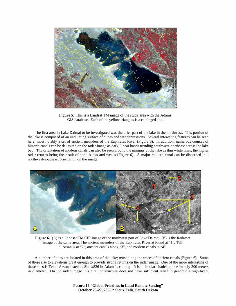
Figure 5. This is a Landsat TM image of the study area with the Adams GIS database. Each of the yellow triangles is a cataloged site.
The first area in Lake Dalmaj to be investigated was the drier part of the lake in the northwest. This portion of the lake is composed of an undulating surface of dunes and wet depressions. Several interesting features can be seen here, most notably a set of ancient meanders of the Euphrates River (Figure 6). In addition, numerous courses of historic canals can be delimited on the radar image as dark; linear bands trending southwest-northeast across the lake bed. The orientation of modern canals can also be seen around the margins of the lake as thin white lines; the higher radar returns being the result of spoil banks and weeds (Figure 6). A major modern canal can be discerned in a northwest-southeast orientation on the image.
Figure 6. (A) is a Landsat TM CIR image of the northwest part of Lake Dalmaj; (B) is the Radarsat image of the same area. The ancient meanders of the Euphrates River at found at “1”, Tell
al Arsan is at “2”, ancient canals along “3”, and modern canals at “4”.
A number of sites are located in this area of the lake; most along the traces of ancient canals (Figure 6). Some
of these rise to elevations great enough to provide strong returns on the radar image. One of the more interesting of these sites is Tel al-Arsan; listed as Site #826 in Adams’s catalog. It is a circular citadel approximately 200 meters in diameter. On the radar image this circular structure does not have sufficient relief to generate a significant
Pecora 16 “Global Priorities in Land Remote Sensing” October 23-27, 2005 * Sioux Falls, South Dakota
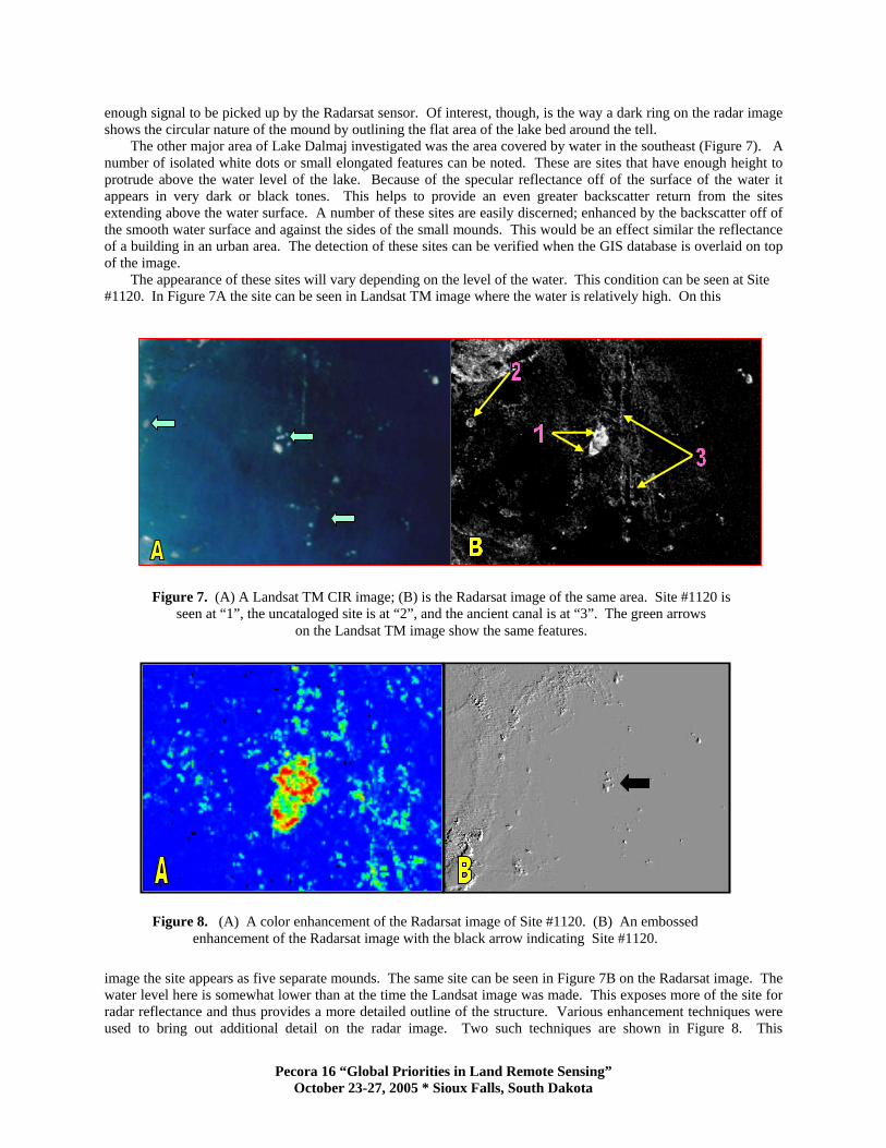
enough signal to be picked up by the Radarsat sensor. Of interest, though, is the way a dark ring on the radar image shows the circular nature of the mound by outlining the flat area of the lake bed around the tell.
The other major area of Lake Dalmaj investigated was the area covered by water in the southeast (Figure 7). A number of isolated white dots or small elongated features can be noted. These are sites that have enough height to protrude above the water level of the lake. Because of the specular reflectance off of the surface of the water it appears in very dark or black tones. This helps to provide an even greater backscatter return from the sites extending above the water surface. A number of these sites are easily discerned; enhanced by the backscatter off of the smooth water surface and against the sides of the small mounds. This would be an effect similar the reflectance of a building in an urban area. The detection of these sites can be verified when the GIS database is overlaid on top of the image.
The appearance of these sites will vary depending on the level of the water. This condition can be seen at Site #1120. In Figure 7A the site can be seen in Landsat TM image where the water is relatively high. On this
Figure 7. (A) A Landsat TM CIR image; (B) is the Radarsat image of the same area. Site #1120 is seen at “1”, the uncataloged site is at “2”, and the ancient canal is at “3”. The green arrows
on the Landsat TM image show the same features.
Figure 8. (A) A color enhancement of the Radarsat image of Site #1120. (B) An embossed enhancement of the Radarsat image with the black arrow indicating Site #1120.
image the site appears as five separate mounds. The same site can be seen in Figure 7B on the Radarsat image. The water level here is somewhat lower than at the time the Landsat image was made. This exposes more of the site for radar reflectance and thus provides a more detailed outline of the structure. Various enhancement techniques were used to bring out additional detail on the radar image. Two such techniques are shown in Figure 8. This
Pecora 16 “Global Priorities in Land Remote Sensing” October 23-27, 2005 * Sioux Falls, South Dakota
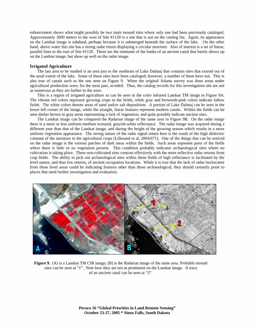
enhancement shows what might possibly be two main mound sites where only one had been previously cataloged. Approximately 3000 meters to the west of Site #1120 is a site that is not on the catalog list. Again, its appearance on the Landsat image is subdued, perhaps because it is submerged beneath the surface of the lake. On the other hand, above water this site has a strong radar return displaying a circular structure. Also of interest is a set of linear, parallel lines to the east of Site #1120. These are the remnants of the banks of an ancient canal that barely shows up on the Landsat image, but show up well on the radar image. Irrigated Agriculture
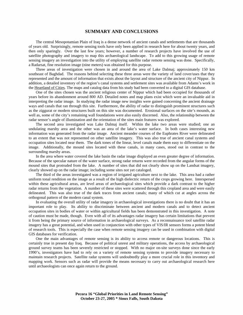
The last area to be studied is an area just to the northeast of Lake Dalmaj that contains sites that extend out of the areal extent of the lake. Some of these sites have been cataloged; however, a number of them have not. This is also true of canals such as the one seen on Figure 9. When the original Adams survey was done areas under agricultural production were, for the most part, avoided. Thus, the catalog records for this investigation site are not as numerous as they are farther to the west.
This is a region of irrigated agriculture as can be seen in the color infrared Landsat TM image in Figure 9A. The vibrant red colors represent growing crops in the fields, while gray and brownish-pink colors indicate fallow fields. The white colors denote areas of sand and/or salt depositions. A portion of Lake Dalmaj can be seen in the lower left corner of the image, while the straight, linear features represent modern canals. Within the fields can be seen darker brown or gray areas representing a lack of vegetation, and quite possibly indicate ancient sites.
The Landsat image can be compared the Radarsat image of the same area in Figure 9B. On the radar image there is a more or less uniform medium textured, grayish-white reflectance. The radar image was acquired during a different year than that of the Landsat image, and during the height of the growing season which results in a more uniform vegetation appearance. The strong nature of the radar signal return here is the result of the high dielectric constant of the moisture in the agricultural crops (Lillesand et al, 2004:671). One of the things that can be noticed on the radar image is the various patches of dark areas within the fields. Such areas represent parts of the fields where there is little or no vegetation present. This condition probably indicates archaeological sites where no cultivation is taking place. These non-cultivated sites contrast effectively with the more reflective radar returns from crop fields. The ability to pick out archaeological sites within these fields of high reflectance is facilitated by the level nature, and thus low returns, of ancient occupation locations. While it is true that the lack of radar backscatter from these level areas could be indicating features other than those archaeological, they should certainly point to places that need further investigation and evaluation.
Figure 9. (A) is a Landsat TM CIR image; (B) is the Radarsat image of the same area. Probable mound sites can be seen at “1”. Note how they are not as prominent on the Landsat image. A trace
of an ancient canal can be seen at “2”.
Pecora 16 “Global Priorities in Land Remote Sensing” October 23-27, 2005 * Sioux Falls, South Dakota
SUMMARY AND CONCLUSIONS
The central Mesopotamian Plain of Iraq is a dense network of ancient canals and settlements that are thousands of years old. Surprisingly, remote sensing tools have only been applied in research here for about twenty years, and then only sparingly. Over the last few years; however, a number of research projects have involved the use of satellite photography and imagery to map this archaeological landscape. To add to this growing usage of remote sensing imagery an investigation into the utility of employing satellite radar remote sensing was done. Specifically, a Radarsat, fine resolution image (nine meters) was obtained for this purpose.
Three areas of investigation were chosen in and around the area of Lake Dalmaj; approximately 150 km southeast of Baghdad. The reasons behind selecting these three areas were the variety of land cover/uses that they represented and the amount of information that exists about the layout and structure of the ancient city of Nippur. In addition, a detailed inventory of the region’s canal systems and settlement sites was available from Adams’s work in the Heartland of Cities. The maps and catalog data from his study had been converted to a digital GIS database.
One of the sites chosen was the ancient religious center of Nippur which had been occupied for thousands of years before its abandonment around 800 AD. Detailed notes and map plans exist which were an invaluable aid in interpreting the radar image. In studying the radar image new insights were gained concerning the ancient drainage ways and canals that ran through this site. Furthermore, the ability of radar to distinguish prominent structures such as the ziggurat or modern structures built on this site was documented. Erosional surfaces on the site’s mounds, as well as, some of the city’s remaining wall foundations were also easily discerned. Also, the relationship between the radar sensor’s angle of illumination and the orientation of the sites main features was explored.
The second area investigated was Lake Dalmaj itself. Within the lake two areas were studied; one an undulating marshy area and the other was an area of the lake’s water surface. In both cases interesting new information was generated from the radar image. Ancient meander courses of the Euphrates River were delineated to an extent that was not represented on other satellite imagery. This was also true of ancient canal systems and occupation sites located near them. The dark tones of the linear, level canals made them easy to differentiate on the image. Additionally, the mound sites located with these canals, in many cases, stood out in contrast to the surrounding marshy areas.
In the area where water covered the lake basin the radar image displayed an even greater degree of information. Because of the specular nature of the water surface, strong radar returns were recorded from the angular forms of the mound sites that protruded from the lake. A number of sites that did not clearly show up on the Landsat imagery, clearly showed up on the radar image; including some sites not yet cataloged.
The third of the areas investigated was a region of irrigated agriculture next to the lake. This area had a rather uniform tonal rendition on the image as a result of the high dielectric return of the crops growing here. Interspersed within these agricultural areas, are level areas of archaeological sites which provide a dark contrast to the higher radar returns from the vegetation. A number of these sites were scattered through this cropland area and were easily delineated. This was also true of the dark traces from ancient canals; many of which cut at angles across the orthogonal pattern of the modern canal system.
In evaluating the overall utility of radar imagery in archaeological investigations there is no doubt that it has an important role to play. Its ability to discriminate between ancient and modern canals and to detect ancient occupation sites in bodies of water or within agricultural fields has been demonstrated in this investigation. A note of caution must be made, though. Even with all of its advantages radar imagery has certain limitations that prevent it from being the primary source of information in archaeological surveys. As a reconnaissance tool satellite radar imagery has a great potential, and when used in conjunction with other types of VIS/IR sensors forms a potent blend of research tools. This is especially the case when remote sensing imagery can be used in combination with digital GIS databases for verification.
One the main advantages of remote sensing is its ability to access remote or dangerous locations. This is certainly true in present day Iraq. Because of political unrest and military operations, the access by archaeological ground survey teams has been severely restricted or stopped. With no major on-site surveys done since the early 1990’s, investigators have had to rely on a variety of remote sensing systems to provide imagery necessary to maintain research projects. Satellite radar systems will undoubtedly play a more crucial role in this inventory and mapping work. Sensors such as radar will provide the means necessary to carry out archaeological research here until archaeologists can once again return to the ground.
Pecora 16 “Global Priorities in Land Remote Sensing” October 23-27, 2005 * Sioux Falls, South Dakota

REFERENCES
Adams, R. McC., (1965). Land Behind Baghdad. University of Chicago Press, Chicago. Adams, R. McC., (1972., Settlement and Irrigation patterns in ancient Akkad. In The City and Area of Kish, edited by McG. Gibson, Field Research Projects, Miami. Adams, R. McC., (1981). Heartland of Cities. University of Chicago Press, Chicago. Avery, E. and Berlin, G. (1997). Fundamentals of Remote Sensing and Airphoto Interpretation. Fifth Edition, Macmillan Publishing Co, New York. Buringh, P., (1960). Soils and Soil Conditions in Iraq. Republic of Iraq, Ministry of Agriculture, Baghdad. Campbell, J.,(2002). Introduction to Remote Sensing. Third Edition, Guilford Press, New York. Ebert, J. and Lyons, T. Eds., (1983). Archaeology, Anthropology, and Cultural Resources Management. In Estes, J.
Vol. II Ed., Manual of Remote Sensing, pp. 1233-1304. American Society of Photogrammetry. The Sheridan Press, Falls Church, VA.
ERDAS, Inc., (1997). ERDAS Field Guide. Fourth Edition, Atlanta. Gasche, H and Cole, S., (1998). Changing Watercourses in Babylonia: Towards a Reconstruction of the Ancient
Environment in Lower Mesopotamia, edited by H. Gasche and Tanret, M., University of Ghent and the Oriental Institute of the University of Chicago, Mesopotamian History and Environment Series II: V., University of Chicago Press, Chicago.
Gibson, McG., (1972). The City and Area of Kish. Field Research Projects, Miami. Gibson, McG., (1992). Patterns of Occupation at Nippur. Retrieved August 15, 2005 from University of Chicago, Oriental Institute Web site: http://oi.uchicago.edu/OI/PROJ/NIP/Nippur.html#Articles. Holcomb, D., (1998). Applications of Imaging Radar to Archaeological Investigations, In Manual of Remote Sensing, Vol. 2, Principles and Applications of Imaging Radar, edited by Henderson, F. and Lewis, A., American
Society of Photogrammetry and Remote Sensing, pp. 769-777, John Wiley & Sons, New York. Holcomb, D. and Allan, J., 1992, Radar Data – An Important Source for the 1990’s, 18th Conference of the Remote Sensing Society, pp. 408-413 University of Dundee. Hritz, ., (2005). Landscape and Settlement in Southern Mesopotamia. University of Chicago, Department of Near
Eastern Languages and Civilizations, unpublished dissertation. Jensen, J.,(2004). Introductory Digital Image Processing. Third Edition, Prentice Hall, Upper Saddle River, NJ. Kennedy, D.,(1998). Declassified Satellite Photographs and Archaeology in the Middle East: Case Studies from Turkey. Antiquity 72: 553-61. Lee, J., Jurkevich, I., Dewaele, P., Wambacq, P., and Oosterlinck, A., (1994). Speckle Filtering of Synthetic Aperture Radar Images: A Review, Remote Sensing Reviews, 8: 313-340. Lillesand, T, Kiefer, R., and Chipman, J., (2004). Remote Sensing and Image Interpretation, Fifth Edition, Wiley and Sons, New York. Postgate, J and Moorey, P., (1976). Excavations at Abu Salabikh. Iraq 38: 133-170. Pournelle, J., (2003). , Marshland of Cities: Deltaic Landscapes and the Evolution of Early Mesopotamian Civilization. University of San Diego, Anthropology, unpublished dissertation. Raney, K., Radar Fundamentals: Technical Perspective, (1998). In Manual of Remote Sensing, Vol. 2, Principles and Applications of Imaging Radar, edited by Henderson, F. and Lewis, A., American Society of Photogrammetry
and Remote Sensing, pp. 769-777, John Wiley & Sons, New York. Sabins, F., (1997). Remote Sensing: Principles and Interpretation. Third Edition, W.H. Freeman Co, New York. Verhoeven, K., (199). Geomorphological Research in the Mesopotamian Flood Plain”. In Changing Watercourses in Babylonia: Towards a Reconstruction of the Ancient Environment in Lower Mesopotamia. edited by H. Gasche and
Tanret, M., University of Ghent and the Oriental Institute of the University of Chicago Press, Mesopotamian History and Environment Series II: V.
Wescott, K. (2000). Introduction, In Practical Applications of GIS for Archaeologists, edited by Wescott, K. and Brandon, J., Taylor and Francis, London. Wilkinson, T., (1990). Early channels and Landscape Development Around Abu Salabikh: A Preliminary Report”. Iraq 52: 75-83. Wilkinson, T., (2003). Archaeological Landscapes of the Near East. University of Arizona Press, Tuscan. Wright, H., (1981). The Southern Margins of Sumer: Archaeological Survey of the Area of Eridu and UR, In Heartland of Cities. Adams, R.McC. University of Chicago Press, Chicago.
Pecora 16 “Global Priorities in Land Remote Sensing” October 23-27, 2005 * Sioux Falls, South Dakota