Collaborative Forest Landscape Restoration Program
U.S.D.A. Forest Service National Forest in Florida
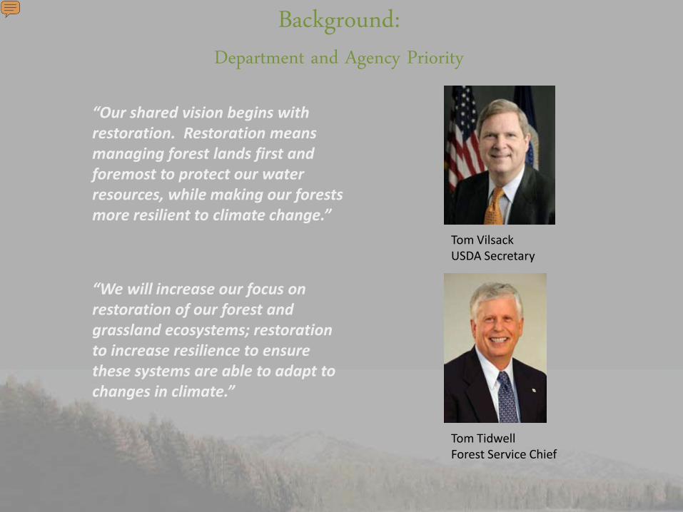
Tom VilsackUSDA Secretary
Tom TidwellForest Service Chief
“Our shared vision begins with restoration. Restoration means managing forest lands first and foremost to protect our water resources, while making our forests more resilient to climate change.”
“We will increase our focus on restoration of our forest and grassland ecosystems; restoration to increase resilience to ensure these systems are able to adapt to changes in climate.”
Background:Department and Agency Priority
Presenter
Presentation Notes
We have strong political commitment to our work on climate change. It is an exciting time. Thank you.
Background:The Omnibus Act of 2009
• The Collaborative Forest Landscape Restoration Program was authorized in Title IV of the Omnibus Public Land Management Act of 2009 (Omnibus Act)
• A Federal Advisory Committee was established to evaluate and recommend proposals for funding. The panel met in July 2010 in an open meeting and recommended 10 projects for funding
Background:Purpose of CFLR
• From Title IV of the Omnibus Act: “The purpose of this title is to encourage the collaborative, science-based ecosystem restoration of priority forest landscapes through a process that– encourages ecological, economic, and social sustainability;
– leverages local resources with national and private resources;
– facilitates the reduction of wildfire management costs, including through reestablishing natural fire regimes and reducing the risk of uncharacteristic wildfire; and
– demonstrates the degree to which--• Various ecological restoration techniques--
– achieve ecological and watershed health objectives; and – affect wildfire activity and management costs; and
• the use of forest restoration byproducts can offset treatment costs while benefitting local rural economies and improving forest health.”
Background:2010 Projects
• In August 2010, the Secretary selected 10 projects for funding and allocated $10 million
• Projects selected in Fiscal Year 2010 include:
Region Project Name State
3 Southwest Jemez Mountains New Mexico
5 Dinkey Landscape California
6 Deschutes Skyline Oregon
6 Tapash Washington
8 Accelerating Longleaf Pine Restoration
Florida
Region Project Name State
1 Southwestern Crown of the Continent
Montana
1 Selway- Middle Fork Clearwater Idaho
2 Uncompahgre Plateau Colorado
2 Colorado Front Range Colorado
3 4 Forest Restoration Initiative Arizona
WHY LONGLEAF PINE?
6
Presenter
Presentation Notes
[Click to next slide]
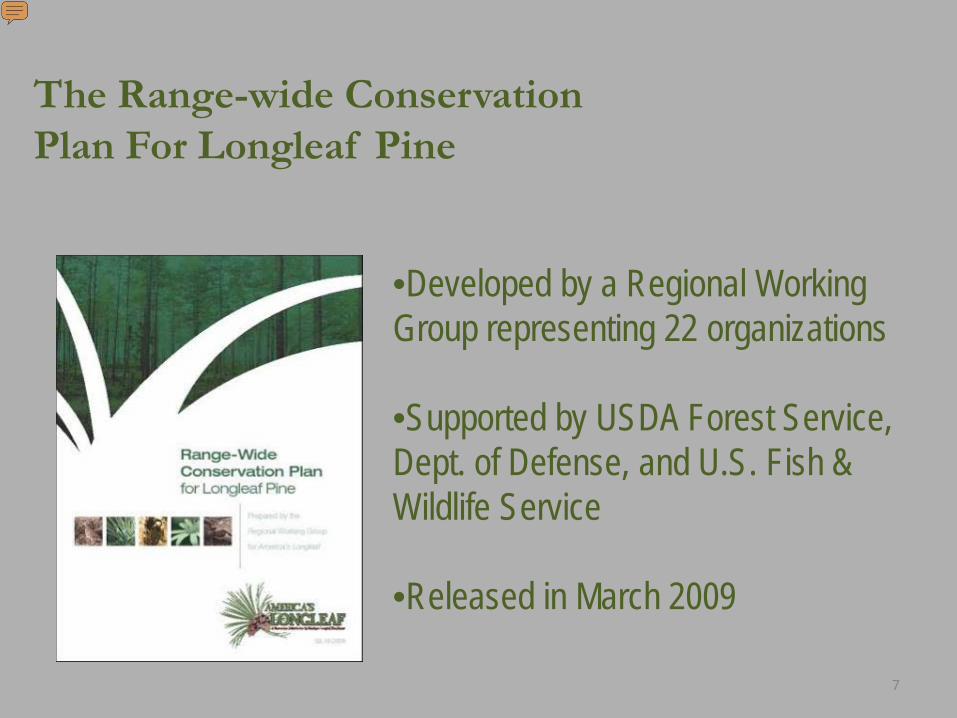
•Developed by a Regional Working Group representing 22 organizations
•Supported by USDA Forest Service, Dept. of Defense, and U.S. Fish & Wildlife Service
•Released in March 2009
7
The Range-wide Conservation Plan For Longleaf Pine
Presenter
Presentation Notes
Following initial discussions hosted by the Longleaf Alliance, in 2007 the USDA Forest Service, Dept. of Defense, and the US Fish and Wildlife Service supported a regional working group, representing 22 organizations, to develop the “Range-wide Conservation Plan for Longleaf Pine”. Released in March 2009, the plan outlines an “all lands approach” to longleaf conservation, requiring both public and private involvement.
Who Cares About Longleaf?
• Wildlife Advocates/Hunters/Conservationists• State and Federal Land Managers, including
Military Services • Private Landowners and Managers
8
Presenter
Presentation Notes
--What constituencies really care, care enough to get involved in a hands-on way and commit resources to longleaf related activity. Let me give three examples: -- Among those keenly interested in longleaf restoration are hunters with their sites set on wild turkey or bobwhite quail. Properly maintained longleaf makes excellent habitat for both of these game birds. In fact, the National Wild Turkey Federation has directly assisted in the replanting of longleaf on public lands, including military bases and national forests, and on private lands where hunting is common in the South. -- Other conservationists are more interested in habitat for critters like gopher tortoises which find longleaf stands entirely suitable for their extensive boroughs. -- And importantly, private landowners are interested in longleaf restoration for economic, recreational and land stewardship interests.
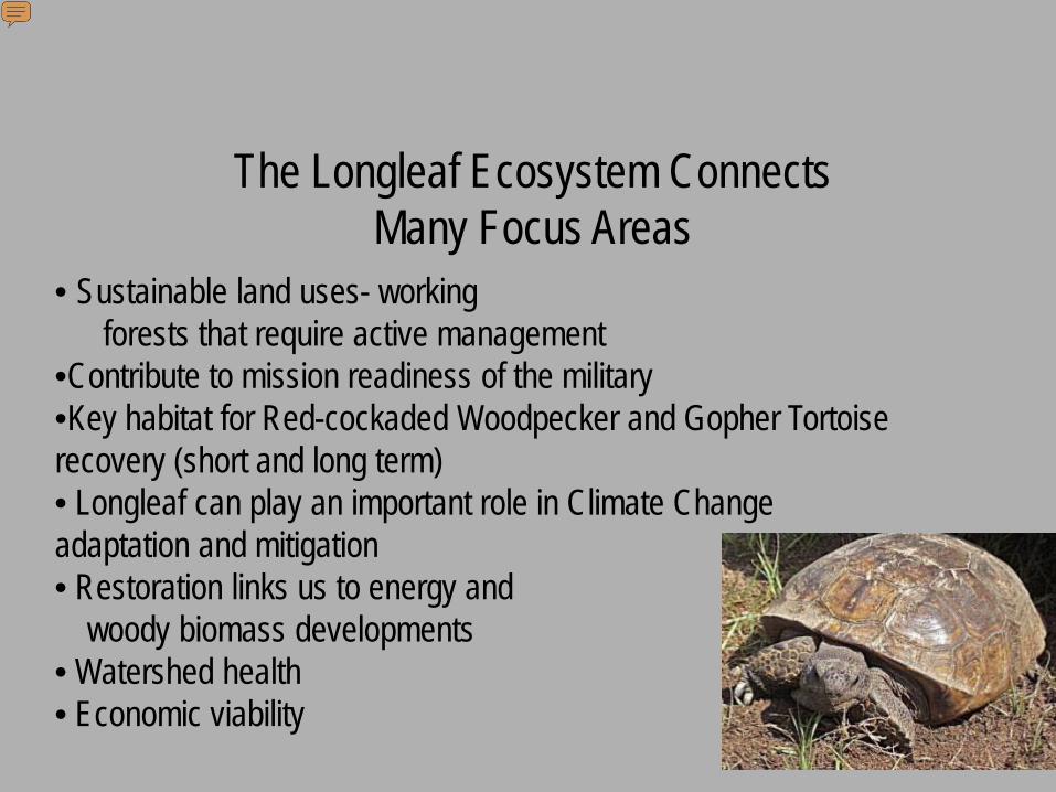
The Longleaf Ecosystem Connects Many Focus Areas
9
• Sustainable land uses- working forests that require active management
•Contribute to mission readiness of the military•Key habitat for Red-cockaded Woodpecker and Gopher Tortoise recovery (short and long term)• Longleaf can play an important role in Climate Change adaptation and mitigation • Restoration links us to energy and
Longleaf offers connections with many values we are concerned about: Sustainable land uses- these have to be working forests Mission readiness of the military Endangered species recovery, Climate change mitigation, biomass production, renewable energy and energy facility siting Watershed health Rural economic viability with more resistance to storms and pests, high return crops (of pine straw, poles, etc) These linkages of longleaf can or should factor in our plans and actions on the other major forces in play in the Southeast.
Historical Range: Coastal Plain from Virginia to
East Texas
Longleaf forests once covered over 90 million acres
Today, less than 3% remain.
Presenter
Presentation Notes
-- Longleaf was once the dominant forest type on the coastal plain from Virginia to Texas, comprising some 90M acres. -- The world class biodiversity of this forested ecosystem encompasses both plants and animals. Home to 29 threatened and endangered species. -- In fact, longleaf was the tree that built our young country (many of those buildings are still standing today. -- Of course, longleaf is still a valuable commodity today, supplying high quality forest products. -- Longleaf also occupies central role in social heritage and culture of the region -- Yes, all of these are legitimate reasons for the widespread interest in longleaf.
Presenter
Presentation Notes
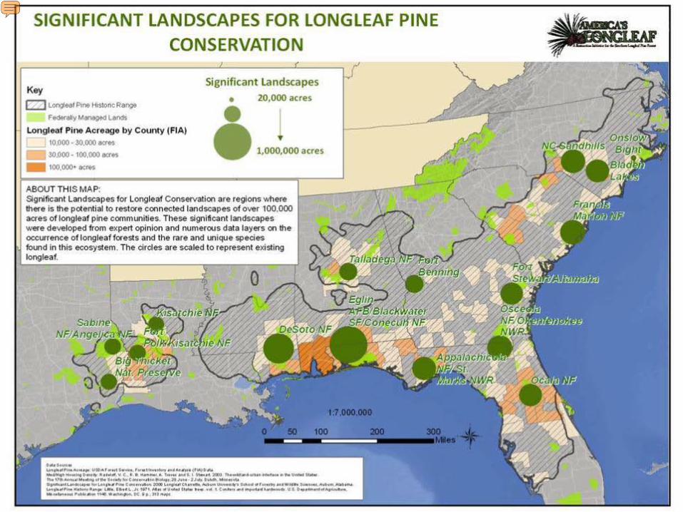
This map shows the locations of the 16 significant geographic areas where large, existing landscapes exist & provides the opportunity to secure large, intact tracts of longleaf ecosystems. In addition there are significant sites (not highlighted on the map) that local efforts will more fully define – such as montane longleaf in Alabama & Georgia, the South Carolina sandhills, and the Red Hills of southwest Georgia and northern Florida. . The Plan uses Significant Geographic Area comprised of Significant Landscapes and Significant Sites. Where LLP is intact in established or maintained functional landscapes with adequate connectivity for large-area dependent species. The objectives of designating both Significant Landscapes and Significant Sites is to provide a network of areas that capture the full spectrum of biodiversity and other values throughout the range of longleaf ecosystems Focus limited conservation resources where they are most strategically useful Suggests where local implementation teams could or should be formed for implementation
• The Osceola and the surrounding state and private lands have been plagued wildfires
• During the past 12 years, over 31 million dollars have been expended on wildfire suppression with a wildfire rehabilitation cost of 3.6 million dollars
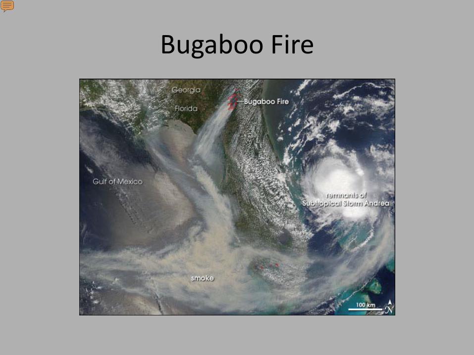
• The Bugaboo Fire in 2007 was the largest wildfire east of the Mississippi River and caused the closure of Interstates 10 and 75 for several days
Why The Osceola National Forest
Presenter
Presentation Notes
Purpose Slide The fundamental purpose of the Ecological Condition Model is to dramatically increase the health of forest ecosystems at a landscape scale by: 1) Assessing current ecological condition compared to Desired Future Conditions - using ranked tiers of condition category. 2) Maximizing integration of program areas - both staff and funding. 3) Prioritizing areas needed treatments - as well as the activities to be conducted. 4) Balancing restoration of degraded areas with maintenance of areas already in good condition. Our philosophy is that we should focus on ensuring that we maintain areas in good condition before we attempt restoration of degraded areas. 5) Increasing management efficiencies. E.g., Identifying clusters of burn blocks in good condition for prescribed burning (low fuel loads), focusing on reducing fuels in areas between those blocks, and then increasing the size of burn blocks – at same cost.
Bugaboo Fire
Presenter
Presentation Notes
In the workshop on the Osceola NF we developed 3 separate prioritization models Fire Mechanical Fuels treatment Timber thinning And for the fire model we even ran 2 different scenarios with the same input layers weighted differently….
• The Forest is located within one of the significant longleaf pine conservation areas
Why The Osceola National Forest
Presenter
Presentation Notes
Purpose Slide The fundamental purpose of the Ecological Condition Model is to dramatically increase the health of forest ecosystems at a landscape scale by: 1) Assessing current ecological condition compared to Desired Future Conditions - using ranked tiers of condition category. 2) Maximizing integration of program areas - both staff and funding. 3) Prioritizing areas needed treatments - as well as the activities to be conducted. 4) Balancing restoration of degraded areas with maintenance of areas already in good condition. Our philosophy is that we should focus on ensuring that we maintain areas in good condition before we attempt restoration of degraded areas. 5) Increasing management efficiencies. E.g., Identifying clusters of burn blocks in good condition for prescribed burning (low fuel loads), focusing on reducing fuels in areas between those blocks, and then increasing the size of burn blocks – at same cost.
Presenter
Presentation Notes
This map shows the locations of the 16 significant geographic areas where large, existing landscapes exist & provides the opportunity to secure large, intact tracts of longleaf ecosystems. In addition there are significant sites (not highlighted on the map) that local efforts will more fully define – such as montane longleaf in Alabama & Georgia, the South Carolina sandhills, and the Red Hills of southwest Georgia and northern Florida. . The Plan uses Significant Geographic Area comprised of Significant Landscapes and Significant Sites. Where LLP is intact in established or maintained functional landscapes with adequate connectivity for large-area dependent species. The objectives of designating both Significant Landscapes and Significant Sites is to provide a network of areas that capture the full spectrum of biodiversity and other values throughout the range of longleaf ecosystems Focus limited conservation resources where they are most strategically useful Suggests where local implementation teams could or should be formed for implementation
• The forest developed an Ecological Condition Model (ECM) to assess current conditions relative to desired future conditions along with prioritization models for fire, timber harvest and mechanical fuel reduction
• The ECM revealed that almost 50% of the Osceola NF is in poor ecological condition
Why The Osceola National Forest
Presenter
Presentation Notes
Purpose Slide The fundamental purpose of the Ecological Condition Model is to dramatically increase the health of forest ecosystems at a landscape scale by: 1) Assessing current ecological condition compared to Desired Future Conditions - using ranked tiers of condition category. 2) Maximizing integration of program areas - both staff and funding. 3) Prioritizing areas needed treatments - as well as the activities to be conducted. 4) Balancing restoration of degraded areas with maintenance of areas already in good condition. Our philosophy is that we should focus on ensuring that we maintain areas in good condition before we attempt restoration of degraded areas. 5) Increasing management efficiencies. E.g., Identifying clusters of burn blocks in good condition for prescribed burning (low fuel loads), focusing on reducing fuels in areas between those blocks, and then increasing the size of burn blocks – at same cost.
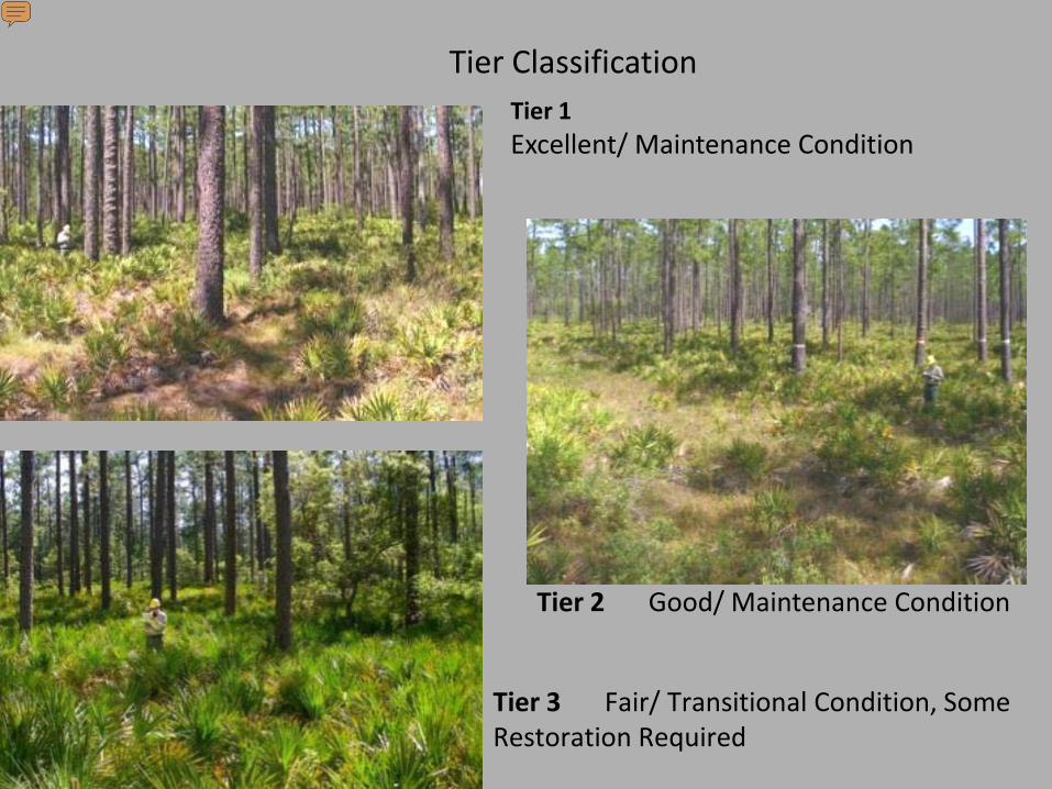
Tier 1Excellent/ Maintenance Condition
Tier 2 Good/ Maintenance Condition
Tier 3 Fair/ Transitional Condition, Some Restoration Required
Tier Classification
Presenter
Presentation Notes
Tier 1 Excellent/ Maintenance Condition�-“Old growth” pines present (>110 yrs old)3 acres on entire forest!�-Basal area within RCW recovery plan range (40-60 ft2) -Normal fire return interval (2-3 years) Tier 2 Good/ Maintenance Condition -Near old growth” pines present (90-109 yrs old) -Basal area within RCW recovery plan range (40-60 ft2) -Saw palmetto cover is less than ~30%. -Normal fire return interval (2-3 years) Tier 3 Fair/ Transitional Condition, Some Restoration Required -Mature pines present (60-89 yrs old) -Basal area slightly higher than RCW recovery plan range (60-80 ft2) -Fire return interval of 3-5 years
Tier 4 Poor Condition, Restoration Required
Tier 5 Very Poor Condition, Restoration Required
Tier Classification
Presenter
Presentation Notes
Tier 4 Poor Condition, Restoration Required -Young pines present (<60 year old) Fire return interval of ≥ 5 years High basal area (>80 ft2) Tier 5Very Poor Condition, Restoration Required Young pines present (<60 year old) in a plantation Fire return interval of ≥ 5 years High basal area (>80 ft2) Heavy hydrological disturbance caused by site preparation (bedding) and ditching
2009 ECMTier ClassesFlatwoods Condition
Good-Excellent (Tier 1,2) 13%
Transitional (Tier 3)40%
Poor-Very Poor (Tier 4,5) 47%
Presenter
Presentation Notes
Gray = NOT Flatwoods and some data gaps in Pinhook Results Summary Tier 1 = 0.003%3 ac Tier 2 = 13% 14,145 ac Tier 3 = 40%44,870 acNote: Tier 3 may be fine from a fuels mgt perspective! Tier 4 = 26% 28,761 ac Tier 5 = 22% 24,046 ac
Prioritization Models
• Fire Prioritization
• Mechanical Fuels Treatment Prioritization
• Timber Thinning Prioritization
Presenter
Presentation Notes
In the workshop on the Osceola NF we developed 3 separate prioritization models Fire Mechanical Fuels treatment Timber thinning And for the fire model we even ran 2 different scenarios with the same input layers weighted differently….
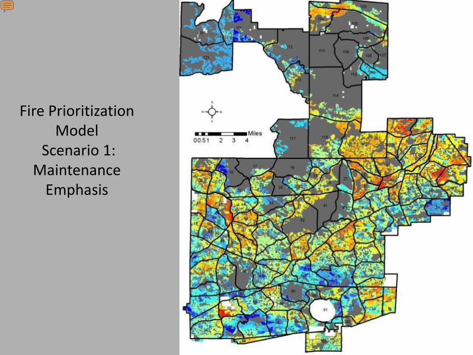
Fire Prioritization Model
Scenario 1: Maintenance
Emphasis
Presenter
Presentation Notes
Gray = NOT Flatwoods and some data gaps in Pinhook The first scenario primarily focused on areas burned within past 2-4 years in close proximity to good quality areas (ECM tier 2). Color scale from blue (very low priority) to orange and red (highest priority)
Fire Prioritization Model Scenario 2: Heavy Fuels
Emphasis and RCWs
Presenter
Presentation Notes
The second scenario primarily focused on areas with greater than 6 year rough and RCWs, particularly in WUI areas Again, oranges and red (highest priority)
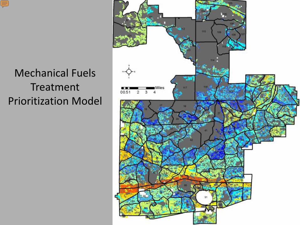
Mechanical Fuels Treatment
Prioritization Model
Presenter
Presentation Notes
Primarily focuses on WUI areas along I-10 with heavy fuels (>7 year rough) Model also avoids areas with high basal area due to equipment operability constraints
Timber Thinning Prioritization Model
Presenter
Presentation Notes
Primarily focused on longleaf pine stands with high basal area and intermediate age (20-80 yrs) near RCW areas Jason Ends Here!
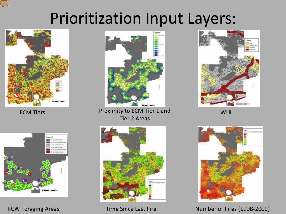
Prioritization Input Layers:
Proximity to ECM Tier 1 and Tier 2 Areas
ECM Tiers WUI
RCW Foraging Areas Time Since Last Fire Number of Fires (1998-2009)
Presenter
Presentation Notes
For the development of the prioritization model a key input is the current ecological condition (from the ECM) But we can consider many other resource factors in this process such as proximity to high quality areas (expand/link up), wildland urban interface areas, T&E species habitat, time since last fire and so on These factors can weighted accordingly based on knowledge of resource area experts in a collaborative way (for example we had an all day workshop on the Osceola NF to develop custom prioritization models to meet their needs) The key is that areas with overlapping resource factors (especially those with higher weights) will have a higher priority ranking by the model
Planned Activities
1. Double the annual prescribed fire acreage to 50,000 acres
2. Mechanically reduce fuel loads on 10,000 acres
3. Increase timber harvest from thinning less than 2,000 acres a year to 5,000 acres a year for the next 10 years
4. Restore ground cover by light roller chopping 21,000 acres followed by application of prescribed fire
5. Restore hydrology by correcting known problems on 309 miles of roads and 90 miles of old fire lines
6. Utilize Stewardship Contracts the Wyden Amendment authority to help state and private land cooperators conduct restoration treatments
Presenter
Presentation Notes
Related thoughts: Increased communication/cooperation/visioning between programs; Integrates and focuses different resource programs to achieve common goals Used to develop prioritization models and Landscape Scale Assessments Mid-level planning tool that links project level NEPA to Land and Resource Management Plan (LRMP) More thoughts from Dave Harris: Makes management decisions more open and transparent to the public in accordance with the President’s Open Government Directive (usda.gov/open) Serves as a tool for describing desired conditions and objectives during Forest Plan revision
Participation of Adjacent State and Private Land Owners
1. Utilize Stewardship Contracts and the Wyden Amendment authority to help cooperating state and private landowners conduct restoration treatments
2. Revenue from timber thinnings will accumulated and retained to fund restoration treatments on cooperators lands
Presenter
Presentation Notes
Related thoughts: Increased communication/cooperation/visioning between programs; Integrates and focuses different resource programs to achieve common goals Used to develop prioritization models and Landscape Scale Assessments Mid-level planning tool that links project level NEPA to Land and Resource Management Plan (LRMP) More thoughts from Dave Harris: Makes management decisions more open and transparent to the public in accordance with the President’s Open Government Directive (usda.gov/open) Serves as a tool for describing desired conditions and objectives during Forest Plan revision
Broad principles guide our efforts as we work with stakeholders in at a range-wide scale and the state and local levels. Each group brings their strengths and can realize synergies from a collaborative approach. We view these partnerships as essential to maintain, improve or restore longleaf ecosystems at a meaningful landscape scale- no one can do it alone.
Forecasted CFLRP Accomplishments in Acres FY10 – FY19