Embed Size (px)
Citation preview
Summits on the Air
U.S.A. W9 Call Area
Association Reference Manual
Document Reference S95.1
Issue number 1.0
Date of issue 1st July 2013
Participation start date 1st July 2013
Authorised by SOTA MT Date: 1st July 2013
Association Manager Dennis Martin WA2USA
Summits-on-the-Air an original concept by G3WGV and developed with G3CWI
Notice “Summits on the Air” SOTA and the SOTA logo are trademarks of the Programme. This document is copyright of the Programme. All other trademarks and copyrights referenced herein are acknowledged.
Summits on the Air – ARM for U.S.A (W9 Call Area)
Page 2 of 14
Table of contents. 1 ASSOCIATION REFERENCE DATA ........................................................................... 4
1.1 PROGRAMME DERIVATION .................................................................................................................. 5 1.2 GENERAL INFORMATION ..................................................................................................................... 5 1.3 RIGHTS OF WAY AND ACCESS ISSUES.................................................................................................. 6 1.4 MAPS AND NAVIGATION ...................................................................................................................... 6 1.5 SAFETY CONSIDERATIONS .................................................................................................................. 6 1.6 FOREIGN Amateur Radio Operators in Indiana, Illinois and Wisconsin............................................ 6 1.7 AWARDS ........................................................................................................................................... 7 1.8 DISCLAIMER ....................................................................................................................................... 7
2 SUMMIT REFERENCE DATA...................................................................................... 9
2.1 REGION REFERENCE – Indiana Mountains (IN) 2.1. A. Map of Indiana ............................................................................................................... 8 2.1.1 Regional notes ................................................................................................................ 9 2.1.2 Table of summits ............................................................................................................. 9
2.2 REGION REFERENCE – Illinois Mountains (IL) 2.2. A. Map of Illinois ............................................................................................................... 10 2.2.1 Regional notes ................................................................................................................ 11 2.2.2 Table of summits ............................................................................................................. 11
2.3 REGION REFERENCE – Wisconsin Mountains (WI) 2.3. A. Map of Wisconsin ......................................................................................................... 12 2.3.1 Regional notes ................................................................................................................ 13 2.3.2 Table of summits ............................................................................................................. 13

Summits on the Air – ARM for U.S.A (W9 Call Area)
Page 3 of 14
Date Version Details
1st July 2013 1.0 First formal issue of this document
Summits on the Air – ARM for U.S.A (W9 Call Area)
Page 4 of 14
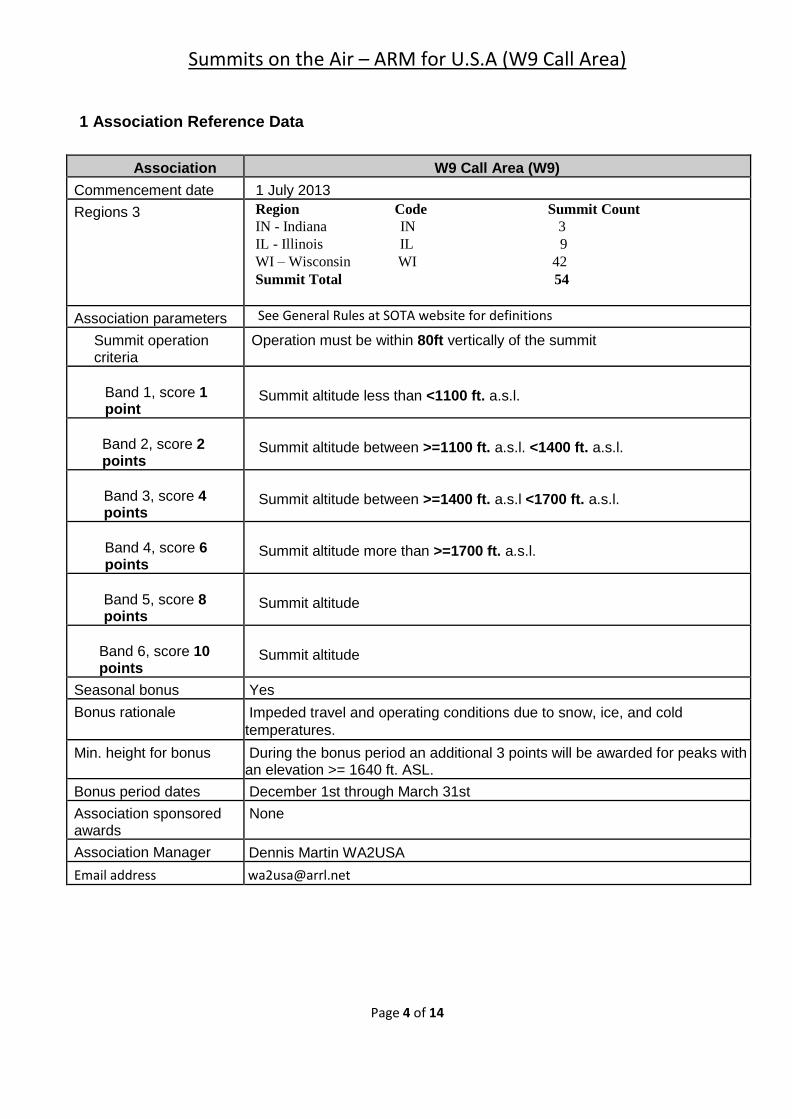
1 Association Reference Data
Association W9 Call Area (W9)
Commencement date 1 July 2013
Regions 3 Region Code Summit Count
IN - Indiana IN 3
IL - Illinois IL 9
WI – Wisconsin WI 42
Summit Total 54
Association parameters See General Rules at SOTA website for definitions
Summit operation criteria
Operation must be within 80ft vertically of the summit
Band 1, score 1 point
Summit altitude less than <1100 ft. a.s.l.
Band 2, score 2 points
Summit altitude between >=1100 ft. a.s.l. <1400 ft. a.s.l.
Band 3, score 4 points
Summit altitude between >=1400 ft. a.s.l <1700 ft. a.s.l.
Band 4, score 6 points
Summit altitude more than >=1700 ft. a.s.l.
Band 5, score 8 points
Summit altitude
Band 6, score 10 points
Summit altitude
Seasonal bonus Yes
Bonus rationale Impeded travel and operating conditions due to snow, ice, and cold
temperatures.
Min. height for bonus During the bonus period an additional 3 points will be awarded for peaks with an elevation >= 1640 ft. ASL.
Bonus period dates December 1st through March 31st
Association sponsored awards
None
Association Manager Dennis Martin WA2USA
Email address [email protected]
Summits on the Air – ARM for U.S.A (W9 Call Area)
Page 5 of 14
1.1 Program Deviation The W9 Call area SOTA is an extension of similar programs already active in other countries and other regions of the United States. Much of the list of summits was derived from the work of John Kirk, published on the http://www.listofjohn.com website. Other sources of data exit, namely from the United States Geological Survey (USGS). A random sampling of the data from John Kirk’s site was found to match the USGS data so it was chosen to be the source. The W9 Association scoring scheme is based on the relative height of summits of 100M (328ft) elevation for the surrounding saddle in order to qualify. This value has been rounded off to 330ft for convenience in SOTA regions where the routine measurement for height is in feet. Further information on the concept of “prominence” is available from Wikipedia and other sources.
The summit database is thought to be complete. If you would like a summit added, or you find an error in this ARM, please contact the Association Manager (AM). If the AM determines the requested summit is valid, or a change needs to occur to an existing summit’s database record, he will update the ARM and submit it for approval to the SOTA Management Team (MT). Summits cannot be counted for points until a launch date and a reference number has been allocated by the AM and approved by the MT.
Please include the following information to help expedite requests for additions and/or corrections to the ARM’s summit list:
1. Name of the summit as shown on the applicable USGS topographical map or as listed in the Geonames database.
2. Latitude and longitude of the summit expressed in decimal degrees to at least four decimal places.
3. Elevation of the summit expressed in feet above sea level. 4. Prominence value of the summit expressed in feet with a citation indicating the source of this
value.
1.2 General information Regions were based on the states, Indiana, Illinois and Wisconsin within the 9th call area. Each summit location was verified using the county location provided from the List of John and matched to a corresponding Section as shown on the individual state map preceding each region. For simplicity each region was given the following code system, IN (Indiana), IL (Illinois) and WI (Wisconsin). All mountains in Indiana and Illinois are located in the southern half for both states. The mountains of Wisconsin are located in 3 of the 4 sections of the state representing 26 counties. A Section column was added to the Wisconsin Regional table to help locate each summit within the state using the following sections: Northeastern (NE), Southeastern (SE), Southern (S) and Western (W).
All regions do have the same points scoring scheme. If additional summits are added to this W9 Association, they must comply with this scoring scheme.
To in order to qualify, a summit has to meet the following requirements:
• The summit must be listed on USGS topo maps.
• The summit must have at least 330 ft. prominence
• In the case of doubt regarding compliance to qualification criteria, the SOTA Management Team
reserves the right to decide whether or not the Summit will be added to the list.
Summits on the Air – ARM for U.S.A (W9 Call Area)
Page 6 of 14
1.3 Rights of way and access issues
Some of the summits listed in this ARM are on private land with no public access. Private lands in the USA are NOT open to camping and hiking simply by default. While European activators may be accustomed to the privileges of “Every Man’s Right” laws, these laws do not exist in the USA. No SOTA activator should ever trespass onto private land. If an activator does receive permission from a private landowner to a private summit, the activator must remember he or she may be the landowner’s only contact with SOTA or amateur radio and therefore must adhere to the highest standards of politeness and courtesy during the activation so as to pave the way for future activators to be authorized. The landowner is performing a favour for the amateur activator.
1.4 Maps and navigation
A reliable map of the region to be hiked along with a compass, and competency in the use of both, are essential. USGS topographical maps should be supplemented by trail maps where available. State parks often provide specific trail maps at no cost. A GPS is a good supplemental tool, though it should not be relied upon for primary navigation. It can fail to acquire satellite reception when in heavy cover, which is typical of forested area on steep ground.
When map sources are discovered by potential activators, the association strongly encourages sharing this data on the SOTAwatch website at http://www.sotawatch.org/summits.php to assist other activators. Please be sure to respect intellectual property law when adding information to the SOTAwatch site.
1.5 Safety considerations A wealth of information on hiking and mountaineering is available from numerous resources on the
internet, specialty retailers, bookstores, and local libraries. In addition to the standard preparation
and planning that should go into any summit venture (essential supplies, weather forecast, etc.)
particular consideration should be given to the following.
Added pack weight and space for communication equipment (transceivers, batteries, antenna and
accessories) will change the amount of effort an experienced hiker will expend going to and from
most summits. Test your SOTA station thoroughly before leaving home and include plenty of time
in the day to set up, operate, and tear down a station.
The main objective is to return safely to the trail head and NOTHING should jeopardize this
objective. Be mindful of time and weather conditions when lingering at the summit faced with
making the last contact or working every caller in a pile-up. Most climbing accidents occur on
descent and are generally due to fatigue and travel along trails as darkness approaches. It gets
dark quickly on a trail in the woods.
1.6 Foreign amateur radio operators in Indiana, Illinois and Wisconsin Foreign amateurs that are citizens and licensees of countries that participate in operating agreements with the United States of America are encouraged to consult the ARRL or FCC website for full details of operating within each of the three states within the W9 call area.
Summits on the Air – ARM for U.S.A (W9 Call Area)
Page 7 of 14
1.7 Awards There are no W9 Association awards at this time. However, several awards are available from the SOTA
parent organization. Consult the SOTA website for details.
1.8 Disclaimer Hiking, hill-walking and rock-climbing are potentially dangerous activities. The SOTA Management Team
and their associates assume no responsibility for accidents.
Participants must be competent to undertake their proposed Expedition and must carry suitable
equipment, taking account of the terrain, weather conditions, etc. Activators take part in the Programme
entirely at their own risk and the Programme in its entirety shall accept no responsibility for injury, loss of
life or any other loss. Activators are reminded that hill climbing is an inherently hazardous activity.
Accidents can and do happen in the mountains and the risk is neither increased nor mitigated by the
SOTA programme.
Each participant does so at his or her own risk, and must decide, on the basis of their ability, whether an
objective is achievable. The listing of a summit in the reference does not mean that it is easy to reach,
and it is always worth seeking local advice for all but the simplest of the expeditions.
Summits on the Air – ARM for U.S.A (W9 Call Area)
Page 8 of 14
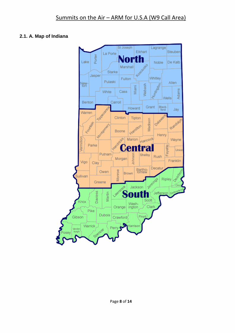
2.1. A. Map of Indiana
Summits on the Air – ARM for U.S.A (W9 Call Area)
Page 9 of 14
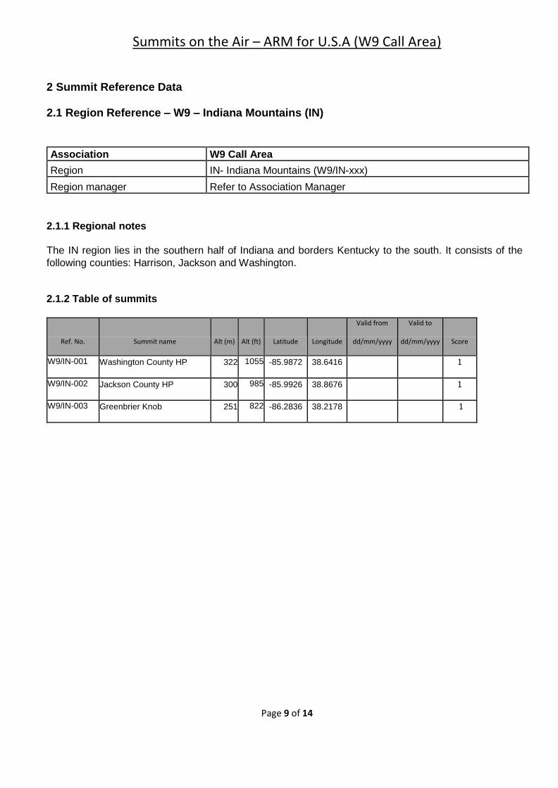
2 Summit Reference Data 2.1 Region Reference – W9 – Indiana Mountains (IN)
Association W9 Call Area
Region IN- Indiana Mountains (W9/IN-xxx)
Region manager Refer to Association Manager
2.1.1 Regional notes
The IN region lies in the southern half of Indiana and borders Kentucky to the south. It consists of the
following counties: Harrison, Jackson and Washington.
2.1.2 Table of summits
Ref. No. Summit name Alt (m) Alt (ft) Latitude Longitude
Valid from
dd/mm/yyyy
Valid to
dd/mm/yyyy Score
W9/IN-001 Washington County HP 322 1055 -85.9872 38.6416 1
W9/IN-002 Jackson County HP 300 985 -85.9926 38.8676 1
W9/IN-003 Greenbrier Knob 251 822 -86.2836 38.2178 1
Summits on the Air – ARM for U.S.A (W9 Call Area)
Page 10 of 14
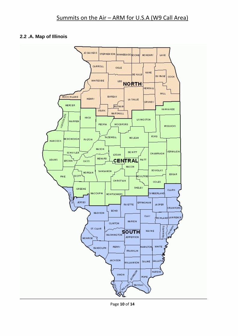
2.2 .A. Map of Illinois
Summits on the Air – ARM for U.S.A (W9 Call Area)
Page 11 of 14
2.2 Region Reference – W9 – Illinois Mountains (IL)
Association W9 Call Area
Region IL – Illinois Mountains (W9/IL-xxx)
Region manager Refer to Association Manager
2.2.1 Regional notes The IL region lies within southern half of Illinois with Indiana to the east, Missouri to west and Kentucky
to the south. It consists of the following counties: Gallatin, Jackson, Pope, Saline and Union.
2.2.2 Table of summits
Ref. No. Summit name Alt (m) Alt (ft) Latitude Longitude
Valid from
dd/mm/yyyy
Valid to
dd/mm/yyyy Score
W9/IL-001 Williams Hill 324 1064 -88.4756 37.5823 1
W9/IL-002 Bald Knob 314 1030 -89.3463 37.552 1
W9/IL-003 Horton Hill 308 1010 -88.4376 37.6247 1
W9/IL-004 Wamble Mountain 290 950 -88.455 37.611 1
W9/IL-005 High Knob 283 929 -88.3282 37.6004 1
W9/IL-006 Atwood Ridge 277 910 -89.3347 37.4251 1
W9/IL-007 Fountain Bluff 237 779 -89.487 37.6995 1
W9/IL-008 Wildcat Hills 234 768 -88.3432 37.7 1
W9/IL-009 Gold Hill 215 705 -88.214 37.6931 1
Summits on the Air – ARM for U.S.A (W9 Call Area)
Page 12 of 14
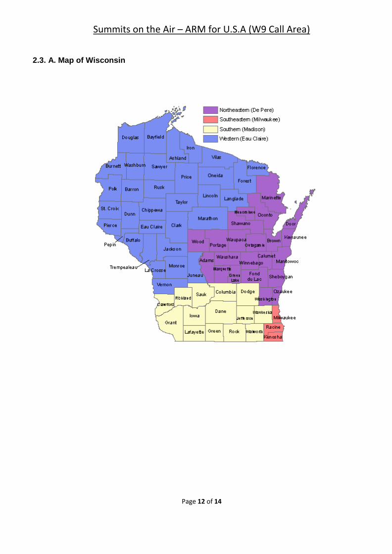
2.3. A. Map of Wisconsin
Summits on the Air – ARM for U.S.A (W9 Call Area)
Page 13 of 14
2.3 Region Reference – W9 – Wisconsin Mountains (WI)
Association W9 Call Area
Region Wisconsin Mountains (W9/WI-xxx)
Region manager Refer to Association Manager
2.4.1 Regional notes
The WI region lies in the Northeastern, Western and Southern sections of Wisconsin and borders Illinois to the south and Iowa and Minnesota to the west. It consists of the following 26 counties: Adams, Ashland, Bayfield, Buffalo, Chippewa, Clark, Columbia, Douglas, Dunn, Forest, Iowa, Iron, Jackson, Juneau, La Crosse, Lafayette, Lincoln, Marinette, Marathon, Monroe, Price, Rusk, Sawyer, Sauk, Trempealeau, and Washington. 2.4.2 Table of summits
Ref No. Summit name Alt (m) Alt (ft) Latitude Longitude
Valid from
Dd/mm/yyyy
Valid to
dd/mm/yyyy Score
Section
W9/WI-001 Timms Hill 595 1951 -90.1954 45.4509 6 W
W9/WI-002 Sugarbush Hill 591 1939 -88.8139 45.5577 6 W
W9/WI-003 Lookout Mountain 588 1930 -89.4824 45.4005 6 W
W9/WI-004 Rib Mountain 586 1924 -89.6951 44.9207 6 W
W9/WI-005 Whittlesey, Mount 572 1875 -90.6029 46.3022 6 W
W9/WI-006 1865 568 1865 -90.3599 46.4274 6 W
W9/WI-007 1825 556 1825 -90.7758 46.2894 6 W
W9/WI-008 Meteor Hill 549 1801 -91.3965 45.6883 6 W
W9/WI-009 Rusk County HP 535 1755 -91.4741 45.4923 6 W
W9/WI-010 Blue Mounds 524 1719 -89.8527 43.0282 6 S
W9/WI-011 McCaslin Mountain 503 1650 -88.3961 45.396 4 NE
W9/WI-012 Mosinee Hill 489 1605 -89.6504 44.8881 4 W
W9/WI-013 Sauk Point 486 1593 -89.654 43.4278 4 S
W9/WI-014 Flambeau Ridge 468 1535 -91.2164 45.2804 4 W
W9/WI-015 Happy Hill 454 1490 -89.862 43.3925 4 S
W9/WI-016 1475 450 1475 -91.2572 46.6652 4 W
Summits on the Air – ARM for U.S.A (W9 Call Area)
Page 14 of 14
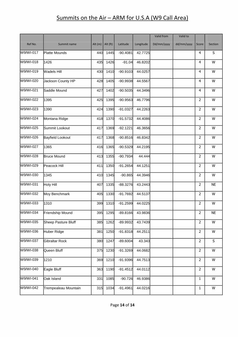
Ref No. Summit name Alt (m) Alt (ft) Latitude Longitude
Valid from
Dd/mm/yyyy
Valid to
dd/mm/yyyy Score
Section
W9/WI-017 Platte Mounds 440 1445 -90.4081 42.7725 4 S
W9/WI-018 1426 435 1426 -91.04 46.8202 4 W
W9/WI-019 Wadels Hill 430 1410 -90.9103 44.0257 4 W
W9/WI-020 Jackson County HP 428 1405 -90.9938 44.5567 4 W
W9/WI-021 Saddle Mound 427 1402 -90.5035 44.3496 4 W
W9/WI-022 1395 425 1395 -90.9563 46.7796 2 W
W9/WI-023 1390 424 1390 -91.0327 44.2263 2 W
W9/WI-024 Montana Ridge 418 1370 -91.5732 44.4086 2 W
W9/WI-025 Summit Lookout 417 1369 -92.1221 46.3656 2 W
W9/WI-026 Bayfield Lookout 417 1368 -90.8516 46.8342 2 W
W9/WI-027 1365 416 1365 -90.5329 44.2195 2 W
W9/WI-028 Bruce Mound 413 1355 -90.7934 44.444 2 W
W9/WI-029 Peacock Hill 411 1350 -91.2654 44.1251 2 W
W9/WI-030 1345 410 1345 -90.865 44.3946 2 W
W9/WI-031 Holy Hill 407 1335 -88.3276 43.2443 2 NE
W9/WI-032 Moy Benchmark 405 1330 -91.7692 44.5137 2 W
W9/WI-033 1310 399 1310 -91.2599 44.0225 2 W
W9/WI-034 Friendship Mound 395 1295 -89.8166 43.9836 2 NE
W9/WI-035 Sheep Pasture Bluff 385 1262 -89.9932 43.7439 2 W
W9/WI-036 Huber Ridge 381 1250 -91.8318 44.2511 2 W
W9/WI-037 Gibraltar Rock 380 1247 -89.6004 43.343 2 S
W9/WI-038 Queen Bluff 375 1230 -91.3269 44.0682 2 W
W9/WI-039 1210 369 1210 -91.9396 44.7513 2 W
W9/WI-040 Eagle Bluff 363 1190 -91.4512 44.0112 2 W
W9/WI-041 Oak Island 331 1085 -90.726 46.9386 1 W
W9/WI-042 Trempealeau Mountain 315 1034 -91.4961 44.0216 1 W