Embed Size (px)
Citation preview
Go HomeU.S. DEPARTMENT OF THE INTERIOR
U.S. GEOLOGICAL SURVEY
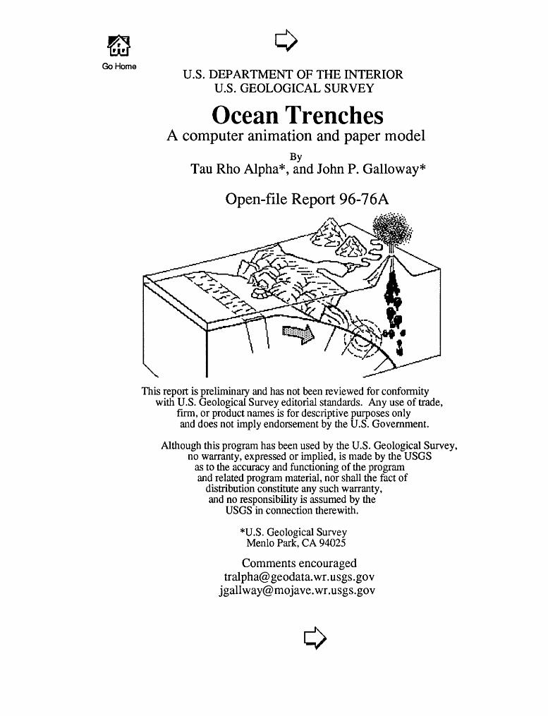
Ocean TrenchesA computer animation and paper model
ByTau Rho Alpha*, and John P. Galloway*
Open-file Report 96-76A
This report is preliminary and has not been reviewed for conformity with U.S. Geological Survey editorial standards. Any use of trade,
firm, or product names is for descriptive purposes only and does not imply endorsement by the U.S. Government.
Although this program has been used by the U.S. Geological Survey, no warranty, expressed or implied, is made by the USGS
as to the accuracy and functioning of the program and related program material, nor shall the fact of
distribution constitute any such warranty, and no responsibility is assumed by the
USGS in connection therewith.
*U.S. Geological Survey Menlo Park, CA 94025
Comments [email protected]
o
(go backward) < I l> (go forward)
Description of Report
This report illustrates, by means of computer animations and a paper model, how a subduction zone works. By studying the animations and the paper model, students will better understand the processes that operate at converging margins between tectonic plates and how ocean trenches and the volcanoes associated with them are developed.
Included in the paper and diskette versions of this report are templates for making the paper model, instructions for its assembly, a discussion of the lithosphere, asthenosphere, earth's plates, plate boundaries, and only in the diskette version, animations of sea-floor spreading.
Many people provided help and encouragement in the development of this HyperCard stack, particularly Art Ford and Tracy Vallier. This report was enhanced by the excellent reviews by Tracy Vallier, Donald Peterson and Jim Pinkerton.
Table of Contents for paper version of this report.Title page page 1Description of report page 2Teachers guide page 4Paper models page 22
(go backvand) <T"1 L^ (go forward)
Description of Report
Requirements for using the diskette version are: Apple Computer, Inc., HyperCard 2.2 software and an Apple Macintosh computer with a high-density drive. If you are using System 7, we recommend using at least 3 MB of RAM with 4500K of memory available for HyperCard.
The animation is accompanied by sound. If no sound is heard, change the memory of HyperCard to 4500K and ensure that the control panel "Sound," which is in the "Control Panels" folder under the "Apple" menu, has the volume set to at least 2. To change the memory available to HyperCard, quit this stack. Highlight the HyperCard program icon and choose "Get Info" from the File Menu. Change the "memory requirements" to 4500K and start this stack again.
Purchasers of the diskette version of this report, which includes all of the text and graphics, can use HyperCard 2.2 software (not supplied) to change the model (by adding geologic patterns, symbols, colors, etc.) or to transfer the model to other graphics software packages.
To see the entire page (card size: MacPaint), select "Scroll" fron the "Go" menu and move the hand pointer in the scroll window. If you are experiencing trouble with user-level buttons, select "message" fron the "Go" menu. Type "magic" in the message box and press return. Three more user-level buttons should appear.
The date of this Open File Report is 4/9/1996. OF 96-76-A, paoer copy,41p.; OF 96-76-B, 3.5-in. Macintosh 1.4-MB high-density diskette.
To order this report, contact:
USGS ESIC Open-File Report Section Box 25286, MS 517 Denver Federal Center Denver, CO 80225-0046
or call (303) 236-4476.
^ , ^ .« f To Table of Contents I H\ Teachers Guide: v___________/ H^
Page 1 of 19
INTRODUCTION
The Earth is far more dynamic than many people realize. Movement at tfr, edges of large, rigid slabs of the earth's outer shell account for many of the dynamic features of the earth's surface: mountain building, volcanic activity, and earthquakes. Movement of these large rigid slabs is explained by what is known as the theory of plate tectonics. Tectonics (Tektonikso = to construct) refers to the building of the earth's crustal features.
The concept of a dynamic earth evolved from an earlier model called "continental drift." In 1915 Alfred Wegener (a German meteorologist) presented abundant evidence suggesting that the continents moved great distan^s (thousands of kilometers) over time. Wegener viewed the continents as traveling across the ocean floor like rafts through the sea. Most scientists at the time believed the continents and ocean basins were fixed in a "locked" position, and because Wegener had not found satisfactory evidence for a mechanism governing how rigid continents could move through or across the ocean floor, his grand concept was not accepted by the mainstream of geologic thinkers. Even so, continental drift continued to be mentioned as a kind of aberration or curiosity among possible explanations for how continents are distributed across the surface of the earth.
In the early 1920's scientists had plotted enough earthquakes from around the world that a pattern became apparent. Earthquakes did not occur randomly over the Earth's surface. Instead, earthquakes were concentrated in zones that extended in lines along the Earth's crust. Several prominent earthquake zone? were mapped, which inclined 40-60° from the horizontal and extended tens and hundred of kilometers into the Earth. Two scientists, Wadati and Benioff, working separately, recognized the emerging pattern, they focussed their efforts to enhance and confirm the pattern and each of them convincingly demonstrated that the occurrence of earthquakes was not random. These zones were later named Wadati-Benioff zones in their honor. But what was the relation between these zones of earthquakes and the distribution of oceanic trenches and volcanoes?
To Table of Contents
Teachers Guide: Page 2 of 19
Exploration of the ocean floor in the 1950's and 60's produced a vast amount of scientific data. In the early 1960's great linear mountain ranges were mapped on the ocean floor. These mountain ranges were believed to be zones of weakness where the ocean floor was being ripped apart. Magma from deep within the Earth entered these zones of weakness and eventually erupted along the ridges to form new oceanic crust. Thus, "new" oceanic crust was being continually created along mid-oceanic ridges. Many geologists believe that the Earth has changed little in size since its formation 4.6 billion years ago. So how can new ocean crust be added along the mid-oceanic ridges without increasing the size of the Earth? In 1962, Harry Hess, a professor of geology at Princeton University, wrote a paper suggesting that some oceanic margins had been overridden by continents and the ocean sediments at those margins were pulled (or pushed) down, under the continents and nearby, the ocean floor became welded to the continents. This concept of "recycling" the oceanic crust into deep subduction zones and oceanic trenches had a profound effect on the development of the theory of plate tectonics.
This report illustrates how to build a model that can be used to teach one of the basic principles of plate tectonics, the collision of plate boundaries and the formation of trenches. It supplements a previously published computer animation and paper model on Sea-Floor Spreading which discusses the other two basic principles of plate tectonic theory, the formation of an oceanic ridge system (sea-floor spreading) and the formation of transform fault boundaries Published Open-file reports with animations and paper models can be found on page 20.
Teachers Guide: Page 3 of 19
STRUCTURE OF THE EARTH
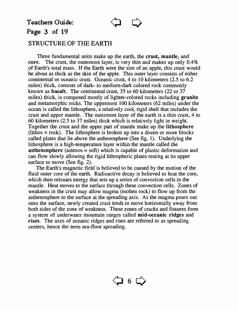
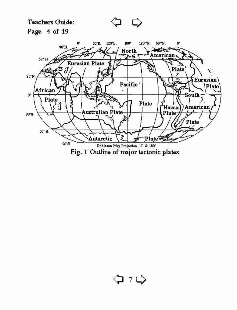
Three fundamental units make up the earth, the crust, mantle, and core. The crust, the outermost layer, is very thin and makes up only 0.4% of Earth's total mass. If the Earth were the size of an apple, this crust would be about as thick as the skin of the apple. This outer layer consists of either continental or oceanic crust. Oceanic crust, 4 to 10 kilometers (2.5 to 6.2 miles) thick, consists of dark- to medium-dark colored rock commonly known as basalt. The continental crust, 35 to 60 kilometers (22 to 37 miles) thick, is composed mostly of lighter-colored rocks including granite and metamorphic rocks. The uppermost 100 kilometers (62 miles) under the ocean is called the lithosphere, a relatively cool, rigid shell that includes the crust and upper mantle. The outermost layer of the earth is a thin crust, 4 to 60 kilometers (2.5 to 37 miles) thick which is relatively light in weight. Together the crust and the upper part of mantle make up the lithosphere (lithos = rock). The lithosphere is broken up into a dozen or more blocks called plates that lie above the asthenosphere (See fig. 1). Underlying the lithosphere is a high-temperature layer within the mantle called the asthenosphere (astenos = soft) which is capable of plastic deformation and can flow slowly allowing the rigid lithospheric plates resting at its upper surface to move (See fig. 2).
The Earth's magnetic field is believed to be caused by the motion of the fluid outer core of the earth. Radioactive decay is believed to heat the core, which then releases energy that sets up a series of convection cells in the mantle. Heat moves to the surface through these convection cells. Zones of weakness in the crust may allow magma (molten rock) to flow up from the asthenosphere to the surface at the spreading axis. As the magma pours out onto the surface, newly created crust tends to move horizontally away from both sides of the zone of weakness. These zones of cracks and fissures form a system of underwater mountain ranges called mid-oceanic ridges and rises. The axes of oceanic ridges and rises are referred to as spreading centers, hence the term sea-floor spreading.
Teachers Guide: Page 4 of 19
o90'N.
0" 60'E. 120'E. 180' 120'V. 60'V.
60'N
30'N.
30'S.
.Nazcal)American PlateAustralian Plate
\ ~\
60'S.
90-8Eoliiison Mkp Projection 0' & ISO'
Fig. 1 Outline of major tectonic plates
Teachers Guide: Page 5 of 19
Divergentboundary
Convergent ^ Convergentboundary ________ _ boundaryTrench Trench
Lithosphere
Oi:^V:-': '!'/." " ' ' ^ ' ' ' : vy-\Vj :.; (£:>:;« ^::^:; - ' Core ^V:
Fig. 2 Asthenosphere convection.
DEFORMATION OF THE CRUST
The deformation of rock is determined by three factors: (1) temperature, (2) pressure, and (3) rate at which a deforming force (stress) is applied. When force is applied to a solid mass, such as the rigid shell of the earth, the crust, several things can happen. The solid mass is either (1) squeezed (compression), (2) pulled apart (tension) or (3) slides (shear). Geologists now recognize three distinctive boundaries between crustal plates. These boundaries are usually marked by earthquakes, volcanism, and rugged mountain topography. The three types of plate boundaries are known as (1) convergent boundaries, (2) divergent boundaries, and (3) transform plate boundaries. Crustal blocks are squeezed (compressed) at convergent boundaries, pulled apart (tension) at divergent boundaries, and slide past each other (shear) at transform boundaries.
Teachers Guide: Page* 6 of 19
COLLISION OF PLATE BOUNDARIES
Crust is destroyed where two plates meet. This type of "collision" boundary is known as a convergent plate boundary. Earthquakes and volcanic activity are concentrated near this boundary. The destructive "recycling" of crust occurs at a convergent plate boundary. Three types of collision can occur: 1) oceanic-continental convergence; 2) oceanic-oceanic convergence; and 3) continental-continental convergence.
Oceanic-continental convergenceAs dense oceanic crust collides with the less dense continental crust, the
oceanic plate generally slides beneath the continental plate, and, along the line of contact an ocean trench may form. An example of oceanic-continental convergence is where the South American Plate meets the Pacific's Nazca Plate. The relatively light continental lithosphere rides up and over the heavier oceanic lithosphere of the Nazca Plate. The Nazca Plate is subducted into a long, deep, narrow trench that parallels the west coast of South America. The downward movement of the plate produces earthquakes. Earthquakes trace the path of the plate as it pulled down into the asthenosphere. The Wadati-Benioff zone represents this zone of downward movement where the plate is being subducted. As the oceanic plate melts, magma is formed that rises through zones of weakness in the over-riding continental crust, causing volcanoes to form. Me ^t of the active volcanoes of Central and South America are a result of this process.
Oceanic-oceanic convergenceWhat happens when two oceanic plates converge? Usually one of the oceanic
plates is older. The older plate is cooler and denser than the younger plate. T% °, denser plate will slide beneath the younger plate, and the downward movement of the plate forms deep oceanic trenches. As the denser oceanic plate and its sediments melt, magma is formed and rises to the seafloor forming a curving chain of volcanic islands called "island arcs". These volcanic island arcs closely parallel oceanic trenches. Examples include the Marianas and the Aleutian trenches.
Teachers Guide: \JjPage 7 of 19
Continental-continental convergenceAlthough not discussed in this report, there is a third type of convergent plate
boundary. When continents collide, the plates are compressed, folded, and uplifted to form mountain ranges such as the Himalayas or the Swiss Alps. TI~e collision of India into Asia 50 million years ago caused the Eurasia Plate to buckle and override the Indian Plate.
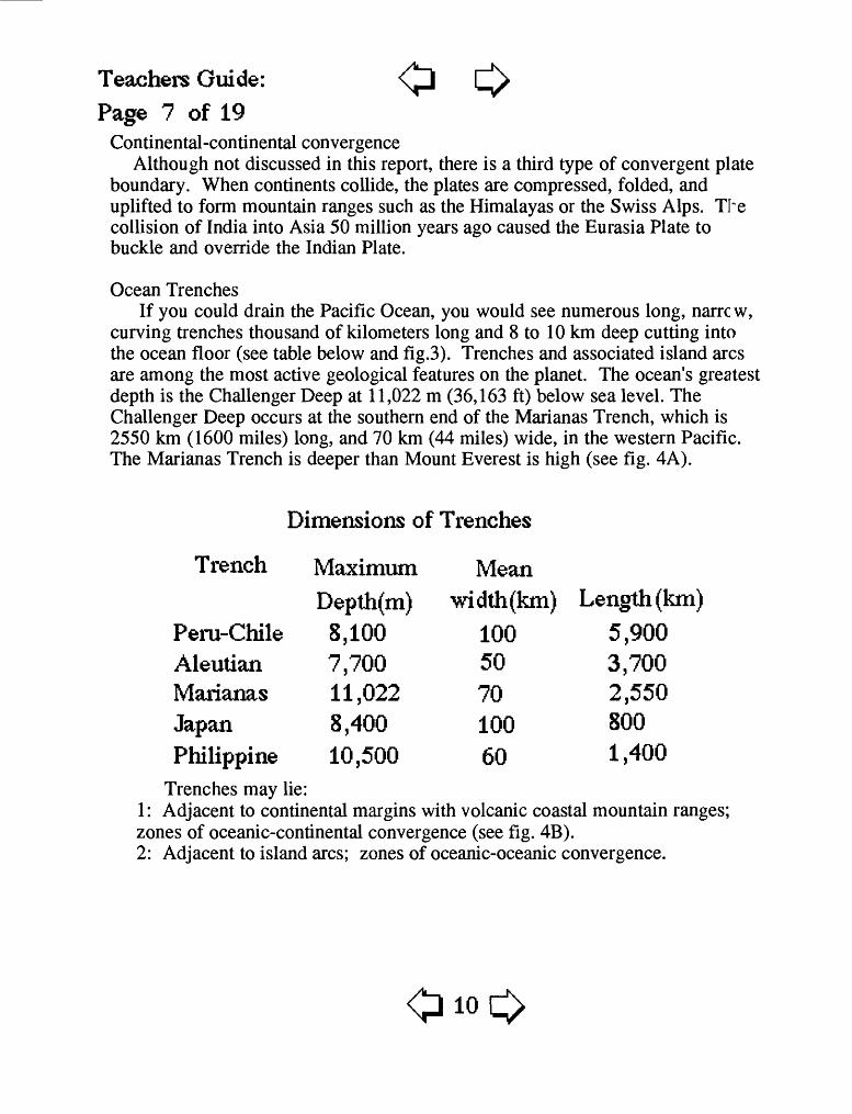
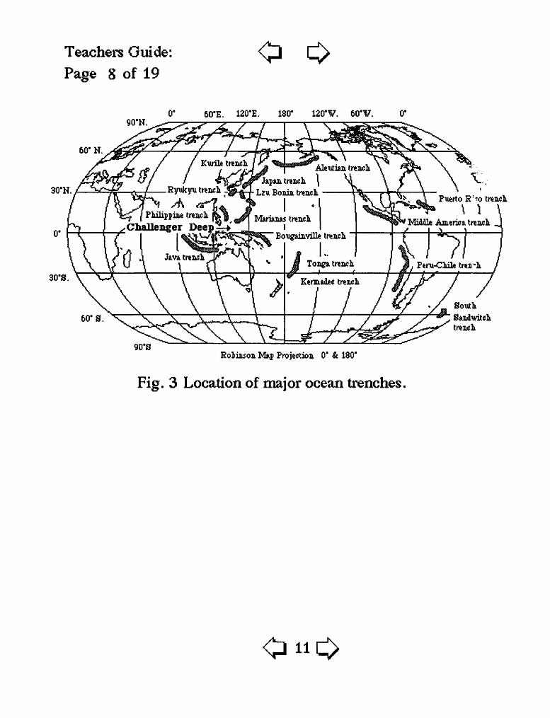
Ocean TrenchesIf you could drain the Pacific Ocean, you would see numerous long, narrc w,
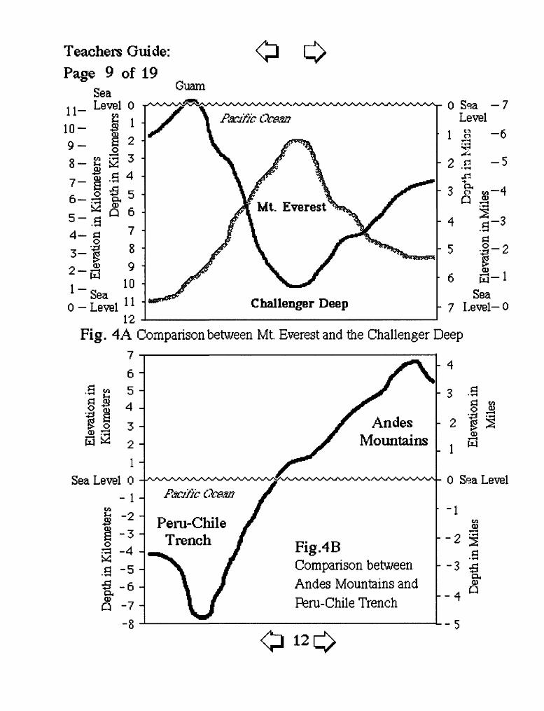
curving trenches thousand of kilometers long and 8 to 10 km deep cutting into the ocean floor (see table below and fig.3). Trenches and associated island arcs are among the most active geological features on the planet. The ocean's greatest depth is the Challenger Deep at 11,022 m (36,163 ft) below sea level. The Challenger Deep occurs at the southern end of the Marianas Trench, which is 2550 km (1600 miles) long, and 70 km (44 miles) wide, in the western Pacific. The Marianas Trench is deeper than Mount Everest is high (see fig. 4A).
Dimensions of Trenches
Trench Maximum Depth(m)
8,100 7,700 11,022 8,400 10,500
Mean width(km) Length (km)
Peru-Chile 8,100 100 5,900Aleutian 7,700 50 3,700Marianas 11,022 70 2,550Japan 8,400 100 800Philippine 10,500 60 1,400
Trenches may lie:1: Adjacent to continental margins with volcanic coastal mountain ranges; zones of oceanic-continental convergence (see fig. 4B). 2: Adjacent to island arcs; zones of oceanic-oceanic convergence.
Teachers Guide: Page 8 of 19
0
90'N.60'E. 120'E. 180' 120'V. 60'V.
60'N.
30'N.
30'S.
Rynkyu trench _^£1 Lzu Bonia traiwhPuerto R : -!o trench.
\Miidle America. trencL. ^
Philippine Challenger Deep
Projection 0' & 180'
Fig. 3 Location of major ocean trenches.
Teachers Guide: Page 9 of 19
o oGuam
Challenger Deep1-
0 LevelSea
Level- 0
Fig. 4A Comparison between Mt. Everest and the Challenger Deep76 -
.a g 5-
£ ,0 3
S 2 2
1 Sea Level 0
- 1 -\wS "2
3 "4 S "^a -6 P*CDQ -7
-8
Andes Mountains
Pacific Oe&w
Peru-Chile Trench Fig.4B
Comparison between Andes Mountains and Fteru-Chile Trench
£H M O ^j
- 2 g^CD
0 Sea Level
-1
-2 ?
PuCD
Q
-5
Teachers Guide: Page 10 of 19
Unsolved Problems
The theory of plate tectonics explains much about the dynamics of the Earth and the formation of the ocean basins, volcanoes, and mountain ranges. But many unsolved problems remain.
Oceanic-continental convergence sustains many of the Earth's active volcanoes, such as those bordering the rim of the Pacific Ocean. This eruptive activity is clearly associated with the process of subduction. Yet geologists st'll debate the possible source of the magma. Is the magma generated by the partial melting of the subducted oceanic slab or the overlying continental lithosphere or both?
The prevailing explanations about what drives plate tectonics have emphasized a mantle convection model with seafloor spreading as the primary force. Sone scientists are now looking at the forces associated with subduction as being more important than seafloor spreading. They propose that the gravity-controlled sinking of a cold oceanic slab into a subduction zone (called "slab pull") may drag the rest of the plate with it and is the driving force of plate tectonics. Perhaps both mechanisms play a role.
Are the movements of plates due entirely to motion in the asthenosphere? Or are other types of convection cells involved?
Will the process of seafloor spreading and subduction continue indefinitely ? Have they occurred throughout the 4.6 billon years of earth history? Do plate movements occur in cycles?
Teachers Guide: Page 11 of 19
Fundamental Concepts
"SCIENTIFIC LITERACY FOR ALL STUDENTS is a National goal. The National Science Education Standards are a contribution toward achieving that goal." (Draft, November 1994, National Science Education Standards, prepared by the National Research Council, National Academy of Science)
After building this model and reading the text all students should have developed a basic understanding of the following fundamental concepts for Earth and Space Science as recommend in the National Science Education Standards. These fundamental concepts for grades 5-8 and 9-12 are highlighted below.
Grades 5 - 8
+ The solid Earth is layered, with a thin brittle crust, a hot convecting mantle, and a dense metallic core.
+ Crustal plates on the scale of continents and oceans constantly move. Major geologic events, such as earthquakes, volcanic eruptions, and mountain building, result from these plate motions.
+ The Earth processes we see today are similar to those that occurred in the past.
Grades 9-12
+ The outward transfer of Earth's internal heat drives convection circulation in the mantle which propels the crustal plates.
+ Geologic time can be estimated by observing rock sequences.
Teachers Guide: Page 12 of 19
Why study Plate tectonics and subduction ?
Many of the world's geologic hazards are directly related to the movement of oceanic plates. Geologic hazards are those hazards that pose a danger to human life and can cause widespread destruction of buildings and roads. Mary of the major geologic events, such as earthquakes, volcanic eruptions and mountain building are the direct result of the movement of crustal plates. Trn worldwide distribution of earthquakes and volcanoes on the ocean floor is not random but is linked to the movement of oceanic plates. A large earthquake occurring offshore may generate tsunamis (seismic sea waves) that can kill thousands of people and destroy cities that are located near the coast. The study of sea-floor spreading and subduction helps geologists understand the distribution of earthquakes and volcanoes. This knowledge can help scientists and decision makers reduce the potential damage caused by earthquakes and volcanic eruptions. As the oceanic plates are subducted under continental plates, a system of deep ocean trenches and volcanoes is formed. These trenches and volcanoes snake their way around the edges of the continents. It is FUN to krow that there are deep trenches on the ocean floor and to learn why and how mountains, earthquakes, and volcanoes are associated with, and influenced by, the processes that produce sea-floor trenches.
Teachers Guide: Page 13 of 19
Questions
Is the floor of the ocean flat? Where are the deepest features of the ocean flc or located?
Are the plates that make up the Earth's crust located on land or in the oceans? What is the largest plate?
Are trenches located at the edges of plates or in the middle of plates?
Are trenches a single point, curved features, or linear features?
Is plate tectonics a recent process or has it been going on for most of Earth's history?
Are volcanoes associated with oceanic trenches?
Are earthquakes associated with subduction and oceanic trenches?
Is there a pattern to the worldwide distribution of earthquakes, volcanoes, and oceanic trenches?
Teachers Guide: Page 14 of 19
GLOSSARY
Asthenosphere: (astenos = soft) A weak, high-temperature plastic layer underlying the lithosphere which is capable of plastic deformation and can flow slowly, allowing the rigid lithospheric plates resting at its upper surface to move.
Basalt: A dark- to medium-dark colored igneous (volcanic) rock.
Continental Drift: A general term used to describe the movement or displacement of the continents by sea floor spreading.
Convergent Plate Boundary: A region where plates are pushed together or collide. This is a region where a mountain range, island arc (volcanic islands), and/or trench will form.
Core: The central zone of the Earth's interior. Earth's magnetic field originates in the core. Part of the three fundamental units which make up the Earth, the crust, mantle, and core.
Crust: The thin outermost layer of the Earth. The crust is 4 to 60 kilometer? (2.5 to 37 miles) thick. Part of the three fundamental units make up the Eartl, the crust, mantle, and core.
Earthquakes: A sudden shaking of the Earth caused by the abrupt release of stress which had been slowly accumulating (by faulting) or by volcanic eruptions.
Geomagnetic time scale: A chronology based on counting the reversals of the Earth's magnetic field.
Granite: A rock that has cooled slowly from a magma, in contrast to basalt, which cooled very rapidly from a magma. Granitic rocks make up the continental crust and basaltic rocks make up oceanic crust.
Lithosphere: The uppermost 700 kilometers (435 miles) of the Earth is called the lithosphere, a relatively cool, ridged shell that includes the crust and upper mantle.
Teachers Guide: Page 15 of 19
Magma: Hot molten rock generated within the Earth.
Mantle: The zone of the Earth below the crust. Part of the three fundamental units which make up the Earth, the crust, mantle, and core.
Mid-oceanic ridges and rises: A series of cracks forming a system of underwater mountain ranges called mid-oceanic ridges and rises. The axes of oceanic ridges and rises are referred to as spreading centers, hence the term sea floor spreading.
Subduction: The downward movement of a lithospheric plate into the asthenosphere.
Theory of plate tectonics: A global model of the Earth based on the movement of crustal plates (oceanic and continental).
Trench: An arc-shaped depression in the deep-ocean floor with very steep sic^s. Trenches are associated with subduction zones and commonly occur in the Pacific Basin.
Transform faults: As newly formed oceanic crust (lithosphere) moves away from the axis of an ocean ridge, it travels perpendicular to the axis. Movement along these breaks offsets the ridge axis, producing transform faults. A transform fault represents active displacement of the axes, where one plate slides past another.
Teachers Guide: Page 16 of 19
Further Reading
Anonymous, 1994, A Correlated History of the Earth, 1 sheet, Pan Terra Inc., P.O. Box 392, Afton, MN, 55001.
Garrison, Tom, 1993, Oceanography ~ An Invitation to Marine Science, Wadsworth Publishing Company, 540 p.
Kious, W.J., and Tilling, R.I., 1996, This Dynamic Earth: The story of Plate Tectonics: U.S. Geological Survey, 77 p.
Moores, E.M., 1990, Shaping the Earth ~ Tectonics of Continents and Oceanr: Readings from Scientific American, 206 p.
Plumer, C.C. and McGeary, David, 1991, Physical geology, 5th ed., Wm. C. Brown, Publishers, 543 p.
Simkin, Tom, Unger, J.D., Tilling, R.I., Vogt, P.R., and Spall, Henry, compilers, 1994, This Dynamic Planet: World map of volcanoes, earthquakes impact craters and plate tectonics: 1 sheet, U.S. Geological Survey. Note: In addition to the map's visually obvious physiographic features that relate to plate tectonics, the explanatory text gives a concise summary of how plate tectonics work.
Thurman, H.V., 1993, Essentials of Oceanography, 4th ed., Macmillan Publishing Company, 393 p.
Teachers Guide:
Page 17 of 19 Additional Models and Animations
Alpha, Tau Rho, 1989, How to construct two paper models showing the effects of glacial ice on a mountain valley: U. S. Geological Survey Open-File Report 89-190 A&B (Available as a 3.5-in. MACINTOSH disk or a 30-p. report)
Alpha, Tau Rho, Lahr, John C., and Wagner, Linda F., 1989, How to construct a paper model showing the motion that occurred on the San Andreas fault during the Loma Prieta, California, earthquake of October 17, 1989: U. S. Geological Survey Open-File Report 89-640A&B (Available as a 3.5-in. MACINTOSH disk or a 10-p. report)
Alpha, Tau Rho, and Lahr, John C., 1990, How to construct seven paper models that describe faulting of the Earth:
U. S. Geological Survey Open-File Report 90-257 A&B (Available as a 3.5-in. MACINTOSH disk or a 40-p. report)
Alpha, Tau Rho, 1991, How to construct four paper models that describe island coral reefs: U. S. Geological Survey Open-File Report 91-131A&B (Available as a 3.5-in. MACINTOSH disk or a 19-p. report)
Teachers Guide:
Page 18 of 19 Additional Models and Animations
Alpha, Tau Rho , and Gordon, Leslie C., 1991, Make your own paper model of a volcano: U.S. Geological Survey Open-File Report 91-115A&B (Available as a 3.5. MACINTOSH disk or a 4-p. report)
Alpha, Tau Rho, Page, Robert A., and Gordon, Leslie C., 1992, Earthquake effects, a computer animation and paper model: U. S. Geological Survey Open-File Report 92-200A&B (Available as a 3.5-in. MACINTOSH disk or a 4-p. report)
Alpha, Tau Rho, Starratt, Scott W. and Chang, Cecily C., 1993, Make your own Earth and tectonic globes: U. S. Geological Survey Open-File Report 93-380A&B (Available as a 3.5- in. MACINTOSH disk or a 14-p. report)
Alpha, Tau Rho, and Stein, Ross S., 1994, Make your own paper model of the Northridge, California, earthquake, January 17, 1994: U. S. Geological Survey Open-File Report 94-143 4-p.
Alpha, Tau Rho, and Stein, Ross S., 1994, The Northridge, California, Earthquake of January 17, 1994: A computer animation and paper model: U. S. Geological Survey Open-File Report 94-214A&B. (Available as a 3.5-in. MACINTOSH disk or
a 30-p. report).
Teachers Guide: \^ f To Table of Contents j
Page 19 of 19 Additional Models and Animations
Alpha, Tau Rho, Starratt, Scott W., Hendley, James W., II, 1994, Make your own paper fossils, a computer animation and paper models: U.S. Geological Survey Open-File Report 94-667A&B. (Available on 3.5 MACINTOSH disk or a 42 p. report)
Alpha, Tau Rho, Galloway, John P., Bonito, Mark V., 1995, Sea-Floor Spreading, a computer animation and paper model:
U.S. Geological Survey Open-File Report 95-573A&B. (Available on 3.5 MACINTOSH disk or a 35 p. report)
Alpha, Tau Rho, and Reimnitz, Erk, 1995, Arctic Delta Processes, a computer animation and paper models: U.S. Geological Survey Open-File Report 95-843A&B. (Available on 3.5 MACINTOSH disk or a 27 p. report)
To order these reports, contact:
USGS Open-File Report Section Box 25286, MS 517 Denver Federal Center Denver, CO 80225-0046
or call (303)-202-4651. or FAX, (303)-202-4695
To Table of Contents
Fold
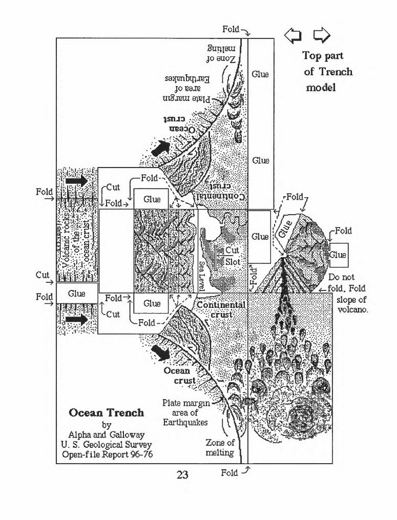
Top part of Trench model
V X IE*E?.£ J* W Jr
5^ /.Continental
Plate margin -^y^c Ocean Trench area of
by Earthquakes I (V-^jAlpha and Gallovay ^ \7
U. S. Geological Survey Zone ofOpen-file Report 96-76 melting
Do notfold. Fold
slope of volcano.
Sg Volcanic rocks -^jl^.^uV-.'rtf'fWp" ' iV.-*rt*i .;_._ . . JJi :.U.DC_, _ -^ !*
^V'-[bjbB^5cr^'t;:j;iS^^i>^^rf;mjti^V~ ;j-'-'|X^I^
rr.*. -r.-x jSli^^up^iT*
r^-^.^?SS^:^::':;J3;(siafrI^-ysiafgSiipiJ^^
rr:|^g?5-\ocean!crust : ?!^S.J? »! ..-...- .. S i . TT^.r s /"ci'ez?
.yafg^pgy^-.v^
tjig^pijjgiggl^^
^^ yy ^ |_^^. .".^jj^'r.". .'..T^y fcyPT^^^Y*6"^^-^JPI I' 1 f '' ''** "^-4^
^ U'JS * -x^^fiivr
g?'':'A'.'.'v'Xf flip''-''^.'-^..^^
^T^o.yL j :£'£S.£a£ *f i- _ "jt j^^^nvs " AMV ^^^4 «i*^I'-«Bl
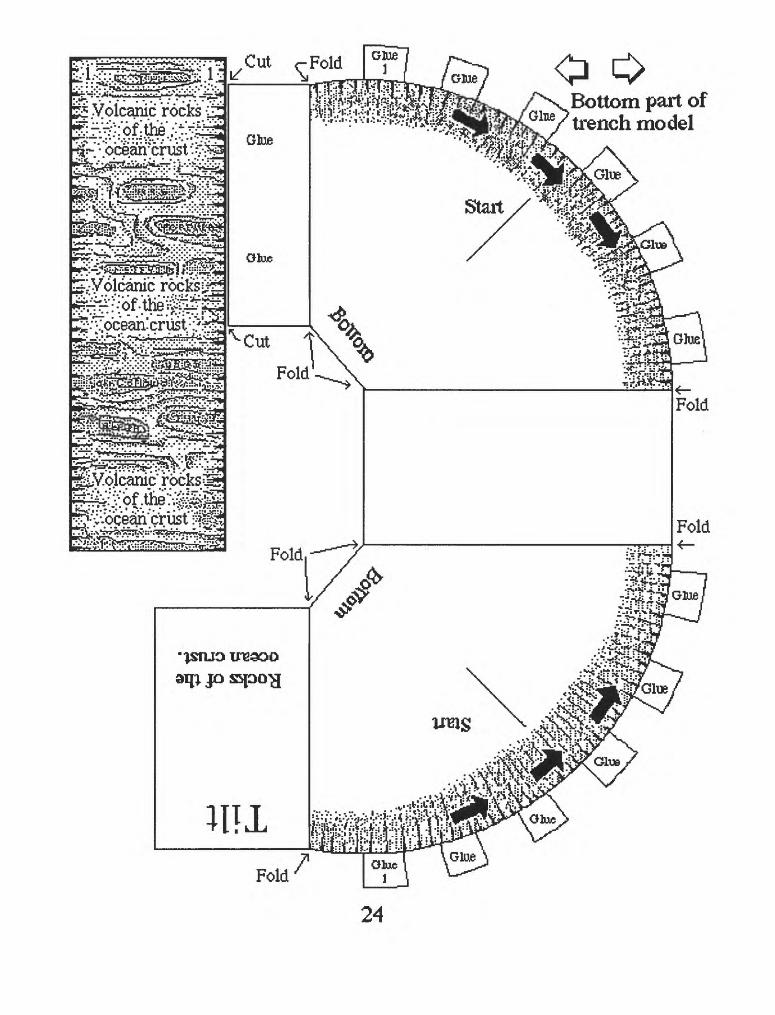
Cut oBottom part of toench model
Fold
24
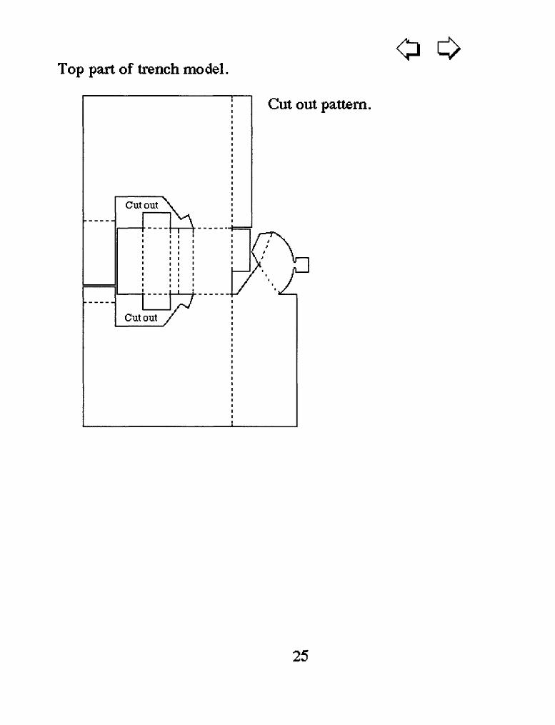
Top part of trench model.o
Cut out pattern.
25
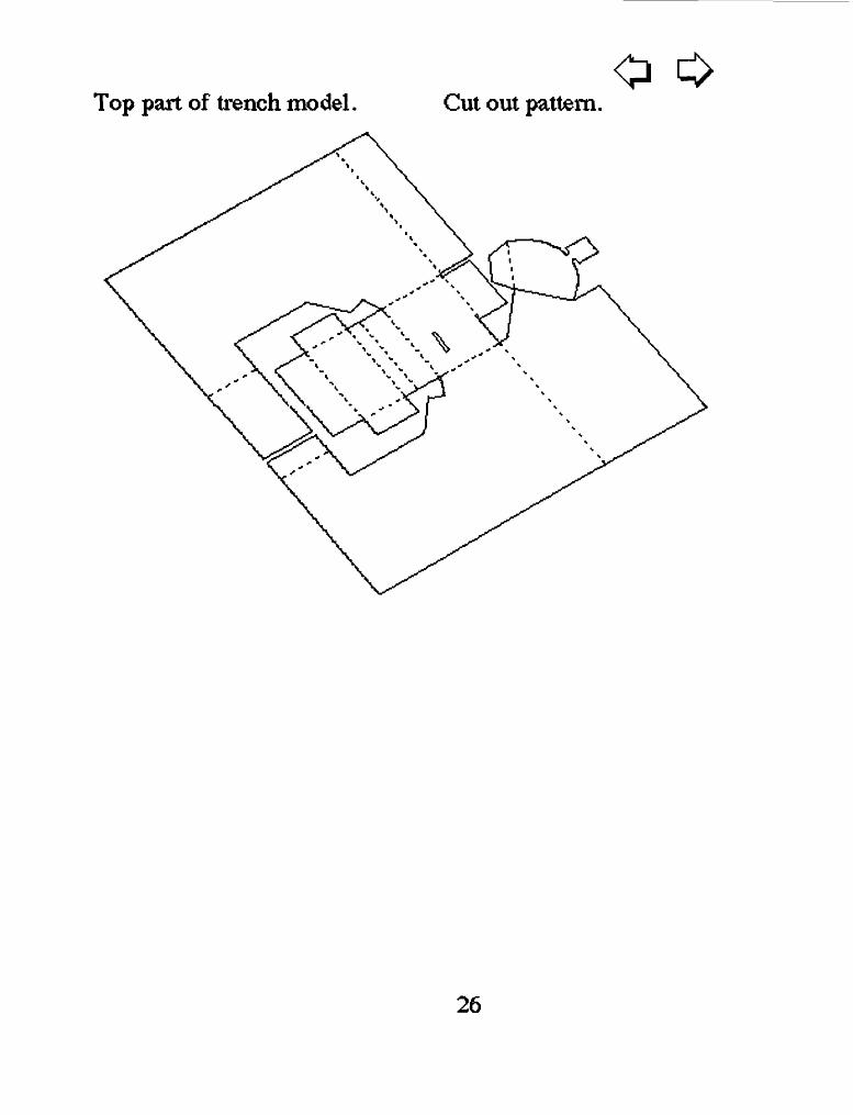
Top part of trench model. Cut out pattern.o
26
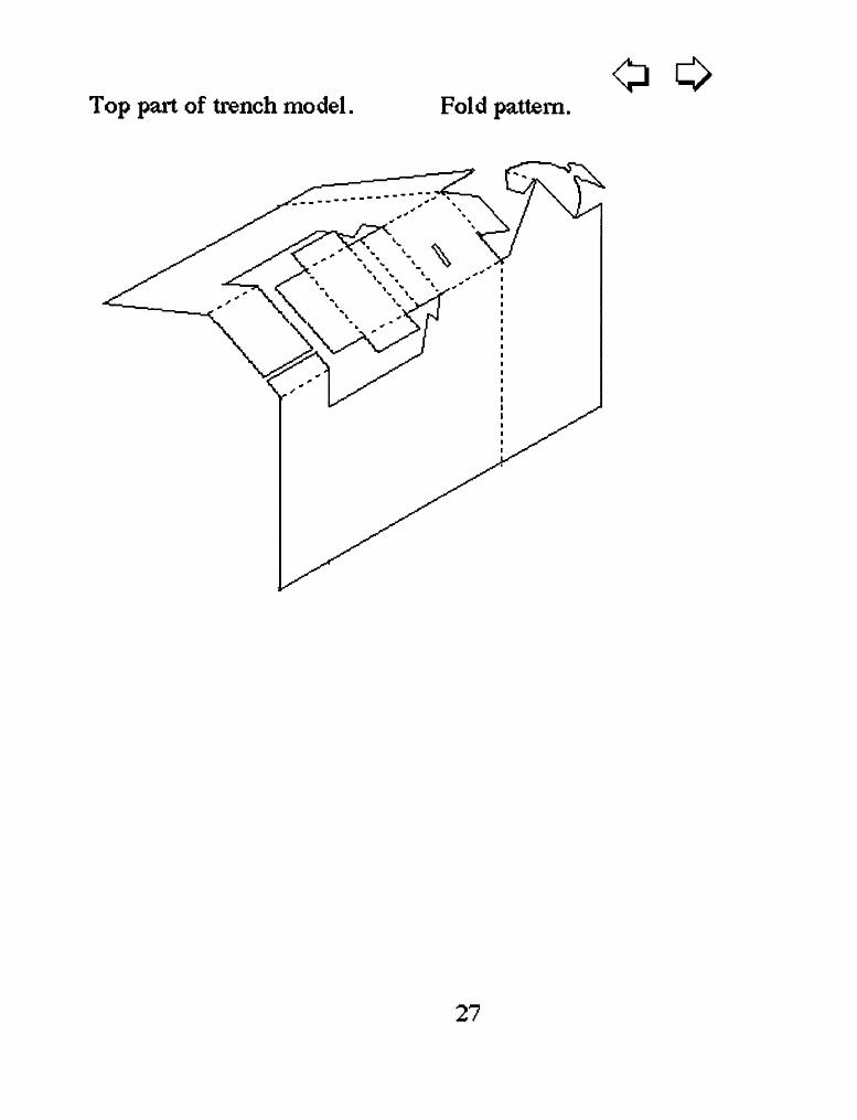
Top part of trench model. Fold pattern.0
27
Top part of trench model.o
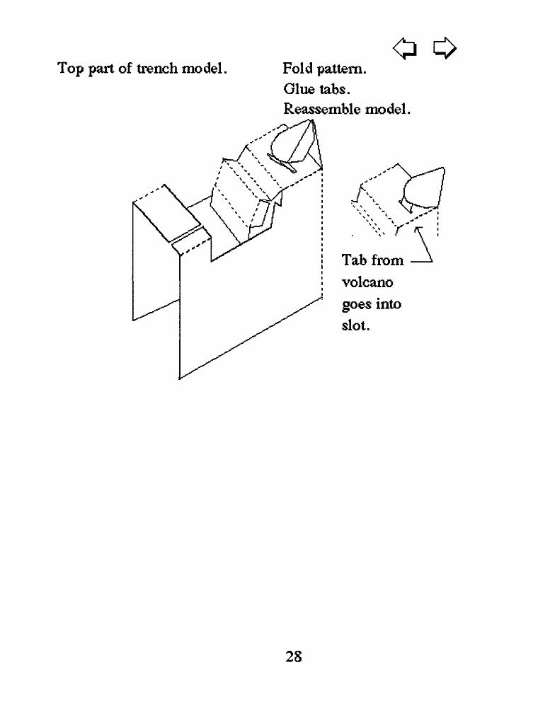
Fold pattern. Glue tabs. Reassemble model.
A
Tab from volcano goes into slot.
28
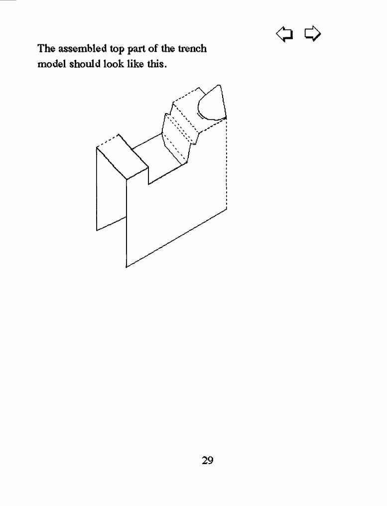
The assembled top part of the trench model should look like this.
o
29
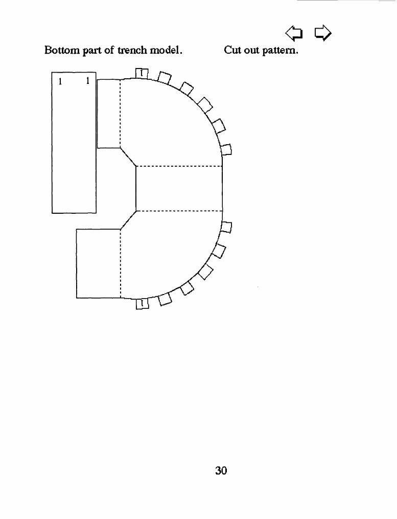
Bottom part of trench modelo
Cut out pattern.
30
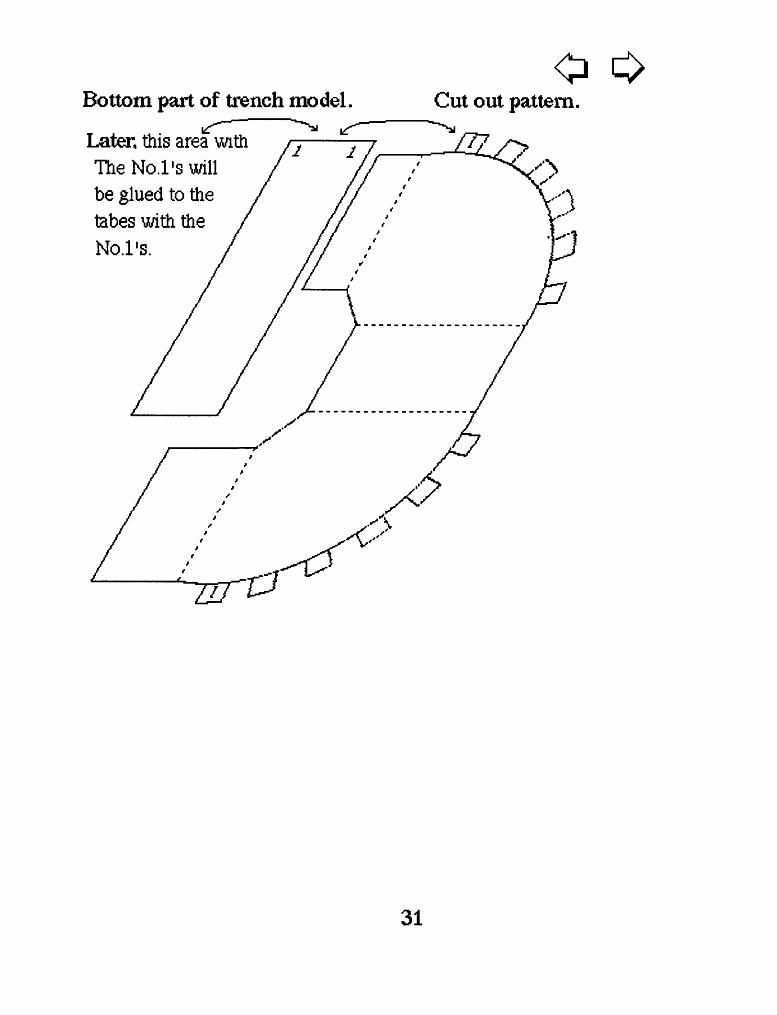
Bottom part of trench model.
Later, this area with The No.l's will be glued to th tabes with the No.l's.
oCut out pattern.
31
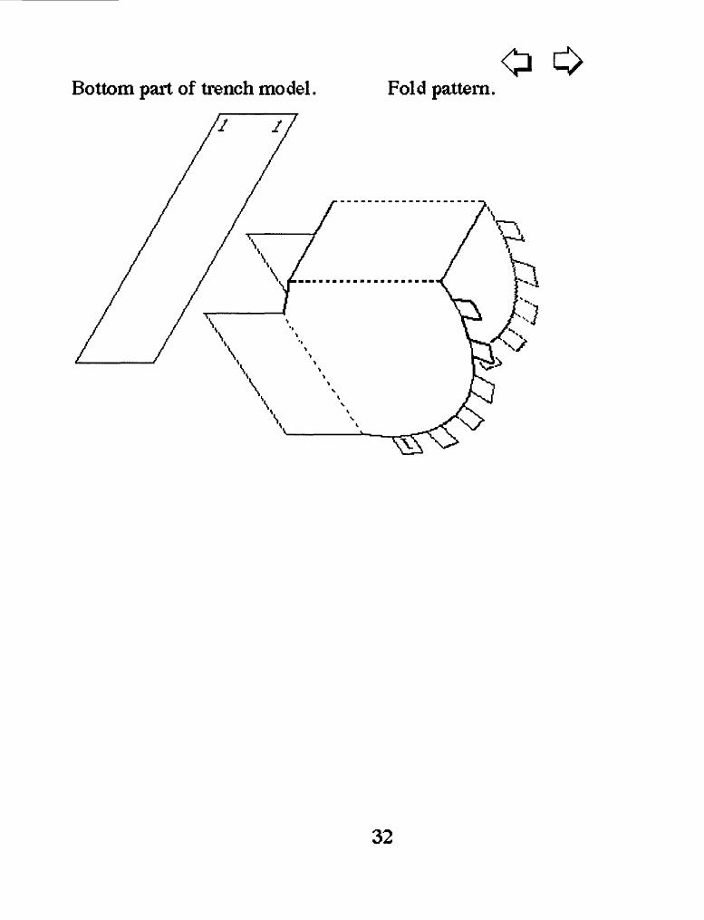
Bottom part of trench model. Fold pattern.
32
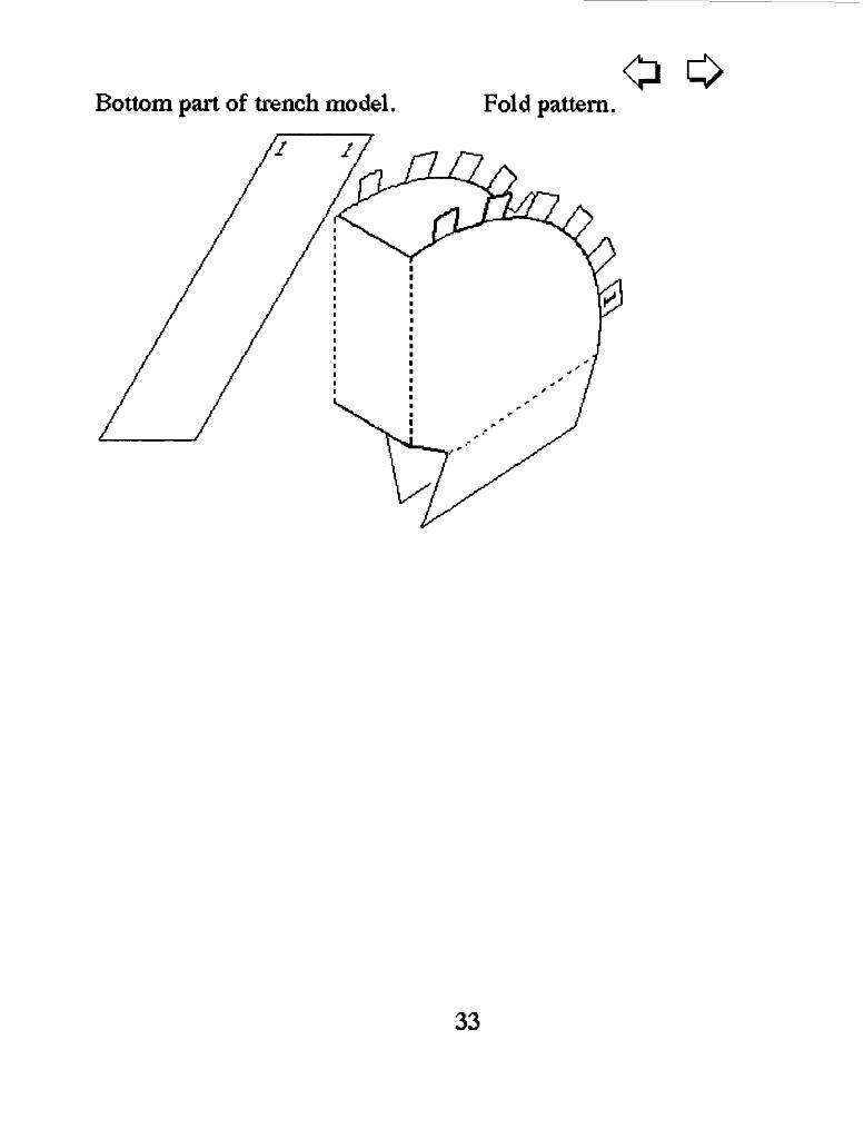
Bottom part of trench model. Fold pattern.o
33
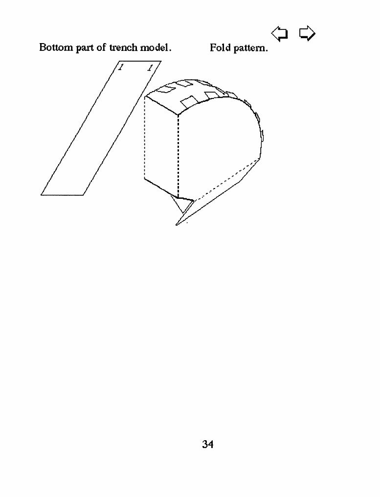
Bottom part of trench model. Fold pattern.o o
34
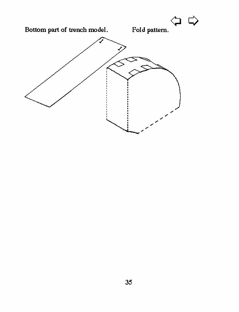
Bottom part of trench model. Fold pattern
35
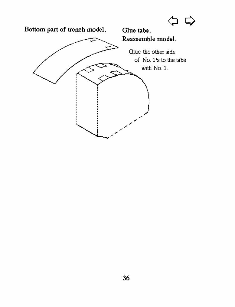
Bottom part of trench modelo
Glue tabs. Reassemble model.
Glue the other side of No. 1's to the tabs
with No. 1.
36
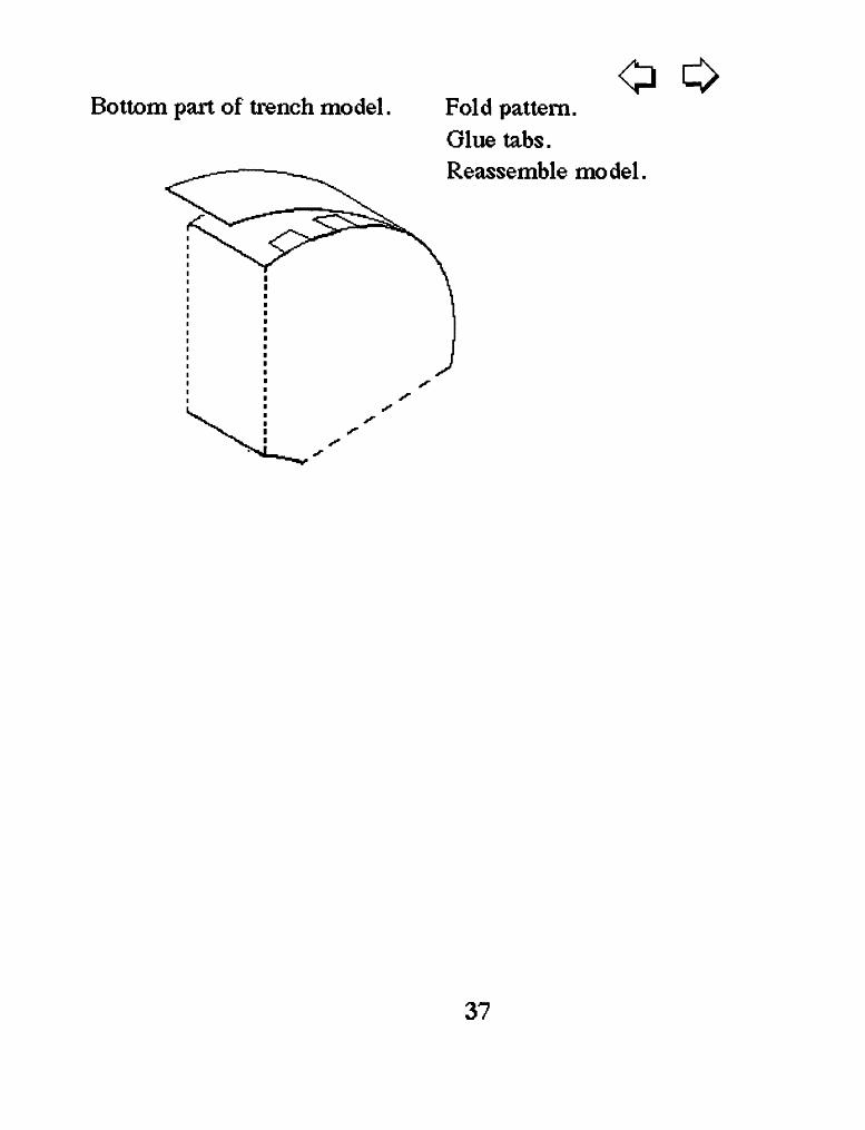
Bottom part of trench model.o
Fold pattern. Glue tabs. Reassemble model.
37
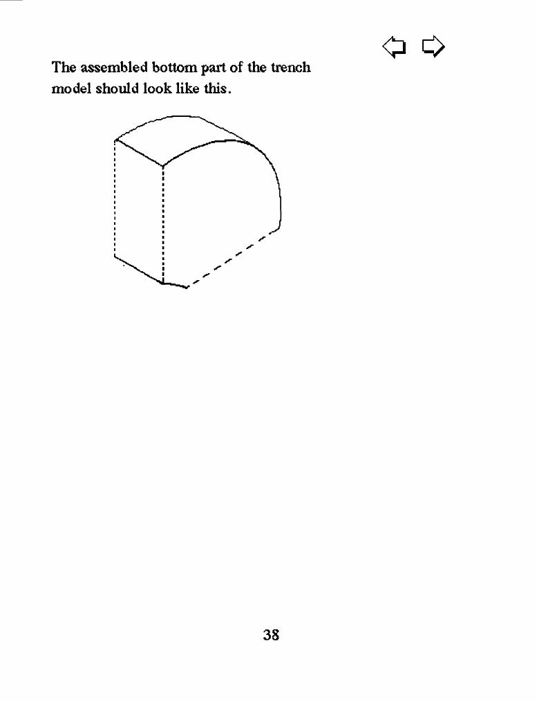
The assembled bottom part of the trench model should look like this.
38
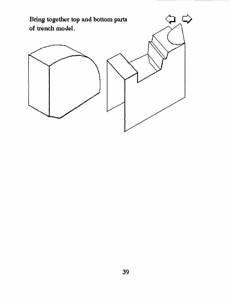
Bring together top and bottom parts of trench mo del.
39
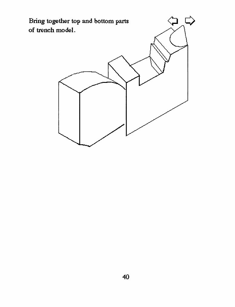
Bring together top and bottom parts of trench mo del.
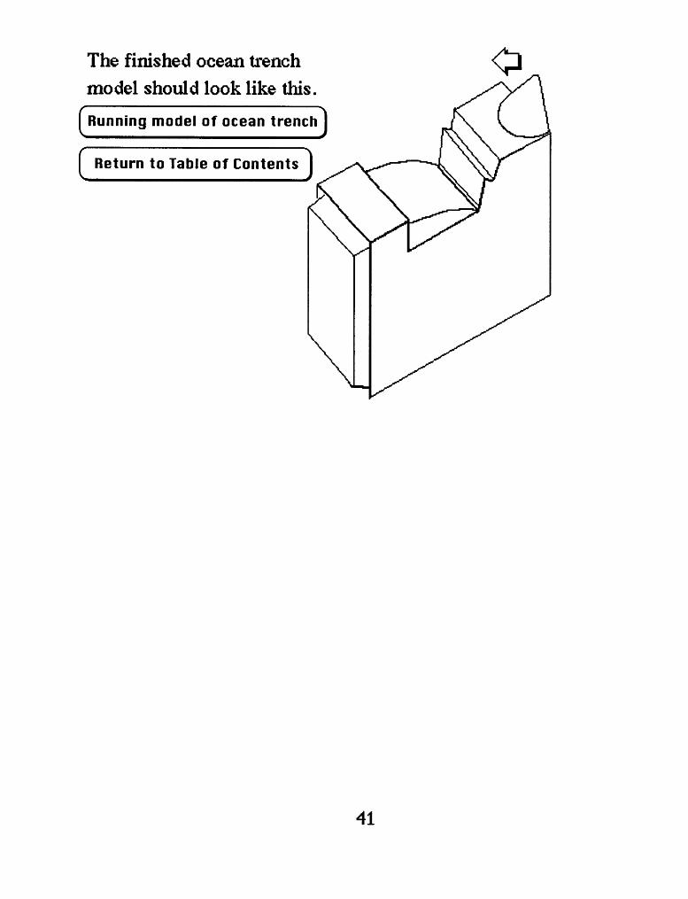
The finished ocean trench model should look like this.
[ Running model of ocean trench I
c Return to Table of Contents
41