Embed Size (px)
Citation preview
US-20/SH-75 (TIMMERMAN JUNCTION) INTERSECTION STUDYFINAL REPORT - NOVEMBER 2016
US 20 SH 75TIMMERMAN JUNCTION
&Intersection Study
US-20/SH-75 (TIMMERMAN JCT.) INTERSECTION STUDYNovember 2016
Prepared for:
Idaho Transportation Department
Prepared by:
Kittelson & Associates, Inc.
In association with:
RBCI
US-20/SH-75 (Timmerman Jct.) Intersection Study
| i
TABLE OF CONTENTS
Preface .....................................................................................................................................iv
Acknowledgments ......................................................................................................................ivStudy Management Team ............................................................................................................... ivCommunity Advisory Committee .................................................................................................... iv
Supporting Documentation ......................................................................................................... vTechnical Appendix Table of Contents ............................................................................................. vStudy Website ................................................................................................................................. v
Introduction ................................................................................................................................ 2Background & History .................................................................................................................... 2Study Purpose & Need .................................................................................................................... 4Study Goals & Objectives ................................................................................................................ 5Study Timeline ................................................................................................................................. 6
Existing Conditions ...................................................................................................................... 8Transportation Facilities .................................................................................................................. 8Adjacent Properties ......................................................................................................................... 9Environmental Considerations......................................................................................................... 9Historical Crash Data Analysis ......................................................................................................... 9Existing Traffic Conditions .............................................................................................................. 10
Future No-Build Conditions ....................................................................................................... 15Expected Safety Performance ....................................................................................................... 15Future Traffic Conditions ............................................................................................................... 15
Alternatives Development and Evaluation ................................................................................. 20Community Involvement ............................................................................................................... 20Tier 1 Alternatives Assessment...................................................................................................... 22Tier 1 Fatal Flaws Assessment ....................................................................................................... 22Tier 2 Alternatives Assessment...................................................................................................... 25Conclusions from the Alternatives Development & Evaluation ..................................................... 43Other Intersection Treatment Ideas .............................................................................................. 45
Implementation Plan ................................................................................................................. 48Implementation Plan Summary ..................................................................................................... 48SMT & CAC Feedback on Implementation Plan ............................................................................. 51Implementation Considerations .................................................................................................... 51
References ................................................................................................................................ 60Supporting Documentation ........................................................................................................... 61
ii | Idaho Transportation Department
US-20/SH-75 (Timmerman Jct.) Intersection Study
LIST OF EXHIBITS
Exhibit 1. Study Area ................................................................................................................... 2
Exhibit 2. Right-of-Way Acquisition for Ultimate Grade Separation (1950s ITD Study) .................. 3
Exhibit 3. FEIS US-20/SH-75 Intersection Turn Lanes Alternative .................................................. 4
Exhibit 4. US-20/SH-75 Study Timeline ........................................................................................ 6
Exhibit 5. Existing Transportation Facilities and Roadway Designations ....................................... 8
Exhibit 6. Historical Automated Traffic Recorder (ATR) Volumes by Month (2010-2015) ............. 11
Exhibit 7. Existing Intersection Configuration & Peak Season Friday AM & PM Peak Hour Existing Turning Movement Volumes ......................................................................................... 11
Exhibit 8. Expected Safety Performance of the Year 2040 No-Build Condition ............................ 15
Exhibit 9. Historical Average Annual Daily (AADT) at ITD ATR Locations (1990-2014) .................. 16
Exhibit 10. Future No-Build Intersection Configuration & Peak Season Friday AM & PM Year 2040 Peak Hour Turning Movement Volumes ..................................................................... 16
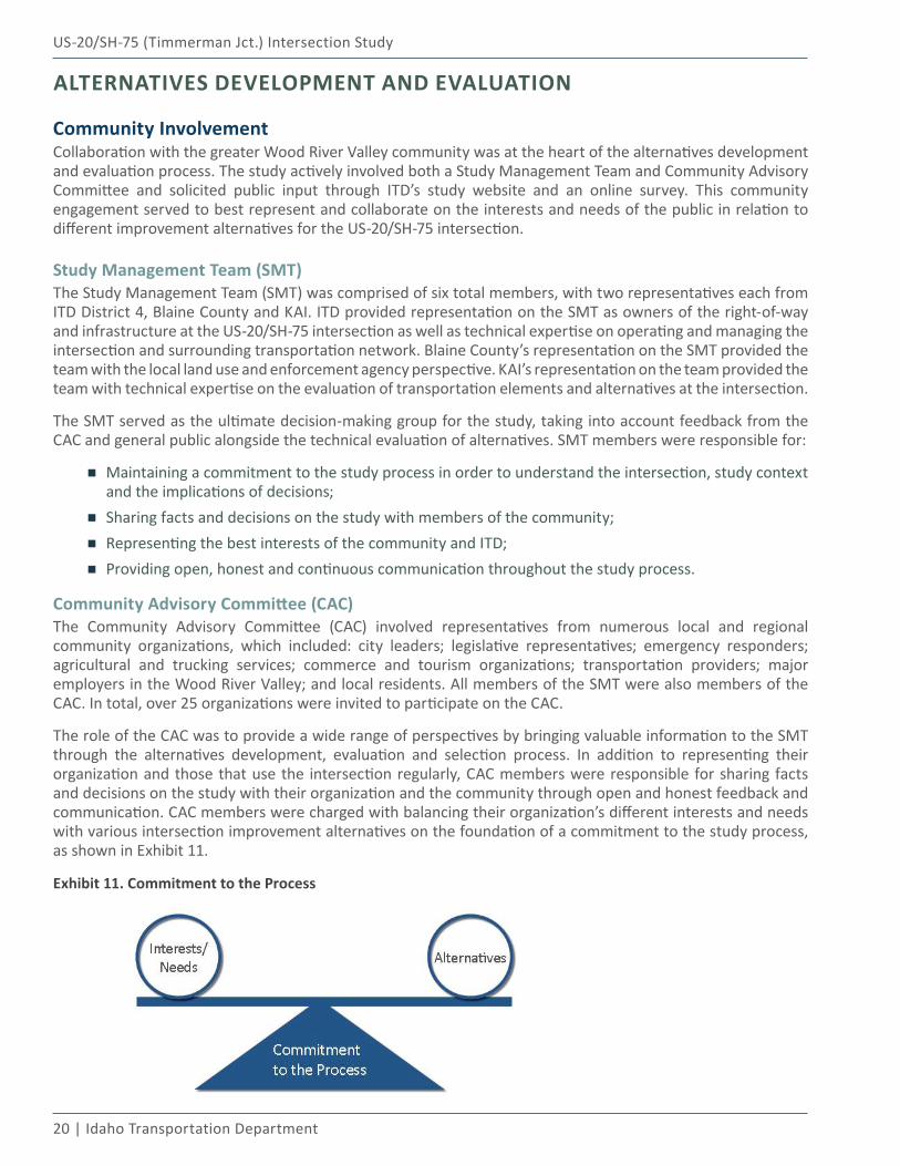
Exhibit 11. Commitment to the Process ..................................................................................... 20
Exhibit 12. Alternatives Development, Evaluation, and Screening Process ................................. 21
Exhibit 13. No-Build Concept & Assessment............................................................................... 28
Exhibit 14. Remove Intersection Skew (Centered) Concept & Assessment .................................. 30
Exhibit 15. Add Northbound and Southbound Right- and Left-Turn Lanes on SH-75 Concept & Assessment .............................................................................................................. 32
Exhibit 16. Traffic Signal with Addition of Turn Lanes Concept & Assessment ............................. 34
Exhibit 17. Conflict Point Comparison - Traditional Four-Leg Intersection vs. Single-Lane Roundabout ........................................................................................................... 35
Exhibit 18. Single-Lane Roundabout with Approach Curvature Concept & Assessment .............. 36
Exhibit 19. Restricted Crossing U-Turn Intersection (RCUT) Concept & Assessment .................... 38
Exhibit 20. Grade-Separated Diamond Interchange Concept & Assessment................................ 40
Exhibit 21. Online Survey Rank Distribution for the Intersection Alternatives ............................ 42
Exhibit 22. Successive Approach Curvature at Rural Roundabouts ............................................. 53
Exhibit 23. Example OSOW Bypass Lanes at a Roundabout - Marion County, Kansas .................. 56
Exhibit 24. Splitter Island Length for Rural Roundabouts ............................................................ 56
US-20/SH-75 (Timmerman Jct.) Intersection Study
| iii
LIST OF TABLES
Table 1. US-20/SH-75 Intersection Historical Crash Data Summary (2011-2015) ......................... 10
Table 2. Existing Conditions Intersection Operations Summary .................................................. 12
Table 3. Existing Conditions Traffic Signal Warrant Analysis Summary ........................................ 13
Table 4. Year 2040 No-Build Conditions Intersection Operations Summary................................. 17
Table 5. Year 2040 Traffic Signal Warrant Analysis Summary ...................................................... 17
Table 6. Tier 1 Fatal Flaws Assessment Summary ....................................................................... 23
Table 7. Tier 1 Intersection Alternatives - SMT & CAC Assessment Summary .............................. 25
Table 8. Tier 2 Alternatives Evaluation Criteria - SMT and CAC Rankings ..................................... 27
Table 9. Tier 2 Intersection Alternatives - Summary of SMT & CAC Evaluation ............................ 41
Table 10. Average Ranking of Alternatives from Online Survey .................................................. 42
Table 11. US-20/SH-75 Implementation Plan Summary .............................................................. 49
Table 12. Implementation Plan - Summary of SMT & CAC Feedback ........................................... 51
iv | Idaho Transportation Department
US-20/SH-75 (Timmerman Jct.) Intersection Study
PREFACEThe US-20/SH-75 (Timmerman Jct.) Intersection Study was performed under the guidance of the Study Management Team (SMT) and Community Advisory Committee (CAC). The SMT served as the ultimate decision-making group for the study, taking into account feedback from the CAC and general public alongside the technical evaluation of alternatives. All members of the SMT were also members of the CAC. The CAC involved representatives from numerous local and regional community organizations, which included: city leaders; legislative representatives; emergency responders; agricultural and trucking services; commerce and tourism organizations; transportation providers; major employers in the Wood River Valley; and local residents. The primary role of the CAC was to provide a wide range of perspectives by bringing valuable information to the SMT through the alternatives development, evaluation and selection process.
ACKNOWLEDGMENTS
Study Management TeamBruce Christensen, ITD District 4 Scott Malone, ITD District 4Angenie McCleary, Blaine County Commission & Blaine County Regional Transportation CommitteeGene Ramsey, Blaine County SheriffYuri Mereszczak, Kittelson & Associates, Inc.Andy Daleiden, Kittelson & Associates, Inc.
Community Advisory CommitteeJacob Greenberg, Blaine County CommissionLawrence Schoen, Blaine County CommissionJeff Loomis, Blaine County EngineerJim Keating, Blaine County Recreation DistrictSteve Thompson, Blaine County Road & BridgeRex Squires, Blaine County School DistrictJade Sparrow, Blaine/Camas Farm BureauLen Harlig, Citizen RepresentativeGreg Cappel, Citizen RepresentativeChristopher Koch, City of Bellevue MayorRandall Patterson, City of Carey MayorRobyn Mattison, City of KetchumBrian Christensen, City of KetchumBrad Dufur, City of Sun Valley Council
Pat Bowton, Hailey Chamber of CommerceDonna Pence, Idaho State RepresentativeMichelle Stennett, Idaho State SenateWalter Burnside, ITD District 4 MaintenanceBrad Lynch, ITD District 4 MaintenanceConnie Jones, ITD District 4 EnvironmentalNathan Jerke, ITD District 4 Public InformationJason Miller, Mountain RidesDan Gilmore, Power EngineersTerrence Sheehan, Senior ConnectionJack Sibbach, Sinclair Co./Sun Valley ResortArlene Schieven, Sun Valley-Ketchum Chamber & Visitors BureauBart Lassman, Wood River Fire & Rescue Chad Stoesz, Wood River Land Trust
Thank you to all of the members of the SMT and CAC for your dedication and commitment to the US-20/SH-75 Intersection Study and improving this intersection for all users. A special thanks to the Blaine County Courthouse for graciously hosting our SMT and CAC meetings and to Jenny Lovell, Commissioners Assistant, for scheduling and assisting with the logistics of these meetings. A special thanks also to Rosemary Curtin, Kate Nice and all the staff at RBCI for your assistance with the extensive public involvement efforts on this study. A final thank you to the Wood River Valley community and the many individuals who participated in the online survey and/or attended one or more of the CAC meetings. Your comments and suggestions were very helpful in providing additional perspective and direction for this study.
US-20/SH-75 (Timmerman Jct.) Intersection Study
Preface | v
SUPPORTING DOCUMENTATIONNumerous supporting memoranda and informational materials were developed throughout the course of this study. A separate Technical Appendix document provides these key memoranda and materials and contains all of the appendices referenced throughout this report. The Technical Appendix is available through contacting ITD District 4 (208.334.8000). Additional supporting materials not provided in the Technical Appendix are also available on the study website.
Technical Appendix Table of ContentsAppendix A: High-Level Environmental Scan MemorandumAppendix B: Traffic Volume Development MemorandumAppendix C: Existing and Year 2040 No-Build Conditions Traffic and Safety Analysis MemorandumAppendix D: ITD Traffic Signal Warrant Form 1415 - Existing ConditionsAppendix E: ITD Traffic Signal Warrant Form 1415 - Future ConditionsAppendix F: Tier 1 Alternatives Assessment PacketAppendix G: Expected Safety Performance Estimation Worksheets (Highway Safety Manual Application)Appendix H: SMT & CAC Meeting #1 SummariesAppendix I: Tier 2 Alternatives Concept DesignsAppendix J: Tier 2 Alternatives Assessment PacketAppendix K: Tier 2 Alternatives Concept-Level Construction Cost EstimatesAppendix L: Tier 2 Alternatives Life-Cycle Cost Estimate Output WorksheetAppendix M: Tier 2 Alternatives 3D Ground-Level RenderingsAppendix N: ITD Turn Lane Warrant WorksheetsAppendix O: Roundabout Alternative Truck Turning TemplatesAppendix P: Tier 2 Alternatives Detailed Evaluation WorksheetAppendix Q: SMT & CAC Meeting #2 SummariesAppendix R: Online Survey Public Comment Summary MemorandumAppendix S: Supporting Information for Other Intersection Treatment IdeasAppendix T: ITD Highway Safety Improvement Program Benefit-Cost Ratio WorksheetsAppendix U: SMT & CAC Meeting #3 Summaries
Study WebsiteUS 20 and Idaho 75 Intersection Study: itd.idaho.gov/d4 (subject to change)
Introduction01
2 | Idaho Transportation Department
US-20/SH-75 (Timmerman Jct.) Intersection Study
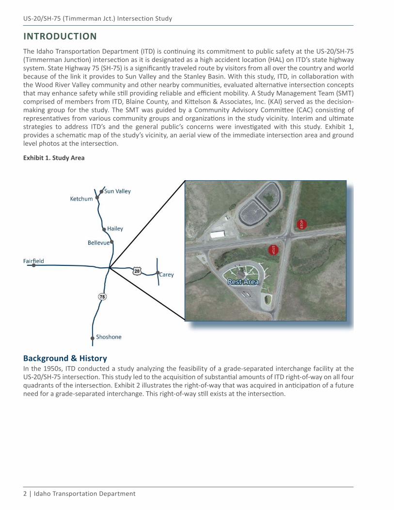
INTRODUCTIONThe Idaho Transportation Department (ITD) is continuing its commitment to public safety at the US-20/SH-75 (Timmerman Junction) intersection as it is designated as a high accident location (HAL) on ITD’s state highway system. State Highway 75 (SH-75) is a significantly traveled route by visitors from all over the country and world because of the link it provides to Sun Valley and the Stanley Basin. With this study, ITD, in collaboration with the Wood River Valley community and other nearby communities, evaluated alternative intersection concepts that may enhance safety while still providing reliable and efficient mobility. A Study Management Team (SMT) comprised of members from ITD, Blaine County, and Kittelson & Associates, Inc. (KAI) served as the decision-making group for the study. The SMT was guided by a Community Advisory Committee (CAC) consisting of representatives from various community groups and organizations in the study vicinity. Interim and ultimate strategies to address ITD’s and the general public’s concerns were investigated with this study. Exhibit 1, provides a schematic map of the study’s vicinity, an aerial view of the immediate intersection area and ground level photos at the intersection.
Exhibit 1. Study Area
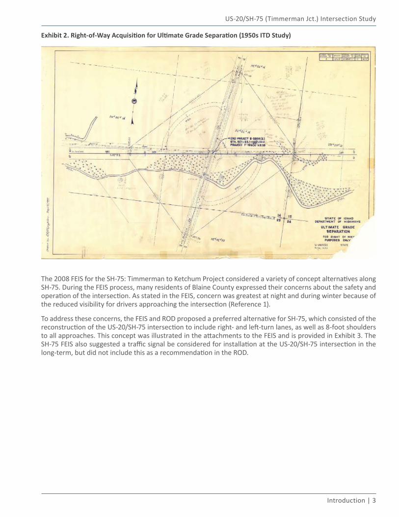
Background & History In the 1950s, ITD conducted a study analyzing the feasibility of a grade-separated interchange facility at the US-20/SH-75 intersection. This study led to the acquisition of substantial amounts of ITD right-of-way on all four quadrants of the intersection. Exhibit 2 illustrates the right-of-way that was acquired in anticipation of a future need for a grade-separated interchange. This right-of-way still exists at the intersection.
US-20/SH-75 (Timmerman Jct.) Intersection Study
Introduction | 3
Exhibit 2. Right-of-Way Acquisition for Ultimate Grade Separation (1950s ITD Study)
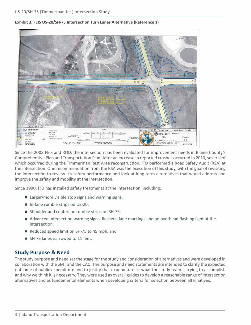
The 2008 FEIS for the SH-75: Timmerman to Ketchum Project considered a variety of concept alternatives along SH-75. During the FEIS process, many residents of Blaine County expressed their concerns about the safety and operation of the intersection. As stated in the FEIS, concern was greatest at night and during winter because of the reduced visibility for drivers approaching the intersection (Reference 1).
To address these concerns, the FEIS and ROD proposed a preferred alternative for SH-75, which consisted of the reconstruction of the US-20/SH-75 intersection to include right- and left-turn lanes, as well as 8-foot shoulders to all approaches. This concept was illustrated in the attachments to the FEIS and is provided in Exhibit 3. The SH-75 FEIS also suggested a traffic signal be considered for installation at the US-20/SH-75 intersection in the long-term, but did not include this as a recommendation in the ROD.
4 | Idaho Transportation Department
US-20/SH-75 (Timmerman Jct.) Intersection Study
Exhibit 3. FEIS US-20/SH-75 Intersection Turn Lanes Alternative (Reference 1)
Since the 2008 FEIS and ROD, the intersection has been evaluated for improvement needs in Blaine County’s Comprehensive Plan and Transportation Plan. After an increase in reported crashes occurred in 2010, several of which occurred during the Timmerman Rest Area reconstruction, ITD performed a Road Safety Audit (RSA) at the intersection. One recommendation from the RSA was the execution of this study, with the goal of revisiting the intersection to review it’s safety performance and look at long-term alternatives that would address and improve the safety and mobility at the intersection.
Since 1990, ITD has installed safety treatments at the intersection, including:
▪ Larger/more visible stop signs and warning signs;
▪ In-lane rumble strips on US-20;
▪ Shoulder and centerline rumble strips on SH-75;
▪ Advanced intersection warning signs, flashers, lane markings and an overhead flashing light at the intersection;
▪ Reduced speed limit on SH-75 to 45 mph; and
▪ SH-75 lanes narrowed to 11 feet.
Study Purpose & NeedThe study purpose and need set the stage for the study and consideration of alternatives and were developed in collaboration with the SMT and the CAC. The purpose and need statements are intended to clarify the expected outcome of public expenditure and to justify that expenditure — what the study team is trying to accomplish and why we think it is necessary. They were used as overall guides to develop a reasonable range of intersection alternatives and as fundamental elements when developing criteria for selection between alternatives.
US-20/SH-75 (Timmerman Jct.) Intersection Study
Introduction | 5
Study Purpose: ITD is continuing its commitment to improve safety at the US-20/SH-75 intersection (Timmerman Junction), while providing reliable and efficient mobility. To accomplish this, ITD, in collaboration with local community leaders and representatives, will evaluate a wide range of intersection alternatives. From this evaluation, the SMT will identify proposed improvements for the intersection. While funding for the improvements is not currently in place, this study will help provide the direction needed to pursue funding for future implementation.
Study Need: The US-20/SH-75 intersection is a high crash location, ranking as #16 on ITD’s High Accident Location (HAL) list for District 4 and #321 statewide. Several serious injury crashes have occurred at the intersection over the past fifteen years. ITD has installed numerous safety treatments at the intersection since 1990, but recognizes the need to investigate additional treatments that may further improve the safety of the intersection. The intersection also currently functions at an acceptable level of service and ITD must ensure the intersection continues to do so with any improvements implemented in the future.
Study Goals & ObjectivesThe goals and objectives the study set out to accomplish are identified below and build upon the study purpose and need outlined above.
Goal #1: Identify alternatives to improve the safety performance of the US-20/SH-75 intersection. Objectives:
▪ Evaluate the safety performance of intersection alternatives via a quantitative and qualitative predictive safety evaluation.
▪ Select intersection alternatives that are expected to reduce the number of crashes occurring at the intersection.
Goal #2: Maintain acceptable operational performance and mobility at the US-20/SH-75 intersection.Objectives:
▪ Evaluate the operational performance of intersection alternatives via a traffic operations analysis and qualitative mobility evaluation and compare to existing and forecast year no-build conditions and ITD level-of-service standards.
▪ Select intersection alternatives that are expected to maintain an acceptable operational level of service at the intersection.
Goal #3: Identify and evaluate alternatives at the US-20/SH-75 intersection in collaboration with local community leaders and representatives.Objectives:
▪ Establish a Community Advisory Committee (CAC) to provide guidance and input to ITD and the Study Management Team (SMT).
▪ Listen to the CAC to develop and confirm the study vision and desired outcomes, understand community concerns and identify opportunities and constraints that may influence the development and evaluation of alternatives.
▪ Involve the members of the CAC in the development and evaluation of intersection alternatives.
▪ Determine and document pros and cons and estimated benefit/cost ratios for each alternative. Evaluate and rank alternatives based on this information and community concerns.
6 | Idaho Transportation Department
US-20/SH-75 (Timmerman Jct.) Intersection Study
Goal #4: Establish a prioritized implementation plan for proposed improvements at the US-20/SH-75 intersection.Objectives:
▪ Provide clear recommendations on proposed improvements for implementation, considering ultimate build improvements that can accommodate phased, mid-term improvements.
▪ Prioritize and outline the relative timing for implementation of the proposed improvements.
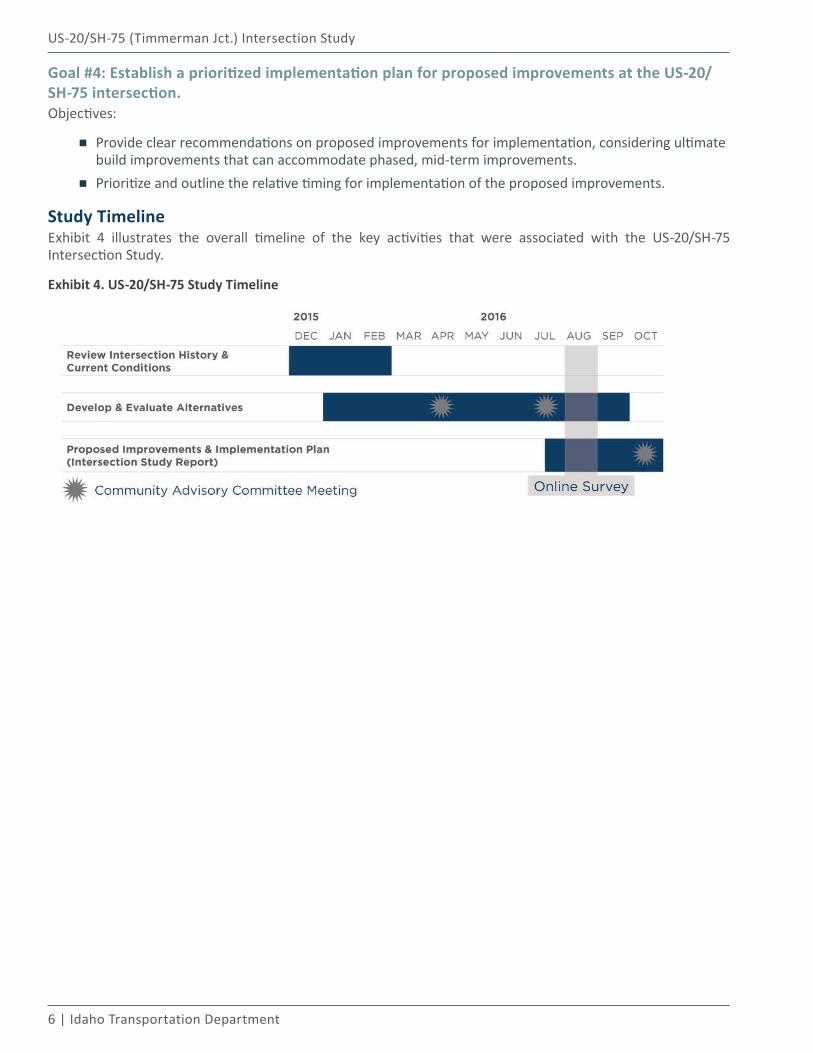
Study TimelineExhibit 4 illustrates the overall timeline of the key activities that were associated with the US-20/SH-75 Intersection Study.
Exhibit 4. US-20/SH-75 Study Timeline
Existing Conditions02
8 | Idaho Transportation Department
US-20/SH-75 (Timmerman Jct.) Intersection Study
EXISTING CONDITIONSThe existing conditions analysis identifies the current physical and environmental conditions in the vicinity of the intersection, operational and geometric characteristics of the intersection and approaching roadways, and the recent historical safety performance of the intersection. The existing conditions are used as a basis to compare with future conditions alternatives at the US-20/SH-75 intersection.
Existing traffic counts were collected at the study intersection on Friday, December 18, 2015. These counts were factored to represent peak season traffic conditions, explained further in the sections below. Additionally, KAI staff visited and inventoried the intersection and approach roadways in March 2016. At that time, KAI collected information regarding site conditions, lane configurations, roadway sign inventory, and adjacent properties.
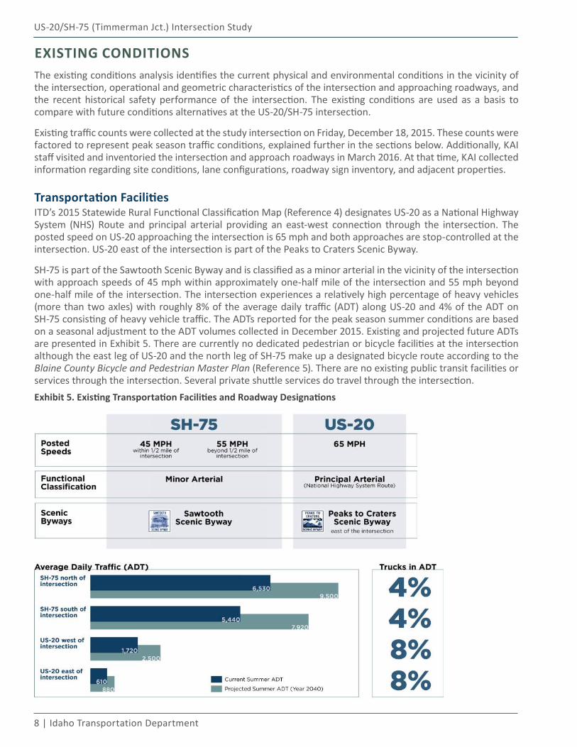
Transportation FacilitiesITD’s 2015 Statewide Rural Functional Classification Map (Reference 4) designates US-20 as a National Highway System (NHS) Route and principal arterial providing an east-west connection through the intersection. The posted speed on US-20 approaching the intersection is 65 mph and both approaches are stop-controlled at the intersection. US-20 east of the intersection is part of the Peaks to Craters Scenic Byway.
SH-75 is part of the Sawtooth Scenic Byway and is classified as a minor arterial in the vicinity of the intersection with approach speeds of 45 mph within approximately one-half mile of the intersection and 55 mph beyond one-half mile of the intersection. The intersection experiences a relatively high percentage of heavy vehicles (more than two axles) with roughly 8% of the average daily traffic (ADT) along US-20 and 4% of the ADT on SH-75 consisting of heavy vehicle traffic. The ADTs reported for the peak season summer conditions are based on a seasonal adjustment to the ADT volumes collected in December 2015. Existing and projected future ADTs are presented in Exhibit 5. There are currently no dedicated pedestrian or bicycle facilities at the intersection although the east leg of US-20 and the north leg of SH-75 make up a designated bicycle route according to the Blaine County Bicycle and Pedestrian Master Plan (Reference 5). There are no existing public transit facilities or services through the intersection. Several private shuttle services do travel through the intersection.Exhibit 5. Existing Transportation Facilities and Roadway Designations
US-20/SH-75 (Timmerman Jct.) Intersection Study
Existing Conditions | 9
Adjacent PropertiesEach quadrant surrounding the intersection is zoned as Agricultural. An old service station site, zoned as Recreational Development, sits approximately one-half mile south of the intersection on SH-75. While there is no commercial or residential development adjacent to the intersection, there are ITD owned facilities in the northwest and southwest quadrants of the intersection. The northwest quadrant consists of an ITD maintenance storage and storm water treatment facility. This facility has two points of access from US-20 (via an acceleration/deceleration lane) at approximately 475 feet and 800 feet west of the intersection.
The Timmerman Rest Area is located in the southwest quadrant of the intersection. The rest area provides rest rooms, picnic tables and area maps for passing travelers. Reconstructed in 2010, the rest area has one point of access to US-20 approximately 775 feet west of the intersection and one point of access to SH-75 approximately 725 feet south of the intersection. There are no turn lanes into the accesses from either US-20 or SH-75. Crash data from 2011-2015 does not indicate safety concerns at either of these access points as there have been no recorded crashes at either access during that time frame.
Environmental ConsiderationsA high-level environmental scan was completed for this study and is provided in Appendix A. The two key aspects from the environmental scan involve wetlands surrounding the intersection and high groundwater in the intersection area. Wetlands mapping from the National Wetlands Inventory (NWI) database indicates both Freshwater Emergent Wetlands and Freshwater Forested/Shrub Wetlands within the study area (Reference 6). Some wetlands mitigation will likely be necessary with any reconstruction at the US-20/SH-75 intersection. Additionally, Willow Creek runs immediately to the south of the intersection and is designated as a “water of the U.S.” with its connection to the Big Wood River (Reference 6). Surface water discharged to Willow Creek would likely be subject to regulations under Section 404 of the Clean Water Act by the U.S. Army Corps of Engineers. Due to these and other environmental conditions in the intersection vicinity, a contingency for environmental mitigation was accounted for in the cost estimates of the various intersection alternatives.
The “water table” refers to a saturated zone in the soil occurring during specified months for a duration longer than one month. Per the USGS Web Soil Survey, the depth to the water table for the entire project area varies from approximately 20 centimeters (~0.65 feet) to 200 centimeters (~6.5 feet), with most of the immediate intersection area being over ground in which the water table is approximately 20-25 centimeters below the surface (~0.65-0.80 feet) (Reference 7). Subsurface excavation and/or construction (including placement of roadway base materials) activities may encounter groundwater; therefore, dewatering and/or base stabilization may be necessary during construction; these likely construction activities were accounted for via a contingency amount within the cost estimates of the various intersection alternatives.
No floodplains are located within the intersection study area as illustrated in the Flood Insurance Rate Map (FIRM) from the Idaho Department of Water Resources website. A floodplain is identified on the FIRM along the Big Wood River approximately two miles to the west of the intersection; however that floodplain has no influence on the intersection area (Reference 8).
No other significant environmental considerations were identified as part of the high-level environmental scan; however, a future NEPA environmental evaluation is likely to occur upon establishment of a specific improvement project for the intersection and this evaluation may identify other environmental considerations.
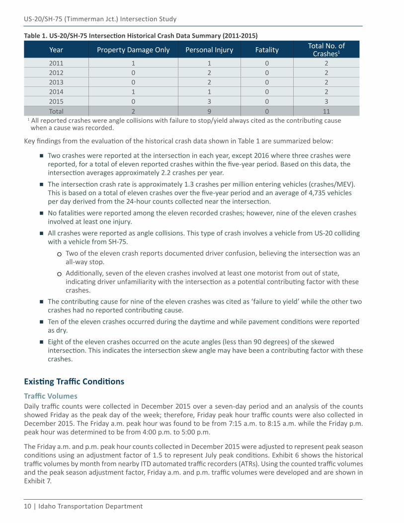
Historical Crash Data AnalysisThe US-20/SH-75 intersection is a high crash location, ranking as #16 on ITD’s High Accident Location (HAL) list for District 4 and #321 statewide. It is worth noting that crash data was obtained from ITD for a fifteen-year period from 2001-2015 for the sole purpose of determining whether or not any fatalities were reported at the intersection over the past fifteen years. While several serious injury crashes were reported, no fatalities were reported in the past fifteen years of crash data at the intersection of US-20/SH-75.
Detailed crash data was obtained from ITD for the most recent five years at the US-20/SH-75 intersection. Table 1 summarizes the most recent five-year period from 2011-2015.
10 | Idaho Transportation Department
US-20/SH-75 (Timmerman Jct.) Intersection Study
Table 1. US-20/SH-75 Intersection Historical Crash Data Summary (2011-2015)
Year Property Damage Only Personal Injury Fatality Total No. of Crashes1
2011 1 1 0 22012 0 2 0 22013 0 2 0 22014 1 1 0 22015 0 3 0 3Total 2 9 0 11
1 All reported crashes were angle collisions with failure to stop/yield always cited as the contributing cause when a cause was recorded.
Key findings from the evaluation of the historical crash data shown in Table 1 are summarized below:
▪ Two crashes were reported at the intersection in each year, except 2016 where three crashes were reported, for a total of eleven reported crashes within the five-year period. Based on this data, the intersection averages approximately 2.2 crashes per year.
▪ The intersection crash rate is approximately 1.3 crashes per million entering vehicles (crashes/MEV). This is based on a total of eleven crashes over the five-year period and an average of 4,735 vehicles per day derived from the 24-hour counts collected near the intersection.
▪ No fatalities were reported among the eleven recorded crashes; however, nine of the eleven crashes involved at least one injury.
▪ All crashes were reported as angle collisions. This type of crash involves a vehicle from US-20 colliding with a vehicle from SH-75.
Two of the eleven crash reports documented driver confusion, believing the intersection was an all-way stop.Additionally, seven of the eleven crashes involved at least one motorist from out of state, indicating driver unfamiliarity with the intersection as a potential contributing factor with these crashes.
▪ The contributing cause for nine of the eleven crashes was cited as ‘failure to yield’ while the other two crashes had no reported contributing cause.
▪ Ten of the eleven crashes occurred during the daytime and while pavement conditions were reported as dry.
▪ Eight of the eleven crashes occurred on the acute angles (less than 90 degrees) of the skewed intersection. This indicates the intersection skew angle may have been a contributing factor with these crashes.
Existing Traffic ConditionsTraffic VolumesDaily traffic counts were collected in December 2015 over a seven-day period and an analysis of the counts showed Friday as the peak day of the week; therefore, Friday peak hour traffic counts were also collected in December 2015. The Friday a.m. peak hour was found to be from 7:15 a.m. to 8:15 a.m. while the Friday p.m. peak hour was determined to be from 4:00 p.m. to 5:00 p.m.
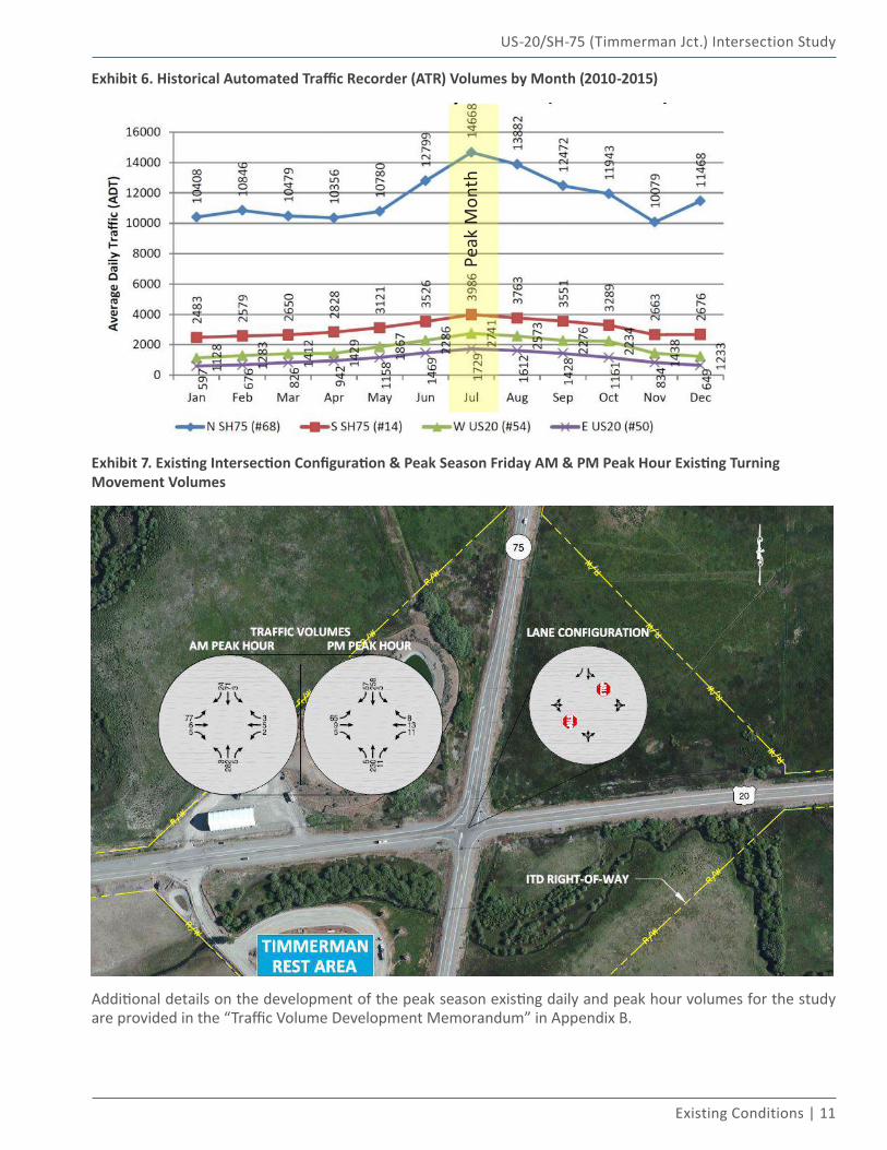
The Friday a.m. and p.m. peak hour counts collected in December 2015 were adjusted to represent peak season conditions using an adjustment factor of 1.5 to represent July peak conditions. Exhibit 6 shows the historical traffic volumes by month from nearby ITD automated traffic recorders (ATRs). Using the counted traffic volumes and the peak season adjustment factor, Friday a.m. and p.m. traffic volumes were developed and are shown in Exhibit 7.
US-20/SH-75 (Timmerman Jct.) Intersection Study
Existing Conditions | 11
Exhibit 6. Historical Automated Traffic Recorder (ATR) Volumes by Month (2010-2015)
Peak
Mon
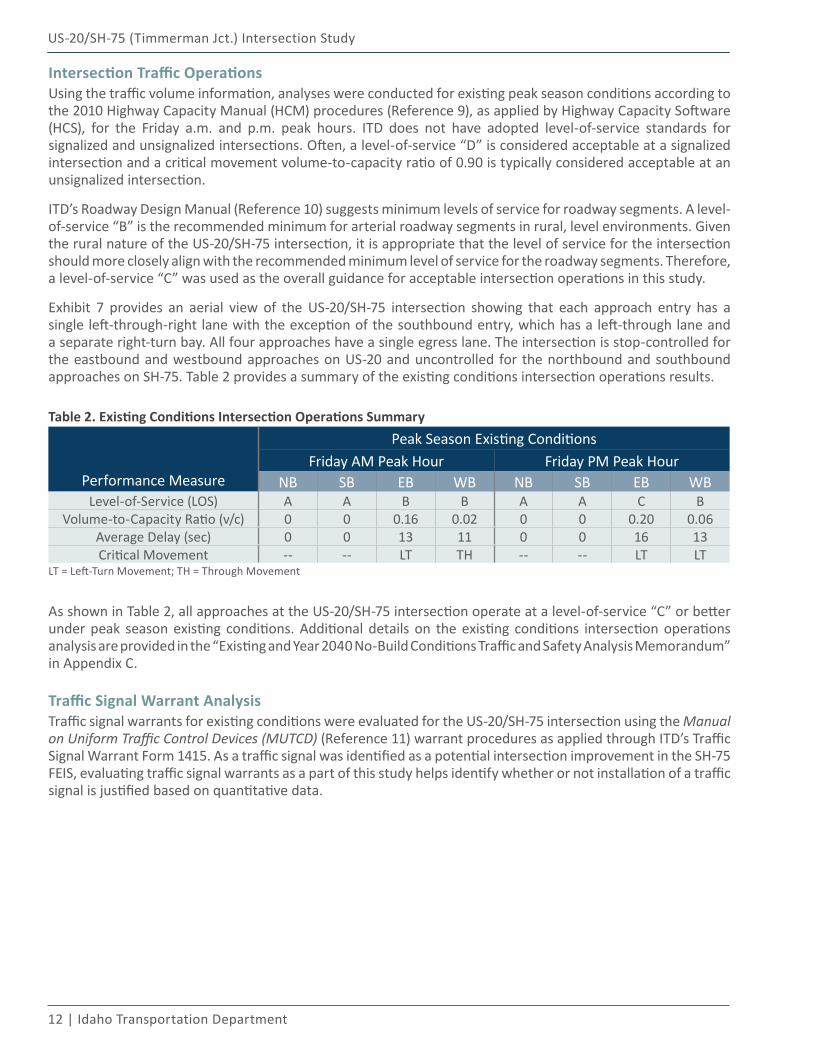
thExhibit 7. Existing Intersection Configuration & Peak Season Friday AM & PM Peak Hour Existing Turning Movement Volumes
Additional details on the development of the peak season existing daily and peak hour volumes for the study are provided in the “Traffic Volume Development Memorandum” in Appendix B.
12 | Idaho Transportation Department
US-20/SH-75 (Timmerman Jct.) Intersection Study
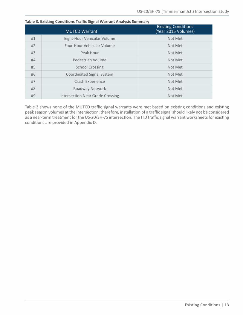
Intersection Traffic OperationsUsing the traffic volume information, analyses were conducted for existing peak season conditions according to the 2010 Highway Capacity Manual (HCM) procedures (Reference 9), as applied by Highway Capacity Software (HCS), for the Friday a.m. and p.m. peak hours. ITD does not have adopted level-of-service standards for signalized and unsignalized intersections. Often, a level-of-service “D” is considered acceptable at a signalized intersection and a critical movement volume-to-capacity ratio of 0.90 is typically considered acceptable at an unsignalized intersection.
ITD’s Roadway Design Manual (Reference 10) suggests minimum levels of service for roadway segments. A level-of-service “B” is the recommended minimum for arterial roadway segments in rural, level environments. Given the rural nature of the US-20/SH-75 intersection, it is appropriate that the level of service for the intersection should more closely align with the recommended minimum level of service for the roadway segments. Therefore, a level-of-service “C” was used as the overall guidance for acceptable intersection operations in this study.
Exhibit 7 provides an aerial view of the US-20/SH-75 intersection showing that each approach entry has a single left-through-right lane with the exception of the southbound entry, which has a left-through lane and a separate right-turn bay. All four approaches have a single egress lane. The intersection is stop-controlled for the eastbound and westbound approaches on US-20 and uncontrolled for the northbound and southbound approaches on SH-75. Table 2 provides a summary of the existing conditions intersection operations results.
Table 2. Existing Conditions Intersection Operations Summary
Performance Measure
Peak Season Existing Conditions Friday AM Peak Hour Friday PM Peak Hour
NB SB EB WB NB SB EB WBLevel-of-Service (LOS) A A B B A A C B
Volume-to-Capacity Ratio (v/c) 0 0 0.16 0.02 0 0 0.20 0.06Average Delay (sec) 0 0 13 11 0 0 16 13Critical Movement -- -- LT TH -- -- LT LT
LT = Left-Turn Movement; TH = Through Movement
As shown in Table 2, all approaches at the US-20/SH-75 intersection operate at a level-of-service “C” or better under peak season existing conditions. Additional details on the existing conditions intersection operations analysis are provided in the “Existing and Year 2040 No-Build Conditions Traffic and Safety Analysis Memorandum” in Appendix C.
Traffic Signal Warrant AnalysisTraffic signal warrants for existing conditions were evaluated for the US-20/SH-75 intersection using the Manual on Uniform Traffic Control Devices (MUTCD) (Reference 11) warrant procedures as applied through ITD’s Traffic Signal Warrant Form 1415. As a traffic signal was identified as a potential intersection improvement in the SH-75 FEIS, evaluating traffic signal warrants as a part of this study helps identify whether or not installation of a traffic signal is justified based on quantitative data.
US-20/SH-75 (Timmerman Jct.) Intersection Study
Existing Conditions | 13
Table 3. Existing Conditions Traffic Signal Warrant Analysis Summary
MUTCD WarrantExisting Conditions
(Year 2015 Volumes)#1 Eight-Hour Vehicular Volume Not Met
#2 Four-Hour Vehicular Volume Not Met
#3 Peak Hour Not Met
#4 Pedestrian Volume Not Met
#5 School Crossing Not Met
#6 Coordinated Signal System Not Met
#7 Crash Experience Not Met
#8 Roadway Network Not Met
#9 Intersection Near Grade Crossing Not Met
Table 3 shows none of the MUTCD traffic signal warrants were met based on existing conditions and existing peak season volumes at the intersection; therefore, installation of a traffic signal should likely not be considered as a near-term treatment for the US-20/SH-75 intersection. The ITD traffic signal warrant worksheets for existing conditions are provided in Appendix D.
Future No-Build Conditions03
US-20/SH-75 (Timmerman Jct.) Intersection Study
Future No-Build Conditions | 15
FUTURE NO-BUILD CONDITIONSFuture no-build conditions reflect traffic conditions in the planning year 2040, documenting growth within the region and the anticipated safety and operational performance of the US-20/SH-75 intersection if no improvements were to be implemented at the intersection.
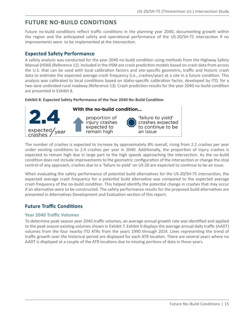
Expected Safety PerformanceA safety analysis was conducted for the year 2040 no-build condition using methods from the Highway Safety Manual (HSM) (Reference 12). Included in the HSM are crash prediction models based on crash data from across the U.S. that can be used with local calibration factors and site-specific geometric, traffic and historic crash data to estimate the expected average crash frequency (i.e., crashes/year) at a site in a future condition. This analysis was calibrated to local conditions based on Idaho-specific calibration factor, developed by ITD, for a two-lane undivided rural roadway (Reference 13). Crash prediction results for the year 2040 no-build condition are presented in Exhibit 8.
Exhibit 8. Expected Safety Performance of the Year 2040 No-Build Condition
The number of crashes is expected to increase by approximately 8% overall, rising from 2.2 crashes per year under existing conditions to 2.4 crashes per year in 2040. Additionally, the proportion of injury crashes is expected to remain high due in large part to the high speeds approaching the intersection. As the no-build condition does not include improvements to the geometric configuration of the intersection or change the stop control of any approach, crashes due to a ‘failure to yield’ on US-20 are expected to continue to be an issue.
When evaluating the safety performance of potential build alternatives for the US-20/SH-75 intersection, the expected average crash frequency for a potential build alternative was compared to the expected average crash frequency of the no-build condition. This helped identify the potential change in crashes that may occur if an alternative were to be constructed. The safety performance results for the proposed build alternatives are presented in Alternatives Development and Evaluation section of this report.
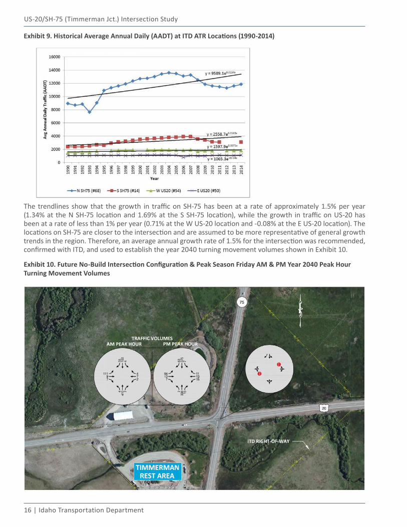
Future Traffic ConditionsYear 2040 Traffic VolumesTo determine peak season year 2040 traffic volumes, an average annual growth rate was identified and applied to the peak season existing volumes shown in Exhibit 7. Exhibit 9 displays the average annual daily traffic (AADT) volumes from the four nearby ITD ATRs from the years 1990 through 2014. Lines representing the trend of traffic growth over the historical period are displayed for each ATR location. There are several years where no AADT is displayed at a couple of the ATR locations due to missing portions of data in those years.
16 | Idaho Transportation Department
US-20/SH-75 (Timmerman Jct.) Intersection Study
Exhibit 9. Historical Average Annual Daily (AADT) at ITD ATR Locations (1990-2014)
The trendlines show that the growth in traffic on SH-75 has been at a rate of approximately 1.5% per year (1.34% at the N SH-75 location and 1.69% at the S SH-75 location), while the growth in traffic on US-20 has been at a rate of less than 1% per year (0.71% at the W US-20 location and -0.08% at the E US-20 location). The locations on SH-75 are closer to the intersection and are assumed to be more representative of general growth trends in the region. Therefore, an average annual growth rate of 1.5% for the intersection was recommended, confirmed with ITD, and used to establish the year 2040 turning movement volumes shown in Exhibit 10.
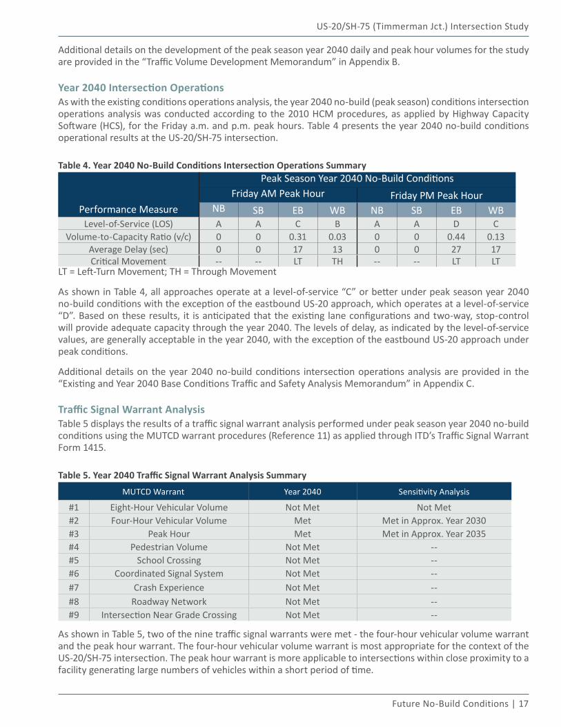
Exhibit 10. Future No-Build Intersection Configuration & Peak Season Friday AM & PM Year 2040 Peak Hour Turning Movement Volumes
US-20/SH-75 (Timmerman Jct.) Intersection Study
Future No-Build Conditions | 17
Additional details on the development of the peak season year 2040 daily and peak hour volumes for the study are provided in the “Traffic Volume Development Memorandum” in Appendix B.
Year 2040 Intersection OperationsAs with the existing conditions operations analysis, the year 2040 no-build (peak season) conditions intersection operations analysis was conducted according to the 2010 HCM procedures, as applied by Highway Capacity Software (HCS), for the Friday a.m. and p.m. peak hours. Table 4 presents the year 2040 no-build conditions operational results at the US-20/SH-75 intersection.
Table 4. Year 2040 No-Build Conditions Intersection Operations Summary
Performance Measure
Peak Season Year 2040 No-Build Conditions Friday AM Peak Hour Friday PM Peak Hour
NB SB EB WB NB SB EB WBLevel-of-Service (LOS) A A C B A A D C
Volume-to-Capacity Ratio (v/c) 0 0 0.31 0.03 0 0 0.44 0.13Average Delay (sec) 0 0 17 13 0 0 27 17Critical Movement -- -- LT TH -- -- LT LT
LT = Left-Turn Movement; TH = Through Movement
As shown in Table 4, all approaches operate at a level-of-service “C” or better under peak season year 2040 no-build conditions with the exception of the eastbound US-20 approach, which operates at a level-of-service “D”. Based on these results, it is anticipated that the existing lane configurations and two-way, stop-control will provide adequate capacity through the year 2040. The levels of delay, as indicated by the level-of-service values, are generally acceptable in the year 2040, with the exception of the eastbound US-20 approach under peak conditions.
Additional details on the year 2040 no-build conditions intersection operations analysis are provided in the “Existing and Year 2040 Base Conditions Traffic and Safety Analysis Memorandum” in Appendix C.
Traffic Signal Warrant AnalysisTable 5 displays the results of a traffic signal warrant analysis performed under peak season year 2040 no-build conditions using the MUTCD warrant procedures (Reference 11) as applied through ITD’s Traffic Signal Warrant Form 1415.
Table 5. Year 2040 Traffic Signal Warrant Analysis Summary
MUTCD Warrant Year 2040 Sensitivity Analysis
#1 Eight-Hour Vehicular Volume Not Met Not Met#2 Four-Hour Vehicular Volume Met Met in Approx. Year 2030#3 Peak Hour Met Met in Approx. Year 2035#4 Pedestrian Volume Not Met --#5 School Crossing Not Met --#6 Coordinated Signal System Not Met --#7 Crash Experience Not Met --#8 Roadway Network Not Met --#9 Intersection Near Grade Crossing Not Met --
As shown in Table 5, two of the nine traffic signal warrants were met - the four-hour vehicular volume warrant and the peak hour warrant. The four-hour vehicular volume warrant is most appropriate for the context of the US-20/SH-75 intersection. The peak hour warrant is more applicable to intersections within close proximity to a facility generating large numbers of vehicles within a short period of time.
18 | Idaho Transportation Department
US-20/SH-75 (Timmerman Jct.) Intersection Study
Given the fact a traffic signal is warranted under year 2040 conditions, a sensitivity analysis was conducted to identify the approximate time frame (prior to year 2040) at which the four-hour and peak hour signal warrants would be met. As shown in Table 5, the sensitivity analysis concluded that the four-hour vehicular volume warrant and peak hour warrant were met in approximately the years 2030 and 2035, respectively. Therefore, installation of a traffic signal is appropriate to consider as a potential mid-term to long-term treatment for the US-20/SH-75 intersection. The ITD traffic signal warrant worksheets for future conditions are provided in Appendix E.
Alternatives Development and
Evaluation04
20 | Idaho Transportation Department
US-20/SH-75 (Timmerman Jct.) Intersection Study
ALTERNATIVES DEVELOPMENT AND EVALUATION
Community InvolvementCollaboration with the greater Wood River Valley community was at the heart of the alternatives development and evaluation process. The study actively involved both a Study Management Team and Community Advisory Committee and solicited public input through ITD’s study website and an online survey. This community engagement served to best represent and collaborate on the interests and needs of the public in relation to different improvement alternatives for the US-20/SH-75 intersection.
Study Management Team (SMT)The Study Management Team (SMT) was comprised of six total members, with two representatives each from ITD District 4, Blaine County and KAI. ITD provided representation on the SMT as owners of the right-of-way and infrastructure at the US-20/SH-75 intersection as well as technical expertise on operating and managing the intersection and surrounding transportation network. Blaine County’s representation on the SMT provided the team with the local land use and enforcement agency perspective. KAI’s representation on the team provided the team with technical expertise on the evaluation of transportation elements and alternatives at the intersection.
The SMT served as the ultimate decision-making group for the study, taking into account feedback from the CAC and general public alongside the technical evaluation of alternatives. SMT members were responsible for:
▪ Maintaining a commitment to the study process in order to understand the intersection, study context and the implications of decisions;
▪ Sharing facts and decisions on the study with members of the community;
▪ Representing the best interests of the community and ITD;
▪ Providing open, honest and continuous communication throughout the study process.
Community Advisory Committee (CAC)The Community Advisory Committee (CAC) involved representatives from numerous local and regional community organizations, which included: city leaders; legislative representatives; emergency responders; agricultural and trucking services; commerce and tourism organizations; transportation providers; major employers in the Wood River Valley; and local residents. All members of the SMT were also members of the CAC. In total, over 25 organizations were invited to participate on the CAC.
The role of the CAC was to provide a wide range of perspectives by bringing valuable information to the SMT through the alternatives development, evaluation and selection process. In addition to representing their organization and those that use the intersection regularly, CAC members were responsible for sharing facts and decisions on the study with their organization and the community through open and honest feedback and communication. CAC members were charged with balancing their organization’s different interests and needs with various intersection improvement alternatives on the foundation of a commitment to the study process, as shown in Exhibit 11.
Exhibit 11. Commitment to the Process
US-20/SH-75 (Timmerman Jct.) Intersection Study
Alternatives Development and Evaluation | 21
The CAC gathered for three in-person meetings throughout the course of the study to work through a tiered alternatives evaluation process. All CAC meetings were advertised and open to the public. These meetings presented findings from the technical analyses, detailed information on each of the potential alternatives and a proposed implementation plan for the intersection. CAC members engaged in small group discussions during these meetings to share perspectives on the advantages and challenges of each intersection alternative. During these small group discussions CAC members were asked to rank each of the alternatives to be carried forward for future consideration. These rankings and the associated feedback were considered in determining the alternatives to be carried through the tiered alternatives evaluation process.
Photos Courtesy: Rosemary Curtin, RBCI
Public InputITD created a website for the study that was accessible to all and provided a clearinghouse for distribution of study materials and information as well as the study purpose and need and goals (itd.idaho.gov/d4). The website also provided a forum for the public to leave comments and feedback on the study.
ITD also facilitated an online survey in August 2016 to collect public feedback on the intersection alternatives (http://www.surveygizmo.com/s3/2953321/US-20-and-Idaho-75-SH-75-Intersection-Timmerman-Junction-Study; survey no longer active). The survey was advertised to citizens in the Wood River Valley and Magic Valley areas via e-mail, the study website, local media and the local public advisory group for ITD District 4. The survey received 762 total responses, with 72% of respondents completing the entire survey. More information on the results of the online survey is provided later in the report.
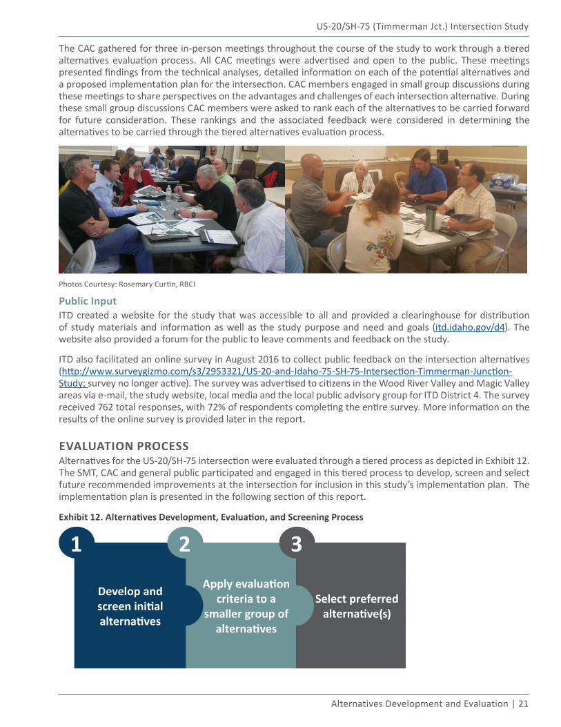
EVALUATION PROCESSAlternatives for the US-20/SH-75 intersection were evaluated through a tiered process as depicted in Exhibit 12. The SMT, CAC and general public participated and engaged in this tiered process to develop, screen and select future recommended improvements at the intersection for inclusion in this study’s implementation plan. The implementation plan is presented in the following section of this report.
Exhibit 12. Alternatives Development, Evaluation, and Screening Process
Develop and screen initial alternatives
Apply evaluation criteria to a
smaller group of alternatives
1 2 3
Select preferred alternative(s)
22 | Idaho Transportation Department
US-20/SH-75 (Timmerman Jct.) Intersection Study
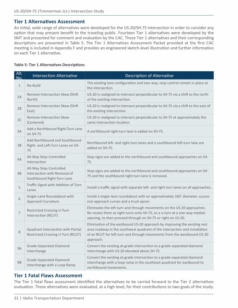
Tier 1 Alternatives AssessmentAn initial, wide range of alternatives were developed for the US-20/SH-75 intersection in order to consider any option that may present benefit to the traveling public. Fourteen Tier 1 alternatives were developed by the SMT and presented for comment and evaluation by the CAC. These Tier 1 alternatives and their corresponding descriptions are presented in Table 5. The Tier 1 Alternatives Assessment Packet provided at the first CAC meeting is included in Appendix F and provides an engineered sketch-level illustration and further information on each Tier 1 alternative.
Table 5: Tier 1 Alternatives Descriptions
Alt. No. Intersection Alternative Description of Alternative
1 No BuildThe existing lane configuration and two-way, stop control remain in place at the intersection.
2ARemove Intersection Skew (Shift North)
US-20 is realigned to intersect perpendicular to SH-75 via a shift to the north of the existing intersection.
2BRemove Intersection Skew (Shift East)
US-20 is realigned to intersect perpendicular to SH-75 via a shift to the east of the existing intersection.
2CRemove Intersection Skew (Centered)
US-20 is realigned to intersect perpendicular to SH-75 at approximately the same intersection location.
3AAdd a Northbound Right-Turn Lane on SH-75
A northbound right-turn lane is added on SH-75.
3BAdd Northbound and Southbound Right- and Left-Turn Lanes on SH-75
Northbound left- and right-turn lanes and a southbound left-turn lane are added on SH-75.
4AAll-Way Stop-Controlled Intersection
Stop signs are added to the northbound and southbound approaches on SH-75.
4BAll-Way Stop-Controlled Intersection with Removal of Southbound Right-Turn Lane
Stop signs are added to the northbound and southbound approaches on SH-75 and the southbound right-turn lane is removed.
5Traffic Signal with Addition of Turn Lanes
Install a traffic signal with separate left- and right turn lanes on all approaches.
6Single-Lane Roundabout with Approach Curvature
Install a single-lane roundabout with an approximately 160’ diameter, succes-sive approach curves and a truck apron.
7Restricted Crossing U-Turn Intersection (RCUT)
Eliminates the left-turn and through movements on the US-20 approaches. Re-routes them as right turns onto SH-75, to a u-turn at a one-way median opening, to then proceed through on SH-75 or right on US-20.
8Quadrant Intersection with Partial Restricted Crossing U-Turn (RCUT)
Elimination of the eastbound US-20 approach by improving the existing rest area roadway in the southwest quadrant of the intersection and installation of an RCUT for left-turn and through movements from the westbound US-20 approach.
9AGrade-Separated Diamond Interchange
Convert the existing at-grade intersection to a grade-separated diamond interchange with US-20 elevated above SH-75.
9BGrade-Separated Diamond Interchange with a Loop Ramp
Convert the existing at-grade intersection to a grade-separated diamond interchange with a loop ramp in the southeast quadrant for eastbound to northbound movements.
Tier 1 Fatal Flaws AssessmentThe Tier 1 fatal flaws assessment identified the alternatives to be carried forward to the Tier 2 alternatives evaluation. These alternatives were evaluated, at a high level, for their contributions to two goals of the study:
US-20/SH-75 (Timmerman Jct.) Intersection Study
Alternatives Development and Evaluation | 23
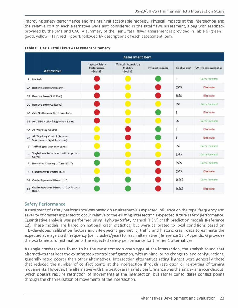
improving safety performance and maintaining acceptable mobility. Physical impacts at the intersection and the relative cost of each alternative were also considered in the fatal flaws assessment, along with feedback provided by the SMT and CAC. A summary of the Tier 1 fatal flaws assessment is provided in Table 6 (green = good, yellow = fair, red = poor), followed by descriptions of each assessment item.
Table 6. Tier 1 Fatal Flaws Assessment Summary
Safety PerformanceAssessment of safety performance was based on an alternative’s expected influence on the type, frequency and severity of crashes expected to occur relative to the existing intersection’s expected future safety performance. Quantitative analysis was performed using Highway Safety Manual (HSM) crash prediction models (Reference 12). These models are based on national crash statistics, but were calibrated to local conditions based on ITD-developed calibration factors and site-specific geometric, traffic and historic crash data to estimate the expected average crash frequency (i.e., crashes/year) for each alternative (Reference 13). Appendix G provides the worksheets for estimation of the expected safety performance for the Tier 1 alternatives.
As angle crashes were found to be the most common crash type at the intersection, the analysis found that alternatives that kept the existing stop control configuration, with minimal or no change to lane configurations, generally rated poorer than other alternatives. Intersection alternatives rating highest were generally those that reduced the number of conflict points at the intersection through restriction or re-routing of turning movements. However, the alternative with the best overall safety performance was the single-lane roundabout, which doesn’t require restriction of movements at the intersection, but rather consolidates conflict points through the channelization of movements at the intersection.
24 | Idaho Transportation Department
US-20/SH-75 (Timmerman Jct.) Intersection Study
MobilityAssessment of mobility was based on an alternative’s expected influence on the movement of various users (all modes) through the intersection. This assessment included the quantitative calculation of average delay (LOS) and expected residual capacity (v/c) for each alternative. The mobility assessment also included a qualitative evaluation of the expected change of the following relative to the No Build alternative: average delay; number of stops; and travel time through the intersection.
The two alternatives rating best in this assessment were the grade-separated interchange alternatives due to the reduction in delay for the through movements on both US-20 and SH-75 and the significant decrease in the number of stops and travel time on US-20. The two intersection alternatives rating poorest were the all-way stop controlled alternatives due to the significant increase in average delay, stops and travel time on SH-75. The remaining ten alternatives rated fair in the assessment as, in general, they did not adversely affect mobility at the intersection. While these alternatives ranged in control type and lane configuration, there was nominal difference in delay and/or capacity from the no-build condition, resulting in little difference in travel time through the intersection.
Physical ImpactsAssessment of physical impacts included an alternative’s physical impact on the landscape, environment and properties in the vicinity of the intersection based on the engineered sketch-level diagrams of the alternatives (see Appendix F). The alternatives with the least physical impact included alternatives with little or no lane configuration improvements at the intersection. While these alternatives have a relatively low physical impact, they generally did not adequately address safety performance and/or mobility measures. The alternatives with the greatest physical impacts included those with the greatest amount of impervious surface added to the intersection area and typically involved realignment of one or more of the roadway approaches. These alternatives included two of the remove skew options, as well as the RCUT, quadrant and grade-separated interchange options.
Relative Cost
For the Tier 1 assessment, the relative cost criterion was not based on measured quantities or calculated values, but instead on engineering experience and judgment of the construction, operational and maintenance costs in comparing one alternative to another. The grade-separated alternatives, which rated highest in safety performance and mobility, also had the highest relative cost amongst all alternatives. In general, alternatives with higher physical impacts had a relatively higher cost. The lowest relative cost alternatives included intersection alternatives that also generally rated lower in safety performance and mobility measures.
SMT & CAC Feedback
As described earlier, the input, opinions and feedback from the SMT and CAC on the Tier 1 alternatives were essential to the intersection alternatives assessment. The Tier 1 assessment performed by the SMT and CAC included an overview of each intersection alternative and a summary of each alternatives’ performance with respect to the assessment items described above. The end result of the Tier 1 assessment was a compilation of responses from each SMT and CAC member as to whether an alternative should be carried forward to the Tier 2 assessment or whether to eliminate it from further consideration. The summary of the SMT and CAC Tier 1 intersection alternatives evaluation is presented in Table 7.
US-20/SH-75 (Timmerman Jct.) Intersection Study
Alternatives Development and Evaluation | 25
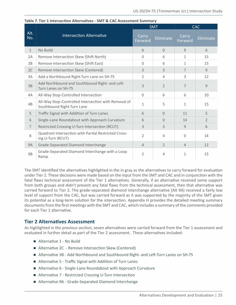
Table 7. Tier 1 Intersection Alternatives - SMT & CAC Assessment Summary
Alt. No. Intersection Alternative
SMT CAC
Carry Forward Eliminate Carry
Forward Eliminate
1 No Build 6 0 9 62A Remove Intersection Skew (Shift North) 0 6 1 152B Remove Intersection Skew (Shift East) 0 6 1 152C Remove Intersection Skew (Centered) 3 3 7 93A Add a Northbound Right-Turn Lane on SH-75 2 4 3 12
3B Add Northbound and Southbound Right- and Left-Turn Lanes on SH-75 3 2 7 9
4A All-Way Stop-Controlled Intersection 0 6 6 10
4B All-Way Stop-Controlled Intersection with Removal of Southbound Right-Turn Lane 1 5 1 15
5 Traffic Signal with Addition of Turn Lanes 6 0 11 56 Single-Lane Roundabout with Approach Curvature 6 0 14 27 Restricted Crossing U-Turn Intersection (RCUT) 3 3 9 6
8 Quadrant Intersection with Partial Restricted Cross-ing U-Turn (RCUT) 2 4 0 14
9A Grade-Separated Diamond Interchange 4 2 4 12
9B Grade-Separated Diamond Interchange with a Loop Ramp 2 4 1 15
The SMT identified the alternatives highlighted in the in gray as the alternatives to carry forward for evaluation under Tier 2. These decisions were made based on the input from the SMT and CAC and in conjunction with the fatal flaws technical assessment of the Tier 1 alternatives. Generally, if an alternative received some support from both groups and didn’t present any fatal flaws from the technical assessment, then that alternative was carried forward to Tier 2. The grade-separated diamond interchange alternative (Alt 9A) received a fairly low level of support from the CAC, but was carried forward as it was supported by the majority of the SMT given its potential as a long-term solution for the intersection. Appendix H provides the detailed meeting summary documents from the first meetings with the SMT and CAC, which includes a summary of the comments provided for each Tier 1 alternative.
Tier 2 Alternatives AssessmentAs highlighted in the previous section, seven alternatives were carried forward from the Tier 1 assessment and evaluated in further detail as part of the Tier 2 assessment. These alternatives included:
▪ Alternative 1 - No Build
▪ Alternative 2C - Remove Intersection Skew (Centered)
▪ Alternative 3B - Add Northbound and Southbound Right- and Left-Turn Lanes on SH-75
▪ Alternative 5 - Traffic Signal with Addition of Turn Lanes
▪ Alternative 6 - Single-Lane Roundabout with Approach Curvature
▪ Alternative 7 - Restricted Crossing U-Turn Intersection
▪ Alternative 9A - Grade-Separated Diamond Interchange
26 | Idaho Transportation Department
US-20/SH-75 (Timmerman Jct.) Intersection Study
The Tier 2 assessment refined the sketch-level designs from Tier 1 and prepared engineered concept designs for each of the seven alternatives. The concept designs for the Tier 2 alternatives can be found in Appendix I. Additionally, ground-level renderings for each alternative were prepared from a viewpoint south of the intersection looking to the north. The renderings helped better visualize the alternative and gave perspective on potential impacts to the view shed as drivers approach the Wood River Valley. The ground-level renderings can be found in the Tier 2 Alternatives Assessment Packet provided in Appendix J.
Concept-level construction cost estimates were developed for each Tier 2 alternative based on the concept designs and using the latest ITD bid averages for quantifiable items (e.g., new pavement, excavation, curb & gutter, etc.). For items not quantifiable at the concept level (e.g., drainage system, traffic control, etc.), including design/construction management fees, a percentage of the quantifiable items total was used to estimate approximate costs. Contingency percentages ranging from 20%-30% were applied to account for unknown costs for each of the alternatives. Worksheets documenting the concept-level construction cost estimates for the Tier 2 alternatives can be found in Appendix K.
Life-cycle cost estimates were developed for each Tier 2 alternative through application of the procedures outlined in NCHRP Web-Only Document 220: Estimating the Life-Cycle Cost of Intersection Designs (Reference 14). The ultimate output from the life-cycle cost estimation process is a benefit/cost ratio accounting for different benefits and costs at a net present dollar value. Arriving at this output involved the following inputs:
▪ Planning & construction costs;
▪ On-going maintenance (post-construction) costs;
▪ Auto passenger and truck time saved (or not saved) compared to the no-build alternative; and,
▪ Economic cost of crashes - monetary value assigned to crashes based upon severity from the 2014 Idaho Traffic Crashes Report published by ITD (Reference 15).
The life-cycle cost estimate output worksheet, displaying the estimated net present value of the costs and benefits outlined above, can be found in Appendix L.
Tier 2 Evaluation CriteriaThe alternatives were evaluated according to five major criteria, described below. Specific performance measures (i.e., sub-criteria) are listed within each criterion relative to the context of the US-20/SH-75 intersection. Feedback on these criteria and sub-criteria was obtained from the SMT and CAC in order to confirm and prioritize the criteria that were used in the Tier 2 Alternatives evaluation.
Safety Performance – Assesses an alternative’s expected influence on the type, frequency, and severity of crashes expected to occur and the alternative’s expected safety performance relative to the existing intersection geometry and control. Specific performance measures within this criterion included:
▪ Expected change in crashes per year (all types and severities);
▪ Expected change in injury crashes per year;
▪ Influence on angle type crashes; and,
▪ Change in the number of vehicle-vehicle conflict points.Mobility – Assesses an alternative’s expected influence on the movement of various users (all modes) through the intersection. Specific performance measures within this criterion included:
▪ Average delay/level-of-service (by roadway approach);
▪ Expected residual capacity of the intersection;
▪ Change in number of stops (by roadway approach);
▪ Travel time through the intersection; and,
▪ Impact on the movement of freight and agricultural vehicles, including oversized and overweight (OSOW) vehicles.
US-20/SH-75 (Timmerman Jct.) Intersection Study
Alternatives Development and Evaluation | 27
Physical and Environmental Impacts – Assesses an alternative’s physical impact on the landscape, environment and properties in the vicinity of the intersection. Additionally, impacts to access are assessed within this criterion. Specific performance measures within this criterion included:
▪ Extent of impact to the physical landscape;
▪ Extent of impact to adjacent properties and/or access to adjacent properties;
▪ Impacts to sensitive and/or protected environmental features (e.g., wetlands, cultural features, habitat of protected species);
▪ Amount of impervious surface added to the intersection area; and
▪ Impact to the viewshed into the Wood River Valley.Implementation & Maintenance – Assesses the constructability of an alternative, the level of effort and ability to effectively maintain an alternative and the feasibility of an alternative to serve as part of a phased implementation strategy. Specific performance measures within this criterion included:
▪ Ease of construction of an alternative given the existing constraints in the intersection area;
▪ Estimated level of effort and ability to effectively maintain an alternative; and,
▪ Ability of an alternative to phase from a mid-term treatment into a long-term solution or the ability of an alternative to be a long-term solution phased from a mid-term treatment.
Cost – Assesses the estimated construction, right-of-way, and maintenance costs associated with each alternative. Specific performance measures within this criterion include:
▪ Estimated design & construction costs; and,
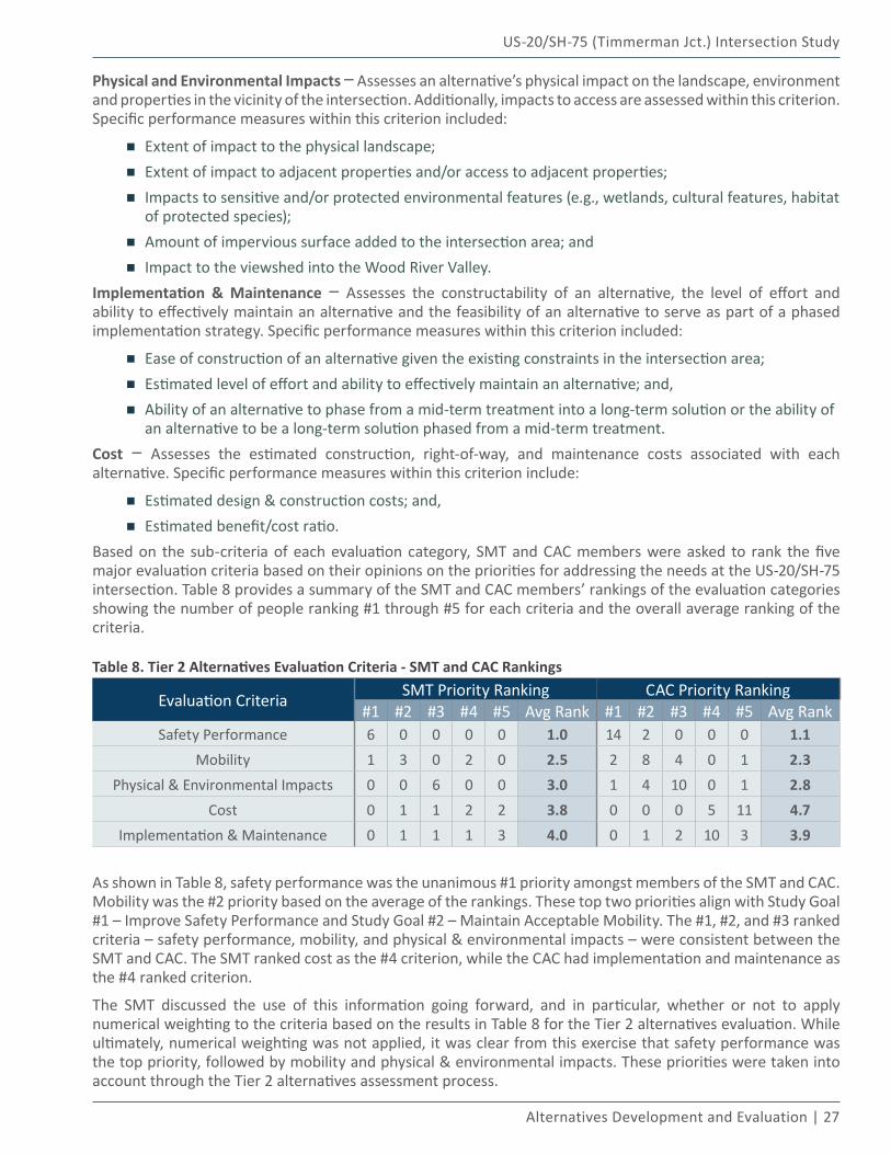
▪ Estimated benefit/cost ratio.Based on the sub-criteria of each evaluation category, SMT and CAC members were asked to rank the five major evaluation criteria based on their opinions on the priorities for addressing the needs at the US-20/SH-75 intersection. Table 8 provides a summary of the SMT and CAC members’ rankings of the evaluation categories showing the number of people ranking #1 through #5 for each criteria and the overall average ranking of the criteria.
Table 8. Tier 2 Alternatives Evaluation Criteria - SMT and CAC Rankings
Evaluation Criteria SMT Priority Ranking CAC Priority Ranking#1 #2 #3 #4 #5 Avg Rank #1 #2 #3 #4 #5 Avg Rank
Safety Performance 6 0 0 0 0 1.0 14 2 0 0 0 1.1Mobility 1 3 0 2 0 2.5 2 8 4 0 1 2.3
Physical & Environmental Impacts 0 0 6 0 0 3.0 1 4 10 0 1 2.8Cost 0 1 1 2 2 3.8 0 0 0 5 11 4.7
Implementation & Maintenance 0 1 1 1 3 4.0 0 1 2 10 3 3.9
As shown in Table 8, safety performance was the unanimous #1 priority amongst members of the SMT and CAC. Mobility was the #2 priority based on the average of the rankings. These top two priorities align with Study Goal #1 – Improve Safety Performance and Study Goal #2 – Maintain Acceptable Mobility. The #1, #2, and #3 ranked criteria – safety performance, mobility, and physical & environmental impacts – were consistent between the SMT and CAC. The SMT ranked cost as the #4 criterion, while the CAC had implementation and maintenance as the #4 ranked criterion.
The SMT discussed the use of this information going forward, and in particular, whether or not to apply numerical weighting to the criteria based on the results in Table 8 for the Tier 2 alternatives evaluation. While ultimately, numerical weighting was not applied, it was clear from this exercise that safety performance was the top priority, followed by mobility and physical & environmental impacts. These priorities were taken into account through the Tier 2 alternatives assessment process.
28 | Idaho Transportation Department
US-20/SH-75 (Timmerman Jct.) Intersection Study
Tier 2 AlternativesEach of the Tier 2 alternatives is briefly described in the following sub-sections and exhibits are provided showing the alternatives’ concept design along with the technical performance assessment for each alternative. As mentioned previously, larger depictions of the concept designs are available in Appendix I and more detail on the Tier 2 alternatives is available in Appendix J. Additionally, Appendix M provides ground-level, 3D renderings for each of the Tier 2 alternatives looking northbound on SH-75 through the intersection.
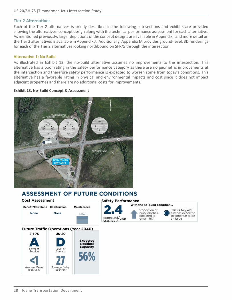
Alternative 1: No BuildAs illustrated in Exhibit 13, the no-build alternative assumes no improvements to the intersection. This alternative has a poor rating in the safety performance category as there are no geometric improvements at the intersection and therefore safety performance is expected to worsen some from today’s conditions. This alternative has a favorable rating in physical and environmental impacts and cost since it does not impact adjacent properties and there are no additional costs for improvements.
Exhibit 13. No-Build Concept & Assessment
US-20/SH-75 (Timmerman Jct.) Intersection Study
Alternatives Development and Evaluation | 29
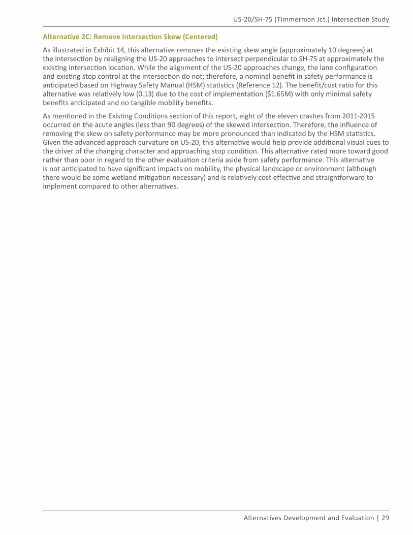
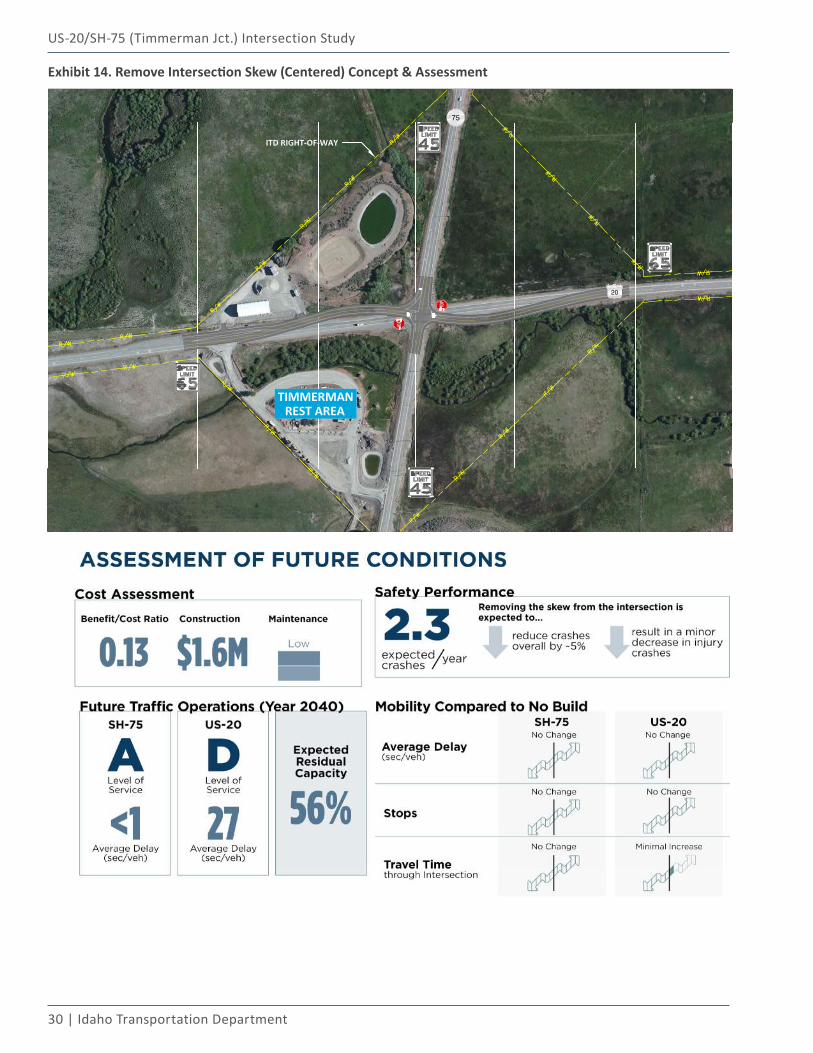
Alternative 2C: Remove Intersection Skew (Centered)
As illustrated in Exhibit 14, this alternative removes the existing skew angle (approximately 10 degrees) at the intersection by realigning the US-20 approaches to intersect perpendicular to SH-75 at approximately the existing intersection location. While the alignment of the US-20 approaches change, the lane configuration and existing stop control at the intersection do not; therefore, a nominal benefit in safety performance is anticipated based on Highway Safety Manual (HSM) statistics (Reference 12). The benefit/cost ratio for this alternative was relatively low (0.13) due to the cost of implementation ($1.65M) with only minimal safety benefits anticipated and no tangible mobility benefits.
As mentioned in the Existing Conditions section of this report, eight of the eleven crashes from 2011-2015 occurred on the acute angles (less than 90 degrees) of the skewed intersection. Therefore, the influence of removing the skew on safety performance may be more pronounced than indicated by the HSM statistics. Given the advanced approach curvature on US-20, this alternative would help provide additional visual cues to the driver of the changing character and approaching stop condition. This alternative rated more toward good rather than poor in regard to the other evaluation criteria aside from safety performance. This alternative is not anticipated to have significant impacts on mobility, the physical landscape or environment (although there would be some wetland mitigation necessary) and is relatively cost effective and straightforward to implement compared to other alternatives.
30 | Idaho Transportation Department
US-20/SH-75 (Timmerman Jct.) Intersection Study
Exhibit 14. Remove Intersection Skew (Centered) Concept & Assessment
US-20/SH-75 (Timmerman Jct.) Intersection Study
Alternatives Development and Evaluation | 31
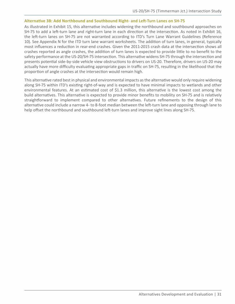
Alternative 3B: Add Northbound and Southbound Right- and Left-Turn Lanes on SH-75As illustrated in Exhibit 15, this alternative includes widening the northbound and southbound approaches on SH-75 to add a left-turn lane and right-turn lane in each direction at the intersection. As noted in Exhibit 16, the left-turn lanes on SH-75 are not warranted according to ITD’s Turn Lane Warrant Guidelines (Reference 10). See Appendix N for the ITD turn lane warrant worksheets. The addition of turn lanes, in general, typically most influences a reduction in rear-end crashes. Given the 2011-2015 crash data at the intersection shows all crashes reported as angle crashes, the addition of turn lanes is expected to provide little to no benefit to the safety performance at the US-20/SH-75 intersection. This alternative widens SH-75 through the intersection and presents potential side-by-side vehicle view obstructions to drivers on US-20. Therefore, drivers on US-20 may actually have more difficulty evaluating appropriate gaps in traffic on SH-75, resulting in the likelihood that the proportion of angle crashes at the intersection would remain high.
This alternative rated best in physical and environmental impacts as the alternative would only require widening along SH-75 within ITD’s existing right-of-way and is expected to have minimal impacts to wetlands and other environmental features. At an estimated cost of $1.3 million, this alternative is the lowest cost among the build alternatives. This alternative is expected to provide minor benefits to mobility on SH-75 and is relatively straightforward to implement compared to other alternatives. Future refinements to the design of this alternative could include a narrow 4- to 8-foot median between the left-turn lane and opposing through lane to help offset the northbound and southbound left-turn lanes and improve sight lines along SH-75.
32 | Idaho Transportation Department
US-20/SH-75 (Timmerman Jct.) Intersection Study
Exhibit 15. Add Northbound and Southbound Right- and Left-Turn Lanes on SH-75 Concept & Assessment
US-20/SH-75 (Timmerman Jct.) Intersection Study
Alternatives Development and Evaluation | 33
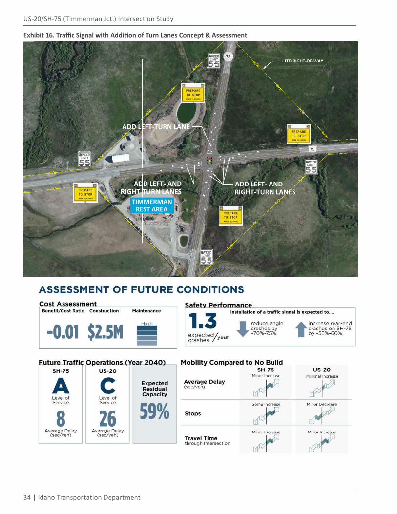
Alternative 5: Traffic Signal with Addition of Turn LanesAs illustrated in Exhibit 16, this alternative includes installation of a traffic signal at the intersection and widening each approach for the addition of left-turn and right-turn lanes. Advanced signal warning flashers are recommended with this alternative on all approaches given the high approach speeds and the rural context of the intersection. The warning flashers should be placed approximately 450 feet from the stop line, with advanced detection at approximately 750 feet from the stop line, based on the recommended guidelines from the Evaluation of Advance Warning Signal Installation report (assumes 85th percentile speeds of approximately 65 mph approaching the intersection) (Reference 16). As explained in the Future Conditions section of this report, a traffic signal at the US-20/SH-75 intersection is not expected to be warranted for approximately 15 years according to the Manual on Uniform Traffic Control Devices (MUTCD) signal warrant procedures (Reference 11) and therefore may not be an appropriate near-term treatment for the intersection.
Based on HSM statistics, installation of traffic signal is expected to reduce angle crashes at the intersection, but potentially result in increases to rear-end crashes (Reference 12). The signal is also expected to significantly impact the average delay and stops experienced by drivers on SH-75, while providing little to no improvement to the average delay for drivers on US-20. The signal is not expected to have extensive impacts on the physical landscape or environment, but the signal poles and mast arms would have some impact on the view shed into the Wood River Valley. The construction cost for the signal is estimated at $2.5 million and this alternative is anticipated to have the highest maintenance costs of any of the alternatives due to the signal equipment. The benefit/cost ratio for this intersection was the lowest amongst all build alternative as the anticipated safety benefits were offset by the higher average travel time through the intersection and the higher maintenance costs.
34 | Idaho Transportation Department
US-20/SH-75 (Timmerman Jct.) Intersection Study
Exhibit 16. Traffic Signal with Addition of Turn Lanes Concept & Assessment
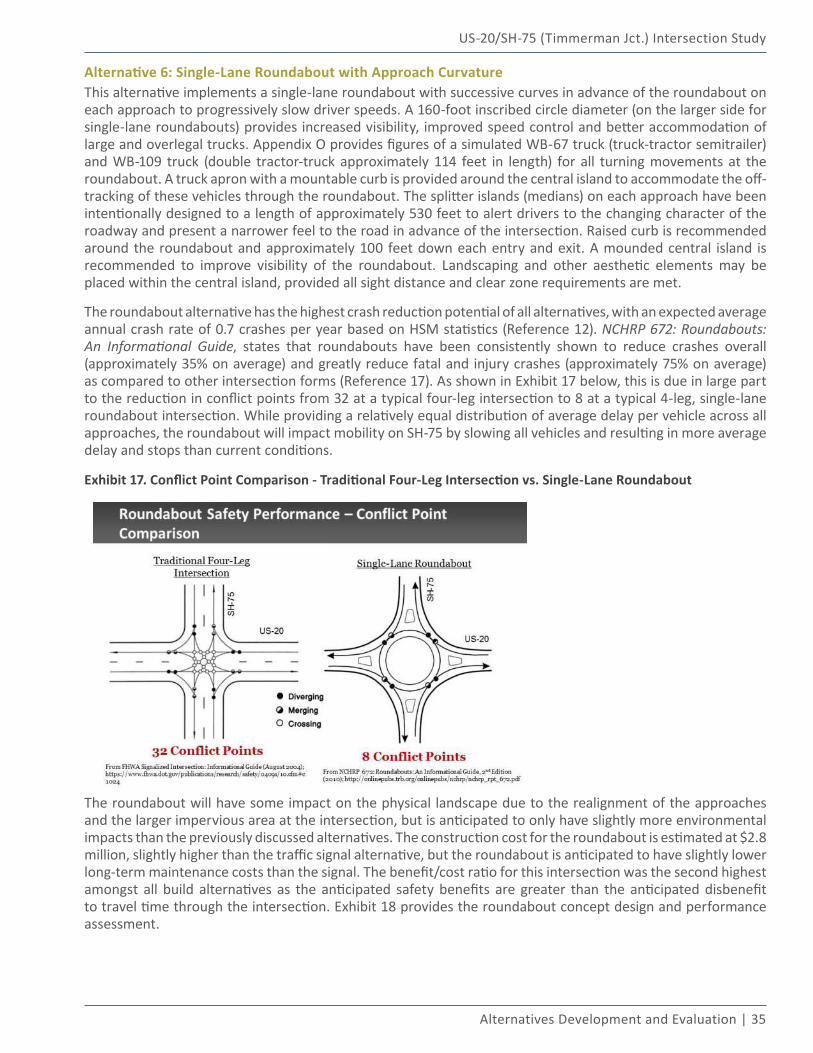
US-20/SH-75 (Timmerman Jct.) Intersection Study
Alternatives Development and Evaluation | 35
Alternative 6: Single-Lane Roundabout with Approach CurvatureThis alternative implements a single-lane roundabout with successive curves in advance of the roundabout on each approach to progressively slow driver speeds. A 160-foot inscribed circle diameter (on the larger side for single-lane roundabouts) provides increased visibility, improved speed control and better accommodation of large and overlegal trucks. Appendix O provides figures of a simulated WB-67 truck (truck-tractor semitrailer) and WB-109 truck (double tractor-truck approximately 114 feet in length) for all turning movements at the roundabout. A truck apron with a mountable curb is provided around the central island to accommodate the off-tracking of these vehicles through the roundabout. The splitter islands (medians) on each approach have been intentionally designed to a length of approximately 530 feet to alert drivers to the changing character of the roadway and present a narrower feel to the road in advance of the intersection. Raised curb is recommended around the roundabout and approximately 100 feet down each entry and exit. A mounded central island is recommended to improve visibility of the roundabout. Landscaping and other aesthetic elements may be placed within the central island, provided all sight distance and clear zone requirements are met.
The roundabout alternative has the highest crash reduction potential of all alternatives, with an expected average annual crash rate of 0.7 crashes per year based on HSM statistics (Reference 12). NCHRP 672: Roundabouts: An Informational Guide, states that roundabouts have been consistently shown to reduce crashes overall (approximately 35% on average) and greatly reduce fatal and injury crashes (approximately 75% on average) as compared to other intersection forms (Reference 17). As shown in Exhibit 17 below, this is due in large part to the reduction in conflict points from 32 at a typical four-leg intersection to 8 at a typical 4-leg, single-lane roundabout intersection. While providing a relatively equal distribution of average delay per vehicle across all approaches, the roundabout will impact mobility on SH-75 by slowing all vehicles and resulting in more average delay and stops than current conditions.
Exhibit 17. Conflict Point Comparison - Traditional Four-Leg Intersection vs. Single-Lane Roundabout
The roundabout will have some impact on the physical landscape due to the realignment of the approaches and the larger impervious area at the intersection, but is anticipated to only have slightly more environmental impacts than the previously discussed alternatives. The construction cost for the roundabout is estimated at $2.8 million, slightly higher than the traffic signal alternative, but the roundabout is anticipated to have slightly lower long-term maintenance costs than the signal. The benefit/cost ratio for this intersection was the second highest amongst all build alternatives as the anticipated safety benefits are greater than the anticipated disbenefit to travel time through the intersection. Exhibit 18 provides the roundabout concept design and performance assessment.
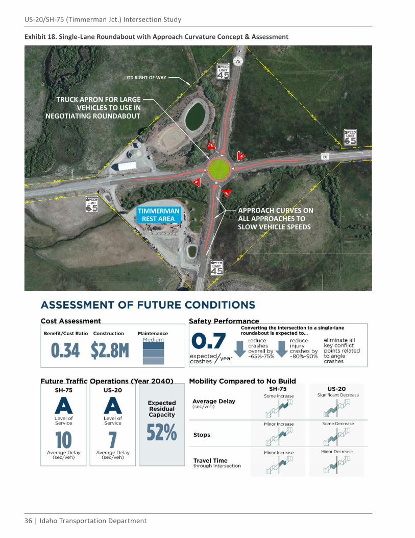
36 | Idaho Transportation Department
US-20/SH-75 (Timmerman Jct.) Intersection Study
Exhibit 18. Single-Lane Roundabout with Approach Curvature Concept & Assessment
US-20/SH-75 (Timmerman Jct.) Intersection Study
Alternatives Development and Evaluation | 37
Alternative 7: Restricted Crossing U-Turn Intersection (RCUT)As illustrated in Exhibit 19, this alternative implements an alternative intersection form referred to as a restricted crossing u-turn (RCUT) intersection. The Federal Highway Administration (FHWA) RCUT Informational Guide provides extensive detail on all aspects of the RCUT intersection form (Reference 18). The RCUT intersection design eliminates the through and left-turn movements from the US-20 approaches. Instead, drivers turn right from US-20 onto SH-75 and then make a u-turn maneuver at a one-way median opening to then proceed through on SH-75 or right onto US-20. Movements on SH-75 remain free flow. The RCUT requires widening on SH-75 to accommodate the raised medians and the loons that allow for large trucks to make the u-turn maneuvers.
The physical and environmental impacts of this alternative are higher than any of the build alternatives aside from the grade-separated interchange. This alternative improves safety performance at the intersection, particularly with respect to angle crashes; however, the relatively high estimated construction cost of $4.1 million and the out-of-direction travel for vehicles on US-20 (substantial increase in travel time and delay) offset the safety benefit and result in a benefit/cost ratio of 0.0.
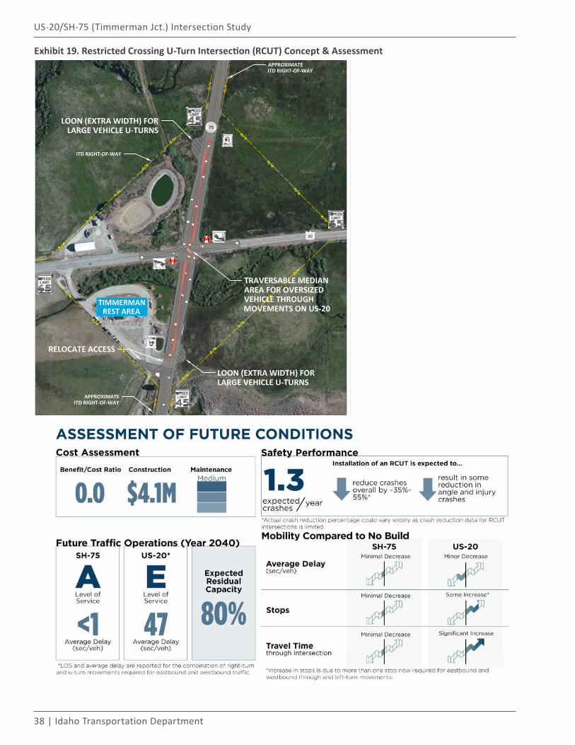
38 | Idaho Transportation Department
US-20/SH-75 (Timmerman Jct.) Intersection Study
Exhibit 19. Restricted Crossing U-Turn Intersection (RCUT) Concept & Assessment
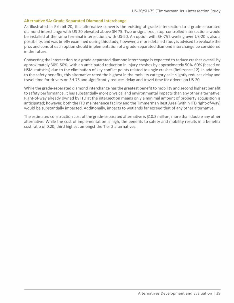
US-20/SH-75 (Timmerman Jct.) Intersection Study
Alternatives Development and Evaluation | 39
Alternative 9A: Grade-Separated Diamond InterchangeAs illustrated in Exhibit 20, this alternative converts the existing at-grade intersection to a grade-separated diamond interchange with US-20 elevated above SH-75. Two unsignalized, stop-controlled intersections would be installed at the ramp terminal intersections with US-20. An option with SH-75 traveling over US-20 is also a possibility, and was briefly examined during this study; however, a more detailed study is advised to evaluate the pros and cons of each option should implementation of a grade-separated diamond interchange be considered in the future.
Converting the intersection to a grade-separated diamond interchange is expected to reduce crashes overall by approximately 30%-50%, with an anticipated reduction in injury crashes by approximately 50%-60% (based on HSM statistics) due to the elimination of key conflict points related to angle crashes (Reference 12). In addition to the safety benefits, this alternative rated the highest in the mobility category as it slightly reduces delay and travel time for drivers on SH-75 and significantly reduces delay and travel time for drivers on US-20.
While the grade-separated diamond interchange has the greatest benefit to mobility and second highest benefit to safety performance, it has substantially more physical and environmental impacts than any other alternative. Right-of-way already owned by ITD at the intersection means only a minimal amount of property acquisition is anticipated; however, both the ITD maintenance facility and the Timmerman Rest Area (within ITD right-of-way) would be substantially impacted. Additionally, impacts to wetlands far exceed that of any other alternative.
The estimated construction cost of the grade-separated alternative is $10.3 million, more than double any other alternative. While the cost of implementation is high, the benefits to safety and mobility results in a benefit/cost ratio of 0.20, third highest amongst the Tier 2 alternatives.
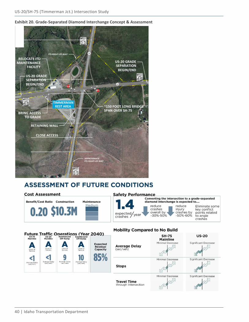
40 | Idaho Transportation Department
US-20/SH-75 (Timmerman Jct.) Intersection Study
Exhibit 20. Grade-Separated Diamond Interchange Concept & Assessment
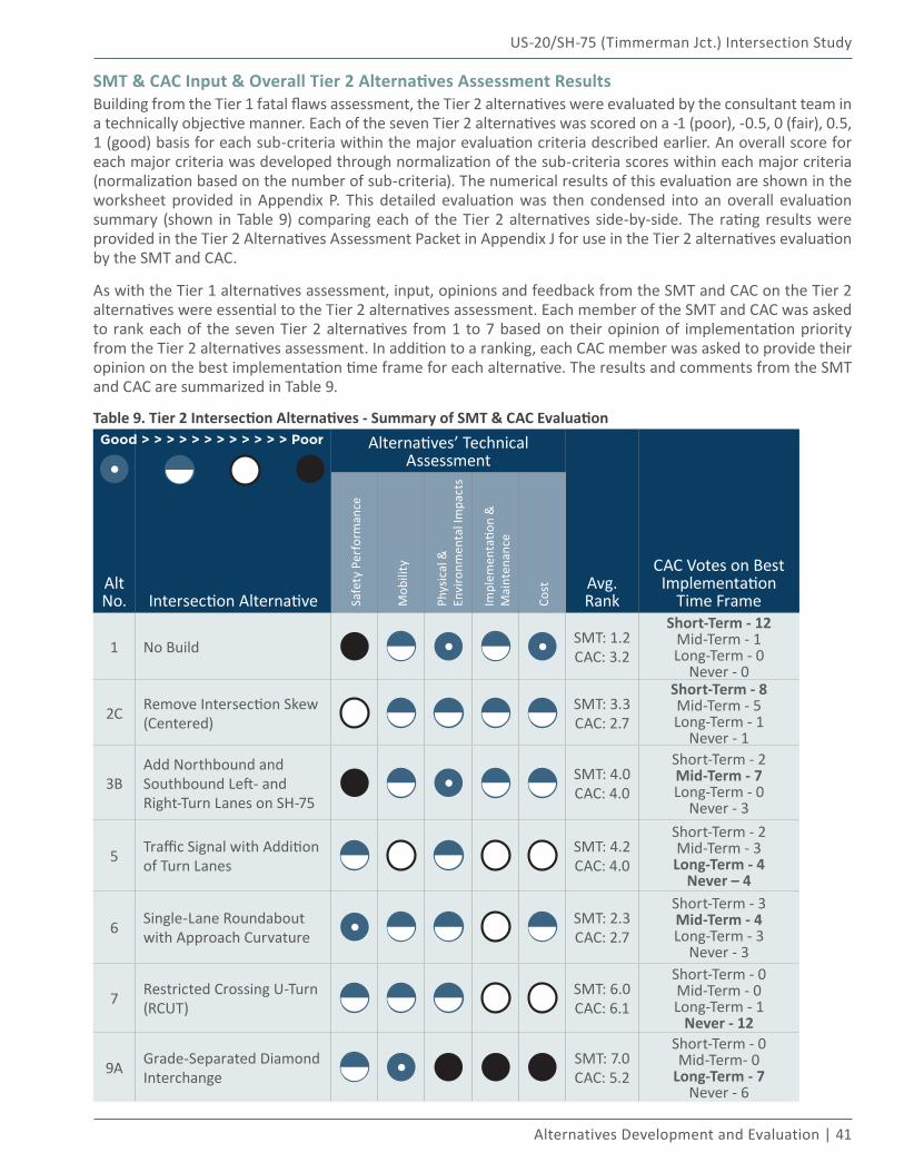
US-20/SH-75 (Timmerman Jct.) Intersection Study
Alternatives Development and Evaluation | 41
SMT & CAC Input & Overall Tier 2 Alternatives Assessment ResultsBuilding from the Tier 1 fatal flaws assessment, the Tier 2 alternatives were evaluated by the consultant team in a technically objective manner. Each of the seven Tier 2 alternatives was scored on a -1 (poor), -0.5, 0 (fair), 0.5, 1 (good) basis for each sub-criteria within the major evaluation criteria described earlier. An overall score for each major criteria was developed through normalization of the sub-criteria scores within each major criteria (normalization based on the number of sub-criteria). The numerical results of this evaluation are shown in the worksheet provided in Appendix P. This detailed evaluation was then condensed into an overall evaluation summary (shown in Table 9) comparing each of the Tier 2 alternatives side-by-side. The rating results were provided in the Tier 2 Alternatives Assessment Packet in Appendix J for use in the Tier 2 alternatives evaluation by the SMT and CAC.
As with the Tier 1 alternatives assessment, input, opinions and feedback from the SMT and CAC on the Tier 2 alternatives were essential to the Tier 2 alternatives assessment. Each member of the SMT and CAC was asked to rank each of the seven Tier 2 alternatives from 1 to 7 based on their opinion of implementation priority from the Tier 2 alternatives assessment. In addition to a ranking, each CAC member was asked to provide their opinion on the best implementation time frame for each alternative. The results and comments from the SMT and CAC are summarized in Table 9.
Table 9. Tier 2 Intersection Alternatives - Summary of SMT & CAC Evaluation
Alt No. Intersection Alternative
Alternatives’ Technical Assessment
Avg. Rank
CAC Votes on Best Implementation
Time FrameSafe
ty P
erfo
rman
ce
Mob
ility
Phys
ical
&
Envi
ronm
enta
l Im
pact
s
Impl
emen
tatio
n &
M
aint
enan
ce
Cost
1 No Build SMT: 1.2 CAC: 3.2
Short-Term - 12Mid-Term - 1Long-Term - 0
Never - 0
2C Remove Intersection Skew (Centered)
SMT: 3.3 CAC: 2.7
Short-Term - 8Mid-Term - 5Long-Term - 1
Never - 1
3BAdd Northbound and Southbound Left- and Right-Turn Lanes on SH-75
SMT: 4.0 CAC: 4.0
Short-Term - 2Mid-Term - 7Long-Term - 0
Never - 3
5 Traffic Signal with Addition of Turn Lanes
SMT: 4.2 CAC: 4.0
Short-Term - 2Mid-Term - 3Long-Term - 4
Never – 4
6 Single-Lane Roundabout with Approach Curvature
SMT: 2.3 CAC: 2.7
Short-Term - 3Mid-Term - 4Long-Term - 3
Never - 3
7 Restricted Crossing U-Turn (RCUT)
SMT: 6.0 CAC: 6.1
Short-Term - 0Mid-Term - 0Long-Term - 1
Never - 12
9A Grade-Separated Diamond Interchange
SMT: 7.0 CAC: 5.2
Short-Term - 0Mid-Term- 0
Long-Term - 7Never - 6
Good > > > > > > > > > > > > Poor
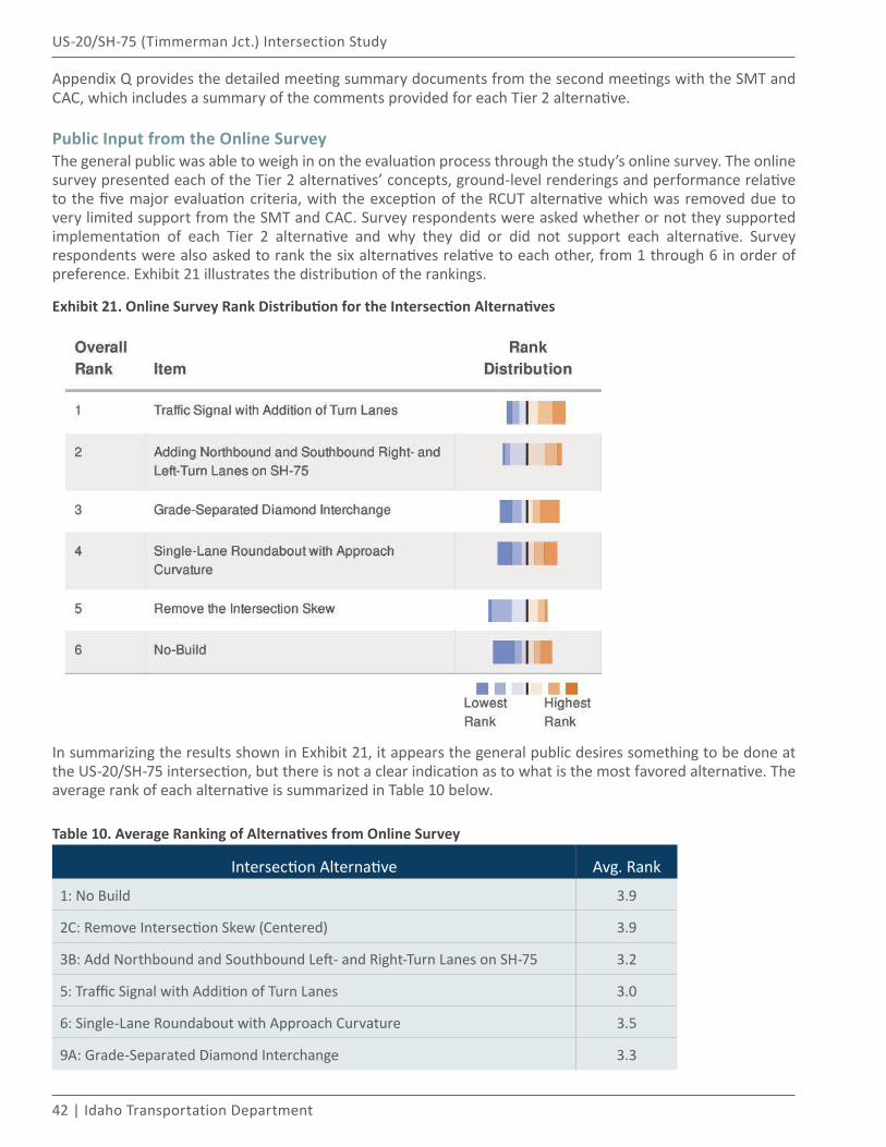
42 | Idaho Transportation Department
US-20/SH-75 (Timmerman Jct.) Intersection Study
Appendix Q provides the detailed meeting summary documents from the second meetings with the SMT and CAC, which includes a summary of the comments provided for each Tier 2 alternative.
Public Input from the Online SurveyThe general public was able to weigh in on the evaluation process through the study’s online survey. The online survey presented each of the Tier 2 alternatives’ concepts, ground-level renderings and performance relative to the five major evaluation criteria, with the exception of the RCUT alternative which was removed due to very limited support from the SMT and CAC. Survey respondents were asked whether or not they supported implementation of each Tier 2 alternative and why they did or did not support each alternative. Survey respondents were also asked to rank the six alternatives relative to each other, from 1 through 6 in order of preference. Exhibit 21 illustrates the distribution of the rankings.
Exhibit 21. Online Survey Rank Distribution for the Intersection Alternatives
In summarizing the results shown in Exhibit 21, it appears the general public desires something to be done at the US-20/SH-75 intersection, but there is not a clear indication as to what is the most favored alternative. The average rank of each alternative is summarized in Table 10 below.
Table 10. Average Ranking of Alternatives from Online Survey
Intersection Alternative Avg. Rank
1: No Build 3.9
2C: Remove Intersection Skew (Centered) 3.9
3B: Add Northbound and Southbound Left- and Right-Turn Lanes on SH-75 3.2
5: Traffic Signal with Addition of Turn Lanes 3.0
6: Single-Lane Roundabout with Approach Curvature 3.5
9A: Grade-Separated Diamond Interchange 3.3
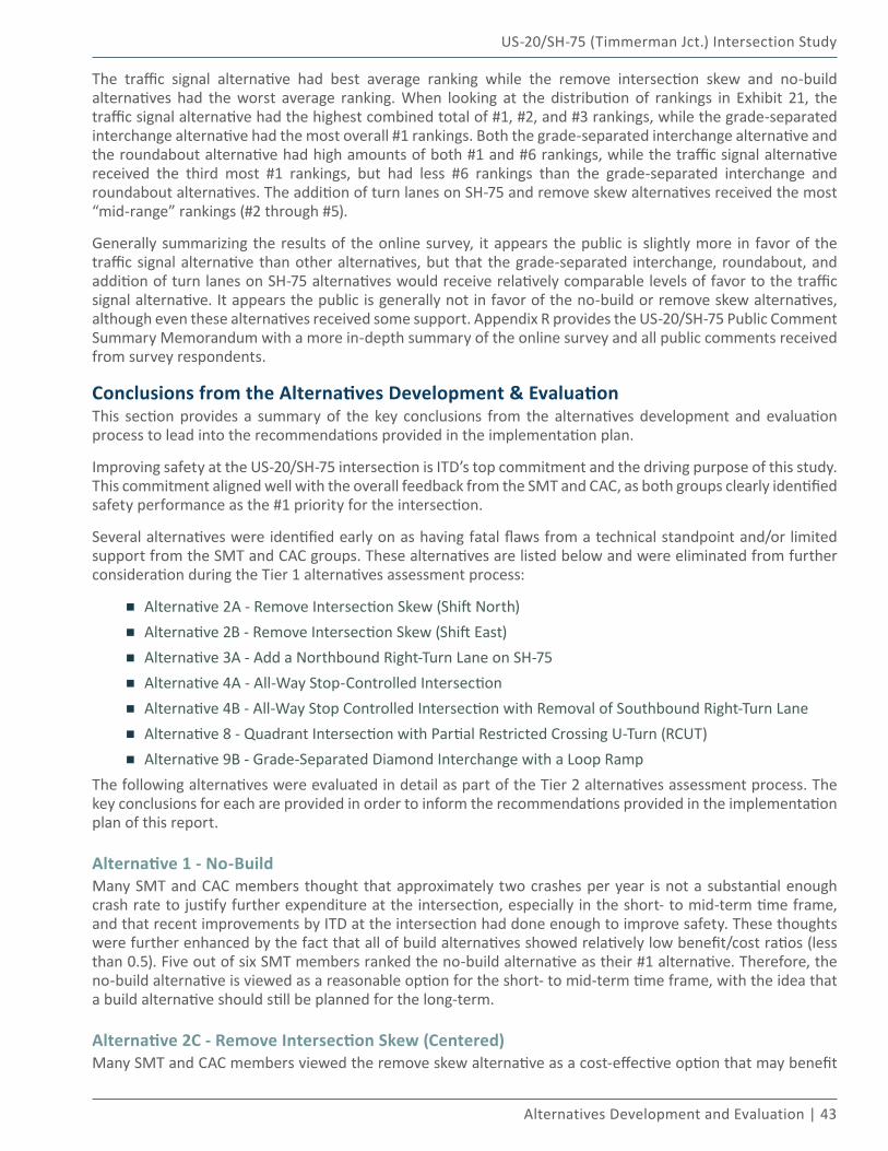
US-20/SH-75 (Timmerman Jct.) Intersection Study
Alternatives Development and Evaluation | 43
The traffic signal alternative had best average ranking while the remove intersection skew and no-build alternatives had the worst average ranking. When looking at the distribution of rankings in Exhibit 21, the traffic signal alternative had the highest combined total of #1, #2, and #3 rankings, while the grade-separated interchange alternative had the most overall #1 rankings. Both the grade-separated interchange alternative and the roundabout alternative had high amounts of both #1 and #6 rankings, while the traffic signal alternative received the third most #1 rankings, but had less #6 rankings than the grade-separated interchange and roundabout alternatives. The addition of turn lanes on SH-75 and remove skew alternatives received the most “mid-range” rankings (#2 through #5).
Generally summarizing the results of the online survey, it appears the public is slightly more in favor of the traffic signal alternative than other alternatives, but that the grade-separated interchange, roundabout, and addition of turn lanes on SH-75 alternatives would receive relatively comparable levels of favor to the traffic signal alternative. It appears the public is generally not in favor of the no-build or remove skew alternatives, although even these alternatives received some support. Appendix R provides the US-20/SH-75 Public Comment Summary Memorandum with a more in-depth summary of the online survey and all public comments received from survey respondents.
Conclusions from the Alternatives Development & EvaluationThis section provides a summary of the key conclusions from the alternatives development and evaluation process to lead into the recommendations provided in the implementation plan.
Improving safety at the US-20/SH-75 intersection is ITD’s top commitment and the driving purpose of this study. This commitment aligned well with the overall feedback from the SMT and CAC, as both groups clearly identified safety performance as the #1 priority for the intersection.
Several alternatives were identified early on as having fatal flaws from a technical standpoint and/or limited support from the SMT and CAC groups. These alternatives are listed below and were eliminated from further consideration during the Tier 1 alternatives assessment process:
▪ Alternative 2A - Remove Intersection Skew (Shift North)
▪ Alternative 2B - Remove Intersection Skew (Shift East)
▪ Alternative 3A - Add a Northbound Right-Turn Lane on SH-75
▪ Alternative 4A - All-Way Stop-Controlled Intersection
▪ Alternative 4B - All-Way Stop Controlled Intersection with Removal of Southbound Right-Turn Lane
▪ Alternative 8 - Quadrant Intersection with Partial Restricted Crossing U-Turn (RCUT)
▪ Alternative 9B - Grade-Separated Diamond Interchange with a Loop RampThe following alternatives were evaluated in detail as part of the Tier 2 alternatives assessment process. The key conclusions for each are provided in order to inform the recommendations provided in the implementation plan of this report.
Alternative 1 - No-BuildMany SMT and CAC members thought that approximately two crashes per year is not a substantial enough crash rate to justify further expenditure at the intersection, especially in the short- to mid-term time frame, and that recent improvements by ITD at the intersection had done enough to improve safety. These thoughts were further enhanced by the fact that all of build alternatives showed relatively low benefit/cost ratios (less than 0.5). Five out of six SMT members ranked the no-build alternative as their #1 alternative. Therefore, the no-build alternative is viewed as a reasonable option for the short- to mid-term time frame, with the idea that a build alternative should still be planned for the long-term.
Alternative 2C - Remove Intersection Skew (Centered)Many SMT and CAC members viewed the remove skew alternative as a cost-effective option that may benefit
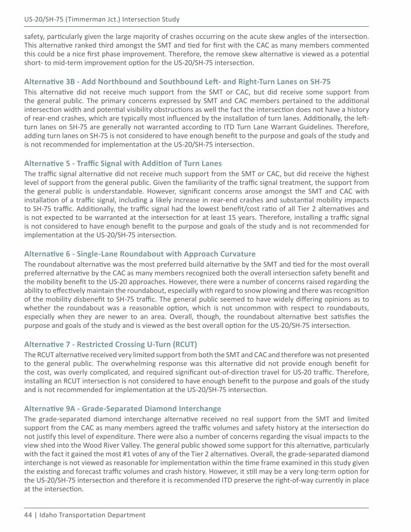
44 | Idaho Transportation Department
US-20/SH-75 (Timmerman Jct.) Intersection Study
safety, particularly given the large majority of crashes occurring on the acute skew angles of the intersection. This alternative ranked third amongst the SMT and tied for first with the CAC as many members commented this could be a nice first phase improvement. Therefore, the remove skew alternative is viewed as a potential short- to mid-term improvement option for the US-20/SH-75 intersection.
Alternative 3B - Add Northbound and Southbound Left- and Right-Turn Lanes on SH-75This alternative did not receive much support from the SMT or CAC, but did receive some support from the general public. The primary concerns expressed by SMT and CAC members pertained to the additional intersection width and potential visibility obstructions as well the fact the intersection does not have a history of rear-end crashes, which are typically most influenced by the installation of turn lanes. Additionally, the left-turn lanes on SH-75 are generally not warranted according to ITD Turn Lane Warrant Guidelines. Therefore, adding turn lanes on SH-75 is not considered to have enough benefit to the purpose and goals of the study and is not recommended for implementation at the US-20/SH-75 intersection.
Alternative 5 - Traffic Signal with Addition of Turn LanesThe traffic signal alternative did not receive much support from the SMT or CAC, but did receive the highest level of support from the general public. Given the familiarity of the traffic signal treatment, the support from the general public is understandable. However, significant concerns arose amongst the SMT and CAC with installation of a traffic signal, including a likely increase in rear-end crashes and substantial mobility impacts to SH-75 traffic. Additionally, the traffic signal had the lowest benefit/cost ratio of all Tier 2 alternatives and is not expected to be warranted at the intersection for at least 15 years. Therefore, installing a traffic signal is not considered to have enough benefit to the purpose and goals of the study and is not recommended for implementation at the US-20/SH-75 intersection.
Alternative 6 - Single-Lane Roundabout with Approach CurvatureThe roundabout alternative was the most preferred build alternative by the SMT and tied for the most overall preferred alternative by the CAC as many members recognized both the overall intersection safety benefit and the mobility benefit to the US-20 approaches. However, there were a number of concerns raised regarding the ability to effectively maintain the roundabout, especially with regard to snow plowing and there was recognition of the mobility disbenefit to SH-75 traffic. The general public seemed to have widely differing opinions as to whether the roundabout was a reasonable option, which is not uncommon with respect to roundabouts, especially when they are newer to an area. Overall, though, the roundabout alternative best satisfies the purpose and goals of the study and is viewed as the best overall option for the US-20/SH-75 intersection.
Alternative 7 - Restricted Crossing U-Turn (RCUT)The RCUT alternative received very limited support from both the SMT and CAC and therefore was not presented to the general public. The overwhelming response was this alternative did not provide enough benefit for the cost, was overly complicated, and required significant out-of-direction travel for US-20 traffic. Therefore, installing an RCUT intersection is not considered to have enough benefit to the purpose and goals of the study and is not recommended for implementation at the US-20/SH-75 intersection.
Alternative 9A - Grade-Separated Diamond InterchangeThe grade-separated diamond interchange alternative received no real support from the SMT and limited support from the CAC as many members agreed the traffic volumes and safety history at the intersection do not justify this level of expenditure. There were also a number of concerns regarding the visual impacts to the view shed into the Wood River Valley. The general public showed some support for this alternative, particularly with the fact it gained the most #1 votes of any of the Tier 2 alternatives. Overall, the grade-separated diamond interchange is not viewed as reasonable for implementation within the time frame examined in this study given the existing and forecast traffic volumes and crash history. However, it still may be a very long-term option for the US-20/SH-75 intersection and therefore it is recommended ITD preserve the right-of-way currently in place at the intersection.
US-20/SH-75 (Timmerman Jct.) Intersection Study
Alternatives Development and Evaluation | 45
Other Intersection Treatment IdeasThrough the public involvement process of the study, numerous other treatment ideas were brought up for the US-20/SH-75 intersection. Many short-term treatment ideas were offered; generally, those brought up by the CAC were addressed by ITD through the process of the study (see Appendix S). One short-term treatment idea implemented through the course of this study was the relocation of the outbound speed limit signs on SH-75 to shorten the length of the 45 mph speed zone.
Summarizing all other treatment ideas offered is not feasible within the bounds of this study; however, several ideas were brought up that may warrant further consideration by ITD due to implications on the implementation plan for this study.
Video Monitoring of the IntersectionThis treatment idea generally involves setting up video detection cameras for an extended period of time at the US-20/SH-75 intersection to obtain extensive data on specific items (e.g., drivers running the stop sign). Current technology would be used to process the data in a mostly automated manner and further inform future decisions for improvements at the intersection. This treatment is further discussed in the Implementation Plan section of this report.
Visibility of the IntersectionMany comments were received throughout the course of the study with various short-term treatment ideas on improving the visibility and conspicuity of the existing intersection, particularly for drivers on US-20. Several of these ideas (listed below) may assist drivers with seeing and better understanding the control at the intersection and it is recommended they be given further consideration for implementation by ITD:
▪ Providing a larger overhead flashing light in the center of the intersection (consider the use of LED bulbs)
▪ Providing stop signs on US-20 with flashing red LED lights around the border of the signs
Image Courtesy: Traffic & Parking Control Company, Inc.
▪ Placing red, retroreflective tape on the stop sign posts on US-20
Image Courtesy: Michigan Department of Transportation (MDOT)
46 | Idaho Transportation Department
US-20/SH-75 (Timmerman Jct.) Intersection Study
Passing Lane on Southbound SH-75 (Traveling Up Timmerman Hill)Acceleration of trucks and other vehicles with loads to the south of the US-20/SH-75 intersection up Timmerman Hill was a key concern expressed by both the CAC and the general public. This concern was especially associated with implementation of any intersection alternative stopping or slowing traffic on SH-75. The average grade for the first one-half mile immediately south of the intersection was estimated to be approximately 1%. After one-half mile, the grade on SH-75 steepens to an average of approximately 4.5% up Timmerman Hill. Appendix S provides an illustration of the general SH-75 roadway profile leading to Timmerman Hill.
A typical loaded truck (starting from a stop condition) is estimated to be able to accelerate to speeds greater than 40 mph prior to reaching the steeper grade up Timmerman Hill. A typical loaded truck would then be expected to slow to speeds less than 40 mph as it travels up the steeper grade of Timmerman Hill. These estimations were based on speed-distance estimations for the acceleration of typical loaded trucks from the AASHTO Policy on the Geometric Design of Highways and Streets (Reference 19). Therefore, it is not anticipated that a stop condition on SH-75 at the US-20/SH-75 intersection would adversely affect the ability of a typical loaded truck to climb Timmerman Hill. A typical loaded truck would not be able to maintain a 40 mph or faster speed as it travels up the steeper portion of the hill. Providing a passing lane on Timmerman Hill may be worth further investigation by ITD, but does not necessarily need to coincide with improvements at the US-20/SH-75 intersection.
Shifting the Intersection to the SouthThis treatment idea involves relocating the intersection approximately one-half mile to the south in order to try and bring the intersection out of the wetlands and high groundwater area it is currently located in. The estimated length of new roadway needed for the relocation would about 2.7 miles. At a rough cost of $5M-$7M/mile, this equates to a total cost in the range of $14M-$19M. There would still likely be wetlands impacts to the west of the intersection; however, the intersection itself would be out of the currently delineated wetlands areas. Appendix S provides a rough schematic of the potential realignment of US-20 to accomplish this shift.
Implementation Plan05
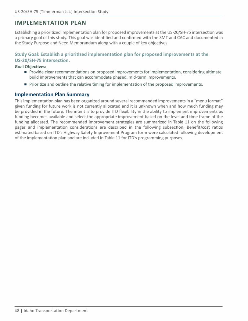
48 | Idaho Transportation Department
US-20/SH-75 (Timmerman Jct.) Intersection Study
IMPLEMENTATION PLANEstablishing a prioritized implementation plan for proposed improvements at the US-20/SH-75 intersection was a primary goal of this study. This goal was identified and confirmed with the SMT and CAC and documented in the Study Purpose and Need Memorandum along with a couple of key objectives.
Study Goal: Establish a prioritized implementation plan for proposed improvements at the US-20/SH-75 intersection.Goal Objectives:
▪ Provide clear recommendations on proposed improvements for implementation, considering ultimate build improvements that can accommodate phased, mid-term improvements.
▪ Prioritize and outline the relative timing for implementation of the proposed improvements.
Implementation Plan SummaryThis implementation plan has been organized around several recommended improvements in a “menu format” given funding for future work is not currently allocated and it is unknown when and how much funding may be provided in the future. The intent is to provide ITD flexibility in the ability to implement improvements as funding becomes available and select the appropriate improvement based on the level and time frame of the funding allocated. The recommended improvement strategies are summarized in Table 11 on the following pages and implementation considerations are described in the following subsection. Benefit/cost ratios estimated based on ITD’s Highway Safety Improvement Program form were calculated following development of the implementation plan and are included in Table 11 for ITD’s programming purposes.
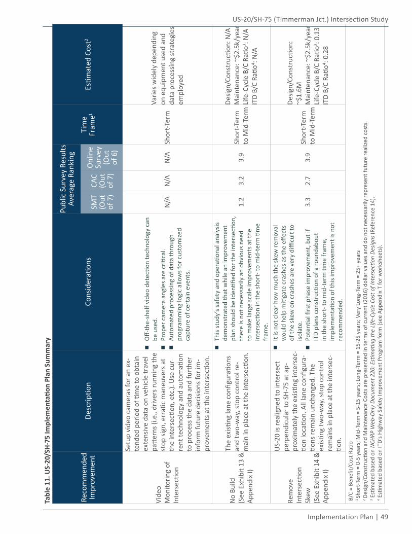
US-20/SH-75 (Timmerman Jct.) Intersection Study
Implementation Plan | 49
Tabl
e 11
. US-
20/S
H-7
5 Im
plem
enta
tion
Plan
Sum
mar
y
Reco
mm
ende
d Im
prov
emen
tDe
scrip
tion
Cons
ider
ation
s
Publ
ic S
urve
y Re
sults
Aver
age
Rank
ing
Tim
e Fr
ame1
Estim
ated
Cos
t2
SMT
(Out
of
7)
CAC
(Out
of
7)
Onl
ine
Surv
ey(O
ut
of 6
)
Vide
o M
onito
ring
of
Inte
rsec
tion
Setu
p vi
deo
cam
eras
for a
n ex
-te
nded
per
iod
of ti
me
to o
btai
n ex
tens
ive
data
on
vehi
cle
trav
el
patte
rns (
i.e.,
driv
ers r
unni
ng th
e st
op si
gn, e
rrati
c m
aneu
vers
at
the
inte
rsec
tion,
etc
.). U
se c
ur-
rent
tech
nolo
gy a
nd a
utom
ation
to
pro
cess
the
data
and
furt
her
info
rm fu
ture
dec
ision
s for
im-
prov
emen
ts a
t the
inte
rsec
tion.
▪Off-
the-
shel
f vid
eo d
etec
tion
tech
nolo
gy c
an
be u
sed.
▪Pro
per c
amer
a an
gles
are
criti
cal.
▪Aut
omat
ed p
roce
ssin
g of
dat
a th
roug
h pr
ogra
mm
ing
logi
c al
low
s for
cus
tom
ized
capt
ure
of c
erta
in e
vent
s.
N/A
N/A
N/A
Shor
t-Ter
m
Varie
s wid
ely
depe
ndin
g on
equ
ipm
ent u
sed
and
data
pro
cess
ing
stra
tegi
es
empl
oyed
No
Build
(See
Exh
ibit
13 &
Ap
pend
ix I)
The
existi
ng la
ne c
onfig
urati
ons
and
two-
way
, sto
p co
ntro
l re-
mai
n in
pla
ce a
t the
inte
rsec
tion.
▪Thi
s stu
dy’s
safe
ty a
nd o
pera
tiona
l ana
lysis
de
mon
stra
ted
that
whi
le a
n im
prov
emen
t pl
an sh
ould
be
iden
tified
for t
he in
ters
ectio
n,
ther
e is
not n
eces
saril
y an
obv
ious
nee
d to
mak
e la
rge
scal
e im
prov
emen
ts a
t the
in
ters
ectio
n in
the
shor
t- to
mid
-ter
m ti
me
fram
e.
1.2
3.2
3.9
Shor
t-Ter
m
to M
id-T
erm
Desig
n/Co
nstr
uctio
n: N
/AM
aint
enan
ce: ~
$2.5
k/ye
arLi
fe-C
ycle
B/C
Rati
o3 : N/A
ITD
B/C
Ratio
4 : N/A
Rem
ove
Inte
rsec
tion
Skew
(See
Exh
ibit
14 &
Ap
pend
ix I)
US-
20 is
real
igne
d to
inte
rsec
t pe
rpen
dicu
lar t
o SH
-75
at a
p-pr
oxim
atel
y th
e ex
isting
inte
rsec
-tio
n lo
catio
n. A
ll la
ne c
onfig
ura-
tions
rem
ain
unch
ange
d. T
he
existi
ng tw
o-w
ay, s
top
cont
rol
rem
ains
in p
lace
at t
he in
ters
ec-
tion.
▪It i
s not
cle
ar h
ow m
uch
the
skew
rem
oval
w
ould
hel
p m
itiga
te c
rash
es a
s the
effe
cts
of th
e sk
ew o
n cr
ashe
s are
ver
y di
fficu
lt to
iso
late
.
▪Pot
entia
l firs
t pha
se im
prov
emen
t, bu
t if
ITD
plan
s con
stru
ction
of a
roun
dabo
ut
in th
e sh
ort-
to m
id-t
erm
tim
e fr
ame,
im
plem
enta
tion
of th
is im
prov
emen
t is n
ot
reco
mm
ende
d.
3.3
2.7
3.9
Shor
t-Ter
m
to M
id-T
erm
Desig
n/Co
nstr
uctio
n:
~$1.
6MM
aint
enan
ce: ~
$2.5
k/ye
arLi
fe-C
ycle
B/C
Rati
o3 : 0.1
3IT
D B/
C Ra
tio4 : 0
.28
B/C
= Be
nefit
/Cos
t Rati
o1 Sh
ort-T
erm
= 0
-5 y
ears
; Mid
-Ter
m =
5-1
5 ye
ars;
Lon
g-Te
rm =
15-
25 y
ears
; Ver
y Lo
ng-T
erm
= 2
5+ y
ears
2 De
sign/
Cons
truc
tion
and
Mai
nten
ance
Cos
ts a
re p
rese
nted
in te
rms o
f cur
rent
(201
6) d
olla
r val
ues a
nd d
o no
t nec
essa
rily
repr
esen
t fut
ure
real
ized
cost
s.3 E
stim
ated
bas
ed o
n N
CHRP
Web
-Onl
y Do
cum
ent 2
20: E
stim
ating
the
Life
-Cyc
le C
ost o
f Int
erse
ction
Des
igns
(Ref
eren
ce 1
4).
4 Esti
mat
ed b
ased
on
ITD’
s Hig
hway
Saf
ety
Impr
ovem
ent P
rogr
am fo
rm (s
ee A
ppen
dix
T fo
r wor
kshe
ets)
.
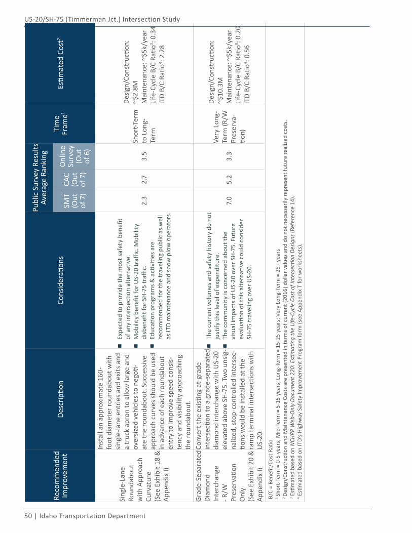
50 | Idaho Transportation Department
US-20/SH-75 (Timmerman Jct.) Intersection Study
Reco
mm
ende
d Im
prov
emen
tDe
scrip
tion
Cons
ider
ation
s
Publ
ic S
urve
y Re
sults
Aver
age
Rank
ing
Tim
e Fr
ame1
Estim
ated
Cos
t2
SMT
(Out
of
7)
CAC
(Out
of
7)
Onl
ine
Surv
ey(O
ut
of 6
)
Sing
le-L
ane
Roun
dabo
ut
with
App
roac
h Cu
rvat
ure
(See
Exh
ibit
18 &
Ap
pend
ix I)
Inst
all a
n ap
prox
imat
e 16
0-fo
ot d
iam
eter
roun
dabo
ut w
ith
singl
e-la
ne e
ntrie
s and
exi
ts a
nd
a tr
uck
apro
n to
allo
w la
rge
and
over
sized
veh
icle
s to
nego
ti-at
e th
e ro
unda
bout
. Suc
cess
ive
appr
oach
cur
ves s
houl
d be
use
d in
adv
ance
of e
ach
roun
dabo
ut
entr
y to
impr
ove
spee
d co
nsis-
tenc
y an
d vi
sibili
ty a
ppro
achi
ng
the
roun
dabo
ut.
▪Exp
ecte
d to
pro
vide
the
mos
t saf
ety
bene
fit
of a
ny in
ters
ectio
n al
tern
ative
.
▪Mob
ility
ben
efit f
or U
S-20
traffi
c. M
obili
ty
disb
enefi
t for
SH
-75
traffi
c.
▪Edu
catio
n pr
ogra
ms &
acti
vitie
s are
re
com
men
ded
for t
he tr
avel
ing
publ
ic a
s wel
l as
ITD
mai
nten
ance
and
snow
plo
w o
pera
tors
.
2.3
2.7
3.5
Shor
t-Ter
m
to L
ong-
Term
Desig
n/Co
nstr
uctio
n:
~$2.
8MM
aint
enan
ce: ~
$5k/
year
Life
-Cyc
le B
/C R
atio3 : 0
.34
ITD
B/C
Ratio
4 : 2.2
8
Grad
e-Se
para
ted
Diam
ond
Inte
rcha
nge
- R/W
Pr
eser
vatio
n O
nly
(See
Exh
ibit
20 &
Ap
pend
ix I)
Conv
ert t
he e
xisti
ng a
t-gra
de
inte
rsec
tion
to a
gra
de-s
epar
ated
di
amon
d in
terc
hang
e w
ith U
S-20
el
evat
ed a
bove
SH
-75.
Tw
o un
sig-
naliz
ed, s
top-
cont
rolle
d in
ters
ec-
tions
wou
ld b
e in
stal
led
at th
e ra
mp
term
inal
inte
rsec
tions
with
U
S-20
.
▪The
cur
rent
vol
umes
and
safe
ty h
isto
ry d
o no
t ju
stify
this
leve
l of e
xpen
ditu
re.
▪The
com
mun
ity is
con
cern
ed a
bout
the
visu
al im
pact
s of U
S-20
ove
r SH
-75.
Fut
ure
eval
uatio
n of
this
alte
rnati
ve c
ould
con
sider
SH
-75
trav
elin
g ov
er U
S-20
.
7.0
5.2
3.3
Very
Lon
g-Te
rm (R
/W
Pres
erva
-tio
n)
Desig
n/Co
nstr
uctio
n:
~$10
.3M
Mai
nten
ance
: ~$5
k/ye
arLi
fe-C
ycle
B/C
Rati
o3 : 0.2
0IT
D B/
C Ra
tio4 : 0
.56
B/C
= Be
nefit
/Cos
t Rati
o1 Sh
ort-T
erm
= 0
-5 y
ears
; Mid
-Ter
m =
5-1
5 ye
ars;
Lon
g-Te
rm =
15-
25 y
ears
; Ver
y Lo
ng-T
erm
= 2
5+ y
ears
2 De
sign/
Cons
truc
tion
and
Mai
nten
ance
Cos
ts a
re p
rese
nted
in te
rms o
f cur
rent
(201
6) d
olla
r val
ues a
nd d
o no
t nec
essa
rily
repr
esen
t fut
ure
real
ized
cost
s.3 E
stim
ated
bas
ed o
n N
CHRP
Web
-Onl
y Do
cum
ent 2
20: E
stim
ating
the
Life
-Cyc
le C
ost o
f Int
erse
ction
Des
igns
(Ref
eren
ce 1
4).
4 Esti
mat
ed b
ased
on
ITD’
s Hig
hway
Saf
ety
Impr
ovem
ent P
rogr
am fo
rm (s
ee A
ppen
dix
T fo
r wor
kshe
ets)
.
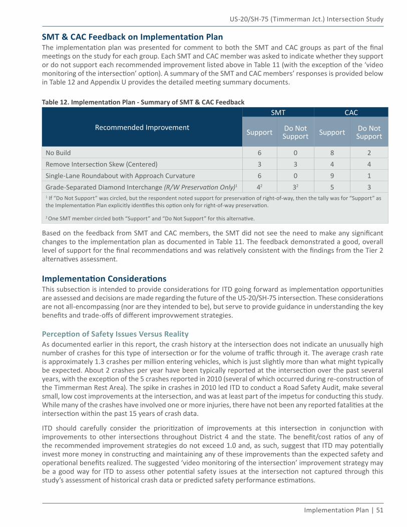
US-20/SH-75 (Timmerman Jct.) Intersection Study
Implementation Plan | 51
SMT & CAC Feedback on Implementation PlanThe implementation plan was presented for comment to both the SMT and CAC groups as part of the final meetings on the study for each group. Each SMT and CAC member was asked to indicate whether they support or do not support each recommended improvement listed above in Table 11 (with the exception of the ‘video monitoring of the intersection’ option). A summary of the SMT and CAC members’ responses is provided below in Table 12 and Appendix U provides the detailed meeting summary documents.
Table 12. Implementation Plan - Summary of SMT & CAC Feedback
Recommended Improvement
SMT CAC
Support Do Not Support Support Do Not
Support
No Build 6 0 8 2Remove Intersection Skew (Centered) 3 3 4 4Single-Lane Roundabout with Approach Curvature 6 0 9 1Grade-Separated Diamond Interchange (R/W Preservation Only)1 42 32 5 31 If “Do Not Support” was circled, but the respondent noted support for preservation of right-of-way, then the tally was for “Support” as the Implementation Plan explicitly identifies this option only for right-of-way preservation.
2 One SMT member circled both “Support” and “Do Not Support” for this alternative.
Based on the feedback from SMT and CAC members, the SMT did not see the need to make any significant changes to the implementation plan as documented in Table 11. The feedback demonstrated a good, overall level of support for the final recommendations and was relatively consistent with the findings from the Tier 2 alternatives assessment.
Implementation ConsiderationsThis subsection is intended to provide considerations for ITD going forward as implementation opportunities are assessed and decisions are made regarding the future of the US-20/SH-75 intersection. These considerations are not all-encompassing (nor are they intended to be), but serve to provide guidance in understanding the key benefits and trade-offs of different improvwement strategies.
Perception of Safety Issues Versus RealityAs documented earlier in this report, the crash history at the intersection does not indicate an unusually high number of crashes for this type of intersection or for the volume of traffic through it. The average crash rate is approximately 1.3 crashes per million entering vehicles, which is just slightly more than what might typically be expected. About 2 crashes per year have been typically reported at the intersection over the past several years, with the exception of the 5 crashes reported in 2010 (several of which occurred during re-construction of the Timmerman Rest Area). The spike in crashes in 2010 led ITD to conduct a Road Safety Audit, make several small, low cost improvements at the intersection, and was at least part of the impetus for conducting this study. While many of the crashes have involved one or more injuries, there have not been any reported fatalities at the intersection within the past 15 years of crash data.
ITD should carefully consider the prioritization of improvements at this intersection in conjunction with improvements to other intersections throughout District 4 and the state. The benefit/cost ratios of any of the recommended improvement strategies do not exceed 1.0 and, as such, suggest that ITD may potentially invest more money in constructing and maintaining any of these improvements than the expected safety and operational benefits realized. The suggested ‘video monitoring of the intersection’ improvement strategy may be a good way for ITD to assess other potential safety issues at the intersection not captured through this study’s assessment of historical crash data or predicted safety performance estimations.
52 | Idaho Transportation Department
US-20/SH-75 (Timmerman Jct.) Intersection Study
Phasing/Timing of ImprovementsTable 11 provides general thoughts related to the phasing and time frame of the various implementation strategies. The following bullets expand upon these general thoughts to provide ITD with more detailed guidance regarding the potential phasing and timing of improvements:
▪ If ITD is able to plan, program and obtain the approximately $2.8M in funding estimated to be necessary to design and construct the single-lane roundabout then it is recommended the roundabout be the ultimate alternative implemented within the next 25 years.
▪ If ITD is able to plan, program and obtain at least $1.6M in funding for the intersection, but less than $2.8M, then it is recommended the removal of the intersection skew be implemented. Implementing the skew removal does not necessarily preclude future implementation of the roundabout improvement should additional funding become available later in the future. However, if ITD plans construction of a roundabout in the short- to mid-term time frame, it is not recommended to implement the skew removal improvement as it is not needed for implementation of the roundabout. The skew removal option would establish the advanced approach curvature recommended for the roundabout for two of the four legs of the intersection and thus could be viewed as a first phase of construction and result in some cost savings should a roundabout ultimately be constructed in the long-term future.
▪ ITD should retain the existing right-of-way currently in place at the intersection for the possibility of eventually constructing a grade-separated interchange at the intersection beyond the 25-year time frame of this study. A grade-separated interchange is not anticipated to be necessary (or appropriate) within the next 25 years; however, the right-of-way should continue to be preserved should traffic conditions or crash occurrences change substantially. Also, this right-of-way can continue to be used by ITD for other purposes. In addition to the rest area and maintenance facility already in use within this right-of-way, ITD may consider its use for future stormwater treatment facilities and/or temporary roadways for construction of intersection improvements.
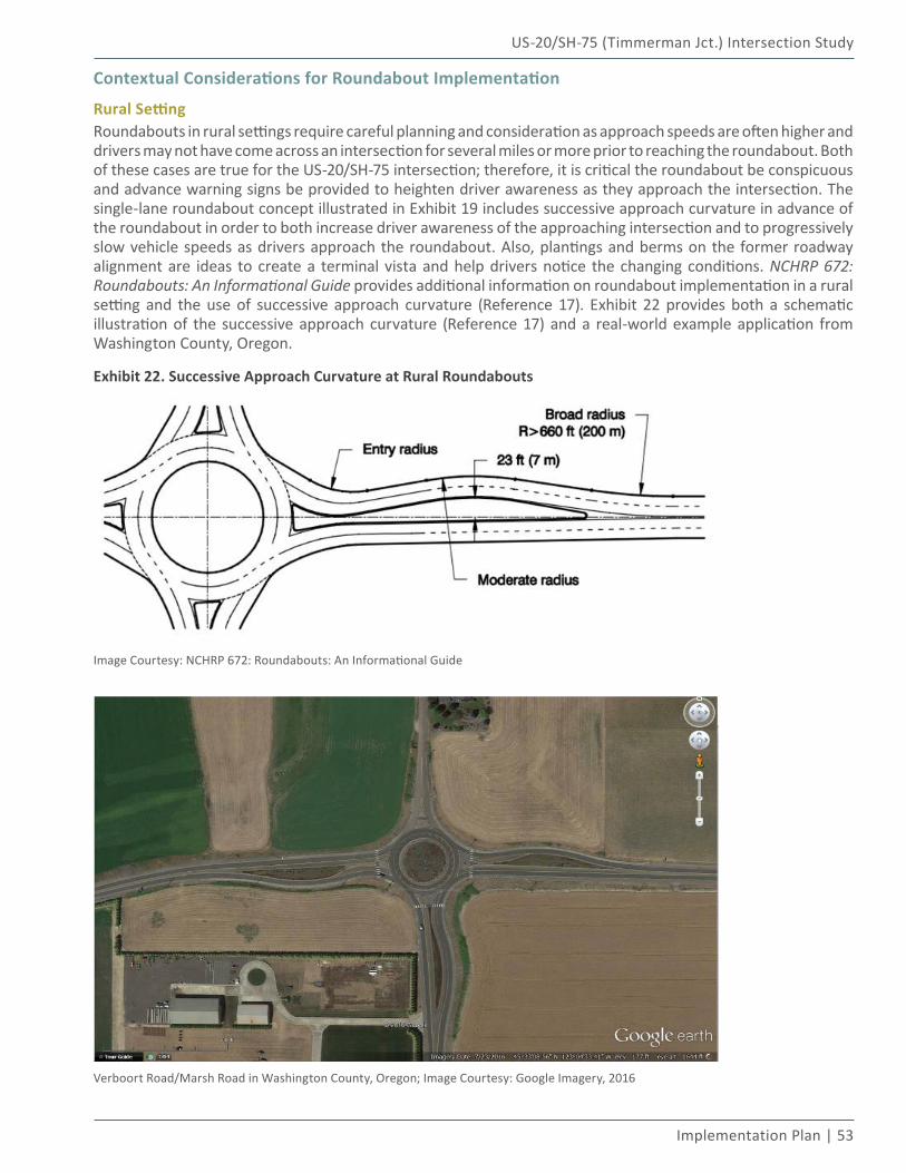
US-20/SH-75 (Timmerman Jct.) Intersection Study
Implementation Plan | 53
Contextual Considerations for Roundabout Implementation
Rural SettingRoundabouts in rural settings require careful planning and consideration as approach speeds are often higher and drivers may not have come across an intersection for several miles or more prior to reaching the roundabout. Both of these cases are true for the US-20/SH-75 intersection; therefore, it is critical the roundabout be conspicuous and advance warning signs be provided to heighten driver awareness as they approach the intersection. The single-lane roundabout concept illustrated in Exhibit 19 includes successive approach curvature in advance of the roundabout in order to both increase driver awareness of the approaching intersection and to progressively slow vehicle speeds as drivers approach the roundabout. Also, plantings and berms on the former roadway alignment are ideas to create a terminal vista and help drivers notice the changing conditions. NCHRP 672: Roundabouts: An Informational Guide provides additional information on roundabout implementation in a rural setting and the use of successive approach curvature (Reference 17). Exhibit 22 provides both a schematic illustration of the successive approach curvature (Reference 17) and a real-world example application from Washington County, Oregon.
Exhibit 22. Successive Approach Curvature at Rural Roundabouts
Image Courtesy: NCHRP 672: Roundabouts: An Informational Guide
Verboort Road/Marsh Road in Washington County, Oregon; Image Courtesy: Google Imagery, 2016
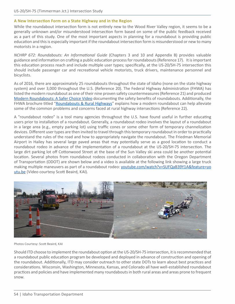
54 | Idaho Transportation Department
US-20/SH-75 (Timmerman Jct.) Intersection Study
A New Intersection Form on a State Highway and in the RegionWhile the roundabout intersection form is not entirely new to the Wood River Valley region, it seems to be a generally unknown and/or misunderstood intersection form based on some of the public feedback received as a part of this study. One of the most important aspects in planning for a roundabout is providing public education and this is especially important if the roundabout intersection form is misunderstood or new to many motorists in a region.
NCHRP 672: Roundabouts: An Informational Guide (Chapters 3 and 10 and Appendix B) provides valuable guidance and information on crafting a public education process for roundabouts (Reference 17). It is important this education process reach and include multiple user types; specifically, at the US-20/SH-75 intersection this should include passenger car and recreational vehicle motorists, truck drivers, maintenance personnel and bicyclists.
As of 2016, there are approximately 25 roundabouts throughout the state of Idaho (none on the state highway system) and over 3,000 throughout the U.S. (Reference 20). The Federal Highway Administration (FHWA) has listed the modern roundabout as one of their nine proven safety countermeasures (Reference 21) and produced Modern Roundabouts: A Safer Choice Video documenting the safety benefits of roundabouts. Additionally, the FHWA brochure titled “Roundabouts & Rural Highways” explains how a modern roundabout can help alleviate some of the common problems and concerns faced at rural highway intersections (Reference 22).
A "roundabout rodeo" is a tool many agencies throughout the U.S. have found useful in further educating users prior to installation of a roundabout. Generally, a roundabout rodeo involves the layout of a roundabout in a large area (e.g., empty parking lot) using traffic cones or some other form of temporary channelization devices. Different user types are then invited to travel through this temporary roundabout in order to practically understand the rules of the road and how to appropriately navigate the roundabout. The Friedman Memorial Airport in Hailey has several large paved areas that may potentially serve as a good location to conduct a roundabout rodeo in advance of the implementation of a roundabout at the US-20/SH-75 intersection. The large dirt parking lot off Cottonwood Street at the base of the Sun Valley ski area could be another potential location. Several photos from roundabout rodeos conducted in collaboration with the Oregon Department of Transportation (ODOT) are shown below and a video is available at the following link showing a large truck making multiple maneuvers as part of a roundabout rodeo: youtube.com/watch?v=SUFQaB39Y1A&feature=youtu.be (Video courtesy Scott Beaird, KAI).
Photos Courtesy: Scott Beaird, KAI
Should ITD choose to implement the roundabout option at the US-20/SH-75 intersection, it is recommended that a roundabout public education program be developed and deployed in advance of construction and opening of the roundabout. Additionally, ITD may consider outreach to other state DOTs to learn about best practices and considerations. Wisconsin, Washington, Minnesota, Kansas, and Colorado all have well-established roundabout practices and policies and have implemented many roundabouts in both rural areas and areas prone to frequent snow.
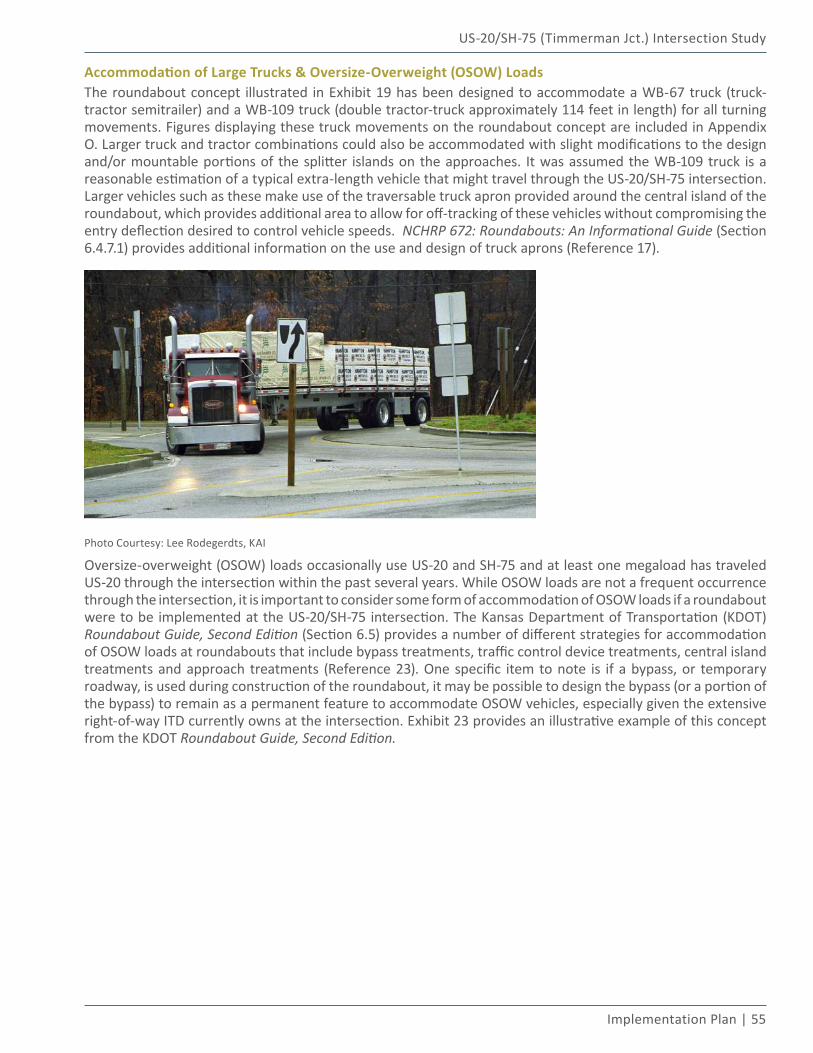
US-20/SH-75 (Timmerman Jct.) Intersection Study
Implementation Plan | 55
Accommodation of Large Trucks & Oversize-Overweight (OSOW) LoadsThe roundabout concept illustrated in Exhibit 19 has been designed to accommodate a WB-67 truck (truck-tractor semitrailer) and a WB-109 truck (double tractor-truck approximately 114 feet in length) for all turning movements. Figures displaying these truck movements on the roundabout concept are included in Appendix O. Larger truck and tractor combinations could also be accommodated with slight modifications to the design and/or mountable portions of the splitter islands on the approaches. It was assumed the WB-109 truck is a reasonable estimation of a typical extra-length vehicle that might travel through the US-20/SH-75 intersection. Larger vehicles such as these make use of the traversable truck apron provided around the central island of the roundabout, which provides additional area to allow for off-tracking of these vehicles without compromising the entry deflection desired to control vehicle speeds. NCHRP 672: Roundabouts: An Informational Guide (Section 6.4.7.1) provides additional information on the use and design of truck aprons (Reference 17).
Photo Courtesy: Lee Rodegerdts, KAI
Oversize-overweight (OSOW) loads occasionally use US-20 and SH-75 and at least one megaload has traveled US-20 through the intersection within the past several years. While OSOW loads are not a frequent occurrence through the intersection, it is important to consider some form of accommodation of OSOW loads if a roundabout were to be implemented at the US-20/SH-75 intersection. The Kansas Department of Transportation (KDOT) Roundabout Guide, Second Edition (Section 6.5) provides a number of different strategies for accommodation of OSOW loads at roundabouts that include bypass treatments, traffic control device treatments, central island treatments and approach treatments (Reference 23). One specific item to note is if a bypass, or temporary roadway, is used during construction of the roundabout, it may be possible to design the bypass (or a portion of the bypass) to remain as a permanent feature to accommodate OSOW vehicles, especially given the extensive right-of-way ITD currently owns at the intersection. Exhibit 23 provides an illustrative example of this concept from the KDOT Roundabout Guide, Second Edition.
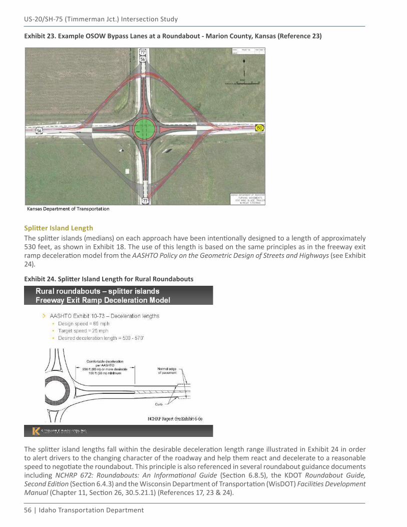
56 | Idaho Transportation Department
US-20/SH-75 (Timmerman Jct.) Intersection Study
Exhibit 23. Example OSOW Bypass Lanes at a Roundabout - Marion County, Kansas (Reference 23)
Splitter Island LengthThe splitter islands (medians) on each approach have been intentionally designed to a length of approximately 530 feet, as shown in Exhibit 18. The use of this length is based on the same principles as in the freeway exit ramp deceleration model from the AASHTO Policy on the Geometric Design of Streets and Highways (see Exhibit 24).
Exhibit 24. Splitter Island Length for Rural Roundabouts
The splitter island lengths fall within the desirable deceleration length range illustrated in Exhibit 24 in order to alert drivers to the changing character of the roadway and help them react and decelerate to a reasonable speed to negotiate the roundabout. This principle is also referenced in several roundabout guidance documents including NCHRP 672: Roundabouts: An Informational Guide (Section 6.8.5), the KDOT Roundabout Guide, Second Edition (Section 6.4.3) and the Wisconsin Department of Transportation (WisDOT) Facilities Development Manual (Chapter 11, Section 26, 30.5.21.1) (References 17, 23 & 24).
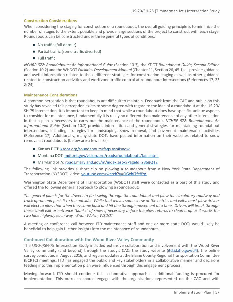
US-20/SH-75 (Timmerman Jct.) Intersection Study
Implementation Plan | 57
Construction ConsiderationsWhen considering the staging for construction of a roundabout, the overall guiding principle is to minimize the number of stages to the extent possible and provide large sections of the project to construct with each stage. Roundabouts can be constructed under three general types of conditions:
▪ No traffic (full detour)
▪ Partial traffic (some traffic diverted)
▪ Full traffic NCHRP 672: Roundabouts: An Informational Guide (Section 10.3), the KDOT Roundabout Guide, Second Edition (Section 10.2) and the WisDOT Facilities Development Manual (Chapter 11, Section 26, 45.1) all provide guidance and useful information related to these different strategies for construction staging as well as other guidance related to construction activities and work zone traffic control at roundabout intersections (References 17, 23 & 24).
Maintenance ConsiderationsA common perception is that roundabouts are difficult to maintain. Feedback from the CAC and public on this study has revealed this perception exists to some degree with regard to the idea of a roundabout at the US-20/SH-75 intersection. It is important to keep in mind that while a roundabout does have specific, unique aspects to consider for maintenance, fundamentally it is really no different than maintenance of any other intersection in that a plan is necessary to carry out the maintenance of the roundabout. NCHRP 672: Roundabouts: An Informational Guide (Section 10.7) provides information and general strategies for maintaining roundabout intersections, including strategies for landscaping, snow removal, and pavement maintenance activities (Reference 17). Additionally, many state DOTs have posted information on their websites related to snow removal at roundabouts (below are a few links):
▪ Kansas DOT: ksdot.org/roundabouts/faqs.asp#snow
▪ Montana DOT: mdt.mt.gov/visionzero/roads/roundabouts/faq.shtml
▪ Maryland SHA: roads.maryland.gov/m/index.aspx?PageId=286#Q12The following link provides a short clip on plowing a roundabout from a New York State Department of Transportation (NYSDOT) video: youtube.com/watch?v=OGxbI7fe8Yg.
Washington State Department of Transportation (WSDOT) staff were contacted as a part of this study and offered the following general approach to plowing a roundabout:
The general plan is for the drivers to first swing through the roundabout and plow the circulatory roadway and truck apron and push it to the outside. While that leaves some snow at the entries and exits, most plow drivers will elect to plow that when they come back and hit one through movement at a time. Drivers will break through these small exit or entrance “banks” of snow if necessary before the plow returns to clean it up as it works the two lane highway each way. -Brian Walsh, WSDOT
A meeting or conference call between ITD maintenance staff and one or more state DOTs would likely be beneficial to help gain further insights into the maintenance of roundabouts.
Continued Collaboration with the Wood River Valley CommunityThe US-20/SH-75 Intersection Study included extensive collaboration and involvement with the Wood River Valley community (and beyond) through the study's CAC, the study website (itd.idaho.gov/d4), the online survey conducted in August 2016, and regular updates at the Blaine County Regional Transportation Committee (BCRTC) meetings. ITD has engaged the public and key stakeholders in a collaborative manner and decisions feeding into this implementation plan were influenced through this engagement process.
Moving forward, ITD should continue this collaborative approach as additional funding is procured for implementation. This outreach should engage with the organizations represented on the CAC and with
58 | Idaho Transportation Department
US-20/SH-75 (Timmerman Jct.) Intersection Study
the general public. A future NEPA environmental process specific to this intersection is anticipated prior to construction of improvements and will provide one opportunity for this continued engagement. The BCRTC should remain informed and be given the opportunity to provide input toward future implementation decisions. Lastly, continued collaboration with the community may present opportunities for funding partnerships through any number of funding mechanisms (e.g., Rural Highway Safety Improvement Program, Surface Transportation Program, or Rural Community Development Block Grants).
References06
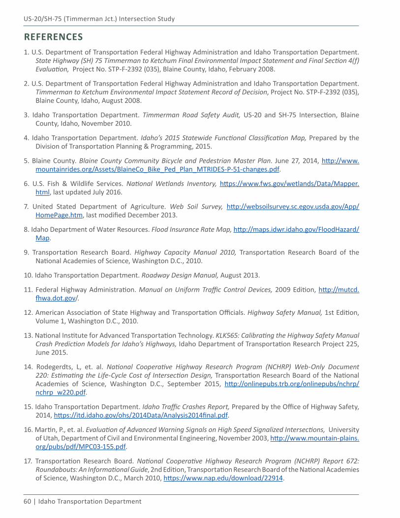
60 | Idaho Transportation Department
US-20/SH-75 (Timmerman Jct.) Intersection Study
REFERENCES1. U.S. Department of Transportation Federal Highway Administration and Idaho Transportation Department.
State Highway (SH) 75 Timmerman to Ketchum Final Environmental Impact Statement and Final Section 4(f) Evaluation, Project No. STP-F-2392 (035), Blaine County, Idaho, February 2008.
2. U.S. Department of Transportation Federal Highway Administration and Idaho Transportation Department. Timmerman to Ketchum Environmental Impact Statement Record of Decision, Project No. STP-F-2392 (035), Blaine County, Idaho, August 2008.
3. Idaho Transportation Department. Timmerman Road Safety Audit, US-20 and SH-75 Intersection, Blaine County, Idaho, November 2010.
4. Idaho Transportation Department. Idaho’s 2015 Statewide Functional Classification Map, Prepared by the Division of Transportation Planning & Programming, 2015.
5. Blaine County. Blaine County Community Bicycle and Pedestrian Master Plan. June 27, 2014, http://www.mountainrides.org/Assets/BlaineCo_Bike_Ped_Plan_MTRIDES-P-51-changes.pdf.
6. U.S. Fish & Wildlife Services. National Wetlands Inventory, https://www.fws.gov/wetlands/Data/Mapper.html, last updated July 2016.
7. United Stated Department of Agriculture. Web Soil Survey, http://websoilsurvey.sc.egov.usda.gov/App/HomePage.htm, last modified December 2013.
8. Idaho Department of Water Resources. Flood Insurance Rate Map, http://maps.idwr.idaho.gov/FloodHazard/Map.
9. Transportation Research Board. Highway Capacity Manual 2010, Transportation Research Board of the National Academies of Science, Washington D.C., 2010.
10. Idaho Transportation Department. Roadway Design Manual, August 2013.
11. Federal Highway Administration. Manual on Uniform Traffic Control Devices, 2009 Edition, http://mutcd.fhwa.dot.gov/.
12. American Association of State Highway and Transportation Officials. Highway Safety Manual, 1st Edition, Volume 1, Washington D.C., 2010.
13. National Institute for Advanced Transportation Technology. KLK565: Calibrating the Highway Safety Manual Crash Prediction Models for Idaho’s Highways, Idaho Department of Transportation Research Project 225, June 2015.
14. Rodegerdts, L, et. al. National Cooperative Highway Research Program (NCHRP) Web-Only Document 220: Estimating the Life-Cycle Cost of Intersection Design, Transportation Research Board of the National Academies of Science, Washington D.C., September 2015, http://onlinepubs.trb.org/onlinepubs/nchrp/nchrp_w220.pdf.
15. Idaho Transportation Department. Idaho Traffic Crashes Report, Prepared by the Office of Highway Safety, 2014, https://itd.idaho.gov/ohs/2014Data/Analysis2014final.pdf.
16. Martin, P., et. al. Evaluation of Advanced Warning Signals on High Speed Signalized Intersections, University of Utah, Department of Civil and Environmental Engineering, November 2003, http://www.mountain-plains.org/pubs/pdf/MPC03-155.pdf.
17. Transportation Research Board. National Cooperative Highway Research Program (NCHRP) Report 672: Roundabouts: An Informational Guide, 2nd Edition, Transportation Research Board of the National Academies of Science, Washington D.C., March 2010, https://www.nap.edu/download/22914.
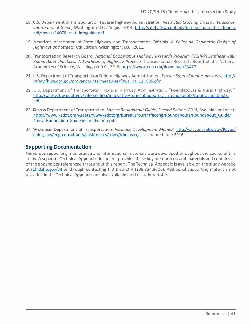
US-20/SH-75 (Timmerman Jct.) Intersection Study
References | 61
18. U.S. Department of Transportation Federal Highway Administration. Restricted Crossing U-Turn Intersection Informational Guide, Washington D.C., August 2014, http://safety.fhwa.dot.gov/intersection/alter_design/pdf/fhwasa14070_rcut_infoguide.pdf.
19. American Association of State Highway and Transportation Officials. A Policy on Geometric Design of Highways and Streets, 6th Edition, Washington, D.C., 2011.
20. Transportation Research Board. National Cooperative Highway Research Program (NCHRP) Synthesis 488: Roundabout Practices: A Synthesis of Highway Practice, Transportation Research Board of the National Academies of Science, Washington D.C., 2016, https://www.nap.edu/download/23477.
21. U.S. Department of Transportation Federal Highway Administration. Proven Safety Countermeasures, http://safety.fhwa.dot.gov/provencountermeasures/fhwa_sa_12_005.cfm.
22. U.S. Department of Transportation Federal Highway Administration. “Roundabouts & Rural Highways”, http://safety.fhwa.dot.gov/intersection/innovative/roundabouts/rural_roundabouts/ruralroundabouts.pdf.
23. Kansas Department of Transportation. Kansas Roundabout Guide, Second Edition, 2014, Available online at: https://www.ksdot.org/Assets/wwwksdotorg/bureaus/burtrafficeng/Roundabouts/Roundabout_Guide/KansasRoundaboutGuideSecondEdition.pdf
24. Wisconsin Department of Transportation. Facilities Development Manual, http://wisconsindot.gov/Pages/doing-bus/eng-consultants/cnslt-rsrces/rdwy/fdm.aspx, last updated June 2016.
Supporting DocumentationNumerous supporting memoranda and informational materials were developed throughout the course of this study. A separate Technical Appendix document provides these key memoranda and materials and contains all of the appendices referenced throughout this report. The Technical Appendix is available on the study website at itd.idaho.gov/d4 or through contacting ITD District 4 (208.334.8000). Additional supporting materials not provided in the Technical Appendix are also available on the study website.
US 20 SH 75TIMMERMAN JUNCTION
&Intersection Study