Embed Size (px)
Citation preview
Timmerman to KetchumEnvironmental Impact Statement
Project No. STP-F-2392 (035)Key No. 3077
RECORD OF DECISIONRECORD OF DECISION
SH-75 Timmerman to Ketchum Record of Decision Project No. STP-F-2392 (035)
August 8, 2008 1
RECORD OF DECISION 1 SH-75 Timmerman to Ketchum Environmental Impact Statement & Section 4(f) Evaluation, 2
Blaine County, Idaho 3 4
1.0 INTRODUCTION 5 The proposed SH-75 Timmerman to Ketchum Project will involve Federal Highway Administration funding. 6 Consequently, pursuant to the National Environmental Policy Act (NEPA) (42 U.S. C. 4321 et seq.) and Section 4(f) of 7 the Department of Transportation Act, the Federal Highway Administration (FHWA) in coordination with the Idaho 8 Transportation Department (ITD), prepared an Environmental Impact Statement /Section 4(f) Evaluation (EIS) for the 9 Project. A Draft EIS (DEIS) was issued December 23, 2005. The Final EIS (FEIS), which was prepared in condensed 10 format pursuant to FHWA Technical Advisory 6640.8A, was signed on March 05, 2008 and a notice placed in the 11 Federal Register on March 27, 2008. 12 13 The Council on Environmental Quality (CEQ) regulations for implementing the National Environmental Policy Act (NEPA) 14 require that the Record of Decision specify “the alternative or alternatives which were considered to be environmentally 15 preferable” (40 C.F.R. §1505.2(b)). The environmentally preferred alternative has been interpreted to be the alternative 16 that will promote the national environmental policy as expressed in the NEPA Section 101 (CEQ’s Forty Most-Asked 17 Questions”, 46 Federal Register, 18026, March 23, 1981). Ordinarily, this means the alternative that causes the least 18 damage to the biological and physical environment; it also means the alternative that best protects, preserves, and 19 enhances historic, cultural, and natural resources. Two build alternatives were considered in the DEIS, Alternative 2 20 and Alternative 3. Both alternatives have exactly the same impacts on historic, cultural and natural resources, as 21 documented in the DEIS and FEIS. Alternative 3, however, has less favorable traffic operations characteristics in the 22 section of SH-75 between McKercher Boulevard and Elkhorn Road. 23 24 By this Record of Decision (ROD) the FHWA selects Alternative 2 from among the alternatives considered in the EIS. 25 Alternative 2 is also the environmentally preferred alternative when SH-75 traffic operations are considered. Alternative 26 2, which is identified as the Preferred Alternative in the FEIS, consists of specified transportation improvements to State 27 Highway 75 (SH-75) between Timmerman Junction (US-20 and SH-75 intersection) and River Street in the City of 28 Ketchum. This includes portions of Blaine County and the Cities of Bellevue, Hailey, Sun Valley, and Ketchum, Idaho. 29 Alternative 2 (Selected Alternative) is described in more detail below, but generally consists of widening SH-75 to include 30 two general purpose lanes and a turn lane for most of the corridor, along with intersection and shoulder improvements, 31 bus turnouts and pedestrian crossings. 32 33 2.0 DECISION 34 The purpose of the Project is to increase SH-75 roadway capacity to accommodate existing peak-hour vehicle traffic and 35 future year 2025 vehicle traffic, and to increase transportation safety for all users. The need for the Project is based on 36 the following: 37
• Current and predicted future year 2025 peak hour travel demand exceeds available transportation capacity. 38 Peak hour congestion is primarily from commuters traveling within the Project limits. 39
• Lack of shoulders, lack of right-turn lanes, and lack of center left-turn lanes at intersections create a safety and 40 a capacity concern throughout the SH-75 corridor. 41
• Pedestrians and bicyclists need safe access across SH-75 to access community resources. 42 • Current bus transit and rideshare programs experience peak hour congestion. 43
After independently reviewing the FEIS/Section 4(f) Evaluation, the administrative record, technical reports and input 44 from the public and state, local and federal agencies, FHWA has selected FEIS Alternative 2 for improvements to SH-75 45 between Timmerman Junction and the City of Ketchum. The Selected Alternative is also the environmentally preferred 46 alternative and is described in detail in the FEIS and summarized below. 47 48 49 50
SH-75 Timmerman to Ketchum Record of Decision Project No. STP-F-2392 (035)
August 8, 2008 2
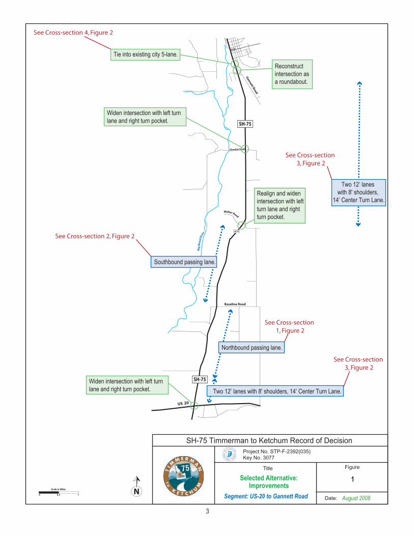
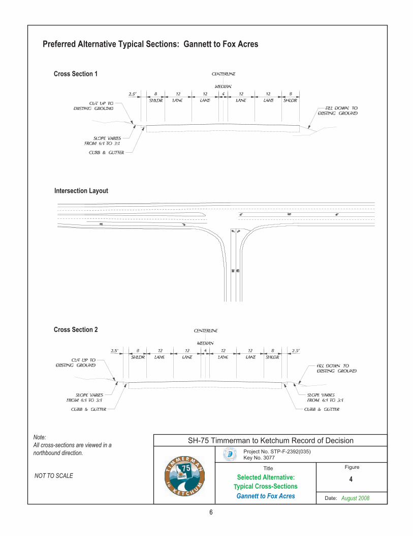
3.0 ALTERNATIVES CONSIDERED 1 The EIS first considered a broad range of concept alternatives for the SH-75 Project. Based on an assessment of 2 whether these alternatives were practical and feasible, would have less environmental impacts and would meet the 3 project purpose and need, the following concept alternatives were screened out: a new highway corridor through the 4 Wood River Valley, SH-75 with reversible lanes, a fixed guideway transit system, and a bus-only transit system. 5 Concept alternatives that were advanced into a more detailed evaluation and screening process were the no build; four 6 lanes with a center-turn lane; four lanes with a center-turn lane and HOV; enhanced two lane; and State Policy LOS C. 7 Screening criteria at this phase included more detailed indicators of travel performance, environmental resource impacts, 8 cost, and community impacts. Based on the application of these criteria, two “build” alternatives were carried forward for 9 further detailed analysis. 10 The Build Alternatives are identified as Alternatives 2 and 3. The No Build Alternative was also carried through the 11 process to provide a baseline, as required by NEPA. A Preferred Alternative was identified in the FEIS after detailed 12 analysis of these final two build alternatives. The alternatives are summarized in the following discussion. 13 3.1 No Build Alternative 14 Under the No Build Alternative, there would be no physical improvements to SH-75. 15 3.2 Alternative 2: Four-Lane with Center-Turn Lane 16 Alternative 2 includes the reconstruction of SH-75 as described below by geographic section of the corridor, from south 17 to north. 18 US-20 to Gannett Road The existing US-20 and SH-75 intersection will be reconstructed to provide for turn lanes and 8-19 foot shoulders. North of the intersection, the roadway will be widened to two 12-foot lanes and a 14-foot center turn lane 20 and 8-foot shoulders. A northbound passing lane extending up to Baseline Road and a southbound passing lane 21 between Walker Road and Baseline Road will be provided. These improvements are shown in Figures 1 and 2. 22 Gannett Road to Fox Acres Road The intersection of Gannett Road and SH-75 will be reconstructed to a roundabout. 23 SH-75 will be widened to match the existing 2 lanes in each direction and center turn lane through Bellevue. Two 12-24 foot lanes in each direction, a 4-foot safety media, and 8-foot shoulders will be provided from north Bellevue to Fox 25 Acres Road. Traffic signals will be installed at Woodside Boulevard and Countryside Boulevard. These improvements 26 are shown graphically in Figures 3 and 4. 27 Fox Acres Road to McKercher Boulevard At-grade pedestrian crossings will be improved. A traffic signal will be 28 installed at the intersection with Myrtle Street. Bus pull-outs will be provided at the intersection of McKercher Boulevard 29 and SH-75. No other change to the existing SH-75 cross-section will be made. 30 McKercher Boulevard to Elkhorn Road The existing highway will be widened to two 12-foot lanes in each direction, with 31 a 14-foot center turn lane and 8-foot shoulders. Where the center turn lane is not needed, the 14-foot center turn 32 median is reduced to a 4-foot safety median. Traffic signals will be provided at the intersections of SH-75 with Buttercup 33 Road/Zincspur Road, and with Ohio Gulch/Starweather Road. Three pedestrian undercrossing are provided at North 34 Treasure Lane, Spruce Way and Ohio Gulch/Starweather Road. Bus pullouts are included at Buttercup Road/Zincspur 35 Road, north Treasure Lane and Ohio Gulch/Starweather Road. The Big Wood River Bridge will be replaced. These 36 improvements are shown graphically in Figures 5 and 6. 37 Elkhorn Road to River Street From Elkhorn Road to Serenade Lane, four 11-foot lanes will be provided. Between 38 Serenade Lane and River Street, one 11-foot lane in each direction, a 12-foot center turn lane, and 4-foot shoulders will 39 be provided. The Trail Creek Bridge will be replaced. These improvements are shown in Figures 7 and 8. 40 River Street to Saddle Road 41 No widening of SH-75 between River Street and Saddle Road will occur. 42 43 3.3 Alternative 3: Four-Lane with Center Turn Lane and HOV 44 Alternative 3 has the same physical footprint as Alternative 2 described above. From McKercher Boulevard to Elkhorn 45 Road, the curb lane will operate as a high-occupancy vehicle lane (HOV) in the morning and evening peak hours. It 46 would be restricted to buses and other vehicles carrying two or more persons. 47
Northbound passing lane.
Southbound passing lane.
Two 12’ lanes with 8' shoulders,
14’ Center Turn Lane.
ImprovementsSegment: US-20 to Gannett Road
Widen intersection with left turn lane and right turn pocket.
Realign and widen intersection with left turn lane and right turn pocket.
Widen intersection with left turn lane and right turn pocket.
1
2-17
August 2008
SH-75 Timmerman to Ketchum Record of Decision
Selected Alternative:
See Cross-section 2, Figure 2
See Cross-section 4, Figure 2
See Cross-section 1, Figure 2
See Cross-section 3, Figure 2
Two 12’ lanes with 8' shoulders, 14’ Center Turn Lane.
See Cross-section 3, Figure 2
Tie into existing city 5-lane.
3
Reconstruct intersection as a roundabout.
Selected Alternative:Typical Cross-Sections
US-20 to Gannett
2
Preferred Alternative Typical Sections: US-20 to Gannett Road
Cross Section 1
Cross Section 2
Cross Section 3
Cross Section 4
NOT TO SCALE
Note:All cross-sections are viewed in a northbound direction.
August 2008
SH-75 Timmerman to Ketchum Record of Decision
4
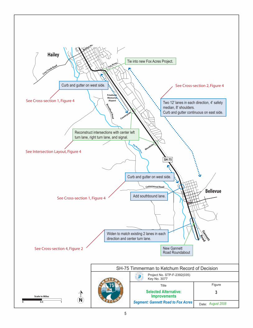
ImprovementsSegment: Gannett Road to Fox Acres
Reconstruct intersections with center left turn lane, right turn lane, and signal.
Tie into new Fox Acres Project.
2-20
Widen to match existing 2 lanes in each direction and center turn lane.
Add southbound lane.
Curb and gutter on west side.
Curb and gutter on west side.
Two 12' lanes in each direction, 4' safety median, 8' shoulders.Curb and gutter continuous on east side.
3
August 2008
SH-75 Timmerman to Ketchum Record of Decision
Selected Alternative:
See Cross-section 1, Figure 4
See Cross-section 1, Figure 4
See Cross-section 4, Figure 2
See Cross-section 2, Figure 4
See Intersection Layout, Figure 4
5
New GannettRoad Roundabout
Typical Cross-SectionsGannett to Fox Acres
4
Preferred Alternative Typical Sections: Gannett to Fox Acres
Cross Section 1
Cross Section 2
Intersection Layout
NOT TO SCALE
Note:All cross-sections are viewed in a northbound direction.
2-21August 2008
SH-75 Timmerman to Ketchum Record of Decision
Selected Alternative:
6
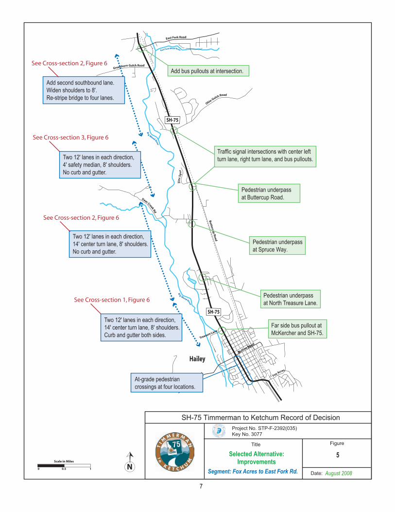
ImprovementsSegment: Fox Acres to East Fork Rd.
Traffic signal intersections with center left turn lane, right turn lane, and bus pullouts.
Two 12' lanes in each direction, 14' center turn lane, 8' shoulders.No curb and gutter.
Two 12' lanes in each direction, 14' center turn lane, 8' shoulders.Curb and gutter both sides.
Add second southbound lane.Widen shoulders to 8'.Re-stripe bridge to four lanes.
At-grade pedestrian crossings at four locations.
Add bus pullouts at intersection.
Far side bus pullout at McKercher and SH-75.
Pedestrian underpass at North Treasure Lane.
Pedestrian underpass at Spruce Way.
Pedestrian underpass at Buttercup Road.
Two 12' lanes in each direction, 4' safety median, 8' shoulders.No curb and gutter.
5
2-24
Trrusae
L eena
August 2008
SH-75 Timmerman to Ketchum Record of Decision
Selected Alternative:
See Cross-section 3, Figure 6
See Cross-section 2, Figure 6
See Cross-section 2, Figure 6
See Cross-section 1, Figure 6
7
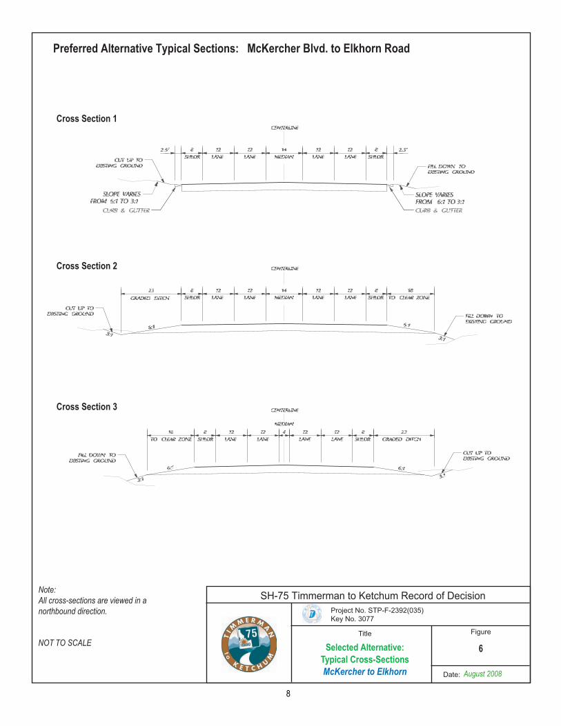
Typical Cross-SectionsMcKercher to Elkhorn
6
Preferred Alternative Typical Sections: McKercher Blvd. to Elkhorn Road
Cross Section 1
NOT TO SCALE
Cross Section 2
Cross Section 3
Note:All cross-sections are viewed in a northbound direction.
2-26
August 2008
SH-75 Timmerman to Ketchum Record of Decision
Selected Alternative:
8
ImprovementsSegment: East Fork to Elkhorn Road
Two 12' lanes in each direction, 14' center turn lane, 8' shoulders.Curb and gutter both sides.
Tie into existing four lanes.
Two 12' lanes in each direction, 14' center turn lane, 8' shoulders.No curb or gutter.
Two 12' lanes in each direction, 4' safety median, 8' shoulders.No curb or gutter.
Tie into northern terminus of Alturas to Timberway project.
Add bus pullout.
New bridge over Big Wood River with four 12' lanes and 4' safety median.
Intersections with right turn lanes at Gimlet, Cold Springs, Broadway, and Hospital Road.
7
2-25
August 2008
SH-75 Timmerman to Ketchum Record of Decision
Selected Alternative:
See Cross-section 1, Figure 6
See Cross-section 2, Figure 6
See Cross-section 3, Figure 6
9
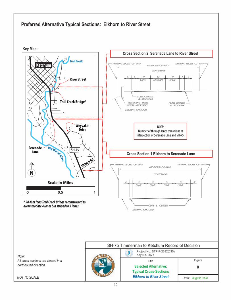
Selected Alternative: Typical Cross-SectionsElkhorn to River Street August 2008
8
Preferred Alternative Typical Sections: Elkhorn to River Street
NOT TO SCALE
Note:All cross-sections are viewed in a northbound direction.
SH-75 Timmerman to Ketchum Record of Decision
10
Key Map:
Weyyakin Drive
Trail Creek Bridge*
Trail Creek
River Street
SerenadeLane
Cross Section 2 Serenade Lane to River Street
Cross Section 1 Elkhorn to Serenade Lane
NOTE:Number of through lanes transitions at
intersection of Serenade Lane and SH-75.
* 58-foot long Trail Creek Bridge reconstructed to accommodate 4 lanes but striped to 3 lanes.
SH-75 Timmerman to Ketchum Record of Decision Project No. STP-F-2392 (035)
August 8, 2008 11
1 4.0 COMMENTS ON THE DEIS and FEIS 2 3 Comments received on the DEIS were individually numbered and tracked. A formal response to comments was 4 prepared in accordance with NEPA requirements and included as Appendix B in the FEIS. The FEIS, inclusive of the 5 response to comments, was distributed to all who provided comments during the public comment period. A brief 6 overview of the major themes in these comments follows. 7 8 4.1 Federal and State Agency Comments 9 10 Comments were received from the U.S. Army Corps of Engineers (COE), the Environmental Protection Agency (EPA), 11 and the Idaho Department of Fish and Game (IDFG). 12 The COE commented on the need for a Section 404 permit under the Clean Water Act and also concurred with the 13 analysis of impacts presented in the DEIS. 14 EPA commented on the purpose and need, range of alternatives, secondary and cumulative impacts, wetlands and 15 wetland mitigation, wildlife crossing mitigation, air quality and air toxics, and tribal consultation and cultural resources. 16 IDFG commented on the need to address wildlife crossing issues, the impacts of potential noise walls and barriers on 17 wildlife crossings, and maintaining angler access to the Big Wood River. 18 19 4.2 Local Government Comments 20 21 Blaine County, the City of Bellevue, City of Hailey, City of Ketchum and City of Sun Valley provided a joint comment 22 letter on the DEIS, and also individual letters from each jurisdiction, supporting Alternative 3. The 4-lane highway 23 solution and the HOV component of Alternative 3 between McKercher Boulevard and Elkhorn Road is seen as important 24 to addressing congestion and future travel demands, providing the widest range of options for achieving overall system 25 efficiency, and furthering the development of transit objectives in the Wood River Valley. 26 27 4.3 Public Comments on the DEIS 28 29 Ninety-one letters, emails and faxes were received from local organizations and members of the public as well as 25 30 verbal comments received during oral testimony at the public hearing on the DEIS. This body of public comment had the 31 following common themes. 32 • Preference for an alternative. Thirty-one comments expressed preference for Alternative 2; 28 expressed a 33
preference for Alternative 3. 34 • Desire for greater transit service. Commenters felt that transit should be an important part of the transportation 35
solution for SH-75. 36 • Traffic signals. Commenters requested that traffic signals should be installed at several intersections with SH-75. 37 • Improvements north of Elkhorn Road. Commenters felt that improvements north of Elkhorn Road are needed. 38 • Roundabouts. Commenters requested consideration of roundabouts at several locations along SH-75; however, 39
some comments were opposed to the use of roundabouts. 40 • Pedestrian underpasses. The specific locations for pedestrian underpasses were questioned by some while support 41
for underpasses was expressed. 42 • Noise. Many comments were received expressing concern with traffic noise and the need to provide for noise 43
mitigation. 44 • Wildlife crossings. Many commenters expressed concern with wildlife kill on SH-75 and the need to mitigate with 45
some form of wildlife crossings. 46 • Direct property impacts. Several commenters were concerned with the direct impacts of the proposed alternatives on 47
their property. 48 49 50 51
SH-75 Timmerman to Ketchum Record of Decision Project No. STP-F-2392 (035)
August 8, 2008 12
4.4 Comments Received on the FEIS 1 2 Three comments were received on the FEIS. The comments and responses to them are contained in Appendix A. 3 4 The Environmental Protection Agency acknowledged their appreciation for the responses to comments they provided on 5 the DEIS, and provided support for the project’s commitments to maintaining and enhancing habitat and roadway 6 permeability. They encourage identification of any additional measures to reduce air toxics that may be feasible when 7 the project is being constructed. 8 9 Givens-Pursley, representing a landowner, reiterated a concern with the location of a detention pond on the landowner’s 10 property, and acknowledged that additional discussions concerning alternative locations for the detention pond will be 11 pursued with ITD during final design of this section of SH-75. 12 13 The owner of Reinheimer Ranch submitted comments that reflect her concern with the process for identifying a locally 14 preferred cross-section between Elkhorn Road and River Street, for the manner in which noise information is presented 15 in the FEIS, and questioning the coordination meetings that occurred after the DEIS. 16 17 The comments received from EPA and the two landowners do not provide information or comment that substantially 18 affects the decision to select Alternative 2 in this Record of Decision. 19 20 4.5 FEIS Errata and Clarification 21 22 Comments received on the FEIS identified two errata or clarifications. 23 24 Errata in the FEIS: 25
• Table 6-1 Federal, State and Local Jurisdiction Coordination Meetings on page 6-3 of the FEIS refers to a 26 meeting held on March 14, 2006 (third last entry in the table). The correct meeting date is March 14, 2007. All 27 other information presented in this table is correct. 28
Clarification in the DEIS: 29 • The description of the Reinheimer Ranch (lines 26 to 30 on page 3-33 of the DEIS) states that the Idaho 30
Foundation for Parks and Lands (IFPL) owns 110 acres of the property. It should be noted that the barn and 31 farmhouse at the Reinheimer Ranch are part of the Reinheimer family owned parcel and are not owned by the 32 IFPL. 33
34 5.0 SELECTION OF ALTERNATIVE 2 35 36 The decision to identify Alternative 2 as the Preferred Alternative in the FEIS, and to select Alternative 2 in this ROD, is 37 based on a comparison of the year 2025 travel performance and environmental impacts of the two Build alternatives and 38 the No Build Alternative. Resource agency input and public comment were also considered. 39 40 Based on the comparative analysis of the Build Alternatives, summarized in Table 2.2 “Comparison of Alternatives” on 41 page 2-13 of Chapter 2 of the FEIS, Alternative 2 was identified as the Preferred Alternative in the FEIS. Although 42 Alternative 2 and 3 have virtually the same environmental impacts on natural and human resources, traffic modeling 43 indicates that Alternative 2 would best increase SH-75 roadway capacity to accommodate future year 2025 traffic, 44 increase transportation safety for all users, provide the most travel time improvement for all SH-75 users. 45 46 As described in Section 4.2 above, in comments on the DEIS, the five local jurisdictions stated a preference for 47 Alternative 3. Implementation of Alternative 2 will result in the physical roadway infrastructure needed to support a 48 future HOV operation, as both Alternative 2 and Alternative 3 have the same physical characteristics. The decision of 49 whether and when to convert to HOV operations will be made by ITD. However, Section 11.2 of this Record of 50 Decision documents ITD’s commitments to convert to HOV operations. The FHWA will not be involved in that decision 51 and HOV operations are not part of the Selected Alternative or part of this FHWA decision. 52
SH-75 Timmerman to Ketchum Record of Decision Project No. STP-F-2392 (035)
August 8, 2008 13
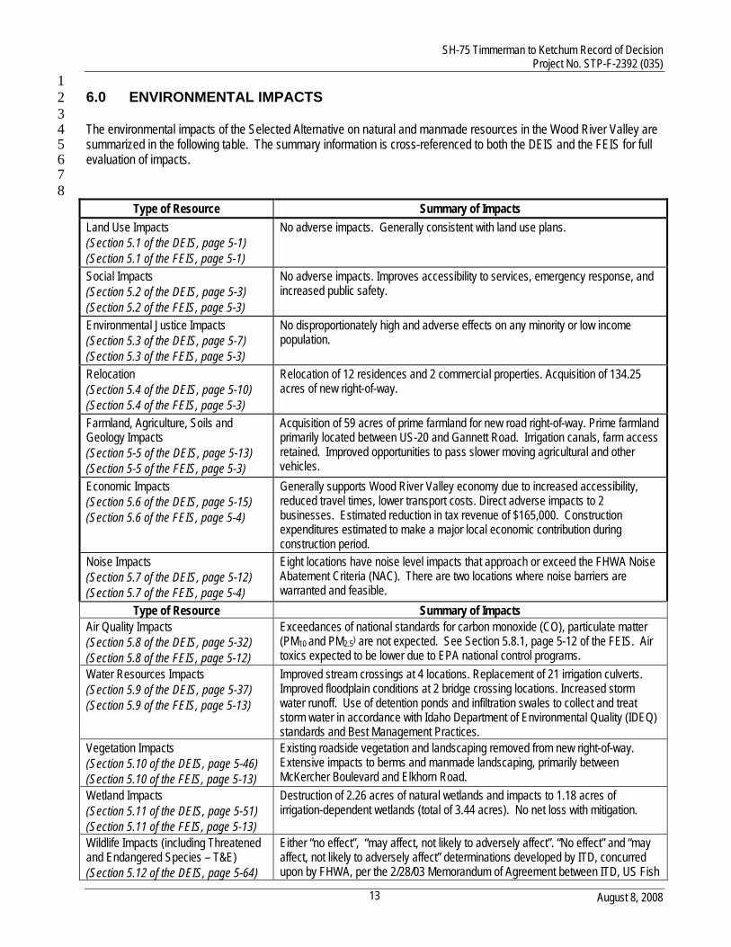
1 6.0 ENVIRONMENTAL IMPACTS 2 3 The environmental impacts of the Selected Alternative on natural and manmade resources in the Wood River Valley are 4 summarized in the following table. The summary information is cross-referenced to both the DEIS and the FEIS for full 5 evaluation of impacts. 6 7
8 Type of Resource Summary of Impacts
Land Use Impacts (Section 5.1 of the DEIS, page 5-1) (Section 5.1 of the FEIS, page 5-1)
No adverse impacts. Generally consistent with land use plans.
Social Impacts (Section 5.2 of the DEIS, page 5-3) (Section 5.2 of the FEIS, page 5-3)
No adverse impacts. Improves accessibility to services, emergency response, and increased public safety.
Environmental Justice Impacts (Section 5.3 of the DEIS, page 5-7) (Section 5.3 of the FEIS, page 5-3)
No disproportionately high and adverse effects on any minority or low income population.
Relocation (Section 5.4 of the DEIS, page 5-10) (Section 5.4 of the FEIS, page 5-3)
Relocation of 12 residences and 2 commercial properties. Acquisition of 134.25 acres of new right-of-way.
Farmland, Agriculture, Soils and Geology Impacts (Section 5-5 of the DEIS, page 5-13) (Section 5-5 of the FEIS, page 5-3)
Acquisition of 59 acres of prime farmland for new road right-of-way. Prime farmland primarily located between US-20 and Gannett Road. Irrigation canals, farm access retained. Improved opportunities to pass slower moving agricultural and other vehicles.
Economic Impacts (Section 5.6 of the DEIS, page 5-15) (Section 5.6 of the FEIS, page 5-4)
Generally supports Wood River Valley economy due to increased accessibility, reduced travel times, lower transport costs. Direct adverse impacts to 2 businesses. Estimated reduction in tax revenue of $165,000. Construction expenditures estimated to make a major local economic contribution during construction period.
Noise Impacts (Section 5.7 of the DEIS, page 5-12) (Section 5.7 of the FEIS, page 5-4)
Eight locations have noise level impacts that approach or exceed the FHWA Noise Abatement Criteria (NAC). There are two locations where noise barriers are warranted and feasible.
Type of Resource Summary of Impacts Air Quality Impacts (Section 5.8 of the DEIS, page 5-32) (Section 5.8 of the FEIS, page 5-12)
Exceedances of national standards for carbon monoxide (CO), particulate matter (PM10 and PM2.5) are not expected. See Section 5.8.1, page 5-12 of the FEIS. Air toxics expected to be lower due to EPA national control programs.
Water Resources Impacts (Section 5.9 of the DEIS, page 5-37) (Section 5.9 of the FEIS, page 5-13)
Improved stream crossings at 4 locations. Replacement of 21 irrigation culverts. Improved floodplain conditions at 2 bridge crossing locations. Increased storm water runoff. Use of detention ponds and infiltration swales to collect and treat storm water in accordance with Idaho Department of Environmental Quality (IDEQ) standards and Best Management Practices.
Vegetation Impacts (Section 5.10 of the DEIS, page 5-46) (Section 5.10 of the FEIS, page 5-13)
Existing roadside vegetation and landscaping removed from new right-of-way. Extensive impacts to berms and manmade landscaping, primarily between McKercher Boulevard and Elkhorn Road.
Wetland Impacts (Section 5.11 of the DEIS, page 5-51) (Section 5.11 of the FEIS, page 5-13)
Destruction of 2.26 acres of natural wetlands and impacts to 1.18 acres of irrigation-dependent wetlands (total of 3.44 acres). No net loss with mitigation.
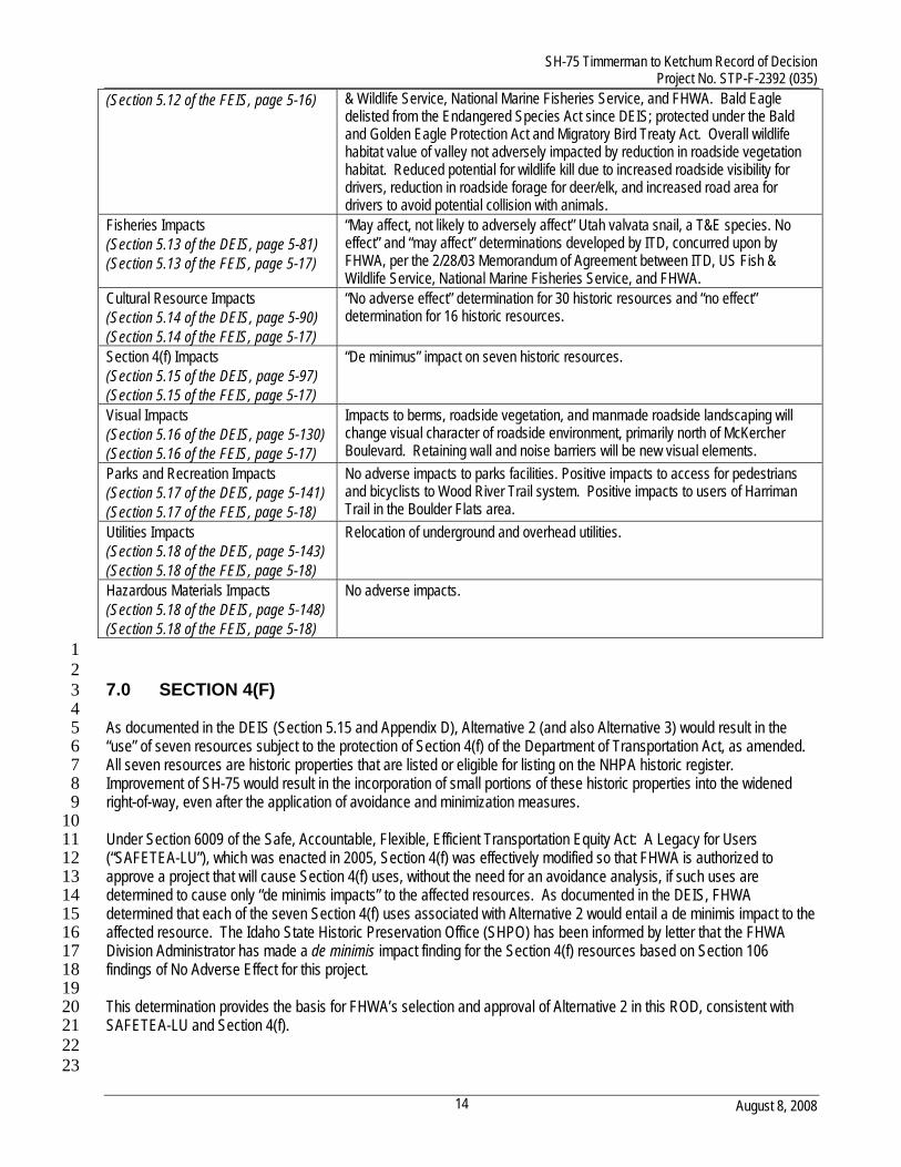
Wildlife Impacts (including Threatened and Endangered Species – T&E) (Section 5.12 of the DEIS, page 5-64)
Either “no effect”, “may affect, not likely to adversely affect”. “No effect” and “may affect, not likely to adversely affect” determinations developed by ITD, concurred upon by FHWA, per the 2/28/03 Memorandum of Agreement between ITD, US Fish
SH-75 Timmerman to Ketchum Record of Decision Project No. STP-F-2392 (035)
August 8, 2008 14
(Section 5.12 of the FEIS, page 5-16) & Wildlife Service, National Marine Fisheries Service, and FHWA. Bald Eagle delisted from the Endangered Species Act since DEIS; protected under the Bald and Golden Eagle Protection Act and Migratory Bird Treaty Act. Overall wildlife habitat value of valley not adversely impacted by reduction in roadside vegetation habitat. Reduced potential for wildlife kill due to increased roadside visibility for drivers, reduction in roadside forage for deer/elk, and increased road area for drivers to avoid potential collision with animals.
Fisheries Impacts (Section 5.13 of the DEIS, page 5-81) (Section 5.13 of the FEIS, page 5-17)
“May affect, not likely to adversely affect” Utah valvata snail, a T&E species. No effect” and “may affect” determinations developed by ITD, concurred upon by FHWA, per the 2/28/03 Memorandum of Agreement between ITD, US Fish & Wildlife Service, National Marine Fisheries Service, and FHWA.
Cultural Resource Impacts (Section 5.14 of the DEIS, page 5-90) (Section 5.14 of the FEIS, page 5-17)
“No adverse effect” determination for 30 historic resources and “no effect” determination for 16 historic resources.
Section 4(f) Impacts (Section 5.15 of the DEIS, page 5-97) (Section 5.15 of the FEIS, page 5-17)
“De minimus” impact on seven historic resources.
Visual Impacts (Section 5.16 of the DEIS, page 5-130) (Section 5.16 of the FEIS, page 5-17)
Impacts to berms, roadside vegetation, and manmade roadside landscaping will change visual character of roadside environment, primarily north of McKercher Boulevard. Retaining wall and noise barriers will be new visual elements.
Parks and Recreation Impacts (Section 5.17 of the DEIS, page 5-141) (Section 5.17 of the FEIS, page 5-18)
No adverse impacts to parks facilities. Positive impacts to access for pedestrians and bicyclists to Wood River Trail system. Positive impacts to users of Harriman Trail in the Boulder Flats area.
Utilities Impacts (Section 5.18 of the DEIS, page 5-143) (Section 5.18 of the FEIS, page 5-18)
Relocation of underground and overhead utilities.
Hazardous Materials Impacts (Section 5.18 of the DEIS, page 5-148) (Section 5.18 of the FEIS, page 5-18)
No adverse impacts.
1 2 7.0 SECTION 4(F) 3
4 As documented in the DEIS (Section 5.15 and Appendix D), Alternative 2 (and also Alternative 3) would result in the 5 “use” of seven resources subject to the protection of Section 4(f) of the Department of Transportation Act, as amended. 6 All seven resources are historic properties that are listed or eligible for listing on the NHPA historic register. 7 Improvement of SH-75 would result in the incorporation of small portions of these historic properties into the widened 8 right-of-way, even after the application of avoidance and minimization measures. 9 10 Under Section 6009 of the Safe, Accountable, Flexible, Efficient Transportation Equity Act: A Legacy for Users 11 (“SAFETEA-LU”), which was enacted in 2005, Section 4(f) was effectively modified so that FHWA is authorized to 12 approve a project that will cause Section 4(f) uses, without the need for an avoidance analysis, if such uses are 13 determined to cause only “de minimis impacts” to the affected resources. As documented in the DEIS, FHWA 14 determined that each of the seven Section 4(f) uses associated with Alternative 2 would entail a de minimis impact to the 15 affected resource. The Idaho State Historic Preservation Office (SHPO) has been informed by letter that the FHWA 16 Division Administrator has made a de minimis impact finding for the Section 4(f) resources based on Section 106 17 findings of No Adverse Effect for this project. 18 19 This determination provides the basis for FHWA’s selection and approval of Alternative 2 in this ROD, consistent with 20 SAFETEA-LU and Section 4(f). 21 22 23
SH-75 Timmerman to Ketchum Record of Decision Project No. STP-F-2392 (035)
August 8, 2008 15
8.0 MEASURES TO MINIMIZE AND MITIGATE ENVIRONMENTAL IMPACTS 1 2 As the Selected Alternative for this project was developed and reviewed through the NEPA process, the alignment 3 underwent numerous changes to minimize adverse environmental impacts. Many potential impacts have been 4 eliminated or reduced by adjusting the proposed action and/or avoiding sensitive resources. The remaining impacts 5 associated with project construction and operation will be minimized by adhering to the current ITD standard 6 specifications for road and bridge construction, and a variety of project-specific mitigation measures. The environmental 7 consequences of this project, including direct, indirect and cumulative impacts, are described in Section 4 of the EIS. 8 The FEIS also includes a variety of mitigation measures that have been incorporated here. 9 10 The following are mitigation commitments that will be carried out in conjunction with the final design and construction of 11 the project. 12 13 8.1 Noise 14 Pursuant to 23 CFR 772.11(c) and 772.13(c) and the ITD Noise Policy, a noise impact will occur at eight locations. Of 15 these locations, mitigation is feasible at only two locations, Receptor 29 and Receptor 32. 16 ITD issued a revised Noise Policy in June 2007. It is part of Section 1300 of the ITD Environmental Process Manual. 17 This policy was approved by FHWA Boise Division on June 20, 2007. Section 1350.03, page 11 of this policy states the 18 following: 19
Prior to implementation of a proposed noise wall, however, a majority of impacted property owners must agree 20 that it is desirable. Desirability may be determined (with or without the assistance of consultants) at a public 21 hearing, by petition, by mailed questionnaire/surveys, or as otherwise determined acceptable by the FHWA and 22 ITD. 23
Section 1350.06 of the June 2007 policy further states: 24 Noise abatement will not be implemented if the majority (50% +1) of the impacted people are in opposition or 25 indifferent to noise mitigation. Opposition to barrier construction shall be documented in writing, such as formal 26 surveys or petitions. 27
If the majority of impacted people (50% + 1) support the noise barriers required to mitigate Receptors 29 and 32, ITD will 28 apply for a site alteration permit or a conditional use permit or variance under Section 9-21A of the Blaine County Code. 29 This County permit or variance will be required as the height of the noise barriers for Receptors 29 (10 to 12 feet high) 30 and 32 (8 feet high) will exceed the Blaine County Scenic Overlay District height restrictions. 31 ITD sent letters by certified U.S. Mail to the owners of record of the land parcels directly affected by proposed noise 32 barriers to determine whether they support, oppose, or are indifferent to noise mitigation. Only one landowner for each 33 barrier is directly impacted. Both landowners returned a signed petition indicating their support for noise barrier 34 construction for their properties. 35 Prior to submitting an application for a site alteration permit or a conditional use permit or variance under Section 9-21A 36 of the Blaine County Code during final design, ITD will contact the owners of record of the land parcels directly affected 37 by the proposed noise barriers to again determine whether they support, oppose, or are indifferent to noise mitigation. 38 Should the owners support or are indifferent to noise mitigation, ITD will confirm with Blaine County which of these three 39 permit/variance options is the most appropriate to facilitate Blaine County’s approval process. 40
8.2 Floodplains 41 Retaining walls adjacent to the waterway will be used at the new Big Wood River Bridge and Trail Creek Bridge to 42 eliminate or minimize fill in the floodplain. 43
8.3 Vegetation 44 Retaining walls adjacent to the waterway will be used at the new Big Wood River Bridge and Trail Creek Bridge to limit 45 the amount of riparian vegetative clearing and fill required in the riparian vegetated area. 46
SH-75 Timmerman to Ketchum Record of Decision Project No. STP-F-2392 (035)
August 8, 2008 16
8.4 Wetlands 1 Mitigation for wetlands will be implemented in accordance with the wetlands concept plan developed for the Boulder 2 Flats area of the Sawtooth National Recreation Area, as shown on Figure 5-4 of the FEIS. The final wetland mitigation 3 plan will be developed in consultation with the Corps and EPA and will include the timing of the mitigation work, 4 description of removal of artificial stream bank structures, development of performance standards for the wetland 5 mitigation site, and description of the legal means to ensure permanent protection of the mitigation site. 6
8.5 Relocations 7 Mitigation for relocation of the affected homes and businesses will include the following: 8
• An acquisition and relocation plan will be prepared that identifies the process, procedures, and time frame for 9 right-of-way acquisition and relocation of affected residences and businesses. 10
• The acquisition and relocation program will be conducted in accordance with the Uniform Relocation and Real 11 Property Acquisition Policies Act of 1970, as amended. (Uniform Act). This act is explained in ITD’s Uniform 12 Relocation Assistance and Real Property Acquisition Policies and Relocation Services brochure. This brochure 13 can be found at http://itd.idaho.gov/row/new/docs/Acquisition%205_06.pdf 14
Relocation resources will be made to all relocated residential and commercial properties without discrimination. If 15 comparable dwellings are not available at the time the project is advanced to construction, the Housing of Last Resort of 16 the Uniform Act will be used. This provision includes construction of a new replacement dwelling, rehabilitation of an 17 existing replacement dwelling, and special financing arrangements at a reasonable cost. 18
8.6 Wildlife 19 Mitigation for impacts on wildlife from Selected Alternative includes the following: 20
• Landscape restoration of disturbed areas within the unpaved right-of-way will be planted with a low-growing 21 grass-forb plant community. The plant species mix used will be designed to deter deer, elk and other wildlife 22 from resting and/or foraging immediately adjacent to SH-75 and within its unpaved right-of-way. This will help 23 reduce the potential for wildlife to venture onto SH-75. 24
• Revegetated areas within the highway right-of-way will not be irrigated or have sprinkler systems to minimize 25 the attractiveness of these areas for herbivore foraging opportunities and as a source of cover for small 26 mammals. 27
• Woody plants exceeding 24 inches in height will not be used in highway right-of-way (ROW) revegetation. The 28 use of a low-growing grass-forb plant community will make larger animals more visible to drivers, as well as 29 reduce the attractiveness of the ROW for big game foraging. 30
• Disturbed areas will be revegetated adjacent to the Big Wood River Bridge and Trail Creek bridge crossings 31 and the Willow Creek and unnamed tributary culvert crossings to provide additional riparian cover for wildlife 32 using these riparian travel corridors. This habitat improvement will increase the likelihood for an animal to cross 33 beneath SH-75 at these perennial water crossings rather than at grade. 34
• The removal of mature cottonwoods and other riparian habitat values associated with bridge construction at the 35 Big Wood River and at the Trail Creek crossings will be minimized by using retaining walls. 36
• Use of arched culverts at Willow Creek and Unnamed Tributary will improve the attractiveness of these 37 crossings to small animals. The Unnamed Tributary is located just north of the US-20 and SH-75 intersection. 38
• Culverts on perennial streams or irrigation ditches will have beaver dam-proof structures on the upstream side. 39 • Replacement of existing culverts will be with a culvert design that facilitates small animal crossings of SH-75, 40
incorporating design features that are attractive to small mammals and amphibians. 41 • Wherever new fencing is installed within ITD right-of-way, such fencing will be designed and built in accordance 42
with IDFG “wildlife friendly” fencing specifications. 43 • Permanent wildlife crossing signs, flashing lights, and flagging will be installed along the project corridor at 44
known big game crossing points. Known locations are the 2-mile segment south of Bellevue and the 9-mile 45 segment that includes the Buttercup Road South hotspot segment and the Elkhorn Road South hotspot 46
SH-75 Timmerman to Ketchum Record of Decision Project No. STP-F-2392 (035)
August 8, 2008 17
segment. The flashing lights will be operated during peak big game migration periods. These migration periods 1 extend from mid-October to mid-November and from mid-May to late June. 2
• Impacts to wetland-associated species will be fully compensated by the wetland mitigation plan. 3 • The use of retaining walls at the Big Wood River Bridge and Trail Creek Bridge will minimize the loss of mature 4
cottonwood trees in these riparian areas, thereby reducing potential impacts on bald eagle perching and 5 roosting habitat. 6
• Winter habitat for the bald eagle occurs in the project area along the Big Wood River. As the Bald Eagle has 7 been delisted since preparation of the DEIS, mitigation will be in accordance with the National Bald Eagle 8 Management Guidelines, which ensures compliance with the Bald Eagle and Golden Eagle Protection Act and 9 the MBTA. 10
8.7 Wildlife Habitat Permeability 11 Mitigation for wildlife habitat permeability includes the following three elements: 12
• Landscape restoration within the SH-75 right-of-way will be planted to a low-growing grass-forb plant 13 community less palatable to deer and elk than the habitat types currently adjacent to SH-75. 14
• Arched culverts will be used to replace the existing corrugate metal pipe culverts at Willow Creek and the 15 Unnamed Tributary to be more attractive to small animals crossing SH-75. 16
• The existing Trail Creek culvert will be replaced with a single-span bridge, affording more horizontal space and 17 vertical space to facilitate wildlife crossings. 18
8.8 Fisheries 19 Measures to minimize adverse impacts to riparian/aquatic habitat and resident fish populations include: 20
• Natural-bottom culverts will be installed at Willow Creek and the unnamed tributary near the US-20/SH-75 21 Intersection to accommodate fish passage. Rock boulders and cobbles will be used to provide channel aquatic 22 habitat and to further dissipate hydraulic energy within the culverts. 23
• Culvert hydraulics and water velocities under high and low flow conditions will be suitable for fish passage 24 during all life stages (fry, juvenile, and adult). 25
• Culverts installed to provide fish passage will be appropriately sized to ensure that upstream water levels will be 26 acceptable and that flow velocities will not be too high to inhibit fish movement through the culverts. 27
• Retaining walls will be used at the Big Wood River bridge crossing and at the Trail Creek crossing to minimize 28 the amount of fill and vegetation removal required in riparian, wetland, and floodplain habitats. 29
• The wetland impacts and mitigation plan includes the stream channel impacts resulting from culvert installation 30 in Willow Creek and the unnamed tributary and those resulting from bridge pier installation at the Big Wood 31 River crossing. 32
• In conjunction with replacing the existing box culvert with a bridge at the Trail Creek crossing, the stream 33 channel will be restored to a pre-culvert condition. The channel restoration concept will be to use small 34 boulders, cobbles, and gravel to replicate riffle/glide habitat beneath the bridge. 35
8.9 Section 4(f) Properties 36 The pre-disturbance condition of the Section 4(f) properties will be documented using Idaho State Historical Society 37 State Preservation Office (SHPO)-approved photographic documentation prior to construction of Selected Alternative. 38 ITD will submit this documentation to the SHPO. The SHPO will archive the documentation. 39 During construction, equipment will not be staged or placed on the canal or ditch banks outside the Area of Potential 40 Effect (APE) to ensure that the banks are not crushed or disturbed. Construction-related fill will not be placed in the 41 canals or ditches outside the APE. 42 43 44 45 46
SH-75 Timmerman to Ketchum Record of Decision Project No. STP-F-2392 (035)
August 8, 2008 18
9.0 MONITORING AND ENFORCEMENT 1 2 Monitoring and enforcement measures to minimize harm during construction will be implemented for the project. 3 4 The mitigation measures described below will be incorporated into the construction contract, plans, and specifications 5 and will be monitored in accordance with a construction monitoring plan developed to include all monitoring 6 commitments in this ROD and those required to complex with specific permits. 7 8 The ITD District 4 Resident Engineer, who will have the authority to enforce adherence to these measures, will supervise 9 construction activities. 10 11 The Boise Division of FHWA is responsible for administering the Federal-Aid Highway Program in Idaho and will make 12 periodic inspections of all phases of highway design and construction to assure compliance with federal requirements 13 including those of NEPA. 14 15
9.1 Water Quality 16 To ensure water quality in the Wood River Valley is protected during construction, highway and drainage design features 17 will be consistent with ITD’s Standard Specifications for Highway Construction and with the Best Management Practices 18 (BMPs) detailed in ITD’s Erosion and Sediment Control Manual and in IDEQ’s Catalog of Storm Water Best 19 Management Practices for Idaho Cities and Counties. These standard specifications and BMPs will be incorporated into 20 the construction contract documents, including the Storm Water Pollution Prevention Plan (SWPPP), requiring that the 21 contractor adhere to such practices. 22 Adverse short- and long-term impacts on hydrology, floodplains, and water quality will be minimized or avoided by 23 adhering to the following measures and BMPs. Construction documents will require the contractor to comply with these 24 and all other applicable Federal, State, and local laws and regulations regarding the control and abatement of water 25 pollution, storm water drainage and treatment, and floodplain protection during construction. 26 A Section 404 permit issued by the U.S. Army corps of Engineers will be required for the placement of fill material or 27 highway facilities into wetlands and waters of the U.S. The SH-75 project will require a Stream Alteration Permit from the 28 Idaho Department of Water Resources (IDWR). These permits often incorporate regulations and stipulations on the 29 management and maintenance of sediment control for storm water during the construction phase of a project. 30 Water quality certification from IDEQ and a National Pollutant Discharge Elimination System (NPDES) Storm Water 31 Permit from the EPA will also be required. Various Blaine County, ITD, EPA, IDEQ, and other Federal and State 32 agencies will also be involved during the permitting processes. The process established under the Clean Water Act, 33 Section 404, ensures that Federal and State jurisdictional agencies will have the opportunity to comment on the permits 34 and provide recommendations if desired. 35 Specific impact minimization and avoidance measures for the project construction will include the following: 36 • National Pollutant Discharge Elimination System Storm water (NPDES) Permit: ITD will prepare an NPDES Storm 37
Water Permit for Construction Activities, including a Storm Water Pollution Prevention (SWPP) Plan, consistent with 38 ITD Standard Specifications for Highway Construction, Section 212, Erosion and Sediment Control. The SWPP Plan 39 will focus on erosion-sensitive areas, sediment-sensitive areas, and the control and precautionary measures to be 40 followed. This plan will include BMPs with a description of the maintenance schedule, drainage and culvert systems, 41 pre- and post-construction hydrology, non-storm water discharges, waste disposal, dust control, re-vegetation, and 42 monitoring procedures. 43
Sediment and Pollution Control Measures: These measures include the following: 44 • Water pollution prevention control measures will be scheduled and implemented to correspond with ground-45
disturbing activities. 46 • Within 100 yards of all natural waterways, fiber wattles or other similar erosion control measures (i.e., rock 47
check dams and retention basins) will be installed during construction to control sediment. Fiber wattles will 48
SH-75 Timmerman to Ketchum Record of Decision Project No. STP-F-2392 (035)
August 8, 2008 19
consist of certified “noxious weed free” material and manufactured from straw, coconut fiber or wood fiber. 1 Fiber wattles will consist of a tube of straw, coconut fiber, or wood fiber with a minimum 8” diameter, 25-feet 2 long and wrapped with biodegradable netting of natural fiber (jute, sisal, cotton, hemp, or burlap) that will have a 3 life expectancy of approximately one year. The ends will be securely tied with biodegradable twine. 4
• When fiber wattles are used, the wattles will be placed around the perimeter of existing and new inlets, outlets, 5 ditches, or channels to slow runoff velocity and capture sediments. The fiber wattles will be staked in place and 6 adjacent wattles will abut each other. When sediment has filled-in to overflow behind the fiber wattles, new fiber 7 wattles will be installed either upstream or downstream as directed. Fiber wattles will be left in place after final 8 construction unless otherwise directed. 9
• Only clean, granular material, rock or aggregate will be used for the construction of temporary dikes and 10 cofferdams for equipment operation and project construction. 11
• Re-vegetation of the disturbed riparian zone will be accomplished by preserving all topsoil, placing additional 12 topsoil if needed, and planting selected rooted trees and woody vegetation along with an approved riparian 13 seed mix. This will enable the area to recover quickly and with more mature vegetation providing an almost 14 immediate restoration of stream bank and riparian areas. All introduced cobble will be removed and/or 15 contoured to achieve a natural appearance in the project area. 16
• Activities with a high potential for causing sediment, such as cofferdam placement or stream diversion, will not 17 be conducted during periods of high flow. All in-stream diversion, and bridge pier and culvert construction in 18 perennial waterways will be conducted during the low flow season (November through March) and in 19 accordance with all applicable permit conditions. 20
• Turbidity levels caused by construction activities will be limited to the increases permitted under the guidelines 21 issued by the EPA and IDEQ for streams in the Big Wood River basin. When necessary to perform construction 22 work within a stream channel, the prescribed turbidity limits may be exceeded for the shortest practical period 23 required to complete such work, subject to permit conditions. Machinery for in-stream construction work will 24 operate from the stream bank or an approved work pad or work bridge rather than within the stream channel. 25
• Construction specifications will require riprap/armor materials to be free of contaminants. 26 • Any and all sedimentation basins that may occur in the floodplain will be restored to a natural appearance and 27
seeded with an approved riparian seed mix reflecting native vegetative patterns. 28 • Demolition of existing bridges may cause some debris to enter the stream flow. Debris entering the stream flow 29
will be minimized through the use of a suspended canvas or similar catchment device under the bridge during 30 demolition activities. Any large debris (concrete and/or asphalt) that falls into the stream will be removed daily. 31
• Excess soil and rock materials will not be stockpiled or disposed of near or in wetlands, riparian areas, 32 floodplains, or other watercourse perimeters where they could be washed away by high water or storm water 33 runoff, or will encroach upon the water body itself. 34
• Water pumped during construction will not enter watercourses or other surface water features (e.g., drainage 35 ditches) without use of turbidity control measures. These may include settling ponds, entrapment dikes, or other 36 approved methods. Any wastewater discharged into surface waters will be free of settleable material. 37
• Approved upland seed mix will be used in conjunction with composted ungulate manure in all disturbed areas to 38 reduce sediment loading, encourage re-vegetation, and improve water quality. 39
• Erosion controls consistent with BMP’s will be established on all disturbed ground by snowfall, and in a manner 40 appropriate to prevent erosion through the ensuing winter. 41
• All retaining walls and fill placement work near the Big Wood River, Trail Creek, and other perennial drainages 42 will be conducted during the low flow season (November through March). 43
• All construction waste material will be disposed of as specified by Federal, State, and County health and 44 pollution control regulations. 45
• Construction specifications will require methods that prevent entrance or accidental spillage of solid matter, 46 contaminants, debris, and other objectionable pollutants and wastes into flowing or dry watercourses or 47 groundwater. Potential pollutants and wastes include, but are not limited to, refuse, garbage, cement, concrete, 48 sewage effluent, industrial waste, oil, and other petroleum products. 49
SH-75 Timmerman to Ketchum Record of Decision Project No. STP-F-2392 (035)
August 8, 2008 20
• Inserts will be used as described in BMP #42 of IDEQ’s catalog of BMPs to aid in the removal of sediment, oil, 1 and litter from storm water before it is discharged into the Comstock Ditch. This catalog is at 2 http://www.deq.state.id.us/water/data_reports/storm_water/catalog/index.cfm BMP 42 is at 3 http://www.deq.state.id.us/water/data_reports/storm_water/catalog/sec_2/bmps/42.pdf 4
• Settling basin and infiltration swales will conform to BMP #43 of IDEQ’s catalog of BMPs. BMP 43 is at 5 http://www.deq.state.id.us/water/data_reports/storm_water/catalog/sec_2/bmps/43.pdf 6
• The potential for oil and fuel spills during construction will be minimized through careful handling and 7 designation of specific equipment repair and fuel storage areas that are at least 100 feet away from surface 8 waters. 9
• Oil, petroleum waste products, chemicals, and hazardous or potentially hazardous wastes will not be drained 10 onto the soil, but confined in sealed containers for removal to approved disposal waste sites. Waste materials 11 known to be hazardous will be disposed of in approved treatment or disposal facilities in accordance with 12 federal, state, and local regulations, standards, codes, and laws. Hazardous waste materials will be transported 13 in accordance with all applicable Federal and State safety standards. 14
• A hazardous material safety and communication plan will be required from each contractor with special 15 emphasis on preventing hazardous materials from entering watercourses and wetland or riparian areas, or 16 contaminating the ground or groundwater. In the event that any hazardous materials are spilled during project 17 construction, the Blaine County Disaster Service Office Director and IDEQ will be promptly notified. 18
• Any wells located within acquired right-of-way will be abandoned in accordance with Idaho Department of Water 19 Resources requirements, plugged, and relocated outside the right-of-way boundary if their current location 20 cannot be retained. 21
• Retaining walls will be used at the Big Wood River crossing and Trail Creek bridge crossing to minimize the 22 amount of fill located in floodplain, riparian, and wetland areas. 23
9.2 Vegetation 24 Construction impacts on vegetation will be mitigated by the following: 25
• Construction specifications will require contractors to preserve the landscape and prevent any unnecessary 26 destruction, scarring, or defacing of vegetation in the work vicinity. All trees, shrubs, and other vegetation will be 27 preserved and protected from construction activities and equipment, except where clearing and grubbing is 28 required for fill, excavation, or other construction activities (e.g., retaining wall). All maintenance yards, field 29 offices, and staging areas will be sited to preserve vegetation. 30
• Clearing and grubbing activities will be limited to that needed for project construction. All critical environmental 31 areas including wetlands, riparian areas, stream corridors, and floodplains will be clearly delineated and marked 32 with hazard fencing before the start of construction and avoided to the maximum practicable extent. Critical 33 environmental areas will not be used for equipment, material storage, construction staging grounds and 34 maintenance activities, or field offices. 35
• Excavated or graded materials will not be stockpiled or deposited near or on any waterways, steep slopes, or 36 wetlands outside the approved footprint. 37
• As soon as an area is no longer needed for construction, stockpiling, or access, final site stabilization and 38 landscape restoration measures will be initiated. Any lands disturbed and not permanently occupied by project 39 facilities will be graded to provide proper drainage, covered with topsoil or composed ungulate manure, scarified 40 as needed, and revegetated with a low-lying, grass-forb seed mix that will be less likely to attract ungulates into 41 the highway right-of-way. 42
• A retaining wall will be used at the Big Wood River Bridge and Trail Creek Bridge crossing to minimize the 43 amount of fill and vegetative clearing required in wetland and associated riparian areas. 44
• The IDFG will be consulted to determine the final revegetation goals and recommended composition of plant 45 species, planting dates, and seeding rates established for short- and long-term site stabilization and landscape 46 restoration. The species mix to be used will be matched for soil drainage, climate, shading, resistance to 47 erosion, and vegetation management goals. 48
SH-75 Timmerman to Ketchum Record of Decision Project No. STP-F-2392 (035)
August 8, 2008 21
• The contractors will be required to establish conditions suitable for reseeding or replanting, proper drainage, 1 and erosion prevention. Composted ungulate manure or other comparable methods will be used as a means of 2 controlling dust and erosion, and to aid revegetation efforts. 3
• When no longer required by the contractor, any temporary access roads will be restored to their preconstruction 4 original contours, graded to ensure proper drainage and erosion prevention, and made impassable to traffic. 5 Temporary access road surfaces will be scarified to establish conditions suitable for reseeding or replanting and 6 will be blocked from traffic to allow establishment of vegetation. 7
• Only certified and approved weed-free mulch will be used in accordance with the Noxious Weed-Free Forage 8 and Straw Certification Rules (IDAPA 02, Title 06, Chapter 31). 9
• To ensure successful plant establishment, permanent plantings will occur during the early spring and/or fall 10 when precipitation is sufficient for plant survival. 11
• To ensure successful plant establishment and long-term health and vigor, all plantings will be carefully 12 monitored by ITD and the landscape contractor for a period extending at least through two growing seasons. If 13 noxious weeds are identified during monitoring, measures will be taken by ITD or the landscape contractor to 14 ensure that the landscape restoration effort succeeds. 15
• During the third growing season, ITD and Blaine County Weed Control will jointly conduct a final site review to 16 determine whether a contingency revegetation plan is necessary. For the Boulder Flats wetland mitigation 17 project, the USFS will also participate in this final site review and decision on whether the restoration is 18 acceptable or whether a contingency plan is needed. A contingency plan will be developed by ITD and Blaine 19 County, and with USFS for the Boulder Flats wetland mitigation site, if the landscape or wetland restoration 20 effort is judged unacceptable by ITD on the road right-of-way, by the County on county lands, or by the USFS 21 on Forest Service lands. 22
• A weed control management plan will be developed by the landscape contractor and approved by ITD prior to 23 initiating construction. Measures to avoid the establishment and spread of noxious weeds will include at a 24 minimum: (1) inspection and cleaning of all construction equipment, (2) use of weed seed-free mulches, topsoil 25 and seed mixtures during landscaping and (3) use of eradication strategies in the event a noxious weed 26 invasion occurs. 27
9.3 Wetlands 28 Construction impacts on wetlands will be mitigated by the following: 29
• Before construction begins, wetland and riparian areas outside the project footprint or edge of ITD right-of-way 30 will be staked and flagged or marked by perimeter fencing to identify the no-work area. 31
• Free flow of waters into and across wetlands will be maintained by installing culverts at existing grade. 32 • Erosion control on the filled grade of the right-of-way will be implemented with composted ungulate manure, 33
fiber wattles and/or rock check dams. 34 • Embankments, bridges, and culverts will be designed to minimize adverse impacts on wetlands, riparian areas, 35
and drainages. 36 • Impacted wetland plants and soils will be identified and salvaged to the maximum practicable extent prior to 37
construction disturbance. 38 • When construction activities commence, administrative and environmental controls will be in place to ensure 39
that wetland/riparian areas outside the project footprint are protected. 40 • Erosion control measures will be used to ensure that sediment from construction areas does not reach 41
wetlands, riparian areas, or streams. 42 • Any changes to the construction plans by either the contractor or ITD will require review and approval by the 43
appropriate State or Federal agency if there is the potential for impacts on wetlands or waters of the U.S. not 44 previously identified. 45
• Contract specifications will ensure that all contractors are aware of Section 404 and Stream Alteration Permit 46 conditions and of the various plans and measures developed to control and minimize wetland, riparian, and 47
SH-75 Timmerman to Ketchum Record of Decision Project No. STP-F-2392 (035)
August 8, 2008 22
stream alteration impacts during construction. ITD will monitor contractor activities to ensure all permit 1 conditions are met. 2
• Restoration of temporarily disturbed wetlands will include rough grading, if necessary, and revegetation to 3 approximate pre-project conditions. 4
9.4 Fisheries 5 Implementation of the BMPs and other environmental protection measures required by ITD, Corps, and IDEQ during 6 project construction and the period required for site stabilization and landscape restoration will avoid or minimize these 7 impacts. These measures will ensure that the Big Wood River’s TDMLs for suspended sediment and substrate sediment 8 loads will not be exceeded. Such exceedence could result in adverse effects on aquatic/benthic organisms, and a 9 reduction in pool habitat, fish egg incubation/emergence, food intake, and the availability of gravel substrate for 10 spawning. With impact avoidance and mitigation measures successfully applied, increased turbidity and sediment levels 11 during construction will be temporary, minor, and within acceptable limits. 12 All in-stream diversion work, bridge pier construction work, and culvert installation in perennial waterways will be 13 conducted during the low flow season (November through March) and in accordance with all applicable IDWR stream 14 alteration and Corps 404 permit conditions. The water quality, vegetation, and wetlands construction-related avoidance, 15 minimization and mitigation measures and associated BMP’s will mitigate any potential adverse impacts on riparian and 16 aquatic habitat. 17
9.5 Traffic 18 Mitigation of traffic and access impacts during construction will be provided by a traffic control plan to be prepared by ITD 19 in accordance with ITD standard traffic control drawings and the Manual of Uniform Traffic Control Devices. The traffic 20 control plan will provide for the maintenance of two-way traffic on SH-75 during construction. The traffic control plan will 21 provide for access to all existing legal access points, including residences, businesses, farming operations, and arterial 22 streets. 23 A public information plan will be developed and implemented to inform Wood River Valley residents, businesses, visitors 24 and other users of the SH-75 corridor of construction phasing, detours, and durations. 25
9.6 Noise 26 Construction noise will be mitigated by the following: 27
• Limiting construction activities to between 7 a.m. and 10 p.m. will reduce construction noise levels during 28 sensitive nighttime hours. 29
• Equipping construction equipment engines with adequate mufflers, intake silencers, and engine enclosures will 30 reduce their noise by 5 to 10 dBA (U.S. EPA, 1971). 31
• Turning off construction equipment during prolonged periods when equipment is not in active use will eliminate 32 noise from construction equipment during those periods. 33
9.7 Air Quality 34 Construction air quality impacts will be mitigated by the following: 35
• Spraying exposed soil with water and/or compost to reduce PM10 emissions and deposition of particulate 36 matter. 37
• Covering all trucks transporting materials, to substantially reduce particulates blowing off trucks during 38 transportation. 39
• Wetting materials in trucks or providing adequate freeboard (space from the top of the material to the top of the 40 truck) to reduce PM10 emissions and deposition of particulates during transportation. 41
• Providing wheel washers to remove particulate matter that will otherwise be carried off site by vehicles. 42 • Removing particulate matter deposited on paved public roads to reduce potential muddy areas. 43 • Routing and scheduling construction trucks to reduce traffic delays during peak travel times and reduce 44
secondary impacts on air quality. 45
SH-75 Timmerman to Ketchum Record of Decision Project No. STP-F-2392 (035)
August 8, 2008 23
• Using well-maintained equipment and appropriate emission control devices on all construction equipment 1 powered by gasoline or diesel fuel, to reduce CO emissions in vehicular exhaust. 2
9.8 Hazardous Materials 3 For the structures that will be demolished during implementation of the Selected Alternative, the potential for asbestos-4 containing materials will be determined by an Air Hazard Emergency Response Act (AHERA) certified person. After the 5 analysis results of any potential materials are received, materials and locations that contain more than 1% asbestos by 6 weight will be handled in accordance with the EPA Occupational Safety and Health Act of 1971 standards prior to 7 demolition or removal. 8 During construction, should an unanticipated discovery of hazardous waste or contamination be uncovered that has not 9 been identified in the initial and/or preliminary site assessment, a detailed site investigation will be completed to quantify 10 the problem and expedite remediation. Consultation with IDEQ during this process will occur. 11 Accidental spills of toxics through construction activities will be avoided or minimized through adherence to BMP’s 12 specified in 5.20.4.1 Water Quality. 13
9.9 Socio-Economic 14 A public information program will be developed and implemented to keep travelers advised during the construction 15 period. 16 17 10.0 PERMITS 18
19 The following permits will be required for this project: 20 21 • A dredge/fill permit under Section 404 of the Clean Water Act from the U.S. Army Corps of Engineers; 22 • A National Pollution Discharge Elimination System permit under the Clean Water Act, including a Storm Water 23
Pollution Prevention Plan from the Environmental Protection Agency; 24 • Stream Alteration Permit from the Idaho Department of Water Resources; 25 • 401 Water Quality Certification from the Idaho Department of Environmental Quality. 26 • Blaine County site alteration permit, conditional use permit or variance, as determined by Blaine County. 27 28 29 11.0 COMMITMENTS 30 31 A number of commitments were made by FHWA and ITD during the EIS process. Some of those commitments are 32 being relied upon by the FHWA in issuing this ROD, and are therefore FHWA-enforceable conditions of approval. Some 33 ITD commitments were made to the local governments in connection with the potential future conversion to HOV 34 operations and are not part of the FHWA decision documented in this ROD, but they are included in the ROD to inform 35 the public of those commitments. 36 37
• ITD will conduct additional coordination with the Environmental Protection Agency and the U.S. Army Corps of 38 Engineers regarding the Big Wood River Bridge design during the design phase of the project. EPA clarified 39 that additional information is needed concerning the specific Big Wood River bridge design to fully understand 40 and evaluate the impacts of the bridge and to ensure that it meets the Section 404(b)(1) guidelines of the Clean 41 Water Act. EPA therefore requested additional coordination during the final design of this bridge. This 42 coordination may result in minor changes to the bridge design that will further minimize impacts to the riparian 43 environment and further reduce impacts to riparian wetlands. 44
SH-75 Timmerman to Ketchum Record of Decision Project No. STP-F-2392 (035)
August 8, 2008 24
• ITD will provide EPA and the IDEQ with a sediment/erosion control plan. Upon approval, ITD will use that 1 approved plan in their NPDES permit as part of their SWPPP. It will also be reflected in their construction plans 2 and specifications to provide the necessary BMPs that will provide reasonable assurance that discharges will be 3 protective of the Big Wood River, particularly where the road crosses the Big Wood River. 4
• ITD will evaluate additional air quality construction mitigation requirements at the time the construction 5 specifications are being developed for the project. All air quality construction mitigation requirements in effect at 6 the time of construction will be implemented. 7
• Prior to issuance of a construction contract for this project, ITD will review the feasibility of implementation of 8 any additional measures to minimize construction-related air toxics. 9
• Prior to submitting an application for a site alteration permit or a conditional use permit or variance under 10 Section 9-21A of the Blaine County Code during final design, ITD will contact the owners of record of the land 11 parcels directly affected by the proposed noise barriers to again determine whether they support, oppose, or are 12 indifferent to noise mitigation. Should the owners support or are indifferent to noise mitigation, ITD will confirm 13 with Blaine County which of these three permit/variance options is the most appropriate to facilitate Blaine 14 County’s approval process, and prepare and submit the application. 15
• ITD will work with the City of Hailey to obtain additional input and perform evaluations to determine the need for 16 traffic signal installation at the intersection of Myrtle Street and SH-75, and to install signals as warranted at that 17 location. 18
• As part of implementation of the wetlands mitigation plan, ITD will construct the relocated Harriman Trail to the 19 same standards and cross-section as the existing trail. Set backs from the relocated SH-75 to provide 20 adequate snow storage removal without impacting the trail will be incorporated if no additional impacts to 21 wetlands or cultural resources or additional cuts into the terrain become apparent during final design. 22
• ITD will evaluate the results of the FHWA Quiet Pavement Pilot Programs (January 2005) and their potential 23 applicability and sustainability for SH-75 during final design as part of the pavement design process. As noise 24 was an issue during preparation of the DEIS, many comments on the DEIS expressed continued concern with 25 noise impacts, and noise mitigation is only feasible in two locations. Examination of the quiet pavement pilot 26 program results and assessment of their applicability to the SH-75 project is warranted. 27
• ITD will review the results of the Wildlife Sightings project and determine how those results may supplement 28 commitments to maintain wildlife permeability and reduce wildlife road kill. 29
• The Programmatic Biological Assessment (PBA) contained in Volume III Technical Reports of the DEIS 30 provides information to facilitate an evaluation of the potential impact of the proposed SH-75 Timmerman to 31 Ketchum project on listed and candidate species under USFWS and NOAA Fisheries jurisdiction. It also 32 provides guidance for conducting ongoing consultation as the project moves forward and phased construction 33 activities are initiated. As each phase is designed, additional coordination by ITD with the USFWS will occur to 34 ensure consistency with the effect determinations, conservation/mitigation measures, and species-specific 35 analyses contained in this document. 36
37 For each construction phase, Individual Project Worksheets will be completed and submitted to the USFWS 38 prior to construction. The worksheets will provide phase-specific project descriptions, including project 39 components such as erosion control, offsite components, mitigation, and construction methods/sequencing. 40 Where pertinent, updated biological information on species and habitat will be provided. In total, the phase-41 specific information contained in the worksheets will be used to verify conformance and compatibility with this 42 PBA and its associated concurrence letter. 43
44 If an individual construction phase fails to conform to or remain compatible with the conservation/mitigation 45 measures and effect determinations outlined in the PBA, re-initiation of consultation may be necessary to 46 ensure compliance with the Endangered Species Act. Additionally, any subsequent listing of a new species or 47 critical habitat may warrant re-initiation. 48
49
SH-75 Timmerman to Ketchum Record of Decision Project No. STP-F-2392 (035)
August 8, 2008 25
In summary, the worksheets will serve as documentation of ITD’s reevaluation of the project and its constituent 1 parts. The worksheets will be provided to the USFWS for use in verifying that each individual construction 2 phase tiers to this PBA and the conservation/mitigation measures identified herein. 3
4 12.0 POTENTIAL FUTURE HOV OPERATIONS 5
• ITD will continue to coordinate with Blaine County, and the Cities of Bellevue, Hailey, Ketchum, and Sun Valley 6 to refine project phasing to meet future project funding that may occur beyond that provided in the current STIP. 7
• ITD will create a SH-75 Corridor Operations Management Team composed of representatives from ITD, Blaine 8 County, Mountain Rides, and the Cities of Bellevue, Hailey, Ketchum and Sun Valley for the purpose of 9 developing and implementing a program to meet the four requirements for potential conversion to peak hour 10 HOV operations for McKercher Boulevard to Elkhorn Road, as described in Section 2.4 of this FEIS. The 11 members of the Operations Management Team will enter into a Memorandum of Understanding to commit the 12 resources to comply with the four requirements and to develop and provide documentation to ITD that the 13 conditions have been met. 14 Formation of this Corridor Operations Management Team will occur once funding for construction of the final 15 section of the SH-75 corridor between McKercher Boulevard and Elkhorn Road has been approved in the State 16 Transportation Improvement Plan. ITD will be responsible for initiating formation of the Corridor Operations 17 Management Team at that time. 18
• ITD will continue working with each of the Cities of Ketchum, Sun Valley, Hailey and Bellevue to help determine, 19 fund and implement SH-75 traffic calming and pedestrian improvements within the existing SH-75 right-of-way 20 within their respective cities. ITD will obtain any additional environmental clearances or permits that may be 21 required for these improvements. 22
23 13.0 LIMITATION ON CLAIMS 24 25 FHWA intends to publish a notice in the Federal Register, pursuant to 23 USC §139(l), indicating that one or more 26 Federal agencies have taken final action on permits, licenses, or approvals for a transportation project. If such notice is 27 published, claims seeking judicial review of those Federal agency actions will be barred unless such claims are filed 28 within 180 days after the date of publication of the notice, or within such shorter time period as is specified in the Federal 29 laws pursuant to which judicial review of the Federal agency action is allowed. If no notice is published, then the periods 30 of time that otherwise are provided by the Federal laws governing such claims will apply. 31 FHWA has determined that it will publish such a notice for its approval of the SH-75 Project in this ROD. 32 14.0 CONCLUSION 33 34 The FHWA has determined that Alternative 2 for the SH-75 Timmerman to Ketchum Project best meets the project 35 purpose and need. FHWA has further determined that with the application of specified avoidance, minimization and 36 mitigation measures, Alternative 2 adequately addresses environmental, safety and socioeconomic considerations, 37 meets Section 4(f) requirements, and is in the public interest. The FHWA therefore approves implementation of 38 Alternative 2 for the SH-75 Timmerman to Ketchum project. 39 40 41 42 43 By Date: 44 Peter J. Hartman 45 Federal Highway Administration 46 3050 Lakeharbor Lane, #126 47 Boise, Idaho 8370348
SH-75 Timmerman to Ketchum Record of DecisionProject No. STP-F-2392 (035)
A-1 August 8, 2008
APPENDIX A RESPONSE TO COMMENTS RECEIVED ON THE FEIS1
Three comment letters were received after issuance of the Final Environmental Impact Statement. The2original letters as submitted are contained in this appendix. Responses to these comments are provided in3Table A-1.4
SH-75 Timmerman to Ketchum Record of DecisionProject No. STP-F-2392 (035)
A-2 August 8, 2008
Table A-1 Response to Comments on the Final Environmental Impact Statement1COMMENT RESPONSE
United States Environmental Protection Agency, April 28, 2008
The U.S. Environmental Protection Agency has reviewed the Final Environmental ImpactStatement (FEIS) for the SH-75 Timmerman to Ketchum Project. We are submittingcomments in accordance with our responsibilities under the National Environmental PolicyAct (NEPA) and Section 309 of the Clean Air Act.
The responses provided to our comments on the Draft EIS are appreciated. Weparticularly commend Blaine County, ITD, and FHWA for their efforts to provide habitatconnectivity and roadway permeability for wildlife. We understand the challenges thispresents, and are encouraged by the commitments I the FEIS, which include:
Commissioning Sh-75 wildlife sighting/road kill research by WesternTransportation Institute (WTI);Designing 21 replacement culverts to facilitate small animal crossings of SH-75;Installing permanent wildlife crossing signs, flashing lights, and flagging at roadkill hotspots;Modifying roadside vegetation to deter deer, elk, and other wildlife;Replacing corrugate metal pipe culverts at Willow Creek and the UnnamedTributary with arched culverts that are more attractive to small animals crossingSH-75; andReplacing the Trail Creek culvert with a single-span bridge to facilitate wildlifecrossings.
We fully support and encourage these and continued efforts, particularly implementationof any additional measures that may be recommended in the Wildlife Sightings Report thatwill be released this fall.Air Toxics: Because the project area is becoming increasingly developed and includessensitive receptor sites, such as schools and St. Luke’s Hospital, we continue torecommend that construction mitigation measures be augmented to minimizeconstruction-related air toxics and diesel particulate matter. While there may be noregulatory basis for many of the construction mitigation measures we have suggested,their use should still be considered (NEPA’s Forty Most Asked Questions, #19 Council onEnvironmental Quality). We understand that biodiesel fuel is not currently available in the
ITD will review the results of the Wildlife Sightings project and determine how thoseresults may supplement commitments to maintain wildlife permeability and reducewildlife road kill.Prior to issuance of a construction contract for this project, ITD will review thefeasibility of implementation of any additional measures to minimize construction-related air toxics.
SH-75 Timmerman to Ketchum Record of DecisionProject No. STP-F-2392 (035)
A-3 August 8, 2008
Wood River Valley, and appreciated the willingness to consider using when or if itbecomes available. Other suggested mitigation measures could be feasible and easy toimplement.
Thank you for the opportunity to comment on the Final EIS. IF you would like to discussany issues associated with this proposed project, please feel free to contact ElaineSomers of my staff at (2065) 553-2966 or by electronic mail at [email protected].
Christine Reichgott, ManagerNEPA Review Unit
Christopher H. Meyer, Givens-Pursley, LLP, April 11, 2008.Representing Morgan Dene Oliver of 102 Mountain View Lane.As you know, I represent Morgan Dene Oliver, a homeowner in Blaine County, inconnection with the proposed expansion of ID-75 from Timmerman to Ketchum. Mr. Oliverowns property located at 102 Mountain View Lane (also known as Lot 7 of River RanchSubdivision), just north of Hailey. The property is held in the name of the Oliver FamilyTrust.
In a letter dated March 21, 2008, the Idaho Transportation Department (”ITD”) identifiedyou as he contact person for the Final Environmental Impact Statement (“EIS”). In yourtelephone conversation yesterday with may associate Peter Barton, you identified yourselfas the person to whom comments on the Final EIS should be addressed. I ask that thisletter be deemed a comment and added to the administrative record in this matter.
A review of Appendix B to the Final EIS shows a previous comment letter I submitteddated September 27, 2006. However a subsequent letter dated February 5, 2007 was notincluded. I have attached a copy of the February 5, 2007 letter and ask that it also beincluded in the record.
As my previous letters explained more fully, Mr. Oliver became aware of a proposal tocondemn a portion of his property adjacent to his home for use as a retention pond. Myassociate Peter Barton spoke yesterday with Charles “Chuck” Carnohan of ITD about howthe Final EIS differs from the Draft EIS with respect to Mr. Oliver’s property. Mr. Carnohan
Both the September 27, 2006 and the February 5, 2007 letters are included in theadministrative record.
During design and preparation of right-of-way plans for the affected section of SH-75,ITD will consider other locations for a retention pond, based on available lands andopportunities at that time. Additional coordination with Mr. Oliver or hisrepresentative will be appropriate at that time and will be initiated by ITD.
SH-75 Timmerman to Ketchum Record of DecisionProject No. STP-F-2392 (035)
A-4 August 8, 2008
stated that ITD’s position had not changed from our January 31, 2007 meeting and thatthe ITD was still investigating other alternatives. Mr. Carnohan explained that the decisionto place the pond on Mr. Oliver’s property was done only at a conceptual level and that itremained preliminary where the pond would ultimately be placed. He stated that he wasconfident that an alternative would be found that would not negative impact Mr. Oliver’sproperty.
While I am comforted by this assurance from Mr. Carnohan, we remain concerned that theretention pond continues to be displayed as located on Mr. Oliver’s property. As myFebruary 5, 2007 letter noted, agency representatives have assured us that there is noneed to press the issue at this time. Nothing is locked in and it makes sense to wait untilfinal design review and supplemental environmental review to engage in a detaileddiscussion of alternatives. Accordingly, we will wait until the appropriate time to engage ina thorough and effective consideration of alternatives.
If you have any questions, fell free to contact myself or Peter Barton at 208-388-1200.
See response above.
Karen Reinheimer, letter undated.I would like to present my comments today on the FEIS for the Timmerman Hill toKetchum highway project. I thought to divide my comments into two sections: one ofwhich describes a circumstance which pertains to the designation of the section ofhighway between Elkhorn Road and River Street in Ketchum, and the second, to thecomments themselves. As the first portion helps to place in context aspects of thesecond, and also relates to potential future discussions regarding this section of thehighway, I would like to begin with it at present.
On March 14, 2007, a Special City Council meeting was held at City Hall in Ketchum. Inattendance were representatives from the City of Ketchum, City of Sun Valley, and theBlaine County Commissioners, as well as Chuck Carnohan of ITD, and Diana Atkins (TheParsons Brinckerhoff consultant). Unfortunately, as the means of advertising the meetingto the public was the posting of a 24-hour notice outside of City Hall, the majority of thepublic, of which I count myself, had no knowledge of the meeting and discussion. Assuch, a meeting was held and a decision made as to the designation of the section ofhighway between Elkhorn Road and River Street in Ketchum essentially without publicinput. And that decision is now reflected in the FEIS (See Appendix A: a four page letter
The March 14, 2007 meeting was held by the City of Ketchum, following theirstandard meeting notification procedures. ITD and the consultant were asked toattend. The City of Ketchum made a decision on its preferred cross-section for thesection of SH-75 between Elkhorn Road and River Street, based on the cross-sections developed during the EIS process and as presented in the DEIS and at theDEIS public hearing. These same cross-sections had been made available for publicreview and comment at numerous public information meetings, storefront offices, andopen houses, as documented in Chapter 6 of the DEIS. Subsequent to that meeting,the City of Ketchum provided a letter documenting their decision and
SH-75 Timmerman to Ketchum Record of DecisionProject No. STP-F-2392 (035)
A-5 August 8, 2008
dated March 15, 2007 on the Ketchum letterhead). recommendation. The FHWA took this letter into consideration when making adecision on the Preferred Alternative and in the preparation of this Record ofDecision.
Added to this is a further element: for a number of years it was generally understood inthe Ketchum area that there would be extensive public meetings and discussion beforeany decision was made as to the city portion of the highway (and by extension – toElkhorn Road). Thus, the above decision was made without the benefit of comment fromthe public who not only may have been waiting for just such an opportunity to do so, butdid not fully comment (or at all) within the EIS process because of this understanding andexpectation. Sadly, I also count myself among those, and know I am not alone in this.
Chapter 6 Comments and Consultation of the DEIS a chronology of storefront officemeetings, open houses, presentations and project newsletters that includedopportunities for members of the public to review and provide input to the alternativesbeing considered. Beginning in mid-2002 and continuing through the public hearingon the DEIS in January of 2006, information on alternatives was included in thosemeetings. Notification of opportunities for public input included purchased ads in thetwo local newspapers, direct mailings to landowners, press releases, and local mediacoverage. The public hearing was attended by 176 people. The hearing recordindicates that this landowner did not attend the DEIS public hearing nor submit acomment during the public comment period.
Lastly, though I have heard that the striping of this highway section may change basedupon re-evaluation over time, basic, fundamental decisions were made that day whichnow appear irreversible: i.e., going from a “No Build” to a “Build” option, thus precludingfuture public discussions of its impact and all this may entail, and deciding upon analternative which gives the parameters of a minimum of highway width in which to stripe.
As required by NEPA, the DEIS included consideration of the No Build Alternative,including for the section of SH-75 from Elkhorn Road to River Street. The DEIS didnot, however, identify the No Build as the preferred alternative (for this or any othersection of the highway), nor did FHWA or ITD otherwise indicate, in the DEIS or inany other document or forum, that the No Build Alternative had been selected for thissection of the highway. Instead, the alternative selection decision is being made nowin the Record of Decision. It is true that the City’s preferred alternative, as identifiedin March 15, 2007 letter, was an important consideration in the agencies’ decision toselect the build alternative for this section of the roadway. However, thecommenter’s characterization that a decision was made to go from a “’No Build’ to a‘Build’ option at the March 14, 2007 meeting is not accurate.
Given the above situation, I hope those who undertake the re-evaluation process in thefuture commit to include the public upfront in those discussions, and understand that for anumber of the resident’s and business owner’s points of view, we will be basicallybeginning from square one when it comes to a discussion of this portion of the highway.
If, in the future, a re-evaluation is required for this section of the highway pursuant to23 CFR 771.129, the FHWA and ITD will follow all regulatory requirements in thereevaluation process.
1. On page 1-28 of the Draft EIS, within the portion of the highway from Elkhorn Road toKetchum, there is depicted the symbol (C2): Substandard Clear-Zone-RoadsideObstruction. The Reinheimer house and barn are situated on the east and west sideof the highway within this section respectively. As we have had cars drive off thehighway and through the fence both to the north and south of the ranch house, andsouth of the barn in previous years due to the proximity of a highway curve to the
Lines 28 to 30 on page 1-23 of the DEIS disclose that the reason for a substandardclear zone shown in Figure 1-28 of the DEIS is the location of existing power poles inclose proximity to the travelled way on the east side of SH-75. It is not related to anystructures on the Reinheimer Ranch property.Both curves adjacent to the Reinheimer Ranch property are designed using curveradii that meet American Association of State Highway and Transportation Officials
SH-75 Timmerman to Ketchum Record of DecisionProject No. STP-F-2392 (035)
A-6 August 8, 2008
south (Sadly, I think a traffic fatality happened on this curve some years ago), I amconcerned that by adopting Elkhorn to Serenade Lane Cross Section 1 (page ES-13,FEIS), that the widening of the highway to four lanes of traffic at this curve, especiallyin slick or snowy weather conditions, may incur more accidents (Building F (garage)which is listed as loft, from the highway project in the Idaho Historic Sites InventoryForm, Field #13-16101, also sits in close proximity to this curve). Also, four lanes, asa general rule, appear to incur greater accident risks (See page 4-18, Draft EIS, lines44 – 51). Thus it is a concern that adopting Cross Section 1 as opposed to CrossSection 3 (See page 2-29, Draft EIS, item 2.8.6.1) may increase greater risks to thegeneral safety of the public and to some of the historic buildings near this curve at theranch.
(AASHTO) standards for radius of curvature.The safety and crash analysis conducted for the project and as documented inSection 1.7 of the DEIS indicates that the section of SH-75 between Elkhorn Roadand Serenade has an accident rate that is well below the state average. Thediscussion on page 4-18 of the DEIS relates to four-lane sections with large volumesof left turning traffic, where left turning traffic stopped in a through lane to make a leftturn could be rear-ended by through traffic in the same lane. The are only twodriveways through Reinheimer Ranch, both of which provide access to theReinheimer Ranch on the east side of SH-75 and to the barn complex on the westside.Given the low speed for this section of SH-75, adjacent tangent (straight) length ofroadway between the two curves, the implementation of four lanes through theReinheimer Ranch area is unlikely to create a safety issue.
2. I would like to ask if the FEIS might include a mapping of the Noise MeasurementComparison levels north of Timber Way, reflected on the map of page 5-7, FEIS. Itappears there is no map here for a significant section of the highway (Please seepage 5-27, Draft EIS, item 5.7.2.2, lines 1 – 21). As a matter of fact, as the threemaps shown in the FEIS on the pages 5-5, 5-6, and 5-7 are titled NoiseMeasurements Comparison South, Central, and North respectively, one may havethe impression the noise levels shown reflect those for the whole valley. This,though, is not the case, as a very large and significant portion of the highway –considered in the actual north end of the valley – is not depicted on a map. Theinformation contained in these unmapped noise levels is also very significant for thepublic’s awareness because of the concentration of noise levels that would be at orexceed the ITD Noise Policy impact level. The fact that these noise levels do notchange or lessen with the lowering of the speed limit I think is a reason to include thisinformation in the FEIS and not exclude it, as a significant source of information forboth the public and future. As the lowering of the speed limit – i.e., from 55 mph to45 mph – is an integral part of the lessening of the noise levels as depicted in theDEIS section cited above and reflected in the comparisons on the present maps (i.e.,“Build” noise levels are lower then “No Build”), may I ask that this important piece ofinformation – the reduction in the future highway speed limits – also be reflected inthe FEIS, either on the Noise Comparison maps themselves, or in the related writtenmaterial.
Chapter 3, Section 3.74 Existing Noise Levels and its associated Figures 3.7-1 and3.7-2 on pages 3-91 and 3-92 provide the noise information for the entire corridor,including the area north of Timberway. Noise impacts of the project were disclosedin Section 5.7 Noise of the DEIS, cross-referencing Figures 3.7-1 and 3.7-2.Volume III Technical Reports of the DEIS includes the full Noise Technical Report.Volume III was made available to the public as part of the distribution of the DEIS.Because of the concern expressed by many landowners and other participants in theEIS process, a special public open house on noise impacts and mitigation was heldon August 19, 2003. This event was noted in Table 6.5 of the DEIS, page 6-11.
Section 5.7 on page 5-4 of the FEIS, including Figures 5-1through 5-3 aresupplemental to the information presented in the DEIS. Lines 8 through 18 on page5-4 of the FEIS provide this explanation. The information in the DEIS on pages 5-26and 5-27 (and in the Noise Technical Report in Volume III of the DEIS) includes adisclosure of the lowered speed limits (see page 5-26 and 5-27 of the DEIS). Thisinformation was also presented at the special noise open house on August 19, 2003.Full disclosure of the noise analysis and impacts has been made through the EISprocess, included in the DEIS documents, and supplemented in the FEIS.
A. In Table 6-1, page 6-3, FEIS, it appears that the March 14, 2006 date for the meetingbetween the City of Ketchum and Sun Valley may be incorrect as this could actually
The correct meeting date is March 14, 2007. The March 14, 2006 as listed in Table6-1 of the FEIS is an inadvertent typographical error. This correction has been noted
SH-75 Timmerman to Ketchum Record of DecisionProject No. STP-F-2392 (035)
A-7 August 8, 2008
be the meeting of March 14, 2207 which I described in the first portion of this letter.Also, the March 14, 2006 meeting now listed would predate the April 5, 2006 meetinglisted at the top of the 6-1 chart (is this possible?) and, I imagine, if the March date iscorrect, should be positioned as such.
If the March 14, 2007 meeting date is the actual correct one, may I ask that the chartreflect that change and all the agencies and jurisdictions present at the meeting belisted: i.e., The City of Ketchum, The City of Sun Valley, the Blaine CountyCommissioners, and ITD. May the “purpose” section also show that not only adiscussion was held at the 2007 meeting, but a decision was made as to thepreferred alternative between Elkhorn Road and River Street. In all events, I thinkthe present chart is incomplete and may be potentially misleading if it does notinclude the March 14, 2007 meeting date, and all the information pertinent to it.
If both a March 14, 2006 and a March 14, 2007 meeting were held, may I ask thatboth meetings and relevant information be listed as reflective of the facts and acorrect reference on the chart (I also wonder if – one line down from the March date –the December 14, 2006 meeting should not read December 14, 2007, as it alsorelates to the Elkhorn Road to River Street preferred alternative discussion, and if so,be reflected as such?).
in the Errata & Clarification Section of the Record of Decision.
A discussion of the preferred alternative is an accurate description of the purpose ofthe meeting. The subsequent City of Ketchum decision was communicated to ITD ina letter dated the following day, which is included in the FEIS Appendix A. FHWAtook this input from the City of Ketchum into consideration when making the decisionon the Preferred Alternative under NEPA.
As previously noted, there was no March 14, 2006 meeting and a correction hasbeen made in the Errata/Clarification section of the ROD.
B. As a small correction, may I add that the barn and farmhouse at the ReinheimerRanch are part of the family parcel: the barn isn’t owned by the Idaho Foundation forParks and Lands as one may assume by reading the Draft EIS, page 3-33, item3.2.4.2, lines 26 – 29.
This clarification correction has been noted in the Errata & Clarification Section of theRecord of Decision.