Embed Size (px)
Citation preview
Executive Summary
Urban Design Study for the New Central Harbourfront
July 2011
Printed by the Government Logistics Department
Urban Design Study for the New Central Harbourfront
Executive Summary i
CONTENTS I BACKGROUND 1 1.1 Introduction 1 1.2 Study Objectives and Key Tasks 1 1.3 The Study Area 2 1.4 Planning and Urban Design Context 3 1.5 Urban Design Objectives 5 1.6 Design Considerations 6 II PUBLIC ENGAGEMENT 10 2.1 Introduction 10 2.2 Stage 1 Public Engagement 11 2.3 Stage 2 Public Engagement 12 2.4 Written Submissions 13 2.5 Consolidation Forum 14 III REFINED URBAN DESIGN FRAMEWORK 15 3.1 Refined Urban Design Framework Plan 15 3.2 View Corridors and View Protection 20 3.3 Controlled Massing Approach 21 3.4 Building Height Strategy 21 3.5 Pedestrian Network 23 3.6 Public Transport Provision 23 3.7 Car Parking Provision 24 3.8 Landscape Strategy 25 3.9 Anchoring Public Spaces 27 3.10 Interaction with the Harbour 28 3.11 Cultural Heritage 29 3.12 Proposed Locations for Reassembling QP and Reconstructing
Old SFCT 30 3.13 Air Ventilation Assessment 30 3.14 Sustainability Assessment 31 IV DESIGN CONCEPTS OF KEY SITES AND MASTER LAYOUT PLAN 32 4.1 Architectural Feasibility Study 32 4.2 Main Design Concepts and Major Planning Parameters 32 4.3 Design Concept of Sites 1 and 2 33 4.4 Design Concept of Site 3 34 4.5 Design Concept of Site 4 36 4.6 Design Concept of Site 5 37 4.7 Design Concept of Site 6 38 4.8 Design Concept of Sites 7 and 8 39 4.9 Master Layout Plan 41 4.10 Planning and Design Briefs 41 V IMPLEMENTATION 43 5.1 Design Control Mechanisms 43 5.2 Implementation Agents 43 5.3 Other Considerations 43

Urban Design Study for the New Central Harbourfront
Executive Summary ii
ABBREVIATIONS & ACRONYMS
“A” Amenity
“C/R” Commercial/ Residential
“C” Commercial
“CDA” Comprehensive Development Area
“DO” District Open Space
“G/IC” Government, Institution or Community
“G” Government
“IC” Institution/ Community
“O” Open Space
“OU” Other Specified Use
“R” Residential
“RO” Regional Open Space
AAB Antiquities Advisory Board
ACP Airport Core Project
AMO Antiquities and Monuments Office
AREOT Airport Railway Extended Overrun Tunnel
ArchSD Architectural Services Department
AVA Air Ventilation Assessment
BD Buildings Department
BHIA Built Heritage Impact Assessments
CBD Central Business District
CDA Comprehensive Development Area
CEDD Civil Engineering and Development Department
CEF Community Engagement Forum
CFA Construction Floor Area
CRI Central Reclamation Phase I
CRIII Central Reclamation Phase III
CWB Central-Wan Chai Bypass
DC District Council
DR Drainage Reserve
DSD Drainage Services Department
ESB Electricity Supply Building
EVA Emergency Vehicular Access
F&B Food and Beverage
FEHD Food and Environmental Hygiene Department
Urban Design Study for the New Central Harbourfront
Executive Summary iii
FGW Focus Group Workshop
GFA Gross Floor Area
GIC Government/ Institution/ Community
GMB Green Mini Bus
GPO General Post Office
HEC Harbour-front Enhancement Committee
HGV Heavy Goods Vehicle
HKAC Hong Kong Arts Centre
HKAPA Hong Kong Academy for Performing Arts
HKCEC Hong Kong Convention and Exhibition Centre
HKIA The Hong Kong Institute of Architects
HKIE The Hong Kong Institution of Engineers
HKIP Hong Kong Institute of Planners
HKPSG Hong Kong Planning Standards & Guidelines
HPG Harbour Planning Guidelines
HPLB Housing, Planning and Lands Bureau
HPP Harbour Planning Principles
HyD Highways Department
IEC Island Eastern Corridor
IFC International Finance Centre
JPN Joint Practice Notes
JR Judicial Review
KS Key Site(s)
LandsD Lands Department
LCSD Leisure and Cultural Services Department
LegCo Legislative Council
LGV Light Goods Vehicle
LSP Landscape Strategy Plan
L/UL Loading/Unloading
MOE Means of Escape
MLP Master Layout Plan
MTR Mass Transit Railway
MTRC Mass Transit Railway Corporation
NBA Non Building Area
NIL North Hong Kong Island Line
OZP Outline Zoning Plan
PHO Protection of the Harbour Ordinance
Urban Design Study for the New Central Harbourfront
Executive Summary iv
PLA People’s Liberation Army
PlanD Planning Department
PLB Public Light Bus
PPRI Public Policy Research Institute
PNAP Practice Notes for Authorized Persons, Registered Structural Engineers and
Registered Geotechnical Engineers
PNP Pedestrian Network Plan
PS Pump Station
PT Public Transport
PTI Public Transport Interchange
PTP Public Transport Plan
PTT Public Transport Terminus
PV Private Vehicle
QP Queen’s Pier
RODP Recommended Outline Development Plan
SB Security Bureau
SCL Shatin to Central Link
SF Star Ferry
SFCT Star Ferry Clock Tower
SPB Special Purpose Bus
TCL Tung Chung Line
TD Transport Department
TDD Territory Development Department
TPB Town Planning Board
TPO Town Planning Ordinance
TPDM Transport Planning and Design Manual
UDFP Urban Design Framework Plan
UDG Urban Design Guidelines
UPH Underground Pump House
VCF View Collection Form
VS Vent Shaft
WDII Wan Chai Development Phase II
XHT Cross Harbour Tunnel
Urban Design Study for the New Central Harbourfront
Executive Summary 1
I. BACKGROUND
1.1 Introduction
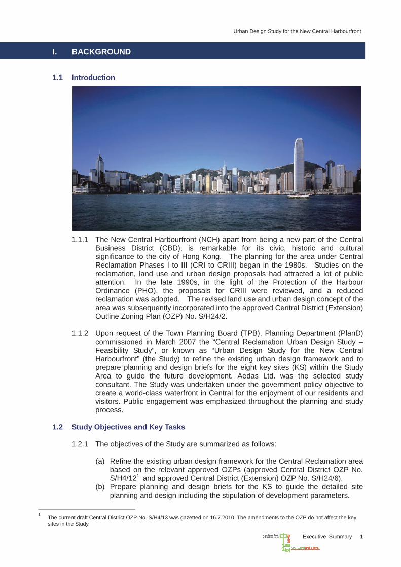
1.1.1 The New Central Harbourfront (NCH) apart from being a new part of the Central
Business District (CBD), is remarkable for its civic, historic and cultural significance to the city of Hong Kong. The planning for the area under Central Reclamation Phases I to III (CRI to CRIII) began in the 1980s. Studies on the reclamation, land use and urban design proposals had attracted a lot of public attention. In the late 1990s, in the light of the Protection of the Harbour Ordinance (PHO), the proposals for CRIII were reviewed, and a reduced reclamation was adopted. The revised land use and urban design concept of the area was subsequently incorporated into the approved Central District (Extension) Outline Zoning Plan (OZP) No. S/H24/2.
1.1.2 Upon request of the Town Planning Board (TPB), Planning Department (PlanD)
commissioned in March 2007 the “Central Reclamation Urban Design Study – Feasibility Study”, or known as “Urban Design Study for the New Central Harbourfront” (the Study) to refine the existing urban design framework and to prepare planning and design briefs for the eight key sites (KS) within the Study Area to guide the future development. Aedas Ltd. was the selected study consultant. The Study was undertaken under the government policy objective to create a world-class waterfront in Central for the enjoyment of our residents and visitors. Public engagement was emphasized throughout the planning and study process.
1.2 Study Objectives and Key Tasks
1.2.1 The objectives of the Study are summarized as follows:
(a) Refine the existing urban design framework for the Central Reclamation area
based on the relevant approved OZPs (approved Central District OZP No. S/H4/121 and approved Central District (Extension) OZP No. S/H24/6).
(b) Prepare planning and design briefs for the KS to guide the detailed site planning and design including the stipulation of development parameters.
1 The current draft Central District OZP No. S/H4/13 was gazetted on 16.7.2010. The amendments to the OZP do not affect the key
sites in the Study.
Urban Design Study for the New Central Harbourfront
Executive Summary 2
(c) Formulate urban design control mechanisms to guide the implementation of
the urban design proposals in the future development of KS and its adjacent area.
(d) Respect the cultural heritage and in particular examine locations and design ideas for reconstructing the old Star Ferry Clock Tower (SFCT) and reassembling Queen’s Pier (QP).
(e) Integrate community inputs through an open, transparent, and collaborative public engagement process aiming at “Designing with the Public”.
1.2.2 The four main tasks undertaken during the course of the Study are:
(a) Task 1: Examination of Planning and Design Context (b) Task 2: Refinement of Urban Design Framework and Preparation of
Landscape Strategy Plan (LSP) (c) Task 3: Evaluation and Refinement of Design Concepts of KS (d) Task 4: Preparation of Planning and Design Briefs or Conceptual Landscape
Design Guidelines and Identification of Design Control Mechanisms
1.3 The Study Area
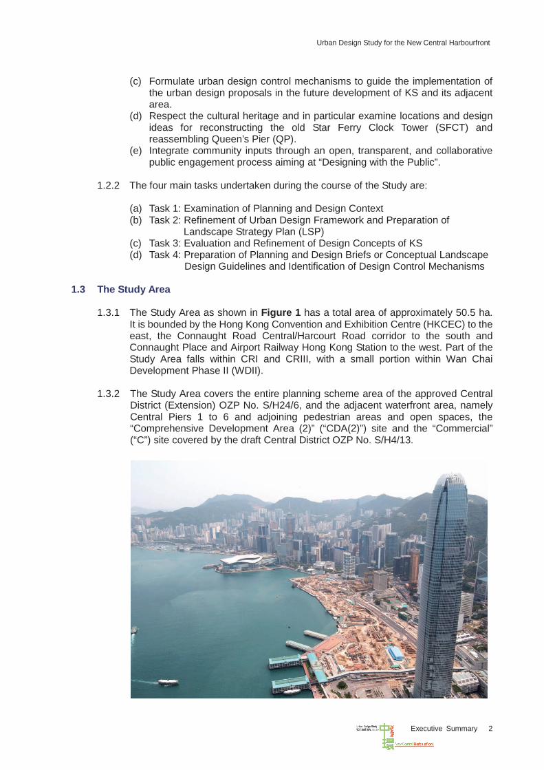
1.3.1 The Study Area as shown in Figure 1 has a total area of approximately 50.5 ha. It is bounded by the Hong Kong Convention and Exhibition Centre (HKCEC) to the east, the Connaught Road Central/Harcourt Road corridor to the south and Connaught Place and Airport Railway Hong Kong Station to the west. Part of the Study Area falls within CRI and CRIII, with a small portion within Wan Chai Development Phase II (WDII).
1.3.2 The Study Area covers the entire planning scheme area of the approved Central
District (Extension) OZP No. S/H24/6, and the adjacent waterfront area, namely Central Piers 1 to 6 and adjoining pedestrian areas and open spaces, the “Comprehensive Development Area (2)” (“CDA(2)”) site and the “Commercial” (“C”) site covered by the draft Central District OZP No. S/H4/13.
Urban Design Study for the New Central Harbourfront
Executive Summary 3
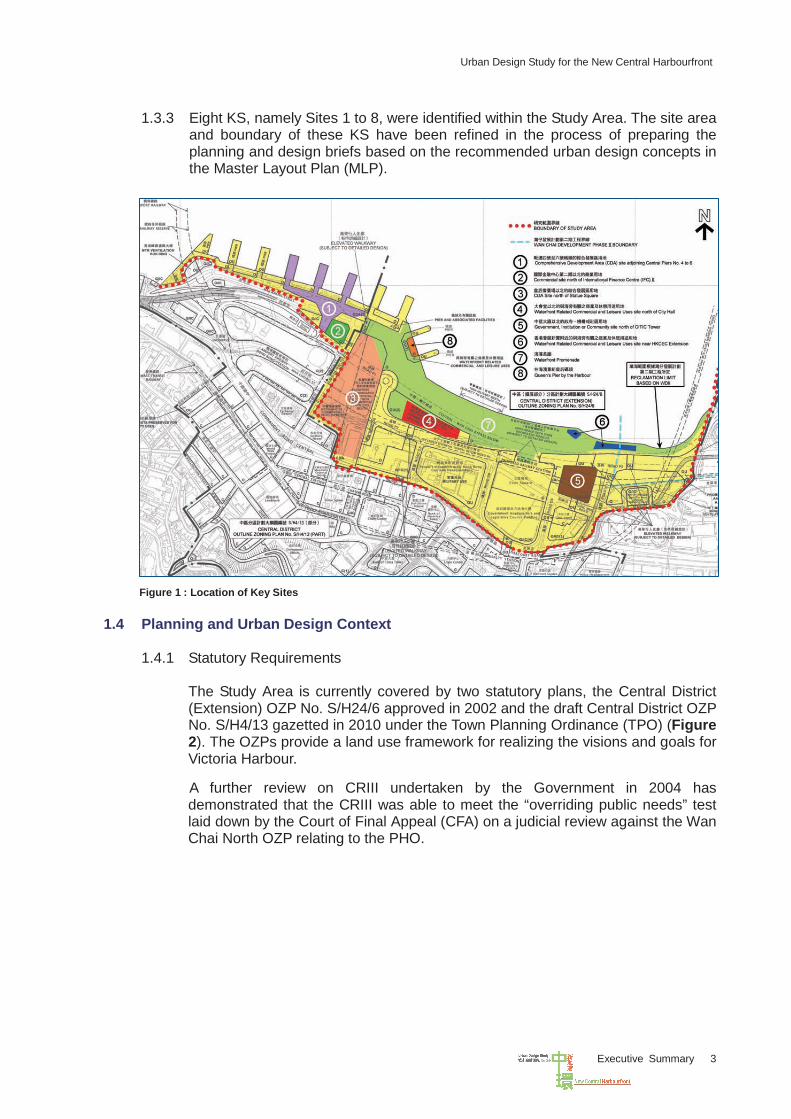
1.3.3 Eight KS, namely Sites 1 to 8, were identified within the Study Area. The site area
and boundary of these KS have been refined in the process of preparing the planning and design briefs based on the recommended urban design concepts in the Master Layout Plan (MLP).
Figure 1 : Location of Key Sites
1.4 Planning and Urban Design Context 1.4.1 Statutory Requirements
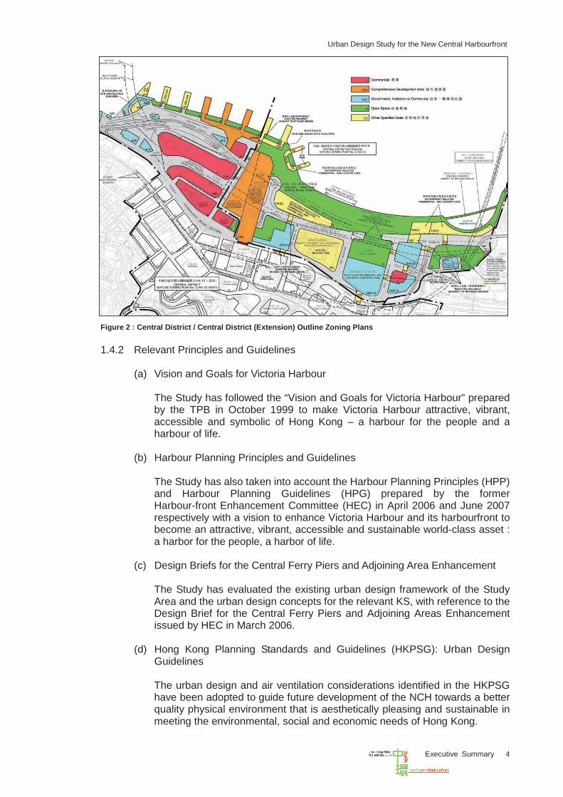
The Study Area is currently covered by two statutory plans, the Central District (Extension) OZP No. S/H24/6 approved in 2002 and the draft Central District OZP No. S/H4/13 gazetted in 2010 under the Town Planning Ordinance (TPO) (Figure 2). The OZPs provide a land use framework for realizing the visions and goals for Victoria Harbour.
A further review on CRIII undertaken by the Government in 2004 has
demonstrated that the CRIII was able to meet the “overriding public needs” test laid down by the Court of Final Appeal (CFA) on a judicial review against the Wan Chai North OZP relating to the PHO.
Urban Design Study for the New Central Harbourfront
Executive Summary 4
Figure 2 : Central District / Central District (Extension) Outline Zoning Plans 1.4.2 Relevant Principles and Guidelines
(a) Vision and Goals for Victoria Harbour
The Study has followed the “Vision and Goals for Victoria Harbour” prepared by the TPB in October 1999 to make Victoria Harbour attractive, vibrant, accessible and symbolic of Hong Kong – a harbour for the people and a harbour of life.
(b) Harbour Planning Principles and Guidelines
The Study has also taken into account the Harbour Planning Principles (HPP) and Harbour Planning Guidelines (HPG) prepared by the former Harbour-front Enhancement Committee (HEC) in April 2006 and June 2007 respectively with a vision to enhance Victoria Harbour and its harbourfront to
a harbor for the people, a harbor of life.
(c) Design Briefs for the Central Ferry Piers and Adjoining Area Enhancement
The Study has evaluated the existing urban design framework of the Study Area and the urban design concepts for the relevant KS, with reference to the Design Brief for the Central Ferry Piers and Adjoining Areas Enhancement issued by HEC in March 2006.
(d) Hong Kong Planning Standards and Guidelines (HKPSG): Urban Design Guidelines The urban design and air ventilation considerations identified in the HKPSG have been adopted to guide future development of the NCH towards a better quality physical environment that is aesthetically pleasing and sustainable in meeting the environmental, social and economic needs of Hong Kong.
become an attractive, vibrant, accessible and sustainable world-class asset :
Urban Design Study for the New Central Harbourfront
Executive Summary 5
1.4.3 Existing Urban Design Framework
Due consideration has been given to the Urban Design Framework presented in the current OZPs, which are summarized as follows: (a) To create a waterfront with four main distinctive components:
- the Statue Square Corridor - the Civic Corridor - the Arts and Entertainment Corridor - the Waterfront Promenade
(b) To ensure that the scale and height of the waterfront development could preserve a minimum of 20% building free area so as to protect the ridgeline of the Victoria Peak as recommended in the Metroplan, and to maintain a clear vista towards the harbour when viewed from the major public vantage point in Tsim Sha Tsui.
(c) To provide new dedicated pedestrian arteries via a series of interconnected elevated decks and walkways to facilitate safe and uninterrupted pedestrian connection.
1.5 Urban Design Objectives
1.5.1 Urban Design Vision
The NCH will be the centerpiece of Hong Kong. The urban design vision is to create a vibrant, green and accessible NCH that is symbolic of Hong Kong. With the magnificent natural setting of the Victoria Harbour and mountain backdrop, Hong Kong is renowned as one of the most beautiful harbour cities in the world. To develop the NCH as a symbol of Hong Kong, we would preserve and enhance its relationship with the city and with its natural setting. Accessibility to the new harbourfront would also be enhanced for public enjoyment of this new destination with the beautiful Victoria Harbour setting.
1.5.2 Urban Design Objectives
The urban design objectives for the NCH are: (a) To project a distinctive identity for the Central Business District (CBD) and the
new harbourfront; (b) To create an attractive harbourfront with high quality public and private
developments and open space in a luxuriant landscape setting; (c) To create a vibrant harbourfront with a mix of uses and diverse activities for
public enjoyment; (d) To create a harmonious visual and physical relationship with the ridgeline,
harbour setting and the CBD; (e) To respect the cultural and historical context of Central; (f) To improve public accessibility to the harbourfront and the new reclamation
from its surrounding areas; and (g) To create a sustainable design that contributes to economic vitality, is
commensurate with traffic, environmental and infrastructural capacities, and preserves heritage and local character.
Urban Design Study for the New Central Harbourfront
Executive Summary 6
1.5.3 Urban Design Emphases
The urban design emphases include: (a) Functional with High Quality: to design the NCH with international quality and
an appropriate mix of uses to meet different land use needs (b) Diversified with Unity: to encourage development with a mix of uses to
promote vibrancy and diversity while unifying the development sites with strategic linkages and a coherent urban design framework
(c) Vibrant and Green: to create vibrant anchoring nodes and provide extensive greening and landscaped areas for the waterfront promenade to form a green unifying harbour edge extending from Central to Wan Chai
(d) Enjoyable Public Spaces: to promote public enjoyment of the harbourfront through signature public plazas, quality open spaces and attractive streetscape along the waterfront
(e) Accessible Waterfront: to further enhance public accessibility to the waterfront through a comprehensive Pedestrian Network Plan (PNP)
(f) Respecting Cultural Heritage: to ensure that the urban setting of the NCH is compatible with the built heritage of Central
(g) Conducive to Economic Vitality: to ensure that an appropriate scale and mixture of commercial activities conducive to economic vitality can be sustained
(h) Guiding while Allowing Design Flexibility: to guide further development by planning and design briefs for the KS while allowing sufficient design flexibility and creativity to achieve the planning and design visions.
1.6 Design Considerations
1.6.1 Existing Urban Fabric
Specific urban design considerations are given to guide the appropriate scale, massing and height profile for the new developments along the waterfront so as to ensure compatibility with the existing urban fabric and enhance visual permeability to the harbour and air ventilation of the existing urban core. Breezeways and view corridors are introduced at strategically planned locations. Historical and cultural references of existing built environment are respected in planning the new development areas. A comprehensive network of pedestrian circulation through at-grade, underground and elevated level connections in the form of pedestrian subways, landscaped decks and elevated footbridges should be well orchestrated to provide connectivity to the existing urban core.
1.6.2 Site Constraints The CRIII works including the locations and sizes of underground and above ground utility structures as well as other infrastructure projects have significant impact on the design and technical feasibility of development within the NCH. The major site constraints identified within the Study Area include the following existing and planned facilities: (a) Alignment and Protection Zone of Central-Wan Chai Bypass (CWB) (b) Drainage Reserves (underground box culverts) (c) Railway Reserves (including planned Shatin to Central Link (SCL), North
Island Line (NIL), Airport Railway Extended Overrun Tunnel (AREOT), etc.) (d) Openings of underground utilities
Urban Design Study for the New Central Harbourfront
Executive Summary 7
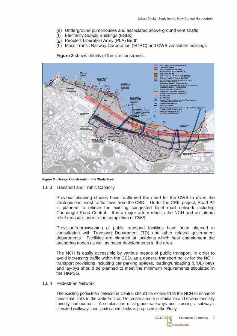
(e) Underground pumphouses and associated above-ground vent shafts (f) Electricity Supply Buildings (ESBs) (g) People’s Liberation Army (PLA) Berth (h) Mass Transit Railway Corporation (MTRC) and CWB ventilation buildings Figure 3 shows details of the site constraints.
Figure 3 : Design Constraints in the Study Area
1.6.3 Transport and Traffic Capacity Previous planning studies have reaffirmed the need for the CWB to divert the strategic east-west traffic flows from the CBD. Under the CRIII project, Road P2 is planned to relieve the existing congested local road network including Connaught Road Central. It is a major artery road in the NCH and an interim relief measure prior to the completion of CWB. Provision/reprovisioning of public transport facilities have been planned in consultation with Transport Department (TD) and other related government departments. Facilities are planned at locations which best complement the anchoring nodes as well as major developments in the area. The NCH is easily accessible by various means of public transport. In order to avoid increasing traffic within the CBD, as a general transport policy for the NCH, transport provisions including car parking spaces, loading/unloading (L/UL) bays and lay-bys should be planned to meet the minimum requirements stipulated in the HKPSG.
1.6.4 Pedestrian Network The existing pedestrian network in Central should be extended to the NCH to enhance pedestrian links to the waterfront and to create a more sustainable and environmentally friendly harbourfront. A combination of at-grade walkways and crossings, subways, elevated walkways and landscaped decks is proposed in the Study.
Urban Design Study for the New Central Harbourfront
Executive Summary 8
1.6.5 Economic Issues In view of the shortage in supply and strong demand for Grade A office/hotel/commercial floor space in Central, provision of some commercial uses in the NCH is considered necessary in order to sustain the competitive edge of the CBD in Central. A diversity of uses comprising commercial, retail, recreational and tourism activities in the NCH can promote a vibrant harbourfront and enhance the image and functions of the Victoria Harbour. A sustainability assessment was conducted as part of the Study. The following Sustainable Design Principles are identified as critical to the long term sustainability for the harbourfront and guidelines are prepared to ensure that the environmental, economic and social aspects could be addressed and carried forward for implementation: (a) Diverse Uses and Activities (b) Respecting Natural and Existing Urban Context (c) Promoting Harbourfront Enhancement (d) Respecting Cultural Heritage (e) Ease of Pedestrian Access to Harbourfront (f) Promoting Environmentally Friendly Building Design and Greening
1.6.6 Environmental Issues Environmental issues were addressed in the Study to ensure that the overall environment is ideal for public enjoyment of the waterfront. The proposed design concept promotes a harmonious juxtaposition of different land uses along the harbourfront. Sensitive building design with appropriate disposition, air paths and height profile can help improve the air quality and pedestrian wind environment. Appropriate sustainable building design features, such as renewable energy, green roof system, landscaping, etc. can also improve the micro-climate. The air ventilation assessment (AVA) has concluded that the developments proposed in the Study Area have no significant adverse impacts to the surroundings. In order to preserve views to ridgelines and mountain backdrops, a 20% building free zone has been maintained as recommended in the Urban Design Guidelines. Visual analysis was conducted in the process of refining the urban design framework. View corridors have been introduced to enhance visual connectivity with the harbour.
1.6.7 Interface with Other Development and Infrastructure Projects The new developments in the NCH should be fully integrated with the existing and planned landmarks such as the International Finance Centre (IFC) I and II, the City Hall Complex, the Tamar Development, and the proposed extension of the Hong Kong Academy for Performing Arts (HKAPA). The Study has taken into consideration the latest development of infrastructure projects, namely, CR III, WDII, CWB, existing and planned railway alignments and facilities including SCL, NIL, PLA Berth, etc.
Urban Design Study for the New Central Harbourfront
Executive Summary 9
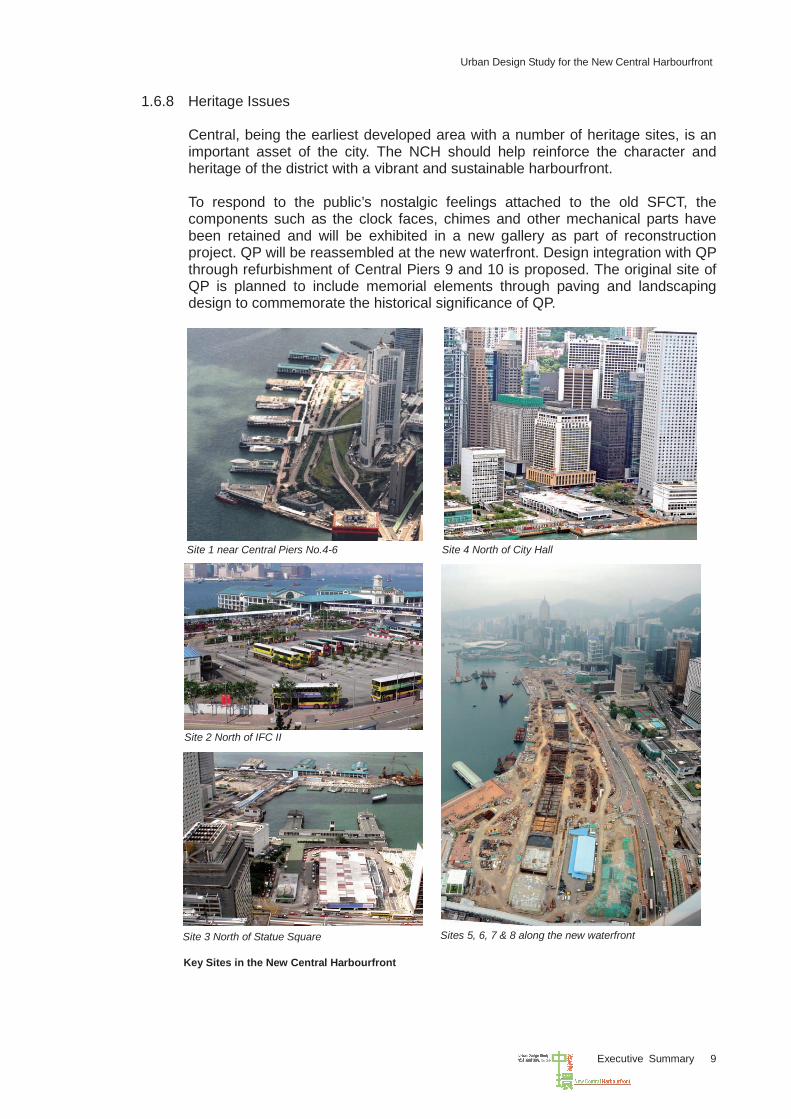
1.6.8 Heritage Issues Central, being the earliest developed area with a number of heritage sites, is an important asset of the city. The NCH should help reinforce the character and heritage of the district with a vibrant and sustainable harbourfront. To respond to the public’s nostalgic feelings attached to the old SFCT, the components such as the clock faces, chimes and other mechanical parts have been retained and will be exhibited in a new gallery as part of reconstruction project. QP will be reassembled at the new waterfront. Design integration with QP through refurbishment of Central Piers 9 and 10 is proposed. The original site of QP is planned to include memorial elements through paving and landscaping design to commemorate the historical significance of QP.
Site 1 near Central Piers No.4-6
Site 2 North of IFC II
Site 3 North of Statue Square
Site 4 North of City Hall
Sites 5, 6, 7 & 8 along the new waterfront
Key Sites in the New Central Harbourfront
Urban Design Study for the New Central Harbourfront
Executive Summary 10
II PUBLIC ENGAGEMENT
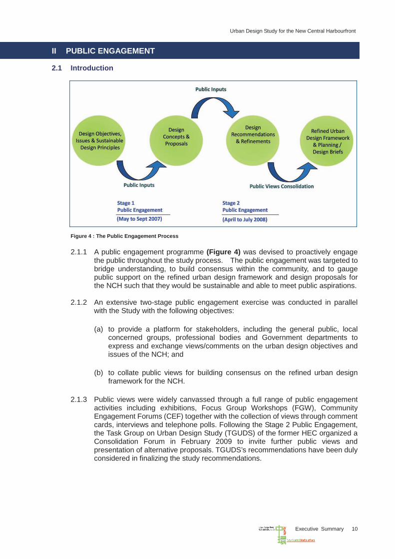
2.1 Introduction
Figure 4 : The Public Engagement Process
2.1.2 An extensive two-stage public engagement exercise was conducted in parallel
with the Study with the following objectives:
(a) to provide a platform for stakeholders, including the general public, local concerned groups, professional bodies and Government departments to express and exchange views/comments on the urban design objectives and issues of the NCH; and
(b) to collate public views for building consensus on the refined urban design
framework for the NCH.
2.1.3 Public views were widely canvassed through a full range of public engagement activities including exhibitions, Focus Group Workshops (FGW), Community Engagement Forums (CEF) together with the collection of views through comment cards, interviews and telephone polls. Following the Stage 2 Public Engagement, the Task Group on Urban Design Study (TGUDS) of the former HEC organized a Consolidation Forum in February 2009 to invite further public views and presentation of alternative proposals. TGUDS’s recommendations have been duly considered in finalizing the study recommendations.
2.1.1 A public engagement programme (Figure 4) was devised to proactively engage the public throughout the study process. The public engagement was targeted to bridge understanding, to build consensus within the community, and to gauge public support on the refined urban design framework and design proposals for the NCH such that they would be sustainable and able to meet public aspirations.
Urban Design Study for the New Central Harbourfront
Executive Summary 11
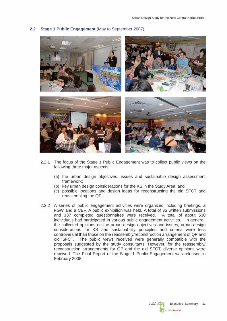
2.2 Stage 1 Public Engagement (May to September 2007)
2.2.1 The focus of the Stage 1 Public Engagement was to collect public views on the
following three major aspects:
(a) the urban design objectives, issues and sustainable design assessment framework;
(b) key urban design considerations for the KS in the Study Area; and (c) possible locations and design ideas for reconstructing the old SFCT and
reassembling the QP.
2.2.2 A series of public engagement activities were organized including briefings, a FGW and a CEF. A public exhibition was held. A total of 35 written submissions and 137 completed questionnaires were received. A total of about 530 individuals had participated in various public engagement activities. In general, the collected opinions on the urban design objectives and issues, urban design considerations for KS and sustainability principles and criteria were less controversial than those on the reassembly/reconstruction arrangement of QP and old SFCT. The public views received were generally compatible with the proposals suggested by the study consultants. However, for the reassembly/ reconstruction arrangements for QP and the old SFCT, diverse opinions were received. The Final Report of the Stage 1 Public Engagement was released in February 2008.
Urban Design Study for the New Central Harbourfront
Executive Summary 12
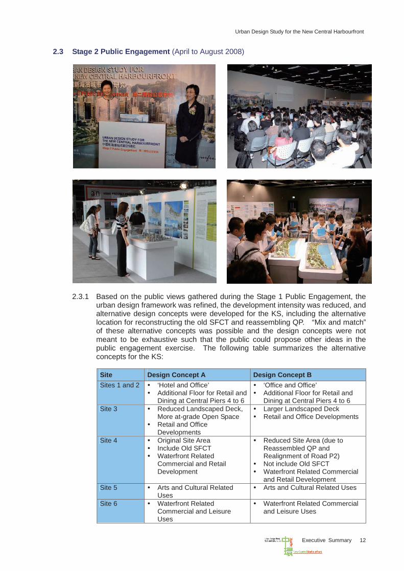
2.3 Stage 2 Public Engagement (April to August 2008)
2.3.1 Based on the public views gathered during the Stage 1 Public Engagement, the
urban design framework was refined, the development intensity was reduced, and alternative design concepts were developed for the KS, including the alternative location for reconstructing the old SFCT and reassembling QP. “Mix and match” of these alternative concepts was possible and the design concepts were not meant to be exhaustive such that the public could propose other ideas in the public engagement exercise. The following table summarizes the alternative concepts for the KS:
Site Design Concept A Design Concept B Sites 1 and 2 ‘Hotel and Office’
Additional Floor for Retail and Dining at Central Piers 4 to 6
‘Office and Office’ Additional Floor for Retail and
Dining at Central Piers 4 to 6 Site 3 Reduced Landscaped Deck,
More at-grade Open Space Retail and Office
Developments
Larger Landscaped Deck Retail and Office Developments
Site 4 Original Site Area Include Old SFCT Waterfront Related
Commercial and Retail Development
Reduced Site Area (due to Reassembled QP and Realignment of Road P2)
Not include Old SFCT Waterfront Related Commercial
and Retail Development Site 5 Arts and Cultural Related
Uses Arts and Cultural Related Uses
Site 6 Waterfront Related
Commercial and Leisure Uses
Waterfront Related Commercial and Leisure Uses
Urban Design Study for the New Central Harbourfront
Executive Summary 13
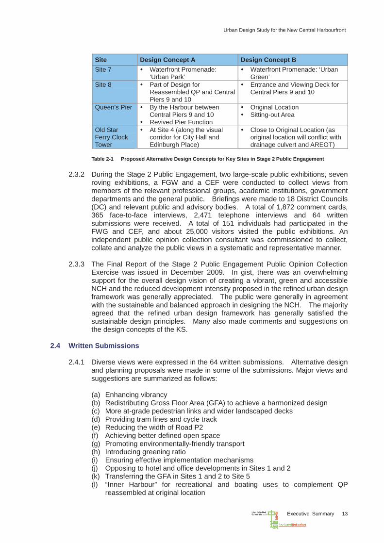
Site Design Concept A Design Concept B Site 7 Waterfront Promenade:
‘Urban Park’ Waterfront Promenade: ‘Urban
Green’ Site 8 Part of Design for
Reassembled QP and Central Piers 9 and 10
Entrance and Viewing Deck for Central Piers 9 and 10
Queen’s Pier By the Harbour between Central Piers 9 and 10
Revived Pier Function
Original Location Sitting-out Area
Old Star Ferry Clock Tower
At Site 4 (along the visual corridor for City Hall and Edinburgh Place)
Close to Original Location (as original location will conflict with drainage culvert and AREOT)
Table 2-1 Proposed Alternative Design Concepts for Key Sites in Stage 2 Public Engagement
2.3.2 During the Stage 2 Public Engagement, two large-scale public exhibitions, seven
roving exhibitions, a FGW and a CEF were conducted to collect views from members of the relevant professional groups, academic institutions, government departments and the general public. Briefings were made to 18 District Councils (DC) and relevant public and advisory bodies. A total of 1,872 comment cards, 365 face-to-face interviews, 2,471 telephone interviews and 64 written submissions were received. A total of 151 individuals had participated in the FWG and CEF, and about 25,000 visitors visited the public exhibitions. An independent public opinion collection consultant was commissioned to collect, collate and analyze the public views in a systematic and representative manner.
2.3.3 The Final Report of the Stage 2 Public Engagement Public Opinion Collection
Exercise was issued in December 2009. In gist, there was an overwhelming support for the overall design vision of creating a vibrant, green and accessible NCH and the reduced development intensity proposed in the refined urban design framework was generally appreciated. The public were generally in agreement with the sustainable and balanced approach in designing the NCH. The majority agreed that the refined urban design framework has generally satisfied the sustainable design principles. Many also made comments and suggestions on the design concepts of the KS.
2.4 Written Submissions
2.4.1 Diverse views were expressed in the 64 written submissions. Alternative design and planning proposals were made in some of the submissions. Major views and suggestions are summarized as follows:
(a) Enhancing vibrancy (b) Redistributing Gross Floor Area (GFA) to achieve a harmonized design (c) More at-grade pedestrian links and wider landscaped decks (d) Providing tram lines and cycle track (e) Reducing the width of Road P2 (f) Achieving better defined open space (g) Promoting environmentally-friendly transport (h) Introducing greening ratio (i) Ensuring effective implementation mechanisms (j) Opposing to hotel and office developments in Sites 1 and 2 (k) Transferring the GFA in Sites 1 and 2 to Site 5 (l) “Inner Harbour” for recreational and boating uses to complement QP
reassembled at original location
Urban Design Study for the New Central Harbourfront
Executive Summary 14
(m) “Lagoon” proposal to complement reassembling QP at original location (n) Providing water-based activities such as Maritime Museum and hotel uses in
Sites 5 and 6 (o) Providing the PLA berth offshore
2.4.2 The alternative proposals have been critically examined together with the
concerned Government departments and the TGUDS. They have been suitably addressed in the process of refining the MLP and design concepts of KS. The “inner harbour” and “lagoon” proposals have been studied thoroughly and are considered not practicable or desirable from technical and urban design points of view.
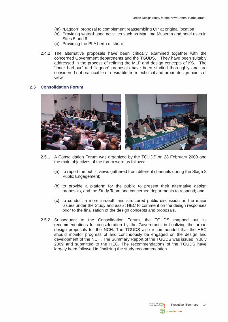
2.5 Consolidation Forum
2.5.1 A Consolidation Forum was organized by the TGUDS on 28 February 2009 and
the main objectives of the forum were as follows:
(a) to report the public views gathered from different channels during the Stage 2 Public Engagement;
(b) to provide a platform for the public to present their alternative design
proposals, and the Study Team and concerned departments to respond; and (c) to conduct a more in-depth and structured public discussion on the major
issues under the Study and assist HEC to comment on the design responses prior to the finalization of the design concepts and proposals.
2.5.2 Subsequent to the Consolidation Forum, the TGUDS mapped out its
recommendations for consideration by the Government in finalizing the urban design proposals for the NCH. The TGUDS also recommended that the HEC should monitor progress of and continuously be engaged on the design and development of the NCH. The Summary Report of the TGUDS was issued in July 2009 and submitted to the HEC. The recommendations of the TGUDS have largely been followed in finalizing the study recommendation.
Urban Design Study for the New Central Harbourfront
Executive Summary 15
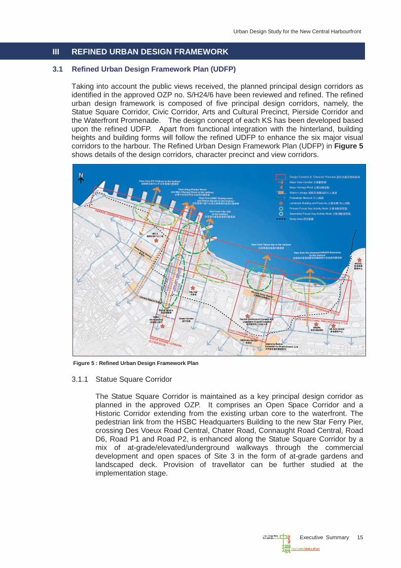
III REFINED URBAN DESIGN FRAMEWORK 3.1 Refined Urban Design Framework Plan (UDFP)
Taking into account the public views received, the planned principal design corridors as identified in the approved OZP no. S/H24/6 have been reviewed and refined. The refined urban design framework is composed of five principal design corridors, namely, the Statue Square Corridor, Civic Corridor, Arts and Cultural Precinct, Pierside Corridor and the Waterfront Promenade. The design concept of each KS has been developed based upon the refined UDFP. Apart from functional integration with the hinterland, building heights and building forms will follow the refined UDFP to enhance the six major visual corridors to the harbour. The Refined Urban Design Framework Plan (UDFP) in Figure 5 shows details of the design corridors, character precinct and view corridors.
Figure 5 : Refined Urban Design Framework Plan 3.1.1 Statue Square Corridor
The Statue Square Corridor is maintained as a key principal design corridor as planned in the approved OZP. It comprises an Open Space Corridor and a Historic Corridor extending from the existing urban core to the waterfront. The pedestrian link from the HSBC Headquarters Building to the new Star Ferry Pier, crossing Des Voeux Road Central, Chater Road, Connaught Road Central, Road D6, Road P1 and Road P2, is enhanced along the Statue Square Corridor by a mix of at-grade/elevated/underground walkways through the commercial development and open spaces of Site 3 in the form of at-grade gardens and landscaped deck. Provision of travellator can be further studied at the implementation stage.
Urban Design Study for the New Central Harbourfront
Executive Summary 16
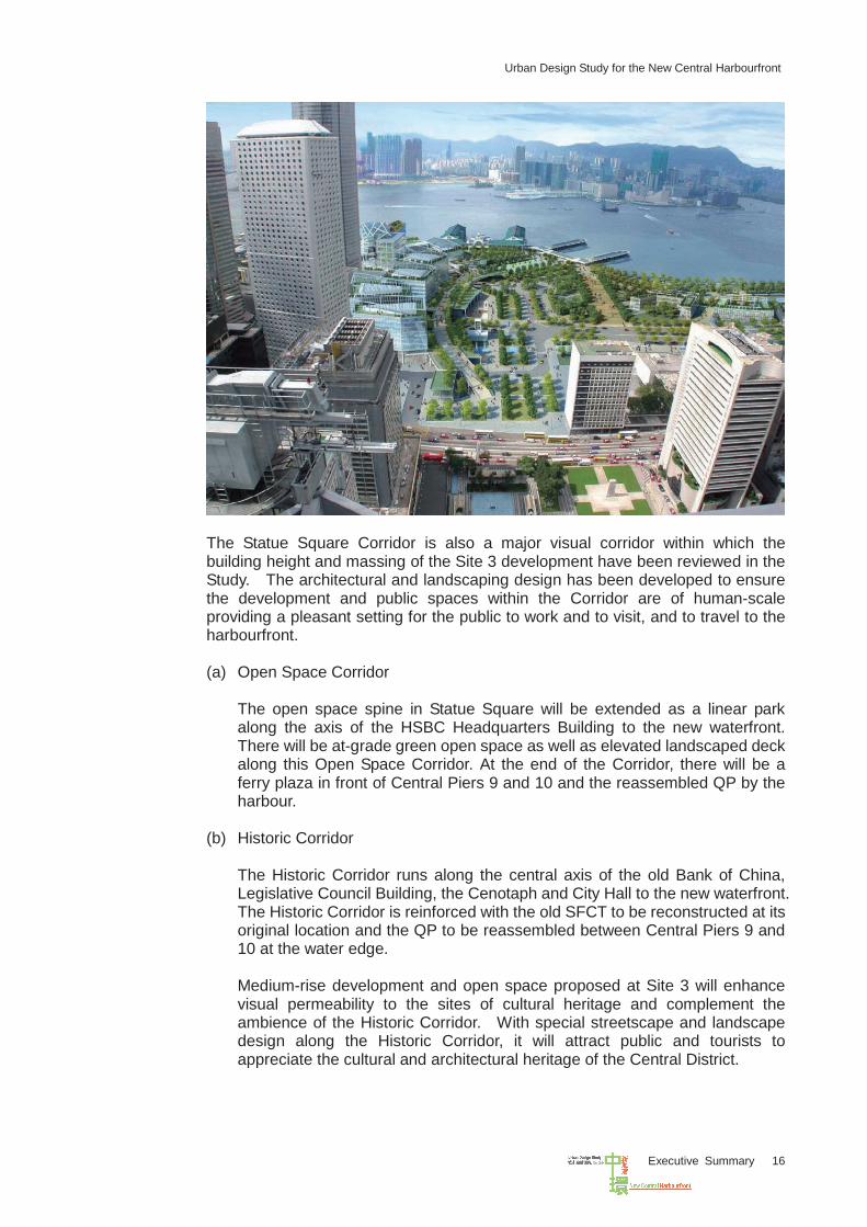
The Statue Square Corridor is also a major visual corridor within which the building height and massing of the Site 3 development have been reviewed in the Study. The architectural and landscaping design has been developed to ensure the development and public spaces within the Corridor are of human-scale providing a pleasant setting for the public to work and to visit, and to travel to the harbourfront. (a) Open Space Corridor
The open space spine in Statue Square will be extended as a linear park along the axis of the HSBC Headquarters Building to the new waterfront. There will be at-grade green open space as well as elevated landscaped deck along this Open Space Corridor. At the end of the Corridor, there will be a ferry plaza in front of Central Piers 9 and 10 and the reassembled QP by the harbour.
(b) Historic Corridor
The Historic Corridor runs along the central axis of the old Bank of China, Legislative Council Building, the Cenotaph and City Hall to the new waterfront. The Historic Corridor is reinforced with the old SFCT to be reconstructed at its original location and the QP to be reassembled between Central Piers 9 and 10 at the water edge. Medium-rise development and open space proposed at Site 3 will enhance visual permeability to the sites of cultural heritage and complement the ambience of the Historic Corridor. With special streetscape and landscape design along the Historic Corridor, it will attract public and tourists to appreciate the cultural and architectural heritage of the Central District.
Urban Design Study for the New Central Harbourfront
Executive Summary 17
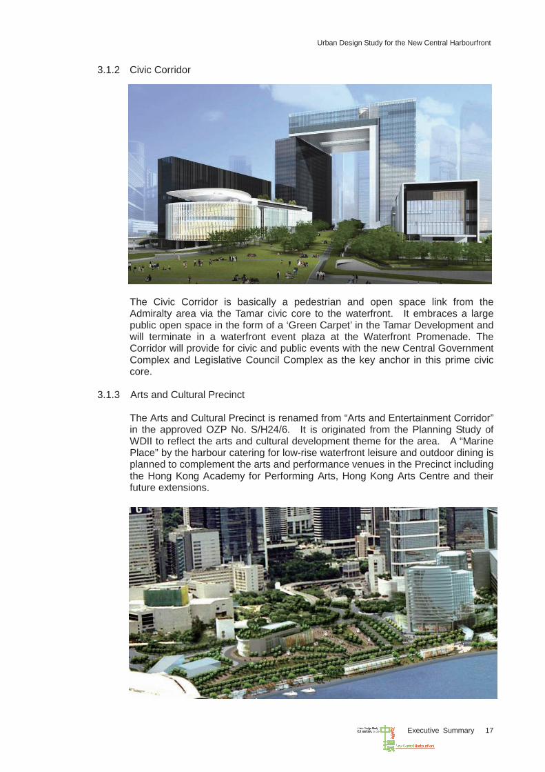
3.1.2 Civic Corridor
The Civic Corridor is basically a pedestrian and open space link from the Admiralty area via the Tamar civic core to the waterfront. It embraces a large public open space in the form of a ‘Green Carpet’ in the Tamar Development and will terminate in a waterfront event plaza at the Waterfront Promenade. The Corridor will provide for civic and public events with the new Central Government Complex and Legislative Council Complex as the key anchor in this prime civic core.
3.1.3 Arts and Cultural Precinct
The Arts and Cultural Precinct is renamed from “Arts and Entertainment Corridor” in the approved OZP No. S/H24/6. It is originated from the Planning Study of WDII to reflect the arts and cultural development theme for the area. A “Marine Place” by the harbour catering for low-rise waterfront leisure and outdoor dining is planned to complement the arts and performance venues in the Precinct including the Hong Kong Academy for Performing Arts, Hong Kong Arts Centre and their future extensions.
Urban Design Study for the New Central Harbourfront
Executive Summary 18
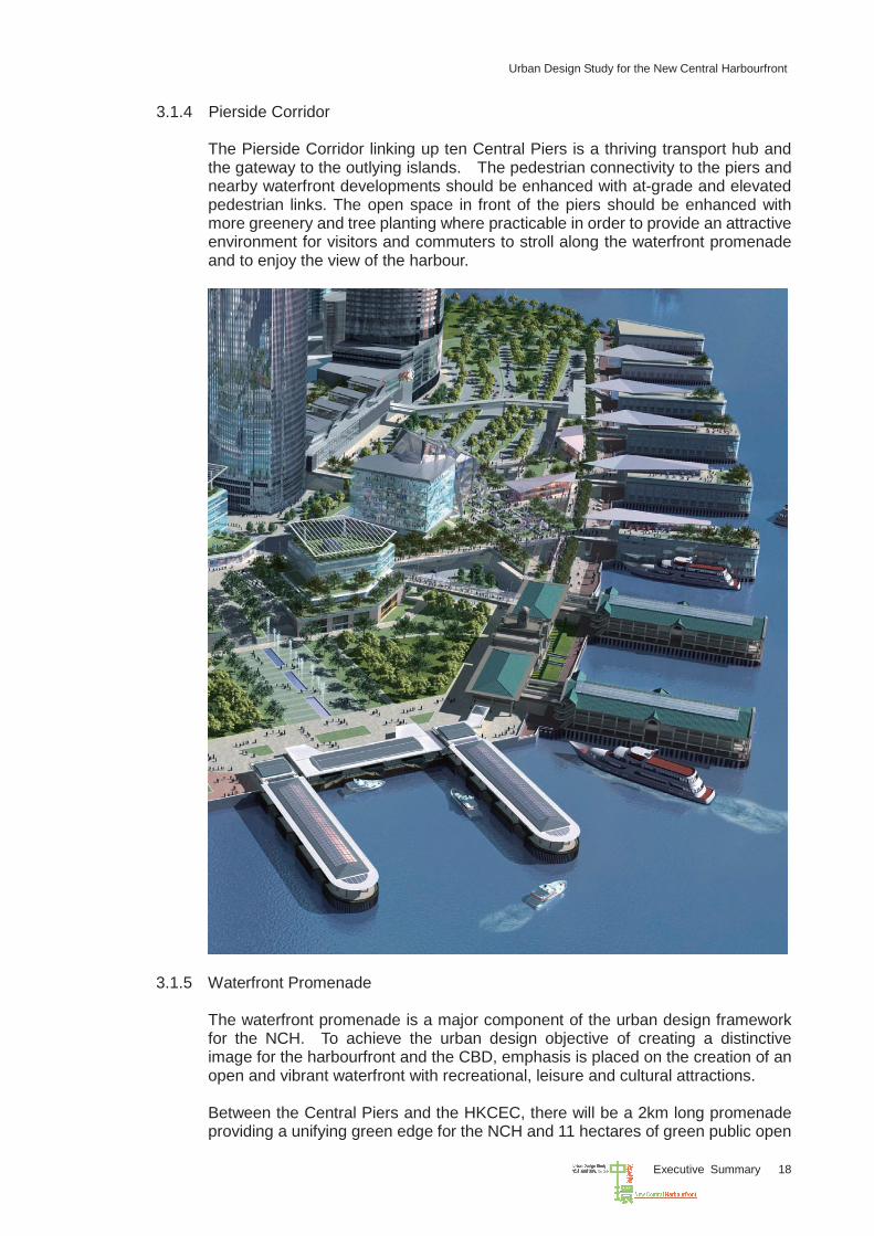
3.1.4 Pierside Corridor
The Pierside Corridor linking up ten Central Piers is a thriving transport hub and the gateway to the outlying islands. The pedestrian connectivity to the piers and nearby waterfront developments should be enhanced with at-grade and elevated pedestrian links. The open space in front of the piers should be enhanced with more greenery and tree planting where practicable in order to provide an attractive environment for visitors and commuters to stroll along the waterfront promenade and to enjoy the view of the harbour.
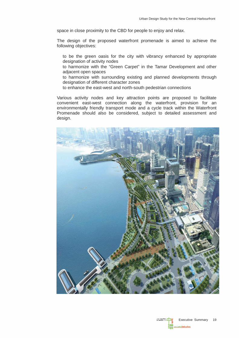
3.1.5 Waterfront Promenade
The waterfront promenade is a major component of the urban design framework for the NCH. To achieve the urban design objective of creating a distinctive image for the harbourfront and the CBD, emphasis is placed on the creation of an open and vibrant waterfront with recreational, leisure and cultural attractions. Between the Central Piers and the HKCEC, there will be a 2km long promenade providing a unifying green edge for the NCH and 11 hectares of green public open
Urban Design Study for the New Central Harbourfront
Executive Summary 19
space in close proximity to the CBD for people to enjoy and relax. The design of the proposed waterfront promenade is aimed to achieve the following objectives: • to be the green oasis for the city with vibrancy enhanced by appropriate
designation of activity nodes • to harmonize with the “Green Carpet” in the Tamar Development and other
adjacent open spaces • to harmonize with surrounding existing and planned developments through
designation of different character zones • to enhance the east-west and north-south pedestrian connections Various activity nodes and key attraction points are proposed to facilitate convenient east-west connection along the waterfront, provision for an environmentally friendly transport mode and a cycle track within the Waterfront Promenade should also be considered, subject to detailed assessment and design.
Urban Design Study for the New Central Harbourfront
Executive Summary 20
3.2 View Corridors and View Protection
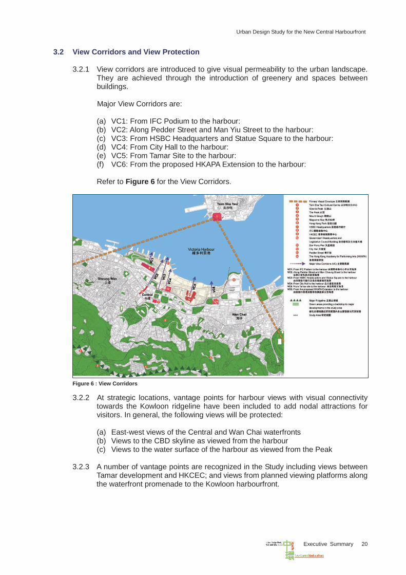
3.2.1 View corridors are introduced to give visual permeability to the urban landscape. They are achieved through the introduction of greenery and spaces between buildings. Major View Corridors are:
(a) VC1: From IFC Podium to the harbour: (b) VC2: Along Pedder Street and Man Yiu Street to the harbour: (c) VC3: From HSBC Headquarters and Statue Square to the harbour: (d) VC4: From City Hall to the harbour: (e) VC5: From Tamar Site to the harbour: (f) VC6: From the proposed HKAPA Extension to the harbour:
Refer to Figure 6 for the View Corridors.
Figure 6 : View Corridors 3.2.2 At strategic locations, vantage points for harbour views with visual connectivity
towards the Kowloon ridgeline have been included to add nodal attractions for visitors. In general, the following views will be protected:
(a) East-west views of the Central and Wan Chai waterfronts (b) Views to the CBD skyline as viewed from the harbour (c) Views to the water surface of the harbour as viewed from the Peak
3.2.3 A number of vantage points are recognized in the Study including views between Tamar development and HKCEC; and views from planned viewing platforms along the waterfront promenade to the Kowloon harbourfront.
Urban Design Study for the New Central Harbourfront
Executive Summary 21
3.3 Controlled Massing Approach
3.3.1 The “controlled massing” approach is adopted in the Study to contain the building masses and building bulk for the KS in the NCH. While mandatory features, essential plants rooms and hotel concessions can be excluded from GFA calculation, no bonus GFA or GFA exemptions relating to dedication for public passage, surrender for road widening and building set back would be allowed in the NCH under the “controlled massing” approach. Public car parks and public transport facilities should be included in GFA calculation, except otherwise provided for in the planning and design brief. Minimum car parking provision under the HKPSG has been adopted and provision of basement car park is required, where practicable.
3.3.2 Development parameters are derived for each KS based on the “controlled
massing” approach. They are stipulated in the planning and design briefs to guide the future developments and include the following :
• Defined maximum GFA
The following items should be exempted from GFA calculation: mandatory features, essential plant rooms, hotel concession and ancillary car parking at basement level. No bonus GFA or GFA exemption relating to dedication of public passageway, surrender for road widening and building set back would be allowed.
• Defined maximum height limit • Defined minimum area and locations of open space • Defined minimum greening ratio and locations of green areas • Defined vehicular ingress/egress2 • Defined transport facility requirements 3 (including public and private car
parking spaces, L/UL, private vehicle (PV) /taxi/coach laybys, public transport facilities, driveway etc.)
• Defined routes/public passageways for pedestrian accessibility and connections at-grade and at upper levels.
3.4 Building Height Strategy
3.4.1 Ridgelines and Skylines
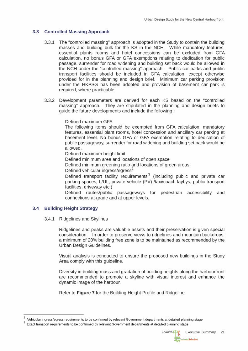
Ridgelines and peaks are valuable assets and their preservation is given special consideration. In order to preserve views to ridgelines and mountain backdrops, a minimum of 20% building free zone is to be maintained as recommended by the Urban Design Guidelines. Visual analysis is conducted to ensure the proposed new buildings in the Study Area comply with this guideline. Diversity in building mass and gradation of building heights along the harbourfront are recommended to promote a skyline with visual interest and enhance the dynamic image of the harbour. Refer to Figure 7 for the Building Height Profile and Ridgeline.
2 Vehicular ingress/egress requirements to be confirmed by relevant Government departments at detailed planning stage 3 Exact transport requirements to be confirmed by relevant Government departments at detailed planning stage
Urban Design Study for the New Central Harbourfront
Executive Summary 22
Figure 7 : Building Height Profile and Ridgeline 3.4.2 Gradation of Height Profile
Developments within and around the harbourfront generally adopt a descending height profile with the heights of buildings descending towards the harbour to avoid domination of the Harbour. A cascading design and a cluster of building blocks with a descending building height have been introduced. This approach promotes openness to the harbour with additional architectural features such as sky-terrace and roof garden where harbour appreciation is further enhanced.
3.4.3 Respect Human Scale Building heights and spaces are to bear a relationship to human proportion in order to facilitate easy usage, interaction and perception by the users. The proposed maximum building height along the waterfront, i.e. the Harbour Place in Site 4 and the Marine Place in Site 6, are kept low to correspond with the human scale.
3.4.4 Harmonize with the Surroundings New developments within the NCH should give emphasis to the sites or buildings with cultural and historical value in the surroundings. The height and visual dominance of the developments near the reassembled QP and reconstructed old SFCT should not overshadow the historical buildings and sites. A building height limit is also suggested in the interest of optimizing the visual permeability to the harbourfront within the urban context.
3.4.5 Building Identity The height of a building can express the identity of the users and the identity of Hong Kong as a whole. The buildings in Sites 1 and 2 are planned to give particular emphasis to the developments and landscaped deck to form an iconic destination in the area and to create a new landmark for Hong Kong. Developments at Sites 3 and 5 present themselves with their own particular characteristics to create commercial developments which complement the waterfront setting while forming different destination anchor nodes. The relatively low buildings in Sites 4 and 6 give a relatively comfortable and welcoming ambience for the public to enjoy and better spatial interaction with the
Urban Design Study for the New Central Harbourfront
Executive Summary 23
surrounding landscape and the waterfront edge. They complement the waterfront promenade for public enjoyment and harbour appreciation.
3.5 Pedestrian Network
3.5.1 The north-south pedestrian access to the waterfront proposed in the Study through the proposed major north-south routes is adequate. Continuous east-west pedestrian connections have been provided to reinforce the inter-district connections from Sheung Wan to Wan Chai.
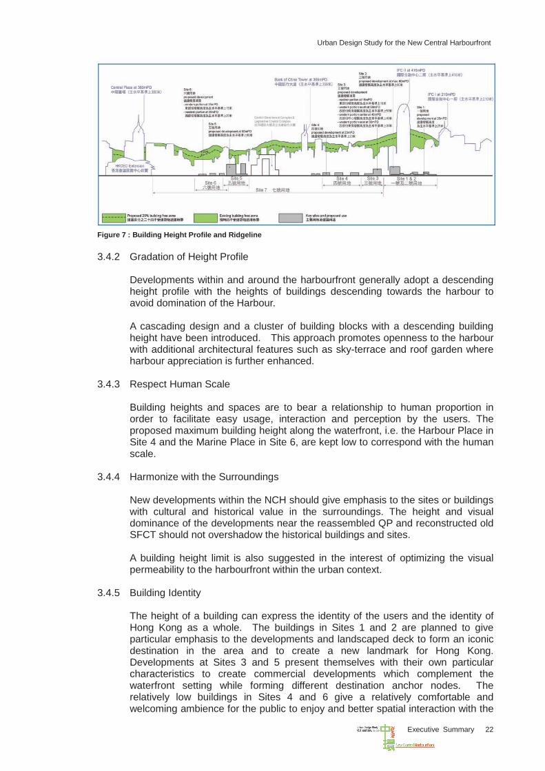
3.5.2 Upon completion of the CRIII and WDII, the existing pedestrian connections within
the Central/Admiralty/north-west Wan Chai areas will be further enhanced with a more comprehensive pedestrian network system which aims at:
• Extending the existing elevated walkway system to link up Central, Admiralty
and north-west Wan Chai further northward to achieve direct access and improved connectivity with the future waterfront promenade;
• Enhancing connections amongst and within the KS; and • Providing a combination of at-grade, underground and elevated pedestrian
connections. Figure 8 on Pedestrian Network Plan (PNP) shows the details.
Figure 8 : Pedestrian Network Plan
3.6 Public Transport Provision
Upon further review of the proposed public transport facilities and changes to the design concepts of KS, the originally planned public transport interchange at Site 2 has been deleted in the revised design and would be redistributed to the ferry pier area and other areas close to the NCH in order to meet the public aspirations for a more
Urban Design Study for the New Central Harbourfront
Executive Summary 24
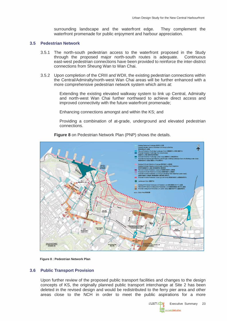
pedestrian-oriented harbourfront environment. Public transport facilities are integrated into the planning of Sites 1, 2 and 3. Connections to the MTR stations are provided in Sites 3 and 5. Public Transport Plan (PTP) in Figure 9 shows the details.
Figure 9 : Public Transport Plan
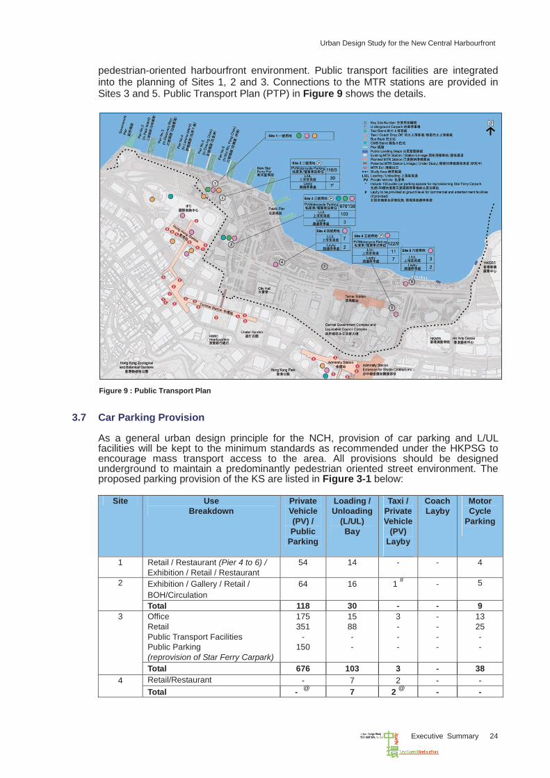
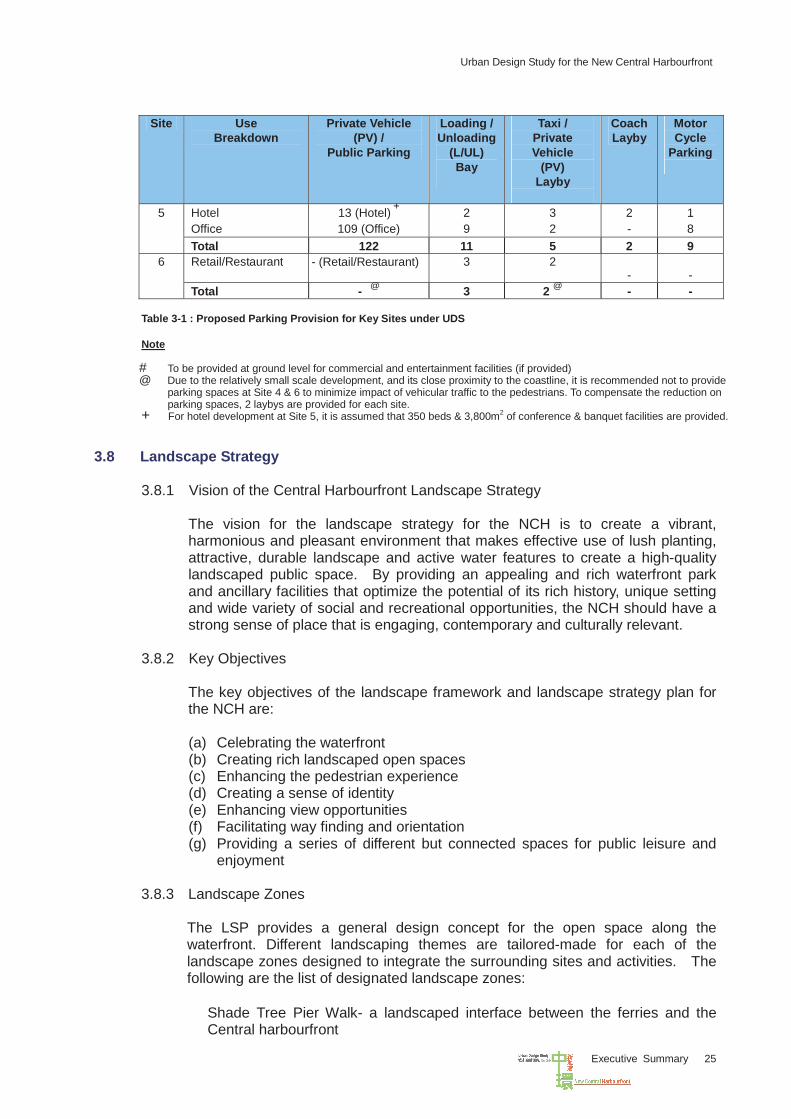
3.7 Car Parking Provision
As a general urban design principle for the NCH, provision of car parking and L/UL facilities will be kept to the minimum standards as recommended under the HKPSG to encourage mass transport access to the area. All provisions should be designed underground to maintain a predominantly pedestrian oriented street environment. The proposed parking provision of the KS are listed in Figure 3-1 below:
Site Use Breakdown
Private Vehicle (PV) / Public
Parking
Loading /Unloading
(L/UL) Bay
Taxi / Private Vehicle
(PV) Layby
Coach Layby
Motor Cycle
Parking
1 Retail / Restaurant (Pier 4 to 6) / Exhibition / Retail / Restaurant
54 14 - - 4
Exhibition / Gallery / Retail / BOH/Circulation
64 16 1 # - 5 2
Total 118 30 - - 9 Office Retail Public Transport Facilities Public Parking (reprovision of Star Ferry Carpark)
175 351
- 150
15 88 - -
3 - - -
- - - -
13 25 - -
3
Total 676 103 3 - 38 Retail/Restaurant - 7 2 - - 4 Total -
@ 7 2 @ - -
Urban Design Study for the New Central Harbourfront
Executive Summary 25
Table 3-1 : Proposed Parking Provision for Key Sites under UDS
Note
# To be provided at ground level for commercial and entertainment facilities (if provided) @ Due to the relatively small scale development, and its close proximity to the coastline, it is recommended not to provide
parking spaces at Site 4 & 6 to minimize impact of vehicular traffic to the pedestrians. To compensate the reduction on parking spaces, 2 laybys are provided for each site.
+ For hotel development at Site 5, it is assumed that 350 beds & 3,800m2 of conference & banquet facilities are provided.
3.8 Landscape Strategy
3.8.1 Vision of the Central Harbourfront Landscape Strategy
The vision for the landscape strategy for the NCH is to create a vibrant, harmonious and pleasant environment that makes effective use of lush planting, attractive, durable landscape and active water features to create a high-quality landscaped public space. By providing an appealing and rich waterfront park and ancillary facilities that optimize the potential of its rich history, unique setting and wide variety of social and recreational opportunities, the NCH should have a strong sense of place that is engaging, contemporary and culturally relevant.
3.8.2 Key Objectives The key objectives of the landscape framework and landscape strategy plan for the NCH are: (a) Celebrating the waterfront (b) Creating rich landscaped open spaces (c) Enhancing the pedestrian experience (d) Creating a sense of identity (e) Enhancing view opportunities (f) Facilitating way finding and orientation (g) Providing a series of different but connected spaces for public leisure and
enjoyment
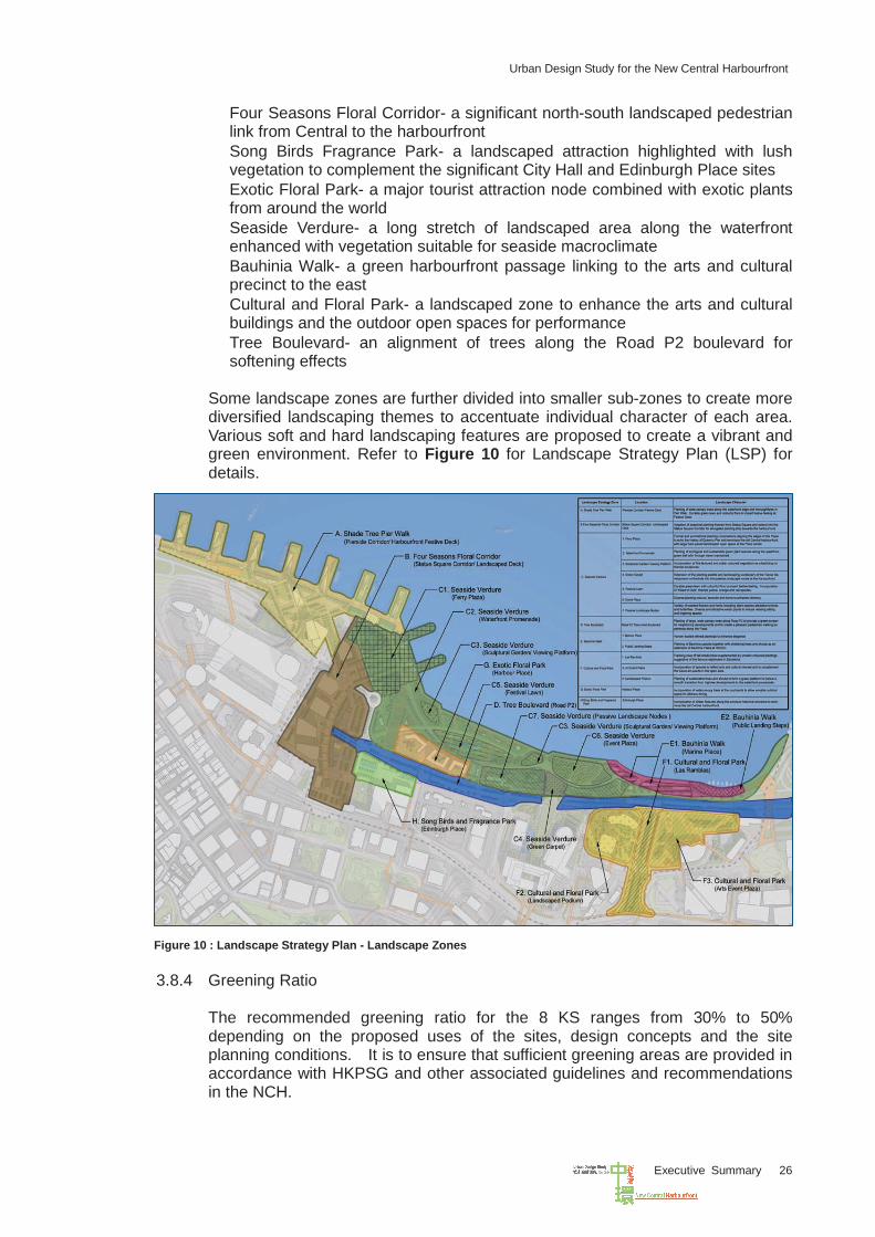
3.8.3 Landscape Zones
The LSP provides a general design concept for the open space along the waterfront. Different landscaping themes are tailored-made for each of the landscape zones designed to integrate the surrounding sites and activities. The following are the list of designated landscape zones: • Shade Tree Pier Walk- a landscaped interface between the ferries and the
Central harbourfront
Site Use Breakdown
Private Vehicle (PV) /
Public Parking
Loading /Unloading
(L/UL) Bay
Taxi / Private Vehicle
(PV) Layby
Coach Layby
Motor Cycle
Parking
Hotel
Office 13 (Hotel) + 109 (Office)
2 9
3 2
2 -
1 8
5
Total 122 11 5 2 9 Retail/Restaurant - (Retail/Restaurant) 3 2
- - 6
Total - @ 3 2 @ - -
Urban Design Study for the New Central Harbourfront
Executive Summary 26
• Four Seasons Floral Corridor- a significant north-south landscaped pedestrian link from Central to the harbourfront
• Song Birds Fragrance Park- a landscaped attraction highlighted with lush vegetation to complement the significant City Hall and Edinburgh Place sites
• Exotic Floral Park- a major tourist attraction node combined with exotic plants from around the world
• Seaside Verdure- a long stretch of landscaped area along the waterfront enhanced with vegetation suitable for seaside macroclimate
• Bauhinia Walk- a green harbourfront passage linking to the arts and cultural precinct to the east
• Cultural and Floral Park- a landscaped zone to enhance the arts and cultural buildings and the outdoor open spaces for performance
• Tree Boulevard- an alignment of trees along the Road P2 boulevard for softening effects
Some landscape zones are further divided into smaller sub-zones to create more diversified landscaping themes to accentuate individual character of each area. Various soft and hard landscaping features are proposed to create a vibrant and green environment. Refer to Figure 10 for Landscape Strategy Plan (LSP) for details.
Figure 10 : Landscape Strategy Plan - Landscape Zones
3.8.4 Greening Ratio
The recommended greening ratio for the 8 KS ranges from 30% to 50% depending on the proposed uses of the sites, design concepts and the site planning conditions. It is to ensure that sufficient greening areas are provided in accordance with HKPSG and other associated guidelines and recommendations in the NCH.
Urban Design Study for the New Central Harbourfront
Executive Summary 27
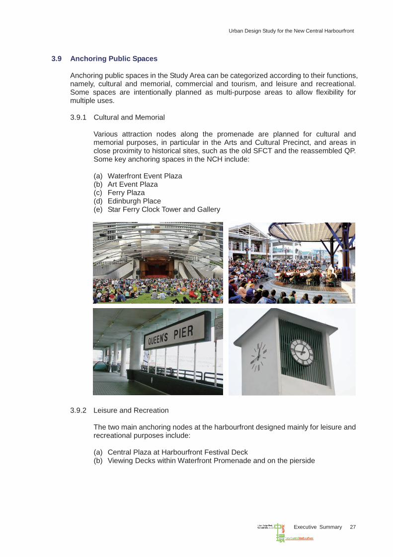
3.9 Anchoring Public Spaces
Anchoring public spaces in the Study Area can be categorized according to their functions, namely, cultural and memorial, commercial and tourism, and leisure and recreational. Some spaces are intentionally planned as multi-purpose areas to allow flexibility for multiple uses. 3.9.1 Cultural and Memorial
Various attraction nodes along the promenade are planned for cultural and memorial purposes, in particular in the Arts and Cultural Precinct, and areas in close proximity to historical sites, such as the old SFCT and the reassembled QP. Some key anchoring spaces in the NCH include: (a) Waterfront Event Plaza (b) Art Event Plaza (c) Ferry Plaza (d) Edinburgh Place (e) Star Ferry Clock Tower and Gallery
3.9.2 Leisure and Recreation
The two main anchoring nodes at the harbourfront designed mainly for leisure and recreational purposes include: (a) Central Plaza at Harbourfront Festival Deck (b) Viewing Decks within Waterfront Promenade and on the pierside
Urban Design Study for the New Central Harbourfront
Executive Summary 28
3.9.3 Commercial & Tourism
Developments of the KS such as Sites 1 and 2, 3, 4, 5 and 6 are considered to be the main anchoring nodes in the new harbourfront for providing commercial and retail uses and promoting tourism.
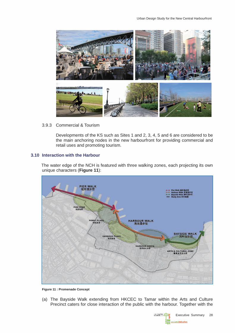
3.10 Interaction with the Harbour
The water edge of the NCH is featured with three walking zones, each projecting its own unique characters (Figure 11):
Figure 11 : Promenade Concept
(a) The Bayside Walk extending from HKCEC to Tamar within the Arts and Culture Precinct caters for close interaction of the public with the harbour. Together with the
Urban Design Study for the New Central Harbourfront
Executive Summary 29
public landing steps, there will be a good interplay of the on-shore and off-shore recreational activities such as fishing, boat race, outdoor dining by the harbour, etc.
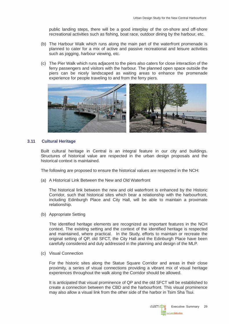
(b) The Harbour Walk which runs along the main part of the waterfront promenade is
planned to cater for a mix of active and passive recreational and leisure activities such as jogging, harbour viewing, etc.
(c) The Pier Walk which runs adjacent to the piers also caters for close interaction of the
ferry passengers and visitors with the harbour. The planned open space outside the piers can be nicely landscaped as waiting areas to enhance the promenade experience for people traveling to and from the ferry piers.
3.11 Cultural Heritage
Built cultural heritage in Central is an integral feature in our city and buildings. Structures of historical value are respected in the urban design proposals and the historical context is maintained. The following are proposed to ensure the historical values are respected in the NCH: (a) A Historical Link Between the New and Old Waterfront
The historical link between the new and old waterfront is enhanced by the Historic Corridor, such that historical sites which bear a relationship with the harbourfront, including Edinburgh Place and City Hall, will be able to maintain a proximate relationship.
(b) Appropriate Setting The identified heritage elements are recognized as important features in the NCH context. The existing setting and the context of the identified heritage is respected and maintained, where practical. In the Study, efforts to maintain or recreate the original setting of QP, old SFCT, the City Hall and the Edinburgh Place have been carefully considered and duly addressed in the planning and design of the MLP.
(c) Visual Connection
For the historic sites along the Statue Square Corridor and areas in their close proximity, a series of visual connections providing a vibrant mix of visual heritage experiences throughout the walk along the Corridor should be allowed. It is anticipated that visual prominence of QP and the old SFCT will be established to create a connection between the CBD and the harbourfront. This visual prominence may also allow a visual link from the other side of the harbor in Tsim Sha Tsui.
Urban Design Study for the New Central Harbourfront
Executive Summary 30
(d) Enhanced Connectivity
It is envisaged that the old-new waterfront linkage will be enhanced in the Historic Corridor with the increase of pedestrian connectivity between the ferry piers and the hinterland via the development of Site 3 including the at-grade open space and landscaped deck. The convenience of existing pedestrian networks will be maintained, and it is intended to provide a more enjoyable walking environment by overlooking the historical landmark buildings in the vicinity.
3.12 Proposed Locations for Reassembling QP and Reconstructing old SFCT
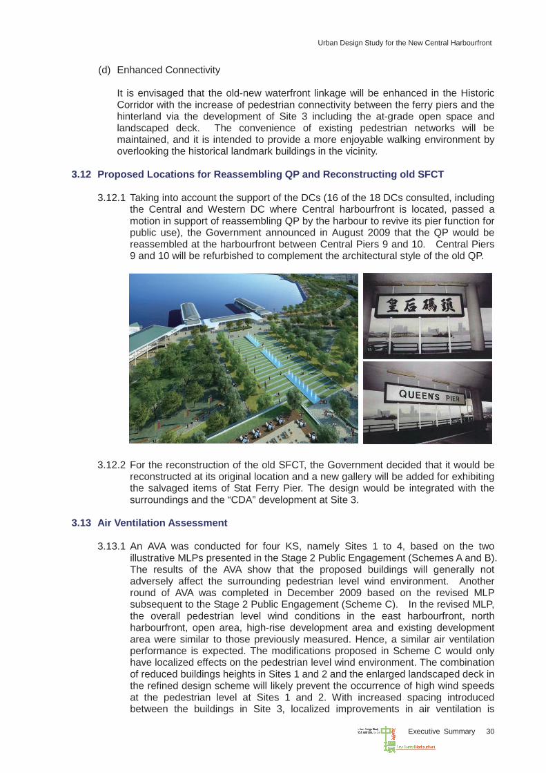
3.12.1 Taking into account the support of the DCs (16 of the 18 DCs consulted, including the Central and Western DC where Central harbourfront is located, passed a motion in support of reassembling QP by the harbour to revive its pier function for public use), the Government announced in August 2009 that the QP would be reassembled at the harbourfront between Central Piers 9 and 10. Central Piers 9 and 10 will be refurbished to complement the architectural style of the old QP.
3.12.2 For the reconstruction of the old SFCT, the Government decided that it would be
reconstructed at its original location and a new gallery will be added for exhibiting the salvaged items of Stat Ferry Pier. The design would be integrated with the surroundings and the “CDA” development at Site 3.
3.13 Air Ventilation Assessment
3.13.1 An AVA was conducted for four KS, namely Sites 1 to 4, based on the two illustrative MLPs presented in the Stage 2 Public Engagement (Schemes A and B). The results of the AVA show that the proposed buildings will generally not adversely affect the surrounding pedestrian level wind environment. Another round of AVA was completed in December 2009 based on the revised MLP subsequent to the Stage 2 Public Engagement (Scheme C). In the revised MLP, the overall pedestrian level wind conditions in the east harbourfront, north harbourfront, open area, high-rise development area and existing development area were similar to those previously measured. Hence, a similar air ventilation performance is expected. The modifications proposed in Scheme C would only have localized effects on the pedestrian level wind environment. The combination of reduced buildings heights in Sites 1 and 2 and the enlarged landscaped deck in the refined design scheme will likely prevent the occurrence of high wind speeds at the pedestrian level at Sites 1 and 2. With increased spacing introduced between the buildings in Site 3, localized improvements in air ventilation is
Urban Design Study for the New Central Harbourfront
Executive Summary 31
expected. Similar to Schemes A and B, the size of the landscaped deck at Site 3 will create localized areas of low wind speed. For Site 4, the revised courtyard design building layouts will create some localized low wind flow as some are sheltered from the prevailing winds from the north-east quadrant. As the overall dimensions and heights of the proposed building remain low-rise at Site 4, the air ventilation performance for Scheme C will be similar to Schemes A and B.
3.13.2 The AVA results concluded from Schemes A, B and C for Sites 1 to 4 are generally
satisfactory. The future developers should make reference to the AVA findings and recommendations conducted under the Study and demonstrate that their proposed schemes will not have worsened the air ventilation performance and/or create negative ventilation impacts to the development schemes prepared under the Study.
3.14 Sustainability Assessment
3.14.1 The results of the sustainability assessment indicate that the refined MLP is considered sustainable in the long term. It would bring about a range of benefits; particularly in the social and mobility aspects, such as accommodating leisure, cultural and government facilities, creating a significant landscaped area and quality waterfront at the heart of the city, cultivating a sense of place, meeting the need for essential strategic transport infrastructure and facilitating the ease of movement.
3.14.2 The performance in the economic aspects has been slightly affected due to the
reduction of commercial GFA in the refined MLP. However, the implications are relatively minimal and are compensated by the improved performance in the social and environmental aspects, particularly by reducing energy consumption, construction waste and impact on landfill capacity.
3.14.3 While the final proposal would still have less desirable implications on the
environmental and natural resources aspects, the extent has been reduced from the previous proposals (i.e. the two illustrative MLPs in the Stage 2 Public Engagement). The impact of these implications on the overall sustainability can be kept to a minimum through the incorporation of environmental mitigation measures as recommended in the approved Environmental Impact Assessment (EIA) under the CRIII project and sustainable building design for the developments. The planning and design briefs for the KS provide clear design parameters and guidelines to guide future design and implementation.
Urban Design Study for the New Central Harbourfront
Executive Summary 32
IV DESIGN CONCEPTS OF KEY SITES AND MASTER LAYOUT PLAN
4.1 Architectural Feasibility Study
Notional design schemes have been produced for each KS for deriving the proposed development parameters based on a number of assumptions. The notional schemes are indicative only and should be further reviewed at the implementation stage.
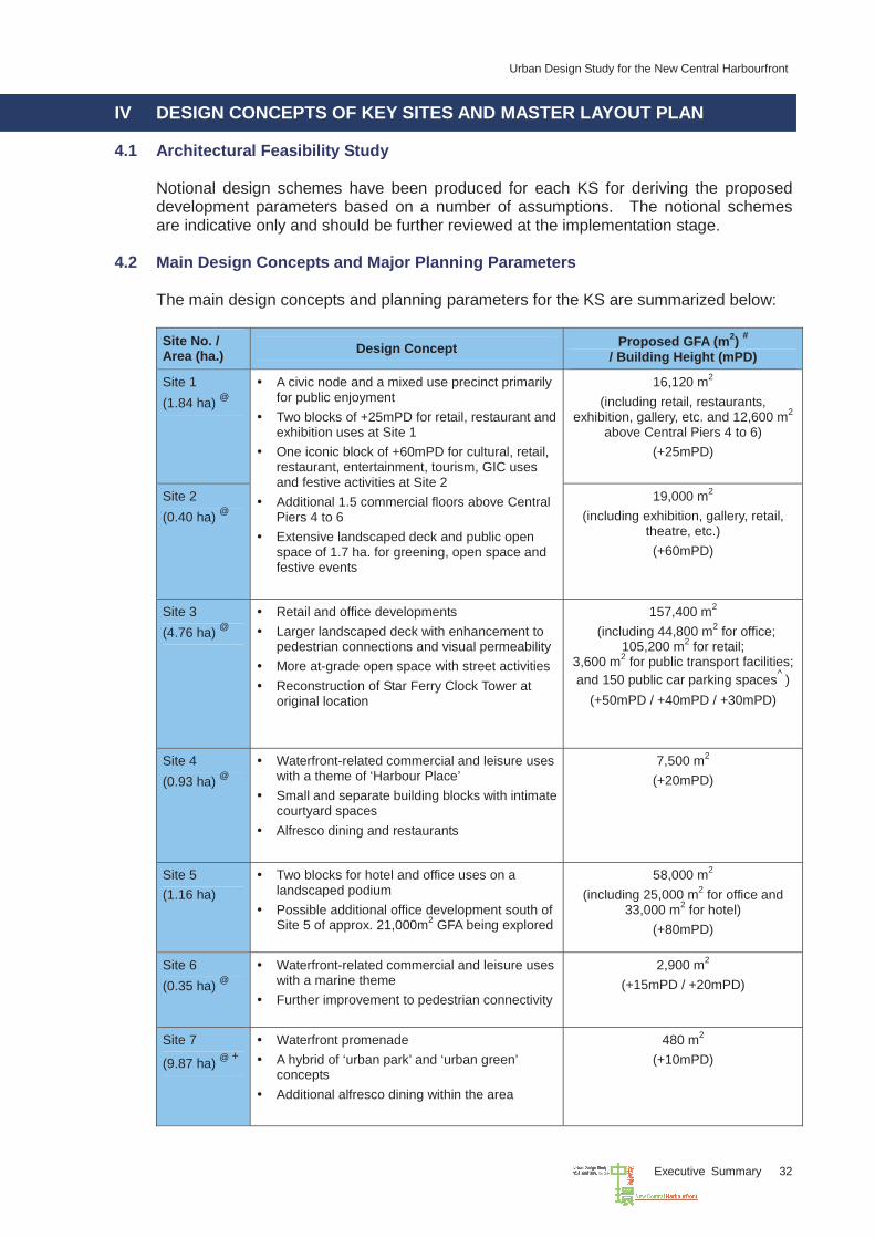
4.2 Main Design Concepts and Major Planning Parameters
The main design concepts and planning parameters for the KS are summarized below: Site No. / Area (ha.) Design Concept Proposed GFA (m2) #
/ Building Height (mPD)
Site 1 (1.84 ha) @
16,120 m2 (including retail, restaurants,
exhibition, gallery, etc. and 12,600 m2
above Central Piers 4 to 6) (+25mPD)
Site 2 (0.40 ha) @
A civic node and a mixed use precinct primarily for public enjoyment
Two blocks of +25mPD for retail, restaurant and exhibition uses at Site 1
One iconic block of +60mPD for cultural, retail, restaurant, entertainment, tourism, GIC uses and festive activities at Site 2
Additional 1.5 commercial floors above Central Piers 4 to 6
Extensive landscaped deck and public open space of 1.7 ha. for greening, open space and festive events
19,000 m2 (including exhibition, gallery, retail,
theatre, etc.) (+60mPD)
Site 3 (4.76 ha) @
Retail and office developments Larger landscaped deck with enhancement to
pedestrian connections and visual permeability More at-grade open space with street activities Reconstruction of Star Ferry Clock Tower at
original location
157,400 m2 (including 44,800 m2 for office;
105,200 m2 for retail; 3,600 m2 for public transport facilities; and 150 public car parking spaces^ )
(+50mPD / +40mPD / +30mPD)
Site 4 (0.93 ha) @
Waterfront-related commercial and leisure uses with a theme of ‘Harbour Place’
Small and separate building blocks with intimate courtyard spaces
Alfresco dining and restaurants
7,500 m2 (+20mPD)
Site 5 (1.16 ha)
Two blocks for hotel and office uses on a landscaped podium
Possible additional office development south of Site 5 of approx. 21,000m2 GFA being explored
58,000 m2 (including 25,000 m2 for office and
33,000 m2 for hotel) (+80mPD)
Site 6 (0.35 ha) @
Waterfront-related commercial and leisure uses with a marine theme
Further improvement to pedestrian connectivity
2,900 m2 (+15mPD / +20mPD)
Site 7
(9.87 ha) @ +
Waterfront promenade A hybrid of ‘urban park’ and ‘urban green’
concepts Additional alfresco dining within the area
480 m2 (+10mPD)
Urban Design Study for the New Central Harbourfront
Executive Summary 33
Site No. / Area (ha.) Design Concept Proposed GFA (m2) #
/ Building Height (mPD)
Site 8 (0.14 ha) @
Reassembly of Queen’s Pier by the Harbour and refurbishment of Central Piers No. 9 and 10
Improve design of Ferry Plaza
1,200 m2 * (+11.24mPD)
Table 4-1 Summary of Main Design Concepts and Major Planning Parameters of Key Sites Notes # Estimated amount of total GFA is subject to refinement upon detailed design @ Site boundary and area of the subject sites have been refined in accordance with the design concept in the
Master Layout Plan in the process of preparing the planning and design briefs for the key sites in the Study + Only 9.23 ha under CRIII ^ Number of public car parking spaces reprovisioned from existing Star Ferry Car Park * Roof area of Queen’s Pier
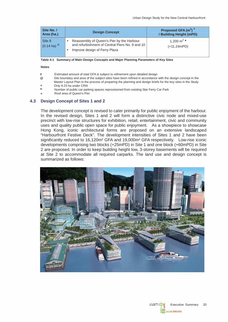
4.3 Design Concept of Sites 1 and 2
The development concept is revised to cater primarily for public enjoyment of the harbour. In the revised design, Sites 1 and 2 will form a distinctive civic node and mixed-use precinct with low-rise structures for exhibition, retail, entertainment, civic and community uses and quality public open space for public enjoyment. As a showpiece to showcase Hong Kong, iconic architectural forms are proposed on an extensive landscaped “Harbourfront Festive Deck”. The development intensities of Sites 1 and 2 have been significantly reduced to 16,120m² GFA and 19,000m² GFA respectively. Low-rise iconic developments comprising two blocks (+25mPD) in Site 1 and one block (+60mPD) in Site 2 are proposed. In order to keep building height low, 3-storey basements will be required at Site 2 to accommodate all required carparks. The land use and design concept is summarized as follows:
Urban Design Study for the New Central Harbourfront
Executive Summary 34
(a) As a mixed-use precinct, uses within Sites 1 and 2 (outside the pier portion) may include exhibition, gallery, theatre, civic, community, retail, dining, entertainment uses and the like to create a vibrant, attractive and accessible civic node for public enjoyment of the harbourfront and to showcase Hong Kong. It should feature a low-rise iconic development with quality design, distinctive architectural expression and comprehensive master planning.
(b) An extensive elevated landscaped deck with an area of about 20,000m2 (4) should be provided under the concept of a “Harbourfront Festive Deck”. It will primarily be used for public open space, mainly for greening, leisure and festive celebrations with a central plaza for hosting public events. To enhance vibrancy within the public open space, limited scale of alfresco dining, open air cafes, exhibition area, information booths etc. (without permanent structures) can be introduced on the landscaped deck. The deck should be connected with the surrounding developments to create a comprehensive pedestrian network at elevated level while maintaining traffic flow and public transport facilities around the ferry piers at ground level.
(c) To enhance vibrancy of the harbourfront, an additional one and a half storey
commercial floor space will be constructed above Central Piers 4 to 6 under a separate government contract targeted for completion by end of 2014. The additional GFA for the piers will be assigned back to the ferry operators for dining, retail, and other waterfront related uses. Design and development of Sites 1 and 2 shall integrate with the façade of the refurbished piers and the function of the piers therein. The roofscape of Central Piers 2 and 3 shall also adopt a coherent design with the pier development of Piers 4 to 6 to project a welcoming image for this ferry transport hub and a coordinated design theme for the Pierside Corridor.
(d) Rooftop public open space shall be provided above Central Piers 4 to 6, the design of
which should be coordinated with the landside development to complement its waterfront setting and yet respect the pier function operating on the ground and first floor levels of the piers. The future developer of the Site is required to provide a 24-hour public access between the landscaped deck to the rooftop public open space above the piers in agreement with the ferry operator.
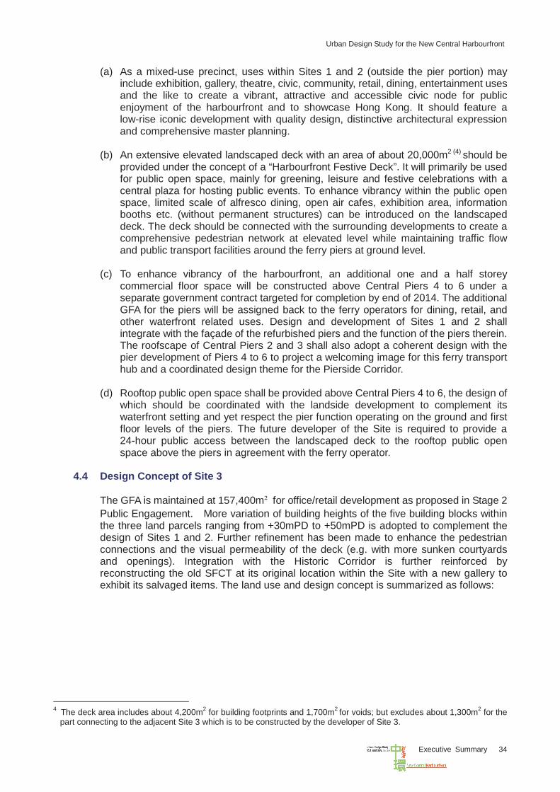
4.4 Design Concept of Site 3
The GFA is maintained at 157,400m² for office/retail development as proposed in Stage 2 Public Engagement. More variation of building heights of the five building blocks within the three land parcels ranging from +30mPD to +50mPD is adopted to complement the design of Sites 1 and 2. Further refinement has been made to enhance the pedestrian connections and the visual permeability of the deck (e.g. with more sunken courtyards and openings). Integration with the Historic Corridor is further reinforced by reconstructing the old SFCT at its original location within the Site with a new gallery to exhibit its salvaged items. The land use and design concept is summarized as follows:
4 The deck area includes about 4,200m2 for building footprints and 1,700m2 for voids; but excludes about 1,300m2 for the
part connecting to the adjacent Site 3 which is to be constructed by the developer of Site 3.
Urban Design Study for the New Central Harbourfront
Executive Summary 35
(a) The development is subject to comprehensive planning and design controls including
maximum GFAs and building heights for different parts of the Site. Development of the Site will require the submission of a MLP under Comprehensive Development Area “(CDA)” zone for approval by the TPB.
(b) For the western portion of the Site, it is intended for low-rise commercial/office and
retail development to be connected through a continuous landscaped deck spanning over Road P1, Road P2, Road D6 and the CWB with commercial uses provided at basement levels. The large landscaped deck will provide uninterrupted pedestrian connection towards the Star Ferry Piers and the waterfront promenade. Voids shall be introduced on the deck above the aforementioned roadways to enhance lighting and ventilation for the ground level environment in addition to introducing some punctuation to the building mass.
Urban Design Study for the New Central Harbourfront
Executive Summary 36
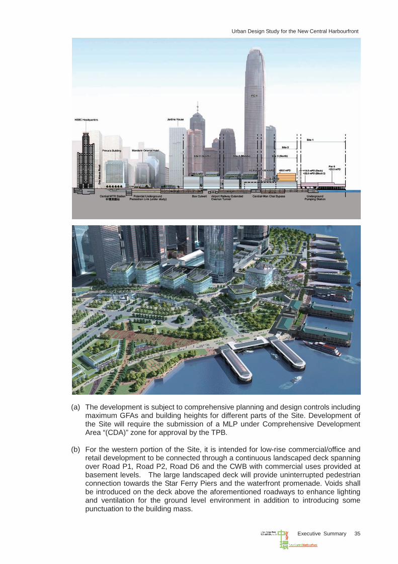
(c) For the eastern portion of the Site, it is intended for public open space use at ground level and commercial and retail uses at basement levels. Sunken plazas and voids are recommended at the ground level to facilitate physical access and skylight to the basement. The ground level open space will enhance the visual permeability along the view corridor from HSBC Headquarters Building to the harbour. Together with the elevated landscaped deck in the western portion, there will be a continuous public open space and green link connecting the existing CBD with the new waterfront.
(d) The old SFCT is to be constructed at its original location with a new gallery by its side,
the design of which should blend in not only with the public open space at ground level but also the landscaped deck.
(e) A ferry plaza at the northeastern side of the Site is to be designed as a key nodal
point at the NCH. The plaza will be a prominent public gathering place strategically located to mark the entrance to the Statue Square Corridor, the Pierside Corridor and the reassembled QP, as well as the development at Site 3.
(f) An entrance plaza is to be designed in the southern part of the Site abutting
Connaught Road Central with an anchor building for the commercial development and landscaped deck of the Site. Direct pedestrian link should be provided to connect the plaza and the anchor building with the new underground connection to MTR Central Station and the existing subway across Connaught Road Central.
(g) Public transport facilities comprising green mini-bus bays, taxi stand, coach bays,
and public L/UL bays are planned at ground level within the northern part of the Site, located north of Road P1 to enhance inter-modal connectivity and convenient public accessibility to the new harbourfront.
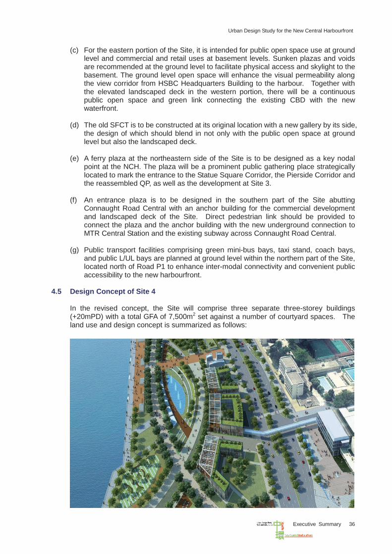
4.5 Design Concept of Site 4
In the revised concept, the Site will comprise three separate three-storey buildings (+20mPD) with a total GFA of 7,500m2 set against a number of courtyard spaces. The land use and design concept is summarized as follows:
Urban Design Study for the New Central Harbourfront
Executive Summary 37
(a) The Site should be used for low-rise waterfront related commercial and leisure uses. Possible uses include eating place, place of entertainment, place for recreation, sports and culture, shops and services, government use, etc.
(b) It is proposed as a “Harbour Place” providing an anchor and a diversity of
experiences at the waterfront. (c) The development of the Site should blend in with the proposed waterfront
promenade which will be featured with extensive green open space, a variety of anchoring spaces and a cycle track. The character of place should be designed to take into consideration the historical City Hall complex and Edinburgh Place located to its immediate south.
(d) Visual and air permeability to the harbour is to be optimized through low-rise building
design with adequate separation between the building blocks.
(e) Courtyard building design is recommended in order to provide more intimate activity pockets and green spaces for outdoor and semi-outdoor activities. It may also serve as an additional buffer against the environmental impact of Road P2 located to the south, if the courtyard spaces are designed to fronting Road P2. To capitalize on the magnificent views of the harbour and the waterfront setting, limited scale of alfresco dining is recommended in the courtyards.
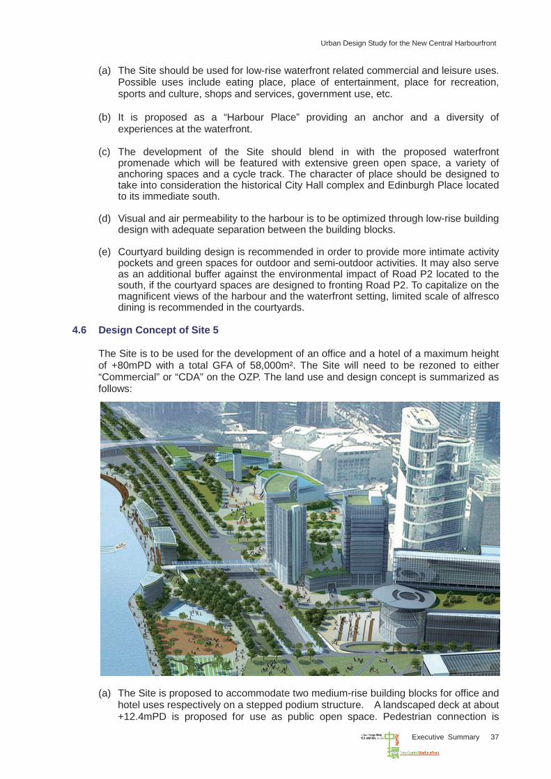
4.6 Design Concept of Site 5
The Site is to be used for the development of an office and a hotel of a maximum height of +80mPD with a total GFA of 58,000m². The Site will need to be rezoned to either “Commercial” or “CDA” on the OZP. The land use and design concept is summarized as follows: (a) The Site is proposed to accommodate two medium-rise building blocks for office and
hotel uses respectively on a stepped podium structure. A landscaped deck at about +12.4mPD is proposed for use as public open space. Pedestrian connection is
Urban Design Study for the New Central Harbourfront
Executive Summary 38
proposed on the deck level with two proposed footbridges linking to CITIC Tower to the south and the Waterfront Promenade to the north.
(b) The development of the Site should complement the harbourfront setting and the
surrounding site context, such as the landmark buildings for civic, arts and cultural uses in the vicinity, including Tamar, HKCEC, HKAPA, other arts venues, etc., with green open space and anchoring spaces for commercial and tourism activities.
(c) The design of the development on the Site should cater for the future underground
NIL tunnel and the ancillary facilities of the nearby MTR station at Tamar. Subject to the advice of the Highways Department, building foundation structures should not be allowed within the railway reserve.
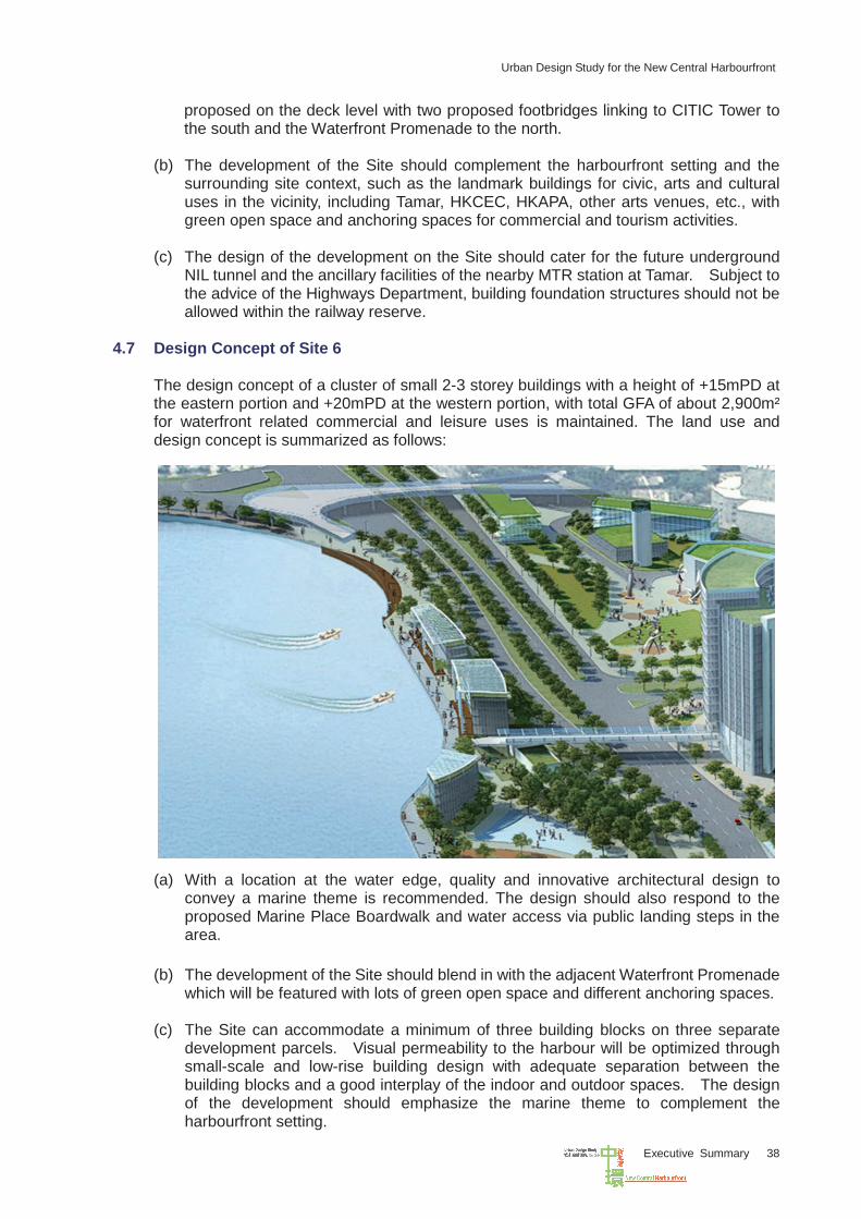
4.7 Design Concept of Site 6
The design concept of a cluster of small 2-3 storey buildings with a height of +15mPD at the eastern portion and +20mPD at the western portion, with total GFA of about 2,900m² for waterfront related commercial and leisure uses is maintained. The land use and design concept is summarized as follows: (a) With a location at the water edge, quality and innovative architectural design to
convey a marine theme is recommended. The design should also respond to the proposed Marine Place Boardwalk and water access via public landing steps in the area.
(b) The development of the Site should blend in with the adjacent Waterfront Promenade
which will be featured with lots of green open space and different anchoring spaces. (c) The Site can accommodate a minimum of three building blocks on three separate
development parcels. Visual permeability to the harbour will be optimized through small-scale and low-rise building design with adequate separation between the building blocks and a good interplay of the indoor and outdoor spaces. The design of the development should emphasize the marine theme to complement the harbourfront setting.
Urban Design Study for the New Central Harbourfront
Executive Summary 39
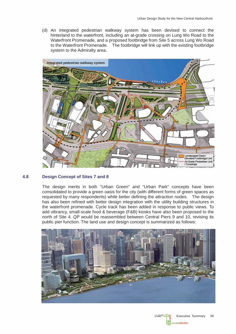
(d) An integrated pedestrian walkway system has been devised to connect the hinterland to the waterfront, including an at-grade crossing on Lung Wo Road to the Waterfront Promenade, and a proposed footbridge from Site 5 across Lung Wo Road to the Waterfront Promenade. The footbridge will link up with the existing footbridge system to the Admiralty area.
4.8 Design Concept of Sites 7 and 8
The design merits in both “Urban Green” and “Urban Park” concepts have been consolidated to provide a green oasis for the city (with different forms of green spaces as requested by many respondents) while better defining the attraction nodes. The design has also been refined with better design integration with the utility building structures in the waterfront promenade. Cycle track has been added in response to public views. To add vibrancy, small-scale food & beverage (F&B) kiosks have also been proposed to the north of Site 4. QP would be reassembled between Central Piers 9 and 10, revising its public pier function. The land use and design concept is summarized as follows:
Integrated pedestrian walkway system
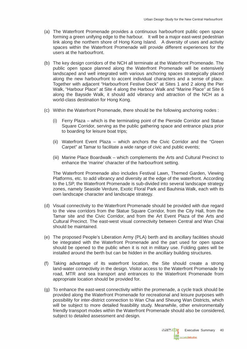
Urban Design Study for the New Central Harbourfront
Executive Summary 40
(a) The Waterfront Promenade provides a continuous harbourfront public open space forming a green unifying edge to the harbour. It will be a major east-west pedestrian link along the northern shore of Hong Kong Island. A diversity of uses and activity spaces within the Waterfront Promenade will provide different experiences for the users at the harbourfront.
(b) The key design corridors of the NCH all terminate at the Waterfront Promenade. The public open space planned along the Waterfront Promenade will be extensively landscaped and well integrated with various anchoring spaces strategically placed along the new harbourfront to accent individual characters and a sense of place. Together with adjacent “Harbourfront Festive Deck” at Sites 1 and 2 along the Pier Walk, “Harbour Place” at Site 4 along the Harbour Walk and “Marine Place” at Site 6 along the Bayside Walk, it should add vibrancy and attraction of the NCH as a world-class destination for Hong Kong.
(c) Within the Waterfront Promenade, there should be the following anchoring nodes :
(i) Ferry Plaza – which is the terminating point of the Pierside Corridor and Statue Square Corridor, serving as the public gathering space and entrance plaza prior to boarding for leisure boat trips;
(ii) Waterfront Event Plaza – which anchors the Civic Corridor and the “Green
Carpet” at Tamar to facilitate a wide range of civic and public events; (iii) Marine Place Boardwalk – which complements the Arts and Cultural Precinct to
enhance the ‘marine’ character of the harbourfront setting. The Waterfront Promenade also includes Festival Lawn, Themed Garden, Viewing Platforms, etc. to add vibrancy and diversity at the edge of the waterfront. According to the LSP, the Waterfront Promenade is sub-divided into several landscape strategy zones, namely Seaside Verdure, Exotic Floral Park and Bauhinia Walk, each with its own landscape character and landscape strategy.
(d) Visual connectivity to the Waterfront Promenade should be provided with due regard to the view corridors from the Statue Square Corridor, from the City Hall, from the Tamar site and the Civic Corridor, and from the Art Event Plaza of the Arts and Cultural Precinct. The east-west visual connectivity between Central and Wan Chai should be maintained.
(e) The proposed People’s Liberation Army (PLA) berth and its ancillary facilities should be integrated with the Waterfront Promenade and the part used for open space should be opened to the public when it is not in military use. Folding gates will be installed around the berth but can be hidden in the ancillary building structures.
(f) Taking advantage of its waterfront location, the Site should create a strong
land-water connectivity in the design. Visitor access to the Waterfront Promenade by road, MTR and sea transport and entrances to the Waterfront Promenade from appropriate location should be provided for.
(g) To enhance the east-west connectivity within the promenade, a cycle track should be
provided along the Waterfront Promenade for recreational and leisure purposes with possibility for inter-district connection to Wan Chai and Sheung Wan Districts, which will be subject to more detailed feasibility study. Meanwhile, other environmentally friendly transport modes within the Waterfront Promenade should also be considered, subject to detailed assessment and design.
Urban Design Study for the New Central Harbourfront
Executive Summary 41
4.9 Master Layout Plan
Taken into consideration the public comments received in the Stage 2 Public Engagement, the MLP (Figure 12) has been refined in an iterative manner by incorporation of updated information on the existing and planned infrastructure projects including the design of the West Ventilation Building under the CWB Project. The MLP reflects the refined urban design framework and design concepts of all KS.
4.10 Planning and Design Briefs
4.10.1 Planning and design briefs are prepared with the aim to ensure that the future developments of individual sites in the NCH are in line with the urban design concepts in the Study and the urban design objectives are met. They are prepared with supporting illustrative materials to guide the future development of the KS.
4.10.2 The contents of the planning and design briefs have included the following aspects:
(a) Background of the site, including the existing and surrounding developments,
the existing and planned traffic and pedestrian networks in the vicinity, identifiable technical and physical site development constraints, etc.;
(b) The planning context and the public views gathered in the public engagement exercise regarding the design concept of the site;
(c) The planning and urban design objectives of the NCH as well as the particular
site according to the MLP, UDFP, LSP and PNP to provide a design vision for planning and development of the site;
(d) The planning parameters and design criteria for the site, including land use
and design concept, height and GFA restrictions, mix of uses, area of open space and greening ratio. Other requirements, including landscape design, view corridors and key vantage points, transport provisions, pedestrian connectivity, environmental design, etc. should also be stated;
(e) The implementation programme of the site, taking into account the
development and construction programmes of the adjacent sites, the reclamation and other major infrastructure projects, etc.; and
(f) The implementation agents for various projects associated with the
development of the site.
4.10.3 A total of six planning and design briefs have been prepared for the eight KS, which are included in the Task 4 Report of the Study:
(a) Sites 1 and 2 – North of International Finance Centre II (b) Site 3 – North of Statue Square (c) Site 4 – North of City Hall (d) Site 5 – North of CITIC Tower (e) Site 6 – West of Hong Kong Convention and Extension Centre Extension (f) Sites 7 and 8 – Waterfront Promenade
Urban Design Study for the New Central Harbourfront
Executive Summary 42
Figure 12 : Master Layout Plan
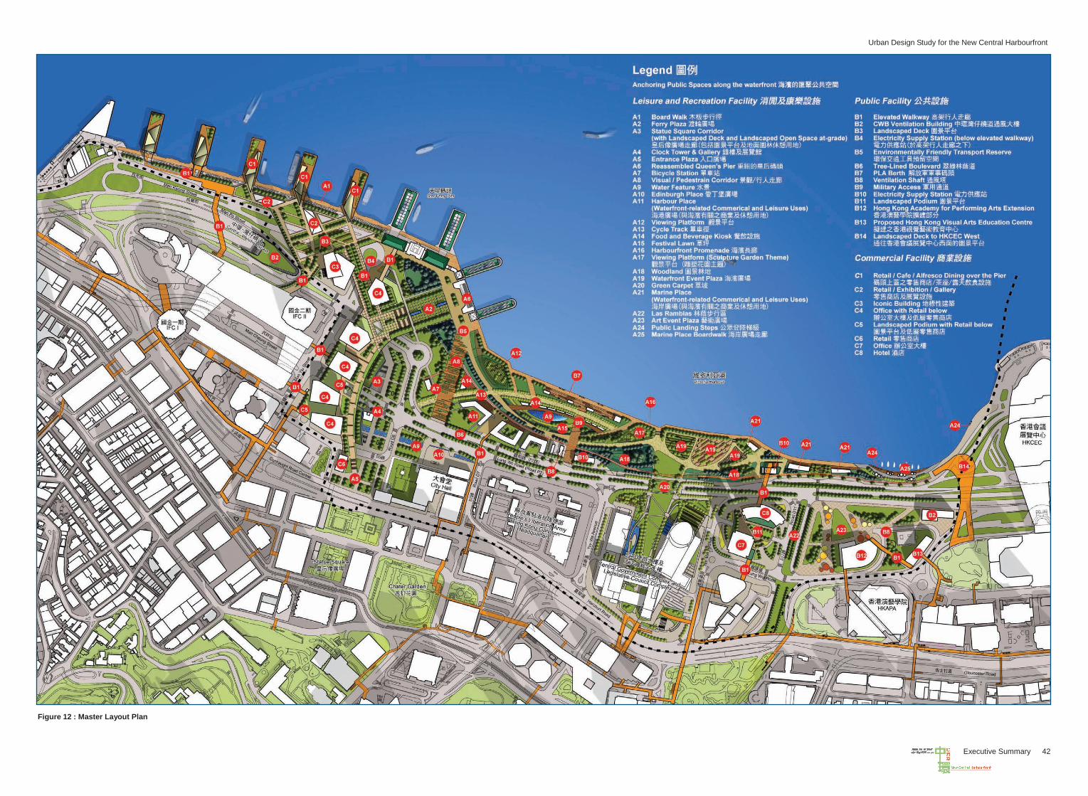
Urban Design Study for the New Central Harbourfront
Executive Summary 41
4.9 Master Layout Plan
Taken into consideration the public comments received in the Stage 2 Public Engagement, the MLP (Figure 12) has been refined in an iterative manner by incorporation of updated information on the existing and planned infrastructure projects including the design of the West Ventilation Building under the CWB Project. The MLP reflects the refined urban design framework and design concepts of all KS.
4.10 Planning and Design Briefs
4.10.1 Planning and design briefs are prepared with the aim to ensure that the future developments of individual sites in the NCH are in line with the urban design concepts in the Study and the urban design objectives are met. They are prepared with supporting illustrative materials to guide the future development of the KS.
4.10.2 The contents of the planning and design briefs have included the following aspects:
(a) Background of the site, including the existing and surrounding developments,
the existing and planned traffic and pedestrian networks in the vicinity, identifiable technical and physical site development constraints, etc.;
(b) The planning context and the public views gathered in the public engagement exercise regarding the design concept of the site;
(c) The planning and urban design objectives of the NCH as well as the particular
site according to the MLP, UDFP, LSP and PNP to provide a design vision for planning and development of the site;
(d) The planning parameters and design criteria for the site, including land use
and design concept, height and GFA restrictions, mix of uses, area of open space and greening ratio. Other requirements, including landscape design, view corridors and key vantage points, transport provisions, pedestrian connectivity, environmental design, etc. should also be stated;
(e) The implementation programme of the site, taking into account the
development and construction programmes of the adjacent sites, the reclamation and other major infrastructure projects, etc.; and
(f) The implementation agents for various projects associated with the
development of the site.
4.10.3 A total of six planning and design briefs have been prepared for the eight KS, which are included in the Task 4 Report of the Study:
(a) Sites 1 and 2 – North of International Finance Centre II (b) Site 3 – North of Statue Square (c) Site 4 – North of City Hall (d) Site 5 – North of CITIC Tower (e) Site 6 – West of Hong Kong Convention and Extension Centre Extension (f) Sites 7 and 8 – Waterfront Promenade
Urban Design Study for the New Central Harbourfront
Executive Summary 42
Figure 12 : Master Layout Plan
Urban Design Study for the New Central Harbourfront
Executive Summary 43
V IMPLEMENTATION
5.1 Design Control Mechanisms
The developments in NCH in terms of use, building intensity, building height, etc. are controlled through the following mechanisms: (a) Statutory Control under OZP
All the sites are subject to statutory control under the OZP. For sites zoned as “CDA”, a MLP should be submitted to TPB for consideration and approval in accordance with section 4A(2) of the TPO. For preparation of the MLP, the planning and design parameters, design and layout of buildings, technical assessments and other planning requirements including the requirements for provision of public transport and GIC facilities as stipulated in the OZP and the planning and design brief of the subject site should be followed.
(b) Planning and Design Briefs Planning and design briefs prepared for the KS in the NCH set out the main planning and design objectives, development parameters, planning requirements and design guidelines for the development of the sites. They should be used to guide detailed planning and design of the subject sites.
(c) Control under Lease Conditions Major planning and design parameters and technical requirements set out in the planning and design briefs should be incorporated into the lease conditions to ensure that the planning and design objectives can be achieved and enforced.
(d) Control under Outline Development Plan The overall urban design framework and the MLP as recommended in the Study should form the basis for preparing and updating the relevant departmental Outline Development Plan to guide the future development of all areas in the NCH including the KS and all public works projects in the area in a coherent manner.
5.2 Implementation Agents
In respect of implementation of the development proposals put forth in the Study, the responsible agents will include the public sector, private developer or joint partnership. The Final Report has set out the key implementation agents for the various identified works and development projects which are proposed in the Study.
5.3 Other Considerations
5.3.1 Some areas within the KS can be used as temporary public open space for public enjoyment before the whole site is ready for their long term development. The Advance Promenade is being planned by the Government to the north of the Tamar development for early public enjoyment pending permanent development of the waterfront promenade at Site 7. Consideration could also be given to advancing the implementation of some related projects such as the refurbishment of Edinburgh Place with the memorial features at the original site of QP.
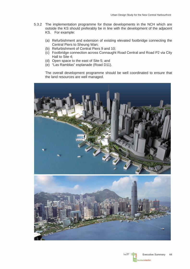
Urban Design Study for the New Central Harbourfront
Executive Summary 44
5.3.2 The implementation programme for those developments in the NCH which are outside the KS should preferably be in line with the development of the adjacent KS. For example:
(a) Refurbishment and extension of existing elevated footbridge connecting the
Central Piers to Sheung Wan; (b) Refurbishment of Central Piers 9 and 10; (c) Footbridge connection across Connaught Road Central and Road P2 via City
Hall to Site 4; (d) Open space to the east of Site 5; and (e) “Las Ramblas” esplanade (Road D11). The overall development programme should be well coordinated to ensure that the land resources are well managed.

Executive Summary
Urban Design Study for the New Central Harbourfront
July 2011
Printed by the Government Logistics Department