Embed Size (px)
Citation preview

Urban Design Brief
Fox Hollow ResidentialDevelopment
1235-1295 Fanshawe Park Road West
Proposed Zoning Amendment
16164
City of London
May, 2017 (As Amended June, 2017)
Prepared for:
SmartREIT
700 Applewood Cres, Suite 200
Vaughan, ON
L4K 5X3
Prepared by:
GSP Group Inc.
72 Vistoria Street S., Suite 201
Kitchener, ON
N2G 4Y9

1
GSP Group Inc. Smart REIT - Foxhollow May 2017 (Amended June 2017) Urban Design Brief
Table of Contents
SECTION ONE .......................................................................................................................... 2
1.1 The Proposal .................................................................................................................... 3
1.2 Design Goals and Objectives ............................................................................................ 4
1.3 Design Response to City Documents ............................................................................... 5
Official Plan Policies ........................................................................................................... 5
Zoning ................................................................................................................................13
1.4 Spatial Analysis ...............................................................................................................14
SECTION 2 ...............................................................................................................................18
2.1 Site Design ......................................................................................................................18
2.2 Built Form and Architecture .............................................................................................20
Building Form and Urban Context ......................................................................................21
Exterior Composition and Detail Design .............................................................................21
2.3 Landscape Design ...........................................................................................................27
SUMMARY ...............................................................................................................................29

2
GSP Group Inc. Smart REIT - Foxhollow May 2017 (Amended June 2017) Urban Design Brief
SECTION ONE
The purpose of this Urban Design Brief is to present the design details of the possible residential
development proposed by Smart REIT located on vacant land northeast of their existing commercial
development along Fanshawe Park Road West and Hyde Park Road in the Foxhollow Community,
in the northwest end of the City of London (Image 1).
Image 1: Site Location – Google Earth Arial Imagery (2016)

3
GSP Group Inc. Smart REIT - Foxhollow May 2017 (Amended June 2017) Urban Design Brief
1.1 The Proposal
Smart REIT is proposing to amend the zoning for their property municipally known as 1235-
1295 Fanshawe Park Road West in the Fox Hollow community in Northwest London (the “Site”).
The Site is bordered by Fanshawe Park Road West to the south, Hyde Park Road to the west,
Dalmagarry Road to the east and Tokala Trail to the north. The Site is approximately 7.3
hectares (18.04 acres) in size and is located at the intersection of Fanshawe Park Road West
and Dalmagarry Road. The Site has approximately 229m of frontage along Fanshawe Park
Road West, 310m of along Dalmagarry Road and 101m of frontage along Tokala Trail.
The Zoning By-law Amendment seeks to expand the range of permitted uses of this property by
adding a mix of residential uses to this Site in addition to the retail and service commercial uses
permitted on this Site. This is in keeping with London Plan objectives that encourage a mix of
uses in the Shopping Area Place Type, and will contribute additional residential density to the
Fox Hollow Planning Area.
The Site Plan concept provided is intended to demonstrate how the Site could be developed. It
is noted that the ultimate layout and designs may change depending on the final mix of uses
and built form proposed. The design of any future development will be refined through the Site
Plan process.
The concept provided illustrates approximately 682 residential units (130 townhouses and 552
apartment units) and 1,871 square metres (20,138 square feet) of existing commercial floor
area. This translates into a total FSI of 1.13 and a density of 113units/ha. Two centrally located
parkettes are shown, which would provide ample amenity space and areas for potential
landscaping and pedestrian connections.
The northerly portion of the Site, approximately 2.8ha (6.97ac), is located across from an
existing residential subdivision along Tokala Trail. The concept shows townhomes along that
subdivision providing a transition between the existing low to mid-rise residential development
and the higher density apartment buildings.
The southern portion is approximately 3.2ha (7.94ac) and would be developed with four (4)
apartment buildings, each 4-storeys in height, as permitted in the Shopping Area Place Type of
the London Plan. The two (2) larger buildings would provide approximately 198 units each, while
the two (2) smaller buildings would provide 78 units. The apartments are proposed to be a mix
of one and two bedroom units with indoor amenity spaces. The amenity space shown between
the apartment buildings is approximately 0.18ha (0.45acre).
The existing commercial development at the south end of the Site includes two (2) restaurants
(Tim Hortons and Boston Pizza) and two (2) banks (Royal Bank and the Bank of Montreal).
Underground parking could be made available for the apartment units, while visitor parking
could be provided throughout the Site as shown. Internal street would remain private and

4
GSP Group Inc. Smart REIT - Foxhollow May 2017 (Amended June 2017) Urban Design Brief
access could be provided to match the proposed subdivision entrance north across Tokala Trail
and across Dalmagarry Road to match the seniors care facility entrance.
Smart REIT’s land holdings in the area are of an ideal size and configuration to intensify and/or
introduce residential development into their commercial/retail development. Given the location
of the Site and the development occurring in the surrounding area, Smart REIT is prepared to
introduce the residential use as an option at this location to make better use of the space and to
contribute to making Fox Hollow a more complete community. The height and lot coverage
regulations requested are appropriate given its proximity to Fanshawe Park Road West, an
Urban Thoroughfare.
A pre-application consultation meeting was held with City Staff on November 24th, 2016 to
discuss the addition of mix of residential uses including 16 strorey residential apartment
buildings. Following this meeting, Smart REIT reduced the proposed height to 6 storeys. A
revised Record of Pre-Application Consultation was completed on April 6th, 2017 reflecting
changes in the proposed development.
Smart REIT’s original design proposal has been modified to accommodate Staff’s
recommendations regarding the height and density. The location of the built form has also been
modified to show how the uses can be transitioned offering an appropriate interface between
the Site and the low density residential uses to the north and the commercial uses to the south.
1.2 Design Goals and Objectives
The overall goal of the project is to permit the development of a well-designed and functional
mixed use block. Although the Site Plan concept is only an example of what could potentially be
developed at this location, the design objectives of any future development will be to establish a
built form and site design that:
Accommodates the needs of residents;
Integrates with the existing commercial development and broader community;
Acts as a transition of density and scale between the commercial lands along Fanshawe
Park Road West and the low density residential lands north of Tokala Trail; and,
Contributes to the creation of a great street edge along Tokala Trail and Dalmagarry
Road.
The proposed design has been developed with these goals and objectives in mind together with
collaboration and input from City Staff.

5
GSP Group Inc. Smart REIT - Foxhollow May 2017 (Amended June 2017) Urban Design Brief
1.3 Design Response to City Documents
City of London Official Plan (1989) Policies
The Site Plan concept for 1235-1295 Fanshawe Park Road West provided, aligns with the
urban design policies outlined in London Official Plan (the “OP”). The chart states some of the
main design principles that are achievable through the proposed development of this Site:
Architectural
Continuity
v) The massing and
conceptual design of
new development should
provide for continuity
and harmony in
architectural style with
adjacent uses which
have a distinctive and
attractive visual identity
or which are recognized
as being of cultural
heritage value or
interest.
The concept shows townhouses at the edge of
the Site across from the low density residential
development north of Tokala Trail. The
townhomes provide a buffer between the low-
density residential use and the higher density
apartments. The architectural details of the
buildings are currently unknown. However, a
precedent image, Image 11 herein,
demonstrates how the apartments could look.
Streetscape vii) A coordinated
approach should be
taken to the planning and
design of streetscape
improvements in
commercial areas,
including the upgrading
of building facades,
signage, sidewalks,
lighting, parking areas
and landscaping
The buildings have been positioned to visually delineate the boundaries to the public streetscape, with building facades along Dalmagarry Road and Tokala Trail. Entrances to the townhomes and the street fronting apartment building have been positions along the street to activate these areas with pedestrian activity.
Landscaping x)
Landscaping should be
used to conserve energy
and water, enhance the
appearance of building
setback and yard areas,
contribute to the blending
of new and existing
development and screen
parking, loading,
garbage and service
Landscaping improvements are proposed throughout the Site, particularly within the open amenity spaces but also between buildings and along the street edge. Additional vegetation along the street will enhance the space making it more appealing to residents, visitors as well as the broader community.
6
GSP Group Inc. Smart REIT - Foxhollow May 2017 (Amended June 2017) Urban Design Brief
facilities from adjacent
properties and streets.
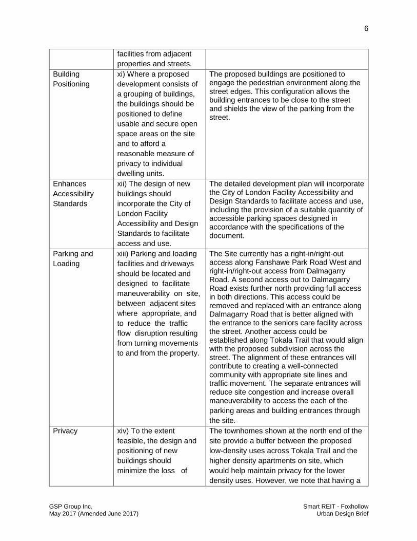
Building
Positioning
xi) Where a proposed
development consists of
a grouping of buildings,
the buildings should be
positioned to define
usable and secure open
space areas on the site
and to afford a
reasonable measure of
privacy to individual
dwelling units.
The proposed buildings are positioned to engage the pedestrian environment along the street edges. This configuration allows the building entrances to be close to the street and shields the view of the parking from the street.
Enhances
Accessibility
Standards
xii) The design of new
buildings should
incorporate the City of
London Facility
Accessibility and Design
Standards to facilitate
access and use.
The detailed development plan will incorporate the City of London Facility Accessibility and Design Standards to facilitate access and use, including the provision of a suitable quantity of accessible parking spaces designed in accordance with the specifications of the document.
Parking and
Loading
xiii) Parking and loading
facilities and driveways
should be located and
designed to facilitate
maneuverability on site,
between adjacent sites
where appropriate, and
to reduce the traffic
flow disruption resulting
from turning movements
to and from the property.
The Site currently has a right-in/right-out access along Fanshawe Park Road West and right-in/right-out access from Dalmagarry Road. A second access out to Dalmagarry Road exists further north providing full access in both directions. This access could be removed and replaced with an entrance along Dalmagarry Road that is better aligned with the entrance to the seniors care facility across the street. Another access could be established along Tokala Trail that would align with the proposed subdivision across the street. The alignment of these entrances will contribute to creating a well-connected community with appropriate site lines and traffic movement. The separate entrances will reduce site congestion and increase overall maneuverability to access the each of the
parking areas and building entrances through
the site.
Privacy xiv) To the extent
feasible, the design and
positioning of new
buildings should
minimize the loss of
The townhomes shown at the north end of the
site provide a buffer between the proposed
low-density uses across Tokala Trail and the
higher density apartments on site, which
would help maintain privacy for the lower
density uses. However, we note that having a

7
GSP Group Inc. Smart REIT - Foxhollow May 2017 (Amended June 2017) Urban Design Brief
privacy for adjacent
residential properties.
four storey development across a collector
road from two storey development is still an
appropriate relationship and would not
interfere with maintaining privacy.
Outdoor Space xv) For multiple forms of
low-rise residential
development, such as
row housing, each unit
should be provided with
adequate and clearly
defined outdoor living
space
Common outdoor amenity space is provided in
the middle of the Site surrounded by the four
apartment buildings. Additional amenity space
is provided in a centralized location between
the rows of townhouse units creating a
welcoming entrance to the block and providing
open space to the residents of these
townhomes. The townhouse units would also
have private amenity space in the rear yard.
For those townhouse units along the street
that also back onto internal roads, second
floor patios could be incorporated above their
driveways to provide usable outdoor space.
An examples of this type of design can be
found in Image 13 herein.
Play Areas xvi) Residential
developments that are
likely to house families
should include an
appropriately sized
outdoor children's play
area that is safely
accessible from all units
in the development
A small play structure can been incorporated,
as seen on the proposed landscape plan, to
provide a centralized space for children to play
safely, and close to home.
Recreational
Facilities
xvii) The developers of
medium or high density
residential projects shall
be encouraged to
provide recreational
facilities appropriate to
the size of the
development and the
needs and interests of
the intended residents.
Two outdoor amenity areas are proposed for
the site. A play structure could be added to
these open spaces. Additional indoor
recreational space may be provided within the
apartment buildings; however, full architectural
layout have not yet been completed.

8
GSP Group Inc. Smart REIT - Foxhollow May 2017 (Amended June 2017) Urban Design Brief
The London Plan Policies
The Site Plan concept for 1235-1295 Fanshawe Park Road West provided, aligns with the
urban design policies outlined in London Plan. The following policies relate to the proposed
amendment and were considered as part of the Site Plan concept design:
Our Strategy
The London Plan provide policy direction to lead the City towards their collective vision for 2035
(Policy 54_). Of the key directions outlined in the London Plan is to build a mixed-use and
compact City (Policy 59_). The planning strategies outlined to achieve this direction are as
follows:
1. “Implement a city structure plan that focuses high-intensity, mixed-use
development to strategic locations - along rapid transit corridors and within
the Primary Transit Area.
2. Plan to achieve a compact, contiguous pattern of growth – looking “inward
and upward”.
3. Sustain, enhance, and revitalize our downtown, main streets, and urban
neighbourhoods.
4. Plan for infill and intensification of various types and forms to take
advantage of existing services and facilities and to reduce our need to grow
outward.
5. Ensure a mix of housing types within our neighbourhoods so that they are
complete and support aging in place.
6. Mix stores, restaurants, clean industry, live-work arrangements and
services in ways that respect the character of neighbourhoods, while
enhancing walkability and generating pedestrian activity.
7. Build quality public spaces and pedestrian environments that support
walking.
8. Manage outward growth through the use of an Urban Growth Boundary and
by supporting infill and intensification in meaningful ways.”
The proposed development for 1235-1295 Fanshawe Road West aligns with the City’s strategy
and direction. The addition of a range of residential uses proposed by the Zoning By-law
amendment for the the Site will add flexibility to develop a wider range of permitted uses making
it easier to use the space to the fullest extent.
Infilling the vacant area of the Site, the Applicants will be making better use of the existing
services in the area. The concept plan illustrates the potential to provide mid-rise housing to the
area at higher density proximate to Fanshawe Park Road and transit. The development of this
Site will also help to enhance the Fox Hollow community by providing active building facades
proximate to, and along, Dalmagarry Road and Tokala Trail.

9
GSP Group Inc. Smart REIT - Foxhollow May 2017 (Amended June 2017) Urban Design Brief
The mixed-use nature of this development will contribute to the creation of a mixed use
community and the added intensity of the Site will contribute to the use of public transit and bike
lanes along Fanshawe Park Road West and Hyde Park Road.
City Design
The City Design section of the London Plan outlines objectives for planning and development
applications related to: character; street network; streetscapes; public space; site layout; and,
buildings. The following describes how the applicable policies from this section specifically
relate to the proposed development and were considered as part of the Site Plan concept:
Character
Northwest London is a developing area with a mix of commercial development and low, medium
and high density residential development. These uses, along with the City’s services, schools
and other public amenities come together to form the Fox Hollow community. The Site Plan
concept for the Site expresses a site layout that would contribute to the character of this
community. The addition of buildings along the Dalmagarry Road and Tokola Trail frontages will
add vibrancy to the neighbourhood and will stimulate interaction between the developing
subdivision to the north and the developing seniors care facility to the east.
The internal street pattern shown in the concept would enable connectivity with the
neighbouring developments by aligning the entrances with the subdivision to the north and the
seniors care facility to the east. Additional connections can be made to link the potential
residential development to the existing commercial uses along Fanshawe Park Road West,
drawing people to the urban thoroughfare where there is access to bike lanes, public transit and
other commercial uses and services.
Street Network
The Site is located at the corner of Fanshawe Park Road West, which as classified as an Urban
Thoroughfare and Dalmagarry Road, which is classified as a Neighbourhood Connector. Urban
Thoroughfares are intended to move high volumes of traffic, including pedestrians, cyclists and
vehicles (371_4). Neighbourhood Connector roads have a focus on the pedestrian realm while
still providing low to medium volumes of cycle, transit and vehicular traffic (371_7). The design
of the Site will need to implement appropriate pedestrian connections to allow future residents
and/or patrons to adequately access these streets.
The Site currently has a right-in/right-out access along Fanshawe Park Road West and right-
in/right-out access from Dalmagarry Road. A second access out to Dalmagarry Road exists
further north providing full access in both directions. This access could be removed and
replaced with an entrance along Dalmagarry Road that is better aligned with the entrance to the
seniors care facility across the street. Another access could be established along Tokala Trail

10
GSP Group Inc. Smart REIT - Foxhollow May 2017 (Amended June 2017) Urban Design Brief
that would align with the proposed subdivision across the street. The alignment of these
entrances will contribute to creating a well-connected community with appropriate site lines and
traffic movement.
The private street network will be designed to maximize convenience for mobility and ensure
high-quality pedestrian environments (Policy 211_). The proposed internal block sizes will be
designed to encourage connectivity and support active mobility including cycling, walking,
blading, boarding and transit and infrastructure to support these modes of mobility will be
incorporated in the Site design, as required in Policy 217_.
Streetscapes
As per Policy 221_, the streetscape design is to support the planned vision for the place type.
The Shopping Area Place Type vision includes the following (Policy 871_):
“871_ Shopping Areas will constitute an important part of London’s complete
communities, providing commercial centres with a wide range of retail, service,
business, recreational, social, educational, and government uses within easy walking
distance for neighbourhoods. Over time, many of these centres will re-format to become
mixed-use areas that include retail, service, office and residential uses. These centres
will also become more pedestrian, cycling, and transit-oriented, and less automobile-
dominated in their design.”
Policy 876_ suggests the Shopping Area designation vision can be realized by:
Allowing for flexibility in use and the intensification of existing centres.
Encouraging the repurposing, reformatting, infill and intensification of existing centres to
take advantage of existing services, use land more efficiently, and reduce the need for
outward expansion.
Introducing mid-rise residential development into these existing centres to intensity their
use, promote activity on these sites outside of shopping hours, and strengthen their role
as neighbourhood centres.
The requested amendment will contribute to re-formatting this centre into a mixed-use area with
options for retail, service, office and residential development. The design and layout of the Site
will contribute to making the area more pedestrian, cyclist and transit-oriented by providing
appropriate connections to sidewalks, bike lanes and bus stops wherever possible. As shown in
the concept, the overall streetscape along Dalmagarry Road and Tokala Trail can be
transformed from its current vacant state into a well-developed property with appealing
structures and welcoming pedestrian environments that will help to build a strong character for
the Fox Hollow community.
Landscaping will be used to define spaces, highlight prominent features and add visual interest,
as required by Policy 235_. Landscaping can also be used to define pedestrian areas, offer visual

11
GSP Group Inc. Smart REIT - Foxhollow May 2017 (Amended June 2017) Urban Design Brief
screens from parking areas or utility boxes and improve the aesthetic quality of the
neighbourhood. Trees, including street trees will be an important part of any future design to help
provide a pleasant pedestrian environment that also helps to naturally cool adjacent buildings,
improve air quality and offer wildlife habitat as recommended by Policy 236_ and 237_.
As the Site Plan is only a concept at this stage, landscaping plans will only be provided later on
during the site plan stage.
Site Layout
Policy 252_ states that, “The site layout of new development should be designed to respond to
its context and the existing and planned character of the surrounding area” and should,
“minimize and mitigate impacts on adjacent properties” (Policy 253_). The Site Plan concept
provides a potential layout that would serve as a transition area between the low-density
residential across Tokala Trail to the more intensified commercial uses along Fanshawe Park
Road West. Connectivity will be promoted throughout the site from north to south, east to west,
to ensure safe movement throughout for pedestrians, cyclists, and motorists.
Minimal setbacks have been proposed from public rights-of-way and public spaces in the Site
Plan concept to create a street edge. This will help to create a sense of enclosure and
contribute to the creation of a comfortable pedestrian environment, as requested in Policy 256_.
The concept demonstrates how direct connections can easily be provided from the proposed
buildings to the public side walk.
Concerns were raised through pre-application consultation that because the proposed
townhouses face onto the street and have a driveway at the rear of the property, they would not
have any outdoor amenity space. As a solution, should this type of unit be developed along the
street edge, second floor patios could be built to provide that outdoor amenity space for those
units (Image 10 & 11). The patio would not interfere with the access to the garages and could
be built in such a way that it does not intrude on the privacy of those across the private road.
The concept positions the apartment buildings in a box format to create a centralized park area
and to provide some visitor parking for the site. The parking is mostly hidden by the buildings or
otherwise provided underground, reducing the visual exposure of the parking areas to the
street.
Although not shown on the plan, secure, covered and non-covered bicycle parking could be
incorporated into the site. Areas such as the central amenity spaces and walkways would be
dedicated for pedestrian priority to ensure safe pedestrian connectivity throughout the site.
Landscaping can be used throughout the site not only for visual effect but it could also
potentially be used to help convey stormwater and reduce the heat island effect.

12
GSP Group Inc. Smart REIT - Foxhollow May 2017 (Amended June 2017) Urban Design Brief
Buildings
Although the plans are only conceptual at this time, blanks walls will be avoided along the street
edge to support pedestrian activity and safety, and building articulation and variation of
materials will help to create a comfortable relationship between pedestrians and larger
buildings. The apartment buildings could be designed to express a human-scale façade on the
lower levels with a visually cohesive middle and a top portion that integrates or masks any
mechanical penthouse.
Policy 298_ sets out to ensure an appropriate transition of building height, scale and massing is
provided between developments of different intensities, especially at the interface of two
different place types. The Site is located within the Shopping Area place type but needs to be
mindful of the surrounding established or establishing Neighbourhood place types. This is why
the concept provide townhouses at the northern edge of the Site where the neighbouring use
across Tokala Trail is predominantly low-density residential. The townhomes provide an
excellent buffer between the low-density use and the higher density apartments. However, we
note that having 4 storey development across a collector road from 2 storey development is also
an appropriate relationship and is similar.
The buildings themselves have not been designed but could incorporate a diversity of materials
to visually break up massing, reduce visual bulk and add interest to the building design (Policy
301_). Materials are to be selected based on their: scale, texture, quality, durability, and
consistency within their context (Policy 302_).
Intensity
The Shopping Area designation permits a broad range of retail, service, office, entertainment,
recreational, educational, institutional and residential uses. Section 878_ of the Plan outlines
Intensity policies that apply to the Shopping Area Place Type. The following chart provides a list
of these policies and explains how they have been achieved by the Site Plan concept:
Policy Response
1. It is the intent of this Plan to allow for the
more intense and efficient use of Shopping
Area sites through redevelopment, expansion,
and the introduction of residential
development.
The proposed amendment would achieve
this objective as it would permit the
introduction of residential uses to the Site.
2. Buildings within the Shopping Area Place
Type will not exceed four storeys in height.
Type 2 Bonus Zoning beyond this limit, up to
six storeys, may be permitted in conformity
with the Our Tools policies of this Plan.
The current Site plan concept proposes
some townhomes and some apartments,
to a maximum of 4-storeys in height.
13
GSP Group Inc. Smart REIT - Foxhollow May 2017 (Amended June 2017) Urban Design Brief
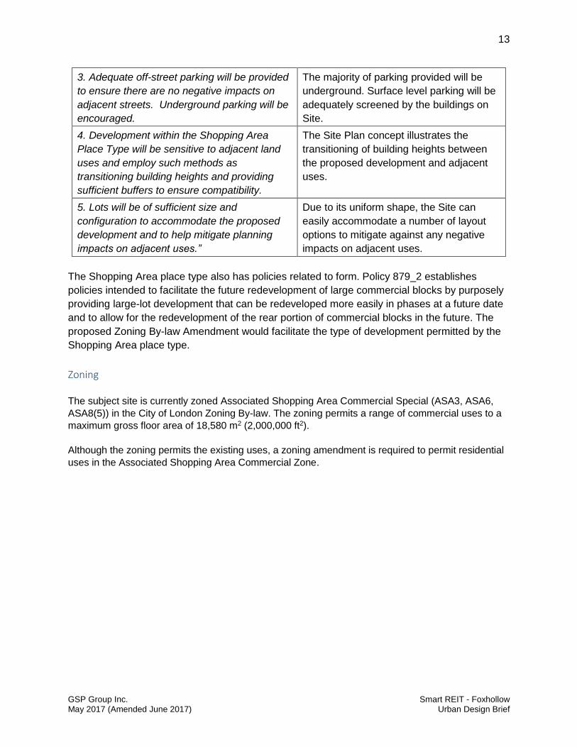
3. Adequate off-street parking will be provided
to ensure there are no negative impacts on
adjacent streets. Underground parking will be
encouraged.
The majority of parking provided will be
underground. Surface level parking will be
adequately screened by the buildings on
Site.
4. Development within the Shopping Area
Place Type will be sensitive to adjacent land
uses and employ such methods as
transitioning building heights and providing
sufficient buffers to ensure compatibility.
The Site Plan concept illustrates the
transitioning of building heights between
the proposed development and adjacent
uses.
5. Lots will be of sufficient size and
configuration to accommodate the proposed
development and to help mitigate planning
impacts on adjacent uses.”
Due to its uniform shape, the Site can
easily accommodate a number of layout
options to mitigate against any negative
impacts on adjacent uses.
The Shopping Area place type also has policies related to form. Policy 879_2 establishes
policies intended to facilitate the future redevelopment of large commercial blocks by purposely
providing large-lot development that can be redeveloped more easily in phases at a future date
and to allow for the redevelopment of the rear portion of commercial blocks in the future. The
proposed Zoning By-law Amendment would facilitate the type of development permitted by the
Shopping Area place type.
Zoning
The subject site is currently zoned Associated Shopping Area Commercial Special (ASA3, ASA6,
ASA8(5)) in the City of London Zoning By-law. The zoning permits a range of commercial uses to a
maximum gross floor area of 18,580 m2 (2,000,000 ft2).
Although the zoning permits the existing uses, a zoning amendment is required to permit residential
uses in the Associated Shopping Area Commercial Zone.

14
GSP Group Inc. Smart REIT - Foxhollow May 2017 (Amended June 2017) Urban Design Brief
1.4 Spatial Analysis
Regional Spatial Analysis Plan
The proposed development will be centrally located within the developing Foxhollow Community
in northwest London. The Site fronts onto Fanshawe Park Road West, an arterial roadway
which has transit service. North of the Site is a low rise residential neighbourhood. To the east,
west and south are major commercial developments (Image 2).
Image 2: Regional Spatial Analysis Plan – Goggle Earth Arial Imagery (2016)

15
GSP Group Inc. Smart REIT - Foxhollow May 2017 (Amended June 2017) Urban Design Brief
The Site is described as Part 1 and part of Part 2 on Registered Plan 33R-17347. These parcels
are 7.3hectares (18acres) in size with approximately 229m of frontage along Fanshawe Park
Road West, 101m along Tokala Trail and 310m along Dalmagarry Road. There are four (4)
existing commercial buildings at the south end of the Site, fronting onto Fanshawe Park Road
West. The remainder of the Site is currently vacant
Adjacent to the Site along the westerly property boundary and south of the Site across
Fanshawe Park Road West are commercial development owned by the applicant. East of the
site, across Dalmagarry Road is a proposed 5 storey residential development for seniors and
further east is the Saint Andrew Bessette Catholic School. North across Tokala Trail is a
residential subdivision intended for townhomes and single detached dwellings.
The Site serves as part of the gateway into the neighbouhood along Dalmagarry Road. The
commercial development and proposed 4-storey seniors development across Dalmagarry Road
have oriented their buildings to the street, creating an attractive street edge on the east side of
the road. The residential development, illustrated in the conceptual site plan will also orient the
apartment and townhouse buildings to face the street to create a sense of enclosure. This will
serve to create a better pedestrian experience for locals and visitors accessing the site by
transit service along Fanshawe Park Road.

16
GSP Group Inc. Smart REIT - Foxhollow May 2017 (Amended June 2017) Urban Design Brief
Site Photos
With a strong orientation to Fanshawe Park Road West, Dalmagarry Road and Tokala Trail, the
proposed development will create a desirable addition to the streetscape and the
neighbourhood.
Image 3 - View looking South Towards Fanshawe Park Road West from Dalmagarry Road
Image 4 - View looking North from Fanshawe Park Road West and Dalmagarry Road

17
GSP Group Inc. Smart REIT - Foxhollow May 2017 (Amended June 2017) Urban Design Brief
Image 5 – View looing North from southeast corner of the Dalmagarry Road and Fanshawe Park Road East
intersection
Image 6 – View looking West along Fanshawe Park Road West from Dalmagarry Road
Image 7 – View from the rear of the existing commercial development blocks on Site looking southeast

18
GSP Group Inc. Smart REIT - Foxhollow May 2017 (Amended June 2017) Urban Design Brief
SECTION 2
2.1 Site Design
The Site has frontage onto Fanshawe Park Road West, an urban thoroughfare, and two
collector streets, Dalmagarry Road and Tokala Trail. The adjacent commercial development to
the west and the existing commercial buildings on Site to the south do not provide any specific
restrictions or constraints on site design but measures should be taken to ensure an appropriate
transition is made between the interface of these uses and the residential development
proposed.
Discussions with City staff reinforce the City desire to have buildings frame the street and to
have as much building mass as possible along the street frontages. The intent is to create a
comfortable pedestrian zone and interaction between the building and the street.
The conceptual site plan (Image 8) includes four apartment buildings with a total of 552 units
and 130 townhouse units in addition to the 1,871m2 of commercial space already provided along
Fanshawe Park Road. Common amenity space is provided in the middle of the Site surrounded
by the four apartment buildings. Additional amenity space is provided in a centralized location
between the rows of townhouse units creating a welcoming entrance to the block and providing
open space to the residents of these townhomes.
Entrances to the buildings are oriented to provide pedestrian access to and from the buildings
along the street, wherever buildings abut a street. Building access will also be provided for
pedestrians and vehicular traffic from inside the Site.
There are three existing entrances to the Site. The Fanshawe Park Road West entrance and the
southerly access off of Dalmagarry Road service the existing commercial development at the
south end of the Site. Both of these entrances provide right-in right-out access. The northerly
entrance off of Dalmagarry Road is shown to be closed and replaced with a new entrance
further north that lines up with the proposed entrance of the seniors development across the
street at 2825 Tokala Trail. Another entrance is proposed along Tokala Trail and lines up with
the proposed road servicing the residential subdivision to the north. Both new entrances are
intended to serve the illustrated residential development.
Internal private roads throughout the Site are in a modified grid format that reflect a logical and
traditional neighbourhood design pattern. This configuration maximizes connectivity and ease of
mobility and supports the delivery of emergency vehicles. Existing truck loading and drive-thru
areas of the commercial precinct are to remain the same.
A circulation plan showing pedestrian and vehicular paths as well as building entrances is
provided as Image 9 below.

19
GSP Group Inc. Smart REIT - Foxhollow May 2017 (Amended June 2017) Urban Design Brief
Image 8 – Site Concept (Petroff, 2017)

20
GSP Group Inc. Smart REIT - Foxhollow May 2017 (Amended June 2017) Urban Design Brief
Image 9 – Circulation Plan (GSP Group, 2017)
21
GSP Group Inc. Smart REIT - Foxhollow May 2017 (Amended June 2017) Urban Design Brief
2.2 Built Form and Architecture
Building Form and Urban Context
The strategy for this project is to transition the building mass and strengthen the street edges of
Tokala Trial and Dalmagarry Road, thereby strengthening the City’s Urban Design principles.
The height and scale are compatible with other buildings and uses in the neighbourhood. The
proposed townhomes face the proposed townhomes across Tokala Trail and the proposed 4
Storey apartments abut the commercial uses and the five storey seniors development across
Dalmagary Road. Internally, landscaping and privacy fencing will be required to soften the
interface between the proposed townhomes and the adjacent commercial development to the
west.
The conceptual site plan shows the apartment building is setback 6.06m from Dalmagarry
Road, while the townhouses are setback approximately 5m along Dalmagary Road and Tokala
Trail. This provides an appropriate distance between buildings and public sidewalks based on
their relative scale. The intervening space between property line and building would be
landscaped providing an appealing street edge. The location and massing of the proposed
apartment buildings acts as a screens for the interior amenity space and hides most of the
surface parking from the street.
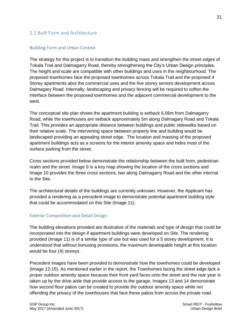
Cross sections provided below demonstrate the relationship between the built form, pedestrian
realm and the street. Image 9 is a key map showing the location of the cross sections and
Image 10 provides the three cross sections, two along Dalmagarry Road and the other internal
to the Site.
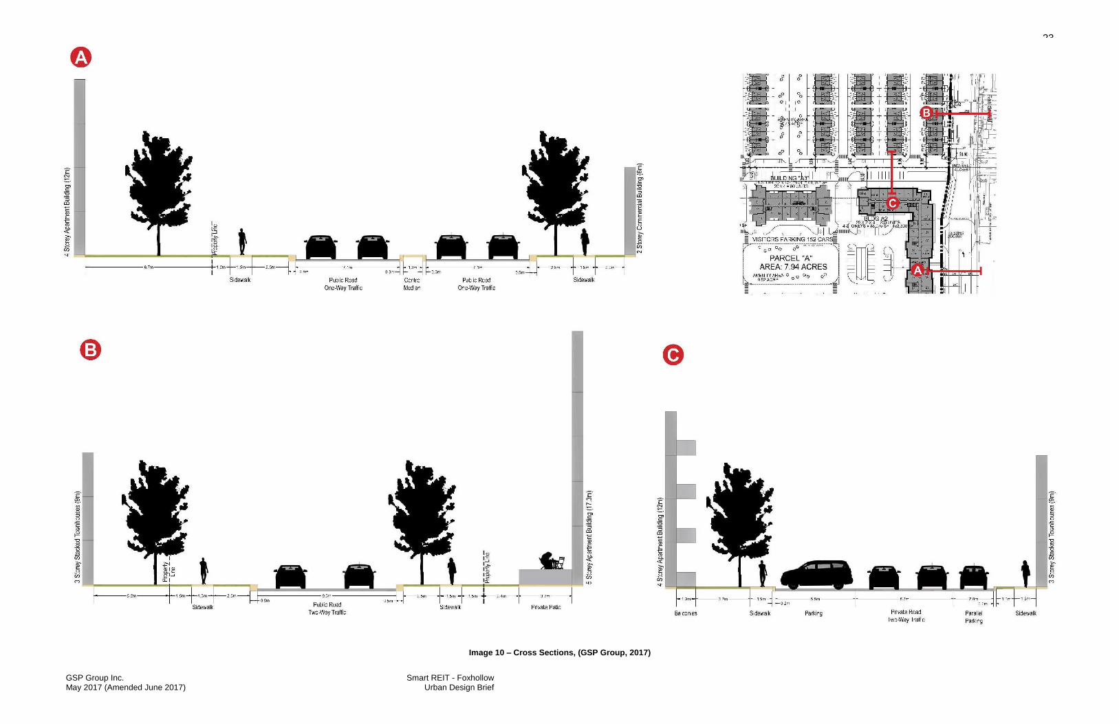
The architectural details of the buildings are currently unknown. However, the Applicant has
provided a rendering as a precedent image to demonstrate potential apartment building style
that could be accommodated on this Site (Image 11).
Exterior Composition and Detail Design:
The building elevations provided are illustrative of the materials and type of design that could be
incorporated into the design if apartment buildings were developed on Site. The rendering
provided (Image 11) is of a similar type of use but was used for a 5 storey development. It is
understood that without bonusing provisions, the maximum developable height at this location
would be four (4) storeys.
Precedent images have been provided to demonstrate how the townhomes could be developed
(Image 12-15). As mentioned earlier in the report, the Townhomes facing the street edge lack a
proper outdoor amenity space because their front yard faces onto the street and the rear year is
taken up by the drive aisle that provide access to the garage. Images 13 and 14 demonstrate
how second floor patios can be created to provide the outdoor amenity space while not
offending the privacy of the townhouses that face these patios from across the private road.

22
GSP Group Inc. Smart REIT - Foxhollow May 2017 (Amended June 2017) Urban Design Brief
Image 15 provides an example of how mixed use commercial/residential built form can be
incorporated into the design of the townhome units. This form of development would be
permitted by the proposed zoning by-law amendment and would also be in keeping with the
residential and commercial character evolving in this area.
23
GSP Group Inc. Smart REIT - Foxhollow May 2017 (Amended June 2017) Urban Design Brief
Image 10 – Cross Sections, (GSP Group, 2017)
24
GSP Group Inc. Smart REIT - Foxhollow May 2017 (Amended June 2017) Urban Design Brief
Image 11 – Example rendering of an apartment building (Petroff, 2017)

25
GSP Group Inc. Smart REIT - Foxhollow May 2017 (Amended June 2017) Urban Design Brief
Image 11 – Example of townhouse designs from Highland Road East, Kitchener, ON
Image 12 – Example of townhomes with front façade facing the street (Highland Road East, Kitchener, ON)

26
GSP Group Inc. Smart REIT - Foxhollow May 2017 (Amended June 2017) Urban Design Brief
Image 13 – Example of second floor rear patios
Image 14 – Example of mixed use townhomes (Laurelwood and Erbsville, Waterloo, ON)

27
GSP Group Inc. Smart REIT - Foxhollow May 2017 (Amended June 2017) Urban Design Brief
2.3 Landscape Design
A landscape design will be considered through the Site Plan process. Some of the components
are illustrated on Image 13. The landscaping will be used to enhance the public realm and
create an attractive setting for residents and visitors. Pedestrian connections will be provided
along Dalmagarry Road and Tokala Trail from the apartment building and townhomes. Internal
sidewalks will be provided throughout the Site, around apartment building and townhouse
blocks with a variety of plantings along these route.
Along the two street frontages, the space between the sidewalk and building can be planted
with trees, shrubs and flowering plants. Outdoor amenity spaces will be provided in central
locations providing easy access and will serve as a natural focal point.
The project signage will be integrated into the landscape design to frame the entrances from
Dalmagarry Road and Tokala Trail.

28
GSP Group Inc. Smart REIT - Foxhollow May 2017 (Amended June 2017) Urban Design Brief
Image 13 – Landscape Plan Concept (GSP Group, May 2017)

29
GSP Group Inc. Smart REIT - Foxhollow May 2017 (Amended June 2017) Urban Design Brief
SUMMARY
From an Urban Design perspective, the development that would be permitted by the proposed Zoning
By-law Amendment is appropriate for the Site given that:
It can be designed to frame the street and provide connections between the street and the
built form;
It recognizes the developing low density residential neighbourhood to the north and provides
an appropriate transition between this residential area and the commercial nodes to the south
and west at this gateway site; and,
It will provide appropriate architecture and materials that fit well within the existing
neighbourhood.
Details of the specific development have not been finalized at this time and will be subject to
Site Plan approval following approval of the Zoning By-law Amendment. We are of the opinion
that the addition of residential uses, and potentially some mixed-use buildings, in addition to the
already permitted retail and service commercial uses are appropriate for this Site. The
development illustrated in the conceptual site plan fits well within the context of the developing
community and would provide additional residential accommodation to the growing area of
northwest London.
The proposed plan conforms to the City of London Official Plan and the proposed Zoning
Amendments would permit added flexibility that are appropriate for the Site and would facilitate
the creation of a vibrant and desirable development.