Embed Size (px)
Citation preview
2007 Gulf Coast Geological Societies Convention, October 21-23, Corpus Christi, Texas
+ Version 1.5
* See Author Biographies at End of Paper
Uranium In-Situ Leach (Recovery) Development
and
Associated Environmental Issues +
by
Michael D. Campbell, P.G., P.H.,*
Henry M. Wise, P.G.,**
and
Ruffin I. Rackley ***
Abstract
Tertiary uranium roll-front deposits of South Texas exhibit an exceptionally strong bias toward long,
narrow ore bodies. Understanding these deposits is paramount in accurately determining the uranium
resource available and in designing in situ leach (ISL) patterns to minimize the volume of barren sand to
be included in the leach field.
As in other mining projects, ore reserves are assessed by qualified professionals on the basis of the
quantity and quality of the information available about the mineralization. To assess reserves in uranium
roll-front deposits where ISL is under consideration, the number and distribution of the boreholes and core
samples (to evaluate the local radiometric equilibrium and the amount and type of carbon present) and the
quality of the geophysical logs (elevation control, radiometric calibration, panel settings, etc.) provide the
required data to produce a meaningful assessment of reserves in preparation for ISL development.
In ISL projects, the design of the well field depends on the appropriate interpretation of where in 3-
dimensional space the uranium mineralization occurs. This requires not only an understanding of the
geologic conditions present but also of the hydrogeologic conditions such porosity and hydraulic
conductivity of the various segments of the ore zone and associated barren zones to understand the ground-
water flow regime.
Uranium exploration and mining are regulated by the State of Texas. Baseline studies consisting of
comprehensive characterization of geography, geology, hydrogeology, and other topics are required by the
State before mining can begin. To help the permitting process proceed smoothly, a strong community
relations program should be made an integral part of management’s function.
Introduction
With nuclear power re-emerging, exploration and development of uranium resources
have accelerated over the past few years (Campbell et al., 2005; Campbell et al., 2007).
Numerous investigations were conducted by the western states and by the federal
government supporting uranium exploration beginning in the late 1940s and increasing in
the 1960s through the 1970s. The Natural Uranium Resource Evaluation Program (the
now well-known NURE Program) produced hundreds of reports to further the
exploration for uranium resources in Texas as well as in other states with potential for
uranium occurrences. For the southwest U. S., Campbell and Biddle (1977) provided a
review for areas outside known areas with potential for uranium mineralization. Criteria
for locating uranium in Texas were developed in a number of reports, notably by Flawn
(1967), Norton (1970), Fisher, et al. (1970), Grutt (1972), Eargle, et al. (1975),
Page 2
Galloway, et al. (1979), Henry, et al. (1982), and Smith, et al. (1982), among others. A
comprehensive uranium bibliography is also available that includes references to the
NURE microfilm library, see: http://www.mdcampbell.com/uraniumreferenceslibrary.pdf
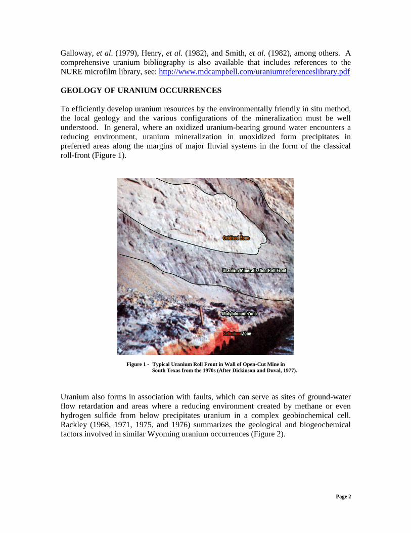
GEOLOGY OF URANIUM OCCURRENCES
To efficiently develop uranium resources by the environmentally friendly in situ method,
the local geology and the various configurations of the mineralization must be well
understood. In general, where an oxidized uranium-bearing ground water encounters a
reducing environment, uranium mineralization in unoxidized form precipitates in
preferred areas along the margins of major fluvial systems in the form of the classical
roll-front (Figure 1).
Figure 1 - Typical Uranium Roll Front in Wall of Open-Cut Mine in
South Texas from the 1970s (After Dickinson and Duval, 1977).
Uranium also forms in association with faults, which can serve as sites of ground-water
flow retardation and areas where a reducing environment created by methane or even
hydrogen sulfide from below precipitates uranium in a complex geobiochemical cell.
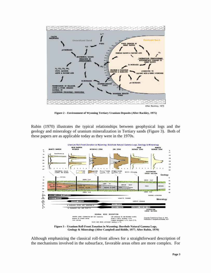
Rackley (1968, 1971, 1975, and 1976) summarizes the geological and biogeochemical
factors involved in similar Wyoming uranium occurrences (Figure 2).
Page 3
Figure 2 – Environment of Wyoming Tertiary Uranium Deposits (After Rackley, 1975)
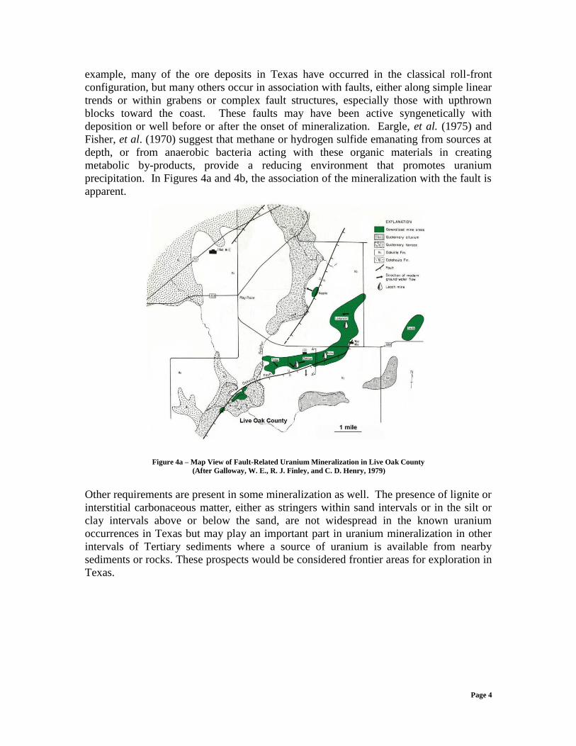
Rubin (1970) illustrates the typical relationships between geophysical logs and the
geology and mineralogy of uranium mineralization in Tertiary sands (Figure 3). Both of
these papers are as applicable today as they were in the 1970s.
Figure 3 – Uranium Roll-Front Zonation in Wyoming: Borehole Natural Gamma Logs,
Geology & Mineralogy (After Campbell and Biddle, 1977; After Rubin, 1970)
Although emphasizing the classical roll-front allows for a straightforward description of
the mechanisms involved in the subsurface, favorable areas often are more complex. For
Page 4
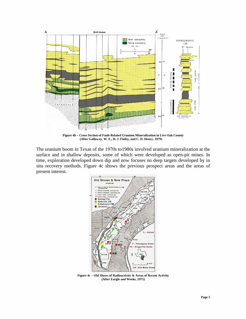
example, many of the ore deposits in Texas have occurred in the classical roll-front
configuration, but many others occur in association with faults, either along simple linear
trends or within grabens or complex fault structures, especially those with upthrown
blocks toward the coast. These faults may have been active syngenetically with
deposition or well before or after the onset of mineralization. Eargle, et al. (1975) and
Fisher, et al. (1970) suggest that methane or hydrogen sulfide emanating from sources at
depth, or from anaerobic bacteria acting with these organic materials in creating
metabolic by-products, provide a reducing environment that promotes uranium
precipitation. In Figures 4a and 4b, the association of the mineralization with the fault is
apparent.
Figure 4a – Map View of Fault-Related Uranium Mineralization in Live Oak County
(After Galloway, W. E., R. J. Finley, and C. D. Henry, 1979)
Other requirements are present in some mineralization as well. The presence of lignite or
interstitial carbonaceous matter, either as stringers within sand intervals or in the silt or
clay intervals above or below the sand, are not widespread in the known uranium
occurrences in Texas but may play an important part in uranium mineralization in other
intervals of Tertiary sediments where a source of uranium is available from nearby
sediments or rocks. These prospects would be considered frontier areas for exploration in
Texas.
Page 5
Figure 4b – Cross Section of Fault-Related Uranium Mineralization in Live Oak County
(After Galloway, W. E., R. J. Finley, and C. D. Henry, 1979)
The uranium boom in Texas of the 1970s to1980s involved uranium mineralization at the
surface and in shallow deposits, some of which were developed as open-pit mines. In
time, exploration developed down dip and now focuses on deep targets developed by in
situ recovery methods. Figure 4c shows the previous prospect areas and the areas of
present interest.
Figure 4c – Old Shows of Radioactivity & Areas of Recent Activity
(After Eargle and Weeks, 1975)
Page 6
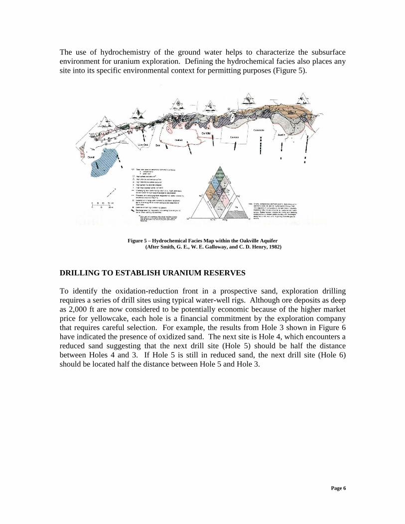
The use of hydrochemistry of the ground water helps to characterize the subsurface
environment for uranium exploration. Defining the hydrochemical facies also places any
site into its specific environmental context for permitting purposes (Figure 5).
Figure 5 – Hydrochemical Facies Map within the Oakville Aquifer
(After Smith, G. E., W. E. Galloway, and C. D. Henry, 1982)
DRILLING TO ESTABLISH URANIUM RESERVES
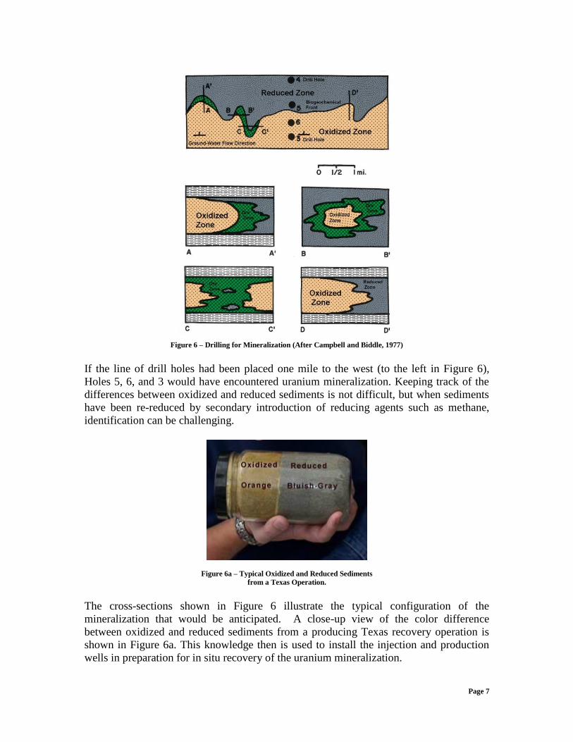
To identify the oxidation-reduction front in a prospective sand, exploration drilling
requires a series of drill sites using typical water-well rigs. Although ore deposits as deep
as 2,000 ft are now considered to be potentially economic because of the higher market
price for yellowcake, each hole is a financial commitment by the exploration company
that requires careful selection. For example, the results from Hole 3 shown in Figure 6
have indicated the presence of oxidized sand. The next site is Hole 4, which encounters a
reduced sand suggesting that the next drill site (Hole 5) should be half the distance
between Holes 4 and 3. If Hole 5 is still in reduced sand, the next drill site (Hole 6)
should be located half the distance between Hole 5 and Hole 3.
Page 7
Figure 6 – Drilling for Mineralization (After Campbell and Biddle, 1977)
If the line of drill holes had been placed one mile to the west (to the left in Figure 6),
Holes 5, 6, and 3 would have encountered uranium mineralization. Keeping track of the
differences between oxidized and reduced sediments is not difficult, but when sediments
have been re-reduced by secondary introduction of reducing agents such as methane,
identification can be challenging.
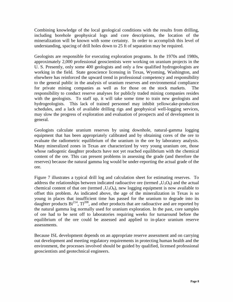
Figure 6a – Typical Oxidized and Reduced Sediments
from a Texas Operation.
The cross-sections shown in Figure 6 illustrate the typical configuration of the
mineralization that would be anticipated. A close-up view of the color difference
between oxidized and reduced sediments from a producing Texas recovery operation is
shown in Figure 6a. This knowledge then is used to install the injection and production
wells in preparation for in situ recovery of the uranium mineralization.
Page 8
Combining knowledge of the local geological conditions with the results from drilling,
including borehole geophysical logs and core descriptions, the location of the
mineralization will be known with some certainty. In order to accomplish this level of
understanding, spacing of drill holes down to 25 ft of separation may be required.
Geologists are responsible for executing exploration programs. In the 1970s and 1980s,
approximately 2,000 professional geoscientists were working on uranium projects in the
U. S. Presently, only some 400 geologists and only a few qualified hydrogeologists are
working in the field. State geoscience licensing in Texas, Wyoming, Washington, and
elsewhere has reinforced the upward trend in professional competency and responsibility
to the general public in the analysis of uranium reserves and environmental compliance
for private mining companies as well as for those on the stock markets. The
responsibility to conduct reserve analyses for publicly traded mining companies resides
with the geologists. To staff up, it will take some time to train new geologists and
hydrogeologists. This lack of trained personnel may inhibit yellowcake-production
schedules, and a lack of available drilling rigs and geophysical well-logging services,
may slow the progress of exploration and evaluation of prospects and of development in
general.
Geologists calculate uranium reserves by using downhole, natural-gamma logging
equipment that has been appropriately calibrated and by obtaining cores of the ore to
evaluate the radiometric equilibrium of the uranium in the ore by laboratory analysis.
Many mineralized zones in Texas are characterized by very young uranium ore, those
whose radiogenic daughter products have not yet reached equilibrium with the chemical
content of the ore. This can present problems in assessing the grade (and therefore the
reserves) because the natural gamma log would be under-reporting the actual grade of the
ore.
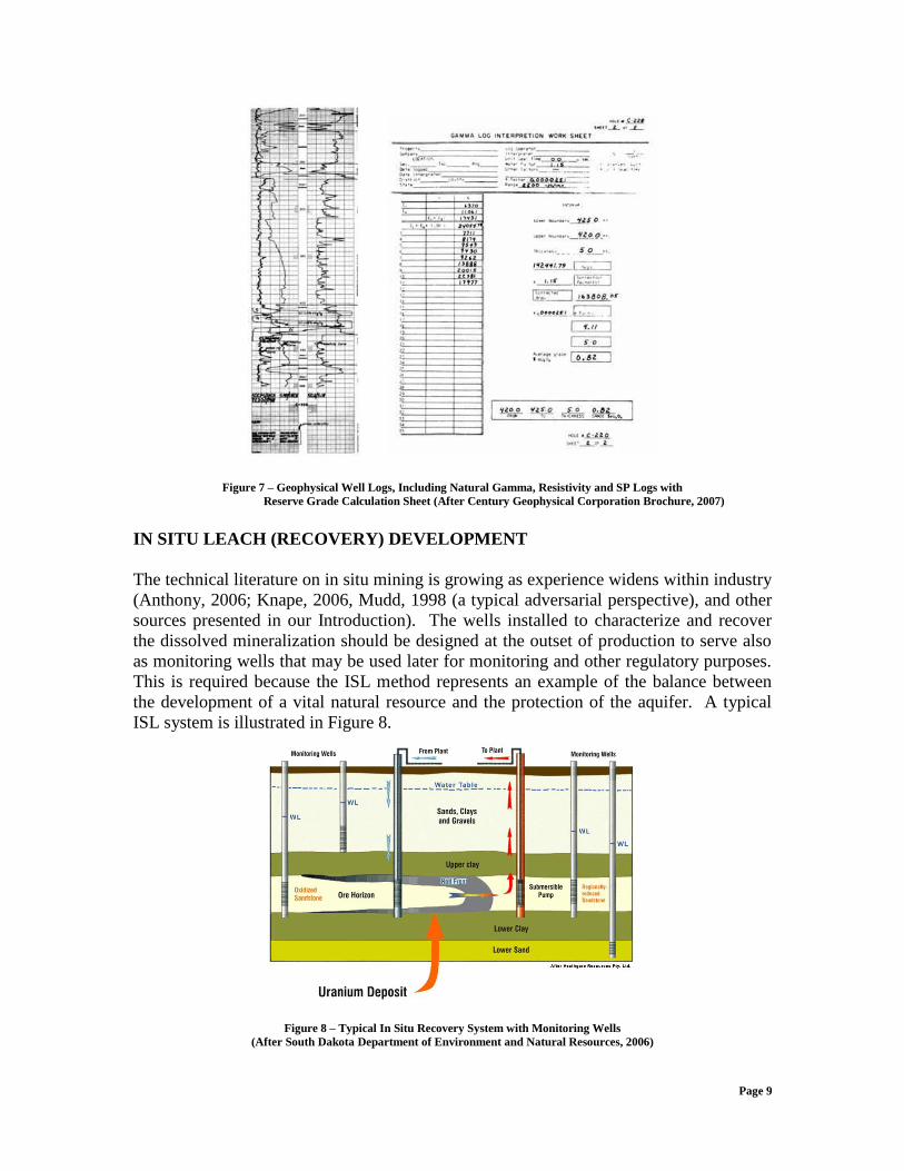
Figure 7 illustrates a typical drill log and calculation sheet for estimating reserves. To
address the relationships between indicated radioactive ore (termed eU3O8) and the actual
chemical content of that ore (termed cU3O8), new logging equipment is now available to
offset this problem. As indicated above, the age of the mineralization in Texas is so
young in places that insufficient time has passed for the uranium to degrade into its
daughter products Bi214
, Tl208
, and other products that are radioactive and are reported by
the natural gamma log normally used for uranium exploration. In the past, core samples
of ore had to be sent off to laboratories requiring weeks for turnaround before the
equilibrium of the ore could be assessed and applied to in-place uranium reserve
assessments.
Because ISL development depends on an appropriate reserve assessment and on carrying
out development and meeting regulatory requirements in protecting human health and the
environment, the processes involved should be guided by qualified, licensed professional
geoscientists and geotechnical engineers.
Page 9
mm
Figure 7 – Geophysical Well Logs, Including Natural Gamma, Resistivity and SP Logs with
Reserve Grade Calculation Sheet (After Century Geophysical Corporation Brochure, 2007)
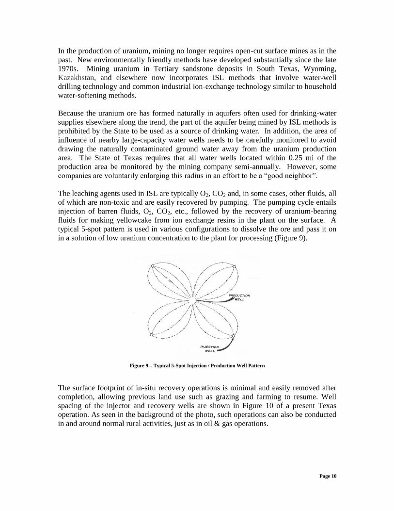
IN SITU LEACH (RECOVERY) DEVELOPMENT
The technical literature on in situ mining is growing as experience widens within industry
(Anthony, 2006; Knape, 2006, Mudd, 1998 (a typical adversarial perspective), and other
sources presented in our Introduction). The wells installed to characterize and recover
the dissolved mineralization should be designed at the outset of production to serve also
as monitoring wells that may be used later for monitoring and other regulatory purposes.
This is required because the ISL method represents an example of the balance between
the development of a vital natural resource and the protection of the aquifer. A typical
ISL system is illustrated in Figure 8.
Figure 8 – Typical In Situ Recovery System with Monitoring Wells
(After South Dakota Department of Environment and Natural Resources, 2006)
Page 10
In the production of uranium, mining no longer requires open-cut surface mines as in the
past. New environmentally friendly methods have developed substantially since the late
1970s. Mining uranium in Tertiary sandstone deposits in South Texas, Wyoming,
Kazakhstan, and elsewhere now incorporates ISL methods that involve water-well
drilling technology and common industrial ion-exchange technology similar to household
water-softening methods.
Because the uranium ore has formed naturally in aquifers often used for drinking-water
supplies elsewhere along the trend, the part of the aquifer being mined by ISL methods is
prohibited by the State to be used as a source of drinking water. In addition, the area of
influence of nearby large-capacity water wells needs to be carefully monitored to avoid
drawing the naturally contaminated ground water away from the uranium production
area. The State of Texas requires that all water wells located within 0.25 mi of the
production area be monitored by the mining company semi-annually. However, some
companies are voluntarily enlarging this radius in an effort to be a “good neighbor”.
The leaching agents used in ISL are typically O2, CO2 and, in some cases, other fluids, all
of which are non-toxic and are easily recovered by pumping. The pumping cycle entails
injection of barren fluids, O2, CO2, etc., followed by the recovery of uranium-bearing
fluids for making yellowcake from ion exchange resins in the plant on the surface. A
typical 5-spot pattern is used in various configurations to dissolve the ore and pass it on
in a solution of low uranium concentration to the plant for processing (Figure 9).
Figure 9 – Typical 5-Spot Injection / Production Well Pattern
The surface footprint of in-situ recovery operations is minimal and easily removed after
completion, allowing previous land use such as grazing and farming to resume. Well
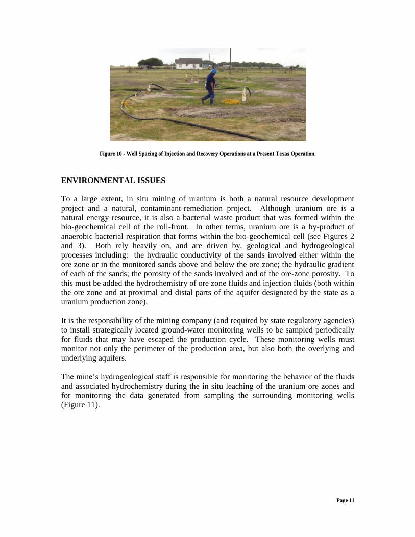
spacing of the injector and recovery wells are shown in Figure 10 of a present Texas
operation. As seen in the background of the photo, such operations can also be conducted
in and around normal rural activities, just as in oil & gas operations.
Page 11
Figure 10 - Well Spacing of Injection and Recovery Operations at a Present Texas Operation.
ENVIRONMENTAL ISSUES
To a large extent, in situ mining of uranium is both a natural resource development
project and a natural, contaminant-remediation project. Although uranium ore is a
natural energy resource, it is also a bacterial waste product that was formed within the
bio-geochemical cell of the roll-front. In other terms, uranium ore is a by-product of
anaerobic bacterial respiration that forms within the bio-geochemical cell (see Figures 2
and 3). Both rely heavily on, and are driven by, geological and hydrogeological
processes including: the hydraulic conductivity of the sands involved either within the
ore zone or in the monitored sands above and below the ore zone; the hydraulic gradient
of each of the sands; the porosity of the sands involved and of the ore-zone porosity. To
this must be added the hydrochemistry of ore zone fluids and injection fluids (both within
the ore zone and at proximal and distal parts of the aquifer designated by the state as a
uranium production zone).
It is the responsibility of the mining company (and required by state regulatory agencies)
to install strategically located ground-water monitoring wells to be sampled periodically
for fluids that may have escaped the production cycle. These monitoring wells must
monitor not only the perimeter of the production area, but also both the overlying and
underlying aquifers.
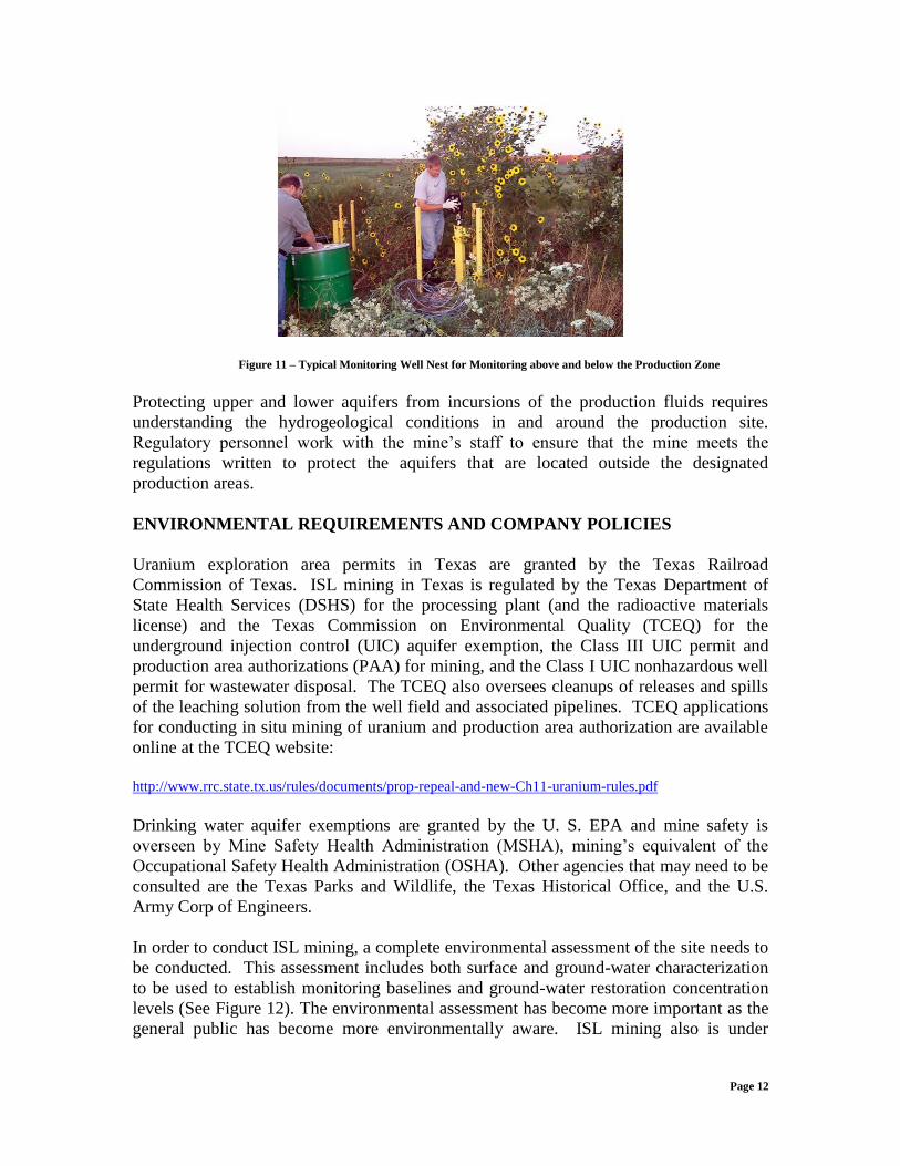
The mine’s hydrogeological staff is responsible for monitoring the behavior of the fluids
and associated hydrochemistry during the in situ leaching of the uranium ore zones and
for monitoring the data generated from sampling the surrounding monitoring wells
(Figure 11).
Page 12
Figure 11 – Typical Monitoring Well Nest for Monitoring above and below the Production Zone
Protecting upper and lower aquifers from incursions of the production fluids requires
understanding the hydrogeological conditions in and around the production site.
Regulatory personnel work with the mine’s staff to ensure that the mine meets the
regulations written to protect the aquifers that are located outside the designated
production areas.
ENVIRONMENTAL REQUIREMENTS AND COMPANY POLICIES
Uranium exploration area permits in Texas are granted by the Texas Railroad
Commission of Texas. ISL mining in Texas is regulated by the Texas Department of
State Health Services (DSHS) for the processing plant (and the radioactive materials
license) and the Texas Commission on Environmental Quality (TCEQ) for the
underground injection control (UIC) aquifer exemption, the Class III UIC permit and
production area authorizations (PAA) for mining, and the Class I UIC nonhazardous well
permit for wastewater disposal. The TCEQ also oversees cleanups of releases and spills
of the leaching solution from the well field and associated pipelines. TCEQ applications
for conducting in situ mining of uranium and production area authorization are available
online at the TCEQ website:
http://www.rrc.state.tx.us/rules/documents/prop-repeal-and-new-Ch11-uranium-rules.pdf
Drinking water aquifer exemptions are granted by the U. S. EPA and mine safety is
overseen by Mine Safety Health Administration (MSHA), mining’s equivalent of the
Occupational Safety Health Administration (OSHA). Other agencies that may need to be
consulted are the Texas Parks and Wildlife, the Texas Historical Office, and the U.S.
Army Corp of Engineers.
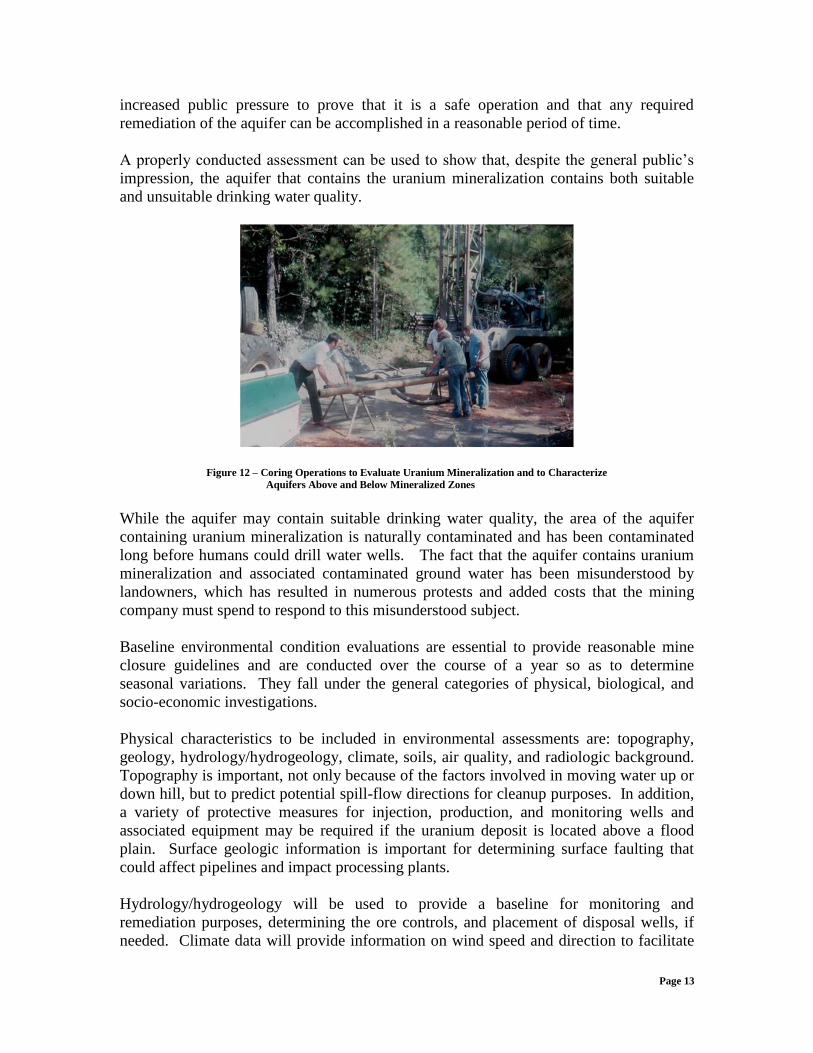
In order to conduct ISL mining, a complete environmental assessment of the site needs to
be conducted. This assessment includes both surface and ground-water characterization
to be used to establish monitoring baselines and ground-water restoration concentration
levels (See Figure 12). The environmental assessment has become more important as the
general public has become more environmentally aware. ISL mining also is under
Page 13
increased public pressure to prove that it is a safe operation and that any required
remediation of the aquifer can be accomplished in a reasonable period of time.
A properly conducted assessment can be used to show that, despite the general public’s
impression, the aquifer that contains the uranium mineralization contains both suitable
and unsuitable drinking water quality.
Figure 12 – Coring Operations to Evaluate Uranium Mineralization and to Characterize
Aquifers Above and Below Mineralized Zones
While the aquifer may contain suitable drinking water quality, the area of the aquifer
containing uranium mineralization is naturally contaminated and has been contaminated
long before humans could drill water wells. The fact that the aquifer contains uranium
mineralization and associated contaminated ground water has been misunderstood by
landowners, which has resulted in numerous protests and added costs that the mining
company must spend to respond to this misunderstood subject.
Baseline environmental condition evaluations are essential to provide reasonable mine
closure guidelines and are conducted over the course of a year so as to determine
seasonal variations. They fall under the general categories of physical, biological, and
socio-economic investigations.
Physical characteristics to be included in environmental assessments are: topography,
geology, hydrology/hydrogeology, climate, soils, air quality, and radiologic background.
Topography is important, not only because of the factors involved in moving water up or
down hill, but to predict potential spill-flow directions for cleanup purposes. In addition,
a variety of protective measures for injection, production, and monitoring wells and
associated equipment may be required if the uranium deposit is located above a flood
plain. Surface geologic information is important for determining surface faulting that
could affect pipelines and impact processing plants.
Hydrology/hydrogeology will be used to provide a baseline for monitoring and
remediation purposes, determining the ore controls, and placement of disposal wells, if
needed. Climate data will provide information on wind speed and direction to facilitate
Page 14
air modeling in case of vapor/dust releases, and temperature and rainfall information can
contribute to the design of holding ponds. Soil information is used to determine
infiltration rates in case of spills or releases from pipelines, holding ponds, etc.
Collection and analysis of air-quality information will be used to provide a baseline for
monitoring purposes. Radiologic background also will be used to provide
decommissioning guidelines to be applied when the production equipment is removed
from the site.
Collection and analysis of biological factors include flora and fauna (both terrestrial and
aquatic), endangered species, and radiologic analyses of selected samples. These factors
allow the mining company to make preparations for dealing with environmentally
sensitive locations. These preparations may include taking added precautions to protect
these areas, altering the size or shape of the mining grid, or avoiding an area completely.
Socio-economic issues have become increasingly important over the recent decades.
Impacts on local populations may disrupt local lifestyles, but there also may be positive
impacts by providing employment in an otherwise depressed area. An assessment of
current resource use, such as agriculture, wildlife harvesting, fishing, and tourism is
important. Cultural issues must be considered, including both current conditions, and
archaeology and history. The costs and benefits must be carefully weighed. Knowledge
of these factors would help to reinforce community relations.
ISSUES TO BE ADDRESSED
Some of the more important issues that should be considered / accepted are:
What type of mining solution should be used? There are pros and cons to each
of the types available.
What is a reasonable cleanup goal? Remediating a site to drinking water levels
is no longer required by the state because this action was deemed unreasonable
since the site was naturally contaminated already. The general public will need to
understand why and how the cleanup goals have been set. In more than one case
companies have been criticized about the cleanup levels set, even though these
levels were well below the human health risk levels approved by the state
regulatory agency. Good community relations through communication are an
important function of the mining company’s management.
Are there any abandoned wells that need attention? Identification of old
boreholes may be required to make sure they are properly sealed before ISL
mining begins. Because many of the new deposits were discovered in the 1980s,
it is entirely possible that, by today’s standards, they were improperly sealed. It
once was common practice to simply fill the hole with drilling mud and then
insert a 10-foot concrete plug three feet below the surface. These plugs were
known to slip, and old boreholes that were thought to be properly abandoned
Page 15
would cave-in and remain open to the surface for many years. These open
borings serve as routes for the migration of mining fluids to both higher and lower
aquifers. There have been cases reported of these old boreholes being discovered
by the fluid geyser that resulted when the nearby injection wells were initially
operated.
What is the best way to dispose of excess wastewaters? By evaporative ponds
or disposal well. Evaporative ponds are thought to be more environmentally
friendly, but may be unfeasible in areas of high humidity or low temperatures.
Ponds such as these often leak, creating cleanup problems later during closure, so
ponds should be avoided if possible. In some mines, above ground storage tanks
are used to temporarily contain wastewaters. Disposal wells may be
uneconomical if they need to be drilled too deep to reach an appropriate injection
zone similar to those zones used for brine disposal from local oil and gas wells. It
has also been suggested that two disposal wells should be installed, in case a
problem develops with one of them.
Are all company employees properly trained in the handling of the
equipment and of radioactive materials? They also need to be made aware of
the danger of radiation exposure from yellowcake dust and why it must not be
allowed to escape into the general environment. Appropriate plant designs and
operation and maintenance practices can minimize such concerns.
Have all neighboring water wells been identified? All water wells within 0.25
mi of the mining area need to be included in any monitoring program for periodic
sampling and laboratory analysis. Some mining companies are extending this
radius to insure that the coverage is suitable.
Is a well-established emergency-response procedure in place and are all
employees skilled in its use? This should be an established mining company
management function.
With the general public becoming more environmentally conscious, it is imperative that
an ISL mining company is prepared to respond to all spills and releases immediately and
answer any and all questions from concerned persons openly and honestly. This may not
insure that problems and misunderstandings will not occur, but a community approach
should prevent most of the associated problems.
References Cited
Anthony, H., 2006, In situ mining, in Uranium information at Goliad conference, Goliad,
Texas: http://goliad-tx.tamu.edu/uranium information conference.html , (accessed April 6, 2007).
Campbell, M. D., H. M. Wise, and D. Evensen, 2005, Recent uranium industry
developments, exploration, mining and environmental programs in the U. S. and
Page 16
overseas: Report of the Uranium Committee, Energy Minerals Division, AAPG, March
25, http://mdcampbell.com/EMDUraniumCommittee2005Report.pdf , (accessed April 2, 2007).
Campbell, M. D., H. M. Wise, D. Evenson, B. Handley, S. M. Testa, J. Conca, and H.
Moore, 2007, Nuclear power: Winds of change: Report of the Uranium Committee,
Energy Minerals Division, AAPG, March 31, http://www.mdcampbell.com/EMDUranium
CommitteeReport033107FINAL.pdf , (accessed April 6, 2007).
Campbell, M. D., and K. T. Biddle, 1977, Frontier areas and exploration techniques –
Frontier uranium exploration in the South-Central United States, in Geology [and
environmental considerations] of alternate energy resources, uranium, lignite, and
geothermal energy in the South Central States, pp. 3-40 (Figure 17 – p. 34): The Houston
Geological Society, 364 p., http://www.ela-iet.com/ie08000B.htm , (accessed April 1, 2007).
Dickinson, K. A., and J. S. Duval, 1977, Trend areas and exploration techniques – South-
Texas uranium: Geologic controls, exploration techniques, and potential, in Geology [and
Environmental Considerations] of alternate energy resources, uranium, lignite, and
geothermal energy in the South Central States, pp. 45-66 (Figure 4D – p. 51): The
Houston Geological Society, 364 p., http://www.ela-iet.com/ie08000B.htm , (accessed April 1,
2007).
Eargle, D. H., 1975, South Texas uranium deposits: AAPG Bull. v. 59, no.5, p. 766-779.
Eargle, D. H., and A. D. Weeks, 1975, Geologic Relations Among Uranium Deposits,
South Texas Coastal Plain Region, U.S. A., in Amstutz, G.C. and A.J. Bernard, eds., Ores
in Sediments: Springer-Verlag, New York, 350 p.
Fisher, W. L., C. V. Proctor, W. E. Galloway, and J. S. Nagle, 1970, Depositional
systems in the Jackson Group of Texas – Their relationship to oil, gas, and uranium:
University of Texas Austin Bureau of Economic Geology, circ. 70-4, p. 234-261.
Flawn, P.T., 1967, Uranium in Texas: University of Texas Austin Bureau of Economic
Geology, circ 67-1, 16 p.
Galloway, W. E., R. J. Finley, and C. D. Henry, 1979, South Texas uranium province –
Geologic perspective: University of Texas Austin Bureau of Economic Geology,
Guidebook 18, Field Trip for EMD of AAPG, National Convention, Houston, Texas, 81
p.
Grutt, E. W., Jr., 1972, Prospecting criteria for sandstone-type uranium deposits, in
Uranium prospecting handbook: London, Institute of Mining and Metallurgy, p. 47-48.
Henry, C. D., W. E. Galloway, and G. E. Smith, 1982, Considerations in the extraction of
uranium from a fresh-water aquifer-Miocene Oakville sandstone, South Texas:
University of Texas Austin Bureau of Economic, Geology Report of Investigations, No.
126, 36 p.
Page 17
Knape, B., 2006, Regulation of In situ uranium mining, in Uranium information at Goliad
conference, Goliad, Texas: http://goliad-tx.tamu.edu/uranium information conference.html ,
(accessed April 6, 2007).
Mudd, G., 1998, An environmental critique of in situ leach mining: The case against
uranium solution mining: Research Report to Friends of the Earth (Fitzroy) and the
Australian Conservation Foundation, 48 p.
Norton, D. L., 1970, Uranium geology of the Gulf Coastal area: Corpus Christi
Geological Society Bulletin, v.10, p. 19-26.
Rackley, R. I., P. N. Shockey, and M. P. Dahill, 1968, Concepts and methods of uranium
exploration: Wyoming Geological Association, 20th Field Conference Guidebook, p.
115-124.
Rackley, R. I., and R. L. Johnson, 1971, The geochemistry of uranium roll-front deposits
with a case history from the Powder River Basin: Economic Geology, v. 66, n. 1, p. 202-
203, (abstract).
Rackley, R. I., 1975, Environment of Wyoming Tertiary uranium deposits: AAPG
Bulletin, v. 56, n. 4, p. 755-774: http://www.mdcampbell.com/RackleyAAPG1975.pdf
Rackley, R. I., 1976, Origin of Western-States type uranium mineralization, in K.H.
Wolf, ed., Handbook of strata-bound and Strataform ore deposits, v. 7: Elsevier Science
Publishing Company, Amsterdam, p. 89-156.
Rubin, B., 1970, Uranium roll-front Zonation of southern Powder River Basin,
Wyoming: Wyoming Geological Society Earth Science Bulletin, v. 3, no. 4, December,
p. 5-18.
Smith, G. E., W. E. Galloway, and C. D. Henry,1982, Regional hydrodynamics and
hydrochemistry of the uranium-bearing Oakville aquifer (Miocene) of South Texas:
University of Texas Austin Bureau of Economic Geology Report of Investigations, no.
124, 31 p.
South Dakota Department of Environment and Natural Resources, 2006, Preliminary
draft rules chapter 74:29:11 In situ leach mining, Discussions of November 16: http://www.state.sd.us/denr/DES/Mining/UraniumQuestionandAnswerSheetNovember16b.pdf , (accessed
January 12, 2007).
About the authors:
* Michael D. Campbell, P.G., P.H., serves as Managing Partner for the firm, M. D. Campbell and
Associates, L.P. in Houston, Texas Mr. Campbell has a strong professional history in corporate and
technical management of major international engineering and mining companies such as CONOCO
Mining, Teton Exploration, Div. United Nuclear Corporation in uranium projects during the 1970s
Page 18
and such as Law Engineering, DuPont, and others in environmental projects from the 1980s to the
present. Mr. Campbell has over 40 years of mining, minerals and environmental project experience. He
has published three technical books on uranium and other natural resources, and numerous associated
reports, technical papers, and presentations in the U.S. and overseas. Mr. Campbell is a graduate of The
Ohio State University in geology and hydrogeology, from Rice University in geology and geophysics, and
was elected a Fellow in the Geological Society of America. He has received a number of awards and
citations. He was a Founding Member in 1977 of the Energy Minerals Division of AAPG and presently
serves as Chairman of the Uranium Committee and in other professional committees. For additional
information, see his CV at: http://www.mdcampbell.com/mdcCV.asp.
** Henry M. Wise, P.G., serves as Exploration Manager – Texas (C&A) and has more than 30 years of
professional experience in geological, uranium exploration and development and environmental
remediation. His experience includes the exploration and in-situ leach mining of roll-front uranium deposits
in South Texas where he was responsible for the delineation and production at the Pawilk Mine for U.S.
Steel. He also has substantial experience in ground-water remediation projects in Texas. Mr. Wise is a
graduate of Boston University and obtained as master’s degree from the University of Texas at El Paso in
geology. He was a Founding Member in 1977 of the Energy Minerals Division of AAPG and is a member
of the Uranium Committee.
*** Ruffin I. Rackley, M.S., serves as Director of Exploration (C&A) and has almost 50 years of
geological and uranium exploration and development experience. He is a well-known expert in the field of
uranium exploration and development and has published numerous publications that are known worldwide.
He served as Manager of Mineral Development for Teton Exploration and United Nuclear Corporation in
the 1960s and 1970s. He is a graduate from the University of Tennessee in geology with bachelor’s and
master’s degrees, and was a Founding Member and served as Secretary of the Energy Minerals Division of
AAPG in 1977, and presently serves as a special consultant to the Uranium Committee. For additional
information, see his Summary of Experience and papers produced at: http://mdcampbell.com/rackley.asp.
xxx