Embed Size (px)
Citation preview

FAIRFAX COUNTY COMPREHENSIVE PLAN, 2013 Edition AREA III Upper Potomac Planning District, Amended through 2-11-2014 Overview Page 1
UPPER POTOMAC PLANNING DISTRICT OVERVIEW
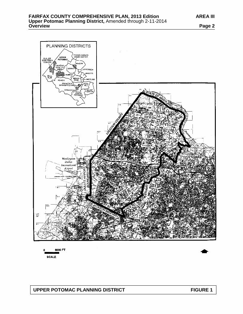
The Upper Potomac Planning District is located in the northwest portion of Fairfax County.
It is generally bounded on the north by the Potomac River, on the east by Difficult Run and Towlston Road, on the south by Lee Jackson Memorial Highway (Route 50) and on the west by Loudoun County and the Washington Dulles International Airport (see Figure 1).
The Upper Potomac Planning District encompasses approximately 47,500 acres which is
about 18 percent of the county’s land area. The character of the this planning district varies widely, from the semi-rural area of Great Falls along the Potomac River, to the urbanizing Reston Transit Station Areas and Dulles Suburban Center, to the suburban neighborhoods along West Ox Road and Lee Jackson Memorial Highway. The northern area which includes the Riverfront, Springvale and Hickory Community Planning Sectors contains the Great Falls Village area, several estates and large-lot subdivisions and low density residential areas.
The Greater Herndon and Reston Community Planning Sectors contain concentrations of
office, industrial and commercial development, surrounded by residential development. The Innovation Center Transit Station Area is located in the Greater Herndon Community Planning Sector, and the Reston Transit Station Areas are in the Reston Community Planning Sector. The Sully Community Planning Sector is located entirely within the Dulles Suburban Center and is partially developed with office, industrial and commercial development, with large vacant areas. The West Ox and Lee-Jackson Community Planning Sectors are characterized by suburban neighborhood development in the western areas in the vicinity of Chantilly, and low density residential development in the eastern area where the headwaters of the Difficult Run Watershed are located. The Lee-Jackson Community Planning Sector includes some commercial development along Lee Jackson Memorial Highway.
The planning district is served by community and neighborhood shopping centers in the
vicinity of Reston, Herndon, Chantilly, and Great Falls. Tysons Corner Center and Fair Oaks Mall are the nearest regional shopping centers.
The Upper Potomac Planning District reflects a pattern common to the county, that of
suburban and low density neighborhoods surrounding mixed-use centers. Planning objectives in this district seek to protect stable neighborhoods while maintaining employment, shopping and recreation opportunities.
The county has adopted a sewer service area map which defines areas where public sewer
is planned to be permitted. Several planning sectors in the Upper Potomac Planning District, including Riverfront, Springvale and Hickory, Reston and West Ox, have areas that are outside the Approved Sewer Service Area. These areas are planned for uses which do not require public sewer service and may be developed with residential densities or with nonresidential uses that do not require public sewer service. CONCEPT FOR FUTURE DEVELOPMENT The planning guidance provided by the Concept for Future Development is one of the principal elements used in formulating Area Plan recommendations. The Concept and its
FAIRFAX COUNTY COMPREHENSIVE PLAN, 2013 Edition AREA III Upper Potomac Planning District, Amended through 2-11-2014 Overview Page 2
UPPER POTOMAC PLANNING DISTRICT FIGURE 1
FAIRFAX COUNTY COMPREHENSIVE PLAN, 2013 Edition AREA III Upper Potomac Planning District, Amended through 2-11-2014 Overview Page 3 associated land use guidance recommend the predominant use and character envisioned for land areas within each Planning District although within the planning districts, there may be land areas planned for a distinctly different land use than that envisioned by the Concept. The Upper Potomac Planning District consists of areas that the Concept for Future Development recommends as Low Density Residential Areas, Suburban Neighborhoods and two Suburban Centers -- Dulles Suburban Center, and Fairfax Center Area. The Dulles Suburban Center, located primarily in UP6 Sully Community Planning Sector is subject to the Route 28 Tax District legislation. A portion of the Fairfax Center Area is located in the Upper Potomac Planning District; this area is addressed in the Fairfax Center Area Plan. The Reston Transit Station Areas are recommended in the Concept for Future Development for a mixture of office, retail and residential uses, with ancillary institutional uses. In the portion of the Upper Potomac Planning District that is north of the Dulles Airport Access Road, Suburban Neighborhoods are located in the vicinity of Reston and Sugarland Run (the area of the County surrounding the Town of Herndon.) South of the Dulles Airport Access Road, Suburban Neighborhoods border the Dulles Suburban Center and the Reston Transit Station Areas, Difficult Run, Lee-Jackson Memorial Highway and Fairfax Center. A wide range of housing types occurs in these areas.
Low Density Residential Areas are located primarily north of Leesburg Pike, along the
Potomac River shoreline. The areas around the Difficult Run stream valley and watershed in the eastern portion of the Upper Potomac Planning District are also designated as Low Density Residential Areas, due to the established low density character, the ecological significance, and environmental sensitivity of these areas. MAJOR OBJECTIVES
Planning objectives in the Upper Potomac Planning District are the following:
• Limit redevelopment of commercial, industrial and residential areas to intensities which will, upon redevelopment, result in acceptable levels of service and have minimal impact on stable residential areas, village centers, and other centers that serve villages or neighborhoods;
• Preserve stable residential areas through infill development of a character and
intensity/density that is compatible with existing residential uses; • Limit commercial encroachment into residential neighborhoods and establish a
clearly defined "edge" between commercial and residential areas; • Maintain the residential character development along the Route 7 Corridor and
prevent industrial, office, research and development (R&D) and retail commercial development in this corridor between the Dulles Airport Access Road and the Loudoun County line;
• Encourage pedestrian access to retail areas;
FAIRFAX COUNTY COMPREHENSIVE PLAN, 2013 Edition AREA III Upper Potomac Planning District, Amended through 2-11-2014 Overview Page 4
• Encourage the creation of additional parks, open space and recreation areas and acquire additional acreage in environmentally sensitive areas as part of the Environmental Quality Corridor program;
• Identify, preserve and promote awareness of heritage resources through research,
survey and community involvement; • Provide adequate facilities for the full range of human services, including child care,
senior citizen programs, health care, education, and recreational programs for all segments of the community;
• Continue active pursuit of affordable housing goals by enlarging the inventory and
maintaining and improving existing affordable units; and • Provide child care and elderly care facilities to meet the anticipated growth in needs.
DISTRICT-WIDE RECOMMENDATIONS Transportation
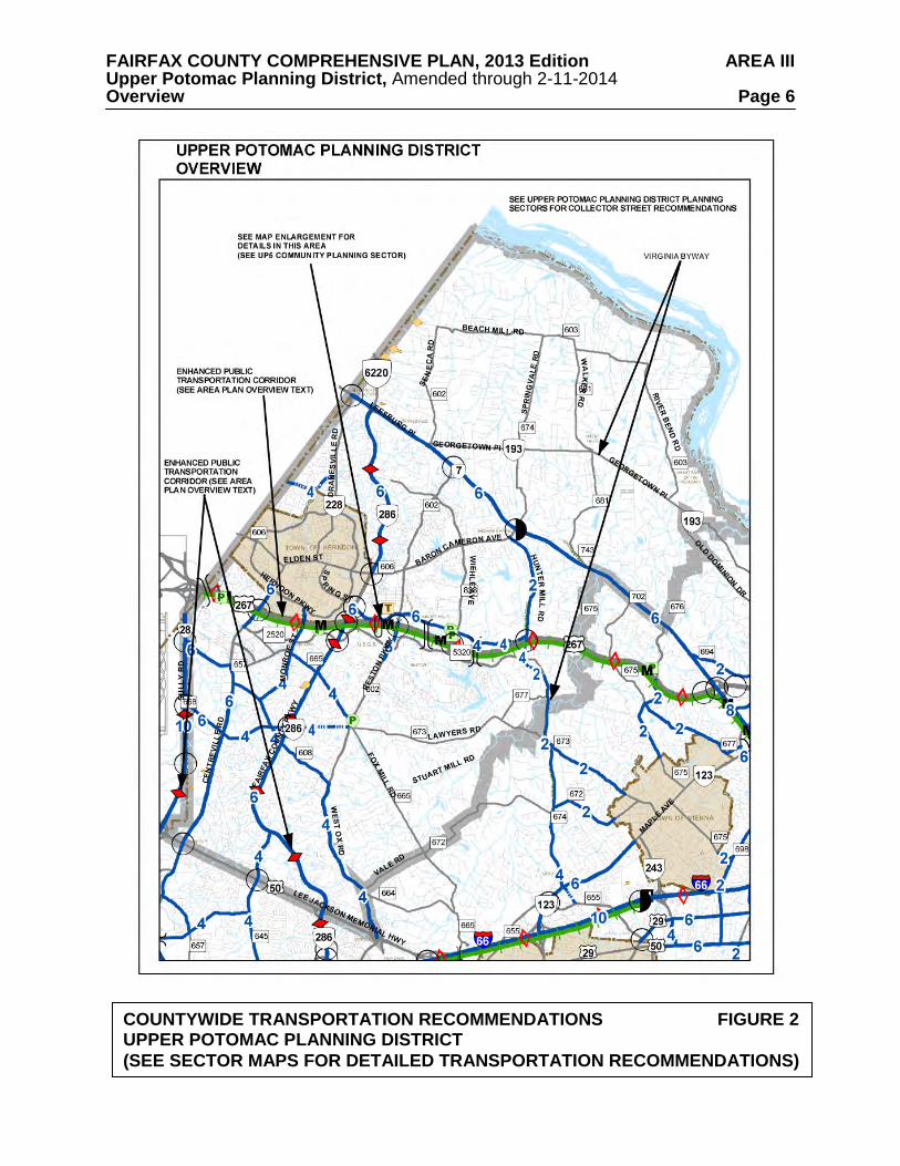
Travel within and through the Upper Potomac Planning District is affected by land uses and transportation facilities in adjacent districts, as well as throughout the Northern Virginia region. Therefore, the transportation network affecting the District is comprised of several elements, many of which relate to more extensive countywide facilities, services, and policies. The arterial and major collector roadways affecting the District are shown on Figure 2. Other countywide transportation elements are also depicted.
Within the discussion for each sector of the Planning District, a sector map depicting the
Transportation Plan recommendations in that sector is provided. More detail is provided on these sector maps than on the planning district map. The additional detail may relate to more local transportation issues that are difficult to present at the planning district scale. In some cases, such as interchange areas, a portion of the sector map has been enlarged so that the transportation recommendations are clearly identified. These enlargements of the sectors may also include guidance regarding the provision of access to selected land areas.
Georgetown Pike should be maintained within its existing right-of-way. Center turn lanes
and deceleration and acceleration lanes should be discouraged and curb cuts should not be allowed unless no other alternative exists. Georgetown Pike is commonly acknowledged to contain some traffic hazards. However, it is generally acceptable in its present condition to local residents. It has been designated a Virginia Byway. Major changes in alignment or widening the road would damage the scenic and historic character and the historic integrity of the Byway and have been strongly opposed by residents of adjacent areas. Planning efforts should focus on other means of dealing with traffic volume in order to maintain this Byway. Scenic and conservation easements should be sought along Georgetown Pike wherever practical for the preservation of the historic and scenic significance and beauty of the corridor.
Construction of the future westbound lanes of the four-lane Lawyers Boulevard between Cobra Drive and West Ox Road should be coordinated with the construction of Lawyers Boulevard between West Ox Road and the Fairfax County Parkway in order for these segments of Lawyers Boulevard to be open to traffic simultaneously.
FAIRFAX COUNTY COMPREHENSIVE PLAN, 2013 Edition AREA III Upper Potomac Planning District, Amended through 2-11-2014 Overview Page 5 Hunter Mill Road from Chain Bridge Road to Baron Cameron Avenue is a 7.2 mile roadway that is designated a Virginia Byway. To preserve the road’s scenic and historic character, planning efforts should focus on innovative ways of dealing with traffic volumes. The Hunter Mill Road Traffic Calming Study, sponsored by the Northern Virginia Regional Commission (NVRC) and completed in 2006, provides both a traffic calming conceptual plan for Hunter Mill Road, as well as context sensitive roadway design techniques. Housing
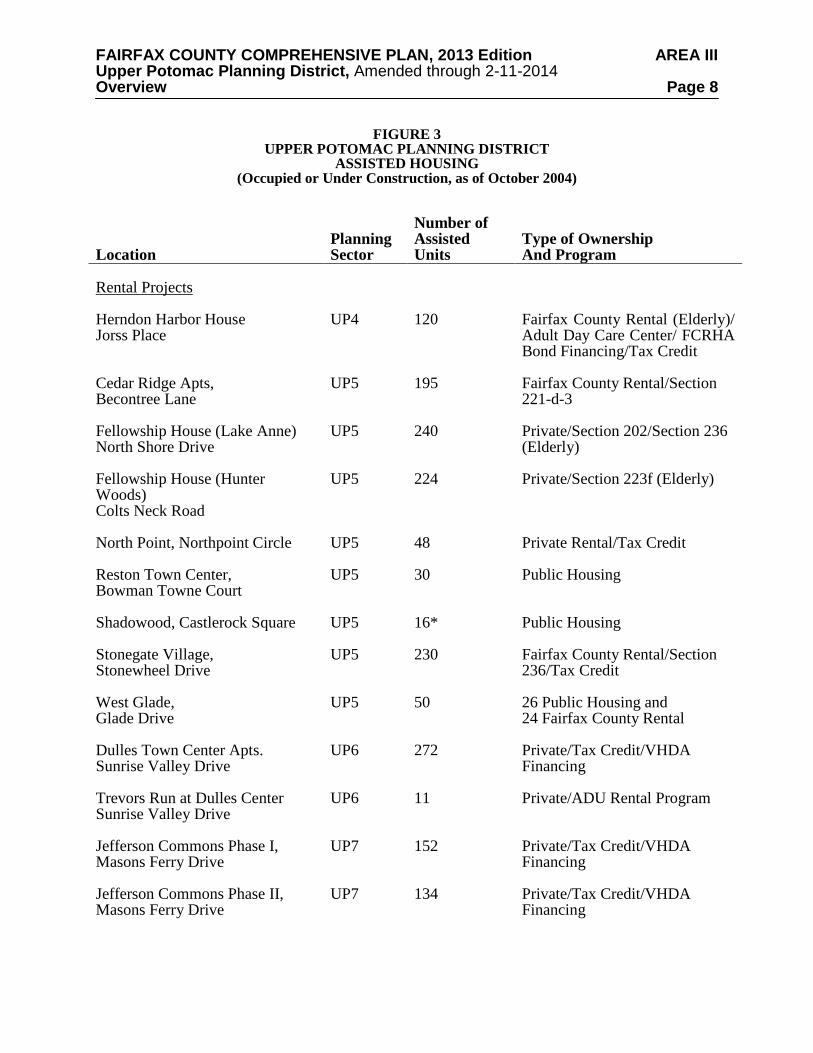
A list of existing, under construction, and proposed assisted housing for the Upper Potomac Planning District is shown in Figure 3. This list includes housing developments which, to the County’s knowledge, have received some type of housing assistance as defined below, but it should not be considered all inclusive.
Assisted housing includes programs which limit the amount of rent and the eligibility of
occupants based on income as a condition for the provision of financial assistance from Federal, State, or local sources. Some programs have time limits, and those units would no longer be considered “assisted” after income eligibility and rent limitations have been removed. The programs listed below are included as "assisted housing." Most programs provide assistance to privately owned housing developments. In some cases, multiple sources of financing may be used. The primary program and type of ownership is listed in the figure.
• Housing units owned or managed by the Fairfax County Redevelopment and Housing Authority (FCRHA) and operated by the Department of Housing and Community Development under the Federal Public Housing program or the local Fairfax County Rental Program;
• Housing units owned by the FCRHA and leased to the Fairfax-Falls Church
Community Services Board for use as group homes or to nonprofit groups for emergency housing;
• Federal Section 8 project based rent subsidy units, which are usually privately owned; • Units subsidized under Federal mortgage subsidy programs including Section 202
(Elderly), Section 811 (Disabled), Section 221(d)(3), Section 235 or Section 236. These units may be publicly owned but most are owned by private or nonprofit entities;
• Developments which were financed with FCRHA bonds where a portion of the units
must have reduced rents for tenants who meet income eligibility requirements;
• Tax Credit/VHDA financed projects with Low Income Housing Tax Credits and/or Virginia Housing Development Authority (VHDA) financing which establishes income eligibility requirements, many of which are privately owned;
• Nonprofit rental units and group homes serving nine or more individuals and owned
by private entities, which were assisted with loans or grants from the Community Development Block Grant (CDBG), Section 108 loans, Home Investment Partnerships Program (HOME), or Fairfax County Housing Trust Fund;
FAIRFAX COUNTY COMPREHENSIVE PLAN, 2013 Edition AREA III Upper Potomac Planning District, Amended through 2-11-2014 Overview Page 6
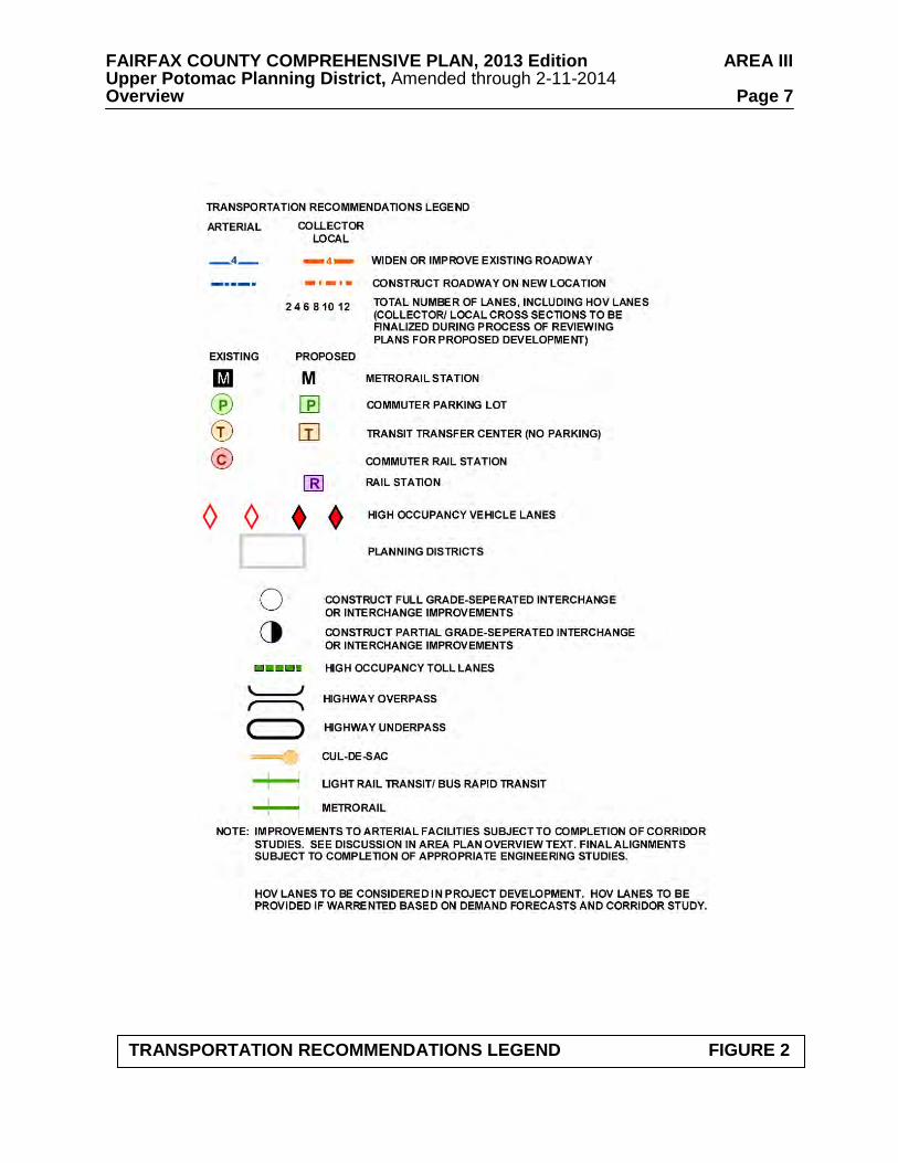
COUNTYWIDE TRANSPORTATION RECOMMENDATIONS FIGURE 2 UPPER POTOMAC PLANNING DISTRICT (SEE SECTOR MAPS FOR DETAILED TRANSPORTATION RECOMMENDATIONS)
FAIRFAX COUNTY COMPREHENSIVE PLAN, 2013 Edition AREA III Upper Potomac Planning District, Amended through 2-11-2014 Overview Page 7
TRANSPORTATION RECOMMENDATIONS LEGEND FIGURE 2
FAIRFAX COUNTY COMPREHENSIVE PLAN, 2013 Edition AREA III Upper Potomac Planning District, Amended through 2-11-2014 Overview Page 8
FIGURE 3 UPPER POTOMAC PLANNING DISTRICT
ASSISTED HOUSING (Occupied or Under Construction, as of October 2004)
Location
Planning Sector
Number of Assisted Units
Type of Ownership And Program
Rental Projects
Herndon Harbor House Jorss Place
UP4
120
Fairfax County Rental (Elderly)/ Adult Day Care Center/ FCRHA Bond Financing/Tax Credit
Cedar Ridge Apts, Becontree Lane
UP5
195
Fairfax County Rental/Section 221-d-3
Fellowship House (Lake Anne) North Shore Drive
UP5
240
Private/Section 202/Section 236 (Elderly)
Fellowship House (Hunter Woods) Colts Neck Road
UP5
224
Private/Section 223f (Elderly)
North Point, Northpoint Circle
UP5 48 Private Rental/Tax Credit
Reston Town Center, Bowman Towne Court
UP5
30 Public Housing
Shadowood, Castlerock Square
UP5
16*
Public Housing
Stonegate Village, Stonewheel Drive
UP5
230
Fairfax County Rental/Section 236/Tax Credit
West Glade, Glade Drive
UP5
50 26 Public Housing and 24 Fairfax County Rental
Dulles Town Center Apts. Sunrise Valley Drive
UP6
272
Private/Tax Credit/VHDA Financing
Trevors Run at Dulles Center Sunrise Valley Drive
UP6
11
Private/ADU Rental Program
Jefferson Commons Phase I, Masons Ferry Drive
UP7
152
Private/Tax Credit/VHDA Financing
Jefferson Commons Phase II, Masons Ferry Drive
UP7
134
Private/Tax Credit/VHDA Financing
FAIRFAX COUNTY COMPREHENSIVE PLAN, 2013 Edition AREA III Upper Potomac Planning District, Amended through 2-11-2014 Overview Page 9
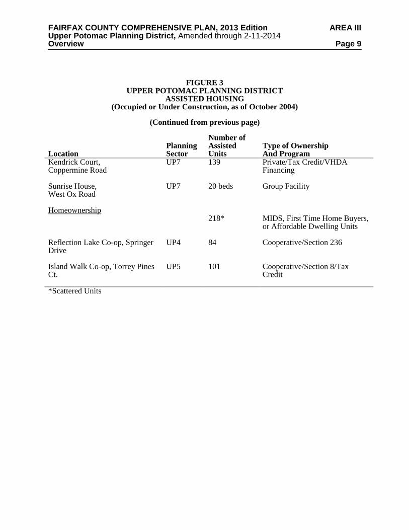
FIGURE 3 UPPER POTOMAC PLANNING DISTRICT
ASSISTED HOUSING (Occupied or Under Construction, as of October 2004)
(Continued from previous page)
Location
Planning Sector
Number of Assisted Units
Type of Ownership And Program
Kendrick Court, Coppermine Road
UP7 139 Private/Tax Credit/VHDA Financing
Sunrise House, West Ox Road
UP7
20 beds Group Facility
Homeownership 218*
MIDS, First Time Home Buyers, or Affordable Dwelling Units
Reflection Lake Co-op, Springer Drive
UP4
84 Cooperative/Section 236
Island Walk Co-op, Torrey Pines Ct.
UP5 101 Cooperative/Section 8/Tax Credit
*Scattered Units
FAIRFAX COUNTY COMPREHENSIVE PLAN, 2013 Edition AREA III Upper Potomac Planning District, Amended through 2-11-2014 Overview Page 10
• Moderate Income Direct Sales (MIDS) program units which are for sale to income-eligible, first time home buyers with financial assistance provided in return for control of the re-sale price of the home; and
• Affordable Dwelling Units (ADU) for sale or for rent to serve households with
incomes up to 70% of Metropolitan Statistical Area (MSA) median income and which are required to be included in certain housing developments of 50 or more units pursuant to Article 2, Part 8 of the Fairfax County Zoning Ordinance. In some instances, units created under the ADU Program may be owned by the FCRHA or a nonprofit organization; if so, they would be considered in one of the other categories above.
In many cases the assisted units represent only a portion of a larger development. Only the number of assisted units is included on the figure. Also, the housing listed as part of the Section 8 program is only that where the Section 8 rent subsidy is tied to specific housing units (project based). Housing where eligible tenants are receiving assistance through the Section 8 Housing Choice Voucher Rental program or where the subsidy transfers with the tenant is not listed since the units change continuously as tenants move. Countywide, at the end of 2002, over 3,200 families living in Fairfax County were assisted with tenant-based vouchers. Finally, for some proposed developments where a zoning proffer requires the provision of low and/or moderate income housing, but no specific program (such as MIDS) is identified in the proffer, the type of program is listed as Unknown. Environment The Upper Potomac Planning District contains a portion of the Occoquan Reservoir watershed, the northern and western portions of the Difficult Run watershed, the entirety of Fairfax County’s portion of the Sugarland Run watershed, most of Fairfax County’s portion of the Horsepen Creek watershed and all of the Pond Branch and Nichols Run watersheds. The northern boundary of the planning district is the shoreline of the Potomac River, which is mostly park or preserved lands. The area near the eastern edge of Dulles International Airport contains a small amount of land impacted by aircraft noise. The northern and southeastern parts of the planning district have a semi-rural character, with a large number of stream valleys and other high quality plant and animal habitat areas meriting preservation. All such stream valleys and high quality habitat areas would qualify for designation as Environmental Quality Corridors; many, but not all, of the stream valleys have been protected as Resource Protection Areas pursuant to the Chesapeake Bay Preservation Ordinance. Like portions of the Pohick, Lower Potomac, Vienna and Bull Run Planning Districts, this area is vital to the preservation of Fairfax County's remaining natural resources. Reston and Herndon, in the central portion of the planning district, as well as other portions of the planning district, have largely been developed and are characterized by higher development densities; natural resources in these areas are not as extensive as they are in the semi-rural areas. In these more densely developed areas, a focus on pollution control and reclamation is appropriate. A major environmental stewardship objective in the Upper Potomac Planning District is the protection and restoration of streams. Watershed management plans have been, or are being, developed for all watersheds in the County; implementation of the watershed management plan recommendations for streams in this planning district is critical to the protection and restoration of these streams. Streams located in semi-rural areas, such as the Nichols Run watershed, the Pond Branch watershed and portions of the Difficult Run watershed, are some of the relatively
FAIRFAX COUNTY COMPREHENSIVE PLAN, 2013 Edition AREA III Upper Potomac Planning District, Amended through 2-11-2014 Overview Page 11 few streams in the County that remain in good condition. The high quality of these streams should be supported through the maintenance of the low density character of these semi-rural areas and the pursuit of development designs that will minimize impervious cover and maximize the replication of natural hydrologic conditions. Within this planning district, two areas have been certified by the National Wildlife Federation as “Community Wildlife Habitats.” These areas are Reston (Planning Sector UP5) and Great Falls (the Riverfront Community Planning Sector (UP1), Springvale Community Planning Sector (UP2) and Hickory Community Planning Sector (UP3) north of Leesburg Pike and west of Difficult Run). Great Falls has many large and old trees. The protection and restoration of streams and other ecological resources should be a central consideration during the land development process. Toward that end, the following guidelines are suggested for the Upper Potomac Planning District: • Retain a low density character in the Nichols Run and Pond Branch watersheds as well as
in those portions of the Difficult Run and Sugarland Run watersheds that have such a character.
• Implement the Environmental Quality Corridor policy to:
- Preserve ecologically significant habitat areas; - Protect steep slopes, problem soil areas and wetlands.
Large undeveloped areas, particularly where adjacent to already protected areas, provide ecological and water quality benefits. Protection of these areas should be encouraged. In Upper Potomac Planning Sectors UP1, UP2 and UP3, encourage the use of pervious and semi-pervious materials for paved areas (e.g. parking lots, driveways, walkways and patios). All new development and redeveloped properties in the Riverfront (UP1), Springvale (UP2), and Hickory (UP3) north and east of Leesburg Pike community planning sectors are strongly encouraged to bury all overhead utilities while protecting the valuable Heritage Trees and significant treescapes, and improving the safety and quality of life in the community.
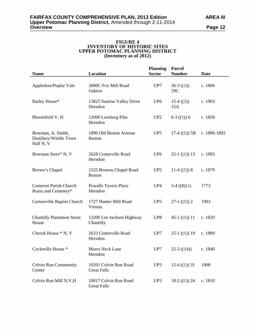
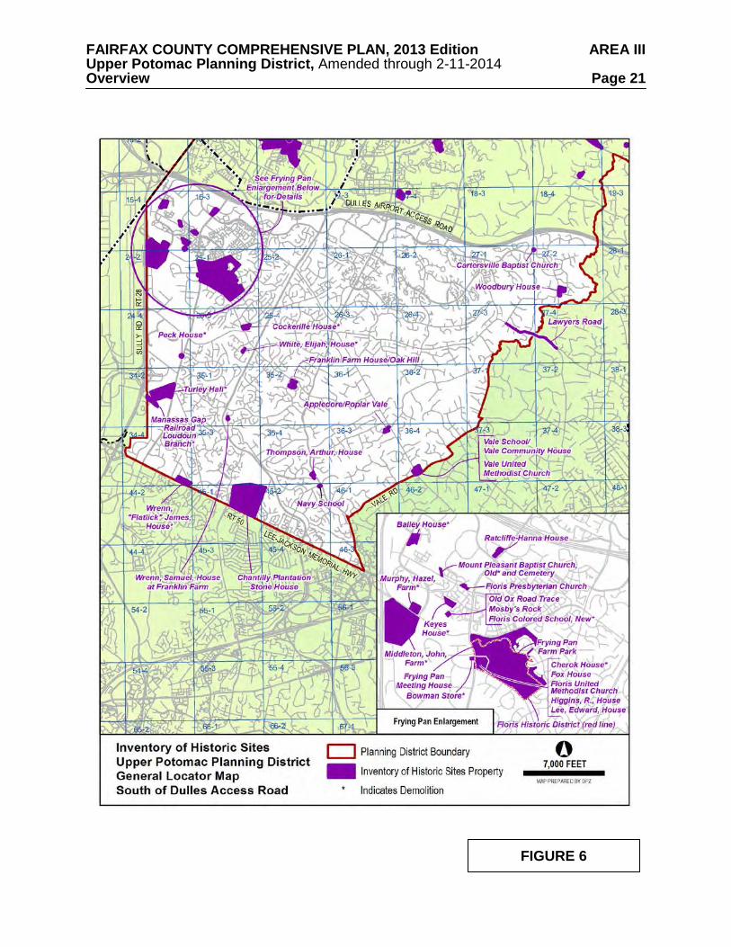
Heritage Resources The Upper Potomac Planning District contains both known and potential heritage resources. A list of those heritage resources included in Fairfax County's Inventory of Historic Sites is shown on Figure 4, and a map of those resources is shown on Figures 5 and 6. The Inventory is open-ended and continues to grow. For information about these and other historic sites, consult the Fairfax County Department of Planning and Zoning. Identified heritage resources include:
• Potomac (Patowmack) Canal Historic District – This National Register Historic District in Great Falls Park contains remains of the Potomac Canal, one of the earliest canals in the United States.
• Dranesville Tavern – This rural inn on Leesburg Pike served travelers during the 18th
and 19th centuries. It is protected by a County Historic Overlay District.
FAIRFAX COUNTY COMPREHENSIVE PLAN, 2013 Edition AREA III Upper Potomac Planning District, Amended through 2-11-2014 Overview Page 12
FIGURE 4 INVENTORY OF HISTORIC SITES
UPPER POTOMAC PLANNING DISTRICT (Inventory as of 2012)
Name Location Planning Sector
Parcel Number Date
Appledore/Poplar Vale
3000C Fox Mill Road Oakton
UP7 36-3 ((1)) 29C
c. 1806
Bailey House* 13825 Sunrise Valley Drive Herndon
UP6 15-4 ((2)) 15A
c. 1903
Bloomfield V, H
12000 Leesburg Pike Herndon
UP2 6-3 ((1)) 6 c. 1858
Bowman, A. Smith, Distillery/Wiehle Town Hall N, V
1890 Old Reston Avenue Reston
UP5 17-4 ((1)) 5B c. 1890-1892
Bowman Store* N, V 2628 Centreville Road Herndon
UP6 25-1 ((1)) 13 c. 1893
Brown’s Chapel 1525 Browns Chapel Road Reston
UP5 11-4 ((1)) 8 c. 1879
Cameron Parish Church Ruins and Cemetery*
Powells Tavern Place Herndon
UP4 5-4 ((8)) G 1773
Cartersville Baptist Church
1727 Hunter Mill Road Vienna
UP5 27-1 ((1)) 2 1903
Chantilly Plantation Stone House
13200 Lee Jackson Highway Chantilly
UP8 45-1 ((1)) 11 c. 1820
Cherok House * N, V 2633 Centreville Road Herndon
UP7 25-1 ((1)) 19 c. 1889
Cockerille House *
Mares Neck Lane Herndon
UP7 25-3 ((14)) c. 1840
Colvin Run Community Center
10201 Colvin Run Road Great Falls
UP3 12-4 ((1)) 31 1908
Colvin Run Mill N,V,H 10017 Colvin Run Road Great Falls
UP3 18-2 ((1)) 24 c. 1810
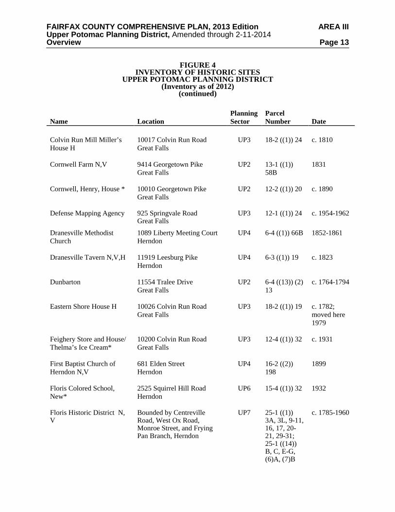
FAIRFAX COUNTY COMPREHENSIVE PLAN, 2013 Edition AREA III Upper Potomac Planning District, Amended through 2-11-2014 Overview Page 13
FIGURE 4 INVENTORY OF HISTORIC SITES
UPPER POTOMAC PLANNING DISTRICT (Inventory as of 2012)
(continued)
Name Location Planning Sector
Parcel Number Date
Colvin Run Mill Miller’s House H
10017 Colvin Run Road Great Falls
UP3 18-2 ((1)) 24 c. 1810
Cornwell Farm N,V
9414 Georgetown Pike Great Falls
UP2 13-1 ((1)) 58B
1831
Cornwell, Henry, House *
10010 Georgetown Pike Great Falls
UP2 12-2 ((1)) 20 c. 1890
Defense Mapping Agency 925 Springvale Road Great Falls
UP3 12-1 ((1)) 24 c. 1954-1962
Dranesville Methodist Church
1089 Liberty Meeting Court Herndon
UP4 6-4 ((1)) 66B 1852-1861
Dranesville Tavern N,V,H 11919 Leesburg Pike Herndon
UP4 6-3 ((1)) 19 c. 1823
Dunbarton 11554 Tralee Drive Great Falls
UP2 6-4 ((13)) (2) 13
c. 1764-1794
Eastern Shore House H 10026 Colvin Run Road Great Falls
UP3 18-2 ((1)) 19 c. 1782; moved here 1979
Feighery Store and House/ Thelma’s Ice Cream*
10200 Colvin Run Road Great Falls
UP3 12-4 ((1)) 32 c. 1931
First Baptist Church of Herndon N,V
681 Elden Street Herndon
UP4 16-2 ((2)) 198
1899
Floris Colored School, New*
2525 Squirrel Hill Road Herndon
UP6 15-4 ((1)) 32 1932
Floris Historic District N, V
Bounded by Centreville Road, West Ox Road, Monroe Street, and Frying Pan Branch, Herndon
UP7 25-1 ((1)) 3A, 3L, 9-11, 16, 17, 20-21, 29-31; 25-1 ((14)) B, C, E-G, (6)A, (7)B
c. 1785-1960
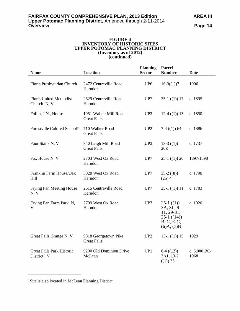
FAIRFAX COUNTY COMPREHENSIVE PLAN, 2013 Edition AREA III Upper Potomac Planning District, Amended through 2-11-2014 Overview Page 14
FIGURE 4 INVENTORY OF HISTORIC SITES
UPPER POTOMAC PLANNING DISTRICT (Inventory as of 2012)
(continued)
Name Location Planning Sector
Parcel Number Date
Floris Presbyterian Church 2472 Centreville Road
Herndon
UP6 16-3((1))7 1906
Floris United Methodist Church N, V
2629 Centreville Road Herndon
UP7 25-1 ((1)) 17 c. 1895
Follin, J.N., House 1051 Walker Mill Road Great Falls
UP3 12-4 ((1)) 13 c. 1850
Forestville Colored School*
710 Walker Road Great Falls
UP2 7-4 ((1)) 64 c. 1886
Four Stairs N, V 840 Leigh Mill Road Great Falls
UP3 13-3 ((1)) 20Z
c. 1737
Fox House N, V 2703 West Ox Road Herndon
UP7 25-1 ((1)) 20 1897/1898
Franklin Farm House/Oak Hill
3020 West Ox Road Herndon
UP7 35-2 ((8)) (25) 4
c. 1790
Frying Pan Meeting House N, V
2615 Centreville Road Herndon
UP7 25-1 ((1)) 11 c. 1783
Frying Pan Farm Park N, V
2709 West Ox Road Herndon
UP7 25-1 ((1)) 3A, 3L, 9-11, 29-31; 25-1 ((14)) B, C, E-G, (6)A, (7)B
c. 1920
Great Falls Grange N, V
9818 Georgetown Pike Great Falls
UP2 13-1 ((1)) 15 1929
Great Falls Park Historic District1 V
9200 Old Dominion Drive McLean
UP1 8-4 ((12)) 3A1, 13-2 ((1)) 35
c. 6,000 BC-1968
1Site is also located in McLean Planning District
FAIRFAX COUNTY COMPREHENSIVE PLAN, 2013 Edition AREA III Upper Potomac Planning District, Amended through 2-11-2014 Overview Page 15
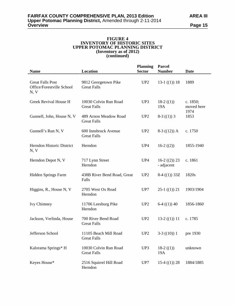
FIGURE 4 INVENTORY OF HISTORIC SITES
UPPER POTOMAC PLANNING DISTRICT (Inventory as of 2012)
(continued)
Name Location Planning Sector
Parcel Number Date
Great Falls Post Office/Forestville School N, V
9812 Georgetown Pike Great Falls
UP2 13-1 ((1)) 18 1889
Greek Revival House H 10030 Colvin Run Road Great Falls
UP3 18-2 ((1)) 19A
c. 1850; moved here 1974
Gunnell, John, House N, V
489 Arnon Meadow Road Great Falls
UP2 8-3 ((1)) 3 1853
Gunnell’s Run N, V 600 Innsbruck Avenue Great Falls
UP2 8-3 ((12)) A c. 1750
Herndon Historic District N, V
Herndon UP4 16-2 ((2)) 1855-1940
Herndon Depot N, V 717 Lynn Street Herndon
UP4 16-2 ((2)) 23 - adjacent
c. 1861
Hidden Springs Farm 438B River Bend Road, Great Falls
UP2 8-4 ((1)) 33Z 1820s
Higgins, R., House N, V
2705 West Ox Road Herndon
UP7 25-1 ((1)) 21 1903/1904
Ivy Chimney 11706 Leesburg Pike Herndon
UP2 6-4 ((1)) 40 1856-1860
Jackson, Verlinda, House 700 River Bend Road Great Falls
UP2 13-2 ((1)) 11 c. 1785
Jefferson School
11105 Beach Mill Road Great Falls
UP2 3-3 ((10)) 1 pre 1930
Kalorama Springs* H
10030 Colvin Run Road Great Falls
UP3 18-2 ((1)) 19A
unknown
Keyes House* 2516 Squirrel Hill Road Herndon
UP7 15-4 ((1)) 28 1884/1885
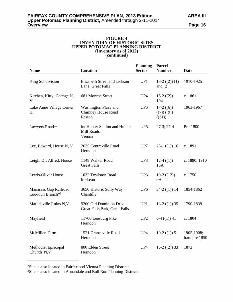
FAIRFAX COUNTY COMPREHENSIVE PLAN, 2013 Edition AREA III Upper Potomac Planning District, Amended through 2-11-2014 Overview Page 16
FIGURE 4 INVENTORY OF HISTORIC SITES
UPPER POTOMAC PLANNING DISTRICT (Inventory as of 2012)
(continued)
Name Location Planning Sector
Parcel Number Date
King Subdivision Elizabeth Street and Jackson
Lane, Great Falls
UP1 13-2 ((2)) (1) and (2)
1910-1925
Kitchen, Kitty, Cottage N, V
681 Monroe Street UP4 16-2 ((2)) 194
c. 1861
Lake Anne Village Center H
Washington Plaza and Chimney House Road Reston
UP5 17-2 ((6)) ((7)) ((9)) ((31))
1963-1967
Lawyers Road*2 b/t Hunter Station and Hunter Mill Roads Vienna
UP5 27-3; 27-4 Pre-1800
Lee, Edward, House N, V
2625 Centreville Road Herndon
UP7 25-1 ((1)) 16 c. 1891
Leigh, Dr. Alfred, House 1148 Walker Road Great Falls
UP3 12-4 ((1)) 15A
c. 1890, 1910
Lewis-Oliver House
1032 Towlston Road McLean
UP3 19-2 ((12)) 9A
c. 1750
Manassas Gap Railroad Loudoun Branch*3
3650 Historic Sully Way Chantilly
UP6 34-2 ((1)) 14 1854-1862
Matildaville Ruins N,V 9200 Old Dominion Drive Great Falls Park, Great Falls
UP1 13-2 ((1)) 35 1790-1839
Mayfield 11700 Leesburg Pike Herndon
UP2 6-4 ((1)) 41 c. 1804
McMillen Farm 1521 Dranesville Road Herndon
UP4 10-2 ((1)) 5 1905-1908; barn pre 1850
Methodist Episcopal Church N,V
800 Elden Street Herndon
UP4 16-2 ((2)) 33 1872
2Site is also located in Fairfax and Vienna Planning Districts 3Site is also located in Annandale and Bull Run Planning Districts
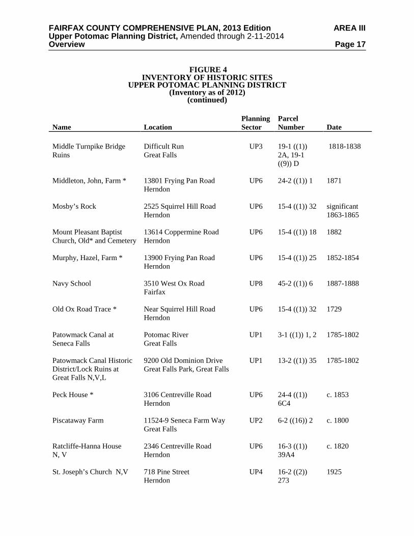
FAIRFAX COUNTY COMPREHENSIVE PLAN, 2013 Edition AREA III Upper Potomac Planning District, Amended through 2-11-2014 Overview Page 17
FIGURE 4 INVENTORY OF HISTORIC SITES
UPPER POTOMAC PLANNING DISTRICT (Inventory as of 2012)
(continued)
Name Location Planning Sector
Parcel Number Date
Middle Turnpike Bridge Ruins
Difficult Run Great Falls
UP3 19-1 ((1)) 2A, 19-1 ((9)) D
1818-1838
Middleton, John, Farm * 13801 Frying Pan Road Herndon
UP6 24-2 ((1)) 1 1871
Mosby’s Rock 2525 Squirrel Hill Road Herndon
UP6 15-4 ((1)) 32 significant 1863-1865
Mount Pleasant Baptist Church, Old* and Cemetery
13614 Coppermine Road Herndon
UP6 15-4 ((1)) 18 1882
Murphy, Hazel, Farm *
13900 Frying Pan Road Herndon
UP6 15-4 ((1)) 25 1852-1854
Navy School
3510 West Ox Road Fairfax
UP8 45-2 ((1)) 6 1887-1888
Old Ox Road Trace *
Near Squirrel Hill Road Herndon
UP6 15-4 ((1)) 32 1729
Patowmack Canal at Seneca Falls
Potomac River Great Falls
UP1 3-1 ((1)) 1, 2
1785-1802
Patowmack Canal Historic District/Lock Ruins at Great Falls N,V,L
9200 Old Dominion Drive Great Falls Park, Great Falls
UP1 13-2 ((1)) 35 1785-1802
Peck House * 3106 Centreville Road Herndon
UP6 24-4 ((1)) 6C4
c. 1853
Piscataway Farm
11524-9 Seneca Farm Way Great Falls
UP2 6-2 ((16)) 2 c. 1800
Ratcliffe-Hanna House N, V
2346 Centreville Road Herndon
UP6 16-3 ((1)) 39A4
c. 1820
St. Joseph’s Church N,V 718 Pine Street Herndon
UP4 16-2 ((2)) 273
1925
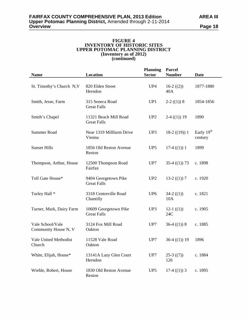
FAIRFAX COUNTY COMPREHENSIVE PLAN, 2013 Edition AREA III Upper Potomac Planning District, Amended through 2-11-2014 Overview Page 18
FIGURE 4 INVENTORY OF HISTORIC SITES
UPPER POTOMAC PLANNING DISTRICT (Inventory as of 2012)
(continued)
Name Location Planning Sector
Parcel Number Date
St. Timothy’s Church N,V 820 Elden Street
Herndon
UP4 16-2 ((2)) 40A
1877-1880
Smith, Jesse, Farm 315 Seneca Road Great Falls
UP1 2-2 ((1)) 8 1854-1856
Smith’s Chapel
11321 Beach Mill Road Great Falls
UP2 2-4 ((1)) 19 1890
Summer Road Near 1319 Millfarm Drive Vienna
UP3 18-2 ((19)) 1 Early 19th century
Sunset Hills 1856 Old Reston Avenue Reston
UP5 17-4 ((1)) 1 1899
Thompson, Arthur, House
12500 Thompson Road Fairfax
UP7 35-4 ((1)) 73 c. 1898
Toll Gate House*
9404 Georgetown Pike Great Falls
UP2 13-2 ((1)) 7 c. 1920
Turley Hall * 3318 Centreville Road Chantilly
UP6 34-2 ((1)) 10A
c. 1821
Turner, Mark, Dairy Farm 10609 Georgetown Pike Great Falls
UP3 12-1 ((1)) 24C
c. 1905
Vale School/Vale Community House N, V
3124 Fox Mill Road Oakton
UP7 36-4 ((1)) 8 c. 1885
Vale United Methodist Church
11528 Vale Road Oakton
UP7 36-4 ((1)) 19 1896
White, Elijah, House* 13141A Lazy Glen Court Herndon
UP7 25-3 ((7)) 126
c. 1884
Wiehle, Robert, House 1830 Old Reston Avenue Reston
UP5 17-4 ((1)) 3 c. 1895
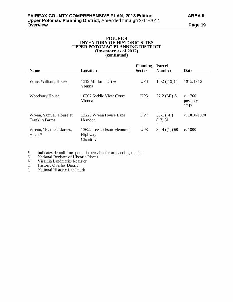
FAIRFAX COUNTY COMPREHENSIVE PLAN, 2013 Edition AREA III Upper Potomac Planning District, Amended through 2-11-2014 Overview Page 19
FIGURE 4 INVENTORY OF HISTORIC SITES
UPPER POTOMAC PLANNING DISTRICT (Inventory as of 2012)
(continued)
Name Location Planning Sector
Parcel Number Date
Wine, William, House
1319 Millfarm Drive Vienna
UP3 18-2 ((19)) 1 1915/1916
Woodbury House 10307 Saddle View Court Vienna
UP5 27-2 ((4)) A c. 1760, possibly 1747
Wrenn, Samuel, House at Franklin Farms
13223 Wrenn House Lane Herndon
UP7 35-1 ((4)) (17) 31
c. 1810-1820
Wrenn, “Flatlick” James, House*
13622 Lee Jackson Memorial Highway Chantilly
UP8 34-4 ((1)) 60 c. 1800
* indicates demolition: potential remains for archaeological site N National Register of Historic Places V Virginia Landmarks Register H Historic Overlay District L National Historic Landmark
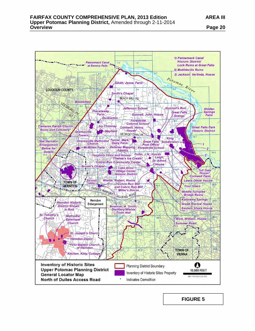
FAIRFAX COUNTY COMPREHENSIVE PLAN, 2013 Edition AREA III Upper Potomac Planning District, Amended through 2-11-2014 Overview Page 20
FIGURE 5
FAIRFAX COUNTY COMPREHENSIVE PLAN, 2013 Edition AREA III Upper Potomac Planning District, Amended through 2-11-2014 Overview Page 21
FIGURE 6
FAIRFAX COUNTY COMPREHENSIVE PLAN, 2013 Edition AREA III Upper Potomac Planning District, Amended through 2-11-2014 Overview Page 22
• Colvin Run Mill and Miller’s House – This early 19th century gristmill and miller’s house built on Difficult Run are protected by a County Historic Overlay District. The mill is also a National Register site.
• Herndon Historic District – Beginning in the mid 19th century and heavily influenced
by the railroad, this village was the beginning of a major residential community in Fairfax County. This National Register Historic District is comprised mostly of areas protected by local Heritage Preservation Overlay Districts administered by the Town of Herndon.
There are known and potential heritage resources located along the 7.2-mile length of Hunter Mill Road, a portion of which lies within this Planning District. Such resources include sites or structures that are evidence of Native American occupation, pre-Revolutionary and Civil War activities, and the County’s agrarian past. Actions to document these heritage resources, and to protect and preserve those that are determined by the County to be of historic or archaeological significance are underway and should be encouraged. Hunter Mill Road has been determined to be eligible for listing in the Virginia Landmarks Register and the National Register of Historic Places. The determination of eligibility is the first step in the process for being listed in the Virginia Landmarks and/or the National Register of Historic Places. Hunter Mill Road has also been designated as a Virginia Byway. Georgetown Pike has also been determined to be eligible for listing in the Virginia Landmarks Register and National Register of Historic Places. It has been designated as a Virginia Byway. The Great Falls Survey Report of Historic Properties identified historically significant sites which are now listed in the County Inventory of Historic Sites. Great Falls Grange is also listed in the Virginia Landmarks Register and National Register of Historic Places. Additional sites included in this survey are potentially significant heritage resources and should be further evaluated. Other heritage resources including those protected by Historic Overlay Districts, or listed in the National or Virginia Landmarks Register are also shown on Figure 4, and may be identified in the text and recommendations section. The Fairfax County Inventory of Historic Sites, the Virginia Landmarks Register, the National Register of Historic Places, and the County's Historic Overlay Districts promote the recognition of sites with historic, architectural and archaeological significance. Designation confers public recognition and can offer incentives for preservation to the property owner. The County Inventory of Historic Sites includes properties which meet certain eligibility criteria and are officially designated by the County's History Commission. In addition to historic, architectural or archaeological significance, property that serves as a focus of community identity and pride may also be recognized. The benefits of designation include public recognition of the structure's significance and enhanced support for preservation. Owners of properties included in the Inventory may meet with the County's Architectural Review Board on a voluntary basis to review proposed changes to their properties. Project review and approval by the County's Architectural Review Board may be required in accordance with the guidance provided by the Policy Plan under Land Use Appendix 9 Residential Development Criteria 8 Heritage Resources.
FAIRFAX COUNTY COMPREHENSIVE PLAN, 2013 Edition AREA III Upper Potomac Planning District, Amended through 2-11-2014 Overview Page 23 The Virginia Landmarks Register and the National Register of Historic Places also officially recognize properties meeting specific criteria. Like the County Inventory, benefits of designation include public recognition and enhanced support for preservation. In addition, projects that are funded or sanctioned by Federal government agencies may require review to determine if they will have any effect on properties listed in or eligible for listing in the National Register for Historic Places. Alternatives must be explored to avoid or reduce harm to the historic properties. National Historic Landmarks are properties listed in the National Register of Historic Places which “possess exceptional value or quality in illustrating and interpreting the heritage of the United States.” These properties are of importance on a national level and are considered irreplaceable. Fewer than 5% of sites listed in the National Register are granted this designation. The County's Historic Overlay District is a zoning tool used to regulate proposed new construction and changes to existing structures in areas containing heritage resources to ensure compatibility with the resources. Site design, facades, demolition, and building materials must be reviewed and approved by the County's Architectural Review Board. In those areas where significant heritage resources have been recorded, an effort should be made to preserve them for the benefit of present and future generations. If preservation is not feasible then the threatened resources should be thoroughly recorded and, in the case of archaeological resources, the data recovered in accordance with countywide policies. Prior to any zoning action, the Department of Planning and Zoning should be consulted as to what architectural surveys are necessary to document any on-site cultural resources. Staff from the Cultural Resource Management and Protection Section of the Park Authority should be consulted to develop a scope of work for any on-site archaeological surveys prior to any development or ground disturbing activity. Should architectural or archaeological resources be discovered that are potentially eligible for inclusion in the National Register, further survey and testing should occur to evaluate these resources as to their eligibility. If such resources are found to be eligible, mitigation measures should be developed that may include avoidance, documentation, data recovery excavation and interpretation. Public Facilities
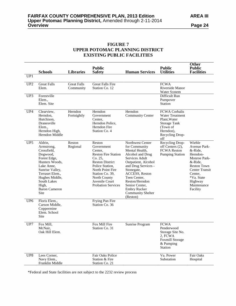
Existing public facilities located within the Upper Potomac Planning District and those for which a future need has already been identified are included on Figure 7. Major expansions of existing facilities (with the exception of Federal or State facilities) or uses of land that are distinctly different than the use of the public facility must be considered by the County Planning Commission through provisions outlined in Section 15.2-2232 of the Code of Virginia. For these existing facilities minor expansions which are in keeping with the character of the facility may be considered in conformance with the Plan.
A number of public facilities have been identified as future needs in this Planning District.
These projects are included for informational purposes and in most cases will require a 2232 Review public hearing before the Planning Commission prior to being established. Those facilities for which a specific location for future construction has been identified are also listed in the sector recommendations and may be considered a feature of the Comprehensive Plan upon review by the Planning Director and concurrence by the Planning Commission. If such feature shown determination is made, these projects will not require a future 2232 Review public hearing. The following public facilities are identified as future needs in the Upper Potomac Planning District:
FAIRFAX COUNTY COMPREHENSIVE PLAN, 2013 Edition AREA III Upper Potomac Planning District, Amended through 2-11-2014 Overview Page 24
FIGURE 7
UPPER POTOMAC PLANNING DISTRICT EXISTING PUBLIC FACILITIES
Schools
Libraries
Public Safety
Human Services
Public Utilities
Other Public Facilities
UP1
UP2 Great Falls Elem.
Great Falls Community
Great Falls Fire Station Co. 12
FCWA Riverside Manor Water System
UP3 Forestville Elem., Elem. Site
Difficult Run Pumpover Station
UP4 Clearview, Herndon, Hutchison, Dranesville Elem., Herndon High, Herndon Middle
Herndon Fortnightly
Herndon Government Center, Herndon Police, Herndon Fire Station Co. 4
Herndon Community Center
FCWA Corbalis Water Treatment Plant,Water Storage Tank (Town of Herndon), Recycling Drop-off
UP5 Aldrin, Armstrong, Crossfield, Dogwood, Forest Edge, Hunters Woods, Lake Anne, Sunrise Valley, Terraset Elem., Hughes Middle, South Lakes High, Baron Cameron Site
Reston Regional
Reston Government Center, Reston Fire Station Co. 25, Reston District Police Station, North Point Fire Station Co. 39, North County Juvenile Court Probation Services
Northwest Center for Community Mental Health, Alcohol and Drug Services Adult Outpatient, Alcohol and Drug Services - Stonegate, ACCESS, Reston Teen Center, Reston/Herndon Senior Center, Embry Rucker Community Shelter (Reston)
Recycling Drop-off Centers (2), FCWA Reston Pumping Station
Wiehle Avenue Park-&-Ride, Herndon-Monroe Park-&-Ride, Reston Town Center Transit Center, *Va. State Highway Maintenance Facility
UP6 Floris Elem., Carson Middle, Coppermine Elem. School Site
Frying Pan Fire Station Co. 36
UP7 Fox Mill, McNair, Oak Hill Elem.
Fox Mill Fire Station Co. 31
Sunrise Program FCWA Penderwood Storage Site No. 2, FCWA Foxmill Storage & Pumping Station
UP8 Lees Corner, Navy Elem., Franklin Middle
Fair Oaks Police Station & Fire Station Co. 21
Va. Power Substation
Fair Oaks Hospital
*Federal and State facilities are not subject to the 2232 review process
FAIRFAX COUNTY COMPREHENSIVE PLAN, 2013 Edition AREA III Upper Potomac Planning District, Amended through 2-11-2014 Overview Page 25
1. If warranted, consider the development of a fire and rescue mini-station to serve the north Great Falls area. (UP1, UP2)
2. Implement the Regional Stormwater Management Plan by providing necessary
stormwater detention ponds in this district. 3. Provide the necessary improvements to the Corbalis Water Treatment Plant on land
currently owned at the Authority's plant site to meet current and future needs. (UP4) 4. Construct a new elementary school in Sector UP7.
5. Construct additional public transit facilities including park-and-ride lots at the
southeastern quadrant of the Dulles Airport Access Road and Monroe Street, at Reston East and at Lawyers Road and Reston Parkway. Construct a transit center in Reston at the Reston Town Center. In addition, preserve the potential for rail destination stations at the following locations: Dulles Toll Road just west of the Reston Parkway and Dulles Toll Road at the Center for Innovative Technology (CIT). (UP5)
6. Fire facilities and equipment at the Herndon Fire Station should be kept adequate to
meet increasing demand for fire and emergency protection. (UP4)
7. Provide an additional 2.5 million gallon ground water storage tank at the County Water Authority's Penderwood Water Storage Tanks II site on West Ox Road near Waples Mill Road. (UP7)
8. Provide two adult day health care centers, one in the Reston-Herndon vicinity and one
in Chantilly. (UP8) 9. Provide a District Public Health Center in the Centreville/Chantilly area. (UP8) 10. Provide a five-acre site for Crossroads, an intensive drug and alcohol treatment
program. In addition to treating clients, this facility will also house children of clients.
11. Expand the Reston Regional Library in Sector UP5 consistent with the Policy Plan
standards for regional libraries. 12. Provide any necessary improvements to FCWA’s Riverside Manor Water System to
meet future regulations (UP2).
13. Provide additional finished water transmission facilities between the Corbalis Water Treatment Plant and The Fox Mill Storage and Pumping Facilities (UP5, UP7).
14. Provide additional finished water transmission facilities between Lawyers Road and
Vale Road along the Fox Mill corridor (UP5, UP7). 15. Provide additional finished water transmission facilities along the Route 50 corridor
between Rugby Road and Stringfellow Road (UP8).
16. Explore possible sites for a Great Falls Community Center. (UP1, UP2, and UP3).
FAIRFAX COUNTY COMPREHENSIVE PLAN, 2013 Edition AREA III Upper Potomac Planning District, Amended through 2-11-2014 Overview Page 26 Parks and Recreation Public parks located within the Upper Potomac Planning District are identified on Figure 8. Additional recreational facilities are provided at county public school sites. The Upper Potomac Planning District contains many of the most significant natural and heritage resource areas in Fairfax County. The majority of the Potomac River shoreline is protected in land holdings administered by the Fairfax County Park Authority, Northern Virginia Regional Park Authority, National Park Service and The Nature Conservancy. Additionally, a permanent open space easement along the entire river shoreline has been acquired by the U. S. Department of the Interior for development of the Potomac River National Heritage Trail.
Nationally and regionally significant historic properties include Sully, Dranesville Tavern,
Frying Pan Meeting House, and Colvin Run Mill. Frying Pan Park, Floris Community Park and the Great Falls Grange preserve elements of the agricultural history of the local community. A wide diversity of recreational opportunities are available at Lake Fairfax, Fox Mill and Baron Cameron District Parks and the major stream valleys.
The Difficult Run, Little Difficult Run, and Sugarland Run stream valley system, which traverses the entire district from south to north, contains environmentally sensitive natural resources and cultural resources. A variety of resource protection mechanisms, including acquisition of conservation/open space, scenic, and historic preservation easements, land dedication and purchase by the County should be utilized to protect identified resources not currently in public ownership. The intrusion of non-recreational development should be restricted and the impacts of offsite development should be mitigated.
Current deficiencies in active recreation facilities will be exacerbated by the large population growth projected for the western part of the district. Additionally, Community Parks should be provided in the UP4, UP7 and UP8 sectors. Cooperative public/private sector strategies should be pursued to locate outdoor recreation facilities to serve the adult workforce in proximity to employment centers. The potential for, and possible location of, a future recreation center in this planning district will be determined by the Fairfax County Park Authority based on the results of the recreation demand survey and recreation feasibility study. The evaluation of recreational needs in the Centreville District being conducted by the County should be used in determining those activities to be included in an Oak Marr-type facility to be located in the Herndon-Reston area. The construction of a recreation facility in the Springfield District at Stringfellow Road and Lee-Jackson Memorial Highway is also endorsed.
FAIRFAX COUNTY COMPREHENSIVE PLAN, 2013 Edition AREA III Upper Potomac Planning District, Amended through 2-11-2014 Overview Page 27
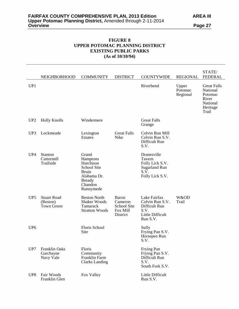
FIGURE 8 UPPER POTOMAC PLANNING DISTRICT
EXISTING PUBLIC PARKS (As of 10/10/94)
NEIGHBORHOOD
COMMUNITY
DISTRICT
COUNTYWIDE
REGIONAL
STATE/ FEDERAL
UP1 UP2 UP3 UP4 UP5 UP6 UP7 UP8
Holly Knolls Lockmeade Stanton Cuttermill Trailside Stuart Road (Reston) Town Green Franklin Oaks Garchayne Navy Vale Fair Woods Franklin Glen
Windermere Lexington Estates Grand Hamptons Hutchison School Site Bruin Alabama Dr. Bready Chandon Runnymede Reston North Shaker Woods Tamarack Stratton Woods Floris School Site Floris Community Franklin Farm Clarks Landing Fox Valley
Great Falls Nike Baron Cameron School Site Fox Mill District
Riverbend Great Falls Grange Colvin Run Mill Colvin Run S.V. Difficult Run S.V. Dranesville Tavern Folly Lick S.V. Sugarland Run S.V. Folly Lick S.V. Lake Fairfax Colvin Run S.V. Difficult Run S.V. Little Difficult Run S.V. Sully Frying Pan S.V. Horsepen Run S.V. Frying Pan Frying Pan S.V. Difficult Run S.V. South Fork S.V. Little Difficult Run S.V.
Upper Potomac Regional W&OD Trail
Great Falls National Potomac River National Heritage Trail
FAIRFAX COUNTY COMPREHENSIVE PLAN, 2013 Edition AREA III Upper Potomac Planning District, Amended through 2-11-2014 Reston Transit Station Areas Page 28
RESTON TRANSIT STATION AREAS
OVERVIEW
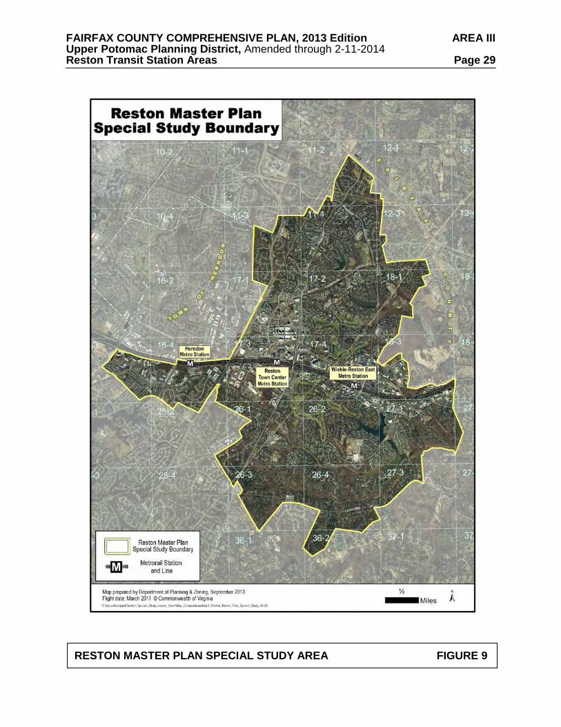
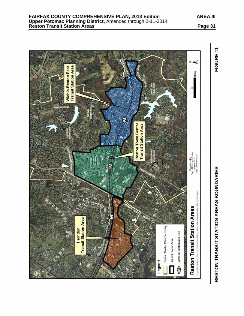
Reston is located in the northwestern quadrant of Fairfax County, approximately 20 miles west of Washington DC, seven miles west of Tysons and six miles east of Washington Dulles International Airport. It is a community of approximately 6,700 acres and is bisected by the Dulles Airport Access Road and Dulles Toll Road (DAAR, Route 267) (see Figure 9). The community will be served by three Metrorail Silver Line stations: the Reston Town Center Station, the Wiehle-Reston East Station and the Herndon Station, as shown on Figure 10. For purposes of the Comprehensive Plan, the areas around these stations are designated as Transit Station Areas (TSAs), as shown on Figure 11. The Vision for Reston articulated below and the associated Planning Principles should apply to the whole community of Reston. The other guidance in this section is designed to apply only to the Transit Station Areas.
The Wiehle-Reston East and Reston Town Center TSAs are located along both sides of the
DAAR from the Virginia Department of Transportation owned storage facility to the east, Hunter Mill Road on the southeast and Fairfax County Parkway on the west. The Herndon TSA is located along the south side of the DAAR and is bounded by Fairfax County Parkway on the east, Fox Mill Road and Sunrise Valley Drive on the south, and Centreville Road on the west. Land to the north of the Herndon Station is within the Town of Herndon.
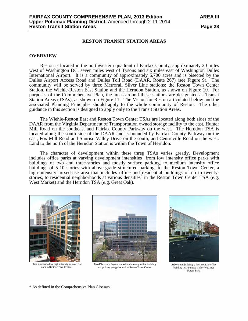
The character of development within these three TSAs varies greatly. Development
includes office parks at varying development intensities* from low intensity office parks with buildings of two and three-stories and mostly surface parking, to medium intensity office buildings of 5-10 stories with above-grade structured parking, to the Reston Town Center, a high-intensity mixed-use area that includes office and residential buildings of up to twenty-stories, to residential neighborhoods at various densities* in the Reston Town Center TSA (e.g. West Market) and the Herndon TSA (e.g. Great Oak).
* As defined in the Comprehensive Plan Glossary.
Plaza surrounded by high-intensity commercial uses in Reston Town Center.
Two Discovery Square, a medium intensity office building and parking garage located in Reston Town Center.
Arboretum Building, a low intensity office building near Sunrise Valley Wetlands
Nature Park.
FAIRFAX COUNTY COMPREHENSIVE PLAN, 2013 Edition AREA III Upper Potomac Planning District, Amended through 2-11-2014 Reston Transit Station Areas Page 29
RESTON MASTER PLAN SPECIAL STUDY AREA FIGURE 9
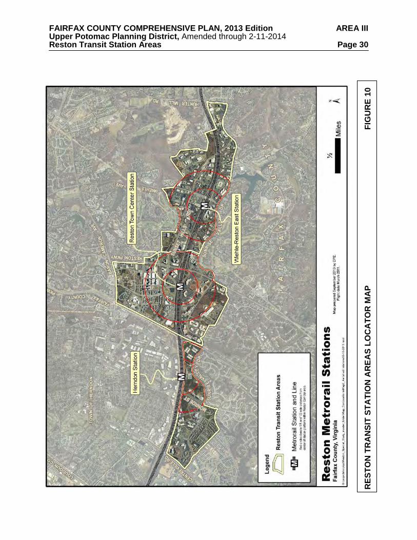
FAIRFAX COUNTY COMPREHENSIVE PLAN, 2013 Edition AREA III Upper Potomac Planning District, Amended through 2-11-2014 Reston Transit Station Areas Page 30
RES
TON
TR
AN
SIT
STA
TIO
N A
REA
S LO
CA
TOR
MA
P
F
IGU
RE
10
FAIRFAX COUNTY COMPREHENSIVE PLAN, 2013 Edition AREA III Upper Potomac Planning District, Amended through 2-11-2014 Reston Transit Station Areas Page 31
RES
TON
TR
AN
SIT
STA
TIO
N A
REA
S B
OU
ND
AR
IES
F
IGU
RE
11
FAIRFAX COUNTY COMPREHENSIVE PLAN, 2013 Edition AREA III Upper Potomac Planning District, Amended through 2-11-2014 Reston Transit Station Areas Page 32 The TSAs together make up the County’s second largest office market and, given their proximity to Washington Dulles International Airport and the excellent regional access provided by the Metro’s Silver Line and the DAAR, are appropriate for a variety of residential and employment land uses.
Each TSA has within it a core area that has been designated for Transit-Oriented
Development (TOD). These TOD areas or districts are adjacent to the future rail stations and are planned to transition to a more urban form and include a complementary mix of uses at higher development intensities than that planned for the other areas in the TSAs.
The planning objectives for these TOD districts are to create a transit-focused
neighborhood within ½ mile of the transit station that will encourage pedestrian activity to enliven the area throughout the day and evening and where the emphasis will be on creating places and connections that are safe, comfortable and attractive for pedestrians and bicyclists. These objectives will result in the evolution of the existing commercial areas along the DAAR, including those formerly designated as the Reston Center for Industry and Government1, into truly viable pedestrian-oriented neighborhoods. CONCEPT FOR FUTURE DEVELOPMENT
The Concept for Future Development’s policy direction focuses employment growth into
designated Mixed-Use Centers. The Concept identifies these three future Metro stations (Reston Town Center, Wiehle-Reston East and Herndon) as Transit Station Areas along the Dulles Corridor. The purpose of the Transit Station Area designation is to optimize development opportunities associated with the availability of mass transit while maintaining the stability of existing land uses outside of the Transit Station Areas. Transit Station Areas allow a mixture of residential, office, retail and other commercial uses and may provide opportunities for joint public-private development. PLANNING HISTORY
The Reston community was planned and has developed as one of the nation’s landmark
new towns. The Reston Master Plan was initially adopted in July 1962 and specified locations for residential, recreational, and civic uses as well as an employment center in the geographic center of the community. The Reston Master Plan, comprised of a Land Use Map, Community Facilities Map and Transportation Map, is incorporated by reference into the Fairfax County Comprehensive Plan and has continued to serve as a general guide for development within Reston from 1962 to the present day.
In 1991, the Reston-Herndon Suburban Center was established as part of the Fairfax
Planning Horizons process, a major revision of the policy and land use recommendations of the County’s Comprehensive Plan. Suburban centers are designed to be employment centers along major arterial roads and to encourage a mix of office, hotel, support retail and residential uses in a low to medium-intensity setting with designated core areas of higher intensity and a more urban form. The Reston-Herndon Suburban Center developed over time with primarily office uses in traditional suburban office parks stretched along the length of the DAAR west of Hunter
1 The Reston Center for Industry and Government consisted of commercially and industrially zoned properties that were planned for office and R&D use and where covenants on the land limited retail use and prohibited residential and hotel uses. These covenants were voluntarily terminated by landowners in 2011.
FAIRFAX COUNTY COMPREHENSIVE PLAN, 2013 Edition AREA III Upper Potomac Planning District, Amended through 2-11-2014 Reston Transit Station Areas Page 33 Mill Road. These office parks include both low-density buildings with surface parking and moderate-density areas with a mix of commercial uses, including community serving uses such as restaurants and childcare facilities, with structured parking. The highest density area is the mixed-use core successfully developed at the Reston Town Center, which includes office, retail, hotel and residences, and an urban streetscape with a grid of streets, ground level retail to promote activity at the street level and public gathering spaces that serve local employees and residents as well as the broader community. With this Plan Amendment, the area previously designated as the Reston-Herndon Suburban Center will no longer be described as a single Suburban Center but rather as three Transit Station Areas (TSAs) located within Reston. This change fosters transit-oriented development at the three Metrorail stations and emphasize the connection between these TSAs and the larger Reston community.
A guiding concept at Reston’s founding was that residents should have the opportunity to
work close to where they lived. The Reston Master Plan designated most of the area contained within the three TSAs for office and research and development use. From the 1960s until 2011, much of the land within Reston along the Dulles Corridor was subject to restrictive covenants, which limited residential and hotel uses. The covenants were voluntarily lifted in 2011 by property owners for the area known as the Reston Center for Industry and Government, creating the opportunity for the desired mixed-use development in the TSAs. Reston Master Plan Special Study Task Force
In October 2009, the Fairfax County Board of Supervisors established the Reston Master
Plan Special Study Task Force to work with County planning staff to review current plan guidance related to the community of Reston in the Fairfax County Comprehensive Plan and make recommendations to the Planning Commission and Board regarding appropriate changes to the Comprehensive Plan.
The Task Force included over 40 members and its membership comprised representatives
from multiple community organizations, including the Reston Association, the Reston Citizens Association, the Reston Community Center, the Greater Reston Chamber of Commerce, and the Reston Planning and Zoning Committee, as well as commercial property owners and residents. The Task Force developed the following Vision statement and Planning Principles to help guide future development in Reston. VISION FOR RESTON
Reston has since its inception been envisioned to be a
place to live, work and play. It will continue to evolve over the next four or five decades into a community with an even greater variety of opportunities to do so. As Reston evolves, it is important to respect the characteristics that have helped to define Reston from its inception. A foundational characteristic is a commitment to encouraging a strong sense of community, through design as well as the provision of a wide variety of community amenities. The design character should be enhanced in the future by integrating gathering places of varying types and sizes throughout new development. In the Village Centers, a central plaza is planned to be a key feature of any future redevelopment. In the Wiehle-Reston East and Reston Town Center TSAs, at
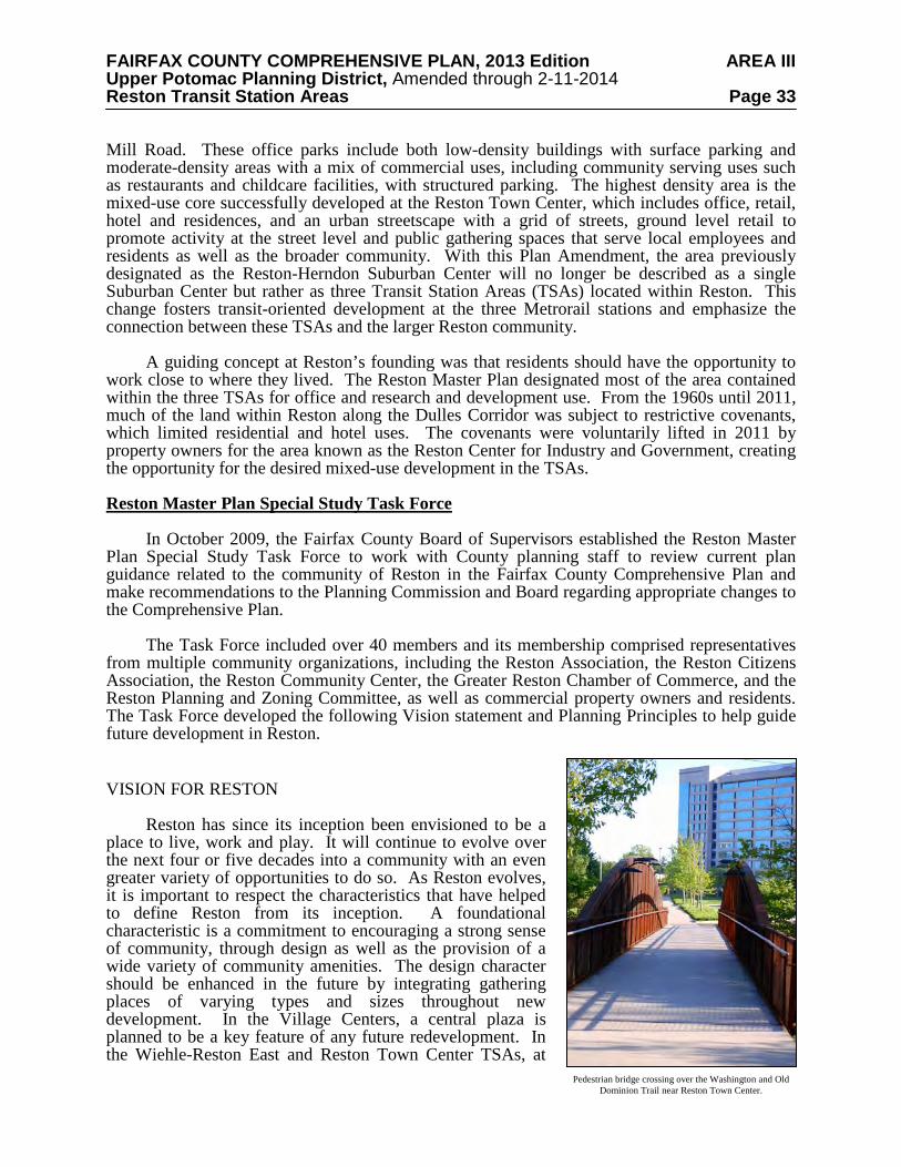
Pedestrian bridge crossing over the Washington and Old Dominion Trail near Reston Town Center.
FAIRFAX COUNTY COMPREHENSIVE PLAN, 2013 Edition AREA III Upper Potomac Planning District, Amended through 2-11-2014 Reston Transit Station Areas Page 34 least one plaza should be provided on both the north and south side of the DAAR in close proximity to the transit station and with ground-level retail along the plaza, while in the Herndon TSA, a plaza should be provided on the south side of the DAAR at or near the transit station and with ground-level retail along the plaza.
The Policy Plan provides guidance for establishing green neighborhood and building
practices. The planning and design of development within the Transit Station Areas should be guided by green neighborhood principles on place making, creating pedestrian oriented connections, energy conservation, and preservation of natural resources. Non-residential development should be planned and designed to achieve LEED silver or equivalent standards, at a minimum, in light of the level of redevelopment proposed for the TSAs. Residential development should also be guided by the Policy Plan objectives for natural resource conservation, green building, and green neighborhood practices. A broad range of practices can be pursued in support of and in addition to green neighborhood and building certification.
The following examples of energy and ecologically conscious approaches to green
neighborhood and building design that should be encouraged within Reston are outlined in the following:
• Place making:
- Orientation of plazas and other public spaces to provide adequate solar access - Provision of a mix of uses at each transit station area (TSA) to minimize walking
distances between uses - Provision of housing for all ages and incomes in close proximity to the transit stations
to minimize walking distances - Use of site design principles for the orientation of streets and blocks to maximize
solar access - Provision for outstanding architecture and public art for place making
• Pedestrian connections: - Provision for enhanced linkages to transit stations - Provision of tree-lined and shaded streets (streetscape) to improve the character of
pedestrian experience - Provision of a grid of local streets to provide a variety of opportunities for access to
transit - Use of bikeways and trails to improve access to recreation areas and the transit
stations - Provision to link the northern and southern areas of Reston through the transit station
areas • Energy conservation (see Environmental Stewardship section):
- Provision of green and cool roof systems - Use of thermal and photovoltaic energy systems - Incorporation of passive cooling through proper shading and ventilation - Use of ground source heat pump heating and cooling systems for building
conditioning and hot water requirements - Reduction of water consumption, including re-use of gray water where allowed - Use of radiant floor heating and cooling - Provision of wind turbines as an energy source - Recycling of materials and maximize use of locally produced materials - Use of cool roof systems or light reflecting roof surfaces - Use of light shades that provide shading for glass and direct sunlight deep into
building spaces for daylighting
FAIRFAX COUNTY COMPREHENSIVE PLAN, 2013 Edition AREA III Upper Potomac Planning District, Amended through 2-11-2014 Reston Transit Station Areas Page 35
• Preservation of natural resources: - Protection of wetlands - Preservation of streams and buffer areas especially in the headwaters of streams - Enhancement and protection of lakes and ponds - Use of closely spaced street trees and landscaping in open space areas to increase tree
canopy in the TSAs - Provision for enhanced stormwater management - Conservation of existing forest areas in accordance with the Fairfax County policies
Development within the TSAs can become better integrated into the fabric of the larger Reston community by providing future TSA residents and employees access and robust connectivity to existing community amenities, including the lakes and the network of trails throughout Reston. This can best be achieved through incorporation into the existing Reston Association or the Reston Town Center Association. Each of these entities has indicated a willingness to include these new developments in their associations.
A second foundational characteristic of Reston
has been a commitment to preserve natural areas and integrate open space throughout the community. The sustainable design of the community lends itself to the preservation of parkland, natural areas, clean lakes and walking trails. In the TSAs, this characteristic should be acknowledged via incorporation of a Reston-specific urban landscape. This landscape should preserve trees and existing landscaping in key, designated locations and incorporates more trees and plantings in the streetscape of selected new streets as further described in the Urban Design and Placemaking section.
Another key Reston characteristic is an
emphasis on pedestrian and bicycle connectivity. Future development in the TSAs should augment this connectivity by providing appropriate links within and between the TSAs as well as multiple links to the existing Reston trail system in the areas adjacent to the TSAs.
From its beginning in 1964, the planned
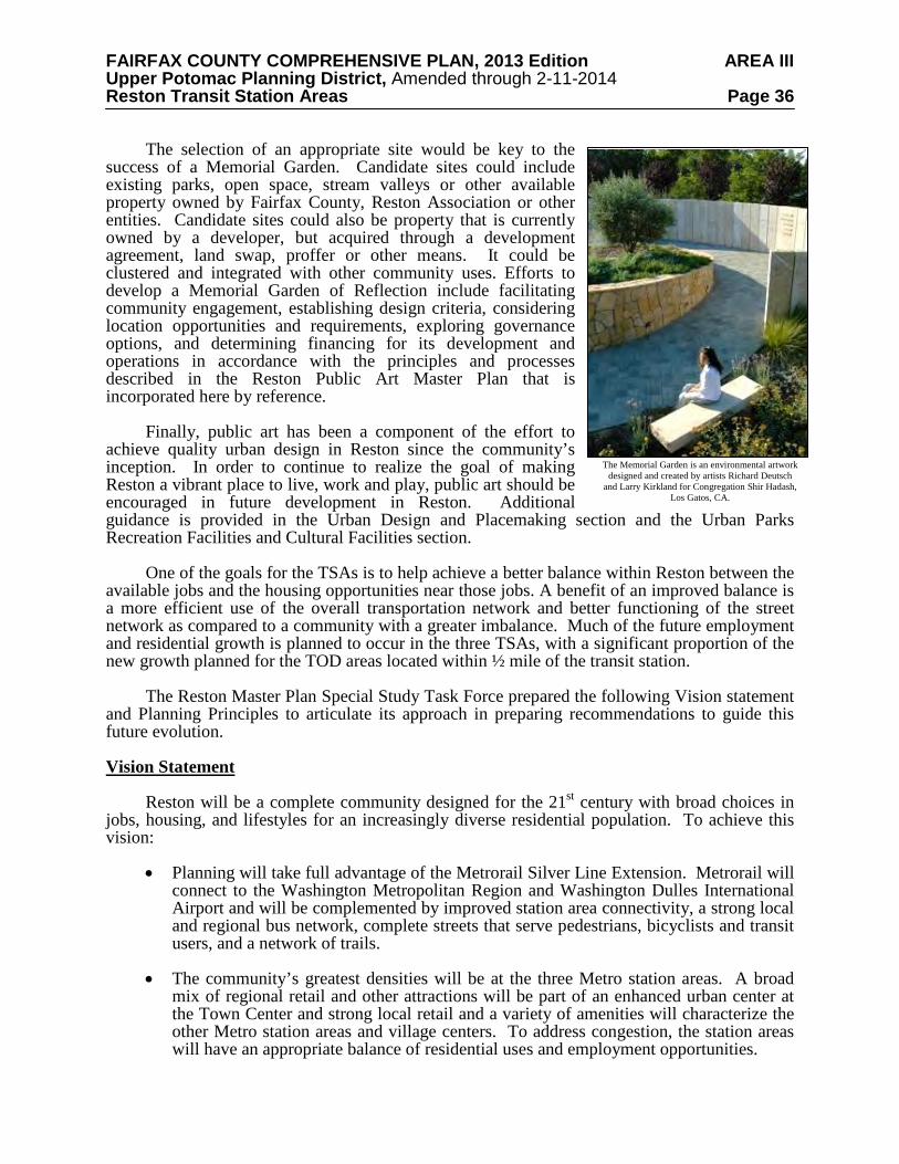
community of Reston has lacked a special place where one can go to remember and memorialize loved ones. A Memorial Garden of Reflection is a community facility that should be developed. A clear vision for such a facility has emerged through the work of the Initiative for Public Art – Reston (IPAR):
It should be a universal and inclusive place, where Restonians can remember and reflect upon the passing of loved ones. It should respect and support the many ways in which people choose to acknowledge the passing of life. And, its design should provide a setting for tranquil reflection, contemplation, meditation, inspiration and healing.
Memorial Garden designed and created by artists Richard Deutsch and Larry Kirkland for Congregation Shir Hadash, Los Gatos, CA.
The Memorial Garden is an environmental artwork designed and created by artists Richard Deutsch and Larry Kirkland for Congregation Shir Hadash, Los Gatos, CA.
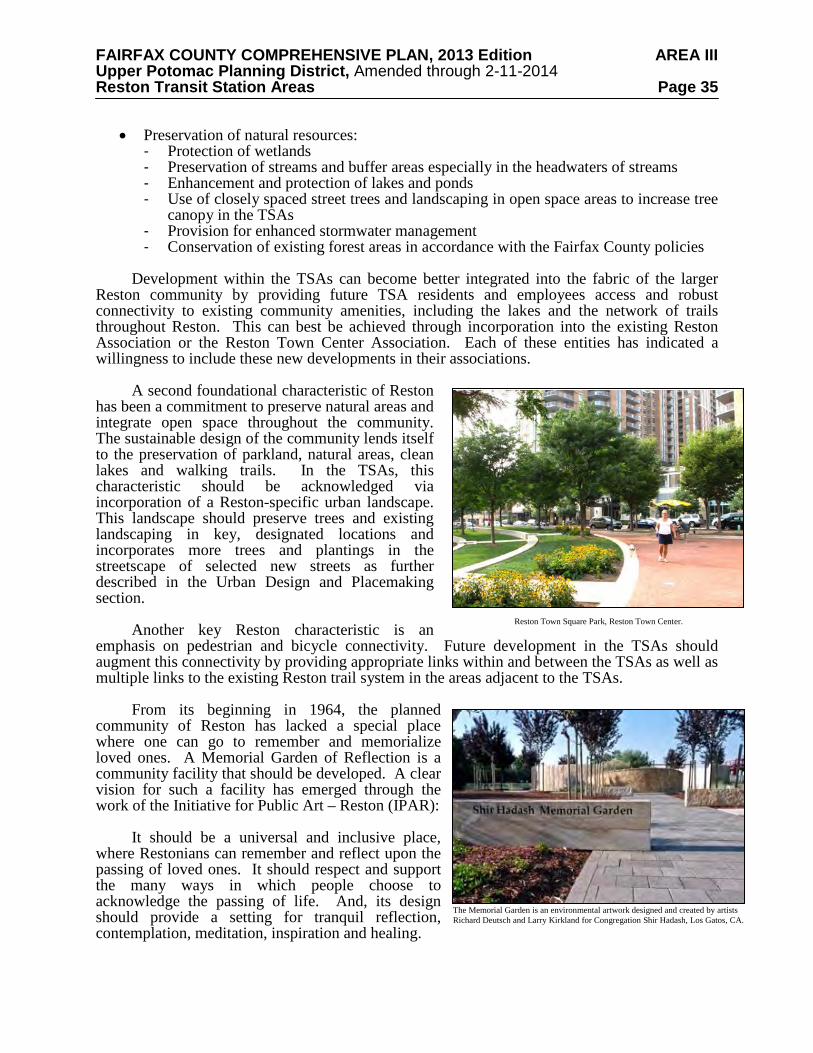
Reston Town Square Park, Reston Town Center.
FAIRFAX COUNTY COMPREHENSIVE PLAN, 2013 Edition AREA III Upper Potomac Planning District, Amended through 2-11-2014 Reston Transit Station Areas Page 36
The selection of an appropriate site would be key to the success of a Memorial Garden. Candidate sites could include existing parks, open space, stream valleys or other available property owned by Fairfax County, Reston Association or other entities. Candidate sites could also be property that is currently owned by a developer, but acquired through a development agreement, land swap, proffer or other means. It could be clustered and integrated with other community uses. Efforts to develop a Memorial Garden of Reflection include facilitating community engagement, establishing design criteria, considering location opportunities and requirements, exploring governance options, and determining financing for its development and operations in accordance with the principles and processes described in the Reston Public Art Master Plan that is incorporated here by reference.
Finally, public art has been a component of the effort to
achieve quality urban design in Reston since the community’s inception. In order to continue to realize the goal of making Reston a vibrant place to live, work and play, public art should be encouraged in future development in Reston. Additional guidance is provided in the Urban Design and Placemaking section and the Urban Parks Recreation Facilities and Cultural Facilities section.
One of the goals for the TSAs is to help achieve a better balance within Reston between the
available jobs and the housing opportunities near those jobs. A benefit of an improved balance is a more efficient use of the overall transportation network and better functioning of the street network as compared to a community with a greater imbalance. Much of the future employment and residential growth is planned to occur in the three TSAs, with a significant proportion of the new growth planned for the TOD areas located within ½ mile of the transit station.
The Reston Master Plan Special Study Task Force prepared the following Vision statement
and Planning Principles to articulate its approach in preparing recommendations to guide this future evolution. Vision Statement
Reston will be a complete community designed for the 21st century with broad choices in
jobs, housing, and lifestyles for an increasingly diverse residential population. To achieve this vision:
• Planning will take full advantage of the Metrorail Silver Line Extension. Metrorail will
connect to the Washington Metropolitan Region and Washington Dulles International Airport and will be complemented by improved station area connectivity, a strong local and regional bus network, complete streets that serve pedestrians, bicyclists and transit users, and a network of trails.
• The community’s greatest densities will be at the three Metro station areas. A broad mix of regional retail and other attractions will be part of an enhanced urban center at the Town Center and strong local retail and a variety of amenities will characterize the other Metro station areas and village centers. To address congestion, the station areas will have an appropriate balance of residential uses and employment opportunities.
Memorial Garden designed and created by artists Richard Deutsch and Larry Kirkland for Congregation Shir Hadash, Los Gatos, CA.
The Memorial Garden is an environmental artwork designed and created by artists Richard Deutsch
and Larry Kirkland for Congregation Shir Hadash, Los Gatos, CA.

FAIRFAX COUNTY COMPREHENSIVE PLAN, 2013 Edition AREA III Upper Potomac Planning District, Amended through 2-11-2014 Reston Transit Station Areas Page 37
• A full range of housing choices will be provided for households of all incomes and
needs.
• Employment opportunities will build upon the existing mix of international and national corporations, professional associations, centers for advanced technology, research and development companies, and local services.
• A strong institutional component will include a major hospital center, a regional government center, a new 21st century regional public library, a major fine and performing arts center, other civic and cultural uses, and public and private educational institutions of higher learning.
• Planning will emphasize protection of natural areas and the environment and the development of an array of cultural, educational, and recreational opportunities.
Planning Principles
Planning will consider Reston as a comprehensive unit. Development projects will be
evaluated based on their ability to meet the planning principles and the particular character of each area, as well as their specific impacts on the surrounding neighborhoods. The following principles will guide development of Reston as a complete community for the 21st century.
1. Excellence in planning, urban design, and architecture will be community
hallmarks. The community will continue to strive to achieve excellence in planning and urban design, architecture, gathering places such as plazas connection with the natural environment, compatibility of uses, livability, and the integration of high-quality public art as distinguishing features of the Reston community.
2. Planning will provide for environmental sustainability and green technology.
Natural resources and ecosystems, including natural areas, will be protected and restored. Adverse impacts on the environment (land, water, and air) will be minimized, and best practices will be used to protect environmentally sensitive areas. Green neighborhood and building practices will meet high standards. Tree canopy will continue to be an important component of the Reston visual experience.
3. Development will be phased with infrastructure.
The phasing and funding of the expansion and modification of adequate transportation infrastructure and programs, and other infrastructure components such as schools, parks, and other public facilities should occur with development.
4. Reston will continue to offer a mix of urban and suburban life styles.
The Metro Silver Line extension will add opportunities for transit-oriented development to Reston’s already diverse and unique community. In terms of emphasis:
• The Metro Station areas will be livable urban places, with densities that step
down from the Town Center to the other station areas. The station areas will also be the areas of highest commercial and residential intensity in the community.
FAIRFAX COUNTY COMPREHENSIVE PLAN, 2013 Edition AREA III Upper Potomac Planning District, Amended through 2-11-2014 Reston Transit Station Areas Page 38
• The village centers are important community gathering spaces that include a mix of locally serving retail, a residential component, and employment opportunities. Redevelopment to augment and enhance the village centers will be pedestrian-oriented, should include a plaza as a central element and provide adequate transition to surrounding neighborhoods. Convenient public transportation options should link the village centers and the transit stations.
• Residential neighborhoods will continue to provide a variety of housing types
serving all income levels. Appropriate transitions will be provided between new development and all residential neighborhoods.
5. The rail corridor will be transformed.
Over time it will become an area with robust, livable, walkable mixed-use communities
having an appropriate balance between residential and non-residential uses. Each of the transit station areas will have a distinct character to meet multiple community needs. Town Center will be a livable regional urban center and destination with the community’s highest densities and major shopping and cultural features to attract visitors. Wiehle-Reston East and Herndon will be urban transit neighborhoods. Special consideration for higher educational uses should be encouraged for the Wiehle-Reston East station. At the Herndon station, a special focus should be placed on its central environmental (wetlands) feature. The highest densities will be concentrated within ¼ mile of the rail stations, tapering down somewhat within ½ mile to maximize the use of rail. Residential and non-residential populations in each transit station area will be balanced to further maximize rail use and reduce dependence on automobiles. Future air rights development around the stations should be pursued to enhance development opportunities, encourage transit use, and improve north-south connectivity across the DAAR.
6. Reston will become a more vibrant employment center.
From its inception, Reston has provided a place for a spectrum of companies, from local to international, of varying sizes. Future development and redevelopment should continue to promote a broad range of opportunities for a robust and diverse business, advanced technology, educational, and research community.
7. Housing will be provided for all ages and incomes. Reston will accommodate people of all ages, physical abilities, and economic circumstances, and households of all sizes and stages of family life.
8. Connectivity and mobility will be strengthened. A range of high-quality transportation facilities–including roads, bridges, tunnels, sidewalks, bikeways, trails, strengthened and expanded bus and shuttle services, and Metro will link the residential community and resident workers with activity centers, employment, open spaces, parks, schools, and civic, cultural and recreational facilities. New bridges and tunnels across the DAAR near the stations are a high priority to increase mobility on the existing road network. A robust transit system, expanded pedestrian and bicycle networks and transportation demand management strategies will also help reduce reliance on the automobile while increasing community mobility.
9. High quality public open spaces will be required.
Abundant open space and a range of recreational and cultural opportunities are essential components of the high quality of life in Reston. The transit station areas and village centers should include a variety of public spaces such as a large urban central park, recreational facilities, urban plazas and greens, pocket parks, playgrounds, and other
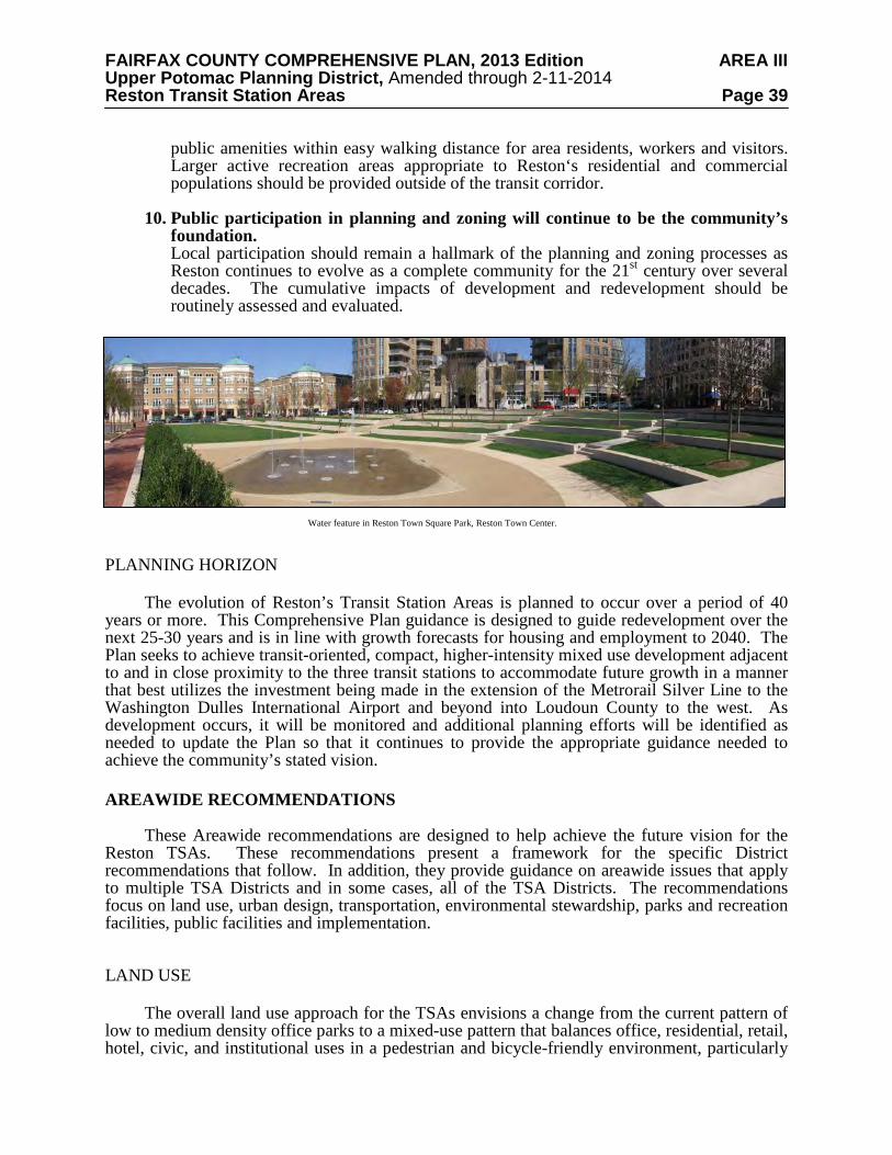
FAIRFAX COUNTY COMPREHENSIVE PLAN, 2013 Edition AREA III Upper Potomac Planning District, Amended through 2-11-2014 Reston Transit Station Areas Page 39
public amenities within easy walking distance for area residents, workers and visitors. Larger active recreation areas appropriate to Reston‘s residential and commercial populations should be provided outside of the transit corridor.
10. Public participation in planning and zoning will continue to be the community’s
foundation. Local participation should remain a hallmark of the planning and zoning processes as Reston continues to evolve as a complete community for the 21st century over several decades. The cumulative impacts of development and redevelopment should be routinely assessed and evaluated.
PLANNING HORIZON
The evolution of Reston’s Transit Station Areas is planned to occur over a period of 40 years or more. This Comprehensive Plan guidance is designed to guide redevelopment over the next 25-30 years and is in line with growth forecasts for housing and employment to 2040. The Plan seeks to achieve transit-oriented, compact, higher-intensity mixed use development adjacent to and in close proximity to the three transit stations to accommodate future growth in a manner that best utilizes the investment being made in the extension of the Metrorail Silver Line to the Washington Dulles International Airport and beyond into Loudoun County to the west. As development occurs, it will be monitored and additional planning efforts will be identified as needed to update the Plan so that it continues to provide the appropriate guidance needed to achieve the community’s stated vision. AREAWIDE RECOMMENDATIONS
These Areawide recommendations are designed to help achieve the future vision for the
Reston TSAs. These recommendations present a framework for the specific District recommendations that follow. In addition, they provide guidance on areawide issues that apply to multiple TSA Districts and in some cases, all of the TSA Districts. The recommendations focus on land use, urban design, transportation, environmental stewardship, parks and recreation facilities, public facilities and implementation. LAND USE
The overall land use approach for the TSAs envisions a change from the current pattern of low to medium density office parks to a mixed-use pattern that balances office, residential, retail, hotel, civic, and institutional uses in a pedestrian and bicycle-friendly environment, particularly
Water feature in Reston Town Square Park, Reston Town Center.
FAIRFAX COUNTY COMPREHENSIVE PLAN, 2013 Edition AREA III Upper Potomac Planning District, Amended through 2-11-2014 Reston Transit Station Areas Page 40 in the areas closest to the stations. The employment areas farther away from the stations will continue to provide excellent locations for office development to occur as well as other complementary uses, such as data centers and research and development uses. The recommendations encourage a more urban, transit-oriented development pattern, with the objective of creating a walkable activity center at each station. The areas closest to the stations should consist of a mix of uses to include employment, housing and services to meet the needs of daily living. As noted earlier, achieving this vision will be a long-term process. Therefore, the land use section also includes guidance on land use compatibility, land use flexibility, incremental redevelopment as well as new development.
A key element in creating a more urban fabric in the TSAs will be the introduction of new
streets to provide a more grid-like pattern to the road network that will enhance pedestrian and vehicular circulation around the stations. Another important element will be the introduction of new urban parks of various sizes and a well-connected public open space network. In addition, public gathering spaces and public uses will be located in the TSAs so as to continue to meet the needs of the Reston community. Transit Station Areas Land Use Concept
The land use concept for the TSAs is informed by experience in the Washington
Metropolitan area that shows that a higher proportion of residents within walking distance of a Metro station will use transit as compared with workers. In addition, residents are willing to walk further to transit than workers will. Therefore, to best take advantage of transit, the land use concept places an emphasis on locating the significant majority of new office uses in mixed use developments in TOD Districts located within a safe, comfortable and reasonably direct ¼ mile walk of the Metro stations (see Figure 12). The predominant use in new development to be located in TOD areas between ¼ and ½ mile of the stations should be multi-family housing in order to realize the objective of achieving an improved jobs-to-housing balance in Reston.
This approach of differentiating the emphasis of new development types in areas closest to
the stations versus areas more removed from the stations formed the basis of the two TOD district-specific land use categories described below, Transit Station mixed use and Residential mixed use. Exceptions to this approach should only be considered to facilitate the provision of significant new public infrastructure such as the planned new crossings of the DAAR. In those instances, new office uses above those already zoned may be considered for areas between ¼ and ½ mile of the stations. Land Use Categories
The following land use categories indicate a general character of the mix of uses for a
given area, as shown on Figure 12; however, the appropriate mix for any given project will be evaluated on a case-by-case basis during the rezoning/development review process. A primary goal in the TOD areas is to generate pedestrian activity throughout the day and well into the evening. It should be noted that the appropriate mix for a proposed development (redevelopment) will be affected by the other TOD and non-TOD development that has already occurred or been approved within the TSA.
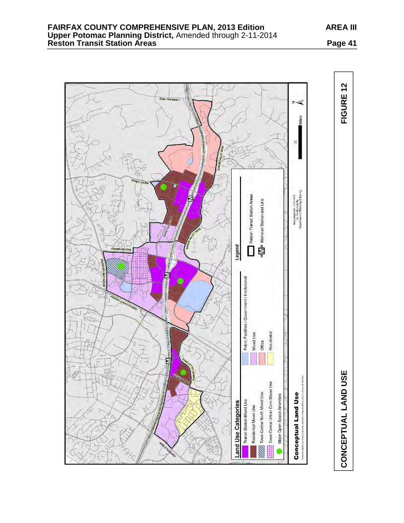
FAIRFAX COUNTY COMPREHENSIVE PLAN, 2013 Edition AREA III Upper Potomac Planning District, Amended through 2-11-2014 Reston Transit Station Areas Page 41
CO
NC
EPTU
AL
LAN
D U
SE
FIG
UR
E 12
FAIRFAX COUNTY COMPREHENSIVE PLAN, 2013 Edition AREA III Upper Potomac Planning District, Amended through 2-11-2014 Reston Transit Station Areas Page 42 Initial development proposals in a TOD District should conform to the recommended mix for the land use categories within the TOD District or include a higher proportion of residential use than specified. Coordinated development plans may be submitted as described below in the Development Review Performance Objectives. Projects that encompass multiple land use categories may be granted flexibility in the location of proposed uses as long as they achieve TOD objectives and contribute to the character recommended for the subject area.
The Land Use categories are as follows: Transit Station Mixed Use: These areas are located close to the Metro stations and
generally include the parcels within a safe, comfortable and reasonably direct ¼ mile walk from the station. They are planned for a balanced mix of office, hotel, retail, institutional (including civic) and residential uses. The long-term goal is for each Transit Station Mixed Use area (vs. individual projects) to achieve 50 percent non-residential uses and 50 percent residential uses on the basis of approved square footage.
Residential Mixed Use: These areas are a safe, comfortable and reasonably direct walk
of ¼ - ½ mile from the Metro station platforms. In some instances, the areas in this category may be slightly further than ½ mile from a station due to redevelopment opportunities available under already approved development plans. These areas are planned primarily for a mix of existing office uses and new residential uses and new commercial uses other than office uses. The long-term goal is for each Residential Mixed Use area (vs. individual projects) to achieve 75 percent residential uses on the basis of approved square footage.
Town Center Urban Core Mixed Use: This area is planned for a mix of uses including
office, retail, hotel and residential. Town Center North Mixed Use: This area is planned for institutional uses along with
residential, office, medical uses, hotel, civic, and support retail uses. Various County agencies will continue to constitute a significant civic presence in this area.
Mixed Use: These areas are planned for a mix of uses including office, retail, institutional,
hotel and residential uses. Office: These areas are planned almost exclusively for office uses, including research and
development (R & D) uses and industrial flex space. Supporting retail and service uses, such as hotels and restaurants, are also encouraged in these areas.
Residential: These areas are planned almost exclusively for residential uses, including
multi-family housing and townhouses. Supporting retail uses are allowed and should be compatible with the character of the neighborhood.
Public Facilities/Government/Institutional: These areas are planned for public uses, such
as a library, school, fire station, or government offices. In addition, they may be planned for private institutional uses such as hospitals or colleges or universities. The Conceptual Land Use map identifies existing public or institutional uses in the TSAs. Planned public or institutional uses are discussed in the District Recommendations.
Major Open Space Amenities: These areas are planned for major, centrally located open
spaces. These areas may include urban parks or spaces, such as plazas or greens with a variety of recreational and/or cultural uses, or may include natural habitat such as the Sunrise Valley Wetlands Nature Park. In instances when intensity credit is given for dedicating land for a park
FAIRFAX COUNTY COMPREHENSIVE PLAN, 2013 Edition AREA III Upper Potomac Planning District, Amended through 2-11-2014 Reston Transit Station Areas Page 43 or open space, the land use mix applied to the intensity credit should be consistent with the land use category of an adjacent area. Additional guidance on parks and open space can be found in the Parks, Recreation Facilities and Cultural Facilities section and the Urban Design section.
The land use concept for each TSA divides the TSA into a TOD District and one or more
Non-TOD Districts, as shown on Figure 13 and Figure 14. Some of these Districts have been divided into Subdistricts for the purpose of organizing land use recommendations. The three TOD Districts are located around the station platforms, are planned for the highest intensities within each TSA and are envisioned to become vibrant neighborhoods, each with its own distinct character. A general description of each TOD and Non-TOD District is provided below. TOD Districts The three TOD Districts are as follows:
Wiehle Station District: The Wiehle Station TOD District will be an urban transit
neighborhood that will serve as a signature gateway to Reston. It should include a robust residential component and new office development should be focused in the area closest to the station as shown on the Conceptual Land Use Map. The district is envisioned to develop a more prominent educational focus by adding to the existing base of institutions of higher learning in the district. As noted in the Overview, this district does not extend to the south of Sunrise Valley Drive.
Reston Town Center Station District: The Reston Town Center Station TOD District
should be Reston’s “downtown” station with significant residential and commercial components to complement existing development in the Reston Town Center. New office uses should be concentrated close to the station as shown on the Conceptual Land Use Map. This district has two sub-districts.
The North TOD Sub-district is planned to be an extension of the existing Town Center
urban core with a comparable urban form and similar high-density residential and commercial functions. It is also envisioned to improve connectivity for pedestrians and bicyclists from the Metrorail station to the Reston Town Center core.
The South TOD Sub-district is planned to develop in a manner that is complementary to the
Town Center on the north of the DAAR but not as a continuation of the Town Center core. Consequently, it is envisioned to develop with a somewhat lower overall intensity in the planning horizon of this Plan.
Herndon Station District: The Herndon Station TOD District is located on the south side
of the DAAR and the station. It is envisioned to be an urban transit neighborhood adjacent to the publicly accessible wetlands located along Sunrise Valley Drive. New office uses should be concentrated close to the station as shown on the Conceptual Land Use Map. Non-TOD Districts
The Non-TOD Districts vary in character and the mix of uses present within each. These
districts, unless otherwise noted, should maintain their existing character, uses and zoned intensities due to their proximity to existing residential neighborhoods outside of the TSAs. The nine Non-TOD Districts are briefly described below, from east to west.
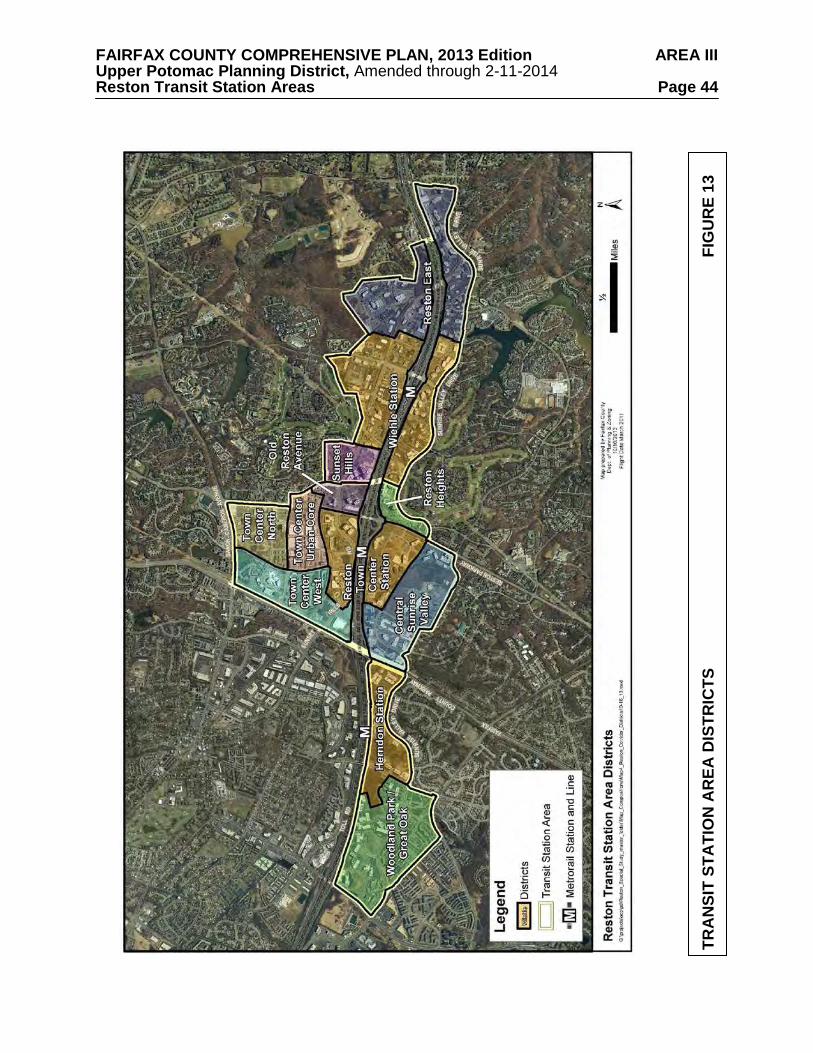
FAIRFAX COUNTY COMPREHENSIVE PLAN, 2013 Edition AREA III Upper Potomac Planning District, Amended through 2-11-2014 Reston Transit Station Areas Page 44
TRA
NSI
T ST
ATI
ON
AR
EA D
ISTR
ICTS
F
IGU
RE
13
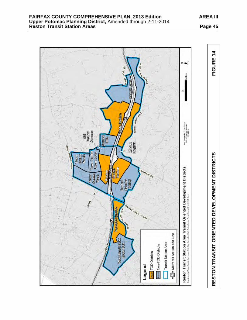
FAIRFAX COUNTY COMPREHENSIVE PLAN, 2013 Edition AREA III Upper Potomac Planning District, Amended through 2-11-2014 Reston Transit Station Areas Page 45
RES
TON
TR
AN
SIT
OR
IEN
TED
DEV
ELO
PMEN
T D
ISTR
ICTS
FIG
UR
E 14
FAIRFAX COUNTY COMPREHENSIVE PLAN, 2013 Edition AREA III Upper Potomac Planning District, Amended through 2-11-2014 Reston Transit Station Areas Page 46 Reston East District: This district is developed almost exclusively with low-density office parks. This district serves as a transition to low-density residential neighborhoods to the south of Sunrise Valley Drive and west of Lake Fairfax Business Center and Hunter Mill Road.
Sunset Hills District: This district is located between the Wiehle Station and Reston
Town Center Station TOD Districts on the north side of the DAAR. It includes the Plaza America office and retail center as well as office development north of Sunset Hills Road. It is envisioned that this area will serve as a transition between the two adjacent TOD Districts. Redevelopment and new infill development will be less intense than the adjacent TOD Districts and should focus on adding residential uses.
Old Reston Avenue District: This district includes an office campus, smaller scale office
uses, and several auto-oriented uses in a more typical suburban land use pattern and a residential building at the corner of Reston Parkway and Sunset Hills Road with a more urban form and site layout.
Town Center Urban Core District: This district is the mixed use “downtown” of Reston.
It has an urban form, is pedestrian-oriented and provides two key publicly-accessible gathering spaces.
Town Center North District: This district is situated to the north of the Reston Town
Center urban core and south of Baron Cameron Drive. It currently includes the North County Governmental Center, medical facilities, human services offices and elderly housing. The future land use pattern in this district should incorporate significant new residential development and new non-residential uses to complement the existing and planned public uses and the concentration of employment in the Reston Town Center and a significant new open space to serve as a defining element in the organization of a new, more urban pattern of blocks. The future land use pattern should also allow for a transition from the urban core of the Town Center to the low density commercial use along the north side of Baron Cameron Drive and the adjacent residential neighborhoods. This district has two subdistricts.
Town Center West District: This district contains a variety of residential and commercial
uses to the west of the Town Center core, including Reston Hospital, two residential neighborhoods and a concentration of automobile-oriented retail uses along Sunset Hills Road. This district is envisioned to continue to generally serve these same functions over the planning horizon of this Plan.
Central Sunrise Valley District: This district includes areas to the north and south of
Sunrise Valley Drive between Fairfax County Parkway on the west and Reston Parkway on the east. The United States Geological Survey’s headquarters, which includes a significant amount of undeveloped land, is located on two large parcels located within this district. Other uses include several office parks with 2-5 story buildings, a mini-storage facility, and a data center.
Woodland Park/Great Oak District: This district is at the western boundary of the
Herndon Transit Station Area and includes Woodland Park, a major mixed use development with office, hotel, retail uses (including a grocery store) and multi-family residential development. It also includes the Great Oak subdivision, which includes single family detached units and townhouses.
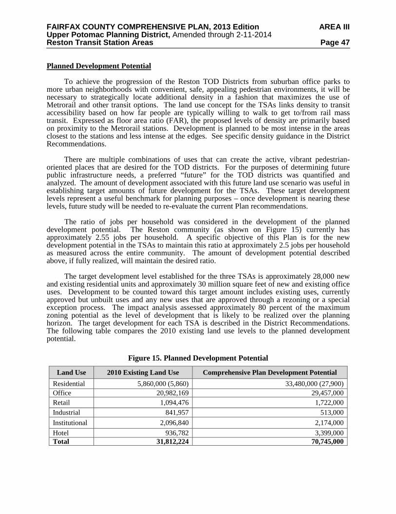
FAIRFAX COUNTY COMPREHENSIVE PLAN, 2013 Edition AREA III Upper Potomac Planning District, Amended through 2-11-2014 Reston Transit Station Areas Page 47 Planned Development Potential
To achieve the progression of the Reston TOD Districts from suburban office parks to
more urban neighborhoods with convenient, safe, appealing pedestrian environments, it will be necessary to strategically locate additional density in a fashion that maximizes the use of Metrorail and other transit options. The land use concept for the TSAs links density to transit accessibility based on how far people are typically willing to walk to get to/from rail mass transit. Expressed as floor area ratio (FAR), the proposed levels of density are primarily based on proximity to the Metrorail stations. Development is planned to be most intense in the areas closest to the stations and less intense at the edges. See specific density guidance in the District Recommendations.
There are multiple combinations of uses that can create the active, vibrant pedestrian-
oriented places that are desired for the TOD districts. For the purposes of determining future public infrastructure needs, a preferred “future” for the TOD districts was quantified and analyzed. The amount of development associated with this future land use scenario was useful in establishing target amounts of future development for the TSAs. These target development levels represent a useful benchmark for planning purposes – once development is nearing these levels, future study will be needed to re-evaluate the current Plan recommendations.
The ratio of jobs per household was considered in the development of the planned
development potential. The Reston community (as shown on Figure 15) currently has approximately 2.55 jobs per household. A specific objective of this Plan is for the new development potential in the TSAs to maintain this ratio at approximately 2.5 jobs per household as measured across the entire community. The amount of development potential described above, if fully realized, will maintain the desired ratio.
The target development level established for the three TSAs is approximately 28,000 new
and existing residential units and approximately 30 million square feet of new and existing office uses. Development to be counted toward this target amount includes existing uses, currently approved but unbuilt uses and any new uses that are approved through a rezoning or a special exception process. The impact analysis assessed approximately 80 percent of the maximum zoning potential as the level of development that is likely to be realized over the planning horizon. The target development for each TSA is described in the District Recommendations. The following table compares the 2010 existing land use levels to the planned development potential.
Figure 15. Planned Development Potential
Land Use 2010 Existing Land Use Comprehensive Plan Development Potential Residential 5,860,000 (5,860) 33,480,000 (27,900) Office 20,982,169 29,457,000 Retail 1,094,476 1,722,000 Industrial 841,957 513,000 Institutional 2,096,840 2,174,000 Hotel 936,782 3,399,000 Total 31,812,224 70,745,000
FAIRFAX COUNTY COMPREHENSIVE PLAN, 2013 Edition AREA III Upper Potomac Planning District, Amended through 2-11-2014 Reston Transit Station Areas Page 48
The development potential shown in the table above is based on quantification of the land use recommendations. The land use recommendations for each district provide flexibility for a change of land uses within certain parameters. For example, some areas are encouraged to include more housing when there is a corresponding reduction in office use. Additional retail uses are encouraged when they contribute to the area’s vibrancy and convenience. Additional hotel uses are encouraged because they can support retails uses and pedestrian activity and also result in fewer peak hour trips than office uses. Generally the Plan seeks to encourage a vibrant mix of uses that are balanced with the infrastructure needs.
Monitoring the potential impacts of office development is important since office uses
currently represent the significant majority of existing uses and have high peak period vehicle trip generation characteristics. New uses other than offices that have a significant impact on peak period trips should also be managed carefully and may be counted toward the office development level.
The Transportation section of the Areawide Recommendations discusses the monitoring
activities that will be necessary to track development performance. Monitoring will be essential to future planning efforts. A particular condition to be monitored is the achievement of transportation improvements needed to mitigate the impacts of new development. Development Review Performance Objectives
All development proposals within the TSAs will be evaluated for the extent to which they
meet or contribute to the following objectives.
• Achieve High Quality Site Design and Architecture – Excellent site design in the TSAs should continue the Reston traditions of emphasizing community gathering places, integrating access to the natural environment when possible, and providing public art. In addition, there should be an emphasis on environmentally sustainable design and practices with non-residential development achieving U.S. Green Building Council’s Leadership in Energy and Environmental Design (LEED) Silver certification or the equivalent, at a minimum. Residential development should be guided by the Fairfax County Policy Plan objectives on Resource Conservation and Green Building Practices. See additional guidance in the Environmental Stewardship and Urban Design sections.
• Provide Pedestrian and Bicycle Connectivity throughout the Transit Station Areas – New pedestrian and bicycle connections should be provided through complete streets within the TSAs and new or extended trails on both sides of the DAAR connecting the three Metrorail stations. Pedestrian and bicycle crossings of existing streets should be improved to increase pedestrian and bicyclists’ safety, visibility and convenience. Several existing streets act as major barriers to pedestrian and bicycle movement and are identified for specific improvements within the District Recommendations. In addition, connections should be made from the Metrorail stations to the existing community trail network. See additional guidance in the Transportation section.
• Provide Urban Parks and other Recreational Amenities throughout the Transit Station Areas – Local-serving urban parks, recreational and cultural amenities including but not limited to plazas, trails and public art should be provided throughout the TSAs in order to serve local leisure and recreation needs. Membership in Reston Association may serve to meet a portion of the identified park and recreation needs. The exact number of urban parks and other amenities, their sizes and distribution will be determined by the amount and type of
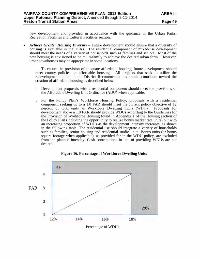
FAIRFAX COUNTY COMPREHENSIVE PLAN, 2013 Edition AREA III Upper Potomac Planning District, Amended through 2-11-2014 Reston Transit Station Areas Page 49
new development and provided in accordance with the guidance in the Urban Parks, Recreation Facilities and Cultural Facilities section.
• Achieve Greater Housing Diversity – Future development should ensure that a diversity of housing is available in the TSAs. The residential component of mixed-use development should meet the needs of a variety of households such as families and seniors. Most of the new housing is envisioned to be multi-family to achieve the desired urban form. However, urban townhouses may be appropriate in some locations.
To ensure the provision of adequate affordable housing, future development should meet county policies on affordable housing. All projects that seek to utilize the redevelopment option in the District Recommendations should contribute toward the creation of affordable housing as described below.
o Development proposals with a residential component should meet the provisions of
the Affordable Dwelling Unit Ordinance (ADU) when applicable.
o For the Policy Plan’s Workforce Housing Policy, proposals with a residential component seeking up to a 1.0 FAR should meet the current policy objective of 12 percent of total units as Workforce Dwelling Units (WDU). Proposals for development above a 1.0 FAR should provide WDUs according to the Guidelines for the Provision of Workforce Housing found in Appendix 1 of the Housing section of the Policy Plan (including the opportunity to realize bonus market rate units) but with an increasing proportion of WDUs as the development intensity increases, as shown in the following table. The residential use should integrate a variety of households such as families, senior housing and residential studio units. Bonus units (or bonus square footage when applicable), as provided for in the WDU policy, are excluded from the planned intensity. Cash contributions in lieu of providing WDUs are not desired.
FAR
Percentage of WDUs
Figure 16. Percentage of Workforce Dwelling Units
FAIRFAX COUNTY COMPREHENSIVE PLAN, 2013 Edition AREA III Upper Potomac Planning District, Amended through 2-11-2014 Reston Transit Station Areas Page 50
o Non-residential development in the TOD districts should contribute $3.00 per non-residential square foot on total new development intensity unless superseded by Board of Supervisors action on a Countywide policy. This amount is to be adjusted annually based on the Consumer Price Index and may be contributed to a housing trust fund that will be used to create affordable and workforce housing opportunities near Metrorail stations. The contribution may be made over a period of time to be determined at the time of rezoning at a rate of at least 25 cents per non-residential square foot. Such developments may provide an equivalent contribution of land or affordable units in lieu of a cash contribution. Non-residential contributions could also be used to fund affordable housing opportunities in the TOD districts through a partnership. If non-residential floor area is achieved through a bonus for providing WDUs, the bonus floor area should not be included when calculating the contribution amount. Ground level retail located in office, hotel, and residential buildings should also not be included when calculating the contribution amount. In addition, educational as well as other institutional and governmental uses should not be included when calculating the contribution amount only when a firm commitment has been made that such a use will be included in the proposed mix of uses.
• Provide Office Uses in Strategic Locations – New office uses at higher intensities should be located within approximately ¼ mile of the Metrorail station¸ as shown on the Conceptual Land Use Map, to maximize use of transit by future office workers and it should be demonstrated that proposed site layouts achieve a safe, comfortable and reasonably direct walk for employees. In selected circumstances, increased office intensity may be considered for parcels outside of the ¼ mile radius if it will facilitate the provision of new public infrastructure, such as a new crossing of the DAAR, or other critical public facilities, and a safe, comfortable and reasonably direct walk can be achieved. See additional guidance in the District Recommendations.
• Provide Public Uses – Public uses such as a library, fire station or recreation center, that are integrated into a building may also generate activity in off-peak hours and are encouraged so as to further diversify the type of uses in the TSAs. In instances where space for a public use in a private development is requested in a Transit-Oriented Development (TOD) District, the square footage associated with these uses will not be included in the overall calculation of the proposed FAR for the purposes of determining conformance of a mixed-use proposal with the applicable FAR specified in the District Recommendations. However, this square footage will be considered in all other aspects of site development and traffic impact analysis. In addition, these public uses may be exempted from the non-residential use category for the purposes of determining the appropriate mix of uses specified in the Transit Station Mixed Use and Residential Mixed Use categories in a proposal, provided that a firm commitment is made to provide these uses.
• Provide Retail, Hotel Uses and Institutional Uses – Retail uses on the ground floor of mixed-use buildings are encouraged in all TSAs to allow employees and residents in each TSA to carry out daily activities with minimal need to use single-occupancy vehicles. However, free-standing retail uses are strongly discouraged in the TSA. Such uses are typically not compatible with the urban form desired in the TSAs and frequently draw vehicle trips to an area. Consequently, retail uses should be integrated into buildings containing other uses.
FAIRFAX COUNTY COMPREHENSIVE PLAN, 2013 Edition AREA III Upper Potomac Planning District, Amended through 2-11-2014 Reston Transit Station Areas Page 51
Hotel uses are encouraged in all TSAs because they generate potential transit users and pedestrian traffic and have less impact on the road network. In addition, hotels can contribute to the objective of generating pedestrian activity throughout the day and into the evening.
Specific institutional uses, including childcare centers, places of worship and arts and
cultural uses, and quasi-public uses that are integrated into a building may also generate activity in off-peak hours and are encouraged so as to further diversify the type of uses in the TSAs.
Hotel uses (excluding meeting spaces), retail and the institutional uses specified above
will be exempted from the non-residential use category for the purposes of determining the appropriate mix of uses specified in the Transit Station Mixed Use and Residential Mixed Use land use categories in a proposal provided that a firm commitment is made in proffers to provide these uses.
To encourage the institutional uses specified above and quasi-public uses as part of
mixed use development in the TSAs, the square footage associated with this use will not be included in the overall calculation of the proposed FAR for the purposes of determining conformance of a mixed-use proposal with the applicable FAR specified in the District Recommendations, provided that it does not constitute more than one-quarter of the total development. However, this square footage will be considered in all other aspects of site development and traffic impact analysis.
• Encourage Coordinated Development Plans – For development proposals requesting
increased intensity above the base plan recommendation, consolidation or coordinated development plans are encouraged. Coordinated development plans refer to two or more concurrent and contiguous development applications that demonstrate coordination of site design, building locations, urban design, open space amenities and signage, inter-parcel access where appropriate, roadway realignment or improvements, and parking facilities. When coordinated development plans are used in lieu of, or in addition to substantial consolidation, development proposals will need to ensure that projects function in a compatible, well-designed, efficient manner; compatible with development on adjacent properties; reflect coordinated phasing of improvements as needed (for example, providing links in a street grid); consistent with the overall intent of the land use concept to achieve a desired urban form and mix of uses; and do not preclude adjacent parcels from developing in conformance with the Plan.
• Encourage Educational Institution(s) – There is a desire for additional educational institutions (specifically institutions of higher learning) to complement the other uses planned for the TSAs in addition to providing continuing education opportunities for residents and employees. The Wiehle-Reston East TOD District has been identified as the preferred location for developing a major presence by one or more institutions of higher learning. To encourage public and not-for-profit education uses in the TSAs, space devoted to this use will not be included in the overall calculation of the proposed FAR for the purposes of determining conformance of a mixed-use proposal with the applicable FAR specified in the District Recommendations, provided that it doesn’t constitute more than one third of total development. However, this square footage will be considered in all other aspects of site development and traffic impact analysis.
• Accommodate Existing Uses and Buildings – In some instances, existing development may not be consistent with the long-term vision for the TSAs. This Plan is not intended to interfere with the continuation of existing land uses or buildings. If improvements to the
FAIRFAX COUNTY COMPREHENSIVE PLAN, 2013 Edition AREA III Upper Potomac Planning District, Amended through 2-11-2014 Reston Transit Station Areas Page 52
open space or road network that are identified in the Plan are not feasible due to an existing building’s location on the site, alternative streetscape and other design improvements intended to implement the Plan’s vision may be considered.
• Protect Existing Low Density Residential Areas – The majority of existing residential communities adjacent to the TSAs are low density neighborhoods comprised of single family detached homes and townhomes. In most instances, these communities are separated from the TSAs by major roadways. Appropriate design measures such as reduced building height and massing for new development closest to these existing neighborhoods should be utilized to help define the limits of the TSAs. Parking in TSAs should be managed to avoid spillover parking in existing residential areas. Residential Permit Parking Districts may be necessary near the Metro stations.
TOD District Intensity
Mixed-use development may be approved through a rezoning up to a maximum FAR as
specified in the District Recommendations. The recommendations regarding planned intensity are based on an analysis that has identified the measures necessary to mitigate the impacts of the planned intensity on the transportation network and other public facilities.
In some cases, additional intensity may be necessary to provide an additional incentive for
redevelopment or provision of needed infrastructure. This “bonus” development intensity, up to an additional 0.5 FAR above the FARs described in the District Recommendations, may be approved in the TOD Districts. Any areas that have previously approved development above the FARs described in the District Recommendations are not eligible for bonus development intensity.
Proposals requesting bonus development intensity should provide clear benefits above and
beyond those identified in the Development Review Performance Objectives. Specifically, consideration will be given to proposals that achieve a combination of two or more of the following additional development objectives in a manner that demonstrates a better functioning transit-oriented development environment as compared to what can be achieved under the Redevelopment Options in the District Recommendations.
• Contribute to realizing significant infrastructure needs by providing a contribution of land
or building space for a major public facility need such as a crossing of the DAAR, a school, or a large urban park. Monetary contributions toward realizing a crossing of the DAAR may be considered.
• Lower vehicle trips in the TOD districts by providing a firm commitment to additional TDM measures so as to further reduce trips on a proportional basis to the increase in FAR being requested beyond the percentages shown in the Transportation section.
• Achieve a greater diversity in housing in the TOD districts by providing a firm commitment to offer Workforce Dwelling Units to families making 60 percent and 70 percent of Area Median Income or by providing more Workforce Dwelling Units on a proportional basis to the increase in FAR being requested.
• Achieve a higher standard of site design via parcel consolidation with two or more owners that results in a logical assemblage of parcels that realize TOD objectives and is of sufficient size to allow projects to function in a compatible, well-designed and efficient manner. In general, any unconsolidated parcels should still be able to develop in a

FAIRFAX COUNTY COMPREHENSIVE PLAN, 2013 Edition AREA III Upper Potomac Planning District, Amended through 2-11-2014 Reston Transit Station Areas Page 53
manner that supports the planning objectives of the Comprehensive Plan or should represent stable development.
“Bonus” development intensity beyond the 0.5 FAR specified above may be considered for substantial contributions toward realizing a multi-modal crossing of the DAAR. Non-TOD District Intensity
Many portions of Non-TOD Districts are planned for office use. In some instances, new
development can be added under the existing approved zoning. In other cases, infill new development or redevelopment is planned. Specific guidance for the six Non-TOD Districts can be found in the District Recommendations. Phasing Development Phasing to Transportation Improvements and Programs
The amount of new development planned for the Reston TSAs will require significant transportation improvements and changes in travel patterns. Planned roadway improvements, including several new crossings of the DAAR, are necessary to enhance circulation and access in the area and help relieve congestion at key intersections. Improvements to transit and to pedestrian and bicycle networks are also needed to encourage travel by these modes. The provision of such infrastructure and the achievement of trip reduction objectives should occur in concert with future growth. Additional guidance on phasing to transportation improvements is in the Transportation section. Phasing to Public Facilities
The public facilities needed to serve the planned development will be constructed
throughout the planning horizon as the need arises. However, it is critical that space for most, if not all, of these facilities be secured within the first 10-20 years of the Plan’s implementation. Providing these facilities in concert with future employment and residential growth will present a challenge. Development proposals should commit to provide land and/or space for public facilities as early as possible to help ensure that locations are available when needed to provide the appropriate public facilities to support the growth in employment and number of new residents. Phasing Site Development
It is anticipated that some development projects in the TSAs will be phased over time.
Each phase of a development proposal seeking rezoning approval should be reviewed for conformance with the overall vision, with careful consideration given to interim conditions. Priorities that should be addressed in the earliest phases of site development plans include critical links within the street grid, parks and open space, a balanced mix of uses, pedestrian access to the Metro stations, and the integration of development with the station entrances. Developments should be phased so as to create interim conditions that are still attractive and inviting for pedestrians.
Interim conditions that will enhance the desired urban character of the TSAs are
encouraged for the portions of a project that will not be built until later phases. Examples include green space or a low intensity temporary use with an urban form. It may also be acceptable to maintain existing uses as long as they do not preclude the achievement of other
FAIRFAX COUNTY COMPREHENSIVE PLAN, 2013 Edition AREA III Upper Potomac Planning District, Amended through 2-11-2014 Reston Transit Station Areas Page 54 priorities, such as the street grid. Additional guidance on interim conditions is in the Urban Design section. URBAN DESIGN AND PLACEMAKING
Reston is a complete community with a distinct physical character in its neighborhoods and
village centers. That character is largely defined by the clustering of homes and businesses in a manner that allows for ample open space and the integration of wooded areas into neighborhoods and around commercial development. The TSAs, located along the central east-west spine of Reston, have more variety in their character. The existing Reston Town Center urban core, anchored by Fountain Plaza, has a truly urban form and design. Other areas are much more suburban in form, with large surface parking lots and a development pattern that is very challenging for pedestrians.
A key goal in the transition of this central part of Reston is to create new transit-oriented
neighborhoods in each TOD district located within ½ mile of each transit station (in areas that are designated as Transit Station Mixed Use or Residential Mixed Use land use categories as shown on Figure 13). These TOD neighborhoods will be urban in form and easily accessible by pedestrians of all types and bicyclists of all skill levels. In addition, they should incorporate design and landscaping elements to connect these neighborhoods physically (e.g. via connections to the existing trail network) and visually (via common design approaches and elements) to each other and to the larger Reston community.
Urban design is the discipline that guides the appearance, arrangement, and functional
elements of the physical environment, with a particular emphasis on public spaces. An urban environment is comprised of many elements including streets, blocks, open spaces, pedestrian areas, and buildings. The following recommendations provide guidance for each of these elements, with a particular emphasis on creating a high-quality urban environment that is walkable and pedestrian-friendly and are applicable to all areas of the TSAs.
These Plan recommendations should be used in conjunction with any Urban Design
Guidelines as may be endorsed by the Board of Supervisors subsequent to the adoption of this Plan. In addition, these recommendations are intended to complement the existing urban design guidelines of the Reston Town Center Association that apply to properties located in the Town Center. There are several existing entities and design review bodies in Reston that developers should submit plans to for review and local community input.
The other parts of the TSAs, outside of the TOD areas, are generally envisioned to retain
their current or approved uses, intensities and form. The exception is a portion of the Town Center North District, which is also planned to develop into a more urban area. Urban Design Vision
The Reston Master Plan Special Study Task Force articulated the following vision to help
guide future development in the TSAs. Development and redevelopment should be of the highest caliber in terms of planning, architectural design, compatibility, and livability. Redeveloped areas should be designed as integral parts of the larger Reston community. High standards should be expected for neighborhood and building practices for all public and private development that incorporate best practices in placemaking (including but not limited to a mix of uses, integrated urban parks, variety in housing types, pedestrian connectivity), environmental protection and preservation (as appropriate for an urbanizing environment), and energy
FAIRFAX COUNTY COMPREHENSIVE PLAN, 2013 Edition AREA III Upper Potomac Planning District, Amended through 2-11-2014 Reston Transit Station Areas Page 55 efficiency and conservation. Public art should be integrated into development and redevelopment in a manner consistent with the Reston Public Art Master Plan. Urban Design Principles
Development in the TSAs should be guided by the following urban design principles,
which also provide a framework for possible future urban design guidelines that may be endorsed by the Board of Supervisors.
Enhance Local and Regional Identity
• Advance Reston as Fairfax County’s premiere planned community. Key Reston characteristics include the provision of community gathering spaces to provide opportunities for social interaction; integrating nature and public art into the built environment; providing residents attractive and useful connections between their homes and the other parts of the community.
• Continue the evolution of Reston’s core into several highly desirable, walkable, transit-oriented, mixed use urban environments centered around the transit stations.
• Maintain high standards for architecture and design which will create a unique identity for each TOD district discussed in the District Recommendations and supports the character of Reston as a whole.
Establish a Sense of Place
• Create unique and walkable TOD neighborhoods adjacent to the Metro stations and within the larger Reston community that build upon the success of the Reston Town Center.
• Encourage design elements that promote a distinct character for each TOD neighborhood, as well as common elements that contribute to a cohesive urban environment and are complementary to the larger Reston community.
• Encourage each TOD neighborhood to include tree-lined streets, a variety of urban parks, and public gathering places.
Improve Connectivity
• Increase the efficiency of vehicular, bicycle, and pedestrian movements within the TSAs through a well-designed multi-modal network.
• Create pedestrian and bicycle-friendly environments and connections that are safe, pleasant, and convenient.
• Maximize the benefits of transit in Reston by improving connectivity within and between the TSAs and with the surrounding community.
FAIRFAX COUNTY COMPREHENSIVE PLAN, 2013 Edition AREA III Upper Potomac Planning District, Amended through 2-11-2014 Reston Transit Station Areas Page 56 Design Sustainable Environments
• Encourage sustainable neighborhoods, buildings and infrastructure that meets the community’s present needs while preserving Reston’s essential character and ensuring the ability of future generations to meet their needs.
• Incorporate innovative and environmentally sensitive stormwater design into all new development and redevelopment.
• Restore and stabilize existing streams.
Respect Surrounding Neighborhoods
• Maintain the character and livability of residential neighborhoods adjacent to the TSAs.
• Concentrate the tallest buildings and highest land use intensities closest to Metro stations.
• Transition building heights to be compatible with lower density neighborhoods in the surrounding community.
Incorporate the Arts
• Include venues for performing arts and public art in a variety of spaces throughout the TSAs.
• Encourage developers to work with artists and arts organizations early in the project design process to successfully integrate the arts into their developments.
• Promote the provision of public art in the TSAs by establishing a dedicated funding source.
Urban Design Recommendations
The urban design recommendations expand upon these principles and provide direction for
creating urban places within the area. They are organized into two sections, the Pedestrian Realm Recommendations, and the Building and Site Design Recommendations. Pedestrian Realm Recommendations
The pedestrian realm consists of publicly accessible places where people circulate on foot.
Sidewalks connect pedestrians to their homes, places of employment, retail establishments, restaurants, parks, plazas, trails, and other public places. It is the most visible space within the urban environment.
The pedestrian realm should be continuous but can vary in character depending upon
adjacent uses and the scale of the street. The design of the pedestrian realm should be integrated with and complementary to adjacent land uses to create a safe and comfortable pedestrian and bicycle experience for all users. The following recommendations address important elements of the pedestrian realm, including Street and Block Pattern; Streetscape Design; Wayfinding and Signage; and Public Art.
FAIRFAX COUNTY COMPREHENSIVE PLAN, 2013 Edition AREA III Upper Potomac Planning District, Amended through 2-11-2014 Reston Transit Station Areas Page 57 Street and Block Pattern
A system of connected streets will be the primary organizing element of the area. In
contrast to the existing pattern of large, suburban blocks, new development should create smaller blocks through an interconnected system of streets. This street system will be more walkable, provide travel choices for pedestrians and motorists, and have breaks in building massing to help create a built environment that is appropriately scaled for pedestrian activity.
These local streets will provide east-west travel alternatives for sections of Sunrise Valley
Drive and Sunset Hills Road in order to help relieve congestion at key intersections with north-south streets. Blocks should not be longer than 600 feet; however, due to the configuration of existing streets, some blocks may be irregularly shaped and have block sides longer than 600 feet. When this occurs, a mid-block pedestrian connection such as a pedestrian walkway, a service street with a sidewalk, or a publicly-accessible walkway through a building or a garage should be considered.
All proposals should provide for planned road improvements that follow the street types
and grid of streets guidance in the Transportation section. Streetscape Design
Attractive streetscapes include a well-designed street edge that contributes to area identity
and provides a safe, high-quality pedestrian experience. The streetscape design should vary by the type of street and the adjacent land use, and should create a unifying theme along each of the streets to visually and physically link the various developments within the area. Streetscape design addresses the space between the building face and the curb. For an example of roadway design guidance on the space between the curb and its opposite curb, see the Transportation section.
Elements of streetscapes include sidewalks, street furniture, streetlights, trees and other
plantings, paving, crosswalks, bus shelters, bicycle racks, public art, and seating areas. The purpose of these elements is to enhance the quality of the pedestrian environment. The integration of the Metro station entrances into the public realm is important to the success of the urban environment. The public realm at the station entrances should be attractive, highly visible, and able to safely accommodate high amounts of pedestrian activity.
Below are general recommendations for all streetscapes. These are followed by design
recommendations for streetscapes along individual streets, which follow two approaches. For Reston Parkway, Sunset Hills Road, and Sunrise Valley Drive, general design recommendations are provided but flexibility, rather than strict adherence, should be used in implementing these recommendations to achieve a result that works best from the perspective of improving the pedestrian realm, increasing tree cover, maintaining quality vegetation and integrating new development with existing development. For new streets, design recommendations for streetscapes along each street type (Collectors and Local Streets) are provided. General Streetscape Design Recommendations Definition of Streetscape Zones
The streetscape is composed of three zones (see illustrated streetscape cross-sections). The
landscape amenity panel is located next to the curb and includes such things as trees, lighting, bus stops, bicycle racks, parking meters, and traffic signs. Along selected existing streets, the
FAIRFAX COUNTY COMPREHENSIVE PLAN, 2013 Edition AREA III Upper Potomac Planning District, Amended through 2-11-2014 Reston Transit Station Areas Page 58 landscape amenity panel and sidewalk/trail for pedestrian movement are addressed as one zone to reflect existing conditions that are planned to remain.
The sidewalk is reserved for pedestrian movement and should not contain any street
furniture or other elements that may impede pedestrian movement. The building zone is located between the sidewalk and the building façade; this space is intended to accommodate elements such as lawn, tree grates, outdoor dining, planters, screening, door swing, displays and building awnings. The character of the building zone is determined by the adjacent land use and building context. Underground Utilities
Utilities and some stormwater infrastructure should be located, to the maximum extent
possible, under sidewalks, parking lanes, or the building zone. They should not be located under street trees unless there are no viable alternatives. Access panels should be placed so that pedestrian movement is not encumbered, preferably outside of the sidewalk area. Street Lighting
Street lighting should maintain the overall character and quality of the area, provide
adequate lighting levels that ensure public safety without creating glare or light spillage, and conform to County ordinances and adhere to LEED light pollution mitigation requirements. Street lighting should accommodate standard LED streetlights but innovative and distinctive lighting design should be encouraged on each development plan. Streetscape Maintenance
Streetscape improvements may be provided on a combination of publicly owned right-of-
way and private property. When the public right-of-way is utilized to provide streetscape improvements, commitments should be made by the adjacent property owner(s) to maintain the entire streetscape area. In addition, when the streetscape is not entirely within the right-of-way, additional right-of-way or a public access easement may need to be provided for the portion of the streetscape located on private property. Pedestrian Crossings
Pedestrian crossings should be well-delineated, ADA-accessible and located at desirable
crossing locations, including on all legs of an intersection whenever possible. Crossings at major streets should be highly visible and timed with signalized crossing systems. When locating street trees and other amenities in proximity to pedestrian crossings, safety and sight distance should be taken into consideration. Median Landscape Strip
New streets in the area are not expected to include medians except where they would
facilitate pedestrian crossings. Where medians are provided, they should be designed to create a safety island for pedestrians waiting to finish crossing and should be planted with attractive landscaping. When locating street trees and other amenities in the median, safety and sight distance should be taken into consideration.
FAIRFAX COUNTY COMPREHENSIVE PLAN, 2013 Edition AREA III Upper Potomac Planning District, Amended through 2-11-2014 Reston Transit Station Areas Page 59 On-Street Parking
Streetscapes with on-street parallel parking should have a small paved area adjacent to the
curb known as a pedestrian refuge strip. The pedestrian refuge strip allows passengers to exit parked cars without having to step into planted areas. Planting in the Pedestrian Realm
On new streets, street trees, when planted in rows, should be planted in an environment that
promotes healthy root growth, and should be spaced no more than 40 feet apart, except on designated local streets where a Reston-specific streetscape calls for no more than 30 feet apart, irregularly spaced trees. See the Street Type-Specific Design Recommendations section below for a plan illustration. Only those varieties of trees that require little maintenance, are resistant to disease, and are adapted to extreme urban conditions should be used. In addition to trees, vegetation within planting strips should include supplemental plantings, such as ornamental shrubs, ground cover, flowering plants, and grasses. Supplemental plantings should occur in areas that are not impacted by access to vehicles parked on the street; hardscaped pedestrian access points between sidewalks and parked cars should be provided to protect the planting areas. Irrigation should be provided. Safety and sight distance should be taken into consideration. Stormwater Infrastructure
Streetscape design should include innovative stormwater remediation design elements such
as bio-retention, permeable pavements, and incorporation of water collection and storage. Street Furniture and Other Elements
Street furniture selections, such as benches, refuse and recycling receptacles and bike racks,
should be consistent within each district. Fixed streetscape elements should be located within the landscape amenity panel and not within the sidewalk area so as to minimize the disruption of pedestrian flow. Fire Access Coordination
Given the urban character planned in the TOD areas, fire access may need to be provided
along the street frontage of a building. In locations where buildings front local streets that utilize the Reston-specific streetscape with tree “thickets”, it is unlikely that fire access will be able to be provided from that street frontage. In these instances, fire access may be designed into interior plazas or provided from alleys or side streets. In order to ensure that goals related to both fire access and streetscape can be met, detailed site analysis should take place early in the development process to avoid conflicts between proposed streetscape features and fire access regulations. Development plans should demonstrate how the proposed streetscape, site design and other site features and amenities can be provided while meeting fire access requirements. Streetscape Design Flexibility and Transitions
Consistent dimensions within each block should be promoted to avoid shifting pedestrian
features or building frontages. However, variation from the streetscape guidance may be permitted 1) when the variation results in the continuation of an existing desired streetscape, 2) where pre-existing site constraints are present or 3) where infill or expansion of buildings or other existing features limit the ability of a development to satisfy all streetscape requirements.
FAIRFAX COUNTY COMPREHENSIVE PLAN, 2013 Edition AREA III Upper Potomac Planning District, Amended through 2-11-2014 Reston Transit Station Areas Page 60 Variation from the streetscape guidance may be permitted as long as it results in an acceptable minimum sidewalk, landscape amenity panel and building zone width and an acceptable amount and location of trees and landscaping. In addition, it may be desirable for the new streetscape to relate to existing adjacent streetscape. Street-Specific Design Recommendations Reston Parkway Streetscape
Much of the development along Reston Parkway is envisioned to remain as built or
approved. The existing and approved development provides varying types of streetscape design, some more consistent with the pedestrian realm recommendations than others. Reston Parkway will carry the largest volume of automobile traffic of all the streets passing through the TSAs and will also accommodate buses, bicycles and pedestrians. The Reston Parkway streetscape concept should provide a safe, comfortable and attractive environment for pedestrians and cyclists. Given the difference in the planned streetscape for Reston Parkway north of the DAAR as compared to south of the DAAR, these two street segments are addressed separately below. Reston Parkway Streetscape North of the DAAR
The streetscape along Reston Parkway north of the DAAR is generally planned to continue
the character established by existing and approved development. Landscape amenity panel and Sidewalk Zone
The streetscape along the west side of Reston Parkway should be complementary to the streetscape for the approved development. A minimum 8-foot wide trail or sidewalk should be provided. Attractive street lighting should be provided to illuminate both the street and the sidewalk. Benches and shade trees should be located sporadically along the street.
The east side of Reston Parkway should include a combined landscape amenity panel and a
minimum 8-foot wide trail or sidewalk to preserve the existing wide landscaped area with a multi-use asphalt trail that exists in front of the residential uses that front Reston Parkway from Sunset Hills Road to Temporary Road. This zone effectively separates pedestrians from vehicular travel lanes and provides benches and shades streets for pedestrians. Building Zone
On the west side of Reston Parkway, the building zone will typically be for buildings that are not fronting on this street. A minimum 8-foot wide multi-use zone that accommodates a second row of trees and possibly additional plantings should be provided. Major shade trees should be planted in a manner to ensure that they have building clearance at their mature size. The trees within the building zone should be planted to achieve a staggered effect with those planted in the landscape amenity panel
On the east side of Reston Parkway, the building zone for Reston Parkway should be
complementary with the landscaping north of Bluemont Way and south of Stratford House Place. Shade trees should be planted in a manner to ensure that they have building clearance at their mature size. The trees within the building zone should be planted to achieve a staggered effect with those planted in the landscape amenity panel.

FAIRFAX COUNTY COMPREHENSIVE PLAN, 2013 Edition AREA III Upper Potomac Planning District, Amended through 2-11-2014 Reston Transit Station Areas Page 61 Reston Parkway Streetscape South of the DAAR Landscape amenity panel
This zone should be a minimum of 8 feet wide; however, a 10-foot wide panel is encouraged. Street trees should be evenly spaced in ordered plantings. Vegetation may also include shrubs and ground cover. Amenities such as bicycle racks and bus shelters should be provided as needed to serve the adjacent land uses. Attractive street lighting should be provided to illuminate both the street and the sidewalk. Sidewalk
A minimum 8-foot wide sidewalk should be provided.
Building Zone
Typically the building zone for Reston Parkway south of the DAAR will be for buildings
that are not fronting on this street. A minimum 8-foot wide multi-use zone that accommodates a second row of trees and possibly additional plantings should be provided. Major shade trees should be planted in a manner to ensure that they have building clearance at their mature size. The trees within the building zone should be planted to achieve a staggered effect with those planted in the landscape amenity panel. Sunset Hills Road Avenue, Sunrise Valley Drive and Wiehle Avenue Streetscape
In selected locations, the existing streetscapes include mature trees, stands of trees, and
other desirable landscaping features, as shown in Figure 17. To the extent possible, streetscapes should incorporate these features, particularly healthy mature trees, while accommodating the pedestrian activities generated by the adjacent land uses. See the Publicly Accesible Open Space section for further information.
Figure 17. Streetscape
Streetscape along Sunrise Valley Drive.
FAIRFAX COUNTY COMPREHENSIVE PLAN, 2013 Edition AREA III Upper Potomac Planning District, Amended through 2-11-2014 Reston Transit Station Areas Page 62
The following recommendations are provided for achieving the streetscape character for
these streets:
Landscape amenity panel This zone should be a minimum of 8 feet wide, with transitions in width as appropriate to
existing segments. This zone should include supplemental plantings (to include shade and flowering trees, shrubs, and flowering plants) to create a greater feeling of separation from vehicular travel lanes. Street trees are appropriate when the landscape amenity panel is the minimum width specified above and should be evenly spaced in ordered plantings. It is not envisioned that these streets will have on-street parking so continuous planting areas are encouraged. Amenities such as bicycle racks and bus shelters should be provided as needed to serve the adjacent land uses. Attractive street lighting should be provided to illuminate both the street and the sidewalk. Sidewalk
Sidewalks along these streets should be 8 feet wide.
Building Zone
The width of this zone should range from 4 to 12 feet. When ground-level retail is
provided in a building, a portion of this building zone should be used for retail browsing or outdoor dining. Supplemental plantings (to include shade and flowering trees, shrubs, flowering plants, ground cover, and grasses) may be provided for buildings without retail uses. Collector and Local Street Streetscapes
While collectors and local streets serve different functions from a traffic perspective, their streetscapes are similar. The character of the streetscapes should generally be determined by the pedestrian activities generated by the adjacent land uses rather than the classification of the street. See Figure 18 and Figure 19 below.
The following recommendations are provided for achieving the streetscape character for
collectors, and local streets: Landscape amenity panel
This zone should be a minimum of 8 feet wide. Street trees should be evenly spaced in ordered plantings. Vegetation may also include shrubs and ground cover. On-street parking is envisioned for these streets so a pedestrian step-out zone with a 2-foot width should be provided. Amenities such as bicycle racks and bus shelters should be provided as needed to serve the adjacent land uses. Attractive street lighting should be provided to illuminate both the street and the sidewalk. Sidewalk
Sidewalks along collectors and local streets should be a minimum of 8 feet wide in areas where significant pedestrian activity is expected to occur. Sidewalks along local streets where pedestrian activity is expected to be less significant should be a minimum of 6 feet wide.
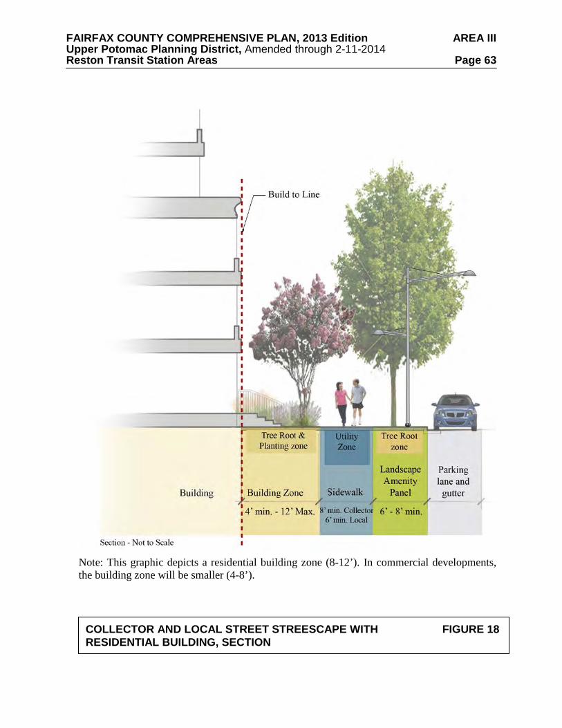
FAIRFAX COUNTY COMPREHENSIVE PLAN, 2013 Edition AREA III Upper Potomac Planning District, Amended through 2-11-2014 Reston Transit Station Areas Page 63
Note: This graphic depicts a residential building zone (8-12’). In commercial developments, the building zone will be smaller (4-8’).
COLLECTOR AND LOCAL STREET STREESCAPE WITH FIGURE 18 RESIDENTIAL BUILDING, SECTION
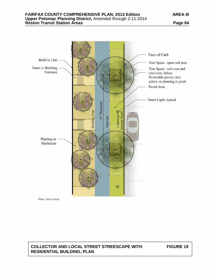
FAIRFAX COUNTY COMPREHENSIVE PLAN, 2013 Edition AREA III Upper Potomac Planning District, Amended through 2-11-2014 Reston Transit Station Areas Page 64
COLLECTOR AND LOCAL STREET STREESCAPE WITH FIGURE 19 RESIDENTIAL BUILDING, PLAN
FAIRFAX COUNTY COMPREHENSIVE PLAN, 2013 Edition AREA III Upper Potomac Planning District, Amended through 2-11-2014 Reston Transit Station Areas Page 65 Building Zone
The width of this zone should range from 4 to 12 feet. When residential uses with direct access onto the street are located on the ground level, a building zone with a minimum 8-foot width should be provided to accommodate entry stairs or other design elements. When ground-level retail is provided in a building, a portion of this building zone should be used for retail browsing or outdoor dining. Supplemental plantings (to include shade and flowering trees, shrubs, flowering plants, ground cover, and grasses) may be provided for buildings without retail uses. Reston-specific Local Street Streetscape
To strengthen the overall development quality and reflect the uniqueness of the landscape design character in Reston, certain local streets should incorporate an alternative, Reston-specific streetscape whose primary design characteristic is the creation of wide, thickly planted areas of irregularly spaced street trees as a contrast to the regularly spaced street trees lining the majority of streets. Ideally, this streetscape treatment would be applied on multiple blocks to create corridors with additional areas of tree cover. Coordination between development applications will be required to achieve this objective.
This streetscape will echo the aesthetic created by the existing areas of densely growing
trees bordering streets throughout Reston’s residential areas and along selected segments of Sunrise Valley Drive and Wiehle Avenue. The streetscape also provides for additional environmental benefits due to the increased tree canopy (accomplished by the increased number and size of trees), and reduction in impervious surfaces.
In recognition that this streetscape’s unique design requires more land than other
streetscape types, development may limit the application of this streetscape to a minimum of one block face per development block.
Landscape amenity panel This zone should be a minimum of 12 feet wide. Street trees should be irregularly spaced,
in relation to the curb and themselves, within a continuous tree space with open soil, with hardscaped pedestrian access points every 80 feet, recognizing the constraints of utility locations. There should be a maximum of 30 feet between trees. Vegetation to include shrubs, grasses and ground cover should be planted between the street trees. On-street parking is envisioned for these streets so a pedestrian step-out zone with a 2-foot width should be provided. Amenities such as bicycle racks and bus shelters should be provided as needed to serve the adjacent land uses. Attractive street lighting should be provided to illuminate both the street and the sidewalk.
Sidewalk Sidewalks should be 6-8 feet wide.
Building Zone This zone should range from 4 to 12 feet. When residential uses with direct entry to the
street are located on the ground level, a building zone with a minimum 8-foot width should be provided to accommodate entry stairs or other design elements. When ground-level retail is provided in a building, a portion of this building zone should be used for retail browsing or outdoor dining. Supplemental plantings (to include shade and flowering trees, shrubs, flowering
FAIRFAX COUNTY COMPREHENSIVE PLAN, 2013 Edition AREA III Upper Potomac Planning District, Amended through 2-11-2014 Reston Transit Station Areas Page 66 plants, ground cover, and grasses) may be provided for buildings without retail uses. Like the landscape amenity panel, these supplemental plantings may include a wide, continuous open soil area. This area would include thickly planted, irregularly spaced street trees with shrubs, grasses and ground cover planted between trees. In addition, clusters of trees may also be used as a landscape design element to emphasize building entries, feature corners or provide transitions between the sidewalk and publicly accessible open space.
Service Street Streetscapes Service streets are expected to provide access to parking, loading docks, waste
management, utilities, and other “back-of-building” operations. While they do not primarily serve pedestrians, they should provide a minimum level of accessibility and safety for pedestrians where applicable. See Figure 20 below.
Sidewalk A minimum 5-foot wide clear sidewalk should be provided adjacent to buildings. No
poles, utilities, or other appurtenances should be located in the sidewalk clear area. Attractive street lighting should be provided to illuminate both the street and the sidewalk. In lieu of pole lights, attractive safety and wayfinding lighting may also be attached to the building face. Wayfinding and Signage
Signage is an important element that will contribute to the character of the Reston TSAs. The two predominant signage types that will most contribute to place making are on-site signage (signs used to identify a place of business or a residential building); and wayfinding elements which are placed in the public realm and provide directional assistance or location information (including street address) to pedestrians and motorists.
The quantity and quality of all signage should be considered in a comprehensive manner
within a development but should also be complementary between neighborhoods and in most cases, the subdistrict, or district as a whole.
It is recommended that a Comprehensive Sign Plan (CSP) be submitted for all
redevelopment applications. It is further recognized that the signage requested pursuant to such CSPs may deviate significantly from that permitted under the Zoning Ordinance’s standard regulations if it contributes to creating a defined character for a district or subdistrict.
All signage should be well-organized, neat, well-maintained, concise and legible. Signage
should fit with the architectural style of the project, using complementary materials and colors, and ideally be incorporated into the architectural elements of structures. As the character of districts and subdistricts emerges, and as parks, entertainment and dining areas are developed, wayfinding signage will help pedestrians and motorists navigate within each TSA and among TSAs.
Wayfinding elements are most effective when used on a subdistrict and district level and indicate routes and events throughout the TSAs. Public art that functions as signage may be considered if it contributes to creating a defined character for a district or subdistrict. A strategy for wayfinding throughout all three TSAs should be considered, and could act as a placemaking tool and help distinguish between the TSAs.
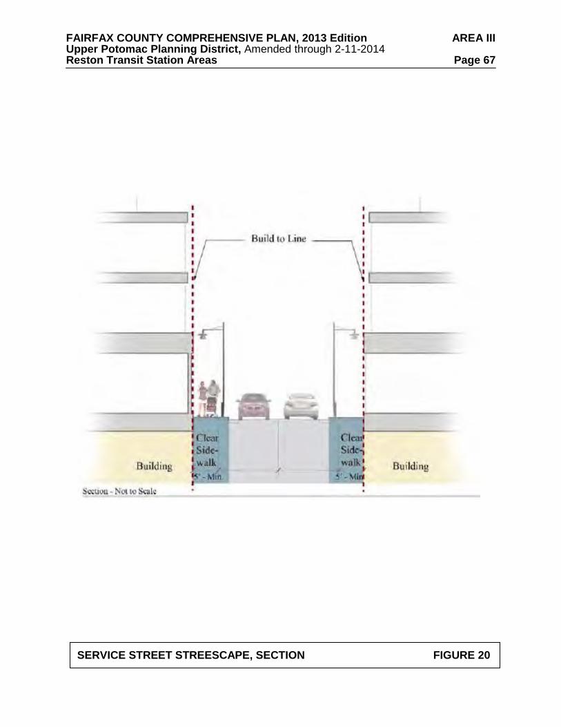
FAIRFAX COUNTY COMPREHENSIVE PLAN, 2013 Edition AREA III Upper Potomac Planning District, Amended through 2-11-2014 Reston Transit Station Areas Page 67
SERVICE STREET STREESCAPE, SECTION FIGURE 20
FAIRFAX COUNTY COMPREHENSIVE PLAN, 2013 Edition AREA III Upper Potomac Planning District, Amended through 2-11-2014 Reston Transit Station Areas Page 68 Public Art
Public art has been a component of the effort to achieve quality urban design in Reston since the community’s inception and is a distinguishing feature that contributes to the overall character of Reston. In order to continue to realize the goal of making Reston a vibrant place to live, work and play, public art should be encouraged in future development in the Reston TSAs. Designated open spaces should also be encouraged to include public art.
The Reston community under the leadership of the Initiative for Public Art in Reston
(IPAR) developed a Public Art Master Plan which establishes a process for planning and commissioning public art including community roles as well as collection management. The IPAR Plan also suggests working zones within which to focus efforts. The IPAR Plan should be used as a guide in the establishment of public art and as a resource for the review of new development and redevelopment proposals within the TSAs. Building and Site Design Recommendations
Building and site design must support the pedestrian realm to create a vibrant urban environment. The pedestrian and public realm is framed by buildings and adjacent open spaces. It is the arrangement and character of the buildings, as well as the quality of the spaces in-between, that determine the quality of the urban form as a whole.
The following recommendations address Build-to Lines; Building Frontages; Active Uses;
Building Mass; Step-Backs; Building Articulation; Fenestration and Transparency; Parking Design; and Building Height. Build-to Lines
The build-to line is a theoretical line on the ground indicating where the facades of
buildings should be located. It is located at the back of the building zone. The build-to line generally applies to the podium (or base) of the building and excludes building towers. The build-to line should be consistent within a block, unless it is intentionally varied to achieve facade articulation, streetscape uses such as outdoor dining, or other public open spaces. Consistent build-to lines ensure that the ground floors of all buildings on a block generally align with each other at the edge of the streetscape, providing a frame for the public realm but allowing architectural variation and interest in order to enhance pedestrian accessibility and convenience.
Proposed developments should adhere to a consistently established build-to line for each
block. The location of the build-to lines will relate to the streetscape guidance, the intensity and activity of the land uses, and the desired relationship of pedestrians to these uses. The location of the build-to line may vary depending on the character of the street and the district.
Existing uses and buildings that do not conform to the build-to line established by new
development (especially those that are a part of phased redevelopment plans) should investigate opportunities to create visual and physical linkages to conforming new buildings that address the pedestrian realm. These existing uses and buildings, whether in front of or behind the build-to line, may use walls, landscaping, or other architectural features to align with other buildings at the build-to line.
FAIRFAX COUNTY COMPREHENSIVE PLAN, 2013 Edition AREA III Upper Potomac Planning District, Amended through 2-11-2014 Reston Transit Station Areas Page 69 Building Frontage
The building frontage is the portion of the building that serves to define and enclose the
pedestrian realm and includes the podium (or base) of the building. It generally aligns with the build-to line and serves as a physical and visual boundary to the pedestrian realm and should therefore be visually engaging to the pedestrian and should provide appropriate, convenient access. The building frontage should engage pedestrians and avoid creating barriers, or the impression of disconnection from the surrounding neighborhood. This encourages an enlivened, engaged and conveniently accessed pedestrian realm.
In general, ground-floor commercial uses should be accessed directly from the adjacent
public sidewalk or building zone. In the absence of significant existing elevation changes, storefronts should be at the same grade as the sidewalk and building zone. Ground-floor residential uses, however, should be appropriately separated from the public sidewalk to distinguish the units and to provide a degree of privacy. This creates the opportunity for stoops, bays, porches or entries that establish a distinct transition between private residential developments and the pedestrian realm, while simultaneously providing convenient access.
If accessed directly from the public sidewalk, stairs should not impinge upon the pedestrian
realm; they should be located wholly on private property so as to not affect pedestrian movement. In lower density areas, front yards should be shallow and characterized by entry gardens and terraces that encourage a direct relationship between the building and the pedestrian realm. Active Uses
Active uses are those uses generally within the first or lowest floors of a building that are
designed to be occupied and have direct relationships to the adjacent streetscape or open space. Active uses engage pedestrians and may include retail or service uses. They encourage pedestrian activity by engaging the interest of pedestrians along their walk. Active uses also provide for “eyes on the street”, creating a sense of safety for pedestrians.
The building frontage should include active uses, such as retail, at street level along the
appropriate pedestrian corridors. Uses like loading docks, mechanical rooms, utility vaults, and exposed parking decks detract from the pedestrian experience and should be placed internal to the building envelope or facing service streets. Building Mass
Building mass is the three-dimensional bulk of a building: height, width, and depth. Planned development in the TOD areas will be urban in nature, and new buildings will generally occupy a majority of the block and be multiple stories in height.
Sites should be designed with care to achieve the desired density goals, while remaining
sensitive to the impact of development on the surrounding context. Attention to building mass in the design process will protect pedestrians’ access to light, and allow for access to light and privacy for other buildings. In addition, proper building mass should minimize long periods of shadow on the street, adjacent buildings and public open space.
FAIRFAX COUNTY COMPREHENSIVE PLAN, 2013 Edition AREA III Upper Potomac Planning District, Amended through 2-11-2014 Reston Transit Station Areas Page 70 Step-Backs
The pedestrian experience is greatly influenced by the height of the building along the
sidewalk. Excessive height along the sidewalk can feel uncomfortable to pedestrians and discourage pedestrian movement through the space. Step-backs are one tool that can be used to create an appropriate proportion of street width to building height.
Building step-backs are created through the stepping back of the upper floors of a building
from the build-to line to reduce its apparent mass at the street level (see Figure 21). As a result, pedestrians only perceive the first few floors of the building base, and not the full height of the tower. Step-backs can be used to reduce the impacts of shadows and increase the access of sunlight to the pedestrian realm. They can also reduce the visually disconcerting “tunnel” effect that sometimes occurs along streets that are lined with tall buildings.
Step-backs can vary by location and context. They can be used to add a measure of depth
and complexity to the bulk of buildings. Step-backs may be necessary to ensure sunlight in certain locations, particularly as related to public open spaces. Solar shading analyses (also called sunlight or shadow studies) may be necessary to ensure that adjacent buildings will have adequate light. For buildings taller than four stories, the step-back may be located anywhere from four to eight stories above sidewalk level. Step-backs should be reviewed in proposed developments to confirm the scale and proportion of the street section and their relationship to adjacent building heights and scale. In general, the goal is to create a street width to podium height ratio anywhere from 1:1 to 1:2. Building Articulation
Building articulation is the variation in a building’s facade to provide changes in depth,
patterning, or fenestration. Some elements of building articulation include rhythmic bays, planar breaks, window systems, entries, balconies and stoops. It can also include changes across building heights. This can include material, color and textures which express the ground floor, building podium and building tower. Building articulation can make buildings interesting and engaging to the pedestrian while simultaneously breaking down the scale of building facades to avoid large, monotonous areas of building wall. Certain types of articulation can also provide shade or orient pedestrians by defining entries.
Building articulation can vary by location and context. Buildings should include
appropriate elements in order provide for an interesting and engaging pedestrian environment. Fenestration and Transparency
Fenestration refers to the pattern of openings in a building facade typically through the use of windows, doors and other glazed areas. Transparency in the fenestration of appropriate ground floor uses can visually activate the pedestrian realm and allow for “eyes on the street” which can enhance the feeling of safety for pedestrians.
Where ground floor retail, commercial, community or other non-residential uses occur, the
facade above bulkhead and below the finished elevation of the first floor ceiling should be largely transparent. Transparency should permit visibility from the sidewalk into a building and its active uses. Opaque, mirrored and translucent glass should be avoided and should not be considered “transparent.”
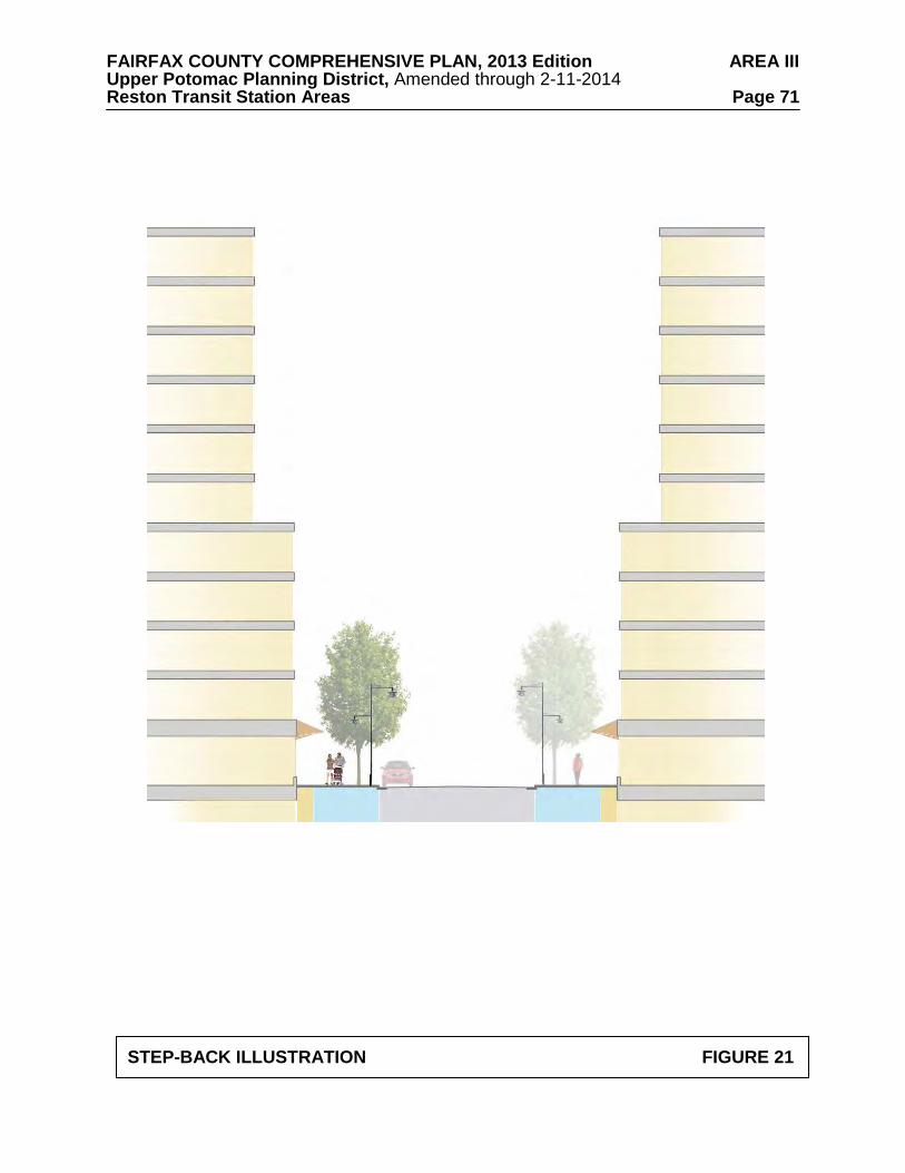
FAIRFAX COUNTY COMPREHENSIVE PLAN, 2013 Edition AREA III Upper Potomac Planning District, Amended through 2-11-2014 Reston Transit Station Areas Page 71
STEP-BACK ILLUSTRATION FIGURE 21

FAIRFAX COUNTY COMPREHENSIVE PLAN, 2013 Edition AREA III Upper Potomac Planning District, Amended through 2-11-2014 Reston Transit Station Areas Page 72 In residential buildings, the level of ground floor transparency may be lower for private uses, such as living areas. Residential lobbies and other common spaces should exhibit higher transparency and should provide a visual connection to the pedestrian realm. Parking Design
Parking facilities should meet the following guidelines:
• Parking access should be designed to minimize conflicts between vehicles and pedestrians and to take into account pedestrian safety. This may include reducing the number of parking access points and minimizing the widths of ramps and curb cuts where they intersect with the sidewalk.
• Vehicular access to parking lots and parking garages should be limited to local streets or service streets when feasible.
• Parking access should always be designed to be attractive and coordinated with the site
plan and architecture. • Certain uses, such as retail, civic or entertainment, may require highly visible parking. • Exterior and interior parking structure lighting design should provide adequate lighting
levels that ensure public safety without creating glare and light spillage into adjacent structures, roads, and the pedestrian realm. All parking lot lighting should conform to current LEED light pollution requirements and County ordinances.
Structured Parking
Underground parking is the least intrusive form of parking on the built environment and is
the preferred method for providing parking in the TSAs. Above-grade structured parking, or podium parking, is also appropriate. Above-grade parking structures should be “wrapped” with active uses to the maximum extent possible. See Figure 22.
In some locations, exposed parking structures may be unavoidable. In such cases, careful architectural detailing, lighting, and landscaping should be employed along the building facades to mitigate the negative impacts of exposed parking levels. If a parking level is not wrapped with an active use, the façade should be designed so that it appears as an attractive architectural element. This is especially recommended if the façade of the building tower is at the same vertical plane as the façade of the building base, so the building will appear to be occupied space all the way to the ground floor.
Generally, the architecture of garages should be consistent with surrounding buildings.
Efforts should be taken to place these structures facing service streets. Where garage, loading access, utility vaults and/or mechanical rooms must be provided on a non-service street, the extent should be minimized and architectural treatments and screening, as discussed above, should be provided.
New stand-alone above-grade parking structures are discouraged.
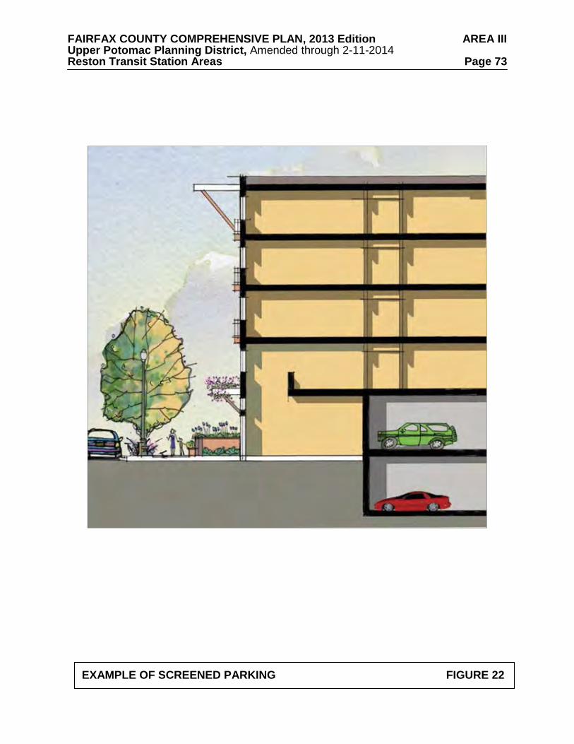
FAIRFAX COUNTY COMPREHENSIVE PLAN, 2013 Edition AREA III Upper Potomac Planning District, Amended through 2-11-2014 Reston Transit Station Areas Page 73
EXAMPLE OF SCREENED PARKING FIGURE 22
FAIRFAX COUNTY COMPREHENSIVE PLAN, 2013 Edition AREA III Upper Potomac Planning District, Amended through 2-11-2014 Reston Transit Station Areas Page 74 Surface Parking
It is the long term vision to avoid large surface parking lots. Surface parking detracts from
the pedestrian experience and should be avoided. The exception to this guideline occurs in portions of the Non-TOD Districts, where structured parking may not be economically feasible. Surface parking may also be considered for short term parking, such as 30 minute retail parking or for passenger drop-off and pick-up areas. In addition, as the area transitions to a more urban environment, surface parking may be considered on an interim basis.
When provided, surface parking lots should be located to the side or rear of the primary use
and should contain pedestrian connections that lead to the front door of the associated building. They should be intensively landscaped, be well-lighted, and publicly visible for greater safety. Surface parking lots should provide low walls or fences at the back of the sidewalk or parallel to the adjacent build-to line to enclose and define the pedestrian realm. They also should be designed to contribute to site stormwater management by using elements such as planting areas and permeable paving in the parking stall area. On-Street Parking
On-street parking makes sidewalks safer and provides necessary and sometimes more accessible short-term residential and retail parking, as well as activating streets. Many new streets within the TSAs should provide on-street parking (see Transportation section for additional guidance). Where on-street parking is provided, curb cuts for vehicular access should be minimized in order to increase pedestrian safety and maximize the number of on-street parking spaces. Building Height
Building heights in the TSAs will reflect the proposed intensity pattern. The tallest
buildings should generally be located within ¼ mile of the Metro station with heights stepping down gradually as the distance from the Metro station increases. In addition, building heights in proximity to the DAAR may be taller, however building heights will be lowest in locations adjacent to existing townhouses and those single-family residential neighborhoods outside of the TSAs. In the Reston Town Center Station TOD district, building heights may be comparable to or exceed those in the Town Center Urban Core. Careful design should protect view corridors and maintain access to sunlight in these sensitive locations.
The following are general recommendations regarding building height:
• Building heights and massing should respond to context, proximity to Metro or other
neighborhood features, intended uses, and the Plan’s vision for specific locations. Buildings may be oriented to maximize their view potential, but their location and orientation should take into consideration uses in the immediate vicinity.
• The tallest buildings should be iconic in design and serve as identifying features that
contribute to the quality of the skyline. Iconic architecture can be defined as buildings that are well-crafted, unique, distinguishable within their context, and complementary to the urban fabric. Iconic architecture should also advance the overall quality of design within the district.
FAIRFAX COUNTY COMPREHENSIVE PLAN, 2013 Edition AREA III Upper Potomac Planning District, Amended through 2-11-2014 Reston Transit Station Areas Page 75
• During the development review process, solar shading analyses (also called shadow studies) for all buildings should be provided to ensure that adjacent buildings and public spaces will have adequate access to sunlight.
Publicly Accessible Open Space
High quality open spaces of all types provide opportunities for spontaneous interaction and
programmed activities as well as for introducing variability in the fabric of the built-environment. A variety of large and small publicly accessible open spaces should be available throughout the Reston community.
In some instances, such open spaces can be sited so as to preserve, augment and/or enhance
the natural environment. In certain parts of Reston’s TSAs, opportunities to preserve areas with existing trees should be sought to help connect these more urban areas to the larger fabric of Reston.
Definition of Publicly Accessible Open Space For the purposes of this Plan, these spaces are to be for public enjoyment and may be either public or privately owned space to which public access is granted. They may include:
• environmentally sensitive areas, such as Resource Protection Areas (including wetlands, streams and stream buffers) and existing stands of trees;
• active recreation areas, such as large active play fields and smaller outdoor recreation
areas for activities such as tennis and volleyball; • designated privately owned, publicly-accessible open spaces, such as gardens, plazas,
walkways, pathways, trails, urban parks, through-block connections, civic spaces, town squares, and a memorial sculpture garden; and
• other publicly owned and publicly accessible open spaces including small urban parks
and civic spaces.
Publicly accessible open spaces do not include streets, parking and driveways or areas for vehicles, streetscape widths that are less than 12 feet wide, and roof top areas not readily accessible to the public. In some instances, publicly accessible open space may need to be identified by a wayfinding sign.
Calculation of Publicly Accessible Open Space
The following guidelines apply when considering the total amount of publicly accessible open space to be provided by any given project:
• The open space goal should be 20 percent of the net lot area (total lot area not including
areas for public or private streets and 12 feet of the streetscape area). Flexibility in location should be used in applying this goal, recognizing that smaller open spaces are more appropriate and are generally used and enjoyed in the highest density areas. Some portions of the 20 percent goal may be more readily located in the immediate proximity of the transit station areas.
FAIRFAX COUNTY COMPREHENSIVE PLAN, 2013 Edition AREA III Upper Potomac Planning District, Amended through 2-11-2014 Reston Transit Station Areas Page 76
• The publicly accessible open space goal for each parcel may be met by open space located off-site and combined with other properties within the TSA to create larger public spaces (e.g. the proposed large civic green in the South TOD area of the Town Center TSA and the proposed green, linear park along Sunrise Valley Drive). In some cases, it may be desirable for monetary contributions for open space areas in Reston to be provided in lieu of land contributions, where such can be used to either aquire new or to improve existing open space in Reston.
• Publicly accessible open space may include active space such as an outdoor
performance space, active recreation fields, public parks, and a memorial sculpture garden.
• Flexibility on the percentage of open space may be granted for exceptional design and
exceptional land dedications for public use.
Interim Conditions
In many cases developments will be phased over time. In addition to demonstrating how projects will ultimately adhere to the Urban Design Principles contained in the Plan, phased developments should prepare plans and supporting graphics that demonstrate how all interim conditions will meet Plan objectives, including those related to urban design. Among other design considerations, these plans should:
• Provide pedestrian circulation that meets the connectivity goals of the Plan. • Show how any interim parking facilities will adhere to parking design and phasing
goals. • Show how landscape and sustainable hardscape improvements will improve the
aesthetic character of any existing or proposed interim uses. • Show how interim stormwater facilities can be creatively incorporated into a high
quality landscape design. • Provide streetscape improvements that conform to Plan guidelines and that result in
enhanced continuity of the streetscape design. • Show how proposed public amenities such as open spaces and Urban Parks will be
integrated into the site.
TRANSPORTATION
The vision for the three Reston TSAs promotes a mix of land uses served by a multi-modal transportation system. Various planned transportation improvements will facilitate this vision, while accommodating current and future commuters and residents within and around the transit stations. The improvements should 1) balance future land uses with supporting transportation infrastructure and services; 2) address the long term needs of the area, including significantly improving the infrastructure and facilities for transit, pedestrians and bicycles; and, 3) design a road network that accommodates all modes of transportation and includes a grid of streets in the TSAs to improve connectivity around the transit stations.

FAIRFAX COUNTY COMPREHENSIVE PLAN, 2013 Edition AREA III Upper Potomac Planning District, Amended through 2-11-2014 Reston Transit Station Areas Page 77
The following recommendations are intended to help improve circulation within, around, and through the TSAs. While the transportation recommendations support the development near the Metrorail stations, these recommendations also will facilitate regional travel through the area. Land Use/Transportation Balance
Maintaining a balance between the land uses in the three TSAs and the supporting transportation system is essential in order to preserve accessibility in and around these areas as development occurs over time. To maintain a balance, the increase in development should be coordinated with the provision of transportation infrastructure and specific programs to reduce vehicle trips.
Within the TSAs, preference should be given to maintaining a high level of service for all
modes including transit, vehicles, pedestrians, and bicyclists. To achieve this, consideration should be given to safety and security, direct pathways, topography, and the achievement of a balance between traffic delay and a pedestrian friendly environment. Impact studies should quantify the level of service (LOS) for all applicable modes by applying up-to-date standard techniques. It is the intent of these recommendations to maximize the future use of transit, bicycling and walking in these TSAs in the future. However, safe and efficient circulation for vehicles will still need to be provided within, through and around the TSAs. Monitoring System
Maintaining a balance between land use and transportation is dependent on a number of factors, such as the provision of a grid of streets and a reduction in the number of vehicle trips. The necessary transportation infrastructure, modal split levels, and vehicle trip reduction levels to balance planned new development have been analyzed extensively based on known conditions at the time of developing this Plan guidance. However, these conditions may change in the future which could result in changes in the number, frequency or direction of vehicle trips. For this reason, it is essential to monitor total development and the resulting vehicle trips into and within the TSAs over time. This review should occur at least every five years or as needed based on the pace of new development. Pedestrian Mobility and Bicycle Facilities Pedestrian Mobility
The street network planning in the Reston TOD districts should provide a safe and comfortable environment for pedestrians while addressing mobility and access needs for all users (including emergency service, goods movement and utilities placement). The enhanced street network should provide a high level of connectivity within the TOD districts so that pedestrians, bicyclists, transit users, and vehicles can choose the most direct routes and access urban properties. In addition, improved connectivity should be provided between the TOD districts and other districts as well as between the TSAs and the adjoining areas outside the TSAs.
In additional, direct paths, such as trails or walkways, should be provided for pedestrians
where additional street connections cannot be made or where a more enhanced pedestrian network is desirable.
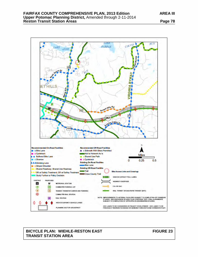
FAIRFAX COUNTY COMPREHENSIVE PLAN, 2013 Edition AREA III Upper Potomac Planning District, Amended through 2-11-2014 Reston Transit Station Areas Page 78
BICYCLE PLAN: WIEHLE-RESTON EAST FIGURE 23 TRANSIT STATION AREA
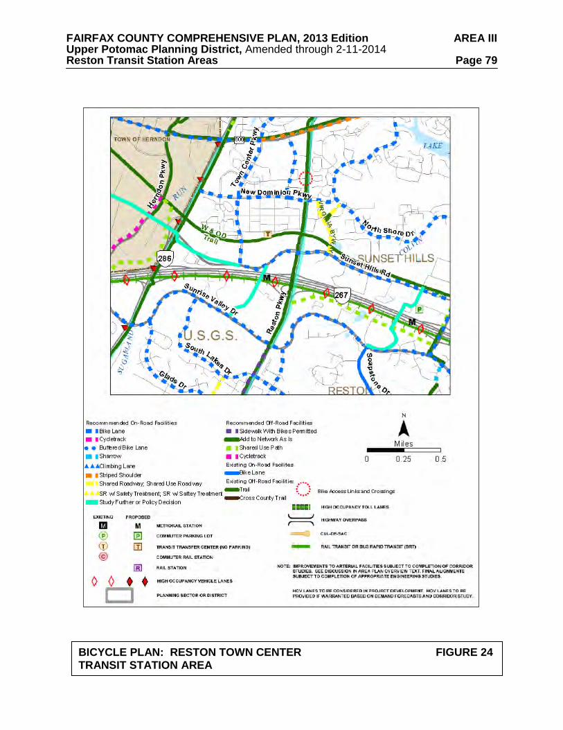
FAIRFAX COUNTY COMPREHENSIVE PLAN, 2013 Edition AREA III Upper Potomac Planning District, Amended through 2-11-2014 Reston Transit Station Areas Page 79
BICYCLE PLAN: RESTON TOWN CENTER FIGURE 24 TRANSIT STATION AREA
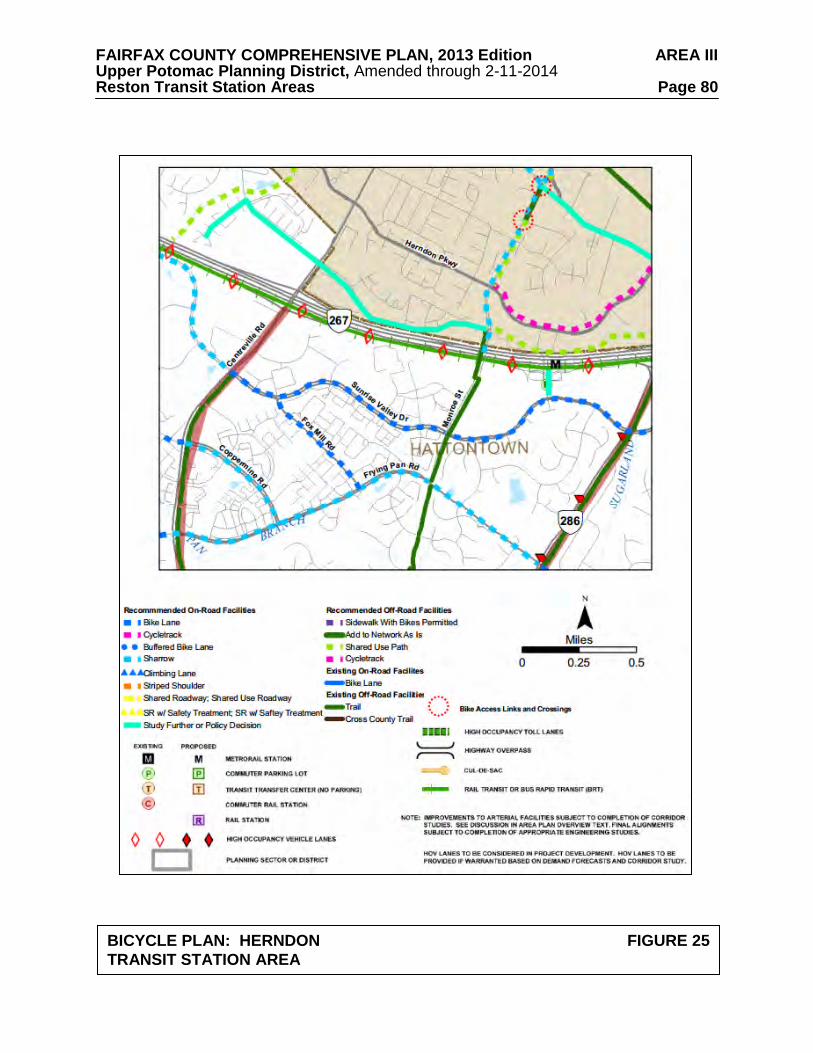
FAIRFAX COUNTY COMPREHENSIVE PLAN, 2013 Edition AREA III Upper Potomac Planning District, Amended through 2-11-2014 Reston Transit Station Areas Page 80
BICYCLE PLAN: HERNDON FIGURE 25 TRANSIT STATION AREA
FAIRFAX COUNTY COMPREHENSIVE PLAN, 2013 Edition AREA III Upper Potomac Planning District, Amended through 2-11-2014 Reston Transit Station Areas Page 81 Bicycle Facilities
Bicycle facilities should be provided consistent with Figures 23-25. In addition, specific bicycle facilities are described in the Street Types Guidelines under the Road Network and Circulation section below. In an effort to encourage bicycling in the TSAs, safe, secure, and convenient bike parking should be provided. The number of bike parking spaces should be determined based on the planned land uses.
Public Transportation Metrorail
The introduction of Metrorail service along the Dulles Airport Access Road and Dulles Toll Road (DAAR, Route 267) is a key component to providing increased mobility and reducing vehicle dependency for employees and residents in the three TSAs. Focusing the highest density development, especially new office development, around the Metrorail stations is vital to promote the use of mass transit and achieving the vision for these TSAs. Local Bus Service
Fairfax Connector bus service currently serves both local riders and people commuting
from the TSAs to other employment centers. These routes will be modified to provide convenient and reliable feeder service from other parts of Reston as well as the outlying communities to the Metrorail stations. There will also be a need for effective service between the TOD areas and between areas on both sides of the DAAR. The Countywide Transit Development Plan provides details regarding planned adjustments to existing routes and new routes to be added.
Road Network and Circulation
The road network and circulation recommendations provide additional transportation
guidance for development within the Wiehle-Reston East, Reston Town Center, and Herndon TSAs. As new streets are constructed, right-of-way should be provided for their ultimate configuration including pedestrian and bicycle facilities as identified in the Plan. The streets should provide a high level of connectivity and accommodate all modes of transportation to the fullest extent possible.
Balancing the competing needs of numerous stakeholders will be necessary from the
earliest stages in the planning and design of transportation projects. The design of a facility should ensure safety and function appropriately for all users regardless of the mode of travel they choose. Flexibility in design may be considered to achieve Plan objectives. Network Level of Service
An overall Level of Service (LOS) ‘E’ is the goal for the intersections within the street
network of Reston TSAs. In instances where a LOS E standard cannot be attained or in a TSA with planned development, remedies should be proposed to offset impacts using the tiered approach described below. The purpose of this tiered approach is to maintain a walkable environment and support implementation of the grid of streets, which is more typical of urban areas and improves mobility for pedestrians and bicyclists.
FAIRFAX COUNTY COMPREHENSIVE PLAN, 2013 Edition AREA III Upper Potomac Planning District, Amended through 2-11-2014 Reston Transit Station Areas Page 82
In the development review process, mitigation of problem locations should follow the following sequence:
1. First, determine whether increased operational efficiency is achievable without decreasing pedestrian walkability and safety.
2. If increased operational influence does not result in an acceptable level of service, additional turn and through lanes can be considered on condition that the level of walkability remains acceptable. However, exclusive turn lanes and/or through lanes will not be desirable in most cases since it will increase street widths at intersections and therefore work against an attractive environment for pedestrians.
3. In lieu of additional lanes, it is preferable to add links to the street grid where applicable with the goal of promoting the build out of the grid of streets. This strategy creates additional diversionary paths for vehicles and decreases the traffic at problem locations in the vicinity of a proposed development.
4. When step 3 is not achievable, decrease future site-generated traffic by (1) changing the mix of land use within the parameters of the applicable land use guidelines (e.g., replacing office or retail uses with residential use); (2) increasing transit use through provision of additional and improved services; and/or, (3) optimizing the application of TDM with measures that might include greater transit use, carpooling, ridesharing, walking and bicycling.
5. If the measures outlined in the previous two steps do not provide adequate improvement of LOS, a development proposal or future phase of development may need to be conditioned on funding or completion of offsetting improvements. Financial contributions of significant value dedicated to addressing deficiencies in the TSA may be considered as an offsetting improvement. These contributions may not be used as a credit against other contributions toward off-site transportation improvements.
Transportation Demand Management
Transportation Demand Management (TDM) refers to a variety of strategies aimed at
reducing the demand on the transportation system, particularly reducing single occupant vehicles during peak periods, and expanding the choices available to residents, employees, and visitors. Examples can be found in the County’s Policy Plan. The result is a more efficient use of the existing transportation system. TDM is a critical component in achieving the Plan’s goal of land use and transportation balance.
The objective of a successful TDM program for the TSAs is to reduce the number of single
occupant vehicle trips. These reductions are based on Institute of Transportation Engineers’ (ITE) trip generation rates and are to fall within the ranges shown in the TDM Goals (See Figure 26). These goals are the ultimate objective once rail is operational and public transit is in place. The recommendations are for reductions of at least 35 percent for the areas within ¼ mile of the Metrorail stations and at least 30 percent for the areas between ¼ and ½ mile from the Metrorail stations. TDM Goals lower than those shown in Figure 26 may be considered, on an interim basis, prior to the opening of each Transit Station Area’s Metrorail Station.
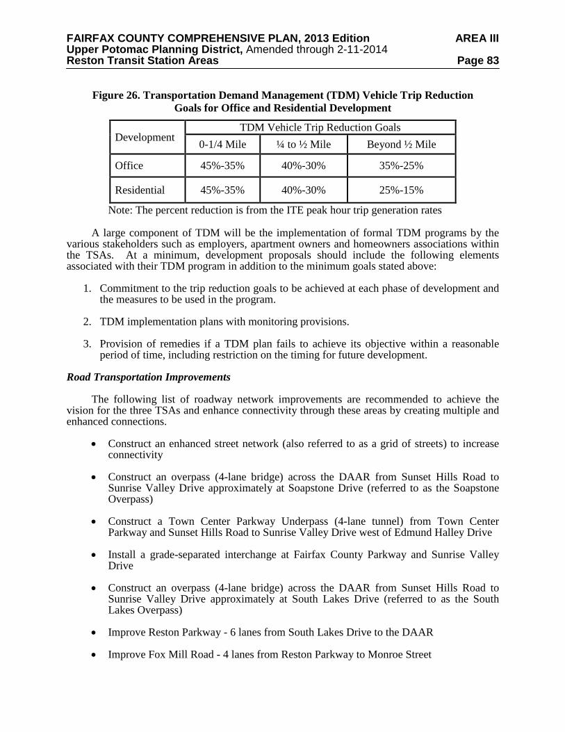
FAIRFAX COUNTY COMPREHENSIVE PLAN, 2013 Edition AREA III Upper Potomac Planning District, Amended through 2-11-2014 Reston Transit Station Areas Page 83
Figure 26. Transportation Demand Management (TDM) Vehicle Trip Reduction Goals for Office and Residential Development
Development TDM Vehicle Trip Reduction Goals
0-1/4 Mile ¼ to ½ Mile Beyond ½ Mile
Office 45%-35% 40%-30% 35%-25%
Residential 45%-35% 40%-30% 25%-15%
Note: The percent reduction is from the ITE peak hour trip generation rates A large component of TDM will be the implementation of formal TDM programs by the
various stakeholders such as employers, apartment owners and homeowners associations within the TSAs. At a minimum, development proposals should include the following elements associated with their TDM program in addition to the minimum goals stated above:
1. Commitment to the trip reduction goals to be achieved at each phase of development and
the measures to be used in the program.
2. TDM implementation plans with monitoring provisions.
3. Provision of remedies if a TDM plan fails to achieve its objective within a reasonable period of time, including restriction on the timing for future development.
Road Transportation Improvements
The following list of roadway network improvements are recommended to achieve the vision for the three TSAs and enhance connectivity through these areas by creating multiple and enhanced connections.
• Construct an enhanced street network (also referred to as a grid of streets) to increase
connectivity • Construct an overpass (4-lane bridge) across the DAAR from Sunset Hills Road to
Sunrise Valley Drive approximately at Soapstone Drive (referred to as the Soapstone Overpass)
• Construct a Town Center Parkway Underpass (4-lane tunnel) from Town Center
Parkway and Sunset Hills Road to Sunrise Valley Drive west of Edmund Halley Drive • Install a grade-separated interchange at Fairfax County Parkway and Sunrise Valley
Drive • Construct an overpass (4-lane bridge) across the DAAR from Sunset Hills Road to
Sunrise Valley Drive approximately at South Lakes Drive (referred to as the South Lakes Overpass)
• Improve Reston Parkway - 6 lanes from South Lakes Drive to the DAAR • Improve Fox Mill Road - 4 lanes from Reston Parkway to Monroe Street
FAIRFAX COUNTY COMPREHENSIVE PLAN, 2013 Edition AREA III Upper Potomac Planning District, Amended through 2-11-2014 Reston Transit Station Areas Page 84
• Improve West Ox Road - 4 lanes from Lawyers Road to Centreville Road • Improve Monroe Street - 4 lanes from West Ox Road to the Town of Herndon • Extend Pinecrest Road from South Lakes Drive to Sunrise Valley Drive • Improve Fairfax County Parkway - 6 lanes with High Occupancy Vehicle (HOV)
lane(s)
A fundamental purpose of the grid of streets is to increase connectivity in the TSAs. One benefit is the availability of alternative routes for vehicles, thereby reducing congestion. A conceptual enhanced street network is shown on Figures 27-29. In planning the grid of streets, consideration should be given to avoiding intersections with acute or awkward angles; minimizing exclusive turn lanes; and having block sizes generally within a 400 foot to 600 foot range. Any block longer than 600 feet should contain a mid-block pedestrian connection where possible.
In addition to the list above, intersection improvements may be required in order to ensure
acceptable traffic operations. Each roadway improvement should be independently evaluated not only for its transportation utility from a cost-benefit perspective but also for its environmental implications, such as effects on storm water management, water quality, noise or parks, and also the roadway design and its integration into the area’s urban context. Street Types
Street types respond to the needs of traffic from transit, pedestrians, bicycles, as well as vehicles. Street types in the TSAs have been identified and an overview of the features within the curb (the road and median) for each street type is included according to each type’s functional classification. The cross-section for each street type contains flexibility to be able to respond to particular needs in different locations. Streetscape diagrams are located in the Urban Design section.
The design guidelines for street types should be followed when providing new private or
public roadway connections or when proposing improvements to the existing roadway network in the TSAs (to the extent consistent with applicable County standards). Minor Arterials primarily function as through traffic carriers. The collector streets collect traffic from the local streets and route them to arterials while the local streets allow internal circulation and connectivity within the area.
The existing and planned roadways in the TSAs and vicinity are categorized as follows according to the Fairfax County Guidelines for Functional Classification of Roadways. The guidance below is for roads associated with redevelopment or new development. Some of these characteristics may not be desirable due to the type of environment or be able to be implemented due to development constraints. Flexibility should be provided for roads that transition to existing roads. In addition, if new roads cross environmentally sensitive land there should be flexibility in road design. The Urban Design section includes the streetscape recommendations.
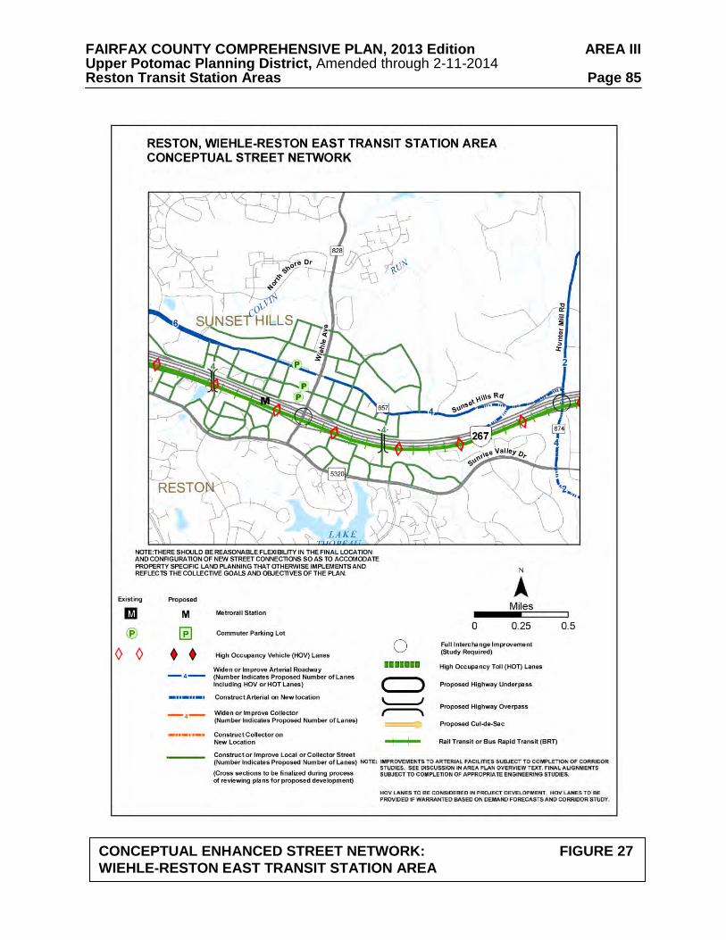
FAIRFAX COUNTY COMPREHENSIVE PLAN, 2013 Edition AREA III Upper Potomac Planning District, Amended through 2-11-2014 Reston Transit Station Areas Page 85
CONCEPTUAL ENHANCED STREET NETWORK: FIGURE 27 WIEHLE-RESTON EAST TRANSIT STATION AREA
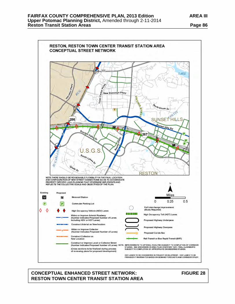
FAIRFAX COUNTY COMPREHENSIVE PLAN, 2013 Edition AREA III Upper Potomac Planning District, Amended through 2-11-2014 Reston Transit Station Areas Page 86
CONCEPTUAL ENHANCED STREET NETWORK: FIGURE 28 RESTON TOWN CENTER TRANSIT STATION AREA
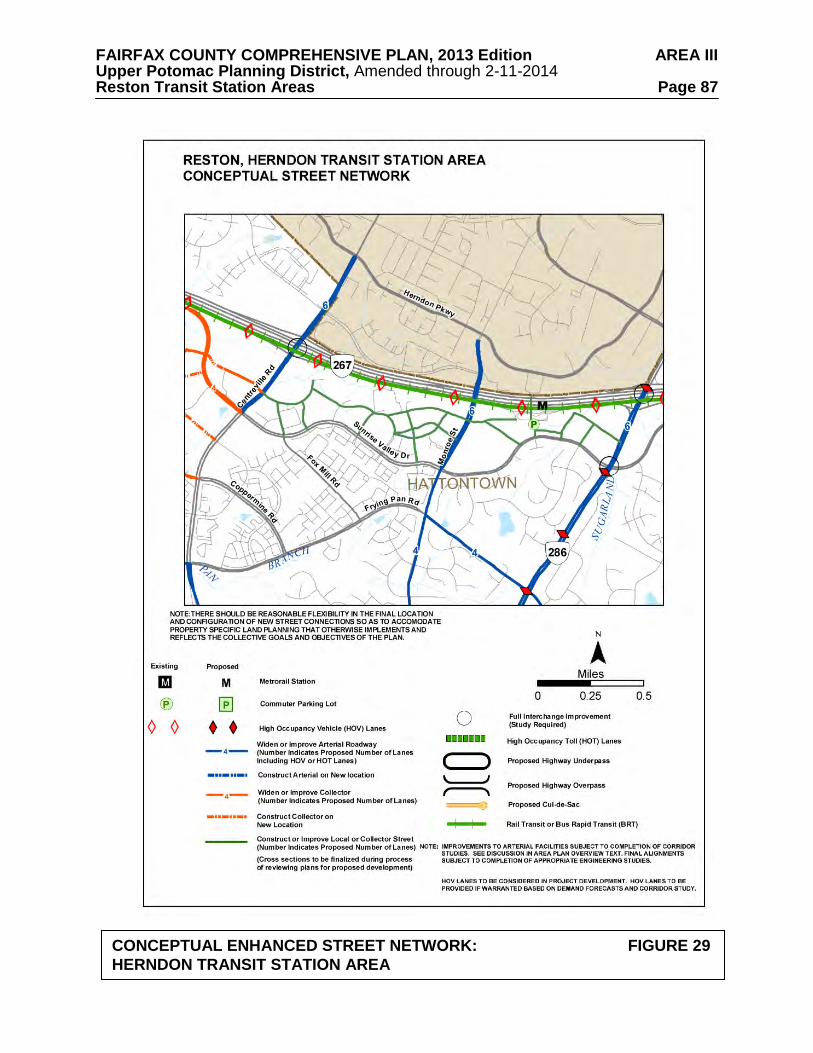
FAIRFAX COUNTY COMPREHENSIVE PLAN, 2013 Edition AREA III Upper Potomac Planning District, Amended through 2-11-2014 Reston Transit Station Areas Page 87
CONCEPTUAL ENHANCED STREET NETWORK: FIGURE 29 HERNDON TRANSIT STATION AREA
FAIRFAX COUNTY COMPREHENSIVE PLAN, 2013 Edition AREA III Upper Potomac Planning District, Amended through 2-11-2014 Reston Transit Station Areas Page 88 Minor Arterials–Type A
Reston Parkway is an example of a Minor Arterial-Type A in the Reston Town Center TSA primarily carrying the longer-distance through traffic from adjacent areas such as the Town of Herndon and Loudoun County.
Curb to Curb Area:
• Median width of approximately 8 to 22 feet (may be wider for areas with frequent and/or heavy pedestrian crossings)
• 2-3 travel lanes per direction (11 feet for each lane) • 5-6 foot on-road bike lane per direction, if found desirable
o If an on-road bike lane cannot be provided, and biking is anticipated to occur on the road, then one extra wide travel lane per direction may be desirable, adjacent to the curb, to accommodate bikes (14 feet)
o If bike facilities are not desirable within the curb to curb area due to the nature of the road, then they should be accommodated on a shared-use path adjacent to the road
• A target posted speed of 30-35 miles per hour is desirable for Reston Parkway.
Minor Arterials-Type B
Sunrise Valley Drive, Sunset Hills Road and Wiehle Avenue are examples of Minor Arterials-Type B in and adjacent to the TSAs. These roadways carry shorter-distance through traffic, and carry less traffic volume than Principle Arterials (as defined in the Transportation section of the Policy Plan).
Curb to Curb Area:
• Median width of approximately 8 to 22 feet, if provided, to allow for safe pedestrian refuge
• 2 travel lanes per direction (11 feet for each lane) • 5-6 foot on-road bike lane per direction, as shown on the bicycle facilities map
o If an on-road bike lane is not provided, then one extra wide travel lane per direction
may be desirable, adjacent to the curb, to accommodate bikes (14 feet). The lane should be marked or signs posted indicating that bikes are using the outside lane.
• 8 feet for on-street parallel parking if found desirable
• A target posted speed of 30 miles per hour is desirable for Sunset Hills Road, Sunrise
Valley Drive and Wiehle Avenue.

FAIRFAX COUNTY COMPREHENSIVE PLAN, 2013 Edition AREA III Upper Potomac Planning District, Amended through 2-11-2014 Reston Transit Station Areas Page 89 Collector Streets Town Center Parkway and New Dominion Parkway, as well as the future Soapstone Road, South Lakes Drive and Town Center Parkway extensions are examples of collectors in and adjacent to the TSAs. These roadways route traffic to major and minor arterials from the local streets. Curb to Curb Area:
• A median is not preferred; however, if provided the width should be approximately 14 to 22 feet
• 1 to 2 travel lanes per direction (11 feet for each lane) • 5-6 foot on-road bike lane, as shown on the bicycle facilities map
o If an on-road bike lane is not provided, then one extra wide travel lane per direction may be desirable, adjacent to the curb, to accommodate bikes (14 feet). The lane should be marked or signs posted indicating that bikes are using the outside lane.
• 8 feet for on-street parallel parking per direction • A target posted speed of 30 miles per hour is desirable for Collectors. In some cases,
25 miles per hour may be desirable for Collectors. Local Streets (Local)
Local streets in this area include the internal circulation roads and the new planned streets which connect the land uses to collector roads and allow internal circulation. Curb to Curb Area:
• Medians are not desirable and should only be required when they are part of the urban design concept and the landscape or open space plan
• 1-2 travel lanes per direction (10-11 feet for each lane)
o The outside lane is a shared travel lane between bicycles and vehicles. Local
streets are low speed facilities that normally may not require bike lanes.
• 7-8 feet for on-street parking∗ • A target posted speed of 25 miles per hour is desirable for Local Streets
Parking Management
To facilitate the achievement of TDM goals and encourage transit use, shared parking for uses which have different peak demand periods, instituting paid parking, or other parking reduction strategies are encouraged. Additionally, shared parking between similar uses with both existing and new buildings should be explored, especially if the existing use is over parked. These parking strategies can serve to reduce vehicle trips and increase the cost-effectiveness of
∗ 7 feet for residential areas; 8 feet for mixed-use commercial areas.
FAIRFAX COUNTY COMPREHENSIVE PLAN, 2013 Edition AREA III Upper Potomac Planning District, Amended through 2-11-2014 Reston Transit Station Areas Page 90 the provision of parking. For development within a half mile of the Metrorail station, a parking plan should be submitted along with a development application that demonstrates that the amount of parking that is provided is sized to support the development. Provisions for parking reductions and other incentives to lower parking should be utilized if it is supported by the parking plan. The use of higher parking rates in the first phases of a development followed by lower parking rates in subsequent phases can be considered for reasons such as existing leases requiring higher parking rates. Parking agreements with neighboring sites can be considered on an interim basis. Residential uses should take into account the number of bedrooms per unit when establishing the amount of parking to supply. All non-residential uses should reduce their parking supply below the Countywide minimum.
For office space, a maximum parking rate should be:
• 2.1 spaces per 1,000 square feet within the Transit Station Mixed Use area • 2.4 spaces per 1,000 square feet Residential Mixed Use
In instances where a higher office parking rate exists or is desired, an appropriate
justification can be submitted in order to consider a different rate for office use. Funding of Transportation Improvements and Services
Funding these transportation improvements through Federal, State and County sources
should be pursued; however, some combination of public and private sector funding will be necessary to cover the costs associated with these improvements and to expedite implementation. Additionally, these improvements may be implemented in stages by the private sector as development occurs. Further detailed examination of these funding options for each identified improvement and yet to be identified improvements is needed before a preferred funding approach is selected. ENVIRONMENTAL STEWARDSHIP
Reston is a community founded on the integration of nature with developed areas and the
stewardship of its wetlands, streams, lakes, forests, and other natural areas. Protecting, restoring and enhancing Reston’s diverse natural areas will remain a central planning principle and activity. Reston Association (RA), the Reston Town Center Association (RTCA), the Northern Virginia Regional Park Authority (NVRPA), Fairfax County, homeowner associations, and individual property owners will plan and manage Reston’s natural resources with the following environmental stewardship planning goals in order to keep natural areas healthy and resilient:
• Protect the headwater areas and other environmentally sensitive areas through the
implementation of innovative stormwater management practices.
• Restore and enhance the mature tree canopy and other natural areas.
• Establish high expectations regarding use of green technology and low impact development techniques for all buildings and neighborhoods.
• Provide noise attenuation measures as appropriate.
FAIRFAX COUNTY COMPREHENSIVE PLAN, 2013 Edition AREA III Upper Potomac Planning District, Amended through 2-11-2014 Reston Transit Station Areas Page 91 Stormwater Management
Future development offers considerable opportunities to improve upon past stormwater
management practices in furtherance of efforts to protect and restore local streams and to reduce pollutant loads entering the Potomac River and Chesapeake Bay. Low impact development (LID) techniques of stormwater management can serve to reduce runoff volumes entering local streams and can more easily be incorporated within densely developed areas than more traditional detention and retention ponds. These LID practices can include, but are not limited to, bioretention or biofiltration facilities (commonly known as rain gardens), vegetated swales, porous pavement, vegetated roofs, tree box filters and the collection and reuse of stormwater runoff.
Environmentally-friendly stormwater design should be an integral design principle that will
be part of the conceptual stage of site development for all future development, recognizing that stormwater management measures may be phased with development. The stormwater design should first seek to minimize the effect of impervious cover, followed by the application of stormwater reuse, retention, detention, extended filtration and, where soils and infrastructure allow, infiltration to improve downstream waters. The incorporation of stormwater management strategies in parks and other open space areas may support this approach while providing recreational amenities, and there may be opportunities to incorporate LID practices within other open space areas.
Coordination of stormwater management controls among multiple development sites may
also be effective in achieving stormwater management goals in an efficient manner. Stormwater management and water quality controls should be optimized for all future development projects consistent with the scale of such projects.
Stormwater quantity and quality control measures should be provided with the goal of
reducing the total runoff volume or significantly delaying its entry into the stream system. In furtherance of stream protection and/or restoration through replication of natural hydrologic conditions, the emphasis should be on LID techniques that evapotranspire water, filter water through vegetation and/or soil, return water into the ground or reuse it.
LID techniques of stormwater management should also be incorporated into new and
redesigned streets where allowed and practicable.
In addition, at a minimum the following guidelines should be followed for any application for which a floor area ratio (FAR) of 1.0 or more is proposed. Any development proposals in the TSAs should be reviewed on a case-by-case basis for the appropriate optimization of stormwater management and water quality controls, allowing for flexibility in specific approaches taken to achieve these guidelines.
1. For sites that have greater than 50 percent impervious cover in the existing condition,
the total volume of runoff released from the site in the post-developed condition for the 2-year, 24-hour storm should be at least 25 percent less than the total volume of runoff released in the existing condition for the same storm. Furthermore, the peak runoff rate for the 2-year, 24-hour storm in the post-developed condition should be at least 25 percent less than the existing condition peak runoff rate for the same storm.
2. For sites that have 50 percent or less impervious cover in the existing condition, the total volume of runoff released as well as the peak release rate for the 1- and 2-year, 24-hour storm in the post-developed condition should be equal to or less than the total
FAIRFAX COUNTY COMPREHENSIVE PLAN, 2013 Edition AREA III Upper Potomac Planning District, Amended through 2-11-2014 Reston Transit Station Areas Page 92
runoff volume and peak release rate in the existing condition for the same storm.
3. In addition to item 1 or 2 above, stormwater runoff associated with the development should be controlled such that either: (a) the total phosphorus load for the property is no greater than what would be required for new development pursuant to Virginia’s Stormwater Regulations/ the County’s Stormwater Management Ordinance; or (b) an equivalent level of water quality control is provided.
As an alternative to items 1, 2 and 3 above, stormwater management measures may be
provided that are sufficient to attain the Rainwater Management credit of the most current version of Leadership in Energy and Environmental Design-New Construction (LEED-NC) or LEED-CS (Core & Shell) rating system (or equivalent of this/these credit(s)).
As an alternative to the minimum guidelines above, stormwater management measures
and/or downstream improvements may be pursued to optimize site-specific stormwater management and/or stream protection/restoration efforts, consistent with the adopted watershed management plan(s) that is/are applicable to the site. Such efforts should be designed to protect downstream receiving waters by reducing stormwater runoff volumes and peak flows from existing and proposed impervious surfaces to the maximum extent practicable, consistent with watershed plan goals. Natural Resources Management
Protection, enhancement and management of natural resources in the existing wetlands and
streams in Reston are critical to the long term viability of those habitats. Wetlands
Wetlands filter water and provide important habitat for native plants and animals. One notable wetlands habitat is the Sunrise Valley Wetlands Nature Park, which lies within ¼ mile of the Herndon Station. This privately owned land is a federally-mandated mitigation site established by Reston Land Corporation through a Conservation Covenant in July 1994. This site provides multiple ecosystems, including open water, marsh and upland forest that attract a wide range of wildlife. Recreational uses that are compatible with the environmental, public accessibility and educational objectives of the wetlands should be encouraged.
Streams and Buffer Areas
The Reston Association (RA) manages many of the stream valleys and lakes within Reston
as part of its water resource program. Various tributaries have been negatively impacted by years of unchecked stormwater runoff, consumption of understory plants by deer, and encroachment by non-native invasive plant species. Generally, these streams suffer from numerous exposed utilities, particularly sewers; areas of severe stream bank erosion and many fallen trees; and a significant number of large sediment deposits. RA is implementing a long-term action plan for a Watershed Master Plan to restore the Glade, Snakeden Branch, and tributaries to Colvin Run in Reston. Lakes and Ponds
Four constructed lakes, (Lake Anne, Thoreau, Audubon and Newport), cover 125 acres, provide valuable habitat for fish and aquatic plants, serve as visual amenities, and create recreation opportunities while also functioning as stormwater management facilities. These
FAIRFAX COUNTY COMPREHENSIVE PLAN, 2013 Edition AREA III Upper Potomac Planning District, Amended through 2-11-2014 Reston Transit Station Areas Page 93 lakes are actively managed by RA for aquatic health, sediment, algae, and shoreline stabilization. In addition, Lake Fairfax, owned by the Fairfax County Park Authority, is located adjacent to Reston and also provides stormwater management and recreation. Smaller ponds provide stormwater management and have become important features of the Reston area. Additional tree canopy and shoreline stabilization should be considered to enhance these important features. Environmental Enhancement
Environmental enhancement efforts should be encouraged and should include endeavors such as the planting of native species of vegetation in degraded open space areas, invasive plant control, deer management, stream restoration, and creating new natural areas where disturbed areas currently exist. These expanded natural areas could build on the stream valley parks, adding land that increases riparian buffers and enhances stream valley corridors. Natural areas outside of Resource Protection Areas could serve as nodes for human activity and greatly improve quality of life while relieving stress on existing riparian areas. Stream valley park expansions should not include large hardscape areas (other than trails) and resources management should drive park design. Tree Canopy Goals
Trees provide numerous environmental and human health benefits and should be
considered an essential element in the vision for development and redevelopment within Reston. Environmental benefits include stormwater management, energy conservation, and mitigation of ozone and carbon in the air. When clustered together, as in a park setting, trees provide habitat areas for wildlife. From an urban design perspective, street trees enhance aesthetics, provide shade and relief from the sun and other elements, and create a sense of safety and protection from street traffic and noise.
The recommendations to protect, restore and enhance the tree canopy include the
following:
• Follow guidelines established in the Tree Action Plan: a 20-Year Strategic Plan to Conserve and Manage Fairfax County’s Urban Forest
• Consult Reston Association’s list of “banned” plants and “preferred” native plantings when selecting trees and other plants for landscaping
• Avoid the overuse of one tree species along streets
• Replace existing trees preferably in the same watershed
• Expand the eradication program for invasive species
• Expand the planting program for native trees, seedings, and shrubs and wildflowers to ensure regeneration and resilience of natural areas
Green Buildings
The Policy Plan’s Environment section provides guidance for green building practices. Non-residential development in the TSAs should achieve LEED Silver certification or the equivalent, at a minimum, in light of the level of redevelopment potential proposed for the TSAs. Residential development should be guided by the Policy Plan objectives on Resource
FAIRFAX COUNTY COMPREHENSIVE PLAN, 2013 Edition AREA III Upper Potomac Planning District, Amended through 2-11-2014 Reston Transit Station Areas Page 94 Conservation and Green Building Practices. Achievement of higher levels of LEED certification is also encouraged. A broad range of practices can be pursued in support of or in addition to green building certification.
The following are examples of energy and ecologically conscious approaches to building
design that should be encouraged within Reston:
• Provision of green (vegetated) roofs
• Use of site and building design and orientation for passive solar heating and daylighting
• Use of thermal and/or photovoltaic solar energy systems
• Incorporation of passive cooling through proper shading and ventilation
• Use of ground source heat pump heating and cooling systems for space conditioning and hot water requirements
• Reduction of water consumption, including the re-use of gray water where allowed
• Use of radiant floor heating
• Provision of roof-mounted wind turbines as an energy source
• Recycling of building materials and maximizing the use of locally produced materials
• Use of light reflecting roof surfaces
• Use of outside light shades that provide shading for glass while also directing sunlight deep into interior building spaces
Noise Impacts
The Policy Plan recommends against new residential development in areas with projected
highway noise exposures exceeding DNL 75 dBA, which is a day-night weighted average noise level. However, broader planning goals for the Reston TSAs may suggest that sites near major highways and Metrorail would be appropriate for residential development and/or other noise-sensitive uses, even when projected noise impacts may exceed DNL 75 dBA. Design approaches may be available that would shield noise-sensitive areas from these impacts; efforts should be taken to design noise-sensitive uses to minimize, if not avoid, the exposure of facades of noise-sensitive interior spaces to noise levels above DNL 75 dBA.
Where residential or other noise sensitive uses are proposed near rail and major highways,
such proposals should only be considered with the provision of a noise study during the review of the development, appropriate commitments to noise mitigation measures, and, potentially, commitments to the provision of disclosure statements and a post-development noise study.
The noise study during development review should clearly define the noise levels
impacting the proposed uses as a measure of dBA DNL. The noise study should include noise contours and/or noise impacts at each façade of each affected building with current noise levels and future noise levels based on a minimum 20-year traffic volume projection for the roadway
FAIRFAX COUNTY COMPREHENSIVE PLAN, 2013 Edition AREA III Upper Potomac Planning District, Amended through 2-11-2014 Reston Transit Station Areas Page 95 and other transportation noise sources. In addition, the noise study should identify differing noise levels that may affect building facades at different elevations.
For those studies that indicate noise levels in excess of DNL 65 dBA on proposed noise
sensitive uses, appropriate mitigation measures should be provided with the goal of achieving DNL 45 dBA for interior space and DNL 65 dBA for outdoor recreation areas. Attenuation may include siting and orientation of the noise sensitive use, as well as the use of appropriate building materials and noise barriers.
In areas where projected noise impacts at affected building facades will exceed DNL 75
dBA, and for dwelling units where outdoor spaces including balconies will be projected to be exposed to noise levels that exceed DNL 65 dBA, disclosure statements should be provided to potentially affected residents and users within the impacted uses or units, which clearly identify the mitigated and unmitigated noise levels for interior space and the noise levels for any affected balconies in addition to noise mitigation for interior space and outdoor recreational areas. When feasible, post-development noise studies should be conducted in order to help staff evaluate the effectiveness of noise mitigation measures. URBAN PARKS, RECREATION FACILITIES AND CULTURAL FACILITIES
The growth and redevelopment planned for the three TSAs will increase the need for parks
and open space, recreation facilities, and cultural amenities, all of which are essential components in creating places where residents and employees can live, work and play. A significant portion of the TSAs was formerly designated as the Reston Center for Industry and Government, which limited residential use and resulted in a development pattern with a minimal amount of existing park, recreation and cultural facilities. As a result, there is an existing deficit of park/recreation capacity within the boundaries of the TSAs. Growth and redevelopment planned for the TSAs will exacerbate existing deficits. The intent of this Section is to present recommendations to meet the need for urban parks, recreation and cultural facilities created by growth in the TSAs.
Several public, quasi-public, non-profit, and private organizations currently provide park,
recreation and cultural facilities and amenities to the Reston area. These include Fairfax County Park Authority (FCPA), Reston Association (RA), Reston Community Center (RCC), Northern Virginia Regional Park Authority (NVRPA), Town of Herndon, YMCA, as well as others. This variety of providers offers a broad range of public benefits but it also requires a continued commitment to collaborative planning and implementation.
Parks provide visual relief in the urban landscape and are spaces for people to enjoy the
outdoors and engage in recreation and leisure pursuits. Public open space is especially critical for residents of higher density housing who may lack access to private yards. A diverse park system contributes economic, social and health benefits by providing a high quality of life for residents in the transit-oriented areas and the surrounding community.
The new parks planned for the TSAs should range from places that support and foster
social interaction to those that support sports and recreation activities. While many developments will include urban parks/plazas as amenities, contributions of recreational facilities will also be needed to ensure a park system that serves the wide range of needs that will exist in the TSAs. The provision of athletic facilities, particularly sports fields, is especially important and challenging. Creative approaches for providing for sports needs will be necessary, including use of technology and scheduling to increase existing and future facility capacities and integrating
FAIRFAX COUNTY COMPREHENSIVE PLAN, 2013 Edition AREA III Upper Potomac Planning District, Amended through 2-11-2014 Reston Transit Station Areas Page 96 facilities within development areas, on rooftops, over stormwater detention facilities, in utility corridors and other alternative locations. Urban Park Service Level Standards and Typology
The Urban Park Framework is in the Parks and Recreation section of the Policy Plan as
Appendix 2. It was established to guide the creation of park systems in Fairfax County’s urbanizing and redevelopment areas and is to be used to guide park development. This framework provides service level standards, design guidelines and a typology of urban park types to guide the creation of urban park systems in Fairfax County.
Ideally, urban areas contain a complement of urban park types in order to serve local
leisure needs; support environmental and sustainability goals; and contribute to the area’s sense of culture, liveliness, and identity. Urban park design elements may be combined in various ways to create a range of urban park types. While park types may be adjusted to fit an area’s specific needs and concept, there are five distinct types of urban parks, including pocket parks, common greens, civic plazas, recreation-focused urban parks and linear parks, as described in the Urban Parks Framework. The urban park typology strives to provide a comprehensive range of amenities and uses, such as pedestrian-oriented by-ways, large open spaces for civic gatherings, and other recreation-oriented opportunities for organized sports and informal play.
Park service level standards guide the provision of parkland and facilities relative to
specific County needs and land use context. For urban areas, the parkland service level standard is based on population and employees. In urban areas, park size is typically less than five acres and often under ½ acre. Service area is generally within a 5-10 minute walking distance (or ¼ - ½ mile) from nearby offices, retail and residences. The urban parkland standard calls for 1.5 acres of urban park space per 1,000 residents and 1.0 acre of urban park space per 10,000 employees that is well integrated into the urban fabric and distinguished from site and public realm landscaping and streetscape features. A range of recreation facilities and park amenities should be incorporated into the urban park spaces to serve the recreation and leisure needs of nearby residents, workers and visitors. The urban parkland standard determines the target acreage for a mixed use, urban area and relies on contributing future development to help meet these area-wide targets, working with public and private partners to integrate publicly-accessible urban parks into development projects. Elements of the Reston Transit Station Area Urban Park System
A wide array of parks, recreation, and cultural amenities will be combined to form the
area’s urban park system. During the course of the Reston Master Plan Special Study, eleven core needs for the urban park system were identified (See Figure 30.)
Need generated in the TSAs should primarily be met through the integration of urban
parks, recreation, and cultural facilities within the mixed use developments of the TSAs. To supplement these parks and facilities, elements of the larger Reston area’s robust park and recreation system (outside of the TSAs) may be able to be improved to help meet the needs of future residents and employees. This opportunity to meet needs both within and beyond the TSAs can only be realized if adequate and accessible pedestrian and bicycle connections are created within the TSAs and between the TSAs and the existing extensive trail system in Reston.
Items on the list are those amenity types (indoor and outdoor) that have been identified as
needed through the Reston Master Plan Special Study and by the three largest not-for-profit providers of parks, recreation, and cultural amenities in Reston – Fairfax County Park
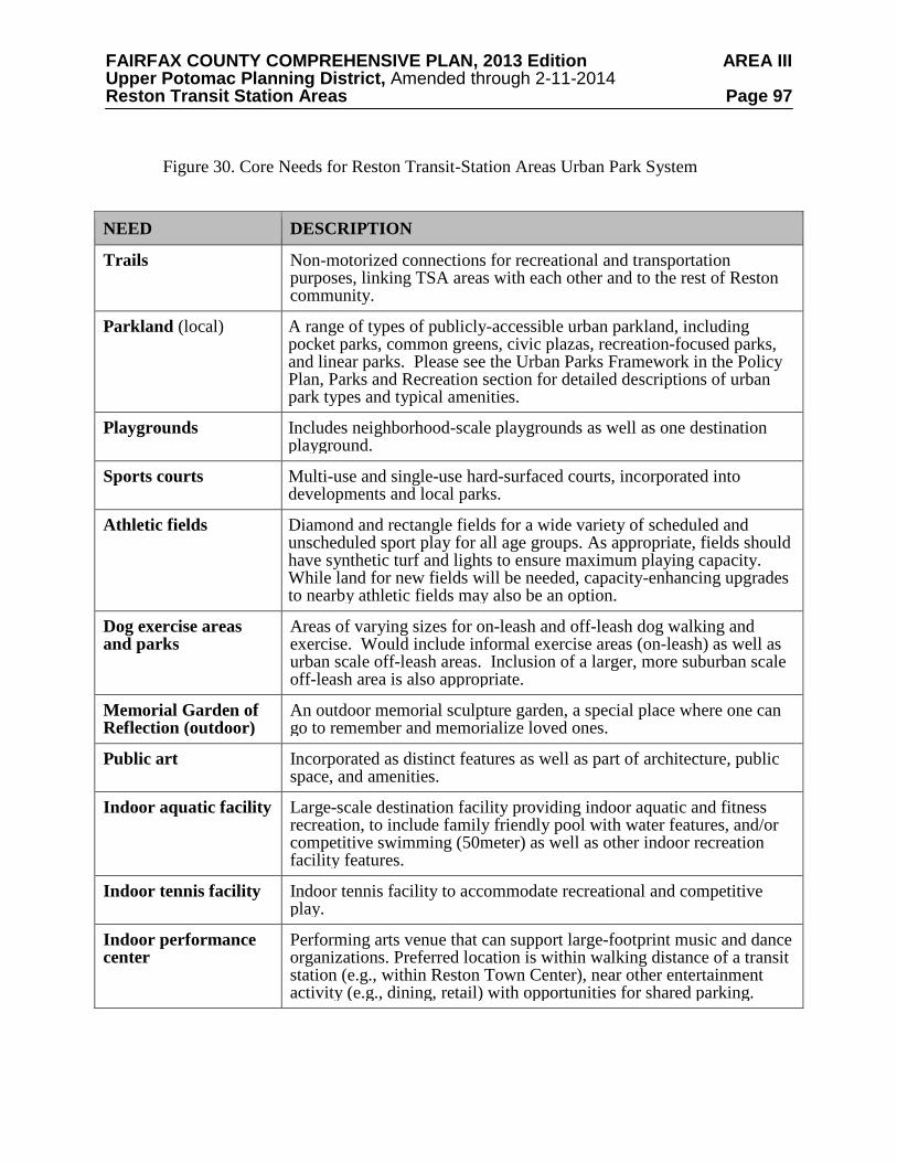
FAIRFAX COUNTY COMPREHENSIVE PLAN, 2013 Edition AREA III Upper Potomac Planning District, Amended through 2-11-2014 Reston Transit Station Areas Page 97 Figure 30. Core Needs for Reston Transit-Station Areas Urban Park System
NEED DESCRIPTION
Trails
Non-motorized connections for recreational and transportation purposes, linking TSA areas with each other and to the rest of Reston community.
Parkland (local)
A range of types of publicly-accessible urban parkland, including pocket parks, common greens, civic plazas, recreation-focused parks, and linear parks. Please see the Urban Parks Framework in the Policy Plan, Parks and Recreation section for detailed descriptions of urban park types and typical amenities.
Playgrounds
Includes neighborhood-scale playgrounds as well as one destination playground.
Sports courts Multi-use and single-use hard-surfaced courts, incorporated into developments and local parks.
Athletic fields
Diamond and rectangle fields for a wide variety of scheduled and unscheduled sport play for all age groups. As appropriate, fields should have synthetic turf and lights to ensure maximum playing capacity. While land for new fields will be needed, capacity-enhancing upgrades to nearby athletic fields may also be an option.
Dog exercise areas and parks
Areas of varying sizes for on-leash and off-leash dog walking and exercise. Would include informal exercise areas (on-leash) as well as urban scale off-leash areas. Inclusion of a larger, more suburban scale off-leash area is also appropriate.
Memorial Garden of Reflection (outdoor)
An outdoor memorial sculpture garden, a special place where one can go to remember and memorialize loved ones.
Public art
Incorporated as distinct features as well as part of architecture, public space, and amenities.
Indoor aquatic facility
Large-scale destination facility providing indoor aquatic and fitness recreation, to include family friendly pool with water features, and/or competitive swimming (50meter) as well as other indoor recreation facility features.
Indoor tennis facility
Indoor tennis facility to accommodate recreational and competitive play.
Indoor performance center
Performing arts venue that can support large-footprint music and dance organizations. Preferred location is within walking distance of a transit station (e.g., within Reston Town Center), near other entertainment activity (e.g., dining, retail) with opportunities for shared parking.

FAIRFAX COUNTY COMPREHENSIVE PLAN, 2013 Edition AREA III Upper Potomac Planning District, Amended through 2-11-2014 Reston Transit Station Areas Page 98 Authority(FCPA), Reston Association (RA), and Reston Community Center (RCC). These park, recreation, and cultural needs are either solely generated (or exacerbated) by the development planned in the TSAs. The listed amenity types are representative and not intended to limit the addition of new facility types to support emerging and evolving needs.
As noted earlier, the adopted population-based countywide service level standards
established in the Parks and Recreation section of the Policy Plan form the basis of determination of how many facilities are needed. Adopted service level standards generally apply toplaygrounds and courts. Adjusted service level standards for athletic fields account for expanded field capacity though use of lighting and synthetic turf and different use patterns. More guidance for the provision of active recreation is provided below. The need for the Memorial Garden of
Reflection is a long standing community goal. The need to expand or add significant indoor facilities including an aquatic center, indoor tennis facility and performance center has been identified through various feasibility studies and community dialogue. Trails are needed throughout and in a quantity sufficient to meet connectivity and recreation goals. Public art is also desired throughout. The Visual and Performing Arts section of the Policy Plan contains additional guidance. Active Recreation Facilities
Outdoor recreational areas should support and foster social interaction as well as team sports and individual recreation activities. Plan guidance for urban parks will be implemented as redevelopment occurs and should incorporate a variety of park amenities. Contributions of recreational facilities will also be needed to ensure a park system that serves the wider range of needs. Adopted Countywide recreation facility standards, adjusted for urban demographics and use patterns, will guide the service level enjoyed by residents, workers and visitors to Reston who will have a full range of leisure opportunities within convenient distances. Due to the size requirement for full size athletic fields, the provision of athletic fields is particularly challenging in the urban context, but an essential facility type where new fields and expanded capacity at existing fields will need to be added as redevelopment occurs.
A goal of adding capacity equivalent to twelve athletic fields serving Reston should be
achieved through development contributions of land and/or facilities. At a minimum, three new full-service athletic fields should be provided within the corridor. It is further recommended that these three fields be distributed throughout the corridor, with one new field in each TSA as a goal. It is also anticipated that between two and four new planned schools will add new fields to serve corridor needs. Enhancements to and redesign of nearby public park, school and Reston Association fields to increase capacity should also be strategies for serving the increased athletic field needs in Reston. Based on the projected redevelopment, the need for 12 fields is equitably fulfilled using a measure of 2.2 million GFA of development per field within the TSA corridor. Implementation of this metric and achievement of active recreation facilities, as well as all other park and recreation facility types, will primarily occur through the development review process.
The provision of new athletic facilities that require larger land areas within Reston TSAs is
especially important and challenging. Creative approaches to providing for sports needs in Reston will be necessary, including integrating facilities within development areas, on rooftops, over stormwater detention facilities, in utility corridors and other alternative locations. The rooftops of parking structures and other buildings in Reston will be considered as locations for some of the new athletic fields and courts that are needed to help meet the future demand for active recreation facilities. Field capacity can be expanded through innovative design features
FAIRFAX COUNTY COMPREHENSIVE PLAN, 2013 Edition AREA III Upper Potomac Planning District, Amended through 2-11-2014 Reston Transit Station Areas Page 99 such as lighting and synthetic turf and through scheduling that provides for longer and more efficient use, and thereby achieving the addition of new fields and added capacity. Overlay and multi-use fields that accommodate multiple sports can reduce the amount of land needed.
Adopted Countywide field standards are based on a majority of youth participants. It is
anticipated that in Reston there will be a large number of adult field users. Corporate softball, flag football, kickball, soccer and adult baseball are anticipated adult needs. Other field sports, such as cricket, may also emerge as a greater need over the horizon of this plan and may need to be accommodated.
The conceptual graphic of the future park system, shown in Figure 31, generally highlights
well-distributed parks and recreation opportunities connected through the W&OD trail on the north, mirrored by an east-west major trail connector on the south side of the Toll Road and north-south connectors through each TOD. Urban Park Implementation
Creation of an urban park network is fundamental to the vision for the TSAs and to the
successful redevelopment efforts around the transit stations. As a result of ownership patterns, urban park development will likely occur in a piecemeal pattern over time. Coordination and collaboration among landowners to create a connected system of needed park spaces is essential and is critical to creating vibrant, successful neighborhoods. A comprehensive system of urban parks, if properly implemented, will contribute to a sense of place and distinguish the area as a quality place to live, work, shop and visit. The Urban Parks Framework should be used to guide the design and location of the urban open space system. Adopted countywide recreation facility standards, adjusted for urban demographics and use patterns, will guide the service level enjoyed by residents, workers and visitors to the Reston transit area.
In implementing elements of the urban park system, consideration should be given to
factors including service areas and targets, core facility purpose, and access. Facilities serving a local neighborhood will look different and have different support facilities than a facility designed to serve an entire TSA or the larger Reston community. As an example, a local-serving playground might include a few pieces of play equipment, seating, special landscaping and pedestrian features; it might serve a cluster of residential buildings or a residential/office mixed use area. This playground might be used daily by residents and is most useful if accessible by walking. A larger-scale playground or athletic field that serves as a destination facility, would be designed to serve a broader area than a local-serving playground, and have a larger footprint. One would expect that visitors might walk, but would also bike, use transit, or drive to get to such a destination, and may not use daily, but would spend more time once there. Factors such as context/location, access, function/purpose, general length of stay, and amenities should be considered in order to inform provision of urban parks, recreation, and cultural amenities. The full set of design elements to be factored into implementation decisions are described in detail in the Design Elements table of the Urban Parks Framework (see Policy Plan, Parks and Recreation section).
Approaches to providing parks, recreation, and cultural amenities within the TSAs and
extended transit corridor area should be creative and innovative – in keeping with the Reston community’s origins and character. Stakeholders, providers, and developers should be encouraged to work together to offer park, recreation, and cultural amenities in ways that are well-suited to the context of an urbanizing transit-oriented community. Parkland can be publicly owned, privately owned, or provided through public-private partnerships. Developers should anticipate providing local, neighborhood-serving, amenities (e.g., sports courts, playgrounds, dog
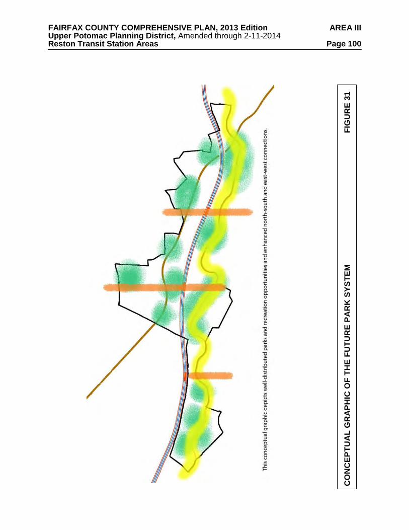
FAIRFAX COUNTY COMPREHENSIVE PLAN, 2013 Edition AREA III Upper Potomac Planning District, Amended through 2-11-2014 Reston Transit Station Areas Page 100
CO
NC
EPTU
AL
GR
APH
IC O
F TH
E FU
TUR
E PA
RK
SYS
TEM
F
IGU
RE
31
FAIRFAX COUNTY COMPREHENSIVE PLAN, 2013 Edition AREA III Upper Potomac Planning District, Amended through 2-11-2014 Reston Transit Station Areas Page 101 exercise areas) as well as contributing to area-wide, broader-serving, amenities (e.g., athletic fields, destination playground, trails, indoor facilities).
Creativity in provision is highly encouraged. Creative urban park initiatives may include
the use of building rooftops for park facilities; unique programming areas; recreation facilities and dedicated program space provided within commercial buildings, redevelopment at nearby parks, and forging new park-provider partnerships. Integration of indoor and outdoor facilities and program space with cooperative programming is highly encouraged. With any of these approaches, visual and physical accessibility to the public is essential.
During the course of the public planning process, several recurring themes related to parks,
recreation, and cultural amenities within Reston were identified. These themes suggest specific opportunities (some geographic, some conceptual) to implement a parks system within the area.
• East-West Connections: Establishing east-west connections within the area is just as
important for internal pedestrian and bike circulation as well as connections to the remainder of Reston. The Washington & Old Dominion Trail (W&OD) provides regional pedestrian and bike connectivity north of the DAAR, but a corresponding connection does not exist south of the DAAR. An east-west connection along Sunrise Valley Drive would create such a central pedestrian and bike connection south of the DAAR.
• North-South Connections: The creation and strengthening of north-south connections throughout the area will contribute greatly to the success of the parks system. These pedestrian and bike connections will provide access to amenities located on one or the other side of the DAAR. The connections become particularly critical in being able to connect the TSAs with the larger Reston community. To that end, north-south connections should be strengthened/enhanced or created along the axes created by the three metro stations, at a minimum. Any new north–south vehicular connections should also include pedestrian facilities.
• Linear Parks: Creating a variety of linked, multi-use parks will be central to the success of the redevelopment of the area. A combination of active and passive amenities linked (or adjacent) to central pedestrian and bike ways should be created. Using existing natural and stormwater features as a backbone for linear parks should also be considered.
o Sunrise Valley Corridor: Several manmade water and natural features exist in the vicinity of the Sunrise Valley corridor and provide a particular opportunity to create small, semi-urban scale parks. Placing trails and clustered amenities such as fitness stations, playgrounds, or interpretive stations around existing or future features builds upon Reston’s existing infrastructure. It may allow double use of spaces – in some cases allowing stormwater management goals to be achieved simultaneously with recreation goals. In addition to realizing the vision of Sunrise Valley as an east-west connection south of the DAAR, it also places amenities in proximity to planned development.
o Washington & Old Dominion Regional Park: The regional Washington & Old
Dominion Trail (W&OD) runs through the study area north of the DAAR, providing opportunities for east-west pedestrian and bike travel. There is the potential to incorporate recreational waysides including, but not limited to seating areas and playgrounds. Incorporation of amenities has been done in other areas along the W&OD, such as Arlington, Falls Church, and Purcellville. There is also the opportunity to develop larger recreational or cultural facilities near the W&OD, such
FAIRFAX COUNTY COMPREHENSIVE PLAN, 2013 Edition AREA III Upper Potomac Planning District, Amended through 2-11-2014 Reston Transit Station Areas Page 102
as gathering places or athletic facilities. Close collaboration with the Northern Virginia Regional Park Authority (NVRPA) as the area redevelops will help identify specific opportunities.
o Stormwater Parks: The role and importance of water bodies and stormwater
management features in Reston presents an opportunity to cluster amenities around these features and create a valued educational, recreational and/or cultural asset. There are opportunities to create enhanced stormwater parks throughout the area – as stand-alone parks or as a series of linked and linear parks. Parks of this type will incorporate active, passive, and/or nature and memorial elements into stormwater management features, creating a multi-purpose community asset.
• Clustered Community Uses: The Reston Town Center North area currently contains many
community uses – library, Hunter Mill Supervisor’s office, public safety, human services, and health related offices. In the future, it is anticipated that many of these uses may remain and there may be the option to further develop or add public amenities. Examples of possible amenities might include a signature community green or a flexible use, community gathering plaza and/or a destination playground. A redesign of the private and public uses in Reston Town Center North is anticipated offering opportunities to better integrate urban park features, recreation and cultural amenities. This area could offer mutually beneficial and complementary community uses and provide a significant public benefit, connecting to and building on the community-focused nature of the adjacent Reston Town Center.
• Integrating the TSAs: The Reston community has expressed the desire to build connections and integrate the TSAs into the Reston community; parks, recreation, and cultural facilities are one means of achieving this goal. Some of the needs identified above may be more appropriate to a location outside of the TSAs and may in fact provide greater benefit in such locations by encouraging broader use (e.g., Memorial Garden of Reflection). To further this goal of integrating new residents in the TSAs into the larger community, new residents should have access to and use of the full suite of amenities that the Reston planned community offers and in a manner similar to what existing residents currently enjoy. Reston Association is the primary provider of local-serving parks and recreational amenities. Reston Community Center offers an array of cultural and indoor recreational amenities, and the Fairfax County Park Authority provides broader-serving public parks and recreational amenities. While inclusion in Reston Community Center services is a given due to the geography of small district 5, membership in Reston Association is not a given and should be encouraged. This will help achieve the goal of reintegration in a seamless and coordinated way that helps to off-set impacts and meets the needs of new residents.
PUBLIC FACILITIES
This section pertains to the public facility needs to accommodate growth in the Transit Station Areas (TSAs). Providing adequate public facilities to serve the planned growth around the three transit stations will require the expansion or modification of existing facilities in some cases and the development of new facilities in other cases. The existing and future public facilities in the TSAs are described below. The provision of future facilities will need to be coordinated with the rate at which planned development occurs in these TSAs as well as in the surrounding Reston community.
FAIRFAX COUNTY COMPREHENSIVE PLAN, 2013 Edition AREA III Upper Potomac Planning District, Amended through 2-11-2014 Reston Transit Station Areas Page 103 Schools
The Reston TSAs are currently served by a total of 10 public schools. These include 6 elementary schools: Coates, Dogwood, Lake Anne, McNair, Sunrise Valley and Terraset. The TSAs are also served by two middle schools, Carson and Hughes, and two high schools, South Lakes and Westfield.
The growth envisioned in the TSAs over the next 20-30 years is projected to result in over
1,600 new elementary school students, 425 new middle school students and 880 new high school students living in these areas once all of the planned housing is built. Based on current planning approaches, this projected enrollment would result in a need for at least two new elementary school sites, together with capacity enhancements at existing facilities. In addition, the growth in these three TSAs plus additional growth at the Innovation Center Transit Station to the west are projected to significantly exceed the available capacity for middle school and high school students. As a result, one new middle school and one new high school, as well as capacity enhancements at existing facilities, will be needed to accommodate the projected increases in enrollment. A middle school and a high school located to the west of Reston, potentially in the Innovation Center area, would be well located to relieve overcrowding in existing schools as well as serve planned growth. Similarly, an elementary school located in the Town Center North District and a second elementary school in the Central Sunrise Valley District would be appropriately located to accommodate planned growth.
During the development review process, developers should provide for additional school
capacity to mitigate the impacts of new development. These contributions could be more traditional in nature, such as dedication of a school site, or may include more innovative urban solutions such as co-locating school facilities with parks or within mixed-use buildings. Fire & Rescue
The TSAs are currently served by four Fire and Rescue stations. The Reston Fire and
Rescue Station 25, located at 1820 Wiehle Avenue, serves virtually all of the Wiehle-Reston East TSA and the part of the Reston Town Center TSA located north of the DAAR. The south side of the Wiehle-Reston East TSA immediately along the DAAR is served by the Fox Mill Fire and Rescue Station 31, located at 2610 Reston Parkway. This station also serves all of the Reston Town Center Transit Station Area south of the DAAR as well as the southeastern portion of the Herndon Transit Station Area. The Frying Pan Fire and Rescue Station 36, located at 2660 West Ox Road, serves the southwestern portion of the Herndon TSA. Finally, the Herndon Fire and Rescue Station 4, located at 680 Spring Street, serves the northwest corner of the Reston Town Center TSA. The North Point Fire and Rescue Station 39, located at 1117 Reston Avenue, is adjacent to the Reston community but serves areas outside the TSAs.
The planned increases in residential dwelling units and non-residential uses in the TSAs
would result in excessive workloads of several of the existing stations. In order to maintain acceptable levels of service to the community, several of these facilities will need to be upgraded and a second Reston station will be needed in the future. A new station located in the North Town Center District would enable the Reston, Herndon and Fox Mill Fire and Rescue Stations to maintain acceptable levels of service to the community, even with the additional planned growth. The station is recommended to be the Fire and Rescue Department’s standard size of 14,500 square feet with a minimum of three apparatus bays to accommodate an engine, a transport unit, and a specialty unit. The new station should be designed and constructed as an urban facility located at the base of a government, commercial, residential building or parking structure.
FAIRFAX COUNTY COMPREHENSIVE PLAN, 2013 Edition AREA III Upper Potomac Planning District, Amended through 2-11-2014 Reston Transit Station Areas Page 104
An urban fire station would be anticipated to be two levels with the ground level dedicated
to the apparatus bays for access to the road network and the second level dedicated to living accommodations. Secure on-site parking for operational personnel to support two 24-hour shifts should also be provided. The provision of this new station should be based on the projected needs as planned development being built.
Finally, the Herndon Station is approved for expansion to add two additional units, an
engine and medic by 2015. The Reston Station currently only has vehicular access from Wiehle Avenue, which requires backing the units up into the site. To improve safety and traffic flow, future development should provide for unit access to the rear of the station. Subject to ongoing analysis, a second medic unit may be needed at Frying Pan Station in the future. Library
The TSAs are served by the Reston Regional library, located in the Town Center North
District at 11925 Bowman Towne Drive. This library facility is one of the most heavily used in the library system in terms of number of visits per year. Options are currently being evaluated to renovate and expand the library. Such a renovation and expansion will be planned to accommodate the future growth in the TSAs. As an alternative to renovation and expansion, new library incorporated into a mixed-use development within one of the TSAs is desirable. IMPLEMENTATION
Achieving the Vision for the Reston TSAs will require an implementation approach that is comprehensive, flexible and innovative. A key component to achieving the place-making that is a primary objective of this Plan is utilizing a variety of tools, some only recently used in Fairfax County for the first time.
A number of strategies for implementation of this Plan are identified in this section.
Funding Strategies
Various options exist for funding the multiple public facility needs to support the desired
new development in the TSAs. The feasibility of the options listed below or other options that may become available in the future should be assessed and the most appropriate tools should be identified for financing specific portions of the Plan as new and/or improved infrastructure is needed.
• Community Development Authorities (TSA-wide, TOD district level or subdistrict level)
• Tax Increment Financing
• Improvement Districts
• Public-private Partnerships
• Private Partnerships
• County, State and Federal funding
FAIRFAX COUNTY COMPREHENSIVE PLAN, 2013 Edition AREA III Upper Potomac Planning District, Amended through 2-11-2014 Reston Transit Station Areas Page 105
• Pro-rata contributions by landowners
• Other forms of borrowing and grants
• Parking fees Regulatory Framework
Adjustments to current Regulatory tools, including amendments to the Zoning Ordinance,
will be needed to implement the type and intensity of new development and to realize the overall urban design goals for the TSAs. In addition, other regulations and documents may need to be updated, such as the County’s Capital Improvement Plan, the County’s transportation demand management programs and the County’s Public Facilities Manual. It may also be necessary to seek legislative authority for new financing or land development strategies. Public-Private Partnerships
A public-private partnership entails using public funds or activities to foster private investment and development activity that may not otherwise occur. A number of public infrastructure improvements will be needed to implement this Plan and public/private partnerships have proven to be a successful mechanism to help the County advance certain infrastructure projects. By using public investments strategically, Fairfax County can reinforce and leverage private sector investments to achieve the vision for the Reston TSAs. Private Partnerships
Cooperation among landowners will be necessary to obtain land for public facilities, park and open space, and the grid of streets. These elements are necessary to the successful evolution of the TOD areas from a suburban environment to a more urban one and it will be incumbent on private property owners to contribute to that success. Phasing
An evolving phasing plan linking future development to specific improvements will ensure that the desired urban infrastructure and public amenities, as well as transportation infrastructure, will occur as growth within the TSAs occurs. The goal of appropriate phasing is to balance projected development with infrastructure and public facility needs over time. Monitoring the approval of and actual construction of new development will ensure that the phasing plan stays current as needs are addressed and new ones identified. DISTRICT RECOMMENDATIONS
This section of the Plan contains specific recommendations for the districts in the three Reston Transit Station Areas (TSAs) (see Figure 32). Three of the districts are designated as Transit-Oriented Development (TOD) districts given their proximity to the Metrorail station platforms. The other districts are designated as Non-TOD districts and typically will provide locations for existing uses at currently approved and/or planned densities.
The discussion of each Transit Station Area begins with a description of the TSA and a
review of the districts and subdistricts in the TSA. Next, the location of the TOD district is described and the vision for the district is articulated. It is followed by a description of the Non-
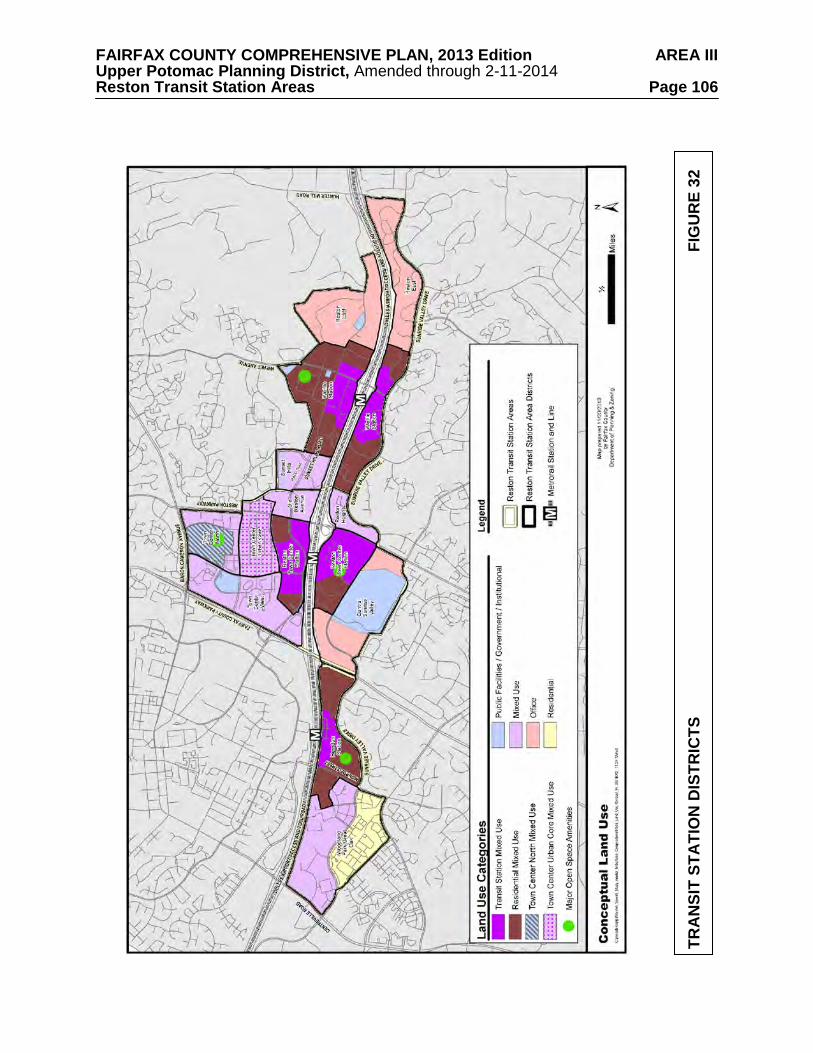
FAIRFAX COUNTY COMPREHENSIVE PLAN, 2013 Edition AREA III Upper Potomac Planning District, Amended through 2-11-2014 Reston Transit Station Areas Page 106
TRA
NSI
T ST
ATI
ON
DIS
TRIC
TS
FIG
UR
E 32
FAIRFAX COUNTY COMPREHENSIVE PLAN, 2013 Edition AREA III Upper Potomac Planning District, Amended through 2-11-2014 Reston Transit Station Areas Page 107 TOD districts in the TSA. Within each district or subdistrict is a paragraph entitled Base Plan, which generally describes the existing and/or approved uses and intensities for the area. Some subdistricts have a section entitled Redevelopment Option. This provides guidance on the land use mix and intensities to achieve the goals discussed in the Areawide Recommendations above.
Local-serving amenities such as urban parks, trails, and public art should be provided
throughout all the subdistricts and for all types of development and are guided by the Areawide text on Urban Parks, Recreation Facilities, and Cultural Facilities as well as the Urban Parks Framework in the Policy Plan. TOD DISTRICT INTENSITY AND MIX OF USES
The TOD districts are planned as shown on the Conceptual Land Use Map (see Figure 12)
in the Areawide Recommendations. The planned development intensity and the planned mix of uses for the TOD districts is based on whether an area is planned for the Transit Station Mixed Use or the Residential Mixed Use category.
The Transit Station Mixed Use area is the critical area for establishing the core of a
compact, mixed-use, walkable transit-oriented environment and should provide a balanced mix of uses to include office, retail, hotel, institutional and public facility uses as well as new residential uses. These areas are planned for the highest development intensity in the TSAs. The planned development intensity for these areas is provided as a range of floor area ratios (FARs). The low end of the range is the minimum FAR that will be considered for redevelopment proposals within the Transit Station Mixed Use area. The high end of the range represents the FAR available for redevelopment on the parcels adjacent to the transit station entrance pavilions. Generally, the parcels that are not consolidated with or part of a coordinated development plan with one or more parcels adjacent to the transit station entrance pavilion are planned for the mid- point of the range. However, redevelopment proposals for these parcels with a higher proportion of residential use than office and other non-residential uses may realize an FAR above the mid-point of the range as described below. The Transit Station Mixed Use areas are planned for 50 percent residential and 50 percent non-residential uses.
The Residential Mixed Use area is generally planned for existing and approved office uses,
significant new residential uses and new retail and hotel uses. The planned development intensity is provided as a maximum FAR and a maximum number of residential units. These areas are planned for 75 percent residential and 25 percent non-residential uses.
For initial proposals in the TOD areas that include at least two buildings, the percentages in
the Conceptual Land Use categories should serve as a guide for individual developments. However, flexibility to adjust the percentages on a case-by-case basis may be considered for some initial proposals to develop or redevelop one building for small parcels in order to further other planning objectives. Once buildings encompassing a true mix of uses have been constructed in the TOD districts, additional flexibility in the mix of uses in a given proposal may be considered for subsequent approvals.
If a property or properties under common ownership that are proposed to be developed
under a unified development plan are split between two Conceptual Land Use categories, the development intensity and mix of uses should be based on the proportion of area in each category. However, flexibility in the location of proposed uses may be granted as long as they achieve TOD objectives and contribute to the character recommended for the subject area. The desired balance between uses may not always be achievable, at least on an interim basis, due to
FAIRFAX COUNTY COMPREHENSIVE PLAN, 2013 Edition AREA III Upper Potomac Planning District, Amended through 2-11-2014 Reston Transit Station Areas Page 108 market demand or other economic factors. In such cases, appropriate commitments should be required to insure interim development does not alter the character of the TSA and that ultimately the mix of uses will be in place consistent with Plan guidance.
WIEHLE-RESTON EAST TRANSIT STATION AREA
The Wiehle-Reston East Transit Station Area is bounded on the north by Hidden Creek Country Club, Lake Fairfax Park and low-density residential neighborhoods to the north of Sunset Hills Road. On the north side of the DAAR, the TSA is bounded on the east by a Virginia Department of Transportation-owned storage facility. On the south side of the DAAR, it is bounded by Hunter Mill Road and to the south it is bounded by Sunrise Valley Drive. On the west and to the north of the DAAR, it is bounded by the Oracle campus and Old Reston Avenue while on the south of the DAAR, it is bounded by the Reston Square development.
Local-serving amenities including plazas, other urban parks, trails, and public art should be
provided throughout the districts to serve local leisure and recreation needs. The exact number of urban parks, their sizes and distribution will be determined by the amount and type of new development, in accordance with the Urban Parks Framework in the Policy Plan. Recreational impacts of new development should be offset through provision of recreation facilities on-site or contributions to nearby parks.
As described in the Areawide text on Urban Parks, Recreation Facilities, and Cultural
Facilities, athletic field needs will be met through the construction of new fields as well as improvements to existing nearby fields. As a part of this, Areawide Plan guidance establishes a goal of one new full-service athletic field within each TSA. Contributions toward land and improvements sufficient to achieve this goal should be provided with development.
This TSA includes three districts: the Wiehle Station Transit-Oriented Development (TOD)
District, the Reston East Non-TOD District and the Sunset Hills Non-TOD District. The Wiehle Station TOD District is further divided into the North Subdistrict and South Subdistrict. Wiehle Station Transit-Oriented Development (TOD) District
The Wiehle Station TOD District is envisioned to evolve into an educationally-focused
urban neighborhood with residential areas that are well-connected to transit via multiple new pedestrian-oriented streets. In the North Subdistrict, these streets are to be anchored by a new “main street,” Reston Station Boulevard (as extended), with ground floor retail providing a safe, varied and comfortable pedestrian environment.
The district’s retail uses are planned to have more of a local serving (as compared to
regional serving) function. In addition, redevelopment should integrate urban parks that are linked by the new street grid to provide places for people of all ages to walk and enjoy outdoor spaces. It should also facilitate multiple links to two important nearby existing recreational amenities in the area, the W&OD trail and Lake Fairfax Park.
Guidance for evaluating development proposals in each subdistrict is contained in the
Areawide Recommendations and the following subdistrict recommendations. Redevelopment options are dependent on the degree to which necessary public infrastructure can be provided and Plan objectives and development conditions set forth in the Areawide and subdistrict guidance can be satisfied by development proposals.
FAIRFAX COUNTY COMPREHENSIVE PLAN, 2013 Edition AREA III Upper Potomac Planning District, Amended through 2-11-2014 Reston Transit Station Areas Page 109 North Subdistrict
The North TOD subdistrict is comprised of approximately 193 acres and is bounded by the
Hidden Creek Country Club on the north, Lake Fairfax Park on the northeast, the DAAR on the south and the Plaza America shopping center on the west. Sunset Hills Road extends from east to west through the subdistrict with Wiehle Avenue being the primary north-south street, as shown on Figure 33.
Existing development in the area is predominantly suburban office parks housing a variety
of office uses (including medical offices, educational uses, specifically Northern Virginia Community College and Marymount University, and banks), and retail and service-oriented uses (including fast food restaurants, childcare facilities and fitness businesses). Reston Fire and Rescue Station 25 is located in this district. Other development includes Reston Station, an approved but as yet unbuilt mixed-use development in the northwest quadrant of the intersection of Wiehle Avenue and the DAAR located on top of a seven-level County-owned and operated transit center and park-and-ride facility with 2,300 spaces for Metro parking. Base Plan
The subdistrict is planned for office use at .50 FAR or residential use at up to 30 dwelling units per acre. Redevelopment Option
The vision for this subdistrict is for significant redevelopment at higher intensities in a mix of mid-rise and high-rise buildings with more diverse land uses than currently exist and a wider array of support services. Residential buildings should front on tree-lined streets and be designed with inviting street level facades. Reston Station Boulevard is expected to be extended west to Plaza American and east across Wiehle Avenue to Michael Faraday Drive. This new street will serve as a “main street” for the subdistrict, supporting a concentration of ground level retail uses and other active uses, including plazas and other open spaces.
Redevelopment proposals that include land to the east of Wiehle Avenue should provide
improved pedestrian and bicycle crossings of this street that will increase pedestrian and bicyclists’ safety, visibility and convenience. Crossings might include overpasses, underpasses or at-grade crossings. Each of these types of crossings can provide both benefits and drawbacks to creating a more hospitable pedestrian environment and depend upon the particular circumstances of each proposal.
The Transit Station Mixed Use area is planned for intensity within a 2.0 to 3.0 FAR range.
The planned zoning target for office development in this area of the subdistrict is 2.4 million square feet of existing, approved and new development. The planned zoning target for residential development is approximately 1,900 residential units. Development proposals should typically provide a mix of 50 percent non-residential use and 50 percent residential use. The approved mix of uses in the Reston Station development and the approved residential use adjacent to Reston Station present a reasonable opportunity to realize the desired Transit Station Mixed Use category mix of 50 percent non-residential uses and 50 percent residential uses. Individual developments may have flexibility to build more office use if other developments are built or rezoned with a use mix that contains proportionally less office. Ground level retail and support service uses are encouraged to add to the vibrancy and enhance the pedestrian environment. Support retail uses should be located in office, hotel or residential buildings and be
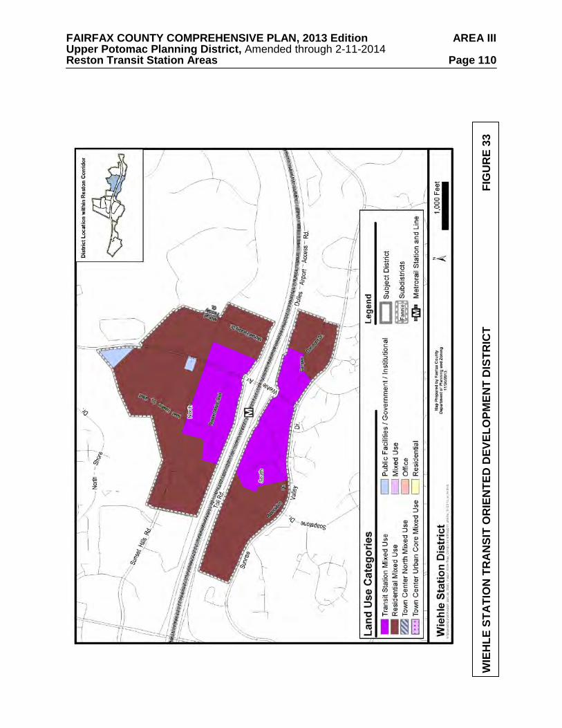
FAIRFAX COUNTY COMPREHENSIVE PLAN, 2013 Edition AREA III Upper Potomac Planning District, Amended through 2-11-2014 Reston Transit Station Areas Page 110
WIE
HLE
STA
TIO
N T
RA
NSI
T O
RIE
NTE
D D
EVEL
OPM
ENT
DIS
TRIC
T
FIG
UR
E 33
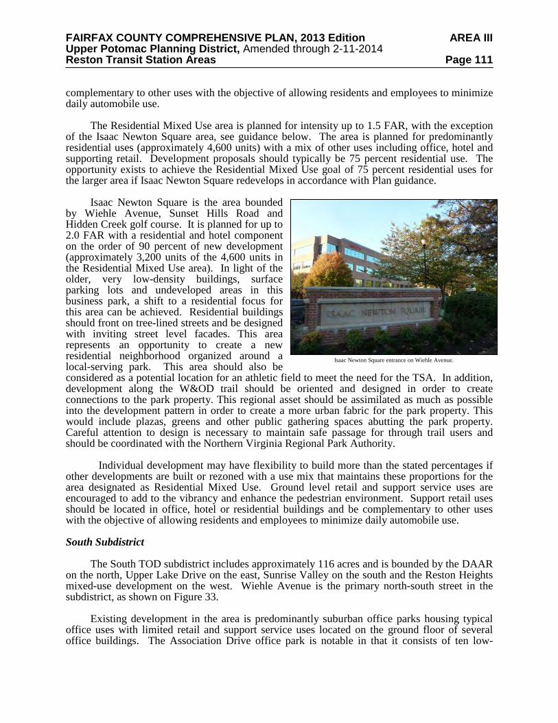
FAIRFAX COUNTY COMPREHENSIVE PLAN, 2013 Edition AREA III Upper Potomac Planning District, Amended through 2-11-2014 Reston Transit Station Areas Page 111 complementary to other uses with the objective of allowing residents and employees to minimize daily automobile use.
The Residential Mixed Use area is planned for intensity up to 1.5 FAR, with the exception of the Isaac Newton Square area, see guidance below. The area is planned for predominantly residential uses (approximately 4,600 units) with a mix of other uses including office, hotel and supporting retail. Development proposals should typically be 75 percent residential use. The opportunity exists to achieve the Residential Mixed Use goal of 75 percent residential uses for the larger area if Isaac Newton Square redevelops in accordance with Plan guidance.
Isaac Newton Square is the area bounded
by Wiehle Avenue, Sunset Hills Road and Hidden Creek golf course. It is planned for up to 2.0 FAR with a residential and hotel component on the order of 90 percent of new development (approximately 3,200 units of the 4,600 units in the Residential Mixed Use area). In light of the older, very low-density buildings, surface parking lots and undeveloped areas in this business park, a shift to a residential focus for this area can be achieved. Residential buildings should front on tree-lined streets and be designed with inviting street level facades. This area represents an opportunity to create a new residential neighborhood organized around a local-serving park. This area should also be considered as a potential location for an athletic field to meet the need for the TSA. In addition, development along the W&OD trail should be oriented and designed in order to create connections to the park property. This regional asset should be assimilated as much as possible into the development pattern in order to create a more urban fabric for the park property. This would include plazas, greens and other public gathering spaces abutting the park property. Careful attention to design is necessary to maintain safe passage for through trail users and should be coordinated with the Northern Virginia Regional Park Authority.
Individual development may have flexibility to build more than the stated percentages if
other developments are built or rezoned with a use mix that maintains these proportions for the area designated as Residential Mixed Use. Ground level retail and support service uses are encouraged to add to the vibrancy and enhance the pedestrian environment. Support retail uses should be located in office, hotel or residential buildings and be complementary to other uses with the objective of allowing residents and employees to minimize daily automobile use. South Subdistrict
The South TOD subdistrict includes approximately 116 acres and is bounded by the DAAR
on the north, Upper Lake Drive on the east, Sunrise Valley on the south and the Reston Heights mixed-use development on the west. Wiehle Avenue is the primary north-south street in the subdistrict, as shown on Figure 33.
Existing development in the area is predominantly suburban office parks housing typical
office uses with limited retail and support service uses located on the ground floor of several office buildings. The Association Drive office park is notable in that it consists of ten low-
Isaac Newton Square entrance on Wiehle Avenue.
FAIRFAX COUNTY COMPREHENSIVE PLAN, 2013 Edition AREA III Upper Potomac Planning District, Amended through 2-11-2014 Reston Transit Station Areas Page 112 density office buildings built in the 1970s and early 1980s that are owned by various professional associations and represent a prime redevelopment opportunity. Base Plan
The subdistrict is planned for office use at .35 FAR or residential use at up to 30 dwelling
units per acre. Redevelopment Option
The vision for this subdistrict is for significant redevelopment at higher intensities in a mix
of mid-rise and high-rise buildings with more diverse land uses than currently exist and a wider array of support services.
Redevelopment proposals that include land to the east of Wiehle Avenue should provide
improved pedestrian and bicycle crossings of this street that will increase pedestrian and bicyclists’ safety, visibility and convenience. Crossings might include overpasses, underpasses or at-grade crossings. Each of these types of crossings can provide both benefits and drawbacks to creating a more hospitable pedestrian environment and depend upon the particular circumstances of each proposal.
Local-serving amenities including civic plazas, other urban parks, trails, and public art
should be provided throughout the subdistrict to serve local leisure and recreation needs. The exact number of urban parks, their sizes and distribution will be determined by the amount and type of new development, in accordance with the Urban Parks Framework in the Policy Plan.
Existing manmade and natural features in the vicinity of Sunrise Valley Drive provide a
particular opportunity to create small, semi-urban scale parks linked by trails and pedestrian facilities planned for the TSA. Opportunities to cluster amenities in nodes along existing natural and stormwater features should be used to form a connected park amenity.
The Transit Station Mixed Use area is planned for intensity within a 1.5 to 2.5 FAR. The
planned zoning target for office development in this area of the subdistrict is 1.6 million square feet of existing, approved and new development. The planned zoning target for residential development is approximately 1,500 residential units. Development proposals should typically provide a mix of 50 percent non-residential use and 50 percent residential use. However, the existing amount of office development in Commerce Executive Park and a lack of vacant land in this subdistrict presents a challenge to realizing the desired goal of the Transit Station Mixed Use designation of 50 percent non-residential uses and 50 percent residential uses. Individual developments may have flexibility to build more office use if other developments are built or rezoned with a use mix that contains proportionally less office. Ground level retail and support service uses are encouraged to add to the vibrancy and enhance the pedestrian environment. Support retail uses should be located in office, hotel or residential buildings and be complementary to other uses with the objective of allowing residents and employees to minimize daily automobile use.
The Residential Mixed Use area is planned for intensity up to 1.5 FAR. The area is
planned for predominantly residential uses (approximately 1,100 units) with a mix of other uses including office, hotel and supporting retail. Development proposals should typically be 75 percent residential use. The existing dispersed pattern of development and relatively low intensity along Association Drive represents an important opportunity to achieve the goal for Residential Mixed Use designated areas of 75 percent residential uses. Individual development
FAIRFAX COUNTY COMPREHENSIVE PLAN, 2013 Edition AREA III Upper Potomac Planning District, Amended through 2-11-2014 Reston Transit Station Areas Page 113 may have flexibility to vary from the stated percentages if other developments are built or rezoned with a use mix that maintains these proportions for the area designated for the Residential Mixed Use category. Ground level retail and support service uses are encouraged to add to the vibrancy and enhance the pedestrian environment. Support retail uses should be located in office, hotel or residential buildings and be complementary to other uses with the objective of allowing residents and employees to minimize daily automobile use.
The Residential Mixed Use area includes parcels along Roland Clarke Place that are zoned
Planned Residential Community (PRC) and are designated on the Reston Master Plan as Convention/Conference Center uses. Two of the parcels (Tax Map 17-4((14))(1A)2 and 3) have an approval for office and retail uses at a 3.55 FAR. A third parcel (Tax Map 17-4((14))(1A)1) has an approval for office and retail uses at 3.02 FAR. Under the Redevelopment Option, they are planned for their approved intensities with a mix of uses to include office, retail, hotel and residential with a minimum of 50 percent of the FAR as residential. The remaining parcels along Roland Clarke Place are planned for office uses at .35 FAR or residential use with support retail at up to 1.0 FAR. Reston East District
The Reston East District is generally bounded by Lake Fairfax Park on the north, by the
Equestrian Park subdivision on the northeast, by a Virginia Department of Transportation-owned parcel and Hunter Mill Road on the east, by Sunrise Valley Drive on the south and by the Michael Faraday Court and the Campus Commons office park on the west, as shown on Figure 34. It consists of approximately 276 acres and is bisected by the DAAR. Development on the north side of the DAAR includes Lake Fairfax Business Center which houses office uses, a data center and large fitness facility; an ice rink and a U.S. Post Office facility. Most of the office buildings on the south side of Sunset Hills Road were built in the 1990s and 2000s. They are between 2-5 stories and are mostly served by surface parking although a few buildings do have structured parking.
Development on the south side of the DAAR consists of office uses located in 2-5 story
buildings with support services, most of which have surface parking lots but a few office buildings built in the 1990s and 2000s are served by structured parking.
This district is planned to retain its employment activity focus, including office, light
industrial, institutional and research and development (R&D) uses up to .50 FAR. Local-serving amenities including plazas, other urban parks, trails, and public art should be
provided throughout the subdistrict to serve local leisure and recreation needs. The exact number of urban parks, their sizes and distribution will be determined by the amount and type of new development, in accordance with the Urban Parks Framework in the Policy Plan.
Existing manmade and natural features in the vicinity of Sunrise Valley Drive provide a
particular opportunity to create small, semi-urban scale parks linked by trails and pedestrian facilities planned for the TSA. Opportunities to cluster amenities in nodes along existing natural and stormwater features should be used to form a connected park amenity.
The northern portion of Michael Faraday Court (parcels identified with Tax Map 18-
3((5))6, 7, 8 & 9) has older, low-rise buildings that are potential redevelopment sites and include the Skatequest ice rink, an important private community recreation facility, which should be preserved in any redevelopment of this area. To provide an incentive for this facility to continueoperation after redevelopment of this area, a redevelopment option of residential use up
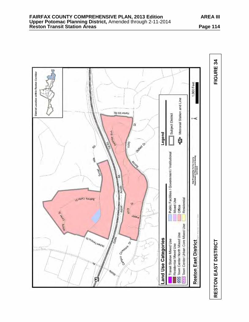
FAIRFAX COUNTY COMPREHENSIVE PLAN, 2013 Edition AREA III Upper Potomac Planning District, Amended through 2-11-2014 Reston Transit Station Areas Page 114
RES
TON
EA
ST D
ISTR
ICT
FIG
UR
E 34
FAIRFAX COUNTY COMPREHENSIVE PLAN, 2013 Edition AREA III Upper Potomac Planning District, Amended through 2-11-2014 Reston Transit Station Areas Page 115 to a 1.0 FAR is planned provided these parcels are consolidated, safe, convenient pedestrian access is provided to the W&OD trail and to the pedestrian network for the TOD district, and the ice rink is a component of the redevelopment.
Sunset Hills District
The Sunset Hills District consists of approximately 64 acres and is bounded on the north by residential neighborhoods served by North Shore Drive, on the east by the western edge of Hidden Creek Country Club, on the south by the DAAR and on the west by Old Reston Avenue and the Oracle campus, as shown in Figure 35.
Existing development includes office uses in medium and high-rise buildings (served by
structured and surface parking) and retail uses in the Plaza America shopping center, which is served by surface parking. The office development to the north of Sunset Hills Road incorporates open space amenities into its stormwater retention facilities. It includes vacant land that has zoning approval for additional office use.
It is desirable to maintain the heritage and character of Old Reston Avenue and adjacent
structures, Sunset Hills (also known as the A. Smith Bowman House, 1850 Old Reston Avenue; Tax Map 17-4((1))1) and the A. Smith Bowman Distillery/Wiehle Town Hall (1890 Old Reston Avenue; Tax Map 17-4((1))5B). Old Reston Avenue is a Virginia Byway and subject to improvements to provide enhanced safety for vehicular and pedestrian access and improved traffic flow, should retain the aesthetic elements of its present character from north of the W&OD Trail to the old location of Temporary Road.
This district is planned for mixed use up to .50 FAR or office and retail uses at currently
approved development intensities. Local-serving amenities such as pocket parks, trails, and public art should be provided
throughout the district and for all types of development. Local-serving amenities are guided by the Areawide text on Urban Parks, Recreation Facilities, and Cultural Facilities as well as the Urban Parks Framework in the Policy Plan. There may be an additional opportunity to provide an enhanced stormwater park in this district, to cluster amenities around the stormwater features and create a valued recreational and/or cultural asset.
Opportunities to provide small-scale recreational waysides (e.g. seating areas, playgrounds)
near the W&OD and in collaboration with NVRPA should be explored. RESTON TOWN CENTER TRANSIT STATION AREA
The Reston Town Center Transit Station Area (TSA) is bounded on the north by Baron
Cameron Drive, on the east by Reston Parkway, Old Reston Avenue and the Plaza America office development and development immediately west of Roland Clarke Place. To the south, the TSA is bounded by Sunrise Valley Drive, Reston Parkway, South Lakes Drive, and the residential neighborhoods south of the U.S. Geological Survey property. To the west, it is bounded by Fairfax County Parkway.
This TSA includes the Reston Town Center Station Transit-Oriented Development (TOD)
District and six non-TOD Districts, specifically the Town Center Urban Core District, the Town Center North District, the Town Center West District, the Old Reston Avenue District, the Reston Heights District and the Central Sunrise Valley Drive District. The Reston Town Center
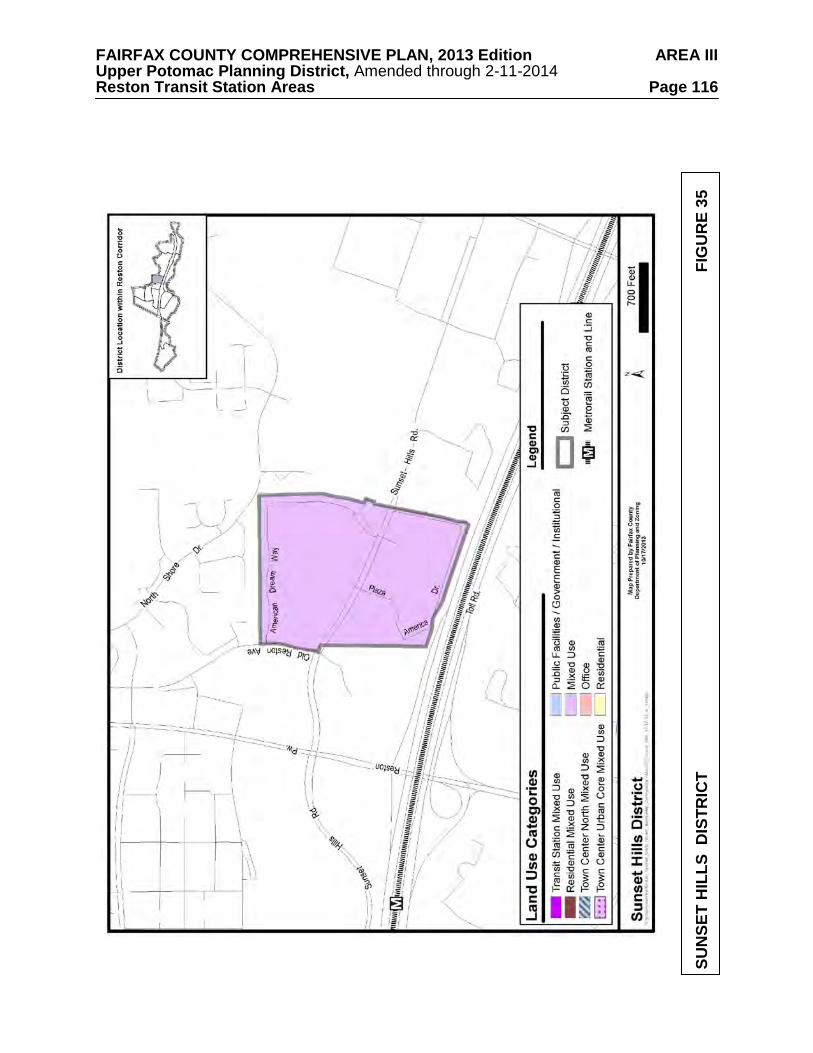
FAIRFAX COUNTY COMPREHENSIVE PLAN, 2013 Edition AREA III Upper Potomac Planning District, Amended through 2-11-2014 Reston Transit Station Areas Page 116
SUN
SET
HIL
LS D
ISTR
ICT
FIG
UR
E 35
FAIRFAX COUNTY COMPREHENSIVE PLAN, 2013 Edition AREA III Upper Potomac Planning District, Amended through 2-11-2014 Reston Transit Station Areas Page 117 Station TOD District is further divided into the North Subdistrict and South Subdistrict. The Town Center North District is further divided into the East Fountain Drive Subdistrict and the West Fountain Drive Subdistrict.
Local-serving amenities including plazas, other urban parks, trails, and public art should be
provided throughout the districts to serve local leisure and recreation needs. The exact number of urban parks, their sizes and distribution will be determined by the amount and type of new development, in accordance with the Urban Parks Framework in the Policy Plan. Recreational impacts of new development should be offset through provision of recreation facilities on-site or contributions to nearby parks.
As described in the Areawide text on Urban Parks, Recreation Facilities, and Cultural
Facilities, athletic field needs will be met through the construction of new fields as well as improvements to existing nearby fields. As a part of this, Areawide Plan guidance establishes a goal of one new full-service athletic field within each TSA. Contributions toward land and improvements sufficient to achieve this goal should be provided with development. Reston Town Center Station Transit-Oriented Development (TOD) District
The Reston Town Center Station TOD District is envisioned to complement the existing
Reston Town Center urban core with urban neighborhoods that are well-connected to transit via existing streets, which should have facilities added to become more pedestrian-friendly; new pedestrian-oriented streets; and new pedestrian-only connections. These neighborhoods should have a balanced mix of diverse uses including arts and entertainment uses similar to those already found in the Town Center urban core.
The district is divided into two subdistricts, as shown on Figure 36 - the North subdistrict
and the South subdistrict. The vision for the North subdistrict is an extension of the Town Center core with a balanced mix of uses to include new office uses, destination retail uses and restaurants, a hotel with convention facilities, a significant residential component, one or more civic uses and ground floor uses that foster a varied and interesting pedestrian environment.
The vision for the South subdistrict is for a new urban neighborhood that complements the
development in the North TOD subdistrict but at a lower intensity. Guidance for evaluating development proposals in each subdistrict is contained in the
Areawide Recommendations and the following subdistrict recommendations. Redevelopment options are dependent on the degree to which necessary public infrastructure can be provided and Plan objectives and development conditions set forth in the Areawide and subdistrict guidance can be satisfied by development proposals.
North Subdistrict The North subdistrict is comprised of approximately 88 acres and is bounded by the W&OD trail on the north, Reston Parkway on the east, the DAAR on the south and the YMCA property on the west. Sunset Hills Road extends from east to west through the subdistrict with Reston Parkway and Town Center Parkway being the primary north-south streets. The subdistrict is strategically located between Reston Town Center urban core and the Reston Town Center Metro station. Existing development includes several suburban office parks at intensities from .30 to .80 FAR located in buildings from 2-5 stories and served by both surface and structured parking.
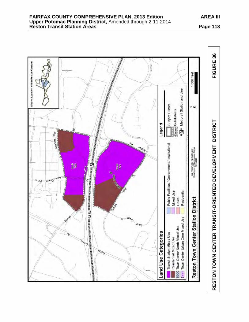
FAIRFAX COUNTY COMPREHENSIVE PLAN, 2013 Edition AREA III Upper Potomac Planning District, Amended through 2-11-2014 Reston Transit Station Areas Page 118
RES
TON
TO
WN
CEN
TER
TR
AN
SIT-
OR
IEN
TED
DEV
ELO
PMEN
T D
ISTR
ICT
FIG
UR
E 36
FAIRFAX COUNTY COMPREHENSIVE PLAN, 2013 Edition AREA III Upper Potomac Planning District, Amended through 2-11-2014 Reston Transit Station Areas Page 119 Other uses include an extended stay hotel, several restaurants and a vacant parcel that is currently being used as temporary surface parking lot. Base Plan
The subdistrict is planned for a variety of uses, including office retail, residential and
community-serving uses, at approved intensities of between .70 and 1.0 FAR or residential use at up to 30 dwelling units per acre. Redevelopment Option
The vision for this subdistrict is for substantial redevelopment at higher intensities in
predominantly mid- to high-rise buildings with more diverse land uses than currently exist and a wider array of support services. Redevelopment should create a series of urban plazas and parks to provide gathering places for people of all ages to enjoy festivals and community events.
Local-serving amenities including plazas, other urban parks, trails, and public art should be
provided throughout the subdistrict to serve local leisure and recreation needs. The exact number of urban parks, their sizes and distribution will be determined by the amount and type of new development, in accordance with the Urban Parks Framework in the Policy Plan. Opportunities to provide small-scale recreational waysides (e.g. seating areas, playgrounds) or larger recreational or cultural facilities (e.g. gathering places) near the W&OD and in collaboration with NVRPA should be explored.
The Transit Station Mixed Use area is planned for intensity within a 3.0 to 4.0 FAR range.
The planned zoning target for office development in this area of the subdistrict is 3 million square feet of existing, approved and new development. The planned zoning target for residential development is approximately 2,600 residential units. Development proposals should typically provide a mix of 50 percent non-residential use and 50 percent residential use. The availability of vacant land in close proximity to the Metro station in this subdistrict presents an opportunity to realize the desired mix for Transit Station Mixed Use areas of 50 percent non-residential uses and 50 percent residential uses. Individual developments may have flexibility to build more office use if other developments are built or rezoned with a use mix that contains proportionally less office. Ground level retail and support service uses are encouraged to add to the vibrancy and enhance the pedestrian environment. Support retail uses should be located in office, hotel or residential buildings and be complementary to other uses with the objective of allowing residents and employees to minimize daily automobile use. Development should be organized around a large, signature community gathering space near the station entrance.
The Residential Mixed Use area in the North TOD subdistrict is bounded on the north by
the W&OD trail and is planned for residential uses up to 1.5 FAR (approximately 500 units). Development proposals should typically be 75 percent residential use. The low density retail development with surface parking located along the western boundary of the subdistrict presents an opportunity for new residential development. Individual development may have flexibility to vary from the stated percentages if other developments are built or rezoned with a use mix that maintains these proportions for the area designated as the Residential Mixed Use category. Ground level retail and support service uses are encouraged to add to the vibrancy and enhance the pedestrian environment. Support retail uses should be located in office, hotel or residential buildings and be complementary to other uses with the objective of allowing residents and employees to minimize daily automobile use.
FAIRFAX COUNTY COMPREHENSIVE PLAN, 2013 Edition AREA III Upper Potomac Planning District, Amended through 2-11-2014 Reston Transit Station Areas Page 120 South Subdistrict
The South TOD subdistrict is comprised of approximately 107 acres and is bounded by the
DAAR on the north, by Reston Parkway on the east, by Sunrise Valley Drive on the south and by a self-storage business on the west. Reston Parkway and Edmund Halley Drive are the primary north-south streets. Base Plan
The subdistrict is planned for office use at .50 FAR or residential use at up to 30 dwelling
units per acre. Redevelopment Option
The vision for this subdistrict is for significant redevelopment at higher intensities in a mix
of mid-rise and high-rise buildings with more diverse land uses than currently exist and a wider array of support services. Residential buildings should front on tree-lined streets and be designed with inviting street level facades. A larger-scale district serving park that includes cultural and recreational amenities should be located within this subdistrict to provide outdoor spaces, places to be active, and areas to enjoy community events. This park will serve as a gathering space and may include a concentration of ground level retail uses along its perimeter.
Local-serving amenities including plazas, other urban parks, trails, and public art should be
provided throughout the subdistrict to serve local leisure and recreation needs. The exact number of urban parks, their sizes and distribution will be determined by the amount and type of new development, in accordance with the Urban Parks Framework in the Policy Plan.
Existing manmade and natural features in the vicinity of Sunrise Valley Drive provide a
particular opportunity to create small, semi-urban scale parks linked by trails and pedestrian facilities planned for the TSA. Opportunities to cluster amenities in nodes along existing natural and stormwater features should be used to form a connected park amenity.
The Transit Station Mixed Use area is planned for intensity within a 2.0 to 3.0 FAR range.
The planned zoning target for office development in this area of the subdistrict is 2.4 million square feet of existing, approved and new development. The planned zoning target for residential development is approximately 3,000 residential units. Development proposals should typically provide a mix of 50 percent non-residential use and 50 percent residential use. The existing development pattern, the presence of surface parking lots and availability of vacant land within close proximity to the Metro station present an opportunity to realize the desired mix for Transit Station Mixed Use areas of 50 percent non-residential uses and 50 percent residential uses. Individual developments may have flexibility to build more office use if other developments are built or rezoned with a use mix that contains proportionally less office. Ground level retail and support service uses are encouraged to add to the vibrancy and enhance the pedestrian environment. Support retail uses should be located in office, hotel or residential buildings and be complementary to other uses with the objective of allowing residents and employees to minimize daily automobile use.
The Residential Mixed Use area in the South TOD subdistrict is planned for intensity up to
a 1.5 FAR range. The area is planned for predominantly residential uses with a mix of other uses including office, hotel and supporting retail. Development proposals should typically be 75 percent residential use. The amount and location of current office buildings in this area designated as the Residential Mixed Use category present a challenge to achieve the goal of 75
FAIRFAX COUNTY COMPREHENSIVE PLAN, 2013 Edition AREA III Upper Potomac Planning District, Amended through 2-11-2014 Reston Transit Station Areas Page 121 percent residential uses. However, individual development may have flexibility in the stated mix percentages if other developments are built or rezoned with a use mix that maintains these proportions for the area designated as the Residential Mixed Use category. Ground level retail and support service uses are encouraged to add to the vibrancy and enhance the pedestrian environment. Support retail uses should be located in office, hotel or residential buildings and be complementary to other uses with the objective of allowing residents and employees to minimize daily automobile use. Town Center Urban Core District
The Town Center Urban Core subdistrict is comprised of approximately 87 acres and is
bounded by New Dominion Parkway on the north, Old Reston Avenue on the east, the W&OD trail on the south and Town Center Parkway on the west as shown on Figure 37.
Existing development includes the Reston Town Center, which has office, residential, retail
and hotel uses. It also has an central plaza which serves as a significant community gathering place and an urban park which provides important green space and a location for active and passive recreation. On the east side of Reston Parkway is Stratford House, a multi-family residential community with a high-rise building and three low-rise buildings, is located on the east side of Reston Parkway and a three-story office building at the intersection of Temporary Road.
The part of the district to the west of Reston Parkway is planned for and developed with a
variety of uses, including office, retail, residential and community-serving uses, at an approved intensity of up to .95 FAR for commercial uses. Residential uses do not have a maximum density. The part of the district to the east of Reston Parkway is planned for residential and/or hotel uses. The Stratford House development is planned for its currently approved density. The parcel with the three-story office building located at the corner of Reston Parkway and Temporary Road is planned for redevelopment to a development intensity that will result in a new building at a similar scale to the high-rise building in the Stratford House development. This is planned to be realized by a residential use at up to a 3.0 FAR or a hotel use up to a 2.5 FAR.
Opportunities to provide small-scale recreational waysides (e.g. seating areas, playgrounds)
or larger recreational or cultural facilities (e.g. gathering places) near the W&OD and in collaboration with NVRPA should be explored. Town Center North District
The vision for the Town Center North District is as an extension of the Town Center Urban
Core with a significant civic presence at a lower overall intensity and a tapering of height from south to north and east to west. This new urban neighborhood should have a grid of pedestrian-oriented streets that connect to the maximum extent possible with existing and planned streets.
The district is divided into two subdistricts: the West Fountain Drive subdistrict and the
East Fountain Drive subdistrict, as shown on Figure 38.
West Fountain Drive Subdistrict
The West Fountain Drive subdistrict is comprised of approximately 66 acres. The vision for this subdistrict is for significant redevelopment within the Town Center North Mixed Use area, as shown in Figure 38, at higher intensities in a mix of mid-rise and high-rise buildingswith
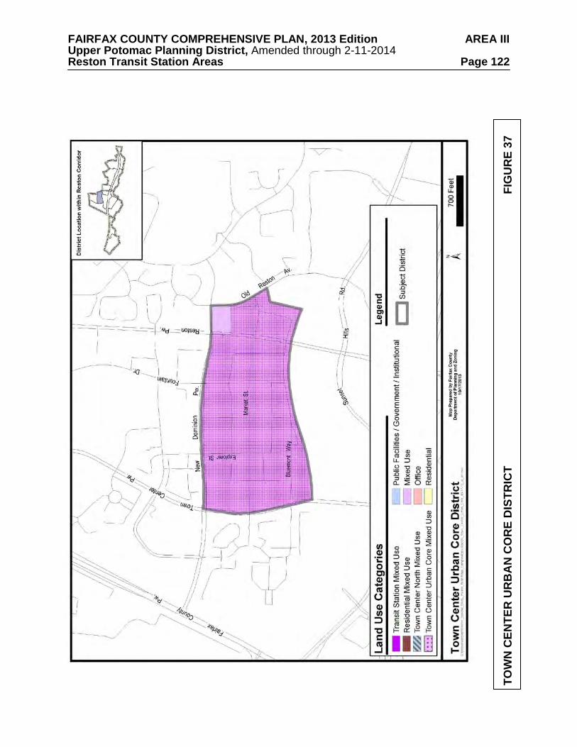
FAIRFAX COUNTY COMPREHENSIVE PLAN, 2013 Edition AREA III Upper Potomac Planning District, Amended through 2-11-2014 Reston Transit Station Areas Page 122
TOW
N C
ENTE
R U
RB
AN
CO
RE
DIS
TRIC
T
F
IGU
RE
37
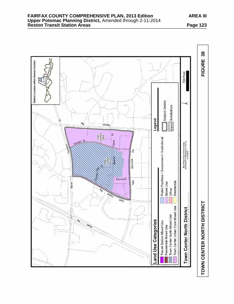
FAIRFAX COUNTY COMPREHENSIVE PLAN, 2013 Edition AREA III Upper Potomac Planning District, Amended through 2-11-2014 Reston Transit Station Areas Page 123
TOW
N C
ENTE
R N
OR
TH D
ISTR
ICT
FIG
UR
E 3
8
FAIRFAX COUNTY COMPREHENSIVE PLAN, 2013 Edition AREA III Upper Potomac Planning District, Amended through 2-11-2014 Reston Transit Station Areas Page 124 more diverse land uses than currently exist and a wider array of support services. A major urban park and community-gathering space should be located in the center of the subdistrict and a key design feature in organizing the layout of the subdistrict.
A preliminary concept with potential street grid and central green space is shown on Figure 39. This concept fosters the creation of several urban blocks that will form a logical extension of the development pattern established in the Town Center. Residential buildings should front on tree-lined streets and be designed with inviting street level facades.
The subdistrict includes a broad variety of County and institutional uses. Civic uses including a regional library, the North County Governmental Center (the Supervisor’s offices and local police station), the Embry Rucker Shelter, a human services office building, a 30-unit townhouse development and a 5 acre public park. Other private uses include two residential uses - a low rise condominium along Taliesin Place in the southwest corner of the subdistrict and the Paramount, a high rise condominium in the southeast quadrant of the subdistrict - a child care center, a rehabilitation center, an assisted living facility and medical offices.
The Town Center North Mixed Use area includes all of the land bounded by Baron
Cameron Avenue on the north, Fountain Drive on the east and Town Center Parkway on the west. This area also includes three parcels to the south of Bowman Towne Drive where the Embry Rucker Shelter and Reston Regional Library are located, as well as Tax Map 17-1((17)) 5A, a small vacant parcel in the southwest corner of Fountain Drive and Bowman Towne Drive.
The Town Center North Mixed Use area is planned for up to a .90 FAR for non-residential
uses, which should include office, public, institutional, medical care, hotel, and retail uses, and a minimum of 1,000 residential units. The public uses may include public safety uses, libraries, shelters, schools, a recreation center, government offices, a performing arts center, and institutions of higher education. Some of the existing residential uses may maintain their current use, density and character.
The undeveloped parcel south of the Reston Regional Library and the Winwood Children’s
Center should be considered for redevelopment only if consolidated with either or both of the adjacent parcels on which the library and shelter are located.
Local-serving amenities including plazas, other urban parks, trails, and public art should be
provided throughout the subdistrict to serve local leisure and recreation needs. The exact number of urban parks, their sizes and distribution will be determined by the amount and type of new development, in accordance with the Urban Parks Framework in the Policy Plan. East Fountain Drive Subdistrict
This subdistrict is approximately 29 acres and comprised of a mixture of residential, office,
hotel, and retail uses. The subdistrict has an approved Planned Residential Community (PRC) plan for significant redevelopment (up to 790,000 square feet of non-residential uses and approximately 1,440 residential units) in a combination of mid-rise and high-rise buildings and with a diverse mix of land uses, including office, hotel, retail and residential uses.
The subdistrict is planned for approved uses and development intensities. Two new
developments are proposed for this sub-district. The Spectrum development is approved for a mix of uses to include office, residential, and retail at an approved intensity of .67 FAR. The office tower replacing the Town Center Office Building is approved for a mix of uses to include office, retail and/or eating establishments at an approved intensity of 4.08 FAR.
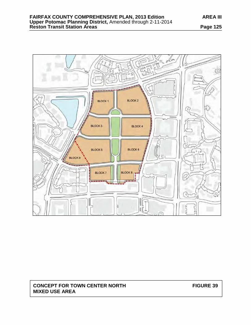
FAIRFAX COUNTY COMPREHENSIVE PLAN, 2013 Edition AREA III Upper Potomac Planning District, Amended through 2-11-2014 Reston Transit Station Areas Page 125
CONCEPT FOR TOWN CENTER NORTH FIGURE 39 MIXED USE AREA
FAIRFAX COUNTY COMPREHENSIVE PLAN, 2013 Edition AREA III Upper Potomac Planning District, Amended through 2-11-2014 Reston Transit Station Areas Page 126 Local-serving amenities including plazas, other urban parks, trails, and public art should be provided throughout the subdistrict to serve local leisure and recreation needs. The exact number of urban parks, their sizes and distribution will be determined by the amount and type of new development, in accordance with the Urban Parks Framework in the Policy Plan. Town Center West District
The Town Center West District consists of approximately 163 acres and is bounded on the
north by Baron Cameron Avenue, on the east by Town Center Parkway, on the south by the DAAR and on the west by Fairfax County Parkway, as shown on Figure 40. It is planned for and developed with a diversity of uses including townhouses and multi-family housing, the Reston Hospital Center and associated medical office buildings, a YMCA facility, a Reston Association storage facility and a Target store. The district is planned to maintain existing character, uses and development intensities (.50-1.0 FAR).
Local-serving amenities including urban parks, trails, and public art should be provided
throughout the subdistrict to serve local leisure and recreation needs. The exact number of urban parks, their sizes and distribution will be determined by the amount and type of new development, in accordance with the Urban Parks Framework in the Policy Plan.
Opportunities to provide small-scale recreational waysides (e.g. seating areas, playgrounds)
or larger recreational or cultural facilities (e.g. gathering places) near the W&OD and in collaboration with NVRPA should be explored. Old Reston Avenue District
The Old Reston Avenue District is comprised of approximately 44 acres and is bounded on
the northwest by the Stratford House residential community, Old Reston Avenue on the east, the DAAR on the south and Reston Parkway on the west, as shown on Figure 41.
Existing development includes office uses in medium and high-rise buildings (served by
structured and surface parking), free-standing auto-oriented retail uses at the intersection of Old Reston Avenue and Sunset Hills Road, and the Carlton House residential condominium building.
The Old Reston Avenue District is planned for mixed use up to .50 FAR or office and retail
uses at currently approved development intensities, or with respect to Tax Map 17-4 ((1)) 1 office and/or residential uses up to .64 FAR. Sunset Hills, also known as the A. Smith Bowman House (1850 Old Reston Avenue; Tax Map 17-4((1))1), should be preserved, its present exterior retained and new buildings should be sensitively sited in relationship to the house. Other scenic assets and natural features such as the pond and gazebo should be preserved as much as possible. The Oracle campus to the east of Reston Parkway is planned for office and residential uses at an already approved intensity of 1.11 FAR.
Local-serving amenities such as pocket parks, trails, and public art should be provided
throughout the district and for all types of development. Local-serving amenities are guided by the Areawide text on Urban Parks, Recreation Facilities, and Cultural Facilities as well as the Urban Parks Framework in the Policy Plan. There may be an additional opportunity to provide an enhanced stormwater park in this district, to cluster amenities around the stormwater features and create a valued recreational and/or cultural asset.
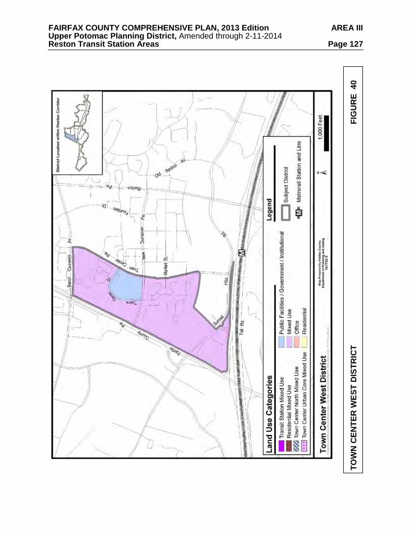
FAIRFAX COUNTY COMPREHENSIVE PLAN, 2013 Edition AREA III Upper Potomac Planning District, Amended through 2-11-2014 Reston Transit Station Areas Page 127
TOW
N C
ENTE
R W
EST
DIS
TRIC
T
FI
GU
RE
40
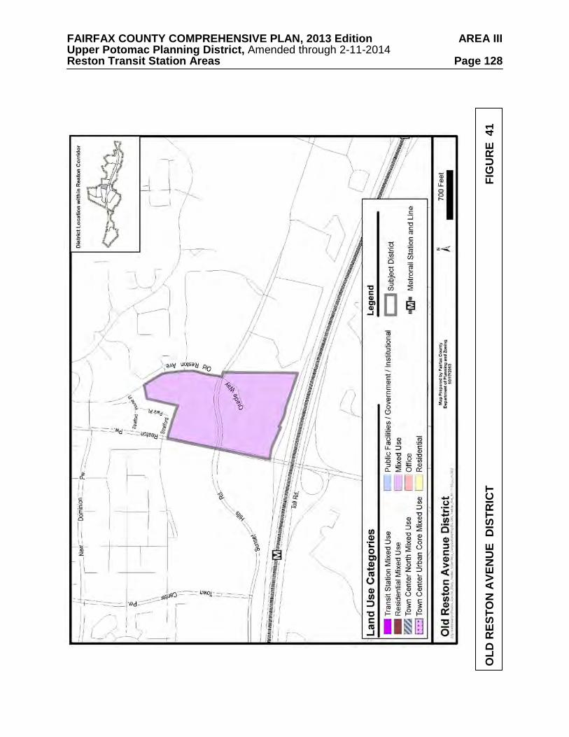
FAIRFAX COUNTY COMPREHENSIVE PLAN, 2013 Edition AREA III Upper Potomac Planning District, Amended through 2-11-2014 Reston Transit Station Areas Page 128
OLD
RES
TON
AVE
NU
E D
ISTR
ICT
FIG
UR
E 4
1

FAIRFAX COUNTY COMPREHENSIVE PLAN, 2013 Edition AREA III Upper Potomac Planning District, Amended through 2-11-2014 Reston Transit Station Areas Page 129
Opportunities to provide small-scale recreational waysides (e.g. seating areas, playgrounds) near the W&OD and in collaboration with NVRPA should be explored. Reston Heights District
The Reston Heights District consists of approximately 35 acres and is bounded on the north
by the DAAR, on the east by development along Roland Clarke Place, on the south by SunriseValley Drive and on the west by Reston Parkway, as shown on Figure 42. Existing development includes the Reston International Center and the surrounding Reston Heights mixed-use development and the Reston Sheraton and the adjacent Reston Square mixed-use development. Other uses include a mix of retail and office uses in a low density commercial area oriented toward Sunrise Valley Drive. The Reston Heights development that includes the Reston International Center is approved for a mix of uses to include office, residential, and retail uses at an approved intensity of 2.8 FAR. The Reston Square development is approved for a mixed use development including office, residential, hotel and retail at a 1.07 FAR and has largely been built as approved.
The district is planned for existing and approved uses and development intensities.
Central Sunrise Valley District
The Central Sunrise Valley District includes 205 acres and is generally bounded by the
DAAR on the north, Edmund Halley Drive on the east, South Lakes Road on the south and the Fairfax County Parkway on the west, as shown on Figure 43.
It is planned for and developed with office and light industrial uses. The district includes
the headquarters of the U.S. Geological Survey (USGS). The area west of the USGS and south of Sunrise Valley Drive is planned for light industrial use up to .35 FAR, while office use up to .50 FAR is appropriate for the balance of the district. For the area within ½ mile of the Reston Town Center station platform, residential use up to 30 dwelling units per acre is appropriate.
This district should be considered as a potential location for a future urban elementary
school. The USGS site in particular should be evaluated for this use. At such time as the need for a second elementary school has been identified by Fairfax County Public Schools, this district should be re-evaluated for the possibility of additional development potential.
Local-serving amenities including plazas, other urban parks, trails, and public art should be
provided throughout the subdistrict to serve local leisure and recreation needs. The exact number of urban parks, their sizes and distribution will be determined by the amount and type of new development, in accordance with the Urban Parks Framework in the Policy Plan.
Existing manmade and natural features in the vicinity of Sunrise Valley Drive provide a
particular opportunity to create small, semi-urban scale parks linked by trails and pedestrian facilities planned for the TSA. Opportunities to cluster amenities in nodes along existing natural and stormwater features should be used to form a connected park amenity.

FAIRFAX COUNTY COMPREHENSIVE PLAN, 2013 Edition AREA III Upper Potomac Planning District, Amended through 2-11-2014 Reston Transit Station Areas Page 130
RES
TON
HEI
GH
TS D
ISTR
ICT
FI
GU
RE
42

FAIRFAX COUNTY COMPREHENSIVE PLAN, 2013 Edition AREA III Upper Potomac Planning District, Amended through 2-11-2014 Reston Transit Station Areas Page 131
CEN
TRA
L SU
NR
ISE
VALL
EY D
ISTR
ICT
FIG
UR
E 4
3
FAIRFAX COUNTY COMPREHENSIVE PLAN, 2013 Edition AREA III Upper Potomac Planning District, Amended through 2-11-2014 Reston Transit Station Areas Page 132 HERNDON TRANSIT STATION AREA
The Herndon Transit Station Area is bounded on the north by the DAAR, on the east by
Fairfax County Parkway, on the south by Sunrise Valley Drive, Frying Pan Road and Fox Mill Road, and on the west by Centreville Road.
Local-serving amenities including plazas, other urban parks, trails, and public art should be
provided throughout the districts to serve local leisure and recreation needs. The exact number of urban parks, their sizes and distribution will be determined by the amount and type of new development, in accordance with the Urban Parks Framework in the Policy Plan. Recreational impacts of new development should be offset through provision of recreation facilities on-site or contributions to nearby parks. The existing Sunrise Valley Wetlands Nature Park provides a particular opportunity to link a publicly accessible natural habitat by trails and pedestrian facilities planned for the TSA to other small semi-urban scale parks along Sunrise Valley Drive in a connected park amenity.
As described in the Areawide text on Urban Parks, Recreation Facilities, and Cultural
Facilities, athletic field needs will be met through the construction of new fields as well as improvements to existing nearby fields. As a part of this, Areawide Plan guidance establishes a goal of one new full-service athletic field within each TSA. Contributions toward land and improvements sufficient to achieve this goal should be provided with development.
This TSA includes the Herndon Transit-Oriented Development (TOD) Station District and
the Woodland Park/Great Oak District.
Herndon Station Transit-Oriented Development (TOD) District
The vision of the Herndon Station TOD District is for a moderate intensity urban neighborhood with a mix of uses including office, residential, and hotel, together with support retail and services, adjacent to a district-defining natural resource amenity. In addition, redevelopment should create pedestrian-friendly connections to one or more smaller urban plazas or parks to provide gathering places for people of all ages as well as places to walk and enjoy green spaces.
Guidance for evaluating development proposals in each district is contained in the
Areawide Recommendations and the following district and subdistrict recommendations. Redevelopment options are dependent on the degree to which necessary public infrastructure can be provided and Plan objectives and development conditions set forth in the Areawide and subdistrict guidance can be satisfied by development proposals.
The Herndon Station District is comprised of approximately 126 acres and is generally
bounded by the DAAR on the north, the Fairfax County Parkway on the east, Sunrise Valley Drive on the south and the Woodland Park office development on the west, as shown on Figure 44. Monroe Street is the primary north-south street in the district.
Existing development in the district is a combination of low rise suburban office buildings
with surface parking and mid-rise office buildings with structured parking. The Herndon Park-and-Ride facility is located adjacent to the planned transit station platform. The four-level County-owned and operated transit center (for Fairfax Connector bus service) and park-and-ride facility has 1,700 spaces and will be expanded to provide 3,500 spaces for Metro parking. The Sunrise Valley Park Wildlife Habitat and Nature Preserve is an approximately 14 acre man-made
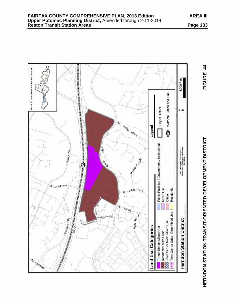
FAIRFAX COUNTY COMPREHENSIVE PLAN, 2013 Edition AREA III Upper Potomac Planning District, Amended through 2-11-2014 Reston Transit Station Areas Page 133
HER
ND
ON
STA
TIO
N T
RA
NSI
T-O
RIE
NTE
D D
EVEL
OPM
ENT
DIS
TRIC
T
FIG
UR
E 4
4
FAIRFAX COUNTY COMPREHENSIVE PLAN, 2013 Edition AREA III Upper Potomac Planning District, Amended through 2-11-2014 Reston Transit Station Areas Page 134 publicly accessible wetland area in the district with a notable diversity of wildlife and a boardwalk facility that crosses the wetland. In addition, there is an approximately 21 acre vacant parcel in the northeastern corner of the Woodland Park mixed-use development along Monroe Street.
Base Plan
The subdistrict is planned for office use at .50 FAR or residential use at up to 30 dwelling
units per acre. The parcel at the eastern end of Woodland Park is planned for mixed-use development up to .70 FAR and has an approved rezoning for approximately 1 million square feet of office use. Redevelopment Option
The vision for this district is for redevelopment at higher intensities with more diverse land
uses than currently exist and a wider array of support services. Local-serving amenities including plazas, other urban parks, trails, and public art should be
provided throughout the subdistrict to serve local leisure and recreation needs. The exact number of urban parks, their sizes and distribution will be determined by the amount and type of new development, in accordance with the Urban Parks Framework in the Policy Plan.
The Transit Station Mixed Use area is planned for intensity within a range of 1.5 to 2.5
FAR. The planned zoning target for office development in this area of the subdistrict is 2.1 million square feet of existing, approved and new development. The planned zoning target for residential development is approximately 2,000 residential units. Development proposals should typically provide a mix of 50 percent non-residential use and 50 percent residential use. The availability of vacant land within close proximity to the Metro station presents an opportunity to realize the desired mix for Transit Station Mixed Use areas of 50 percent non-residential uses and 50 percent residential uses. Individual developments may have flexibility to build more office use if other developments are built or rezoned with a use mix that contains proportionally less office. Ground level retail and support service uses are encouraged to add to the vibrancy and enhance the pedestrian environment. Support retail uses should be located in office, hotel or residential buildings and be complementary to other uses with the objective of allowing residents and employees to minimize daily automobile use.
The Residential Mixed Use area is planned for intensity up to 1.5 FAR (approximately
2,700 units). The area is planned for predominantly residential uses with a mix of other uses including office, hotel and supporting retail. In addition, the wetlands area should be preserved. The availability of vacant land in this district creates an opportunity to achieve the Residential Mixed Use goal of 75 percent residential uses. Individual development may have flexibility to vary from the stated percentages if other developments are built or rezoned with a use mix that maintains these proportions for the area designated as the Residential Mixed Use category. Ground level retail and support service uses are encouraged to add to the vibrancy and enhance the pedestrian environment. Support retail uses should be located in office, hotel or residential buildings and be complementary to other uses with the objective of allowing residents and employees to minimize daily automobile use.
Woodland Park/Great Oak District
The vision of the Woodland Park/Great Oak District is to maintain the character, uses and intensities/densities of existing development.
FAIRFAX COUNTY COMPREHENSIVE PLAN, 2013 Edition AREA III Upper Potomac Planning District, Amended through 2-11-2014 Reston Transit Station Areas Page 135 Woodland Park Subdistrict
The Woodland Park development consists of approximately 163 acres and is bounded by the DAAR on the north, Monroe Street on the east, Sunrise Valley Drive on the south and Centreville Road on the west, as shown on Figure 45. It is planned and developed as a major mixed-use development up to .70 FAR, with office, retail, hotel and residential uses. This area along the DAAR has high visibility and is appropriate for high quality development including corporate headquarters, hotels and office buildings. Mixed-use developments should create a viable, quality living environment with active recreation facilities and other amenities for residents. Residential development should be sited away from the DAAR and towards Sunrise Valley Drive. Support retail and service uses are appropriate in office, hotel or residential buildings.
Pedestrian connections throughout the area and to transit facilities should be provided.
Clustering of buildings in a transit friendly design is encouraged, whereby development that is built prior to rail service can be clustered on a portion of the area so as not to preclude additional buildings and intensity in the future when rail is extended to this area. The overall design should seek to concentrate open space, to the extent possible, into common areas such as urban parks and plazas to provide visual focus and attractive outdoor spaces for residents and employees.
Local-serving amenities including plazas, other urban parks, trails, and public art should be
provided throughout the subdistrict to serve local leisure and recreation needs. The exact number of urban parks, their sizes and distribution will be determined by the amount and type of new development, in accordance with the Urban Parks Framework in the Policy Plan.
Specifically, development in Woodland Park should incorporate recreational amenities for
employees and residents, such as walking/jogging paths, exercise stations, and multi-use courts that are appropriate to the mix of potential users and their needs. The development of this area should incorporate a vehicular circulation network that is appropriate to the type and intensity of the ultimate uses and the pattern of subdivision.
Existing manmade and natural features in the vicinity of Sunrise Valley Drive provide a
particular opportunity to create small, semi-urban scale parks linked by trails and pedestrian facilities planned for the TSA. Opportunities to cluster amenities in nodes along existing natural and stormwater features should be used to form a connected park amenity. Great Oak Subdistrict
The area south of Sunrise Valley Drive includes approximately 99 acres and is bounded by
Monroe Street on the east and Fox Mill Road on the south and west. The subdistrict, composed of 100 percent residential uses, includes the Great Oak subdivision, a development of townhouses and single family homes; the Woodland Park Apartments; and the Fox Mill Station condominiums. This area was previously zoned for industrial use and planned for office use with options for residential use to provide housing to complement the office uses in Woodland Park and to add to the diversity of housing types in this area.
As this area has been developed according to the residential Plan options, it is now planned
for residential uses at the approved densities to maintain its existing character.
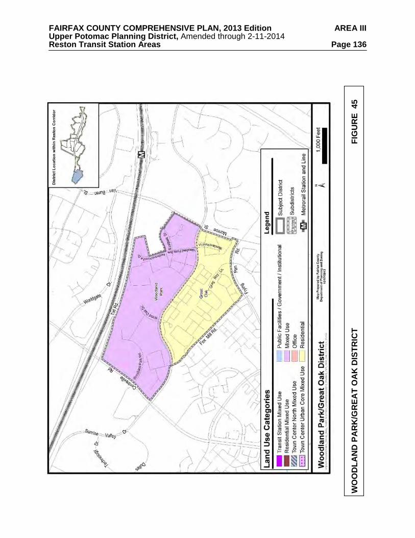
FAIRFAX COUNTY COMPREHENSIVE PLAN, 2013 Edition AREA III Upper Potomac Planning District, Amended through 2-11-2014 Reston Transit Station Areas Page 136
WO
OD
LAN
D P
AR
K/G
REA
T O
AK
DIS
TRIC
T
FI
GU
RE
45
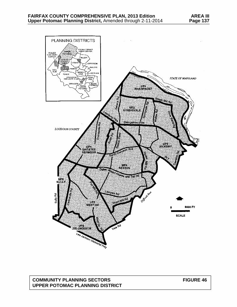
FAIRFAX COUNTY COMPREHENSIVE PLAN, 2013 Edition AREA III Upper Potomac Planning District, Amended through 2-11-2014 Page 137
COMMUNITY PLANNING SECTORS FIGURE 46 UPPER POTOMAC PLANNING DISTRICT
FAIRFAX COUNTY COMPREHENSIVE PLAN, 2013 Edition AREA III Upper Potomac Planning District, Amended through 2-11-2014 UP1-Riverfront Community Planning Sector Page 138
UP1 RIVERFRONT COMMUNITY PLANNING SECTOR CHARACTER
This planning sector is located along the Potomac River shoreline as it extends from the National Park Service's Great Falls Park to the Loudoun County line and Seneca Road. The southern border of this sector is Georgetown Pike (Route 193), River Bend Road and Beach Mill Road.
The Riverfront Planning Sector is a rural area characterized by large lot residential
development, parkland and open space. This planning sector has produced significant prehistoric heritage resources. Because of
the very low density development in the sector, there is a very high potential for both prehistoric and historic heritage resources to still remain. The Potomac floodplain and adjacent uplands are particularly sensitive. The Potomac Canal Lock ruins and the ruins of the Town of Matildaville are significant existing resources in this sector which are listed in the National Register of Historic Places under the Patowmack Canal Historic District/Lock Ruins at Great Falls. This National Register Historic District is a National Historic Landmark, and is also listed in the County Inventory of Historic Sites and the Virginia Landmarks Register. A list and map of heritage resources are included in the Upper Potomac Planning District Overview section, Figures 4, 5 and 6. Additional historic sites in this sector are also included in the inventory.
CONCEPT FOR FUTURE DEVELOPMENT
The Riverfront Community Planning Sector is designated as a Low Density Residential Area in the Concept for Future Development. RECOMMENDATIONS Land Use
The Riverfront Community Planning Sector is a very low density stable residential area. Infill development in this residential area should be of a compatible use, type and intensity in accordance with the guidance provided by the Policy Plan under Land Use Objectives 8 and 14.
Where substantial parcel consolidation is specified, it is intended that such consolidations
will provide for projects that function in a well-defined, efficient manner and provide for the development of unconsolidated parcels in conformance with the Area Plan.
Figure 47 indicates the geographic location of this sector. Due to the general nature of the land use recommendations for this sector, they were not shown on the General Locator Map. 1. Limit land uses to parkland, open space, and large-lot residential development. Residential
density of no greater than one dwelling unit per five acres is planned for this sector to protect the Potomac River Environmental Quality Corridor and Wildlife Preserve. [Not shown]
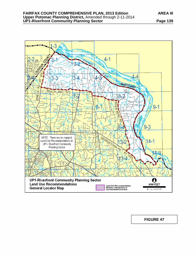
FAIRFAX COUNTY COMPREHENSIVE PLAN, 2013 Edition AREA III Upper Potomac Planning District, Amended through 2-11-2014 UP1-Riverfront Community Planning Sector Page 139
FIGURE 47
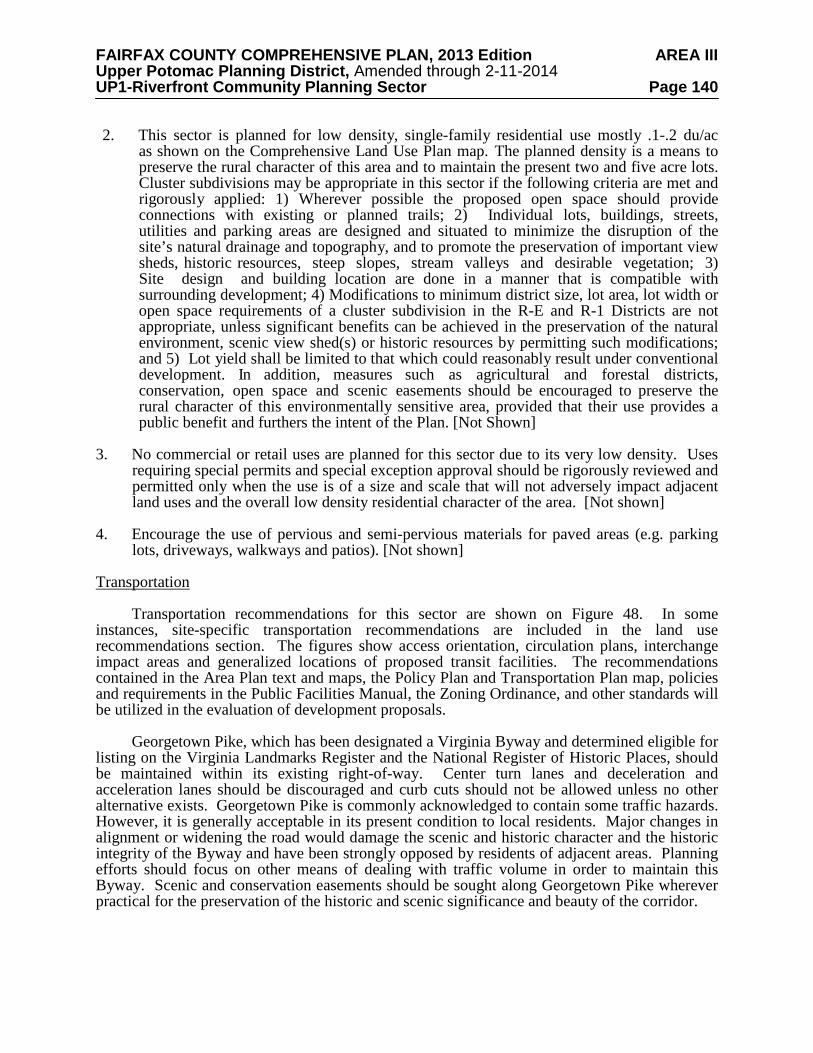
FAIRFAX COUNTY COMPREHENSIVE PLAN, 2013 Edition AREA III Upper Potomac Planning District, Amended through 2-11-2014 UP1-Riverfront Community Planning Sector Page 140 2. This sector is planned for low density, single-family residential use mostly .1-.2 du/ac
as shown on the Comprehensive Land Use Plan map. The planned density is a means to preserve the rural character of this area and to maintain the present two and five acre lots. Cluster subdivisions may be appropriate in this sector if the following criteria are met and rigorously applied: 1) Wherever possible the proposed open space should provide connections with existing or planned trails; 2) Individual lots, buildings, streets, utilities and parking areas are designed and situated to minimize the disruption of the site’s natural drainage and topography, and to promote the preservation of important view sheds, historic resources, steep slopes, stream valleys and desirable vegetation; 3) Site design and building location are done in a manner that is compatible with surrounding development; 4) Modifications to minimum district size, lot area, lot width or open space requirements of a cluster subdivision in the R-E and R-1 Districts are not appropriate, unless significant benefits can be achieved in the preservation of the natural environment, scenic view shed(s) or historic resources by permitting such modifications; and 5) Lot yield shall be limited to that which could reasonably result under conventional development. In addition, measures such as agricultural and forestal districts, conservation, open space and scenic easements should be encouraged to preserve the rural character of this environmentally sensitive area, provided that their use provides a public benefit and furthers the intent of the Plan. [Not Shown]
3. No commercial or retail uses are planned for this sector due to its very low density. Uses
requiring special permits and special exception approval should be rigorously reviewed and permitted only when the use is of a size and scale that will not adversely impact adjacent land uses and the overall low density residential character of the area. [Not shown]
4. Encourage the use of pervious and semi-pervious materials for paved areas (e.g. parking
lots, driveways, walkways and patios). [Not shown] Transportation
Transportation recommendations for this sector are shown on Figure 48. In some instances, site-specific transportation recommendations are included in the land use recommendations section. The figures show access orientation, circulation plans, interchange impact areas and generalized locations of proposed transit facilities. The recommendations contained in the Area Plan text and maps, the Policy Plan and Transportation Plan map, policies and requirements in the Public Facilities Manual, the Zoning Ordinance, and other standards will be utilized in the evaluation of development proposals.
Georgetown Pike, which has been designated a Virginia Byway and determined eligible for
listing on the Virginia Landmarks Register and the National Register of Historic Places, should be maintained within its existing right-of-way. Center turn lanes and deceleration and acceleration lanes should be discouraged and curb cuts should not be allowed unless no other alternative exists. Georgetown Pike is commonly acknowledged to contain some traffic hazards. However, it is generally acceptable in its present condition to local residents. Major changes in alignment or widening the road would damage the scenic and historic character and the historic integrity of the Byway and have been strongly opposed by residents of adjacent areas. Planning efforts should focus on other means of dealing with traffic volume in order to maintain this Byway. Scenic and conservation easements should be sought along Georgetown Pike wherever practical for the preservation of the historic and scenic significance and beauty of the corridor.
FAIRFAX COUNTY COMPREHENSIVE PLAN, 2013 Edition AREA III Upper Potomac Planning District, Amended through 2-11-2014 UP1-Riverfront Community Planning Sector Page 141
TRANSPORTATION RECOMMENDATIONS FIGURE 48
FAIRFAX COUNTY COMPREHENSIVE PLAN, 2013 Edition AREA III Upper Potomac Planning District, Amended through 2-11-2014 UP1-Riverfront Community Planning Sector Page 142 Heritage Resources
Georgetown Pike is designated as a Virginia Byway pursuant to Section 33.1-63 of the
Code of Virginia, as amended. The protection of Georgetown Pike is discussed in the Transportation section above.
Any development or ground disturbance in this sector, both on private and public land,
should be preceded by heritage resource studies, and alternatives should be explored for the avoidance, preservation or recovery of significant heritage resources that are found. In those areas where significant heritage resources have been recorded, an effort should be made to preserve them. If preservation is not feasible, then, in accordance with countywide objectives and policies as cited in the Heritage Resources section of the Policy Plan, the threatened resource should be thoroughly recorded and in the case of archaeological resources, the artifacts recovered.
Parks and Recreation
Park and recreation recommendations for this sector are shown on Figure 49. The column "Park Classification" includes existing park facilities. The "Recommendations" column includes entries for both existing and proposed facilities. Prior to developing parkland, the Fairfax County Park Authority initiates a master planning process to determine the appropriate facilities and design for that park. This process involves extensive citizen review and participation. If an existing park is listed but no recommendation appears on that line, it means the park has been developed in accordance with its master plan. Trails
Trails planned for this sector are delineated on Figure 50 and on the 1”:4,000’ Countywide
Trails Plan Map which is referenced as Figure 2 in the Transportation element of the Policy Plan and is available from the Department of Planning and Zoning. Trails in this sector are an integral part of the overall County system. While some of the segments have already been constructed, the Countywide Trails Plan Map portrays the ultimate system for the sector and the County at large. In addition, the map specifies a classification for each segment, which represents the desired ultimate function and surface type of the trail. Specific construction requirements are detailed in the Public Facilities Manual.
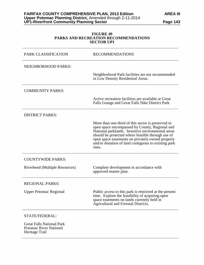
FAIRFAX COUNTY COMPREHENSIVE PLAN, 2013 Edition AREA III Upper Potomac Planning District, Amended through 2-11-2014 UP1-Riverfront Community Planning Sector Page 143
FIGURE 49 PARKS AND RECREATION RECOMMENDATIONS
SECTOR UP1 PARK CLASSIFICATION
RECOMMENDATIONS
NEIGHBORHOOD PARKS:
Neighborhood Park facilities are not recommended in Low Density Residential Areas.
COMMUNITY PARKS:
Active recreation facilities are available at Great Falls Grange and Great Falls Nike District Park.
DISTRICT PARKS:
More than one-third of this sector is preserved in open space encompassed by County, Regional and National parklands. Sensitive environmental areas should be protected where feasible through use of open space easements on privately owned property and/or donation of land contiguous to existing park sites.
COUNTYWIDE PARKS: Riverbend (Multiple Resources)
Complete development in accordance with approved master plan.
REGIONAL PARKS: Upper Potomac Regional
Public access to this park is restricted at the present time. Explore the feasibility of acquiring open space easements on lands currently held in Agricultural and Forestal Districts.
STATE/FEDERAL: Great Falls National Park Potomac River National Heritage Trail

FAIRFAX COUNTY COMPREHENSIVE PLAN, 2013 Edition AREA III Upper Potomac Planning District, Amended through 2-11-2014 UP1-Riverfront Community Planning Sector Page 144
TRAILS PLAN MAP FOR THIS SECTOR UNDER CONSTRUCTION
SEE THE 1” = 4000’ SCALE
COUNTYWIDE TRAILS PLAN MAP
PLANNED TRAIL SYSTEM FIGURE 50
FAIRFAX COUNTY COMPREHENSIVE PLAN, 2013 Edition AREA III Upper Potomac Planning District, Amended through 2-11-2014 UP2-Springvale Community Planning Sector Page 145
UP2 SPRINGVALE COMMUNITY PLANNING SECTOR CHARACTER
The Springvale Community Planning Sector is located in the northern part of the county and is bounded by Beach Mill Road and Seneca Road on the north, River Bend Road to the east, Leesburg Pike (Route 7) and Georgetown Pike (Route 193) on the south, and Loudoun County to the west.
This planning sector is rural in character and consists of residential estates and large-lot
subdivisions, undeveloped land and open space. Local-serving commercial uses are located on Leesburg Pike at Georgetown Pike, at the Great Falls Village area, at Georgetown Pike and Walker Road, and at Beach Mill and Springvale Road. This area is developed as and planned to maintain the very low density character through large-lot residential development.
This planning sector is characterized by low-density residential development and open
space. The sector has a high potential for significant heritage resources, and is rich in known historic sites. Great Falls Grange and Great Falls Post Office/Forestville School, as well as the John Gunnell House, Gunnell’s Run and Cornwell Farm, are listed in the County Inventory of Historic Sites, Virginia Landmarks Register and the National Register of Historic Places. A portion of the Dranesville Tavern Historic Overlay District lies within this sector. Georgetown Pike is designated as a Virginia Byway pursuant to Section 33.1-63 of the Code of Virginia, as amended. A list and map of heritage resources are included in the Upper Potomac Planning District Overview section, Figures 4, 5 and 6. Additional historic sites in this sector are also included in the inventory. CONCEPT FOR FUTURE DEVELOPMENT
The Springvale Community Planning Sector is designated as a Low Density Residential Area in the Concept for Future Development. RECOMMENDATIONS Land Use
The Springvale Community Planning Sector is largely developed as stable low density residential areas. Infill development in these residential areas should be of a compatible use, type and intensity in accordance with the guidance provided by the Policy Plan under Land Use Objectives 8 and 14.
Where substantial parcel consolidation is specified, it is intended that such consolidations
will provide for projects that function in a well-defined, efficient manner and provide for the development of unconsolidated parcels in conformance with the Area Plan.
Figure 51 indicates the geographic location of land use recommendations for this sector.
Where recommendations are not shown on the General Locator Map, it is so noted.
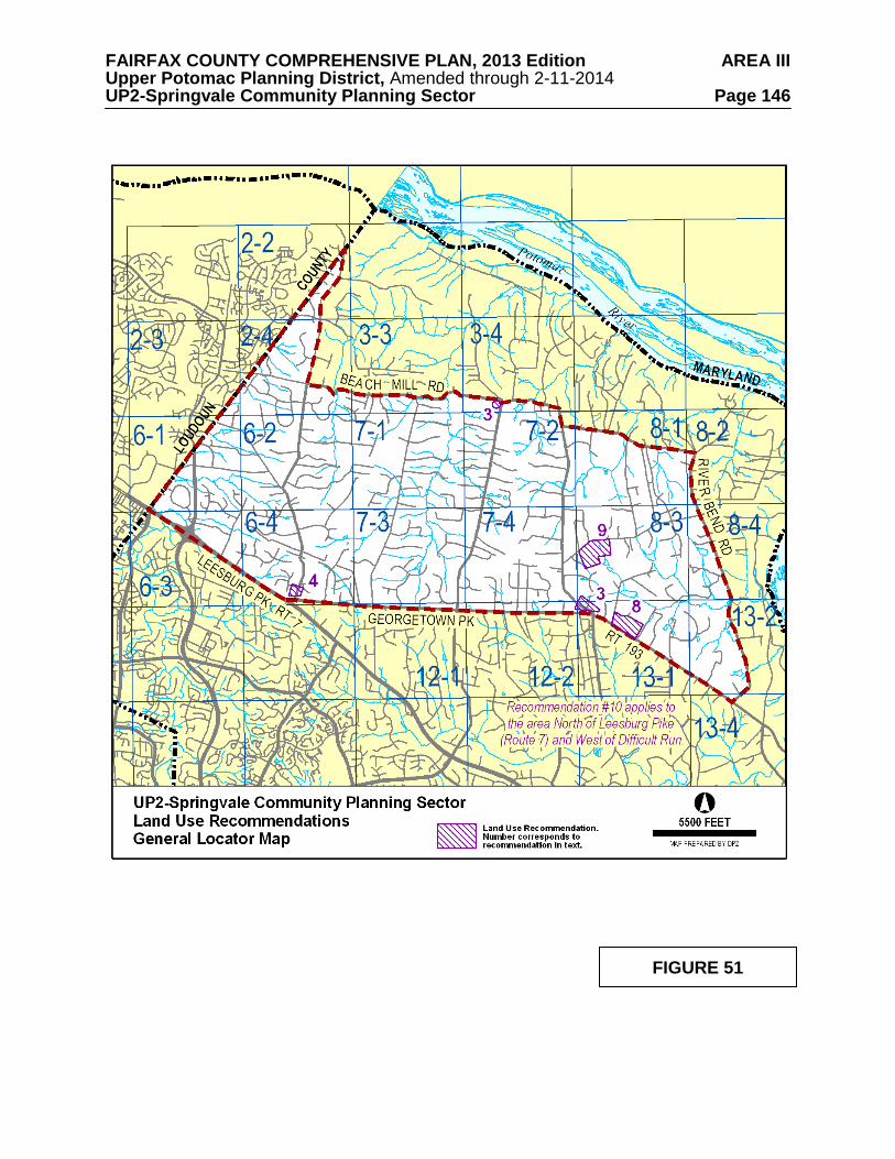
FAIRFAX COUNTY COMPREHENSIVE PLAN, 2013 Edition AREA III Upper Potomac Planning District, Amended through 2-11-2014 UP2-Springvale Community Planning Sector Page 146
FIGURE 51
FAIRFAX COUNTY COMPREHENSIVE PLAN, 2013 Edition AREA III Upper Potomac Planning District, Amended through 2-11-2014 UP2-Springvale Community Planning Sector Page 147
1. Land use in this sector should continue to reflect and support the established low density
residential character of one dwelling unit per two and five acre lots. Public parkland and low density residential uses at .1-.2 dwelling unit per acre and .2-.5 dwelling unit per acre are planned for the area as shown on the Plan map. Several older residential areas along Georgetown Pike are planned at a density of 1-2 dwelling units per acre as a reflection of the typical densities that exist in these areas. [Not shown]
2. This sector is planned for low density, single-family residential use at .2-.5 du/ac as shown
on the Comprehensive Land Use Plan map. Cluster subdivisions may be appropriate in this sector if the following criteria are met and are rigorously applied: 1) Wherever possible the proposed open space should provide connections with existing or planned trails; 2) Individual lots, buildings, streets, utilities and parking areas are designed and situated to minimize the disruption of the site’s natural drainage and topography, and to promote the preservation of important view sheds, historic resources, steep slopes, stream valleys and desirable vegetation; 3) Site design and building location are done in a manner that is compatible with surrounding development; 4) Modifications to minimum district size, lot area, lot width or open space requirements of a cluster subdivision in the R-E and R-1 Districts are not appropriate, unless significant benefits can be achieved in the preservation of the natural environment, scenic view shed(s) or historic resources by permitting such modifications; and 5) Lot yield shall be limited to that which could reasonably result under conventional development. In addition, measures such as agricultural and forestal districts, conservation, open space and scenic easements should be encouraged to preserve the rural character of this environmentally sensitive area, provided that their use provides a public benefit and furthers the intent of the Plan. [Not Shown]
3. Commercial uses should be neighborhood-serving and confined to existing commercial
areas as shown on the Plan map. This includes the area in the vicinity of Walker Road and Georgetown Pike and at Springvale Road and Beach Mill Road.
4. The area along Seneca Road, north of its intersection with Georgetown Pike is currently
planned for residential development at densities of .2-.5 and 1-2 dwelling units per acre. A small portion of this area at Seneca Road and Georgetown Pike is commercially zoned. Commercial development of these parcels should be limited to low intensity office and neighborhood retail uses, not to exceed .25 FAR, under the following conditions:
• Consolidation of commercially-zoned parcels (Tax Map 6-4((3))1, 2, 3, and 4), or the
development of a single project on Tax Map 6-4((1))60B, which represents an earlier consolidation;
• Provision of substantial landscaped and/or naturally vegetated buffers to protect
surrounding residential uses and provide a clear line of demarcation between any commercial development and the existing and planned low density residential uses to the north, east and west. Residentially zoned portions of these parcels should be used and maintained as open space buffers;
• Either office or retail development should be of high quality as demonstrated by
consistent architectural treatment of all building facades in a style that uses materials and design elements that are compatible with the low density residential community. Any office development should be residential in character, in terms of scale, bulk, material, and component detail;
FAIRFAX COUNTY COMPREHENSIVE PLAN, 2013 Edition AREA III Upper Potomac Planning District, Amended through 2-11-2014 UP2-Springvale Community Planning Sector Page 148
• Structures should not exceed 35 feet in height; and • Right-in/right-out only access to a unified commercial development on Tax Map 6-
4((1))60B may be provided from Georgetown Pike if approved by VDOT. 5. Future development and improvements to commercial establishments in the Village of
Great Falls should encourage uniformity of architecture, screening, fencing, signage and encourage the completion of trails in the village. [Not shown]
6. In this planning sector, uses requiring special permits and special exception approval
should be rigorously reviewed and permitted only when the use is of a size and scale that will not adversely impact adjacent land uses and the overall low density residential character of the area. [Not shown]
7. The Route 7 Corridor is planned for and should continue to be reserved for residential
development. Industrial, office, research and development (R&D), and retail commercial uses are not appropriate in the Route 7 Corridor. Uses requiring special permits and special exception approval should be rigorously reviewed and permitted only when the use is of a size and scale that will not adversely impact adjacent land uses and the overall low density residential character of the corridor in order to prevent commercial or quasi-commercial encroachment. [Not shown]
8. Parcel 13-1((1))37, which is located on the northeast corner of Georgetown Pike and
Innsbruck Avenue, is planned for residential use at .2 -.5 dwelling units per acre. As an option, public park use may be appropriate.
9. Parcels 8-3((1)) 45V and 45Z, located on the south side of Arnon Chapel Road across from
the intersection of Arnon Meadow Road, are planned for residential use at .2 - .5 dwelling units per acre. As an option, public park use may be appropriate.
10. Turner Farm Park, in the heart of the Great Falls area, is planned for an astronomical
observatory for educational and recreational use by County schools and residents due to having among the darkest night sky in the Washington, D.C. Metropolitan Area. The night sky in the area surrounding the planned observatory should be protected from excessive and improper lighting. New development (i.e., public and private) in planning sector UP2 and planning sector UP3, north of Leesburg Pike and west of Difficult Run, should provide energy efficient lighting that reduces glare, eliminates light trespass and reduces sky glow.
11. Encourage the use of pervious and semi-pervious materials for paved areas (e.g. parking
lots, driveways, walkways and patios). [Not shown] Transportation
Transportation recommendations for this sector are shown on Figures 52 and 53. In some instances, site-specific transportation recommendations are included in the land use recommendations section. The figures show access orientation, circulation plans, interchange impact areas and generalized locations of proposed transit facilities. The recommendations contained in the Area Plan text and maps, the Policy Plan and Transportation Plan map, policies and requirements in the Public Facilities Manual, the Zoning Ordinance, and other standards will be utilized in the evaluation of development proposals.
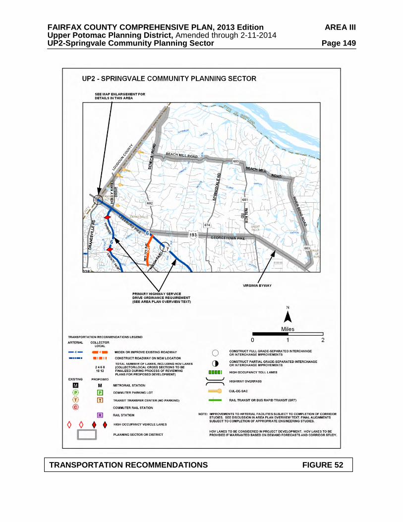
FAIRFAX COUNTY COMPREHENSIVE PLAN, 2013 Edition AREA III Upper Potomac Planning District, Amended through 2-11-2014 UP2-Springvale Community Planning Sector Page 149
TRANSPORTATION RECOMMENDATIONS FIGURE 52
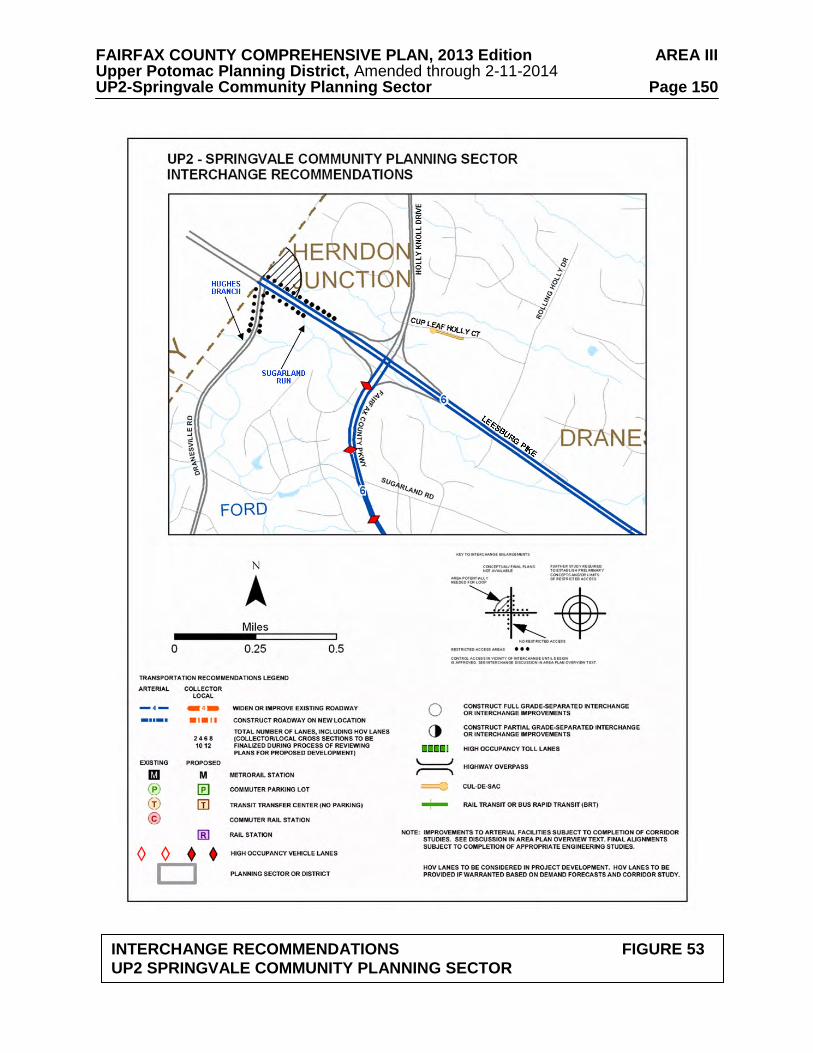
FAIRFAX COUNTY COMPREHENSIVE PLAN, 2013 Edition AREA III Upper Potomac Planning District, Amended through 2-11-2014 UP2-Springvale Community Planning Sector Page 150
INTERCHANGE RECOMMENDATIONS FIGURE 53 UP2 SPRINGVALE COMMUNITY PLANNING SECTOR
FAIRFAX COUNTY COMPREHENSIVE PLAN, 2013 Edition AREA III Upper Potomac Planning District, Amended through 2-11-2014 UP2-Springvale Community Planning Sector Page 151
Georgetown Pike, which has been designated a Virginia Byway and determined eligible for listing on the Virginia Landmarks Register and the National Register of Historic Places, should be maintained within its existing right-of-way. Center turn lanes and deceleration and acceleration lanes should be discouraged and curb cuts should not be allowed unless no other alternative exists. Georgetown Pike is commonly acknowledged to contain some traffic hazards. However, it is generally acceptable in its present condition to local residents. Major changes in alignment or widening the road would damage the scenic and historic character and the historic integrity of the Byway and have been strongly opposed by residents of adjacent areas. Planning efforts should focus on other means of dealing with traffic volume in order to maintain this Byway. Scenic and conservation easements should be sought along Georgetown Pike wherever practical for the preservation of the historic and scenic significance and beauty of the corridor.
Heritage Resources
This planning sector is rich in known historic sites and has a high potential for additional significant heritage resources. The area surrounding the Great Falls Grange and Great Falls Post Office should be considered for protection by establishment of an Historic Overlay District. Dunbarton should also be considered for this type of protection. A portion of the Dranesville Tavern Historic Overlay District lies within this sector. Regulations are discussed in Sector UP4 of the Upper Potomac Planning District. Georgetown Pike is designated as a Virginia Byway pursuant to Section 33.1-63 of the Code of Virginia, as amended. The protection of Georgetown Pike is discussed in the Transportation section above.
Any development or ground disturbance in this sector, both on private and public land,
should be preceded by heritage resource studies, and alternatives should be explored for the avoidance, preservation or recovery of significant heritage resources that are found. In those areas where significant heritage resources have been recorded, an effort should be made to preserve them. If preservation is not feasible, then, in accordance with countywide objectives and policies as cited in the Heritage Resources section of the Policy Plan, the threatened resource should be thoroughly recorded and in the case of archaeological resources, the artifacts recovered. Public Facilities 1. Replace the existing mini-library on Georgetown Pike with a community library near the
intersection of Georgetown Pike and Walker Road. 2. Provide any necessary improvements to FCWA’s Riverside Manor Water System to meet
future regulations (Tax Map 8-1((4))A, D, E). Parks and Recreation
Park and recreation recommendations for this sector are shown on Figure 54. The column
"Park Classification" includes existing park facilities. The "Recommendations" column includes entries for both existing and proposed facilities. Prior to developing parkland, the Fairfax County Park Authority initiates a master planning process to determine the appropriate facilities and design for that park. This process involves extensive citizen review and participation. If an existing park is listed but no recommendation appears on that line, it means the park has been developed in accordance with its master plan.
FAIRFAX COUNTY COMPREHENSIVE PLAN, 2013 Edition AREA III Upper Potomac Planning District, Amended through 2-11-2014 UP2-Springvale Community Planning Sector Page 152
FIGURE 54 PARKS AND RECREATION RECOMMENDATIONS
SECTOR UP2 PARK CLASSIFICATION
RECOMMENDATIONS
NEIGHBORHOOD PARKS: Holly Knolls
No development is planned for the park. Additional Neighborhood Park facilities are not recommended in Low Density Residential Areas.
COMMUNITY PARKS: Windermere
No development is planned for the park.
DISTRICT PARKS:
This sector lies within the service area of Great Falls Nike District Park. The southwestern part of this sector is also served by Baron Cameron District Park.
COUNTYWIDE PARKS: Great Falls Grange (Multiple Resources)
Complete development in accordance with approved master plan. Investigate the potential for obtaining historic preservation easements on selected historic properties.
FAIRFAX COUNTY COMPREHENSIVE PLAN, 2013 Edition AREA III Upper Potomac Planning District, Amended through 2-11-2014 UP2-Springvale Community Planning Sector Page 153 Trails
Trails planned for this sector are delineated on Figure 55 and on the 1”:4,000’ Countywide
Trails Plan Map which is referenced as Figure 2 in the Transportation element of the Policy Plan and is available from the Department of Planning and Zoning. Trails in this sector are an integral part of the overall County system. While some of the segments have already been constructed, the Countywide Trails Plan Map portrays the ultimate system for the sector and the County at large. In addition, the map specifies a classification for each segment, which represents the desired ultimate function and surface type of the trail. Specific construction requirements are detailed in the Public Facilities Manual.
FAIRFAX COUNTY COMPREHENSIVE PLAN, 2013 Edition AREA III Upper Potomac Planning District, Amended through 2-11-2014 UP2-Springvale Community Planning Sector Page 154
TRAILS PLAN MAP FOR THIS SECTOR UNDER CONSTRUCTION
SEE THE 1” = 4000’ SCALE
COUNTYWIDE TRAILS PLAN MAP
PLANNED TRAIL SYSTEM FIGURE 55
FAIRFAX COUNTY COMPREHENSIVE PLAN, 2013 Edition AREA III Upper Potomac Planning District, Amended through 2-11-2014 UP3-Hickory Community Planning Sector Page 155
UP3 HICKORY COMMUNITY PLANNING SECTOR
CHARACTER
The Hickory Community Planning Sector is generally bounded on the north by Georgetown Pike (Route 193), on the east by Old Dominion Drive and Towlston Road, and on the south by Leesburg Pike (Route 7). A portion of the sector between Hunter Mill Road and the Difficult Run Stream Valley extends south of Leesburg Pike to the Dulles Airport Access Road and Dulles Toll Road (DAAR, Route 267).
This planning sector has much of the same rural character as that of the Riverfront and
Springvale planning sectors to the north, although developed at a somewhat higher residential density. There are large-lot subdivisions and a number of lots that are two acres or smaller in size. The planning sector also contains Turner Farm Park. A major land use objective for the sector is to maintain the low density character by encouraging large-lot residential development. Local-serving commercial uses are located at Great Falls Village, Colvin Run Road at Walker Road, and Georgetown Pike at Seneca Road.
Colvin Run Mill Historic Overlay District is a significant heritage resource in this planning sector. The mill is listed in the Virginia Landmarks Register and National Register of Historic Places. Individual sites within the district are listed in the Fairfax County Inventory of Historic Sites. A list and map of heritage resources are included in the Upper Potomac Planning District Overview section, Figures 4, 5 and 6. Additional historic sites in this sector are also included in the inventory.Figures 4, 5 and 6. Additional historic sites in this sector are also included in the inventory. CONCEPT FOR FUTURE DEVELOPMENT
The Hickory Community Planning Sector is designated a Low Density Residential Area in the Concept for Future Development. RECOMMENDATIONS Land Use
The Hickory Community Planning Sector is largely developed as stable low density residential neighborhoods. Infill development in these neighborhoods should be of a compatible use, type and intensity in accordance with the guidance provided by the Policy Plan under Land Use Objectives 8 and 14.
Where substantial parcel consolidation is specified, it is intended that such consolidations
will provide for projects that function in a well-defined, efficient manner and provide for the development of unconsolidated parcels in conformance with the Area Plan.
Figure 56 indicates the geographic location of land use recommendations for this sector.
Where recommendations are not shown on the General Locator Map, it is so noted.
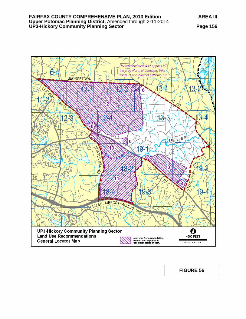
FAIRFAX COUNTY COMPREHENSIVE PLAN, 2013 Edition AREA III Upper Potomac Planning District, Amended through 2-11-2014 UP3-Hickory Community Planning Sector Page 156
FIGURE 56
FAIRFAX COUNTY COMPREHENSIVE PLAN, 2013 Edition AREA III Upper Potomac Planning District, Amended through 2-11-2014 UP3-Hickory Community Planning Sector Page 157 1. Most land should be developed for residential use at .2-.5 dwelling units per acre in order
to preserve the existing character and support the concept of low density residential development for land in the Reston environs. [Not shown]
2. The area bounded by Leesburg Pike, Georgetown Pike, Walker Road and Piney Run is planned for residential use at .5-1 dwelling unit per acre, as shown on the Plan map, to reflect existing and committed development. New development should be generally consistent with existing zoning and should provide for ample landscaping, buffering and substantial building setbacks to ensure that the present relatively low density character of the area will be preserved when viewed from the collector and arterial roadways serving the sector.
3. Residential use at .5-1 dwelling unit per acre is planned for the area north of Leesburg Pike,
between Difficult Run and Towlston Road, as shown on the Plan map. New development should be generally consistent with existing zoning, should provide large lots along the frontage of Leesburg Pike and Towlston Road to preserve the low density, rural characteristics of Towlston Road and Leesburg Pike, and should provide substantial buffers along the frontage of Leesburg Pike.
4. The northwest quadrant of the intersection of Leesburg Pike and Towlston Road, bounded
by the Glen Haven Farms subdivision to the north and Kenmore subdivision to the west, is planned for .5-1 dwelling unit per acre to be compatible with the planned density in this vicinity along Leesburg Pike. Substantial buffering, adequate landscaping and a substantial setback of buildings along the west side of Towlston Road in the area south of Glen Haven Farms subdivision are appropriate to preserve the low density, rural character of Towlston Road.
5. Cluster subdivisions may be appropriate in this sector if the following criteria are met and
are rigorously applied: 1) Wherever possible the proposed open space should provide connections with existing or planned trails; 2) Individual lots, buildings, streets, utilities and parking areas are designed and situated to minimize the disruption of the site’s natural drainage and topography, and to promote the preservation of important view sheds, historic resources, steep slopes, stream valleys and desirable vegetation; 3) Site design and building location are done in a manner that is compatible with surrounding development; 4) Modifications to minimum district size, lot area, lot width or open space requirements of a cluster subdivision in the R-E and R-1 Districts are not appropriate, unless significant benefits can be achieved in the preservation of the natural environment, scenic view shed(s) or historic resources by permitting such modifications; and 5) Lot yield shall be limited to that which could reasonably result under conventional development. [Not Shown]
6. Commercial uses should be limited to existing commercial areas in the vicinity of Walker
Road and Georgetown Pike, and Walker Road and Colvin Run Road. Commercial uses in these areas should be neighborhood-serving in nature and should be restricted to the existing commercially-zoned parcels. However, it would be appropriate for some required commercial parking to be located on the residentially-zoned portion of Tax Map 12-4((16)), provided that the Alfred Leigh House is rehabilitated and maintained as defined in "The Secretary of the Interior's Standards for Historic Preservation Projects." The Fairfax County Architectural Review Board should provide guidance. The parking should be buffered from surrounding residential development. Such parking use should only be continued in conjunction with the continued maintenance of the Leigh House. Should the Leigh House be demolished, use of the residentially-zoned land for parking should cease
FAIRFAX COUNTY COMPREHENSIVE PLAN, 2013 Edition AREA III Upper Potomac Planning District, Amended through 2-11-2014 UP3-Hickory Community Planning Sector Page 158
and the land should be restored to its original condition or a condition appropriate for residential use.
7. The Route 7 Corridor is planned for and should continue to be reserved for residential
development. Industrial, office, research and development (R&D), and retail commercial uses are not appropriate in the Route 7 Corridor. Uses requiring special permits and special exception approval should be rigorously reviewed and permitted only when the use is of a size and scale that will not adversely impact adjacent land uses and the overall character of the corridor in order to prevent commercial or quasi-commercial encroachment. [Not shown]
8. The northwest and northeast quadrants of the intersection of Leesburg Pike and Springvale
Road are planned for residential use at .5-1 dwelling unit per acre. Consolidation of parcels and a coordinated access point to Springvale Road should be required. (See Figure 57.)
9. In this planning sector uses requiring special permits and special exception approval
should be rigorously reviewed and permitted only when the use is of a size and scale that will not adversely impact adjacent land uses and the overall low density residential character of the area. [Not shown]
10. The area south of Leesburg Pike, south of Baron Cameron Avenue and east of Hunter Mill
Road is planned for residential use at .5-1 dwelling unit per acre. Development at this density is similar to existing residential development in the area and will help to maintain a low density buffer around Reston. Additional Plan guidance is included under Land Use Recommendation #12 for Sector UP5.
11. The area bounded by Hunter Mill Road, Colvin Run, Leesburg Pike, Difficult Run and the
Dulles Airport Access Road is part of the Difficult Run watershed and is planned for low density residential development at .2-.5 dwelling units per acre as shown on the Plan map. Uses requiring special permit or special exception approval should be rigorously reviewed and permitted only when the use is of a size and scale that will not adversely impact adjacent land uses and the overall low density residential character of the area. The cumulative effect of special permit and special exception uses should be considered prior to allowing additional uses or the expansion of existing uses to determine if adding new uses or expanding existing uses will change the low density residential character of the area.
12. Turner Farm Park, in the heart of the Great Falls area, is planned for an astronomical
observatory for educational and recreational use by County schools and residents due to having among the darkest night sky in the Washington, D.C. Metropolitan Area. The night sky in the area surrounding the planned observatory should be protected from excessive and improper lighting. New development (i.e., public and private) in planning sector UP2 and planning sector UP3, north of Leesburg Pike and west of Difficult Run, should provide energy efficient lighting that reduces glare, eliminates light trespass and reduces sky glow.
13. Encourage the use of pervious and semi-pervious materials for paved areas (e.g. parking
lots, driveways, walkways and patios). [Not shown].
FAIRFAX COUNTY COMPREHENSIVE PLAN, 2013 Edition AREA III Upper Potomac Planning District, Amended through 2-11-2014 UP3-Hickory Community Planning Sector Page 159 Transportation
Transportation recommendations for this sector are shown on Figures 57 and 58. In some instances, site-specific transportation recommendations are included in the land use recommendations section. The figures show access orientation, circulation plans, interchange impact areas and generalized locations of proposed transit facilities. The recommendations contained in the Area Plan text and maps, the Policy Plan and Transportation Plan map, policies and requirements in the Public Facilities Manual, the Zoning Ordinance, and other standards will be utilized in the evaluation of development proposals. Development proposals should also be evaluated against the Hunter Mill Road Traffic Calming Study (Northern Virginia Regional Commission, 2006), which provides both a traffic calming conceptual plan for Hunter Mill Road, as well as context sensitive roadway design techniques.
Georgetown Pike, which has been designated a Virginia Byway and determined eligible for
listing on the Virginia Landmarks Register and the National Register of Historic Places, should be maintained within its existing right-of-way. Center turn lanes and deceleration and acceleration lanes should be discouraged and curb cuts should not be allowed unless no other alternative exists. Georgetown Pike is commonly acknowledged to contain some traffic hazards. However, it is generally acceptable in its present condition to local residents. Major changes in alignment or widening the road would damage the scenic and historic character and the historic integrity of the Byway and have been strongly opposed by residents of adjacent areas. Planning efforts should focus on other means of dealing with traffic volume in order to maintain this Byway. Scenic and conservation easements should be sought along Georgetown Pike wherever practical for the preservation of the historic and scenic significance and beauty of the corridor. Heritage Resources Maintain the Colvin Run Mill Historic Overlay District and consider expanding the Historic Overlay District to include the Dr. Alfred Leigh House (Tax Map 12-4((1))15A). The regulations of the Colvin Run Mill Historic Overlay District (Appendix 1, A1-600 of the Zoning Ordinance) limit development to residential uses with the exception of commercial uses appropriate to the mill site itself. All improvements shall be designed to be compatible with the scale and appearance of the historic site. All development within the historic overlay district must be reviewed by the Architectural Review Board. Georgetown Pike is designated as a Virginia Byway pursuant to Section 33.1-63 of the Code of Virginia, as amended. The protection of Georgetown Pike is discussed in the Transportation section above. Any development or ground disturbance in this sector, both on private and public land, should be preceded by heritage resource studies, and alternatives should be explored for the avoidance, preservation or recovery of significant heritage resources that are found. In those areas where significant heritage resources have been recorded, an effort should be made to preserve them. If preservation is not feasible, then, in accordance with countywide objectives and policies as cited in the Heritage Resources section of the Policy Plan, the threatened resource should be thoroughly recorded and in the case of archaeological resources, the artifacts recovered.
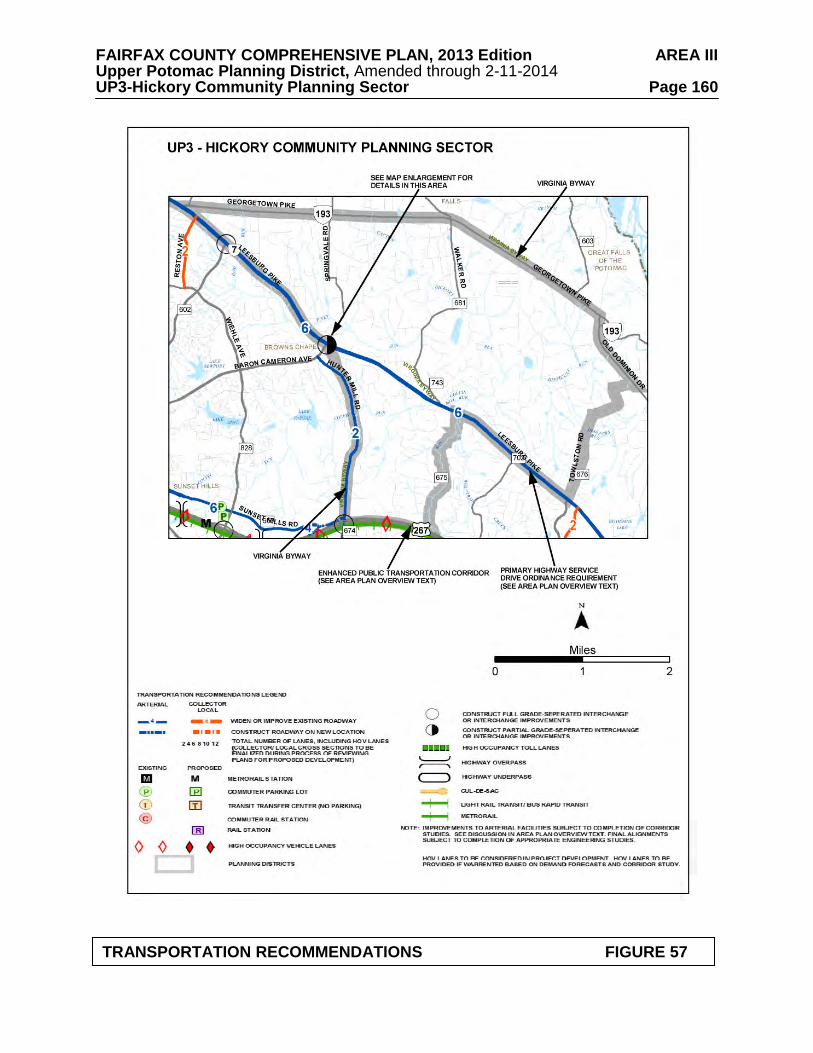
FAIRFAX COUNTY COMPREHENSIVE PLAN, 2013 Edition AREA III Upper Potomac Planning District, Amended through 2-11-2014 UP3-Hickory Community Planning Sector Page 160
TRANSPORTATION RECOMMENDATIONS FIGURE 57
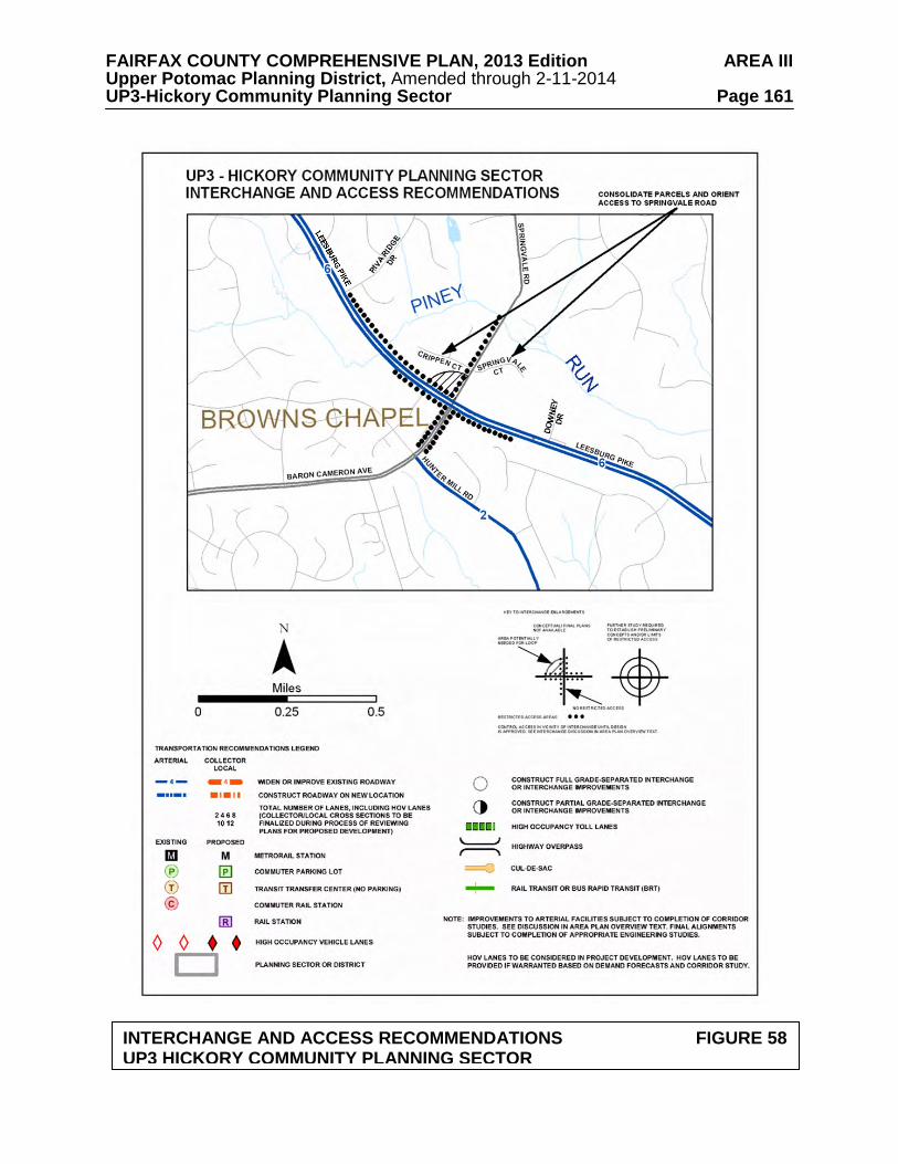
FAIRFAX COUNTY COMPREHENSIVE PLAN, 2013 Edition AREA III Upper Potomac Planning District, Amended through 2-11-2014 UP3-Hickory Community Planning Sector Page 161
INTERCHANGE AND ACCESS RECOMMENDATIONS FIGURE 58 UP3 HICKORY COMMUNITY PLANNING SECTOR

FAIRFAX COUNTY COMPREHENSIVE PLAN, 2013 Edition AREA III Upper Potomac Planning District, Amended through 2-11-2014 UP3-Hickory Community Planning Sector Page 162 Parks and Recreation
Park and recreation recommendations for this sector are shown on Figure 59. The column "Park Classification" includes existing park facilities. The "Recommendations" column includes entries for both existing and proposed facilities. Prior to developing parkland, the Fairfax County Park Authority initiates a master planning process to determine the appropriate facilities and design for that park. This process involves extensive citizen review and participation. If an existing park is listed but no recommendation appears on that line, it means the park has been developed in accordance with its master plan.
Trails
Trails planned for this sector are delineated on Figure 60 and on the 1”:4,000’ Countywide Trails Plan Map which is referenced as Figure 2 in the Transportation element of the Policy Plan and is available from the Department of Planning and Zoning. Trails in this sector are an integral part of the overall County system. While some of the segments have already been constructed, the Countywide Trails Plan Map portrays the ultimate system for the sector and the County at large. In addition, the map specifies a classification for each segment, which represents the desired ultimate function and surface type of the trail. Specific construction requirements are detailed in the Public Facilities Manual.
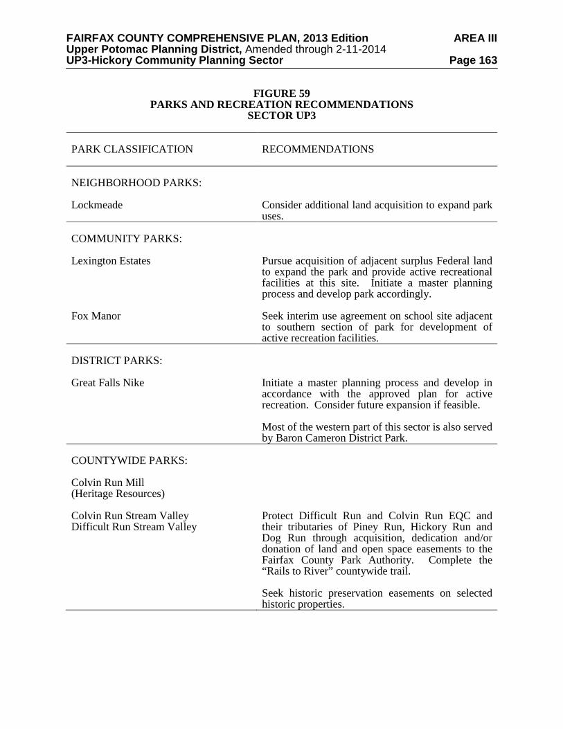
FAIRFAX COUNTY COMPREHENSIVE PLAN, 2013 Edition AREA III Upper Potomac Planning District, Amended through 2-11-2014 UP3-Hickory Community Planning Sector Page 163
FIGURE 59 PARKS AND RECREATION RECOMMENDATIONS
SECTOR UP3 PARK CLASSIFICATION
RECOMMENDATIONS
NEIGHBORHOOD PARKS: Lockmeade
Consider additional land acquisition to expand park uses.
COMMUNITY PARKS: Lexington Estates Fox Manor
Pursue acquisition of adjacent surplus Federal land to expand the park and provide active recreational facilities at this site. Initiate a master planning process and develop park accordingly. Seek interim use agreement on school site adjacent to southern section of park for development of active recreation facilities.
DISTRICT PARKS: Great Falls Nike
Initiate a master planning process and develop in accordance with the approved plan for active recreation. Consider future expansion if feasible. Most of the western part of this sector is also served by Baron Cameron District Park.
COUNTYWIDE PARKS: Colvin Run Mill (Heritage Resources) Colvin Run Stream Valley Difficult Run Stream Valley
Protect Difficult Run and Colvin Run EQC and their tributaries of Piney Run, Hickory Run and Dog Run through acquisition, dedication and/or donation of land and open space easements to the Fairfax County Park Authority. Complete the “Rails to River” countywide trail.
Seek historic preservation easements on selected historic properties.

FAIRFAX COUNTY COMPREHENSIVE PLAN, 2013 Edition AREA III Upper Potomac Planning District, Amended through 2-11-2014 UP3-Hickory Community Planning Sector Page 164
TRAILS PLAN MAP FOR THIS SECTOR UNDER CONSTRUCTION
SEE THE 1” = 4000’ SCALE
COUNTYWIDE TRAILS PLAN MAP
PLANNED TRAIL SYSTEM FIGURE 60
FAIRFAX COUNTY COMPREHENSIVE PLAN, 2013 Edition AREA III Upper Potomac Planning District, Amended through 2-11-2014 UP4-Greater Herndon Community Planning Sector Page 165
UP4 GREATER HERNDON COMMUNITY PLANNING SECTOR CHARACTER
This sector is generally bounded on the south by the Dulles Airport Access Road and Dulles Toll Road (DAAR, Route 267), on the east by Reston, on the north by Leesburg Pike (Route 7), and on the west by Loudoun County. This planning sector includes the Innovation Center Transit Station Area and the Town of Herndon.
The Town of Herndon is an incorporated town within Fairfax County. The town grew
around the railroad depot that opened in 1857, providing local dairy farmers with transportation for their products to the City of Washington. Incorporated in 1879, the town remained a rural community until recently when it began to experience rapid growth. The immediate county neighborhoods and the Washington Dulles International Airport to the west, Reston to the east and the planned mixed-use development along the DAAR and the Metrorail Silver line affects the town in terms of development pressure and environmental impacts.
Herndon has jurisdiction over its own planning. The county's planning efforts within
surrounding planning sectors should strive to advance the integrity of the town and compatibility with neighboring areas. The need to preserve and promote coordinated planning efforts in this part of the county is advanced by the existence of this sector in the county Plan. Fairfax County provides Herndon with a number of public facilities and services, including schools, libraries, health facilities, social services, fire services, and sewer service. Consult the Town of Herndon’s Comprehensive Plan for further guidance in this area.
The Sugarland Run area, the portion of the county immediately north of Herndon, is largely
developed in single-family neighborhoods. This single-family development, in combination with the variety of types of townhouses available in Herndon, gives this planning sector a diversity of housing choices. A large part of the area is dominated by the Sugarland Run stream valley and its floodplain. Local-serving commercial uses are located primarily in Herndon, Reston and Sterling in Loudoun County.
The Center for Innovative Technology (CIT), a state supported research and development
consortium of State universities and colleges, is located north of the DAAR and south of the Town of Herndon boundary.
This planning sector is rich in heritage resources. The Herndon Historic District is listed in
the Virginia Landmarks Register and the National Register of Historic Places. Local Heritage Preservation Overlay Districts are administered by the Town of Herndon. Dranesville Tavern, also in the Virginia and National Registers, is protected by a county historic overlay district. Individual sites within these districts are listed in the Fairfax County Inventory of Historic Sites. A list and map of heritage resources are included in the Upper Potomac Planning District Overview section, Figures 4, 5 and 6. Additional historic sites in this sector are also included in the inventory. CONCEPT FOR FUTURE DEVELOPMENT
The Greater Herndon Community Planning Sector, except for the Town of Herndon and the northern portion of the Innovation Center Transit Station Area, is recommended to develop

FAIRFAX COUNTY COMPREHENSIVE PLAN, 2013 Edition AREA III Upper Potomac Planning District, Amended through 2-11-2014 UP4-Greater Herndon Community Planning Sector Page 166 as Suburban Neighborhoods in the Concept for Future Development. The area within the Innovation Center is recommended to develop as a Transit Station Area, as shown on Figure 61. RECOMMENDATIONS Land Use
The Greater Herndon Community Planning Sector is largely developed with stable residential neighborhoods. Infill development in these neighborhoods should be of a compatible use, type and intensity in accordance with the guidance provided by the Policy Plan under Land Use Objectives 8 and 14.
Where substantial parcel consolidation is specified, it is intended that such consolidations will provide for projects that function in a well-defined, efficient manner and provide for the development of unconsolidated parcels in conformance with the Area Plan.
The land use and density plans for the Town of Herndon and Fairfax County apply to this
sector. Fairfax County and the Town of Herndon should coordinate planning efforts to ensure compatible land use relationships and effective transitions and buffers between uses and intensities within this planning sector.
Figure 62 indicates the geographic location of land use recommendations for this sector.
Where recommendations are not shown on the General Locator Map, it is so indicated. 1. The area (1a) north of the Town of Herndon and west of Sugarland Run is planned for
residential development at 2-3 dwelling units per acre as shown on the Plan map. The area (1b) generally located east of Sugarland Run is planned for residential development at .5-1 dwelling unit per acre. This provides for compatible density west of Sugarland Run and a low density buffer type area adjacent to the Sugarland Run stream valley. The area in Reston should conform to the Reston Master Plan.
2. Density within the Dranesville Tavern Historic District is planned for .2-.5 dwelling unit
per acre, except for the area west of Holly Knoll Drive and south of Leesburg Pike where it is planned for .5-1 dwelling unit per acre.
3. Cluster residential development should be used to preserve open space. [Not shown]
4. The land west of Stuart Road, south of Reston (Tax Map 17-1((24))A, 1-38) is planned for
development at 3-4 dwelling units per acre. As an option, this area may be developed at 7-9 dwelling units per acre, contingent upon the following conditions: • Complete consolidation of all parcels, including the commercially-zoned parcels
immediately north of Laurel Way; • Provision of a minimum 50-foot landscaped buffer including preservation of mature
vegetation supplemented by evergreen and deciduous trees and shrubs (which includes the right-of-way located along the northern boundary) to provide substantial buffering and screening to the single-family detached residential community to the north;
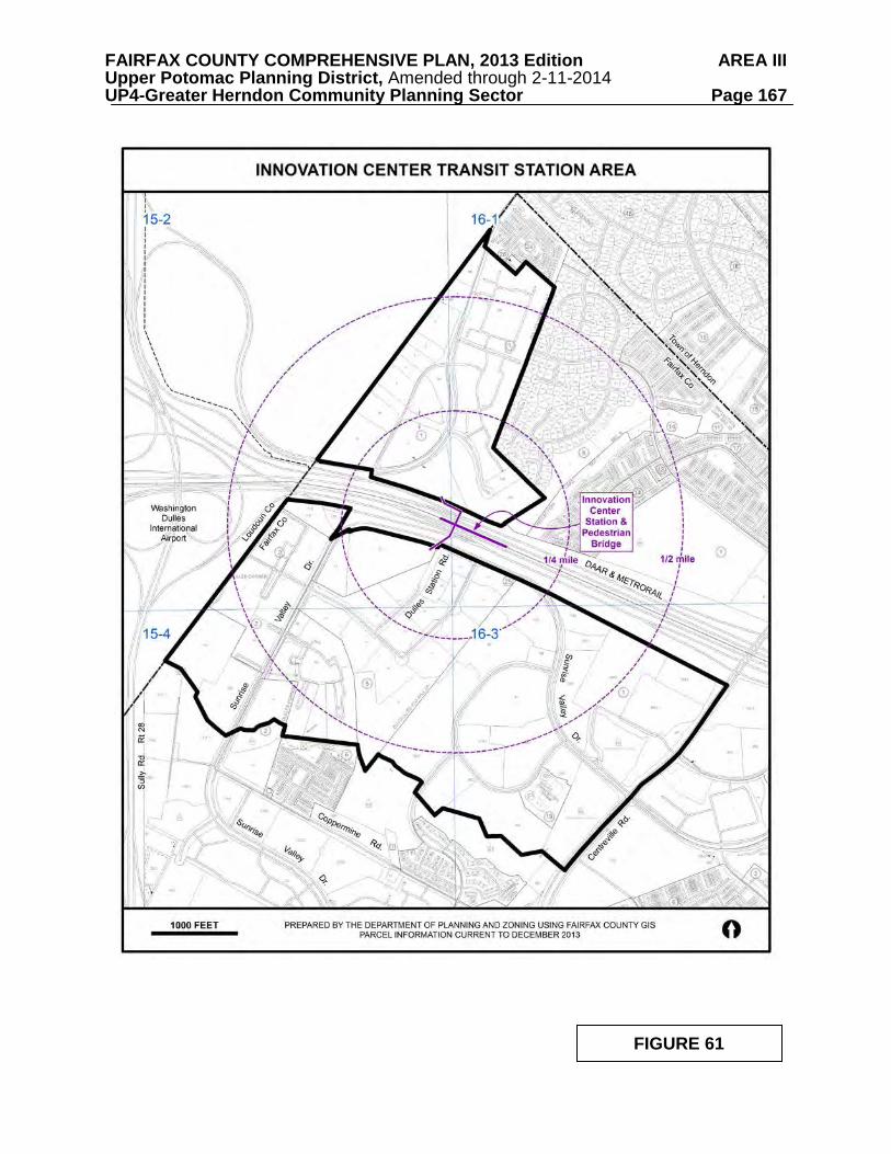
FAIRFAX COUNTY COMPREHENSIVE PLAN, 2013 Edition AREA III Upper Potomac Planning District, Amended through 2-11-2014 UP4-Greater Herndon Community Planning Sector Page 167
FIGURE 61
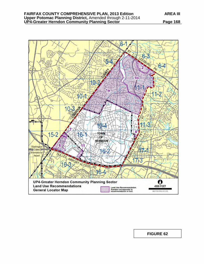
FAIRFAX COUNTY COMPREHENSIVE PLAN, 2013 Edition AREA III Upper Potomac Planning District, Amended through 2-11-2014 UP4-Greater Herndon Community Planning Sector Page 168
FIGURE 62
FAIRFAX COUNTY COMPREHENSIVE PLAN, 2013 Edition AREA III Upper Potomac Planning District, Amended through 2-11-2014 UP4-Greater Herndon Community Planning Sector Page 169
• Provision of a substantial landscaped buffer along the Fairfax County Parkway,
maintaining mature vegetation and supplemented with at a minimum 6-foot evergreen trees;
• Provision of a minimum 35-foot landscaped buffer (supplemented with deciduous and
evergreen trees) or a minimum 7-foot barrier wall and 15-foot landscaped buffer including shade and ornamental trees with underplantings along the southern and western boundary;
• Provision of a pedestrian system that links new Laurel Way to the residential area on
the north: • Provision of recreational amenities such as a tot lot, picnic area, etc.; • Noise attenuation measures (which may include noise barriers), as may be determined
appropriate by the County. 5. Some land in this sector located adjacent to the Loudoun County line is planned for
residential development at 2-3 dwelling units per acre as shown on the Plan map. In order to protect the low density residential communities planned for this area from higher density residential and nonresidential uses planned in Loudoun County, a 25-foot evergreen buffer and barriers should be provided on all land adjacent to Loudoun County. [Not shown]
6. This area is located east of the Loudoun County boundary, north of the Dulles Airport
Access Road (DAAR), west of the Reflection Lake community and south of the Town of Herndon (see Figure 63). A portion of the area is planned for transit oriented development (TOD) focused on the planned Innovation Center Station. Land use options in support of TOD follow the baseline recommendations. Baseline Recommendations for Land Units A, B and C Land Unit A is developed as the Center for Innovative Technology, a State-supported research and development consortium of State universities and colleges. Land Unit A at the baseline is planned for this existing institutional use. Land Units B and C are located west of Rock Hill Road and are planned at the baseline for office and research and development uses. Tax map parcels 15-2((1))3, 4, 5 and 16-1((1)) 4A contain extensive Resource Protection Areas, Environmental Quality Corridors and floodplain. The development potential of these parcels is severely constrained. The restoration, as may be needed, and dedication of these properties to the Fairfax County Park Authority or other land conservation entity as part of a zoning action would address several goals, including preservation of environmentally fragile and valuable land and habitat, and providing open space amenities. Land Unit B (Parcels 15-2((1))4, 5, 16) is planned for a maximum intensity of .50 FAR. A hotel or conference center use up to .50 FAR which would appropriately complement the CIT is also appropriate in Land Unit B. Community-serving retail use incorporated on the ground level of buildings is desirable and appropriate.
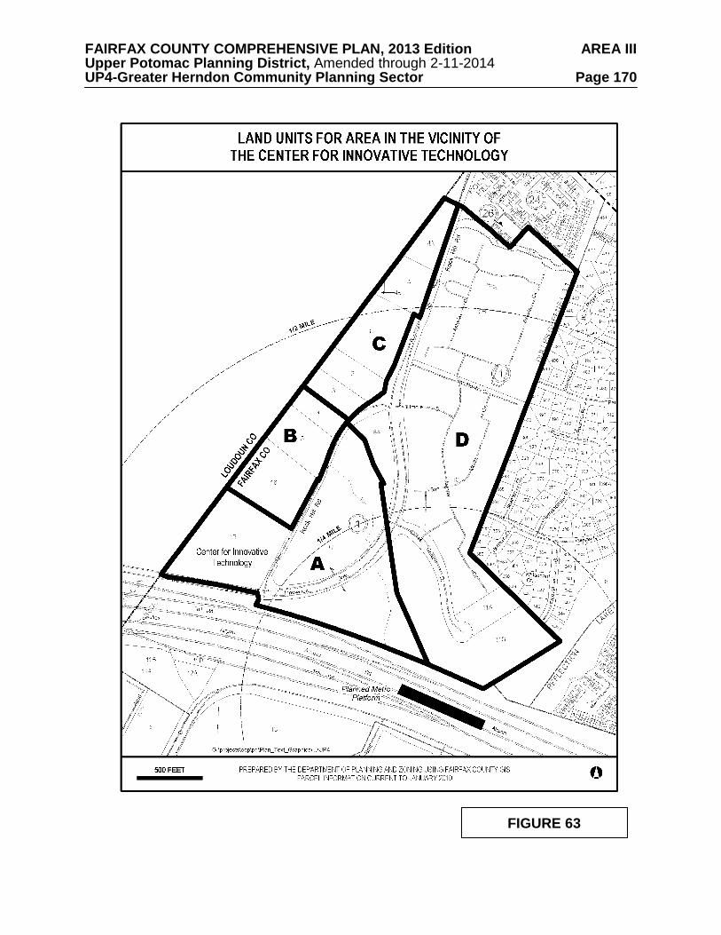
FAIRFAX COUNTY COMPREHENSIVE PLAN, 2013 Edition AREA III Upper Potomac Planning District, Amended through 2-11-2014 UP4-Greater Herndon Community Planning Sector Page 170
FIGURE 63
FAIRFAX COUNTY COMPREHENSIVE PLAN, 2013 Edition AREA III Upper Potomac Planning District, Amended through 2-11-2014 UP4-Greater Herndon Community Planning Sector Page 171
Land Unit C (Parcels 15-2((1))1, 2, 3 and 16-1((1))4, 4A) is planned for office and research and development use at a maximum intensity of .25 FAR at the baseline. Community-serving retail use on the ground level of office structures may be appropriate to serve employees. Only a portion of the parcels that make up Land Units B and C are located in Fairfax County. Consolidation of land or parcels should occur such that the development results in well-designed, high-quality uses that are functionally and visually integrated into the larger mixed use area planned in Loudoun County. Proposed development should be part of a project that incorporates a substantial and contiguous area in Loudoun County and is compatible with the uses and intensities planned by Loudoun County. All development proposals should demonstrate that any unconsolidated parcels within a land unit can be developed in a manner that complements the proposed development and is consistent with the recommendations of the Plan and at a minimum includes environmentally constrained land. Public facilities analyses, including fire, police, schools, recreation, and transportation are performed in conjunction with any development application. The results of these analyses should identify necessary improvements, the phasing of these improvements with new development, and appropriate measures to mitigate other impacts. In addition, development of these land units should result in uses that are designed to be visually compatible with the residentially developed area of Land Unit D. Finally, active recreation areas for employees and residents should be provided. Rail Transit Option for Land Units A, B and C Consistent with TOD policy, this plan provides an option for a mix of uses ranging from .50 to 2.8 FAR, based on distance from the Metrorail station. The Innovation Center Transit Station Area (TSA) includes Land units A, B and C. The TSA is planned for a mixture of interrelated residential and nonresidential uses. The rail transit option may be considered once the provisions pertaining to Phase 2 rail improvements contained in the “Agreement to Fund the Capital Cost of Construction of Metrorail in Fairfax County” are accepted by the Fairfax County Board of Supervisors. Specifically, the terms and conditions of the 100% preliminary engineering cost estimate for Phase 2 must be approved by the Fairfax County Board of Supervisors, and the affirmative decision to participate in financing must be transmitted to MWAA. This option is transit-supportive and includes multifamily residential, office, hotel, as well as retail uses designed to serve the TOD community. This mix of uses will allow the creation of a center of activity that is focused toward the planned Innovation Center Station. In addition the recommendations take advantage of the proximity of the CIT complex, Dulles Airport, the Dulles Access and Toll Road, to provide future employment opportunities and housing in the vicinity of Sully Road. Within the Innovation Center Transit Station Area, the highest concentration of development should be closest to the planned Metro station. The mix of uses should create a critical mass of pedestrian activity as people live, work and recreate in this area. Existing residential communities in Fairfax County and the Town of Herndon create a transition to the planned higher intensity transit oriented development centered around the planned Metro station.
FAIRFAX COUNTY COMPREHENSIVE PLAN, 2013 Edition AREA III Upper Potomac Planning District, Amended through 2-11-2014 UP4-Greater Herndon Community Planning Sector Page 172
The goals for this area include the following:
• Achieve a compact, high-quality transit and pedestrian-oriented, mixed use
community with the highest land use intensity focused within ¼ mile of the planned Innovation Center Station.
• Create a safe pedestrian environment that is visually diverse and stimulating. Provide
for public pedestrian access between the transit station and employment and residential destinations within and adjacent to the area. Any potential conflicts between non-pedestrian and pedestrian circulation are to be resolved in favor of the pedestrian right of way.
• Create functional, well coordinated, visually appealing roads, paths and trails that
provide linkages within the TSA and to adjacent residential areas within Fairfax County, Loudoun County, and the Town of Herndon.
• Link future development to the provision of appropriate multi-modal transportation
improvements for all land units in this area and as indicated in the Plan text and as shown on Figures 64 through 67.
• Provide open space for active recreation (including athletic fields), passive recreation
and visual relief. • Protect and enhance environmental resources. • Encourage parcel consolidation to realize the benefit of comprehensive urban design
and circulation/access principles and environmental protection. • Link development to the provision of needed public facilities. • Protect adjacent residential neighborhoods from the visual impact of development
through use of building tapering, and/or landscaping features, maintaining a high standard for architectural quality, and minimizing noise, glare and traffic intrusion.
• Establish a mechanism for interjurisdictional collaboration to monitor and assure that
a TOD land use, transportation, and public facilities balance is achieved and maintained in all development phases.
General TOD Guidance The vision of the Innovation Center Transit Station Area is to create an inter-connected multi-modal place that benefits surrounding areas. The proximity of a mix of uses to one another should be combined with easy access to multiple modes of transportation, particularly transit (including bus), walking and bicycling that is part of a larger area wide network. The following urban design, transportation, noise, stormwater, and affordable and workforce housing recommendations apply to all development proposals.
FAIRFAX COUNTY COMPREHENSIVE PLAN, 2013 Edition AREA III Upper Potomac Planning District, Amended through 2-11-2014 UP4-Greater Herndon Community Planning Sector Page 173
Urban Design The TSA guidance establishes an environment that thrives around mass transit, minimizes the need for the single-occupant automobile, and fosters a vibrant pedestrian atmosphere. Compact, mixed-use development with the highest densities/intensities closest to transit station platforms, as well as opportunities to move safely, conveniently and enjoyably about the community by foot or bicycle are defining elements. The protection of environmentally valuable areas is essential. Consolidation with parcels containing environmentally sensitive areas such as streams and wetlands should be supported in order to achieve dedication and ultimate preservation. These areas can provide needed passive open space and contribute to creating a pleasing mix of hardscape elements and natural landscapes. Creating high-quality, built environments that result in a uniquely identifiable place is strongly encouraged. With respect to the CIT building, harmonious architectural and other design features to celebrate this iconic structure are encouraged throughout the TSA. Buildings Buildings should be designed at a scale that encourages pedestrian and street activity. The buildings should create an enjoyable, attractive, and safe environment to walk, bike, dine, relax and ride public transit. In order to accomplish these goals, building design placement and orientation should encourage activity both at the street level and in above-ground plazas. Architectural design features such as façade variations of window or building details are encouraged. Ground-floor retail uses are encouraged in office, hotel and residential buildings, as well as parking structures to activate the street. These uses should be designed to complement the surrounding style. Free-standing or drive-through retail establishments are discouraged. Faux windows or storefronts should be used only when necessary, and long expanses of blank walls or facades should be avoided. If retail uses cannot be integrated into the first-floor facades, these façades should be decorated with store-front windows, awnings, and/or vegetated walls. Buildings should be oriented to and frame the street or the plaza on which the building is located. Buildings should have minimal setbacks. Any building setback should be used for features that contribute to the pedestrian environment, such as plazas, or entrance features. High-rise buildings are envisioned to maximize open space and take maximum advantage of proximity to transit. However, given the proximity of Dulles International Airport, review by the Federal Aviation Administration may be required for high-rise buildings. Urban Parks and Open Space Urban parks in the form of plazas, courtyard or mini-parks should be incorporated into the designs of buildings and/or building complexes to serve the daily needs of residents, local employees, and visitors. These parks should be highly visible and easy to access from areas with most of the pedestrian traffic. Features may include trail connections, water features and short-term informal activities and programmed events intended to foster social interactions among users. These open spaces should be appealing places to gather with seating, lighting, landscaping and other amenities. These spaces should be integrated purposefully into the overall design of the development, and not merely be residual areas left over after buildings and parking lots are sited. Public art/sculpture should be incorporated into all open spaces. Opportunities for passive open space are present adjacent to streams and wetlands located throughout the area.
FAIRFAX COUNTY COMPREHENSIVE PLAN, 2013 Edition AREA III Upper Potomac Planning District, Amended through 2-11-2014 UP4-Greater Herndon Community Planning Sector Page 174
Streetscape, Sidewalk, Trail and Road Features A coordinated streetscape design should be developed to contribute to the identity of the CIT area. In addition to the roadway elements of on-street parking, bike lanes, travel lanes, and medians, the streetscape design should provide frontage of sufficient width to create a pedestrian zone to safely separate pedestrian activity from the roadway. Within the pedestrian zone, the space between the sidewalk and the building façade should be determined by the use of the adjacent building and should be used for outdoor cafés, seating, or browsing store windows. Wide sidewalks are encouraged to support the anticipated increase in pedestrian traffic and street furniture throughout the development area. The use of texture, pattern, and materials should be encouraged to make the setting interesting. Finally, a landscape amenity panel should be located next to the curb and may include streetlights, tree grates, planting beds, planters, paving, bus shelters, bicycle racks, public art, and benches. This safe and attractive pedestrian and bicycle circulation system should unify the area, provide for well integrated connections to the Metro Station, adjacent residential neighborhoods, Fairfax County, the Town of Herndon, and adjacent Loudoun County. These sidewalks and trails should be integrated with active and passive open space and promote pedestrian access to all uses. Streetscape improvements may be provided on a combination of publicly owned right-of-way and private property. When the public right-of-way is utilized to provide streetscape improvements, commitments should be made by the property owner or business organization to maintain the streetscape area. In addition, when the sidewalk is not entirely within the right-of-way, a public access easement will need to be provided for the portion of the sidewalk located on private property. Existing vegetation, especially the large specimen trees should be preserved and incorporated into the site as much as possible. Landscaping should be provided that is attractive in all seasons, and provides shade to seating areas and pedestrian paths/sidewalks during summer months. Roads should include features that create a high quality, attractive, functional and safe environment for the pedestrian, bicyclist, transit rider, or other non-motorized vehicle user. Pedestrians, bicyclists, motorists and bus riders of all ages and abilities should be able to safely move along and across streets. Safe and convenient pedestrian crossings such as raised crosswalks, mid-block crossings and sidewalks should be provided to enhance pedestrian movement, reduce pedestrian and vehicular conflicts and improve accessibility. The design should be employed continuously and contain uniform or similar elements to make a cohesive circulation network. Parking Parking should be consolidated into structures and integrated into the streetscape. Except for on-street parking, surface parking should be avoided other than as allowed and needed on an interim basis to support occurring development. Parking structures should be designed as integrated building features. The treatment of the structures, which can include retail as a ground floor use, should contribute to the visual appeal and vitality of the streetscape. Façades should be attractive and inviting from both pedestrian and vehicular perspectives and should incorporate features such as architectural elements or trees and other landscaping to provide visual interest.
FAIRFAX COUNTY COMPREHENSIVE PLAN, 2013 Edition AREA III Upper Potomac Planning District, Amended through 2-11-2014 UP4-Greater Herndon Community Planning Sector Page 175
To encourage transit use, shared parking for uses which have different peak demand periods, instituting paid parking, or other parking reduction techniques and commitment to parking maximums are recommended. This will reduce trips and more efficiently organize and utilize the area. Street Furniture, Bicycle Facilities, Lighting and Other Elements Street furniture selections, such as benches, water fountains, bus shelters, covered trash receptacles and bike racks, should be included in a streetscape plan and be consistent with the area. This may include details such as the model, size, and finish of the street furniture. Bicycle features should be covered and security should be provided. Bus shelters should be provided at transit stops that protect patrons from the weather, are safe, easy to maintain, and relatively vandal-proof. A coordinated signage plan is essential to emphasize identity and provide a harmonious appearance. Street lighting should maintain the overall character and quality of the area, providing adequate lighting levels that ensure public safety without creating glare or light spillage. Light fixtures should be full cutoff and use energy-saving technology in order to minimize the occurrence of glare, light trespass, and urban sky glow. Street lights should be located so as to not conflict with street trees at their projected maturity. Street and Median Planting Street trees and other landscaping in the planting strips should be planted in an environment that promotes healthy root growth. Vegetation within the planting strips could include ornamental shrubs, ground cover, flowering plants, and grasses. These plantings should occur in areas that are clear of vehicles parked on the street, and they should incorporate hardscaped pedestrian access points. Where medians are provided, they should be planted with attractive landscaping. Consideration should be given to the use of Low Impact Development techniques, and using native plants that are drought tolerant, low in maintenance, and resistant to disease, pollution and heat. Transportation The strategy to accomplish and maintain a transportation and land use balance is based on six components: • Partnering with other jurisdictions to identify and implement regional solutions to
multi-modal transportation issues. • Cooperating with other jurisdictions to identify and implement a coherent pattern or
grid of “walkable” streets and safe, attractive bicycle facilities throughout the areas. • Phasing transportation infrastructure, including a grid pattern of streets in the TSA in
addition to major road links to the west and north. Development should be phased in such a way that effective transportation measures will be in place or substantially completed before proceeding to future development phases.
• Providing a realistic transportation demand management (TDM) plan to reduce single
occupant vehicle trips. • Achieving vehicle trip reduction goals contained in the TDM plan.
FAIRFAX COUNTY COMPREHENSIVE PLAN, 2013 Edition AREA III Upper Potomac Planning District, Amended through 2-11-2014 UP4-Greater Herndon Community Planning Sector Page 176
• Monitoring the TDM plan outcome to ensure an adequate multi-modal transportation
system. Transportation solutions for the area are based on the timely provision of transit (including bus), pedestrian and bicycle ways, road improvements and TDM measures. Collaboration among Fairfax County, Loudoun County, the Town of Herndon, and the Metropolitan Washington Airport Authority (MWAA) can bring about the implementation of a regionally-oriented approach that will benefit residents, employees and through-travelers. This cooperative effort should involve representatives of Fairfax County, the Town of Herndon, Loudoun County, and MWAA that can share information on a timely basis and devise approaches and strategies to meet transportation needs. The recommendations contained in the Area Plan text and maps, the Policy Plan and Transportation Plan map, policies and requirements in the Public Facilities Manual, the Zoning Ordinance, and other standards will be used in the evaluation of development proposals. Specific transportation recommendations are contained in the District-Wide Recommendations for the Upper Potomac Planning District, and in the Transportation Recommendations for the Greater Herndon Community Planning Sector (UP4). In addition, the following transportation recommendations should be addressed for any development proposal: Innovation Center Station Access Direct pedestrian access from the Innovation Center Station to any proposed development is encouraged. If public facilities (fire, police, recreation) are constructed on parcel 16-1((1))11B, then separate direct pedestrian and bicycle access to them is also encouraged. Planned Roadway Improvements The planned roadway improvements in and around the Innovation Center Transit Station Area must be phased as needed to support development. Within the Innovation Center Transit Station Area, it is critical to provide a grid system of streets that achieves internal connectivity and, if feasible, links to areas beyond. Roadways in this area are congested and, in some cases, under severe strain. Increased vehicle trips to and from the TSA will compound traffic congestion within the 1/2 mile ring radius and, potentially, on vicinity roadways in Western Fairfax County and the Town of Herndon. At least four cumulative lanes will be needed from the station area north to Route 606 and at least six cumulative lanes will be needed west toward the Route 28/Innovation Avenue interchange to accommodate vehicle traffic attributable to the TSA. As addressed under the Phasing and Monitoring section, these improvements are essential to ensure continued functioning of road networks in the TSA. Studies should be performed to identify the breadth of impact on vicinity roads. Road improvements required to mitigate traffic impact on transportation facilities will extend beyond the Fairfax County Border. These improvements will be necessary to support each phase of development. To construct these roads will require multi-jurisdictional cooperation, and authorization as well as VDOT approval. The width, alignment and location of roads constructed to fulfill this requirement should complement
FAIRFAX COUNTY COMPREHENSIVE PLAN, 2013 Edition AREA III Upper Potomac Planning District, Amended through 2-11-2014 UP4-Greater Herndon Community Planning Sector Page 177
the planned non-SOV-oriented character. Additional guidance about these major improvements is detailed next: • North-South Road(s) –Four cumulative lanes are needed from the transit station area
north to Route 606. They will serve as a major entrance to the area. A new four lane road should be constructed to the west of the existing Rock Hill Road. In addition, existing Rock Hill Road should be improved to a standard two-lane local access road. In its current alignment, Rock Hill Road should not serve as a primary access road to the TSA. The new four lanes to the west of Rock Hill Road should be the primary north-south access to the Innovation Center Transit Station Area.
If only two lanes can be constructed at this western access point, improved Rock Hill
Road could serve as a second two lane north-south access to the transit station area. It is the intent of this Plan that the existing Rock Hill Road should not be improved to
four lanes. However, in the event that Loudoun County does not authorize other alternatives for north south access and these alternatives are determined to be infeasible, then as a last resort, existing Rock Hill Road could be improved to four lanes as a north-south access. This last alternative should only be considered provided that the neighborhood character of the existing communities along Rock Hill Road is protected. All manner of providing new access lanes to the west of Rock Hill Road should be pursued to avoid this alternative.
• East-West Road(s) – This road(s) will serve as a primary route for traffic arriving
from and going to Sully Road. Six lanes are needed to support the transit station area. The lanes should be configured to create a non-SOV-oriented environment, and divided into smaller roads, with at least two connection points on the west side of the transit station area. A feature to be considered is signalization to balance vehicular and pedestrian flows. In addition, pedestrian and bicycle safety and connectivity enhancements should be addressed through applying urban design guidelines such as narrowed travel lanes, the addition of bike lanes and providing at-grade pedestrian crossings.
• Grid of Streets – A grid of streets should be implemented in the area that connects
future and existing development in Fairfax County and if feasible, to adjacent future development in Loudoun County. The grid should create multiple points of access to Innovation Avenue to lead traffic to the west to Sully Road or north along the new north-south road(s) to Route 606. A hierarchy of streets should be delineated to lead traffic exiting and entering the transit station area to higher capacity roads intended to handle the traffic. To the extent that Innovation Avenue establishes a grid of streets across the County line, the road should be realigned.
• East-West Connector Parallel Road to the Dulles Toll Road – A road within the
existing Dulles Toll Road right-of-way that would connect Centreville Road to the transit station area should be studied for feasibility and implementation. If the road cannot be accommodated within the existing Dulles Toll Road right-of-way, other connections could be examined that would also contain other modes of transportation. Regardless, multi-modal connections should be implemented from the developments to the east of the transit station area and the Centreville Road/ Elden Street corridor to the TOD area.
FAIRFAX COUNTY COMPREHENSIVE PLAN, 2013 Edition AREA III Upper Potomac Planning District, Amended through 2-11-2014 UP4-Greater Herndon Community Planning Sector Page 178
• North-South Connector Bridge – Land for right-of-way should be reserved and contributions for construction should be apportioned until a new alignment is adopted. The right-of-way that is reserved north of the Dulles Toll Road should be to the west and outside the core TOD area and could cross the County line. The bridge should be coordinated with adjacent development areas so that all multi-modal connections are maintained within the TOD. Other transportation improvements should be re-evaluated if this bridge is implemented as it may impact transportation studies.
Traffic Level of Service Applicants requesting consideration of the rail-oriented options, which allow the highest intensities of the optional recommendations, shall demonstrate that the transportation system is kept in balance throughout the phasing of development. Consistent with adopted policy on Transit Oriented Development (TOD), a lower level of service may be acceptable within this TOD area. This performance-based approach requires applicants to provide improvements or other guarantees to maintain certain performance levels. These levels would be measured by levels of service or critical movement volumes or other measures as deemed appropriate by the Fairfax County Department of Transportation. Projects may be phased to coincide with the achievement of specific non-SOV (single occupancy vehicle) mode split or trip reduction objectives. Remedies should be considered at locations where an acceptable level of service cannot be attained or maintained, as described below. Circulation and Access As stated in the urban design section, an interconnected network of local streets with wide sidewalks on both sides of streets, delineated pedestrian pathways, and pedestrian crossings should be provided. Logical pathways should connect to external crossing points. Pedestrian movement and safety should be facilitated, in association with implementation of a wayfinding signage plan. A coordinated pedestrian circulation system plan should be developed that demonstrates how interior portions of the transit station area will be connected to destinations and places within and surrounding the property. Transit, Pedestrian, and Bicycle Connectivity Transit, pedestrian, and bicycle connectivity improvements are major elements of the transportation guidance supporting this Plan option. Transportation modes, other than single-occupancy vehicles, are preferred to support the increased density and mix of uses at the optional level of development. Transit, pedestrian, and bicycle connectivity will achieve the objectives of increasing transit usage, and creating a walkable and bike-able area. Pedestrian and bicycle enhancements relating to streets might include delineated crosswalks, bicycle lanes, signal re-timings, intersection sidewalk extensions (bulb-outs), mid-block crossings, street medians, reduced turning radii and other features designed into the street section with the goal of reducing conflicts with vehicles and improving safety, as allowed by VDOT. Transportation Demand Management (TDM) The establishment of a Transportation Demand Management (TDM) program to encourage the use of transit (including bus), and non single occupancy vehicle transportation, will be needed. This program should utilize a variety of measures (see below) to achieve essential reductions in automobile trips to the TSA. TDM measure originating from commitments at
FAIRFAX COUNTY COMPREHENSIVE PLAN, 2013 Edition AREA III Upper Potomac Planning District, Amended through 2-11-2014 UP4-Greater Herndon Community Planning Sector Page 179
rezoning will be components of the overall TDM program for this TDA. TDM recommendations adopted by the interjurisdictional program will be given favorable consideration as possible components. The goal of the TDM program will be to achieve specified trip reduction targets attached to various phases of development. It should ultimately be maintained and funded by residents and business owners once development is completed. The TDM program should be designed to work in conjunction with, and enhance, the transit, pedestrian and bicycle connectivity improvements. TDM measures employed should facilitate and complement these physical improvements and urban design features. The TDM program adopted should identify a full set of measures that could be implemented including alternative transportation services, support facilities and/or programs, and pricing measures. It should include enforcement, evaluation and penalty provisions in the event trip reduction thresholds are not achieved. Transit ridership, in combinations with the TDM program should result in specified trip reduction levels identified for phases of development. The following minimum levels of trip reductions should be achieved: • Within ¼ mile – minimum 30 percent trip reduction for residential and office • Within ½ mile – minimum 25 percent trip reduction for residential, 20 percent for
office • Beyond ½ mile – to be determined with a TDM study These reductions should occur in the peak hour at site build out, with lower levels of trip reduction expected in the interim phases of development. In addition to the goal of achieving the minimum trip reductions stated above, a TDM study and a parking study should be done at the time of rezoning. The intent of the parking study is to determine if parking reductions can be applied to help achieve the overall TDM trip reduction goal. Further, the County should review parking requirements of the Zoning Ordinance to consider the full range of parking management strategies and other TDM strategies. The implementation of a successful comprehensive interjurisdictional TDM program will require cooperation so that property owners in the greater RT28/CIT area also participate, not just those within the transit station area. Precautions should be taken to ensure that inappropriate use of residential parking areas, including neighborhood street parking, in the adjacent areas does not occur. An interjurisdictional program may include paid parking, transit subsidies, ridesharing matching services, preferential treatment of carpool/vanpools, shuttle bus services to nearby transit stations, guaranteed ride home programs, marketing of commuter assistance programs, and other related measures designed to lessen use of single-occupant vehicles and boost HOV usage during peak commuting periods. A fuller list of TDM measures that could be considered are shown next. EXAMPLES OF TRANSPORTATION DEMAND MANAGEMENT (TDM) MEASURES Individual Employer TDM Measures Alternative Transportation Services

FAIRFAX COUNTY COMPREHENSIVE PLAN, 2013 Edition AREA III Upper Potomac Planning District, Amended through 2-11-2014 UP4-Greater Herndon Community Planning Sector Page 180
• Shuttle Bus(es) • Company Vanpools • Telecommuting Support Facilities/Programs • On-Site Transportation Coordinator • Employer Ridematching Services • Preferred HOV Parking Locations • Flexible Work Hours • Guaranteed Ride Home Program Pricing Programs • Parking Management/Pricing Programs • Subsidies for Use of HOV Modes Implementation • CEO and Board of Directors Commitment • Proffers/Negotiated Agreements • Participation in Transportation Management Association Areawide TDM Measures Alternative Transportation Options/Services • Expand Transit Services (peak hours) • Expand Transit Services (off peak & midday) • Carpools • Vanpools • Shuttle Bus(es) Support Facilities/Programs • Transit Center • Park & Ride Lots • HOV Lanes • Preferred Parking Locations • Multi-Employer Ridematching Services • Guaranteed Ride Home Program Mixed-Use Development • Mixed-use developments to include residential, commercial, support retail, hotel and
institutional uses • Development design should maximize pedestrian convenience and accessibility to on-
site services Pricing Programs • Road/Congestion Pricing Programs • Parking Management/Pricing Programs • Transportation Allowances Implementation • Employer Trip Reduction Ordinance • Parking Management Ordinance • Site Design Controls • Proffers/Negotiated Agreements
FAIRFAX COUNTY COMPREHENSIVE PLAN, 2013 Edition AREA III Upper Potomac Planning District, Amended through 2-11-2014 UP4-Greater Herndon Community Planning Sector Page 181
• TMA Coordination Phasing and Monitoring As stated in the Transportation Strategy section, “Development should be phased in such a way that effective transportation measures will be in place or substantially completed before proceeding to future development phases.” Although phasing of the ultimate development should be flexible, a grid of local streets should be established in the initial phase of each development. The design should create a dynamic streetscape and promote pedestrian safety and activity. The initial phase should begin to substantially create multi-modal and pedestrian connections to the metro station landing. Establishing this grid pattern in the early phases of redevelopment should establish the identity of the place as a walkable, pedestrian-scaled, mixed-use area. In addition to establishing a grid of local streets, major road improvements should be phased to mitigate the impacts of each level of development To ensure the transportation impacts of proposed development are fully addressed, the satisfactory preparation of an overall transportation study by the developer as part of a rezoning application is required. The study should demonstrate that impacts to traffic could be mitigated by phasing development in such a way that effective transportation improvements will be approved and funded including TDM measures, bus, Metro rail service and road improvements before proceeding with proposed development. The study should include alignment and phasing of an internal circulation system and submission of detailed transportation studies. The transportation study should evaluate existing transportation conditions and analyze the impacts of the traffic associated with the overall development. The recommendations of this study should include a TDM program to reduce trips. The results will be taken into consideration by the County in determining the timing of construction of improvements, initiation of TDM measures and/or contributions for off-site improvements. Additional roadway improvements in Fairfax County, Loudoun County or the Town of Herndon may be required based on the findings of the development’s traffic study. These improvements may be in addition to the transportation improvements currently cited in the adopted County Transportation Plans for Loudoun County, Town of Herndon or Fairfax County. If the development is phased, detailed studies of development proposed for each subsequent phase should be provided at specified intervals (for example with each Final Development Plan) and follow the methodology described above. In any event, assurances will be expected that the transportation facilities and services assumed to be operational in the study will in fact be provided as stated. The transportation monitoring and evaluation program will be conducted at specified intervals acceptable to the Fairfax County Department of Transportation. The monitoring and evaluation program will include an analysis of the success of the transportation demand management program. Items will include evaluation of trip reduction and mode split; and secondly, an assessment of the performance of site entrances and signalized intersections, as determined by the Fairfax County Department of Transportation in cooperation with Loudoun County and the Town of Herndon. If it is determined by the County during interim review that adverse impacts have not or cannot be successfully mitigated, the amount of development should be reduced to a level that can be adequately supported by transportation infrastructure. Should development phases be delayed or halted because the impacts have not been mitigated based on the TDM program targets, the developer will be responsible for providing other necessary transportation improvements. Failing that, appropriate contributions to a fund for eventual
FAIRFAX COUNTY COMPREHENSIVE PLAN, 2013 Edition AREA III Upper Potomac Planning District, Amended through 2-11-2014 UP4-Greater Herndon Community Planning Sector Page 182
mitigation may be requested. The total level of development may be restored upon demonstrating that adequate infrastructure capacity is available. Noise Proposed residential uses, outdoor activity areas and other noise sensitive areas may be affected by proximity to the Dulles Toll Road. Portions of the area are also located within one-half mile of the DNL 69 noise contour for Washington Dulles International Airport. Furthermore some of the area may be affected by noise from the quarry located to the northwest in Loudoun County. Noise studies may be required to demonstrate that these impacts will be addressed. Provision should be made to notify future residents of the area that they may be impacted by quarry operations. The use of planted terraces, maintenance of tree canopy through the areas under consideration, the use of planted roof gardens and planted sound absorption walls have been found effective management techniques for developments near airports. Stormwater Design Environmentally-friendly stormwater design should be an integral design principle that should be part of the conceptual stage of site development for all projects, recognizing that stormwater management measures may be phased with development. The stormwater design should first seek to minimize the effect of impervious cover, followed by the application of stormwater reuse, retention, detention, extended filtration and, where soils and infrastructure allow, infiltration to improve downstream waters. Coordination of stormwater management controls among multiple development sites may also be effective in achieving stormwater management goals in an efficient manner. Stormwater management and water quality controls for development and redevelopment should be designed to return water into the ground where soils are suitable or reuse it, where allowed, to the extent practicable. Reduction of stormwater runoff volume is an important stormwater design objective. Reduction could occur through techniques that use plants and soils via landscaping measures, through techniques that reuse harvested rainwater in a variety of ways, and/or through approaches that infiltrate water into the ground to replenish aquifers and provide summer base flows to local streams, where soils and infrastructure allow. The following are recommended for all new development and redevelopment: • Stormwater quantity and quality control measures should be optimized with the goal
of reducing the total runoff volume and/or significantly delaying its entry into the stream system. The emphasis should be on Low Impact Development (LID) techniques that evapotranspire water, filter water through vegetation and/or soil, return water into the ground or reuse it.
• LID techniques of stormwater management should also be incorporated into new and
redesigned streets, as well as parking lots, where allowed and practicable. • At a minimum, stormwater management measures should be provided that are
sufficient to attain both the stormwater design-quantity control and

FAIRFAX COUNTY COMPREHENSIVE PLAN, 2013 Edition AREA III Upper Potomac Planning District, Amended through 2-11-2014 UP4-Greater Herndon Community Planning Sector Page 183
• Stormwater design-quality control credits[1] of the most current version of the LEED-NC or LEED-CS rating system (or the equivalent of these credits should be provided). If, on a given site, the attainment of the stormwater design LEED credits (or equivalent) is demonstrated to not be achievable, all available measures should be implemented to the extent possible in support of this goal.
Green Buildings All new buildings should receive green building certification under an established rating system such as the U.S. Green Building Council’s Leadership in Energy and Environmental Design (LEED) program. The green building rating system used should be based on individual building certification, such as LEED-NC (New Construction) or LEED-CS (Core and Shell). LEED Silver certification, or the equivalent, is the minimum expectation for nonresidential development. Residential development should be guided by the Policy Plan objectives on Resource Conservation and Green Building Practices. Affordable Housing and Universal Design All development should conform to County policies on affordable and workforce housing to encourage a diverse population of residents. Per County policy, any residential use should provide at least 12 percent of new units as affordable housing. The residential components should accommodate a variety of age groups, interests, and needs. The units should be accessible for those without cars, meet ADA requirements, and accommodate universal design. Parks and Recreation A more compact, urban style of development is planned within ½ mile of the planned Innovation Center Station. As such, the urban parkland service level standards adopted by the Fairfax County Park Authority Board apply a service level standard of 1.5 acres of land per 1,000 new residents and 1 acre per 10,000 employees. The maximum level of redevelopment will generate the need for approximately 6 acres of publicly accessible urban parkland which should be integrated with development on this site.
1. These credits, as set forth in LEED 2009 for New Construction and Major Renovations, are as follows: SS Credit 6.1: Stormwater Design-Quantity Control: • For sites that have greater than 50% impervious cover in the existing condition, the total volume of runoff released
from the site in the post-developed condition for the 2-year, 24-hour storm should be at least 25% less than the total volume of runoff released in the existing condition for the same storm. Furthermore, the peak runoff rate for the 2-year, 24-hour storm in the post-developed condition should be at least 25% less than the existing condition peak runoff rate for the same storm.
• For sites that have 50% or less impervious cover in the existing condition, the total volume of runoff released as well as the peak release rate for the 1- and 2-year, 24-hour storm in the post-developed condition should be equal to or less than the total runoff volume and peak release rate in the existing condition for the same storm. Alternately, a stormwater management plan that protects receiving stream channels from excessive erosion, including stream channel protection and quantity control strategies, may be pursued.
SS Credit 6.2: Stormwater Design-Quality Control: • Stormwater runoff associated with the development should be controlled such that the first one (1) inch of rainfall is
reused, infiltrated or treated in a manner through which 80% of the average annual post-development total suspended solids (TSS) are removed.
• Equivalent approaches may incorporate coordinated stormwater management on multiple development sites and/or off-
site controls. Additional stormwater management efforts should be encouraged.
FAIRFAX COUNTY COMPREHENSIVE PLAN, 2013 Edition AREA III Upper Potomac Planning District, Amended through 2-11-2014 UP4-Greater Herndon Community Planning Sector Page 184
Urban parks within the Transit Station area support the goals of creating a critical mass of pedestrian activity centered around the planned Metro station. Urban park facilities such as pocket parks could include gathering areas, outdoor cafes, fountains or other focal points of interest and small performance spaces. The inclusion of other urban parks, such as off-leash dog areas, community garden plots, water features, tot lots, fitness courses and trails and plazas would allow a greater range of recreational facilities and amenities. Urban park sites should be publicly accessible and within walkable distance of most residential and mixed use areas. The Upper Potomac Planning District is highly deficient in active recreation facilities, especially athletic fields. Little public parkland is available to support active recreation facility development. To offset the impacts of development on park and recreation service levels, land development projects should contribute land, facilities and/or funds to provide active recreation facilities, preferably on-site or near the development. The area includes large sections of RPA and other natural resources, whose preservation and protection are Fairfax County goals. Dedication of these areas to the Fairfax County Park Authority or other conservation entity as part of a zoning action would address the goals of preserving environmentally valuable land and providing open space amenities. Information and Communications Technology (ICT) The Innovation Center TSA should include ICT infrastructure. Strategies and programs should be developed to ensure that all residential, commercial and public use structures in the TSA are designed and equipped to enable such information and communications networking. Land Use Development should be guided by the TOD guidance set forth in the Policy Plan volume of the Comprehensive Plan. Consistent with that guidance, appropriate intensity should be governed by the distance from the rail transit platform based on concentric rings:
• ¼ mile: mixed use including office, research and development, hotel, retail and
residential uses at an intensity up to 2.8 FAR • ¼ to ½ mile: mixed use including office, hotel, retail and residential uses at an
intensity up to 1.6 FAR • beyond ½ mile: 16-20 dwelling units per acre, at an overall intensity of
approximately .50 FAR. Maximum intensity within each ring will be evaluated based on the considerations that development proposals give to TOD principles, road improvements, recreational facilities, and public service facilities, such as fire and police. Intensities apply to residential and nonresidential (retail commercial, office, institutional) uses. Projects that include areas of different intensity recommendations should have an overall intensity that is based on the proportion of land area associated with each intensity recommendation. The resulting development pattern should generally conform to the goal of locating the highest intensities closest to transit. Proposed intensities should be consistent with the urban scale and character that is envisioned for the area.
FAIRFAX COUNTY COMPREHENSIVE PLAN, 2013 Edition AREA III Upper Potomac Planning District, Amended through 2-11-2014 UP4-Greater Herndon Community Planning Sector Page 185
Tax map parcels 15-2((1))3, 4, 5 and 16-1((1))4A contain extensive Resource Protection Areas, Environmental Quality Corridors and floodplain. The development potential of these parcels is severely constrained. As an incentive to preserve open space, the planned development potential associated with these parcels may be applied as bonus intensity to a developable parcel within the TOD area as part of a zoning action, provided the entire encumbered parcel is dedicated to the Fairfax County Park Authority or another conservation entity. For example, assuming a parcel has a planned development potential of 10,000 square feet, this amount of development would be the bonus to be added to the receiving parcel provided that the resulting development demonstrates that building scaling, massing and open space are in accord with underlying site specific plan guidance and TOD principles and respect Resource Protection Areas, Environmental Quality Corridors and floodplain. Ring 1: Within ¼ mile: Mixed residential and nonresidential uses at an intensity up to up to 2.8 FAR The Center for Innovative Technology, a State-supported research and development consortium of State universities and colleges, constitutes this area. The mixed-use recommendations that follow seek to establish parameters for future development by suggesting a minimum, a maximum, or a range of percentages for residential and nonresidential uses. These percentages are meant to be guides and they may need to be adjusted on a case by case basis in order to further other planning objectives. For example, a mixed-use project that contains an institutional use recommended in the Plan may not be able to achieve the minimum percentage of office use or may exceed the maximum for nonresidential use. Development under this option is subject to the following conditions: • Bus bays, the Kiss and Ride and pedestrian bridge pavilion associated with the
northern portion of the Metro station should be implemented and integrated into the development
• Public facilities analyses, including fire, police, schools, recreation, and transportation
are performed in conjunction with any development application. The results of these analyses should identify necessary improvements, the phasing of these improvements with new development, and appropriate measures to mitigate other impacts.
• Although phasing of the ultimate development should be flexible, establishment of
the pedestrian-scaled, mixed use character of the area should be established in the initial phase of development. This phase should include a grid street pattern, plazas and usable open space vertically-integrated land uses with ground-floor retail and other activity generating uses located along the street.
• A high quality living environment should be created through the provision of well-
designed mixed-use projects that provide active recreation, entertainment and other site amenities. The mixed-use development should have a residential component that is at least 35 percent but no more than 45 percent of the total gross floor area of the development Each residential development should include on-site affordable housing that is well integrated and dispersed throughout the development.
• The nonresidential component of the area within the ring should include office, hotel,
and support retail uses. The current institutional use (CIT) is planned to remain and serves as a focal point for future development. The office component, which may include space for research and development activities should be at least 40 percent of the development, but not exceed 50 percent of the total gross floor area. Support retail
FAIRFAX COUNTY COMPREHENSIVE PLAN, 2013 Edition AREA III Upper Potomac Planning District, Amended through 2-11-2014 UP4-Greater Herndon Community Planning Sector Page 186
uses, to be located in office, hotel or residential buildings, should be at least 2 percent, but not exceed 5 percent of the total gross floor area. Retail should support the residents’ daily needs so as to minimize trips to neighboring communities. Hotel uses are encouraged and should be at least 5 percent but not exceed 15 percent of the total gross floor area.
• Consistent with the Transportation recommendations for the Rail Option, vehicular
access is provided through Loudoun County. • Environmental Quality Corridors should be dedicated to the Fairfax County Park
Authority or other land conservation entity. • Total parcel consolidation should be achieved. Ring 2: Within ¼ -½ mile: Mixed residential and nonresidential uses at an intensity up to 1.6 FAR Ring 3: Beyond ½ mile: Residential use at 16-20 dwelling units per acre, at an overall intensity up to .50 FAR The proposed development in Ring 2 and Ring 3 should be oriented toward the transit station area. In addition, appropriate transitions should be made to residential development in Fairfax County through tapering of building heights, substantial landscaping and other techniques as necessary. Tax map parcels 15-2((1))3, 4, 5 and 16-1((1))4A contain extensive Resource Protection Areas, Environmental Quality Corridors and floodplain. The development potential of these parcels is severely constrained. The restoration, as may be needed, and dedication of these properties to the Fairfax County Park Authority or other land conservation entity as part of a zoning action would address several goals, including preservation of environmentally fragile and valuable land and habitat, and providing open space amenities. Only a portion of the parcels in these areas are located in Fairfax County. Consolidation of land or parcels should occur such that the development results in well-designed, high-quality uses that are functionally and visually integrated into the larger mixed use area planned in Loudoun County. Proposed developments should be part of a project that incorporates a contiguous area in Loudoun County and is compatible with the uses and intensities planned by Loudoun County. All development proposals should demonstrate that any unconsolidated parcels within a land unit can be developed in a manner that complements the proposed development in Loudoun County, is consistent with the recommendations of the Plan, and at a minimum includes environmentally constrained land. The mixed-use recommendations that follow seek to establish parameters for future development by suggesting a minimum, a maximum, or a range of percentages for residential and nonresidential uses. These percentages are meant to be guides and they may need to be adjusted on a case by case basis in order to further other planning objectives. For example, a mixed-use project that contains an institutional use recommended in the Plan may not be able to achieve the minimum percentage of office use or may exceed the maximum for nonresidential use. Development under these options is subject to the following conditions:
FAIRFAX COUNTY COMPREHENSIVE PLAN, 2013 Edition AREA III Upper Potomac Planning District, Amended through 2-11-2014 UP4-Greater Herndon Community Planning Sector Page 187
• Although phasing of the ultimate development should be flexible, establishment of the pedestrian-scaled, mixed use character of the area should be established in the initial phase of development. This phase should include a grid street pattern, plazas and usable open space vertically-integrated land uses with ground-floor retail or other activity generating uses located along the street.
• A high quality living environment should be created through the provision of well-
designed mixed-use projects that provide active recreation, entertainment and other site amenities. The mixed-use development should have a residential component that is at least 50 percent but no more than 60 percent of the total gross floor area in total, with residential becoming the primary use as distance from the platform increases. Each residential development should include on-site affordable housing that is well integrated and dispersed.
• The nonresidential component of the area within the ring should include office, hotel,
and support retail uses. The office component should be at least 40 percent of the development, but not exceed 50 percent of the total gross floor area. Support retail uses, to be located in office, hotel or residential buildings, should not exceed 2 percent of the total gross floor area. Retail should support the residents’ and employees daily needs so as to minimize trips to neighboring communities. Hotel uses are encouraged and may comprise between 5 to 15 percent of the total gross floor area.
• Consistent with the Transportation recommendations for the Rail Options, vehicular
access is provided through Loudoun County. • Environmental Quality Corridors should be dedicated to the Fairfax County Park
Authority or other land conservation entity • Development should result in uses that are designed to be visually compatible with
the residentially developed area east of Rock Hill Road. • Active recreation areas should be provided for employees and residents. In addition, public facilities analyses, including fire, police, schools, recreation, and transportation are performed in conjunction with any development application. The results of these analyses should identify necessary improvements, the phasing of these improvements with new development, and appropriate measures to mitigate other impacts.
Area East of Rock Hill Road (Land Unit D) The portion of the Dulles Transition Area located east of Rock Hill Road, Land Unit D, is planned for multifamily residential use. In order to meet the planning objectives of the Dulles Transition Area it is necessary that new development be responsive to site-specific conditions that are outlined below for the land unit. Land Unit D Land Unit D is planned for residential use at 16-20 dwelling units per acre. Office, retail and other uses, such as a daycare center, designed to serve the residential community are also appropriate. These nonresidential uses should total a minimum of 5,000 square feet including a daycare center. Office and retail uses should be incorporated into the ground
FAIRFAX COUNTY COMPREHENSIVE PLAN, 2013 Edition AREA III Upper Potomac Planning District, Amended through 2-11-2014 UP4-Greater Herndon Community Planning Sector Page 188
floor of residential structures, while a daycare center may be in a free-standing structure. A mix of building types to include low-rise garden style and mid-rise structures is encouraged as a way to facilitate a visual transition. A safe, attractive pedestrian circulation system should be provided. This system of sidewalks and trails should be integrated with passive and active open space and promote pedestrian access to all uses, elements and land units of the area and provide for connections to the existing residential community and to the planned Countywide Trails system. The southern portion of Land Unit D has been identified as the location for commuter facilities that would support Metrorail in the Dulles corridor. A development plan should be submitted that shows the area planned for residential use but noting that a portion of the site may be used for commuter facilities. In order to preserve the option for transit facilities in this location, development of Land Unit D should be phased to progress from north to south so that the southern portion of the land unit remains vacant for as long as possible. In no case should units proposed for the southern portion of the site be transferred to the northern portion. Once a site for a park-and-ride facility has been dedicated to the County, opportunities for joint public-private development of the site for transit parking and support retail uses should be explored. Pedestrian walkways should be provided to facilitate circulation from the transit station area and parking facility to adjacent uses and should connect to existing or planned walkways in adjacent land units and existing sidewalks or trails along major streets in or around the land unit. The development should be in conformance with the Urban Design and Placemaking section for the Transit Station Areas in the Dulles Corridor, located in the Reston Transit Station Areas section of the Plan.
Site-specific development conditions for Land Unit D include the following: • All parcels within the land unit are consolidated and developed as part of a unified
development plan. However, it is recognized that the development of a possible transit facility is consistent with this condition;
• Development of this land unit should result in well-designed, high quality uses and
should be integrated with the adjacent land units; • Visual impacts on existing low-density residential neighborhoods are minimized
through height control, building setback, and transitional screening. Garden apartment structures should be located adjacent to the Reflection Lakes community and heights of these structures should not exceed 40 feet. Any mid-rise structures should not exceed 65 feet in height and should be located to front on Rock Hill Road and will not be adjacent to the Reflection Lake community. Any structure should be controlled by a fifty (50) degree angle of bulk plane as determined from the rear lot line of the adjacent single-family homes;
• A substantial buffer, 75 feet wide as far as practicable but 50 feet wide at a minimum,
is provided next to the Reflection Lake community. This buffer should incorporate existing vegetation and be supplemented with additional landscaping as appropriate to screen the higher density residential areas from the existing single-family detached houses. If a commuter parking facility is developed on the southern portion of the site, a 75-foot buffer to the Reflection Lake community must be provided and the height of the structure should not exceed the height of any adjacent residence. Noise barrier measures should be incorporated into the garage design;
FAIRFAX COUNTY COMPREHENSIVE PLAN, 2013 Edition AREA III Upper Potomac Planning District, Amended through 2-11-2014 UP4-Greater Herndon Community Planning Sector Page 189
• Provision is made for affordable housing either through compliance with the
Affordable Dwelling Unit ordinance, if applicable, or an appropriate proffer of units or land for affordable housing as defined by the ordinance;
• Active recreation uses should be provided to adequately serve the residents of the
development; • Preservation and protection of the Environmental Quality Corridors; • All residential structures should incorporate noise attenuation measures as appropriate
to meet the Interior Noise Level Standard P3, to achieve an interior noise level not to exceed 45 dBA Ldn; and
• To prevent cut-through traffic, vehicle access to the area should be via existing and
realigned Rock Hill Road and Innovative Avenue only, as shown on Figure 66. No connection from Rock Hill Road shall be made to Farougi Court, Maleady Drive or Parcher Avenue. A vehicle turn-around should be provided at the terminus of Parcher Avenue and elsewhere as appropriate.
Upon completion of the extension of Rock Hill Road across the Dulles Airport Access and Toll Road, mixed-use development up to a 1.0 FAR may be appropriate for the area within ¼ mile of the transit station platform, subject to the following conditions: • This option may be considered at such time as a funding agreement for Bus Rapid
Transit (BRT) or rail, as described in the Land Use section in the Suburban Center Areawide Recommendations, is reached.
• A high quality living environment can be created through the provision of well-
designed residential and mixed-use projects which provide active recreation, entertainment and other site amenities. Each residential development should include on-site affordable housing that is well integrated and dispersed throughout the development.
• The mixed-use development should have a residential component that is at least 35%
but no more than 50% of the total gross floor area of the development. • In the nonresidential component of the development, office uses should not exceed
50% of the total gross floor area and support retail uses, to be located in office, hotel or residential buildings, should not exceed 15% of the total gross floor area. Hotel uses are encouraged.
• Retail uses located on the ground floor should have direct public access and display
windows oriented to pedestrian walkways and where appropriate, vehicular drives and/or streets.
• Pedestrian walkways should be provided to facilitate circulation throughout the land
unit and should connect to walkways in adjacent land units and existing sidewalks or trails along major streets in or around the land unit.
• The development should be in conformance with the Urban Design and Placemaking
section located in the Reston Transit Station Areas section of the Plan.
FAIRFAX COUNTY COMPREHENSIVE PLAN, 2013 Edition AREA III Upper Potomac Planning District, Amended through 2-11-2014 UP4-Greater Herndon Community Planning Sector Page 190 7. Rock Hill Subdivision
The Rock Hill subdivision, 16-1((24)) and ((26)), is planned for residential use at 12-16 dwelling units per acre for low-rise garden style structures or at 8-10 dwelling units per acre for single-family attached structures. Residential units should be limited to low-rise garden style structures or single-family attached structures. A safe, attractive pedestrian circulation system should be provided. This system of sidewalks and trails should be integrated with usable open space and promote pedestrian access to all uses and elements of the area and provide for connections to the planned Countywide Trails system. Site-specific development conditions for the Rock Hill subdivision include the following: • Most parcels are consolidated and developed as part of a unified development plan.
All development proposals should demonstrate that any unconsolidated parcels can be developed in a manner that is consistent with the recommendations of the Plan;
• Development should result in well-designed, high quality uses and should be
integrated with the adjacent land units; • Visual impacts on existing low density residential neighborhoods are minimized
through height control, building setbacks, and transitional screening. Heights of low-rise garden style residential structures should not exceed 40 feet. Any structure should be controlled by a fifty (50) degree angle of bulk plane as determined from the rear lot line of the adjacent single-family homes;
• A substantial buffer, preferably 75 feet wide but at least 50 feet wide, should be
provided for low-rise garden style structures next to existing low density residential communities to the north and east. For single-family attached structures, the buffer may have an average width of 50 feet. This buffer should incorporate existing vegetation and be supplemented with additional landscaping as appropriate to screen the higher density residential areas from the existing single-family detached houses;
• Provision is made for affordable housing either through compliance with the
Affordable Dwelling Unit ordinance, if applicable, or an appropriate proffer of units or land for affordable housing as defined by the ordinance;
• Active recreation uses must be provided to adequately serve the residents of the
development; • Measures to preserve and protect the Environmental Quality Corridors should be
taken; • All residential structures should incorporate noise attenuation measures as appropriate
to meet the Interior Noise Level Standard P3, to achieve an interior noise level not to exceed 45 dBA Ldn; and
• To prevent cut-through traffic, vehicle access to the area should be via existing and
realigned Rock Hill Road and Innovative Avenue, as shown on Figure 66. No connection from Rock Hill Road shall be made to Bryce Court, Snowflake Court or Summerfield Drive. A vehicle turn around may be appropriate at the terminus of Bryce Court.
FAIRFAX COUNTY COMPREHENSIVE PLAN, 2013 Edition AREA III Upper Potomac Planning District, Amended through 2-11-2014 UP4-Greater Herndon Community Planning Sector Page 191
8. The Route 7 Corridor is planned for and should continue to be reserved for residential
development. Industrial, office, research and development (R&D), and retail commercial uses are not appropriate in the Route 7 Corridor. Uses requiring special permits and special exception approval should be rigorously reviewed and permitted only when the use is of a size and scale that will not adversely impact adjacent land uses and the overall low density residential character of the corridor in order to prevent commercial or quasi-commercial encroachment. [Not shown]
9. Right-of-way for the Wiehle Avenue extension from Dranesville Road to the Loudoun
County Line has been set aside during the development review process. Any construction of Wiehle Avenue west of Dranesville Road would be subject to a corridor study. This study would examine four lane, two lane, and no-build options. It would be conducted with participation from affected communities. Should only two lanes be required, the additional right-of-way could be used for non-vehicular improvements that benefit the community, for example, pedestrian paths, bike trails and landscaping). [Not shown] (See Figure 64 “Transportation Recommendations”.)
10. Parcels 6-3((1))11 and 11A are planned for single-family detached residential use at 3-4
dwelling units per acre. In order to protect this low density residential use from higher residential and nonresidential uses planned in Loudoun County, a 25-foot evergreen buffer and barrier should be provided along the Loudoun County boundary.
If housing for the elderly or an assisted living and acute care facility is proposed for this site, it should be subject to the following development conditions:
• The project should achieve a residential appearance. Building height should not
exceed 4 stories; • Hughes Branch, part of the environmentally sensitive Sugarland Run watershed,
should be protected; • A large open space buffer of evergreen and deciduous trees, should be established
adjacent to Dranesville Road; • Development of the property should include access to Woodson Drive via
Westminster Place, west of the site in Loudoun County; and • A minimum 50-foot buffer should be provided adjacent to the Loudoun County
boundary or the site should be developed in conjunction with the adjacent property in Loudoun County with uses that are compatible with housing for the elderly.
11. Parcels 16-1((1))7A, 7B, 7C, 8, and 9 are planned for retail and other uses. The currently
approved retail and hotel uses are planned to remain. Pedestrian access within these commercial uses and to the surrounding neighborhood and commercial uses should be encouraged. Improvements to the existing vegetated buffer between the commercial uses and the Reflection Lakes community should be encouraged to ensure an effective buffer and transition between uses. Pedestrian and bicycle access across the Dulles Toll Road should be maintained and improved in proximity to or along Centerville Road.
FAIRFAX COUNTY COMPREHENSIVE PLAN, 2013 Edition AREA III Upper Potomac Planning District, Amended through 2-11-2014 UP4-Greater Herndon Community Planning Sector Page 192 Transportation Transportation recommendations for this sector are shown on Figures 64, 65, 66, and 67. In some instances, site-specific transportation recommendations are included in the land use recommendations section. The figures show access orientation, circulation plans, interchange impact areas and generalized locations of proposed transit facilities. The recommendations contained in the Area Plan text and maps, the Policy Plan and Transportation Plan map, policies and requirements in the Public Facilities Manual, the Zoning Ordinance, and other standards will be utilized in the evaluation of development proposals. Wiehle Avenue extension is planned from Dranesville Road to Crestview Drive. Further study needs to be done to determine whether the extension should be two lanes or four lanes.
Should only two lanes be required, the additional right-of-way could be used for non-
vehicular improvements such as pedestrian paths, bike trails, or landscaping.
An East-West connector road within the existing Dulles Toll Road right-of-way that would connect Centreville Road to the Innovation Center Transit Station Area should be studied for feasibility and implementation. If the road cannot be accommodated within the existing Dulles Toll Road right-of-way, other connections could be examined that would also contain other modes of transportation. Regardless, multi-modal connections should be implemented from the developments to the east of the transit station area and the Centreville Road/Elden Street corridor to the TOD area.
Heritage Resources Dranesville Tavern Historic Overlay District lies within this sector. The Dranesville Tavern Historic Overlay District regulations (Appendix 1, A1-700 of the Zoning Ordinance) specify residential development with the exception of commercial development appropriate to the tavern itself. All improvements shall be designed to be compatible with the scale and appearance of the historic site. All development within the historic district must be reviewed by the Architectural Review Board. Dranesville Methodist Church should be protected. Development in the area should be sensitive to this resource. The Cameron Parish Church Ruins and Cemetery (Tax Map 5-4((8))G) should be preserved. The Herndon Historic District is in the National Register of Historic Places. Most of this area is protected by the Town of Herndon's local Heritage Preservation Overlay Districts.
Any development or ground disturbance in this sector, both on private and public land, should be preceded by heritage resource studies, and alternatives should be explored for the avoidance, preservation or recovery of significant heritage resources that are found. In those areas where significant heritage resources have been recorded, an effort should be made to preserve them. If preservation is not feasible, then, in accordance with countywide objectives and policies as cited in the Heritage Resources section of the Policy Plan, the threatened resource should be thoroughly recorded and in the case of archaeological resources, the artifacts recovered.
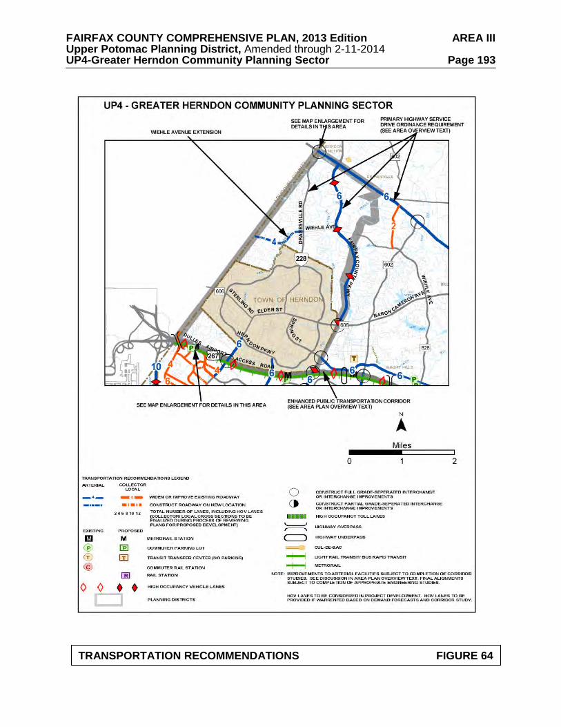
FAIRFAX COUNTY COMPREHENSIVE PLAN, 2013 Edition AREA III Upper Potomac Planning District, Amended through 2-11-2014 UP4-Greater Herndon Community Planning Sector Page 193
TRANSPORTATION RECOMMENDATIONS FIGURE 64
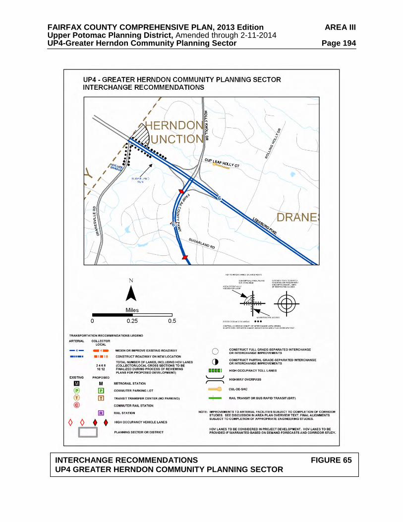
FAIRFAX COUNTY COMPREHENSIVE PLAN, 2013 Edition AREA III Upper Potomac Planning District, Amended through 2-11-2014 UP4-Greater Herndon Community Planning Sector Page 194
INTERCHANGE RECOMMENDATIONS FIGURE 65
UP4 GREATER HERNDON COMMUNITY PLANNING SECTOR
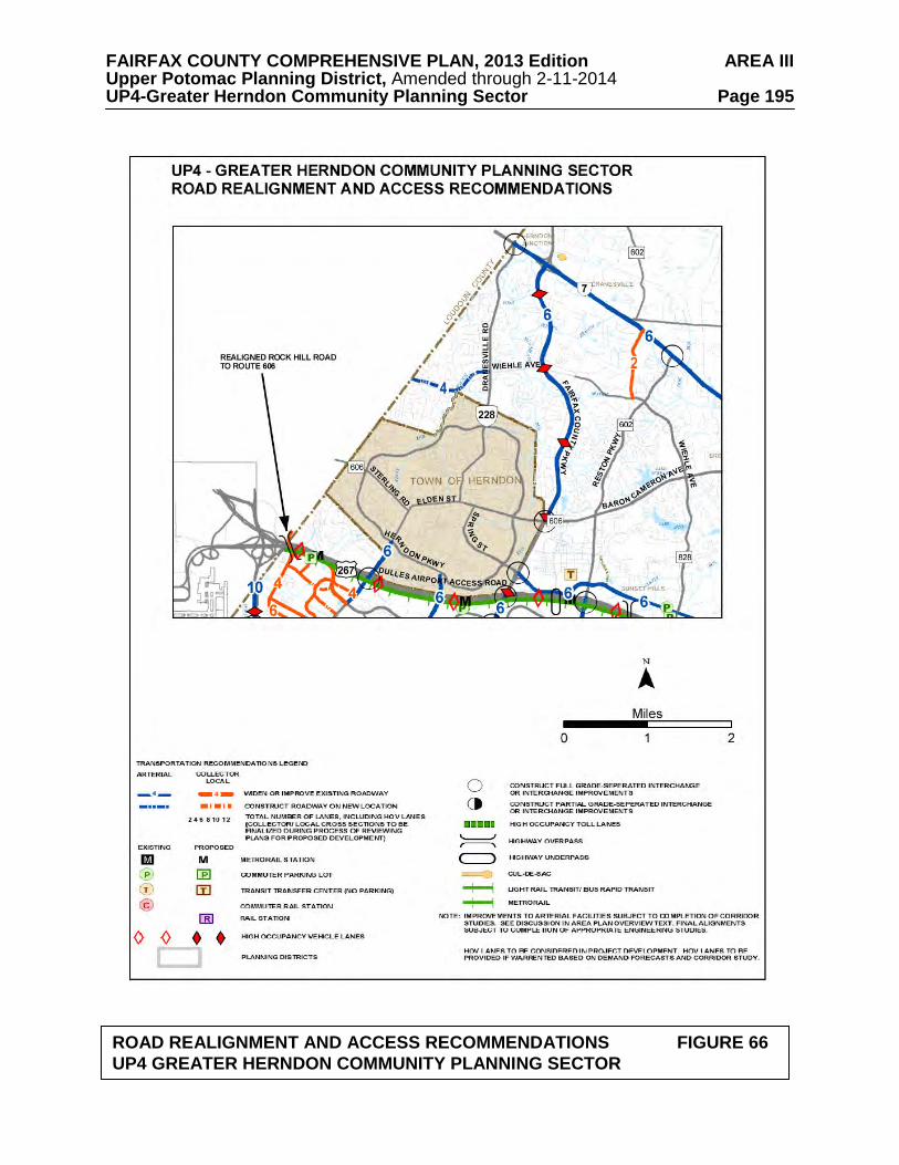
FAIRFAX COUNTY COMPREHENSIVE PLAN, 2013 Edition AREA III Upper Potomac Planning District, Amended through 2-11-2014 UP4-Greater Herndon Community Planning Sector Page 195
ROAD REALIGNMENT AND ACCESS RECOMMENDATIONS FIGURE 66 UP4 GREATER HERNDON COMMUNITY PLANNING SECTOR
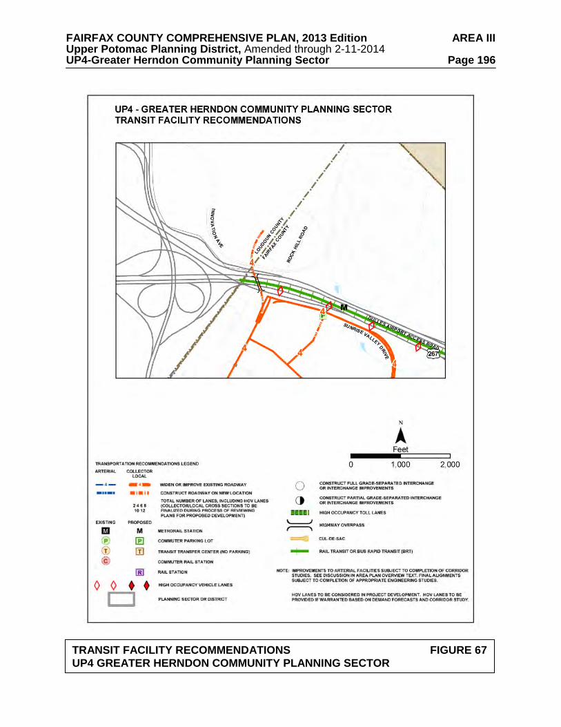
FAIRFAX COUNTY COMPREHENSIVE PLAN, 2013 Edition AREA III Upper Potomac Planning District, Amended through 2-11-2014 UP4-Greater Herndon Community Planning Sector Page 196
TRANSIT FACILITY RECOMMENDATIONS FIGURE 67 UP4 GREATER HERNDON COMMUNITY PLANNING SECTOR
FAIRFAX COUNTY COMPREHENSIVE PLAN, 2013 Edition AREA III Upper Potomac Planning District, Amended through 2-11-2014 UP4-Greater Herndon Community Planning Sector Page 197 Public Facilities 1. Provide the necessary improvements to the Corbalis Water Treatment Plant on land
currently owned at the Water Authority's plant site to meet current and future needs. 2. Fire facilities and equipment at the Herndon Fire Station should be kept adequate to meet
increasing demand for fire and emergency protection. Parks and Recreation Park and recreation recommendations for this sector are shown on Figure 68. The column "Park Classification" includes existing park facilities. The "Recommendations" column includes entries for both existing and proposed facilities. Prior to developing parkland, the Fairfax County Park Authority initiates a master planning process to determine the appropriate facilities and design for that park. This process involves extensive citizen review and participation. If an existing park is listed but no recommendation appears on that line, it means the park has been developed in accordance with its master plan. Trails Trails planned for this sector are delineated on Figure 69 and on the 1”:4,000’ Countywide Trails Plan Map which is referenced as Figure 2 in the Transportation element of the Policy Plan and is available from the Department of Planning and Zoning. Trails in this sector are an integral part of the overall County system. While some of the segments have already been constructed, the Countywide Trails Plan Map portrays the ultimate system for the sector and the County at large. In addition, the map specifies a classification for each segment, which represents the desired ultimate function and surface type of the trail. Specific construction requirements are detailed in the Public Facilities Manual.
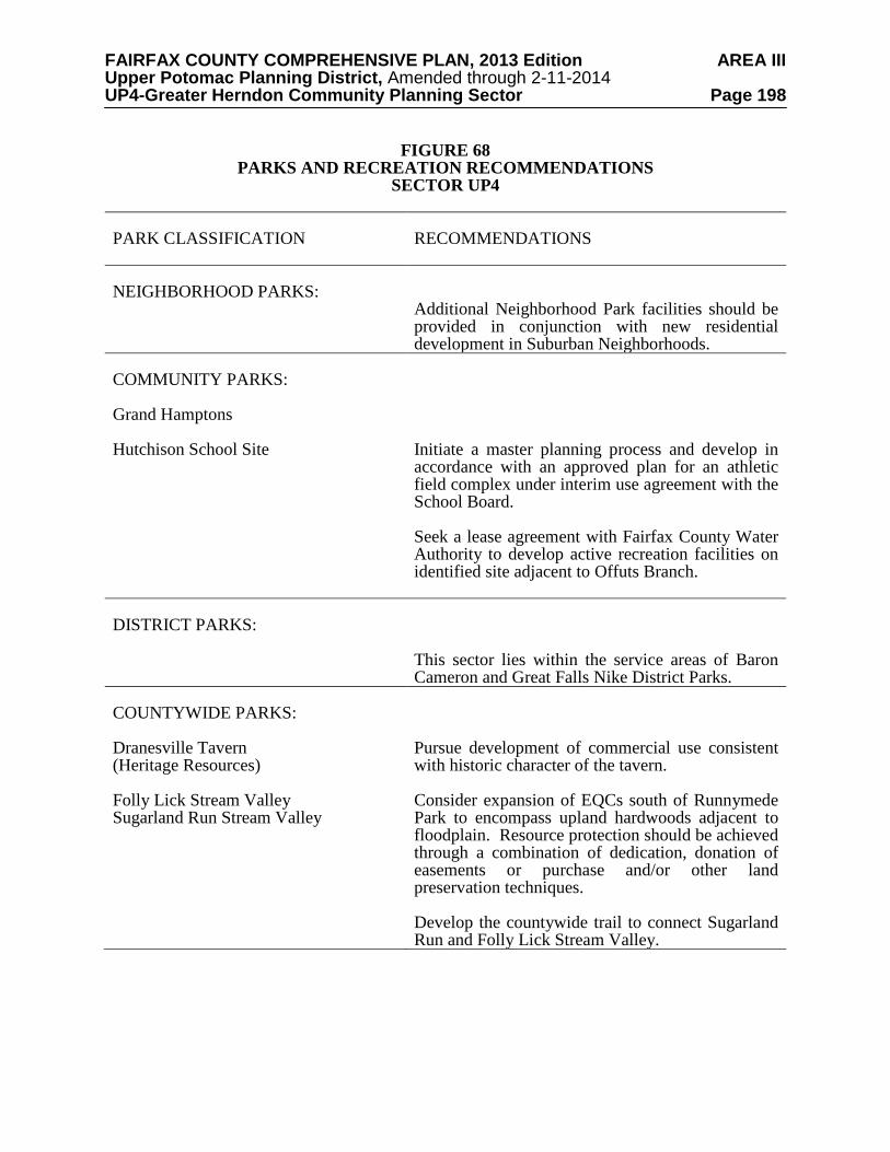
FAIRFAX COUNTY COMPREHENSIVE PLAN, 2013 Edition AREA III Upper Potomac Planning District, Amended through 2-11-2014 UP4-Greater Herndon Community Planning Sector Page 198
FIGURE 68 PARKS AND RECREATION RECOMMENDATIONS
SECTOR UP4 PARK CLASSIFICATION
RECOMMENDATIONS
NEIGHBORHOOD PARKS:
Additional Neighborhood Park facilities should be provided in conjunction with new residential development in Suburban Neighborhoods.
COMMUNITY PARKS: Grand Hamptons Hutchison School Site
Initiate a master planning process and develop in accordance with an approved plan for an athletic field complex under interim use agreement with the School Board. Seek a lease agreement with Fairfax County Water Authority to develop active recreation facilities on identified site adjacent to Offuts Branch.
DISTRICT PARKS:
This sector lies within the service areas of Baron Cameron and Great Falls Nike District Parks.
COUNTYWIDE PARKS: Dranesville Tavern (Heritage Resources) Folly Lick Stream Valley Sugarland Run Stream Valley
Pursue development of commercial use consistent with historic character of the tavern. Consider expansion of EQCs south of Runnymede Park to encompass upland hardwoods adjacent to floodplain. Resource protection should be achieved through a combination of dedication, donation of easements or purchase and/or other land preservation techniques. Develop the countywide trail to connect Sugarland Run and Folly Lick Stream Valley.
FAIRFAX COUNTY COMPREHENSIVE PLAN, 2013 Edition AREA III Upper Potomac Planning District, Amended through 2-11-2014 UP4-Greater Herndon Community Planning Sector Page 199
TRAILS PLAN MAP FOR THIS SECTOR
UNDER CONSTRUCTION
SEE THE 1” = 4000’ SCALE COUNTYWIDE TRAILS PLAN MAP
PLANNED TRAIL SYSTEM FIGURE 69
FAIRFAX COUNTY COMPREHENSIVE PLAN, 2013 Edition AREA III Upper Potomac Planning District, Amended through 2-11-2014 UP5-Reston Community Planning Sector Page 200
UP5 RESTON COMMUNITY PLANNING SECTOR CHARACTER
Reston has its own Master Plan because the community was planned and developed as one of the nation's landmark new towns, beginning in the 1960s. Reston is located between Tysons Corner and the Washington Dulles International Airport along the Dulles Airport Access Road and Dulles Toll Road (DAAR, Route 267) and extends as far north as Leesburg Pike (Route 7) and as far south as Stuart Mill Road. With its planned development almost complete, Reston is comprised of 7,100 acres and may ultimately be the home of more than 60,000 people. This new town is designed around the concept of clustering the community into five "villages," each with its own village center. These centers provide for neighborhood-serving retail, office, and social needs.
The community is focused around the town center, an urban concentration of high-density
housing, offices and cultural facilities. Substantial office development has occurred in recent years along the DAAR, increasing development pressure both within and adjacent to the community. Plan recommendations for this area can be found in a previous section of the Upper Potomac Planning District text in the Reston Transit Station Areas section. An integral part of the Reston Plan is the lower density residential development located on Reston's periphery, buffering adjacent areas from the higher density development in Reston.
Reston offers a wide range of housing, including high-rise apartments, garden apartments,
townhouses, and single-family detached and semi-detached homes. The majority of dwellings in this sector were built after 1975. There are approximately 1,300 low- and moderate-income units in Reston. This housing includes units for the elderly which are found mostly in the village centers. There is scattered new and older residential development outside Reston. Generally these areas are planned to maintain a low density residential character, including areas along Leesburg Pike. The planning sector also contains Lake Fairfax Park.
Lake Anne Village Center and Bowman Distillery/Wiehle Town Hall are significant
heritage resources listed in the Fairfax County Inventory of Historic Sites. A list and map of heritage resources are included in the Upper Potomac Planning District Overview section, Figures 4, 5 and 6. Additional historic sites in this sector are also included in the inventory. Bowman Distillery/Wiehle Town Hall is also listed in the Virginia Landmarks Register and the National Register of Historic Places. Lake Anne Village Center is protected by a County Historic Overlay District. CONCEPT FOR FUTURE DEVELOPMENT
The Concept for Future Development recommends that the Reston Community Planning Sector be designated as primarily Suburban Neighborhoods. A portion of the Reston Transit Station Areas is located in the sector and is discussed in a separate section of the Upper Potomac Planning District portion of the Area III Plan.
FAIRFAX COUNTY COMPREHENSIVE PLAN, 2013 Edition AREA III Upper Potomac Planning District, Amended through 2-11-2014 UP5-Reston Community Planning Sector Page 201 RECOMMENDATIONS Land Use
The Reston Community Planning Sector is largely developed as stable residential neighborhoods. Infill development in these neighborhoods should be of a compatible use, type and intensity in accordance with the guidance provided by the Policy Plan under Land Use Objectives 8 and 14.
Where substantial parcel consolidation is specified, it is intended that such consolidations will provide for projects that function in a well-defined, efficient manner and provide for the development of unconsolidated parcels in conformance with the Area Plan.
Figure 70 indicates the geographic location of land use recommendations for this sector.
Where recommendations are not shown on the General Locator Map, it is so noted. Land Within the Planned Community of Reston
1. Incorporate the Reston Master Plans (Land Use Plan, Community Facilities Plan and
Transportation Plan)*, adopted on July 18, 1962, and as subsequently amended, by reference in the Area Plan and on the composite map. (See Figures 71, 72 and 73). On the periphery where development is not committed by zoning, land should be developed at a density no greater than one dwelling unit per acre. Density should be tiered so that it decreases from the center toward the boundary (within Reston). [Not shown]
*NOTE: The Reston Master Plan has its own program of time-phased development, which shall be the guide for development in Reston. 2. In the northern section of Reston the following policies should apply:
a. The land located between the planned EQC [Environmental Quality Corridor], Reston Parkway, Wiehle Avenue and the Reston boundary is planned for medium density residential use, as shown on the Reston Master Plan Land Use Plan, with the condition that a vegetated buffer be provided adjacent to low density single-family detached residential uses along Reston Avenue.
b. It may be appropriate for Tax Map 11-2((1))46, in the northeast quadrant of
Wiehle Avenue and Reston Avenue, to be incorporated into the residential planned community of Reston if the following conditions are met:
• development on this parcel should be limited to single-family detached
units at a density range of three to four units per acre; • existing mature trees on the site should be preserved to the maximum
extent possible; • the vegetated buffer called for in (a.) above should remain between the
development located on parcel 46 and the medium density residential development to the east; and
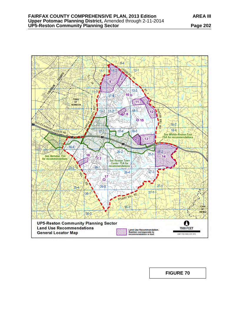
FAIRFAX COUNTY COMPREHENSIVE PLAN, 2013 Edition AREA III Upper Potomac Planning District, Amended through 2-11-2014 UP5-Reston Community Planning Sector Page 202
FIGURE 70
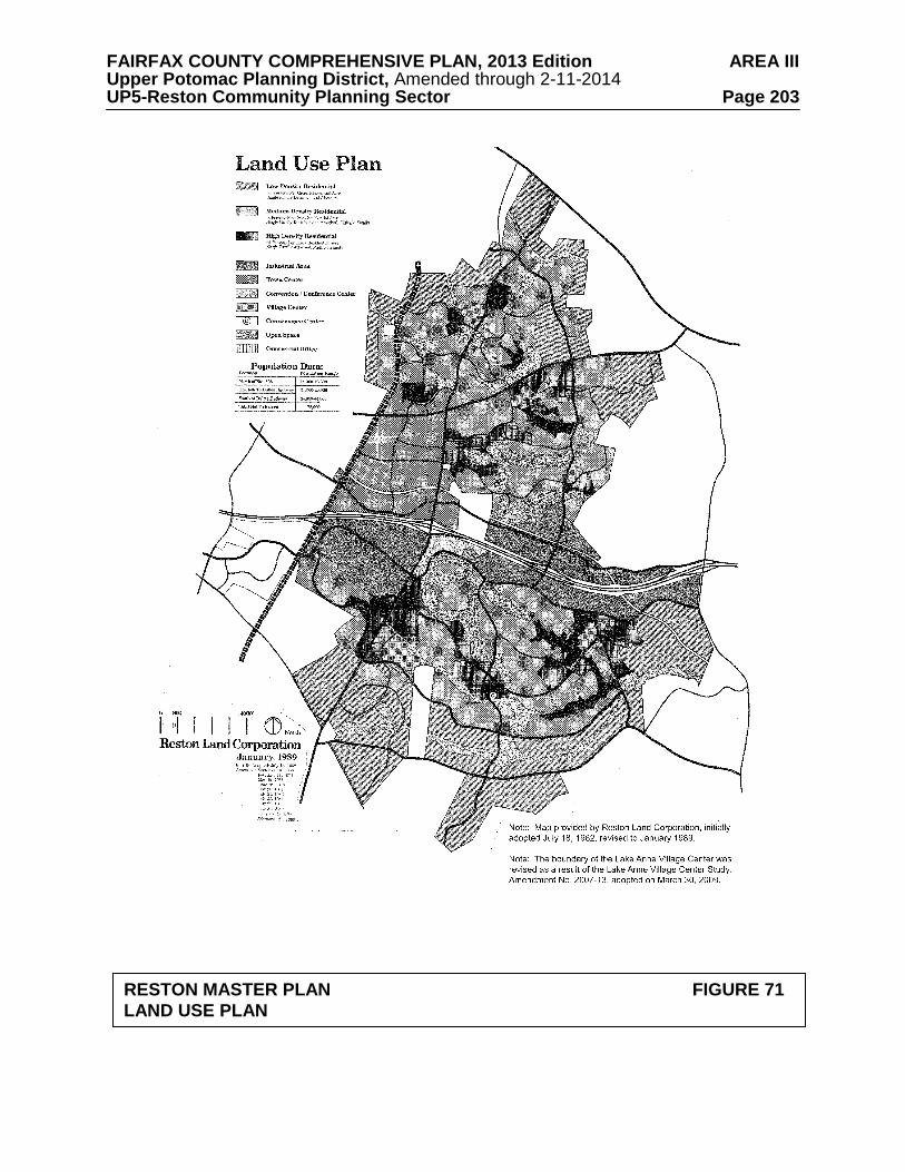
FAIRFAX COUNTY COMPREHENSIVE PLAN, 2013 Edition AREA III Upper Potomac Planning District, Amended through 2-11-2014 UP5-Reston Community Planning Sector Page 203
RESTON MASTER PLAN FIGURE 71
LAND USE PLAN
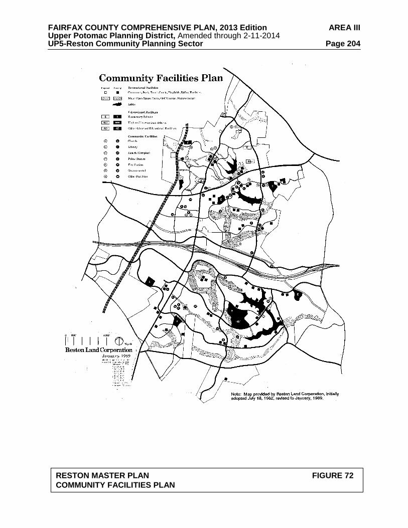
FAIRFAX COUNTY COMPREHENSIVE PLAN, 2013 Edition AREA III Upper Potomac Planning District, Amended through 2-11-2014 UP5-Reston Community Planning Sector Page 204
RESTON MASTER PLAN FIGURE 72
COMMUNITY FACILITIES PLAN
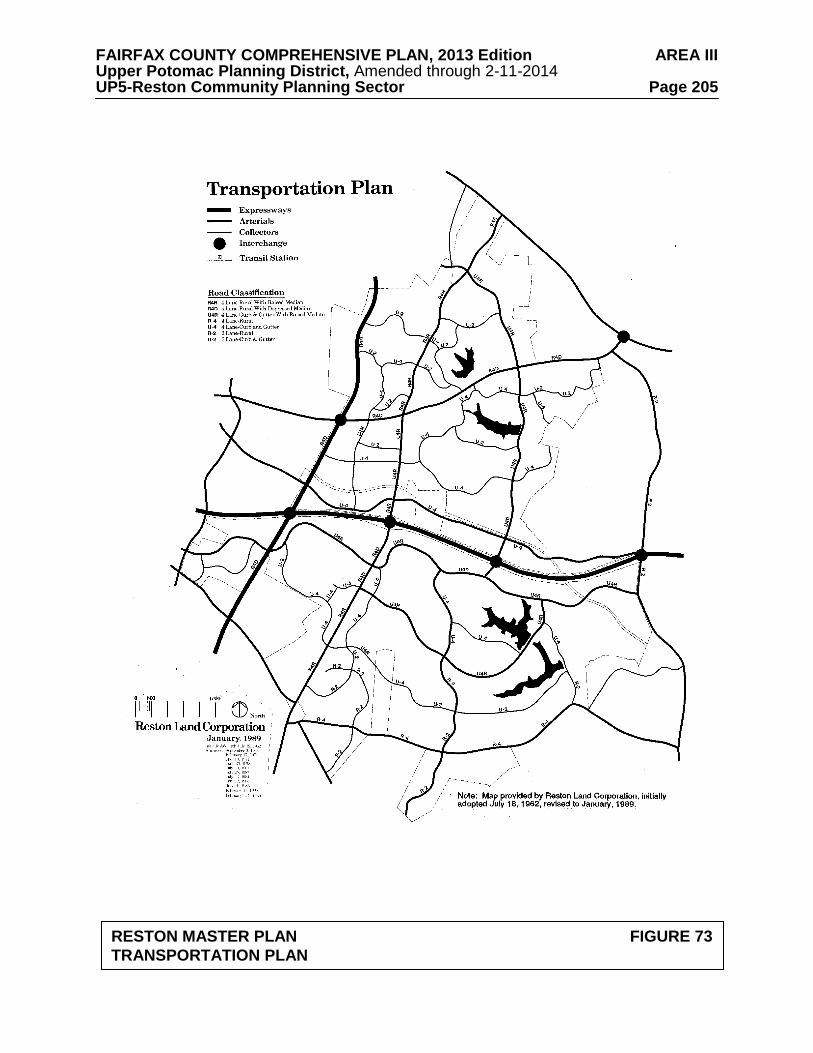
FAIRFAX COUNTY COMPREHENSIVE PLAN, 2013 Edition AREA III Upper Potomac Planning District, Amended through 2-11-2014 UP5-Reston Community Planning Sector Page 205
RESTON MASTER PLAN FIGURE 73
TRANSPORTATION PLAN
FAIRFAX COUNTY COMPREHENSIVE PLAN, 2013 Edition AREA III Upper Potomac Planning District, Amended through 2-11-2014 UP5-Reston Community Planning Sector Page 206
• the utility easement that abuts parcel 46 to the north should serve as the line of demarcation between Reston and the adjacent low density development.
Finally, if this parcel is not incorporated into Reston, it remains planned for .5 to 1 dwelling unit per acre.
c. On the periphery of North Reston within the areas currently shown on the
Reston Land Use Plan for low density residential use, development should occur as single-family detached units at an overall density of one dwelling unit per acre.
3. The Village Centers in Reston should be planned and developed for neighborhood
retail use up to .25 FAR, integrated with accessory office uses, community services, and residential development. [Not shown]
4. Well-defined stable residential neighborhoods exist throughout Reston. However,
because of nearby commercial and other nonresidential uses, these neighborhoods can be threatened by development or redevelopment, and therefore are particularly in need of protection. The design of all new infill projects or redevelopment projects should be compatible with existing and planned residential neighborhoods. [Not shown]
5. Land within the immediate vicinity of future rail station sites may be suitable for joint
development in a phased manner, coordinated with plans for transit development. [Not shown]
6. Recognizing the unique nature of the Reston Association in the development of
natural and open areas and recreation amenities within the boundaries of the Reston Master Plan, the County and the Reston Association should work together in a public/private partnership in attaining the goals and objectives outlined in the Comprehensive Plan under Land Use, Goals 14 and 15; Parks and Recreation; Public Facilities; Environment, and Transportation. [Not shown]
7. Parcel 26-1((13))1 is planned and developed as an existing church on the Community
Facilities Plan component of the Reston Master Plan. Due in part to the convenient public transportation and nearby community services, as an option, the parcel may be redeveloped as elderly housing, age 62 and over, subject to the following:
• The development should be designed to functionally relate to existing
residential uses in the area; • A minimum 65 foot wide buffer should be provided from existing edge of
pavement of Reston Parkway. A substantial vegetated buffer should be provided to serve as a transition to adjacent multifamily residential uses. Existing vegetation should be preserved as deemed appropriate by the Urban Forest Management Division and Reston Association;
• Affordable housing at a minimum of 20 percent of the total number of units
should be provided;
FAIRFAX COUNTY COMPREHENSIVE PLAN, 2013 Edition AREA III Upper Potomac Planning District, Amended through 2-11-2014 UP5-Reston Community Planning Sector Page 207
• Restoration and enhancement of the impaired Snakeden Stream Valley that is located in the northern portion of the parcel should coincide with redevelopment; and
• Pedestrian access from the site to the Snakeden Stream Valley trail, the abutting
multifamily housing development to the south, the Village Center to the east, and Colts Neck Road should be provided.
8. Lake Anne Village Center - The Lake Anne Village Center is located in the
northeastern quadrant of Reston and is bounded generally by Baron Cameron on the north, Lake Anne on the south, and North Shore Drive to the west. The boundary of the Lake Anne Village Center is shown on Figure 74. The Lake Anne Village Center Commercial Revitalization Area encompasses the entire boundary of the Lake Anne Village Center.
The Village Center was the first part of Reston to be developed and is centered on Washington Plaza, which is adjacent to Lake Anne at its northern end. The area surrounding Washington Plaza was designated as the Lake Anne Village Center Historic Overlay District in 1984 in recognition of its significance in the community as Reston’s original Village Center and to ensure the preservation of this historic and architectural landmark. The Board of Supervisors designated Lake Anne as a Commercial Revitalization Area in 1998 with the intent of stimulating reinvestment in existing businesses and encouraging redevelopment as appropriate.
The goals for the Lake Anne Village Center are to create opportunities to: 1) foster residential, office and community-enhancing retail and entertainment uses that will provide a more vital village center environment; 2) support the long-term economic viability of the business community; and, 3) protect and enhance the historic and architectural quality of Washington Plaza and retain the village character of an expanded village center. Proposals for development in the Lake Anne Village Center will be evaluated based on the degree to which these goals are met.
Specific planning objectives to help achieve these goals in the Village Center include:
• Bring more residents and day-time employees to Lake Anne to promote a vibrant community where people can live, work and play;
• Encourage development that complements, rather than competes with, existing
development on Washington Plaza; • Encourage high-quality development in terms of site design, building design
and materials, and appropriately sited open space amenities; • Ensure that diverse housing options exist in Lake Anne, including senior,
workforce, and affordable housing; • Enhance pedestrian and bicycle connections throughout the Village Center as
redevelopment occurs; • Improve the visibility of the Lake Anne Village Center and Washington Plaza
from Village Road and Baron Cameron Avenue;
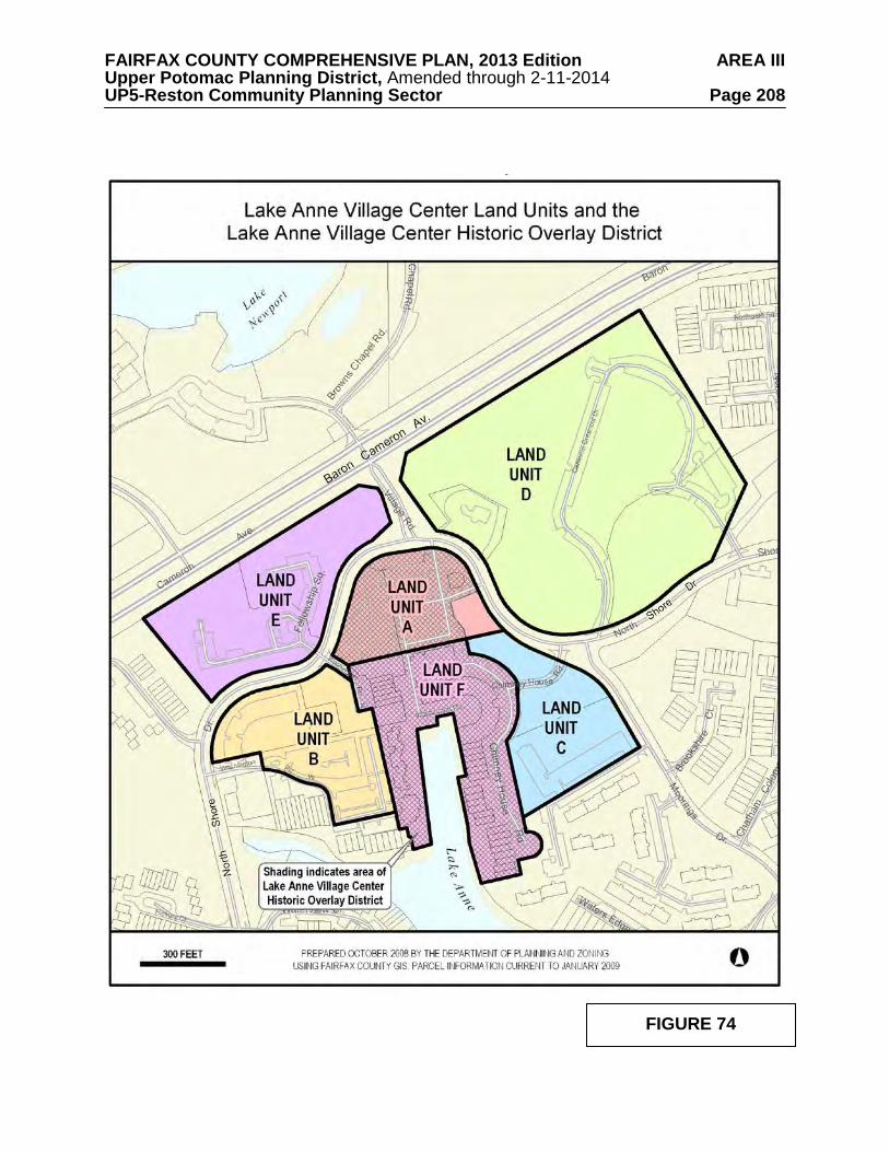
FAIRFAX COUNTY COMPREHENSIVE PLAN, 2013 Edition AREA III Upper Potomac Planning District, Amended through 2-11-2014 UP5-Reston Community Planning Sector Page 208
FIGURE 74
FAIRFAX COUNTY COMPREHENSIVE PLAN, 2013 Edition AREA III Upper Potomac Planning District, Amended through 2-11-2014 UP5-Reston Community Planning Sector Page 209
• Encourage the creation of expanded or additional urban open spaces, such as an extended plaza, to accommodate successful community events such as the Lake Anne Farmers’ Market;
• Preserve attractive and usable green open spaces where possible and introduce
new green spaces, including living green roofs, to provide natural and recreation areas; and
• Limit the visibility of parking throughout the Village Center.
Area-wide Recommendations The parcels comprising the Lake Anne Village Center are divided into six land units (as shown in Figure 74). For Land Units A, B, C, D, and E, a description of its location and character is given and recommendations are provided that articulate the development planned, both in terms of density and intensity, under a baseline recommendation, a redevelopment option for individual land units, and a consolidation option for Land Units A, D, and E. Land Unit F (which consists of the residential and commercial uses along Washington Plaza, including the residences along Chimney House Road) contains the majority of the Lake Anne Village Center Historic Overlay District and is not part of any redevelopment option. The balance of the Historic Overlay District is in Land Unit A. Nonresidential uses, particularly retail and other uses requiring public access, should be concentrated in Land Units A and F to help promote the viability of existing and future nonresidential uses in the core area of Lake Anne. Parcel Consolidation - The preferred approach to redevelopment in the Lake Anne Village Center is through the coordinated redevelopment of Land Units A, D, and E. This would include consolidation of the Washington Plaza surface parking lot (Land Unit A), the Crescent Apartment property and the gas station (Land Unit D), and the Fellowship House property (Land Unit E). In addition, parcels in Land Units B and C may be considered for inclusion in a consolidation effort. If complete consolidation occurs, the Full Consolidation Option level of development can be achieved as described in the Land Unit Recommendations for Land Units A, D, and E. Consolidation of these land units would allow for redevelopment to occur in a well-designed, integrated and efficient manner. Pedestrian access through and among parcels could be more easily designed and roads could be more readily realigned to improve their safety and functionality. The Full Consolidation Option would also provide an opportunity to improve the visibility of Washington Plaza and below-grade parking could more readily be constructed in strategic locations. The Land Unit Recommendations specify the desired mix of uses and levels of development intensity by individual land unit. However, under the Full Consolidation Option, flexibility may be provided in locating uses and intensity in order to achieve the goals and objectives stated above, as well as to meet the Area-wide Recommendations and the conditions in the Land Unit Recommendations.
FAIRFAX COUNTY COMPREHENSIVE PLAN, 2013 Edition AREA III Upper Potomac Planning District, Amended through 2-11-2014 UP5-Reston Community Planning Sector Page 210
Coordinated Development Plans – Coordinated development plans may be an alternative to parcel consolidation. Coordinated development plans refer to two or more concurrent and contiguous development applications that demonstrate coordinated site design, including coordination of building locations, urban design, open space amenities and signage, inter-parcel pedestrian access and vehicular access where appropriate, roadway realignment or improvements, and parking facilities. When coordinated development plans are submitted, the Full Consolidation Option recommendations may be considered. Any subsequent applications should have compatible architectural character and materials to those of the earlier approved coordinated development plans and should provide connections to established locations for inter-parcel pedestrian access and vehicular access where appropriate, and road improvements and parking facilities, if appropriate. Heritage Resources – The Lake Anne Village Center Historic Overlay District regulations are found in Appendix 1, A1-1100 of the Zoning Ordinance. All structures located in Land Units A and F are within the boundary of the Historic Overlay District. Structures within Land Unit A are contributing properties to the district while those in Land Unit F are historic properties. The Fairfax County Architectural Review Board must review all improvements and alterations in the Overlay District. Housing Affordability and Diversity – Fairfax County housing policies include promoting the development of multifamily housing in mixed-use centers in an effort to diversify the County’s housing stock and to encourage lower cost housing options near employment opportunities. In addition, Fairfax County policy encourages the use of Universal Design principles to provide housing that accommodates the needs of a full range of potential residents. Existing residential development in the Lake Anne Village Center includes age-restricted affordable housing (Senior Independent Living) at the Fellowship House (Land Unit E) and workforce housing at the Crescent Apartments (Land Unit D). To preserve the diversity of housing options within Lake Anne and ensure consistency with County policies, the following conditions should be met: • Any new residential development in Lake Anne Village Center should include
at a minimum 12 percent of the total number of units as affordable housing pursuant to the Affordable Dwelling Unit (ADU) provisions of the Fairfax County Zoning Ordinance and the County’s policy regarding workforce housing;
• Any residential redevelopment should replace any affordable housing that
currently exists but is lost in redevelopment. This should be viewed as a collective responsibility that can be addressed through parcel consolidation and property owner cooperation;
• Redevelopment within Lake Anne should include residential units designed
according to Universal Design principles; and • The maximum density specified under these guidelines is the total amount
allowed, and the total number of units specified is inclusive of density bonuses provided for affordable housing.
FAIRFAX COUNTY COMPREHENSIVE PLAN, 2013 Edition AREA III Upper Potomac Planning District, Amended through 2-11-2014 UP5-Reston Community Planning Sector Page 211
Transportation – Future redevelopment in the Lake Anne Village Center area should be balanced with supporting transportation infrastructure improvements and services. To ensure that potential transportation impacts are sufficiently mitigated, the following conditions should be met: • Transportation improvements should be appropriately phased with
development, and development proposals should only be approved following additional transportation analysis and the provision of appropriate transportation mitigation measures;
• Transportation issues associated with any development, particularly those
associated with access, will need to be adequately addressed through appropriate traffic impact analyses. Development plans should identify specific improvements needed to support the applications and should include acceptable plans for ingress/egress and vehicular circulation. Parcel and access consolidation, pedestrian circulation, safety, Transportation Demand Management measures, and transit improvements should be addressed. Dedication of right-of-way for trails and roadway improvements and associated easements may be required;
• Use of public transportation to serve travel demand should be optimized in
order to maximize the reduction in travel by private vehicles. Examples of such measures include:
1) Private subsidization of internal circulating transit services, which may
also connect to transit service outside of the Village Center; 2) Construction of bus shelters; and
3) Monetary contributions toward enhancement of existing transit service;
• Safe pedestrian circulation should be ensured through an adequate and appropriate sidewalk/trail system, and separate bicycle lanes or trails should be considered and provided where appropriate. A combination of public and private sector funding may be necessary to provide for the larger transportation improvements required to serve the general Lake Anne Village Center area;
• An acceptable Level-of-Service (LOS) should be maintained on the roadway
system. A LOS D standard should be applied, in general, to determine mitigation needed at critical approach intersections. Development applications should include analyses that demonstrate that the proposals can maintain a LOS D or better standard, and provide commitments to mitigate traffic in instances where they cannot. Future detailed traffic analyses must ensure that traffic queues at Lake Anne Village Center intersections will not adversely affect other nearby intersections;
• Adequate funding for necessary transportation improvements to maintain an
acceptable LOS should be provided. Roadway and circulation improvements should address needed improvements to the arterial roadway network, collector and local streets, and the pedestrian system. Collector and local street improvements should be provided in conjunction with development proposals;
FAIRFAX COUNTY COMPREHENSIVE PLAN, 2013 Edition AREA III Upper Potomac Planning District, Amended through 2-11-2014 UP5-Reston Community Planning Sector Page 212
• At a minimum, improvements are necessary at the current intersection of Village Road and North Shore Drive. This intersection has current operational deficiencies that need to be corrected before any density increases in the Washington Plaza area can be accommodated. Other potential improvements to mitigate traffic will need to be analyzed as well, such as additional turning lanes at intersections. For example, while additional right-of-way might be required, adding a turn lane to North Shore Drive at both west and eastbound approaches to Wiehle Avenue could measurably decrease intersection delays; and
• To facilitate improvements and traffic flow at the intersection of Village Road
and North Shore Drive, the following options should be considered:
1) The realignment of Village Road to the west to correct operational deficiencies, and to align with and provide a view into an extended Washington Plaza;
2) The slight realignment of North Shore Drive, to the east of Village Road
on Land Unit D, to smooth out the horizontal curve, enhance sight distance, and improve vehicular and pedestrian safety; and
3) The construction of a roundabout on North Shore Drive at the intersection
of a realigned Village Road and North Shore Drive pending detailed additional analysis that compares the benefits of a roundabout versus other congestion mitigation measures.
Pedestrian Network/Bicycle Facilities – Lake Anne Village Center is connected to other parts of Reston through an extensive trail system. The Village Center’s pedestrian orientation should be enhanced with numerous highly accessible pedestrian linkages within the Village Center and connections to existing trail networks at the periphery of the Village Center. Future development and redevelopment in the Village Center should address the following recommendations: • Bicycling should be encouraged as an alternative to the use of single occupancy
vehicles by providing bicycle storage facilities and bike racks. Showering and changing facilities should be provided in buildings with office uses;
• A direct pedestrian connection between Northgate Square Cluster and Land
Unit A through Land Unit D is a high priority. Site designs should ensure that no structures obstruct this direct linkage;
• Pedestrian connectivity and safety is a critical factor in designing pedestrian
links. Auto and pedestrian traffic should be separated to the greatest extent possible. In keeping with the original Master Plan concept for Reston regarding the separation of pedestrians and vehicular traffic, the addition of pedestrian bridges and/or underpasses connecting Land Units D and E with Land Unit A should be considered in order to separate pedestrians from automobile traffic on North Shore Drive;
• Pedestrians should be provided with safe and convenient access to bus stops;
FAIRFAX COUNTY COMPREHENSIVE PLAN, 2013 Edition AREA III Upper Potomac Planning District, Amended through 2-11-2014 UP5-Reston Community Planning Sector Page 213
• Adequate lighting consistent with Reston standards should be provided. Site design should ensure that landscaping does not impede visibility or create unsafe conditions; and
• Signage should contribute to easy pedestrian way-finding throughout the
Village Center. Signage should be compatible with existing signage at Washington Plaza in terms of scale, design, color, materials and placement to create a unified identity for the Village Center.
Complementary Nonresidential Uses – Lake Anne Village Center presently has a variety of complementary nonresidential uses. The existing mix of cultural, governmental and religious uses on or near Washington Plaza includes the Reston Museum, the Reston Community Center, Fairfax County Human Services offices in the Lake Anne Professional Building, and two religious institutions. These uses should be maintained and enhanced as redevelopment occurs. In addition, new complementary nonresidential uses, such as a boutique hotel, a cinema, or similar entertainment uses, which are compatible with the planned mixed-use developments in terms of character and scale, should be encouraged. Other desired uses also include the provision of performing arts space, educational and/or additional religious institutions, a library, recreation and/or park facilities. Urban Design – These urban design guidelines are intended to encourage design excellence in the redevelopment of the Lake Anne Village Center that is sensitive to the aesthetic character and visual environment of Washington Plaza while not being repetitive. The Architectural Review Board is charged with ensuring that the standards and guidelines of the Lake Anne Village Center Historic Overlay District are followed in any redevelopment proposals for the area. The Lake Anne Village Center Historic Overlay District design guidelines, adopted by the Architectural Review Board in 1992, should be reviewed and updated to address new construction. In the event updated design guidelines are developed for the land units surrounding Washington Plaza and the Historic Overlay District, Architectural Review Board review of development proposals for Land Units B, C, D, and E may be appropriate. Under Reston covenants, the Reston Association’s Design Review Board should be kept apprised of proposed redevelopment proposals. Development proposals for the Lake Anne Village Center should address the following:
• Urban Form – The urban form objective is to provide a distinctive and varied
building landscape and assist in achieving other urban design goals, including the preservation of open space. The preferred urban form for the Lake Anne Village Center is a continuation of the design concepts found at Washington Plaza, i.e. high-rise buildings like the Heron House (9-15 stories) surrounded by low-rise development (3-4 stories). Uniform building heights should be avoided to prevent the creation of massive blocks of buildings that would not complement the existing development on Washington Plaza. In no instances should pad sites be permitted within the Village Center. In order to provide design flexibility the Plan recommendations do not set minimum or maximum building heights or setbacks.
FAIRFAX COUNTY COMPREHENSIVE PLAN, 2013 Edition AREA III Upper Potomac Planning District, Amended through 2-11-2014 UP5-Reston Community Planning Sector Page 214
• Building/Site Design – In keeping with Washington Plaza’s distinctive site layout and architecture, redevelopment in Lake Anne should demonstrate excellence in design. Architectural designs should be sensitive to and supportive of the architecture in the Historic Overlay District and site design and materials should support the design concepts in the District.
• Washington Plaza and Lake Anne Vista – Currently, the views of Lake Anne
and the Heron House from the north are obstructed by the Association of School Business Officials building at the intersection of Village Road and North Shore Drive. To create a better view of this area from nearby roadways, the Association of School Business Officials building should be removed. Redevelopment should be designed in such a way as to create an unobstructed view toward Lake Anne.
• Green Buildings and Stormwater Management – In keeping with Reston’s
original vision of protecting the environment and living in harmony with nature, redevelopment proposals should meet the following conditions:
1) The incorporation of green building practices sufficient to attain
certification through the LEED program or its equivalent is required for the Lake Anne Village Center. In addition, attainment of the Silver rating or better through the LEED program or its equivalent is strongly encouraged;
2) Encourage the provision of architectural elements that will provide both
environmental and aesthetic benefits, such as vegetated roofs and/or rooftop plaza areas in locations that will experience pedestrian or other recreation activity in order to provide a high quality visual character; and
3) Incorporate Low Impact Development (LID) stormwater
management techniques where feasible.
• Parking – The visibility of parking should be limited throughout the Lake Anne Village Center. To achieve this objective, parking should be provided in below-grade or partial below-grade structures or above-grade structures that are clad by development. In instances where a portion of a structure may be visible, façade treatments and/or landscaping should be used to minimize the visual impact of the structure. Parking access should be designed in such a manner as to reduce conflicts between vehicles and pedestrians. Any surface parking should be well-landscaped, integrated into the proposed development, and utilize permeable materials to the greatest extent possible.
• Open Space – A minimum of 25 percent of the gross land area of each land unit
should be set-aside as open space that is accessible to the public, which should include urban plazas.
• Street/Plaza Furniture – Street furniture provided along the streets, on the
extended plaza, and/or in other open spaces should be of a design that is consistent with the architecture in the Village Center and use materials commonly found in Washington Plaza.
FAIRFAX COUNTY COMPREHENSIVE PLAN, 2013 Edition AREA III Upper Potomac Planning District, Amended through 2-11-2014 UP5-Reston Community Planning Sector Page 215
• Lighting – The design, style and materials used for light fixtures throughout the Village Center should be compatible with the architectural style and materials of the buildings on Washington Plaza. Lighting should be coordinated with landscaping and pedestrian circulation to ensure an appropriately lit and safe environment. Exposed lamps in light fixtures should be avoided.
• Public Art – Public art was envisioned as a key component of creating a vibrant
community gathering space at Washington Plaza in the Village Center from its inception. New public art should be included in development proposals, and consistent with guidance in the Initiative for Public Art Reston (IPAR) Public Art Master Plan. In keeping with the character of the existing sculpture on the Plaza, new public art ideally should be highly interactive and should be able to be climbed on when possible.
• Signs – Signs should complement the architecture of the building and not
obstruct architectural elements or details that define the design of the building. The placement of signs by different businesses in the same building should be coordinated. The use of freestanding signs should be prohibited.
• Utilities – To the extent possible, on-site utilities should be placed underground
or out of sight from the front of buildings, pedestrian walkways and other public entrances. Service areas and loading docks should be screened with appropriate landscaping, fences or walls. Rooftop mechanical equipment should be properly screened with materials that are compatible with and integral to the architecture.
• Retail – Reinforcing and enhancing the existing retail in Washington Plaza is a
high priority in the redevelopment of the Lake Anne Village Center. Careful consideration should be given regarding the size and types of retail establishments in the surrounding land units to avoid potentially weakening the retail environment needed to revitalize Washington Plaza.
Environmental Protection and Tree Cover – Redevelopment proposals should follow the environmental protection goals and objectives outlined in the Environmental Section of the Fairfax County Policy Plan with special emphasis on protecting and restoring the maximum amount of tree cover on developed and developing sites consistent with planned land use and good silvicultural practices. Planting of new trees should be considered on developing sites, particularly where new impervious surfaces such as parking decks, promenades and plazas are proposed. Technologies that serve to enhance the life span and size of trees and reduce stormwater runoff volumes and associated pollutant loads are recommended. Park and Recreation Facilities – Impacts on park and recreation resources should be offset through the provision of or contribution toward new or improved active recreation facilities in the vicinity, such as tot lots, trails, trail connections, an indoor recreation center, athletic fields, playgrounds, and/or multi-use courts. Recreation facilities should be provided that serve the local population and workforce. In addition, publicly accessible urban park or park features should be integrated within the Village Center, such as plazas, gathering spaces, special landscaping, street furniture, water and play features, performance and visual art exhibit spaces and pedestrian and bike amenities. Proposed pathways within the Village Center should be coordinated and connect to existing pedestrian and bicycle circulation systems.
FAIRFAX COUNTY COMPREHENSIVE PLAN, 2013 Edition AREA III Upper Potomac Planning District, Amended through 2-11-2014 UP5-Reston Community Planning Sector Page 216
Schools – A projected capacity deficit may occur at Hughes Middle School and South Lakes High School by 2013-2014. In addition, there may be a need for additional school facilities in this part of the County because of the approval of residential development that has not yet been constructed in the Reston Town Center area. The impact of Lake Anne Village Center redevelopment on schools should be mitigated. A possible boundary shift may be needed to ensure that the new residents in the Village Center would be assigned to the same schools. Land Unit Recommendations The Lake Anne Village Center is divided into land units (as shown in Figure 74) for the purpose of organizing site-specific recommendations. For each land unit, a description of its location and character is given and recommendations are provided that articulate the planned use(s) and intensity or density.
Land Unit A Land Unit A consists of the area north of Washington Plaza (as shown in Figure 74), the majority of which is located within the Lake Anne Village Center Historic Overlay District. It includes the surface parking lot north of Washington Plaza, dedicated open space owned by the Reston Association, the Association of School Building Officials (ASBO) building, and the 24-7convenience market.
Baseline Recommendation According to the Reston Master Plan Land Use Plan map, the Village Center encompasses Washington Plaza, the surface parking lot to the north of the Plaza, the gas station across North Shore Drive from the plaza parking lot and the area to the west of Washington Plaza, including the Lake Anne Professional Building (an area that includes Land Units A and B and a portion of D). The baseline Plan recommendation for the Village Center is mixed-use with a neighborhood-serving retail component up to a 0.25 FAR and office and residential components in addition to retail uses. Redevelopment Option As an option, the area of the parking lot to the north of Washington Plaza is planned for mixed-use development that will complement the uses on the existing Washington Plaza if redeveloped independently (as opposed to the Full Consolidation Option described below). The total amount of development allowed under the Redevelopment Option should be no more than 235,000 square feet. The mix of uses should include a residential component and a nonresidential component that includes retail, civic, office, and other complementary nonresidential uses. The residential component should consist of up to 150,000 square feet (up to 125 multifamily dwelling units), and the nonresidential component should consist of up to 85,000 square feet, subject to the following conditions: • An extension of Washington Plaza along its existing north-south axis
should be provided, extending northward from the existing northern entrance to the plaza to North Shore Drive. This plaza extension should
FAIRFAX COUNTY COMPREHENSIVE PLAN, 2013 Edition AREA III Upper Potomac Planning District, Amended through 2-11-2014 UP5-Reston Community Planning Sector Page 217
be designed to accommodate community events such as the existing Lake Anne Farmers’ Market and should provide an unobstructed view toward Lake Anne;
• New development should be oriented along the extended plaza with retail
uses that are primarily community-serving in nature on the first or second level and office and residential uses located above;
• New residential uses should primarily be located in one or more taller
buildings at the northern end of the extended plaza; • In addition to the extension of Washington Plaza, the provision of roof top
plazas with well-defined public access is encouraged to provide additional open space in this Land Unit;
• In no instances should pad sites be permitted within Land Unit A; and • Under this option redevelopment should include the removal of the current
Association of School Building Officials building and the convenience market.
Full Consolidation Option As an option, new development up to the following maximum levels may be achieved if Land Units A, D, and E are fully consolidated. The total amount of development allowed under the Full Consolidation Option should be no more than 315,000 square feet. The mix of uses should include a residential component and a nonresidential component that may include office, retail, civic, and other complementary nonresidential uses. The residential component should consist of up to 210,000 square feet (up to 175 multifamily dwelling units), and the nonresidential component should consist of up to 105,000 square feet, subject to the same conditions provided for the Redevelopment Option.
Land Unit B This land unit is located on the south side of North Shore Drive, immediately to the west of Washington Plaza. The land unit contains one office building (the Lake Anne Professional Building), two vacant parcels, and a large surface parking lot that provides parking for Heron House and the Quayside building.
Baseline Recommendation According to the Reston Master Plan, Land Unit B is a part of the Lake Anne Village Center and is planned for mixed-use with a neighborhood-serving retail component up to a 0.25 FAR and office and residential components in addition to retail uses. Redevelopment Option As an option, this land unit is planned for residential and office development, with a minimal amount of support retail and service uses.
FAIRFAX COUNTY COMPREHENSIVE PLAN, 2013 Edition AREA III Upper Potomac Planning District, Amended through 2-11-2014 UP5-Reston Community Planning Sector Page 218
The total amount of development allowed under the Redevelopment Option should be no more than 274,000 square feet. The residential component should consist of up to 144,000 square feet (up to 120 multifamily dwelling units), and the nonresidential component (office, support retail, and/or other complementary nonresidential uses) should consist of up to 130,000 square feet, subject to the following conditions:
• Retail and complementary nonresidential uses should be on the ground floor and limited to a maximum of 5,000 square feet;
• The full amount of office use specified above can only be achieved if the
proposal includes the redevelopment of the existing Lake Anne Professional Building; and
• Usable open space in the form of plazas, urban greens, courtyards or parks
should be provided to make attractive gathering places for residents. The provision of roof top plazas with well-defined public access is encouraged.
Land Unit C This land unit is located on the south side of North Shore Drive, immediately to the east of Washington Plaza. The land unit contains the Buddhist Compassion Relief TZU-CHI (a religious institution) and dedicated open space owned by the Reston Association.
Baseline Recommendation The baseline Plan recommendations for this Land Unit are based on the designations shown on the Reston Master Plan Land Use Plan, and include medium and high density residential uses and community facilities. Redevelopment Option The total amount of development allowed under the Redevelopment Option should be no more than 120,000 square feet. The residential component should consist up to 120,000 square feet (up to 100 multifamily dwelling units), subject to the following conditions:
• Usable open space in the form of plazas, urban greens, courtyards, rooftop plazas and/or parks should be provided to make attractive gathering places; and
• Tree preservation and/or tree cover restoration should be a key condition
of redevelopment in this Land Unit, in accordance with guidance in the Environmental section of the Fairfax County Policy Plan. The existing tree canopy in this Land Unit should be preserved to the greatest extent possible.
Land Unit D This land unit is located to the northeast of Washington Plaza and is bounded on the south by North Shore Drive, on the north by Baron Cameron Drive, and on the west by Village Drive. The land unit contains the Crescent Apartments, five garden
FAIRFAX COUNTY COMPREHENSIVE PLAN, 2013 Edition AREA III Upper Potomac Planning District, Amended through 2-11-2014 UP5-Reston Community Planning Sector Page 219
apartment-style three-story buildings containing 181 units. It also contains a gas station located along North Shore Drive.
Baseline Recommendation The baseline Plan recommendation for this Land Unit is based on the designations shown on the Reston Master Plan Land Use Plan. The area of the Crescent Apartments is designated as high and medium density residential uses. The gas station is designated as Village Center. Redevelopment Option The total amount of development allowed under the Redevelopment Option should be no more than 902,000 square feet. The residential component should consist of up to 900,000 square feet (up to 750 multifamily dwelling units), and the nonresidential component (office, ground-level support retail, civic, and/or other complementary nonresidential uses) should consist of up to 2,000 square feet (exclusive of the gas station), subject to the following conditions:
• Any redevelopment of this property should replace the loss of any of the existing 181 affordable (workforce) rental units with the same number of affordable housing units;
• Usable open space in the form of plazas, urban greens, courtyards, rooftop
plazas and/or parks should be provided to make attractive gathering places;
• Tree preservation and/or tree cover restoration should be a key condition
of redevelopment in this Land Unit, in accordance with guidance in the Environmental section of the Fairfax County Policy Plan; and
• Site designs for Land Unit D should ensure a safe, well-lighted walkway
to connect the residents in Northgate Square with existing and planned office and retail uses in Land Unit A. New structure(s) should not obstruct direct pedestrian linkages.
Full Consolidation Option As an option, new development up to the following maximum levels may be achieved if Land Units A, D, and E are fully consolidated. The total amount of development allowed under the Full Consolidation Option should be no more than 1,126,000 square feet. The residential component should consist of up to 1,122,000 square feet (up to 935 multifamily dwelling units), and the nonresidential component (office, ground-level support retail, civic, and/or other complementary nonresidential uses) should consist of up to 4,000 square feet (exclusive of the gas station), subject to the same conditions provided for the Redevelopment Option. The 0.85 acre site containing the gas station is strongly encouraged to be part of the Full Consolidation Option. However, if it is not included, development plans should show how this parcel will relate to the rest of Land Unit D.
FAIRFAX COUNTY COMPREHENSIVE PLAN, 2013 Edition AREA III Upper Potomac Planning District, Amended through 2-11-2014 UP5-Reston Community Planning Sector Page 220
Land Unit E This land unit is located to the northwest of Washington Plaza and is bounded on the south by North Shore Drive, on the north by Baron Cameron Drive and on the east by Village Road. The land unit contains the Fellowship House senior housing development, a multi-wing high-rise building containing 240 units.
Baseline Recommendation The baseline Plan recommendation for this Land Unit is based on the designation shown on the Reston Master Plan Land Use Plan. The area of the Fellowship House is designated as high-density residential use. Redevelopment Option The total amount of development allowed under the Redevelopment Option should be no more than 386,000 square feet. The residential component should consist of up to 384,000 square feet (up to 320 multifamily dwelling units), and the nonresidential component (office, ground-level support retail, civic, and/or other complementary nonresidential uses) should consist of up to 2,000 square feet, subject to the following conditions:
• Any redevelopment of this property should replace the loss of any of the
existing affordable rental units among all the Land Units; • Usable open space in the form of plazas, urban greens, courtyards or parks
should be provided to make attractive gathering places for residents. The provision of roof top plazas over structured parking with well-defined public access is encouraged where feasible; and
• Tree preservation and/or tree cover restoration should be a key condition
of redevelopment in this Land Unit, in accordance with guidance in the Environmental section of the Fairfax County Policy Plan.
Full Consolidation Option As an option, new development up to the following maximum levels may be achieved if Land Units A, D, and E are fully consolidated. • The total amount of development allowed under the Full Consolidation
Option should be no more than 514,000 square feet. The residential component should consist of up to 510,000 square feet (up to 425 multifamily dwelling units), and the nonresidential component (office, ground-level support retail, civic, and/or other complementary nonresidential uses) should consist of up to 4,000 square feet, subject to same conditions provided for the Redevelopment Option.
Land Unit F
This land unit consists of the development along Washington Plaza, which includes a mix of residential, retail, office, and civic uses, together with the residences along Chimney House Road. The uses along the plaza include the 15-story Heron House, a high-rise residential condominium; three-story “live-work” units with retail and offices uses at the ground level and residential uses on the upper levels; and a variety of community-serving retail uses, office condominiums, the Millennium

FAIRFAX COUNTY COMPREHENSIVE PLAN, 2013 Edition AREA III Upper Potomac Planning District, Amended through 2-11-2014 UP5-Reston Community Planning Sector Page 221
Bank, the Washington Baptist Church, the Reston Community Center, and a child care center. Land Unit F makes up the core of the Lake Anne Village Center Historic Overlay District. Since this land unit is not planned to be redeveloped, it is not part of any redevelopment or consolidation options.
Land on the Periphery of Reston
9. Land between Stuart Road, Leesburg Pike, and Reston should be planned for
residential use at .5-1 dwelling unit per acre as shown on the Plan map. As an option, Tax Map 11-2((1))47A may be developed at a density of 1-2 dwelling units per acre to provide an appropriate transition between the higher density residential development that exists and is planned for the area to the south and to the east and the low density development to the west. Buffering should be provided to the extent possible along the western boundary to ensure a suitable transition.
10. An area located adjacent to the Reston Planned Residential Community near Center
Harbor Road is planned for residential use at 1-2 dwelling units per acre as shown on the Plan map. Development at this density should occur if the land is developed as a functionally integral part of Reston.
11. The area north of Baron Cameron Avenue and east of the Reston boundary (including
Tax Map 12-3((1))part of 21, 21D, 22, 23 and 24) is planned for 2-3 dwelling units per acre as shown on the Plan map. Development in this area should provide substantial buffers to existing residential development and along Baron Cameron Avenue. (See Land Use Recommendation #12 for additional Plan guidance.)
12. The area south of Leesburg Pike and north of Baron Cameron Avenue is planned for
residential use at .5-1 and 2-3 dwelling units per acre. This includes the area south of the Ascot subdivision. Residential development in this area should help to maintain a low density buffer around Reston. This area is identified in Figure 75 as Land Unit A (Tax Map 12-3((1))18A , 19A, and part of 21).
Due to the different Plan density ranges assigned to this area, coordinated development under a unified development plan is encouraged as a way to provide effective transitions between the area planned 2-3 and the area planned .5-1 dwelling units per acre. The overall density will be determined by averaging the Plan ranges, by land area, over the entire site. The high end of the density range can be achieved only if the following conditions are met:
• Complete consolidation of all parcels within Land Unit A and provision of
interparcel access, coordination of lot layouts, pathways and circulation system with adjoining properties;
• No roadway connects with Bishopsgate Way; • The development incorporates substantial open space and facilities for active
recreation;
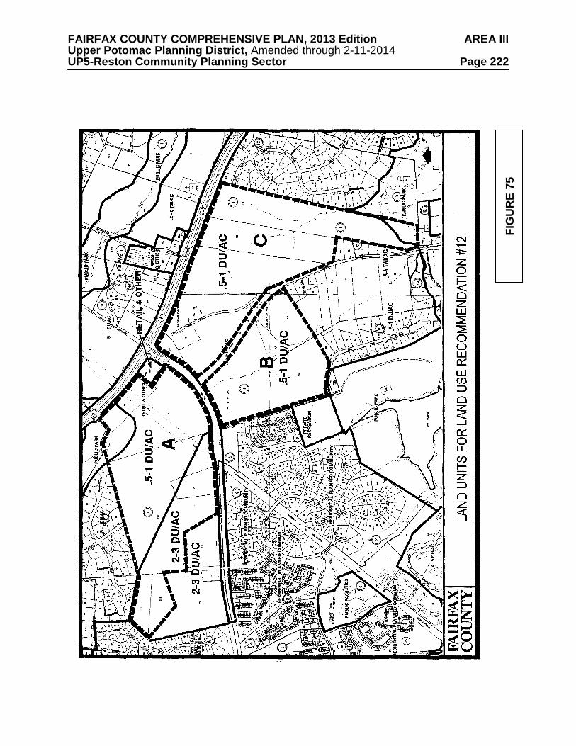
FAIRFAX COUNTY COMPREHENSIVE PLAN, 2013 Edition AREA III Upper Potomac Planning District, Amended through 2-11-2014 UP5-Reston Community Planning Sector Page 222
FIG
UR
E 75
FAIRFAX COUNTY COMPREHENSIVE PLAN, 2013 Edition AREA III Upper Potomac Planning District, Amended through 2-11-2014 UP5-Reston Community Planning Sector Page 223
• No commercial development should occur. The Reston Farm Market located on Baron Cameron Avenue is a non-conforming use;
• Substantial buffers are provided along the frontages of Leesburg Pike and Baron
Cameron Avenue; • Lots abutting the Ascot subdivision and the Reston PRC should be developed in
a similar size (a minimum of 36,000 square feet) to foster compatibility with these existing communities; and
• Satisfactory transportation improvements as determined by the County. The area south of Leesburg Pike and south of Baron Cameron Avenue is planned for residential use at .5-1 dwelling unit per acre. This includes the area east of the Reston boundary and Lake Fairfax Park and north of Colvin Run. Development at this density is similar to existing residential development in the area and will help to maintain a low density buffer around Reston. A portion of this area is identified in Figure 75 as Land Unit B (Tax Map 18-1((1))B1 and B2) and Land Unit C (Tax Map 12-3((1))15, 16, 18B, 31; and 12-4((1))58, 59 and 60). Additional Plan guidance is included under Land Use Recommendation #10 for the Hickory Community Planning Sector (UP3). Development within Land Unit B and Land Unit C is appropriate at the high end of the density range only if the following conditions are met:
• Substantial, if not complete, consolidation of all parcels within each land unit as
noted above and provision of interparcel access, coordination of lot layouts, pathways and circulation system with adjoining properties;
• Substantial buffers are provided along the frontages of Leesburg Pike, Baron
Cameron Avenue, and Hunter Mill Road; • To maintain the low density residential character of Hunter Mill Road and
Leesburg Pike, larger lots should be located near these roadway frontages; • No commercial development should occur; • Substantial buffers are provided along Lake Fairfax Drive and Lake Fairfax
subdivision, and lots abutting Lake Fairfax Drive and Lake Fairfax subdivision should be at least 25,000 square feet in size to foster compatibility with the surrounding community;
• The approximately 30 acres of the area known as the Reston Pet Farm is an area
amenity that should be preserved and incorporated into the development or else maintained as perpetual open space or public parkland, should Pet Farm operations cease; and
• Satisfactory transportation improvements as determined by the County.
FAIRFAX COUNTY COMPREHENSIVE PLAN, 2013 Edition AREA III Upper Potomac Planning District, Amended through 2-11-2014 UP5-Reston Community Planning Sector Page 224
13. The area bounded by Hunter Mill Road, Lake Fairfax Park, Sunset Hills Road, and Lake Fairfax Business Park is planned for residential development at .2-.5 dwelling units per acre as shown on the Plan map. As an option, the southeastern portion of the area may also be appropriate for institutional or public uses if all adverse impacts are satisfactorily mitigated.
Uses requiring special permit or special exception approval should be rigorously reviewed and permitted only when the use is of a size and scale that will not adversely impact adjacent land uses and the overall low density residential character of the area. The cumulative effect of special permit and special exception uses should be considered prior to allowing additional uses of this type. The expansion of existing special permit and special exception uses should be considered on a case-by-case basis to determine if expanding the existing use will be in keeping with the low density residential character of the area.
Any improvement to Sunset Hills Road must be designed so as to not adversely impact the ability of the private school located on Tax Map 18-3((2))5 (formerly the Tara Reston Christian School) to operate at its authorized capacity (February 1988). Safe and convenient access for ingress and egress should be provided. Noise engineering studies should also accompany the corridor study which will have to be conducted for Sunset Hills Road in accordance with Transportation Policy 1b.
14. Tax Map 27-2((1))2, 18-4((1))25 and 29B and 18-4((13))inclusive (approximately
167 acres) are planned for residential use at no more than .5-1 dwelling unit per acre. The site is located in the Difficult Run watershed and is bisected by several small tributaries. These tributaries and their associated Environmental Quality Corridors should be left as open space.
15. An area adjacent to the western edge of Lake Fairfax Park on Colvin Run is planned
for residential use at 4-5 dwelling units per acre. 16. It is appropriate that land in this planning sector associated with the Difficult Run
watershed be planned as public and private open space and residential use at densities of .1-.2, .2-.5, and .5-1 dwelling unit per acre as shown on the Plan map. Residential development at these densities will serve to maintain the large lot residential character of the area that has been established and afford protection of this environmentally sensitive area.
The Guidelines for Cluster Development contained in the Policy Plan should be strictly adhered to in this area, especially the guideline that no cluster development should be considered when the primary purpose of clustering is to maximize density on the site. Because of the configuration of several planned density categories on the Plan map for this area, many properties have more than one category assigned. When a site has more than one planned density range assigned, the appropriate overall density and average lot size should be determined by placing a strong emphasis on achieving compatibility with existing development in the vicinity. See the Area Overview in the Area II or Area III Plan for further guidance regarding the Difficult Run watershed. [Not shown]

FAIRFAX COUNTY COMPREHENSIVE PLAN, 2013 Edition AREA III Upper Potomac Planning District, Amended through 2-11-2014 UP5-Reston Community Planning Sector Page 225
17. The area north of Lawyers Road and south of the Glade Stream Valley that is not zoned as part of Reston is planned for residential use at .1-.2 dwelling unit per acre as shown on the Plan map. It is developed as an institutional use. Any future changes or redevelopment proposed for this area should provide or maintain a substantial buffer to protect the adjacent residential communities and should be sensitive to the environmental constraints of the property.
18. The area west of the Reston Planned Residential Community in the vicinity of
Pinecrest Road is mostly planned for residential use at 1-2 dwelling units per acre as shown on the Plan map. As an option, Parcels 25-2((5))53, 55, 56, 57, 58, and 59 may be appropriate for residential townhouse or patio-style development at 4-5 dwelling units per acre under the following conditions:
• Building heights should not exceed 35 feet; • Effective visual screening and a substantial buffer is provided to protect
adjacent single-family residential uses; and • Access should be provided from both Pinecrest and Fox Mill Roads, as far from
the intersection as possible.
Parcels 26-1((1))5A, 5B, 5C, and 6 are planned for low intensity light industrial/R&D use at a maximum of .25 FAR. This use should be limited to these parcels, designed to minimize visual impacts on adjacent residential parcels, and provide substantial screening and buffering. As an option, if consolidated, parcels 5A and 5C may also be considered for residential use at 4-5 dwelling units per acre provided that:
• Building heights do not exceed 35 feet; • Effective visual screening and a substantial buffer is provided to protect
adjacent existing and planned single-family residential uses; and • Access is provided through the residentially planned and zoned area to the south
and west. Access through the adjacent industrial/R&D use is not appropriate.
19. For the Sector UP5 area outside Reston, ample local-serving commercial facilities are either available or planned within Reston, at the Village Centers and Town Center, leaving no need for commercial development along either Route 606 or Hunter Mill Road. [Not shown]
20. The Route 7 Corridor is planned for and should continue to be reserved for residential
development. Industrial, office, research and development (R&D), and retail commercial uses are not appropriate in the Route 7 Corridor. Uses requiring special permits and special exception approval should be rigorously reviewed and permitted only when the use is of a size and scale that will not adversely impact adjacent land uses and the overall low density residential character of the corridor in order to prevent commercial or quasi-commercial encroachment. [Not shown]
21. The westerly portion of the approximately 120-acre tract of land north of Sunset Hills
Road immediately east of the Reston boundary is considered appropriate for industrial uses provided that:
FAIRFAX COUNTY COMPREHENSIVE PLAN, 2013 Edition AREA III Upper Potomac Planning District, Amended through 2-11-2014 UP5-Reston Community Planning Sector Page 226
a. The industrial portion of the 120-acre tract, which is approximately 55 acres in area and located on the western portion of the tract, is planned for medium intensity industrial research and development and similar uses;
b. The approximately 65-acre residential area of the tract (Equestrian Park subdivision)
has been developed as residential use at .2-.5 dwelling unit per acre. This residential area ensures that low density residential use is maintained to the east of the industrial area located on the western portion of this tract. This line of demarcation establishes the boundary between industrial and residential use and the current development on both sides of the line is consistent with this intent;
c. The dividing line between the industrial and residential uses should accommodate and
follow the swale commencing on the northerly side of the property at its boundary with Lake Fairfax Park and running southerly towards Sunset Hills Road, following the tree line as it approaches Tax Map 18-3((1))0 and continuing towards Sunset Hills Road to the northwesterly corner of Tax Map 18-3((1))10. Tax Map 18-3((1))12B and the eastern portion of 18-3((8))2 and 3 should be retained as a buffer to the low density residential area. The above line of demarcation will establish the boundary between industrial and residential uses by relating the transition and land use to physical features of the land, i.e., the tree line and swale;
d. The applicant should install approved plantings to close the gap, which is
approximately 50 feet wide, between the tree line running north from Sunset Hills Road to where it most closely approaches the existing trees and tying into the treed swale running south from Lake Fairfax Park. In the event that such plantings are inconsistent with good site planning and land use as determined in the final site planning of the property, the Reston Community Association and the applicant should work out a suitable compromise;
e. Stringent environmental controls should be applied to the industrial portion of the
tract. These include extensive landscaping on Sunset Hills Road, buffering for the residentially planned area to the east, and sedimentation control measures to assure the environmental integrity of Lake Fairfax.
Transportation Transportation recommendations for this sector are shown on Figures 76, 77, 78, 79, 80, 81, and 82. In some instances, site-specific transportation recommendations are included in the land use recommendations section. The figures show access orientation, circulation plans, interchange impact areas and generalized locations of proposed transit facilities. The recommendations contained in the Area Plan text and maps, the Policy Plan and Transportation Plan map, policies and requirements in the Public Facilities Manual, the Zoning Ordinance, and other standards will be utilized in the evaluation of development proposals. Development proposals should also be evaluated against the Hunter Mill Road Traffic Calming Study (Northern Virginia Regional Commission, 2006), which provides both a traffic calming conceptual plan for Hunter Mill Road, as well as context sensitive roadway design techniques. Development and redevelopment applicants shall be encouraged to establish or participate in transportation management programs to promote alternatives to single occupant vehicle use, particularly during peak commutation hours. Transportation management programs include, but are not limited to: flexible and alternative work schedules, telecommuting, transit pass programs, dedicated bus/van shuttles to designated transit centers, parking management
FAIRFAX COUNTY COMPREHENSIVE PLAN, 2013 Edition AREA III Upper Potomac Planning District, Amended through 2-11-2014 UP5-Reston Community Planning Sector Page 227 arrangements, promotion of ridesharing, bicycling and walking. Applicants will be encouraged to coordinate with and make appropriate contributions to a Transportation Management Association (TMA) where such a TMA has been established. In addition, applicants will be encouraged to require lessee cooperation with an existing TMA or one established in the future.
Sunset Hills Road as it terminates at Hunter Mill Road provides for the primary access to the Dulles Toll Road for the residential areas and commercial office areas within the eastern periphery of Reston. This access can be provided for by either option A, B or C below. Option A is the preferred option:
• The preferred option A is to slightly modify the current Sunset Hills Road intersection by moving it opposite the Dulles Toll Road westbound off-ramp and relocate the Toll Road westbound on-ramp to begin at Sunset Hills Road west of Hunter Mill Road and east of the existing VDOT maintenance facility.
• A secondary option B, if option A is not accepted by VDOT, would be to relocate
Sunset Hills Road in a configuration that brings the intersection of Sunset Hills Road and Hunter Mill Road as close as possible to the Reston Presbyterian Church (Tax Map 18-3((1))6).
• A third option C is a roundabout as described in the Hunter Mill Road Traffic
Calming Study (Northern Virginia Regional Commission, 2006). Heritage Resources Lake Anne Village Center Historic Overlay District lies within this sector. The Lake Anne Village Center Historic Overlay District regulations are found in Appendix 1, A1-1100 of the Zoning Ordinance. The intent is that the original mixture of residential and commercial space be maintained and that the pattern of commercial frontage on the lake and restrictions to pedestrian access be strictly followed. All improvements and alterations must be reviewed by the Architectural Review Board. Development in the area of the site of the Battle of Dranesville (in the vicinity of Reston Avenue and Leesburg Pike) should be sensitive to any heritage resources associated with that event. Any development or ground disturbance in this sector, both on private and public land, should be preceded by heritage resource studies, and alternatives should be explored for the avoidance, preservation or recovery of significant heritage resources that are found. In those areas where significant heritage resources have been recorded, an effort should be made to preserve them. If preservation is not feasible, then, in accordance with countywide objectives and policies as cited in the Heritage Resources section of the Policy Plan, the threatened resource should be thoroughly recorded and in the case of archaeological resources, the artifacts recovered.
Public Facilities 1. Construct a fire and rescue station at the Leesburg Pike/Reston Avenue intersection.
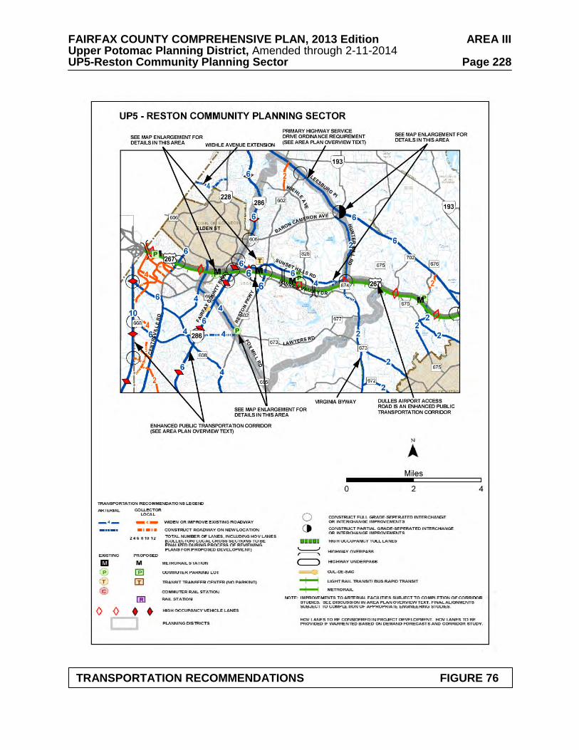
FAIRFAX COUNTY COMPREHENSIVE PLAN, 2013 Edition AREA III Upper Potomac Planning District, Amended through 2-11-2014 UP5-Reston Community Planning Sector Page 228
TRANSPORTATION RECOMMENDATIONS FIGURE 76
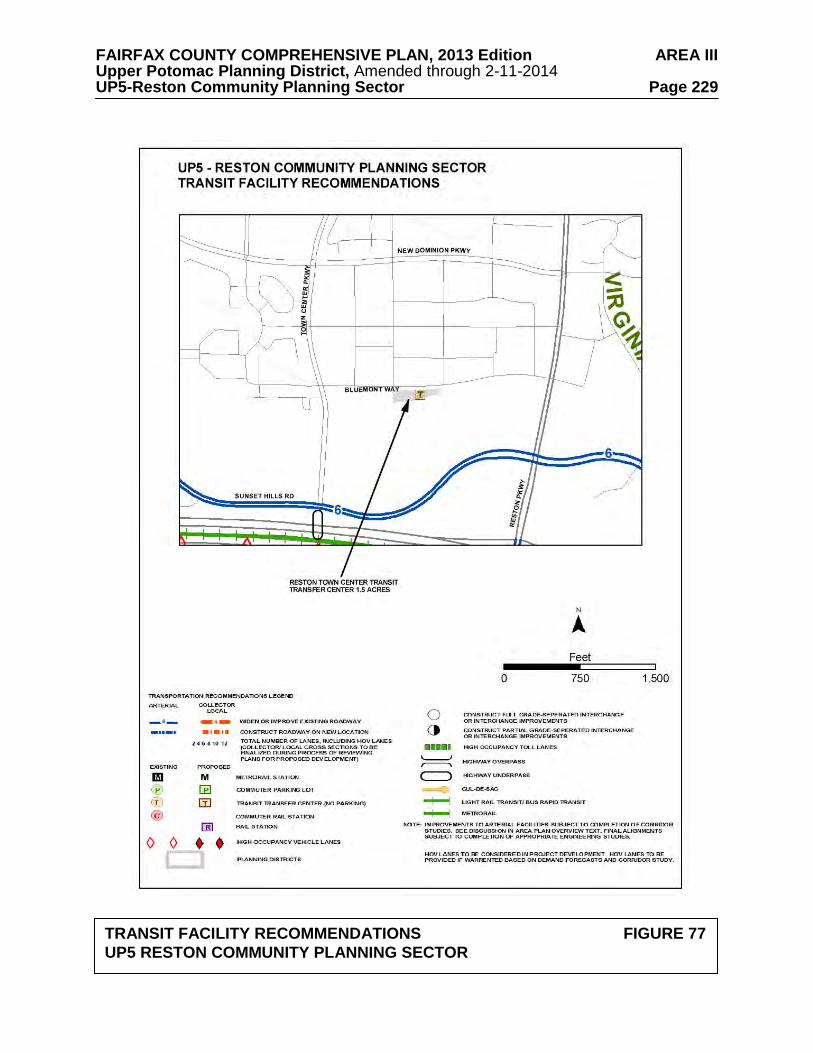
FAIRFAX COUNTY COMPREHENSIVE PLAN, 2013 Edition AREA III Upper Potomac Planning District, Amended through 2-11-2014 UP5-Reston Community Planning Sector Page 229
TRANSIT FACILITY RECOMMENDATIONS FIGURE 77 UP5 RESTON COMMUNITY PLANNING SECTOR
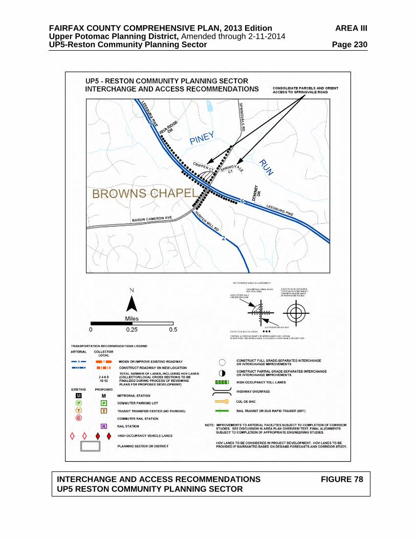
FAIRFAX COUNTY COMPREHENSIVE PLAN, 2013 Edition AREA III Upper Potomac Planning District, Amended through 2-11-2014 UP5-Reston Community Planning Sector Page 230
INTERCHANGE AND ACCESS RECOMMENDATIONS FIGURE 78
UP5 RESTON COMMUNITY PLANNING SECTOR
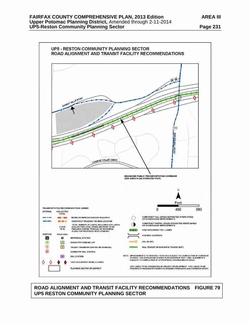
FAIRFAX COUNTY COMPREHENSIVE PLAN, 2013 Edition AREA III Upper Potomac Planning District, Amended through 2-11-2014 UP5-Reston Community Planning Sector Page 231
ROAD ALIGNMENT AND TRANSIT FACILITY RECOMMENDATIONS FIGURE 79
UP5 RESTON COMMUNITY PLANNING SECTOR
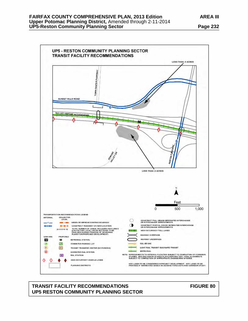
FAIRFAX COUNTY COMPREHENSIVE PLAN, 2013 Edition AREA III Upper Potomac Planning District, Amended through 2-11-2014 UP5-Reston Community Planning Sector Page 232
TRANSIT FACILITY RECOMMENDATIONS FIGURE 80 UP5 RESTON COMMUNITY PLANNING SECTOR
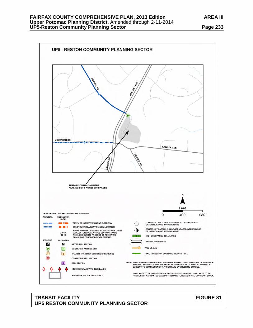
FAIRFAX COUNTY COMPREHENSIVE PLAN, 2013 Edition AREA III Upper Potomac Planning District, Amended through 2-11-2014 UP5-Reston Community Planning Sector Page 233
TRANSIT FACILITY FIGURE 81
UP5 RESTON COMMUNITY PLANNING SECTOR
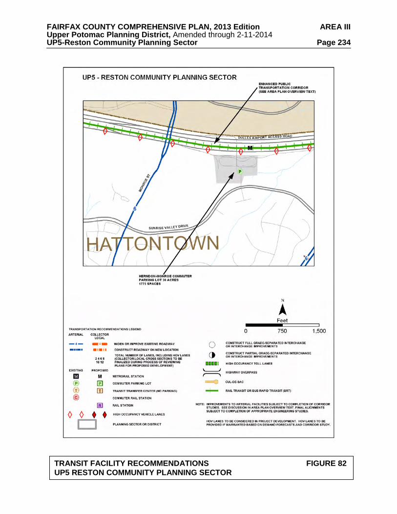
FAIRFAX COUNTY COMPREHENSIVE PLAN, 2013 Edition AREA III Upper Potomac Planning District, Amended through 2-11-2014 UP5-Reston Community Planning Sector Page 234
TRANSIT FACILITY RECOMMENDATIONS FIGURE 82 UP5 RESTON COMMUNITY PLANNING SECTOR
FAIRFAX COUNTY COMPREHENSIVE PLAN, 2013 Edition AREA III Upper Potomac Planning District, Amended through 2-11-2014 UP5-Reston Community Planning Sector Page 235 2. Reserve land adjacent to the Dulles Toll Road just west of the Reston Parkway for a
potential rail station (no parking). 3. Expand the Reston Regional Library consistent with the Policy Plan standards for regional
libraries. 4. Provide additional finished water transmission facilities along Fox Mill Road south of
Lawyers Road. 5. Provide additional finished water transmission facilities along the Fairfax County Parkway,
south of New Dominion Parkway. Parks and Recreation Park and recreation recommendations for this sector are shown on Figure 83. The column "Park Classification" includes existing park facilities. The "Recommendations" column includes entries for both existing and proposed facilities. Prior to developing parkland, the Fairfax County Park Authority initiates a master planning process to determine the appropriate facilities and design for that park. This process involves extensive citizen review and participation. If an existing park is listed but no recommendation appears on that line, it means the park has been developed in accordance with its master plan. Public Art Public art has been a component of the effort to achieve quality urban design in Reston since the community’s inception. In order to continue to realize the goal of making Reston a vibrant place to live, work and play, public art should be encouraged in future development in Reston. The Reston community under the leadership of the Initiative for Public Art in Reston (IPAR), developed a Public Art Master Plan which establishes a process for planning and commissioning public art including community roles as well as collection management. The Plan also suggests working zones on where to focus efforts. The IPAR Plan should be used as a guide for public art efforts in the establishment of public art and as a resource for the review of new development and redevelopment proposals within the Master Plan area.
Trails
Trails planned for this sector are delineated on Figure 84 and on the 1”:4,000’ Countywide Trails Plan Map which is referenced as Figure 2 in the Transportation element of the Policy Plan and is available from the Department of Planning and Zoning. Trails in this sector are an integral part of the overall County system. While some of the segments have already been constructed, the Countywide Trails Plan Map portrays the ultimate system for the sector and the County at large. In addition, the map specifies a classification for each segment, which represents the desired ultimate function and surface type of the trail. Specific construction requirements are detailed in the Public Facilities Manual.
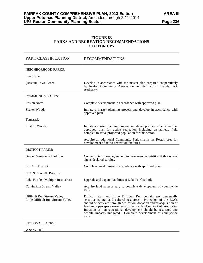
FAIRFAX COUNTY COMPREHENSIVE PLAN, 2013 Edition AREA III Upper Potomac Planning District, Amended through 2-11-2014 UP5-Reston Community Planning Sector Page 236
FIGURE 83
PARKS AND RECREATION RECOMMENDATIONS SECTOR UP5
PARK CLASSIFICATION
RECOMMENDATIONS
NEIGHBORHOOD PARKS: Stuart Road (Reston) Town Green
Develop in accordance with the master plan prepared cooperatively by Reston Community Association and the Fairfax County Park Authority.
COMMUNITY PARKS: Reston North Shaker Woods Tamarack Stratton Woods
Complete development in accordance with approved plan. Initiate a master planning process and develop in accordance with approved plan. Initiate a master planning process and develop in accordance with an approved plan for active recreation including an athletic field complex to serve projected population for this sector. Acquire an additional Community Park site in the Reston area for development of active recreation facilities.
DISTRICT PARKS: Baron Cameron School Site Fox Mill District
Convert interim use agreement to permanent acquisition if this school site is declared surplus. Complete development in accordance with approved plan.
COUNTYWIDE PARKS: Lake Fairfax (Multiple Resources) Colvin Run Stream Valley Difficult Run Stream Valley Little Difficult Run Stream Valley
Upgrade and expand facilities at Lake Fairfax Park. Acquire land as necessary to complete development of countywide trail. Difficult Run and Little Difficult Run contain environmentally sensitive natural and cultural resources. Protection of the EQCs should be achieved through dedication, donation and/or acquisition of land and open space easements to the Fairfax County Park Authority. Intrusion of non-recreational development should be restricted and off-site impacts mitigated. Complete development of countywide trails.
REGIONAL PARKS: W&OD Trail
FAIRFAX COUNTY COMPREHENSIVE PLAN, 2013 Edition AREA III Upper Potomac Planning District, Amended through 2-11-2014 UP5-Reston Community Planning Sector Page 237
TRAILS PLAN MAP FOR THIS SECTOR UNDER CONSTRUCTION
SEE THE 1” = 4000’ SCALE
COUNTYWIDE TRAILS PLAN MAP
PLANNED TRAIL SYSTEM FIGURE 84
FAIRFAX COUNTY COMPREHENSIVE PLAN, 2013 Edition AREA III Upper Potomac Planning District, Amended through 2-11-2014 UP6-Sully Community Planning Sector Page 238
UP6 SULLY COMMUNITY PLANNING SECTOR
The Sully Community Planning Sector is located entirely within the Dulles Suburban Center. Plan guidance for this area is in the Dulles Suburban Center portion of the Area III volume of the Comprehensive Plan.
FAIRFAX COUNTY COMPREHENSIVE PLAN, 2013 Edition AREA III Upper Potomac Planning District, Amended through 2-11-2014 UP7-West Ox Community Planning Sector Page 239
UP7 WEST OX COMMUNITY PLANNING SECTOR
CHARACTER
The West Ox Community Planning Sector is generally bounded by the Dulles Airport Access Road and Dulles Toll Road (DAAR, Route 267), Fox Mill Road, Vale Road, Thompson Road and Centreville Road (Route 28) (see Figure 85).
Single-family residential development in this planning sector preserves the existing
development and prevents encroachment of higher density development from Reston or Chantilly.
This planning sector includes the environmentally sensitive Difficult Run Watershed. A
mixed-use development is located at McNair Farms (near the intersection of Frying Pan Road and Centreville Road) and a large planned residential community is located at Franklin Farm (between Centreville Road and West Ox Road along Franklin Farm Road). Kidwell Farm at Frying Pan Farm Park is a working demonstration farm located at West Ox Road near Centreville Road.
Local-serving commercial uses include retail centers located at Sunrise Valley Drive and
Corporate Park Drive, the southwest quadrant of McLearen Road and Centreville Road, and the northeast quadrant of Fairfax County Parkway (Route 286) and Franklin Farm Road. Fox Mill Shopping Center is located at Fox Mill Road, Reston Parkway and Lawyers Road, and the Village Center at Dulles is located at Centreville Road between Coppermine Road and Sunrise Valley Drive.
Parkland and recreational space is dispersed throughout the planning sector, particularly in
the subwatersheds of the Difficult Run Watershed. Neighborhoods from the early to mid-20th century are also found in this planning sector. These areas offer a high potential for significant heritage resources, especially in the southeastern half of the planning sector along Fox Mill Road. Numerous heritage resources, both known and unknown, exist in this planning sector. The Horsepen Run drainage area in the western portion of the planning sector has been occupied almost continuously since 8000 B.C. Vale United Methodist Church, Vale School/Vale Community House, and Frying Pan Farm Park are significant heritage resources listed in the Fairfax County Inventory of Historic Sites. A list and map of heritage resources are included in the Upper Potomac Planning District Overview section, Figures 4, 5 and 6. Additional historic sites in this sector are also included in the inventory.
CONCEPT FOR FUTURE DEVELOPMENT
The Concept for Future Development recommends the areas of the West Ox Community Planning Sector develop as either Suburban Neighborhoods or Low Density Residential Areas except for the area north of Fox Mill Road which is in the Reston Transit Station Areas. The Suburban Neighborhood area is located in the western portion of the sector, generally west of Lawyers Road. The Low Density Residential Area is located in the eastern portion of the sector, generally east of Lawyers Road and east and south of Reston.
FAIRFAX COUNTY COMPREHENSIVE PLAN, 2013 Edition AREA III Upper Potomac Planning District, Amended through 2-11-2014 UP7-West Ox Community Planning Sector Page 240 RECOMMENDATIONS Land Use
For the area north of Fox Mill Road, between Centreville Road and Monroe Street, refer to Plan text for the Reston Transit Station Areas.
The West Ox Community Planning Sector is largely developed with stable residential
neighborhoods. Infill development in these neighborhoods should be of a compatible use, type and intensity in accordance with the guidance provided by the Policy Plan under Land Use Objectives 8 and 14.
Where substantial parcel consolidation is specified, it is intended that such consolidations
will provide for projects that function in a well-defined, efficient manner and provide for the development of unconsolidated parcels in conformance with the Area Plan.
Figure 85 indicates the geographic location of land use recommendations for this sector.
Where recommendations are not shown on the General Locator Map, it is so noted.
The following land uses and densities are appropriate to provide for a low density transition between the higher densities planned in the Reston, Chantilly and Fairfax Center areas: 1. The area generally between Fox Mill Road, Lawyers Road, and West Ox Road and the
Fairfax County Parkway is planned for residential use at 1-2 dwelling units per acre.
The approximately 8-acre property on Lawyers Road (Tax Map 25-4((1))4) adjacent to the Fox Mill Estates subdivision is planned for 2-3 dwelling units per acre. In order to foster compatible residential development, the overall density should not exceed 2.5 dwelling units per acre. Lot sizes should be compatible to those of the adjacent Fox Mill Estates community (located north and south of the subject property) and the two segments of Wendell Holmes Road should not be connected. As an option, this 8-acre property (Tax Map 25-4((1))4) and adjoining land along Lawyers Road west of Calkins Road (Tax Map 25-4((1))5, 6 and 7) may be appropriate for 2-3 dwelling units per acre provided that each of the following conditions are met:
• All four parcels are consolidated and developed under a single development plan; • Lot sizes are compatible with those of the adjacent Fox Mill Estates community,
located north, south, and west of the properties; • The two segments of Wendell Holmes Road are not connected; and • All access to Lawyers Road is consolidated and occurs only at the planned median
break opposite Calkins Road.
Parcels 5, 6 and 7 along the west side of Lawyers Road can be considered for up to 2 dwelling units per acre provided that such development, including lot sizes, is compatible with the adjacent Fox Mill Estates community and access to Lawyers Road is consolidated and occurs only at the planned median break opposite Calkins Road.
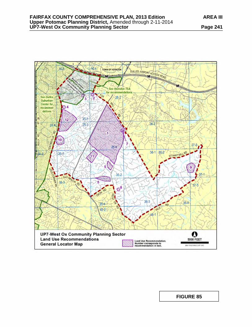
FAIRFAX COUNTY COMPREHENSIVE PLAN, 2013 Edition AREA III Upper Potomac Planning District, Amended through 2-11-2014 UP7-West Ox Community Planning Sector Page 241
FIGURE 85
FAIRFAX COUNTY COMPREHENSIVE PLAN, 2013 Edition AREA III Upper Potomac Planning District, Amended through 2-11-2014 UP7-West Ox Community Planning Sector Page 242
2. The area in the southwest quadrant of the intersection of Monroe Street and Frying Pan
Road (Tax Map 16-4((1))10, 11, 12 and 13 and Tax Map 25-2((1))1) is planned for residential use at 2-3 dwelling units per acre, as shown on the Plan map. As an option, residential use at a density of 4-5 dwelling units per acre may be appropriate if the following conditions are met:
• All five parcels are consolidated and developed with single-family detached units
under a unified development plan to facilitate high quality development; • Lot sizes are compatible with the single-family detached development shown on the
approved development plan for rezoning case RZ 92-C-009 for the abutting property to the south and west;
• Access should be provided from the south and west rather than from Monroe Street or
Frying Pan Road, utilizing the interparcel access shown on the approved development plan for the rezoning case RZ 92-C-009 for the abutting property to the south and west. However, if development on the abutting property does not occur in a timely manner, consideration may be given to the provision of access from Monroe Street.
• Improvements to Monroe Street and/or Frying Pan Road should be made to mitigate
the impact of this development, as determined during the development review process.
3. The property located on the south side of Frying Pan Road at the southern terminus of Fox
Mill Road (Tax Map 25-1((1))5), is planned for residential use at 5-8 dwelling units per acre. Parcel 5 should be developed with townhouses to facilitate restoration of the Environmental Quality Corridor of the Frying Plan Branch Stream Valley that traverses the parcel. Development should address the following conditions:
• The stockpile that exists on the property should be removed; • The boundaries of the EQC should be delineated based on Policy Plan guidelines and
the topography that existed prior to the establishment of the stockpile. The topography restored to a more natural condition and the portion of the EQC outside the sewer easement should be revegetated; and
• The restored EQC area should be dedicated to the Fairfax County Park Authority or
preserved as homeowners open space. 4. The area north of West Ox Road and south of Frying Pan Park and the Frying Pan Meeting
House (zoned C-5 and R-1) is planned for residential use at 1-2 dwelling units per acre. Any enhancement of retail uses in Floris north of West Ox Road should demonstrate that these changes will be beneficial to the community and not adversely impact adjacent, stable residential communities and existing heritage resources. As an option, this area may be appropriate for the following uses: • Frying Pan Park oriented-uses. Facilities not found on the park, but used by visitors
such as eating establishments, overnight accommodations, retail focused upon the agricultural, equestrian and/or historic nature of the adjacent publicly-owned land should be considered. This would help elevate the use of the park and make it more of a draw. New uses could carry an equestrian theme and have direct access to the
FAIRFAX COUNTY COMPREHENSIVE PLAN, 2013 Edition AREA III Upper Potomac Planning District, Amended through 2-11-2014 UP7-West Ox Community Planning Sector Page 243
Park. This could be a tourism-oriented use. A small equestrian museum with meeting space, perhaps a visitor center would all be appropriate ancillary uses to lodging, food and appropriate retail. Design and architecture guidelines should be strictly adhered to with focus on quality architecture with a cohesive theme. The historic church should be retained and the new uses designed around it.
• Residential use with transition to higher density residential toward the four-lane, but
eventual six-lane Centreville Road from Frying Pan Park. Densities could be in the 8-10 dwelling units per acre range. The design should create a small, enclosed community with the church as a centerpiece. The church should be retained and moved back from the road to facilitate its use as a historic centerpiece.
• Public Park use should the Fairfax County Park Authority expand Frying Pan Park.
The historic church should be retained. 5. The area bounded by Fox Mill Road, Bennett Road, West Ox Road, Thompson Road, and
Lawyers Road is planned for residential use at .5-1 dwelling unit per acre. As an option, up to 2 dwelling units per acre may be appropriate for the portion south and southeast of the Franklin Farm community and west of West Ox Road (Tax Map 35-2((1))38, 51, 52, 53, 54 and 54A; 35-2((12))inclusive (Franklin Corner) and 35-2((17))inclusive (Still Oaks); 35-4((1))4, 4A, 4B, 4C, 4D and 10) provided that: • Substantial parcel consolidation is achieved to ensure that the property is developed
under the planned development concept; • The property is developed within a planned development concept, with substantial
open space to foster compatibility. The higher density single-family lots should be concentrated internally to the development. Larger lots should be located along the peripheries to provide the transition between densities. It is anticipated that this option area will be developed in single-family detached dwelling units; and
• Access to the northern portion of the option area south of Franklin Farm (Tax Map
35-2((12))inclusive) is provided via Pond Crest and Willow Glen Drive to Franklin Farm Road; access to the southern portion of that option area is provided from West Ox Road and Oxon Road. Access to the northernmost area adjacent to Franklin Farm (Tax Map 35-2((1))38 and 35-2((17))inclusive) is provided by an entrance at the northeast end of the property that does not interfere with traffic flow at the intersection of West Ox Road, Folkstone Road, and Lawyer's Road.
6. It is appropriate that land in this planning sector associated with the Difficult Run
watershed be planned as public and private open space and residential use at densities of .1-.2, .2-.5, and .5-1 dwelling unit per acre as shown on the Plan map. Residential development at these densities will serve to maintain the large lot residential character of the area that has been established and afford protection of this environmentally sensitive area.
The Guidelines for Cluster Development contained in the Policy Plan should be strictly adhered to in this area, especially the guideline that no cluster development should be considered when the primary purpose of clustering is to maximize density on the site. In addition, the clustering of residential lots should not be approved for subdivisions in which any lot would have direct vehicular access onto Fox Mill Road, Stuart Mill Road, Vale Road, West Ox Road, Bennett Road, Lawyers Road or Pinecrest Road. A natural buffer
FAIRFAX COUNTY COMPREHENSIVE PLAN, 2013 Edition AREA III Upper Potomac Planning District, Amended through 2-11-2014 UP7-West Ox Community Planning Sector Page 244
strip, not less than 25 feet in width, should be provided between all cluster lots and the right-of way for roads listed above with no direct vehicular access permitted.
Because of the configuration of several planned density categories on the Plan map for this area, many properties have more than one category assigned. When a site has more than one planned density range assigned, the appropriate overall density and average lot size should be determined by placing a strong emphasis on achieving compatibility with existing development in the vicinity. [Not shown]
7. Commercial use in the Fox Mill Road/Lawyers Road/Reston Parkway/Pinecrest Road
vicinity should be confined to the Fox Mill Shopping Center and should not exceed a .25 FAR. Future neighborhood-serving commercial activity, if needed, should be located near or along Centreville Road and developed in conjunction with planned residential development. Isolated commercial uses are not appropriate within this sector.
8. The site of the old Navy-Vale Fire station is appropriate for non-commercial
community-serving uses. The site has two Fairfax County public tennis courts, and the Chantilly Youth Association has a lease on the building. If the land is used for residential purposes, it is planned for residential use at .5-1 dwelling unit per acre to be compatible with adjacent properties.
9. The area bounded by Stuart Mill Road on the east, private open space and Oakton Woods
on the north, Linda Marie Drive on the west and Clarkes Landing Park on the south is planned for residential use at .2-.5 dwelling unit per acre. It is preferable that this area be developed at the lower density level to be compatible with existing development.
10. It is recommended that the areas in the northeast and southeast quadrants of the intersection
of Centreville Road and McLearen Road (Tax Map 25-3((1))14, 15, 15B, and 23B; Tax Map 25-3((10)) inclusive; Tax Map 25-3((13))4, 5 and 6; Tax Map 24-4((2))inclusive and Tax Map 24-4((5))1, 2 and 3) be comprehensively developed in a mix of employment, commercial, recreational and residential uses. Planned use of this area would include office/light industrial employment activity, related local-serving retail activity and recreation and residential uses. There should be adequate open space to provide a buffered transition to residential uses. Residential use should be at an overall density of 2-3 dwelling units per acre.
Development of this property should be phased so that the construction of residential units, development of recreational areas and the provision of landscaped open space buffers precede commercial and/or office/light industrial development.
11. The land east of Ashburton Avenue and south of West Ox Road is planned for residential
development at .5-1 dwelling unit per acre. As an option, development at 1-2 dwelling units per acre may be considered for this area which includes Parcels 35-1((1))2, 2A, 4 and 5; 35-2((1))3, 4, 5 and 31. This option may be appropriate if the following conditions are met:
• Substantial consolidation is achieved to facilitate high quality development; • The site is developed with single-family detached units on lot sizes which are
comparable with surrounding residential development; • The bridge on Ashburton Avenue is improved as soon as possible;
FAIRFAX COUNTY COMPREHENSIVE PLAN, 2013 Edition AREA III Upper Potomac Planning District, Amended through 2-11-2014 UP7-West Ox Community Planning Sector Page 245
• Necessary measures for EQC protection and preservation are taken; • Wetlands are protected in accordance with Federal policies under Section 404 of the
Clean Water Act; • Ashburton Avenue, including the bridge along the frontage of the property is
improved to a two-lane collector status; and • A regional stormwater detention facility is constructed on Parcel 31 if deemed
necessary by the Department of Public Works. 12. The area generally bounded by Centreville Road, West Ox Road, Borneham Woods and
Spring Lake Estates West is planned for residential use at 1-2 dwelling units per acre. For the area south of West Ox Road and north of the Floris Downs subdivision, new retail uses, or expansion of the area currently used for retail uses, is not recommended. Any enhancement of retail uses in Floris south of West Ox Road should demonstrate that these changes will be beneficial to the community and not adversely impact adjacent, stable residential communities.
Transportation
Transportation recommendations for this sector are shown on Figure 86. In some
instances, site-specific transportation recommendations are included in the land use recommendations section. The figures show access orientation, circulation plans, interchange impact areas and generalized locations of proposed transit facilities. The recommendations contained in the Area Plan text and maps, the Policy Plan and Transportation Plan map, policies and requirements in the Public Facilities Manual, the Zoning Ordinance, and other standards will be utilized in the evaluation of development proposals.
Extend Lawyers Boulevard (west of Reston) as a four-lane facility from Reston Avenue to
Centreville Road. The purpose of this recommendation is to provide for east-west arterial in the south Reston area, linking it with major circumferential routes and particularly the industrial development near Dulles Airport. Without this facility, these trips will be forced onto Fox Mill, West Ox, and Centreville Roads.
The design of Lawyers Boulevard between Reston Avenue and the Fairfax County
Parkway shall be coordinated with residents of Fox Mill Estates and other communities.
Construct an interchange at Sully Road and Frying Pan Road. Actual staging of intersection/interchange construction is to be determined based on traffic volumes and the extent to which commitments to complete the interchange exist.
Improvements to Centreville Road should be provided as follows:
• The alignment of Centreville Road should be located to the west (undeveloped) side of the road as currently proposed by staff and VDOT;
• Acquisition of right-of-way for six lanes should move forward;
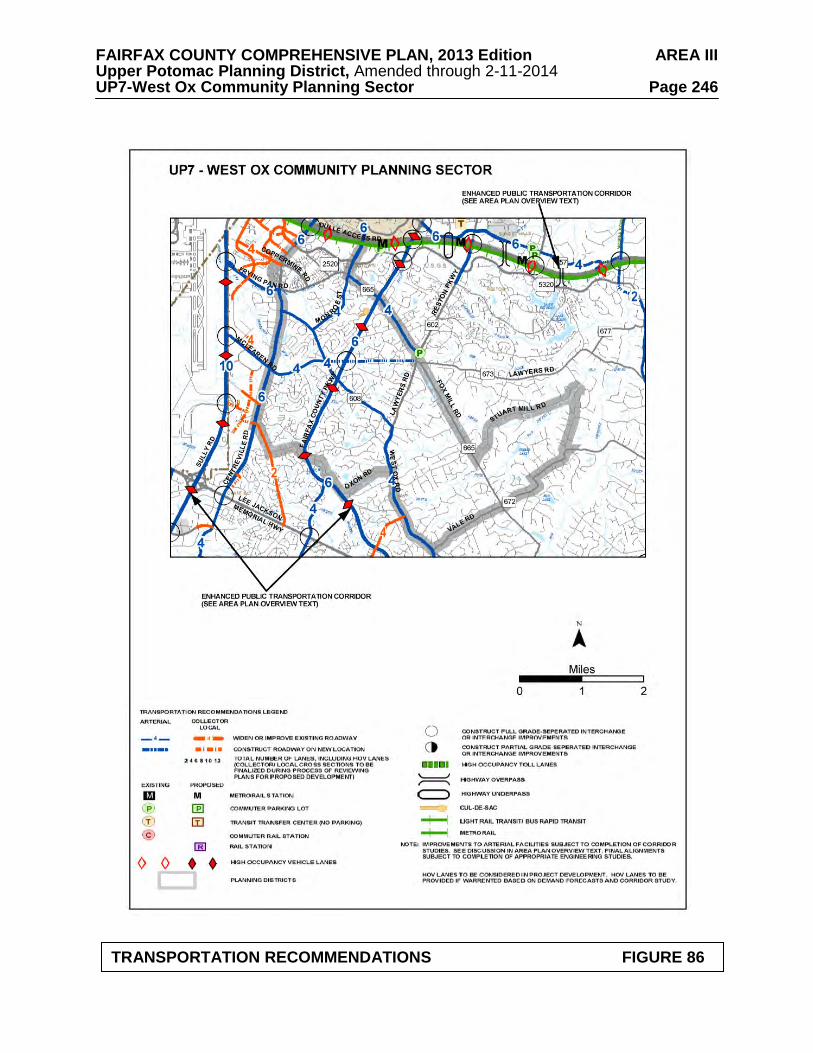
FAIRFAX COUNTY COMPREHENSIVE PLAN, 2013 Edition AREA III Upper Potomac Planning District, Amended through 2-11-2014 UP7-West Ox Community Planning Sector Page 246
TRANSPORTATION RECOMMENDATIONS FIGURE 86
FAIRFAX COUNTY COMPREHENSIVE PLAN, 2013 Edition AREA III Upper Potomac Planning District, Amended through 2-11-2014 UP7-West Ox Community Planning Sector Page 247
• Within the VDOT project from West Ox Road to Lee-Jackson Memorial Highway, construction of the VDOT proposed alternative calling for four outside lanes (permanent construction with outside curb-and-gutter and permanent drainage structures) and a 42-foot wide, graded grass median should be implemented;
• At intersections, provisions should be made consistent with the ultimate six-lane
design. The need for dual left turn lanes into or out of major residential developments along Centreville Road, such as Franklin Farm Road, should be reevaluated at such time as funds become available for construction of the segment from McLearen Road to Lee-Jackson Memorial Highway;
• The need for widening the entire Centreville Road mainline from four lanes to six
lanes should be reevaluated after improvements to Sully Road, the Fairfax County Parkway, and West Ox Road are completed. Furthermore, this decision should follow the completion of a transportation and traffic study conducted in accordance with accepted standards; and
• Priority should be given to the acquisition of right-of-way for the future six laning of
Centreville Road, with a notation that at the time of rezonings, attempts will be made to acquire right-of-way through proffers.
Heritage Resources Additional unidentified resources may yet exist in both undeveloped and developed areas of the sector. Large portions of the UP7 sector have not been surveyed to determine the presence or absence of heritage resources. The community of Floris has been designated a National Register Historic District. Development should be sensitive to the numerous recorded and unrecorded heritage resources associated with the community of Floris. The South Fork and Little Difficult Run Stream Valley areas are vulnerable to public utility and recreation development. This should not occur without prior survey and appropriate mitigation. Any development or ground disturbance in this sector, both on private and public land, should be preceded by heritage resource studies, and alternatives should be explored for the avoidance, preservation or recovery of significant heritage resources that are found. In those areas where significant heritage resources have been recorded, an effort should be made to preserve them. If preservation is not feasible, then, in accordance with countywide objectives and policies as cited in the Heritage Resources section of the Policy Plan, the threatened resource should be thoroughly recorded and in the case of archaeological resources, the artifacts recovered. Public Facilities 1. Provide an additional 2.5-million gallon ground water storage tank at the County Water
Authority's Penderwood Water Storage Tanks II site on West Ox Road, near Waples Mill Road.
2. Construct an elementary school to serve the Herndon/Chantilly area.
FAIRFAX COUNTY COMPREHENSIVE PLAN, 2013 Edition AREA III Upper Potomac Planning District, Amended through 2-11-2014 UP7-West Ox Community Planning Sector Page 248 3. Provide additional finished water transmission facilities along the Fairfax County Parkway,
north of the FCWA Fox Mill Storage and Pumping Facilities. 4. Provide additional finished water transmission facilities along Fox Mill Road to Vale
Road. Parks and Recreation
Parks and recreation recommendations for this sector are shown on Figure 87. The column "Park Classification" includes existing park facilities. The "Recommendations" column includes entries for both existing and proposed facilities. Prior to developing parkland, the Fairfax County Park Authority initiates a master planning process to determine the appropriate facilities and design for that park. This process involves extensive citizen review and participation. If an existing park is listed but no recommendation appears on that line, it means the park has been developed in accordance with its master plan. Trails
Trails planned for this sector are delineated on Figure 88 and on the 1”:4,000’ Countywide Trails Plan Map which is referenced as Figure 2 in the Transportation element of the Policy Plan and is available from the Department of Planning and Zoning. Trails in this sector are an integral part of the overall County system. While some of the segments have already been constructed, the Countywide Trails Plan Map portrays the ultimate system for the sector and the County at large. In addition, the map specifies a classification for each segment, which represents the desired ultimate function and surface type of the trail. Specific construction requirements are detailed in the Public Facilities Manual.
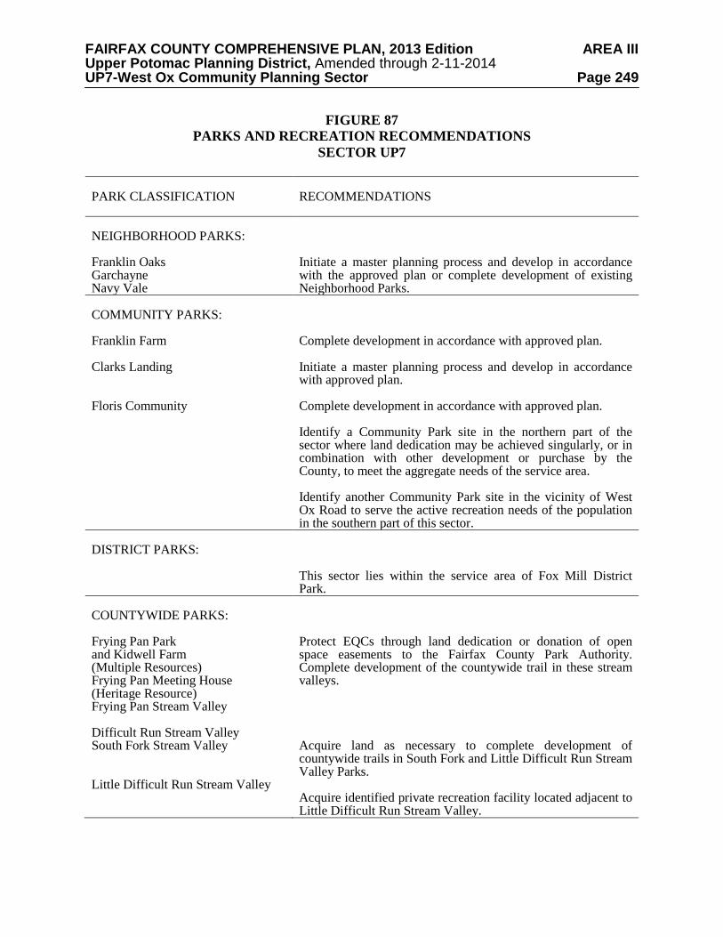
FAIRFAX COUNTY COMPREHENSIVE PLAN, 2013 Edition AREA III Upper Potomac Planning District, Amended through 2-11-2014 UP7-West Ox Community Planning Sector Page 249
FIGURE 87 PARKS AND RECREATION RECOMMENDATIONS
SECTOR UP7 PARK CLASSIFICATION
RECOMMENDATIONS
NEIGHBORHOOD PARKS: Franklin Oaks Garchayne Navy Vale
Initiate a master planning process and develop in accordance with the approved plan or complete development of existing Neighborhood Parks.
COMMUNITY PARKS: Franklin Farm Clarks Landing Floris Community
Complete development in accordance with approved plan. Initiate a master planning process and develop in accordance with approved plan. Complete development in accordance with approved plan. Identify a Community Park site in the northern part of the sector where land dedication may be achieved singularly, or in combination with other development or purchase by the County, to meet the aggregate needs of the service area. Identify another Community Park site in the vicinity of West Ox Road to serve the active recreation needs of the population in the southern part of this sector.
DISTRICT PARKS:
This sector lies within the service area of Fox Mill District Park.
COUNTYWIDE PARKS: Frying Pan Park and Kidwell Farm (Multiple Resources) Frying Pan Meeting House (Heritage Resource) Frying Pan Stream Valley Difficult Run Stream Valley South Fork Stream Valley Little Difficult Run Stream Valley
Protect EQCs through land dedication or donation of open space easements to the Fairfax County Park Authority. Complete development of the countywide trail in these stream valleys. Acquire land as necessary to complete development of countywide trails in South Fork and Little Difficult Run Stream Valley Parks. Acquire identified private recreation facility located adjacent to Little Difficult Run Stream Valley.
FAIRFAX COUNTY COMPREHENSIVE PLAN, 2013 Edition AREA III Upper Potomac Planning District, Amended through 2-11-2014 UP7-West Ox Community Planning Sector Page 250
TRAILS PLAN MAP FOR THIS SECTOR UNDER CONSTRUCTION
SEE THE 1” = 4000’ SCALE
COUNTYWIDE TRAILS PLAN MAP
PLANNED TRAIL SYSTEM FIGURE 88
FAIRFAX COUNTY COMPREHENSIVE PLAN, 2013 Edition AREA III Upper Potomac Planning District, Amended through 2-11-2014 UP8-Lee-Jackson Community Planning Sector Page 251
UP8 LEE-JACKSON COMMUNITY PLANNING SECTOR
CHARACTER The Lee-Jackson Community Planning Sector lies along the north side of Lee Jackson Memorial Highway (Route 50) generally between Centreville Road (Route 28) and West Ox Road (see Figure 89).
Chantilly is located in the southwestern portion of the planning sector (Centreville Road and Lee-Jackson Memorial Highway). The planning sector is characterized by a mixture of single-family detached dwellings and townhouse subdivision development. The sector is primarily residential and it is largely developed.
There are numerous single-family detached subdivisions developed at a density of 2-4
dwelling units per acre, including Armfield Estates, Franklin Glen and Foxfield. Fair Oaks Estates, a single-family detached residential subdivision is adjacent to the Fair Oaks Hospital and developed at a density of 2-3 dwelling units per acre. Century Oak is developed at a density of 1-2 dwelling units per acre and is located between Thompson Road and Ox Trail (Rugby Road). Fair Woods is an attached single-family planned unit residential development with a density of 6 dwelling units per acre located along Route 50 near the intersection of the Fairfax County Parkway (Route 286).
Office, hotel and commercial uses are located along Lee-Jackson Memorial Highway in
the portion of the Fairfax Center area located within this planning sector. The area north of Thompson Road between Oxon Road and West Ox Road, about 175 acres, is developed with older single-family houses on large lots. The Camberley East and Camberley West subdivisions are developed at a density of approximately one dwelling unit per acre. They are located near the intersection of Thompson Road and Oxon Road and on West Ox Road at Bennett Road, respectively.
The International Town and Country Club is a major open space and recreation feature in
the planning sector. It is a privately owned 237 acre facility located between Lee-Jackson Memorial Highway and the Fairfax County Parkway. Sully Plaza shopping center is located in Chantilly at the intersection of Centreville Road and Lee-Jackson Memorial Highway, to the east and north of Sully Place. Sully Plaza has frontage on both Lee-Jackson Memorial Highway and Centreville Road.
Numerous prehistoric and historic archaeological sites are located in the western part of the sector. These sites date to as far back as 11,500 years ago when the first known humans entered the area. There are numerous prehistoric and historic archaeological sites in the vicinity of Upper Cub Run and of Lee-Jackson Memorial Highway. Chantilly Plantation Stone House and Navy School are significant heritage resources listed in the Fairfax County Inventory of Historic Sites. A list and map of heritage resources are included in the Upper Potomac Planning District Overview section, Figures 4, 5 and 6. Additional historic sites in this sector are also included in the inventory. CONCEPT FOR FUTURE DEVELOPMENT
The Concept for Future Development recommends that the entire sector be developed as Suburban Neighborhoods.
FAIRFAX COUNTY COMPREHENSIVE PLAN, 2013 Edition AREA III Upper Potomac Planning District, Amended through 2-11-2014 UP8-Lee-Jackson Community Planning Sector Page 252
RECOMMENDATIONS Land Use
This sector is largely developed with stable residential neighborhoods. Infill development in these neighborhoods should be of a compatible use, type and intensity in accordance with the guidance provided by the Policy Plan under Land Use Objectives 8 and 14.
Where substantial parcel consolidation is specified, it is intended that such consolidations
will provide for projects that function in a well-designed, efficient manner and provide for the development of unconsolidated parcels in conformance with the Area Plan.
Figure 89 indicates the geographic location of land use recommendations for this sector.
Where recommendations are not shown on the General Locator Map, it is so noted. 1. Residential use at a density of .5-1 dwelling unit per acre is planned for the triangular area
formed by Oxon Road, West Ox Road and Thompson Road. This density provides an appropriate transition between the large lot development and conservation areas in the Difficult Run headwaters east of West Ox Road and the residential use planned and existing at a density of 1-2 dwelling units per acre south of Thompson Road.
2. Tax map 34-4((1)) parcel 9 is planned for retail or office use with a maximum FAR of .25.
Any nonresidential use on this parcel should be designed to be compatible with adjacent residential development. Free standing, auto-oriented, retail uses should be discouraged in order to avoid undesirable visual and traffic impacts. To establish an effective transition to adjacent single-family use, nonresidential development should be no more than two stories in height and should be set back at least 250 feet from the northern property line;
This property may also be appropriate for multifamily residential use if designed to serve as a transition to the low density residential use to the north. A density of up to 20 dwelling units per acre may be considered if the following conditions are met: • The development plan should provide high quality site and architectural design,
streetscaping, urban design and development amenities including on-site recreation. Structures should be articulated to minimize the appearance of bulk and mass;
• To establish an effective transition to adjacent single-family use, multifamily
buildings should be no more than four stories in height and should be set back at least 250 feet from the northern property line. Land on the northeast side of Skyhawk Drive extended should be retained as open space. Existing vegetation should be supplemented with trees and shrubs to help create a visual barrier when the vegetation matures.
• Parking should be provided primarily in structures and oriented toward the interior of
the development; • In order to foster high quality development and to mitigate development impacts, any
residential development proposed under this alternative should satisfy at least three-fourths of the density criteria as stated in Appendix 9 of the Land Use section of thePolicy Plan, including, Criterion 8, which, at a minimum, should be fulfilled consistent with development below the high end of the density range.
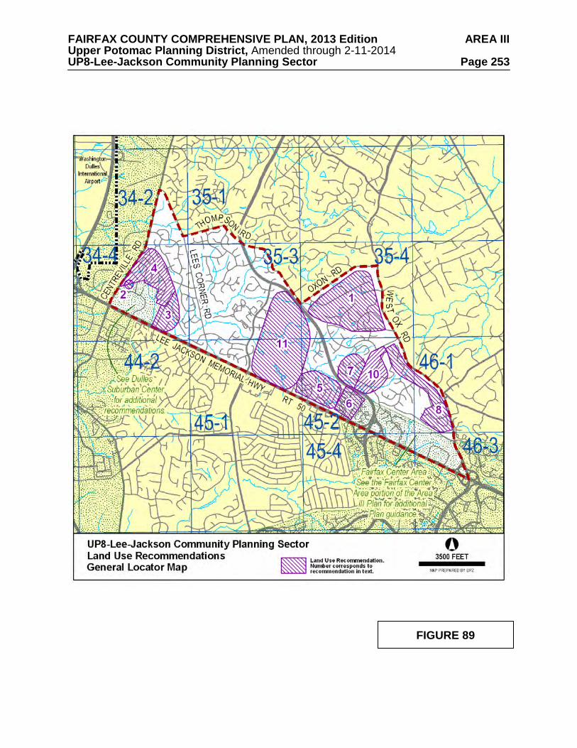
FAIRFAX COUNTY COMPREHENSIVE PLAN, 2013 Edition AREA III Upper Potomac Planning District, Amended through 2-11-2014 UP8-Lee-Jackson Community Planning Sector Page 253
FIGURE 89
FAIRFAX COUNTY COMPREHENSIVE PLAN, 2013 Edition AREA III Upper Potomac Planning District, Amended through 2-11-2014 UP8-Lee-Jackson Community Planning Sector Page 254
• A well-designed pedestrian circulation system with appropriate pedestrian links to
adjacent development should be provided to enable residents and visitors to walk easily to adjacent and nearby commercial and employment facilities.
For either alternative land use, it is desirable for Skyhawk Drive to be extended through the site and connected to Metrotech Drive. The only access to the site should be from Skyhawk Drive extended and not Centreville Road.
3. Chantilly Estates is planned for residential use at 1-2 dwelling units per acre, the current
density. Every effort should be made to protect this stable neighborhood. As an option, tax map parcel 34-4((5))B may be considered for a density of 2-3 dwelling units per acre if: • a solid fence adjacent to nonresidential uses and Lee-Jackson Memorial Highway is
provided, and • a 35 foot vegetated buffer adjacent to nonresidential uses and substantial buffering to
Lee-Jackson Memorial Highway is provided, and • a service drive is constructed along the Route 50 frontage of parcel 34-4((5))B to
provide a connection between Chantilly Road and the gas station at Downs Drive and Lee-Jackson Memorial Highway.
However, if this stable neighborhood should be consolidated in the future, then it should be planned for residential use at a density of 3-4 dwelling units per acre.
Re-development of Chantilly Estates, should not occur without substantial land consolidation and provision of a 35-foot landscaped buffer along the adjacent commercial land to protect the residential community.
4. The area between Armfield Farms and Chantilly Green, Tax Map; 34-4 ((1)) 4, 5, 6; 34-4
((2)) 1-12; 34-4 ((3)) 1-12, is planned for residential use at 3-4 dwelling units per acre. As an option, residential use at 4-5 dwelling units per acre may be considered under the following conditions:
• At a minimum, the land area found for Tax Map 34-2((1)) 18, 34-4((1)) 4, 5, 6, and
85% of the land area of the Ox Hill subdivision, Tax Map 34-4((2)) 1-12 and ((3)) 1-12) should be consolidated. Consolidation should occur in a manner that provides for the future development of any unconsolidated parcels, either to remain at 1 dwelling unit per acre as zoned, or up to the base level density of 3 dwelling units per acre;
• Single-family detached and/or other types of single-family units, such as patio or
zero-lot-line, are appropriate. It should be demonstrated that units types other than single-family detached can be effectively integrated into the community;
• High quality design is a priority in order to foster compatibility with existing adjacent
residential communities; and
• Consider removing the restrictions that allow only emergency vehicle access at the eastern end of Lowe Street, in order to improve traffic circulation. There should be no connection to Springhaven Drive.

FAIRFAX COUNTY COMPREHENSIVE PLAN, 2013 Edition AREA III Upper Potomac Planning District, Amended through 2-11-2014 UP8-Lee-Jackson Community Planning Sector Page 255 5. The area between Lee-Jackson Memorial Highway, Oxlick Branch, the Fairfax County
Parkway, the International Town and Country Club and the Murray Farms subdivision (Tax Map 45-2((1))1A, 2 and 3) is planned for residential use at 2-3 dwelling units per acre. Consolidation of parcels is desirable; at a minimum, development on parcel 3 should provide interparcel access and should not preclude development on parcel 2 in conformance with the Plan.
Development of Tax Map 45-2((1))3 should provide interparcel access to the portion of the Century Oak subdivision located south of the Fairfax County Parkway. Access should be sited to have minimal impact on the EQC.
6. The Murray Farms subdivision south of the Fairfax County parkway is planned for residential use at 1-2 dwelling units per acre. As an option, development may be appropriate at 4-5 dwelling units per acre. Redevelopment of this area should strive to create a sense of community and coordinated and attractive residential development on both sides of Rugby Road. This optional density may be considered under the following conditions:
• East of Rugby Road, full land consolidation is required, excluding church property or
land approved for institutional use. In addition, the following conditions should be met:
a) Development should be compatible with the Fair Woods subdivision to the east; b) Development should occur in a manner that permits future development of
unconsolidated parcels in conformance with the Comprehensive Plan. c) Access and circulation should be coordinated in order to limit the number of
access points to Rugby Road to the greatest extent possible; and
d) Adverse impacts from adjacent institutional uses should be mitigated, incorporating such techniques as screening and buffering.
• West of Rugby Road, an initial land consolidation of a minimum of 12 acres is
required. This initial land consolidation may be satisfied by one or more rezoning applications that are coordinated, fully integrated in terms of design, and concurrently pursued with the County. In addition, the following conditions should be met:
a) New development should mitigate impacts on any existing residential uses on
unconsolidated parcels using techniques such as screening and buffering; and b) Development should occur in a manner that permits future development of
unconsolidated parcels to be unified with the initial consolidation. Unconsolidated parcels may be considered for 4-5 dwelling units per acre if they are designed to be fully integrated with existing (or approved) adjacent development.
c) Traffic circulation should be coordinated to the greatest extent possible, in an
attempt to minimize the number of access points on Rugby Road.
FAIRFAX COUNTY COMPREHENSIVE PLAN, 2013 Edition AREA III Upper Potomac Planning District, Amended through 2-11-2014 UP8-Lee-Jackson Community Planning Sector Page 256 7. Tax Map 45-2((1))1, located north of the Fairfax County Parkway and west of Murray
Farms, is planned for residential use at 2-3 dwelling units per acre which is compatible with the single-family detached development in the immediate vicinity. The portion of Murray Farms west of Rugby Road and north of the Fairfax County Parkway is planned for residential use at a density of 1-2 dwelling units per acre with an option for 2-3 dwelling units per acre. In order for development to occur at a density of 2-3 dwelling units per acre, substantial land consolidation should be provided to ensure that the land use relationships, buffering, access and circulation patterns will be compatible with development in the surrounding area, especially residential areas to the north and west.
8. The land between the Fair Oaks Hospital and West Ox Road, land forming a narrow strip
along West Ox Road south of the Fair Oaks Hospital and land in an older, 35-acre subdivision along Avery Road is planned for residential development at 1-2 dwelling units per acre with an option for 2-3 dwelling units per acre. Development under this option will provide an appropriate transition to the Difficult Run, where the predominant character is large lot residential and conservation/open space use. It is also a density compatible with that of existing adjacent residential development in Fair Oaks Estates.
Substantial land consolidation should be provided for development under this option to ensure that the land use relationships, buffering, access and circulation patterns are compatible with development in the surrounding area. Access to West Ox Road should be minimized and coordinated with major points of access on the northern side of the road. To enhance the residential character of the portion of this area along West Ox Road, consolidation plans should include provision for planting trees and other suitable landscaping in the median of West Ox Road.
9. The Guidelines for Cluster Development contained in the Policy Plan should be strictly
adhered to in this sector. [Not shown] 10. The Fair Oaks Hospital site is approximately 73 acres, generally located north of the
Fairfax County Parkway and east of Rugby Road. Tax Map parcels 45-2((1)) 41B1 and 45-2((2)) 38, 39A, 39B, 46A1 and 51A1 are planned for hospital and related low intensity ancillary medical office, service uses and clinics provided that:
• A substantial vegetated wooded buffer is provided and maintained as undisturbed
open space between such uses and the residential neighborhoods to the north and east; • The campus achieves high-quality architectural and landscape design, and the overall
intensity on the site does not exceed .35 FAR Medical office buildings should be limited to a total of 370,000 square feet of GFA;
• The buffer to be provided and maintained along Rugby Road and Ox Trail will be
115-120 feet in width with the exception of the existing child care center and single- family dwelling where a lesser buffer is provided. In addition, the buffer may be modified to provide for a new vehicular access to Rugby Road and to accommodate related improvements (widening, turn lanes, signal equipment, etc.) to facilitate such access. The buffer will consist of existing vegetation supplemented where necessary with evergreens and other landscaping. Unless deemed essential based on final engineering, no additional storm water management ponds (wet or dry) shall be located in this buffer. Any utilities, to include stormwater pipes or channel improvements, that must be located within this buffer area shall be located and
FAIRFAX COUNTY COMPREHENSIVE PLAN, 2013 Edition AREA III Upper Potomac Planning District, Amended through 2-11-2014 UP8-Lee-Jackson Community Planning Sector Page 257
designed to minimize damage to existing vegetation and should be subject to landscaping to reduce any views into the campus. This buffer is to be measured from the eastern edge of the existing (2009) right-of-way of Rugby Road and Ox Trail;
• A maximum of one new full movement vehicular access point from the hospital
campus to Rugby Road may be provided so long as the following criteria are satisfied:
a) The new vehicular access should not align with the intersection of Misty Creek
Lane; b) Joseph Siewick Drive should not be realigned to intersect Rugby Road/Ox Trail in
a full intersection with Misty Creek Lane;
c) In the vicinity of the new vehicular access, screening should be provided and/or supplemented to minimize visual impacts on nearby residences, including landscaping and/or architectural barrier features harmonious with the surrounding residential community.
• A quality site layout should be provided, including appropriate pedestrian and bicycle
connections linking the medical campus to existing sidewalks on the periphery and within the site, walking paths with landscaped seating and picnic areas for employees and visitors to the hospital, and appropriate screening against neighboring residential uses;
• A Transportation Demand Management (TDM) program should be formulated and
implemented to mitigate traffic associated with development on the Fair Oaks Hospital site in excess of .30 FAR. One element of the program should be an ongoing commitment from the hospital to the County to support continuing bus service to the Hospital and to contribute toward the installation and maintenance of necessary bus shelters on the Hospital campus. The TDM program should include a ride sharing program and consideration should be given to programs that will facilitate employee use of public transportation;
• Due to the importance of providing public transportation to the site, it is expected that
the hospital will allow direct bus access through the site to provide convenient stops for visitors and employees;
• Building height for the main hospital buildings and additions thereto shall be limited
to a maximum of 100 feet. All other buildings shall be limited to a maximum of 60 feet in height to minimize visual impacts on the residential community;
• Parking structures will be designed to minimize visual impacts on adjacent residential
neighborhoods and the design and materials of the structures will be integrated with that of the buildings they serve. Recognizing the nuisance aspects of unfocused light emissions, efforts will be made to minimize light emissions that create sources of glare which may interfere with residents’ and travelers’ visual acuity. Landscaping will be provided on the parking structures and/or adjacent to them to make them more attractive and to soften their appearance. Opportunity for additional screening measures will be evaluated at time of rezoning. The applicant should, in consultation with the County’s Urban Forester, determine appropriate species and types of native and noninvasive vegetation;
FAIRFAX COUNTY COMPREHENSIVE PLAN, 2013 Edition AREA III Upper Potomac Planning District, Amended through 2-11-2014 UP8-Lee-Jackson Community Planning Sector Page 258
• All rooftop mechanical equipment is screened. In addition, no antennae will be located on building rooftops other than the main hospital building and additions thereto, except as may be required for public safety purposes;
• Monopoles are excluded from the hospital campus; • Visual impacts are further minimized through building setback and site design
features such as berms, fences and landscaping treatments; • No additional parking, including above or underground parking structures, other than
what existed in September, 1994 shall be located between the medical campus and Fair Oaks Estates; and
• A detailed traffic impact analysis should be done to determine any additional
improvements required to mitigate the impacts of additional development on the street network in the vicinity of the development.
The southern 7.5-acre portion (Tax Map 45-2((1))42) of this site is owned by the Fairfax County Park Authority and is planned for a public park. Tax Map 45-2((2))38, 39A and 39B and 45-2((6))A1, K2 and L1 are also planned for a public park and should be dedicated to the Fairfax County Park Authority. Density credit is appropriate for any land dedicated for right-of-way or public park use, as provided for in the Fairfax County Zoning Ordinance.
11. The International Town and Country Club land is planned for private recreation use and should be maintained through tax incentives when development pressure reduces its economic viability. Public acquisition for park purpose should be considered as an alternative preservation measure.
Transportation
Transportation recommendations for this sector are shown on Figures 90, 91 and 92. In some instances, site-specific transportation recommendations are included in the land use recommendations section. The figures show access orientation, circulation plans, interchange impact areas and generalized locations of proposed transit facilities. The recommendations contained in the Area Plan text and maps, the Policy Plan and Transportation Plan map, policies and requirements in the Public Facilities Manual, the Zoning Ordinance, and other standards will be utilized in the evaluation of development proposals. See text for Community Planning Sectors UP6 and UP7 for a description of transportation considerations for Centreville Road. Heritage Resources There are numerous prehistoric and historic archaeological sites in the vicinity of Upper Cub Run and of Lee-Jackson Memorial Highway which should be evaluated as to their need for protection. Chantilly Plantation Stone House is located on the grounds of the International Town and Country Club (Tax Map 45-1((1))11) on Route 50. It is a well-maintained site which may become subject to redevelopment pressure. Its preservation should be insured.

FAIRFAX COUNTY COMPREHENSIVE PLAN, 2013 Edition AREA III Upper Potomac Planning District, Amended through 2-11-2014 UP8-Lee-Jackson Community Planning Sector Page 259 Navy School (Tax Map 45-2((1))6) should be preserved or moved to another site. If this is not feasible, the site should be thoroughly documented for its historic value. Part of the Sully Historic Overlay District lies within this sector. Regulations for this district are discussed in section BR1 of the Bull Run Planning District Any development or ground disturbance in this sector, both on private and public land, should be preceded by heritage resource studies, and alternatives should be explored for the avoidance, preservation or recovery of significant heritage resources that are found. In those areas where significant heritage resources have been recorded, an effort should be made to preserve them. If preservation is not feasible, then, in accordance with countywide objectives and policies as cited in the Heritage Resources section of the Policy Plan the threatened resource should be thoroughly recorded and in the case of archaeological resources, the artifacts recovered. Public Facilities 1. An elementary school site, possibly in combination with an active recreation park site
should be located in the area between Armfield Farms and the intersection of Lee-Jackson Memorial Highway and Centreville Road. The school site should have a minimum of 14 acres, and include ballfields or other facilities for active recreation use for the community.
2. Provide additional finished water transmission facilities along the Route 50 corridor
between Rugby Road and Stringfellow Road. Parks and Recreation
Parks and recreation recommendations for this sector are shown on Figure 93. The column "Park Classification" includes existing park facilities. The "Recommendations" column includes entries for both existing and proposed facilities. Prior to developing parkland, the Fairfax County Park Authority initiates a master planning process to determine the appropriate facilities and design for that park. This process involves extensive citizen review and participation. If an existing park is listed but no recommendation appears on that line, it means the park has been developed in accordance with its master plan. Trails Trails planned for this sector are delineated on Figure 94 and on the 1”:4,000’ Countywide Trails Plan Map which is referenced as Figure 2 in the Transportation element of the Policy Plan and is available from the Department of Planning and Zoning. Trails in this sector are an integral part of the overall County system. While some of the segments have already been constructed, the Countywide Trails Plan Map portrays the ultimate system for the sector and the County at large. In addition, the map specifies a classification for each segment, which represents the desired ultimate function and surface type of the trail. Specific construction requirements are detailed in the Public Facilities Manual.
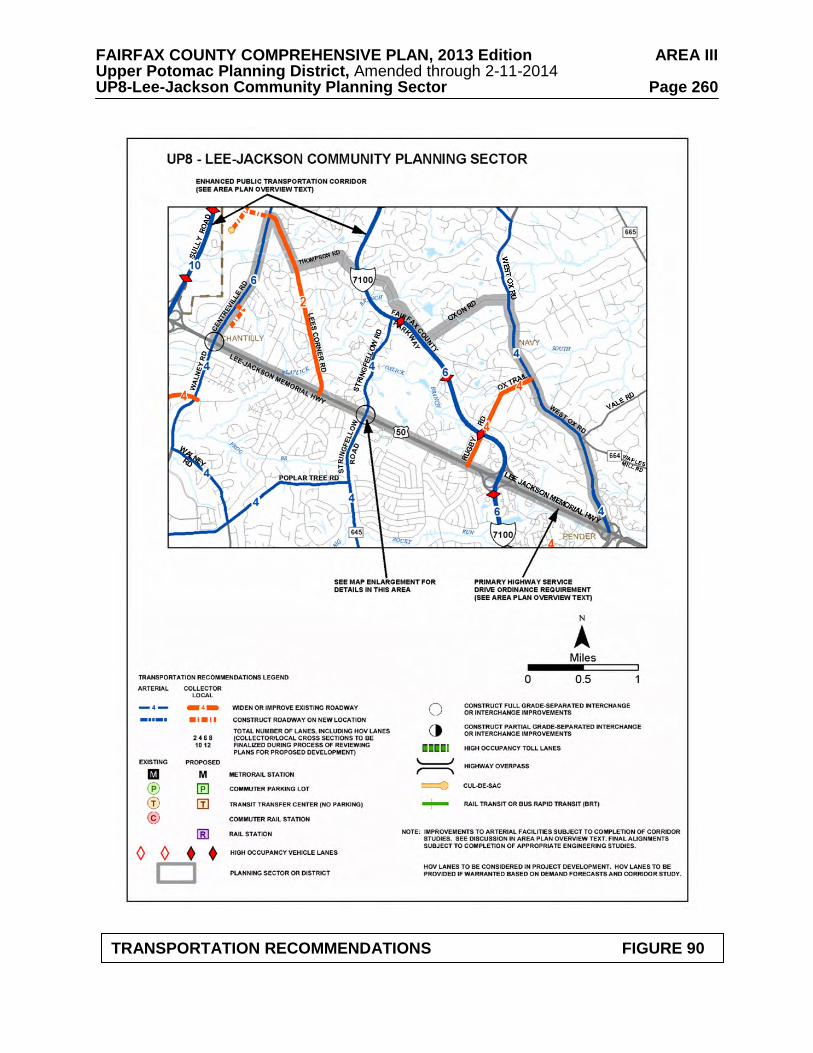
FAIRFAX COUNTY COMPREHENSIVE PLAN, 2013 Edition AREA III Upper Potomac Planning District, Amended through 2-11-2014 UP8-Lee-Jackson Community Planning Sector Page 260
TRANSPORTATION RECOMMENDATIONS FIGURE 90
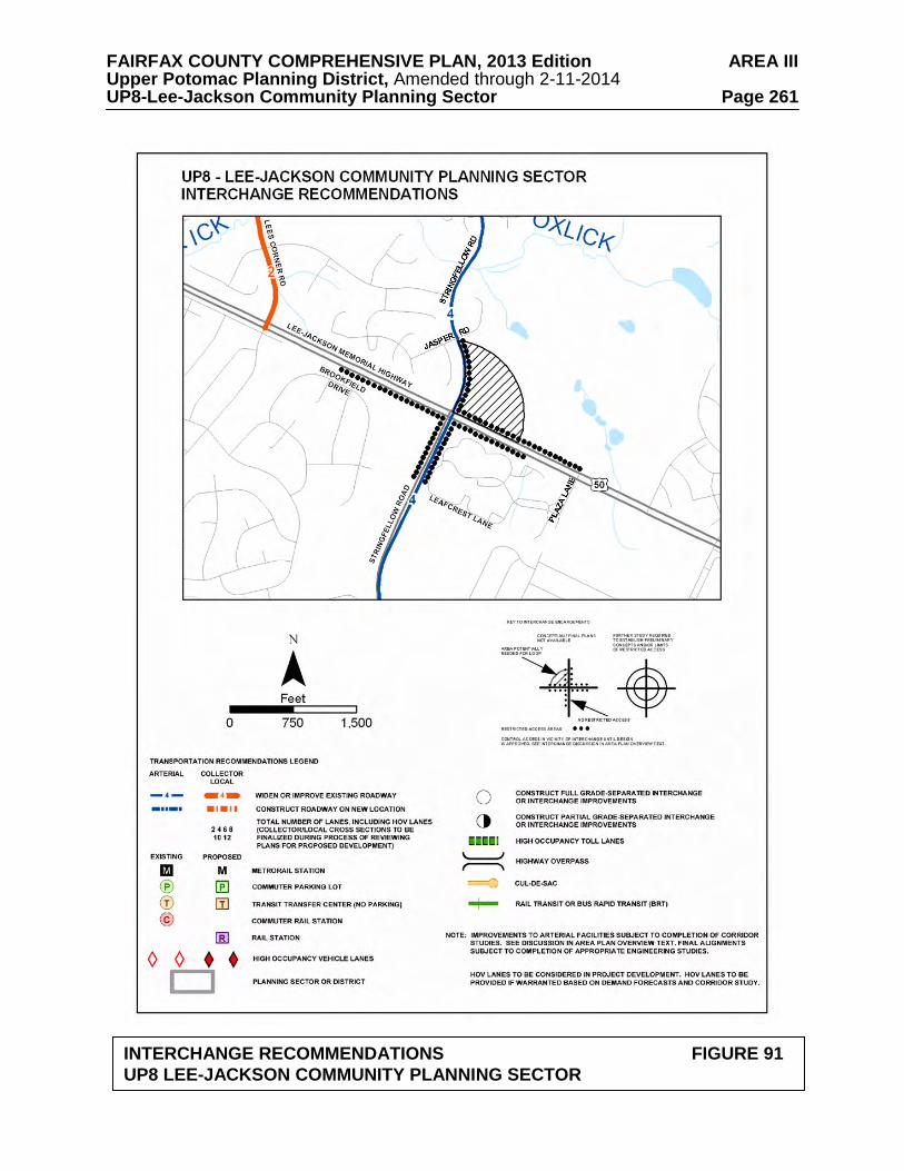
FAIRFAX COUNTY COMPREHENSIVE PLAN, 2013 Edition AREA III Upper Potomac Planning District, Amended through 2-11-2014 UP8-Lee-Jackson Community Planning Sector Page 261
INTERCHANGE RECOMMENDATIONS FIGURE 91
UP8 LEE-JACKSON COMMUNITY PLANNING SECTOR

FAIRFAX COUNTY COMPREHENSIVE PLAN, 2013 Edition AREA III Upper Potomac Planning District, Amended through 2-11-2014 UP8-Lee-Jackson Community Planning Sector Page 262
INTERCHANGE AND ACCESS RECOMMENDATIONS FIGURE 92 UP8 LEE-JACKSON COMMUNITY PLANNING SECTOR
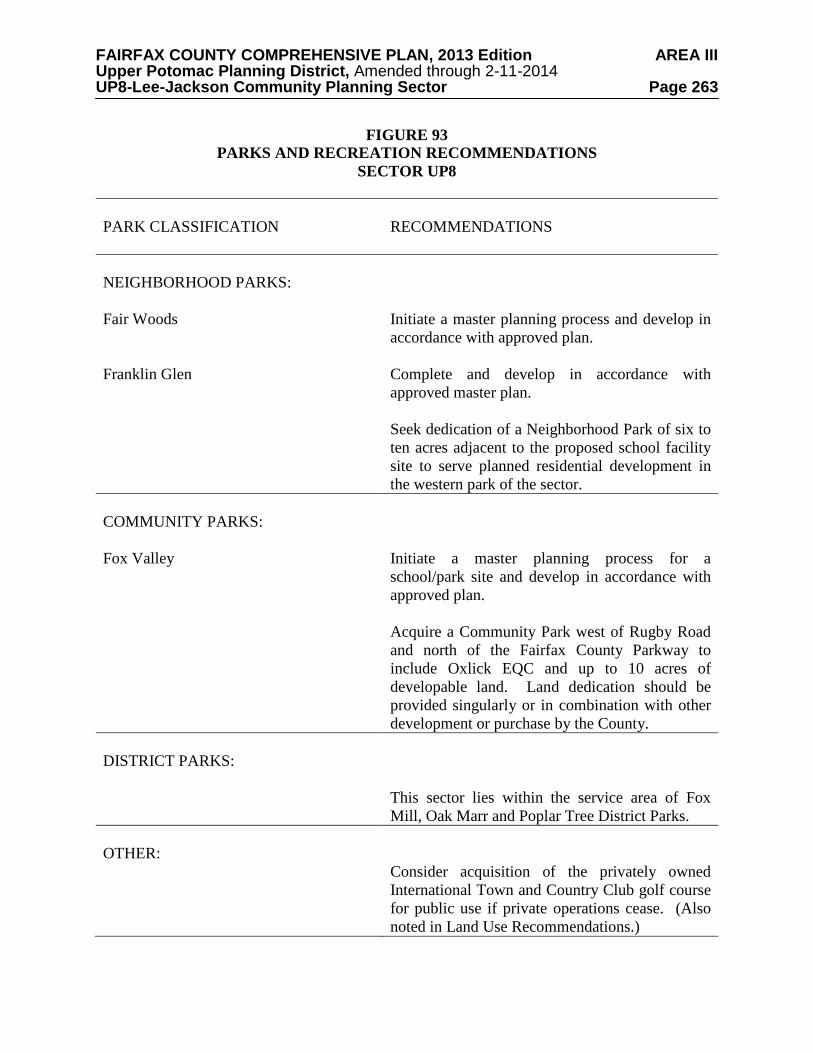
FAIRFAX COUNTY COMPREHENSIVE PLAN, 2013 Edition AREA III Upper Potomac Planning District, Amended through 2-11-2014 UP8-Lee-Jackson Community Planning Sector Page 263
FIGURE 93 PARKS AND RECREATION RECOMMENDATIONS
SECTOR UP8 PARK CLASSIFICATION
RECOMMENDATIONS
NEIGHBORHOOD PARKS: Fair Woods Franklin Glen
Initiate a master planning process and develop in accordance with approved plan. Complete and develop in accordance with approved master plan. Seek dedication of a Neighborhood Park of six to ten acres adjacent to the proposed school facility site to serve planned residential development in the western park of the sector.
COMMUNITY PARKS: Fox Valley
Initiate a master planning process for a school/park site and develop in accordance with approved plan. Acquire a Community Park west of Rugby Road and north of the Fairfax County Parkway to include Oxlick EQC and up to 10 acres of developable land. Land dedication should be provided singularly or in combination with other development or purchase by the County.
DISTRICT PARKS:
This sector lies within the service area of Fox Mill, Oak Marr and Poplar Tree District Parks.
OTHER:
Consider acquisition of the privately owned International Town and Country Club golf course for public use if private operations cease. (Also noted in Land Use Recommendations.)
FAIRFAX COUNTY COMPREHENSIVE PLAN, 2013 Edition AREA III Upper Potomac Planning District, Amended through 2-11-2014 UP8-Lee-Jackson Community Planning Sector Page 264
TRAILS PLAN MAP FOR THIS SECTOR UNDER CONSTRUCTION
SEE THE 1” = 4000’ SCALE
COUNTYWIDE TRAILS PLAN MAP
PLANNED TRAIL SYSTEM FIGURE 94