Embed Size (px)
Citation preview

Upper Ordovician and Silurian Stratigraphy in Sequatchie Valley and Parts of the Adjacent Valley and Ridge, Tennessee
GEOLOGICAL SURVEY PROFESSIONAL PAPER 996
Prepared in cooperation with the Tennessee Division of Geology

Upper Ordovician and Silurian Stratigraphy in Sequatchie Valley and Parts of the Adjacent Valley and Ridge, Tennessee
By ROBERT C. MILICI and HELMUTH WEDOW, JR.
GEOLOGICAL SURVEY PROFESSIONAL PAPER 996
Prepared in cooperation with the Tennessee Division of Geology
UNITED STATES GOVERNMENT PRINTING OFFICE, WASHINGTON 1977
UNITED STATES DEPARTMENT OF THE INTERIOR
CECIL D. ANDRUS, Secretary
GEOLOGICAL SURVEY
V. E. McKelvey, Director
Library of Congress Cataloging in Publication Data
Milici, Robert C 1931-Upper Ordovician and Silurian stratigraphy in Sequatchie Valley and parts of the adjacent valley and ridge,
Tennessee. (Geological Survey professional paper; 996) Bibliography: p. Supt. of Docs. no.: I 19.16:996 1. Geology, Stratigraphic--Ordovician. 2. Geology, Stratigraphic--Silurian. 3. Geology--Tennessee--Sequatchie
Valley. 4. Geology--Tennessee--Chattanooga region. I. Wedow, Helmuth, 1917- joint author. II: Title. Upper Ordovician and Silurian stratigraphy in Sequatchie Valley .... III. Series: United States. Geological Survey. Professional paper; 996.
QE660.M54 551.7'310976877 76-608170
For sale by the Superintendent of Documents, U.S. Government Printing Office Washington, D.C. 20402
Stock Number 024-001-03002·1
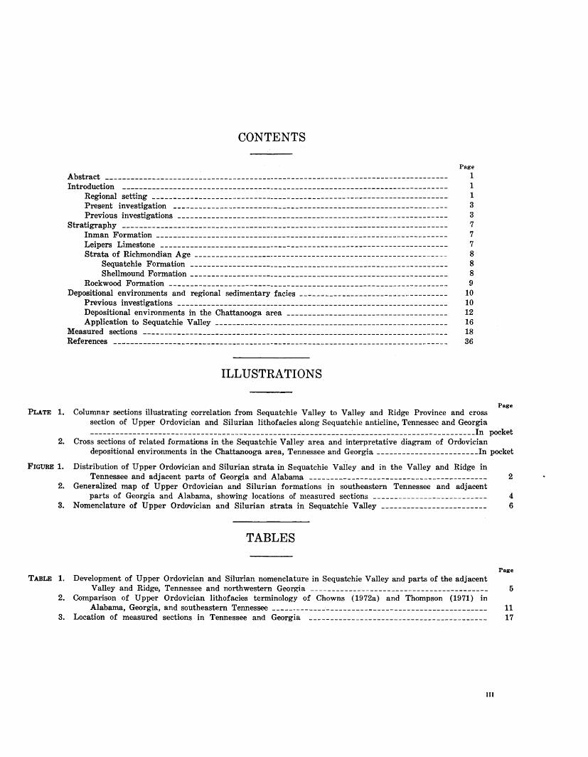
CONTENTS
Abstract
Introduction -----------------------------------------------------------------------------Regional setting ----------------------------------------------------------------------Present investigation ____________________ ----- _____________________________ ------ ____ -Previous investigations ___________________ ---- _______ --- ______ -- __ ---------------------
Stratigraphy ----------------------------------------------------------------------------Inman Formation ---------------------------------------------------------------------Leipers Limestone --------------------------------------------------------------------Strata of Richmondian Age ------------------------------------------------------------
Sequatchie Formation -------------------------------------------------------------Shellmound Formation ________________ ---- ________________________________ - --------
Rockvvood Fortnation ------------------------------------------------------------------Depositional environments and regional sedimentary facies -----------------------------------
Previous investigations ________ -------- _____________________________________ --- ______ --
Depositional environments in the Chattanooga area -------------------------------------Application to Sequatchie Valley -------------------------------------------------------
~easured sections ------------------------------------------------------------------------References -------------------------------------------------------------------------------
ILLUSTRATIONS
Page
1 1 1 3 3 7 7 7 8 8 8 9
10 10 12 16 18 36
PLATE 1. Columnar sections illustrating correlation from Sequatchie Valley to Valley and Ridge Province and cross section of Upper Ordovician and Silurian lithofacies along Sequatchie anticline, Tennessee and Georgia
Page
----- __ ------ _________________________________________________ , _____________________________ In pocket
2. Cross sections of related fortnations in the Sequatchie Valley area and interpretative diagram of Ordovician depositional environments in the Chattanooga area, Tennessee and Georgia ________________________ In pocket
FIGURE 1. Distribution of Upper Ordovician and Silurian strata in Sequatchie Valley and in the Valley and Ridge in Tennessee and adjacent parts of Georgia and Alabama ------------------------------------------ 2
2. Generalized map of Upper Ordovician and Silurian formations in southeastern Tennessee and adjacent parts of Georgia and Alabama, shovving locations of measured sections --------------------------- 4
3. Nomenclature of Upper Ordovician and Silurian strata in Sequatchie Valley ------------------------- 6
TABLES
Page
TABLE 1. Development of Upper Ordovician and Silurian nomenclature in Sequatchie Valley and parts of the adjacent Valley and Ridge, Tennessee and northvvestern Georgia ------------------------------------------ 5
2. Comparison of Upper Ordovician lithofacies terminology of Chowns (1972a) and Thompson (1971) in Alabama, Georgia, and southeastern Tennessee --------------------------------------------------- 11
3. Location of measured sections in Tennessee and Georgia ------------------------------------------ 17
III
METRIC-ENGLISH EQUIVALENTS Metric unit
millimetre (mm) metre (m) kilometre (km)
square metre (m2) square kilometre (km2) hectare (ha)
cubic centimetre (em~) litre (I) cubic metre (m3) cubic metre cubic hectometre (hm3) litre litre litre cubic metre
cubic metre
gram (g) gram tonne (t) tonne
English equivalent
Length
0.039:37 inch (in) :{.28 feet (ft)
.62 mile (mi)
Area
10.76 .386
2.47
Volume
0.061 61.0X 35.31
.00081 =810.7
2.113 1.06 .26 .00026
6.290
Weight
0.035 .0022
1.1 .98
square feet (ft2) square mile ( mi2) acres
cubic inch (ina) cubic inches cubic feet (ft3) acre-foot (acre-ft) acre-feet pints (pt) quarts (qt) gallon (gal) million gallons (Mgal or
10a gal) barrels (bbl) (1 bbl=42 gal)
ounce, avoirdupois ( oz avdp) pound, avoirdupois (lb avdp) tons, short (2,000 lb) ton, long (2,240 lb)
Specific combinations
kilogram per square centimetre (kg/cm2)
kilogram per square centimetre
cubic metre per second (ma;s)
0.96
.98
35.3
atmosphere (atm)
bar (0.9869 atm)
cubic feet per second (ft3js)
Metric unit English equivalent
Specific combinations-Continued
litre per second (1/s) .0353 cubic foot per second cubic metre per second
per square kilometre [ (ms;s) /km2]
metre per day (m/11)
metre per kilometre (m/km)
kilometre per hour (km/h)
metre per second (m/s) metre squared per day
(m2/d)
cubic metre per second (mSjs)
cubic metre per minute (m3/min)
litre per second (1/s) litre per second per
metre [ (1/s) /m]
kilometre per hour (km/h)
metre per second (m/s) gram per cubic
centimetre (g/cm3 )
gram per square centimetre (g/cm2)
gram per square centimetre
degree Celsius (°C) degrees Celsius
(temperature)
!ll.47
B.28
rl.28
.9113 3.28
10.764
= 22.826
=264.2 15.85
4.83
.62 2.237
62.43
2.04R
.0142
cubic feet per second per square mile [ (fta;s) /ml2]
feet per day (hydraulic conductivity) (ft/d)
feet per mile ( ft/mi)
foot per second (ft/R) feet per second
feet squared per day (ftl!fd) (transmissivity)
million gallons per day (Mgal/d)
gallons per minute (gal/min) gallons per minute
gallons per minute per foot [(gal/min) /ft]
mile per hour (mi/h) miles per hour
pounds per cubic foot (lb/ft3 )
pounds per square foot (lb/ft2)
pound per square inch (lb/in2)
Temperature
1.8 degrees Fahrenheit (°F)
=[(1.8X°C)+32] degrees Fahrenheit
UPPER ORDOVICIAN AND SILURIAN STRATIGRAPHY IN SEQUATCHIE VALLEY AND PARTS OF THE ADJACENT
VALLEY AND RIDGE, TENNESSEE
By RoBERT C. MILICI 1 and HELMUTH WEnow, JR.
ABSTRACT
The Inman, Leipers, Sequatchie, and Shellmound Formations constitute the Upper Ordovician strata exposed in Sequatchie Valley and parts of the adjacent Valley and Ridge in southeastern Tennessee. These rocks are underlain by the Catheys Limestone (Middle Ordovician) and overlain by the Rockwood Formation (Silurian). The Rockwood, in turn, includes all Silurian strata of this region, being underlain by beds of the Sequatchie-Shellmound sequence and overlain, unconformably, by the Chattanooga Shale (Upper Devonian and Mississippian). As originally defined by C. W. Hayes in 1891, the Rockwood included all strata between the Chickamauga Limestone (Middle Ordovician) and the younger Chattanooga Shale. In 1911, E. 0. Ulrich redefined the lower or older part of Hayes' Rockwood as the Sequatchie Formation, restricting the name Rockwood to the upper or younger part of the sequence.
The Inman Formation contains calcareous red beds in southern Sequatchie Valley and in Lookout Valley .and is all gray or greenish gray to the northeast. The Leipers Limestone is a fairly homogeneous, extensively burrowed, gray argillaceous limestone. The Sequatchie Formation consists of grayish-red and greenish-gray calcareous mudstones and calcisiltites. The formation generally lacks skeletal fossils but some beds are abundantly burrowed, some are laminated, some contain numerous intraclasts, and others show desiccation features such as mudcracks and birdseyes. The Sequatchie grades southwestward into the Shellmound Formation, a shelly limestone and shale sequence that also contains ironbearing sedimentary rocks.
The Rockwood Formation consists of shale and limestone of Early and Middle Silurian age. In northern Sequatchie Valley the formation consists of a few feet of cherty limestone, the Skillern Chert Member (new name) . To the southwest along Sequatchie anticline the formation thickens considerably and consists of terrigenous shale and fine sandstone interbedded with limestone. In the Valley and Ridge, to the east of Sequatchie anticline, terrigenous shales and sandstones dominate much thicker sections, and limestone is present in only small amounts. The Rockwood contains locally abundant sedimentary hematite zones that formerly were mined as iron ore.
The Upper Ordovician-Silurian beds can be interpreted as representing a regressive-transgressive sequence. Upper
1 Tennessee Division of Geology.
Ordovician mudflat deposits prograded seaward and graded laterally into marine deposits. Subsidence and drowning of these littoral deposits was followed by deposition of a postTaconic Silurian molasse.
INTRODUCTION
REGIONAL SETTING
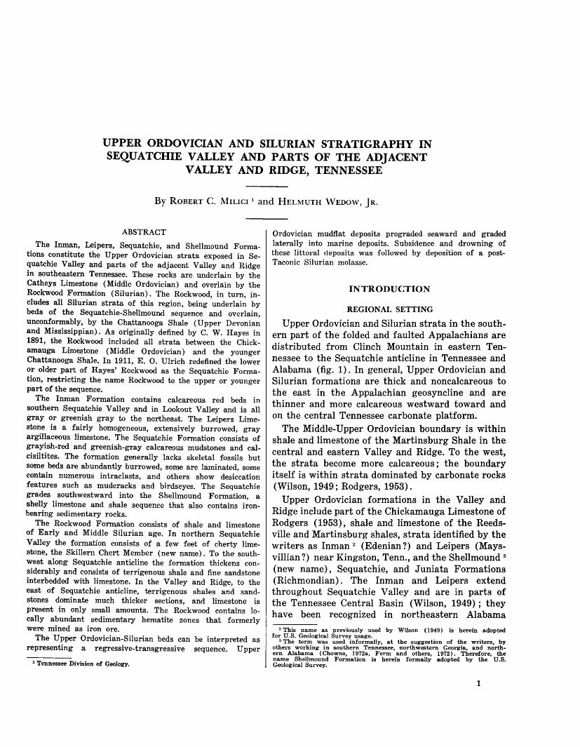
Upper Ordovician and Silurian strata in the southern part of the folded and faulted Appalachians are distributed from Clinch Mountain in eastern Tennessee to the Sequatchie anticline in Tennessee and Alabama (fig. 1). In general, Upper Ordovician and Silurian formations are thick and noncalcareous to the east in the Appalachian geosyncline and are thinner and more calcareous westward toward and on the central Tennessee carbonate platform.
The Middle-Upper Ordovician boundary is within shale and limestone of the Martinsburg Shale in the central and eastern Valley and Ridge. To the west, the strata become more calcareous; the boundary itself is within strata dominated by carbonate rocks (Wilson, 1949; Rodgers, 1953).
Upper Ordovician formations in the Valley and Ridge include part of the Chickamauga Limestone of Rodgers (1953), shale and limestone of the Reedsville and Martinsburg shales, strata identified by the writers as Inman 2 (Edenian ?) and Leipers (Maysvillian ?) near Kingston, Tenn., and the Shellmound 3
(new name), Sequatchie, and Juniata Formations (Richmondian). The Inman and Leipers extend throughout Sequatchie Valley and are in parts of the Tennessee Central Basin (Wilson, 1949); they have been recognized in northeastern Alabama
2 This name as previously used by Wilson (1949) is herein adopted for U.S. Geological Survey usage.
3 The term was used informally, at the suggestion of the writers, by others working in southern Tennessee, northwestern Georgia, and northern Alabama ( Chowns, 1972a, Ferm and others, 1972) . Therefore, the name Shellmound Formation is herein formally adopted by the U.S. Geological Survey.
1
---... ----~~---------
fQ\,\)<t;, c§:J~- I
~~~~~~~ ., ~9.dV
r"" ~ - --~ U" l.._ ~0~
0 25 50 75 MILES I I I I I I I I I II I I I I
0 25 50 75 KILOMETERS
340 ;;:;,'~,ir;!,,l:,i:,i!':iW~~~ ~ { I I I I
FIGURE !.-Distribution of Upper Ordovician and Silurian strata in Sequatchie Valley and in the Valley and Ridge in Tennessee and adjacent parts of Georgia and Alabama. Light shading (stippled pattern), Cambrian to Mississippian rocks; heavy shading, Upper Ordovician and Silurian strata; medium shad-ing, Pennsylvanian rocks.
~
c:: "tt "tt l:.%j pj
0 pj I:' 0 <! 1-1 Cl 1-1
> z > z I:' Ul 1-1 ~ q pj 1-1
> z Ul ~ pj
> 1-3 1-1
0 pj
> "tt ::tl !< 1-3 l:.%j
z z t_':l:j Ul Ul t_':l:j t_':l:j
INTRODUCTION 3
(Neathery and others, 1969) but are absent in Whiteoak Mountain syncline in the south-central Tennessee Valley and Ridge, where the Sequatchie overlies the Catheys lithosome.
The Juniata Formation (Richmondian) on Clinch Mountain in eastern Tennessee consists of 400 ft ( 120 m) of predominantly non calcareous red beds (Rodgers, 1953). Equivalent strata to the west are thinner and more calcareous and were named Sequatchie by Ulrich (1911).
In the Valley and Ridge the Ordovician-Silurian boundary is between the Sequatchie and Juniata red beds below and the sandstone, siltstone, and shale of the Clinch and Rockwood above. Silurian strata range from Clinch and younger quartzitic sandstone on Clinch Mountain, through the Rockwood sandstone, siltstone, shale, and limestone in the western Valley and Ridge and in Sequatchie Valley, to the shale and limestone formations of central Tennessee. Silurian formations are usually overlain by the Chattanooga Shale (Devonian and Mississippian), although in places other beds (Wildcat Valley Formation) may intervene (Dennison and Boucot, 1969).
The geographic boundary between the Sequatchie and Juniata facies (Rodgers, 1953, p. 97) depends on the respective presence or absence of marine fossils and on the relative amounts of calcareous and terrigenous materials. On the geologic map of east Tennessee, Rodgers (1953) placed the SequatchieJuniata facies boundary between Clinch Mountain on the southeast and Powell Mountain on the northwest. On the other hand, Hardeman and others (1966), in their compilation for the most recent State geologic map of Tennessee, used the term Juniata for this sequence of rocks, not only for the Clinch Mountain and Powell Mountain belts but also as far northwest as Wallen Ridge.
In contrast with these compilations, detailed geologic quadrangle maps of northeastern Tennessee and southwestern Virginia by the U.S. Geological Survey (Harris and Miller, 1958; 1963), the Virginia Division of Mineral Resources (Brent, 1963), and the Tennessee Division of Geology (Brent, in press) have called red beds on Clinch Mountain Sequatchie rather than Juniata. This placement of the boundary would indicate that perhaps no nonmarine Upper
,). D.rdil¥ieier·~t..aY"..c;#..~ present in Tennessee.
PRESENT INVESTIGA. TION
The purposes of this study are: to define and describe the stratigraphy and gross sedimentary environments of the Inman, Leipers, Sequatchie, Shellmound, and Rockwood Formations in Sequatchie
Valley; to establish a standard section for the Rockwood Formation; and to correlate Upper Ordovician and Silurian strata from Sequatchie Valley to the southwestern Valley and Ridge.
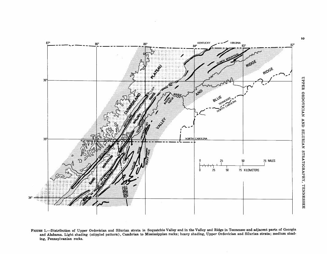
The writers have at different times studied the stratigraphy of Upper Ordovician and Silurian rocks in Sequatchie Valley and the Valley and Ridge. During the 1940's Wedow (1960) measured numerous Upper Ordovician and Silurian sections in Tennessee and adjacent parts of Alabama and Georgia. More recently Milici (Coker and Milici, in press; Coker, Milici, and Finlayson, 1967 ; Garman and Milici, 1967; Milici, 1965 and in press; Milici and Coker, 1967; Milici, Coker, and Garman, in press; Milici, Coker, and Luther, 1972; Milici and Finlayson, 1967 and in press ; and Milici, Finlayson, Barnes, and Colvin, in press) mapped the same strata throughout Sequatchie Valley and has measured sections there and in adjacent areas. This paper represents a synthesis of research performed and interpretations generated by the writers. Locations of measured sections are shown in figure 2 and are described in tables.
The writers are particularly indebted to Dr. Richard E. Bergenback of the University of Tennessee at Chattanooga for his interest and assistance in the study of the depositional environments of the Sequatchie Formation and for making available his unpublished data of the Green Gap section. Thin sections were prepared in the geological laboratory of the University of Tennessee at Chattanooga. Parts of the manuscript were reviewed by Dr. Kenneth E. Walker, University of Tennessee at Knoxville.
PREVIOUS INVESTIGATIONS
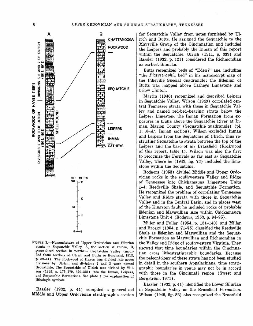
The Rockwood Formation was named by Hayes (1891, p. 143) for exposures then available at Rockwood, Roane County, Tenn. (table 1). As defined by Hayes, Rockwood included all strata between his Chickamauga Limestone and the Chattanooga Shale. The Rockwood thus consisted of strata previously assigned by Safford (1869) to the transition beds, White Oak Mountain Sandstone, and the Dyestone Group.
Initially the Knox, Chickamauga, and Rockwood Formations were considered Silurian by the U.S. Geological Survey (Hayes, 1894 a, b, c; 1895 a, b, c). Subsequently, the Upper Knox, Chickamauga, and Cincinnatian rocks were assigned an Ordovician age (Twenhofel and others, 1954).
Ulrich (in Burchard, 1913, p. 32-41) divided the Rockwood Formation of Hayes into seven subdivisions. Division 1 was recognized only in the White-
4 UPPER ORDOVICIAN AND SILURIAN STRATIGRAPHY, TENNESSEE
36~0·~------------~a~s~~o~·------------------------------~s~~----------------------------~,
Crossville •
15 I
20 I
0 5 I II II I I II 1) I
10 I
I 15
I 20
I 25 MILES I
0 5 10 25 KILOMETERS
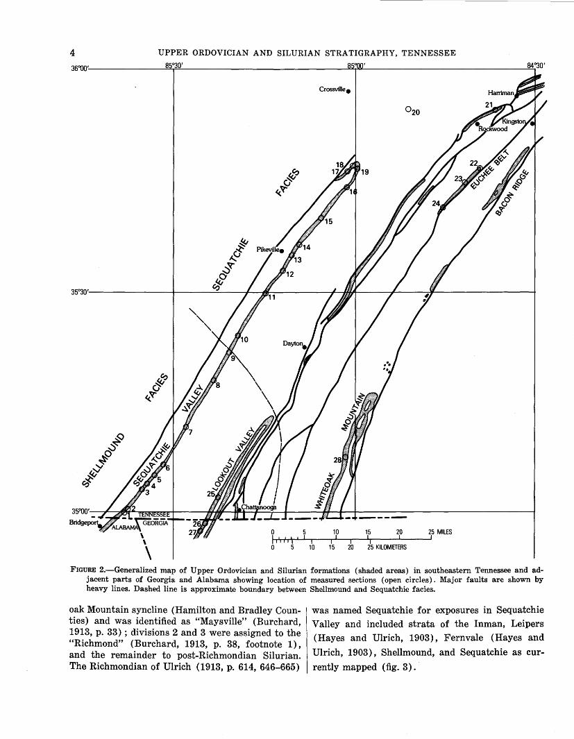
FIGURE 2.-Generalized map of Upper Ordovician and Silurian formations (shaded areas) in southeastern Tennessee and adjacent parts of Georgia and Alabama showing location of measured sections (open circles). Major faults are shown by heavy lines. Dashed line is approximate boundary between Shellmound and Sequatchie facies.
oak Mountain syncline (Hamilton and Bradley Counties) and was identified as "Maysville" (Burchard, 1913, p. 33) ; divisions 2 and 3 were assigned to the "Richmond" (Burchard, 1913, p. 38, footnote 1), and the remainder to post-Richmondian Silurian. The Richmondian of Ulrich (1913, p. 614, 646-665)
was named Sequatchie for exposures in Sequatchie
Valley and included strata of the Inman, Leipers
(Hayes and Ulrich, 1903), Fernvale (Hayes and
Ulrich, 1903), Shellmound, and Sequatchie as cur
rently mapped (fig. 3).
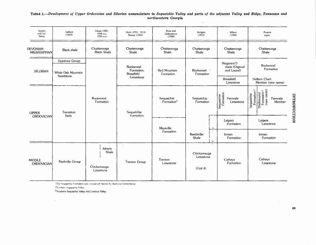
TABLE !.-Development of Upper Ordovician and Silurian nomenclature in Sequatchie Valley and parts of the adjacent Valley and Ridge, Tennessee and northwestern Georgia
System and (or)
Series
DEVONIANMISSISSIPPIAN
SILURIAN
UPPER ORDOVICIAN
MIDDLE ORDOVICIAN
Safford (1869)
Black shale
Dyestone Group
White Oak Mountain Sandstone
Transition beds
Nashville Group
Hayes (1891 1894 a-c. 1R95 a-c)
Chattanooga Black Shale
Rockwood Formation
I I Athens 1 Shale I
Chickamauga Limestone
I
I
Ulrich (1911. 1913) Bassler (1932)
Chattanooga Shale
Rockwood Formation,
Brassfield Limestone
Sequatchie Formation
Trenton Group
!The Sequatchie Formation was considered 'Silurian h~· Butts and Gildersleeve
2'\, >rthern Sequatchie Vallet·
3 Southern Sequatchie Valley and Lookout Valley
I
I
Butts and Gildersleeve
(1948)
Chattanooga Shale
Red Mountain Formation
Sequatchie Formation 1
~-------
Maysville Formation
Trenton Limestone
Rodgers (1953)
J
Chattanooga Shale
Rockwood Formation
Sequatchie Formation
r I
Wilson (1949)
Chattanooga Shale
Niagaran(?) shale (Osgood and Laurel)
Brassfield Limestone
c: ~ 0
~ ~ Fernvale ~ 6 Limestone O'L.L. ~
rJ)
Present repon
Chattanooga Shale
Rockwood Formation
Skillern Chert
~
c: .9! ._g ..c tO .8 E tO .... :I 0 O'u..
~
Member (new name)
"'c:~ c: E ~ 5 tO c: E E :3 ~~ ~ ..c -rJ)
Fern vale Member
Leipers .Formation
Leipers Limestone
L?JL---+-----1 .
Inman Formation
Inman Formation
Reedsville Shale I ----~~JL~==-~-----
Chickamauga Limestone
(Unit 4)
Catheys Formation
Catheys Limestone
~ z 1-3 ~ 0 t:::1 c= 0 1-3 ~
0 z
C1l
6 UPPER ORDOVICIAN AND SILURIAN STRATIGRAPHY, TENNESSEE
en - z en o ~ ~ -> en i5 w
~ ~
IL. 0 ::I:
u 0 iE 0 ...J 0 ;::) 3: ~ u 0 l:t:
en z 0 (ij
> 0
A 8 CHATTANOOGA
ROCKWOOD
SEQUATCHIE
LEIPERS
INMAN
CATHEYS
FIGURE 3.-Nomenclature of Upper Ordovician and Silurian strata in Sequatchie Valley. A, ·the section at Inman, B, generalized section in northern Sequatchie Valley (modified from sections of Ulrich and Butts in Burchard, 1913, p. 39-41). The Rockwood of Hayes was divided into seven divisions by Ulrich, and divisions 2 and 3 were named Sequatchie. The Sequatchie of Ulrich was divided by Wilson (1949, p. 175-179, 320-321) into the Inman, Leipers, and Sequatchie Formations. See plate 1 for explanation of lithologic symbols.
Bassler (1932, p. 41) compiled a generalized Middle and Upper Ordovician stratigraphic section
for Sequatchie Valley from notes furnished by Ulrich and Butts. He assigned the Sequatchie to the Maysville Group of the Cincinnatian and included the Leipers and probably the Inman of this report within the Sequatchie. Ulrich (1911, p. 339) and Bassler (1932, p. 121) considered the Richmondian as earliest Silurian.
Butts recognized beds of "Eden?" age, including "the Platystrophia bed" in his manuscript map of the Pikeville Special quadrangle; the Edenian of Butts was mapped above Catheys Limestone and below Clinton.
Martin (1940) recognized and described Leipers in Sequatchie Valley. Wilson (1949) correlated central Tennessee strata with those in Sequatchie Valley and named red-bed-bearing strata below the Leipers Limestone the Inman Formation from exposures in bluffs above the Sequatchie River at Inman, Marion County (Sequatchie quadrangle) (pl. 1, A-A', Inman section). Wilson excluded Inman and Leipers from the Sequatchie of Ulrich, thus restricting Sequatchie to strata between the top of the Leipers and the base of his Brassfield (Rockwood of this report, table 1). Wilson was also the first to recognize the Fernvale as far east as Sequatchie Valley, where he (1949, fig. 73) included the limestone within the Sequatchie.
Rodgers (1953) divided Middle and Upper Ordovician rocks in the southwestern Valley and Ridge of Tennessee into Chickamauga Limestone Units 1-4, Reedsville Shale, and Sequatchie Formation. He recognized the problem of correlating Tennessee Valley and Ridge strata with those in Sequatchie Valley and in the Central Basin, and in places we.st of the Kingston fault he included rocks of probable Edenian and Maysvillian Age within Chickamauga Limestone Unit 4 (Rodgers, 1953, p. 94-95).
Miller and Fuller (1954, p. 131-140) and Miller and Brosge (1954, p. 71-75) classified the Reedsville Shale as Edenian and Maysvillian and the Sequatchie Formation as Maysvillian and Richmondian in the Valley and Ridge of southwestern Virginia. They showed that time boundaries within the Cincinnatian cross lithostratigraphic boundaries. Because the paleontology of these strata has not been studied in detail in the southern Appalachians, time stratigraphic boundaries in vogue may not be in accord with those in the Cincinnati region (Sweet and Bergstrom, 1971).
Bassler (1932, p. 41) identified the Lower Silurian in Sequatchie Valley as the Brassfield Formation. Wilson (1949, fig. 82) also recognized the Brassfield
STRATIGRAPHIC UNITS 7
as well as a younger shale, which he assigned tentatively to the Niagaran.
Faunal lists for Upper Ordovician and Silurian formations were published by Bassler (1932) and Wilson (1949). The most recent paleontologic study of Upper Ordovician and Silurian strata in adjacent Alabama was made by Ross (in Burchard and Andrews, 1947, p. 319-326) near Bridgeport Ferry, 1!2 mile (0.8 km) south of the Bridgeport city limit on the road to the ferry. This locality is 6 miles (91;2 km) south of the most southerly measured section of this report. Ross called strata between the Chickamauga Limestone and Chattanooga Shale the Red Mountain Formation and divided the formation into three faunal zones. Zones 1 and 2 were classified as Richmondian, although some fossils were possibly indicative of Edenian and Maysvillian formations; zone 3 was identified as Brassfield.
Paleontologic evidence supplied by Ross and by Ulrich (in Adams and others, 1926, p. 141) indicates that the youngest Silurian formation along the Sequatchie anticline is the Brassfield, which is older than the Clinton iron ore beds of the Birmingham district. However, the writers have collected Pentamerus oblongus, the Clinton guide fossil, from the Rockwood at the Anderson Hill section, Sequatchie quadrangle, and concur with Wilson's identification of Silurian younger than Brassfield in the southern Sequatchie Valley area.
The Rockwood of current usage is considered to be entirely Lower Silurian in its type area but elsewhere may contain Middle Silurian strata (Rodgers, 1953, table 5; Wilmarth, 1938, p. 1834-1835). The writers prefer to call all Silurian rocks in Sequatchie Valley Rockwood rather than Brassfield, primarily because the hematite-bearing strata resemble type Rockwood more than they resemble the central Tennessee and Kentucky equivalents.
STRATIGRAPHY
Upper Ordovician strata in Sequatchie Valley are composed of argillaceous and silty limestone (pl. 1) that was deposited in mudflat and adjacent nearshore and offshore environments.
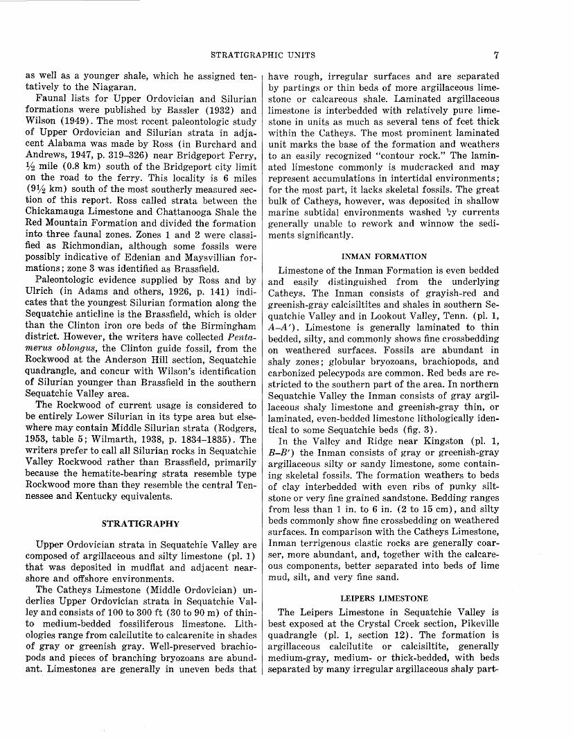
The Catheys Limestone (Middle Ordovician) underlies Upper Ordovician strata in Sequatchie Valley and consists of 100 to 300ft (30 to 90 m) of thinto medium-bedded fossiliferous limestone. Lithologies range from calcilutite to calcarenite in shades of gray or greenish gray. Well-preserved brachiopods and pieces of branching bryozoans are abundant. Limestones are generally in uneven beds that
have rough, irregular surfaces and are separated by partings or thin beds of more argillaceous limestone or calcareous shale. Laminated argillaceous limestone is interbedded with relatively pure limestone in units as much as several tens of feet thick within the Catheys. The most prominent laminated unit marks the base of the formation and weathers to an easily recognized "contour rock." The laminated limestone commonly is mudcracked and may represent accumulations in intertidal environments; for the most part, it lacks skeletal fossils. The great bulk of Catheys, however, was deposited in shallow marine subtidal environments washed 1;y currents generally unable to rework and winnow the sediments significantly.
INMAN FORMATION
Limestone of the Inman Formation is even bedded and easily distinguished from the underlying Catheys. The Inman consists of grayish-red and greenish-gray calcisiltites and shales in southern Sequatchie Valley and in Lookout Valley, Tenn. (pl. 1, A-A'). Limestone is generally laminated to thin bedded, silty, and commonly shows fine crossbedding on weathered surfaces. Fossils are abundant in shaly zones; globular bryozoans, brachiopods, and carbonized pelecypods are common. Red beds are restricted to the southern part of the area. In northern Sequatchie Valley the Inman consists of gray argillaceous shaly limestone and greenish-gray thin, or laminated, even-bedded limestone lithologically identical to some Sequatchie beds (fig. 3) .
In the Valley and Ridge near Kingston (pl. 1, B-B') the Inman consists of gray or greenish-gray argillaceous silty or sandy limestone, some containing skeletal fossils. The formation weathers to beds of clay interbedded with even ribs of punky siltstone or very fine grained sandstone. Bedding ranges from less than 1 in. to 6 in. (2 to 15 em), and silty beds commonly show fine crossbedding on weathered surfaces. In comparison with the Catheys Limestone, Inman terrigenous clastic rocks are generally coarser, more abundant, and, together with the calcareous components, better separated into beds of lime mud, silt, and very fine sand.
LEIPERS LIMESTONE
The Leipers Limestone in Sequatchie Valley is best exposed at the Crystal Creek section, Pikeville quadrangle (pl. 1, section 12). The formation is argillaceous calcilutite or calcisiltite, generally medium-gray, medium- or thick-bedded, with beds separated by many irregular argillaceous shaly part-
8 UPPER ORDOVICIAN AND SILURIAN STRATIGRAPHY, TENNESSEE
ings. The Inman-Leipers contact is selected where even beds of the older formation give way to thicker more poorly bedded strata.
In some sections the Leipers contains, usually in the upper half of the formation, even beds or ribs of impure calcisiltite or very fine grained calcarenite 2 to 6 in. ( 5 to 15 em) thick. Unweathered rock in drill core through the Leipers beneath the Tennessee Valley Authority's Nickajack Dam (Sequatchie quadrangle) shows extensive disruption of bedding by burrowing organisms. Fossils, both whole and in large fragments, commonly found in the formation are the large brachiopods Platystrophia ponderosa and H ebertella sinuata.
Limestone of the Leipers type occurs in places within both the Inman Formation and Sequatchie equivalents. In northern Sequatchie Valley the Leipers is separated from Inman argillaceous limestone where thin-bedded or laminated greenish-gray strata of the upper Inman are exposed between the two. Identification of Platystrophia or H ebertella is diagnostic of the Leipers, and carbonized impressions of both elongate and winged pelecypods are common in the Inman. An additional key to the detailed stratigraphy is the basal Sequatchie-Shellmound glauconitic siltstone marker bed.
STRATA OF RICHMONDIAN AGE
Strata regarded as Richmondian (Wilson, 1949, p. 219-223) were deposited in two principal sedimentary environments in Sequatchie Valley and in nearby portions of the Valley and Ridge. To the north and east sediments that became the typical Sequatchie beds of the geological literature were deposited mostly in nearshore mudflat environments. The southern and more westerly sediments belong to an offshore facies containing an abundant and varied marine fauna (pl. 1).
The writers retain herein the name Sequatchie for strata dominated by grayish-red and greenish-gray calcisiltite and propose herein to name the dominantly gray and greenish-gray fossiliferous limestone facies the Shellmound Formation (see footnote 3 herein).
The best section of the Sequatchie Formation, a standard for the type area of Ulrich, is the Hicks Gap section in northern Sequatchie Valley, Vandever quadrangle (pl. 1, B-B', Hicks Gap section). The type section of the Shellmound is along the westbound lane of Interstate 24 near Shellmound, Marion County, Tenn., a few hundred feet west of the Jasper interchange (pl. 1, A-A', Interstate 24 section).
SEQUATCHIE FORMATION
In Sequatchie Valley the Sequatchie Formation and its equivalent, the Shellmound Formation, overlie the Leipers Limestone and are overlain by the Rockwood Formation (pl. 1). The bases of both the Sequatchie and the Shellmound are marked by a few feet of silty or sandy calcisiltite or fine-grained calcarenite interbedded with glauconitic limestonethe glauconite marker. Beds of the marker are generally in even layers 1j2 to 1 ft (15 to 30 em) thick. Small amounts of terrigenous impurities are evident where strata are weathered. Weathered limestone has silty or very fine grained sand crusts which show the finely crossbedded nature of the rock. Where deeply weathered, only a residue of punky yellowish-brown siltstone or very fine grained sandstone remains, and chips or broken blocks of this material are abundant in the residuum of the basal beds of the Sequatchie and Shellmound.
The Sequatchie Formation typically consists of greenish-gray and grayish-red silty argillaceous and dolomitic calcisiltite, calcareous mudstone, and shale. The Sequatchie contains small amounts of calcilutite and very fine grained to fine-grained calcarenite, sandstone, and sandy limestone. Mudcracks, laminations, and borings of Scolithus are common, but skeletal fossils are rarely evident in cursory examination of hand samples. Intraclasts are abundant, and in some places lime cobbles appear to have been produced by periods of severe desiccation (pl. 1, B-B', Thief Neck section).
In Sequatchie Valley the Sequatchie Formation may be divided into two facies, a red-limestone facies composed of interbedded greenish-gray and grayishred strata and a green-limestone facies composed only of greenish-gray beds. In section the red beds are confined to the middle of the formation and are enclosed above and below by nonred Sequatchie limestone (pl. 1).
SHELLMOUND FORMATION
The Sequatchie facies grades into the gray fossiliferous limestone facies (Shellmound Formation) in southern Sequatchie Valley and in Lookout Valley near Chattanooga (pl. 1, A-A'). Like the Sequatchie the lower part of the Shellmound consists of a few feet of silty glauconitic limestone. This is overlain by 10 to 20 ft (3 to 6 m) of silty argillaceous limestone that resembles the Leipers Limestone. Simil,. arly, Wilson (1949, p. 201-207) observed in central Tennessee that the Arnheim of Richmondian Age resembles the Leipers. Platystrophia and Hebertella occur in this "pseudo-Leipers" in a few places. In
STRATIGRAPHIC UNITS 9
Sequatchie Valley, however, Leipers-like strata within the lower Shellmound contain more silt than Leipers" contains so little lime that it reacts only slightly with dilute hydrochloric acid (Shellmound the Leipers, and they weather to characteristic punky siltstone. In some places unweathered "pseudorailroad-cut section near Nickajack Dam).
The "pseudo ... Leipers" grades vertically into silty calcisiltite and calcarenite which contain thin zones of chamosite and hematite ooids (Chowns, 1970) similar to ore in the Rockwood. The relative amount of calcarenite increases upward in the formation and near the top, where it is clean and varicolored, calcarenite and bryozoan boundstone constitute the Fernvale Member 4 of the Shellmound Formation (pl. 1, A-A'; fig. 3). The Fernvale in central Ten-nessee, which has been described in detail by both Bassler (1932, p. 125-130) and Wilson (1949, A212-215), seems to have much the same character in both Sequatchie Valley and in the southwestern Valley and Ridge.
In Sequatchie Valley and Lookout Valley, hematitic, and slightly phosphatic, Fernvale limestone 1 to 20 ft ( 0.3 to 6 m) thick overlies and in places is interbedded with gray and greenish-gray limestone of the main body of the Shellmound. However, on Whiteoak Mountain at Green Gap, and to the southwest in Big Wills Valley, Ala., grayish-red Sequatchie calcisiltite is below the Fernvale and other Upper Ordovician shale and limestone. In some places the Fernvale has enough hematite to constitute a lean iron deposit or ferruginous flux (Bassler, 1932, p. 129-130; Wilson, 1949, p. 233-234).
ROCKWOOD FORMATION
The Rockwood Formation overlies the Sequatchie and the Shellmound Formations and is overlain by the Chattanooga Shale. In northern Sequatchie Valley lower Rockwood limestone contains lenses and thin layers of chert which serve to separate the formation from the underlying Sequatchie. The cherty limestone is herein named the Skillern Chert Member for exposures along Skillern Creek near Pikeville, Tenn. (pl. 1, section 13). In Sequatchie Valley chert-bearing beds have been mapped in the lower Rockwood as far south as Henson Gap. From Henson Gap south the Rockwood thickens by addition of limestone and shale to its base ; cherty limestone, however, persists within the lower half of the formation south to where it wedges out near Inman (pl.
4 In this area, the Fernvale Limestone/Formation is herein reduced in rank to Fernvale Member and assigned to upper parts of the Shellmound and Sequatchie formation in Sequatchie Valley, East Tennessee, and adjacent parts of Alabama and Georgia.
1) . Basal Rockwood cherty limestone extends eastward into the Valley and Ridge and marks the Sequatchie-Rockwood contact in exposures along Watts Bar Lake (Tennessee River) between Bacon Ridge and the Cumberland Plateau (fig. 1) and in the Rockwood reference section at Emory Gap along and near Interstate 40 between Rockwood and Harriman (pl. 1, B-B'; also see latter part of this section). In southern Sequatchie Valley, Tenn., and in Lookout Valley the base of the Rockwood Formation is marked by thin but prominent beds of siltstone and silty limestone.
The Rockwood is overlain by the Chattanooga Shale. In the study area the Chattanooga ranges from 10 to 50 ft (3 to 15 m) thick from southwest to northeast. The base of the Chattanooga is usually marked by 2 in. to 1 ft ( 5 to 30 em) of poorly sorted sandstone (Hardin Sandstone Member) that is thought by some to represent a basal deposit on a regional unconformity (Conant and Swanson, 1961). In general, the Chattanooga cuts progressively lower into the Silurian from southwest to northeast along Sequatchie Valley; in central Tennessee this shale cuts across formations which range in age from Middle Ordovician to Middle Devonian (Conant and Swanson, 1961; Wilson, 1949).
In northern Sequatchie Valley the Rockwood Formation consists mostly of 50 to 60 ft ( 15 to 18 m) of very fine grained to medium-grained dolomite and calcarenite in shades of gray. Beds are from 1 to 8 in. (2 to 20 em) thick, and individual layers generally persist at about the same thicknesses along the outcrop. Bedding surfaces are uneven. The rock commonly contains irregular masses of gray chert, but some chert is in even layers an inch or so thick that persist laterally for short distances. Greenish-gray calcareous share is found in small amounts within the formation. Fossils are relatively uncommon within the northern phase of the formation, and only a few brachiopods were observed.
In southern Sequatchie Valley the Rockwood Formation is 100 to 135 ft (30 to 40 m) thick and is divided into two units (pl. 1, A-A'). The lower unit consists of 70 to 80 ft (21 to 24 m) of interbedded gray calcisHtite to medium-grained calcarenite and olive-gray shale. Beds are generally 1;2 to 6 in. ( 1 to 15 em) thick, are even, and have irregular surfaces. Some beds of limestone have crossbedded argillaceous- or silty-weathering crusts. Fossils are abundant and consist mostly of brachiopods, co.rals, and fragmented crinoid stems.
The up·per unit of the Rockwood Formation in southern Sequatchie Valley consists of 30 to 40 ft
10 UPPER ORDOVICIAN AND SILURIAN STRATIGRAPHY, TENNESSEE
(9 to 12 m) of relatively unfossiliferous pale-green, yellowish-green, or light-olive-gray shale. Siltstone interbeds 1 to 6 in. (2 to 15 em) thick are common in the lower part of the member.
In Sequatchie Valley a sedimentary hematite zone of considerable lateral persistence occurs generally at the boundary between the lower and upper members. The iron was extensively mined near Inman at the end of the last century, and many strip mines and several underground mines are still evident (Burchard, 1913; Milici and others, in press). The ore bed consists mostly of hematite pellets and replaced fossil fragments intermixed with gray and greenish-gray calcarenite. Hematite was selectively concentrated by weathering and leaching of calci urn carbonate of the parent calcarenite, and punky residual material constituted the best iron ore.
Rockwood sections in Lookout Valley near Tiftonia (west Chattanooga,) contain lithologies similar to those in southern Sequatchie Valley, Tenn. (pl. 1, A-A'). In general, the formation in Lookout Valley may be divided into the same two units recognized in southern Sequatchie Valley-a lower interbedded calcarenite-shale-hematite unit and an upper shale unit. In contrast to the Sequatchie Valley area, Lookout Valley exposures are about 100 ft (30 m) thicker and contain 7 to 10 sedimentary hematite zones rather than 1.
The single most complete section in Lookout Valley (section 25a.) is almost entirely punky saprolite but shows 7 hematite zones in the lower 100 ft (30 m) of section. Freshly exposed Rockwood sections along Interstate 59-24 from Tiftonia south into Georgia (sections 25c, 25d) show fair thickness of the formation and, when these are pieced together, 10 hematite zones are in the same part of the sequence as those of s·ection 25a. Such hematite zones are usually associated with calcarenite beds, which have little Iateral persistence. (See pl. 1.)
The only exposures of Rockwood Formation in its old type area are near and along Interstate 40 in the vicinity of the village of Emory Gap, Harriman quadrangle. Almost every bed of the formation is exposed, and a complete section of weathered strata was pieced together from several short segments. Seven hematite zones are scattered from about 70 ft (20 m) below the top of the formation to within 50ft (15m) of the base. The main ore zone is near the middle of the section and in one pit was measured as 4.2 ft ( 1.5 m) thick. Total thickness of the Rockwood at Emory Gap is about 230 ft (70 m), which is about 100 ft (30 m) thinner than the sec-
tion measured by Ulrich (in Burchard, 1913, p. 33) for divisions 5, 6, and 7 at Rockwood.
The Emory Gap section is herein designated the reference section for the Rockwood Formation.
The Rockwood Formation is thicker and is composed mostly of terrigenous clastic rocks east of the Chattanooga fault. In contrast to the western exposures the formation along the Bacon Ridge-White• oak Mountain belt contains only a little limestone. Sections in the Euchee belt along Watts Bar Lake, between Bacon Ridge and Sequatchie Valley, resemble the eastern terrigenous facies more than the mixed shale-limestone units to the west. As the Watts Bar sections are intermediate in position, however, so are they intermediate in composition, and calcareous rocks are abundant in the lower part of the section at Fooshee Bend (pl. 1, B-B').
Silurian sections along Watts Bar Lake are incomplete, the upper part having been removed by faulting. In the Watts Bar region some of the Rockwood consists of interbedded thin shale, siltstone, and sandstone (some graded) which have abundant sole markings; thin calcareous or silty and sandy hematite zones are common. Similar strata characterize the Rockwood at Green Gap on Whiteoak Mountain, Tenn., where the thickness of Rockwood is a little more than double that in the Chattanooga area.
DEPOSITIONAL ENVIRONMENTS AND REGIONAL SEDIMENTARY FACIES
PREVIOUS INVESTIGATIONS
The sedimentary petrology and inferred depositional environments of Upper Ordovician strata in northern Tennessee and southwestern Virginia were described by Thompson (1970b); the Upp·er Ordovician of northwestern Georgia was described by Chowns (1972a), and correlative strata in northeastern Alabama by Thompson (1971).
Thompson (1970b) divided calcareous and dolomitic Upper Ordovician strata of southwestern Virginia and northern Tennessee (which we consider to be entirely Sequatchie) into a Sequatchie facies, a Juniata facies, and an intermediate facies.
Strata which Thompson called Sequatchie were separated from those called Juniata primarily on the basis of color ; 'the Juniata facies is red, unfossiliferous and relatively argillaceous; the Sequatchie facies is gray, fossiliferous and relatively limy" (1970b, p. 1272). It is clear from Thompson's map (1970b, fig. 1) and descriptions that strata he called Juniata are considered Sequatchie by most workers
DEPOSITIONAL ENVIRONMENTS 11
in the Southeast. In spite of these nomenclatural difficulties, Thompson's work is useful in deciphering the depositional environments of these rocks, and in our opinion his (1970b, fig. 18) inferred paleogeographic distribution of Upper Ordovician lithofacies is valid if one regards the Juniata as dominantly noncalcareous fluvial (or deltaic) deposits, the Sequatchie as dominantly calcareous or dolornitic supratidal or intertidal mudflat, and the Shellmound as dominantly subtidal marine limestone.
The Sequatchie facies of Thompson (1970b) consists of fossiliferous biomicrite and biomicrudite 5
which he interpreted as representing normal marine shallow subtidal deposits. These strata apparently were interbedded with red (Juniata facies of Thompson) silty micrite, pelmicrite, pelsparite, and dolomite in most of the sections which he studied in Tennessee.
The red facies is laminated to massive, intraclastic, contains graded beds, and shows extensive development of vertical burrows, has almost no skeletal fossil debris, and exhibits abundant evidence of subaerial exposure. Thompson concluded that the red carbonate rocks represent high tidal-flat deposits.
The interm·ediate facies of Thompson (1970b) consists of red-mottled burrowed strata, interlayered red pelmicrite and burrowed gray skeletal calcarenite. In contrast with the red facies, horizontal burrows in the intermediate facies are more abundant than vertical burrows. Thompson interpreted the intermediate facies as representing shallow subtidal to low tidal-flat deposits.
Thompson's (1971) work in northeastern Alabama is more in accord with the currently accepted nomenclature in adjacent parts of Tennessee. In Alabama he divided the Upper Ordovician strata into four major lithofacies, a "red terrigenous-carbonate facies," a "gray terrigenous-carbonate facies," a "micrite facies," and a "calcarenite facies."
The red terrigenous-carbonate facies (Sequatchie) is laminated to thinly bedded silty micrite and contains beds of calcareous silty shale. Mudcracks, vertical burrows, and dark filmlike remnants of algal mats were observed by Thompson; skeletal fossils are generally absent.
Thompson's gray terrigenous-carbonate facies (Shellmound) consists of silty or argillaceous fossiliferous biomicrite and biosparite which apparently
5 The petrographic classification of carbonate rocks used in this discussion of depositional environments is that described by Folk (1959).
were deposited as shallow subtidal normal marine sediments.
The micrite facies (Leipers) is thick-bedded, bioturbated, and fossiliferous argillaceous gray biomicrite and dismicrite. These rocks also contain a few bands of skeletal calcarenite. Thompson interpreted these rocks as having been deposited in protected environments such as coastal embayments or in shallow lagoons behind barriers.
Thompson described the calcarenite facies (Fernvale) as generally consisting of coarse skeletal calcarenite which apparently was deposited in a high energy environment such as a marine channel or system of local barrier bars.
Chowns ( 1972a, p. 3-11) recognized six major lithofacies in the Upper Ordovician of northwestern Georgia and southeastern Tennessee: the "Juniata," red Sequatchie, gray Sequatchie, Fernvale, Mannie, and Leipers. Facies terminology of Chowns and Thompson are compared in table 2. In northwestern
TABLE 2.-Comparison of Upper Ordovician lithofacies terminology of Chowns (1972a) with Thompson (1971) in Alabama, Georgia, and southeastern Tennessee
Chowns (1972a)
Northwestern Georgia
"Juniata" Red Sequatchie
Gray Sequatchie Mannie
Fern vale Leipers
Thompson (1971)
Northeastern Alabama
Red terrigenouscarbonate
Gray terrigenouscarbonate
Calcarenite Micrite
Georgia the "Juniata" facies, exposed on the ridge called Rocky Face to the east of Taylor Ridge (fig. 1), is composed of a series of fining-upward cycles indicative of alluvial sedimentation. The red Sequatchie facies is characterized by graded beds, laminations, desiccation structures such as mudcracks, breccias, and birds·eyes, a scarcity of skeletal fossils, and the common occurrence of trace fossils. Chowns concluded that the facies was deposited in a high tidal-flat environment and that the red color was a result of subaerial oxidation. Except for color, the gray Sequatchie facies contains strata lithologically similar to those of the red facies and in addition contains a variety of pelletal and skeletal limestone. Chowns concluded that the gray facies represents deposits of low tidal flats (intertidal) subjected to daily flooding (and introduction of organic material) which prevented subaerial reddening. A similar conclusion was reached by Thompson (1971, p. 66). Chowns (1972a, p. 9) interpreted Fernvale "red and gray, ripple-marked bryozoan-
12 UPPER ORDOVICIAN AND SILURIAN STRATIGRAPHY, TENNESSEE
crinoid biosparites" as representing a barrier-beach deposit, with red and gray lithologies representing relative degrees of subarea! oxidation. Mannie-like shales and thin beds of oolitic ironstones are interpreted to have formed in back-barrier lagoons or in more open ma.rine embayments. Burrowed, silty, fossiliferous, dolomitic micrite of the Leipers facies was interpreted by Chowns to be deposited in an open marine embayment, whereas the underlying more abundantly fossiliferous beds of the Catheys represent a more open marine subtidal environment.
Silurian depositional environments in Alabama and Georgia were described by Sheldon (1970) and by Chowns (1972b), respectively. Sheldon concluded that the Red Mountain Formation of Alabama represented lagoonal, barrier-island, neritic marine and basinal sediments, and that iron-rich sediments were deposited in the lagoonal environment and on the lagoonward side of the barrierisland environment.
Chowns concluded that the Red Mountain Formation in Georgia was deposited as a post-Taconic molasse in sedimentary environments ranging from littoral lagoon and barrier to open marine platform and slope deposits. The Silurian iron-ore beds of Georgia are associated with beds interpreted, in eastern areas of exposure, to be regressive barrier sandstone, tidal channel, and tidal delta deposits containing an abundance of skeletal debris ; in the west near Chattanooga these inferred barriers are more calcareous.
DEPOSITIONAL ENVIRONMENTS IN THE CHATTANOOGA AREA
Upper Ordovician strata of southe·rn Tennessee are composed of fine terrigenous clastic and carbonrute sediments that were deposited in tidal-flat and associated subtidal environments. In general, the sequence represents the intrusion of mudflat environments into an area dominated earlier by subtidal shelf carbonate rocks (regressive phase) ; eventually the tidal-flat sequence was drowned and replaced by shelf deposits of fossiliferous calcareous mud (transgressive phase).
Our model for the mudflat sequence, shown in plate 2D, was constructed primarily by comparing data obtained from the major roadcuts in the Chattanooga area (pl. 2A, B, and C) with the modern tidal-flat model described by Shinn, Lloyd, and Ginsburg (1969). In general, we recognized strata belonging to 11 major depositional environments: (1) carbonate shelf, (2) burrowed subtidal micrite, (3) calcarenite flat or sand bar, ( 4) green intertidal
mudflat, ( 5) red intertidal mudflat, ( 6) regressive or transgressive beach ridge, (7) pond, (8) channel fill, (9) lagoon, (10) subtidal calcarenite bar, and (11) muddy shelf.
Carbonate shelf.-Strata assigned to the carbonate-shelf environment are those of the upper part of the Catheys Limestone (pl. 2A, C). In general these strata are gray biomicrite and biosparite. These rocks can be divided into three main types of deposits that reflect subtle differences in the subtidal depositional environments: beds of impure shaly calcarenite, cobbly fossiliferous limestone interbedded with shale, and thin-bedded or laminated silty micrite.
Calcarenite bodies a few feet thick probably accumulated in relatively higher energy zones where currents were sufficient to wash and winnow a fittle of the fine material. These bodies generally are poorly bedded, argillaceous, and lack evidence of a basal scour, which would indicate a channel-fill deposit. Under the microscope these rocks are seen to be biosparite containing abundant bryozoan, brachiopod, and pelmato.zoan debris mixed with areas of slightly dolomitized biomicrite.
The thicker calcarenite bodies are interb~dded with thinner beds of fossiliferous cobbly limestone (biosparite to biomicrite) and calcareous shale. Interbedded limestone and shale in units a fe,w feet to a few tens of feet thick apparently were deposited in regions of fluctuating energy level. Shale and lime mud accumulated during periods of relative calm, and some beds contain fossilized clams in growth position. The biosparite layers represent higher energy deposits which formed when fossil debris was washed in, probably from adjacent calcarenite banks.
A zone a few feet thick of greenish-gray laminated or thin beds is within the Catheys at the Slygo Ridge section (pl. 2A, unit 2). Some of these beds contain shrinkage cracks (incomplete mudcracks) which may represent either salinity fluctuations in a subaqueous environment (Donovan and Foster, 1972) or incomplete subarea! desiccation. Thin sections of this rock show it to consist of silty microsparite and burrowed dolomitized micrite that contains anastamosing carbonaceous films, interpreted as algal laminations; it also contains horizontally distributed birdseyes. The birdseyes are spar-filled voids that probably were formed by small gas bubbles trapped between the algal laminae (Shinn, 1968). The laminated zone is interbedded with gray subtidal limestone, and, because it contains no well-
DEPOSITIONAL ENVIRONMENTS 13
developed filled mudcracks, it is assigned to a low intertidal or high subtidal environment.
Burrowed subtidal micrite.-Homogeneous bioturbated shaly but poorly bedded limestone is not only the dominant rock type of the Leipers Limestone (pl. 2A, unit 9; pl. 2B, unit 7 and parts of unit 4) but is also present in the upper part of the Catheys Limestone (pl. 2A, unit 3) and in the lower part of the Shellmound Formation (pl. 2B, units 6 and 7). These beds are characterized by the large-shelled brachiopods H ebertella and Platystrophia and commonly contain coiled gastropods, bryozoans, and ostracodes. Microscopically, this facies consists of biopelmicrite, biomicrite, and intramicrite, dolomitized and laminated microsparite, and contains zones of biosparite coquina. Calcite birdseyes in the rock are nort of the shrinkage, desiccation variety but rather are fillings. of fossil fragments. Algal lami:nations, some broken by burrows, are common. Some rocks contain algal oncolites suggestive of agitated shallow-water deposition. Others contain quartz silt.
Calcarenite flat or sand bar.-The upper beds of the Inman Formation in the Sly go Ridge section (pl. 2A, upper part of unit 8) and in section 25b (unit 10) along U.S. Highway 11 in Tiftonia were interpreted as representing a subtidal or intertidal sand flat or bar. Lithologically, the strata are greenish-gray fine lime sand or silt in lenses or mediumthick beds. Thinner beds are lenticular, whereas the thicker ones are more persistent horizontally. Bedding tends to be ragged, with upper and lower contacts of many beds gradational. Rippled beds are common, and some beds exhibit horizontal laminations. Some beds show evidence of soft sediment slumping, and others contain green shale chip rip-up clasts.
The comparatively coarse nature of the rock and the lack of obvious burrows in it suggest a relatively rapid accumulation of sediment in flow regimes which ranged from ripple- to laminate-producing currents. The lack of fossils suggests that life in the area of deposition was inhibited by shifting silts and sands. Under the microscope the rock appears as an algally laminated intramicrosparite containing some calcite birdseyes and dolomite rhombs.
Because the gray biomicrite is commonly interbedded with lenses of greenish-gray or mediumlight-gray micrite, interp·reted to be of intertidal mudflat origin, and with calcisiltite and calcarenite, inferred to be of sand-flat origin, it is assigned to a nearshore adjacent marine environment. As such, parts of the Leipers and Catheys Limestones can
be regarded as the subtidal toes of the prograding mudflats. Anhydrite-filled vugs are common in some beds within the Leipers and suggest the existence of at least local hypersaline conditions. A modern example of this nearshore type of environment might he the marine zone adjacent to Andros Island which was reported by Shinn, Lloyd, and Ginsburg (1969). It parallels the tidal flat in a belt some 10 to 20 miles (16 to 32 km) wide. These modern adjacent marine deposits are light gray, indicative of a reducing environment, are generally lacking in primary sedimentary laminations, and are extensively burrowed.
In general, the sediment lacks the sedimentary features of high intertidal and supratidal flats, but its coarseness and its green rather than gray color suggest a slightly higher energy and more oxidizing environment than that of the associated lime mud. Accordingly, the unit is interpreted to be a sand flat or bar, generally high subtidal, or perhaps, as beds containing birdseyes suggest, even intertidal.
Green intertidal mudflat.-Modern intertidal-flat sediments described by Shinn, Lloyd, and Ginsburg (1969) are "light tan to cream in color," that is, relatively oxidized, and generally lack primary sedimentary laminations because of extensive burrowing. Ordovician strata interpreted as intertidal mudflat deposits a.re similar except for their green color, and that may be explained by their greater amounts of terrigenous impurities.
Rocks assigned to the green intertidal mudflat facies (pl. 2A, unit 4, unit 6, and lower part of unit 8; pl. 2B, unit 3, parts of unit 4, and unit 5; pl. 2C, units 1 and 8) are in all of the Upper Ordovician formations in the Chattanooga area and are closely associated both with gray limestone, interpreted as subtidal, and with red mudstone, which is considered intertidal. Lithologically, the strata are greenishgray silty micrite beds containing lenses of biosparite. In some places the poorly bedded, homogeneous nature of the silty micrite is suggestive of burrowing. In other places vertical burrows an inch or so long are abundant and are associated with irregular beds of biosparite. Thompson (1970b, p. 1280) interpreted such burrows to have been formed by infaunal suspension feeders which lived in the fluctuating conditions of the intertidal or supratidal regions. Where examined in thin section, some of these rocks are distinctly biomicrite, algally laminated micrite, or microsparite that generally contains dolomite rhombs. Quartz silt is common. Burrowed pelletal biomicrite and biosparite are also
14 UPPER ORDOVICIAN AND SILURIAN STRATIGRAPHY, TENNESSEE
common in this facies, as are pieces of bryozoans, ' brachiopods, pelmatozoans, and other fossils. Some of the rocks contain the anastamosing filaments which are interpreted to be algal laminations, and some contain horizontally distributed birdseyes between algal laminations.
The green color of these rocks, intermediate between gray and orange or red, is probably the result of an intermediate state of oxidation of sediment exposed not long enough to permit reds to form. This state of oxidation coupled with the mixture of abundant fos.sils and some desiccation-formed birdseyes, implies an intertidal origin for these rocks.
In the Inman Formation the green beds occupy positions above and below red beds, but, where observed, red and gray limestone beds are always separated by the green beds. In the Sequatchie Formation green zones occupy positions between gray and red beds as they do in the Inman. Green burrowed silty biomicrite containing gastropods and bryozoans in both the Leipers and at the base of the Shellmound Formation are interbedded with gray beds. Because they are green rather than gray and contain some spar-filled birdseyes, such beds are interpreted as representing intertonguing of the subtidal-intertidal zone. However, a fairly thick green zone of interbedded laminated and burrowed and silty micrite beds at the base of the Shellmound in Lookout Valley is interpreted to represent the development of a fairly extensive intertidal flat because it contains an abundance of silt and mud-filled polygonal mudcracks (section 25b, unit 14).
Red intertidal mudflat.-Rocks assigned to the red intertidal mudflat environment range from mottled grayish-red and greenish-gray silty limestone or calcareous siltstone and mudstones to beds which are almost entirely grayish red. Some mudstone contains thin lenses of fossiliferous limestone. Shrinkage cracks are common, and rocks of this environment are characterized also by an abundance of vertical burrows. Internal sedimentary laminations are generally not evident. Liesegang diffusion bands are seen in some of the burrowed beds and were apparently developed around the burrows (Chowns, 1972a, p. 5).
Red and red-green mottled beds are in both the Inman and Sequatchie Formations in the Chattanooga area. In the Slygo Ridge section mottled, burrowed red beds of the Inman (pl. 2A, unit 5) lie between greenish-gray beds of micrite (low intertidal) containing lenses of fossiliferous limestone. At Green Gap on Whiteoak Mountain the burrowed red mudstone is in the upper part of the Sequatchie Forma-
tion as well as at its base (pl. 2C, units 2, 9-11, 13, and 15). There, this lithology is associated with both green and gray fossiliferous beds interpreted as being subtidal or low intertidal in origin and with laminated sediments interpreted as a supratidal carbonate beach ridge.
The red color, the abundance of vertical burrows, the presence of only a few thin zones of fossiliferous limestone, and the associations of rock types suggests a high intertidal origin for the mudstone.
Beach ridge.-Strata herein assigned to the beachridge environment as defined by Shinn, Lloyd, and Ginsburg (1969) constitute most of the rock called red Sequatchie facies by Chowns (1972a) and red terrigenous-carbonate by Thompson (1971). At Green Gap (pl. 2C, units 3-7) the lower beach-ridge deposits of the Sequatchie are separated from the Catheys by a few feet of red and green intertidal mudstone.
Strata belonging to the beach-ridge environment are laminated to medi urn thick beds of oxidized silty calcisiltite and fine calcarenite. Sedimentation units are commonly graded, having rip-up clasts of red shale chips at the base overlain by rippled and (or) internally lamina,ted sediment. Commonly, at the top of such beds, thin layers of red silty shale have well-de~veloped polygonal mudcracks. Some of these beds are burrowed, and some contain birdseyes. Thin discontinuous zones of poorly bedded bleached mudstone that is interspersed within the better bedded rock are interpreted to be wet spots on the supratidal mudflat. Some features similar to these were described from mode,rn beach-ridge deposits by Shinn, Lloyd, and Ginsburg (1969),
Although the three-dimensional aspect of the exposure at Green Gap cannot be observed, both the lithology of the vertical sequence and the absence of large channel fills there suggest that most of the lower half of the Sequatchie represents a regressive, seaward accreting beach-ridge environment. As such, this deposit would have formed in an environment similar to that described by Shinn, Lloyd, and Ginsburg (1969) for sediments on the sourthwest coast of Andros Island, where a supratidal flat more than 3 miles (about 5 km) across is unbroken by channels.
Whereas the lower part of the Sequatchie at Green Gap is re,gressive, the upper part is transgressive. Above strata interpreted as intertidal flat and pond, but below and interbedded with red shale interpreted as muddy channel fill and lagoon fill, are two laminated zones which are burrowed and contain evidence of desiccation as well as having interspersed thin beds of limestone (pl. 2C, units 16 and 18). In
DEPOSITIONAL ENVIRONMENTS 15
general, these rocks are similar to the beach-ridge deposits in the lower part of the section, but they are only a few feet thick. The upper laminated zone is scoured, suggestive of similar scours on modern beach ridges (Shinn and others, 1969, fig. 14). The position in sequence, erosive features, and thinness of the depositional units is evidence that these sediments are the last supratidal deposits of the drowning mudflat.
Pond.-Two units of gray and greenish-gray fossiliferous limestone in the upper part of the Green Gap section are interpreted to have been deposited in shallow ponds on the intertidal flat (pl. 2C, units 12, 14). Both units are interbedded with burrowed red mudstone of inferred intertidal origin. The basal contacts of the fossiliferous units lack the scours characteristic of tidal channels, and the burrowing and the regular bedding of fine clay and lime mud is evidence for quiet water deposition. One unit of red shale near the top of the red bed sequence at Green Gap lies between laminated beds of the transgressive beach ridge facies (pl. 2C, unit 17). This highly oxidiz~d deposit is also interpreted to represent a quiet water pond environment, but higher and more restricted than the ponds on the intertidal flat. Modern pond sediments described by Shinn, Lloyd, and Ginsburg (1969) are gray with some tan mottling. They generally lack primary sedimentary laminations probably because of homogenization by burrowing fauna.
Channel fill.-Channel-fill deposits were observed in one place in the upper part of the Green Gap section. Laminated red and green limestone was eroded and the resulting depression was then filled by beds of red shale. The deposit is interpreted to be the· fill of a tidal channel that cut into a low-lying beach ridge (pl. 2C, unit 19).
Lagoon.-Sediments of inferred muddy-lagoon origin are the thin red and green shale units near the top of the Ordovician section at Green Gap (pl. 2C, units 20 and 21). These units contain some beds of fossiliferous limestone and are green upward (and offshore) away from the mudflat environment. Green shale is interbedded with overlying Fernvale calcarenite along the road level, but on the first bench the Fern vale cuts well down into the shale unit. The position of these red and green shale units, the interbedded fossiliferous calcarenites, and the comparative thinness of the units suggests that they were deposited in a shallow subtidal lagoon between the tidal flat and an offshore calcarenite bar.
Open lagoon sediments constitute most of the Shellmound Formation. At its type section (pl. 2B)
the Shellmound consists mostly of fossiliferous calcareous shale, siltstone, and sandstone, some interbedded with fossiliferous micrite. Below the Fernvale Member (unit 23), the Shellmound generally coarsens upward from bioturbate "pseudoLeipers" (units 6 and 7) through siltstone (units 8-10) to very fine quartz-rich calcareous sandstone (units 16 and 18).
The coarsening-upward sequence represents a general filling of the lagoon with a mixture of carbonate sediment derived from fauna that dwelled therein, and from terrigenous clastic sediment transported into the area from the east (Chowns, 1972a).
Some of the shale and siltstone beds along Interstate 24 (pl. 2B) contain an abundance of bryozoans and brachiopods. Horizontal burrows characteristic of infaunal deposit feeders (Thompson, 1970b, p. 1281) dominate other beds. Chamosite and hematite grains, ooids, and fossil replacements are in layers or are scattered throughout some of the silty sediments. Microscopically, some ferruginous calcareous siltstone beds are impure biosparite with bryozoans and brachiopods, some replaced by hematite. These beds contain irregular layers of dolomitized micrite and rounded quartz grains. Other beds are pelletal microsparite layers. Interbedded hen1atitic sandstone has calcareous cement and an abundance of bryozoan fragments. The quartz sand grains are well sorted, rounded, and generally appear to be floating in the calcareous matrix.
The upper, coarser beds of the lagoon-fill were deposited under moderate to high energy. Some sandy calcarenite is festooned and contains an abundance of shale-chip conglomerate (pl. 2B, unit 16) . Other calcarenites are characterized by rippled beds or long low-angle accretion beds suggestive of the lower part of beach foreshore beds (pl. 2B, unit 18). Microscopically, some of these beds are calcareous sandstone units containing an abundance of bryozoans and brachiopods and having areas of dolomitized micrite. Some are silty microsparite, and others are quartzose intrasparite units containing numerous bryozoan and brachiopod fragments and intraclasts of dolomitized micrite. All of the quartz is well rounded and, in each bed, well sorted.
The coarsening-upward lagoon-fill sequence terminates with the deposition of the quartz-rich calcareous sandstone. The sequence marks the regional regressive phase which existed in this area throughout most of the Late Ordovician. The overlying shale and calcarenite bar facies marks the regional submergence which began toward the end of the Late Ordovician in the Chattanooga area.
16 UPPER ORDOVICIAN AND SILURIAN STRATIGRAPHY, TENNESSEE
Subtidal calcarenite bar.-The most mature, highest energy deposits in these sequences are the calcarenite beds of the Fern vale Member. In general these beds are well winnowed of mud and silt. Bedforms consist mostly of ripples in the sections through Anderson Hill and Whiteoak Mountain (pl. 2B, unit 23; pl. 2C, unit 22), although high-angle bedforms are in the lower part of the section along Interstate 75 at Whiteoak Mountain. In general the Fernvale is interbedded with shale low in each section, suggesting that the deposit was washed into and ultimately filled an adjacent muddy lagoon. Thus, the high-angle crossbedded calcarenite units which are interbedded with shale can be interpreted as spillover lobes.
When examined with a microscope the Fernvale was shown to be mostly biosparite containing varying amounts of pelmatozoan, bryozoan, and brachiopod debris. Poorly developed ooids, although not abundant, are common, indicating deposition under agitated conditions. Some rocks contain zoned dolomite rhombs, some contain an abundance of rounded quartz grains., and others have intraclasts of siltstone.
The posi~tion in sequence of the Fernvale, the bedforms, and the microscopic characteristics are evidence that the unit was formed as subtidal bars between muddy and silty lagoon-fill deposits and open-shelf deposits. of the Rockwood.
Muddy Shelf.-At Whiteoak Mountain (Green Gap section) the subtidal bar environment is overlain by beds of burrowed silty shale and shaly siltstone (pl. 2C, units 23-26) of the muddy shale environment. Impressions of pelecypods and the horizontal burrows attest to the subtidal nature of this coarsening-upward sequence. In the Chattanooga area and in southern Sequatchie Valley, the Shellmound is overlain by interbedded fossiliferous limestone and shale of the Rockwood Formation (pl. 1, sections 1, 3, 4, 6, 25, and 26). These beds were deposited in depositional environments in some ways similar to those of the upper part of the Catheys Limestone. In general, limestone beds in the lower part of the Rockwood are replaced upward by argillaceous sediments derived from the east ( Chowns, 1972b).
The limestone is biosparite and hematitic biosparite commonly containing pelmatozoan debris, pieces of bryozoans, and broken brachiopod shells. The hematite occurs both as discrete grains and as coatings and replacements of fossils. Some beds contain a few ooids. Hematite grains and coatings follow crossbeds in many of the lenses.
The more prominent limestone units are as much as a few feet thick, and these apparently represent subtidal shell banks. Beds of shale are interbedded with thinner beds of fossiliferous limestone. Some of the limestone beds are finely cross bedded ; others are rippled. In general, these individual beds of limestone represent the intrusion of higher energy deposits into areas characterized by the accumulation of terrigenous and calcareous mud, and they were likely washed there by storm waves or tidal currents.
APPLICATION TO SEQUATCHIE VALLEY
Upper Ordovician and Silurian lithofacies along Sequatchie Valley in Tennessee are illustrated in plate 1. The section trends about N. 35° E. and cuts the northwest-trending depositional strike at a high angle. Because there is no evidence of a major unconformity between the upper beds of the Catheys Limestone and the pre-Chattanooga unconformity at the top of the Rockwood, the Sequatchie Valley section can be interpreted as representing a major regressive-transgressive cycle.
In Sequatchie Valley the Inman Formation represents a major change in depositional environmentfrom the dominantly subtidal carbonate shelf deposits of the Catheys to a more restricted littoral environment.
Inman red limestone is restricted to the southern part of the area studied and has been correlated by Chowns (1972a, fig. 3) with lower Sequatchie red beds to the east at Ringgold, and Green Gap, Tenn. The occurrence of red beds in the lower part of the section in the southern part of the study area suggests that the mudflat environment entered the Sequatchie Valley region as tongues or lobes from the southeast.
The Leipers of the Sequatchie Valley region probably represents an adjacent marine deposit that accumulated slowly enough to be extensively reworked by burrowing organisms, rather than a protected marine embayment environment as suggested by Thompson (1971, p. 68-69).
Leipers bioturhate beds are overlain by Sequatchie mudflat deposits which can be ascribed to both green and red intertidal deposits and red beach-ridge deposi,ts. Because the models described in the previous section of this report show that much of the red Sequatchie facies represents sediments deposited on the higher parts of tidal flats and the green facies the lower parts, the regressive-transgressive nature of the Sequatchie is evident in Sequatchie Valley (pl. 1). There, red tongues grade seaward into green beds
DEPOSITIONAL ENVIRONMENTS 17
and then into the abundantly fossiliferous limestone of the Shellmound or Leipers. Late Ordovician and Silurian transgression is marked by submergence and burial of red tidal-flat sediments, first by green tidal-flat deposits and then by subtidal limestone and shale of the Rockwood. Basal sand and silt beds of the Rockwood probably represent a fine lag deposited by the winnowing action of advancing ocean currents.
Iron-bearing calcisiltite and calcarenite mark three zones in the Upper Ordovician and Silurian of
southern Sequatchie Valley, Tenn. From the discussions of Sheldon (1970) and Chowns (1972 a, b), it is clear that the iron deposits have multiple origins. Those lower in the Shellmound and in the calcareous phase of the Rockwood may be lagoonal or near offshore deposits. Chowns ( 1972a, p. 9) ascribed hematite in calcarenite units to wind-blown dust, derived from red tidal flats, and this idea is supported by the association of abundant fine wellrounded quartz silt and very fine sand.
TABLE 3.-Location of measured sections in Tennessee and Georgia [Sections 1-20 are in the Sequatchie anticline; sections 21-28 are in the Valley and Ridge]
Section No. Quadrangle
1 ______ Bridgeport (101-NW).
2 ______ Sequatchie (100-SE).
3 ______ Sequatchie (100-SE).
4 ______ Sequatchie (100'--SE).
5 ______ Sequatchie (100---SE).
6 ______ Sequatchie (100-SE).
7 ______ Ketner Gap (105-NW).
8 ______ Daus (104-SW).
9 ______ Henson Gap (104-SE).
10 ______ Mount Airy (104-NE).
11 ______ Brayton (111-NW).
12 ______ Pikeville (110-SW).
13 ______ Pikeville (110-SW).
14 ______ Pikeville (110-SW).
15 ______ Melvine (110'-NE).
16 ______ Melvine (110'-NE).
17 ------Vandever (109-SE).
Tennessee State Coordinates
221,000N; 2,111,00Q:E
222,600N; 2,113,600E
236,200N; 2',122,500E
238,200N; 2,124,600E
250,800N; 2,132,800E
261,800N; 2,141,700E
259,200N; 2,141,700E
289,000N; 2,157,600E
289,700N; 2,158,400E
332,000N; 2,183,700E
332,600N; 2,183,100E
335,200N; 2,197,000E
368,100N; 2,204,300E
402,700N; 2,224,500E
402,600N; 2,225,700E
419,600N; 2,236,000E
418,400N; 2,237,000E
433,800N; 2,247,700E
438,400N; 2,250,100E
464,800N; 2,273,800E
485,200N; 2 ?~1 ~OOE
485,100N; 2,291,100E
499,600N; 2,288,000E
Description
Cut of L and N railroad, relocated because of Nickajack Dam; adjacent to Shellmound Road.
TVA drill core C+10-115+00 under Nickajack Dam.
Roadcuts along westbound lane of Interstate 24. Type section of Shellmound Formation.
Anderson Hill; roadcuts on U.S. H wy. 41.
Bluffs above Sequatchie River.
Roadcut at Inman.
Exposures in woods in vicinity of old iron mines at Inman.
Abandoned limestone quarry south and west of Tennessee State Hwy. 27.
Along Tennessee State H wy. 27 about 1 mile ( 1 liz km) east of Powells Crossroads.
Abandoned limestone quarry west of U.S. Hwy. 127.
Along U.S. Hwy. 12·7 about 0.75 mile (1.2 km) south of intersection with Tennessee State Hwy. 28.
Banks and bottom of Henson Creek.
Along Welch (Swanner) Branch and in nearby limestone quarry, about 0.5 mile (0.8 km) east-southeast of East Valley Road, and about 0.3 mile (0.5 km) east-southeast of Hopewell Church.
Ledges on hillside along south bank of branch.
Along creek draining from Pitt Gap 0.6-0.8 mile (1 km) east of East Valley Road.
Ridgetop north of Crystal Creek.
Along Crystal Creek about 0.4 mile (0.6 km) east of East Valley Road.
Composite from partial sections measured along Skillern Creek and its tributaries and along Tennessee State Hwy. 30 about 3 miles ( 4.8 km) southeast of Pikeville. Type section of Skillern Chert Member of Rockwood Formation.
Ledge on hillside under telephone line.
Composite from partial sections along creek and secondary roads in Beatty Cove and vicinity.
Exposed in stream bottom north of Lowe Gap road.
Along Lowe Gap road about 1.5 miles (2.4 km) southeast of Litton.
Along secondary road leading to Brown Gap and adjacent small tributary of Sequatchie River.

18 UPPER ORDOVICIAN AND SILURIAN STRATIGRAPHY, TENNESSEE
TABLE 3.-Location of measured sections in Tennessee and Georgia-Continued
Section No. Quadrangle
18 ------Vandever (109-SE).
19 ______ Grassy Cove (117-SW).
20 ______ Ozone (117-NE).
21 ______ Harriman (123-NE).
22 ______ Rockwood (123-SW).
23 ______ Ten Mile (124-NW).
24 ______ Spring City (118-NE).
25a ______ Chattanooga (105-SE).
25b ------Wauhatchie (105-SW).
25c ------Wauhatchie (105-SW).
25d ______ Wauhatchie (105-SW).
26 ______ Hooker (106-NW).
27 ______ Hooker .106-NW).
28 ______ Snow Hill (112-NE).
Tennessee State Coordinates
507,900N; 2,292,300E
509,800N; 2,300,700E
556,800N; 2,339,100E
556,800N; 2,415,700E
508,500N; 2,400,400E
495,200N; 2,386,900E
475,300N; 2,370,400E
229,800N; 2,190,500E
228,800N; 2,187,000E
229,500N; 2,185,100E
228,200N; 2,184,000E
211,500N; 2,173,000E
192,700N; 2,155,400E
269,000N; 2,290,600E
MEASURED SECTIONS
The measured sections described herein are those which best illustrate the Upper Ordovician and Silurian stratigraphy of the region. All sections are listed in table 3 and are located by means of Tennessee State Coordinates (TSC). Where possible, thicknesses of sections were measured with steel tape; elsewhere, by hand level.
SECTION 1.-Skellmound Road, Bridgeport quadrangle, Tennessee
[Section measured along Louisville and Nashville Railroad right-of-way relocated parallel to Shellmound Road because of Nickajack Dam. TSC: 221,000N; 2,111,000E]
Chattanooga Shale: Rockwood Formation:
Thickness (feet)
m=0.3048 ft
51. Covered --------------------------------- 5 50. Shale, silty, light-olive-gray to moderate-olive-
brown, greatly weathered --------------- 6 49. Calcisiltite, silty, light-gray to grayish-orange
or light-yellowish-brown; in even beds, 0.05 to 0. 7 ft thick, having irregular bedding surfaces; contains some disseminated pyrite; interbedded with shale similar to that described in unit 50 -------------------- 3
Description
Exposed along hill slope along north side of branch near secondary road near Burke.
Exposed in Selby Creek west of Hicks Gap. Reference section for Sequatchie Formation.
Shell Oil, Peterson No.1 well; about 1 mile (1% km) northeast of Crab Orchard.
Emory Gap ; cuts along secondary roads and on Inters·tate 40 west. Reference section for Rockwood Formation.
On Thief Neck; measured along northeast point on Watts Bar Lake.
Old Johnson Ferry Road; measured along northeas-t point on Watts Bar Lake.
Section along Watts Bar Lake at Fooshee Bend.
West-facing hillside north of U.S. Hwy. 11 in Tiftonia.
Roadcut on north side of U.S. Hwy. 11 in Tiftonia.
Exit ramp from Interstate 24 west.
East-facing hillside and along entrance ramp to Interstate 24 west.
Pope Spring area. Composite section measured in roadcuts and quarry along Interstate 24-59 0.7 to 2.1 miles ( 1.1 to 3.4 km) south of the TennesseeGeorgia State line.
Measured in cuts along Interstate 59 to about 1,000 ft ( 305 m) south of Slygo Road overpass.
Green Gap, Whiteoak Mountain, measured along Interstate-75 cuts, northbound lane.
SECTION 1.-Skellmound Road, Bridgeport quadrangle, Tennessee-Continued
Rockwood Formation-Continued 48. Shale, some silty, light-olive-gray to moder
ate-olive-brown, mostly covered; contorted (faulted?) ; contains some interbeds of siltstone and calcisiltite --------------------
47. Hematite, sedimentary, greatly weathered, dark-yellowish-orange to moderate-yellowish-brown, punky, fossiliferous ----------
46. Shale, silty, as in unit 48 ------------------45. Shale and calcisiltite, interbedded, shale
is silty, dark greenish gray, in beds 0.1 to 0.2 ft thick. Calcisiltite i's silty dark greenish gray where fresh to moderate yellowish brown where weathered; in even beds, 0.5 to 1 ft thick, having irregular bedding surface.s. Some beds contain black phosphorite ( ? ) as small grains and fragments __ -
44. Calcarenite, fine- to coarse-grained, ferruginous, grayish-red to medium-gray and green-ish-gray, fossiliferous _______ -----------
43. Calcisiltite to calcarenite, interbedded with silty shale. Calcisiltite and calcarenite are medium grained, dark greenish gray; this part contains some argillaceous, silty, or fine sandy even beds, 0.05 to 1 ft thick, having
Thickness (feet)
17
0.5-1 5
5.5
0.5
MEASURED SECTIONS 19
SECTION 1.-Shellmound Road, Bridgeport quadrangle, Tennessee-Continued
Rockwood Formation-Continued irregular bedding surfaces; has weathered crust of fine quartz sand showing distinctive crossbedding; is fossiliferous. Shale is dark greenish gray, some silty or calcareous, generally in partings or beds as much
Thickness (feet)
as 0.2 ft thick ------------------------ 48 42. Shale, dark-greenish-gray, interbedded with
medium-gray to dark-greenish-gray calcisil-tite to coarse-grained calcarenite, some beds argillaceous. Shale is generally in beds 0.1 to 1 ft thick. Limestone occurs as partings or as beds as much as 0.4 ft thick; generally in even beds having irregular bedding surfaces; fossiliferous, containing abundant corals and brachiopods ------------------ 33
41. Shale, greenish-gray, calcareous, poorly bed-
ded ----------------------------------- 3.7 40. Siltstone, calcareous, medium-gray where
fresh, light-olive-gray where weathered; in one even bed -------------------------- 2.0
Shellmound Formation:
39. Shale, and a few thin beds of argillaceous medium-gray calcisiltite. Shale is medium dark gray where fresh to gre·enish gray where weathered ----------------------- 3.2
38. Calcilutite to calcisiltite, some argillaceous, medium-gray to greenish-gray; in uneven beds, about 0.05 ft thick, containing fragmental pieces of limestone and black chert (phosphorite?) as much as 0.01 ft across __ 0.4
37. Shale, medium-dark-gray or dark-greenish-gray, calcareous, containing abundant fossil fragments and a few limesJtone fragments _ 0.5
36. Calcilutite to calcisiltite, medium-gray, con-taining some fossil fragments ------------ 0.4
35. Shale, greenish-gray, calcareous, pyritic, con-taining abundant fossil fragments _______ 0.2
34. Calcilutite to calcisiltite, medium-gray, having greenish-gray splotches, in one even bed having irregular bedding surfaces _______ 0.45
33. Shale, calcareous, greenish-gray to dark-gray, unevenly bedded ------------------------ 0.15
32. Calcarenite, medium to coarse crystalline, very pale orange to pale-olive; in even beds, 0.2 to 1 ft thick, having irregular bedding surfaces and partings of pale-green, grayish-green, or greenish-gray shale; fossili-ferous ___ _ _ _ _ _ __ _ _ ___ __ _ _ _ __ _ _ _ _ __ __ _ _ 1.6
31. Shale, calcareous, grayish-green, abundantly fossiliferous with many well-pres·erved bra-chiopods _ _ _ _ _ _ _ _ _ _ _ _ _ _ _ _ __ __ _ __ _ __ __ _ _ 0.3
30. Calcarenite, with bedding and partings like that of unit 32: ------------------------- 1.0
29. Calcisiltite to medium-grained calcarenite, interbedded with argillaceous limestone and shale. Limestone is medium to medium dark gray, in beds 0.1 to 0.3 ft thick; bedding is extremely uneven, so much so that sedi-
SECTION 1.-ShellnwuntT Road, B1·idgeport quadmngle, Tennessee-Continued
Shellmound Formation-Continued mentary lenses pinch and swell along outcrop within a few feet. Shale is generally calcareous, greenish gray, in beds 0.05 to 0.3 ft thick ---------------------------
28. Calcarenite, containing shale pebbles, as in
unit 24 -------------------------------27. Shale, silty, as in unit 25 -----------------26. Calcarenite, containing shale pebbles, as in
unit 24 _______________________________ _
25. Shale, with lenses of calcarenite. Shale is medium dark gray to dark gre,enish gray, silty, stiff. Calcarenite, as in unit 24, is in lenses as much as 1 in. thick, fiossiliferous -
24. Calcarenite, fine- to medium-grained, mediumgray, containing yellowish-gray shale pebbles; even bedded, in beds 0.2 to 0. 7 ft thick separated by .dark-greenish-gray or mediumdark-gray shale partings in layers as much as 0.1 ft thick; the shale is stiff and slilty _
23. Shale, calcareous, greenish-gray, weathers yellowish gray, with black (phosphorite?) fragments at base ----------------------
22. Calcisilt,ite to med,ium-grained calcarenite, medium-gray with dusky-yellow and pal,eyellowish-brown argillaceous and silty ·splotches and beds; beds are 0.1 to 1 ft thick and generally uneV!en; limestone layers are separated by argillaceous or silty partings; some beds contain calcite-replaced and calcite-fiUed brachiopods in great numbers. The unit contains numerous isolated holes as much as 0.25 ft across ----------
21. Shale, as in unit 19 ---,--------------------20. Calcisiltite, one bed, as in unit 18 ----------19. Shale, greenish-gray, stiff, slightly calcareous 18. Calcisiltite, medium-dark-gray, in one even
bed -----------------------------------17. Siltstone, with a few beds of silty calcisiltite,
medium-gray, in even beds 0.3 to 2.0 ft thick; with fine quartz ·sand in lower 2 ft; weathered surface is rough and hackly ---
16. Shale, silty, dark-yellowish-brown; probably weathered limestone --------------------
15. Calcisiltite, medium-dark-gray, in even beds 0.1 to 1.0 ft thick; some beds are argillaceous; some beds contain calcite-replaced fossils ------------------------------
14. Siltstone, dark-yellowish-brown, weathered __ 13. Calcisiltite, snty, medium-gray, in one bed --12. Siltstone, dark-yellowish-brown, weathered __ 11. Calcarenite, medium-grained, slightly argil-
lac,eous, medium-dark-gray; in two beds of about equal thickness ------------------
10. Siltstone, medium-dark-gray, tough, slightly calcareous; weathers dark yellowish brown
9. Calcisiltite to medium-grained calcarenite, silty, in one even bed -------------------
8. Siltstone, dark-yellowish to moderate-yellow-
ish-brown -----------------------------
Thicliness (feet)
7.9
0.3 0.4
0.4
1.2
2.2
0.3
15.0 1.9 0.4 0.5
0.8
4.9
1.4
3.0 0.5 0.3 0.4
0.9
0.6
1.5
1.0
20 UPPER ORDOVICIAN AND SILURIAN STRATIGRAPHY, TENNESSEE
SECTION 1.-Shellmound Road, Bridgeport quadrangle, Tennessee-Continued
Shellmound Formation-Continued 7. Calcarenite, medium-grained, medium-dark
gray; in two even beds 0.4 and 0.8 ft thick separated by 0.1 ft of siltstone like that of unit 8; anhydrite-filled vugs as much as 0.2 ft in diameter in zone' 0.2 ft
Thickness (feet)
above base ---------------------------- 1.3 6. Siltstone, as in unit 8 -------------------- 0.2' 5. Calcisiltite, argillaceous, medium-bluish-gray,
in uneven beds ------------------------ 0.5 4. Siltstone, dolomitic, as in unit 8 ------------ 0.5 3. Calcisiltite, silty, medium-dark-gray; fossili
ferous with nume·rous .calcite-fined and retplaced fossils; in even beds 0.1 to 2 ft thick that weather with a hackly surface; numer-ous carbonized fossils (chiefly pelecypods) near middle of unit; weathers to dark-yellowish-orange stiff silty shale; fresh bro-ken rock effervesces with HCl, whereas weathered surfaces concentrat,e insolubles and effervesce only mildly, if at all ------ 16.5
2. Calcilutite, argillaceous, medium-dark-gray, with yellowish-gray silty streaks and splotches; in generally even beds 0.5 to 2 ft thick; some beds contain calcite-replaced fossils -------------------------------- 8.0
1. Calcilutite to caldsiltite, light- to medium-gray and greenish-gray; in part silty (chiefly greenish-gray rock) with streaks and blebs of glauconite; in even beds 1 to 2 ft thick ------------------------------- 7.0
Leipers Limestone: Limestone and shale poorly exposed _ _ _ _ _ _ _ _ _ _ _ _ 20 Covered.
SECTION 3.-Interstate 24-W section, Sequatchie quadrangle, Tennessee
[In roadcuts along westbound lane of Interstate 24. Type section of Shellmound Formation. TSC: 236,200N; 2,122,500E]
Rockwood Formation: 25. Shale, slightly calcareous, greenish-gray,
weathers yellowish-gray; in beds 0.01 to
Thickness (feet)
0.3 ft thick; bedding is poorly developed, bedding SIUrfaces are irregular --------- 5.0
24. Siltstone, calcareous, weatheTed, yellowish-gray to grayish-orange; in one even bed__ 0.5
Shellmound Formation: 23. Calcisiltite to fine-grained calcarenite, pale-
red to light-olive-gray, with grayish-red hematite partings; in uneven beds gen-emlly 0.1 to 0.5 ft thick; contains crystal-line hematite in vugs; isolated vugs are as much as 0.1 ft in diameter; some beds are almost completely composed of fossil fragments; Fernvale Member ---------- 13.5
22. Calcisiltite or fine-grained calcarenite, medium-light-gray, interbedded with greenish-
SECTION 3.-Interstate 24-W section, Sequatchie quadrangle, Tennessee-Continued
Shellmound Formation-Continued gra:r shale. Calcareous beds occur in irregular pods and lense.s 0.1 to 0.3 ft thick, thicker lenses having considerably more lateral extent; thinner lenses pinch and swell and are displaced by shale in very short distances. Shale is silty, slightly cal-careous, and stiff ----------------------
21. Calcisiltite to fine-grained calcarenite like rocks in unit 22, but with only a few shale partings; in beds generally 0.1 to 1 ft
thick ---------------------------------20. Shale, very slightly calcareous, as in unit 22,
with a few beds of limestone as much as 0.3 ft thick as in unit 22 --------------
19. Calcarenite, fine-grained, as in unit 23, ferruginoos; in one uneven bed -----------
18. Calcisiltite to fine-grained calcarenite, sandy, medium-gray to greenish-gray, slightly silty; weathered grayish orange to pale yellowish brown along joints and bedding; generally in even beds 0.2 to 1.5 ft thick; some beds are separated by partings of greenish-gray, stiff, silty shale in layers about 0.01 ft thick; lower beds in unit contain isolated vugs as much as 0.1 ft
long ----------------------------------17. Calcisiltite, or fine-grained calcarenite in
terbedded with shale, as in unit 22; some limestone beds contain isolated shale pebbles, as in unit 16; limestone beds are from 0.05 to 0.5 ft thick; anhydrite-filled vugs 0.1 to 0.2 ft in diameter occur at base of
interval -------------------------------16. Calcarenite, fine-grained, sandy, medium
gray to greenish-gray; in very uneven (wavy) beds generally 0.1 to 1 ft thick (numerous individual layers are restricted horizontally); partings of stiff greenishgray shale are common; upper 7 ft and lower 3 ft of unit contain considerablenumbe·rs of shale pebbles and some beds are shale-pebble conglomerates; the s:hale pebbles, though flat, are otherwise well rounded, but some angular fragments occur; long pebble diameter varies from about 0.01 to 0.15 ft, averaging about 0.05 ft; the fragments are typical greenishgray stiff shale; the unit contains numerous isolated pores o·r vugs as much. as 0.1
Thickness (feet)
4.0
2.7
8.0
0.5
9.0
3.8
ft in diameter ------------------------ 14.7 15. Limestone and s:hale, interbedded, as in unit
22; limestone beds are 0.1 to 0.5 ft thick__ 0.8
14. Dolosiltite, silty, dark-greenish-gray, weathers yellowish-gray; in one even bed- 0.8
13. Shale, silty, greenish-gray; containing lenses of medium-gray, very fine grained calcarenite 0.01 to 0.02 ft thick -------------- 0.9
MEASURED SECTIONS 21
SECTION 3.-Interstate 24-W section, Sequatchie quadrangle, Tennessee-Cootinued
Thickness (feet)
Shellmound Formation-Continued 12. Calcilutite, medium-gray, containing yellow
ish-gray to pale-olive argillaceous splotches; in one bed having irregular bedding surfaces ----------------------- 0.8
11. Shale, greenish-gray, with 0.05 ft parting of medium-gray calcarenite in middle ------ 1.4
10. Calcilutite to fine-grained calcarenite, but generally calcisiltite, silty or argillaceous, medium-gray to greenish-gray; in slightly uneven beds 0.05 to 1 ft thick; contains minor amounts of greenish-gray silty shale, generally in thin partings but a few layers as much as 0.3 ft thick --------- 10.9
9. Calcarenite, fine- to medium-grained, sandy, ferruginous, medium-dark-gray, pale-red, or grayish-red, containing calcite-filled brachiopods near top and bryozoans near bottom; beds are 1 to 2 ft thick, with a few medium-gray shale partings; upper and lower contacts are gradational ------- 4.5
8. Siltstone, calcisiltite, and shale, medium-darkgray; very fossiliferous with calcite-filled brachiopod and bryozoan skeletal remains strung out along poorly defined bedding; shale is silty and occurs in only minor amounts; a ferruginous limestone bed, as in unit 9 and as much as 0.7 ft thick, occurs 1.5 ft below top of unit; lower contact of this limestone bed is locally gradational __ 11.5
7. Calcilutite, argillaceous, nodular, mediumdark-gray, with medium-dark-gray calcareous shale partings; in uneven beds generally 0.2 to 0.5 ft thick; upper contact is gradational; some beds have calcite-replaced fossils; anhydrite-filled vugs about 0.25 ft in diameter occur about 1.5 ft above base of unit; lithology is considered Leipers type, as in unit 4 ----------------------
6. Calcilutite, medium-dark-gray, in one massive bed; calcite-filled fossils and vugs are common in upper 1 ft; some vugs are filled with anhydrite; upper and lower contacts slightly irregular ----------------------
5. Calcilutite to calcisiltite, light-gray to medium-gray, containing abundant streaks of a pale-green mineral, probably glaucon-ite; whole unit is slightly argillaceous and has a faintly greenish cast; in generally even beds 0.2 to 2.0 ft thick -------------
Leipers Limestone:
4. Calcilutite, argillaceous, medium-dark-gray to greenish-gray; in beds 0.1 to 2.0 ft thick, bedding poorly derfined except along medium-dark-gray calcareoos shale partings; contain numerous calcite-filled or calcite-replaced fossils, and some isolated vugs as much as 0.2 ft in diameter partly
5.8
2.9
3.4
SECTION 3.-Interstate 24-W section, Sequatchie quadrangle, Tennessee-Continued
Thickness (feet)
Leipers Limestone-Continued filled with calcite or anhydrite (gypsum?), such vugs occur 7, 15, and 20ft above base of unit ------------------------------- 34.5
Inman Formation:
3. Calcilutite, argillaceous, medium-gray to greenish-gray; more-argillaceous layers are as much as 0.1 ft thick and are interbedded with relatively pure calcilutite beds 0.2 to 0.5 ft thick; extremely fine laminae appear on the weathered surfaces of the greenish-gray layers; bedding is even and well defined, beds generally separated by calcareous shale partings; rock weathers to dusky-yellow s.ilty shale ----- 14.0
2. Calcilutite, grayish-red to greenish-gray, colors interbedded, in even beds 0.01 to 0.25 ft thick; weathers to grayish-red shale__ 3.0
1. Covered.
SECTION 4.-Anderson Hill, Sequatchie quadrangle, Tennessee
[Section measured in roadcuts along U.S. Highway 41 through Anderson Hill. TSC: 238,200N; 2,124,600E]
Chattanooga S.hale:
Thickness (feet)
8. Shale, dark-gray to grayish-black -------- 10
Rockwood Formation:
7. Shale, pale-green .to dusky-yellow-green; weathered --------------------""------- 17
6. Siltstone, grayish-orange to yellowish-brown, calcareous, in uneven beds 0.1 to 0.5 ft thick, dee·ply weathered ( p·robahly was silty limestone), interbedded with lightolive-gray shale ----------------------- 16
5. Shale, light-olive-gmy ------------------- 3 4. Calcisiltite to very fine grained calcarenite,
medium-light-gray; in even beds, general-ly 0.05 to 0.5 ft thick having irregular bedding surfaces and partingS! of shale that is like that in unit 5, fossiliferous__ 6.5
3. Calcarenite, fine- to medium-grained, lightto medium-gray, grayish-red, and green .. ish-gray; in beds 0.7 to 1 ft thick containing streaks and uneven layers of sedimentary hematite; unit abundantly fossili-ferous, particularly Pentamerous oblongus? 2
2. Calcisiltite to medium-grained calcarenite, medium-light-gray to medium-gray; in even and uneven current-bedded layers generally 0.05 to 0.5 ft thick, :£ossiliferous with numerous brachiopods, corals, and crinoid stems; interbedded with light-olivegray shale ---------------------------- 66
1. Covered.
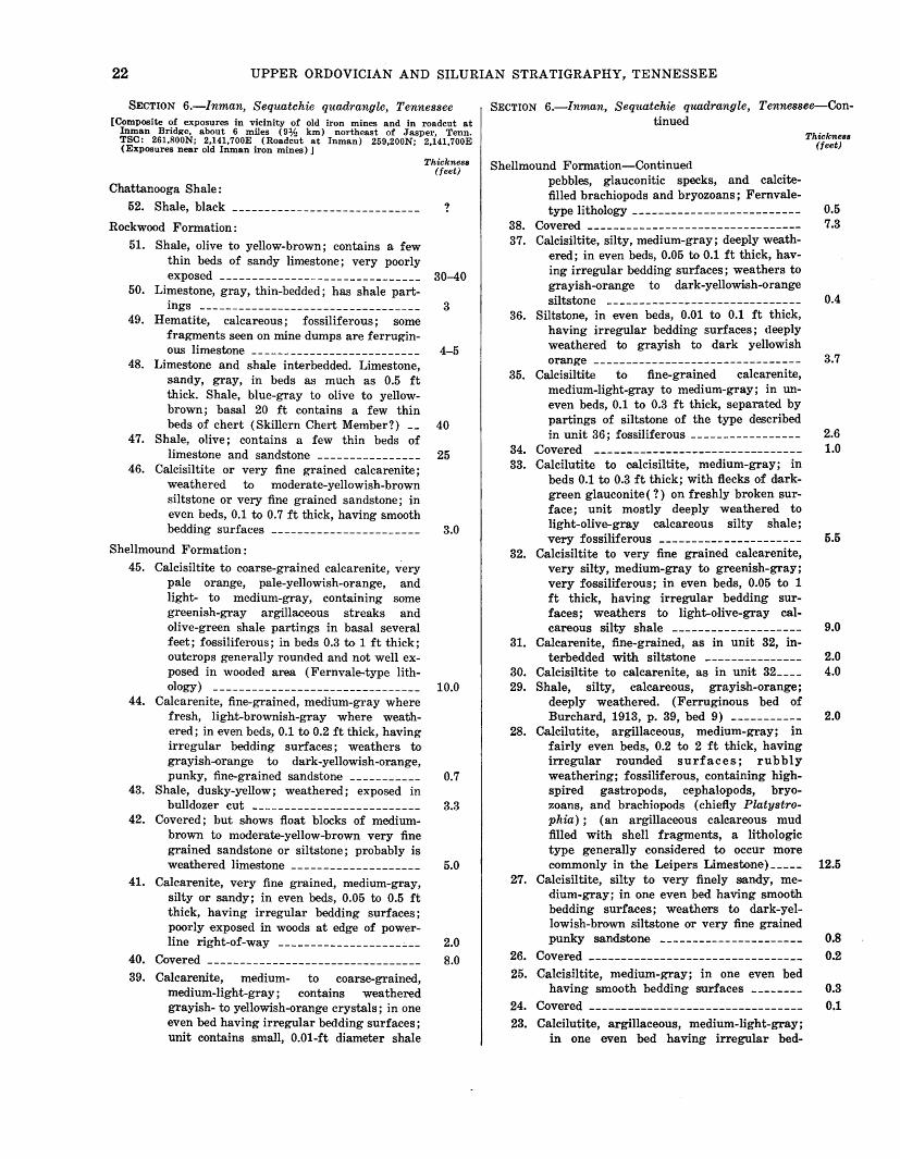
22 UPPER ORDOVICIAN AND SILURIAN STRATIGRAPHY, TENNESSEE
SECTION 6.-lnman, Sequatchie quadrangle, Tennessee [Composite of exposures in vicinity of old iron mines and in roadcut at
Inman Bridge, about 6 miles (9lf2 km) northeast of Jasper, Tenn. TSC: 261,800N; 2,141,700E. (Roadcut at Inman) 259,200N; 2,141,700E (Exposures near old Inman Iron mines)]
Chattanooga Shale:
52. Shale, black
Rockwood Formation:
51. Shale, olive to yellow-brown; contains a few thin beds of sandy limestone; very poorly
exposed -------------------------------50, Limestone, gray, thin-bedded; has shale part-
ings ----------------------------------49. Hematite, calcareous; fossiliferous; some
fragments seen on mine dumps are ferrugin-ous limestone _________________________ _
48. Limestone and shale interbedded. Limestone, sandy, gray, in beds as much as 0.5 ft thick. Shale, blue-gray to olive to yellowbrown; basal 20 ft contains a few thin beds of chert (Skillern Chert Member?) __
47. Shale, olive; contains a few thin beds of limestone and sandstone ----------------
46. Calcisiltite or very fine grained calcarenite; weathered to moderate-yellowish-brown siltstone or very fine grained sandstone; in even beds, 0.1 to 0. 7 ft thick, having smooth bedding surfaces -----------------------
Shellmound Formation :
45. Calcisiltite to coarse-grained calcarenite, very pale orange, pale-yellowish-orange, and light- to medium-gray, containing some greenish-gray argillac,eous streaks and olive-green shale partings in basal several feet; fossiliferous; in beds 0.3 to 1 ft thick; outcrops generally round·ed and not well exposed in wooded area (Fernvale-type lith-ology) ______ -- _ -----------------------
44. Calcarenite, fine-grained, medium-gray where fresh, light-brownish-gray where weathered; in even beds, 0.1 to 0.2 ft thick, having irregular bedding surfaces; weathers to grayish-<>range to dark-yellowish-orange, punky, fine-grained sandstone -----------
43. Shale, dusky-yellow; weathered; exposed in bulldozer cut --------------------------
42. Covered; but shows float blocks of medium-brown to moderate-yellow-brown very fine grained sandstone or siltstone; probably is weathered limestone --------------------
41. Calcarenite, very fine grained, medium-gray, silty or sandy; in even beds, 0.05 to 0.5 ft thick, having irregular bedding surfaces; poorly exposed in woods at edge of power-line right-of-way ___________________ .:_ __
40. Covered
39. Calcarenite, medium- to coarse-grained, medium-light-gray; contains weathered grayish- to yellowish-orange crystals; in one even bed having irregular bedding surfaces; unit contains small, 0.01-ft diameter shale
Thickness (feet)
?
30-40
3
4-5
40
25
3.0
10.0
0.7
3.3
5.0
2.0
8.0
SECTION 6.-lnman, Sequatchie quadrangle, Tennessee-Continued
Shellmound Formation-Continued
38. 37.
36.
35.
34. 33.
pebbles, glauconitic specks, and calcitefilled brachiopods and bryozoans; Fernvale-type lithology --------------------------
Covered ---------------------------------Calcisiltite, silty, medium-gray; deeply weath-
ered; in even beds, 0.05 to 0.1 ft thick, having irregular bedding surfaces; weathers to grayish-<>range to dark-yellowish-orange siltstone ___________________ -----------
Siltstone, in even beds, 0.01 to 0.1 ft thick, having irregular bedding surfaces; deeply weathered to grayish to dark yellowish
orange --------------------------------Calcisiltite to fine-grained calcarenite,
medium-light-gray to medium-gray; in uneven beds, 0.1 to 0.3 ft thick, separated by partings of siltstone of the type described in unit 36; fossiliferous -----------------
Covered --------------------------------Calcilutite to calcisiltite, medium-gray; in
beds 0.1 to 0.3 ft thick; with flecks of d'arkgreen glauconite(?) on freshly broken surface; unit mostly deeply weathered to light-olive-gray calcareous silty shale; very fossiliferous ----------------------
32. Calcisiltite to very fine grained calcarenite, very silty, medium-gray to greenish-gray; very fossiliferous; in even beds, 0.05 to 1 ft thick, having irregular bedding surfaces; weathers to light-olive-gray cal-
31.
30. 29.
28.
careous silty shale -------------------Calcarenite, fine-grained, as in unit 32, in-
terbedded with siltstone ---------------Galcisiltite to calcarenite, as in unit 32 ___ _ Shale, silty, calcareous, grayish-orange;
deeply weathered. (Ferruginous bed of Burchard, 1913, p. 39, bed 9) -----------
Calcilutite, argillaceous, medium-gray; in fairly even beds, 0.2 to 2 ft thick, having irregular rounded surfaces; rubbly weathering; fossiliferous, containing highspired gastropods, ce·phalopods, bryozoans, and brachiopods (chiefly Platystrophia) ; (an argillaceous calcareous mud filled with shell fragments, a lithologic type generally considered to occur more commonly in the Leipers Limestone)-----
27. Calcisiltite, s.ilty to very finely .sandy, medium-gray; in one even bed having smooth bedding surfaces; weathers to dark-yellowish-brown siltstone or very fine grained punky sandstone ----------------------
26. Covered ---------------------------------25. Calcisiltite, medium-gray; in one even bed
having smooth bedding surfaces --------
24. Covered ---------------------------------23. Calcilutite, argillaceous, medium-light-gray;
in one even bed having irregular bed-
Thickness (feet)
0.5 7.3
0.4
3.7
2.6 1.0
5.5
9.0
2.0 4.0
2.0
12.5
0.8 0.2
0.3 0.1
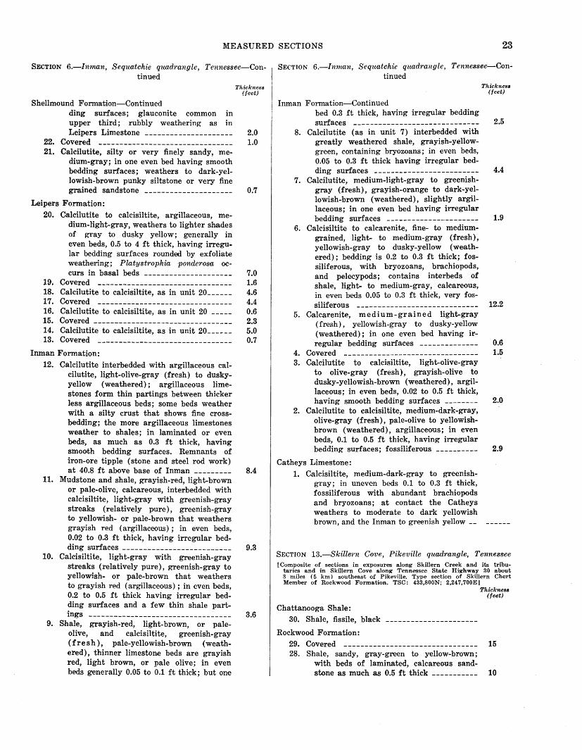
MEASURED SECTIONS 23
SECTION 6.-Inman, Sequatchie quadrangle, Tennessee-Continued
Shellmound Formation-Continued ding surfaces; glauconite common in upper third; rubbly weathering as in
Thickness (feet)
Leipers Limestone --------------------- 2.0 22. Covered -------------------------------- 1.0 21. Calcilutite, silty or very finely sandy, me
dium-gray; in one even bed having smooth bedding surfaces; weathers to dark-yellowish-brown punky siltstone or very fine grained sandstone --------------------- 0.7
Leipers Formation:
20. Calcilutite to calcisiltite, argillaceous, medium-light-gray, weathers to lighter shades of gray to dusky yellow; generally in even beds, 0.5 to 4 ft thick, having irregular bedding surfaces rounded by exfoliate weathering; Platystrophia ponderosa oc-curs in basal beds --------------------- 7.0
19. Covered -------------------------------- 1.6 18. Calcilutite to calcisiltite, as in unit 20______ 4.6 17. Covered -------------------------------- 4.4 16. Calcilutite to calcisiltite, as in unit 20 _____ 0.6
15. Covered --------------------------------- 2.3 14. Calcilutite to calcisiltite, as in unit 20______ 5.0 13. Covered -------------------------------- 0.7
Inman Formation:
12. Calcilutite interbedded with argillaceous calcilutite, light-olive-gray (fresh) to duskyyellow (weathered); argillaceous limestones form thin partings between thicker less argillaceous beds; some beds weather with a silty crust that shows fine crossbedding; the more argillaceous limestones weather to shales; in laminated or even beds, as much as 0.3 ft thick, having smooth bedding surfaces. Remnants of iron-ore tipple (stone and steel rod work) at 40.8 ft above base of Inman --------- 8.4
11. Mudstone and shale, grayish-red, light-brown or pale-olive, calcareous, interbedded with calcisiltite, light-gray with greenish-gray streaks (relatively pure), greenish-gray to yellowish- or pale-brown that weathers grayish red (argillaceous) ; in even beds, 0.02 to 0.3 ft thick, having irregular bed-ding surface.s -------------------------- 9.3
10. Calcisiltite, light-gray with greenish-gray streaks (relatively pure), greenish-gray to yellowish- or pale-brown that weathers to grayish red (argillaceous) ; in even beds, 0.2 to 0.5 ft thick having irregular bedding surfaces and a few thin shale part-ings ---------------------------------- 3.6
9. Shale, grayish-red, light-brown, or pale-olive, and calcisiltite, greenish-gray (fresh), pale-yellowish-brown (weathered), thinner limestone beds are grayish red, light brown, or pale olive; in even beds generally 0.05 to 0.1 ft thick; but one
SECTION 6.-Inman, Sequatchie quadrangle, Tennessee-Continued
Inman Formation-Continued bed 0.3 ft thick, having irregular bedding
Thickness (feet)
surfaces ------------------------------ 2.5 8. Calcilutite (as in unit 7) interbedded with
greatly weathered shale, grayish-yellowgreen, containing bryozoans; in even beds, 0.05 to 0.3 ft thick having irregular bed-ding surfaces ------------------------- 4.4
7. Calcilutite, medium-light-gray to greenishgray (fresh), grayish-orange to dark-yellowish-brown (weathered), slightly argillaceous; in one even bed having irregular bedding surfaces --------------·-------- 1.9
6. Calcisiltite to calcarenite, fine- to mediumgrained, light- to medium-gr:ay (fresh), yellowish-gray to dusky-yellow (weathered); bedding is 0.2 to 0.3 ft thick; fossiliferous, with bryozoans, brachiopods, and pelecypods; contains interbeds of shale, light- to medium-gray, calcareous, in even beds 0.05 to 0.3 ft thick, very fos-siliferous ____ ___ __ ___ ______ _ ___ __ ____ _ 12.2
5. Calcarenite, medium-grained light-gray (fresh), yellowish-gray to dusky-yellow (weathered); in one even bed having ir-regular bedding surfaces -------------- 0.6
4. Covered -------------------------------- 1.5 3. Calcilutite to calcisiltite, light-olive-gray
to olive-gray (fresh), grayish-olive to dusky-yellowish-brown (weathered), argillaceous; in even beds, 0.0.2 to 0.5 ft thick, having smooth bedding surfaces -------- 2.0
2. Calcilutite to calcisiltite, medium-dark-gray, olive-gray (fresh), pale-olive to yellowishbrown (weathered), argillaceous; in even beds, 0.1 to 0.5 ft thick, having irregular bedding surfaces; fossiliferous ---------- 2.9
Catheys Limestone: 1. Calcisiltite, medium-dark-gray to greenish
gray; in uneven beds 0.1 to 0.3 ft thick, fossiliferous with abundant brachiopods and bryozoans; at contact the Catheys weathers to moderate to dark yellowish brown, and the Inman to greenish yellow __
SECTION l3.-Skille1'n Cove, Pikeville quadrangle, Tennessee [Composite of sections in exposures along Skillern Creek and its tribu
taries and in Skillern Cove along Tennessee State Highway 30 about 3 miles ( 5 km) southeast of Pikeville. Type section of Skillern Chert Member of Rockwood Formation. TSC: 433,800N; 2,247,700E]
Chattanooga Shale: 30. Shale, fissile, black
Rockwood Formation:
Thickness (feet)
29. Covered -------------------------------- 15 28. Shale, sandy, gray-green to yellow-brown;
with beds of laminated, calcareous sandstone as m.uch as 0.5 ft thick ----------- 10
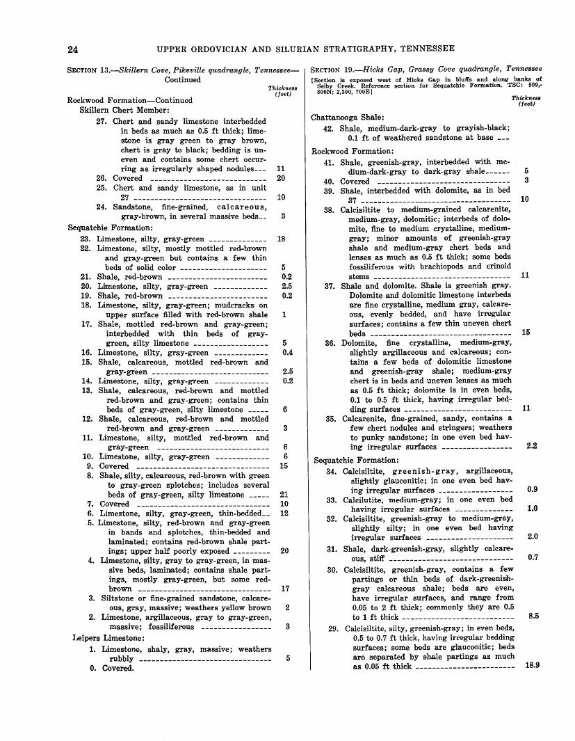
24 UPPER ORDOVICIAN AND SILURIAN STRATIGRAPHYt TENNESSEE
SECTION 13.-Skillern Cove, Pikeville quadrangle, TennesseeContinued
Thickness (feet)
Rockwood Formation-Continued Skillern Chert Member:
27. Chert and sandy limestone interbedded in beds as much as 0.5 ft thick; limestone is gray green to gray brown, chert is gray to black; bedding is uneven and contains some chert occur-ring as irregularly shaped nodules __ _
26. Covered ----------------------------25. Chert and sandy limestone, as in unit
27 --------------------------------24. Sandstone, fine-grained, calcareous,
gray-brown, in several mass,ive beds __
Sequatchie Formation:
23. Limestone, silty, gray-green --------------22. Limestone, silty, mostly mottled red-brown
and gray-green but contains a few thin beds of solid color ---------------------
21. S.hale, red-brown ------------------------20. Limestone, silty, gray-green -------------19. S·hale, red-brown ------------------------18. Limestone, silty, gray-green; mudcracks on
upper surface filled with red-brown shale 17. Shale, mottled red-brown and gray-green;
interbedded with thin beds of graygreen, silty limestone ------------------
16. Limestone, silty, gray-green -------------15. Shale, calcareous, mottled red-brown and
11 20
10
3
18
5 0.2 2.5 0.2
1
5 0.4
gray-green ---------------------------- 2.5 14. Limestone, silty, gray-green ------------- 0.2 13. Shale, calcareous, red-brown and mottled
red-brown and gray-green; contains thin beds of gray-green, silty limestone _____ 6
12. Shale, calcareous, red-brown and mottled red-brown and gray-green ------------- 3
11. Limestone, silty, mottled red-brown and gray-green --------------------------- 6
10. Limestone, silty, gray-green ------------- 6
9. Covered -------------------------------- 15 8. Shale, silty, calcareous, red-brown with green
to gray-green splotches; includes several beds of gray-green, silty limestone _____ 21
7. Covered -------------------------------- 10 6. Limestone, silty, gray-green, thin-bedded__ 12 5. Limestone, silty, red-brown and gray-green
in bands and splotches, thin-bedded and laminated; contains red-brown shale partings; upper half poorly exposed --------- 20
4. Limestone, silty, gray to gray-green, in massive beds, laminated; contains shale partings, mostly gray-green, but some red-brown -------------------------------- 17
3. Siltstone or fine-grained sandstone, calcare-ous, gray, massive; weathers yellow brown 2
2. Limestone, argillaceous, gray to gray-green, massive; fossiliferous ----------------- 3
I ,eipers Limestone: 1. Limestone, shaly, gray, massive; weathers
rubbly -------------------------------- 5 0. Covered.
SECTION 19.-Hicks Gap, Grassy Cove quadrangle, Tennessee [Section is exposed west of Hicks Gap in bluffs and along banks of
Selby Creek. Reference section for Sequatchie Formation. TSC: 509,SOON; 2,300, 700E]
Chattanooga Shale: 42. Shale, medium-dark-gray to grayish-black;
0.1 ft of weathered sandstone at base
Rockwood Formation: 41. Shale, greenish-gray, interbedded with me-
Thickness (feet)
dium-dark-gray to dark-gray shale______ 5
40. Covered -------------------------------- 3 39. Shale, interbedded with dolomite, as in bed
37 ------------------------------------ 10 38. Calcisiltite to medium-grained calcarenite,
medium-gray, dolomitic; interbeds of dolomite, fine to medium crystalline, mediumgray; minor amounts of greenish-gray shale and medium-gray chert beds and lenses as much as 0.5 ft thick; SiOme beds fossiliferous with brachiopods. and crinoid
s~s --------------------------------- 11 37. Shale and dolomite. Shale is greenish gray.
Dolomite and dolomitic limestone interbeds are fine crystalline, medium gray, calcareous, evenly bedded, and have irregular surfaces; contains a few thin uneven chert
beds ---------------------------------- 15 36. Dolomite, fine crystalline, medium-gray,
slightly argillaceous and calcareous; contains a few beds of dolomitic limes.tone and greenish-gray shale; medium-gray chert is in beds and uneven lenses as much as 0.5 ft thick; dolomite is in even beds, 0.1 to 0.5 ft thick, having irre·gular bed-ding surfaces -------------------------- 11
3·5. Calcarenite, fine-grained, sandy, contains a few chert nodules and stringers; weathers to punky sandstone; in one even bed hav-ing irregular surfaces ----------------- 2.2
S.equatchie Formation: 34. Ca.lcisiltite, greenish-gray, argillaceous,
slightly glauconitic; in one even bed hav-ing irregular surface·s ------------------ 0.9
33. Calcilutite, medium-gray; in one e-ven bed having irregular surfaces -------------- 1.0
32. Calcisiltite, greenish-gray to medium-gray, slightly silty; in one even bed having irregular surface.s --------------------- 2.0
31. Shale, dark-greenish-gray, slightly calcare-ous, stiff ------------------------------ 0.7
30. Oalcisiltite, greenish-gray, contains a few partings or thin beds of dark-greenishgray calcareous shale; beds are even, have irregular surf-aces, and range from 0.05 to 2 ft thick; commonly they are 0.5 to 1 ft thick --------------------------- 8.5
29. Calcisiltite, silty, greenish-gray; in even beds, 0.5 to 0.7 ft thick, having irregular bedding surfaces; some beds are glauconitic; beds are separated by shale partings as much as 0.05 ft thick ------------------------ 18.9
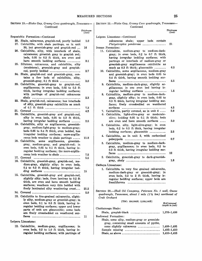
MEASURED SECTIONS 25
SECTION 19.-Hicks Gap, Gmssy Cove quadrangle, TennesseeContinued
Sequatchie Forma;tion-Continued
Thickness (feet)
28. Shale, calcareous, grayish-red, poorly bedded 1.0 27. Calcisiltite, with shale partings, as in unit
30, but greenish-gray and grayish-red __ 16 26. Calcisiltite, silty, with interbeds orf shale,
calcareous; greenish gray to grayish red; beds, 0.05 to 0.3 ft thick, are even and have smooth bedding surfaces --------- 3.1
25. Siltstone, calcareous, and calcisiltite, silty (mudstone), greenish-gray and grayish-red, poorly bedded --------------------- 2.7
24. Shale, grayish-red and greenish-gray, con-tains a few beds of calcisiltite, silty, greenish-gray, 0.1 ft thick -------------- 3.0
23. Calcisiltite, greenish-gray to grayish-red, argillaceous; in even beds, 0.02 to 0.3 ft thick, having irregular bedding surfaces; with partings of grayish-red calcareous shale --------------------------------- 2.3
22. Shale, grayish-red, calcareous; has interbeds of silty, greenish-gray calcisiltite as much of 0.1 ft thick ------------------------ 7.3
21. Covered --------------------------------- 4.5 20. Calcisiltite, greenish-gray and grayish-red,
silty in even beds, 0.05 to 0.3 ft thick, having irregular bedding surfaces ------ 2.5
19. Calcisiltite, silty or argillaceous, greenishgray, medium-light-gray to medium-gray; beds 0.05 to 0.4 ft thick, e·ven bedded, has irregular bedding surfaces; more-argilla-ceous beds weather to shale partings _____ 11.8
18. Calcisiltite, some argillaceous, greenishgray, medium-gray, and grayish-red; in even beds, 0.05 to 0.1 ft thick, having irregular bedding surfaces; the more-argilla-ceous beds weather to shale-------------- 7.5
17. Covered -------------------------------- 5.5 16. Calcisiltite, greenish-gray, grayish-red, me
dium-gray, slightly silty; in even beds, 0.1 to 0.3 ft thick, having irregular bed-ding surfaces ------------------------- 15
15. Calcisiltite, greenish-gray and grayish-red, slightly silty; beds, from laminae to 0.2 ft thick, are even and have smooth bedding surfaces; weathers very thin bedded with finely laminated silty weathering crust___ 21.2
14. Covered --------------------------------- 5.0 13. Calcilutite to fine-grained calcarenite, slight-
ly silty, medium-gray or greenish-gray; in even beds, 0.1 to 0.5 ft thick, having irregular bedding surface.s; upper and lower parts of unit are glauconitic; some beds are finely crossbedded on weathered sur-faces --------------------------------- 11
Leipers Limestone:
12. Calcisiltite, medium-gray, argillaceous; in even beds, 0.2 to 1.0 ft thick, having irregular bedding surfaces; with partings of
SECTION 19.-Hicks Gap, Grassy Cove quadrangle, TennesseeContinued
Leipers Limestone-Continued
Thickness (feet)
calcareous shale; upper beds contain Platystrophia ponderosa ---------------- 21
Inman Formation: 11. Calcisiltite, medium-gray to medium-dark
gray; in even beds, 0.2 to 0.7 ft thick, having irregular bedding surfac.es; with partings or interbeds of medium-gray or greenish-gray argillaceous calcilutite as much as 0.3 ft thick; glauconitic -------- 6.3
10. Calcisiltite, some argillaceous, medium-gray and greenish-gray; in even beds 0.05 to 0.4 ft thick, having smooth bedding sur-faces --------------------------------- 5.5
9. Galcisiltite, medium-dark-gray, slightly ar-gillaceous; in one even bed having irregular bedding surfaces --------------- 1.5
8. Calcisiltite, medium-gray to medium-darkgray, slightly silty; in even beds, 0.05 to 0.3 ft thick, having irregular bedding surfaces; finely crossbedded on weathered surfaces ------------------------------ 4.5
7. Galcisiltite, partly covered, as in unit 6 ---- 5.0 6. Galcisiltit€, light-olive-gray or moderate-
olive; bedding 0.05 to 0.1 ft thick; beds are even and have smooth surface·s ---- 3.0
5. Calcisiltite, silty, light-olive-gray; in even beds, 0.2 to 0.5 ft thick, having irregular bedding surfaces; glauconitic ----------- 2.5
4. Calcisiltite, as in unit 3, with carbonized pelecypods ---------------------------- 0.7
3. Calcisiltite, medium-gray to medium-darkgray, argillaceous; in even beds, 0.2 to 0.3 ft thick, having irregular bedding sur-faces --------------------------------- 12
2. Calcilutite, greenish-gray to dark-greenish-gray, shaly --------------------------- 1.8
Catheys Limestone: 1. Calcisiltite to very fine grained calcarenite,
medium-dark-gray or greenish-gray; in even beds, 0.2 to 2 ft thick, having irregular bedding surfaces; upper beds are fossiliferous --------------------------
SECTION 20.-Shell Oil Company, Peterson No. 1 well, Ozone quadrangle, Tennessee, about 1 mile (1% km) northeast of Crab Orchard
[TSC: 556,800N; 2,339,100E]
Chattanooga Shale: Shale, grayish-black
Rockwood Formation: Shale, some silty, medium-gray or greenish
gray, containing small amounts of pyrite, some slightly calcareous --------------
Sample missing -----------------------Shale, as above --------------------------
W eU inter11al (depth in feet)
1,370-1,400
1,400-1,405 1,405-1,410 1,410-1,415
26 UPPER ORDOVICIAN AND SILURIAN STRATIGRAPHY,. TENNESSEE
SECTION 20.-Shell Oil Company, Peterson No. 1 well, Ozone quadrangle, Tennessee, about 1 mile (1% km) northeast of Crab Orchard-Continued
Rockwood Formation-Continued
Shale, as above, with fragment of red ore;
Well interval (depth in feet)
some calcilutite to calcisiltite, light-gray __ 1,415-1,420 Shale and siltstone, medium-light-gray to
medium-gray or greenish-gray; and calcilutite to calcisiltite, light-gray, containing small amounts of pyrite and mediumlight to medium-gray chert and a f•ew fragments of grayish-red shale __________ 1,420-1,425
Shale and siltstone, as above, with small amounts of light-gray caldsiltite and medium-light-gray to medium-gray chert and fragments of grayish-red mu<t:;tone __ 1,425-1,430
Shale and siltstone, as above, containing small amount of pyrite ---------------- 1,430-1,445
Shale and silts1tone, as above, containing some light-gray oolitic limestone ------------- 1,445-1,450
Sequatchie Formation :
Shal,e, siltstone, and oolitic limestone, as above, containing a few fragments of gray-ish-red siltstone ----------------------- 1,450-1,455
Shale and siltstone, as above, containing a few fragments of grayish-red siltstone __ 1,455-1,465
Calcisiltite, shale, and siltstone, medium-light-gray to medium-gray ------------- 1,465-1,470
Sample missing ------------------------- 1,470-1,475 Caldsiltite, shale, and siltstone, as above,
containing small amounts of pyrite and • a few fragments of grayiSih-red siltstone _ 1,475-1,480
Calcisiltite, shale, and siltstone, as above, mostly calcisiltite ---------------------- 1,480-1,485
Calcisiltite, shale, and sriltstone, as, above, but contains abundant grayish-red calcareous siltstone _ _ _ _ __ _ _ _ __ __ _ _ _ _ _ __ _ _ _ _ _ _ _ _ _ 1,485-1,500
Shale, siltstone, and some calcisiltite, light-to medium-gray, some dolomitic ________ 1,500-1,505
Shale, siltstone, and calcisiltite, as above, but some shale and siltstone is grayish-red or greenish-gray _ _ _ _ __ __ _ _ _ _ __ __ __ __ _ _ _ _ _ 1,505-1,510
Caldsi:ltite, argillaceous, and silts,tone, dolo-mitic, light- to medium-gray, greenish-gray and grayish-red ------------------ 1,510-1,530
Calcisiltite and sHtstone, as above, but con-taining abundant light-gray calcisiltite and lesser amounts of grayish-red mudstone __ 1,530-1,535
Calcisiltite, argillaceous, and sHtstone, dolomitic, light-gray to medium-light-gray and greenish-gray, containing minor amounts. of grayish-red mudstone --------------- 1,535-1,540
Calcisiltite, and siltstone, dolomitic, light-gray to medium-light-gray and greenish-gray; argillaceous -------------------- 1,540-1,555
Siltstone, dolomitic, and calcisiltite, light-gray to medium-light-gray, and greenish-gray; argillac·eous _ __ __ _ _ __ _ __ _ __ _ ___ _ 1,555-1,560
Calcisiltite and siltstone, dolomitic, light-gray to medium-light-gray and greenish-gray; argillaceous -------------------------- 1,560-1,565
SECTION 20.-Shell Oil Company, Peterson No. 1 well, Ozone quadrangle, Tennessee, about 1 mile (1% km) northeast of Crab Orchard-Continued
Sequatchie Formation-Continued
Calcisiltite and siltstone, as above, but con-
Well interval (depth in feet)
taining some grayish-red mudstone ------ 1,565-1,570 Calcisiltite and siltstone, dolomitic, light-
gray to medium-light-gray, greenish-gr·ay and grayish-red; argillaceous ---------- 1,570-1,605
Calcisiltite and siltstone, as above, with fos-sil fragment -------------------------- 1,605-1,610
Calcisiltite and siltstone, as above, witlh only a few grayish-red fragments ---------- 1,610-1,625
Oalcisiltite and siltstone, as above, with small amounts of pyrite, light-gray chert, and almost no grayish-red rock ------------- 1,625-1,630
Calcisiltite and siltstone, as above, with small amounts of grayish-red mudstone and py-rite ____ :... _ _ _ ___ _ _ _ _ _ _ _ _ ____ _ _ __ _ _ __ _ _ _ 1,630-1,635
Calcisiltite and siltstone, as above, with small amounts of light-gray chert, and almost no grayish-red rock ---------------------- 1,635-1,640
Calcisiltite and siltstone, as above, with some calcisiltite, medium-gray, and a few fossil fragments _ _ _ _ _ _ _ _ _ __ _ _ _ _ _ _ _ ___ __ _ _ _ _ _ 1,640-1,650
Leipers Limestone::
Sample missing -----------------------Calcisiltite, medium-gray, with some green-
ish-gray siltstone; fossiliferous --------Calcisiltite, light- to medium-gray, with some
fossil fragments _____________________ _
Calcisiltite, as above, with some mediumgray silty dolomite --------------------
Inman Formation:
Calcisiltite and siltstone, with some medium-gray to light-greenish-gray dolosiltite and some sparry white calcite -------------
Sample missing ------------------------
Catheys Limestone (not shown on pl. 1) :
Calcisiltite and siltstone, medium-light-gray to medium-gray with some dolosiltite, with abundant sparry white calcite; fossilifer-
1,650-1,655
1,655-1,665
1,665-1,670
1,670-1,675
1,675-1,705 1,705-1,710
ous with a few piec'es of pyrite --------- 1,710-1,795
SECTION 21.-Emory Gap, Harriman quadrangle, Tennessee [In cuts along secondary roads and westbound lane of Interstate 40. New
reference section for Rockwood Formation. TSC: 556,800N; 2,415,700 E] Thickness
(feet)
Chattanooga Shale:
35. Shale, dark-gray to grayish-black 30±
Chattanooga Shale or Rockwood Formation:
34. Claystone, greenish-gray ----------------- 0.7 33. Shale, light-greenish-gray ---------------- 1.6 32. Shale, as in unit 31 interbedded with brown-
ish-gray shale; in beds 0.05 to 0.1 ft thick - 1.5 31. Shale, light-greenish-gray ---------------- 4.8 30. Shale, brownish-black -------------------- 0.1 29. Shale, silty, light-greenish-gray ----------- 3.9
MEASURED SECTIONS 27
SECTION 21.-Emory Gap, Harriman quad-rangle, TennesseeContinued
Thickness (feet)
Chattanooga Shale or Rockwood Formation-Continued 28. Shale, brownish-black, weathered ---------- 0.2-0.3 27. Shale, silty, light-greenish-gray ----------- 3.9 26. Shale, brownish-black -------------------- 0.2 25. Shale, silty, light-greenish-gray ----------- 4.2 24. Shale, brownish-black -------------------- 2.6-3.8
Rockwood Formation:
23. Shale, .silty, light-greenish-gray to pale-olive 18
22. Siltstone or very fine grained sandstone, darkyellowish-orange; in even beds, 0.1 to 0.5 ft thick, having irregular bedding sur-faces ___ __ _ _ __ _ _ _ _ _ _ __ _ _ _ _ ____ __ __ __ __ 1.6
21. Shale, silty, pale-olive -------------------- 13 20. Siltstone or very fine grained sandstone, as
in unit 2;21; in one even bed having irregu-lar bedding surfaces ------------------- 0.6
19. Shale, silty, pale-olive, containing a few ribs of siltstone or very fine grained sandstone as in unit 22, in even beds, 0.05 to 0.1 ft thick, having irregular bedding surfaces __
18. Hemrutite, in one bed, greatly weathered ___ _
17. Shale, silty, pale-olive --------------------
16. Hematite -------------------------------15. Shale, slightly silty, dark-greenish-gray
where fresh, pale-olive where weathered, containing a few even ribs of siltstone and very fine grained sands.tone in even beds, 0.1 to 0.3 ft thick, having irregular bedding surfaces _____ -- _____ --- _- --------------
14. Hematite; main ore zone ------------------13. Shal,e, as in unit 15, containing beds of very
fine grained sandstone, dark-yellowishorange, in even ribs, 0.02 to 0.2 ft thick, having irregular bedding surfaces -------
12. Hematite --------------------------------11. Shale interbedded with sandstone, as in unit
13; a trace of hematite 2 ft above the base _
10. Hematite --------------------------------9. Shale interbedded with sandstone, as in unit
13 ------------------------------------8. Hematite --------------------------------7. Shale, as in unit 15, interbedded with
weathered punky yellowish-orange to yellowish-brown siltstone (probably was silty limestone); in even beds, 0.05 to 0.2 ft thick, having irregular bedding surfaces -------
6. Shale interbedded with siltstone, darkgreenish-gray to medium-bluish-gray where fresh, yellowish-orange to yellowish-brown where weathered, with ribs of chert, argillaceous calcisiltite, and fine-grained calcarenite in even beds, 0.1 to 0.5 ft thick, hav-ing irregular bedding surfaces _________ _
5. Siltstone, yellowish-orange to yellowish-brown, poorly exposed, greatly weathered --------
12
0.2
7.0-7.5
0.3-0.5
50
1.5-4.2
15
0.2-0.3
17
0.3
20
0.2
11
40
6.0
SECTION 21.-Emory Gap, Harrirnan quad-rangle, TennesseeContinued
Sequatchie Formation (measured along Interstate 40 right-of-way, under construction) :
Thickness (feet)
4. Siltstone, as in unit 5, interbe!(ided with greatly weathered grayish-red shale ------ 26 ±
3. Calcisiltite, greenish-gray and grayish-red, greatly weathered ---------------------- 155 ±
2. Covered with grayish-red soil ---·----------- 65 ±
Sequatchie Formation ( ?) :
1. Claystone saprolite, some silty, greatly weathered, yellowish-gray, yellowish-orange, yellowish-brown --------------------------
SECTION 22.-Thief Neck, Rockwood quadrangle, Tennessee [Measured along northeast point on Watts Bar Lake. TSC: 508,500N;
2,400,400E]
Sequatchie Forma.tion :
43. Cobble conglomerat'e; greenish-gray calcisiltite coibbles are in a matrix of grayish-red calcisiltite _______________ --- _____ ------
42. Calcisiltite, grayish-red, silty; in even beds 0.2 to 2.0 ft thick, internally laminated and has smooth bedding surfaces; weathered rock is interlaminated grayish orange, pale olive, and grayish red, mudcracks are common; some rock i.s mottled or burrowed _____ - _-
41. Covered ---------------------------------40. Calcisiltite, as in unit 42 ------------------39. Cove11ed ---------------------------------38. Calcisiltite, as in unit 42, with abundant
ripple marks, mudcracks, flat pebble con-glomerate ___ --------------------------
37. Covered ---------------------------------36. Calcisiltite, as in unit 42 ------------------35. Covered ---------------------------------34. Sandstone, very fine grained, pale- to moder-
ate-brown, finely crossbedded; even beds 0.1 to 0.5 ft thick, with smooth bedding sur-
faces ----------------------------------33. Calcisiltite, as in unit 42, and sandstone,
32. 31.
30.
29.
28.
weathered, pale- to moderate-brown, very fine grained, finely crossbedded, in even ribs, 0.1 to 1.5 ft thick, having irregular bedding
surfaces ------------------------------Calcisiltite, as in unit 42 -----------------Calcisiltite, medium-gray to greenish-gray,
glauconitic, in one even bed having irregular bedding surfaces, with a few partings of argillaceous limestone ------------------
Mudstone, greenish-gray to grayish-red, cal-careous, poorly bedded ------------------
Calcilutite to calcisiltite, greenish-gray to grayish-red, slightly argillaceous; in even beds, 0.2 to 0.3 ft thick, having irregular
bedding surfaces -----------------------Calcisiltite, medium-light-gray to greenish-
gray, and a few grayish-red beds; even beds
Thickness (feet)
1.0
10 2.0 3.0 4.5
16 6.0
55 10
6.0
18 50
2.0
1.0
1.8
28 UPPER ORDOVICIAN AND SILURIAN STRATIGRAPHY, TENNESSEE
SECTION 22.-Thief Neck, Rockwood quadrangle, TennesseeContinued
Sequatchie Formation-Continued
are 0.2 to 0.7 ft thick and have irregular
Thickness (feet)
surfaces ------------------------------ 2.7
Leipers Limestone:
27. Calcisiltite, medium-gray to medium-darkgray, argillaceous, beds 0.1 to 0.3 ft thick, uneven, separated by partings of calcareous shale or more silty or argillaceous lime-stone; cobbly weathering --------------- 13.7
26. Calcisiltite, medium-dark-gray, silty and sandy; weathers to a punky very fine grained sandstone, yellowish-orange to yellowish-brown; even beds are 0.05 to 0.2 ft thick and have irregular bedding surfaces _ 2.0
25. Calcisiltite, fossiliferous (bryozoan-brachiopod fauna in a calcisiltite matrix), medium-gray; in beds 0.05 to 0.3 ft thick separ-ated by partings of calcareous shale or very argillaceous limestone; bedding uneven _ _ _ 11.7
24. Calcisiltite, medium-gray, argillaceous, in un-even beds 0.1 to 0.3 ft thick separated by partings of calcareous shale or more argillaceous limestone; cobbly weathering; some beds contain numerous bryozoans and brachiopods, including Platystrophia ponderosa 10.5
23. Calcarenite, fine-grained, medium-gray fossiliferous; even beds are 0.5 to 1.0 ft thick and have irregular surfaces ------------- 2.0
Inman Formation:
22. Calcisiltite, medium-gray, light-olive-gray; weathers to punky siltstone, grayish- to yellowish-orange and yellowish-brown; even beds are 0.02 to 0.3 ft thick and have irregular surfaces ; a few beds are deeply weathered grayish-red (stained from over-lying Sequatchie) clay 0.1 to 0.2 ft thick __ 4.0
21. Calcarenite, fine-grained, and calcisiltite, medium-dark-gray and silty or argillaceous, interbedded with badly weathered olivebrown silty shale; beds are even, generally 0.1 to 0.2 ft thick, and have irregular sur-faces --------------------------------- 13
20. Sandstone, very fine grained, moderate-yellowish-brown, weathered; even beds are 0.05 to 0.3 ft thick and have some ripple marks and irregular bedding surfaces ---------- 5.0
19. Saprolite, as in unit 18; small fold --------- 2.5
18. Saprolite; interbedded siltstone and sandstone, very fine grained, punky, grayish- to yellowish-orange; even beds are 0.02 to 0.2 ft thick and have smooth bedding surfaces __ 18
17. Covered --------------------------------- 15
16. Calcilutite, as in unit 14 ------------------ 0.5
15. Covered --------------------------------- 2.0
SECTION 22.-Thief Neck, Rockwood quadrangle, TennesseeContinued
Inman Formation-Continued
14. Calcilutite, medium-dark-gray, brachiopods scattered on bed surface, in even beds hav-
Thickness (feet)
ing irregular surfaces ------------------ 0.5 13. Covered --------------------------------- 1.5 12. Calcilutite, medium-dark-gray ------------- 0.5 11. Covered --------------------------------- 1.0 10. Calcilutite, medium-dark-gray ------------- 0.5
9. Saprolite, clay, grayish- to yellowish-orange, silty, with a few ribs of punky siltstone -- 5.3
8. Calcisiltite, medium-gray, silty, one even bed with irre·gular partings of more-argillaceous limestone; bedding surfaces are ir-regular, strewn with brachiopods -------- 0.5
7. Covered --------------------------------- 4.8 6. Calcisiltite, as in unit 3, bedding 0.02 to 0.3
ft thick, contains some beds of fine-grained calcarenite, medium-dark-gray, with small brachiopods ---------------------------- 4.2
5. Siltstone, punky, greatly weathered, moderate-yellowish-brown, in one even bed hav-ing irregular bedding surfaces ---------- 0.4
4. Calcisiltite, as in unit 3 except beds are 0.02 to 0.05 ft thick, greatly weathered, punky _ 1.6
3. Calcisiltite, medium-dark-gray, silty or sandy, weathers to punky grayish- or yellowishorange siltstone or very fine grained sandstone; in one even bed having irregular bedding surfaces ----------------------- 0.7
2. Sandstone, very fine grained, punky, grayishorange to dark-yellowish-orange, even beds are 0.1 to 0.3 ft thick and have irregular surfaces -------------------------------
1. Covered
Catheys Limestone:
Limestone, medium-gray, fossiliferous ---------
SECTION 23.-0ld Johnson Ferry Road
1.5
16
[Section is exposed along point facing north into Watts Bar Lake, Ten Mile quadrangle, Tennessee. TSC: 495,200N; 2,386,900E]
Rockwood FormaJtion:
Sequatchie Formation:
16. Calcilutite, very argillaceous, interbedded with calcareous shal·e; moderate-olive-brown, greatly weathered; in uneven beds 0.05 to 1 ft thick, fossiliferous with brachiopods
Thickness (feet)
and bryozoans ------------------------- 8.0 15. Shale, calcareous, dusky-yellow, greatly
weathered; contains balls of calcilutite, light-olive-gray, 0.05 to 0.3 ft in diameter - 5.0
MEASURED SECTIONS 29
SECTION 23.-0ld Johnson Ferry Road-Continued
Sequatchie Formation-Continued:
14. Calcilutite to calcisiltite, medium-gray with greenish-gray splotches; in beds 1 to 2 ft
Thickness (feet)
thick; .outcrop rounded ------------------ 4.0 13. Calcisiltite, very argillaceous, yellowish-gray,
weathered; in even beds, 0.1 to 0.3 ft thick, having irregular bedding surfaces _______ 2.0
12. Calcilutite to calcisiltite, as in unit 14 ______ 2.0
11. Calcisiltite, argillaceous, greenish-gray to grayish-red; even beds are 0.1 to 0.5 ft thick, have irregular bedding surfaces, and some have mudcracks. Colors are in splotches or irregular bands 0.1 to 0.2 ft thick ---------------------------------- 19
10. Conglomerate; intraclasts 0.2 to 0.9 ft across are of rounded calcisiltite, greenish-gray to grayish-red, and are in a greenish-gray to grayish-red calcisiltite matrix --------- 4.0
9. Calcisiltite, interbedded with mudstone, calcareous, greenish-gray to grayish-red; beds are even, 0.1 to 1 ft thick, and have slightly irregular bedding surfaces; mudcracks are common ------------------------------- 46
8. Calcisiltite, argillaceous, grayish-red to green-ish-gray; in even beds 1 to 3 ft thick ____ 16
7. Calcisiltite, laminated, greenish-gray to grayish-red, beds are even, 0.1 to 2 ft thick, have irregular bedding surfaces and mud-cracks ____ .:..___________________________ 2.0
6. Covered --------------------------------- 4.0 5. Calcisiltite, dolomitic greenish-gray, grayish-
red, medium-gray, some silty or sandy beds weather to ribs of sandstone, very fine grained, moderate-brown; beds are even, 0.1 to 2 ft thick, have irregular bedding surfaces; some beds are color laminated, and some have ripple marks ------------ 90
4. Calcisiltite interbedded with calcareous mudstone, as in unit 9 ---------------------- 33
3. Calcilutite, medium-gray to greenish-gray, some argillaceous calcilutite is dusky yellow green; beds are even, about 0.5 ft thick, and have irregular bedding surfaces; some beds are glauconitic (grayish-green
streaks) -------------------------------Leipers Limestone:
2. Covered ---------------------------------
Inman Formation:
1. Saprolite, siltstone interbedded with clay, yellowish-orange to brown, beds are 0.05 to 0.3 ft thick, some of which are of little weathered brachiopod-bryozoan biomicrite and calcisiltite, medium- to medium-dark-
gray ----------------------------------
Catheys Limestone:
Limestone, medium-gray; fossiliferous --------
2.0
50
80
SECTION 24.-Fooshee Bend, Sp-ring City quadrangle, Tennessee
[Main section is on the northeast-facing point of Fooshee Bend, Watts Bar Lake. A supplementary section was measured along the shore on a small point about 1,000 ft (305 m) southwest of the main section. TSC: 475,300N; 2,370,400E.]
Rockwood Formation:
(Beds S1-S5 measured along lake shore on points to south of main section.)
S5. Shale, grayish-red, poorly exposed --------S4. Sandstone, very fine grained, weathered, yel
lowish-orange to yellowish-brown; beds are 0.05 to 0.4 ft thick, are even, and have irregular bedding surfaces; probably same sandstone as in uppermost 1 ft in the main section (bed 40) -----------------------
S3. Shale, interbedded with sandstone, as in unit
S1 ------------------------------------S2. Shale, light-olive-gray --------------------Sl. Shale, light-olive-gray interbedded with sand
stone, very fine grained, weathered, yellowish-orange to yellowish-brown, in even ribs, 0.05 to 0.2 ft thick, having irregular bedding surfaces; base of unit is rib of impure ferruginous siltstone 0.01 to 0.02 ft thick __
(Main Fooshee Bend section.)
40. Sandstone, very fine grained, weathered, yellowish-orange to yellowish-brown, in even beds, 0.05 to 0.4 ft thick, having irregular bedding surfaces; probably same as
bed S4 --------------------------------
39. Covered ---------------------------------
38. Shale, light-olive-gray, with ribs of evenbedded sandstone, very fine grained, medium-gray, some containing ferruginous streaks; beds are even, are 0.05 to 0.2 ft thick, and have irregular bedding surfaces; sandstone beds have sole marks ----------
37. Hematite lens, grayish-red, weathered _____ _
36. Shale, light-olive-gray; contains a few even ribs of weathered, yellowish-orange to yellowish-brown siltstone or very fine grained sandstone, 0.05 to 0.3 ft thick; two even ribs, 0.2 to 0.3 ft thick, of very fine grained, greenish-gray dolomite are in lower 5 ft of
35.
34.
33. 32.
31.
30.
unit; trilobite fossils occur near middle of
unit ----------------------------------Covered --------------------------------Hematite, grayish-red, weathered ----------
Shale, light-olive-gray, folded ------------Shale, light-olive-gray, with ribs of sand-
stone, as in unit 30 --------------------Hematite, grayish-red, very fossiliferous with
Pentamerous ___ ------ ____ -------------Shale, silty, light-olive-gray to greenish-gray;
contains a few ribs of medium-gray very fine grained sandstone in even beds, 0.02 to 0.3 ft thick, having irregular bedding sur-
faces ---------------------------------
Thickness (feet)
20
5.0
13 8.0
1.0
1.0
7.0
23
0.2
33
25
0.2
20±
10±
0.5
10
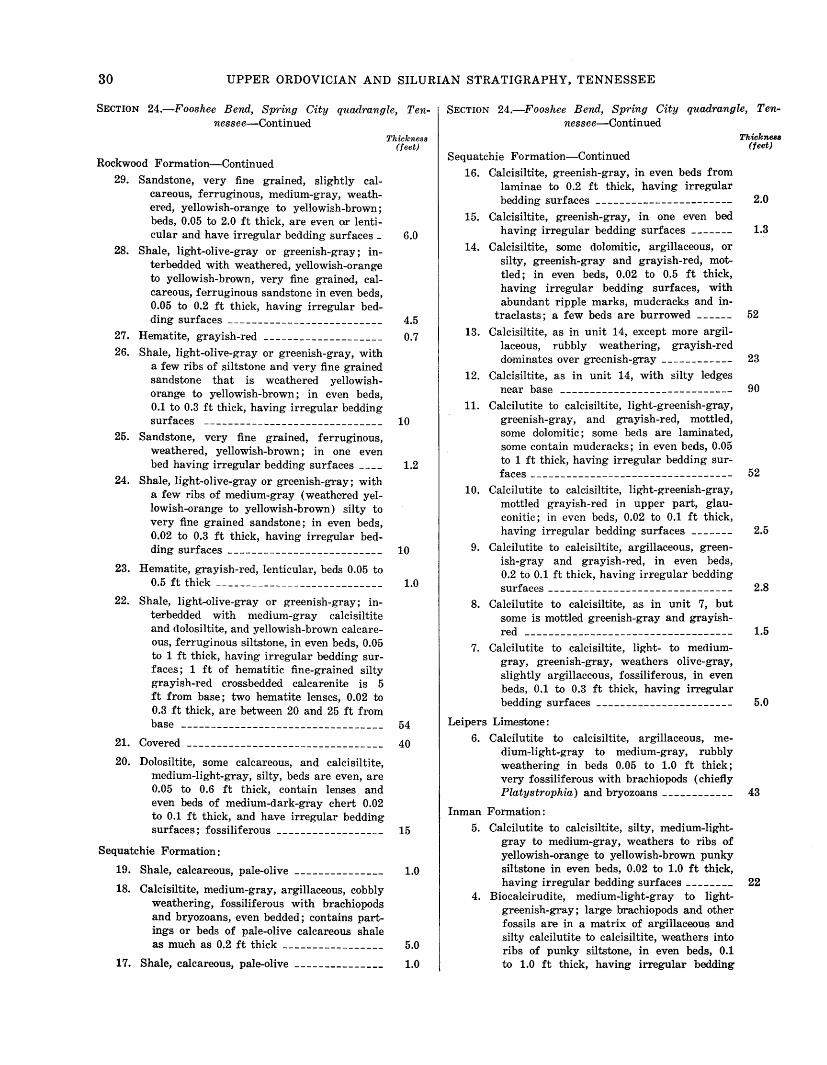
30 UPPER ORDOVICIAN AND SILURIAN STRATIGRAPHY, TENNESSEE
SECTION 24.-Fooshee Bend, Spring City quadrangle, Tennessee-Continued
Rockwood Formation-Continued
29. Sandstone, very fine grained, slightly calcareous, ferruginous, medium-gray, weathered, yellowish-orange to yellowish-brown; beds, 0.05 to 2.0 ft thick, are even or lenticular and have irregular bedding surfaces_
28. Shale, light-olive-gray or greenish-gray; interbedded with weathered, yellowish-orange to yellowish-brown, very fine grained, calcareous, ferruginous sandstone in even beds, 0.05 to 0.2 ft thick, having irregular bed-
ding surfaces --------------------------27. Hematite, grayish-red --------------------26. Shale, light-olive-gray or greenish-gray, with
a few ribs of siltstone and very fine grained sandstone that is weathered yellowishorange to yellowish-brown; in even beds, 0.1 to 0.3 ft thick, having irregular bedding
surfaces ------------------------------25. Sandstone, very fine grained, ferruginous,
weathered, yellowish-brown; in one even bed having irregular bedding surfaces ___ _
24. Shale, light-olive-gray or greenish-gray; with a few ribs o.f medium-gray (weathered yellowish-orange to yellowish-brown) silty to very fine grained sandstone; in even beds, 0.02 to 0.3 ft thick, having irregular bed-
ding surfaces --------------------------
23. Hematite, grayish-red, lenticular, beds 0.05 to 0.5 ft thick ----------------------------
22. Shale, light-olive-gray or greenish-gray; inteTbedded with medium-gray calcisiltite and dolosiltite, and yellowish-brown calcareous, ferruginous siltstone, in even beds, 0.05 to 1 ft thick, having irregular bedding surfaces; 1 ft of hematitic fine-grained silty grayish-red crossbedded calcarenite is 5 ft from base; two hematite lenses, 0.02 to 0.3 ft thick, are between 20 and 25 ft from base ----------------------------------
21. Covered ---------------------------------20. Dolosiltite, some calcaxeous, and calcisiltite,
medium-light-gray, silty, beds are even, are 0.05 to 0.6 ft thick, contain lenses and even beds of medium-dark-gray chert 0.02 to 0.1 ft thick, and have irregular bedding surfaces; fossiliferous ------------------
Sequatchie Formation:
19. Shale, calcareous, pale-olive
18. Calcisiltite, medium-gray, argillaceous, cobbly weathering, fossiliferous with brachiopods and bryozoans, even bedded; contains partings or beds of pale-olive calcareous shale as much as 0.2 ft thick -----------------
17. Shale, calcareous, pale-olive ______________ _
Thickness (feet)
6.0
4.5
0.7
10
1.2
10
1.0
54
40
15
1.0
5.0
1.0
SECTION 24.-Fooshee Bend, Spring City quadrangle, Tennessee-Continued
Sequatchie Formation-Continued 16. Calcisiltite, greenish-gray, in even beds from
laminae to 0.2 ft thick, having irregular bedding surfaces -----------------------
15. Calcisiltite, greenish-gray, in one even bed having irregular bedding surfaces ______ _
14. Calcisiltite, some dolomitic, argillaceous, or silty, greenish-gray and grayish-red, mottled; in even beds, 0.02 to 0.5 ft thick, having irregular bedding surfaces, with abundant ripple marks, mudcracks and in-
traclasts; a few beds are burrowed _____ _
13. Calcisiltite, as in unit 14, except more argillaceous, rubbly weathering, grayish-red dominates over greenish-gray ------------
12. Calcisiltite, as in unit 14, with silty ledges
near base -----------------------------11. Calcilutite to calcisiltite, light-greenish-gray,
greenish-gray, and grayish-red, mottled, some dolomitic; some beds are laminated, some contain mudcracks; in even beds, 0.05 to 1 ft thick, having irregular bedding sur-
faces ----------------------------------10. Calcilutite to calcisiltite, light-greenish-gray,
mottled grayish-red in upper part, glauconitic; in even beds, 0.02 to 0.1 ft thick, having irregular bedding surfaces ______ _
9. Calcilutite to calcisiltite, argillaceous, greenish-gray and grayish-red, in even beds, 0.2 to 0.1 ft thick, having irregular bedding
surfaces -------------------------------8. Calcilutite to calcisiltite, as in unit 7, but
some is mottled greenish-gray and grayish-
red -----------------------------------7. Calcilutite to calcisiltite, light- to medium
gray, greenish-gray, weathers olive-gray, slightly argillaceous, fossiliferous, in even beds, 0.1 to 0.3 ft thick, having irregular bedding surfaces -----------------------
Leipers Limestone:
6. Calcilutite to calcisiltite, argillaceous, medium-light-gray to medium-gray, rubbly weathering in beds 0.05 to 1.0 ft thick; very fossiliferous with brachiopods (chiefly Platystrophia) and bryozoans ------------
Inman Formation:
5. Calcilutite to calcisiltite, silty, medium-lightgray to medium-gray, weathers to ribs of yellowish-orange to yellowish-brown punky siltstone in even beds, 0.02 to 1.0 ft thick, having irregular bedding surfac·es --------
4. Biocalcirudite, medium-Hg~ht-gray to lightgreenish-gray; large brachiopods and other fossils are in a matrix of argillaceous and silty calcilutite to calcisiltite, weathers into ribs of punky siltstone, in even beds, 0.1 to 1.0 ft thick, having irregular bedding
Thickness (feet)
2.0
1.3
52
23
90
52
2.5
2.8
1.5
5.0
43
22

MEASURED SECTIONS 31
SECTION 24.-Fooshee Bend, Spring City quadrangle, Ten-~ SECTION 25a.-Tiftonia, Chattanooga quadrangle, Tennessee-nessee-Continued Continued
Inman Formation-Continued
surfaces; some beds are shaly or lamin-
Thickness (feet)
ated ---------------------------------- 6.0 3. Covered, but contains a few ribs of medium
dark-gray silty calcisiltite in even beds 0.05 to 0.1 in. thick, having irregular bedding surfaces; fossiliferous with brachiopods and
bryozoans ----------------------------- 17 2. Shale, calcareous, dusky-yellow to yellowish
brown, weathered; interbedded with medium-gray to medium-dark-gray silty calcisiltite (weathers to punky yellowishbrown siltstone), in even beds, 0.1 to 0.3 ft thick, having irregular bedding surfaces, fossiliferous with numerous brachiopods and bryozoans; some beds finely cross-
bedded -------------------------------- 32 Catheys Limestone:
1. Calcisiltite to calcarenite, very fine grained, medium-gray; some beds compooed of fossil fragments in a micrite matrix, brachiopods are numerous, even beds are 0.1 to 0. 7 ft thick and have irregular bedding sur-faces _________________________________ _
Section 25.-Tiftonia, Chattanooga and W auhatchie quadrangles, Tennessee
[Composite section 25 (pl. 1) is compiled from four partial sections of t~e R-?ckwood Formation measured on both sides of Lookout Valley at Tifton.•a, Tenn., south along Interstate 24-59 to Slygo Ridge, east of the . divergence of the Interstate highways. These are described as sections 25a through 25d below]
SECTION 25a.-Tiftonia, Chattanooga quadrangle, Tennessee [Section measured on west-facing hillside, stripped for construction pur
poses, north of U.S. Highway 11. TSC: 229,800N; 2,190,500E]
Chattanooga Shale:
Rockwood Formation: 17. Shale, pale-yellowish-green to grayish-green;
interbedded with evenly bedded chert 0.05 to 0.1 ft thick; upper 15 ft deformed _____
16. Saprolite -------------------------15. Shale, grayish-red to pale-brown interbedded
with siltstone saprolite -----------------14. Sandstone, very fine grained, yellowish-gray;
interbedded with siltstone saprolite ______
13. Shale, pale--brown; grayish-red hematite about 0.1 ft thick is in lenses near base ________
12. Sandstone, very fine grained, yellowish-gray _
11. Saprolite --------------------------------10. Hematite, grayish-red --------------------9. Saprolite --------------------------------
Thickness (feet)
25 4.0
2.5
4.5
1.3
5.0
18
0.2
35
Rockwood Formation-Continued
8. Saprolite, containing thin interbeds of hema-
Thickness (feet)
tite, grayish-red ------------------------ 5.0 7. Saprolite -------------------------------- 22 6. Saprolite, interbedded with hematite, grayish-
red ----------------------------------- 3.5 5. Saprolite -------------------------------- 34 4. Hematite, grayish-red -------------------- 0.2 3. Saprolite -------------------------------- 1.0 2. Hematite, grayish-red -------------------- 0.5 1. Saprolite, interbedded shale, and siltstone ___ 71 ±
SECTION 25b.-Tiftonia, Wauhatchie quadrangle, Tennessee [Measured in roadcut along north side of U.S. Highway 11. TSC. 228,800N;
2,187,000E]
Shellmound Formation (lower beds) : 14. Calcisiltite, medium-gray or greenish-gray,
argillaceous or silty, with partings of greenish-gray argillaceous or silty calcisiltite or calcareous siltstone; even beds are 0.05 to 0.3 ft thick and have smooth bedding surfaces; mudcracks common; glauconitic in lower 1 ft --------------------
Leipers Limestone:
13. Calcisiltite, medium-gray, argillaceous and silty, generally in even beds, 0.1 to 2 ft thick, having irregular bedding surfaces; thinner beds are uneven and separated by partings of argillaceous cobbly-weathering limestone _____________________ --------
12. Covered ---------------------------------11. Calcisiltite, as in unit 13 ------------------
Inman Formation:
10. Calcisiltite, medium-gray to greenish-gray,
9.
8.
silty; in even beds, 0.2 to 0.5 ft thick, having smooth bedding surfaces, with silty laminations on weathered exposure ______ _
Calcisiltite, greenish-gray, silty, argillaceous; even beds are from laminae to 0.1 ft thick and have smooth bedding surfaces; interbedded with greenish-gray calcareous shale in partings or thin beds as much as 0.1 ft
thick ---------------------------------Calcisiltite and shale as in unit 9, but some is
Thickness (feet)
13
16
3.8
2.0
10
3.8
grayish red ---------------------------- 3.6 7. 6. 5. 4.
Calcisiltite and shale, as in unit 9 ---------- 2.4 Calcisiltite and shale, as in unit 8 ---------- 1.5 Calcisiltite and shale, as in unit 9 --------- 1.5 Calcisiltite, greenish-gray, silty, argillaceous,
in even beds, 0.1 to 2 ft thick, having irregular bedding surfaces; interbedded with greenish-gray calcareous shale in partings or in beds as much as 0.2 ft thick -------- 11.5
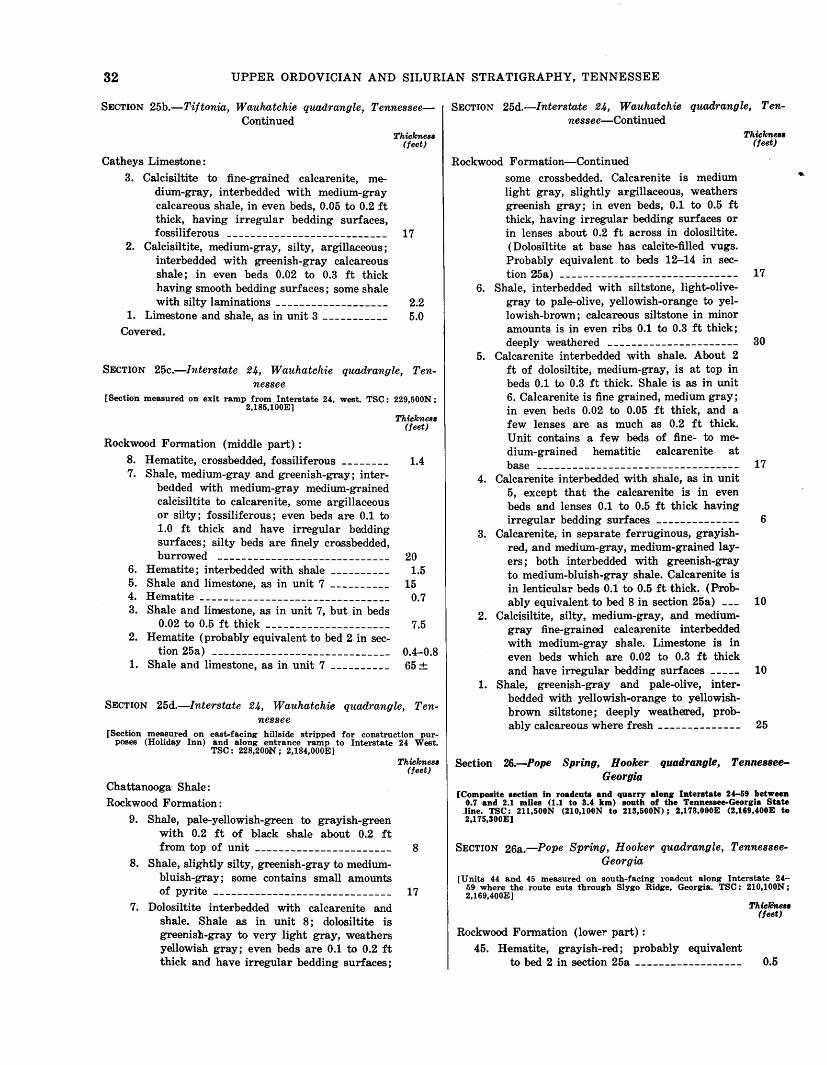
32 UPPER ORDOVICIAN AND SILURIAN STRATIGRAPHY, TENNESSEE
SECTION 25b.-Tiftonia, Wauhatchie quadrangle, Tennessee- SECTION 25d.-lnterstate 24, Wauhatchie quadrangle, Ten-Continued nessee-Continued
Thicknese Thicknese (feet) (feet)
Catheys Limestone:
3. Calcisiltite to fine-grained calcarenite, medium-gray, interbedded with medium-gray calcareous shale, in even beds, 0.05 to 0.2 ft thick, having irregular bedding surfaces, fossiliferous --------------------------- 17
2. Calcisiltite, medium-gray, silty, argillaceous; interbedded with greenish-gray calcareous shale; in even beds 0.02 to 0.3 ft thick having smooth bedding surfaces; some shale with silty laminations ------------------- 2.2
1. Limestone and shale, as in unit 3 ----------- 5.0 Covered.
SECTION 25c.-lnterstate 24, Wauhatchie quadrangle, Tennessee
[Section measured on exit ramp from Interstate 24, west. TSC: 229,500N; 2,185,100E]
Rockwood Formation (middle part) :
Thicknese (feet)
8. Hematite, crossbedded, fossiliferous -------- 1.4 7. Shale, medium-gray and greenish-gray; inter
bedded with medium-gray medium-grained calcisiltite to calcarenite, some argillaceous or silty; fossiliferous; even beds are 0.1 to 1.0 ft thick and have irregular bedding surfaces; silty beds a11e finely cross bedded, burrowed -----------------------------
6. Hematite; interbedded with shale ----------5. Shale and limestone, as in unit 7 ----------4. Hematite --------------------------------3. Shale and limestone, as in unit 7, but in beds
0.02 to 0.5 ft thick ---------------------2. Hematite (probably equivalent to bed 2 in sec-
tion 25a) ------------------------------1. Shale and limestone, as in unit 7 ----------
20 1.5
15 0.7
7.5
0.4-0.8 65±
SECTION 25d.-Interstate 24, Wauhatchie quadrangle, Tennessee
[Section measured on east-facing hillside stripped for construction purposes (Holiday Inn) and along entrance ramp to Interstate 24 West.
TSC: 228,200iN; 2,184,000E]
Chattanooga Shale:
Rockwood Formation :
9. Shale, pale-yellowish-green to grayish-green with 0.2 ft of black shale about 0.2 ft
Thicknese (feet)
from top of unit ----------------------- 8 8. Shale, slightly silty, greenish-gray to medium
bluish-gray; some contains small amounts
of pyrite ------------------------------ 17 7. Dolosiltite interbedded with calcarenite and
shale. Shale as in unit 8; dolosiltite is greenish-gray to very light gray, weathers yellowish gray; even beds are 0.1 to 0.2 ft thick and have irregular bedding surfaces;
Rockwood Formation-Continued
some crossbedded. Calcarenite is medium light gray, slightly argillaceous, weathers greenish gray; in even beds, 0.1 to 0.5 ft thick, having irregular bedding surfaces or in lenses about 0.2 ft across in dolosiltite. ( Dolosiltite at base has calcite-filled vugs. Probably equivalent to beds 12-14 in sec-tion 25a) ------------------------------ 17
6. Shale, interbedded with siltstone, light-olivegray to pale-olive, yellowish-orange to yellowish-brown; calcareous siltstone in minor amounts is in even ribs 0.1 to 0.3 ft thick; deeply weathered ---------------------- 30
5. Calcarenite interbedded with shale. About 2 ft of dolosiltite, medium-gray, is at top in beds 0.1 to 0.3 ft thick. Shale is as in unit 6. Calcarenite is fine grained, medium gray; in even beds 0.02 to 0.05 ft thick, and a few lenses are as much as 0.2 ft thick. Unit contains a few beds of fine- to medium-grained hematitic calcarenite at
base ---------------------------------- 17 4. Calcarenite interbedded with shale, as in unit
3.
2.
1.
5, except that the calcarenite is in even beds and lenses 0.1 to 0.5 ft thick having irregular bedding surfaces ____ - _-------- 6
Calcarenite, in separate ferruginous, grayishred, and medium-gray, medium-grained layers; both interbedded with greenish-gray to medium-bluish-gray shale. Calcarenite is in lenticular beds 0.1 to 0.5 ft thick. (Prob-ably equivalent to bed 8 in section 25a) --- 10
Calcisiltite, silty, medium-gray, and mediumgray fine-grained calca,enite interbedded with medium-gray shale. Limestone is in even beds which are 0.02 to 0.3 ft thick and have irregular bedding surfaces ----- 10
Shale, greenish-gray and pale-olive, interbedded with yellowish-orange to yellowishbrown siltstone; deeply weathetred, prob-ably calcareous where fresh -------------- 25
Section 26.-Pope Spring, Hooker quadrangle, TennesseeGeorgia
[Composite section in roadcuts and quarry along Interstate 24-59 between 0.7 and 2.1 miles (1.1 to 3.4 km) south of the Tennessee-Georgia State
.line. TSC: 211,500N (210,100N to 213,500N); 2,173,000E (2,169,400E to 2,175,300E)
SECTION 26a .. -Pope Spring, Hooker quadrangle, TennesseeGeorgia
[Units 44 and 45 measured on south-faeing roadcut along Interstate 24-59 where the route cuts through Slygo Ridge, Georgia. TSC: 210,100N: 2,169,400E]
Rockwood Formation (lowe!' part) :
45. Hematite, grayish-red; probably equivalent
Thiclmese (feet)
to bed 2 in section 25a ------------------ 0.5
..
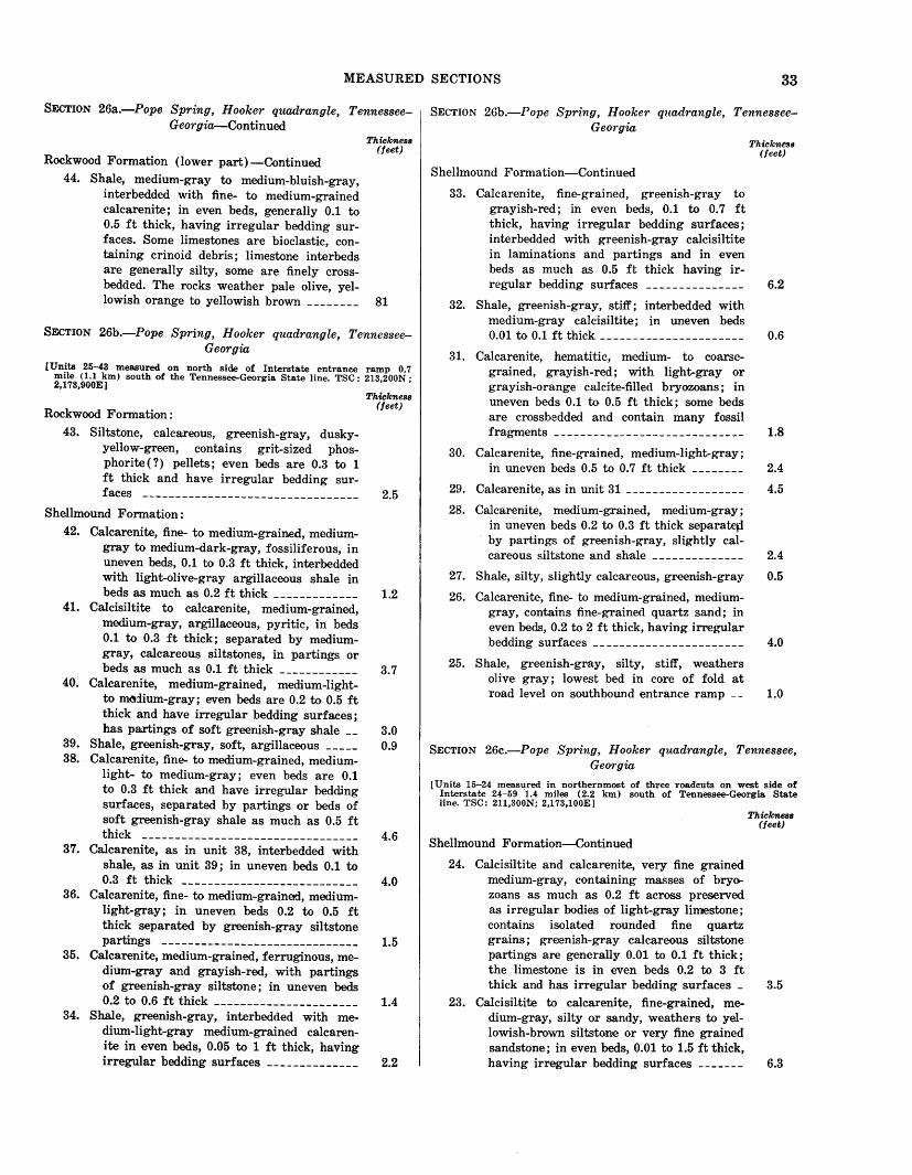
MEASURED SECTIONS 33
SECTION 26a.-Pope Spring, Hooker quadrangle, TennesseeGeorgia-Continued
Rockwood Formation (lower part) -Continued
44. Shale, medium-gray to medium-bluish-gray, interbedded with fine- to medium-grained calcarenite; in even beds, generally 0.1 to 0.5 ft thick, having irregular bedding surfaces. Some limestones are bioclastic, containing crinoid debris; limestone interbeds are generally silty, some are finely crossbedded. The rocks weather pale olive, yel-
Thickness (feet)
lowish orange to yellowish brown ________ 81
SECTION 26b.-Pope Spring, Hooker quadrangle, TennesseeGeorgia
[Units 25-43 measured on north side of Interstate entrance ramp 0.7 mile (1.1 km) south of the Tennessee-Georgia State line. TSC: 213,200N; 2,173,900E]
Rockwood Formation:
43. Siltstone, calcareous, greenish-gray, duskyyellow-green, contains grit-sized phosphorite ( ? ) pellets; even beds are 0.3 to 1 ft thick and have irregular bedding sur-
faces ---------------------------------Sh~lmound Formation:
42. Calcarenite, fine- to medium-grained, mediumgray to medium-dark-gray, fossiliferous, in uneven beds, 0.1 to 0.3 ft thick, interbedded with light-olive-gray argillaceous shale in beds as much as 0.2 ft thick -------------
41. Calcisiltite to calcarenite, medium-grained, medium-gray, argillaceous, pyritic, in beds 0.1 to 0.3 ft thick; separated by medium-gray, calcareous siltstones, in partings or beds as much as 0.1 ft thick ------------
40. Calcarenite, medium-grained, medium-lightto m~:iium-gray; even beds are 0.2 to 0.5 ft thick and have irregular bedding surfaces;
Thickness (feet)
2.5
1.2
3.7
has partings of soft greenish-gray shale __ 3.0 39. Shale, greenish-gray, soft, argillaceous _____ 0.9 38. Calcarenite, fine- to medium-grained, medium-
light- to medium-gray; even beds are 0.1 to 0.3 ft thick and have irregular bedding surfaces, separated by partings or beds of soft greenish-gray shale as much as 0.5 ft thick --------------------------------- 4.6
37. Calcarenite, as in unit 38, interbedded with shale, as in unit 39; in uneven beds 0.1 to 0.3 ft thick --------------------------- 4.0
36. Calcarenite, fine- to medium-grained, medium-light-gray; in uneven beds 0.2 to 0.5 ft thick separated by greenish-gray siltstone partings ------------------------------ 1.5
35. Calcarenite, medium-grained, ferruginous, me-dium-gray and grayish-red, with partings of greenish-gray siltstone; in uneven beds 0.2 to 0.6 ft thick ---------------------- 1.4
34. Shale, greenish-gray, interbedded with medium-light-gray medium-grained calcarenite in even beds, 0.05 to 1 ft thick, having irregular bedding surfaces -------------- 2.2
SECTION 26b.-Pope Spring, Hooker quadrangle, TennesseeGeorgia
Shellmound Formation-Continued
33. Calcarenite, fine-grained, greenish-gray to grayish-red; in even beds, 0.1 to 0.7 ft thick, having irregular bedding surfaces; interbedded with greenish-gray calcisiltite in laminations and partings and in even beds as much as 0.5 ft thick having ir-
Thickness (feet)
regular bedding surfaces --------------- 6.2
32. Shale, greenish-gray, stiff; interbedded with medium-gray calcisiltite; in uneven beds 0.01 to 0.1 ft thick ---------------------- 0.6
31. Calcarenite, hematitic, medium- to coarsegrained, grayish-red; with light-gray or grayish-orange calcite-filled bryozoans; in uneven beds 0.1 to 0.5 ft thick; some beds are crossbedded and contain many fossil fragments _ _ _ _ _ _ _ _ _ __ _ _ __ _ _ _ _ _ _ _ __ _ _ _ __ 1.8
30. Calcarenite, fine-grained, medium-light-gray; in un·even beds 0.5 to 0.7 ft thick -------- 2.4
29. Calcarenite, as in unit 31 ------------------ 4.5
28. Calcarenite, medium-grained, medium-gray; in uneven beds 0.2 to 0.3 ft thick separatep by partings of greenish-gray, slightly cal-careous siltstone and shale -------------- 2.4
27. Shale, silty, slightly calcareous, greenish-gray 0.5
26. Calcarenite, fine- to medium-grained, medium-gray, contains fine-grained quartz sand; in even beds, 0.2 to 2 ft thick, having irregular bedding surfaces ----------------------- 4.0
25. Shale, greenish-gray, silty, stiff, weathers olive gray; lowest bed in core of fold at road level on southbound entrance ramp __ 1.0
SECTION 26c.-Pope Spring, Hooker quadrangle, Tennessee, Georgia
[Units 15-24 measured in northernmost of three roadcuts on west side of Interstate 24-59 '1.4 miles (2.2 km) south of Tennessee-Georgia State line. TSC: 211,300N; 2,173,100E]
Shellmound Formation-Continued
24. Calcisiltite and calcarenite, very fine grained medium-gray, containing masses of bryo-zoans as much as 0.2 ft across preserved as irregular bodies of light-gray limestone; contains isolated rounded fine quartz grains; greenish-gray calcareous siltstone partings are generally 0.01 to 0.1 ft thick; the limestone is in even beds 0.2 to 3 ft
Thickness (feet)
thick and has irregular bedding surfaces _ 3.5 23. Calcisiltite to calcarenite, fine-grained, me
dium-gray, silty or sandy, weathers to yellowish-brown siltsto!ne or very fine grained sandstone; in even beds, 0.01 to 1.5 ft thick, having irregular bedding surfaces ------- 6.3
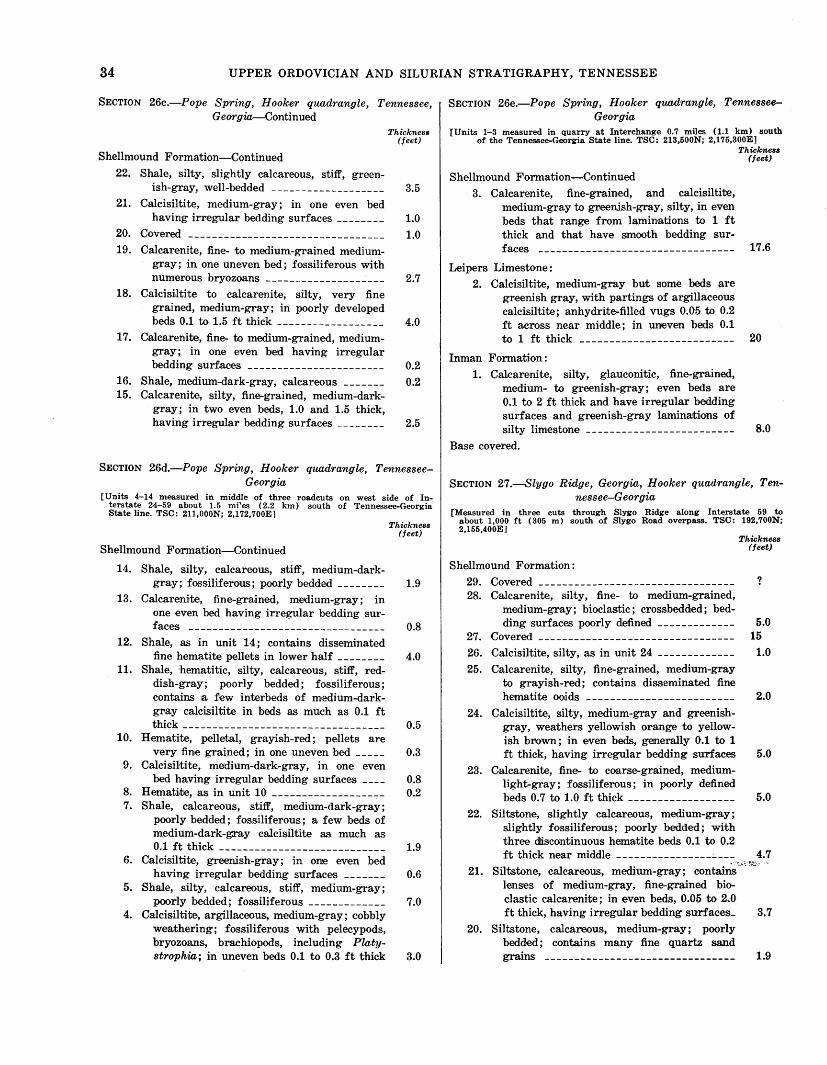
34 UPPER ORDOVICIAN AND SILURIAN STRATIGRAPHY, TENNESSEE
SECTION 26c.-Pope Spring, Hooker quadrangle, Tennessee, Georgia-Continued
Shellmound Formation-Continued
22. Shale, silty, slightly calcareous, stiff, green-
Thickness (feet)
ish-gray, well-bedded ------------------- 3.5 21. Calcisiltite, medium-gray; in one even bed
having irregular bedding surfac,es ________ 1.0
20. Covered --------------------------------- 1.0 19. Calcarenite, fine- to medium-grained medium-
gray; in one uneven bed; fossiliferous with numerous bryozoans --------------------
18. Calcisiltite to calcarenite, silty, very fine grained, medium-gray; in poorly developed beds 0.1 to 1.5 ft thick ------------------
17. Calcarenite, fine- to medium-grained, mediumgray; in one even bed having irregular bedding surfaces -----------------------
16. Shale, medium-dark-gray, calcareous ______ _ 15. Calcarenite, silty, fine-grained, medium-dark
gray; in two even beds, 1.0 and 1.5 thick, having irregular bedding surfaces _______ _
2.7
4.0
0.2
0.2
2.5
SECTION 26d.-Pope Spring, Hooker quadrangle, TennesseeGeorgia
[Units 4-14 measured in middle of three roadcuts on west side of Interstate 24-59 about 1.5 mi'es (2.2 km) south of Tennessee-Georgia State line. TSC: 211,000N; 2,172,700E]
Shellmound Formation-Continued
14. Shale, silty, calcareous, stiff, medium-dark-gray; fossiliferous; poorly bedded _______ _
13. Calcarenite, fine-gra,ined, medium-gray; in one even bed having irregular bedding sur-faces _______ -- ------------------------
12. Shale, as in unit 14; contains disseminated fine hematite pellets in lower half --------
11. Shale, ·hematitic, silty, calcareous, stiff, reddish-gray; poorly bedded; fossiliferous; contains 1a few interbeds of medium-darkgray calcisiltite in beds as much as 0.1 ft
thick ----------------------------------10. Hematite, pelletal, grayish-red; pellets are
very fine grained; in one uneven bed ____ _ 9. Calcisiltite, medium-dark-gray, in one even
bed having irregular bedding surfaces ___ _ 8. Hematite, as in unit 10 -------------------7. Shale, calcareous, stiff, medium-dark-gray;
poorly bedded; fossiliferous; a few beds of medium-dark-g:ray calcisiltite as much as 0.1 ft thick ----------------------------
6. Calcisiltite, greenish-gray; in one even bed having irregular bedding surfaces ______ _
5. Shale, silty, calcareous, stiff, medium-gray; poorly bedded; fossiliferous -------------
4. Calcisiltite, argillaceous, medium-gray; cobbly weathering; fossiliferous with pelecypods, bryozoans, brachiopods, including Platystrophia; in uneven beds 0.1 to 0.3 ft thick
Thickness (feet)
1.9
0.8
4.0
0.5
0.3
0.8 0.2
1.9
0.6
7.0
3.0
SECTION 26e.-Pope Spring, Hooker quadrangle, TennesseeGeorgia
[Units 1-3 measured in quarry at Interchange 0.7 miles (1.1 km) south of the Tennessee-Georgia State line. TSC: 213,500N; 2,175,300E]
Thickness (feet)
Shellmound Formation-Continued 3. Calcarenite, fine-grained, and calcisiltite,
medium-gray to greenish-gray, silty, in even beds that range from laminations to 1 ft thick and that have smooth bedding sur-faces --------------------------------- 17.6
Leipers Limestone:
2. Calcisiltite, medium-gray but some beds are greenish gray, with partings of argillaceous calcisiltite; anhydrite-filled vugs 0.(}5 to 0.2 ft across near middle; in uneven beds 0.1 to 1 ft thick -------------------------- 20
Inman Formation: 1. Calcarenite, silty, glauconitic, fine-grained,
medium- to greenish-gray; even beds are 0.1 to 2 ft thick and have irregular bedding surfaces and greenish-gray laminations of silty limestone ------------------------- 8.0
Base covered.
SECTION 27.-Slygo Ridge, Georgia., Hooke'r quadrangle, Tennessee-Georgia
[Measured in three cuts through Slygo Ridge along Interstate 59 to about 1,000 ft (305 m) south of Slygo Road overpass. TSC: 192,700N; 2,155,400E]
Thickness (feet)
Shellmound Formation:
29. 28.
27.
26.
25.
24.
23.
22.
Covered --------------------------------Calcarenite, silty, fine- to medium-grained,
medium-gray; bioclastic; cross bedded; bed-
?
ding surfaces poorly defined ------------- 5.0 Covered --------------------------------- 15 Calcisiltite, silty, as in unit 24 ------------- 1.0 Calcarenite, silty, fine-grained, medium-gray
to grayish-red; contains disseminated fine hematite ooids ------------------------- 2.0
Calcisiltite, silty, medium-gray and greenishgray, weathers yellowish orange to yellowish brown; in even beds, generally 0.1 to 1 ft thick, having irregular bedding ·surfaces 5.0
Calcarenite, fine- to coarse-grained, mediumlight-gray; fossiliferous; in poorly defined beds 0.7 to 1.0 ft thick ------------------ 5.0
Siltstone, slightly calcareous, medium-gray; slightly fossiliferous; poorly bedded; with three dtiscontinuous hematite beds 0.1 to 0.2 ft thick near middle ----------------~--- 4.7
21. Siltstone, calcareous, medium-gray; contai:r~r·;.:.!i'~· lenses of medium-gray, fine-grained bioclastic calcarenite; in even beds, 0.05 to 2 .. 0 ft thick, having irregular bedding surfaces_ 3. 7
20. Siltstone, calcareous, medium-gray; poorly bedded; contains many fine quartz sand grains -------------------------------- 1.9
MEASURED SECTIONS 35
SECTION 27.-Slygo Ridge, Georgia, Hooker quadrangle, Tennessee-Georgia-Continued
Shellmound Formation-Continued
19. Calcarenite, medium- to coarse-grained, medium-light-gray; biocl·astic; in one even bed
Thickness (feet)
having irregular bedding surfaces _______ 0.5 18. Siltstone, argillaceous, calcareous, medium-
gray, fossiliferous; 0.5 ft of pelletal hema-
tite at base ---------------------------- 4.9 17. Siltstone and calcilutite, argillaceous, silty,
medium-gray, weathers shaly; fossiliferous; contains 1 ft of chamosite p·e.Ilets 1 to 2 ft from top -------------------------- 4.0
16. Siltstone, calcareous, medium-gray; with some fossils; poorly bedd·ed ------------------- 5.0
15. Calcilutite, argillaceous, medium-gray; very fossilifierous; wi.th some Leipers-type cal-cisiltite (see unit 8 below), near base ____ 5.0
14. Calcisiltite to calcarenite, silty, fine-grained, medium-light-gray, weathers yellowish gray; in two beds ---------------------- 3.0
13. Calcilutite, argillaceous, medium-gray, and some medium-gray, fine- to mediUlllr-grajnerl bioclastic calcarenite; fills mudcracks in unit below ---------------------------- 1.0
12. Calcisiltite to calcarenite, silty, glauconitic, very fine grained, medium-light-gray, weathers yellowish gray, some beds burrowed; beds generally uneven, but finer grained beds are even, and have smooth bedding surfaces ----------------------- 14
Leipers Limestone:
11. Calcilutite, argillaceous and silty, mediumgray, weathers medium light gray or yellowish gray; beds uneven, generally 0.1 to 0.6 ft thick, and have argillaceous partings 9.5
10. Calcisiltite to calcarenite, very fine grained, some laminated, as in unit 8 ------------- 2.5
9. Calcilutite, argillaceous, medium-gray, weathers medium light gray; in uneven beds generally 0.1 to 0.6 ft thick with shaly part-
ings ---------------------------------- 7.0 Inman Formation:
8. Calcisiltite to calcarenite, silty, glauconitic, weathers yellowish gray; in uneven beds 0.02 to 0.8 ft thick, having irregular bed-ding surfaces; calcarenites are lenticular _ 13.5
7. Calcisiltite, grayish-red; interbedded with greenish-gray argillaceous or silty calcilutite; in even beds, 0.02 to 0.3 ft thick, having irregular bedding surfaces; some beds broken, burrowed ---------------------- 7.0
6. Calcarenite, bioclastic, fine- to coarse-grained, medium-light-gray, and silty calcisiltite, medium-light-gray (weathers yellowish gray), in uneven beds 0.05 to 1.0 ft thick __ 3.5
5. Calcisiltite, silty, mottled, grayish-red and greenish-gray; in beds 0.1 to 4 ft thick, with upper 4 ft in one bed -------------- 6.3
SECTION 27.-Slygo Ridge, Georgia, Hooker quadrangle, Tennessee-Georgia-Continued
Inman Formation-Continued
4. Calcisiltite to calcarenite, silty, fine-grained, medium-light-gray, weathers yellowish gray; with some glauconite; in uneven beds 0.5 to 1 ft thick; grades upward into
Thickness (feet)
grayish-red rock ----------------------- 3.7
Catheys Limestone:
3. Calcilutite, argillaceous to calcarenite, medium-gray, fine- to medium grained, fossiliferous; lower beds weather yellowish gray; in uneven beds 0.2 to 0.3 ft thick -------- 14
2. Calcisiltite, argillaceous, silty; weathers yellowish gray; in even beds, 0.2 to 0.3 ft thick, some of which are laminated ------- 5.0
1. Calcilutite, argillaceous, medium-gray; fossilifierous; upper part weathers yellowish gray; poorly bedded -------------------- 7.0
SECTION 28.-Green Gap, Whiteoak Mountain, Snow Hill quadrangle, Tennessee
[Measured along Interstate 75 cuts, northbound lane. TSC: 269,000N; 2,290,600E]
Rockwood Formation :
27. Sandstone, quartzose, very fine grained, medium-gray, weathers yellowish orange to yellowish brown; burrowed; grad·es upward
Thickness (feet)
into sandy siltstone --------------------- 7.0
Sequatchie Formation:
26. Siltstone, shaly, medium-gray to light-olivegray, has horizontal burrows and lenses of burrowed Vlery fine grained sandstone as much as 0.1 ft thick -------------------- 4.0
25. Siltstone, medium-gray to light-olive-gray, massively bedded, has extensive development of horizontal burrows; contains quartz and phosphorite ( ?) grit at top ---------- 4.6
24. Siltstone, shaly, medium-gray, contains lenses of very fine grained sandstone and calcareous siltstone as much as 0.2 ft thick and impressions of pelecypods and horizontal bur-
rows ----------·------------------------ 19.5 23. Siltstone, shaly, medium-dark-gray and gray
ish-red; upper part has abundant horizon-tal burrows ---------------------------- 5.0
22. Calc•arenite, medium- to coarse-grained, medium-light to medium-gray, yellowishorange, pale-r~, with grayish-red hematite stains and partings; bedding ranges from 0.1 to 2.0 ft thick and is generally in even beds, some crossbedded; some beds fossili-ferous with brachiopods, bryozoans, and horizontal burrows (Fernvale Member) __ 23.5
21. Shale, greenish-gray ---------------------- 3.3 20. Shale, greenish-gray, with lenses of calcaren-
ite ------------------------------------ 3.0
36 UPPER ORDOVICIAN AND SILURIAN STRATIGRAPHY, TENNESSEE
SECTION 28.-Green Gap, Whiteoak Mountain, Snow Hill quadrangle, Tennessee-Continued
Sequatchie Formation-Continued
19. Shale, grayish-red -----------------------18. Mudstone, grayish-red and greenish-gray,
thin-bedded, color-laminated, some burrowed and mottled ----------------------------
17. Shale, grayish-red ------------------------16. Calcisiltite, grayish-red and greenish-gray,
color-l,aminated with several interbeds of massive red mudstone; some mudcracks
Thickness (feet)
2.0
2.3
3.5
and extensive vertical burrows ---------- 8.8 15. Calcisiltite, mottled greenish-gray and gray-
ish-red; masshne, extensively burrowed ___ 6.0
14. Shale, medium-gray, interbedded with beds of medium-gray fossiliferous calcareous mudstone about 1 ft thick --------------- 6.5
13. Mudstone, calcareous, grayish-red, poorly bedded, with shrinkage cracks and large (as much as 0.05 ft across) flattened horizontal burrows ------------------------------- 4.3
12.. Siltstone, calcareous, medium-gray to greenish-gray, interbedded with lenses of fossiliferous limestone as much as 0.4 ft thick; contains bryozoans, brachiopods, and pelecy-
pods ---------------------------------- 6.0 11. Mudstone, grayish-red, some greenish-gray,
massively bedded, extensively burrowed, has medium-gray calcisiltite stringer 0.2 ft thick in middle ------------------------ 12.5
10. Calcisiltite, greenish-gray, with channeled contact at base containing lag conglomerate of red shale chips; upper bed is mud-cracked red shale ------------------ 1.0
9. Mudstone, mottled, burrowed, grayish-red, has thin irregular greenish-gray beds ________ 6.5
8. Mudstone, massive, greenish-gray, mottled grayish-red, burrowed ------------------ 2.6
7. Calcisiltite, grayish-<red to grayish-orange pink, some medium-gray, thin- to mediumbedded, some mottled, some with birdseyes _ 54.4
6. Mudstone, calcareous, greenish-gray and grayish-red ---------------------------- 2.1
5. Calcisiltite, grayish-red, gra!Y'ish-orange-pink, some medium-light-gray, thin- to mediumbedded; some beds are mottled grayish red and greenish gray; some burrowed, some have birdseyes ------------------------- 18.8
4. Calcisiltite, grayish-red to grayish-orange-pink; two beds with liesegang diffusion bands are separated by a thin-bedded unit _ 3.6
3. Calcisiltite, grayish-red, greenish-gray, p•ale-red, grayish-orange-pink, in flat-be<JPed fining-upward units 0.05 to 0.6 ft thick; some beds burrow mottled, some have red-shale pebble conglomerate above basal scour, and some have thin skin of grayish-red mudcracked shale at top -------------------- 36.4
SECTION 28.-Green Gap, Whiteoak Mountain, Snow Hill quadrangle, Tennessee-Continued
Sequatchie Formation-Continued 2. Mudstone, calcareous, grayish-red and green
ish-gray, interbedded with thin beds of medium-light-gray micrite anP. bryozoan biomicrite, some having birdseyes; upper surface of beds are mud-cracked grayish-
Thickness (feet)
red shale ------------------------------ 10.7 1. Mudstone, calcareous, medium-dark-gray,
greenish-gray, having lenses of medium-light-gray bryozoan biomicrite ----------- 5.5
Catheys Limestone: 0. Calcisiltite and fine-grained calcarenite, me
dium to medium-dark-gray, interbedded with some medium-gray to greenish-gray calcareous shale and siltstone; fossiliferous
(not measured) ------------------------
REFERENCES
Adams, G. I., Butts, Charles, Stephenson, L. W ., and Cooke, C. W., 1926, Geology of Alabama: Alabama Geol. Survey Spec. Rept. 14, 312 p.
Bassler, R. S., 1932, The stratigraphy of the Central Basin of Tennessee: Tennessee Div. Geology Bull. 38, 268 p.
Brent, W. B., 1963, Geology of the Clinchport quad:rangle, Virginia: Virginia Div. Mineral Resources Rept. Inv. 5, 47 p.
---, in press, Geologic map and mine·ral resources summary of the Looneys Gap quadrangle, Tennessee: Tennessee Div. Geology Geol. Map GM 179-SW.
Burchard, E. F., 1913, The red iron ores of East Tennessee: Tennessee Geol. Survey Bull. 16, 173 p.
Burchard, E. F., and Andrews, T. G., 1947, Iron ore outcrops of the Red Mountain Fo·rmation in northeast Alabama, with a section on Paleontologic correlation of the members of the Red Mountain Formation in the· Guntersville reservoir by R. M. Ross: Alabama Geol. Survey Spec. Rept. 19, 375 p.
Butts, Charles, (no date), Manuscript map of the Pikeville Special quadrangle, Tennessee: Tennessee Div. Geology, open-file geologic map, scale 1:62,500.
Butts, Charles, and Gildersleeve, Benjamin, 1948, Geology and mineral resources of the Paleozoic area in northwest Georgia: Georgia Geol. Survey Bull. 54, 176 p.
Chowns, T. M., 1970, A chamosite-hematite oolite from the Sequatchie Formation in northwest Georgia [ abs.] : Georgia Acad. Sci. Bull., v. 28, no. 2, p. S19.
--- 1971, Stratigraphy of the Ordovician and Silurian section exposed in the Ringgold road cuts-A proposed geological monument [ abs.] : Georgia Acad. Sci. Bull., v. 29, no. 2, p. 123.
--- 1972a, Depositional environments in the Upper Ordovician of northwest Georgia and southeast Tennessee, in Chowns, T. M., compiler, Sedimentary environments in the Paleozoic rocks of northwest Georgia: Georgia Geol. Survey Guidebook 11, p. 3-12.
REFERENCES 37
--- 1972b, Molasse sedimentation in the Silurian rocks of northwest Georgia, in Chowns, T. M., compiler, Sedimentary environments in the Paleozoic rocks of northwest Georgia: Georgia Geol. Survey Guidebook 11, p. 13-23.
Coker, A. E., and Milici, R. C., in press, Geologic map of thte Henson Gap quadrangle, Tennessee: Tennessee Div. Geology Geol. Map GM 104-SE.
Ooker, A. E., Milici, R. C., and Finlayson, C. P., 1967, Geologic map of the Billingsley Gap quadrangle, Tennessee: Tennessee Div. Geology Geol. Map GM 110-NW.
Conant, L. C., and Swanson, V. E., 1961, Cattanooga Shale and related rocks of central Tennessee and nearby areas: U.S. Geol. Survey Prof. Paper 357, 91 p.
Dennison, J. M., and Boucot, A. J., 1969, Little War Gap at Clinch Mountain has most nearly complete Devonian section in eastern Tennessee [ abs. J : Geol. Soc. America Abs. with Programs 1969, [ v. 1 J, pt. 4, p. 17-18.
Donovan, R. N., and Foster, R. J., 1972, Subaqueous shrinkage cracks from the Caithness Flagstone Series (Middle Devonian) of northeast Sootland: Jour. Sed. Petrology, v. 42, no. 2, p. 309-317.
Ferm, J. C., Milici, R. C., and Eason, J. E., 1972, Carboniferous depositional envirorunents in the Cumberland Plateau of southern Tennessee and northern Alabama: Tennessee Div. Geology Rept. Inv. 33, 32 p.
Folk, R. L., 1959, Practical petrographic classification of limestones: Am. Assoc. Petroleum Geologists Bull., v. 43, no. 1, p. 1-38.
Garman, R. K., and Milici, R. C., 1967, Geologic map of the Brockdell quadrangle, Tennessee: Tennessee Div. Geology Geol. Map GM 103-SE.
Hardeman, W. D., Miller, R. A., and Swingle, G. D., 1966, Geologic map of Tenne·ssee: Tennessee Div. Geology Geol. Map, scale 1:250,000.
Harris, L. D., and Miller, R. L., 1958, Geology of the Duffield quadrangle, Virginia: U.S. Geol. Survey Geol. Quad. Map GQ-111.
--- 1963, Geology of the Stickleyville quadrangle, Virginia: U.S. Geol. Survey Geol. Quad. Map GQ-238.
Hayes, C. W., 1891, The overthrust faults of the southern Appalachians: Geol. Soc. America Bull., v. 2, p. 141--ll.54.
--- 1894a, Ringgold atlas sheet [Georgia-Tennessee]: U.S. Geol. Survey Geol. Atlas, folio no. 2, 3 p.
--- 1894b, Description of the Kingston sheet [Tennessee J: U.S. Geol. Survey Geol. Atlas, folio no. 4, 4 p.
--- 1894c, Chattanooga atlas sheet-description [Tennessee J: U.S. Geol. Survey Geol. Atlas, folio no. 6, 3 p.
--- 1895a, Description of the Stevenson Sheet [AlabamaGeorgia-Tennessee J: U.S. Geol. Survey Geol. Atlas, folio no. 19, 4 p.
--- 1895b, Description of the Cleveland Sheet [Tennessee J : U.S. Geol. Survey Geol. Atlas, folio no. 20, 4 p.
--- 1895c, Description of the Pikeville Sheet [Tennessee]: U.S. Geol. Survey Geol. Atlas, folio no. 21, 4 p.
Hayes, C. C., and Ulrich, E. 0., 1903, Description of the Columbia quadrangle [Tennessee J : U.S. Geol. Survey Geol. Atlas, folio no. 95, 6 p.
Martin, G. C., Jr., 1940, The geology of northern Sequatchie valley and vicinity [Tennessee J : Columbus, The Ohio State Univ., Ph.D. dissertation.
Milici, R. C., 1965, Geologic map of the Grassy Cove quadrangle, Tennessee: Tennessee Div. Geology Geol. Map GM 117-SW.
--- in press, Geologic map of the Whitwell quadrangle, Tennessee: Tennessee Div. Geology Geol. Map GM 100-NE.
Milici, R. C., and Coker, A. E., 1967, Geologic map of the Melvine quadrangle, Tennessee: Tennessee Div. Geology Geol. Map GM 110-NE.
Milici, R. C., Coker, A. E., and Garman, R. K., in press, Geologic map of the Mount Airy quadrangle, Tennessee: Tennessee Div. Geology Geol. Map GM 104-NE.
Milici, R. C., Coker, A. E., and Luther, E. T., 1972, Geologic map of the Ketner Gap quadrangle, Tenne,ssee: Tennessee Div. Geology Geol. Map GM 105-NW.
Milici, R. C., and Finlayson, C. P., 1967, Goologic map of the Pikeville quadrangle, Tennessee: Tennessee Div. Geology Geol. Map GM 110-SW.
--- in press, Geologic map of the South Pittsburgh quadrangle, Tennessee: Tennessee Div. Geology Geol. Map GM 100-SW.
Milici, R. C., Finlayson, C. P., Barnes, R. H., and Colvin, J. M., in press, Geologic map and mineral resources summary of the Sequatchie quadrangle, Tennessee: Tennessee Div. Geology Geol. Map GM 100-SE.
Miller, R. L., and Brosge, W. P., 1954, Geology and oil resources of the Jonesville district, Lee County, Virginia: U.S. Geol. Survey Bull. 990, 240 p.
Miller, R. L., and Fuller, J. 0., 1954, Geology and oil resources of the Rose Hill district-the fenster area of the Cumberland Overthrust Block-Lee County, Virginia: Virginia Geol. Survey Bull. 71, 383 p.
Neathery, T. L., Drahovzal, J. A., and Raymond, D. E., 1969, The Upper Ordovician of Alabama r abs. J : Geol. Soc. America, Abs. with Programs for 1969, pt. 7, p. 158.
Rodgers, John, 1953, Geologic map of East Tennessee with explanatory text: Tennessee Div. Geology Bull. 58, pt. 2, 168 p.
Safford, J. M., 1869, Geology of Tennessee: Nashville, Tennessee, S.C. Mercer, 550 p.
Sheldon, R. P., 1970, Sedimentation of iron-rich rocks of Llandovery age (Lower Silurian) in the southern Appalachian Basin, in Berry, W. B. N., and Boucot, A. J., Correlation of the North American Silurian rocks: Geol. Soc. America Spec. Paper 102, p. 107-112.
Shinn, E. A., 1968, Practical significance of bir!dseye structures in carbonate rocks: Jour. Sed. Petrology, v. 38, p. 215-223.
Shinn, E. A., Lloyd, R. M., and Ginsburg, R. N., 1969, Anatomy of a modern carbonate tidal flat, Andros Island, Bahamas: Jour. Sed. Petrology, v. 39, no. 3, p. 1202-1228.
Sweet, W. C., and Bergstrom, S.M., 1971, The American Upper Ordovician standard-XIII, A revised time-stratigraphic classification of North American Upper Middle and Upper Ordovician rocks: Geol. Soc. America Bull., v. 82, no. 3, p. 613-628.
Thompson, A. M., 1970a, Geochemistry of color genesis in red-bed sequence, Juniata and Bald Eagle Formations, Pennsylvania: Jour. Sed. Petrology v. 40, no. 2, p. 599-615.
38 UPPER ORDOVICIAN AND SILURIAN STRATIGRAPHY, TENNESSEE
--- 1970b, Tidal-flat deposition and early dolomitization in Upper Ordovician rocks of southern Appalachian Valley and Ridge: Jour. Sed. Petrology, v. 40, no. 4, p. 1271-1286.
--- 1971, Clastic-carbonate facies relationships and paleoenvironments in Upper Ordovician rocks of northeast Alabama, in Drahovzal, J. A., and Neathery, T. L., The Middle and Upper Ordovician of the Alabama Appalachians: Alabama Geol. Soc. Guidebook, 9th Ann. Field Trip, p. 63-78.
Twenhofel, W. H., and others, 1954, Correlation of Ordovician formations of North America: Geol. Soc. America Bull., v. 65, no. 3, p. 247-298.
Ulrich, E. 0., 1911, Revisrion of the Paleozoic systems: Geol. Soc. America Bull., v. 22, p. 281-680.
--- 1913 [1914], The Ordovician-Silurian boundary: Internat. Geol. Cong., 12th, Canada, 1913, comptes rendus, p. 593-667.
Wedow, Helmuth, Jr., 1960, Sequatchie and Rockwood formations in southeast Tennessee and part of northwest Georgia [ abs.] : Geol. Soc. America Bull., v. 71, no. 12, p. 2028.
Wilmarth, M. G., 1938, Lexicon of geologic names of the United States (including Alaska): U.S. Geol. Survey Bull. 896, 2396 p. (in 2 parts) .
Wilson, C. W., Jr., 1949, Pre-Chattanooga stratigraphy in central Tennessee: Tennessee Div. Geology Bull. 56, 407 p.
~U.S. Government Printing Office: 1977-240-961/111