Embed Size (px)
Citation preview

UPDATE ON THE RIVERFRONT ISLAND MASTER PLAN
From: Goody Clancy
Date: January 5, 2012
Overview
Over the next two months, the Lewiston‐Auburn community will have an opportunity to think about alternative approaches for the future of Riverfront Island. To help with this discussion, the consultant team has prepared three scenarios, which have grown out of the November 16 public workshop, interviews with community members, discussions with the Advisory Committee, and consultant team analysis. These scenarios are a starting point for discussion about what the key ingredients of the master plan should be. The master plan that will emerge in February and March may be a combination of the three scenarios described below – or may include new approaches and ideas.
We look forward to the January 18 public workshop, and hope to see you there!
Riverfront Island Master Plan, Public Workshop #2 | Wednesday, January 18 @ 6pm | Bates Mill Atrium, 36 Chestnut Street
Snow date: 1/25, same time and location
**********
The first Riverfront Island Master Plan public meeting held in November provided an opportunity to discuss a wide range of potential opportunities for future development that would enhance the Island as an asset for the Lewiston‐Auburn community.
There is broad public agreement on many aspects of the island’s potential:
The river can become a far stronger public asset through improved public access to its edge and to the water itself. Community members would like to see the development of a continuous riverwalk along the Lewiston side of the river that links Auburn riverwalk/trails.
The canals are a unique and untapped asset. They can become part of a recreational network by lining them with tree‐lined walking and/or biking trails and the water itself has the potential for creative recreational use for skating, boating and other activities.
Stronger connections are needed between the Island and Lisbon Street.
Better pedestrian and bike access are needed throughout the area and crossings of Main and Cedar Streets need to be improved.
Island Point land is major opportunity for new development.

Creative lighting of the Falls, the river and its bridges, the canals and key public structures is a lower cost initiative that could really highlight the area’s unique assets.
The reuse of the Bates Mills complex is a major success story for Lewiston. Both the high quality of renovation and the vital mix of restaurant, office and medical tenants represent models for other development in the area.
Both the Continental Mill and Bates Mill have the potential to accommodate housing uses that can add to the vitality of the area.
Museum L‐A and the Franco‐American Heritage Center are important cultural anchors for riverfront island and their continued development and success offer benefits for the whole community.
The future of the Bates Mill #5 site is the topic that draws the most divergent opinions in the Lewiston Auburn community:
Some see the building as a revered and historically important structure, an important part of the community’s legacy, an untapped gem that is poised for transformation
Some view the building as an eyesore that is holding back development of the area as a whole, a financial burden on the city with little potential for feasible reuse.
Some see the layout of the building as highly inflexible and unsuitable for many uses such as office space or housing, and given its poor condition likely to be very expensive to reuse.
Many are frustrated at how long it has taken to identify potentially viable reuses and would now like to consider alternatives to reuse.
Most agree that given the building’s highly visible location at Lewiston’s front door, whatever happens will define Lewiston for future generations, much as it has over the last 100 years.
For all of these reasons, the future of the Bates Mill #5 site will define the identity of the city going forward and determining its future is the most critical decision to be defined through the Riverfront Island Master Plan process.
Consequently, the most significant variable in the master plan scenarios that now must be discussed is the future of this property. It is important to recognize that the use of this property shapes the use and potential of many surrounding properties too.
We have developed three Scenarios for discussion with the Committee and the Public:
Scenario #1: Bates Mill #5 Preserved and Reused for High Intensity Use. We believe that the only plausible reuse options for the structure involves high‐intensity options such as public offices, convention facilities, or a major recreational use. Many creative lower intensity uses have been discussed, however, we believe that the very high cost of preservation of the structure means that only more intense use types that

generate major economic activity could realistically be considered.
Scenario #2: Bates Mill #5 Demolished and Replaced with Signature Downtown Park. As discussed at the Riverfront Island Master Plan public workshop, many communities have successfully launched open space initiatives as transformative community and economic development strategies. Strategies have involved more traditional park spaces as well as efforts that incorporate elements of former industial mills as seen at Minneapolis’s Mill Ruins Park.
Scenario #3: Bates Mill #5 Demolished and Replaced with Retail Center. There is potential market demand that could support a food‐anchored retail development at the Bates Mill #5 site. Could such a use be compatible with the intended character of the district and complement other uses and activities on Riverfront Island?
Riverfront Island Master Plan Scenarios
Key aspects of each scenario are further described below and in the associated concept diagrams.
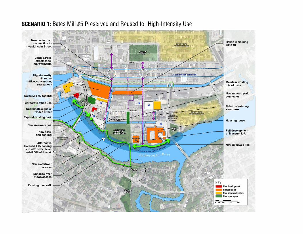

Scenario #1: Bates Mill #5 Preserved and Reused for High Intensity Use
Development
345,000SF Bates Mill #5 Reused for office, convention, recreational use
200,000SF Bates Mill vacant space fitted‐out for office healthcare, residential and mixed‐use
500,000SF Continental Mill reused for housing and mixed‐use (phased development)
250,000SF Hill Mill continues to serve a diverse mix of business uses
Expand existing parking structure at Bates Mill #5 site and at Lincoln/Chestnut to accommodate approximately 700 additional spaces related to Bates Mill
Create new parking 1,200 space parking structure at Island Point (alt. location at Lincoln), primarily to accommodate Bates Mill #5 parking need
New hotel at Lincoln and Water Streets
50,000SF corporate office at Island Point
Targeted rehabilitation/redevelopment of buildings/land in blocks between Oxford and Lincoln Streets
Public Space/Streetscape
Lewiston Riverwalk—add missing links near Yvon’s and at Museum L‐A/Continental Mill
Extend Railroad Park to Lincoln Street near Depot building
Widen Main Street to accommodate increased turning movements related to traffic accessing Bates Mill and Island Point
Benefits
High intensity reuse of Bates Mill adds employment and new vitality
Preservation of historically significant structure
Concerns
Bates Mill #5 Structure continues to serve as a physical barrier between downtown and Riverfront Island
Need to accommodate large parking structure to meet Bates Mill #5 needs; diminished development opportunities at Island Point site or elsewhere
High level of public subsidy needed to support preservation and reuse of Bates Mill (including parking need); may diminish availability of public resources for other key initiatives
Bates Mill #5 likely to require ongoing public operating subsidy for most likely uses


Scenario #2: Bates Mill #5 Demolished and site Redeveloped as Major Park
Development
Bates Mill site repositioned as Mill Park—centerpiece of downtown area
200,000SF Bates Mill vacant space fitted our for office healthcare, residential and mixed‐use
500,000SF Continental Mill reused for housing and mixed‐use (phased development)
250,000SF Hill Mill continues to serve a diverse mix of business uses
150,000SF corporate office/healthcare space at Island Point on prime site
Expand existing parking structure at Bates Mill #5 site and at Lincoln/Chestnut to accommodate approximately 700 additional spaces related to Bates Mill
New 600 space parking structure at Island Point
New hotel at Lincoln and Water Streets
Targeted rehabilitation/redevelopment of buildings/land in blocks between Oxford and Lincoln Streets
Public Space/Streetscape
Major park development at Bates Mill #5 site; open up canals to park and district; create direct links via new pedestrian bridge to Lisbon Street via alley and Ash Street
Lewiston Riverwalk—add missing links near Yvon’s and at Museum L‐A/Continental Mill
Extend Railroad Park to Lincoln Street near Depot building
Benefits
New Park becomes signature element of downtown and the city; expands capacity to host activities and events
Park development opens up canals as a more significant part of the downtown scene and reduces barriers between Lisbon Street and Riverfront Island
Park creates new front door for Lewiston
Concerns
Public cost of park development on key site
Lost opportunity for development on highly visible parcel


Scenario #3: Bates Mill #5 Demolished and site Redeveloped as Retail Center and Surface Parking
Development
Bates Mill site repositioned as food‐anchored retail center
200,000SF Bates Mill vacant space fitted our for office healthcare, residential and mixed‐use
500,000SF Continental Mill reused for housing and mixed‐use (phased development)
250,000SF Hill Mill continues to serve a diverse mix of business uses
150,000SF corporate office/healthcare space at Island Point
Expand existing parking structure at Bates Mill #5 site and at Lincoln/Chestnut to accommodate approximately 700 additional spaces related to Bates Mill
New parking 600 space parking structure at Island Point
New hotel at Lincoln and Water Streets
Targeted rehabilitation/redevelopment of buildings/land in blocks between Oxford and Lincoln Streets
Public Space/Streetscape
Extend Ash Street over canal into Riverfront Island area; strengthen connections between downtown and riverfront
Create parkland along canal street between Ash and Main Streets
Lewiston Riverwalk—add missing links near Yvon’s and at Museum L‐A/Continental Mill
Extend Railroad Park to Lincoln Street near Depot building
Benefits
Retail center adds activity to the downtown area
Improved access along canals
Ash Street connection enhances riverfront‐downtown connections, improves circulation
Concerns
Retail center using a suburban model or format may detract from area’s identity as a unique urban center unless carefully planned and executed