Embed Size (px)
Citation preview
James R. DeLisle, Ph.D. Real Estate Process, Fall 2008
Tutorial 1: Retrieving Public InformationRevised 2008
Original by: Jim DeLisle & Rebecca Griego
Introduction
In King County Washington, there are a number of items that you can explore regarding an individual parcel of property. Using the County’s website, it is relatively easy to find information about the size and dimensions of a site, as well as the improvements, ownership and transaction history that might be useful in exploring alternative uses or conducting other forms of research.
This tutorial is divided into three components, including:
ContentsPart 1-A. Identifying a Parcel..........................................................................................................2Part 1-B: Determining Parcel Dimensions......................................................................................9Part 1-C: Determining the Zoning Code........................................................................................15Part 1-4. Deciphering Zoning Code...............................................................................................18
To move to a particular section, click on the link in the table of contents above.
1

James R. DeLisle, Ph.D. Real Estate Process, Fall 2008
Part 1-A. Identifying a Parcel
To start, go to the King county GIS website http://www.metrokc.gov/gis/Mapportal/iMAP_main.htm There are more There are more than one ways to get to the parcel info, either click on the START IMAP green button or select parcel viewer from the left side
There are more than one ways to get to the parcel info, either click on the START IMAP green button or select parcel viewer from the left side
2

James R. DeLisle, Ph.D. Real Estate Process, Fall 2008
After you click on START Imap, you will be directed to this screen
As you can see there are many ways to conduct a search. You can:
Enter 10 digit parcel number by clicking the “Property Search” button on the left, this shows the property search bar below the map
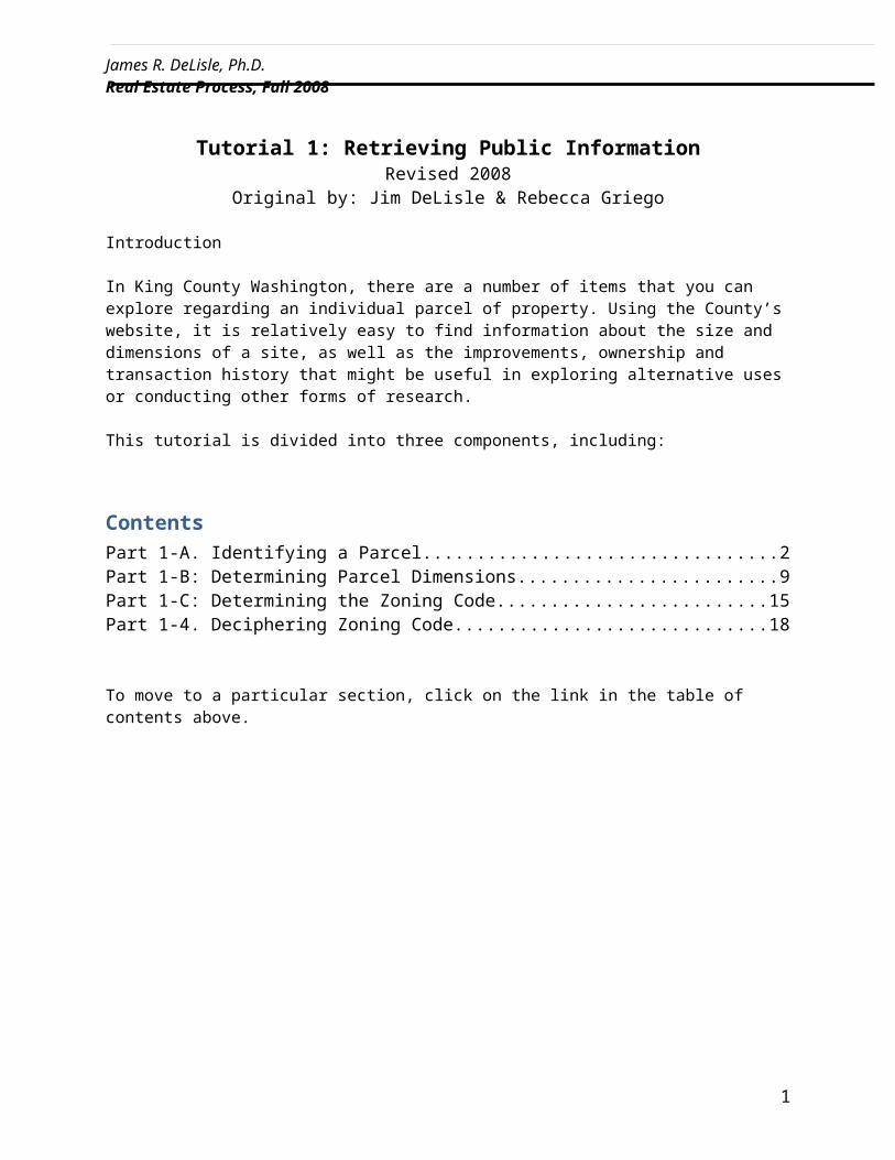
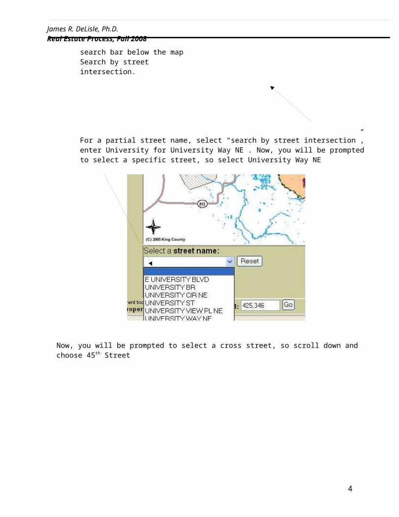
Search by address by clicking “search by address” in the search bar below the map Search by street intersection.
3
James R. DeLisle, Ph.D. Real Estate Process, Fall 2008
For a partial street name, select “search by street intersection”, enter University for University Way NE . Now, you will be prompted to select a specific street, so select University Way NE
Now, you will be prompted to select a cross street, so scroll down and choose 45 th Street
4
James R. DeLisle, Ph.D. Real Estate Process, Fall 2008
Now, say that you were looking for the site on the intersection of 45th Street and University Way NE, which is vacant retail (previously Pier 1), and select the Zoom In tool and click on the area until you can properly identify the site.
You will see that the site/parcel is labeled 1142000125, which is the parcel number for that site. To learn
about the parcel, select the and click on that parcel. To select multiple parcels select the “select a feature” to click and drag over multiple parcels. Attached to the parcel you will find assessor data report and district and development report Below the map
5
Zoom in tool
Parcel

James R. DeLisle, Ph.D. Real Estate Process, Fall 2008
You should now see that the address is 4345 UNIVERSITY WY NE, or if you selected multiple parcels you will all the addresses selected. To learn more, select Available link in the column of the Assessor Data Report below the map. It will prompt you to the available information on that parcel.
6

James R. DeLisle, Ph.D. Real Estate Process, Fall 2008
a. Tax Payer information b. Tax Statusc. Appraised Land and Improvement Valued. Taxable Land and Improvement Valuee. Sale Datef. Sale Priceg. Seller Nameh. Buyer Namei. District Informationj. Property Name k. Property Typel. Plat Namem. Present usen. Plat Lot o. Plat Blockp. Lot Areaq. Accessr. Building information
i. Number of Buildingsii. Building Quality
iii. Number of Buildingsiv. Building Description
7
James R. DeLisle, Ph.D. Real Estate Process, Fall 2008
v. Year Builtvi. Construction Classification
vii. Gross SFviii. Net SF
ix. Shapex. Stories
xi. Heating Componentsxii. Predominant Use
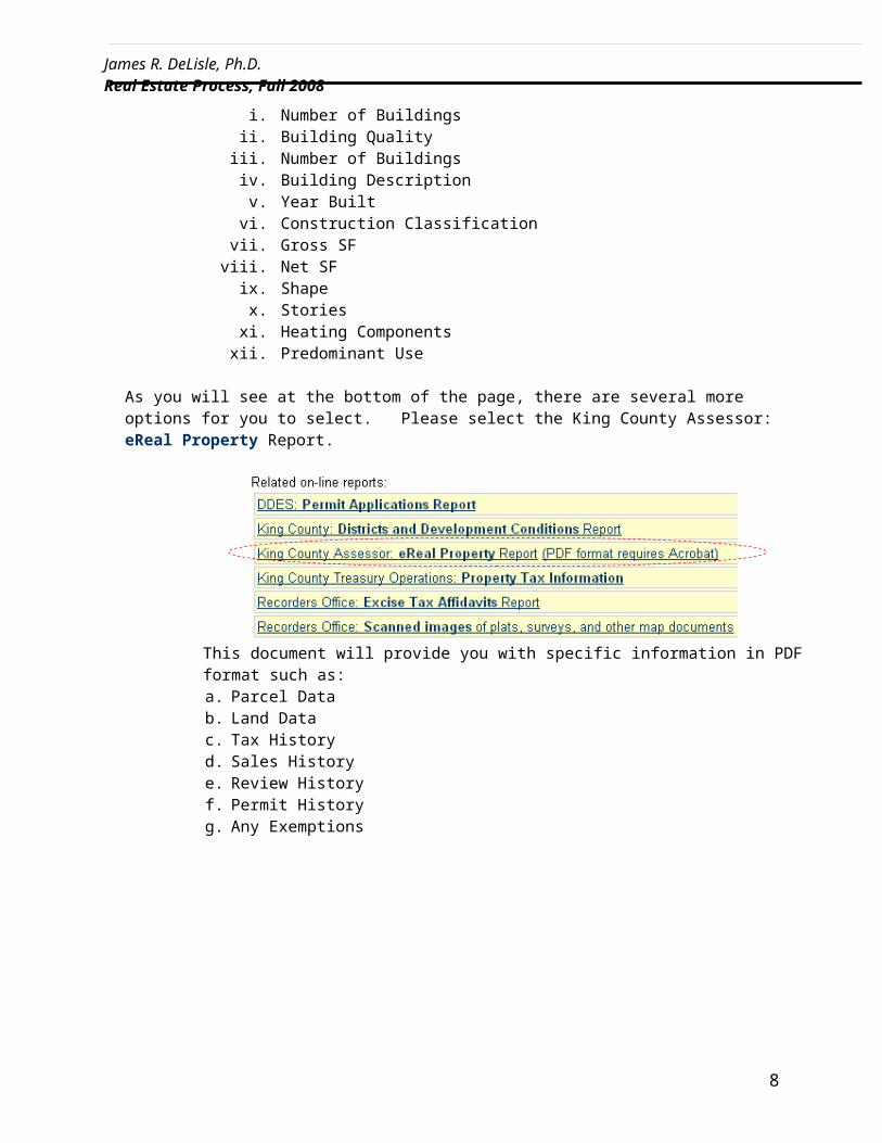
As you will see at the bottom of the page, there are several more options for you to select. Please select the King County Assessor: eReal Property Report.
This document will provide you with specific information in PDF format such as: a. Parcel Datab. Land Datac. Tax Historyd. Sales Historye. Review Historyf. Permit Historyg. Any Exemptions
8

James R. DeLisle, Ph.D. Real Estate Process, Fall 2008
9

James R. DeLisle, Ph.D. Real Estate Process, Fall 2008
Part 1-B: Determining Parcel Dimensions
1) The assessor parcel records will give you the parcel dimensions
2) As well as the eReal Property Report in adobe format seen on page 8 of this tutorial under Land Data
3) Another way to get to the parcel (total square foot) dimension Go to the Department of Planning and Development http:www.seattle.gov/dpd/research/
10

James R. DeLisle, Ph.D. Real Estate Process, Fall 2008
4) Click on Parcel Data. Use this search tool to find parcel information, including simple parcel maps, for a selected parcel within the Seattle city limits
11
James R. DeLisle, Ph.D. Real Estate Process, Fall 2008
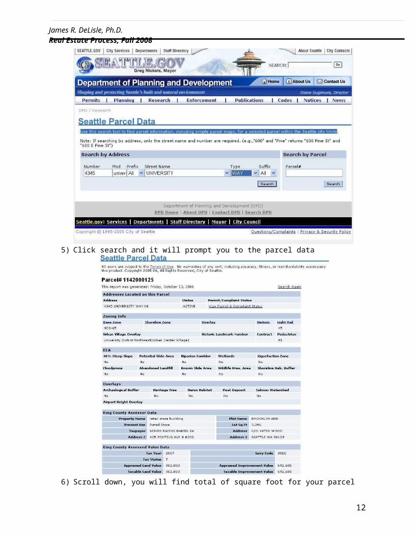
5) Click search and it will prompt you to the parcel data
6) Scroll down, you will find total of square foot for your parcel as lot Sq Ft 3,356
12

James R. DeLisle, Ph.D. Real Estate Process, Fall 2008
7) Another way to get to the parcel (sides) dimension is:Go to the Department of Planning and Development http://www.seattle.gov/dpd/research/
8) Click on zoning Maps. It will prompt you to
13

James R. DeLisle, Ph.D. Real Estate Process, Fall 2008
9) Identify general area subject property is located. For purposes of this assignment, click on Section 78.
10) Now you should see a large map. In order to determine a specific parcel’s dimensions, you will need to select the zoom option on your toolbar and zoom in on the prospective area. Once you have zoomed in as desired, select the hand/pan tool from your toolbar and move the map until you find your desired parcel. Note, that you will see dimensions for length and width.
14

James R. DeLisle, Ph.D. Real Estate Process, Fall 2008
11) Example: Look up the site located on the intersection of 45th Street and University Way NE.12) You will see that the side along 45th Street is marked 103(P) and the side along University
Avenue NE is marked 40(P).
13) This means that the actual size would be 103 * 40 = 4,120 SF, however because the dimensions contain a (P), that means that the actual site will be less than 4,120 SF due to (P) pedestrian allotment. In order to determine what the actual recorded size of the property is, you will need to reference the parcel information in the Assessor Parcel Records in the Property Report opened earlier, which shows a Lot Area of 3,356 SF. So, 4,120SF - 3,356F = 764 SF of pedestrian space.
15
James R. DeLisle, Ph.D. Real Estate Process, Fall 2008
Part 1-C: Determining the Zoning Code
1) Go to the City of Seattle website http://www.seattle.gov/dpd/research 2) Select Parcel Data
3) Enter address information
16

James R. DeLisle, Ph.D. Real Estate Process, Fall 2008
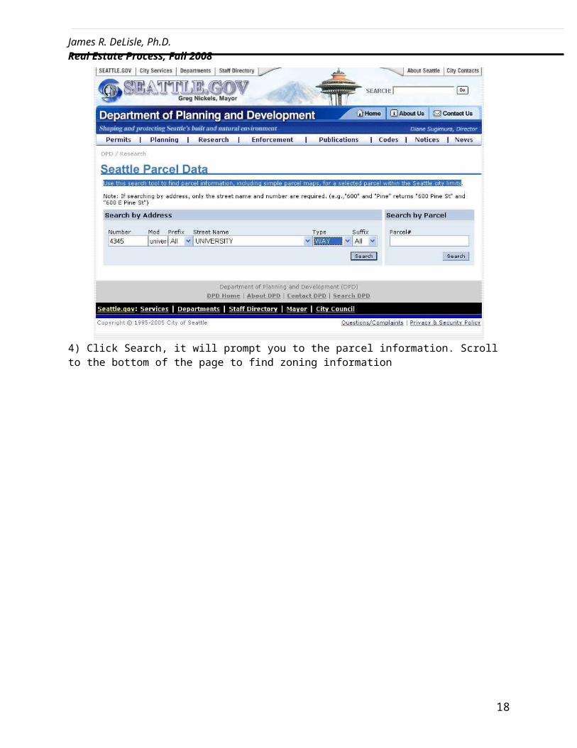
4) Click Search, it will prompt you to the parcel information. Scroll to the bottom of the page to find zoning information
17
James R. DeLisle, Ph.D. Real Estate Process, Fall 2008
18
James R. DeLisle, Ph.D. Real Estate Process, Fall 2008
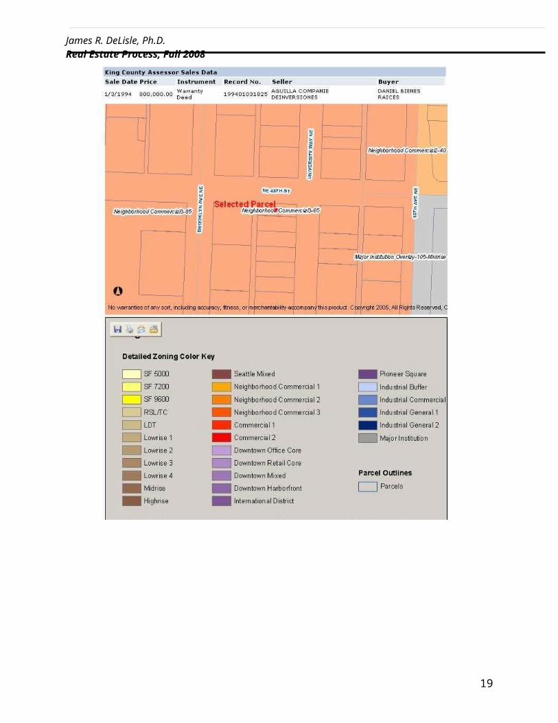
Part 1-4. Deciphering Zoning Code
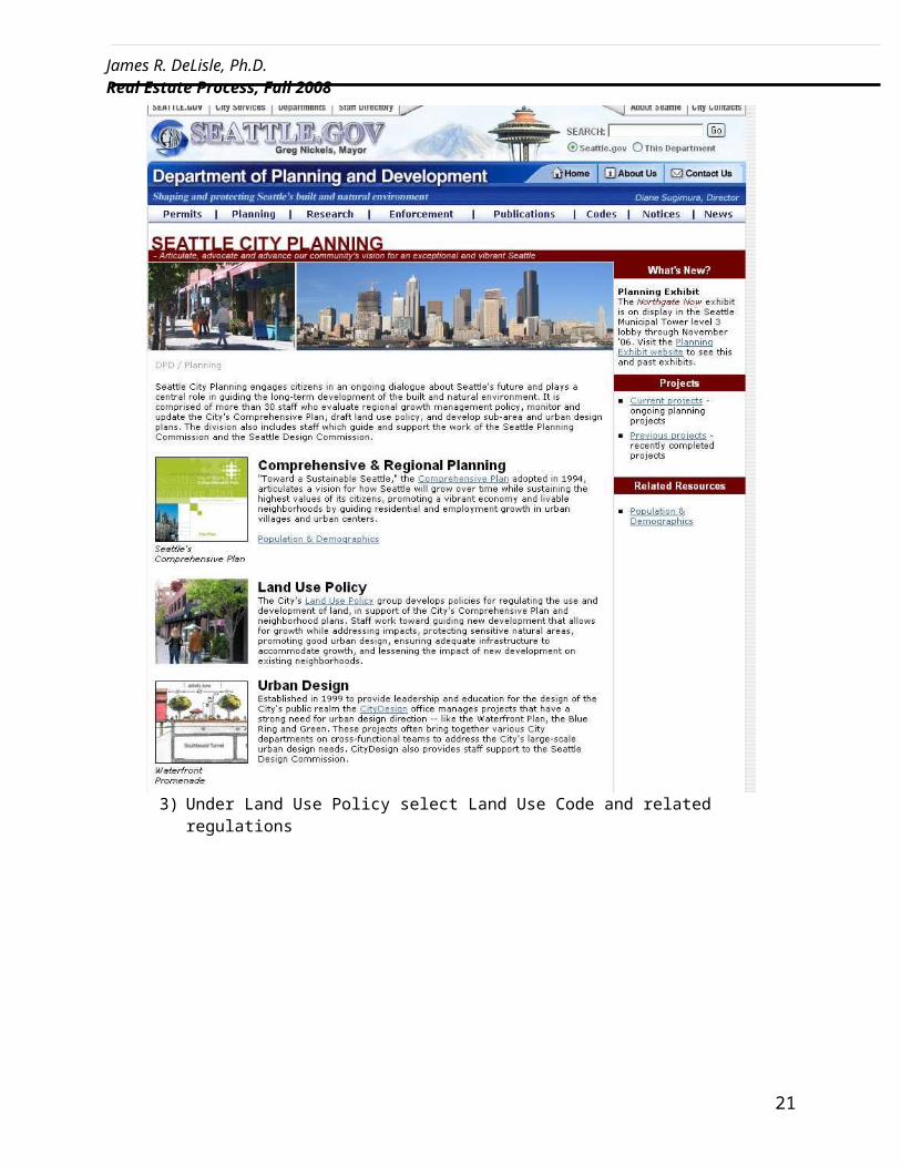
1) Go to the City of Seattle – Planning Department website http://www.seattle.gov/dpd/planning/
2) click on Land Use Policy
3) Under Land Use Policy select Land Use Code and related regulations
19

James R. DeLisle, Ph.D. Real Estate Process, Fall 2008
4) Select Land Use Code Table of Contents
5) Under Land Use Regulations, choose Zone Designations Established
6) There you will see the definitions for the abbreviated codes found when determining the zoning.
20
James R. DeLisle, Ph.D. Real Estate Process, Fall 2008
21