Embed Size (px)
Citation preview
UNIVERSITI PUTRA MALAYSIA
EFFECTS OF LOGGING OPERATIONS ON SOIL PHYSICAL PROPERTIES
AND SOIL EROSION IN A HILL DIPTEROCARP FOREST OF PENINSULAR MALAYSIA
BAHARUDDIN KASRAN
FH 1992 3
EFFECTS OF LOGGING OPERATIONS ON SOIL PHYSICAL PROPERTIES
AND SOIL EROSION IN A HILL DIPTEROCARP FOREST
OF PENINSULAR MALAYSIA
By
BAHARUDDIN KASRAN
Thesis Submitted in Fulfillment of the Requirements for the Degree of Master of Science in the
Faculty of Agriculture, Universiti Pertanian Malaysia
December 1992
ACKNOWLEDGMENTS
I would l ike to express my most sincere and deepest
gratitude t o my major superv�sor, Associate Professor Dr. Mohd
Mokhtaruddin bin Abdul Hanan, Faculty o f Agr i c u lt u r e ,
Universiti Pertanian Malaysia f o r h i s h e l p f u l advice,
encouragement and constructlve criticisms throughout the study.
Thanks are a l s o due to my co-supervisor , A s s o c iate
Professor D r . Nik Huhamad Ha)ld, Faculty of Forestry,
Universiti Pertanian Halaysla for his invaluable comments ,
guidance and encouragement . Special thanks are due to Associate
Professor Dr. Siti Zauyah Darus and her laboratory assistants
for their help in porosity analysis.
I would like to acknowledge the Forest Research Institute
Malaysia (FRIM) for giving me the opportunity to undertake this
study. My appreciation to Dr. Abdul Rahim Hj Nik, my project
Leader and Mohd Zaki Mohd Isa at FRIM, for his valuable
comments. I am indebted to my cOlleagues Zulkifli ¥usop and
Saifuddin Sulaiman for their cooperation.
I like to express my speclal thanks to the research staff
and foresters o f the Hydrology Section and field staff of
stesyen Kec il Jengka, FRIM, for their assistance in field data
collection and laboratory analyse s . They are Rajendran, Mohd

Sahat , Ahmad Shahar, Ibrahim, Hashim, Mokhtar, Ranjer Md Nor,
Ayoub, Alisbana, Mat Salleh, Mohd Adam and Ahmad Marhani .
Last but not least, my deepest gratitude and love to my
wife, Tuminah for her understanding, sacrifices and patience;
and to my children, Baharina, Haizal and Hamiza for their love
and patience without which t h i s project would not have
completed.
iii
TABLE OF CONTENTS Page
ACKNOWLEDGMENTS 11
LIST OF TABLES . . . . . . . . . . . . . . . . . . . . . . . . . . . . . . . . . . . . . . . . . . . vii
LIST OF FIGURES . . . . . . . . . . . . . . . . : . . . . . . . . . . . . . . . . . . . . . . . . . ix
LIST OF PLATES . . . . . . . . . . . . . . . . . . . . . . . . . . . . . . . . . . . . . . . . . . . x
LIST OF ABBREVIATIONS . . . . . . . • • • . . . . . . . . . . . . • • . . . . . . . . . . . . x i
ABSTRACT . . . . . . . . . . . . . . . . . . . . . . . . . . . . . . . . . . . . . . . . . . . . . . . . . xii
ABSTRAK xv
CHAPTER
I INTRODUCTION 1
II REVIEW OF LITERATURE 5
Logging System in Malaysia 5
Soil Erosion and Surface Runoff in a Tropical Forest 6
Effects o f Logging on Surface Runoff and Soil Loss 11
Effects of Logging on Surface Runoff . . . . . . 11
Effects of Logglng on Soil Loss . . . . . . . . . . . 13
Effects of Logglng on Soil Physical Properties . . . . . . . . . . . . . . . . . . . . . . . . . . . . . . . . . . . . . 16
I I I METHODOLOGY 20
Experimental Site 20
Location and Topography 20
Geology, 5011 and Vegetation 20
IV
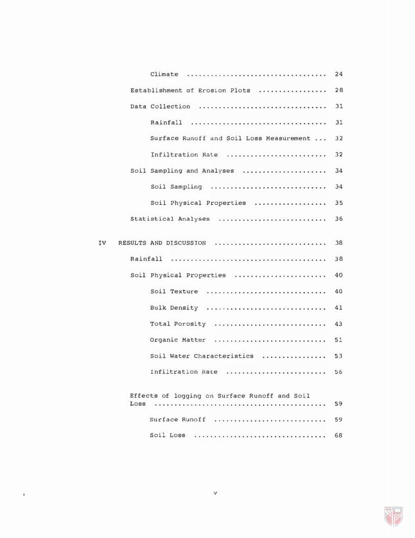
Climate 24
Establishment of Erosion Plots 28
Data Collection 31
Rainfall 31
Surface Runoff and Soil Loss Measurement ... 32
Infiltration Rate 32
Soil Sampling and Analyses 34
Soil Sampling 34
Soil Physical Properties 3 5
Statistical Analyses 36
RESULTS AND DISCUSSION 38
Rainfall 38
Soil Physical Properties . . . . . . . . • • . . . . . . . . • • . . . 40
Soil Texture 40
Bulk Density . . . . . . . . . . . . . . . . . . . . . . . . . . . . . . 41
Total Porosity 43
Organic Matter 5 1
Soil Water Characteristics 53
Infiltration Rate 56
Effects of logging on Surface Runoff and Soil Loss 59
Surface Runoff 59
Soil Loss 68
v

v SUMMARY AND CONCLUSION 7 5
summary . . . . . . . . . . . . . . . . . . . . . • . . . . . . • • • . • . . . . . . . 7 5
Conclusion
REFERENCES CITED
VITA
vi
79
81
94
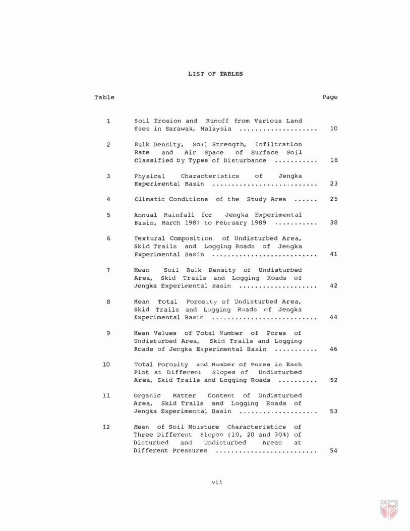
LIST OF TABLES
Table
1 Soil Erosion and Runoff from Various Land
2
3
Uses in Sarawak, Malaysia
Bulk Density, Rate and Classified
So�l Strength, Infiltration Air Space of Surface Soil
Physica l
b y Types of Disturbance . . . . . . . . . . .
Characteristics of Jengka
Page
10
18
Experimental Basin . . . . . . . . . . . . . . . . . . . . . . . . . . . 2 3
4
5
Climatic Conditions of the Study Area
Annual Basin,
Rainfall for March 1987 to
Jengka Experimental February 1989 . . . . . . . . . • .
6 Textural Compositl.on of Undisturbed Area, Skid Trails and Logging Roads of Jengka
7
8
9
Experimental Basin
M.ean Area, Jengka
Soil Bulk Density of Undisturbed
Skid Trails and Logging Roads of
Mean Skid
Experimental Basin
Total Trails
Porosl.ty of
and Logging Experimental Basin
Undisturbed Area, Roads of Jengka
Mean Values of Total Number of Pores of Undisturbed Area, Skid Trails and Logging Roads of Jengka Experimental Basin . . . . . . . . . . .
10 Total Porosity and Number of Pores in Each
Plot at Different Slopes of Undisturbed
11
Area, Skid Trails and Logging Roads
Organic Matter Content of Undisturbed Area, Skid Trails and Logging Roads of Jengka Experimental Basin . . . . . . . . . . . . . . . . . . . .
12 Mean of Soil Mo�sture Characteristics of Three Different Slopes (10, 20 and 30%) of Disturbed and Undisturbed Areas at Different Pressures
vii
2 5
38
41
42
44
46
52
53
54
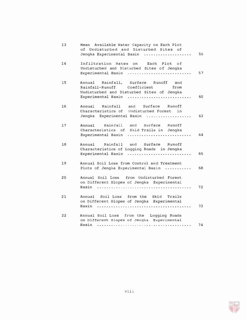
13 Mean Available Water Capacity on Each Plot of Undisturbed and Disturbed S ites of Jengka Experimental Basin
14 I n f iltration Rates on Each Plot o f Undisturbed and Disturbed Sites o f Jengka
15
16
Experimental Basin
Annual Rainfall, Surface Runoff and Rainfall-Runoff Coefficient from Undisturbed and Disturbed Sites of Jengka Experimental Basin . . . . . . . . . . . . . . . . . . . . . . . . . . .
Annual Rainfall and Surface Runoff Characteristics of Undisturbed Forest in
55
57
60
Jengka Experimental Basin . . . . . . . . . . . . . . . . . . . 63
17
I.
Annual Rainfall and surface Runoff Characteristics of Skid Trails in Jengka Experimental Basin
Annual Rainfall Characteristics of Experimental Basin
and Logging
Surface Runoff Roads in Jengka
64
65
19 Annual Soil Loss from Control and Treatment
20
21
22
Plots of Jengka Experimental Basin 6.
Annual Soil Loss from undisturbed Forest on Different Slopes of Jengka Experimental Basin . . . . . . . . . . . . . . . . . . . . . . . . . . . . . . . . . . . . . . . . 72
Annual Soil Loss from the on Different Slopes of Jengka Basin
Annual Soil Loss from the
Skid Trails Experimental
Logging Roads on Different Slopes of Jengka Experimental
73
Basin . . . . . . . . . . .... . . . . . . . . . . . . . . . . . . . . . . . . . . 74
viii
Figure
1
2
3
4
5
6
7
8
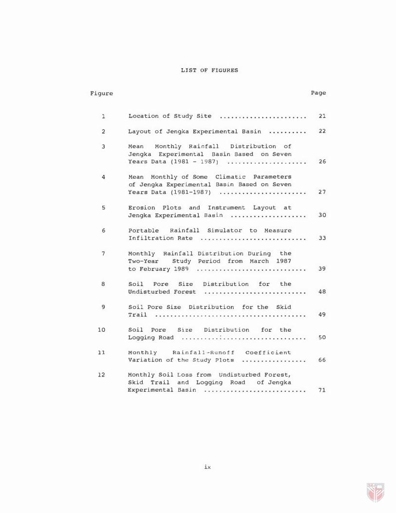
LIST OF FIGURES
Location of Study Site . . . . . . . . . . . . . . . . • • • • . . .
Layout of Jengka Experimental Basin
Mean Monthly Rainfall D istribution of Jengka Experimental Basin Based on Seven Years Data ( 1981 - 1987) . . . . . . . . . . . . . . . . . . . . .
Mean Monthly of Some of Jengka Experimental Years Data (1981-198 7 )
Climatic Parameters Basin Based on Seven
Erosion Plots and Jengka Experimental
I nstrument Layout at Basin
Portable Rainfall Simulator to Measure Infiltration Rate
Monthly Rainfall Two-Year Study to February 1989
Soil Pore Size Undisturbed Forest
Distribution During Period from March
Distribution for
the 1987
the
9 Soil Pore Size Distribution for the Skid
10
11
12
Trail
Soil Pore Logging Road
Size Distribution for the
Monthly Rainfall-Runoff
Variation of the Study Plots
coefficient
Monthly Soil Skid Trail
Loss from Undisturbed Forest, and Logging Road of Jengka
Experimental Basin
ix
Page
21
22
26
2 7
30
33
39
48
49
50
66
71
Plate
1
2
3
•
LIST OF PLATES
Extraction of Log
on the Skid Trail Using Crawler Tractor
Winched Lorry or "San-Tai-Wong"
Erosion Plot on the Logging Road
Regeneration Logging Road
of one
Pioneer spec ies on Year After Logging
K
the
Page
7
7
29
62

FAO
IAHS
IUFRO
m . a . s . l .
UNESCO
USDA
LIST OF ABBREVIATIONS
Food and Agriculture Organization
International Association of Hydrological Science
International Union of Forestry Research Organization
Meter above sea level
United Nations Educational, Scientific and Cultural Organization
United States Department of Agriculture
xi
Abstract of thesis subm1.tted to the Senate of Universiti
Pertanian Malaysia in fulfillment of the requirements for the
degree of Maater of Science.
EFFECXS OF LOGGING OPERATIONS ON SOIL PHYSICAL PROPERTIES
AND SOIL EROSI ON IN A HILL DIPTEROCARP FOREST
Chairman:
Faculty :
OF PENINSULAR MALAYSIA
By
BAHARUODIN KASRAN
December 1992
Associate Prof. Dr. Mohd Mokhtaruddin Abdul Hanan
Agriculture
The effects of 109g1-ng operations on soil phys ical
properties and soil erOS10n 1n logged-over forest occurred
mainly on severely disturbed s011, particu larly on the skid
trail and logging road. ErOS10n plots were es tablished i n
these areas to quantify the amount of surface runoff and soil
loss. Soil samples from the upper layer of the skid trail,
logging road and und1.sturbed area were analyzed for soi l
physical properties.
Significant chan ges 1n S011 physical properties w ere
observed as a result of 10gg1.ng operations. The bulk density
increased by 32 percent on the sk1d trail and 42 percent on the
logging road, and the total porosity reduced by 62 and 69
'H
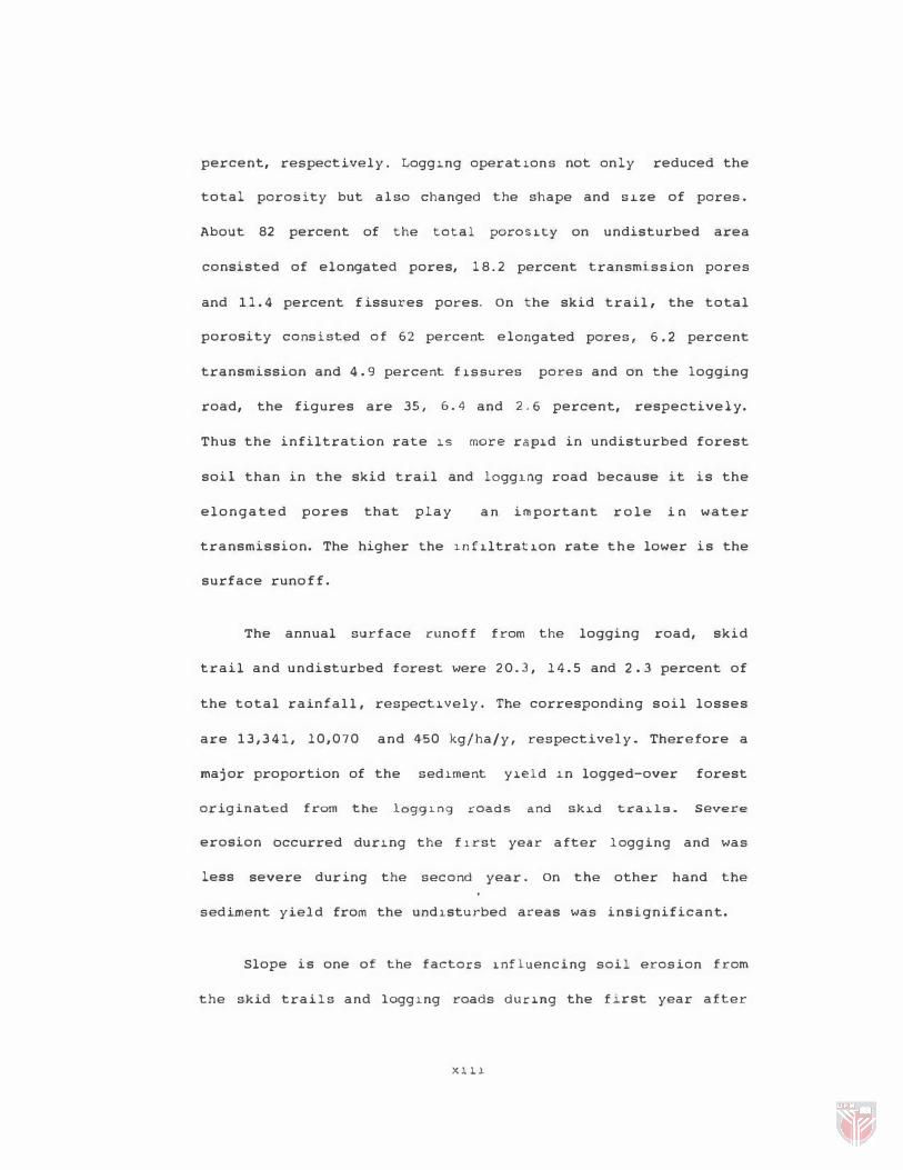
percent, respectively. Logg1ng operat1ons not onl y reduced the
total porosity but also changed the shape and Slze of pores.
About 82 percent of the total poros1ty on undisturbed area
consisted of elongated pores, 1 8 . 2 percent transmission pores
and 1 1 . 4 percent f issures pores. On the skid trail, the total
porosity consisted of 62 percent el ongated pores, 6.2 percent
transmission and 4 . 9 percent f1ssures pores and on the logging
road, the figures are 35, 6.4 and 2.6 percent, respectively.
Thus the infiltration rate lS more ra p1d in undisturbed forest
soil than in the skid trail and 10gg10g road because it is the
elongated pores that play an important r o l e in water
transmission. The higher the 1nf1ltrat1on rate the lower is the
surface runo f f .
The annual surface runoff from the logging road, skid
trail and undisturbed forest were 2 0 . 3 , 1 4 . 5 and 2.3 percent of
the total rainf all , respect1vely. The corresponding soil losses
are 1 3 , 3 4 1 , 10,070 and 450 kg/ha/y, respectively. Ther efore a
major proportion of the sed�ment Y1eld 1n logged-over forest
originated from the l099�n9 roads and sk�d tra�lB. Severe
erosion occurred du r1n g the f1rst year after logging and was
less severe dur ing the second year. On the other hand the
sediment yield from the und�sturbed areas was insignificant.
Slope is one of the factors 1nfluencing soil erosion from
the skid trails and 10gglng roads dur1ng the firs t year after
X III
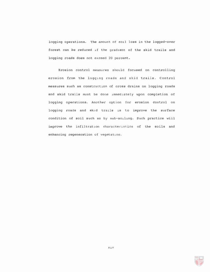
logging operations. The amount of SOll loss in the logged-over
forest can be reduced l.f the grad l ent of the skid trails and
logging roads does not exceed 20 percent.
Erosion control measures should focused on controlling
erosion from the 10gglng roads and skid trails. Control
measures such as construct lon of cross drains on logging roads
and skid trails must be done lmmedl.ate1y upon completion of
logging operations. Another option for erosion control on
logging roads and skl.d tralls lS to improve the surface
condition of soil such as by SUb-solllng. Such practice will
improve the infiltratlon characterl.stics of the soils and
enhancing regeneration of vegetatl.on.
nv
Abstrak tesis dikemukakan
Pertanian Malaysia bagi memenuhi
Ijazah Master Sains.
ke·pada
keperluan
Senat
untuk
universiti
memperolehi
KESAK-KESAN OPERASl PEMBALAKAN KE ATAS SlFAT-SIFAT
FIZlKAL DAN HAKISAN TANAH 01 HUTAH D1PTEROKAP
8UK1T 01 seMENANJUNG MALAYSIA
01eh
BAHARUDDIN KASRAN
Desember 1992
Pengerusi Prof. Madya Dr. Mokhtaruddin Abdul Manan
Fakulti Pertanian
Kesan-kesan operasi pembalakan ke atas sifat-sifat fizikal
tanah dan hakisan di hutan yang telah dibalak sering berlaku di
tanah yang menga1ami kerosakan yang teruk, terutama di jalan
tarik dan ja1an ba1ak. Petak-pet.ak hakisan dibina di kawasan
ini bagi menentukan jum1ah air larian permukaan dan tanah
terhakis. Contoh tanah di lap�san atas jalan tarik, jalan balak
dan kawasan tidak diganggu telah dianalisa untuk menentukan
sifat-sifat fizikal tanah.
Operasi pembalakan menyebabkan berlakunya perubahan ke
at as sifat-sifat fizikal tanah. Ketumpatan pukal bertambah 32
peratus di jalan tarik dan 42 peratus di jalan balak.
Sebaliknya jumlah keliangan masing-masing berkurangan kepada 62
,v
dan 69 peratus di jalan "tar1k dan jalan balak. Operasi
pembalakan bukan sahaja mengurangkan jumlah keliangan bahkan
juga mengubah bentuk dan saiz keliangan. Kira-kira 82 peratus
dari jumlah keliangan di kawasan tidak diganggu terdiri
daripada liang memanjang, 18.2 peratus liang penghantaran dan
11.4 peratus liang rekahan. 01 Jalan tarik pula, 62 peratu$
jumlah keliangan terdiri daripada liang memanjang, 6 . 2 peratus
liang penghantaran dan 4.9 peratus liang rekahan. Oi jalan
balak angka-angka tersebut ialah 35, 6 . 4 dan 2.6 peratus. Oleh
itu proses penyusupan mudah bel"laku d1 hutan tidak diganggu
berbanding di jalan tarik dan jalan balak. Ini disebabkan oleh
liang memanjang memainkan peranan penting bagi pergerakan air
dalam tanah. Semakin tinggi kadar penyusupan semakin rendah air
larian permukaan.
Air larian permukaan tahunan di jalan balak, jalan tarik
dan hutan tidak diganggu masing-masing 2 0 . 3 , 14.5 dan 2 . 3
peratus dari jumlah hujan" In1 bersamaan dengan kehilangan
tanah masing-masing sebanyak 13, 3 4 1 , 10,070 dan 450
kg/ha/tahun. Oleh itu sebahagian besar hasil kelodak dari hutan
telah dibalak beraeal dari jalan balak dan jalan tarik. Hakisan
yang teruk terjadi pada tahun pertama selepas pembalakan dan
berkurangan pada tahun ber ikutnya. Sementara kawasan tidak
diganggu menyumbangkan sedik1t sahaja hasil kelodak.
xvi
Kecerunan merupakan satu daripada faktor-faktor yang
mempengaruhi hakisan tanah dari j'alan tarik dan jalan balak
terutama pada tahun pertama se lepas pembalakan. Jumlah tanah
terhakis dari kawasan ini boleh dikurangkan jika kecerunan
jalan tarik dan jalan balak tidak melebihi 20 peratus.
Langkah-langkah mencegah hakisan harus diutamakan untuk
mengawal hakisan di jalan balak dan jalan tarik. Langkah-
langkah tersebut seperti pembinaan parit melintang di jalan
balak dan jalan tarik harus dilaksanakan serta-merta setelah
operaei pembalakan tamat. Satu lagi cara bagi mengawal hakisan
di kawasan ini ialah memperbaiki keadaan tanah seperti
mengemburkan permukaan tanah di kawasan-kawasan tereebut.
Amalan ini akan meningkatkan Kadar penyusupan dan
mempercepatkan pertumbuhan tumbuh-tumbuhan.
XVlJ.
CHAPTER I
INTRODUCTION
During the past two decades more than 1 . 5 million hectares
of lowland tropical forests in Peninsular Malaysia have been
converted to agricultural land mainly for the planting of
rubber, oil palm and cocoa. This has resulted in a massive
reduction of forested land in the country. I n 1955 forest
constituted about 7 5 percent of the total land area in
Peninsular Malaysia. This was further reduced to 55 percent in
1970, 50 percent in 1980 ( Chong, 1985) and 47 . 7 percent in 1990
(Malaysia, Ministry of primary Industries, 1991) . Most of the
forested land in Malaysia today are confined to hilly areas and
steep terrains and the lowland dipterocarp forests have almost
been totally replaced by agricultural crops.
Logging activities in the steepland areas have created a
number of serious environmental and ecological problems. The
most obvious are those pertaining t o the hydrology of
downstream areas, such as deterioration in water quality,
increased soil erosion, river sedimentation and silting of
reservoirs. In Malaysia, the effects of timber harvesting on
soil erosion and sedimentation have been reported by a number
of investigators including Burgess ( 1971 ) , Baillie ( 1972 ) , Liew
(1974) , Jones ( 1976 ) , Salleh et al . , (1981a, 1981b ) , Lai and
1
2
Shams uddin ( 1 985 ) , Lai and Rentap (1986 ) and Baharuddin
( 1988a ) .
Most of these studies were based on experimental
watersheds. The common approach is to estimate erosion by
determining sediment content of stream water from the
watershed. It provides the general idea of the treatment effect
on sediment production, which is attributed mainly to surface
erosion ( sheet, rill and gully) , stream bank and streambed
erosion. The general conclusion of these studies is that
logging activities contributed a significant amount of
sediments in the stream water. Nevertheless, the exact source
o f sediments s t i l l remains unknown. I t is imperative to
indicate the exact location and sediment regime in the area so
that systematic erosion control measures could be implemented
to minimize sediment content in the streams.
I n addition to sedimentation, forest harvesting operations
are definitely one of the factors that changed the soil
physical properties and aesthetic values of the landscape.
Logging road construction, usage of heavy maChinery and
transportation during logging operations tend to mOdify the
physical properties of the upper layer of forest soil which may
significantly affect regeneration growth. The impact of logging
operations on soil physical properties in temperate region is
well documented ( Froehlich 1972 ) . However , in Malaysia, such
study has not been reported, except by Kamaruzaman ( 1987 ) . The

3
alteration of soil physical properties due to timber harvesting
i s c l os e l y associated with s o i l l o s s o f the a r e a . This
relationship characteristics and the soil loss variation should
be studied in order to gain a better understanding of the soil
erosion problem.
This thesis reports a study of the relationship between
timber harvesting, soil erosion and Boil physical properties in
a logged-over forest in Peninsular Ma lays i a . The general
objective is to determine the amount of surface runoff and
soil loss and to assess the changes in soil physical properties
resulting from construction of logging road and skid trails in
logged-over forest of Peninsular Malaysi a . The spec i f i c
objectives are to:
1 . quantify the amount of
loss from logging roads,
undisturbed forest, and
surface runoff and soil
skid t r a i l s and
2. describe some selected soil properties such as bulk
density, porosity, soil organic matter, soil water
characteristics and infiltration rate on the logging
road, skid trail and undisturbed forest.
The study was conducted in a logged-over forest at Tekam
Forest Reserve, Pahang, Peninsular Malaysia. Nine erosion plots
were established on three different sites, namely undisturbed
forest, skid trails and logging roads. At each site, plots were

4
established on three different slope categories ( 10 , 20 and 30
percent ) . The study commenced six months after logging
operation was completed and continued for a period of two
years, that is, from March 1987 to February 1989.
CHAPTER II
REVIEW OF LITERATURE
Logging system in Malaysia
Selective logging method was introduced in Malaysia as a
forest management system since 1948 . It was then known as the
Halayan Uniform System (MUS) (Wyatt-Smith, 1963). A new system
known as the Selective Management System (SHS) was implemented
in 1970 to replace HUS because the HUS system was found to be
unsuitable to be practiced in the hill forest areas ( Thang,
1986) . This new system was designed to optimize the management
objectives of an economic and efficient harvesting, forest
sustainability and minimum forest development cost. In this
system, minimum cutting limits are 45 and 50 cm diameter breast
height for the non-dipterocarp
respectively.
and dipterocarp species.
The logging system which has been developed in the forests
of Halaysia are completely mechanized and requires low capital
(FAO, 1970, 1973; Ellis, 1976; Jones, 1976). The basic logging
operations include tree felling, construction of forest road
and log transportation. During road construction, the topsoil
and forest debris are pushed aside to ensure firm and level
footing for the skidding operation. The activities during this
operation and the usage of heavy earth-moving equipment such
5
6
as tractors and skidders cause severe soil degradation. In
log transportation, the crawler tractor is used for skidding or
hauling the logs from the felling site to temporary landing
(Plate 1 ) . The logs that are skidded are usually largei 50 to
100 em in diameter at breast height, cut into logs of about 5
to 7 m long or sometimes at tree length. Under such practice,
only heavy equipment are used. The main vehicle tranporting
logs to the logyard is a winch lorry locally known as " San-Tai-
Wong" ( Plate 2 ) . These skidding and transportation activities
can cause serious degradation of soil physical properties both
during the dry and wet seasons. 50il degradation and compaction
resulting from logging will certainly induce surface runoff and
erosion.
soil Erosion and Surface Runoff in a
Tropical Forest
In the temperate zone , surface erosion in undisturbed
forest is minimal (Megahan and King, 1975) . This is not true
for the tropical forest because soil erosion can be detected
even under natural forest (Leigh, 1 9 7 8 ; Fearnside, 1979;
Putj aroon and Pongboon, 1987 ) . Putjaroon and Pongboon ( 19 8 7 )
found that the amount o f runoff and soil loss i n a dry
dipterocarp forest in Saho1nakron Province of Thailand were
1 , 529 m3/ha/y and 664 kg/ha/y, respectively . The values are
however much lower when compared to that of abandoned fields
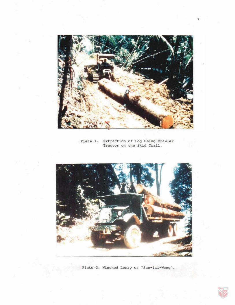
Plate 1. Extraction of Log Using Crawler
Tractor on the Skid Trail.
Plate 2. Winched Lorry or "San-Tai-Wong".
7